pol strts transit elemnts - scottsdale, arizonaplan/formatted+transit+element.pdfchapter 5 - transit...
TRANSCRIPT

CHAPTER 5 - TRANSIT ELEMENT PAGE 75
Route 81 in Scottsdale
TRANSIT ELEMENT1.0 INTRODUCTIONTh e Transit Element is one component of the City of Scottsdale’s multi-modal Transportation Master Plan, and was developed in support of the adopted City of Scottsdale General Plan with public input throughout the planning process. Th e result of this eff ort will be an update of the Scottsdale Transit Plan (February 2003), building on its concepts and further defi ning it. Th e Transit Element will meet all applicable federal, state, and local laws and regulations and will follow Federal Transit Administration (FTA) guidelines in determining transit service changes and improvements.
1.1 UnderstandingMuch like other communities in the region, the City of Scottsdale is experiencing rapid population growth. In parts of the City, growth and redevelopment will continue to transform parts of the community from a suburban to a more urban environment. With this change comes a number of challenges, including the ability to provide transit service that is integrated into a comprehensive multi-modal transportation system. Th e goal of the Transit Element is to provide a transit network that balances local and regional mobility needs with community character, while fi tting into an overall transportation system.
Forecasted growth and development, decreased land availability to construct new transportation corridors, and anticipated increases in transit-riding populations make it evident that alternative transportation strategies are needed to provide a transportation system that eff ectively serves the residents and employees of Scottsdale, as well as the many travelers who pass through Scottsdale everyday. Fortunately, opportunities exist in the City of Scottsdale to increase transit options. Voters in Maricopa County approved the Regional Transportation Plan (RTP) through Proposition 400 in 2004, which extended the half-cent sales tax for transportation for 20 years and includes a large number of transit service and facility improvements in Scottsdale.
Th e purpose of the Transit Element is to develop information in suffi cient detail so that citizens, elected offi cials, City staff , and others can determine the appropriate level of transit investment for the City of Scottsdale. Some of the major issues for transit that are addressed in the Transit Element include:
Utilizing information from previously completed transit and transportation studies; Targeting transit growth areas by analyzing ridership potential, capacity, infrastructure, demographics, land use, and economic development;Ensuring compatibility with the regional transit system; Developing and evaluating transit service options while formulating an action plan for implementation;Identifying funding sources and developing a funding plan for multiple planning horizons; and Creating a transit system that is sustainable.

SCOTTSDALE TRANSPORTATION MASTER PLANPAGE 76
1.2 Vision, Goals, and ObjectivesTh e Vision, Values, and Goals section of the Transportation Master Plan identifi es many over-arching goals (based on the General Plan Community Mobility Element goals and additional goals regarding sustainability and regional coordination). Th e following are directly applicable to the Transit Element.
Protect the function and form of regional air and land corridors. Protect the physical integrity of regional networks to help reduce the number, length, and frequency of private automobile trips, to improve air quality, reduce traffi c congestion, and enhance quality of life and the environment.Promote regional diversity and connectivity of mobility choices. Prioritize regional connections to safely, eff ectively and effi ciently, move people, goods, and information beyond the City boundaries.Enhance connectivity to regional transportation facilities; however, these systems need to respect the City of Scottsdale General Plan.Maintain Scottsdale’s high aesthetic values and environmental standards in the City’s transportation system.Encourage a diversity of links between neighborhood systems, and with citywide and regional systems.Recognize the diversity of neighborhoods throughout the City and their diff erent mobility needs.Use “green” technologies and processes when possible and practical. Reduce emissions that degrade air quality.
In addition to these broader goals, the vision, goals, and objectives for the Transit Element are an extension of those from the City of Scottsdale Transportation Master Plan and the voter-approved RTP, and are listed as follows:
VisionProvide a balanced, accessible, multi-modal transportation system for the City of Scottsdale that gives Scottsdale residents and visitors choices in how to travel and that supports the safe and effi cient movement of people and goods.
GoalImprove accessibility, availability, effi ciency, and viability of transit services for all users within the City of Scottsdale.
Objectives Provide connections to local and regional destinations through a mix of transit services that may include, but are not limited to, fi xed route and express bus service, neighborhood circulators, paratransit, and high capacity transit (HCT).Expand the geographic coverage of transit service by developing a network of fi xed route bus service with connections to regional express bus service, regional local service, and regional HCT. Off er increased bus frequency and a longer span of service throughout the day. Develop and implement a form of HCT along Scottsdale Road that connects to the central Phoenix/East Valley light rail transit (LRT) system.

CHAPTER 5 - TRANSIT ELEMENT PAGE 77
Develop local bus circulators to provide better connectivity between neighborhoods and activity centers.Continue to meet the mobility requirements for persons with disabilities, as required by the Americans with Disabilities Act (ADA).Continue to off er a variety of alternate paratransit services for patrons who are elderly or have a disability with the purpose of managing Dial-a-Ride costs.Develop safe, comfortable, and convenient transit facilities, such as transit centers and park-and-ride lots that are served by local and regional transit services.Support the eff orts of Valley Metro/Regional Public Transportation Authority (RPTA), other jurisdictions, and other transit providers to expand service in the northeast valley.Provide pedestrian connections to complement new and existing transit services. Work with the Planning and Development Services Department to provide for a land use mixture of activities and densities near existing and planned major transit routes and facilities.Encourage partnerships between residents, businesses, system users, and the City in developing, promoting, and implementing the transit system.Use technology to improve passenger convenience, system effi ciency, and eff ectiveness. Develop service standards and levels to meet or exceed regional service standards and levels. Demand high standards from contractors providing service (e.g., passenger comfort, customer service, and service reliability).Actively market transit services and educate consumers to increase ridership and fare revenues.Support trip reduction programs.
2.0 TRANSIT BACKGROUNDTh e Transit Element includes a review of prior and ongoing transportation studies, as well as an overview of existing transit technologies that could be considered during the development and evaluation of transit improvement options.
2.1 Review of Prior and Ongoing StudiesTh e following is brief summary of some prior and ongoing transportation studies that relate to the Transit Element.
Maricopa Association of Governments (MAG) Regional Transportation Plan (RTP)Th e MAG RTP was approved by voters in 2004 through Proposition 400 and extended the region’s half-cent sales tax for transportation. Th e RTP includes a number of transit improvements programmed for the City of Scottsdale, including transit operating and facility improvements. Th e improvements included in the RTP will provide the basis for much of the transit service and capital expansion identifi ed in the Transit Element. Th e most recent version of the RTP is the draft 2007 update. Th e RTP plan may be viewed or downloaded at MAG’s website at http://www.mag.maricopa.gov/detail.cms?item=7091.
Scottsdale Transit Plan (2003)Th e Scottsdale Transit Plan (February 2003) was prepared by City staff and a working group of residents and the business community and was adopted by the Scottsdale City Council in 2003. Th e document outlines the City’s vision for transit and provides specifi c transit operating

SCOTTSDALE TRANSPORTATION MASTER PLANPAGE 78
and capital improvements. Th e Scottsdale Transit Plan did not include a long-term regional funding source for transit and focused more on policy direction than implementation. Th e Scottsdale Transit Plan provides the basis for the Transportation Master Plan Transit Element.
Valley Metro/RPTA Regional Transportation Plan EvaluationValley Metro/RPTA is responsible for the implementation and oversight of the operating and capital components outlined in the Transit Element of the RTP. Th e RTP Evaluation includes a detailed fi nancial analysis and operational feasibility analysis with recommendations of the RTP Transit Element. A summary of the RTP Evaluation as related to the City of Scottsdale is included as Appendix 5-A.
Valley Metro/RPTA Express Bus StudyTh e Valley Metro/RPTA Express Bus Study is developing an operating plan for the regional express bus improvements that will be implemented as part of the RTP. Th e study will provide further detail on express bus frequency, hours of service, stop locations, capital improvements, and fl eet needs.
MAG Transportation Improvement Program (TIP)Th e current MAG FY 2007–2011 TIP identifi es highway and transit projects programmed for construction throughout the region in the next fi ve years. Th e most recent version of the TIP incorporates the near term RTP improvements in the City of Scottsdale.
Scottsdale Capital Improvement Plan (CIP)Th e current FY 2008–2012 Scottsdale CIP identifi es capital projects programmed for construction throughout the City in the next fi ve years. Th e CIP is updated on an annual basis and includes capital improvements from the RTP, as appropriate.
Scottsdale General PlanTh e Scottsdale General Plan was adopted by City Council in 2001 and ratifi ed by the citizens of Scottsdale in 2002. Th e General Plan is a statement of goals and policies that work as the primary tool for guiding the future development of the City. Th e General Plan is divided into six chapters which are based on the Six Guiding Principles of the CityShape 2020 citizen participation process: Character and Lifestyle, Economic Vitality, Neighborhoods, Open Space, Sustainability, and Transportation. Th e Community Mobility Element of the General Plan encourages multi-modal transportation and provision of transportation options. One of those modal options is transit which is defi ned and implemented through the Transit Element of the Transportation Master Plan.
Scottsdale/Tempe North/South Transit Corridor StudyTh e Scottsdale/Tempe North/South Transit Corridor Study (2003) was a transit major investment study that recommended Scottsdale Road as the preferred high capacity transit corridor. Th e Scottsdale City Council approved Scottsdale Road as the corridor and recommended that bus rapid transit (BRT), light rail transit (LRT), and modern streetcar be evaluated in future studies. Th e evaluation of these technologies is part of the HCT (Section 8.0) of the Transit Element and will be discussed further in that section.

CHAPTER 5 - TRANSIT ELEMENT PAGE 79
MAG Park-and-Ride StudyTh e MAG Park-and-Ride Study (2001) identifi es a regional system of park-and-rides to support regional express bus service. Th e study identifi es two regional park-and-rides along the Loop 101 corridor in Scottsdale. Th e site selection for the proposed park-and-ride locations (Shea Boulevard/Loop 101 and Scottsdale Road/Loop 101) is underway.
Phoenix Transit Plan (Transit 2000)Th e Phoenix Transit Plan was approved by Phoenix residents in March 2000. It included a 4/10 of a percent sales tax for 20 years that will result in improved fi xed route and express bus service as well as implementation of LRT. Th e Phoenix Transit Plan is relevant to Scottsdale because many of the east/west routes within the City of Scottsdale connect to and are operated by the city of Phoenix.
Tempe General Plan (2030) – Transportation ChapterTh e Tempe General Plan was adopted by the Tempe City Council in December 2003. Th e transportation chapter is designed to guide the further development of a citywide multi-modal transportation system integrated with the City’s land use plans. Th e transit section of this transportation chapter, with its goals of increasing available transit modes and services and to facilitate connections among transportation modes, is relevant to Scottsdale because of the north/south routes within the City of Scottsdale which connect to and are operated by the City of Tempe.
2.2 Transit TechnologiesA variety of transit technologies, which range from demand response service to high capacity transit, are incorporated into the transit improvement options for the Transit Element.
Fixed Route BusFixed route bus service is the most common form of transit service in the region. It uses standard size transit vehicles (usually 40-foot buses) and is generally characterized by buses operating along the major arterial street grid network. Th e vehicles make frequent stops and may require passengers to transfer in order to reach their destinations. Route 72 on Scottsdale Road is an example of fi xed route bus service.
Limited Stop/Express BusExpress buses operate as commuter service during the peak-hour and usually connect outlying areas with major activity centers. Th e routes typically serve park-and-ride lots and may parallel fi xed route service with fewer stops. Vehicles may include additional amenities geared toward commuter travel, such as reading lights and reclining seats. Route 510, which travels between Scottsdale and downtown Phoenix, is an example of express bus service.
Neighborhood Circulators/ShuttlesNeighborhood circulators focus on serving a common geographic area with frequent, all-day service. Th e vehicles are small and enable passengers to connect to a wider transit network from residential neighborhoods and
Valley Metro bus
City of Phoenix RAPID express bus

SCOTTSDALE TRANSPORTATION MASTER PLANPAGE 80
activity centers. Shuttles provide shorter trips at higher frequencies and are usually free or very low fare. Th e Downtown trolley and Giants shuttle are examples of shuttle service. Th e Neighborhood Connector is an example of a neighborhood circulator. Th ese services are currently delivered utilizing specialty themed vehicles (trolleys). Routes and schedules for circulators/shuttles should be very easy to use and understand.
ParatransitParatransit provides fl exible schedule, on-demand transportation for those unable to access traditional fi xed route service, such as seniors and passengers
with disabilities. ADA requires that complementary paratransit service be provided in all areas within 3/4 mile of fi xed route bus service. Extended service hours are usually provided for individuals who qualify under ADA. Th e East Valley Dial-a-Ride, which provides shared ride, door-to-door service, and Scottsdale’s Cab Connection program are examples of paratransit.
Bus Rapid Transit (BRT)BRT is a form of higher capacity bus service which combines the advantages of rail transit with the fl exibility of buses. It uses a dedicated or shared guideway to provide limited stop service in medium to heavy travel demand corridors. Traffi c signal priority is typically given to BRT vehicles as they operate in designated bus or HOV lanes. Phoenix’s rapid bus service is the closest to BRT in this region. A better example is the Orange Line in Los Angeles, California.
Light Rail Transit (LRT)LRT is electrically powered, high capacity transit service operating on a fi xed guideway. It typically operates on two sets of tracks within exclusive or shared right-of-way (ROW) and serves stations located approximately every mile. LRT emphasizes speed and travel time savings and can operate using multiple vehicles linked together to accommodate large passenger volumes. Th e METRO Central Phoenix/East Valley LRT project is an example of LRT. Th e 20-mile LRT line connecting Phoenix, Tempe, and Mesa is scheduled to open in 2008.
Modern StreetcarModern streetcar is also electrically powered, high capacity transit service that operates on a fi xed-guideway. However, modern streetcar systems typically operate at street level in mixed traffi c in existing urban environments. Modern streetcar is usually operated using a single vehicle and can operate safely in high traffi c and/or high pedestrian activity areas to link neighborhoods with activity centers. Modern streetcar is distinguished from LRT by smaller, lighter vehicles requiring less infrastructure and lower construction costs. Th e Portland Streetcar is an example of a modern streetcar system.
Downtown Trolley
Orange Line in Los Angeles, CA
MAX Light Rail in Portland, OR
Portland Streetcar in Portland, OR

CHAPTER 5 - TRANSIT ELEMENT PAGE 81
3.0 EXISTING TRANSIT CONDITIONSExisting transit service in the City of Scottsdale is characterized by fi xed route bus service operating on the arterial and collector street grid system, along with limited express bus service, neighborhood circulators, shuttles, and paratransit service. Most of the fi xed bus routes in Scottsdale connect to other jurisdictions, and all of the service is contracted to an outside provider. Th e majority of transit service is focused on the southern and central portions of the City, where the highest population and land use densities are located.
Since the adoption of the 2003 Transit Plan, the City of Scottsdale has made substantial improvements to its fi xed route bus service. Service and frequency improvements have been implemented on a number of its routes, including Route 72 on Scottsdale Road. In addition, the City implemented its second neighborhood circulator, known as the Neighborhood Connector, in 2006. Th e following section documents existing transit conditions in Scottsdale.
3.1 Fixed Route and Express Bus ServiceExisting fi xed route bus service in the City of Scottsdale includes twelve fi xed bus routes, three express bus routes, two neighborhood circulators and two seasonal circulator services. In general, fi xed bus routes operate from 5 a.m. to midnight (earlier on some routes) on weekdays and 7 a.m. to 10:00 p.m. (earlier on some routes) on weekends. Further detail is provided in Table 5-1 and Figure 5-1 on the following pages.
TABLE 5-1: Existing Transit Service (as of July 2007)Headway
Route Name Weekday (peak/off-peak) Saturday SundayFixed Route Bus17 McDowell Rd 30/30 30 30Green Thomas Rd 20/30 30 3041 Indian School Rd 15*/30 30 3050 Camelback Rd 15/30/60 30/60 6066 68th St 30/30 30 3072 Scottsdale Rd 15/30 30 3076 Miller Rd 30/30 30 6081 Hayden Rd 15/30 60 6084 Granite Reef Rd 60/60 60 60106 Shea Blvd 30/60 30 60114 Via Linda 60/60 60 60154 Greenway Rd 30/30 30 60170 Bell Rd 30/30 30 30
Express Bus510 Scottsdale 2 trips (peak direction) n/a n/a512 Scottsdale 2 trips (peak direction) n/a n/a532 Mesa 4 trips (peak direction) n/a n/a
* Only west of Loloma Station

SCOTTSDALE TRANSPORTATION MASTER PLANPAGE 82
FIGU
RE 5-
1:
Exist
ing Tr
ansit
Rou
tes (J
uly 20
07)
CHAPTER 5 - TRANSIT ELEMENT PAGE 83
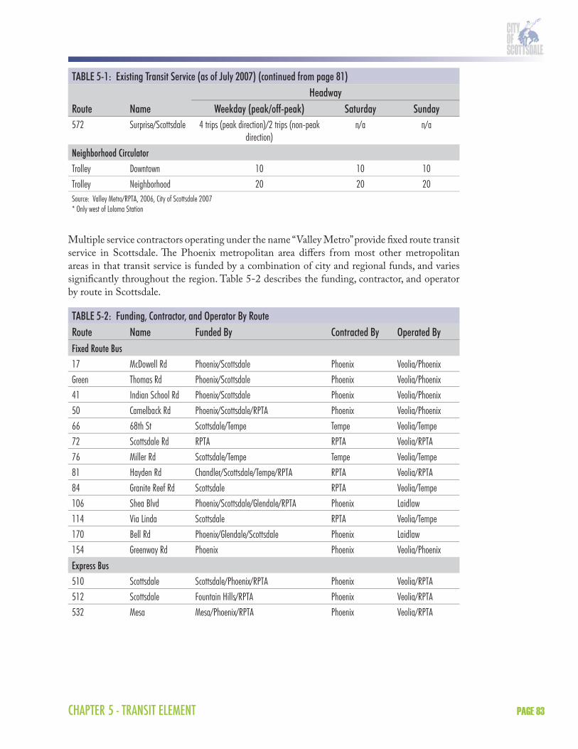
TABLE 5-1: Existing Transit Service (as of July 2007) (continued from page 81)Headway
Route Name Weekday (peak/off-peak) Saturday Sunday572 Surprise/Scottsdale 4 trips (peak direction)/2 trips (non-peak
direction)n/a n/a
Neighborhood CirculatorTrolley Downtown 10 10 10Trolley Neighborhood 20 20 20Source: Valley Metro/RPTA, 2006, City of Scottsdale 2007* Only west of Loloma Station
Multiple service contractors operating under the name “Valley Metro” provide fi xed route transit service in Scottsdale. Th e Phoenix metropolitan area diff ers from most other metropolitan areas in that transit service is funded by a combination of city and regional funds, and varies signifi cantly throughout the region. Table 5-2 describes the funding, contractor, and operator by route in Scottsdale.
TABLE 5-2: Funding, Contractor, and Operator By RouteRoute Name Funded By Contracted By Operated ByFixed Route Bus17 McDowell Rd Phoenix/Scottsdale Phoenix Veolia/PhoenixGreen Thomas Rd Phoenix/Scottsdale Phoenix Veolia/Phoenix41 Indian School Rd Phoenix/Scottsdale Phoenix Veolia/Phoenix50 Camelback Rd Phoenix/Scottsdale/RPTA Phoenix Veolia/Phoenix66 68th St Scottsdale/Tempe Tempe Veolia/Tempe72 Scottsdale Rd RPTA RPTA Veolia/RPTA76 Miller Rd Scottsdale/Tempe Tempe Veolia/Tempe81 Hayden Rd Chandler/Scottsdale/Tempe/RPTA RPTA Veolia/RPTA84 Granite Reef Rd Scottsdale RPTA Veolia/Tempe106 Shea Blvd Phoenix/Scottsdale/Glendale/RPTA Phoenix Laidlaw114 Via Linda Scottsdale RPTA Veolia/Tempe170 Bell Rd Phoenix/Glendale/Scottsdale Phoenix Laidlaw154 Greenway Rd Phoenix Phoenix Veolia/Phoenix
Express Bus510 Scottsdale Scottsdale/Phoenix/RPTA Phoenix Veolia/RPTA512 Scottsdale Fountain Hills/RPTA Phoenix Veolia/RPTA532 Mesa Mesa/Phoenix/RPTA Phoenix Veolia/RPTA

SCOTTSDALE TRANSPORTATION MASTER PLANPAGE 84
TABLE 5-2: Funding, Contractor, and Operator By Route (continued)Route Name Funded By Contracted By Operated ByNeighborhood CirculatorDT Downtown trolley Scottsdale Scottsdale Atypical
TransportationNC Neighborhood
ConnectorScottsdale Scottsdale Atypical
TransportationSource: Valley Metro/RPTA and City of Scottsdale, 2006.
3.1.1 Ridership CharacteristicsRidership data for existing routes within the City of Scottsdale is available from Valley Metro/RPTA, which produces an annual ridership report. For the purposes of this Transit Element, the FY 2005–2006 annual ridership report is being used along with the October 2006 monthly ridership report. According to Valley Metro/RPTA, October is the month that best represents average system-wide ridership conditions.
Ridership by JurisdictionRidership data is identifi ed by jurisdiction in the annual ridership report. According to this report, total boardings in Scottsdale for FY 2005–2006 were 1,890,631. Th is marks a 5 percent increase over the previous fi scal year (FY 2004–2005). Total revenue miles for FY 2005–2006 were 1,653,411 and boardings per mile were approximately 1.1. Table 5-3 shows annual ridership totals in Scottsdale for the last six years.
TABLE 5-3: Total Annual BoardingsFiscal Year Boardings Percent Change From Prior Year2006–2007 1,994,651 +5.5 %2005–2006 1,890,631 +5 %2004–2005 1,797,264 +3 %2003–2004 1,748,215 –4 %2002–2003 1,832,419 +8 %2001–2002 1,680,456Note: FY 2003–2004 decrease in annual boardings was the result of a reduction in transit service.Source: Valley Metro/RPTA, 2007.
Ridership by Individual RoutesTh e FY 2006–2007 annual ridership report describes the total annual boardings by individual routes in Scottsdale (Table 5-4). According to this report, the routes with the highest annual ridership in Scottsdale are Routes 72 (Scottsdale Road), 81 (Hayden Road), 41 (Indian School Road), and the Green Line (Th omas Road).

CHAPTER 5 - TRANSIT ELEMENT PAGE 85
TABLE 5-4: Total Annual Boardings By Route (not including connector service)Route Description Annual BoardingsFixed Route Bus17 McDowell Rd 168,323Green Thomas Rd 204,46341 Indian School Rd 202,73150 Camelback Rd 113,36366 68th St 82,14672 Scottsdale Rd 603,36876 Miller Rd 103,83681 Hayden Rd 284,64384 Granite Reef Rd 26,279106 Shea Blvd 72,097114 Via Linda 28,962170 Bell Rd 87,284
Express Bus510 Scottsdale 10,197512 Scottsdale 4,959
TOTAL 1,994,651Note: Valley Metro/RPTA does not include route 532 as a Scottsdale route.
Source: Valley Metro/RPTA, 2007.
Th e annual ridership report does not identify weekday performance characteristics by routes. However, this information is available in the Valley Metro/RPTA monthly ridership report. For this eff ort, the October 2006 monthly ridership report will be used since it is considered the best month for reporting system-wide transit conditions. Table 5-5 describes the average weekday boardings, revenue miles, and boardings per mile by route in Scottsdale for October 2006.
TABLE 5-5: Average Weekday Boardings By RouteRoute Name Weekday Boardings Revenue Miles Boardings Per MileFixed Route Bus17 McDowell Rd 565 214.7 2.6Green Thomas Rd 697 213.5 3.341 Indian School Rd 627 361.4 1.750 Camelback Rd 405 208.3 1.966 68th St 238 354.4 0.772 Scottsdale Rd 2,028 1,756.5 1.276 Miller Rd 373 670.3 0.681 Hayden Rd 999 1,642.6 0.684 Granite Reef Rd 84 200.9 0.4

SCOTTSDALE TRANSPORTATION MASTER PLANPAGE 86
TABLE 5-5: Average Weekday Boardings By Route (continued)Route Name Weekday Boardings Revenue Miles Boardings Per Mile106 Shea Blvd 230 265.2 0.9114 Via Linda 79 243.4 0.3170 Bell Rd 284 226.4 1.3
Express Bus510 Scottsdale 40 31.0 1.3512 Scottsdale 22 46.8 0.5Note: Valley Metro/RPTA does not include Route 532 as a Scottsdale route. Source: Valley Metro/RPTA, 2006.
Trolley RidershipRidership data for the City of Scottsdale connector/trolley services is not collected or reported in the Valley Metro/RPTA Annual Ridership Report or Monthly Ridership Report, but are collected by Atypical Transportation which is the service contractor for the City’s trolley services. Th ese services include the Downtown Trolley, Neighborhood Connector, Resort Trolley, and Giants Shuttle. According to the City of Scottsdale, there were over 225,000 annual connector and trolley boardings for FY 2006–2007. With the new Neighborhood Connector service, this represents a 100 percent increase over the previous fi scal year. Th e majority of the boardings (164,084) occurred on the Downtown trolley which showed a 60 percent increase over the previous fi scal year. Table 5-6 shows boardings for each of the circulator/trolley services in Scottsdale.
TABLE 5-6: Total Annual Boardings By Connector/Trolley ServiceCirculator Service Annual Boardings (FY 2006–2007)Downtown Trolley 164,084Neighborhood Connector 95,505Giants Spring Training Shuttle Approximately 6,300Resort Trolley 5,153
TOTAL 271,042
Bicycles and TransitEach year in the Valley Metro system, more than 1.2 million “bike boardings” occur, indicating there is signifi cant bicycle usage of the bus network. All Valley Metro buses are equipped with bike racks. Racks are located at the front of the bus and accommodate up to two bicycles.

CHAPTER 5 - TRANSIT ELEMENT PAGE 87
3.2 Special ServicesSpecial services are directed at two specifi c markets: seniors and persons with disabilities.
Mobility training is a personalized training service provided to seniors and persons with disabilities. Th is training matches an instructor with similar physical abilities to the user and the training is accomplished on the bus routes the consumer is most likely to use. In addition, Valley Metro provides group travel training through senior centers on routes leading to the senior centers. Continued mobility training in all forms encourages citizens to utilize the fi xed route system.
Paratransit is a demand responsive transit service that does not follow a fi xed route. Th ere are three types of paratransit service in the City of Scottsdale. Th e East Valley Dial-a-Ride provides service for those unable to access regular transit service (passengers with disabilities and seniors). Th e ADA requires that complementary paratransit service be provided in all areas within 3/4 mile of fi xed route transit service. East Valley Dial-a-Ride provides ADA and non-ADA service in Scottsdale every day (including holidays) from 4 a.m. to 1 a.m.
Th e City of Scottsdale also provides non-traditional transit service through its Cab Connection program. Th e Cab Connection program off ers seniors and persons with disabilities an alternative mode of transportation from Dial-a-Ride. (While important to the regional transportation system, Dial-a-Ride can be expensive and result in lengthy trips for some passengers.) Th e Cab Connection program off ers more fl exibility than Dial-a-Ride, and operates at less cost to the City. Th e program off ers 20 cab vouchers per month per user. Vouchers are subsidized by the City of Scottsdale at the rate of 80 percent up to a maximum of $10. All users must be Scottsdale residents and have a disability, be on dialysis, or be age 65 or older.
3.3 Transit FacilitiesExisting transit facilities range from on-street passenger facilities such as bus stops to large facilities such as park-and-rides and transit centers. Th e City of Scottsdale has developed a new standard for bus stop shelters and passenger amenities and has installed new shelters at various locations throughout the City during the past few years. Existing park-and-rides within the City of Scottsdale are joint-use facilities in which informal agreements have been established for shared parking arrangements. Loloma Station in Downtown is the City’s transit center. Further detail on these facilities is provided in Table 5-7.
TABLE 5-7: Existing Transit FacilitiesTransit Facility Location Bus Routes ServedPark-and-ridesChaparral Park Hayden Rd and Jackrabbit Rd, NE corner 81, 50Costco Butherus Dr and 83rd Pl, NE corner 81, 170Dial Tech Center Scottsdale Rd and Butherus Dr, NE corner 72Miller Plaza Montecito Ave and Miller Rd, NW corner 50, 76, 510Trinity Church Hayden Rd and McCormick Pkwy, SE corner 81, 510
Transit CenterLoloma Station Marshall Way and Second Street, NW corner 41, 66, 72, 76, Downtown Trolley, Neighborhood
ConnectorSource: Valley Metro/RPTA, 2006.

SCOTTSDALE TRANSPORTATION MASTER PLANPAGE 88
4.0 TRANSIT ISSUES AND POLICIESTh e following is a discussion of transit issues and policies related to transit service improvements.
4.1 Regional Service StandardsService (or performance) standards are indicators or measures of the system that trigger further analysis if the parameters are exceeded or are not met. Some standards are objective and are based on industry experience, while others allow services to be compared relative to one another. Generally speaking, the more objective standards are used for eff ectiveness evaluations, while relative objectives are used for effi cient management objectives.
Th e Transit Element will develop transit service improvements in Scottsdale to meet or exceed regional service standards. Currently there is no regional service standard identifi ed in the RTP. However, there is an “unoffi cial” service standard that is generally acknowledged to be the following:
Fixed route bus service
Weekday: 15 minute frequency in the peak and 30 minute frequency in the off -peak from 5 a.m. to midnightWeekend: 30 minute frequency from 6 a.m. to midnight
Express bus service
Weekday: 15 to 30 minute frequency in the peak
High capacity transit
Weekday: 10 minute frequency in the peak and 20 minute frequency in the off -peak from 5 a.m. to 1 a.m.Weekend: 20 minute frequency from 6 a.m. to midnight.
Th e regional service standards for bus and rail are currently being discussed through the implementation of the RTP. To date, there is no document that explicitly describes the RTP regional service standards in terms of frequency and hours of service by route.
4.2 Service Frequency Versus Service CoverageService frequency versus service coverage is an issue that balances the trade-off s between providing higher quality service on a fewer number of streets (more frequency) versus lower quality service on a wider range of streets (greater coverage). Most of the existing transit service in Scottsdale is located on major arterials, with the highest concentration found in the southern and central portions of the City where the highest population and land use densities are located.
It is the approach of this Transit Element to focus on providing frequency before coverage. Th e reasoning is as follows:
Frequency has the opportunity to create more total ridership than coverage; Frequency has the opportunity to attract more new riders than coverage;

CHAPTER 5 - TRANSIT ELEMENT PAGE 89
Frequency can be more cost-eff ective than coverage creating potentially less capital investment. Th ere is no funding source that is exclusively dedicated for transit in Scottsdale so transit improvements need to be as cost-eff ective as possible;Scottsdale’s north/south confi guration and unique geography create obvious transit corridors that need frequency improvements. Th ese same geographic features provide barriers to improving coverage elsewhere; andFrequency facilitates transfers better than coverage. It is easier to transfer between bus routes if they are operating at a higher frequency.
4.3 Capital PolicyCapital investments directly aff ect passengers’ experience of transit and, as such, should be implemented with the highest quality of experience in mind. Th e transit system should refl ect the high standards for which Scottsdale is known.
4.3.1 Bus Stop SpacingExisting bus stop spacing in Scottsdale is inconsistent and generally ranges from 1/8 to 1/2 mile spacing on fi xed bus routes. As transit improvements are made throughout the City, bus stop spacing will become an issue that aff ects transit speed and reliability, as well as cost eff ectiveness. For example, the existing Route 72 on Scottsdale Road has frequent bus stops, often close together, and consequently, often suff ers from poor schedule reliability. Many of the bus stops on the Route 72 that are too close together could be combined. Th is problem is compounded by locations where bus stops are located on both sides of the intersection in the same travel direction.
It is recommended that 1/4 mile spacing be the standard for fi xed bus routes, with shorter spacing for neighborhood circulators and longer spacing for limited stop/express bus routes. Quarter mile bus stop spacing is especially appropriate for fi xed bus routes when providing increased service frequency. Overall, standard bus stop spacing makes the system more user friendly for riders and allows opportunities for the City to market or “brand” service along a route. Exceptions to this spacing would be:
Areas of greater demand and/or roadways corridors designated as urban on the street classifi cation map; andAreas predominantly used by seniors and persons with disabilities.
4.3.2 Bus SheltersTh e City of Scottsdale uses a standard bus shelter kit that includes a bus shelter, seating, trash receptacle, bicycle rack, and signs. Other amenities, including the provision of vertical shade elements, should also be considered as technology and funding becomes available. Th e City has implemented, with great success, a large number of these bus shelter kits over the past few years. In addition, bus shelters that have unique features or design (often artist designed) have been used in certain areas of the City, such as Downtown and Shea Boulevard. Bus shelters in the City of Scottsdale are located based on bus frequency, ridership, bus operational requirements, pedestrian safety, passenger comfort, and ROW availability. Maintenance at stops (such as shelter cleaning or trash disposal) should be provided commensurate with the level of activity

SCOTTSDALE TRANSPORTATION MASTER PLANPAGE 90
occurring at the stop. It is recommended that the location of future bus shelters consider the following:
Bus shelters be prioritized for the highest ridership bus stop locations, which are often along the highest ridership bus routes at the one-mile arterial intersections;Southfacing bus shelters are a higher priority than northfacing bus shelters. Scottsdale is a narrow city with transit connections primarily oriented to the west for east/west bus routes;Shade is at a premium in the late afternoon. Creating shade in the afternoon is of more importance than the morning, especially for north/south bus shelters. Th e existing bus shelter kit does lack in the provision of shade for north/south bus routes in the afternoon;Shade and passenger comfort needs to be the highest priority in the design of future bus shelters. Many of the artist designed bus shelters fall short in these areas; careful design considerations must be given to shade and passenger comfort, as well as ADA requirements for all bus shelters, including those not using the standard bus shelter design; and Enhanced bus shelters need to be considered for the Route 72 along Scottsdale Road given existing and future service and ridership.
4.3.3 Bus BaysBus bays are pads that are cut into curb lanes that allow traffi c to pass while buses are at a bus stop. Existing bus bays are found throughout the City of Scottsdale, especially at major arterial intersections. Bus bays do not increase the speed and reliability of transit, and instead negatively impact transit travel times because buses are usually forced to wait until the entire traffi c queue has passed before re-entering the travel lane. Bus bays are often programmed as a “transit” improvement, but in reality provide very little transit benefi t. National trends in transit planning advocate against the development of bus bays.
New bus pullouts are not recommended along roadways corridors designated as urban on the street classifi cation map. It is recommended that bus bays only be constructed at bus stops in the City of Scottsdale under the following circumstances:
Th e bus stop is a time point where the bus may dwell longer than normal to maintain schedule;Th e bus stop is a high transfer location, where the bus may dwell longer than normal to facilitate transfers between routes (especially if it is a timed transfer);Th e bus stop is a layover location where the bus dwells at the beginning or end of a bus route; Safety concerns related to the location of the bus stop prohibit the bus from safely dwelling in the traffi c lane; orIf level of service (LOS) in suburban corridor segments of bus route is below D.
4.3.4 Bus BulbsBus bulbs are the opposite of bus bays and refer to sections of sidewalk that extend from the curb to the edge of the travel lane. Bus bulbs are typically found in urban areas and prioritize transit travel time over vehicular travel time. Existing curb bulbs (installed as part of a streetscape project) that function similar to bus bulbs are located in Downtown and serve the Downtown trolley. It is recommended that bus bulbs be included as a standard design element at the following locations:

CHAPTER 5 - TRANSIT ELEMENT PAGE 91
Downtown and other “urban areas” where pedestrian concentrations are located; Roadways with on-street parking; and Scottsdale Road in conjunction with enhanced bus service.
4.3.5 Park-and-RidesTh e City of Scottsdale will be constructing regional park-and-ride facilities to serve freeway express bus service. It is recommended that the City also continue to pursue joint use park-and-rides in which informal agreements are established for shared parking arrangements. Th ese types of park-and-rides utilize existing parking capacity within the City and can serve fi xed route bus service and arterial express bus service.
4.4 Transit Priority TreatmentsTransit priority treatments are intended to increase the speed and reliability of the existing transit system through modest capital improvements. Transit priority treatments being considered in the Transit Element that require further dialogue with the Transportation Commission and community before fi nalizing include:
Transit Signal PriorityTransit signal priority is a technology that allows buses to communicate with an approaching traffi c signal via a transponder to provide additional green light time for the bus. Transit signal priority can be used to increase the speed and reliability of transit in high demand corridors. Scottsdale Road will be the fi rst corridor considered for transit signal priority improvements (as discussed in subsequent sections of the Transit Element). Other potential corridors for transit signal priority are Th omas Road, Indian School Road, Shea Boulevard, and Bell Road/Frank Lloyd Wright Boulevard.
Queue JumpsQueue jumps allow buses or other forms of transit to bypass known congestion points by giving transit exclusive right-of-way. It can be combined with transit signal priority to give green light time to transit prior to general purpose traffi c.
Business Access and Transit LanesBusiness access and transit lanes are restricted lanes that are reserved for transit as well as autos making turns to access businesses. Business access and transit lanes usually exist in the right curb lane but can also be designed to exist in the left median lane.
High Occupant Vehicle (HOV) Direct AccessHOV direct access connections allow express buses to enter/exit the center HOV lane on freeways without having to weave through general purpose traffi c and use the general purpose ramps. HOV direct access should be considered at the Mountain View Road and Northsight Boulevard/Th underbird Road overpasses of the Loop 101 Freeway.

SCOTTSDALE TRANSPORTATION MASTER PLANPAGE 92
4.5 Travel Demand ManagementAn eff ective transit system includes a variety of strategies beyond buses and Dial-a-Ride. Th ese strategies encourage business and personal trip management and implement policies that directly or indirectly infl uence travel choices. Strategies include:
Encouraging the coordination of activities occurring through the Maricopa County trip reduction program;Support ridesharing; and Promote incentives in companies aff ected by the Maricopa County trip reduction program.
5.0 SHORT-TERM TRANSIT IMPROVEMENT OPTIONSTh e transit improvement options for the Transit Element are focused on three planning horizons: short-term (5 year), mid-term (10 year), and long-term (20 year). Th e short-term (5 year) transit improvement options are primarily focused on improving the level of bus service in Scottsdale to match that of its neighboring jurisdictions. Currently, much of the fi xed route bus service in Scottsdale operates with less frequency and a shorter service span when compared to Phoenix and Tempe because it lacks a funding source that is exclusively dedicated for transit other than Proposition 400. However, service levels have improved since the City began allocating up to 50 percent of the 0.2 percent transportation privilege tax to transportation operations. Th e short-term transit improvement options are described below.
5.1 Fixed Route BusTh e fi xed route bus improvements in the short-term planning horizon focus on completing the grid of transit service within the City of Scottsdale. Th e goal is to meet the “unoffi cial” regional standard of service, which is 15 minutes in the peak and 30 minutes in the off -peak from 4 a.m. to midnight. Most of the fi xed bus routes will meet this standard at the end of the 20 year planning horizon.
Th e short-term transit improvement option includes additional improvements to Route 72 but also includes several of the east/west routes that operate in the southern part of the City. Th e approach of the Transit Element is slightly diff erent than the RTP in that it advances segments of routes, rather than entire routes, in the short-term.
For example, transit improvements for Route 17 on McDowell Road are planned for the second phase of the RTP. Th is improvement will increase the frequency of the entire length of the route through Scottsdale to match the service frequency in Phoenix. However, another approach is to partner with the city of Phoenix to increase the frequency between 44th Street and Scottsdale Road in the short-term and leave the remainder of the route to be improved in subsequent planning horizons. Th is approach will free up additional service hours that can allow other east/west routes to add service frequency between Phoenix and Scottsdale Road in the short-term. Th e major benefi t to this approach is that Scottsdale Road is the major transfer point for bus routes in Scottsdale. Improving multiple routes to Scottsdale Road will provide far more benefi t to transit riders than improving the frequency of a single east/west route through the length of the City.
CHAPTER 5 - TRANSIT ELEMENT PAGE 93
Th e fi xed bus routes identifi ed in the short-term transit improvement option are described below.
Route 17 (McDowell Road): No route change will occur but service frequencies will be improved to 15 minutes in the peak between 44th Street and Scottsdale Road (requires participation from the city of Phoenix).Green line (Th omas Road): No route change will occur but service frequencies will be improved to 10 minutes in the peak and 20 minutes in the off -peak, between 44th Street and Scottsdale Road (requires participation from the city of Phoenix).Route 50 (Camelback Road): Service frequencies will be improved to 15 minutes in the peak and 30 minutes in the evening, from 5 a.m. to midnight, between 44th Street and SCC in order to serve evening classes (requires participation from the city of Phoenix).Route 66 (68th Street): Th is route will be modifi ed to serve Scottsdale Fashion Square via 68th Street and Camelback Road before returning to Loloma station via Goldwater Boulevard.Route 72 (Scottsdale Road): Th is route has recently been extended north from its former terminus at Princess Boulevard to the Loop 101. Service frequencies will be increased to 15 minutes in the off -peak and the route will be further extended to Th ompson Peak Parkway to serve Scottsdale Healthcare (requires participation from the city of Tempe).Route 84 (Granite Reef ) and Route 114 (Via Linda): Th ese routes should be further analyzed to determine whether they should be combined into a single route (requires participation from the SRPMIC), continue as realigned individual local routes, or be replaced by local circulator service. Minimum service frequencies should be enhanced to 30 minutes minimum under any of the options. Route 106 (Shea Boulevard): No route change will occur but service frequencies will be improved to 15 minutes in the peak and 30 minutes in the off -peak, from 5 a.m. to midnight, between Paradise Valley Mall and 92nd Street (requires participation from the city of Phoenix).Route 154 (Greenway Road): Service frequencies will be increased to 15 minutes in the peak.
5.2 Express BusTh e short-term transit improvement option includes additional trips on the existing express bus routes in Scottsdale. Currently, routes 510 and 512 only provide two trips in the peak direction whereas four trips are the minimum based on the unoffi cial regional planning standard of 30 minute express bus frequency. Th e existing boardings per trip on the routes 510 and 512 justify an increase in the number of trips.
Th e short-term transit improvement option includes the new North Loop 101 express bus route which was implemented in 2007. Th is is a two-way express bus route operating between Surprise and the Airpark that will use the programmed HOV lanes on the Loop 101. Eventually, this route will connect to the future Loop 101/Scottsdale Road park-and-ride or to the east side of the Airpark.
Th e short-term also includes the new East Loop 101 connector which is identifi ed in the RTP for implementation in 2009. Th is is a two-way express bus route operating between the Airpark and Chandler that will use the programmed HOV lanes on the Loop 101. Similar to the north

SCOTTSDALE TRANSPORTATION MASTER PLANPAGE 94
Loop 101 connector, this route will eventually connect to the future Loop 101/Scottsdale Road park-and-ride or to the east side of the Airpark.
5.3 Neighborhood CirculatorTh e short-term planning horizon does not include major changes to the Downtown Trolley and Neighborhood Connector. Downtown Trolley service was recently improved and the Neighborhood Connector began service between Downtown and the Granite Reef Senior Center in 2006. Th e Neighborhood Connector service will be extended in January 2008 following public input and recommendations. It is proposed that the Neighborhood Connector be extended to the future SkySong Transit Center upon its completion, which will enable the Scottsdale neighborhood circulator to connect to Tempe’s circulator service. Currently, the neighborhood circulator is using trolley fl eet identical to the Downtown Trolley. Th e short-term planning horizon proposes transitioning to a low-fl oor bus or trolley for the Neighborhood Connector that better serves the needs of passengers. Th is transition would occur as the existing trolley fl eet reaches the end of its
useful life. While the existing trolleys are ADA accessible, they do not provide for level boarding and are not as convenient as a low-fl oor bus.
5.4 ParatransitTh e short-term transit improvement option includes the gradual expansion of paratransit services available in Scottsdale through the East Valley Dial-a-Ride. Th e East Valley Dial-a-Ride allows for a single service area and provides services for ADA-certifi ed passengers, seniors, and passengers with disabilities. Dial-a-Ride service will need to be expanded as new fi xed route service is added in Scottsdale. ADA requires that complementary paratransit service be provided in all areas within 3/4 mile of fi xed route bus service. It is not recommended that Scottsdale expand its Dial-a-Ride service area beyond what is required by ADA. Additional paratransit service would be more eff ectively provided through the expansion of the Cab Connection program.
5.5 Transit FacilitiesTh e short-term transit improvement option includes two transit facilities as well as general passenger facility improvements.
5.5.1 SkySong Transit CenterTh e short-term transit improvement option includes the future SkySong Transit Center at Scottsdale Road and McDowell Road. Th is facility will provide a new hub for transit services in the southern portion of the City and provide convenient transfers between routes 72 (Scottsdale Road), 17 (McDowell Road), 66 (68th Street), 76 (Miller Road), and the Neighborhood
Downtown Trolley sign
An example of a shade structure at Loloma Station
CHAPTER 5 - TRANSIT ELEMENT PAGE 95
Connector. Th e design of the transit center is currently underway and will be developed to ultimately include the following amenities:
Bus bays; Bus loading platform; Shelters and seating; Variable message signs; Bicycle and pedestrian access; Bicycle storage; Ticket sales and information; Restrooms; Landscaping and lighting; and Opportunities for joint development or joint use.
5.5.2 Mustang Transit Center and Park-and-RideTh e short-term transit improvement option also includes the new Mustang Transit Center and Park-and-Ride, which is being planned near the Mustang Library and Scottsdale Healthcare-Shea campus in the vicinity of Shea Boulevard and 90th Street. Th is facility will provide a new hub for transit services in the central portion of the City, and provide convenient transfers between routes 81 (Hayden Road), 106 (Shea Boulevard), 114 (Via Linda), 512 (Fountain Hills express), and future express bus service on the Loop 101. Th e planning and site selection of the transit center is currently underway and will be developed with a lower scale set of amenities to the SkySong Transit Center. Th e park-and-ride is expected to have approximately 250 spaces.
5.5.3 Passenger AmenitiesTh e short-term planning horizon also focuses on improving passenger amenities at existing and new bus stops. Th ese improvements will include the new standard bus shelter and corresponding passenger amenities (seating, trash receptacles, bicycle racks, and other amenities) that will enhance the safety and comfort of transit patrons. Special consideration will be given to improving passenger amenities at high transfer locations where multiple bus routes converge. As service and ridership increase, new amenities such as electronic display boards and real-time passenger information will be introduced.
5.6 SummaryTh e short-term transit improvement options for the Transit Element are summarized in Table 5-8 and illustrated in Figure 5-2.
TABLE 5-8: Short-term Transit Improvement OptionsHeadway
Route Name ImprovementExisting
(peak/off-peak)Short-term
(peak/off-peak)Fixed Route Bus17 McDowell Rd Increase service frequency between
44th St and Scottsdale Rd30/30 15/30 to
Scottsdale Rd.Green Thomas Rd Increase service frequency between
44th St and Scottsdale Rd20/30 10/20 to
Scottsdale Rd
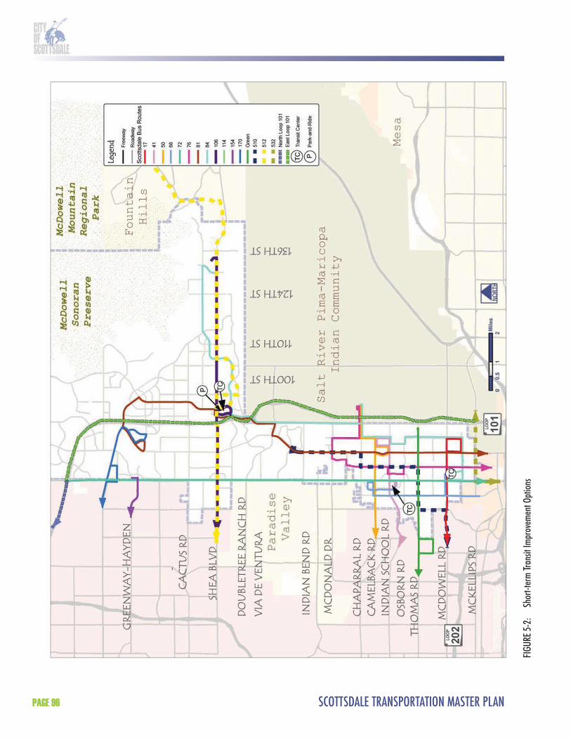
SCOTTSDALE TRANSPORTATION MASTER PLANPAGE 96
FIGU
RE 5-
2:
Shor
t-ter
m Tr
ansit
Impr
ovem
ent O
ption
s

CHAPTER 5 - TRANSIT ELEMENT PAGE 97
TABLE 5-8: Short-term Transit Improvement Options (continued from page 95)Headway
Route Name ImprovementExisting
(peak/off-peak)Short-term
(peak/off-peak)41 Indian School Rd No change 15*/30 No change50 Camelback Rd Increase service frequency and
service span between 44th St and Scottsdale Rd
15/30/60 15/30 to Scottsdale Rd
72 Scottsdale Rd Extend route to Thompson Peak Parkway and increase service frequency
15/30 15/15
76 Miller Rd No change 30/30 No change81 Hayden Rd No change 15/30 No change84 Granite Reef Rd Extend route north on Pima Rd/92nd
S. to Via Linda and combine with Route 114. Increase service frequency and service span.
60/60 30/30
106 Shea Blvd Increase service frequency and service span between PV Mall and 92nd St
30/60 15/30 to 92nd St
114 Via Linda Eliminated (replaced by Route 84 extension)
60/60 n/a
154 Greenway Rd Increase peak service frequency. 30/30 15/30170 Bell Rd No change 30/30 No change
Express Bus510 McCormick Ranch Add two new trips 2 trips (peak
direction)4 trips
512 Fountain Hills Add two new trips 2 trips (peak direction)
4 trips
572 North Loop 101 New two-way route between Surprise and Airpark
---- 8 trips
TBD East Loop 101 New two-way route between Airpark and Chandler
---- 8 trips
Neighborhood CirculatorDT Downtown Trolley No change 10 No changeNC Neighborhood
ConnectorExtend route to serve SkySong Transit Center
20 No change
Source: HDR|SRBA, 2007* only west of Loloma Station.

SCOTTSDALE TRANSPORTATION MASTER PLANPAGE 98
6.0 MID-TERM TRANSIT IMPROVEMENT OPTIONSTh e mid-term (10 year) transit improvement options continue to focus on improving the overall level of fi xed route bus service in Scottsdale. In addition, the mid-term planning horizon introduces substantial new express bus service in the Loop 101 Freeway corridor. Th e mid-term transit improvement options are described below.
6.1 Fixed Route BusTh e goal of the mid-term transit improvement option is to continue to improve transit service in Scottsdale to meet the “unoffi cial” regional standard of service, which is 15 minutes in the peak and 30 minutes in the off -peak
from 5 a.m. to midnight. Th e mid-term transit improvement option follows the same approach as the short-term, in that it advances segments of routes, rather than entire routes.
Th e fi xed bus routes identifi ed in the mid-term transit improvement option are described below.
Route 41 (Indian School Road): Th is route will be extended to Scottsdale Community College from Granite Reef Road so that it connects with Loop 101 express bus service. Route 66 (68th Street): No route change will occur but service frequencies will be improved to 15 minutes in the peak along the entire route in Scottsdale.Route 76 (Miller Road): No route change will occur but service frequencies will be improved to 15 minutes in the peak.Route 170 (Bell Road/Frank Lloyd Wright Boulevard): Extend route to Shea Boulevard via Frank Lloyd Wright Boulevard. Improve service frequencies to 15 minutes in the peak.
6.2 Express BusTh e mid-term transit improvement option includes the addition of the Pima Express bus route which is identifi ed in the RTP for implementation in 2013. Th is is a peak-hour, peak-direction-only express route that operates in the same corridor as the East Loop 101 connector and will use the programmed HOV lanes on the Loop 101. Th is route will connect the Airpark and downtown Phoenix via downtown Tempe.
6.3 Enhanced BusTh e mid-term transit improvement option includes the addition of “enhanced” bus service to the Scottsdale Road corridor between SkySong and Loop 101. Ideally, this service would extend the entire length of the Scottsdale Road/Rural Road corridor from Tempe/Chandler. Enhanced bus service will provide additional frequency, service span, and passenger amenities and accommodate the following characteristics:
Limited stops (major arterials and/or major destinations only); 10-minute peak-hour frequency (no schedule needed); Enhanced shelters with real-time passenger information; Unique branding (bus, shelters, signs); and Transit signal priority.
Valley Metro buses at Loloma Station

CHAPTER 5 - TRANSIT ELEMENT PAGE 99
Th e primary benefi t of the enhanced bus service is that it will off er a faster peak-hour travel time through the corridor by only stopping at major arterials and/or major destinations to increase travel time and facilitate transfers. Existing travel times on the Route 72 (Scottsdale Road) are slow due to frequent stop spacing.
Other potential enhanced bus corridors are Indian School Road, Shea Boulevard, and Bell Road/Frank Lloyd Wright Boulevard. However, these three corridors would require a similar level of service in Phoenix to warrant the investment.
6.4 High Capacity TransitTh e RTP includes funding for arterial bus rapid transit on Scottsdale Road in 2016. Th e design and implementation of arterial BRT will be the subject of further regional study. In the interim, BRT funding could be used for the enhanced bus routes described in the previous section. Th e funding levels of the BRT is more akin to enhanced bus service.
6.5 Neighborhood CirculatorTh e mid-term planning horizon includes enhancements and expansions to the existing neighborhood circulator.
Neighborhood circulators will be considered for use in non-grid areas and in areas where urban development makes typical fi xed route service cumbersome.
Potential areas of use include residential areas north and east of Downtown, Indian School Park, McCormick Ranch, McDowell Mountain Ranch, Chaparral Park, DC Ranch, and in the area of Shea Boulevard and 132nd Street. Th e specifi c routing has not been identifi ed, and will be dependent on a public involvement process similar to other trolley improvements.
Circulators will also be considered to replace fi xed route service on routes that are deemed easier and more cost eff ective to operate as circulators.
Another planning option includes the addition of a new Airpark circulator. Th e implementation of this circulator will be dependent on a number of factors, including the consolidation of transit services at a single location in the Airpark, the completion of the Loop 101/Scottsdale Road park-and-ride, and the ability to connect Loop 101 express bus service with specifi c employment and activity centers.
No changes are proposed to the Downtown Trolley other than to make schedule and route adjustments, as needed.
6.6 ParatransitTh e mid-term transit improvement option includes the gradual expansion of paratransit services available in Scottsdale through the East Valley Dial-a-Ride. Th e East Valley Dial-a-Ride allows for a single service area and provides services for ADA-certifi ed passengers, seniors, and passengers with disabilities. Dial-a-Ride service will need to be expanded as new fi xed route service is added in Scottsdale. ADA requires that complementary paratransit service be provided in all areas within 3/4 mile of fi xed route bus service. It is not recommended that Scottsdale expand the Dial-a-Ride service area beyond what is required by ADA. Additional

SCOTTSDALE TRANSPORTATION MASTER PLANPAGE 100
paratransit service would be more eff ectively provided through the expansion of the Cab Connection program.
6.7 Transit FacilitiesTh e mid-term transit improvement option includes a second regional park-and-ride, three HOV direct access connections in the Loop 101 corridor, and general passenger facility improvements.
6.7.1 Loop 101/Scottsdale Road Park-and-RideTh e Loop 101/Scottsdale Road park-and-ride will serve the north Loop 101 connector, east Loop 101 connector, and Pima express bus routes. Th e preferred location for the park-and-ride is between the Loop 101/Scottsdale Road and Loop 101/Hayden Road interchanges. Th e park-and-ride will accommodate a minimum of 500 vehicles and will be developed to include the following amenities:
Parking spaces for transit riders and carpools (100 percent covered); Bus loading platform; Shelters and seating; Variable message signs; Drop-off zone (kiss-and-ride); Bicycle and pedestrian access; Bicycle storage; Landscaping and lighting, and Opportunities for joint development or joint use.
6.7.2 Loop 101 HOV Direct Access (Scottsdale Road/Hayden Road)Th e mid-term transit improvement option includes HOV direct access connections to the Loop 101/Scottsdale Road park-and-ride as well as to the Airpark. HOV direct access connections allow express buses to enter/exit the center HOV lane on freeways without having to weave through general purpose traffi c and use the general purpose ramps. Th ese facilities add travel time savings for transit/carpools in the peak and additional general purpose capacity in the off -peak.
It is proposed that a full HOV direct access interchange be constructed in the median of the Loop 101 at the half-mile point between Hayden Road and Scottsdale Road. As described above, the preferred location for the park-and-ride is between the Loop 101/Scottsdale Road and Loop 101/Hayden Road interchanges. Th is HOV facility will have the dual benefi t of serving as both an origin and a destination; an origin for park-and-ride users and a destination for the Airpark, One Scottsdale, etc.
6.7.3 Loop 101 HOV Direct Access (Raintree Drive or Northsight Boulevard/Thunder-bird Road)A second full HOV direct access interchange is proposed in the median of the Loop 101 to serve the Airpark directly. Th ere are two potential options:
Add a new HOV direct access connection to the existing Raintree Drive interchange with median HOV ramp connections to the north and south; or
CHAPTER 5 - TRANSIT ELEMENT PAGE 101
Construct a new HOV direct access connection at Northsight Boulevard/ Th underbird Road with ramps to the north and south.
Both of these options provide direct access to the Airpark on the west side of the Loop 101 at this location.
6.7.4 Loop 101 HOV Direct Access (Scottsdale Community College)A third full HOV direct access interchange is proposed in the median of the Loop 101 to serve SCC. Th is location will allow Loop 101 express bus service to provide effi cient transfer opportunities to Downtown from SCC without having to deviate from the Loop 101 corridor. SCC will be served by routes 41, 50, 76, and 84 as well as the East Loop 101 connector and the Pima Express. Th ere are two potential options:
Construct a new HOV direct access connection at Jackrabbit Road with ramps to the north and south; or Construct a new HOV direct access connection at Camelback Road with ramps to the north and south.
Both of these options provide direct access to SCC and Pima Road and will require participation from the SRPMIC.
6.7.5 Passenger AmenitiesIn addition, the mid-term planning horizon continues to focus on improving passenger amenities at existing and new bus stops. Th ese improvements will include the new standard bus shelter and corresponding passenger amenities (seating, trash receptacles, bicycle racks, and other amenities) that will enhance the safety and comfort of transit patrons. Special consideration will be given to improving passenger amenities at high transfer locations where multiple bus routes converge. As service and ridership increase, new amenities such as electronic display boards and real-time passenger information will be introduced.
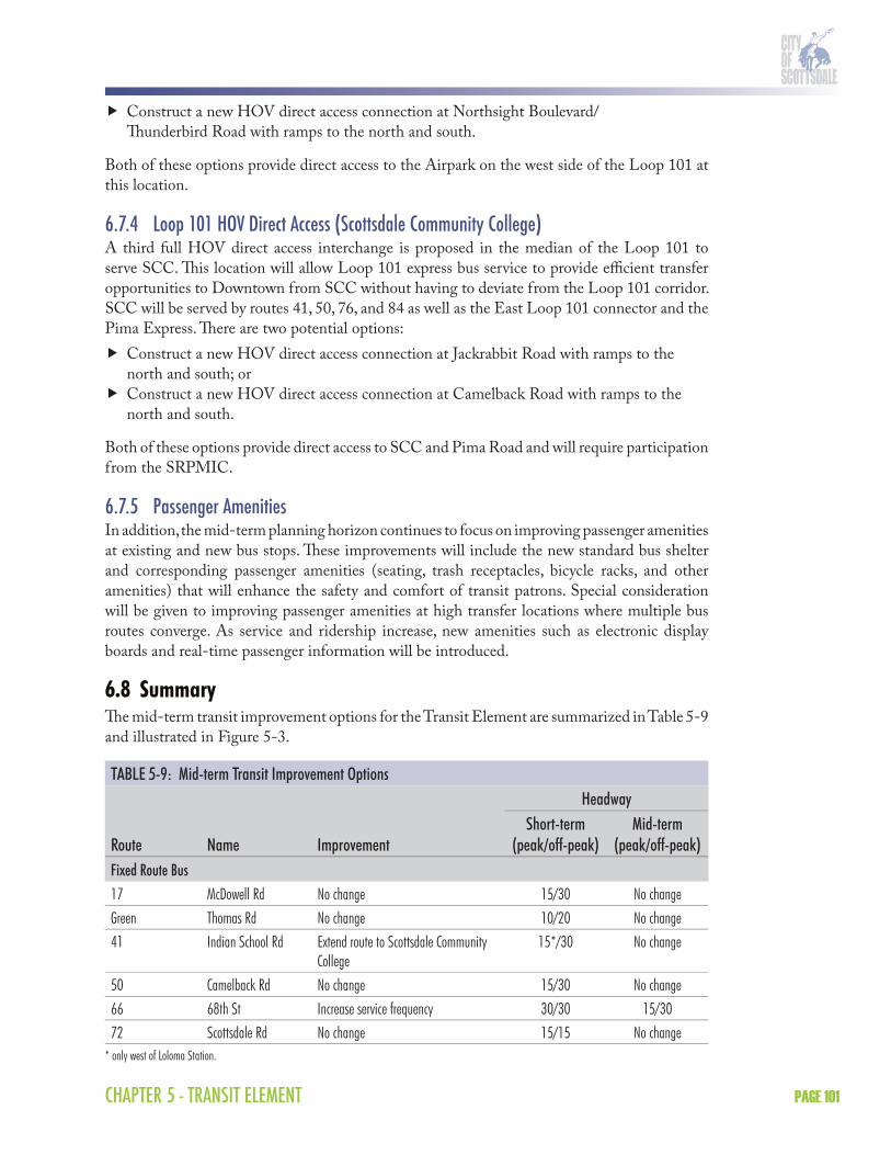
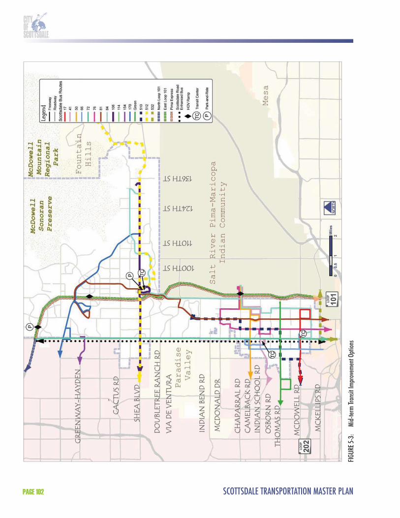
6.8 SummaryTh e mid-term transit improvement options for the Transit Element are summarized in Table 5-9 and illustrated in Figure 5-3.
TABLE 5-9: Mid-term Transit Improvement OptionsHeadway
Route Name ImprovementShort-term
(peak/off-peak)Mid-term
(peak/off-peak)Fixed Route Bus17 McDowell Rd No change 15/30 No changeGreen Thomas Rd No change 10/20 No change41 Indian School Rd Extend route to Scottsdale Community
College15*/30 No change
50 Camelback Rd No change 15/30 No change66 68th St Increase service frequency 30/30 15/3072 Scottsdale Rd No change 15/15 No change
* only west of Loloma Station.
SCOTTSDALE TRANSPORTATION MASTER PLANPAGE 102
FIGU
RE 5-
3:
Mid-
term
Tran
sit Im
prov
emen
t Opt
ions

CHAPTER 5 - TRANSIT ELEMENT PAGE 103
TABLE 5-9: Mid-term Transit Improvement Options (continued from page 101)Headway
Route Name ImprovementShort-term
(peak/off-peak)Mid-term
(peak/off-peak)76 Miller Rd Increase service frequency 30/30 15/3081 Hayden Rd No change 15/30 No change
84 Granite Reef Rd/Via Linda
No change 30/30 No change
106 Shea Blvd No change 15/30 No change154 Greenway Rd No change 15/30 No change170 Bell Rd Extend route to Shea Blvd and increase
service frequency30/30 15/30
Express Bus510 McCormick Ranch No change 4 trips No change512 Fountain Hills No change 4 trips No change572 North Loop 101 No change 8 trips No changeTBD East Loop 101 No change 8 trips No changeTBD Pima New peak-hour, peak direction route
on Loop 101 between the Airpark and downtown Phoenix
---- 8 trips
Enhanced BusTBD Scottsdale Rd. SkySong (or Tempe/Chandler) to
Loop 101---- 10 (peak only)
Neighborhood circulatorDT Downtown trolley No change 10 No changeNC Neighborhood
ConnectorExtend route to serve other areas 20 No change
Source: HDR|SRBA, 2006* only west of Loloma Station.
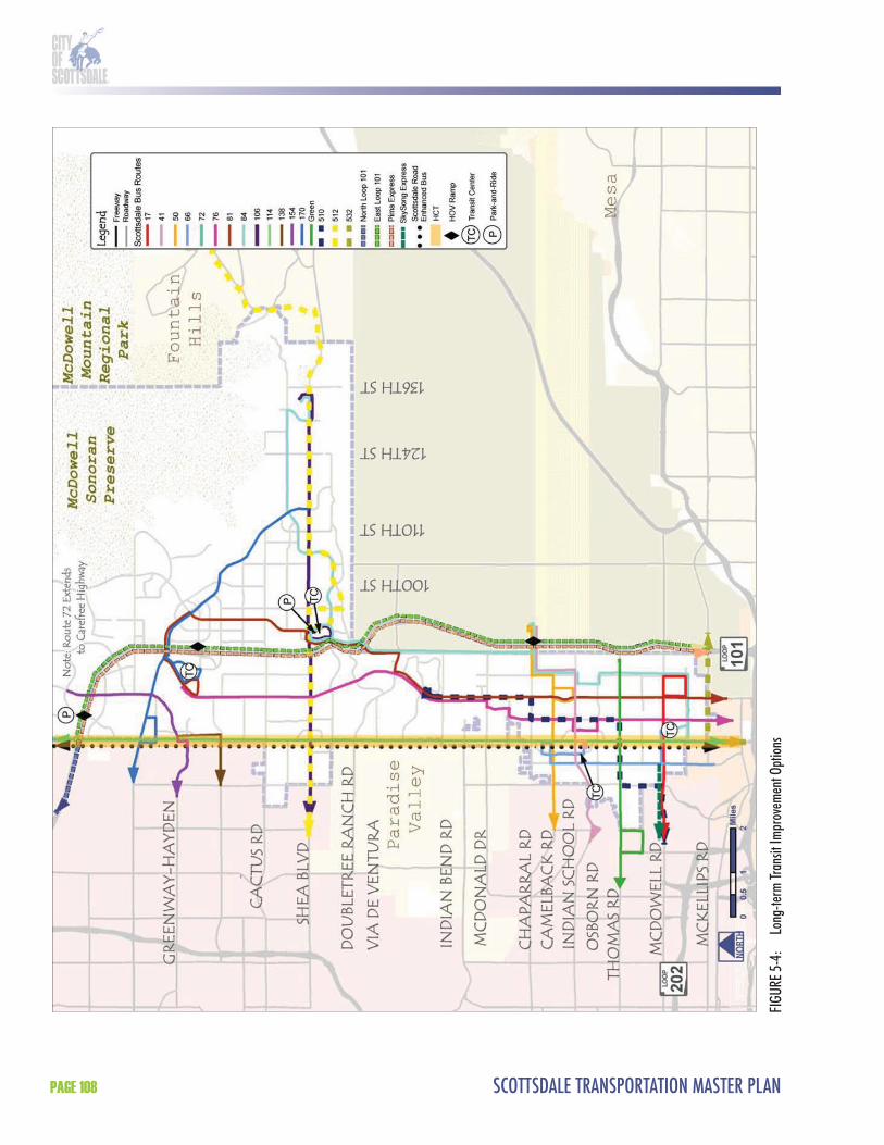
7.0 LONG-TERM TRANSIT IMPROVEMENT OPTIONSTh e long-term (20 year) transit improvement options continue to focus on improving the overall level of fi xed route bus service in Scottsdale. In addition, the long-term planning horizon includes HCT on Scottsdale Road. Some of these improvements are conceptual in nature and will be refi ned in later years. Th e long-term transit improvement options are described below.
7.1 Fixed Route BusTh e goal of the long-term transit improvement option is to complete the transit network in Scottsdale so that it meets or exceeds the regional standard of service, which is 15 minutes in the peak and 30 minutes in the off -peak from 5 a.m. to midnight. Th e long-term transit improvement option fi lls in the remainder of the gaps from the short- and mid-term options.

SCOTTSDALE TRANSPORTATION MASTER PLANPAGE 104
Th e fi xed bus routes identifi ed in the long-term transit improvement option are described below.
Route 17 (McDowell Road): No route change will occur but service frequencies will be improved to 15 minutes in the peak between Scottsdale Road and Pima Road.Green line (Th omas Road): No route change will occur but service frequencies will be improved to 10 minutes in the peak and 20 minutes in the off -peak between Scottsdale Road and Pima Road.Route 41 (Indian School Road): No route change will occur but service frequencies will be improved to 15 minutes between Scottsdale Road and Pima Road. Route 50 (Camelback Road): No route change will occur but service frequencies will be improved to 15 minutes in the peak between Scottsdale Road and SCC.Route 72 (Scottsdale Road): Th is route will be extended north from Loop 101 to Carefree Highway.Route 76 (Miller Road): Th is route will be modifi ed to serve Hayden Road between McDonald Drive and future Airpark transit center.Route 81 (Hayden Road): Reroute to serve future Airpark transit center. Route 84 (Granite Reef/Via Linda): No route change will occur but service frequencies will be improved to 15 minutes in the peak along the entire route. Route 106 (Shea Boulevard): No route change will occur but service frequencies will be improved to 15 minutes in the peak between 92nd Street and Mayo Clinic Scottsdale.Route 138 (Th underbird Road): Th is route will be extended from Paradise Valley Mall to the Airpark.Route 170 (Bell Road): Reroute to serve future Airpark transit center.
7.2 Express BusTh e long-term transit improvement option includes a new express bus route that will connect SkySong with downtown Phoenix. It is proposed that this route operate all day in both directions. Th e primary function of this route will be to complete the “triangle” of transit service between Tempe, Phoenix, and Scottsdale that house Arizona State University’s (ASU) three campuses (ASU Main, ASU Downtown Phoenix, and ASU SkySong). Phoenix and Tempe will be connected by the METRO Central Phoenix/East Valley LRT line while Tempe and Scottsdale will be connected by some form of HCT. Th e connection between Phoenix and Scottsdale is a logical one and could best be served by an all-day, two-way express bus route. Th is route is not identifi ed in the RTP and is currently unfunded.
Th e long-term transit improvement option also includes a new express route on Shea Boulevard that will essentially replace the existing Route 512. Th e new route will be funded regionally and off er a higher frequency of service than the existing Route 512.
7.3 Enhanced BusNo major changes will occur to the enhanced bus service on Scottsdale Road in the long-term transit improvement option. Enhanced bus service will continue to operate on Scottsdale Road between SkySong (or points south if partnered with Tempe/Chandler) and Loop 101. Enhanced bus service will provide additional frequency, service span, and passenger amenities and accommodate the following characteristics:
Limited stops (major arterials and/or major destinations only);
CHAPTER 5 - TRANSIT ELEMENT PAGE 105
10-minute peak-hour frequency (no schedule needed); Enhanced shelters with real-time passenger information; Unique branding (bus, shelters, signs); and Transit signal priority.
Enhanced bus service will be overlaid on existing fi xed route bus service and future high capacity transit service on Scottsdale Road. Th e introduction of HCT (as discussed in Section 6.4) does not preclude the need for enhanced bus in the corridor, since they serve diff erent trip lengths and travel markets. Th e need for peak-hour limited-stop bus service on Scottsdale Road will remain given that the service limits will generally extend farther north and south than the HCT investment.
7.4 High Capacity Transit (HCT)Th e long-term transit improvement option could include the implementation of HCT in the City of Scottsdale. Th e HCT technology for this corridor has yet to be determined and could range from bus rapid transit to modern streetcar or light rail transit. It could also include a combination of technologies throughout the corridor. Potential HCT alternatives will be the subject of further study.
A conceptual level of discussion regarding HCT is included in Section 8.0 of the Transit Element. Th is discussion does not evaluate HCT alternatives, but rather discusses some of the opportunities and constraints of HCT alignments and technologies.
7.5 Neighborhood CirculatorTh e long-term planning horizon will monitor the existing Downtown Trolley and the Neighborhood Connectors and make schedule and route adjustments, as needed.
7.6 ParatransitTh e long-term transit improvement option includes the gradual expansion of paratransit services available in Scottsdale through the East Valley Dial-a-Ride. Th e East Valley Dial-a-Ride allows for a single service area and provides services for ADA-certifi ed passengers, seniors, and passengers with disabilities. Dial-a-Ride service will need to be expanded as new fi xed route service is added in Scottsdale. ADA requires that complementary paratransit service be provided in all areas within 3/4 mile of fi xed route bus service. It is not recommended that Scottsdale expand Dial-a-Ride service beyond what is required by ADA. Additional paratransit service would be more eff ectively provided through the expansion of the Cab Connection program.
7.7 Transit FacilitiesTh e long-term transit improvement option includes HCT infrastructure, a transit center, and general passenger facility improvements.
7.7.1 Airpark Transit CenterTh e long-term transit improvement option includes the future Airpark transit center. Th is facility will provide a new hub for transit services in the northern portion of the City, and could provide convenient transfers between routes 72 (Scottsdale Road), 81 (Hayden Road),
SCOTTSDALE TRANSPORTATION MASTER PLANPAGE 106
138 (Th underbird Road), 154 (Greenway Road), 170 (Bell Road), and the future Airpark circulator, as well as express bus services. Potential site locations have yet to be determined but it is anticipated the transit center will be developed to include the following amenities:
Bus bays; Bus loading platform; Shelters and seating; Variable message signs; Bicycle and pedestrian access; Bicycle storage; Ticket sales and information; Restrooms; Landscaping and lighting; and Opportunities for joint development or joint use.
7.7.2 Passenger AmenitiesIn addition, the long-term planning horizon continues to focus on improving passenger amenities at existing and new bus stops. Th ese improvements will include the new standard bus shelter and corresponding passenger amenities (seating, trash receptacles, bicycle racks, and other amenities) that will enhance the safety and comfort of transit patrons. Special consideration will be given to improving passenger amenities at high transfer locations where multiple bus routes converge. As service and ridership increase, new amenities such as electronic display boards and real-time passenger information will be introduced.
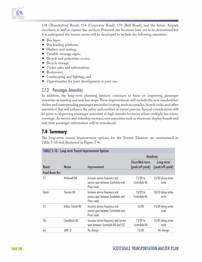
7.8 SummaryTh e long-term transit improvement options for the Transit Element are summarized in Table 5-10 and illustrated in Figure 5-4.
TABLE 5-10: Long-term Transit Improvement OptionsHeadway
Route Name ImprovementShort/Mid-term(peak/off-peak)
Long-term(peak/off-peak)
Fixed Route Bus17 McDowell Rd Increase service frequency and
service span between Scottsdale and Pima roads
15/30 to Scottsdale Rd
15/30 along entire route
Green Thomas Rd Increase service frequency and service span between Scottsdale and Pima roads
10/20 to Scottsdale Rd
10/20 along entire route
41 Indian School Rd Increase service frequency and service span between Scottsdale and Pima roads
15/30 15/30 along entire route
50 Camelback Rd Increase service frequency and service span between Scottsdale Rd and SCC
15/30 to Scottsdale Rd
15/30 along entire route
66 68th St No change 15/30 No change

CHAPTER 5 - TRANSIT ELEMENT PAGE 107
TABLE 5-10: Long-term Transit Improvement Options (continued)Headway
Route Name ImprovementShort/Mid-term(peak/off-peak)
Long-term(peak/off-peak)
72 Scottsdale Rd Extend route from Thompson Peak Pkwy to Carefree Hwy
15/15 No change
76 Miller Rd Reroute to serve Hayden Rd between McDonald Dr and Airpark Transit Center
15/30 No change
81 Hayden Rd Reroute to serve Airpark Transit Center 15/30 No change
84 Granite Reef Rd/Via Linda
Increase service frequency 30/30 15/30
106 Shea Blvd Increase service frequency and service span between 92nd St and Mayo Clinic
15/30 15/30 along entire route
138 Thunderbird Extend route from PV Mall to Airpark ---- 15/30154 Greenway No change170 Bell Reroute to serve Airpark Transit Center 15/30 No change
Express Bus510 McCormick Ranch No change 4 trips No change512 Fountain Hills Eliminated and replaced by Shea/
SR 51 express4 trips Eliminated
572 North Loop 101 No change 12 trips No changeTBD East Loop 101 No change 8 trips No changeTBD Pima Airpark No change 8 trips No changeTBD Loop 202 New all-day, two-way route between
SkySong and downtown Phoenix---- 15/30
TBD Shea/SR 51 Replaces Route 512 ---- 8 trips
Enhanced BusTBD Scottsdale Road SkySong (or Tempe/Chandler) to
Loop 10110 (peak only) No change
Neighborhood circulatorDT Downtown trolley No change 10 No changeNC Neighborhood
ConnectorNo change 20 No change
AC Airpark circulator New Airpark circulator ---- 10/20Source: HDR|SRBA, 2006.
SCOTTSDALE TRANSPORTATION MASTER PLANPAGE 108
FIGU
RE 5-
4:
Long
-term
Tran
sit Im
prov
emen
t Opt
ions
CHAPTER 5 - TRANSIT ELEMENT PAGE 109
8.0 HIGH CAPACITY TRANSITA feasibility study of potential HCT service in Scottsdale was prepared as one component of the Transportation Master Plan. HCT options were evaluated for the Scottsdale Road corridor to connect major activity centers, including Downtown Scottsdale, SkySong, downtown Tempe, and Arizona State University (ASU). Th e feasibility study was the fi rst step in the transit planning process; subsequent planning eff orts will likely be based on this study and could follow the Federal Transit Administration Alternatives Analysis process. Th e HCT Feasibility Study was not federally sponsored and was being initiated by the City of Scottsdale only to identify recommendations for the Scottsdale Road HCT corridor. Because Scottsdale Road was recommended as the preferred HCT corridor in the Scottsdale/Tempe North/South Transit Corridor Study (2003), this study focuses on this corridor as a logical evolution of the HCT planning process.
Th e HCT Feasibility Study examined HCT transit within the City of Scottsdale only. Th e primary study area was bounded by Chaparral Road to the north, McKellips Road to the south, and the City limits to the east and west (Figure 5-5). Potential HCT options north of Chaparral Road were considered in the evaluation of the HCT alternatives and should be examined in regional studies or as part of an FTA Alternatives Analysis.
Th is HCT Feasibility Study analyzed mobility needs and identifi ed and compared the costs, benefi ts, and impacts of three HCT technology alternatives:
Bus Rapid Transit (BRT); Light Rail Transit (LRT); and Modern Streetcar.
Th e study included input from the general public, project stakeholders, (e.g., adjacent neighborhoods, business owners, etc.) and local, regional, state, and federal agencies.
8.1 Purpose and Need8.1.1 What is the Transportation Problem?From 2000–2003, the Scottsdale/Tempe North/South Transit Corridor Study examined the feasibility of a HCT system to serve travel in selected north/south corridors in Scottsdale and Tempe. Given anticipated travel demand on the Loop 101 Freeway and limited opportunities to expand the existing roadway system, transit options represented the most feasible method to serve the traveling public and increase person capacity in these corridors. Th e purpose of the 2003 study was to identify improvements that could reduce existing and future traffi c congestion, while improving mobility options in the study corridor. While there may be some public perception that the HCT Feasibility Study section of the Transportation Master Plan is

SCOTTSDALE TRANSPORTATION MASTER PLANPAGE 110
FIGURE 5-5: High Capacity Transit (HCT) Primary Study AreaSource: HDR|SRBA, 2006
CHAPTER 5 - TRANSIT ELEMENT PAGE 111
intended only to identify options to relieve traffi c congestion, the purpose of this feasibility study is also to provide a new mobility option that provides frequent, all day service to employment, residential, commercial, retail, entertainment, educational, civic, and cultural activities in the Scottsdale Road corridor. Th e Scottsdale Road fi xed-route bus service (Route 72) is the City’s strongest transit corridor. Using the Scottsdale Road corridor for HCT capitalizes on this route with expanded service and ridership possibilities.
Scottsdale Road HCT CorridorTh e HCT Feasibility Study evaluated alternatives for the Scottsdale Road corridor as recommended by the Scottsdale City Council in their approval of the Scottsdale/Tempe North/South Transit Corridor Study on February 25, 2003. Th e Council designated Scottsdale Road as the primary corridor and recommended that BRT, LRT, and modern streetcar be evaluated in future studies. At that time, the City Council also approved Loop 101 as a secondary corridor, to serve commute activity. Proposition 400 (countywide transportation sales tax) funding was provided for services in both corridors, but at a lower level of service than identifi ed in the 2003 study recommendations.
During the study period, some of the public discussion centered on whether the Loop 101 should be the preferred HCT corridor instead of Scottsdale Road. Th e primary reasons for the selection of Scottsdale Road over Loop 101 include the following:
Th e Loop 101 Freeway is planned and funded in the RTP as an express bus/BRT corridor, which will provide peak-hour express service using HOV lanes during the times of day when the freeway is most congested and be consistent with the types of trips generated by the predominantly commercial land use in this corridor. Preliminary stops in or near Scottsdale include Scottsdale Community College, Scottsdale Healthcare Shea campus, and the Scottsdale Airpark;Scottsdale Road is the City’s greatest activity corridor, with all-day and evening employment, residential, commercial, retail, entertainment, educational, civic, and cultural uses. MAG socioeconomic projections for 2030 indicate that these higher concentrations of both population and employment will continue to follow the Scottsdale Road corridor in the future;Th e Scottsdale/Rural Road corridor is identifi ed as an HCT corridor in the RTP and is currently funded for enhanced transit services through Proposition 400 funds available in 2014. Th is corridor extends the length of Scottsdale/Rural Road between Shea Boulevard and Chandler Boulevard, through the cities of Scottsdale, Tempe, and Chandler. Initial funding is proposed for BRT during peak hours;HCT in the Scottsdale Road corridor would provide transfer opportunities with most major east/west bus routes in the region. If HCT were located on Loop 101 to serve Scottsdale, additional transit investment (buses, shuttles, etc.) would be needed to connect the Loop 101 corridor with these bus routes and Scottsdale Road activity centers and places of employment;Loop 101 transit improvements, while helping meet regional mobility needs and potentially providing an important transit connection to the Scottsdale Airpark, will be placed outside of the City’s most populated and pedestrian-oriented core area. Transit provided along the Loop 101 corridor misses a key regional destination/connection opportunity between Downtown Scottsdale and downtown Tempe, and does not connect the two major research centers at SkySong and ASU; and
SCOTTSDALE TRANSPORTATION MASTER PLANPAGE 112
Freeway widening for HOV lanes (beginning in 2007) and general purpose lanes (beginning in 2014) will provide additional capacity for automobile travel on the Loop 101. Widening Scottsdale Road to provide additional vehicular capacity would be costly and require signifi cant additional ROW, creating detrimental impacts to the City’s character and Downtown.
Previous Transportation/Transit InitiativesTh ere has been a wide range of approaches to transportation initiatives in Maricopa County and the City of Scottsdale over the past 20 years. In both 1989 and 1994, proposals to provide regional transportation funding for transit were defeated by Maricopa County voters. At this point, Valley cities began to seek transit funding on a city-by-city basis, with a few cities being successful in this approach. Also in 1989, a 0.2 percent Transportation Privilege Tax was approved by Scottsdale voters. In 1997, voters rejected the City of Scottsdale “Transit Plus” proposal, which included expanded fi xed route bus service, express bus service, neighborhood circulators, Dial-a-Ride service and capital infrastructure improvements.
Th e Scottsdale City Council allows up to 50 percent of the 0.2 percent Transportation Privilege Tax to be utilized for operations such as transit service. Th e portion of the privilege tax not used for operations can be used for various transportation capital improvements, including transit infrastructure. Th e 0.2 percent privilege tax currently generates approximately $21 million per year in Scottsdale.
Th e MAG RTP was approved by voters in 2004 through Proposition 400 which extended the region’s half-cent sales tax for transportation. Th e RTP includes a number of transit improvements programmed for the City of Scottsdale, including local bus, express bus, and HCT improvements, as well as transit capital facility improvements. As more transit services are provided through the RTP and Proposition 400, local funding will be freed up to put towards other transit services as well as new routes that will be created through the RTP.
8.1.2 Statement of PurposeTh e purpose of the HCT Feasibility Study is to identify potential HCT alternatives for the Scottsdale Road corridor. Th e overall long-range transportation goal is to provide an effi cient, appropriate, and integrated transit connection that off ers convenient, accessible, and aff ordable mobility within the study area and maximizes connectivity to the regional HCT and transit system.
Goals and ObjectivesGoal 1: Improve transportation mobility and capacity along the Scottsdale Road corridor.
Objectives
Provide convenient access to major employment, commercial, retail, residential, educational, recreational, medical, civic, and cultural activity centers along the Scottsdale Road corridor.Provide a connection between Downtown Scottsdale and downtown Tempe, and between the two major research centers at SkySong and ASU.Provide better connectivity between neighborhoods and activity centers.

CHAPTER 5 - TRANSIT ELEMENT PAGE 113
Provide improved access to an employee workforce for Scottsdale employers, and convenient access for employees to their workplaces.Increase north/south travel capacity in and to Scottsdale. Provide future access to the regional HCT system. Improve access for students and transit-dependent populations.
Goal 2: Maximize the efficiency, effectiveness, and compatibility of the transit investment.
Objectives
Provide expanded and reliable transit service, including increased frequency and a longer span of service.Provide multi-modal (pedestrian, bicycle, bus, and automobile) access to the transportation system.Provide transit service that is user-friendly and attractive to daily users and occasional users, such as visitors.Develop safe, comfortable, and convenient transit facilities, such as stations and stops. Ensure compatibility with existing transit services. Attract new riders to the transit system. Provide a sustainable transit investment that is consistent with the City’s environmental policies.Promote travel demand management and parking management strategies.
Goal 3: Coordinate the transit investment with land use.
Objectives
Ensure consistency with the General Plan.Ensure consistency with local and regional plans developed by the City of Scottsdale, and partner jurisdictions.Accommodate a mixture of activities and densities per the General Plan.Support economic development and pedestrian/transit oriented development per the General Plan.
Goal 4: Promote a transit investment that is environmentally sustainable and compatible with the built environment.
Objectives
Implement a project that minimizes adverse impacts during construction and operation. Minimize impacts on historic, archaeological, traditional cultural places, parklands, and other sensitive uses.
Goal 5: Provide a transit investment that can be implemented within budget constraints.
Objectives
Minimize capital costs. Provide opportunities for public-private partnerships. Minimize operating and maintenance costs. Maximize cost eff ectiveness.
SCOTTSDALE TRANSPORTATION MASTER PLANPAGE 114
MethodologyTh e HCT Feasibility Study has compiled project information in suffi cient detail so that citizens, stakeholder groups, local and federal agencies, elected offi cials, and other study participants can make informed decisions on the HCT alternatives along the Scottsdale Road corridor and about future steps to advance those alternatives into project development. Th is information will include, but is not limited to, the following:
Development of HCT alternatives; Evaluation of HCT alternatives using a variety of criteria, including rider benefi ts, land use, economic development, traffi c issues, populations served, environmental issues, design issues, costs, and community support; andDefi nition of the supporting transit system that integrates with the HCT alternatives.
On February 6, 2007, in response to citizen petitions, the Scottsdale City Council voted to allow a public vote on high capacity transit in the event that rail transit is proposed.
On December 11, 2007, the City Council opted to join METRO to enable the City’s participation in the north/south HCT study currently underway among METRO, Tempe, and Chandler.
8.1.3 HCT Study Area DescriptionTh e following is a description of the study area’s existing conditions, including land use, demographics, physical barriers and features, and transportation facilities and services.
Land UseExisting land use in the study area includes two major activity centers, Downtown and SkySong, along with local business districts, employment centers, entertainment venues, residential areas, historic neighborhoods, resorts, community facilities, and other uses along the Scottsdale Road corridor. Th e General Plan land use map for this area is included as Figure 5-6.
Downtown ScottsdaleDowntown Scottsdale ranks among the top major activity centers in the region. Downtown includes a diverse range of employment, residential, commercial, retail, entertainment, educational, civic, and cultural facilities.
Mixed-Use – Downtown has experienced signifi cant new and revitalization projects that have either recently been built or are planned for construction during the next fi ve years (Figure 5-7). Th e nearly $3 billion in public and private investment includes a mix of residential, retail, and offi ce uses. Developments with more than $10 million in investment include Scottsdale Waterfront, W Hotel, Main Street Plaza, Hotel Valley Ho, Th ird Avenue Lofts, Galleria Corporate Center, Scottsdale Oasis, Scottsdale Healthcare Osborn, Stetson Plaza/South Canal Bank Project, Main Street Residences, Portales Residential, and Optima Camelview (Figure 5-7).Residential – Downtown includes a wide variety of residential units, including new development and older single-family and multi-family residential. New residential and mixed-use projects, including those listed above, are expected to result in 2,000–2,500 additional residential units in the near future.

CHAPTER 5 - TRANSIT ELEMENT PAGE 115
FIGURE 5-6: Scottsdale General Plan Land Use Map (south of Mountain View Road)Source: City of Scottsdale, General Plan, Conceptual Land Use Map, 2005.
Retail – Th e Downtown districts are known for their unique retail opportunities. Scottsdale Fashion Square in the northwest quadrant of Downtown has approximately 1.8 million square feet of gross fl oor space including Nordstrom’s, Macy’s, and an upcoming Barneys of New York. Th e Fifth Avenue Shops, Old Town, and the Arts District provide upscale retail and art gallery shopping opportunities. Th e Scottsdale Waterfront (Figure 5-8) is currently under construction and includes 1.1 million square feet of mixed-use retail, offi ce, and residential. Th ese combined areas are regional trip generators for tourists and residents. Civic – Th e Scottsdale Civic Center Mall lies in the southeast quadrant of Downtown and includes the Scottsdale City Hall and City offi ces, the Civic Center Public Library, cultural and museum space, open space, and event gathering space. Th e Civic Center Mall area is bordered by restaurants, bars, and a hotel.
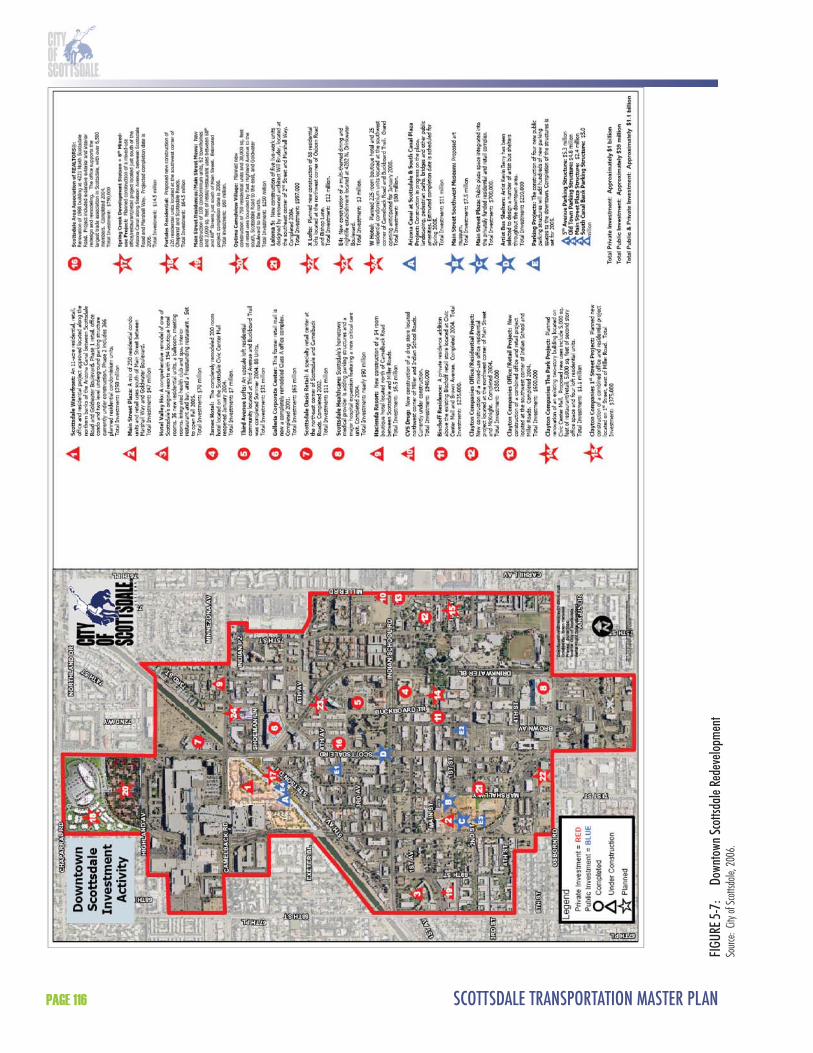
SCOTTSDALE TRANSPORTATION MASTER PLANPAGE 116
FIGU
RE 5-
7:
Down
town
Scot
tsdale
Red
evelo
pmen
tSo
urce:
City
of Sc
ottsd
ale, 2
006.

CHAPTER 5 - TRANSIT ELEMENT PAGE 117
FIGURE 5-8: Scottsdale WaterfrontSource: City of Scottsdale, 2006.

SCOTTSDALE TRANSPORTATION MASTER PLANPAGE 118
SkySongSkySong (formerly called the ASU-Scottsdale Center for New Technology and Innovation), is a 42 acre site located two miles south of Downtown at the southeast corner of McDowell Road and Scottsdale Road (Figure 5-9). Th e initial phase of the center will be completed in 2008 and will include up to 300,000 square feet of research and offi ce space with street level retail, service facilities, and ultimately a 325-unit apartment complex. It is anticipated that the full build-out of this site will include over 1 million square feet of research and offi ce space, employment for 4,000 people, and a total of $300 million in capital investment. Entertainment and retail at SkySong are envisioned to keep the center active after 5 p.m. by providing unique live/work/play opportunities. SkySong has the potential to serve as a southern anchor to Downtown and support development in the approximately two-mile area between the southern boundary of Downtown (Osborn Road) and SkySong (McDowell Road). Th e circulation impact of SkySong is being evaluated as part of the traffi c modeling process used for the Transportation Master Plan. A transit center is planned and funded, with a combination of Federal grants and local dollars, adjacent to SkySong.
Arizona State University (ASU) Tempe Campus and Downtown TempeWhile outside the City of Scottsdale and the primary study area, the ASU Tempe campus and downtown Tempe are important future connections for the HCT alternatives in the Scottsdale Road corridor. Both are located approximately two miles south of the study area, with the ASU Tempe campus adjacent to Scottsdale/Rural Road and downtown Tempe located approximately a half mile west. Th e ASU Tempe campus includes a planning area of approximately 700 acres (Figure 5-10). ASU is an internationally recognized metropolitan Research I University and the Tempe campus off ers a wide range of degrees and programs. Currently, there are approximately 51,000 students and 15,000 faculty/staff on the ASU Tempe campus. Several thousand of these students and faculty/staff live in Scottsdale. Downtown Tempe includes 1.2 million square feet of offi ce space with 7,500 employees and off ers an entertainment district that includes restaurants, bars, shopping, and major hotels. Like Downtown Scottsdale, it is experiencing an infl ux of residential and mixed-use projects.
Historic Properties and NeighborhoodsDowntown includes seven signifi cant historic structures that represent the early development of the community from 1892 to 1933. Figure 5-11 shows the location of Scottsdale’s historic properties. Six of these are located in the Old Town area on or near Main Street and Brown Avenue. Th ese Downtown Historic Register structures include a bank, post offi ce, pool hall, two schools, one church, and a blacksmith shop. Also on the Register is a territorial residence built in 1892 on Hayden Road south of the Downtown. Six properties placed on the Scottsdale Historic Register because of their importance to Scottsdale’s development as an arts and tourism destination during the 1950s include two restaurants, one complex of art/retail buildings on Fifth Avenue, one retail store, one resort hotel on the western edge of the Downtown, and one motor court apartment of adobe construction. Th ere are two residential neighborhoods within the study area that have received historic preservation overlay zoning and that represent postwar subdivision practices. Th ey are Village Grove 1-6 and Town and Country Scottsdale. Th ese two neighborhood historic districts are on either side of Scottsdale Road over one mile south of the Downtown.
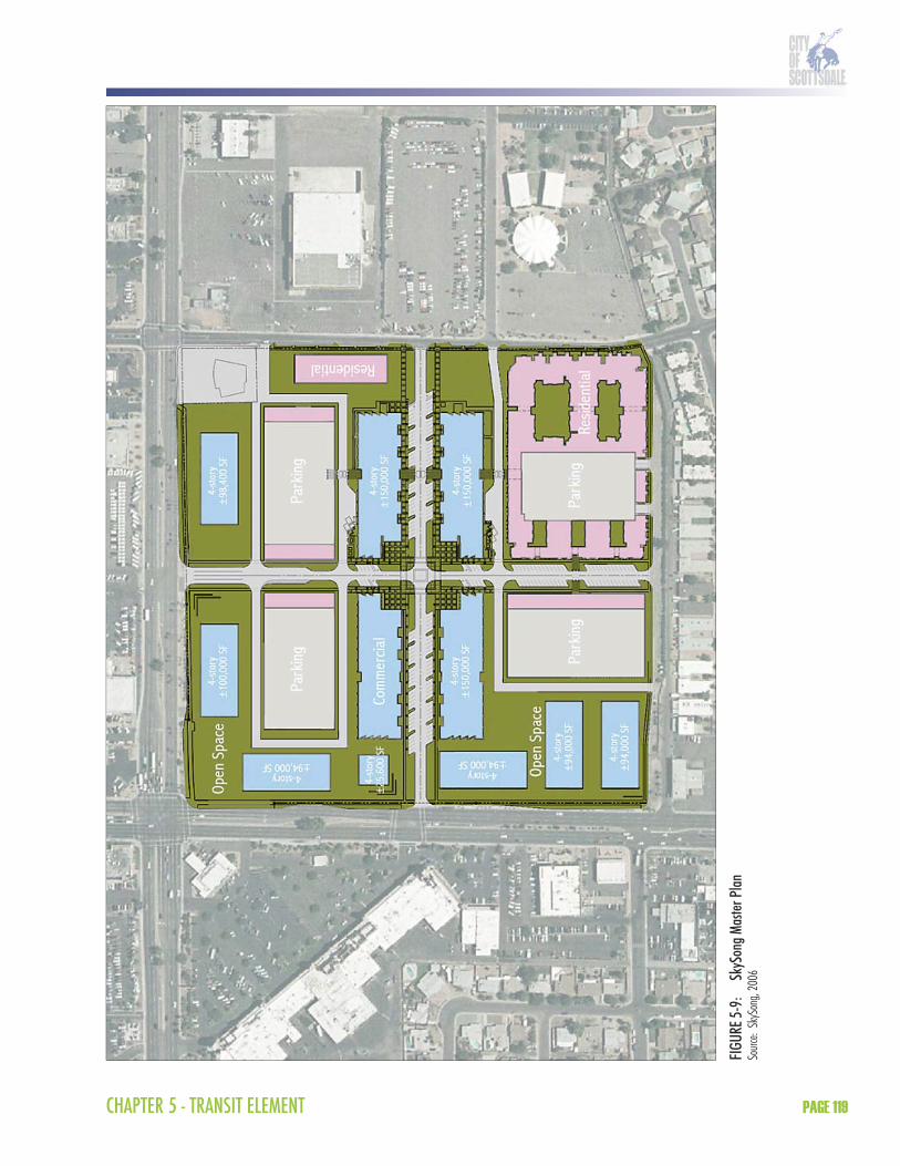
CHAPTER 5 - TRANSIT ELEMENT PAGE 119
FIGU
RE 5-
9:
SkyS
ong M
aster
Plan
Sourc
e: Sk
ySon
g, 20
06

SCOTTSDALE TRANSPORTATION MASTER PLANPAGE 120
FIGURE 5-10: ASU Tempe CampusSource: Arizona State University, 2005.
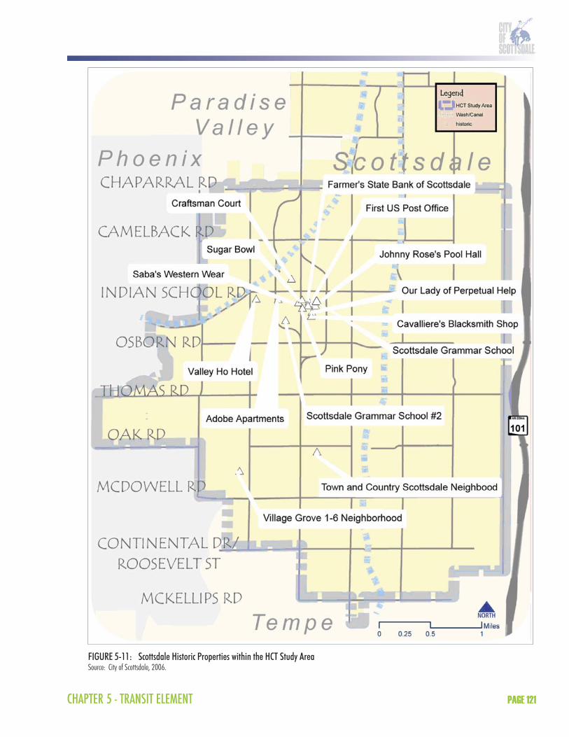
CHAPTER 5 - TRANSIT ELEMENT PAGE 121
FIGURE 5-11: Scottsdale Historic Properties within the HCT Study AreaSource: City of Scottsdale, 2006.

SCOTTSDALE TRANSPORTATION MASTER PLANPAGE 122
Population and EmploymentExisting population and employment data is available by Maricopa County Traffi c Analysis Zone (TAZ) from MAG. According to MAG, the 2000 population (based on the 2000 Federal Census) in the study area is approximately 65,000. Th e projected 2030 population in the study area is 70,000, which represents a 9 percent increase. Th e 2000 employment is approximately 50,000 employees while the projected 2030 employment is 55,500, representing an 11 percent increase. Th ese population and employment growth rates are similar to trends occurring throughout the more mature areas in the region, where land is for the most part developed and the future population and employment growth will need to integrate into the existing built environment.
Physical Constraints and FeaturesTh e City of Scottsdale is a narrow city with a north/south orientation that is constrained by unique physical features and natural barriers. Th e study area is bounded on the west, south, and east by the jurisdictional boundaries of the city of Phoenix, the town of Paradise Valley, the city of Tempe, and the Salt River Pima-Maricopa Indian Community. In addition, the Loop 101, Indian Bend Wash, the Crosscut and Arizona canals, Papago Park, Camelback Mountain, and the Salt River/Tempe Town Lake can disrupt the existing roadway network and place additional strain on the major transportation corridors.
Transportation Facilities – Roadways and ParkingRoadway FacilitiesTh e roadway facilities in or near the study area range from freeways to the arterial and collector street grid network, as shown in Figure 5-12. Roadway options in Scottsdale have changed over the last 10 years with the completion of the Loop 101 (Pima) freeway. Th e freeway is located east of Scottsdale (and the study area) on the SRPMIC south of 92nd Street and in the City of Scottsdale north of 92nd Street. Interchanges near the study area are located at one-mile intervals at McKellips Road, McDowell Road, Th omas Road, Indian School Road, and Chaparral Road. With the exception of Chaparral Road, these roads are all major or minor arterials in the study area. Chaparral Road is a major collector roadway that is primarily residential in character and narrows to two lanes for a quarter mile section between Miller Road and 78th Street. In May 2007, the City Council directed staff to remove the consideration of widening the narrowest section of Chaparral Road from Transportation Master Plan deliberations.
Scottsdale Road, McDowell Road, and Hayden Road are the only continuous major arterials in the study area. Pima Road currently operates as a continuous collector adjacent to the Loop 101. Granite Reef Road, Miller Road, 68th Street, and 64th Street primarily operate as collectors within the study area and are residential in character. Refl ecting a mixture of commercial and residential uses, 68th Street is primarily a residential collector that is a minor arterial between Th omas Road and Indian School Road. Osborn Road and Oak Street operate as collector streets as well, however, these roadways are not continuous, with Osborn Road converting to a residential street east of Hayden Road and Oak Street diverting around El Dorado Park.
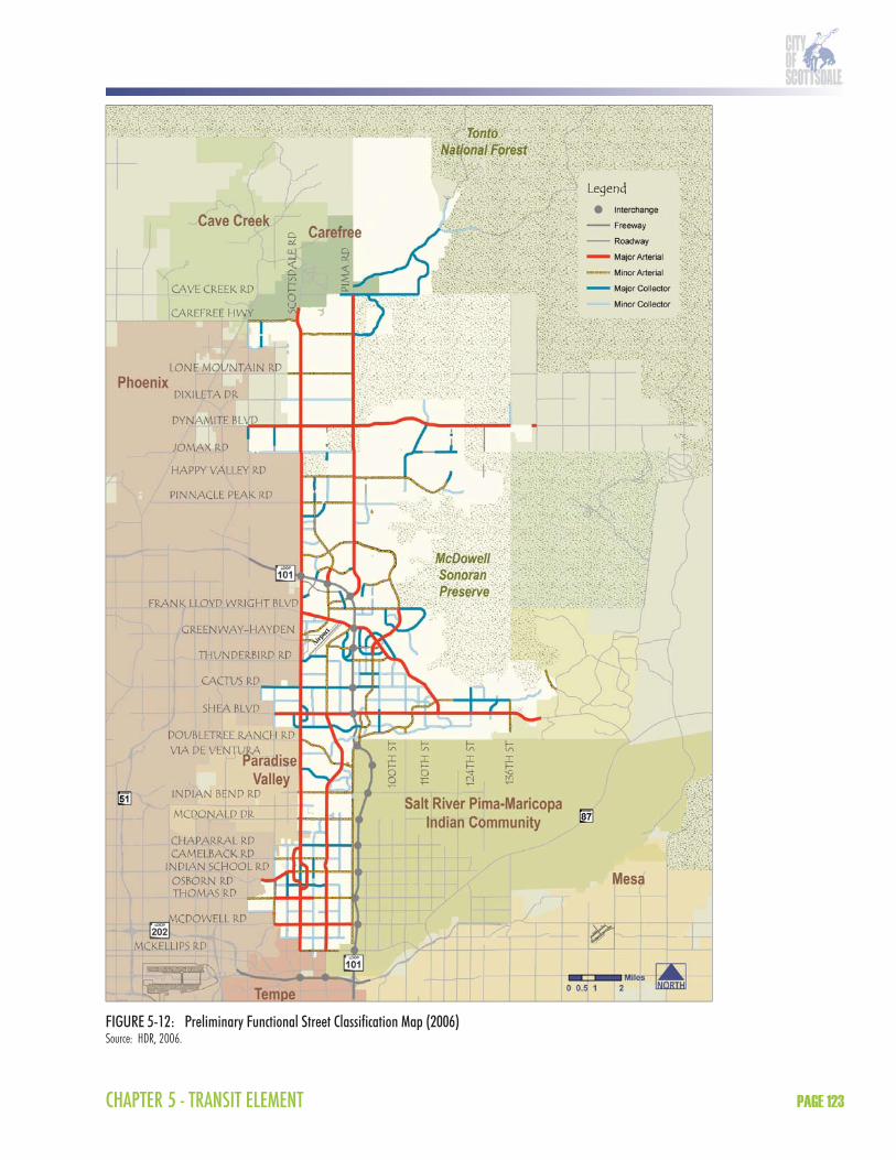
CHAPTER 5 - TRANSIT ELEMENT PAGE 123
FIGURE 5-12: Preliminary Functional Street Classification Map (2006)Source: HDR, 2006.
SCOTTSDALE TRANSPORTATION MASTER PLANPAGE 124
Th e roadway network also includes the Goldwater Boulevard and Drinkwater Boulevard couplet, which is designed to provide an alternative to Scottsdale Road through Downtown. Because Goldwater Boulevard is approximately a half-mile longer than Drinkwater Boulevard and crosses Camelback Road, it functions more effi ciently than Drinkwater Boulevard. Scottsdale Road and Drinkwater Boulevard traffi c merges one block south of Camelback Road adding to congestion at the Camelback Road intersection. Th e southern transition of traffi c merge of Drinkwater Boulevard to Scottsdale Road is not at a signalized intersection, making the travel option south (turning left onto Scottsdale Road from Drinkwater Boulevard) more diffi cult. Th ere appears to be excess capacity on both Scottsdale Road and the couplet in and through Downtown.
Several major transportation facilities improvements are planned and/or programmed in southern Scottsdale. Street projects to complete roadways with pedestrian improvements and/or traffi c capacity improvements include sections of Indian School, Camelback, McDonald and Indian Bend roads. Th ere are several streetscape projects to improve pedestrian and bicycle amenities along existing roadways, including Scottsdale, McDowell, and Th omas roads. In addition, shared-use bike path projects are programmed along the Crosscut Canal and Indian Bend Wash paths. Pima Road has been identifi ed in the RTP to be widened to function as a minor arterial and a study is underway to complete roadway design south of 92nd Street. Th e Loop 101 Freeway has been identifi ed for planned improvements in the RTP that include one general purpose and one HOV lane in each direction throughout Scottsdale.
ParkingFollowing are descriptions for existing parking conditions for Downtown and SkySong. Th e ASU Tempe campus is also discussed given its relevance to the HCT Feasibility Study.
Downtown ScottsdaleTh e City has commissioned various consulting groups and citizen committees over the years to analyze parking in the Downtown. Th e most recent study was conducted in 2003 by Walker Parking Consultants. In response to the various study recommendations, parking facilities have been built over time. Today, Downtown parking is comprised of approximately 8,000 public spaces and 30 public parking facilities. Seven of the facilities are public garages, four of which were built within the last three years. Approximately 60 percent of the public spaces Downtown are signed with three-hour time limits and are enforced with two parking enforcement personnel sharing one full time equivalent position. Public parking Downtown is free during the day. Th e City currently provides valet service only at one parking garage in the Northeast Quadrant (north of Indian School Road, east of Scottsdale Road). Th e City allows valet services to operate and a City license is required for each location served. In exchange for using 40 public curbside spaces, valet companies add approximately 600 spaces to the parking supply by leasing private spaces that would otherwise be closed to use at night.
SkySongTh ere will be approximately 4,000 parking spaces to serve 1.2 million square feet of development at SkySong. Parking guidelines for the site include a desire to integrate with the community and to preserve the pedestrian nature of the site. Th e parking will be made available through on-street parking (particularly for retail establishments), surface parking lots, and parking structures. Th e design guidelines call for parking management incentives and shared parking through mixing of uses with diff erent time of day needs. In addition, active promotion of alternative modes of
CHAPTER 5 - TRANSIT ELEMENT PAGE 125
transportation (transit, bicycles, and pedestrians) is encouraged to minimize the reliance on automobiles. To accommodate future transit use and shuttles to SkySong, the City is developing a transit center in the vicinity.
ASU Tempe CampusTh e ASU Tempe campus has up to 60,000 people accessing the campus each day and currently has 20,000 parking spaces. With a range of alternative transportation mode options, primarily the use of bicycles, the current parking has been suffi cient. However, the planned ASU Rio Salado development of several existing large surface lots will result in the loss of approximately 25 percent of available parking. Th is signifi cant parking reduction is expected to encourage transit and pedestrian access to the campus. Because the ASU campus master plan calls for no net increase in parking, ASU has recognized that a mix of innovative strategies will be required to meet mobility demand. An ASU Parking and Transit Task Force has been formed and is in the process of completing recommendations that include continuation of the one-year pilot unlimited access student transit pass program, parking rate modifi cations, the maximum use of existing bus and future LRT service, and the building of remote parking lots with shuttle service or biking opportunities.
Transportation Facilities and Service - TransitExisting transit service in the City of Scottsdale is characterized by fi xed route bus service operating on the arterial and collector grid system, along with express bus service, neighborhood circulators, and paratransit. Almost all of the fi xed bus routes in Scottsdale connect to other jurisdictions and the service is contracted to an outside provider. Th e majority of transit service is focused south of Frank Lloyd Wright Boulevard, where the highest population and land use densities are located.
Th e City of Scottsdale has made recent improvements to its fi xed route bus service. Service and frequency improvements have been implemented on a number of its routes, including Route 72 on Scottsdale Road. In addition, the City implemented its second circulator route, known as the Neighborhood Connector, in 2006. See Section 3.0 of the Transit Element for discussion of transit service in Scottsdale.
Transit FacilitiesExisting transit facilities range from on-street passenger facilities such as bus stops to large facilities such as park-and-rides and transit centers. Th e City of Scottsdale has developed a new standard for bus stop shelters and passenger amenities and has installed new shelters at various locations throughout the City during the past few years. Existing park-and-rides within the City of Scottsdale are joint-use facilities in which informal agreements have been established for shared parking arrangements. Loloma Station in Downtown is the City’s transit center. Further detail on these facilities is provided in Table 5-11 on the following page.

SCOTTSDALE TRANSPORTATION MASTER PLANPAGE 126
TABLE 5-11: Existing and Planned Transit FacilitiesTransit Facility Location Bus Routes ServedPark-and-Rides
Chaparral Park Hayden and Jackrabbit, NE Corner 81, 50
Costco Butherus and 83rd Place, NE Corner 81, 170
Dial Tech Center Scottsdale and Butherus, NE Corner 72
Miller Plaza Montecito and Miller, NW Corner 50, 76, 510
Trinity Church Hayden and McCormick Parkway, SE Corner 81, 510
Mustang Library/SHC 90th Street and Shea area TBDLoop 101/Scottsdale Rd TBD TBDAirpark TBD TBD
Transit CenterLoloma Station Marshall and 2nd Street, NW Corner 41, 66, 72, 76, Downtown Trolley,
Neighborhood Connector
SkySong Scottsdale and McDowell area TBDMustang Library/SHC 90th St and Shea Blvd area TBDNote: Planned facilities are in blueSource: Valley Metro/RPTA, 2006. City of Scottsdale, 2007
8.2 Need for the Proposed ActionTh e purpose and need for the HCT Feasibility Study is based on the following themes:
Connect major activity centers Create a transit priority corridor Address changes in travel patterns Recognize geographic constraints Provide alternatives to single occupant vehicles Support revitalization Create a sustainable transportation investment
Connect Major Activity CentersTh e proposed HCT investment will link together existing and future major activity centers along the Scottsdale Road corridor. Many of these major activity centers, including Downtown Scottsdale, SkySong, downtown Tempe, and the ASU Tempe campus, are linked with trips between them during all parts of the day. Long-term plans will include linking Downtown to points north, including the resort corridor, Shea Boulevard/Scottsdale Road, and Scottsdale Airpark.
Downtown ScottsdaleDowntown Scottsdale ranks among the top major activity centers in the region. Th e Downtown area includes a diverse range of employment, residential, commercial, retail, educational, civic, and cultural facilities. Th e proposed HCT alternatives serve a variety of major activity centers, including Scottsdale Healthcare Osborn, Old Town, Fifth Avenue Shops, Scottsdale Arts District, Scottsdale Fashion Square, Scottsdale Waterfront, Scottsdale Civic Center, Scottsdale Center for the Performing Arts, Scottsdale Museum of Contemporary Art, Scottsdale Stadium,
CHAPTER 5 - TRANSIT ELEMENT PAGE 127
and Loloma Transit Station. In addition, there is nearly three billion dollars in new public and private investment planned or under construction. Much of this development is residential development in the form of condos or townhomes.
SkySongSkySong is an important revitalization eff ort in the Scottsdale Road and McDowell Road area. Th is development will require a high level of transit service to provide a connection north to Downtown and south to the ASU Tempe campus. SkySong will be a mixed-use research center with 300,000 square feet of offi ce space in Phase I and over 300 apartments. It is anticipated that there will be 4,000 employees that will work at this location. Transit is anticipated to be a key component of circulation to and from SkySong and the project master plan includes a transit center and alternative transportation strategies.
ASU Tempe Campus and Downtown TempeTh e HCT investment is proposed to provide a connection between Downtown Scottsdale and downtown Tempe and ASU. HCT will support connections to the ASU Tempe campus, which currently includes 51,000 students and 15,000 faculty and staff . Th e ASU campus master plan anticipates a 6 percent increase in enrollment for the ASU Tempe campus, with approximately 35 percent of the students living on campus. Several thousand ASU students, faculty, and staff live in Scottsdale and commute to the ASU Tempe campus. Th e ASU campus master plan calls for no net increase in parking and, therefore, an innovative mix of transit and other alternative transportation strategies to accommodate university growth will be needed. Conversely, there are many students, faculty, and staff that live in Tempe but travel to Scottsdale for entertainment, shopping, and employment. Like Downtown Scottsdale, downtown Tempe is experiencing an infl ux of residential and mixed-use projects.
Create a Transit Priority CorridorTh e HCT investment will serve as the transit priority corridor for Scottsdale. Th is corridor is one of the most important corridors for transit in the region, as it has the highest ridership in Scottsdale, it is the longest continuous transit corridor in Scottsdale, and it connects with most major east/west bus routes in the regional transit system. Th e HCT transit priority corridor off ers the benefi t of providing direct access to origin/destinations within the Scottsdale Road corridor, but also serving as a central spine through which east/west transit services connect.
Th e proposed HCT alternatives, as planned, would intersect with the METRO regional LRT line and fi ve of the top ten bus ridership routes in the region:
Green Line (Th omas Road); Red Line (to be replaced by METRO Central Phoenix/East Valley LRT line); Route 41 (Indian School); Route 17 (McDowell); and Route 50 (Camelback).
Th e implementation of the METRO regional LRT line, which is scheduled for completion in 2008, will change the way transit trips are distributed throughout the region. Increased emphasis will be placed on making connections to the system, including the proposed HCT investment along the Scottsdale Road corridor.
SCOTTSDALE TRANSPORTATION MASTER PLANPAGE 128
Th e HCT investment will improve transit service in the corridor by providing increased service hours (18 to 20 hours per day) with a higher frequency (at least 10 minute frequency during the peak). Th ese service characteristics will allow riders to access the system most of the day at their convenience without detailed schedule planning. Th e improved service will link key activity centers, businesses, and neighborhoods and provide an alternative for commute and discretionary trips. Th e vehicles used by the HCT investment will be low-fl oor and have a larger passenger capacity than existing bus service in the study area. Th is allows for increased comfort by passengers as well as the ability to accommodate higher load factors from increased patronage and special events. Transit stations will be uniform in design with regional stations and as user-friendly as possible.
Address Changes in Travel PatternsTh e HCT investment will address changes in travel patterns along the Scottsdale Road corridor. Foremost among these changes is reinvestment including mixed-use development in Downtown and at SkySong that will create the need to move more people between major activity centers seven days a week, outside of peak commute hours. Current transit service along Scottsdale Road has frequent stops and does not yet operate at a high enough capacity/frequency, and extended hours are necessary to fully develop the market to employees, residents, students, and visitors. Th ese groups are all underserved markets that will see expanded use as transit service improves in the corridor. Th e HCT investment can provide improved transit service to existing riders and would attract new riders seeking the convenience, comfort, and reliability of a new type of transit service.
Recognize Geographic ConstraintsScottsdale is a narrow city with a north/south orientation that is constrained by its surrounding geographic features. Papago Park, Camelback Mountain, and the Crosscut and Arizona canals limit transportation corridors to the west and the Salt River Pima-Maricopa Indian Community limits corridors to the east. In addition, the Indian Bend Wash is a north/south linear park and fl ood control facility that runs through the heart of the City. Most north/south roadways do not run contiguously through the City because of geographic constraints. With few choices for north/south transportation options, Scottsdale needs to maximize multi-modal capacity through one of its existing corridors. Geographic constraints reinforce Scottsdale Road as the preferred HCT corridor because it is the only uninterrupted major north/south arterial roadway in Scottsdale.
Provide an Alternative to Single Occupant VehiclesPopulation and employment growth has increased travel demand in Scottsdale at many locations on the arterial roadway network. Although the City has widened arterials and intersections over the years, most streets are now built-out to their maximum cross section. Th e typical cross section for a major arterial roadway in Scottsdale includes six travel lanes —three travel lanes in each direction. Th e daily vehicle miles traveled (VMT) has been forecasted to continue to increase on Scottsdale Road, Hayden Road, and Pima Road over the next 25 years.
Historically, traffi c demand in Scottsdale was primarily found on north/south arterials. However, with the completion of the Loop 101 Freeway there has been a shift to increased traffi c demand on the east/west streets that feed the Loop 101. Th e Loop 101 Freeway is often at capacity in the peak hours in this section of the freeway. With the addition of an HOV lane and

CHAPTER 5 - TRANSIT ELEMENT PAGE 129
another general purpose lane, volumes will remain the same in this section or increase slightly. However, the congestion will extend farther north. As the Loop 101 continues to become more congested, more traffi c is diverted to arterial, collector, and local streets in Scottsdale. Over time, the roadway system will balance itself again with as much traffi c on the north/south roadways as is on the east/west roadways.
Support Revitalization Th e proposed HCT investment supports revitalization in Scottsdale. Downtown and the McDowell Road corridor are areas identifi ed as “growth areas” in the Scottsdale General PlanGrowth Areas Element. Th e policies outlined in the Growth Areas Element are designed to identify areas of the community that will best accommodate future growth and allow increased focus on creating or enhancing transportation systems and infrastructure coordinated with development activity. Growth Areas are designed to accommodate a variety of land uses that will benefi t from improved access to transit and multi-modal transportation. A likely outgrowth of the transit investment will be pedestrian- or transit-oriented development, characterized by mixed-use and a pedestrian-friendly environment near transit stations. Th e concentration of residential and business activity around transit stations can translate into economic gains, depending on the mode technology, resulting from increased accessibility and the introduction of new types of development into the community.
Th e General Plan supports mixed-use, multi-modal transportation systems, and pedestrian-oriented development, in that the ideas of balanced land use and transportation choices that conserve natural resources, contribute to the character of the community, and reduce dependence on the automobile are actively fostered. Th e specifi c applicable General Plan Land Use and Community Mobility Element goals and approaches are listed below and provide a foundation supporting the implementation of the HCT investment.
General Plan Element GoalsLand Use Element Goal
Develop land use patterns that are compatible with and support a variety of mobility opportunities/choices and service patterns
Integrate the pattern of land uses and mobility systems in ways that allow for shorter and fewer automobile trips and greater choices for mobilityEncourage non-motorized (pedestrian and bicycle) access/circulation within and to mixed-use centers to reduce reliance on the automobileProvide a balance of live, work, and play land uses and development intensities that enable convenient non-automotive trips (pedestrian, cycling, and transit) where environmentally and physically feasibleSupport the physical integration of residential uses with retail uses to provide opportunities for pedestrian oriented developmentEnsure Scottsdale’s transportation choices respond to the land use patterns and local neighborhood lifestylesProvide an interconnected open space system that is accessible to the public, including pedestrian and equestrian links, recreation areas, and drainage waysEnsure that basic levels of environmental health and human services are provided for all socioeconomic levels within the community
SCOTTSDALE TRANSPORTATION MASTER PLANPAGE 130
Encourage that land uses with the highest intensity be located in areas conducive to alternative modes of transportation
Community Mobility Element GoalEmphasize live, work, and play land use relationship to optimize the use of citywide systems and reduce the strain on regional and local/neighborhood systems.
Emphasize the relationship and balance of land uses within general areas of the City to determine if an appropriate mixture exists that will reduce the demand on regional and local systems.Encourage the development or redevelopment of areas that support a balance of live, work, and play land use relationships and alternative modes of transportation that reduce the reliance on the automobile.Encourage, where appropriate, mixed-use developments that physically incorporate residential, shopping, and work environments within one area or project and place strong emphasis on connectivity with non-motorized access (pedestrian-oriented development).Encourage access to technology by supporting the expansion of telecommunications services and choices throughout the City.
Th e HCT investment supports policies identifi ed in the General Plan, which outline specifi c ways that land use patterns should integrate with mobility options.
Create a Sustainable Transportation Investment Th e HCT investment will provide multi-modal transportation options that are sustainable both from an operating and environmental perspective. Th e HCT alternatives off er advantages over existing transit service in the region and are more sustainable in the long term than roadway capacity improvements. HCT alternatives (BRT, LRT, modern streetcar) have the ability to move more people with smaller impact on the overall transportation system. Th is effi ciency is magnifi ed when using HCT technologies that off er larger passenger capacities than traditional fi xed route bus service. In addition, all of the HCT alternatives being evaluated are powered by “clean” technologies. LRT and modern streetcar are both electrically powered and BRT would be powered by diesel-electric hybrid engines.
8.2.1 Purpose and Need SummaryTh e purpose of the HCT Feasibility Study is to identify potential HCT alternatives for the Scottsdale Road corridor to serve major activity centers in the corridor. Th e HCT Feasibility Study study area is between the Scottsdale/Tempe border and Chaparral Road, which includes Downtown and SkySong, but also considers connectivity to downtown Tempe and ASU. Th e HCT Feasibility Study analyzes mobility needs and identifi es and compares the costs, benefi ts, and impacts of three HCT technology alternatives: BRT, modern streetcar, and LRT.
While there may be some public perception that the HCT Feasibility Study section of the Transportation Master Plan is intended only to identify options to relieve traffi c congestion, the purpose of this feasibility study is also to provide a new mobility option that provides frequent, all-day service to employment, residential, commercial, retail, entertainment, educational, civic, and cultural activities in the Scottsdale Road corridor. Th e Scottsdale Road fi xed-route bus service (Route 72) is the City’s strongest transit corridor. Using the Scottsdale Road corridor
CHAPTER 5 - TRANSIT ELEMENT PAGE 131
for HCT capitalizes on this route with expanded service and ridership possibilities. Overall, the purpose and need of the HCT Feasibility Study is based on the following:
Th ere is a signifi cant need and benefi t in connecting major activity centers in the Scottsdale Road corridor;Th e transit system has an opportunity to capture more ridership through a solution that consolidates and improves transit in a priority corridor;Th ere is a change in travel patterns in the study area, as land use and transit opportunities take a localized mixed-use arrangement and preference;Th e geographic constraints of Scottsdale limit the range of applicable transportation solutions;Transportation demand continues to grow along with population and employment growth in the Scottsdale Road corridor and study area; andTh e proposed HCT investment supports continued revitalization along the Scottsdale Road corridor.
8.3 Evaluation Methodology8.3.1 Evaluation ProcessTh e HCT Feasibility Study evaluation process (Figure 5-13) includes only a Tier 1 conceptual screening at this time; the report recommends alternatives for Tier 2 detailed evaluation in a subsequent phase which should include regional stakeholders/partners. Th e fi rst phase (Tier 1) includes a conceptual level evaluation that analyzes the advantages and disadvantages of the HCT alternatives. Th e purpose of the Tier 1 evaluation is to determine which technology alternatives and combinations would be the most feasible, and thereby narrow the range of alternatives to be considered for more detailed analysis in Tier 2. Th e Tier 1 evaluation criteria are qualitative in nature and seek to eliminate technology options that have fatal fl aws, do not meet project goals, or do not have public support. Since Scottsdale Road is already designated as the HCT corridor, the evaluation methodology for Tier 1 does not consider corridor alternatives. Alternatives may have minor alignment deviations that can be evaluated quantitatively in Tier 2. Th e alternatives advancing from conceptual screening (Tier 1) will be evaluated in more detail in a subsequent Tier 2 analysis.
It should be noted that an essential component throughout the evaluation process is the public involvement component for the HCT Feasibility Study. Th is aspect, integrated with the public engagement plan of the Transportation Master Plan is necessary to gain an understanding of the public’s perception of need, value, priority, and location of the possible transit investment. Th e major groups to be targeted include: the general public; study area residents, businesses, and property owners; agency staff ; and elected offi cials. Th e engagement plan is designed to inform and obtain representative input from all aff ected residents in the area, including Title VI and environmental justice populations.
8.3.2 Tier 1 Conceptual Screening EvaluationTier 1 of the evaluation process analyzes the initial list of HCT alternatives being considered. Th e criteria developed for this portion of the process are qualitative in nature, and their purpose is to eliminate alternatives that have fatal fl aws, do not meet project goals, or do not have public support. Th e Tier 1 criteria are focused on the evaluation of technologies, in the context of the Scottsdale Road corridor.
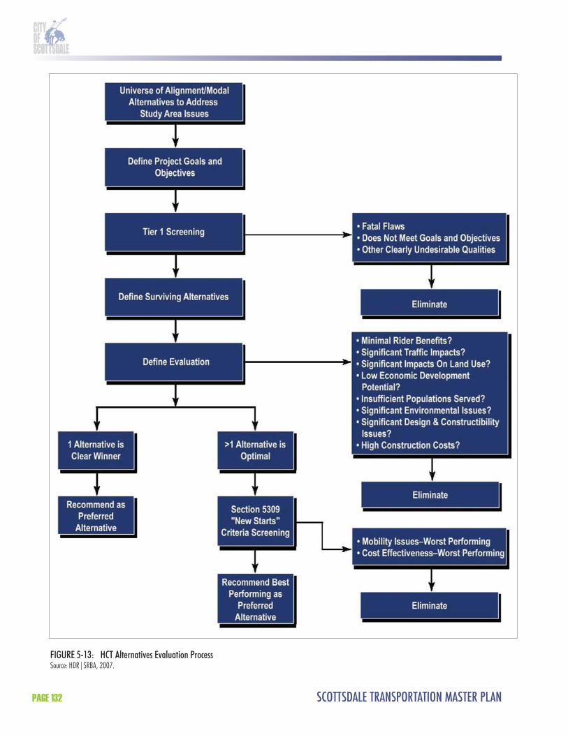
SCOTTSDALE TRANSPORTATION MASTER PLANPAGE 132
FIGURE 5-13: HCT Alternatives Evaluation ProcessSource: HDR|SRBA, 2007.
CHAPTER 5 - TRANSIT ELEMENT PAGE 133
Tier 1 Evaluation CriteriaTable 5-12 illustrates the criteria used in the Tier 1 analysis to evaluate potential HCT technologies, including BRT, LRT, and modern streetcar. Th e criteria for Tier 1 evaluation are established by the Federal Transit Administration (FTA).
TABLE 5-12: Tier 1 Evaluation CriteriaCriteria MeasureMobility Ability to enhance mobility between major activity centers in the study area.Travel times competitiveness Ability to offer transit investment that is competitive relative to existing travel times in the
study area.Ridership potential Ability to attract new riders, based on experiences of peer Downtown/activity areas.
Capacity People carrying capacity of each technology.Capital costs Comparison of the capital investment needed for each technology.Operation and maintenance costs Comparison of operation and maintenance costs required for ongoing operation.Cost effectiveness Comparison of the cost effectiveness based on operating costs per passenger.Ease of implementation Ease of implementation, based on operational requirements, capital costs, construction
timeframe, and community support. Consistency with local plans Consistency with adopted local land use and transportation plans, local land use patterns,
and study goals.Compatibility with existing transit system
Ability to be integrated with the existing transit system.
Expandability Ability to expand beyond the study area.Community support Community support for the technology/technologies.Roadway Impact Ability to coexist with projected traffic volumes and multi-modal facilities (bike lanes,
sidewalks, etc.)
8.3.3 Components of a Future Tier 2 Detailed EvaluationAlthough Tier 2 evaluation will not be completed as part of this study, the HCT alternatives advancing from this Tier 1 conceptual screening should be evaluated in more detail in a Tier 2 detailed evaluation. Th e Tier 2 evaluation is intended to recommend a preferred HCT alternative that will be advanced into future phases of the project. Th e criteria for both Tier 1 and Tier 2 evaluations are established by the FTA. While this study is not part of a Federal Alternatives Analysis, in the future it will be helpful to have followed the process closely so as not to have to duplicate eff ort in any future Alternatives Analysis. To demonstrate what will be incorporated in a subsequent analysis phase, the Tier 2 evaluation criteria is provided in this document.
Tier 2 Evaluation Criteria To meet federal requirements, the Tier 2 alternatives should be evaluated based on the following criteria:
Rider benefi ts; Land use; Economic development; Traffi c issues;

SCOTTSDALE TRANSPORTATION MASTER PLANPAGE 134
Populations served; Environmental issues; Design issues; Costs; and Community support.
A ranking of “low”, “medium”, and “high” should be used to indicate the relative performance of the alternative to the specifi c criteria. Th e specifi c method to be used to determine the ranking within each category will be determined after the alternatives are developed. Table 5-13 lists the individual evaluation criteria and summarizes the method in each should be measured. Th e remainder of this section details the methodology for the evaluation criteria.
TABLE 5-13: Tier 2 Evaluation CriteriaCriteria MeasureRider BenefitsConnectivity Number of major activity centers served in the study area.Travel time savings Travel time through the study area compared to No-Build Alternative.Ridership Amount of new riders attracted to the system.Compatibility with existing transit system Ability to be integrated into the existing transit system.
Land UseProximity to major activity centers Number of major activity centers served in the study area.Proximity to medium and high density residential areas
Acreages of medium and high density residential areas within 1/2 mile of transit stations.
Consistency with local plans Consistency with adopted local land use and transportation plans, local land use patterns, and study goals.
Economic DevelopmentEconomic development Extent of opportunities for economic development based on proximity to areas
targeted for new development or intensification of existing development.Transit oriented development Extent of opportunities for transit oriented development based on land use patterns
and plans along alignment.
Traffic IssuesRoadway capacity impacts Number of intersections with diminished level of service.Left-turn movements Number of residential and commercial locations with diminished left-turn access.Traffic signals Number of new traffic signals required.Parking spaces Number of parking spaces eliminated.
Populations ServedTotal population Total population located within 1/2 mile of transit stations.Total employment Total employment located within 1/2 mile of transit stations.Minority population Total minority population located within 1/2 mile of transit stations.Low-income population Total low-income population located within 1/2 mile of transit stations.Zero-car households Total zero-car households located within 1/2 mile of transit stations.
CHAPTER 5 - TRANSIT ELEMENT PAGE 135
TABLE 5-13: Tier 2 Evaluation Criteria (continued)Criteria MeasureEnvironmental IssuesProperty acquisitions Number of property acquisitions required.Environmental justice Estimated property acquisitions within areas of high concentration of minority and
low-income populations.Historic resources Number of potential historic resources along alignment.Parklands or other Section 4(f) resources Number of Section 4(f) resources along alignment.Noise and vibration-sensitive uses Number of sensitive uses within specified noise and vibration screening distances.Endangered and threatened species Existence of critical habitat and endangered or threatened species along alignment.Floodplains and riparian areas Existence of floodplains or riparian areas along the alignment.Contamination sites Number of potentially contaminated sites along the alignment.
Design IssuesRight-of-way Amount of right-of-way needed along alignment.Utility conflicts Proximity to major utilities and potential for conflicts requiring utility relocation.Operational constraints Extent of operation constraints, such as difficult turning radii or grade changes.Compatibility with existing transit system Ability to be integrated into the existing transit system.Expandability Physical ability to extend the alternative beyond the minimum operable segment.
CostsCapital costs Estimated capital costs to construct the transit investment.Operation and maintenance costs Estimated operation and maintenance costs required for ongoing operation.
Community SupportCommunity support Extent of community support for the transit alternative.
Rider BenefitsTh e rider benefi ts for each alternative should be evaluated based on connectivity, travel time savings, ridership, and compatibility with the existing transit system. Connectivity involves the ability to meet the primary goal of the HCT Feasibility Study, which is to connect major activity centers in the corridor and to consolidate and improve transit service into a transit priority corridor. Travel time through the study area will be evaluated to identify potential time savings compared to the No-Build Alternative. Ridership, and more specifi cally the ability to attract new riders to the system, will also be estimated in comparison to the No-Build Alternative. In addition, the compatibility of alternatives to the existing and future transit system will be estimated from both the customer and City standpoint.
Land UseLand use criteria should be used to evaluate the HCT alternatives proximity to major activity centers, proximity to medium and high density residential areas, and consistency with local plans. Each alternative’s proximity and ease of access to activity centers will be assessed. An activity center is defi ned as a concentration of employment, retail, housing, and recreation opportunities within a relatively small area. Examples in the study area include: Downtown, SkySong, Scottsdale Healthcare Osborn campus, Scottsdale Fashion Square, and Scottsdale Waterfront. Th e alternatives should be evaluated based on the number of activity centers that they connect.

SCOTTSDALE TRANSPORTATION MASTER PLANPAGE 136
Th e eff ectiveness of a major transit investment is enhanced when there are a large number of housing units within walking distance of the alignment. Th e alternatives will be ranked according to the proximity to medium and high density residential, which is typically composed of condominiums, townhouses, apartments, and houses on small lots. Th ose alternatives having more acres of medium and high density residential uses near transit stations will be ranked higher. Finally, the alternatives will be evaluated based on how well each addresses or confl icts with the goals of local land use and transportation plans. Examples include the City of Scottsdale General Plan and Downtown Plan.
Economic DevelopmentEconomic development criteria include the extent of opportunities for economic development as well as pedestrian/transit oriented development. Th e economic development potential of each alternative will be measured by the number of vacant land parcels available to develop, amount of employment (location of major employers, future job creation, job growth), and future land use shifts to business, offi ce, commercial, and high density residential land uses.
Opportunities for pedestrian/transit oriented development, which is development characterized by a mixed-use, high density, and pedestrian-friendly environment around transit stations, will also be evaluated for each alternative. Th e concentration of residential and business activity around transit stations can translate into economic gains resulting from increased accessibility and the introduction of new types of development into the community.
Traffic IssuesTh e alternatives will be evaluated for traffi c issues using the following criteria—roadway capacity impacts, left-turn movements, traffi c signals, and parking spaces. Roadway capacity involves capacity at intersections, which should be analyzed by calculating the level of service (LOS) at aff ected intersections. Th e number of intersections with diminished LOS as a result of the alternative should be estimated. Th e eff ect on left-turn access to residential and commercial properties should be calculated by counting the number of existing driveways that would no longer have full movement access because of potential confl icts with a fi xed-guideway alternative. Th e number of potential new traffi c signals should also be estimated. In addition, the number of parking spaces removed because of the alternative should be calculated.
Populations ServedTh e detailed evaluation criteria include an evaluation of populations served in the study area around transit stations. More specifi cally, the criteria should be used to evaluate the total population, total employment, minority population, low-income population, and zero-car households within a half mile of proposed transit stations. It should be noted that Title VI of the Civil Rights Act of 1964 and Executive Order 12898, Federal Actions to Address Environmental Justice in Minority Populations and Low-Income Populations, require consideration of minority and low-income populations in major transportation investments. Information to evaluate overall population and employment should be obtained through MAG, while information to evaluate minority population, low-income population, and zero-car households should be obtained from the most recent Federal census.
Environmental IssuesEnvironmental issues for the alternatives should be evaluated based on the potential impacts on the following—property acquisitions, environmental justice, historic resources, parklands or other Section 4(f ) resources, noise and vibration-sensitive uses, endangered and threatened

CHAPTER 5 - TRANSIT ELEMENT PAGE 137
species, fl oodplains, and riparian areas. In addition, the potential for the alternative to be aff ected by hazardous materials sites should be evaluated.
Property AcquisitionsTh e extent of property acquisitions needed to accommodate each alternative should be estimated based on the cross section of each alignment in relation to the existing street rights-of-way. Th e additional properties required to accommodate the transit investment while still maintaining acceptable traffi c capacity should be estimated.
Environmental JusticeAs discussed earlier, Title VI of the Civil Rights Act and Executive Order 12898 require consideration of minority and low-income populations in major transportation investments. In addition to considering potential benefi ts, they require evaluating if disproportionately high adverse environmental eff ects on these populations could potentially occur. One potential indicator is the extent of property acquisitions potentially aff ecting minorities and low-income populations. Th is should be estimated based on the extent of property acquisitions within areas with high concentrations of these populations.
Historic ResourcesTh e National Environmental Policy Act (NEPA) and Section 106 of the National Historic Preservation Act of 1966, as amended, stipulate that federal agencies work to preserve not only natural resources but also important historical and cultural aspects of our national heritage. Potential historic resources should be identifi ed for each alternative.
Section 4(f ) ResourcesSection 4(f ) of the Department of Transportation Act of 1966, as amended, restricts the use of any publicly-owned land in a park, recreation area, wildlife or waterfowl refuge, or land from historical sites for transportation purposes unless there is no feasible and prudent alternative to the use of such land, and the project includes all possible planning to minimize harm. Parks, recreation areas, trails, and wildlife and waterfowl refuges adjacent to the alternatives should be identifi ed.
Noise and Vibration ImpactsSensitive land uses (e.g., residences, schools, recreation areas, active sports areas, libraries, and hospitals) that are within regulated screening distances should be identifi ed for each alternative.
Endangered and Th reatened SpeciesTo aid in determination of impacts on threatened and endangered species, the U.S. Fish and Wildlife Service website should be reviewed to determine the potential for threatened or endangered species to occur within the project limits. Th e Arizona Game and Fish Department should be contacted to request a check of the Heritage Management Database to determine what species have been recorded within the vicinity of the project study area. In addition, critical habitat in proximity of the alternatives should be identifi ed based on information obtained from the U.S. Fish and Wildlife Service Arizona Ecological Services.
Floodplains and Riparian AreasFloodplains and riparian areas within or adjacent to the alternatives should be identifi ed through Federal Emergency Management Agency data obtained from the Maricopa County Flood Control District and from the State Lands Department.

SCOTTSDALE TRANSPORTATION MASTER PLANPAGE 138
Hazardous MaterialsSites along the corridor should be identifi ed for potential contamination concerns. In addition, current land use should be identifi ed to determine if there is the potential for environmental issues associated with property uses such as automobile repair and dry cleaning facilities.
Design IssuesTh e alternatives should be evaluated for design issues based on the following criteria—available right-of-way (ROW), utility confl icts, operational constraints, compatibility with existing transit system, and expandability. Th e availability of ROW for each alternative should be estimated and compared, with those requiring less acquisition of ROW ranking higher. Maps of major utilities should also be reviewed in the vicinity of each alternative to determine if the alignment location could confl ict with existing major utilities. Th ose alternatives having the least impact on major utilities should be preferred.
Operational constraints should be evaluated for each alternative and should include physical considerations such as turning radii, grade changes, and operation in mixed-traffi c fl ow. Th e compatibility of the alternative with the existing transit system should also be evaluated, including the physical integration between modes on streets and at transit stations. In addition, the expandability of the alternative should be evaluated in terms of its ability to extend beyond the study area and serve other areas in Scottsdale and the metropolitan region.
CostsCapital costs and operation and maintenance costs should be evaluated for each alternative. Capital costs should include construction costs and other fi xed costs such as vehicle procurement. Construction costs should be estimated based on the cross section of each mode and the overall length of the alignment alternative. Construction costs should also consider the cost of associated project elements such as transit stations, maintenance and storage facilities, signalization and service equipment, and ROW costs. Operating and maintenance costs should be estimated based on costs from peer systems throughout the country. Typical operating costs include energy costs, labor costs, repair costs, and preventative maintenance costs.
Community SupportCommunity support for each of the alternatives from various stakeholders in the study area, including residents, employers, business owners, students, and others, should be evaluated. Th e alternatives with the most public consensus should be ranked the highest.
8.4 Tier 1 Evaluation8.4.1 HCT TechnologiesTh e Tier 1 evaluation seeks to determine the best technology or mix of technologies within the Scottsdale Road HCT corridor. Transit technology refers to the mode used for travel, such as BRT, LRT, and modern streetcar.
Bus Rapid Transit (BRT)BRT is a form of advanced bus service which combines the advantages of rail transit with the fl exibility of buses. It can operate in semi-exclusive ROW or in mixed traffi c on city arterials. Vehicles are usually diesel/electric hybrids. BRT can use Intelligent Transportation Systems (ITS) technology, traffi c signal priority, rapid and convenient fare collection, and integration with
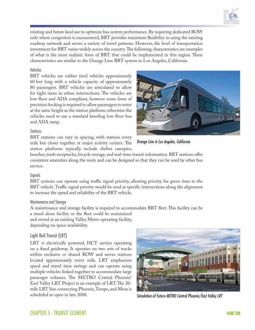
CHAPTER 5 - TRANSIT ELEMENT PAGE 139
existing and future land use to optimize bus system performance. By requiring dedicated ROW only where congestion is encountered, BRT provides maximum fl exibility in using the existing roadway network and serves a variety of travel patterns. However, the level of transportation investment for BRT varies widely across the country. Th e following characteristics are examples of what is the most realistic form of BRT that could be implemented in this region. Th ese characteristics are similar to the Orange Line BRT system in Los Angeles, California.
VehiclesBRT vehicles are rubber tired vehicles approximately 60 feet long with a vehicle capacity of approximately 80 passengers. BRT vehicles are articulated to allow for tight turns in urban intersections. Th e vehicles are low-fl oor and ADA compliant, however some form of precision docking is required to allow passengers to enter at the same height as the station platform; otherwise the vehicles need to use a standard kneeling low-fl oor bus and ADA ramp.
StationsBRT stations can vary in spacing, with stations every mile but closer together at major activity centers. Th e station platforms typically include shelter canopies, benches, trash receptacles, bicycle storage, and real-time transit information. BRT stations off er consistent amenities along the route and can be designed so that they can be used by other bus service.
SignalsBRT systems can operate using traffi c signal priority, allowing priority for green time to the BRT vehicle. Traffi c signal priority would be used at specifi c intersections along the alignment to increase the speed and reliability of the BRT vehicle.
Maintenance and Storage A maintenance and storage facility is required to accommodate BRT fl eet. Th is facility can be a stand alone facility or the fl eet could be maintained and stored at an existing Valley Metro operating facility, depending on space availability.
Light Rail Transit (LRT)LRT is electrically powered, HCT service operating on a fi xed guideway. It operates on two sets of tracks within exclusive or shared ROW and serves stations located approximately every mile. LRT emphasizes speed and travel time savings and can operate using multiple vehicles linked together to accommodate large passenger volumes. Th e METRO Central Phoenix/East Valley LRT Project is an example of LRT. Th e 20-mile LRT line connecting Phoenix, Tempe, and Mesa is scheduled to open in late 2008.
Orange Line in Los Angeles, California
Simulation of Future METRO Central Phoenix/East Valley LRT

SCOTTSDALE TRANSPORTATION MASTER PLANPAGE 140
VehiclesLRT vehicles are electric rail cars approximately 93 feet long with a vehicle capacity of approximately 150 passengers (450 passengers in a three car train). Th e vehicles can operate in both directions, thereby eliminating the need to turn the train around at the end of the line. LRT vehicles are articulated to allow for tight turns in urban intersections. Th e vehicles are low-fl oor and ADA compliant, allowing passengers to enter at the same height as the station platform.
StationsLRT stations are usually located every mile, with closer spacing at major activity centers. Stations include platforms level with the LRT vehicle to facilitate boardings and alightings. Th e station platforms typically include shelter canopies, benches, trash receptacles, bicycle storage, and real-time transit information. LRT stations off er consistent amenities along the route.
SignalsLRT systems can operate using traffi c signal priority, allowing priority for green time to the LRT vehicle. Traffi c signal priority would be used at specifi c intersections along the alignment to increase the speed and reliability of LRT.
TrackworkLRT technology requires two sets of tracks with trains operating in both directions in semi-exclusive ROW. Track placement for LRT can serve stations located in the median or on the curb side of the roadway. In areas where there is signifi cant bicycle travel or curb cut access, curb side track alignments are discouraged for safety reasons.
Power SubstationsLRT requires traction power substations to provide consistent levels of electricity to power the trains. A traction power substation is a small building that contains electrical equipment that distributes electricity to the overhead wires, which powers the LRT vehicles.
Maintenance and Storage A maintenance and storage facility is required to accommodate a LRT fl eet. Eff orts would be made to use the maintenance and storage facility constructed for the METRO Central Phoenix/East Valley LRT line. Th is would require an interlined track at some location to connect to the METRO Central Phoenix/East Valley LRT mainline.
Modern StreetcarModern streetcar is an electrically powered, HCT service that operates on a fi xed-guideway. Modern streetcar systems typically operate at street level in mixed traffi c in existing urban environments. Modern streetcar can operate as a single vehicle or as part of multi-car train and can operate safely in high traffi c and/or high pedestrian activity areas to link neighborhoods with activity centers. Th e Portland Streetcar is an example of a modern streetcar system.
Modern Streetcar in Portland, Oregon
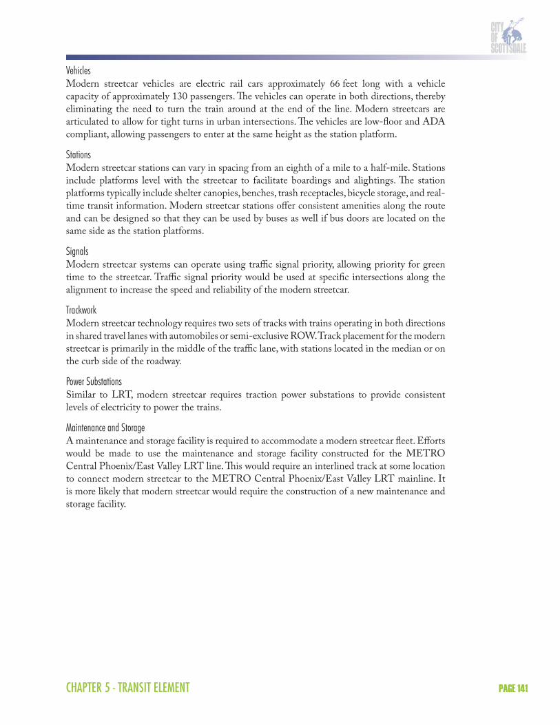
CHAPTER 5 - TRANSIT ELEMENT PAGE 141
VehiclesModern streetcar vehicles are electric rail cars approximately 66 feet long with a vehicle capacity of approximately 130 passengers. Th e vehicles can operate in both directions, thereby eliminating the need to turn the train around at the end of the line. Modern streetcars are articulated to allow for tight turns in urban intersections. Th e vehicles are low-fl oor and ADA compliant, allowing passengers to enter at the same height as the station platform.
StationsModern streetcar stations can vary in spacing from an eighth of a mile to a half-mile. Stations include platforms level with the streetcar to facilitate boardings and alightings. Th e station platforms typically include shelter canopies, benches, trash receptacles, bicycle storage, and real-time transit information. Modern streetcar stations off er consistent amenities along the route and can be designed so that they can be used by buses as well if bus doors are located on the same side as the station platforms.
SignalsModern streetcar systems can operate using traffi c signal priority, allowing priority for green time to the streetcar. Traffi c signal priority would be used at specifi c intersections along the alignment to increase the speed and reliability of the modern streetcar.
TrackworkModern streetcar technology requires two sets of tracks with trains operating in both directions in shared travel lanes with automobiles or semi-exclusive ROW. Track placement for the modern streetcar is primarily in the middle of the traffi c lane, with stations located in the median or on the curb side of the roadway.
Power SubstationsSimilar to LRT, modern streetcar requires traction power substations to provide consistent levels of electricity to power the trains.
Maintenance and Storage A maintenance and storage facility is required to accommodate a modern streetcar fl eet. Eff orts would be made to use the maintenance and storage facility constructed for the METRO Central Phoenix/East Valley LRT line. Th is would require an interlined track at some location to connect modern streetcar to the METRO Central Phoenix/East Valley LRT mainline. It is more likely that modern streetcar would require the construction of a new maintenance and storage facility.
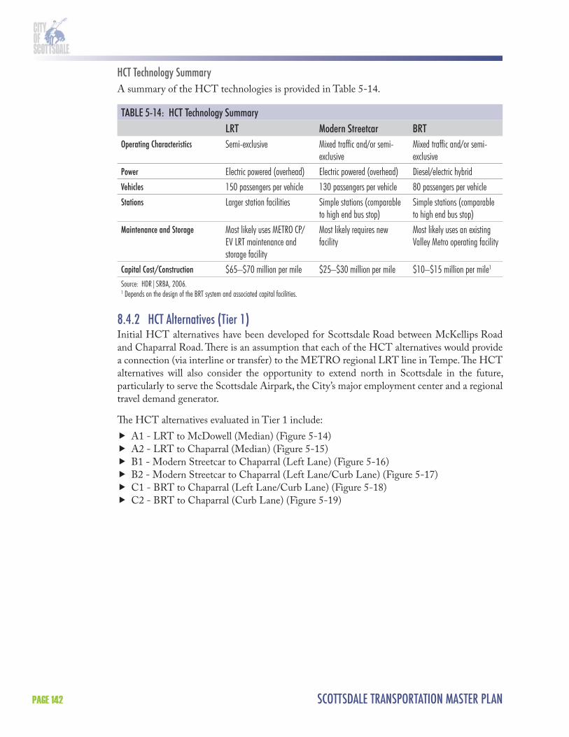
SCOTTSDALE TRANSPORTATION MASTER PLANPAGE 142
HCT Technology SummaryA summary of the HCT technologies is provided in Table 5-14.
TABLE 5-14: HCT Technology SummaryLRT Modern Streetcar BRT
Operating Characteristics Semi-exclusive Mixed traffic and/or semi-exclusive
Mixed traffic and/or semi-exclusive
Power Electric powered (overhead) Electric powered (overhead) Diesel/electric hybridVehicles 150 passengers per vehicle 130 passengers per vehicle 80 passengers per vehicleStations Larger station facilities Simple stations (comparable
to high end bus stop)Simple stations (comparable to high end bus stop)
Maintenance and Storage Most likely uses METRO CP/EV LRT maintenance and storage facility
Most likely requires new facility
Most likely uses an existing Valley Metro operating facility
Capital Cost/Construction $65–$70 million per mile $25–$30 million per mile $10–$15 million per mile1
Source: HDR|SRBA, 2006.1 Depends on the design of the BRT system and associated capital facilities.
8.4.2 HCT Alternatives (Tier 1)Initial HCT alternatives have been developed for Scottsdale Road between McKellips Road and Chaparral Road. Th ere is an assumption that each of the HCT alternatives would provide a connection (via interline or transfer) to the METRO regional LRT line in Tempe. Th e HCT alternatives will also consider the opportunity to extend north in Scottsdale in the future, particularly to serve the Scottsdale Airpark, the City’s major employment center and a regional travel demand generator.
Th e HCT alternatives evaluated in Tier 1 include:
A1 - LRT to McDowell (Median) (Figure 5-14) A2 - LRT to Chaparral (Median) (Figure 5-15) B1 - Modern Streetcar to Chaparral (Left Lane) (Figure 5-16) B2 - Modern Streetcar to Chaparral (Left Lane/Curb Lane) (Figure 5-17) C1 - BRT to Chaparral (Left Lane/Curb Lane) (Figure 5-18) C2 - BRT to Chaparral (Curb Lane) (Figure 5-19)

CHAPTER 5 - TRANSIT ELEMENT PAGE 143
FIGURE 5-14: A1 - LRT to McDowell (Median)Source: HDR|SRBA, 2007.

SCOTTSDALE TRANSPORTATION MASTER PLANPAGE 144
FIGURE 5-15: A2 - LRT to Chaparral (Median)Source: HDR|SRBA, 2007.
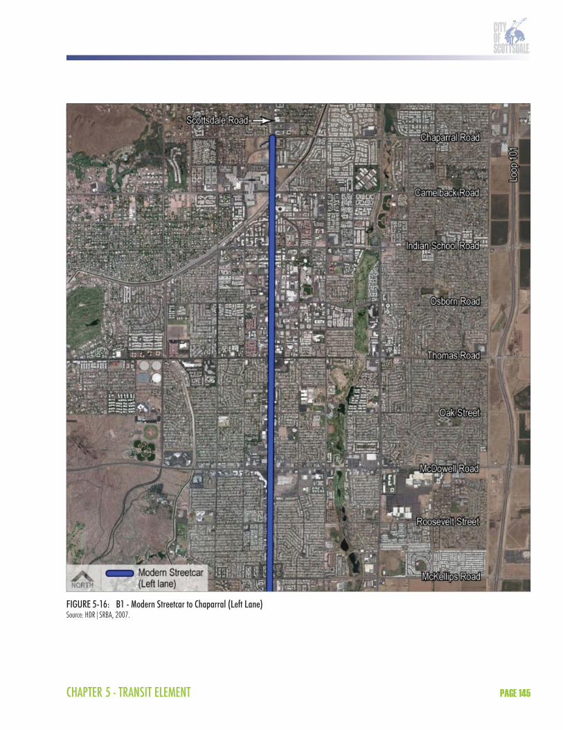
CHAPTER 5 - TRANSIT ELEMENT PAGE 145
FIGURE 5-16: B1 - Modern Streetcar to Chaparral (Left Lane)Source: HDR|SRBA, 2007.

SCOTTSDALE TRANSPORTATION MASTER PLANPAGE 146
FIGURE 5-17: B2 - Modern Streetcar to Chaparral (Left Lane/Curb Lane)Source: HDR|SRBA, 2007.

CHAPTER 5 - TRANSIT ELEMENT PAGE 147
FIGURE 5-18: C1 - BRT to Chaparral (Left Lane/Curb Lane)Source: HDR|SRBA, 2007.
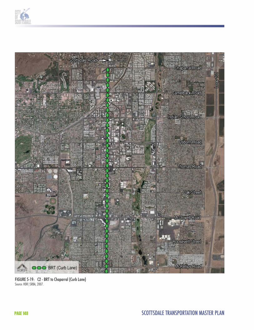
SCOTTSDALE TRANSPORTATION MASTER PLANPAGE 148
FIGURE 5-19: C2 - BRT to Chaparral (Curb Lane)Source: HDR|SRBA, 2007.

CHAPTER 5 - TRANSIT ELEMENT PAGE 149
A1 - LRT to McDowell (Median)Th e A1 HCT alternative includes LRT from McKellips Road at the Scottsdale/Tempe border to McDowell Road adjacent to SkySong. Because LRT operates in semi-exclusive ROW, A1 requires a one-lane reduction in each direction on Scottsdale Road between McKellips Road and McDowell Road. An LRT station would be located in the median of Scottsdale Road just south of McDowell Road. Th is would be the only LRT station located in the City of Scottsdale. BRT would continue north to Chaparral Road. Th e A1 HCT alternative is illustrated in Figure 5-14.
A2 - LRT to Chaparral (Median)Th e A2 HCT alternative includes LRT from McKellips Road at the Scottsdale/Tempe border to Chaparral Road at the north end of Downtown. Because LRT operates in semi-exclusive ROW, the A2 LRT alternative requires a one-lane reduction in each direction on Scottsdale Road or on the couplet between McKellips Road and Chaparral Road. LRT stations would be located in the median of the roadway in the vicinity of McDowell Road, Th omas Road, Osborn Road, Indian School Road, Camelback Road, and Chaparral Road. Th e A2 HCT alternative is illustrated in Figure 5-15.
B1 - Modern Streetcar to Chaparral (Left Lane)Th e B1 HCT alternative includes modern streetcar from McKellips Road at the Scottsdale/Tempe border to Chaparral Road at the north end of Downtown. Modern streetcar would operate on tracks in mixed traffi c in the left lane along Scottsdale Road. It would move into semi-exclusive ROW at station locations outside the Downtown area. Modern streetcar stations would be located in the median of the roadway in the vicinity of McDowell Road, Oak Street, Th omas Road, 2nd Street, Indian School Road, Camelback Road, and Chaparral Road. Th e B1 HCT alternative is illustrated in Figure 5-16.
B2 - Modern Streetcar to Chaparral (Left Lane/Curb Lane) Th e B2 HCT alternative includes modern streetcar from McKellips Road at the Scottsdale/Tempe border to Chaparral Road at the north end of Downtown. Modern streetcar would operate on tracks in mixed traffi c in both the left lane and curb lane along Scottsdale Road. It would move into semi-exclusive ROW at station locations outside the Downtown area. Th e B2 modern streetcar alternative would operate in the left lane between McKellips Road and Downtown (approximately Osborn Road). Once in Downtown, the B2 modern streetcar alternative would transition to the curb lane through Downtown until Drinkwater Boulevard where it would transition back to the left lane. Th is maneuver preserves left-turn movements in the Downtown area. Modern streetcar stations would be located in the vicinity of McDowell Road, Oak Street, Th omas Road, 2nd Street, Indian School Road, Camelback Road, and Chaparral Road. Th e B2 HCT alternative is illustrated in Figure 5-17.
C1 - BRT to Chaparral (Left Lane/Curb Lane)Th e C1 HCT alternative includes BRT from McKellips Road at the Scottsdale/Tempe border to Chaparral Road at the north end of Downtown. BRT would operate in mixed traffi c in the left lane and curb lane along Scottsdale Road. It would move into semi-exclusive ROW at station locations outside the Downtown area. Th e C1 BRT alternative would operate in the left lane between McKellips Road and Downtown (approximately Osborn Road). Once in
SCOTTSDALE TRANSPORTATION MASTER PLANPAGE 150
Downtown, the C1 BRT alternative would transition to the curb lane through Downtown until Drinkwater Boulevard where it would transition back to the left lane. Th is maneuver preserves left-turn movements in the Downtown area. BRT stations would be located in the vicinity of McDowell Road, Oak Street, Th omas Road, 2nd Street, Indian School Road, Camelback Road, and Chaparral Road. Th e C1 HCT alternative is illustrated in Figure 5-18.
C2 - BRT to Chaparral (Curb Lane)Th e C2 HCT alternative includes BRT from McKellips Road at the Scottsdale/Tempe border to Chaparral Road at the north end of Downtown. BRT would operate in mixed traffi c in the curb lane along Scottsdale Road. BRT stations would be located in the vicinity of McDowell Road, Oak Street, Th omas Road, 2nd Street, Indian School Road, Camelback Road, and Chaparral Road. Th e C2 HCT alternative is illustrated in Figure 5-19.
8.4.3 Tier 1 RecommendationsTh e following is a summary of the Tier 1 recommendations. Overall, the B1 Modern Streetcar to Chaparral (Left Lane), B2 Modern Streetcar to Chaparral (Left Lane/Curb Lane), and C1 BRT to Chaparral (Left Lane/Curb Lane) HCT alternatives are recommended for further analysis in Tier 2, as well as alternatives which consider LRT to McDowell (A1) and LRT to Highland/Chaparral via Drinkwater or Goldwater (modifi ed A2). It is also recommended that the B1 and B2 modern streetcar alternatives be combined into a single alternative in Tier 2 with a design option in Downtown. Th e remaining HCT alternatives will be eliminated from further consideration. Table 5-15 summarizes the recommendations.
TABLE 5-15: Tier 1 RecommendationsAdvance into Tier 2 Detailed Evaluation Eliminate from Further ConsiderationA1 – LRT to McDowell Rd (Median)A2 – LRT to Highland/Chaparral Rd via Drinkwater/Goldwater Blvds1
B1 - Modern Streetcar to Chaparral Rd (Left Lane)2
B2 - Modern Streetcar to Chaparral Rd (Left Lane/Curb Lane)2
C1 - BRT to Chaparral Rd (Left Lane/Curb Lane)3
A2 - LRT to Chaparral Rd (Median)1
C2 - BRT to Chaparral Rd (Curb Lane)
Source: HDR|SRBA, 2006.1 It is recommended that alternative A2 be modified to remove consideration of a Scottsdale Road alignment through Downtown, instead using Drinkwater or Goldwater, and carried through into Tier 2 with a design option focusing on Drinkwater.2 It is recommended that the B1 and B2 modern streetcar alternatives be combined into a single alternative in Tier 2 with a design option in Downtown.3 Service standards for BRT in the Regional Transportation Plan have not been finalized for arterial corridors. Tier 2 analysis of C1 should reflect the results of a regional study to define the arterial BRT system parameters.
Th e A1, modifi ed A2, combined B1/B2, and C1 HCT alternatives (Figures 5-20 to 5-23)are being advanced because they off er the best opportunity for HCT in the Scottsdale Road corridor.
Th e primary reasons include:
Travel time savings by using semi-exclusive station locations along Scottsdale Road outside of Downtown. Th ese semi-exclusive stations will serve as “queue jumps” that will allow the non-exclusive lane alternatives to bypass intersection congestion;Providing frequent, all-day access to major activity centers in the corridor; High ridership potential because of new service, travel time savings, regional connectivity, and frequency/service span;

CHAPTER 5 - TRANSIT ELEMENT PAGE 151
Reduced roadway impacts to Scottsdale Road, primarily at station locations, and use of available capacity on Drinkwater/Goldwater boulevards; andAppropriate “scale” for the Scottsdale Road corridor.
Th e A2 LRT to Chaparral (Median) on Scottsdale Road through Downtown HCT alternative is eliminated from further consideration. Th e primary reasons include:
Unacceptable lane reductions and ROW impacts through Downtown on Scottsdale Road; Left turn restrictions in Downtown because of median operation; and Inappropriate “scale” for Downtown.
Th e C2 BRT to Chaparral (Curb Lane) HCT alternative is being eliminated from further consideration. Th e primary reasons include:
Does not off er travel time savings because of curb lane operation outside of Downtown; and Very little distinction from existing Route 72 service on Scottsdale Road.
Based on the goals set forth in Scottsdale’s General Plan, the Scottsdale Road corridor is the appropriate corridor in Scottsdale for high-capacity transit. Any of the three technology modes could be made to fi t in a way that works for the community from a design, functionality, and livability standpoint. As development continues and more interest develops in alternative modes, the need and appropriateness for high-capacity transit will also grow.
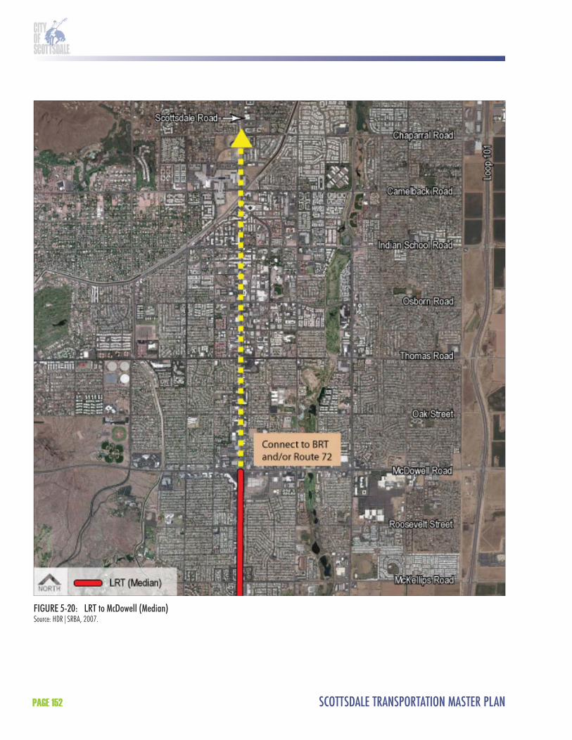
SCOTTSDALE TRANSPORTATION MASTER PLANPAGE 152
FIGURE 5-20: LRT to McDowell (Median)Source: HDR|SRBA, 2007.
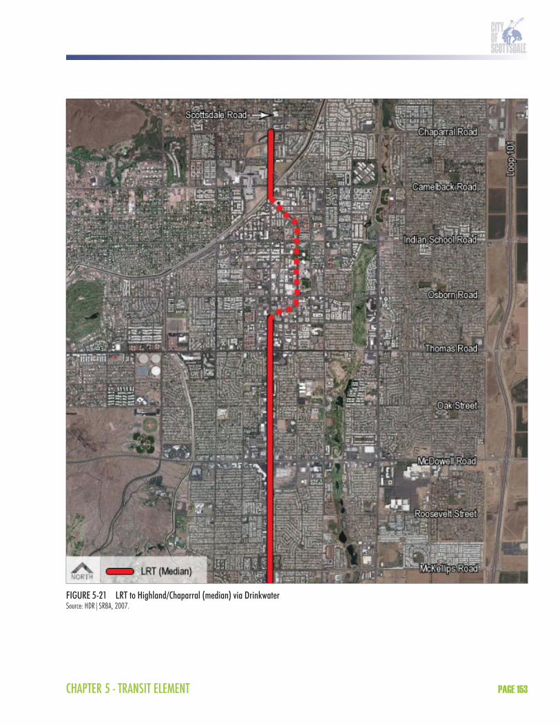
CHAPTER 5 - TRANSIT ELEMENT PAGE 153
FIGURE 5-21 LRT to Highland/Chaparral (median) via DrinkwaterSource: HDR|SRBA, 2007.

SCOTTSDALE TRANSPORTATION MASTER PLANPAGE 154
FIGURE 5-22: Modern Streetcar to Chaparral (Left Lane/Design Option through Downtown)Source: HDR|SRBA, 2007.

CHAPTER 5 - TRANSIT ELEMENT PAGE 155
FIGURE 5-23: BRT to Chaparral (Left Lane/Curb Lane through Downtown)Source: HDR|SRBA, 2007.

SCOTTSDALE TRANSPORTATION MASTER PLANPAGE 156
8.5 Recommended Further Analysis and ConsiderationsTh is section of the Transportation Master Plan Transit Element was designed to take the next steps in the Scottsdale/Tempe Major Investment Study that was adopted in February 2003. At that time, the City Council approved the Scottsdale Road corridor as the most appropriate corridor for the fi rst Scottsdale HCT system, while identifying the need for regional commuter-oriented service on Loop 101 using express bus/BRT technology. Th is report has detailed the background information required for an alternatives analysis and provided a Tier 1 conceptual analysis of alternatives. Recommended alternatives to move through the next phase are included in Section 8.4.3 above.
Community and stakeholder discussion during the course of the Transportation Master Planincluded the desire for consideration of several additional issues: options for additional, high frequency and amenity regional transit service along the Loop 101 corridor; an interest in the results of implementation of the region’s fi rst light rail corridor, the Central Phoenix/East Valley line scheduled for opening in December 2008; regional consideration of updates to the RTP to better integrate the current and proposed high capacity services (express, BRT, LRT, and commuter rail); and current and proposed fi xed route and circulator services.
To follow the FTA’s process, the next steps are to conduct a Tier 2 analysis and an Alternatives Analysis for the alternatives resulting from the Tier 1 conceptual analysis. Care was taken during the Tier 1 analysis to ensure that the fi ndings could be incorporated into a future Alternatives Analysis. It is recommended that an Alternatives Analysis should be undertaken after or as a part of several regional studies that are underway or scheduled to occur within the next three months, as described below. Studies underway or scheduled that aff ect the outcome of any future Alternatives Analysis include: regional arterial BRT study (RPTA); regional freeway express/BRT study (RPTA); regional transit framework study (MAG); and Tempe south alternatives analysis (Valley Metro Rail).
Within the RTP, Scottsdale is identifi ed for inclusion in a high capacity corridor along Scottsdale Road from McKellips Road to Shea Boulevard. Th e corridor overlays a two plus mile light rail corridor within Tempe and extends south through the communities of Tempe and Chandler to Chandler Boulevard, with a connection to the regional Central Phoenix/East Valley light rail system in Tempe in the vicinity of the intersection of University Drive and Rural Road. It is recommended that this designated regional HCT corridor be extended to the Scottsdale Airpark to capture additional potential ridership at this employment center, which generates high regional and local demand, and that the hours of operation and bus amenities be expanded as necessary to provide high quality service. Th ese modifi cations will be addressed through the RTP amendment process and documented in the RPTA’s regional arterial BRT study. Service standards and other features of arterial BRT in the Phoenix region are also currently undefi ned and will be established in this study and will aff ect the outcome of Tier 2 analysis for a BRT option in the Scottsdale Road corridor. RPTA’s regional freeway express/BRT study performed analysis based on the current level of RTP funding and currently-planned freeway lane confi gurations and did not examine improvements to the system based on need; updates to the RTP in the MAG regional transit framework study will address this and other discrepancies in the data needed to evaluate Loop 101 transit options, including the provision of HOV on- and off -ramps.

CHAPTER 5 - TRANSIT ELEMENT PAGE 157
In an eff ort to address connectivity among the various transit modes in the region, update the system for current and planned growth in the region, and to prepare for potential opportunities for statewide transit funding, MAG is beginning a regional transit framework study in January 2008. Scottsdale has asked that the information on the Loop 101 and Scottsdale Road corridors from this HCT feasibility study and prior eff orts be integrated in the MAG study.
Since September 2007, METRO and its member cities of Tempe and Chandler have been engaged in an Alternatives Analysis to determine the direction of Tempe’s light rail extension, with a study area boundary from (north) Loop 202 to (south) Loop 202, and (east) Loop 101 to (west) I-10. On December 11, 2007, the City Council opted to join METRO to enable the City’s participation in the Alternatives Analysis underway among METRO, Tempe, and Chandler.
9.0 FUNDING SOURCES Transit service in Scottsdale is funded with a combination of passenger fares and federal, state, regional, and local funds. Th is section describes the existing and future funding sources for the proposed transit improvements.
9.1 Existing and Future Funding SourcesTh e following is an overview of the existing fi nancial resources potentially available to fund transit operating and capital improvements in the City of Scottsdale. Included are federal, state, regional, and local funding programs.
9.1.1 Federal Funding SourcesFederal funding for public transportation comes through the U.S. Department of Transportation (USDOT). USDOT programs and funding for public transportation were established under the Intermodal Surface Transportation Effi ciency Act (ISTEA) of 1991, which established authorizing levels and programs for transit and highways projects and institutionalized the ability to shift funds from one program to another depending on local priorities. ISTEA expired in 1997 and was replaced by the Transportation Equity Act of the 21st Century (TEA-21). TEA-21, which was eff ective from 1998 to 2003, generally maintained previously established programs and raised the overall level of funding. TEA-21 was reauthorized in August 2005 and is known as the Safe, Accountable, Flexible, Effi cient Transportation Equity Act: A Legacy For Users (SAFETEA-LU). SAFETEA-LU authorizes the federal surface transportation programs for highways, highway safety, and transit for 2005 until 2009. SAFETEA-LU provides funding for USDOT and its subsidiary agencies, the FTA and the Federal Highway Administration (FHWA).
FTA Section 5307 FundsTh e Federal Section 5307 formula program is allocated to urbanized areas over 50,000 in population, according to a tiered formula based on size. FTA has traditionally only awarded grants to one recipient per urbanized area (in this case the city of Phoenix), leaving that recipient to then pass funds through to other qualifi ed users. Th e program is structured to provide total fl exibility to end-users regarding use of the funds for operations and capital facilities, except for urbanized areas over 200,000 in population which cannot use funds for operating assistance. A 50 percent local match for operating assistance and a 20 percent local match for capital facility assistance is required.

SCOTTSDALE TRANSPORTATION MASTER PLANPAGE 158
FTA Section 5309 FundsSection 5309 is the primary federal funding program for capital investment in new transit facilities and equipment. Unlike other FTA funding categories that allocate money on a formula basis, Section 5309 funds are awarded on a discretionary basis for a particular project. In practice, all Section 5309 funds are allocated to projects through earmarks in annual federal appropriations legislation. Th e eligible federal share is 80 to 83 percent. Th e FTA encourages applicants to develop a non-federal match to secure Section 5309 funds.
Section 5309 funds are authorized based on the results of alternatives analysis and preliminary engineering that justify the project based on a variety of criteria. Funds are allocated by statute categories, including “New Starts” and “Small Starts.”
New StartsAs described in the FTA guidance on New Starts, the FTA discretionary New Starts program is the federal government’s primary fi nancial resource for supporting locally planned, implemented and operated major transit investments. Th e New Starts program funds new and extensions to existing fi xed guideway systems. Th ese projects include commuter rail, heavy rail, LRT, BRT, modern streetcar, and ferries. New Starts projects, like all transportation investments in metropolitan areas, must emerge from a regional, multi-modal transportation planning process that has three phases: Phase I (alternatives analysis); Phase II (preliminary engineering); and Phase III (fi nal design).
New Starts projects must undergo evaluation by FTA throughout the entire project development process. Based on these evaluations, FTA makes decisions about moving projects forward, from preliminary engineering to fi nal design, to annual funding recommendations to Congress, and to the execution of a full funding grant agreement (FFGA). In the annual report on New Starts, FTA applies these evaluations to recommend funding for projects anticipated to be ready for an FFGA before the end of the budget fi scal year, and to recommend funding for other meritorious projects.
FTA evaluates the project justifi cation and the local fi nancial commitment according to the following measures:
Mobility improvements; Environmental benefi ts; Cost eff ectiveness; Operating effi ciencies; Transit supportive land use and future patterns; and Local fi nancing.
Small StartsSmall Starts is intended for smaller projects where the project must seek less than $75 million in new start monies and have a total cost of no more than $250 million. According to the FTA Small Starts interim guidance, FTA intends to scale the planning and project development analysis to the size and complexity of the proposed projects. To be eligible, a project must meet the defi nition of "fi xed guideway" for at least 50 percent of the project length during peak period, or be a corridor-based bus project with the following minimum elements:
Transit stations;

CHAPTER 5 - TRANSIT ELEMENT PAGE 159
Traffi c signal priority/preemption, to the extent, if any, that there are traffi c signals in the corridor;Low-fl oor buses or level boarding; Branding of the proposed service; and 10 minute peak/15 minute off -peak headways or better while operating at least 14 hours per weekday (not required for commuter rail or ferries).
Congestion Mitigation and Air Quality (CMAQ) FundsCMAQ provides federal transportation funds to support state and local projects that reduce transportation related air pollution. A portion of the funds are apportioned to the state of Arizona annually based on a legislated formula and coordinated through MAG. CMAQ projects are selected for implementation from the approved regional Transportation Improvement Program (TIP) and are submitted to FTA or FHWA, as appropriate, for fi nal approval and authorization to proceed. Th e types of projects eligible for CMAQ funds include:
Travel demand management strategies; Transit improvements; Shared ride services; Traffi c fl ow improvements; and Pedestrian and bicycle programs.
Th e start-up of new transit services (e.g., new express bus routes or new shuttle service linking major activity centers) is supported under the CMAQ program in an eff ort to tap new markets for transit. While CMAQ cannot be a permanent source of funding for transit service, the goal is to encourage experimentation to determine what new types of services are viable.
Surface Transportation Program (STP) Flexible Funding FHWA STP funds are fl exible funds that may be used by states and localities for transit and highway projects. Under TEA-21, FHWA funds provided a substantial new source of funds for transit projects. Since 1999, the state transportation board annually transferred $5 million of TEA-21 STP funding to transit. However, there is no long-term commitment from the state transportation board to maintain this funding source for transit. In order to compete for the $5 million in STP funding, cities must use 100 percent of the funding for transit purposes and the project must be included in the current MAG TIP.
9.1.2 State Funding SourcesLocal Transportation Assistance Fund (LTAF)Under present law, LTAF is funded from net state lottery proceeds at a fl at $23 million per year, with no provision for escalation. Funds are apportioned to cities and towns on the basis of population as determined by the Arizona Department of Economic Security, though each city is guaranteed a minimum apportionment of $10,000. Cities may use funds for either roadway or transit purposes, with the exception that cities with a population greater than 300,000 in Maricopa County must use the funds for transit purposes only. Cities that are members of Valley Metro/RPTA with a population greater than 60,000 must commit at least one-third of their LTAF funds to transit services while those with a population of less than 60,000 must commit three-quarters of their LTAF funds to transit services.

SCOTTSDALE TRANSPORTATION MASTER PLANPAGE 160
9.1.3 Regional and Local Funding SourcesProposition 400 Proposition 400 was approved by voters in Maricopa County in 2004 and extends the region’s half cent sales tax for transportation. Proposition 400 will fund freeway, street, transit, and non-motorized transportation improvements over the next 20 years. As previously described, there are number of transit operating and capital improvements in the City of Scottsdale as part of Proposition 400.
City of Scottsdale Transportation Sales TaxTh e City of Scottsdale currently funds transit services through a .2% sales tax for transportation. Th is dedicated sales tax allows the City to fund transit and other transportation improvements without the use of general funds. In the past, the .2% sales tax was able to fund both operating and capital improvements. However, the revenue produced by this sales tax is unable to keep up with operating and capital expenses throughout the City. In the future, it is possible that most of the operating expenses (including transit) will be funded by the transportation sales tax while capital improvements will be funded through bond.
Other Local Funding OptionsWhile a sales tax increase is a standard tool for funding local transportation improvements, other potential funding sources exist which are more speculative in nature (Table 5-16).
TABLE 5-16: Local Funding Source OptionsCategory Funding SourceGeneral taxes Sales tax Income tax
Property tax Payroll/head taxSpecial taxes Fuel tax Parking tax
Auto registration fee (flat rate) Rental car taxAuto license tax (value based) Hotel room occupancy tax Driver’s license tax or fee Excise taxes (“sin”)Utility excise tax Business license/fee
Growth related mechanisms Impact fees Tax increment financingIn-kind contributions
Public-private partnerships Turnkey/full service delivery Vendor financingJoint development
Other mechanisms Special financing districts AdvertisingTax-exempt financing Congestion pricing
Source: HDR|SRBA, 2006
Many of the mechanisms for local funding are self-explanatory. Descriptions of some of the less-common approaches are summarized below.
Payroll/head tax : A fl at rate assessment per employee within a jurisdiction.Parking tax: Assessment per parking space levied on commercial property owners to discourage free parking and single-occupant behavior.
CHAPTER 5 - TRANSIT ELEMENT PAGE 161
Impact fees: Assessments on new development intended to off set the cost of new infrastructure. Th ey are often calculated as a fi xed amount per residential unit or square foot of commercial/industrial space.In-kind contributions: Alternatives to the impact fee, but typically assessed (negotiated) for the same basic purpose, to fund new infrastructure. Turnkey/full service delivery: Involves full delegation of project development responsibilities to a single design/build or design/build/operate entity, for a fi xed price. Joint development: Involves co-location of public improvements (e.g., a transit station) and private, for profi t, development (e.g., a mixed-use development) in a coordinated manner on the same site or on adjacent sites. Vendor financing: Involves the extension of credit by an equipment vendor, typically at favorable terms.Special financing districts: Funds specifi c activities or projects in a defi ned geographical area that is typically smaller than the jurisdiction.Tax-exempt debt financing: Translates the federal tax exemption into lower interest cost and is therefore an implicit federal subsidy.Congestion pricing: Involves a schedule of tolls on a presently “free” facility, or on an existing toll road, with the objective of discouraging use during peak periods.
Th ose mechanisms that have historically received the greatest attention for funding transit service and capital facility improvements include:
County or city sales tax; Countywide fuel tax or other auto-related fees or assessments; Hotel room occupancy tax; Development fees, assessments, or other exactions; and General or special obligation bonds (property or sales tax based).
Of these, the sales tax, fuel tax, and the hotel occupancy tax off er the greatest potential revenue yield, along with the greatest potential for acceptance by the public. However, the use of fuel taxes is currently restricted to highway and roadway projects under Arizona law.