point sur to san francisco - quick links · bookletchart point sur to san francisco . noaa chart...
TRANSCRIPT

BookletChart™ Point Sur to San Francisco NOAA Chart 18680
A reduced-scale NOAA nautical chart for small boaters When possible, use the full-size NOAA chart for navigation.
Included Area

2
Published by the National Oceanic and Atmospheric Administration
National Ocean Service Office of Coast Survey
www.NauticalCharts.NOAA.gov 888-990-NOAA
What are Nautical Charts?
Nautical charts are a fundamental tool of marine navigation. They show water depths, obstructions, buoys, other aids to navigation, and much more. The information is shown in a way that promotes safe and efficient navigation. Chart carriage is mandatory on the commercial ships that carry America’s commerce. They are also used on every Navy and Coast Guard ship, fishing and passenger vessels, and are widely carried by recreational boaters.
What is a BookletChart?
This BookletChart is made to help recreational boaters locate themselves on the water. It has been reduced in scale for convenience, but otherwise contains all the information of the full-scale nautical chart. The bar scales have also been reduced, and are accurate when used to measure distances in this BookletChart. See the Note at the bottom of page 5 for the reduction in scale applied to this chart.
Whenever possible, use the official, full scale NOAA nautical chart for navigation. Nautical chart sales agents are listed on the Internet at http://www.NauticalCharts.NOAA.gov.
This BookletChart does NOT fulfill chart carriage requirements for regulated commercial vessels under Titles 33 and 44 of the Code of Federal Regulations.
Notice to Mariners Correction Status
This BookletChart has been updated for chart corrections published in the U.S. Coast Guard Local Notice to Mariners, the National Geospatial Intelligence Agency Weekly Notice to Mariners, and, where applicable, the Canadian Coast Guard Notice to Mariners. Additional chart corrections have been made by NOAA in advance of their publication in a Notice to Mariners. The last Notices to Mariners applied to this chart are listed in the Note at the bottom of page 7. Coast Pilot excerpts are not being corrected.
For latest Coast Pilot excerpt visit the Office of Coast Survey website at http://www.nauticalcharts.noaa.gov/nsd/searchbychart.php?chart=18680.
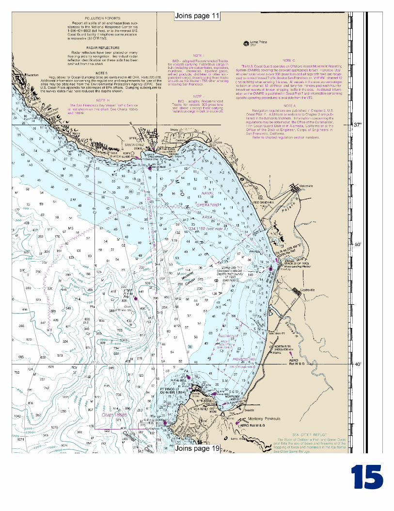
(Selected Excerpts from Coast Pilot) Monterey Bay is a broad open bight 20 miles wide between Point Pinos and Point Santa Cruz. From Point Santa Cruz the coast curves W and N for 23 miles to Pigeon Point, and then extends for 25 miles in a general NNW direction to Point San Pedro, the S headland of the Gulf of the Farallones. Between Cypress Point and Point Pinos the coast is bold and the 30-fathom curve is less than 1 mile from shore in many places; deep submarine valleys extend into Carmel Bay and Monterey
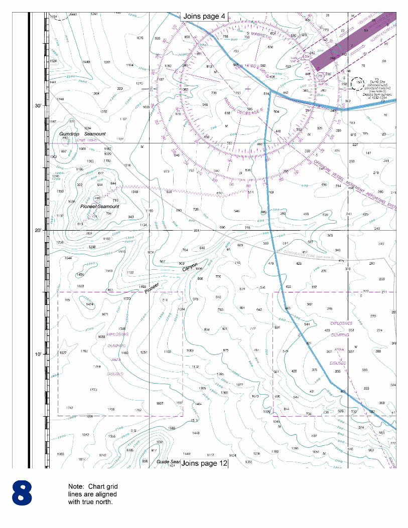
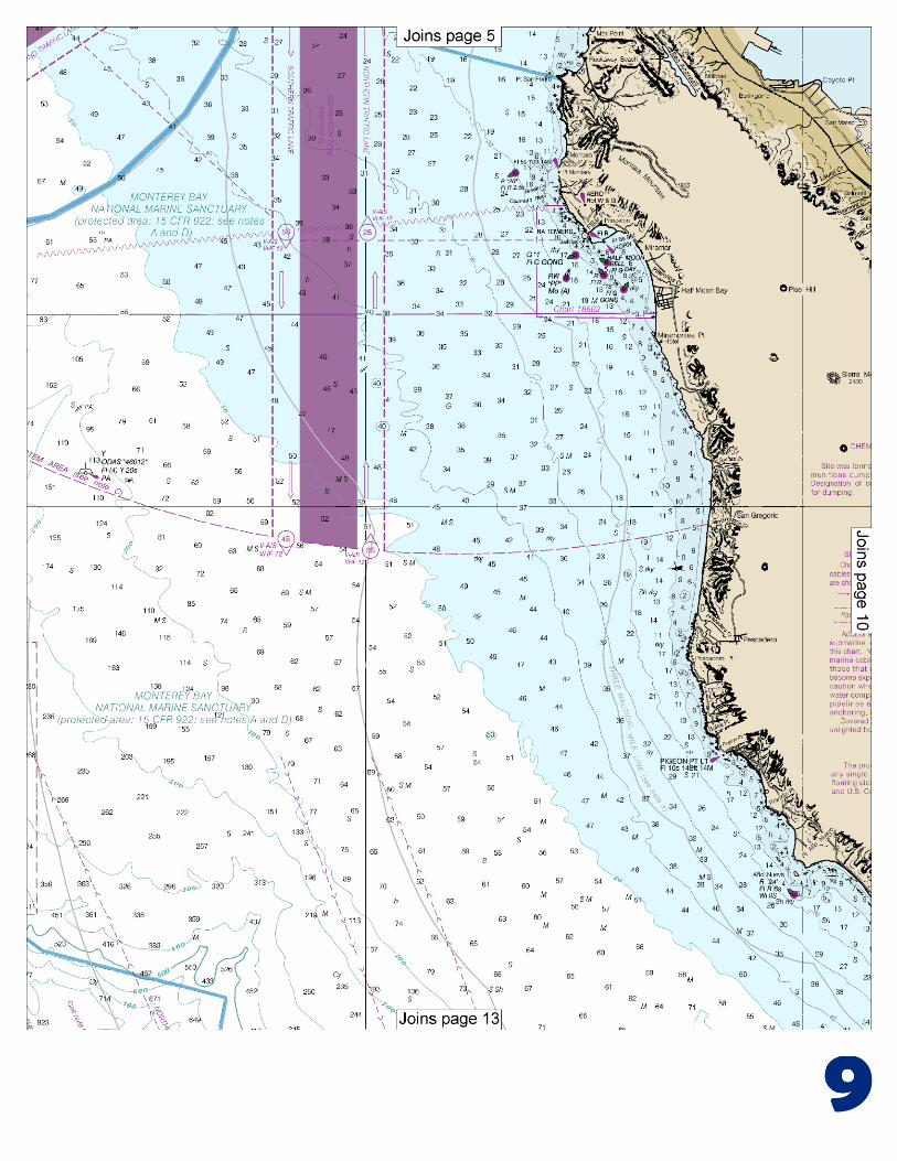
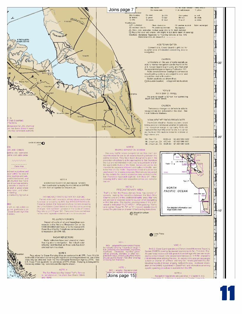
Bay. N of Monterey Bay, depths are more regular and the few dangers extend less than 1 mile from shore. Sea Otter Refuge.–The State of California Fish and Game Code prohibits the discharge of firearms or bows and the trapping of birds or mammals in the California Sea Otter Game Refuge. The refuge extends as a continuous band between the coastline and the three nautical mile limit for the state of California extending offshore from the mouth of the Santa Rosa Creek (35°34'N.) in the N. (See charts 18700 and 18680.) Additional information may be obtained by writing the Department of Fish and Game, Marine Region, 20 Lower Ragsdale Drive, Suite 100, Monterey, CA 93940, telephone 831-649-2870. Monterey Bay National Marine Sanctuary was established to protect and manage the conservation, ecological, recreational, research, educational, historical and esthetic resources and qualities of the coastal and ocean waters and submerged lands in and surrounding Monterey Bay. (See 15 CFR 922, chapter 2, for limits and regulations). From Point Santa Cruz the coast trends W about 4 miles to Needle Rock Point and thence NW to Point Ano Nuevo. Point Ano Nuevo, 18 miles NW of Point Santa Cruz, is formed by sand dunes 20 to 100 feet high. A lighted whistle buoy is about 0.8 mile S of the tower. Anchorage with protection from N and NW winds can be had in the bight S of the point. The kelp bed and reef, extending a little over 0.5 mile SE from the islet, break the force of the swell. Pigeon Point Light (37°10'54"N., 122°23'38"W.), 148 feet above the water, is shown from a 110-foot white conical tower on the end of the point. The light cannot be seen in the bight E of a line joining Pigeon Point and Pillar Point, 20 miles to the N. The light station buildings on Pigeon Point are white with red roofs. From Pigeon Point for 4 miles to Pescadero Point, the coast is nearly straight and is composed of reddish cliffs with numerous outlying submerged and visible rocks. A rocky patch covered 3 feet is about 0.8 mile S of Pescadero Point; a 6¼-fathom rocky patch is about 0.7 mile WSW of the point. Point Montara, 2.8 miles N of Pillar Point, is the seaward end of a spur from Montara Mountain and the NW extremity of the ridge forming Pillar Point. It terminates in cliffs about 60 feet high with numerous outlying rocks. Covered rocks and ledges lie 0.8 mile W of the point and extend in a NW direction for about 1.5 miles. This is a dangerous locality in thick weather, and extreme caution should be used when inside the 30-fathom curve. Point Montara Light (37°32'11"N., 122°31'09"W.), 70 feet above the water, is shown from a 30-foot white conical tower on the point. A group of white buildings with red roofs is prominent on the point. Point San Pedro is a dark, bold, rocky promontory, 640 feet high. It is the seaward termination of Montara Mountain and is an excellent mark in clear weather from either N or S. A large triple-headed rock, about 100 feet high and white on its S face, projects 0.3 mile W from the point. A rocky area, which breaks in a heavy swell, is reported to exist about 1 mile N of the point. A 200-yard-long Municipal fishing pier is about 2.5 miles NE of Point San Pedro.
U.S. Coast Guard Rescue Coordination Center 24 hour Regional Contact for Emergencies
RCC Alameda Commander
11th CG District (510) 437-3700 Alameda, CA

G
NOAA’s navigation managers serve as ambassadors to the maritime community. They help identify navigational challenges facing professional and recreational mariners, and provide NOAA resources and information for safe navigation. For additional information, please visit nauticalcharts.noaa.gov/service/navmanagers
To make suggestions or ask questions online, go to nauticalcharts.noaa.gov/inquiry. To report a chart discrepancy, please use ocsdata.ncd.noaa.gov/idrs/discrepancy.aspx.
Lateral System As Seen Entering From Seaward on navigable waters except Western Rivers
PORT SIDE
ODD NUMBERED AIDS
GREEN LIGHT ONLY
FLASHING (2)
PREFERRED CHANNEL
NO NUMBERS – MAY BE LETTERED
PREFERRED CHANNEL TO
STARBOARD
TOPMOST BAND GREEN
PREFERRED CHANNEL
NO NUMBERS – MAY BE LETTERED
PREFERRED CHANNEL
TO PORT
TOPMOST BAND RED
STARBOARD SIDE
EVEN NUMBERED AIDS
RED LIGHT ONLY
FLASHING (2)
FLASHING FLASHING
OCCULTING GREEN LIGHT ONLY RED LIGHT ONLY OCCULTING QUICK FLASHING QUICK FLASHING
ISO COMPOSITE GROUP FLASHING (2+1) COMPOSITE GROUP FLASHING (2+1) ISO
"1"
Fl G 6s
G "9"
Fl G 4s
GR "A"
Fl (2+1) G 6s
RG "B"
Fl (2+1) R 6s
"2"
Fl R 6s
8
R "8"
Fl R 4s
LIGHT
G
C "1"
LIGHTED BUOY
G
"5"
GR
"U"
GR
C "S"
RG
N "C"
RG
"G"
LIGHT
6
R
N "6"
LIGHTED BUOY
R
"2
"
CAN DAYBEACON
CAN NUN NUN
DAYBEACON
For more information on aids to navigation, including those on Western Rivers, please consult the latest USCG Light List for your area.
These volumes are available online at http://www.navcen.uscg.gov
Navigation Managers Area of Responsibility
Northeast
Lt. Meghan McGovern
Northwest and
Pacific Islands
Crescent Moegling
Great Lakes Region
Tom Loeper
Chesapeake and
Delaware Bay
Steve Soherr
California
Jeff Ferguson
[email protected] Mid-Atlantic
Lt. Ryan Wartick
Alaska
Lt. Timothy M. Smith
Western Gulf Coast
Alan Bunn
Central Gulf Coast
Tim Osborn
[email protected] South Florida
Puerto Rico
U.S. Virgin Islands
Michael Henderson
Southeast
Kyle Ward
2
2 C U 5
1


VHF Marine Radio channels for use on the waterways:Channel 6 – Inter-ship safety communications.Channel 9 – Communications between boats and ship-to-coast.Channel 13 – Navigation purposes at bridges, locks, and harbors.Channel 16 – Emergency, distress and safety calls to Coast Guard and others, and to initiate calls to other
vessels. Contact the other vessel, agree to another channel, and then switch.Channel 22A – Calls between the Coast Guard and the public. Severe weather warnings, hazards to navigation and safety warnings are broadcast here.Channels 68, 69, 71, 72 and 78A – Recreational boat channels.
Getting and Giving Help — Signal other boaters using visual distress signals (flares, orange flag, lights, arm signals); whistles; horns; and on your VHF radio. You are required by law to help boaters in trouble. Respond to distress signals, but do not endanger yourself.
EMERGENCY INFORMATION
Distress Call Procedures
• Make sure radio is on.• Select Channel 16.• Press/Hold the transmit button.• Clearly say: “MAYDAY, MAYDAY, MAYDAY.”• Also give: Vessel Name and/or Description;Position and/or Location; Nature of Emergency; Number of People on Board.• Release transmit button.• Wait for 10 seconds — If no responseRepeat MAYDAY call.
HAVE ALL PERSONS PUT ON LIFE JACKETS!
This Booklet chart has been designed for duplex printing (printed on front and back of one sheet). If a duplex option is not available on your printer, you may print each sheet and arrange them back-to-back to allow for the proper layout when viewing.
QR
Quick ReferencesNautical chart related products and information - http://www.nauticalcharts.noaa.gov
Interactive chart catalog - http://www.charts.noaa.gov/InteractiveCatalog/nrnc.shtmlReport a chart discrepancy - http://ocsdata.ncd.noaa.gov/idrs/discrepancy.aspx
Chart and chart related inquiries and comments - http://ocsdata.ncd.noaa.gov/idrs/inquiry.aspx?frompage=ContactUs
Chart updates (LNM and NM corrections) - http://www.nauticalcharts.noaa.gov/mcd/updates/LNM_NM.html
Coast Pilot online - http://www.nauticalcharts.noaa.gov/nsd/cpdownload.htm
Tides and Currents - http://tidesandcurrents.noaa.gov
Marine Forecasts - http://www.nws.noaa.gov/om/marine/home.htm
National Data Buoy Center - http://www.ndbc.noaa.gov/
NowCoast web portal for coastal conditions - http://www.nowcoast.noaa.gov/
National Weather Service - http://www.weather.gov/
National Hurrican Center - http://www.nhc.noaa.gov/
Pacific Tsunami Warning Center - http://ptwc.weather.gov/
Contact Us - http://www.nauticalcharts.noaa.gov/staff/contact.htm
NOAA’s Office of Coast Survey The Nation’s Chartmaker
For the latest news from Coast Survey, follow @NOAAcharts
NOAA Weather Radio All Hazards (NWR) is a nationwide network of radio stations broadcasting continuous weather information directly from the nearest National Weather Service office. NWR broadcasts official Weather Service warnings, watches, forecasts and other hazard information 24 hours a day, 7 days a week. http://www.nws.noaa.gov/nwr/