point reyes - giacomini public access
TRANSCRIPT

Point Reyes - GiacominiPublic Access

• Review Marin County Trails Objectives
• Presentation on public access options at Giacomini/Point
Reyes– Potential non-vehicular bridge across Lagunitas Creek
– Potential Levee Road Alignment
• Identify community interest and need in additional public
access– Reinitiate community discussion
– Initial input on public access options
Meeting Purpose

• Welcome
• Meeting format
• Background
– Cross-Marin Trail
– Giacomini Wetland Restoration Project
• Public Access Concepts– Lagunitas Creek Bridge
– Levee Road Trail
• Public Breakout/Comment period
• Next Steps
Agenda

Cross Marin TrailBackground

Giacomini Wetland Restoration Project Update


Public Access-Related Project Goal
Enable the public to experience the restoration process as long as opportunities do not conflict with the project’s purpose.
Primary Project Purpose
Restore natural hydrologic and ecological processes and functions in a significant portion of the Project Area
Relationship to Giacomini Wetland Restoration Project

Development of Restoration and Public Access Components as Part of Alternatives
– Conducted extensive surveys and investigations to identify site and resource conditions and, therefore, potential opportunities and constraints
– Used this information to guide development of restoration and public access components
–Landpeople Report, 2005
Relationship to Giacomini Wetland Restoration Project

Design Considerations and Constraints
– > 90% of Project Area is already wetland– Wetlands occur on edge and perimeter, as well as interior– >40% subject to tides on a daily basis; will increase with sea
level rise
– Project Area in 100-Year Floodplain– Project Area and adjacent areas flood regularly even on small
events–Removal of levees will direct brunt of flood flows onto
Giacomini Ranch
– Existing and Potential Future Habitat and Use by Threatened and Endangered Species
– Accessibility Considerations
Relationship to Giacomini Wetland Restoration Project

• Four alternatives developed– Degree of restoration and public access varied
– Alternative A – least restoration; most public access– Alternative D – most restoration; least public access– All components meet goal of allowing public to experience
and enjoy restored wetlands
– Bridge across Lagunitas Creek incorporated in three alternatives (A-C)
– 200-foot prefabricated structure
– Located at old summer dam
– Levee Road – Evaluated in technical studies
– Referenced in EIS/EIR, but not carried forward in EIS/EIR for detailed analysis
Relationship to Giacomini Wetland Restoration Project

Interactive and Integrative Process
• Public Meeting and Scoping – Fall 2002/Winter 2003
• Four (4) Public Workshops – Spring/Summer 2004
• Five (5) Public Access Workshops – Spring 2005
• Release of DEIS/EIR – December 2006
– Public Meeting for DEIS/EIR – January 2007
Relationship to Giacomini Wetland Restoration Project

• Alternative C – which had bridge -- presented as Agency – preferred alternative at meeting
• During meeting and comment period, however, majority of comments supported selection of Alternative D, which had NO bridge
– All commenters supported maximum restoration
– Most commenters did NOT want bridge
– Some urged Park to reconsider Levee Road as an alternative to a bridge, including Levee Road residents
Relationship to Giacomini Wetland Restoration Project

• Structure of Certified FEIS/EIR and ROD
– Incorporates public access components in Alternative D
Relationship to Giacomini Wetland Restoration Project

1

• Structure of Certified FEIS/EIR and ROD
– Incorporates public access components in Alternative D
– Southern Perimeter Trail components incorporated as potential future collaboration with County of Marin
• Lack of community consensus suggested that these elements “not ripe for decision” by NEPA project-planning standards
• Need to bring to table all agencies with stake in lands, including County of Marin
• NPS committed to working with County of Marin on reevaluating access options, including:
– Bridge across Lagunitas Creek
– Levee Road
– Extension of trail from White House Pool park to Inverness Park
Relationship to Giacomini Wetland Restoration Project

Relationship to Giacomini Wetland Restoration Project
Phase I – Restoration
Fall 2007

Relationship to Giacomini Wetland Restoration Project
Phase II – Restoration
Summer – Fall 2008

Resurgence in native grasses
Meadowbarley
Wildrye
Beginning of pasture conversion following flood-related levee breach
Former levee area floods after big storm
Relationship to Giacomini Wetland Restoration Project

Point Reyes - GiacominiPublic Access

• The National Park Service and County of Marin initiated additional investigation of this expanded public access from Point Reyes to White House Pool in fall 2007
• Extension of a trail to Inverness Park will be a later phase
Background –Point Reyes-Giacomini Public Access

Who are the partners and potential partners?
•National Park Service• Owns Giacomini Ranch and portion of Olema Marsh, south of Levee Road
•County of Marin• Leases White House Pool County park, Green Bridge County park• Owns Levee Road
• State of California• Owns center of Lagunitas Creek in Giacomini Ranch• Owns Green Bridge and White House Pool County park
• California Department of Transportation• Owns State Route 1
Point Reyes-Giacomini Public Access
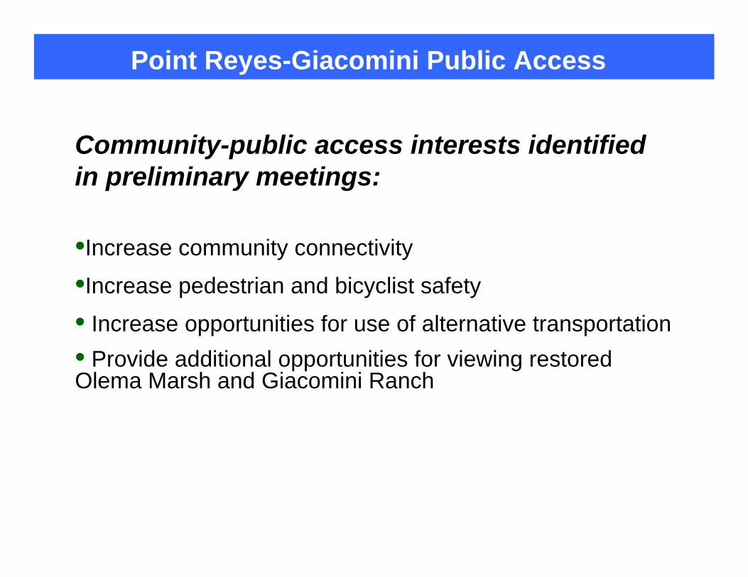
Community-public access interests identified in preliminary meetings:
•Increase community connectivity
•Increase pedestrian and bicyclist safety
• Increase opportunities for use of alternative transportation• Provide additional opportunities for viewing restored Olema Marsh and Giacomini Ranch
Point Reyes-Giacomini Public Access

Reinitiate Community Discussion
• What Was Needed for the Community and the Public to Adequately Understand Options
•Photomontage of bridge showing what potential feasible bridge structure might conceptually look like
• Required that some initial design work be conducted, however:• Meant to be conceptual and not representation of type of bridge that
would actually be built
•Better understanding of type of path possible and desirable on Levee Road and constraints
Point Reyes-Giacomini Public Access

•Lagunitas Creek Bridge: Provides connection from White House Pool County Park to Lagunitas Creek spur trail, ending at Green Bridge County Park
•Improve Levee Road and potentially Green Bridge Pedestrian Causeway: Provides connection from White House Pool County Park to Green Bridge via Levee Road, ending at Green Bridge County Park
Conceptual Pedestrian Alignments
Levee Road Trail Alignment
(Concept)
Olema Marsh Trail(existing)
Lagunitas Creek Bridge
(concept)

Design Considerations for Both Options
• Flooding• Accessibility requirements• User groups and associated requirements (e.g.,
pedestrians, cyclists, horses, etc.)
Point Reyes-Giacomini Public Access

Lagunitas Creek and Levee Road Flood Data

• Supports 10-15% of remaining coho salmon population
in Central California Coast ESU
• 2/3 freshwater inflow to Tomales Bay
• Lagunitas Creek/Levee Road– Confluence of Lagunitas Creek, Olema Creek, Bear Valley Creek
and Tomales Bay
– Daily tides to the Green bridge
– Flooding is influenced by both watershed discharge and tides.
Lagunitas Creek Watershed

• Detailed and comprehensive analysis of existing and
anticipated creek and tidal hydraulics.
• Planning and modeling information was used to identify
the general constraints related to trail development in
this area.
• All available information has been used to support bridge
design to date.
• Hydraulic assessment does not address sea-level rise.
Lagunitas Creek

Lagunitas Creek Flood Frequency
*

Lagunitas Creek Site Cross-Section
XS-3 Profile (River Station 82+00)
-5
0
5
10
15
20
25
250
275
300
325
350
375
400
425
450
475
500
525
550
575
600
625
650
675
700
725
750
775
800
825
850
875
900
925
950
975
1000
Cross Section distance (feet)
(ele
vatio
n - f
t NA
VD88
)
Proposed Phase 2floodplain creation
Levee Road11 foot
elevation
SouthNorth
LAGUNITASCREEK
2-yr flood level
5-yr flood level
10-yr flood 50-yr flood level100-yr flood level
Giacomini East Pasture
MSL @ 3.3 ft
MHHW @ 5.8 ft
Predicted Peak Flow Water Levels at Proposed Bridge Location

5-year flood - Levee Road Profile

100-year flood - Levee Road Profile

Levee Road Public Access Pathway

• Alignment would include access improvements along Levee Road and State Route 1.• Both north and south sides of road evaluated in technical public
access studies conducted in 2004 and 2005
LandPeople 2005
Levee Road Trail Alignment Concept

• Design Considerations - Levee Road Trail Alignment
- Possible expansion of road width to accommodate trail
- Creation of pedestrian causeway on Olema and Bear Valley Creek bridges, State Route 1 un-named bridge
- Improvement of causeway on Green Bridge
- Possible need for cross walk and/or light at State Route 1/Levee Road intersection
- Relocation of power poles
Levee Road Trail Alignment Concept

• Degree of widening of Levee Road would depend on the type or classification of recreational facility constructed– Expanded shoulder would require either fill slope, retaining wall with fill,
or cantilevered boardwalk or combination
Levee Road Trail Alignment Concept
Fill Slope
Retaining wall

Pedestrian Causeway needed-Unnamed cement bridge
Levee Road Trail Alignment Concept
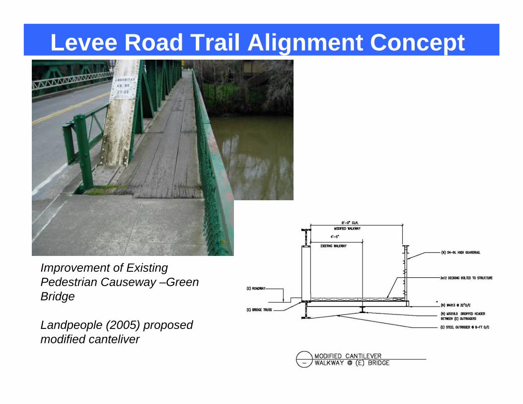
Improvement of Existing Pedestrian Causeway –Green Bridge
Landpeople (2005) proposed modified canteliver
Levee Road Trail Alignment Concept

Public Access Bridge ConceptLagunitas Creek

Lagunitas Creek Bridge Concept
Design Considerations – Type of Bridge
• Concepts show pre-fabricated bridge structure because most economical• One shown in concept is similar to prefabricated bridge at
Inkwells
• Bridge concepts presented here are representative of potential scale to span the creek at this site.
• Concepts are for discussion: other structures possible• Engineered Bridge: Potentially more costly• Seasonal Bridge: Only available seasonally; costs associated
with annual removal and installation

Lagunitas Creek Bridge Concept

Levee Road Trail Alignment
(Concept)
Olema Marsh Trail(existing)
Lagunitas Creek Bridge Concept
Design Considerations – Location• Switch of Location from Old Summer Dam in EIS/EIR to adjacent to White
House Pool County park parking lot• Not enough room for ADA-compliant ramps at former location
• Flood model re-run for this area to generate location-specific flood heights• Flood modeling assumes restored conditions or removal of adjacent levees on
Giacomini Ranch
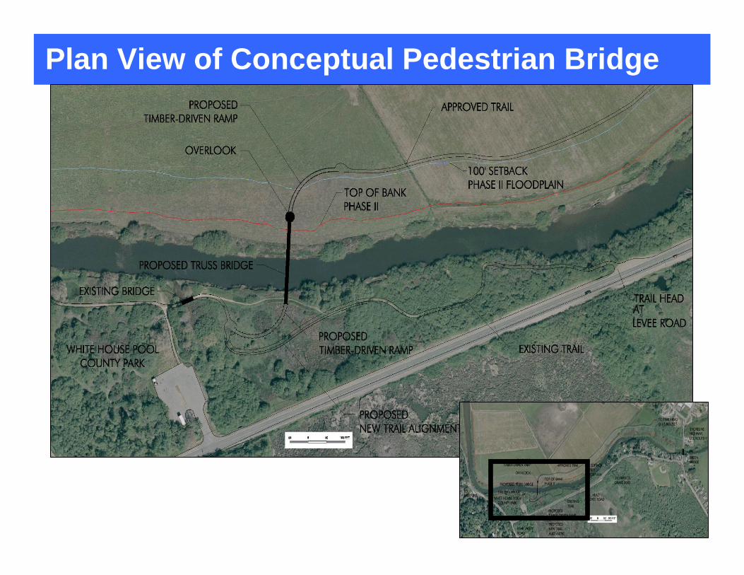
Plan View of Conceptual Pedestrian Bridge

Lagunitas Creek Bridge Concept
Design Considerations – Bridge Height
• Driven by predicted flood water surface elevations conveyed under bridge • Concepts show heights for structures that convey 50-year and 5-
year flood flows under bridge • Heights shown in graphic refer to a standard datum and NOT
elevation relative to creek bottom or bank top• Datum is equivalent to MLLW datum shown in tide logs• For reference purposes, mean sea level is 3.25 feet, and mean high
tide is 5.8 feet

•Bridge accommodates 50-year flow with freeboard varying between 0' and 4'.
•Bridge inundated during larger storm events.
Concept 1: Pedestrian Bridge at 15.4 feet -50 year flood
CrossCross--Sectional View Showing Flood LevelsSectional View Showing Flood Levels

Concept 2: Pedestrian Bridge at 12.6 feet - 5 year flood
•Bridge accommodates 5-year flow with freeboard around 0'.
•Bridge inundated during larger storm events.

Lagunitas Creek Bridge ConceptDesign Considerations – Bridge Height
• Why is flood conveyance an important consideration?• Bridge truss, ramps for bridge act as “dams” and can increase
upstream flooding and potential for creek diversion if not appropriately designed
• Regulatory considerations
Floodwaters overtop Giacomini Ranch levee during 1982 flood
January 1, 2006 – White House Pool

Bridge Span Considerations• 200- Foot structure• Same as EIS/EIR• Width from edge of bank to edge of bank is
approximately 150 feet• Extra 50 feet ensures that abutments are not placed
directly adjacent to creek• Helps reduce need for riprap, potential for undercutting of
abutments by erosion
Lagunitas Creek Bridge Concept

Lagunitas Creek Bridge Concept
Design Considerations – Bridge Dimensions
• Truss = Structural Support of Bridge• For 200-foot structure, need truss that is 12 feet tall
and 10-feet wide• Height of truss above bridge decking
• 8 feet • Doubles as pedestrian safety

Lagunitas Creek Bridge Concept
Design Considerations – Ramps
• Flood Considerations• Went with timber-pile driven rather than earthen ramp
to reduce resistance during flood flows
• Use considerations• Accommodate access for all abilities• Maximum of 5% grade (ADA-compliant)
• Can go up to 7.5%, but have to provide flat landings at regular intervals
• County policy is 5%• Affects Length of Ramps
• 20 feet of length for every 1 foot of vertical rise

Concept 1: North End - Pedestrian Bridge at 15.4 feet - 50 year flood

Concept 1: South End Pedestrian Bridge at 15.4 feet - 50 year flood

Concept 2: South End Pedestrian Bridge at 12.6 feet - 5 year flood event

Concept 2: North End - Pedestrian Bridge at 12.6 feet - 5 year flood event

Safety and Sustainability Considerations
• Bridge• Flood-related and routine annual maintenance• Flood-related and routine repair and/or replacement costs• Public health hazards associated with potential use during
high flow conditions• Public health hazards associated with non-designed uses
during non flood conditions
• Levee Road• Flood-related and routine annual maintenance• Flood-related and routine repair and/or replacement costs• Public health hazards associated with potential use during
high flow conditions• Public health hazards associated with use during non-flood
conditions (e.g., adjacency to roadway)
Point Reyes-Giacomini Public Access

$13,000
$15,000 to $19,000
Annual Maintenance
Cost
$820,000
$730,000 to $1,200,000
Estimated Construction
Cost
440
3,044
Project Area Length, feet
Non-vehicular Bridge and
Ramps
Levee Road Alignment
LandPeople, 2005
• 2008 non-vehicular bridge planning estimate, WRA Inc.– Includes bridge and access ramps on both sides, $1.75 Million
Point Reyes-Giacomini Public Access

• Either trail route would:
–Link the Park Service trail with the White House
Pool County park trail
–Require Levee Road Crossing to link with Olema
Marsh trail
• Subsequent phases would address the access
north of Whitehouse Pool to Inverness Park
Point Reyes-Giacomini Public Access

Existing BridgesAlong Cross Marin Trail

Green Bridge

Cross Marin Trail Bridge

Platform Bridge

Shafter Bridge

• Giacomini Wetland Restoration Update• Lagunitas Creek Hydraulics and Bridge
Concept• Levee Road Trail Alignment Concept• Alternative Transportation
Comment Breakout

Next Steps

• Additional written comments accepted until June 2, 2008
• Consolidate comments from this meeting and additional written comments
• NPS and County review comments
Next Steps