pohl sample pages wm - schweizerbart
TRANSCRIPT


sample
page
s
Economic GeologyPrinciples and Practice
Walter L. Pohl
2nd ed.
eschweizerbart_xxx

sample
page
s
To the Memory of Walther E. Petrascheck
(1906–1991)
Inspiring Geologist and Academic Teacher
Photograph by Fayer Wien; Courtesy Austrian Academy of Sciences
eschweizerbart_xxx

sample
page
s
Economic GeologyPrinciples and Practice
Metals, Minerals, Coal and Hydrocarbons – Introduction to Formation and Sustainable
Exploitation of Mineral Deposits
Walter L. Pohl
2nd
edition
Science Publishers • Stuttgart 2020
eschweizerbart_xxx

sample
page
s
W.L. Pohl: Economic Geology. Principles and Practice
Author’s address: Walter L. Pohl, Austrian Academy of Sciences, Dr. Ignaz Seipel-Platz 2, 1010 Vienna, Austria e-mail: [email protected] website: https://www.walter-pohl.com/
We would be pleased to receive your comments on the content of this book:[email protected]
Front cover: Natural outcrops of massive magnetite bodies (black) at Pliocene-Pleistocene suprasubduc-tion El Laco volcano, Chile. On the flanks of El Laco volcano (5325 m a.s.l.), there are seven large deposits of high-grade iron ore within an area of 30 km2, with total resources exceeding 1500 million tonnes. Black iron ore is composed of magnetite and minor amounts of hematite, anhydrite, apatite and pyroxene. Set in the Chilean iron ore belt among over 50 related deposits, those at El Laco recently yielded astounding scientific findings and are now recognized as the best preserved examples of iron oxide apatite (IOA) ore of Kiruna type in the world. Iron-oxide liquid segregated at 12–22 km depth by mingling between juvenile mafic and crustally derived felsic melt. Erupted as a hot volcanic magmatic gas plume saturated in iron, magnetite crystallized to form orthomagmatic-extrusive and pyroclastic iron ore at El Laco (“the surface venting of an IOA system”). Equally surprising is the recent recognition that in some magmatic columns, iron oxide apatite systems evolve upwards into magmatic-hydrothermal IOCG (iron oxide copper gold) systems. Read more inside this book ... Photo credit Matthias Benz (Germany, https://world-of-crystals.com/).
1st edition Wiley-Blackwell 20112nd revised edition 2020
ISBN 978-3-510-65435-2 ( oftcover)Information on this title: www.schweizerbart.de/9783510654352
ISBN 978-3-510-65441-3 ( ardcover)Information on this title: www.schweizerbart.de/9783510654413
ISBN 978-3-510-65436-9 (pdf)
© 2020 Schweizerbart’sche Verlagsbuchhandlung, Stuttgart, Germany
All rights reserved. No part of this publication may be reproduced, stored in a retrieval system, or transmitted, in any form or by any means, electronic, mechanical photocopying, recording, or otherwise, without the prior written permission of Schweizerbart Science Publishers.
Publisher: Schweizerbart Science Publishers, Johannesstraße 3A, 70176 Stuttgart, [email protected]/www.schweizerbart.dePrinted on permanent paper conforming to ISO 9706-1994Printed in Germany by eschweizerbart_xxx

sample
page
s
Preface (2nd dition)
The new age of economic geology
A new age? Yes, I do believe that we witness an exciting growth of geological research and its application in economic geology, even though building on knowledge created by generations of earlier scientists. Foundation of this revolution – some call it disruption – are new geological un-derstanding and concepts. One of the great advances is Lid Tectonics that have dominated Earth systems in the first half of our planet’s history. Tremendous new tools and methods at all scales are available, from Earth observing satellites to tomography of crust and mantle, drones mapping alteration minerals in open pits, handheld XRF and SWIR spectrometers, laser Raman spectros-copy, laser ablation ICP-MS, and electron probe microanalyzers (EPMA). Add the unlimited potential of the digital transformation, of big data artificial intelligence, mineral systems research,and, of course, the professionals who drive the pace.
Is it possible to catch a screenshot of this movement? Not fully. I admit that some parts of the image provided in this book may be fuzzy, where science advances at too quick a pace. Yet, this book (Economic Geology 2nd ed or EG2) aspires to provide a systematic overview across the state of science and practice in economic geology. EG2 offers a panorama of the whole field of geology applied to the realm of mineral resources. Its range is global, reflecting the spread of mining and exploration activity, and of the actors out there. It is based on over a thousand re-cent papers selected from first class journals. Readers may expect to find access to present-day knowledge in order to explore the great new ideas, discoveries, methods and technologies as well as much detail!
EG2 addresses professionals, earth science students and graduates, academic teachers and scientists; undergraduates are invited to practice selective reading. Some authors of introductory ore geology books strip science of contradictions, avoiding the discussion of different interpreta-tions and minimizing references to published papers. True, this may facilitate learning for begin-ners, but in my opinion, is wrong. We should not hide complexity, but accept a world of many unknowns and fuzziness. Like most natural sciences, economic geology seeks ever better com-prehension and builds models, parts of which are uncertain and in flux. The book proposes to improve the current haphazard subdivision and denomination of ore deposits by merging them into a systematic petrogenetic-tectonic classification.
How to use EG2? – I suggest to initially quick-read Chapter One, which provides the founda-tion for the rest of the book. Only then should you follow your specific interests.
Do not hesitate to refer frequently to the Subject and Location Indexes because information is often spread through the book, concerning themes, ore deposit classes and mines such as, for example, the Olympic Dam iron oxide copper gold (IOCG) deposit. Jumping back and forth to different pages is an absolute must.
Soon, the world population will reach the number of 10 billion. The supply of minerals for humanity requires exploration, development and extraction, from mines on land to floating plat-forms on the high seas or to submarine robots. Metallogenetic-minerogenetic (source – transport – trap) models of Earth processes that contribute to the formation of ore and mineral deposits are the foundation for many of these activities. And let us not forget that as a profession, we always have to strive for precautionary mitigation of any negative environmental and socio-economic impact of our work, guided by an enlightened environmentalism.
Many people have supported me in preparing this second edition of my Economic Geology. Outstandingly helpful was Dr. Bernd Lehmann, Professor at Clausthal University and Chief Edi-tor of Mineralium Deposita. Thank you Bernd, thank you all.
January 2020 Walter L. Pohl
eschweizerbart_xxx

sample
page
s
Preface (1st edition)
Wisely used, mineral resources create wealth, employment, a vital social and natural environ-ment, and peace. If the reverse of these conditions occurs only too often, illustrating the so-called “resource curse”, this should be attributed to the true perpetrators, namely irresponsible, weak or selfish leaders. This book, however, does not intend to provide rules for good governance. I wrote it as a broad overview on geoscientific aspects of mineral deposits, including their origin and geological characteristics, the principles of the search for ores and minerals, and the investi-gation of newly found deposits. In addition, practical and environmental aspects are addressed that arise during the life cycle of a mine and after its closure. I am convinced that in our time, economic geology cannot be taught, studied or practiced without an understanding of environ-mental issues. The scientific core of the book is the attempt to present the extraordinary genetic variability of mineral deposits in the frame of fundamental geological process systems. The com-prehensive approach – covering materials from metal ores to minerals and hydrocarbons – is both an advantage and a loss. The second concerns the sacrifice of much detail but I chose the first for its benefit of a panoramic view over the whole field of economic geology. Being aware that the specialist level of subjects presented in this book fills whole libraries, I do hope that even experienced practicians, academic teachers and advanced students of particular subjects will find the synopsis useful.
Over more than 50 years, five editions of this title were published in German. Since the first edition (Wilhelm & Walther E. Petrascheck 1950), the book was intended to provide a concise in-troduction to the geology of mineral deposits, including its applications to exploration and min-ing. The target readership has changed, however. Originally, it was written for students of mining engineering. Today, it is mainly directed to aspiring and practicing geologists. Each of the seven chapters of the book was developed with my own students as a university course and should be useful to fellow academic teachers. After initially working in industry I never lost contact with applications of economic geology, which is my motive for the constant interweaving of practical aspects in the text and for dedicating one of the chapters to the practice of economic geology. For professional reference purposes, practitioners in geology and mining should appreciate this melange of science and application. Frequent explanations and references to environmental and health aspects of extraction and processing of ores and minerals should assist users involved in environmental work. To those with no background in geology, I recommend to acquire an intro-ductory geoscience text for looking up terms that are employed but cannot be explained in the available space.
Compared with the last German edition (Pohl 2005), this book has been rewritten for an international public. Although it retains a moderate European penchant by referring to examples from this region, important deposits worldwide are preferentially chosen to explain genetic types and practical aspects. I trust that this will be useful to both scholars and practitioners, wherever they work. Generally, it was my ambition to present the state of the art in economic geology, by referring to and citing recent publications as well as earlier fundamental concepts. This should assist and motivate students to pursue topics to greater depth.
Many people have supported me in my life-long pursuit of theory and practice of economic geology, and helped with this book, especially by donating photographs. I cannot name them all but in captions, donors are acknowledged. Here, just let me say thank you.
Walter L. Pohl
eschweizerbart_xxx

sample
page
s
Contents
Preface . . . . . . . . . . . . . . . . . . . . . . . . . . . . . . . . . . . . . . . . . . . . . . . . . . . . . . . . . . . . . . . . . . . . . . VIntroduction . . . . . . . . . . . . . . . . . . . . . . . . . . . . . . . . . . . . . . . . . . . . . . . . . . . . . . . . . . . . . . . . . . 1 What are ore deposits? . . . . . . . . . . . . . . . . . . . . . . . . . . . . . . . . . . . . . . . . . . . . . . . . . . 1 Mining in the stress field between society and environment . . . . . . . . . . . . . . . . . . 2 The mineral resources conundrum. . . . . . . . . . . . . . . . . . . . . . . . . . . . . . . . . . . . . . . . 4
Part I Metalliferous Ore Deposits
1 Geological ore formation process systems (metallogenesis) . . . . . . . . . . . . . . . . 5 Synopsis . . . . . . . . . . . . . . . . . . . . . . . . . . . . . . . . . . . . . . . . . . . . . . . . . . . . . . . . . . . . . . 51.1 Magmatic Ore Formation Systems . . . . . . . . . . . . . . . . . . . . . . . . . . . . . . . . . . . . . . . . 9 1.1.1 Orthomagmatic ore formation. . . . . . . . . . . . . . . . . . . . . . . . . . . . . . . . . . . . 10 1.1.2 Ore deposits related to ocean floor volcanism
(ophiolite hosted Cyprus type Zn-Cu-Au) . . . . . . . . . . . . . . . . . . . . . . . . . . 21 1.1.3 Ore formation related to alkaline igneous rocks, carbonatites
and kimberlites . . . . . . . . . . . . . . . . . . . . . . . . . . . . . . . . . . . . . . . . . . . . . . . . . 26 1.1.4 Granites – The Earth’s workhorses of ore formation. . . . . . . . . . . . . . . . . . 29 1.1.5 Ore deposits in pegmatites: Sources of high-technology rare and
“green” metals .. . . . . . . . . . . . . . . . . . . . . . . . . . . . . . . . . . . . . . . . . . . . . . . . . 37 1.1.6 Hydrothermal ore formation . . . . . . . . . . . . . . . . . . . . . . . . . . . . . . . . . . . . . 42 Isotope geochemistry . . . . . . . . . . . . . . . . . . . . . . . . . . . . . . . . . . . . . . . . . . . . 47 Fluid Inclusions: Temperature and pressure . . . . . . . . . . . . . . . . . . . . . . . . . 53 Mineral succession: Ore microscopy to EPMA . . . . . . . . . . . . . . . . . . . . . . 56 Hydrothermal Host Rock Alteration . . . . . . . . . . . . . . . . . . . . . . . . . . . . . . . 59 1.1.7 Hydrothermal vein deposits . . . . . . . . . . . . . . . . . . . . . . . . . . . . . . . . . . . . . . 62 1.1.8 Skarn- and contact-metasomatic ore deposits . . . . . . . . . . . . . . . . . . . . . . . 68 1.1.9 Volcanogenic ore deposits – Gold, iron and base metals . . . . . . . . . . . . . . 70 Subvolcanic porphyry copper . . . . . . . . . . . . . . . . . . . . . . . . . . . . . . . . . . . . . 71 Terrestrial volcanic epithermal Au and Ag . . . . . . . . . . . . . . . . . . . . . . . . . . 76 Submarine volcanogenic massive sulfides . . . . . . . . . . . . . . . . . . . . . . . . . . . 791.2 Supergene Ore Formation Systems . . . . . . . . . . . . . . . . . . . . . . . . . . . . . . . . . . . . . . . . 82 1.2.1 Residual, or eluvial ore deposits. . . . . . . . . . . . . . . . . . . . . . . . . . . . . . . . . . . 85 1.2.2 Supergene enrichment by descending solutions . . . . . . . . . . . . . . . . . . . . . 87 1.2.3 Infiltration as an agent of ore formation . . . . . . . . . . . . . . . . . . . . . . . . . . . . 921.3 Sedimentary Ore Formation Systems. . . . . . . . . . . . . . . . . . . . . . . . . . . . . . . . . . . . . . 95 1.3.1 Organic-rich shales in metallogenesis. . . . . . . . . . . . . . . . . . . . . . . . . . . . . . 97 1.3.2 Placer deposits . . . . . . . . . . . . . . . . . . . . . . . . . . . . . . . . . . . . . . . . . . . . . . . . . 98 1.3.3 Autochthonous iron and manganese deposits . . . . . . . . . . . . . . . . . . . . . . . 102 1.3.4 Sediment-hosted, submarine-exhalative (sedex) deposits . . . . . . . . . . . . . 1091.4 Diagenetic Ore Formation Systems . . . . . . . . . . . . . . . . . . . . . . . . . . . . . . . . . . . . . . . 112 1.4.1 The European Copper Shale . . . . . . . . . . . . . . . . . . . . . . . . . . . . . . . . . . . . . . 116 1.4.2 Diagenetic-hydrothermal carbonate-hosted Pb-Zn deposits . . . . . . . . . . 118 1.4.3 Diagenetic hydrothermal-metasomatic ore deposits . . . . . . . . . . . . . . . . . 121 1.4.4 Diagenetic-hydrothermal ore formation related to salt diapirs . . . . . . . . . 1231.5 Metamorphosed and Metamorphic Ore Deposits . . . . . . . . . . . . . . . . . . . . . . . . . . . 1251.6 Metamorphogenic Ore Formation Systems. . . . . . . . . . . . . . . . . . . . . . . . . . . . . . . . . 1291.7 Metallogeny – Ore Deposit Formation in Space and Time . . . . . . . . . . . . . . . . . . . . 136
eschweizerbart_xxx

sample
page
s
VIII Contents
1.7.1 Metallogenetic space and time concepts. . . . . . . . . . . . . . . . . . . . . . . . . . . . 137 1.7.2 Metallogeny and lid tectonics (4500 to ~2500 Ma) . . . . . . . . . . . . . . . . . . . 139 1.7.3 Metallogeny and plate tectonics (~2500 Ma to the present) . . . . . . . . . . . 1391.8 Genetic Classification of Ore and Mineral Deposits . . . . . . . . . . . . . . . . . . . . . . . . . 1511.9 Metallogenesis: Summary and Further Reading. . . . . . . . . . . . . . . . . . . . . . . . . . . . . 154
2 Economic geology of metals . . . . . . . . . . . . . . . . . . . . . . . . . . . . . . . . . . . . . . . . . . . . 157 Synopsis . . . . . . . . . . . . . . . . . . . . . . . . . . . . . . . . . . . . . . . . . . . . . . . . . . . . . . . . . . . . . . 1572.1 The Iron and Steel Metals . . . . . . . . . . . . . . . . . . . . . . . . . . . . . . . . . . . . . . . . . . . . . . . . 157 2.1.1 Iron. . . . . . . . . . . . . . . . . . . . . . . . . . . . . . . . . . . . . . . . . . . . . . . . . . . . . . . . . . . 157 2.1.2 Manganese . . . . . . . . . . . . . . . . . . . . . . . . . . . . . . . . . . . . . . . . . . . . . . . . . . . . 168 2.1.3 Chromium . . . . . . . . . . . . . . . . . . . . . . . . . . . . . . . . . . . . . . . . . . . . . . . . . . . . 172 2.1.4 Nickel . . . . . . . . . . . . . . . . . . . . . . . . . . . . . . . . . . . . . . . . . . . . . . . . . . . . . . . . . 177 2.1.5 Cobalt . . . . . . . . . . . . . . . . . . . . . . . . . . . . . . . . . . . . . . . . . . . . . . . . . . . . . . . . 184 2.1.6 Molybdenum . . . . . . . . . . . . . . . . . . . . . . . . . . . . . . . . . . . . . . . . . . . . . . . . . . 186 2.1.7 Tungsten (wolfram) . . . . . . . . . . . . . . . . . . . . . . . . . . . . . . . . . . . . . . . . . . . . . 191 2.1.8 Vanadium . . . . . . . . . . . . . . . . . . . . . . . . . . . . . . . . . . . . . . . . . . . . . . . . . . . . . 1952.2 Base Metals . . . . . . . . . . . . . . . . . . . . . . . . . . . . . . . . . . . . . . . . . . . . . . . . . . . . . . . . . . . . 197 2.2.1 Copper . . . . . . . . . . . . . . . . . . . . . . . . . . . . . . . . . . . . . . . . . . . . . . . . . . . . . . . . 197 2.2.2 Lead and zinc . . . . . . . . . . . . . . . . . . . . . . . . . . . . . . . . . . . . . . . . . . . . . . . . . . 210 2.2.3 Tin . . . . . . . . . . . . . . . . . . . . . . . . . . . . . . . . . . . . . . . . . . . . . . . . . . . . . . . . . . . 2182.3 Precious Metals . . . . . . . . . . . . . . . . . . . . . . . . . . . . . . . . . . . . . . . . . . . . . . . . . . . . . . . . 224 2.3.1 Gold . . . . . . . . . . . . . . . . . . . . . . . . . . . . . . . . . . . . . . . . . . . . . . . . . . . . . . . . . . 240 2.3.2 Silver . . . . . . . . . . . . . . . . . . . . . . . . . . . . . . . . . . . . . . . . . . . . . . . . . . . . . . . . . 240 2.3.3 Platinum and platinum group metals . . . . . . . . . . . . . . . . . . . . . . . . . . . . . . 2462.4 Light Metals . . . . . . . . . . . . . . . . . . . . . . . . . . . . . . . . . . . . . . . . . . . . . . . . . . . . . . . . . . . 251 2.4.1 Aluminium . . . . . . . . . . . . . . . . . . . . . . . . . . . . . . . . . . . . . . . . . . . . . . . . . . . . 251 2.4.2 Magnesium . . . . . . . . . . . . . . . . . . . . . . . . . . . . . . . . . . . . . . . . . . . . . . . . . . . . 2562.5 Minor and Speciality Metals . . . . . . . . . . . . . . . . . . . . . . . . . . . . . . . . . . . . . . . . . . . . . 258 2.5.1 Mercury . . . . . . . . . . . . . . . . . . . . . . . . . . . . . . . . . . . . . . . . . . . . . . . . . . . . . . . 258 2.5.2 Antimony . . . . . . . . . . . . . . . . . . . . . . . . . . . . . . . . . . . . . . . . . . . . . . . . . . . . . 261 2.5.3 Arsenic. . . . . . . . . . . . . . . . . . . . . . . . . . . . . . . . . . . . . . . . . . . . . . . . . . . . . . . . 264 2.5.4 Electronic metals (selenium, tellurium, gallium, germanium,
indium, cadmium) and silicon. . . . . . . . . . . . . . . . . . . . . . . . . . . . . . . . . . . . 267 2.5.5 Bismuth . . . . . . . . . . . . . . . . . . . . . . . . . . . . . . . . . . . . . . . . . . . . . . . . . . . . . . . 270 2.5.6 Zirconium and hafnium . . . . . . . . . . . . . . . . . . . . . . . . . . . . . . . . . . . . . . . . . 271 2.5.7 Titanium . . . . . . . . . . . . . . . . . . . . . . . . . . . . . . . . . . . . . . . . . . . . . . . . . . . . . . 271 2.5.8 Rare earth elements (REE, lanthanides) . . . . . . . . . . . . . . . . . . . . . . . . . . . . 277 2.5.9 Niobium and tantalum . . . . . . . . . . . . . . . . . . . . . . . . . . . . . . . . . . . . . . . . . . 282 2.5.10 Lithium . . . . . . . . . . . . . . . . . . . . . . . . . . . . . . . . . . . . . . . . . . . . . . . . . . . . . . . 289 2.5.11 Beryllium. . . . . . . . . . . . . . . . . . . . . . . . . . . . . . . . . . . . . . . . . . . . . . . . . . . . . . 292 2.5.12 Uranium (and thorium) . . . . . . . . . . . . . . . . . . . . . . . . . . . . . . . . . . . . . . . . . 2952.6 Metals: Summary and Further Reading . . . . . . . . . . . . . . . . . . . . . . . . . . . . . . . . . . . . 309
Part II Non-Metallic Minerals and Rocks
3 Industrial minerals, earths and rocks . . . . . . . . . . . . . . . . . . . . . . . . . . . . . . . . . . . . 311 Synopsis . . . . . . . . . . . . . . . . . . . . . . . . . . . . . . . . . . . . . . . . . . . . . . . . . . . . . . . . . . . . . . 3113.1 Andalusite, kyanite and sillimanite. . . . . . . . . . . . . . . . . . . . . . . . . . . . . . . . . . . . . . . . 3123.2 Asbestos . . . . . . . . . . . . . . . . . . . . . . . . . . . . . . . . . . . . . . . . . . . . . . . . . . . . . . . . . . . . . . 3153.3 Barite and celestite. . . . . . . . . . . . . . . . . . . . . . . . . . . . . . . . . . . . . . . . . . . . . . . . . . . . . . 3183.4 Bentonite (smectite rocks) . . . . . . . . . . . . . . . . . . . . . . . . . . . . . . . . . . . . . . . . . . . . . . . 322
eschweizerbart_xxx

sample
page
s
IXContents
3.5 Borates . . . . . . . . . . . . . . . . . . . . . . . . . . . . . . . . . . . . . . . . . . . . . . . . . . . . . . . . . . . . . . . 3253.6 Carbonate rocks: limestone, calcite marble, marlstone, dolomite . . . . . . . . . . . . . . 3283.7 Clay and clay rocks . . . . . . . . . . . . . . . . . . . . . . . . . . . . . . . . . . . . . . . . . . . . . . . . . . . . . 3313.8 Diamond . . . . . . . . . . . . . . . . . . . . . . . . . . . . . . . . . . . . . . . . . . . . . . . . . . . . . . . . . . . . . 3343.9 Diatomite and tripoli . . . . . . . . . . . . . . . . . . . . . . . . . . . . . . . . . . . . . . . . . . . . . . . . . . . 3423.10 Feldspar and feldspar-rich igneous rocks . . . . . . . . . . . . . . . . . . . . . . . . . . . . . . . . . . 3433.11 Fluorite . . . . . . . . . . . . . . . . . . . . . . . . . . . . . . . . . . . . . . . . . . . . . . . . . . . . . . . . . . . . . . . 3453.12 Graphite . . . . . . . . . . . . . . . . . . . . . . . . . . . . . . . . . . . . . . . . . . . . . . . . . . . . . . . . . . . . . . 3493.13 Gypsum and anhydrite . . . . . . . . . . . . . . . . . . . . . . . . . . . . . . . . . . . . . . . . . . . . . . . . . . 3523.14 Kaolin . . . . . . . . . . . . . . . . . . . . . . . . . . . . . . . . . . . . . . . . . . . . . . . . . . . . . . . . . . . . . . . . 3553.15 Magnesite . . . . . . . . . . . . . . . . . . . . . . . . . . . . . . . . . . . . . . . . . . . . . . . . . . . . . . . . . . . . . 3583.16 Mica (muscovite, phlogopite, vermiculite) . . . . . . . . . . . . . . . . . . . . . . . . . . . . . . . . . 3643.17 Olivine (dunite) . . . . . . . . . . . . . . . . . . . . . . . . . . . . . . . . . . . . . . . . . . . . . . . . . . . . . . . . 3673.18 Phosphate (apatite) . . . . . . . . . . . . . . . . . . . . . . . . . . . . . . . . . . . . . . . . . . . . . . . . . . . . . 3693.19 Quartz and silicon . . . . . . . . . . . . . . . . . . . . . . . . . . . . . . . . . . . . . . . . . . . . . . . . . . . . . . 3733.20 Quartzite . . . . . . . . . . . . . . . . . . . . . . . . . . . . . . . . . . . . . . . . . . . . . . . . . . . . . . . . . . . . . . 3753.21 Quartz sand and gravel . . . . . . . . . . . . . . . . . . . . . . . . . . . . . . . . . . . . . . . . . . . . . . . . . . 3773.22 Sodium carbonate, sodium sulfate and alum salts . . . . . . . . . . . . . . . . . . . . . . . . . . . 3803.23 Sulfur. . . . . . . . . . . . . . . . . . . . . . . . . . . . . . . . . . . . . . . . . . . . . . . . . . . . . . . . . . . . . . . . . 3813.24 Talc and pyrophyllite . . . . . . . . . . . . . . . . . . . . . . . . . . . . . . . . . . . . . . . . . . . . . . . . . . . 3843.25 Volcaniclastic rocks . . . . . . . . . . . . . . . . . . . . . . . . . . . . . . . . . . . . . . . . . . . . . . . . . . . . . 3883.26 Wollastonite . . . . . . . . . . . . . . . . . . . . . . . . . . . . . . . . . . . . . . . . . . . . . . . . . . . . . . . . . . . 3903.27 Zeolites . . . . . . . . . . . . . . . . . . . . . . . . . . . . . . . . . . . . . . . . . . . . . . . . . . . . . . . . . . . . . . . 3923.28 Industrial Minerals and Rocks: Summary and Further Reading . . . . . . . . . . . . . . . 394
4 Salt deposits (evaporites) . . . . . . . . . . . . . . . . . . . . . . . . . . . . . . . . . . . . . . . . . . . . . . . 397 Synopsis . . . . . . . . . . . . . . . . . . . . . . . . . . . . . . . . . . . . . . . . . . . . . . . . . . . . . . . . . . . . . . 3974.1 Salt Minerals and Salt Rocks . . . . . . . . . . . . . . . . . . . . . . . . . . . . . . . . . . . . . . . . . . . . . 3994.2 The Formation of Salt Deposits . . . . . . . . . . . . . . . . . . . . . . . . . . . . . . . . . . . . . . . . . . . 405 4.2.1 Salt formation today . . . . . . . . . . . . . . . . . . . . . . . . . . . . . . . . . . . . . . . . . . . . 405 4.2.2 Salt formation in the geological past . . . . . . . . . . . . . . . . . . . . . . . . . . . . . . . 4134.3 Post-Depositional Fate of Salt Rocks . . . . . . . . . . . . . . . . . . . . . . . . . . . . . . . . . . . . . . 425 4.3.1 Diagenesis and metamorphism of evaporites . . . . . . . . . . . . . . . . . . . . . . . 425 4.3.2 Deformation of salt rocks . . . . . . . . . . . . . . . . . . . . . . . . . . . . . . . . . . . . . . . . 428 4.3.3 Halokinesis and salt tectonics . . . . . . . . . . . . . . . . . . . . . . . . . . . . . . . . . . . . 430 4.3.4 Supergene alteration of salt deposits . . . . . . . . . . . . . . . . . . . . . . . . . . . . . . . 4354.4 From Exploration to Salt Mining . . . . . . . . . . . . . . . . . . . . . . . . . . . . . . . . . . . . . . . . . 437 4.4.1 Exploration and development of salt deposits . . . . . . . . . . . . . . . . . . . . . . . 437 4.4.2 Geological practice in salt mining . . . . . . . . . . . . . . . . . . . . . . . . . . . . . . . . . 4394.5 Salt: Summary and Further Reading. . . . . . . . . . . . . . . . . . . . . . . . . . . . . . . . . . . . . . . 441
Part III The Practice of Economic Geology
5 Geological concepts and methods in the mining cycle: Exploration, exploitation and closure of mines. . . . . . . . . . . . . . . . . . . . . . . . . . . . 443
Synopsis . . . . . . . . . . . . . . . . . . . . . . . . . . . . . . . . . . . . . . . . . . . . . . . . . . . . . . . . . . . . . . 4435.1 Economic Considerations . . . . . . . . . . . . . . . . . . . . . . . . . . . . . . . . . . . . . . . . . . . . . . . 4445.2 The Search for Mineral Deposits (Exploration) . . . . . . . . . . . . . . . . . . . . . . . . . . . . . 446 5.2.1 Pre-exploration stage . . . . . . . . . . . . . . . . . . . . . . . . . . . . . . . . . . . . . . . . . . . . 446 5.2.2 Geological exploration . . . . . . . . . . . . . . . . . . . . . . . . . . . . . . . . . . . . . . . . . . 448 5.2.3 Geological remote sensing . . . . . . . . . . . . . . . . . . . . . . . . . . . . . . . . . . . . . . . 451 5.2.4 Geochemical exploration . . . . . . . . . . . . . . . . . . . . . . . . . . . . . . . . . . . . . . . . 454
eschweizerbart_xxx

sample
page
s
X Contents
5.2.5 Geophysical exploration . . . . . . . . . . . . . . . . . . . . . . . . . . . . . . . . . . . . . . . . . 460 5.2.6 Trenching and drilling . . . . . . . . . . . . . . . . . . . . . . . . . . . . . . . . . . . . . . . . . . 4665.3 Development and Valuation of Mineral Deposits . . . . . . . . . . . . . . . . . . . . . . . . . . . 470 5.3.1 Geological mapping and sampling . . . . . . . . . . . . . . . . . . . . . . . . . . . . . . . . 470 5.3.2 Ore reserve estimation and determination of grade . . . . . . . . . . . . . . . . . . 473 5.3.3 Valuation of mineral deposits . . . . . . . . . . . . . . . . . . . . . . . . . . . . . . . . . . . . 4795.4 Mining and the Environment . . . . . . . . . . . . . . . . . . . . . . . . . . . . . . . . . . . . . . . . . . . . 481 5.4.1 Potential environmental problems related to mining . . . . . . . . . . . . . . . . . 482 5.4.2 Waste rock, tailings and seepage water . . . . . . . . . . . . . . . . . . . . . . . . . . . . . 487 5.4.3 Mining and climate change . . . . . . . . . . . . . . . . . . . . . . . . . . . . . . . . . . . . . . 488 5.4.4 Mine closure . . . . . . . . . . . . . . . . . . . . . . . . . . . . . . . . . . . . . . . . . . . . . . . . . . . 4895.5 Deep Geological Disposal of Dangerous Waste . . . . . . . . . . . . . . . . . . . . . . . . . . . . . 4925.6 The Practice of Economic Geology: Summary and Further Reading . . . . . . . . . . . 495
Part IV Fossil Energy Raw Materials – Coal, Oil and Gas
6 Coal . . . . . . . . . . . . . . . . . . . . . . . . . . . . . . . . . . . . . . . . . . . . . . . . . . . . . . . . . . . . . . . . . . 500 Synopsis . . . . . . . . . . . . . . . . . . . . . . . . . . . . . . . . . . . . . . . . . . . . . . . . . . . . . . . . . . . . . . 5006.1 The Substance of Coal. . . . . . . . . . . . . . . . . . . . . . . . . . . . . . . . . . . . . . . . . . . . . . . . . . . 505 6.1.1 Coal types, rank and grade . . . . . . . . . . . . . . . . . . . . . . . . . . . . . . . . . . . . . . . 505 6.1.2 Petrography of coal: lithotypes and macerals . . . . . . . . . . . . . . . . . . . . . . . 508 6.1.3 The chemical composition of coal . . . . . . . . . . . . . . . . . . . . . . . . . . . . . . . . . 5116.2 Peat Formation and Coal Deposits . . . . . . . . . . . . . . . . . . . . . . . . . . . . . . . . . . . . . . . . 519 6.2.1 Types and dimensions of coal seams . . . . . . . . . . . . . . . . . . . . . . . . . . . . . . 519 6.2.2 Concordant and discordant clastic sediments in coal seams . . . . . . . . . . 522 6.2.3 Peat formation environments . . . . . . . . . . . . . . . . . . . . . . . . . . . . . . . . . . . . 522 6.2.4 Host rocks of coal . . . . . . . . . . . . . . . . . . . . . . . . . . . . . . . . . . . . . . . . . . . . . . 526 6.2.5 Marker beds in coal formations . . . . . . . . . . . . . . . . . . . . . . . . . . . . . . . . . . 527 6.2.6 Coal formation in geological space and time . . . . . . . . . . . . . . . . . . . . . . . 5286.3 The Coalification Process . . . . . . . . . . . . . . . . . . . . . . . . . . . . . . . . . . . . . . . . . . . . . . . 528 6.3.1 Biochemical peatification . . . . . . . . . . . . . . . . . . . . . . . . . . . . . . . . . . . . . . . . 528 6.3.2 Geochemical coalification . . . . . . . . . . . . . . . . . . . . . . . . . . . . . . . . . . . . . . . 530 6.3.3 Measuring the degree of coalification . . . . . . . . . . . . . . . . . . . . . . . . . . . . . 531 6.3.4 Causes of coalification . . . . . . . . . . . . . . . . . . . . . . . . . . . . . . . . . . . . . . . . . . 532 6.3.5 Coal maturity and diagenesis of country rocks . . . . . . . . . . . . . . . . . . . . . . 5356.4 Post-Depositional Changes of Coal Seams . . . . . . . . . . . . . . . . . . . . . . . . . . . . . . . . . 535 6.4.1 Tectonic deformation . . . . . . . . . . . . . . . . . . . . . . . . . . . . . . . . . . . . . . . . . . . 535 6.4.2 Epigenetic mineralization of coal seams . . . . . . . . . . . . . . . . . . . . . . . . . . . 536 6.4.3 Exogenetic alteration of coal . . . . . . . . . . . . . . . . . . . . . . . . . . . . . . . . . . . . . 5366.5 Applications of Coal Geology . . . . . . . . . . . . . . . . . . . . . . . . . . . . . . . . . . . . . . . . . . . . 537 6.5.1 Exploration . . . . . . . . . . . . . . . . . . . . . . . . . . . . . . . . . . . . . . . . . . . . . . . . . . . . 537 6.5.2 Reserve estimation . . . . . . . . . . . . . . . . . . . . . . . . . . . . . . . . . . . . . . . . . . . . . 540 6.5.3 Coal mining geology . . . . . . . . . . . . . . . . . . . . . . . . . . . . . . . . . . . . . . . . . . . . 541 6.5.4 Environmental aspects of coal mining . . . . . . . . . . . . . . . . . . . . . . . . . . . . . 5436.6 Coal: Summary and Further Reading . . . . . . . . . . . . . . . . . . . . . . . . . . . . . . . . . . . . . 547
7 Petroleum and Natural Gas Deposits . . . . . . . . . . . . . . . . . . . . . . . . . . . . . . . . . . . . 551 Synopsis . . . . . . . . . . . . . . . . . . . . . . . . . . . . . . . . . . . . . . . . . . . . . . . . . . . . . . . . . . . . . . 5517.1 Species of Natural Bitumens, Gas and Kerogen, and their Properties . . . . . . . . . . . 553 7.1.1 Crude oil, or petroleum . . . . . . . . . . . . . . . . . . . . . . . . . . . . . . . . . . . . . . . . . 554 7.1.2 Natural gas . . . . . . . . . . . . . . . . . . . . . . . . . . . . . . . . . . . . . . . . . . . . . . . . . . . . 556 7.1.3 Natural gas hydrates (clathrates) . . . . . . . . . . . . . . . . . . . . . . . . . . . . . . . . . . 559
eschweizerbart_xxx

sample
page
s
XIContents
7.1.4 Tar . . . . . . . . . . . . . . . . . . . . . . . . . . . . . . . . . . . . . . . . . . . . . . . . . . . . . . . . . . . 560 7.1.5 Earth wax (ozocerite) . . . . . . . . . . . . . . . . . . . . . . . . . . . . . . . . . . . . . . . . . . . 560 7.1.6 Pyrobitumen . . . . . . . . . . . . . . . . . . . . . . . . . . . . . . . . . . . . . . . . . . . . . . . . . . . 560 7.1.7 Natural asphalt . . . . . . . . . . . . . . . . . . . . . . . . . . . . . . . . . . . . . . . . . . . . . . . . . 560 7.1.8 Kerogen . . . . . . . . . . . . . . . . . . . . . . . . . . . . . . . . . . . . . . . . . . . . . . . . . . . . . . . 5607.2 The Origin of Petroleum and Natural Gas . . . . . . . . . . . . . . . . . . . . . . . . . . . . . . . . . 562 7.2.1 Petroleum source rocks . . . . . . . . . . . . . . . . . . . . . . . . . . . . . . . . . . . . . . . . . . 563 7.2.2 Dry gas source rocks . . . . . . . . . . . . . . . . . . . . . . . . . . . . . . . . . . . . . . . . . . . . 565 7.2.3 Eogenesis and catagenesis of kerogen . . . . . . . . . . . . . . . . . . . . . . . . . . . . . . 566 7.2.4 The oil window . . . . . . . . . . . . . . . . . . . . . . . . . . . . . . . . . . . . . . . . . . . . . . . . . 5697.3 Formation of Petroleum and Natural Gas Deposits . . . . . . . . . . . . . . . . . . . . . . . . . . 570 7.3.1 Migration . . . . . . . . . . . . . . . . . . . . . . . . . . . . . . . . . . . . . . . . . . . . . . . . . . . . . 571 7.3.2 Conventional and unconventional reservoir rocks . . . . . . . . . . . . . . . . . . 573 7.3.3 Petroleum and gas traps . . . . . . . . . . . . . . . . . . . . . . . . . . . . . . . . . . . . . . . . . 575 7.3.4 Formation and reservoir waters . . . . . . . . . . . . . . . . . . . . . . . . . . . . . . . . . . 581 7.3.5 Alteration of petroleum in reservoirs (degradation) . . . . . . . . . . . . . . . . . 582 7.3.6 Tectonic environments and age of hydrocarbon provinces . . . . . . . . . . . . 5837.4 Exploring for Petroleum and Natural Gas Deposits . . . . . . . . . . . . . . . . . . . . . . . . . 584 7.4.1 Geophysical methods . . . . . . . . . . . . . . . . . . . . . . . . . . . . . . . . . . . . . . . . . . . 586 7.4.2 Geochemical methods of hydrocarbon exploration . . . . . . . . . . . . . . . . . . 587 7.4.3 Exploration drilling . . . . . . . . . . . . . . . . . . . . . . . . . . . . . . . . . . . . . . . . . . . . . 587 7.4.4 Geophysical borehole measurements . . . . . . . . . . . . . . . . . . . . . . . . . . . . . . 5887.5 The Exploitation of Petroleum and Natural Gas Deposits. . . . . . . . . . . . . . . . . . . . . 592 7.5.1 Reservoir conditions . . . . . . . . . . . . . . . . . . . . . . . . . . . . . . . . . . . . . . . . . . . . 592 7.5.2 Oil and gasfield development . . . . . . . . . . . . . . . . . . . . . . . . . . . . . . . . . . . . . 594 7.5.3 Oil and gas production . . . . . . . . . . . . . . . . . . . . . . . . . . . . . . . . . . . . . . . . . . 596 7.5.4 Petroleum mining . . . . . . . . . . . . . . . . . . . . . . . . . . . . . . . . . . . . . . . . . . . . . . 599 7.5.5 Reserve and Resource Estimation . . . . . . . . . . . . . . . . . . . . . . . . . . . . . . . . . 599 7.5.6 Post-production uses of oil and gas fields . . . . . . . . . . . . . . . . . . . . . . . . . . 6017.6 Tar, Asphalt, Pyrobitumen and Shungite . . . . . . . . . . . . . . . . . . . . . . . . . . . . . . . . . . . 6017.7 Immature Oil Shales . . . . . . . . . . . . . . . . . . . . . . . . . . . . . . . . . . . . . . . . . . . . . . . . . . . . 6047.8 Environmental Aspects of Oil and Gas Production . . . . . . . . . . . . . . . . . . . . . . . . . . 605 7.8.1 Water resources protection . . . . . . . . . . . . . . . . . . . . . . . . . . . . . . . . . . . . . . . 608 7.8.2 Subsidence, and induced (man-made) seismic activity . . . . . . . . . . . . . . . 608 7.8.3 Hydrocarbons and climate . . . . . . . . . . . . . . . . . . . . . . . . . . . . . . . . . . . . . . . 6097.9 Hydrocarbons: Summary and Further Reading . . . . . . . . . . . . . . . . . . . . . . . . . . . . . 609
Color Plates . . . . . . . . . . . . . . . . . . . . . . . . . . . . . . . . . . . . . . . . . . . . . . . . . . . . . . . . . . . . . . . . . . . 613The New Age of Economic Geology – Epilogue. . . . . . . . . . . . . . . . . . . . . . . . . . . . . . . . . . . . 645References, General Index, Location Index, Box Titles . . . . . . . . . . . . . . . . . . . . . . . . . . . . . 647This book has a companion website: www.schweizerbart.de
eschweizerbart_xxx

sample
page
s
Introduction
Human societies need sufficient water, pro-ductive soil, food, energy in different forms, and organic and mineral raw materials as a base for their physical existence. Of high im-portance is a healthy natural and socio-eco-nomic environment.
Economic Geology is a subdiscipline of the geosciences; according to Lindgren (1933) it is “the application of geology”. Today, we might call it the scientific study of the Earth’s sources of mineral raw materials and the prac-tical application of the acquired knowledge. Considering the life cycle of a mine, economic geology leads in the search for new mineral deposits and in their detailed investigation. It contributes to economic and technical evalua-tions, which confirm the feasibility of a project and result in the physical establishment of a new mine. While mining goes on, economic geology provides many services that assist ra-tional exploitation, foremost by continuously extending mineable reserves and by limiting effects on the mine’s environment to a mini-mum. Possibly negative impacts of mining in-clude surface subsidence, lowering the water table, various emissions and mechanically un-stable or environmentally doubtful waste rock dumps. In the phase of mine closure, economic geology helps to avoid insufficient or outright wrong measures of physical and chemical sta-bilization, recultivation and renaturalization.
In recent years, the economic progress of industrial and of rapidly developing coun-tries caused incisive changes in supply and consumption of mineral raw materials. China rather than Europe or North America pro-vides world markets with essential metals and minerals, although at the same time im-porting large quantities of needed feedstock for its expanding industry and for improving her people’s quality of life. The future supply with petroleum appears to be secure because of new sources and technologies; its role as the main source of liquid fuels for transport is hardly dented by biofuels and other devel-opments. Wind, solar and geothermal energy are increasingly contributing to electricity pro-duction, yet without coal, nuclear power and
natural gas, industrial economies would soon break down and developing nations would be locked in poverty. Ours is a time of transition but we cannot yet discern the outcome. What-ever it will be, metals, minerals and energy are certain to remain a precondition of progress and human well-being.
What are ore deposits?
Ore and mineral deposits are natural concen-trations of useful metals, minerals or rocks, which can be economically exploited. Concen-trations that are too small or too low-grade for mining are called occurrences or mineraliza-tions. It is very important to understand the economic implications of the difference be-tween these terms. Unfortunately, their wrong application is common and leads to funda-mentally misleading deductions. Therefore, the denomination “economic ore deposit” may be used when a clear attribution to this class is to be emphasized. Note that not all ores are strictly natural – it is very common that waste of a former miners’ generation is today’s prof-itable ore, such as tailings of earlier gold, cop-per and diamond mining.
Mineral deposits are basically valuable rock bodies.. Their formation is compared with pro-cesses that have produced ordinary rocks and is investigated with petrological methods. Mineral deposits can also be thought of as a geochemi-cal enrichment of elements or of compounds in the Earth’s crust that is determined by their chemical properties (Railsback 2003; Lehmann et al. 2000b). The ratio between the content of a valued element in an ore deposit and its crustal average (‘Clarke values’, Wedepohl 1995) is called the “concentration factor”. Formation of iron ore with today’s typical grade of 60 wt.% Fe relative to an average crustal iron concentration of ~5% requires 12-fold concentration. Copper ore that has 1% Cu compared to the average of 0.007% Cu in the crust exhibits a 140-fold enrichment. Gold ore with 10 grams/tonne “distilled” from ordinary rocks with 0.002 g/t Au attests to a 5000-fold concentration.
eschweizerbart_xxx

sample
page
s
2 Introduction
Manifold are the processes and factors leading to the concentration of elements and minerals, including the formation of mineral deposits (Robb 2004). Final causes are the dy-namic interactions between the Earth’s core, mantle and crust, and of the hydro-, bio- and atmosphere. Cooling and devolatilization of the Earth and unmixing of the system in the geological-geochemical cycle and dur-ing the transfer of elements have important roles (Lehmann et al. 2000b). With reference to the origin, endogenous and exogenous process systems are distinguished. The first are those resulting from the dynamics of the Earth’s interior that are ultimately driven by the Earth’s heat. At present, the total heat flow at the Earth’s surface is �0.1 W m−2, result-ing from heat entering the mantle from the core, of mantle cooling, radiogenic heating of mantle and crust by the decay of radioactive elements and of various minor processes (Lay et al. 2008). Exogenous processes take place at the Earth’s surface and are mainly due to the flow of energy from the sun (solar irradiance of �240 W m−2 (Feulner 2012). In rare cases, extraterrestrial processes have contributed to the formation of mineral deposits by impact-ing meteorites and asteroids.
The origin of mineral deposits is often due to a complex combination of several pro-cesses, boundary conditions and modifying factors, collectively making up metalloge-netic, or minerogenetic systems. Evidence for such systems that operated in the geological past is always fragmentary. Some questions can possibly be answered by studying pres-ently active ore-forming systems (e.g. black smokers in the deep oceans), but this method (“actualism”) has limitations. Because of the unknown factors there is often room for dif-ferent interpretations (hypotheses) of the scientific facts. Economic geology strives to continuously improve the genetic models of ore formation, i.e. complete schemes of these systems. This effort is assisted by progress in many other sciences (from biology to phys-ics) but the reverse is also true. Economic geology provides a fascinating insight into geological systems that are rare and can only be illuminated by studying mineral depos-its. The practical mission of economic geol-ogy is the provision of metals and minerals
that society requires. Of course, this implies cooperation with other scientific, technical and financial professionals.
Mining in the stress field between society
and environment
Cum semper fuerit inter homines de metallis dissensio, quod alii eis praeconium tribuerent,alii ea graviter vituperarent (the original text
in Latin by Agricola 1556).In English: “People were always divided in
their opinion about mining,as some praised it highly while others
condemned it fiercely.”
Agricola reports that enemies of mining in his time deplored not only harmful effects on the immediate environs but even moral aspects - they accused mining of advancing greed. Today, this remains one motive of opposition to the industry, but fundamental rejection of any extraction of minerals is more common. The main reasons given are that mining visibly uses the land and often leaves a profound and enduring change.
Undoubtedly, mining adds to the pressure exerted on natural systems by growing human populations. Yet, well managed and responsi-ble mining provides a net-positive, long-term contribution to human society and to ecosys-tem well being (ICMM 2016). Its overall bal-ance of benefits, costs and risks is positive. True, there often are sound arguments against mining at a specific location. Compromises should be sought, however, because mineral deposits cannot be installed at arbitrary places. Their locations are predetermined by nature. An example are sand and gravel deposits in river plains. Today, these raw materials are so scarce in many regions that they have to be protected against other claims (e.g. housing developments). Yet, everyone consumes min-erals and mineral-derived products for homes, heating, transport, computers, medicinal use and numerous articles of daily life. Mining provides these minerals. Recycling replaces only part of primary production.
Ours is a time when the impact of human-ity on the Earth is fully revealed (Steffen et al. 2018). By farming, industry, traffic infrastruc-ture, building giant cities, and simply by being
eschweizerbart_xxx

sample
page
s
3Introduction
alive, humans exert a strong imprint on the face of the Earth. Their huge energy consump-tion may even influence weather and climate. This has provoked ecologists and media to call for a new name for the current geological epoch – the Anthropocene. Among practicing geologists, the response appears to be negative (Klein 2015), because the term lacks any geo-logical utility. While the formal judgement of the International Commission on Stratigraphy is pending, the profession of economic geology should not delay recognizing its responsibility and act accordingly, guided by an enlightened environmentalism (Pinker 2018).
Land use by mining is very small (~0.3% of the global ice-free area: Hooke et al. 2012) and only locally visible. Biofuel agriculture, solar and wind energy plants require much more land. Indeed, they create additional de-mand for minerals (e.g. fertilizer, metals for machines and processing plants, transport). Toxic elements such as arsenic and cadmium are essential for sustainable energy produc-tion, for example in photovoltaics. In many cases, even low foot-print technologies like geothermal power plants have serious prob-lems with waste such as brines, salt, toxic and heavy metals (most notably arsenic, mercury and radionuclides). This demonstrates that there are no simple solutions for a sustainable economy without mining. On the contrary, it is undeniable that conservation of our quality of life and development for the major part of humans who still lack the most basic necessi-ties for a life in dignity require both, mineral raw materials and an intact environment.
Mining without an impact on the environ-ment is impossible (Fig. 1.1), but the industry strives to minimize negative effects (Fig. 1.2) and to improve the welfare of affected com-munities (“green mining”). The natural capital and its ecosystem services needs to be incor-porated into decision-making; “natural capi-tal” refers to the living and nonliving compo-nents of ecosystems – other than people and what they manufacture – that contribute to the generation of goods and services of value for people; “ecosystem services” are the conditions and processes of ecosystems that generate ben-efits for people (Guerry et al. 2015). Green mining operations create an enriched land-scape of (re-) constructed ecosystems, which
provide humans with a variety of services (e.g. food, timber, flood and erosion control, areas for recreation and aesthetics, and clean water). Examples include lignite and clay pits, which bequeath beautiful new lakes. Hard rock mines and quarries may grow into rare islands of nature in a sea of human occupation. Many of these sites support rare and threatened spe-cies from archea and bacteria to plants and animals, helping to preserve biodiversity.
Reversing mineral extraction, mines also have an extremely important role as deep dis-posal sites for the safe storage of society’s un-avoidable toxic and radioactive waste. Chemi-cally dangerous waste is stored in worked sections of suitable underground mines. For highly toxic and radioactive waste, the construc-tion of dedicated underground disposal mines is the best solution for protecting the biosphere. Underground disposal takes lessons from na-ture that has preserved high concentrations of hazardous solid, liquid and gaseous substances in the form of mineral deposits over many mil-lions of years (e.g. sulfide metal ores, natural gas, petroleum, uranium and even the remains of natural nuclear reactors).
In 1987, the World Commission on Environ-ment and Development (“Brundtland-Report”) extended the concept of sustainable development to non-renewable resources. Clearly, few mineral resources fit into the concept of sustainability as it was formulated 300 years ago for the manage-ment of forests, “that the amount of wood cut should not exceed the growth rate” (Carlowitz 1713). Such exceptions may be salt, magnesium and potassium harvested from seawater. Most metals and minerals are non-renewable and their use should be managed according to the follow-ing rules: i) Consume as little as possible; ii) optimize the recycling rate; and iii) increase the efficiency of using natural resources, especially of energy. The original concept of sustainability considered mainly the interests of later genera-tions. In the Rio Declaration (UN Conference on Environment and Development 1992) the concept of intrageneration fairness was added, to allow for the interests of the living generation of mankind.
In fact, the world population’s rapid growth and demands for a better life enforce a con-tinuing expansion of raw materials produc-tion. Yet, every individual extractive operation
eschweizerbart_xxx

sample
page
s
4 Introduction
must have the acceptance of public opinion. To reach that aim, all stakeholders must profit and the mine’s social as well as the natural en-vironment needs to be improved. The radical call that sustainability requires immediate ter-mination of any extraction of minerals is, of course, social and economic nonsense (Gilpin 2000). Humanity cannot return to Stone-Age hunting and gathering. Let us use needed re-sources in the interest of living humans, and let us trust in technical and economic inven-tiveness and ingenuity to provide for later gen-erations.
The mineral resources conundrum
But is there a sufficient mass of minerals for an ever-increasing consumption? Because of the limited size of our planet it is true that geologi-cal resources are principally finite, although very large indeed. The search for most min-erals has hardly gone deeper than a few hun-dred metres below the surface, and only land, shallow seas and margins of the vast oceans are fully explored for conventional petroleum and gas deposits. Giant unconventional oil and gas resources opened up in America by tech-nological innovation are fundamentally alter-ing geopolitics of global energy supply. In situ leaching of metals may provide new resources and an alternative to conventional mining (Seredkin et al. 2016).
In contrast to resources, reserves that can be exploited at present economic and technologi-cal conditions are a small part only of the total geological endowment, because searching and defining reserves is a capital investment that must be paid back with interest. Due to the rules of depreciation of a future income, re-serves are typically defined for the next 10–30 years. The result is that at any time, a division of total reserves by the yearly consumption (the R/C ratio or “life-index”) will predict that in ten (or twenty, or thirty) year’s time “the world will run out of the respective mineral”. This fundamental error was famously made by
the Club of Rome when it predicted this dire fate for the years 1990–2000 (Meadows et al. 1974). Because predictions of impending ca-tastrophes are always popular this gave the Club of Rome’s hypothesis a sweeping impact. Actually, the imminent scarcity of important minerals was announced many times in the past but never arrived. The term “life-index” is misleading, and the figure is rather an indica-tion of specific conditions that dictate financ-ing, production and marketing of individual metals and minerals. With few exceptions, R/C ratios change little over time-scales of several decades.
In the future, just as in the past, science and technology will continue to provide the mineral raw materials needed by innovation, by finding new deposits, by recycling and by providing natural or synthetic functional re-placement (Wellmer & Dalheimer 2012). The recycling rate of metals is increasing. End-of-life recycling of metals such as iron, copper and zinc has reached >50% and nearly 90% for toxic lead whereas many high-technology metals (lithium, indium, rare earth elements) are hardly ever recycled, mainly because of unfavourable economics. With complex al-loys, separation is virtually impossible. Often, temporary scarceness of certain critical raw materials is caused by political constraints that distort markets. Furthermore, exploiting lower-grade ores, producing functional re-placements for certain minerals and metals, and recycling of materials all need energy. Ac-cordingly, energy is the most important natu-ral resource of all.
Undeniably, there are physical limits to the availability of certain quality classes of raw materials. Severe problems arising from this fact are not expected as long as the unlimited resource of human creativity is given the free-dom and incentives to search for solutions. The continuously expanding reserve base for practically all minerals, roughly in parallel to increasing consumption, is the best proof of this principle in the mining industry. Finding solutions is our strength.
eschweizerbart_xxx
sample
page
s
151Geological ore formation process systems (metallogenesis)
Also in the Early to Mid-Tertiary, oceanic sub-basins in the Inner Carpathians and the Apuseni Mts. closed, continental microplates indented into the evolving orogen, and slab break-off and mantle delamination caused asthenospheric incursions (Heinrich & Neubauer 2002). Orogenic collapse and slab rupture caused the heat and fluid flow responsible for the subsequent (mainly Miocene) mineralization (De Boorder et al. 1998). In the Apuseni Mts. gold and base metal ores are related to localized centres and short belts of Tertiary andesitic- rhyolitic volcanism (Neubauer et al. 2005). These are classic low-sulfidation, volcanic-hosted Au-Ag epithermal deposits, having formed from essentially magmatic fluids (Alderton & Fallick 2000). For thousands of years until today, this region was the source of much of the gold ever produced in Europe. In the Inner Dinarides and the Rhodope Mountains, lead, zinc and antimony deposits occur in similar settings. The magmatic activity and ore formation style extend into Greece and the Greek islands, where it lasts longer (into the Pliocene and locally, into the Holocene) and where manganese, barite and gold gain a more central role. In Western Europe, Tertiary mineralization includes skarn deposits of magnetite and hematite on the island of Elba, above a granite cupola that intruded Mesozoic sediments some 6 Ma ago. Across the sea in Italy, volcanogenic deposits in the Toscana include epithermal mercury at Monte Amiata. At Rodalquilar in southern Spain near Almeria, andesitic- rhyolitic volcanoes host epithermal deposits of gold-Cu-Te-Sn (Arribas et al. 1995; Fig. 1.90). Messinian evaporites along the Mediterreanean shores are exploited for gypsum, sulfur, rock salt and potassium salts. The giant strontium deposit at Montevives in the Sub-Betic zone of southern Spain is especially remarkable.
In the Late Tertiary and the Holocene north and west of the Alps, a broad mantle plume caused basaltic volcanism (Goes et al. 1999) of little metallogenetic significance. The plume is related to the large crustal break, which traverses Europe from the mouth of River Rhone to the Oslo Graben in Norway. The Upper Rhine Rift is a section of this structure and is endowed with historically important hydrothermal lead-zinc-silver ore veins in the rift shoulders (Fig. 1.36), and with oil and gas deposits as well as potassium salt beds in the Tertiary graben fill.
1.8 Genetic classification of ore and mineral
deposits
Although terms and classes are not the first target of economic geology, classification is necessary and useful. Classifications are need-ed because they clarify terms and provide a common reference frame, and this makes them useful for scientific communication and practical application. Various geological aspects are employed to classify ore deposits, including the presence of certain metals or minerals (e.g. silver, hematite), the local geo-logical environment (submarine or terrestrial volcanism), the plate tectonic setting (island arc, passive continental margin) and other ge-netic characteristics such as the form or style of an orebody (vein, bed, massive, etc.), for-mation temperatures and fluid chemistry. The thoughts of Lindgren (1933), Niggli (1948) and Schneiderhöhn (1932, 1962) represent important stages in metallogenetic classifi-cation.
Because ores and useful minerals are ba-sically just rocks, although rare ones, a com-bined petrogenetic and tectonic approach is
rational, and was already chosen by Launay (1913). Main petrogenetic process systems are magmatism, sedimentation, diagenesis, metamorphism and surficial weathering (Fig. 1.1). Parallel to other classification systems in science, these five petrogenetic clans are the stems for a branching order of genetic super-classes, classes and subclasses. Tectonic class setting may be suprasubduction island arc, submarine shelf rift or continental collision. I suggest that Ore Geology authors regularly should include a section on the classification of their examined deposit. In all classifications, mixed cases pose an interesting problem; for example, magmatic-hydrothermal deposits commonly display a metamorphic component by exchange of fluids and matter with host rocks.
I would recall that Charles Darwin (1859) lucidly described how impossible it is for the naturalist to define species, families and genera of plants and animals only by structural differ-ences. Darwin states “All true classification is ge-nealogical”. Ore deposit classification is certainly not easier than establishing biological systems and should aim for a (petro)genetic logic, too.
eschweizerbart_xxx

sample
page
s
152 Metalliferous Ore Deposits
Yet, a stringent genetic classification of mineral deposits is not easily achieved. One reason for this is that many ore deposits repre-sent a position in a complex multi-dimension-al space of settings and Earth processes. For a given deposit type, the metallogenetic “miner-al systems” approach aims to identify all geo-logical factors and processes that are essential to ore formation (Hagemann et al. 2016a). Of course, if persued literally, this results in de-scriptive volumes similar to the USGS min-eral deposit ‘models’ (below). The formation of volcanic massive sulfide ore deposits, for example, is an interplay of plate tectonic, vol-canic, intrusive, hydrothermal, sedimentary and diagenetic processes (Shanks & Thurston 2016). The origin of high-grade hematite “BIF-hosted iron mineral systems” comprises iron oxide sedimentation induced by proliferating marine life, diagenesis, later deformation and upgrading, often by the passage of regional-metamorphic (orogenic) Fe-rich brines, and a final supergene overprint (Hagemann et al. 2016b).
In the geosciences, strict logic as postulated by Karl Popper (1959) for discovery of scien-tific truth is not easily applied. The induction method (collecting affirmative evidence) is prevalent, whereas deduction and falsification are rarely employed. Models of Earth process-es can rarely claim the state of theories but are predominantly of hypothetical character. Yet, progress in understanding and consequent re-source discovery is impressive.
Continuously, new ore deposits are found (e.g. in China: Hu et al. 2017) and scientific progress radically changes, modifies or im-proves genetic models of known deposits. An ever more detailed understanding of ore-forming processes is the result (Robb 2005). Partly due to this changing landscape of ge-netic models, some practicians of exploration and mining think little of genetic interpreta-tions and prefer descriptive, pragmatic and empirical classifications. In fact, a majority of scientists employs non-genetic terms of clas-sification such as “granite-related” or “sedi-ment-hosted” deposits. Economic geologists use terms such as ‘deposit styles’ (Hough et al. 2007) or ‘deposit types’ (Cox & Singer 2007, 1986) including, for example, porphyry cop-per, orogenic gold, iron oxide Cu-Au (IOCG),
and lateritic nickel type. Attribution to certain types is often determined by descriptive attri-butes and relations to certain host rock asso-ciations (e.g. “turbidite-hosted gold deposits”, “alkaline igneous association”– Laznicka 1993, 1985). The term ‘style’ is preferably used to discriminate different forms of ore bodies oc-curring in one deposit class, such as sheeted veins, breccia, and stratiform or manto style of volcanogenic silver.
The U.S. Geological Survey publishes a se-ries of mineral deposit ‘models’, the latest of which presents the ‘rare metal’ or lithium-cae-sium-tantalum (LCT) pegmatites (Bradley et al. 2017). USGS model reports include descrip-tive geological, grade-tonnage, geoenviron-mental, and geophysical data. Fundamentally, they compile the geologic (including genetic), geochemical, and geophysical characteristics of various types of metallic and nonmetallic mineral deposits. Also, the models list attri-butes that are intended as guides for resource and geoenvironmental studies, and for miner-al exploration. In the USGS model series, de-posits are classified using a lithologic-tectonic-environmental scheme originally developed by Cox & Singer (1986). As used by the USGS, mineral deposit models are comprehensive re-ports on all known facts including hypotheti-cal features of an ore deposit type.
In this book also, the common terms are frequently used. The advantage is that short denominations facilitate communication and that changes of genetic understanding do not enforce new terms. Also, this solves the prob-lem of classifying deposits of intermediate position between petrogenetic/tectonic end members (Fig. 1.11). Yet, genetic concepts and relationships illuminated by classification are a strong element in finding new ore deposits.
Accepting this challenge, we may ask if there is something like genes in mineral deposits? Can we forget all the hard work of collecting data on a new prospect but simply take an ore sample, analyse it and determine its association? Surprisingly, the answer may be yes, within limits. Brauhart et al. (2016) acquired >500 ore samples globally from 15 different deposit types, which they call classes, and determined a suite of 24 elements in each of them. Applying statistical processing they created 3-D plots termed “magmato-hydrothermal space” (MH-space). In this space, samples from deposit
eschweizerbart_xxx

sample
page
s
153Geological ore formation process systems (metallogenesis)
classes such as epithermal, orogenic Au and Cu porphyry form separate clouds, although marginally overlapping. Note that results in turn largely justify current ore deposit distinction. A new sample of unknown deposit type, however, might land in the center of a well-defined cloud or in a marginal, doubtful position. Notwithstanding, the MH-space method may allow to quickly scan samples for their attribution.
Guilbert & Park (1986) admirably describe the problems of ore deposit classification but never-theless argue for the exercise, in spite of short-comings. In this spirit, I endeavour to provide a
simple genetic classification that should help the reader to understand the logic of this chapter’s arrangement. As a general rule, the geological/tectonic setting and the major concentrating process (e.g. sedimentation) determine place-ment in a certain class, e.g. formation of metal-liferous sediments by hydrothermal fluids vent-ing from the sea floor resulting in ‘sedimentary exhalative’ (sedex) deposits. In Table 1.6, tenta-tive ore deposit clans, superclasses, classes and subclasses, with current type nomenclature pre-sented in Chapter 1 are listed with the intention to summarize the genetic panorama.
Table 1.6 The petrogenetic-tectonic classification of ore deposits - demonstrating the proposed application.
I. Magmatogenic Ore Deposits (clan)
1. Orthomagmatic Deposits (superclass) Classes: Sulfide Fe-Ni-(Cu-PGE) ore hosted by Archean komatiites and subvolcanic ultramafic
intrusions; Alpine type Cr-PGM in ophiolites, and seams in layered mafic intrusions; Cu-Ni-PGM “reefs” in layered mafic intrusions; complex mafic-ultramafic intrusions with, for example, conduit-hosted Cu-Ni-PGE; impact magma bodies with Ni-Cu-PGM; Alaska-Urals type ultramafic ring intrusions with Cr-PGE; Ti-Fe in Mesoproterozoic anorthosite intrusions; orthomagmatic deposits of iron oxides and apatite in intermediate to felsic igneous rocks (Kiruna or IOA, iron oxide-apatite type); Ta in highly fractionated granites; apatite-Fe-Nb-Zr-Hf, or light REE in carbonatite plugs and nephelinite intrusions
2. Pegmatites, fluid-rich liquids forming magmatic to magmatic-hydrothermal ore of Be, Li, Rb, Cs, Ta (Nb), U, Th, REE, Mo, Bi, Sn and W, industrial minerals, gemstones
3. Magmatic-Hydrothermal Deposits: Part of orogenic Au; skarn ore, with magnetite-Cu-Co-Au, W, Zn-Pb-Ag, Mo-Bi-Au and
Sn-As-Pb-Zn-W-Mo; contact-metasomatic ore (Pb, Ag, Zn); Fe-oxide-Cu-Au (U-REE) deposits (IOCG) ; porphyry deposits (Cu-Mo-Au, Sn-W) ; submarine volcanogenic (Kuroko) and volcanic massive sulfide deposits (VMS); granite-related vein deposits (Sn, W, Cu) ; epithermal Ag-base metal deposits; epithermal Au-Ag deposits
II. Supergene Ore Deposits (clan) 1. Residual (Eluvial) Deposits:
Residual placers (e.g. Au, W, Sn); bauxite; lateritic Au, Fe and Mn ore deposits 2. Supergene Enrichment Deposits:
Enriched sulfide ore (Cu, Ag); lateritic Ni 3. Infiltration Deposits
U in sandstone; Pb-Zn-F-Ba and Mn in karst cave systemsIII. Sedimentary Ore Deposits (clan) 1. Allochthonous:
Colluvial, alluvial (gold, columbite, cassiterite, wolframite, PGE) and coastal (rutile, ilmenite, magnetite, zircon, monazite) placers
2. Autochthonous: Sulfide deposits such as SHMS (shale-hosted massive sulfide) in organic-rich black shales;
polymetallic deposits of Cu-Sb-Zn-Pb-Ag (-Au) of sedex type; Archean/Paleoproterozoic banded Fe ore (BIF) of Algoma and Superior type; banded Mn ore; oolitic Fe and Mn ore; deep sea manganese nodules and crusts (Mn-Cu-Ni-Co-PGM)
eschweizerbart_xxx

sample
page
s
154 Metalliferous Ore Deposits
1.9 Summary and further reading
Ore formation is an integral component of the Earth’s dynamics and of petrogenetic-tectonic process systems. Energy from the Sun and from the interior of the planet is the driver. Ore deposits typically result from the interaction of several processes and modifying factors. The current haphazard subdivision and denomi-nation of ore deposits might be merged into a systematic petrogenetic-tectonic classification comprising categories such as clans, super-classes, classes and subclasses (Table 1.6).
Reducing the complexity to simple end member concepts leads to the following short-list of genetic variety:
Petrogenetic superclass orthomagmatic ore deposits of metal oxides (magnetite, il-menite, chromite), sulfides (Ni, Cu) and of precious metals (Pt, Pd, Au) are formed by the segregation of solid ore minerals or of ore melt from liquid silicate magma. Gravitational settling of segregates or upward flotation of dense phases attached to vapour bubbles are the basic concentrating factors (Box 1.1 and 1.2). Submarine rivers of nickel sulfide are the most striking deposits formed during the time of Archean lid tectonics.
Superclass metalliferous pegmatites origi-nate by fractionation of volatiles, fluxes (wa-ter, boron, fluorine) and rare metals (Be, Li,
Rb, Cs, Ta, Sn) into the very last silicate melt batches of crystallizing parental granites.
Superclass magmatic-hydrothermal de-posits are formed from metal-bearing mag-matic fluids, gas and aqueous solutions that are released by solidifying magma bodies. Copper porphyry systems (Box 1.5) provide economically outstanding examples. Note the great variety within this class, including skarn (e.g. Cu, Zn-Pb-Ag, Mo, Bi, Au) and contact-metasomatic deposits, Fe-oxide-Cu-Au de-posits (IOCG), and tin, copper and tungsten veins in the roof of parental intrusions (Box 1.4). Whereas the former are related to intru-sive and subvolcanic magma bodies, volcanic-hosted massive sulfides (VMS, Box 1.7) and epithermal gold and silver deposits (Box 1.6) originate near the surface in volcanic centres, either beneath the sea or on land.
The clan of supergene ore deposits re-sults from weathering; the term describes the combined interaction of Earth materials with air, water, biota and the energy flow from the sun. During decomposition of rocks, metals are concentrated either in situ as an insoluble residuum (e.g. bauxite) or by precipitation af-ter some movement in soil and ground water (e.g. lateritic nickel deposits: Box 1.8). Lateral transport distances of 1 to 100 km characterize infiltration deposits of mobile metals such as copper and uranium (Box 1.9).
IV. Diagenetic-Hydrothermal Ore Deposits (clan) 1. Stratabound and/or stratiform sediment-hosted Cu deposits:
European Copper Shale (Cu); Central African Copper Belt (Cu, Co, Pb, Zn, U) 2. Mississippi Valley type (MVT) Pb-Zn-F-Ba deposits
(hosted in marine carbonates) 3. Metasomatic ore deposits 4. Saline brine-related deposits
Pb-Zn-F-Ba of different styles; BIF enrichment towards high-grade hematite; Cu, Pb, Ag, Zn in Mt. Isa, Australia
V. Metamorphosed and Metamorphic Ore Deposits (clan) Metamorphism of pre-existing ore generally improves processing characteristics of ore, but is
rarely a factor of metal accumulation and ore formation; metamorphic examples include ± in situ redistribution, concentration and recrystallization of gold
VI. Metamorphogenic-Hydrothermal Ore Deposits (clan) Prograde and retrograde metamorphogenic-hydrothermal ore deposits (e.g. orogenic Au deposits
in accretion-subduction-collision complexes; the main phase of metal introduction in the Central African Cu-Co ore province). Some gemstones originate by lateral secretion.
eschweizerbart_xxx

sample
page
s
451Geological concepts and methods in the mining cycle
methods are succeeded by detailed investiga-tions, and the pursuit of resemblance to mod-els changes to collecting hard data. Different metal and mineral deposits require distinct ap-proaches, but a general pattern can be sketched as follows (compare Moon et al. 2006):1. Reconnaissance studies and field work. Re-
connaissance aims at rapid and low-cost sort-ing out of prospective and unprospective parts of an area. If data are available, a mineral sys-tem analysis (MSA) should be initiated. Typi-cal methods used include interpretation of published geological maps, satellite images and aerial photographs, aerogeophysics, heavy (in-dicator) minerals and geochemical sampling of stream sediments (e.g. for diamond explora-tion), and other regional geochemical surveys. On-the-ground geological reconnaissance and verification mapping, and on-site inspection of known deposits and prospects are indispens-able.
2. Detailed follow-up exploration. In this phase, prospective locations and anomalies (pros-pects) are examined to a degree that allows a preliminary appraisal of their potential. Essen-tial data include the geological setting, contours and nature of the suspected orebody. Useful methods include detailed geological mapping, geochemical and ground-based geophysical investigations, shallow trenching and some drilling. This work will rapidly expose the low potential of most locations. Note, however, that in some famous cases perseverance in spite of disappointing first drillholes was well rewarded (e.g. Olympic Dam). Retained prospective lo-cations are submitted to a prefeasibility study, which presents the case of potentially profitable exploitation by comparison with mines work-ing similar deposits.
3. Evaluation. Evaluation aims to provide com-prehensive data that allow the final decision to develop a mine or to defer development. In this phase, drilling is intensified and first mine exposures are made in order to provide large samples for semi-industrial scale processing tri-als. Results are indispensible for the assessment of metal or mineral recovery and of product quality. Access to ore and host rocks facilitates determination of rock mechanical and geohy-drologic behaviour. Together with drilling and assaying results, these data serve to estimate reserves (and resources) of the deposit. The next step is realistic planning of the future mine and its processing plant and infrastructure. At this stage, investment, operating costs and the probable future income can be calculated. As-sessment of risk, environmental and social costs
is possible. Of course, evaluation is done by a team of professionals. Evaluation of a mining project concludes with the compilation of a fea-sibility study. A feasibility study guided by codes such as JORC (2012) is the required base for a decision to develop a mine and for investors (e.g. a bank) to finance the project.
Note that wherever exploration is likely to lead to new mining activities, environmental stud-ies must be taken up as early as possible (Seal & Nordstrom 2015). It can be a costly mistake to defer this work to the last stages of develop-ing a new operation.
5.2.3 Geological remote sensing
The term “remote sensing” refers to techniques that are used to measure and interpret the in-teraction between distant matter and electro-magnetic energy. Some of these techniques (e.g. electromagnetic methods) are commonly assigned to geophysics. Geological remote sensing is mainly based on natural electro-magnetic waves radiating from the Earth’s sur-face. Main observation platforms are UAVs, helicopters, aeroplanes and satellites. Interpre-tation focuses on geospatial features (Lillesand et al. 2015). Photogeology was the first remote sensing method widely employed and remains a useful tool. A new dimension of remote sens-ing opened up in 1972, when the first satellite images (Landsat 1) became available. The se-ries was continued and meanwhile, Landsat 8 was launched in February 2013; similar to its forerunners and more recent commercial sat-ellites (e.g. Quickbird, WorldView) producing high-resolution images Landsat 8 is a standard exploration and mapping tool. Since 2012, Australia provides continent-wide “mineral maps” that are based on Advanced Spaceborne Thermal Emission and Reflection (ASTER) data collected by NASA and Japan Space Sys-tems. Essentially, these maps display informa-tion about rocks and minerals.
Only part of the electromagnetic spectrum between ~0.3 μm (micrometer) and 50 cm wavelength is useful for remote sensing from space. This span comprises visible light (0.38–0.78 μm), near and middle (“thermal”) infra-red, and microwaves. Radiation emitted from the surface of interest is recorded: “Passive” remote sensing uses reflected sunlight, where-as “active” methods are based on reflected
eschweizerbart_xxx

sample
page
s
452 The Practice of Economic Geology
induced radiation (e.g. by radar equipment mounted on aircraft and satellites).
Different minerals, rocks, soils and plants reflect radiation in specific wave lengths, which is obvious considering our subjective colour perception of visible light (from short-wave violet to long-wave red). By dividing the spec-trum between ~0.3 and 20 micrometers into more than 200 distinct spectral bands (‘hyper-spectral mapping’, Ramsay 2018) specific re-flection characteristics are recorded. Based on comparative spectral data at different scales, from space to groundtruth in the field and lab-oratory measurements, the method (“imaging spectroscopy” or “spectral geology”) allows identification of minerals and rocks, different soils, types of hydrothermal alteration (Green-berger et al. 2015), gossans and the discrimi-nation of healthy and stressed plants.
In Fig. 5.2/Plate 5.2 a hyperspectral alteration map is shown picturing the Rodalquilar gold mining brown field (Mielke et al. 2016, Arribas et al. 1995). Two major mining and
alteration centres can easily be identified: (i) in the middle of the image, the gold mining operations from 340 Vein to Cinto3; and (ii) Los Tollos alunite mine in the East, both marked by alunite, jarosite and kaolinite; the same minerals characterize waste dumps NW of Cinto3 and East of Consulta mines. Jarosite is presumed to be a proxy for sulfides.
From 20 to 1000 micrometers, atmospheric interference is too strong for reliable inter-pretation. Radar bands used in earth obser-vation include 3 (X), 5.6 (C) and 25 cm (L). These waves penetrate clouds and vegetation. Synthetic aperture radar (SAR) sensors pro-vide high resolution images; the “interference” between two data sets taken at different times (e.g. by the paired system of TerraSAR-X and TanDEM-X launched in 2010) allows map-ping of surface deformation such as subsid-ence, bulging or sliding (Shelp et al. 2011). Ra-dar is most valuable for mapping topography and with it, geological and man-made struc-tures. The Shuttle Radar Topography Mission
Fig. 5.2 (Plate 5.2). This map of the Rodalquilar gold mining field near Almeria in Spain demonstrates hyperspectral detection of hydrothermal alteration calculated from 5 × 5 m pixels HyMap airborne data. Courtesy Christian Mielke, GFZ Potsdam. Note that with present sensors, quartz is not detectable.
4078
000
4078
000
4080
000
4080
000
582000
582000
584000
584000
586000
586000
0 500 1000 1500 2000 m
Former Mining Sites
GoethiteHematiteAlunite+JarositeLimoniteChlorite+EpidoteMontmorilloniteKaolinitePyrophylliteIlliteMuscovite
CalciteDolomiteMagnesite
GypsumGreen VegetationDry + Green VegetationDry VegetationNo Fit Possible
eschweizerbart_xxx

sample
page
s
453Geological concepts and methods in the mining cycle
(SRTM 2000) mapping global elevation data provides high-resolution coverage of 80% of the Earth’s surface.
The foundation of modern remote sens-ing was the development of optomechanical radiometers in the years after 1960. Before, only analogue photographic films with high resolution were used. The new technology al-lowed building multispectral scanners (MSS), which excel in spectral resolution but have relatively poor spatial resolution. These sys-tems record several sections (“bands”) of the electromagnetic spectrum synchronously for the same target area (“pixel”). Land-sat pixels cover a surface of 30 × 30 m, but modern satellites have a much higher resolu-tion. Reflection intensities for each band are digitally registered. For better evaluation, ground surveys with the new generation of portable SWIR spectrometers are invaluable. The instruments produce data across the full spectral range (350–2500 nm, visible light to infrared) at very high resolution and allow mineralogical characterization of soil, rocks and alteration zones that occur in the survey area. Imaging spectroscopy, at varying scales, is a technique whereby images are acquired in hundreds of wavelengths simultaneously, permitting spectral analysis of each discrete pixel. The technology is increasingly applied in economic geology, scanning subtle features of outcrops, cores and specimen (Greenberg-er et al. 2015). Data on type and crystallinity of white micas, for example, may provide an alteration/temperature vector to ore (Wang et al. 2017). Note, however, that quartz cannot yet be mapped by imaging spectroscopy.
MSS technology and hyperspectral map-ping are possible from aircraft (HyMap 2018), but only satellites provide nearly total cover-age of the Earth that is available to the general public. Much used are the workhorses of the Landsat series (1-7). The French Spot series offers better resolution (10 × 10 m pixels) and stereographic capabilities. The US-Japanese Aster system on board of the Terra (*1999) satellite carries 5 bands in the short wave in-frared (SWIR) range, enabling detection of different clays, carbonates, sulfates and other minerals. Better SWIR resolution (3.5 m) provides WorldView-3 (*2014; Digital Globe 2019).
In dry and arid lands, geological evaluation with simple visual methods provides excellent insight into large-scale features, which are best visible in near infrared images. Lithology is well distinguished with shortwave infrared radiation (SWIR). However, the full potential of satellite data can only be achieved by com-bining all available spectral bands in digital processing. This allows enhancing contrasts, linear structures, gossans and hydrothermal alteration, correcting topography and the production of artificial stereo pairs (similar to aerial photographs). Digital image process-ing combined with GIS makes it possible to combine results of remote sensing with topo-graphic (e.g. digital elevation models, DEMs), geophysical, mineralogical and geochemical information (Lillesand et al. 2015).
In geologically well explored areas, satellite images have mainly assisted in the recognition of large-scale structures (lineaments) that de-fied earthbound mapping. After the first elation it was soon realized that large structures rarely host ore deposits although they may have acted as flowpaths of mineralizing fluids and liquids from the mantle or the lower crust. Tectonic control by large shear zones, faults and sutures is frequent and aids rational exploration. Geo-logically less explored regions of the Earth can be economically and quickly mapped and explored with satellite data. Resulting maps at 1:50,000 to 1:1,000,000 support an efficient and effective ex-ploration program. TM data allow easy recogni-tion of gossans and of hydrothermal clay, sulfates such as alunite, and mica zones. Famous suc-cessful cases include the discovery of large por-phyry copper deposits in northern Chile. More recently, remote mapping at a scale of 1:10,000 became feasible, because digital panchromatic and colour data of Ikonos (1999), Quickbird (2001) and WorldView-3 (2014) have a high spectral and a spatial resolution of ~0.4 m. LIDAR (Light Detection and Ranging) technol-ogy provides cm-scale elevation models (DEMs) that support precise mapping, especially in heav-ily vegetated regions. Free satellite imaged DEMs at 90-m resolution are globally available from the German space agency (DLR 2016).
The geological interpretation of aerial photographs can be employed for smaller areas that are to be mapped in great detail. Most countries offer a full coverage of historic
eschweizerbart_xxx

sample
page
s
454 The Practice of Economic Geology
black-and-white photographs at scales be-tween 1:20,000 and 1:50,000. Repeated runs many years apart may be available and are very useful for retracing the landscape evolution, which is essential for environmental work. Different vegetation, moisture and illumina-tion may reveal subtle features. Newer digital photography with high-resolution cameras provides excellent images that can be orthorec-tified and used as a base for topographic (e.g. mine site construction) and geological maps. Orthophoto-like images are produced by sur-veying pits and the mine surroundings with unmanned aerial vehicles (UAVs or “drones”; Fig. 5.3/Plate 5.3). Remote sensing merges into the new world of 3D geological mapping (Pav-lis & Mason 2017).
Optimal results of remote sensing are ob-tained in arid and semi-arid regions that have little soil and vegetation cover (e.g. in Oman: Rajendran 2016). Thick regolith covering wide expanses of Africa and Australia veils bed-rock. Similarly, humid landscapes yield little geological information, apart from structures revealed by morphology. Vegetated hydrother-mal alteration can rarely be mapped although anomalous heavy metal contents may be dis-cernible by stressed plants because their reflec-tion deviates from that of healthy ones.
5.2.4 Geochemical exploration
Data by itself does not make a discovery; it is the intellectual input
Neil Phillips 2012
A modern overview of distribution and mobil-ity of elements in the Earth was first written by V.M. Goldschmidt and posthumously pub-lished (Goldschmidt 1958). White (2018) ed-ited a voluminous and comprehensive presen-tation of geochemistry. Encyclopedias such as this are valuable sources for applied geochem-istry, equally in exploration and environmen-tal investigations. The website Geochemical Earth Reference Model (GERM 2018) allows free access to data on the geochemistry of Earth reservoirs and partition coefficients.
Geochemical methods of exploration are an important component of mineral systems research. Many ore bodies are centres of zones (halos) that deviate chemically from average continental crust and ordinary host rocks. Chemical deviations may be expressed by enrichment or depletion of certain minerals, elements, isotopes and by other systematic dif-ferences. Ore deposit types and classes display characteristic halos, which can be found by analyzing samples of rocks, soil, plants, water, soil gas (Fig. 5.4) and of sediments in streams
Fig. 5.3 (Plate 5.3). Unmanned aircraft system (UAS), better known as a drone, cruising above a rock fall that terminated exploitation of this quarry. The drone carries a digital camera and a LIDAR system for precise mapping. Data collected over time are contrasted in order to identify rock movement and possible acceleration, which may lead to renewed rock falls that threaten traffic on adjacent road and railway.
eschweizerbart_xxx
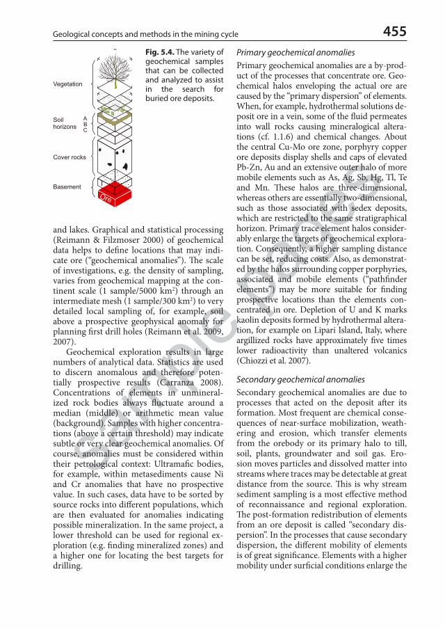
sample
page
s
455Geological concepts and methods in the mining cycle
and lakes. Graphical and statistical processing (Reimann & Filzmoser 2000) of geochemical data helps to define locations that may indi-cate ore (“geochemical anomalies”). The scale of investigations, e.g. the density of sampling, varies from geochemical mapping at the con-tinent scale (1 sample/5000 km2) through an intermediate mesh (1 sample/300 km2) to very detailed local sampling of, for example, soil above a prospective geophysical anomaly for planning first drill holes (Reimann et al. 2009, 2007).
Geochemical exploration results in large numbers of analytical data. Statistics are used to discern anomalous and therefore poten-tially prospective results (Carranza 2008). Concentrations of elements in unmineral-ized rock bodies always fluctuate around a median (middle) or arithmetic mean value (background). Samples with higher concentra-tions (above a certain threshold) may indicate subtle or very clear geochemical anomalies. Of course, anomalies must be considered within their petrological context: Ultramafic bodies, for example, within metasediments cause Ni and Cr anomalies that have no prospective value. In such cases, data have to be sorted by source rocks into different populations, which are then evaluated for anomalies indicating possible mineralization. In the same project, a lower threshold can be used for regional ex-ploration (e.g. finding mineralized zones) and a higher one for locating the best targets for drilling.
Primary geochemical anomaliesPrimary geochemical anomalies are a by-prod-uct of the processes that concentrate ore. Geo-chemical halos enveloping the actual ore are caused by the “primary dispersion” of elements. When, for example, hydrothermal solutions de-posit ore in a vein, some of the fluid permeates into wall rocks causing mineralogical altera-tions (cf. 1.1.6) and chemical changes. About the central Cu-Mo ore zone, porphyry copper ore deposits display shells and caps of elevated Pb-Zn, Au and an extensive outer halo of more mobile elements such as As, Ag, Sb, Hg, Tl, Te and Mn. These halos are three-dimensional, whereas others are essentially two-dimensional, such as those associated with sedex deposits, which are restricted to the same stratigraphical horizon. Primary trace element halos consider-ably enlarge the targets of geochemical explora-tion. Consequently, a higher sampling distance can be set, reducing costs. Also, as demonstrat-ed by the halos surrounding copper porphyries, associated and mobile elements (“pathfinder elements”) may be more suitable for finding prospective locations than the elements con-centrated in ore. Depletion of U and K marks kaolin deposits formed by hydrothermal altera-tion, for example on Lipari Island, Italy, where argillized rocks have approximately five times lower radioactivity than unaltered volcanics (Chiozzi et al. 2007).
Secondary geochemical anomaliesSecondary geochemical anomalies are due to processes that acted on the deposit after its formation. Most frequent are chemical conse-quences of near-surface mobilization, weath-ering and erosion, which transfer elements from the orebody or its primary halo to till, soil, plants, groundwater and soil gas. Ero-sion moves particles and dissolved matter into streams where traces may be detectable at great distance from the source. This is why stream sediment sampling is a most effective method of reconnaissance and regional exploration. The post-formation redistribution of elements from an ore deposit is called “secondary dis-persion”. In the processes that cause secondary dispersion, the different mobility of elements is of great significance. Elements with a higher mobility under surficial conditions enlarge the
Fig. 5.4. The variety of geochemical samples that can be collected and analyzed to assist in the search for buried ore deposits.
eschweizerbart_xxx

sample
page
s
456 The Practice of Economic Geology
anomalous zone. A project targeting polyme-tallic deposits of Pb, Zn and Cu, for example, would use mobile Zn for regional sampling with a low density, whereas dense sampling of Zn-anomalies for Cu and Pb should reveal the drilling targets.
The mobility of elements in secondary dispersion is strongly influenced by factors including the nature of rocks, climate, vegeta-tion, relief and groundwater flow. The complex interaction of these natural factors has been called “landscape geochemistry” (Fortescue 1992). Nearly ubiquitous influence of human activities such as industry, agriculture and building overprints the natural state. Geo-chemical exploration projects must consider the possible presence of perturbation by “an-thropogenic dispersion”.
Effective distinction between prospective and non-significant geochemical anomalies is desirable. To this purpose, non-geochemical data such as the geological setting are consult-ed. Based solely on the geochemical data, the contrast between background and the anoma-lous data is employed. High contrast is consid-ered to affirm the significance of an anomaly. Controls of the contrast include the primary metal contents in ore compared to host rocks, the mobility of the elements investigated and dilution with barren material. Because con-trast is so important, most geochemical work in exploration starts with an orientation phase, which is expected to identify the most suitable sample material and other constraints for the main phase work. For unconsolidated soil, stream and lake sediments, contrast is a func-tion of the chosen grain size, the soil horizon (depth) and the extraction method. If suffi-cient contrast of target element concentrations cannot be reached, possible pathfinder ele-ments should be tested.
Geochemical exploration programmesGeochemical exploration programmes may be designed for the reconnaissance of large areas or for detailed investigation of prospective lo-cations. Regional sampling is done along roads and water courses, whereas sampling grids or parallel lines are typically used in local inves-tigations. In the first case, sampling distances are measured in kilometres, in the second in metres. The orientation of the sampling layout
is chosen to support geological mapping, geo-physical surveys and later drilling. Orientation sampling serves to select suitable field methods and the most appropriate analytical methods. This allows final planning of the main phase of the sampling programme, including logistics.
Stream sedimentsStream sediments (Fig. 5.5) are extremely efficient means to discover geochemically anomalous zones in large regions and with low sampling density, but only if a well-developed drainage system is present. Where suitable wa-ter courses are absent, remarkable results are achieved with wide-spaced soil samples (e.g. Australia), or till and lake sediments (Canada, Finland). The sediment sample from an active river bed is considered to represent an average of its upstream watershed. If mineralization or its dispersion halo is exposed in the drainage area, chemical traces must occur in the sample. Because coarse material dilutes trace element concentrations (and thus lowers the contrast) fine-grained stream sediments (clayey and silty mud) are preferred. Samples are sieved in order to submit a homogeneous fraction for analysis (often -80 mesh corresponding to –180 μm). Samples for indicator mineral in-vestigations (McClenaghan 2005) are collected parallel with the stream sediments. In specific cases such as expected loss of fine-grained gold, or environmental work aiming at volatile pollutants, freeze-sampling is employed (Petts
Fig. 5.5. Environmental stream sediment and water sampling (including in situ determination of pH, T, and Eh) in the Gatumba tin-tantalum mining district, Rwanda.
eschweizerbart_xxx

sample
page
s
457Geological concepts and methods in the mining cycle
et al. 1991). Organic substances and Fe-Mn mud in surface waters adsorb dissolved metals more than clay minerals. Geochemical results from such samples have to be treated apart from common siliciclastic sediment. Water pH, T and Eh should be measured at each sample site because large variations strongly influence the mobility of elements. Never omit to determine the geochemical characteristics of rocks occurring in the watershed as a geo-genic background. If a reference to common average contents of elements is intended, one of the clay rock standards is often more appro-priate than the crustal average (Reimann & de Caritat 1998, Gromet et al. 1984). Fine grained sediments should only be compared with ma-terial of similar grain size.
BLEG (Bulk Leachable Extractable Gold) is a variant of stream sampling that works with 2–5 kg samples. Samples consisting of, for ex-ample, –10 mesh (<1.7 mm) material are di-gested with a dilute (0.1%) cyanide solution by rolling in a container for 24 hours. This dis-solves fine gold flakes hosted in fine-grained river sediment.
Soil sample geochemistrySoil sample geochemistry requires detailed ori-entation work, because success depends on suf-ficient understanding of soil layering and gen-esis (e.g. Butt et al. 2000), which control element mobility (cf. 1.2). Soil samples are mostly sieved to –250 μm, but CSIRO (2019) announces that ultrafine particles (clay, Fe-oxides) at –2 μm may better reveal anomalous tenors of Au. In many cases, distribution patterns are a legacy of several superposed soil formation phases. Allochthonous soil is commonly thought to be of little use in exploration, but many reports disprove this prejudice: In Nevada, Carlin type gold ore covered by nearly 100 m of transported soil and alluvium is readily detected by anoma-lous Au, As, Zn and Bi (Muntean & Taufen 2011). In Western Australia, nickel concentra-tions are anomalous in the B-horizon of trans-ported soil above buried Ni-mineralization; this unexpected finding is explained by nickel trans-fer from deep roots into leaves and from rot-ting litter back into the soil. Many elements are enriched in the B-horizon of a regolith profile, but there are important exceptions. Ferriferous nodules or pisoids that are common in areas of lateritic cover can be useful geochemical guides
to ore in bedrock because they fix elements such as As, Sb and Tl but not gold. In South Australia, pedogenic calcrete is sampled for lo-cating subcropping gold-quartz veins (Mauger et al. 2007). The upward transport of metals from buried ore and primary dispersion halos is tentatively explained by evaporative suction (visible in caliche/calcrete formation), capillary action, plant roots, gas flow, barometric and seismic pumping (Muntean & Taufen 2011).
Geochemical exploration with rock samplesRock chips were the preferred medium in-volved in successful exploration for many circum-Pacific copper and gold discoveries (Sillitoe 1995). Handheld pXRF spectrometers reveal anomalous metal contents (from Mg to U). Geochemical exploration with rock sam-ples, or selected minerals is based on specific geological-petrological models. Examples in-clude the regional sampling of granites in order to locate fertile intrusions, the discrimination of prospective and barren porphyries by analyzing copper in biotite, and the identification of rare metal pegmatites by Cs tenors in muscovite. Pyrite is known to absorb/scavenge a range of trace elements (e.g. Au, As, Cu, Tl, Pb, Co, Ni, Zn, Bi, Te, Pt) from hydrothermal fluids. Em-ploying Laser Ablation (LA-) ICP-MS for direct surface analysis of solid samples may assist in developing geochemical and mineralogical vec-toring tools for certain types of deposits such as orogenic gold and porphyry copper. The lat-ter display a characteristic zonation of ore and trace elements that can be used for exploration targeting (Halley et al. 2015).
Also, rock geochemistry is useful for tracing orebodies in complex structural settings: Cer-tain hydrothermal alteration zones (cf. 1.1.6) are easily recognized and help to point develop-ment adits or drillholes towards ore. Isotope in-vestigations complement data on elemental dis-tribution, mainly at a more local scale. Whole rock stable isotope mapping around centres of epigenetic mineralization, for example, of-ten reveals very clear anomalies that are useful for finding orebodies (Hoefs 2018, Holk et al. 2008). Remember that with all solid materials, the mass of a representative sample is a direct function of the grain diameter. The rules of suf-ficient sample mass and careful diminution, homogenization and sub-sampling must be strictly followed.
eschweizerbart_xxx
sample
page
s
458 The Practice of Economic Geology
Soil gas and atmospheric air samplingSoil gas and atmospheric air sampled near the surface may contain traces of Hg, H2S, SO2 and metals, which are possible keys to buried sul-fide and gold deposits, and radon may indicate uranium ore (Klusman 2009, Hale 2000). In Nevada, an elevated CO2 flux (and O2 mini-ma) occurs above oxidizing pyritic gold ore at depth, probably due to reaction of acidity with the host carbonate (Muntean & Taufen 2011). The gas flow may lift trace metals in submicron particulate or volatile compound form (Klusman 2009). Barometric pumping of soil gas (by expansion/compression parallel to varying air pressure) is the most likely physi-cal driver. Although technological innovation in this field is intense, persuasive case histories are not widely known and more common geo-chemical methods seem to suffice. It appears possible, however, that future search for deep orebodies buried below today’s commonly shallow targets between the surface and ~400 m depth will profit from these methods.
Biogeochemical exploration methodsBiogeochemical exploration methods (“phyto-exploration”) have a demonstrated success rate but are not equally often used as stream sedi-ments and soil samples. Plant roots “sample” soil and soil water, and thus transfer geochem-ical information to their organs above the ground. Samples are usually taken from live plants. Orientation surveys assist to find suit-able plant species and because of organ-specif-ic accumulation, favourable parts of individual plants. Possible choices include leaves, twigs (that must be of one age), or bark. Sampling is relatively cheap because drilling and digging is not needed. Regional and local anomalies of metals and pathfinder elements can be as-certained. Above undisturbed Cortez mine orebodies in the Carlin district, for example, Muntean & Taufen (2011) found a robust Au-As anomaly in sagebrush (Artemisia) and shadscale (Atriplex).
Water samples (hydrogeochemistry)Water samples collected from springs, wells, boreholes and streams are an effective but under-utilized medium for reconnaissance exploration (Muntean & Taufen 2011). Dis-solved metal contents in water are usually very
low (in the ppb-range) and vary strongly with pH and Eh. This makes interpretation difficult. Yet, regional data sets on ground and surface water chemistry may provide important clues to several deposit types. Dickson & Giblin (2007), for example, report successful explo-ration for paleochannel uranium deposits in South Australia. Contrary to common belief, they state that “there is no need to waste time and money on field treatments” such as adding acid, but pH, conductivity, Eh, dissolved Fe2+ and temperature should be measured on site. Of course, water geochemistry is always an es-sential part of environmental monitoring of mine sites (Seal & Nordstrom 2015). Ground-water chemistry surveyed for permitting and environmental monitoring of the Pipeline gold deposit, Nevada, is illustrated by Muntean & Taufen (2011). Before mining, the water flow was across the deposit; a plume of sulfate, As, Sb, K, F and Zn flowing from it clearly pointed to the ore body. The premining groundwater table in this area, however, was at a depth of ~100 m; even today, the costs of drilling to this depth for water samples would hardly be con-sidered rational.
Analytical methods of exploration geochemistrySamples are dried, sieved, sub-sampled and ground until 100% pass an 80–200 mesh (180–75 μm) screen. For analysis, a small ali-quot (0.2–2 g) is dissolved. Partial solution by weak acids or by electrolytic solutions such as ammonium sulfate that only dissolve weakly adsorbed elements is one common procedure. The other is complete dissolution by aqua re-gia, or a multi-acid mixture combining hy-drofluoric, hydrochloric, nitric and perchloric acids at low temperatures and pressures. The choice is guided by the speciation of the ele-ments of interest in the sample. If the main interest concerns metals weakly adsorbed on clay and organic matter, partial solution is rec-ommended. For determination of elements sited in the crystal lattice of minerals, such as barium in muscovite of metamorphosed distal sedex exhalites or Hf in zircon, total dissolu-tion is indicated (Halley et al. 2015). Methods of sequential elution (sequential extraction) provide an understanding of metal specia-tion in soil, lake and stream sediment samples:
eschweizerbart_xxx

sample
page
s
459Geological concepts and methods in the mining cycle
Total metal content of a sample is the sum of several species such as:• Exchangeable ions in clays and carbonates
(‘bioavailable elements’: Pearson et al. 2019); • elements absorbed or adsorbed on inorganic
and organic materials;• structurally bound in Fe and Mn oxy-hydroxides;• bound to organic matter, sulfur and sulfides; and• elements bound within silicate minerals (Rao
et al. 2008).
Defining the most suitable dissolution variant for a specific project is one of the aims of an orientation survey. REE ion adsorption ore, for example, is investigated by determination of the exchangable and adsorbed fraction (Sane-matsu et al. 2013).
Geochemical laboratory equipment for ex-ploration and environmental studies is largely identical. The workhorses of instrumental analysis are inductively coupled plasma-atom-ic emission spectroscopy (ICP-AES) and in-ductively coupled plasma-mass spectrometry (ICP-MS). Other useful methods include X-ray fluorescence (XRF), instrumental neutron activation analysis (INAA), electron probe mi-croanalyzer (EPMA), gamma-activation anal-ysis, atomic absorption spectroscopy (AAS) and electrochemical means such as specific ion electrodes.
In the field and in mines, portable X-ray fluorescence (pXRF) analysers are increas-ingly used for on-site data acquisition (Gazley et al. 2012). Precision is improved by drying samples to equal moisture content, by homog-enization, pulverizing and compressing the powder to comparable density. Colorimetric and other simple field methods remain use-ful, but only deliver semi-quantitative data for elements (e.g. As, Cu, Zn, Mo, W, Ni) and ions (e.g. SO4
2–). They are chosen when quick results are more important than accuracy, for example in remote regions. A decision to use such methods should only be made after tri-als with preliminary samples and consultation with an experienced analyst.
Analytical data in exploration geochemis-try need not in all cases be equal to the abso-lute element content in a sample, or in other words, accuracy may not be essential. Devia-tions of ± 30% from the absolute figure (e.g. an international laboratory standard) are tol-erated, if the relative error remains within nar-row limits. Accuracy is assessed by employing
certified reference materials (standards). In contrast, excellent reproducibility of results from duplicates, that is high precision, is ab-solutely required. This is the base for any data evaluation, especially if the contrast between background and anomalies is small. In all geochemical programmes error control (in practice called QAQC – quality assurance and quality control) is a fundamental aspect. Er-rors may be introduced during sampling, sam-ple processing and transport, and in the labo-ratory. Always, samples should be randomized before submission to the laboratory in order to avoid analyzing them in the same sequence as collected (Muntean & Taufen 2011). Also, it is good practice to repeat at least 10% of sam-pling. Analytical errors are revealed by repeat-edly inserting duplicates, blanks or a standard of known composition such as international reference materials into the series (Arbogast 1990). Control by another laboratory is advis-able. Based on this kind of data, it is possible to calculate total error margins and the confi-dence interval (Taylor 1997).
Indicator minerals and mineral trace chemistryIndicator minerals are increasingly used as a complementary tool to geochemistry. Indicator minerals are characterized by elevated density (>2.8 g/cm3) and a good preservation potential in the weathering environment (McClenaghan 2005). Their application in diamond prospect-ing has a long tradition (cf. 3.8). Other deposit types also display specific indicator minerals. Porphyry copper systems, for example, shed gold, rutile, tourmaline, garnet, jarosite and al-unite. Many rare metal deposits are enveloped by striking tourmalinization halos (Fig. 5.6). Minerals such as apatite, magnetite, tourma-line, chlorite, epidote and micas host elements that may serve exploration targeting (Halley et al. 2015). Tourmaline is outstanding as a geo-chemical monitor of crustal systems, because of its physical robustness and chemical vari-ability. In growth zones, it records chemical and isotopic composition and evolution of the fluids and melts, from which it formed (Mar-shall & Jiang 2011). Boron isotopes of tour-maline that is part of Au-Pd mineralization in Minas Gerais, Brazil, demonstrate a regional-scale fluid flow with B derived from marine
eschweizerbart_xxx

sample
page
s
460 The Practice of Economic Geology
and terrestrial evaporites during the Brasiliano orogeny (Cabral et al. 2017). As a function of the genetic setting, magnetite displays different concentrations of major, minor and trace ele-ments, including Si, Mg, Ca, Al, Mn, Ni, Cr, V and Ti. Current discrimination diagrams, such as (Ti + V) versus (Al + Mn), however, seem not to allow unambiguous genetic attribution (“fingerprinting”; Broughm et al. 2017). Trace elements of magmatic-hydrothermal apatite in different deposit types display characteristic spectra that may assist exploration; regional data of detrital apatite grains potentially point to the presence of specific deposit types (Mao et al. 2016).
Presentation and interpretationData resulting from geochemical exploration should always be presented in maps and sec-tions, because the search is first of all for spa-tial variation. Statistical calculations are a use-ful complement if geology and structure are not too complex. Digital equivalents of point-symbol maps (Howarth 1983) represent the basic tool (similar to Fig. 3.1). Raw data can be amplified by wave-length filtering to produce a map of residual anomalies (Ludington et al. 2006). Principal component analyses of multi-element data and plotting the factor distribu-tion may provide valuable guides for regional exploration. The correlation of geochemical results with geology, geophysics and topogra-phy is investigated using GIS (Carranza 2008).
‘Spatial modelling and analysis of ore-forming processes in mineral exploration targeting’ of Ore Geology Reviews (Vol. 119, 2020) provides instructive examples.
Environmental geochemistryGeochemical work is not finished with the dis-covery and preliminary quantification of a po-tential ore deposit, but reaches a second climax during detailed investigations and preparation of the economic feasibility and environmental impact studies. For the second, the premin-ing environmental state of the future mining area must be documented, including natural and anthropogenic characteristics of bedrock, regolith, surface and groundwater. Establishing the geochemical landscape (Fortescue 1992) is a central task. Considering this requirement, costs of resampling may be saved by imposing high accuracy standards on all exploration geo-chemistry. High resolution, multi-media and multi-element mapping is an important part of environmental impact studies that are the foundation of operational and administrative decisions throughout the life of a mine includ-ing closure. Applied geochemical studies are an essential part of the modern mining cycle (Seal & Nordstrom 2015).
The methods of environmental geochem-istry differ little from its application in explo-ration. In fact, investigations and interpreta-tions of non-mining anthropogenic dispersion might profit from the study of the highly de-veloped methods and accumulated experi-ence of geochemical exploration. One example concerns unreflected reporting of purportedly anthropogenic heavy metal dispersion without reference to natural (geogenic) boundary con-ditions such as the number of samples, back-ground (mean, or median) and the range of values (variance) (Reimann et al. 2009).
5.2.5 Geophysical exploration
All models are uncertain, but some are better than others
Saltus & Blakely 2011
Geophysical methods are applied to scan the subsurface for features that indicate formerly active ore forming systems. The key is remote mapping of indications. An auriferous massive pyrrhotite body, for example, would stand out
Fig. 5.6. Tourmalinization is common in the proximity of pegmatite and granite-related ore. Near cassiterite vein deposits at Rutongo, Rwanda, the growth of black tourmaline needles in quartzite was controlled by folded bedding planes and a weak schistosity.
eschweizerbart_xxx
sample
page
s
461Geological concepts and methods in the mining cycle
as a magnetic, dense and electrically conductive mass. The foundation of geophysical explora-tion methods are the varied physical properties of ore and gangue minerals, fluids and rocks (Cannon 2015, Milsom & Eriksen 2011, Ellis & Singer 2007). Passive geophysical survey meth-ods use natural potential fields (e.g. magnetism, gravity). Active methods rely on interaction of induced artificial fields with the subsurface (e.g. electrical conductivity, seismics). “Inver-sion” designates the computation of geophysical models purely from measurements. Recent de-velopments enable simultaneous joint inversion (SJI) of multiple geophysical datasets (for exam-ple, seismic + gravity or seismic + magnetotellu-rics). This is especially useful in creating models of subsalt, subbasalt and subthrust rock bodies. Geophysical earth models are inherently am-biguous because purely mathematical solutions are non-unique. In many cases, however, useful interpretations can be obtained with hardly any or no independent constraints (Saltus & Blakely 2011). Yet, results are improved and supported by geological, geochemical, drilling and pet-rophysical data (Cannon 2015). Petrophysical properties of rocks and ore are the critical link between geophysics and geology (Dentith & Mudge 2014).
Geophysical methods with a depth pen-etration to several hundred metres below sur-face are commonly employed in the search for solid mineral deposits. Results extend the validity of geological and geochemical data to this depth, which currently limits the econom-ic exploitability of most minerals and ores. In China, deep exploration started with multi-method geophysics in the W and Ag-Pb-Zn (-Cu-Au) Yinkeng orefield (Zhao et al. 2018). In Australia, deep seismic reflection profiling illuminates crustal structures, sedimentary and tectonic history, and relations to flow of mineralizing fluids (Gibson et al. 2016; Korsch & Doublier 2016). The Deep Earth Imaging program (CSIRO 2018) is to develop holistic joint analysis of seismic, magnetotelluric and potential field methods for the next generation of exploration and exploitation of resources. The reason for using geophysics, however, is not always depth penetration. Geophysical in-vestigations of near-surface ores such as coast-al placers, for example, contribute valuable continuity to deposit modelling, e.g. between drill holes. Also, identification and mitigation
of mining-induced environmental problems may profit from geophysical surveys.
Depth, however, is important: In explora-tion for Athabasca Basin uranium deposits, recent advancements in airborne electromag-netic and resistivity technologies promise to identify graphitic basement rocks that po-tentially host ore at depths of >1 km. In cases of strong incentives to extend the search to greater depth, which common surface-based geophysical methods cannot reach, magneto-telluric methods (MT) are used. Base metal deposits such as those of the Sudbury District are explored to >3000 m depth: Deep drillholes are sited on geological evidence to penetrate a prospective rock body, which is scanned by downhole geophysics for signs of ore.
Geophysical surveys complement other exploration methods at all scales. Regional geological and geochemical work is supported by remote sensing of geophysical data from aircraft and helicopters, including unmanned aerial vehicles (UAVs). Frequently used aero-geophysical methods include magnetics, elec-tromagnetics, radiometry and gravimetry. For detailed and more local exploration on the ground, many more methods are available that allow a high density of observations at higher accuracy and improved validity. Borehole geo-physical surveys result in the highest resolu-tion of data (Ellis & Singer 2007), especially in conjunction with geological, physical and chemical core logging results.
Like geochemical surveys, geophysical methods reveal a background that is charac-teristic for ordinary rocks of an area and dis-tinctive anomalies, which illuminate physical contrasts. The magnitude of an anomaly is a function of: i) the contrast between host rocks and the anomalous material; ii) the size, spatial orientation and shape of the anomalous body; and iii) the depth from the surface. The last is essentially due to the general law of inverse-square attenuation of a geophysical signal as a function of distance. Identification and inter-pretation of geophysical anomalies are often challenging, not unlike weak geochemical in-dices.
Although physical properties commonly used in applied geophysics are few (e.g. densi-ty, elasticity, magnetic susceptibility, electrical conductivity and radioactivity), a considerable number of geophysical exploration methods
eschweizerbart_xxx

sample
page
s
462 The Practice of Economic Geology
are available for mineral exploration and each method exists in several innovative variants. The specific choice is a function of the geo-logical and exploration model of the targeted deposits (e.g. Shen et al. 2008), of general con-ditions such as remoteness, climate and hu-man land use, and of the costs. Methods that require the placement of electrodes in the soil, for example, cannot be deployed in permafrost regions. Electrolyte-rich highly conductive soil, rock and groundwater in semi-arid lands limits the depth penetration of most electrical methods. Some well established geophysical methods in ore and mineral exploration in-clude the following:
MagnetometryMeasuring the magnetic field is relatively straightforward, with portable instruments on the ground, borehole probes and instru-ments for aerial surveys (Airo et al. 2004). Various types of magnetometers are available, including “scalar” sensors that measure total magnetic field and “vector” sensors providing directional data. The latter include the tradi-tional fluxgate and the novel supersensitive SQUID (Superconducting Quantum Interfer-ence Device) magnetometers. The intensity of the magnetic field is measured in nanoTesla (previously gamma; 1 nT equals 1 gamma). The Earth’s total field varies from ~30,000 (equator) to 65,000 nT (poles). Regular diur-nal variations of the field are enforced by cur-rents in the ionosphere and reach 10–30 nT. Solar activity such as spots and flares cause short-term irregular disturbances (“magnetic storms”) with amplitudes that may surpass 1000 nT. Field work must be suspended dur-ing magnetic storms. Past solar activity since about 1600 CE and its prediction are discussed in a very readable paper by Solanki & Krivova (2011).
The magnetic properties of rocks differ by several orders of magnitude, which makes magnetic maps highly valuable tools for re-gional and detailed geological mapping. Explo-ration tends to look for strong deviations from the background field, which are commonly caused by minerals of high susceptibility such as magnetite, pyrrhotite and maghemite (oc-curring in certain laterites). Hematite has a very small susceptibility and many iron ore
deposits do not produce magnetic anomalies. Magnetite and pyrrhotite ore deposits can be located with magnetic surveys, but also kim-berlites and other rocks that host magnetic minerals. Airborne magnetic surveys support geological mapping, especially in regions with a thick cover of soil, moraine sheets, water or sediments (on land and offshore). Absence of magnetite caused by destructive hydrother-mal alteration (“magnetic quiet zones”) marks many epithermal systems (Morrell et al. 2011). One of the most relevant tools for detailed mapping are measurements of the anisotropy of magnetic susceptibility (ASM). Results of magnetometry are presented in maps and in sections with distance as horizontal and the magnetic signal as vertical axis.
Electric current methodsConductivity (Siemens per metre, S/m) or its reciprocal, resistivity (Ohm/m), are de-termined by measuring voltages or magnetic fields associated with electric currents flowing in the ground, either induced or natural. Rocks and minerals have widely varying resistivity, with lowest values displayed by native metals and graphite (10–6), clay (1–120), saline pore water, acid rock drainage and sulfide ore (e.g. pyrrhotite 10–3–10–1), whereas common rocks and minerals have high electrical resistivity (quartz at ambient temperature >1010, rock salt 106–107, limestone 120–400). This contrast is used for exploration. Electric current methods rely on placing electrodes in the ground, com-monly two metal stakes (e.g. steel rods) for passing current into the subsurface and two non-polarizing electrodes for measuring the induced potential in volts. Several time-tested arrays of electrode layout are possible. Mov-ing cables, electrodes and equipment from one point (traverse station) to the next makes these methods laborious and slow. They are typically used for local and detailed investigations.• Spontaneous, or self potential methods (SP) rely
on electrochemical processes caused by weath-ering orebodies that straddle the groundwater table. The conductive material concentrates the flow of oxidation-reduction return cur-rents, producing a negative anomaly at the sur-face. Typical targets for SP-surveys are sulfides, graphite, alunite and magnetite. The method is very cheap and simple; only two non-polarizing electrodes, cables and a voltmeter of very high
eschweizerbart_xxx

sample
page
s
463Geological concepts and methods in the mining cycle
impedance are needed. Today, SP surveys are little used in exploration because methods such as EM (see below) more reliably detect orebod-ies. However, SP is useful for locating flowing groundwater (e.g. in a leaky tailings dam) by an effect that is termed “streaming potential”. Large-scale natural potentials in Earth are in-vestigated with telluric and magnetotelluric methods (MT). Practical application finds MT mainly in the hydrocarbon industry. Hybrid-source magnetotelluric systems are capable of measuring electrical resistivity and the mag-netic field in great detail, over depth ranges of a few metres to greater than one kilometre. This method is successfully employed for explora-tion of coal, petroleum, uranium and other metals (Shen et al. 2008).
• Electric resistivity surveys require the four elec-trodes described above. Two different aims are pursued:
1. “Resistivity profiling” is in principle a tool for mapping the shallow subsurface. In this variant, the distance between electrodes is not changed and the whole array is moved across the country, allowing recognition of gravel, sand and clay, massive orebodies, faults and steep rock contacts.
2. “Resistivity sounding” utilizes the larger depth penetration of currents as electrodes are set farther apart. The method reveals the vertical sequence of different rocks but only works well if interfaces between beds are largely horizontal.
Resistivity surveys have been “mechanized” by placing the electrodes on a long trailer pulled by a tractor. Improvement is also possible by placing electrodes in boreholes. Resistivity methods help to locate massive sulfide bodies, acid rock drainage (Rucker et al. 2009), graphite, salt water intrusions on the coast, water-filled sand and gravel aquifers and indirectly, alluvial tin and gold placers.
• Induced polarization (IP) methods are much utilized in exploration because they are able to detect sulfide ore minerals (e.g. of Cu and Mo in porphyries) and other conducting minerals (graphite flakes in gneiss) that are disseminated in a matrix with high resistivity. Induced polar-ization is activated by passing a pulse of cur-rent via two electrodes into the ground. These charges electronically conducting particles not unlike capacitors. When the activating current is cut off, discharge from the particles produc-es currents, voltages and magnetic fields. The transient voltage spike (polarization effect) is measured at the surface via two non-polarizing
electrodes. It is a measure of the number, or more precisely the total surface, of conducting chargeable particles in the ground. A higher signal indicates more intense mineralization. IP systems work either in the frequency or the time domain; frequency domain equipment is generally lighter and more portable. Different electrode configurations are possible. Note that clay minerals display “membrane polarization” that is the cause for most IP effects encountered in the field. IP is successfully employed to a maximum depth of ~600 m.
Electromagnetic methods (EM)EM are very often utilized in geophysical explo-ration and in support of geological mapping. In EM, a physical contact to the ground is not needed (no electrodes), which is an advantage for use above ice, water, swamps, frozen or arid ground. Many different surveying systems are available, for aerial (AEM) and surface deploy-ment. Today, even highly conductive surface zones like salt lakes can be penetrated with equipment such as MagTEM (magnetic field sensor transient electromagnetic technology). The principle of TEM is that an alternating cur-rent is passed through a square loop of cable, which induces an electromagnetic field in the ground. Decaying currents in the subsoil are measured with a receiver coil or a magnetom-eter. If the primary field encounters a good con-ductor, “eddy” currents flow and this produces a secondary electromagnetic field. Its strength and relative phase compared with the primary field indicate possible ore. Typical targets are kimberlites, sulfides (e.g. Ni-Cu in Voisey’s Bay, Canada), graphite (exploration for graphite de-posits, or as a guide to unconformity deposits of uranium) and water-bearing faults. Increasing-ly, natural electromagnetic fields are measured concurrently with induced fields.
For the search of deposits under cover rocks, for example in Western Australia, Air-borne Electromagnetic (AEM) surveys at low resolution are designed to cover great areas; data provide 3-D models of the subsurface to 400 m, but in special cases, allow interpreta-tion down to 2000 m. Wide or close spacing of flight lines is the main control on resolution. Discovered prospective ground is re-flown at medium to high resolution.
The magnetotelluric method (MT) is a passive electromagnetic technique used for
eschweizerbart_xxx

sample
page
s
464 The Practice of Economic Geology
exploring the conductivity structure of the Earth from tens of metres to a depth of several hundred kilometres. MT data can image the thickness of cover, the basement architecture and the crustal architecture. Main applications are in hydrocarbon and in mineral explora-tion.
Gravity methodsGravity methods in exploration are based on detecting variations of the Earth’s natural gravity field. The measure of gravity is accel-eration expressed in gravity units (1 g.u. = 1 μm/s2; earlier, named after Galileo, 1 Gal = 1 cm/s2 or 1 mGal = 10 g.u.). Modern instru-ments (gravimeters) reach an accuracy of 0.1 g.u. that is approximately a one hundred mil-lionth of the Earth’s field. Gravity gradiometers are designed to measure gradients of geologi-cal gravity changes. Surface gravity at a spe-cific location is a function of the rocks under-neath, of the distance from the Earth’s center of gravity, of latitude and relief. Because one metre difference in height of the gravity station causes a change of 3.086 g.u., elevation rela-tive to the theoretical sea level reference sur-face must be determined to an accuracy of ± 3 cm. Surveying is usually the most costly part of gravity operations. Geological factors cause relatively small changes of gravity. Therefore, the above-mentioned effects on readings must be removed by calculations, including the tidal drift of gravity (± 1 g.u.). The corrected, “re-sidual” or “extended” Bouguer fields and in some cases, gravity gradients are presented in maps and in profiles. Interpretation of shape, density and depth of bodies, which cause the measured gravity pattern are derived by calcu-lations based on geological models. Hidden tin granite bodies, for example, can be elucidated for drillhole targeting (Chicharro et al. 2014).
Gravity can be mapped by airborne systems, on the ground, in the sea and in underground mines. Regional gravity maps serve mainly science and hydrocarbon exploration, but are increasingly utilized in exploration for minerals and metal ores (Hildenbrand et al. 2000). Different rocks and tectonic structures are illuminated and orebodies of solid minerals can be distinguished from ordinary rocks by greater (chromite, sulfides) or smaller density (kimberlites, salt diapirs: Fig. 4.29). One of the notable achievements of gravity exploration
in the recent past was the discovery of giant Olympic Dam based on the coincidence of gravity and magnetic anomalies (Ehrig et al. 2017).
Radiometric methodsRadioactive decay of uranium, thorium and potassium, and of certain daughter nuclides of the first two releases gamma radiation, which is measured with handheld or vehicle-mounted instruments on the ground, with equivalent systems on board of aeroplanes and helicopters (Airo et al. 2004) and with borehole probes. Scintillometers or spectrom-eters are usually employed. The second use energy sills of γ-radiation to distinguish be-tween the three elements and to estimate their concentrations. Measurements of γ-radiation in the field are snapshots of a random process and readings vary, even with the same instru-ment. Geologically-sourced radiation forms peaks superimposed on a background of scat-tered cosmic (mainly solar) and terrestrial radiation. The high geochemical mobility of K and U in surficial environments, compared to the nearly immobile Th is the motive for the common use of ratios (U/Th, K/Th) in graphic output. Application is primarily in the search for uranium, but numerous other utilizations have been found. Determination of gamma-radiation is a very convenient and low cost tool to distinguish rocks, from re-gional mapping to borehole logging. It facili-tates recognition of potassium salts in halitite, beach placer horizons in sand, and oil source rocks or phosphorite in marine sediments. Potassium-rich rocks such as certain granites or zones of hydrothermal K-alteration (Mor-rell et al. 2011) can be detected. Airborne and ground use, however, are restricted to areas with little soil cover because most radiation on the surface comes from the uppermost 10–50 cm; deeper sources below soil remain undetected. Read more about radiation sur-veys in Chapter 2.5.12.
Tomographic methodsRemarkable new developments in exploration geophysics include tomographic methods, which produce spatial images of geological bodies, for example ore between the surface, drillholes and mine tunnels. Various means of
eschweizerbart_xxx

sample
page
s
465Geological concepts and methods in the mining cycle
excitation are used, including acoustic, sonar (ultrasonic), radar, muon particles, radio and seismic waves. Tomography allows larger dis-tances between exploration adits and drillholes, and considerably lowers costs. In addition, the risk of overlooking orebodies is reduced. The most formidable example of tomography is high-resolution seismic modelling of the deep lithosphere in support of diamond ex-ploration (Faure et al. 2011). 3D architecture of host rocks, alteration zones and ore can be illuminated by natural potential field methods (Chopping & van der Wielen 2011). A conve-nient method of near-surface reconnaissance is ground penetrating radar (GPR) that maps interfaces of materials having different electro-magnetic properties such as dielectric permit-tivity, conductivity and magnetic permeability. This elucidates bedding planes, moisture and clay content, voids and man-made objects. Applications include imaging of the internal structure of dunes, beaches, fluvial deposits, karst, sinkhole detection, buried channels and lake deposits (Baker & Jol 2007). The thickness of nickel laterite or bauxite can be rapidly and economically determined (Erten et al. 2015). Multifunctional geophysical systems are de-signed to measure several physical parameters at the same time or in rapid sequence; mount-ed on towed sledges this improves efficiency. Seismic methods are rarely used in hard-rock mineral exploration but are the workhorse of hydrocarbon search. Yet, successful location of uranium orebodies with 3D-seismics is reported from the Athabasca Basin, Canada. Structures controlling lead ore at Laisvall re-spond to multicomponent seismic and radio-magnetotelluric geophysics (Malehmir et al. 2015). Coal and lignite seams are routinely scanned by high-resolution seimics in order to guide mechanized mining. Large-scale seismic transects in Australia that illuminate crustal structures serve gold exploration (Willman et al. 2010). The future of exploration geophys-ics will be ever greater resolution, increasing depth penetration and more powerful pro-cessing in order to locate the next generation’s mineral deposits.
Geophysical borehole surveysMost geophysical methods have been adapted for drillholes in mineral resources exploration
with the typically small diameters (~1/10th compared to petroleum and gas drilling for which they were originally developed; Ellis & Singer 2007; cf. 7.4). Wireline logging meth-ods (so called because probes suspended from a wire cable are lowered into the hole) include total gamma, gamma spectroscopy, density by gamma/gamma, laterologs (resistivity and SP), electromagnetic induction (conductivity), borehole deviation, hydrochemistry, elastic rock moduli (sonic) and magnetic suscepti-bility. Acoustic (sonic) scanners are employed for the determination of mechanical rock properties, seismic wave velocity, the direc-tion of joints and borehole breakouts, which reveal the azimuth of stress vectors (Bartlett & Edwards 2009). Optical scanners (“borehole videos”) provide information on orientation, frequency and aperture of fractures, bedding and lithology. A recent development is logging while drilling, e.g. the application of prompt gamma neutron activation analysis (PGNAA) that allows determination of main and minor elements of rocks and fluids in the borehole walls. Uranium is measured with prompt fis-sion neutron (PFN) logging systems that allow determination of in-situ uranium concentra-tions (Penney et al. 2013), both in operating mines and in exploration. At the Bergslagen iron-oxide apatite deposit in Sweden, multi-method logging was used to map detailed rock mechanical properties and to assess ore qual-ity; full-waveform acoustic data considerably improved rock quality assessment for mine planning and exploration (Maries et al. 2017).
Innovations in geophysics are briefly pre-sented by Law (2017) and by Smith et al. (2017). Dentith et al. (1994) published a useful collec-tion of some 50 case histories of geophysical exploration in Western Australia, illuminating both advantages and limitations of most meth-ods mentioned above. In any one project, the variety of geophysical methods and their wide availability rapidly lead to copious data, which can only be processed by advanced computing. The required expertise, both in the field and office is best obtained from specialized compa-nies. The highest efficiency in identifying good prospects, however, can only be expected if co-operation between geophysicists and the field geologists is ensured.
eschweizerbart_xxx

sample
page
s
466 The Practice of Economic Geology
5.2.6 Trenching, drilling and core logging
The difference between successful and unsuccessful exploration companies
is a dramatic difference in the amount of diamond drilling they do.
S. Muessig 1998
Potential orebodies that are indicated by geo-logical, geochemical and geophysical explora-tion methods must be examined in physical exposures. In most cases, this is done by drill-ing, but trenching (costeaning) through the overburden may reveal valuable information. Exploration pits, deep trenches and adits are not regularly made in early phases of investiga-tions. Similar to the preceding reconnaissance exploration work, the objective of detailed fol-low-up exploration is identification of the most promising prospects, whereas locations with insufficient potential are discarded. For pros-pects that display essential characteristics such as formal (e.g. JORC) resources (tonnnage) and ore grades that resemble profitably work-ing mines, the detailed follow-up phase ends with the preparation of a prefeasibility study.
Planning for the trenching and drilling program is based on the geological model. The program includes maps and sections show-ing the required drillholes and exposures, and their description. Technical details and the sequence of execution are proposed. Interme-diate targets (milestones) that can be assessed are set. Fund-controlling recipients of the pro-gram proposal often stipulate a comparison of costs and potential rewards of the planned work. This is founded in the principle that for a company, drilling is an investment that must be justified.
Pits, trenches and shallow drill holesPits, trenches and shallow drill holes are made in soil and soft rock in order to expose near-surface ore, alteration zones and host rocks for detailed geological mapping and sampling. Trenches, tens to hundreds of metres long, may be excavated by manual labour, trench excavators and bulldozers. Pits and shallow shafts provide large samples, which are often required (e.g. of gold or diamond ore). Shal-low drillholes can be sunk with various tools. In unconsolidated loose rocks such as tin placers, scoops with a valve, light-cable and
tool-boring rigs, or augering equipment may be used. Hole depths of ~60 m are possible. Experiments with radiotracer gold particles showed that in non-cohesive material, dry au-gering is the best method to recover represen-tative gold contents (Clarkson 1998).
Rotary percussion air blast drill rigsRotary percussion air blast drill rigs (RAB) also called top, or down-the-hole hammers (DTH) are commonly used in quarries and open cut mines for drilling blastholes at diam-eters from 25–400 mm to depths of 100–200 metres. In exploration, low costs may be an argument for using this method, aiming at quick data acquisition. Compressed air is used in order to lift rock cuttings and dust from the bit to the surface, between the drill-string and the wall of the hole. The hole is typically open and casing (lining), which keeps the wall rocks from falling in, is not installed. Rock flour and cuttings from DTH-holes are useful samples, but higher accuracy is obtained with reverse circulation (RC) hammers (Fig. 5.7). The drill-string of RC-hammers consists of two pipes: The compressed air flows down between the inner and the outer pipe, whereas the rock chips are lifted in the inner pipe. This avoids erosion of wall rocks, which may mix with the cuttings, resulting in diluted or contaminated samples. The large sample size and the high speed of penetration are important advantages of DTH compared to diamond drilling. RC-drilling has become a standard where high ac-curacy is essential and coincides with closely
Fig. 5.7. Reverse circulation hammer bit. Photograph by Leon Bird, copyright Sandvik. Note the wide openings that guide air flow and cuttings into the inner tube.
eschweizerbart_xxx

sample
page
s
467Geological concepts and methods in the mining cycle
spaced (and therefore expensive) drilling, as in gold exploration and mining (Fig. 5.8/Plate 5.8). Most RC drill rigs are constructed for holes to ~500 m depth but the largest ma-chines are capable to drill to 1500 m.
Reverse circulation air-core (RCAC) and sonic drillingThese are new technologies that produce cores from soil and unconsolidated, to mixed hard and soft rocks (e.g. nickel laterite, alluvial overburden, heavy mineral sands, coal spoils, kaolin, lithium brines in lake sediments) and friable ore like the manganese oxide ore at Moanda, Gabon, down to ~60 metres depth. Air core drilling has an air flow similar to RC hammers and allows precise sampling of cut-tings. Sonic drilling works by high frequency vibration and some rotation; the method is said to provide good core from almost any rock. Yet, comparative investigations of vari-ous methods showed that none of the drilling methods currently used for the definition of mineral resources of HM sand deposits can guarantee flawless results (Jones & O’Brien 2014).
Diamond core drillingDiamond core drilling is the standard meth-od employed for hard-rock mineral deposits. Aqueous drilling fluid is the norm in hard rocks, but brine or oil in salts and air in soft rocks such as laterite are also used (see above). Core drilling is two to three times more expen-sive than percussion technology but has sev-eral advantages compared with hammer drill-ing, not least the smaller disturbance of the environment. Average-sized rigs can be pulled by common four-wheel drive vehicles. RC rigs, in contrast, are much heavier. Some available machines can alternatively be equipped for diamond or RC operation. Diamond coring is relatively easy in solid rock, but asks for con-siderable skill in the more common cases of rapidly changing hard material (quartz), solid rock and soft material (clay, fault gauge, etc.). Supporting tools include triple core tubes. Ide-ally, the core taken from a hole is a complete and coherent sample of the ground. Cores provide a wealth of information, such as li-thology, rock boundaries and structural data. Core samples are used to determine (assay) ore grade as well as geochemical, mineralogical
Fig. 5.8. (Plate 5.8). Down-the-hole hammer (DTH) drilling at White Mountain (Qaqortorssuaq) in southwestern Greenland on a ridge of white anorthosite (cf. 3.10). Courtesy Hudson Resources Inc. (2018).
eschweizerbart_xxx

sample
page
s
608 Fossil energy raw materials – coal, oil and gas
7.8.1 Water resources protection
Even if hydrocarbon deposits are covered by efficient seals, there is a constant natural flow of gas towards the surface; diffusion is proba-bly most common, but structural permeability (even microfissures) allows upflow at higher rates. Resulting seeps and traces of such “stray” gas in the shallow subsurface and dissolved in groundwater were long disregarded although sometimes used as exploration guides in the industry (cf. 7.4.2). With the recent growth of shale gas exploitation, the pervasive but het-erogeneous presence of natural gas in the af-fected areas became a concern for the popu-lation and a subject of litigation. One major scientific problem is how to differentiate be-tween shallow natural pre-exploitation gas and deep natural gas mobilized by drilling. Some semi-scientific papers in the past proposed that near-surface gas would always be biogenic whereas mobilized gas should be of thermo-genic origin. This assumption is simplistic and incorrect. Isotopic composition is unreliable; only noble gas traces allow precise differen-tiation of drilling related and natural methane (Darrah et al. 2014).
Petroleum, natural gas and petroleum products in drinking water will be detectable by taste or odour at concentrations below those concentrations of concern for health, particularly for short-term exposure (WHO 2005). Therefore, WHO established no guide-line value. Clearly, the smallest spill will be de-tected. Any contamination of drinking water resources must be avoided.
In the conventional upstream oil and gas industry, formation water is carefully re-in-jected into aquifers below gas and oil in order to protect the environment and to support reservoir pressure. This is often not possible when petroleum or natural gas are produced from shale and coal seam (coal bed methane = CBM) operations, because suitable deep storage rock bodies separated from the gas zone by aquitards may be unavailable. Water abstraction can affect the wider groundwater regime and entails problems of disposing of pumped water that is commonly rich in sol-utes. An average CBM-well in the USA is said to deliver ~20 t/y of salt. An interesting trade-off between natural gas exploitation and the people was agreed in a large project to export
LNG (liquefied natural gas) from the Surat Ba-sin, Queensland, Australia. Here, saline water lifted is treated for use by agriculture, towns and industry. Since 2007, treated water serves irrigation of grazing and forestry plantations buying carbon offsets, improving parched land and supporting communities. The Inter-national Energy Agency (IEA 2012) launched an appeal to industry to commit itself to best practices in unconventional gas development, expressed in the “Seven Golden Rules”:• Measure and disclose environmental and op-
erational data, engage the people in all stages.• Watch where you drill, from siting a well to
monitoring the extension of hydraulic fractures.• Isolate wells, especially from freshwater aqui-
fers, and prevent leakage of fluids.• Treat water responsibly, regarding the amount
used and safe disposal of waste water.• Eliminate venting, minimize flaring and other
emissions (e.g. vehicles, pumps and compres-sors).
• Think big related to local development, infra-structure, land use, air quality, traffic, noise.
• Ensure a consistently high level of environmen-tal performance and assist independent moni-toring.
Methane in groundwater before, during, and after hydraulic fracturing of an unconvention-al Marcellus Shale development was observed during 2 years for chemical and physical reac-tion to operations (Barth-Naftilan et al. 2018), without detection of any impact on ground-water.
7.8.2 Subsidence, and induced (man-made) seismic activity
The oil and gas industry disposes of brines and CO2 in deep drillholes, commonly in sup-port of reservoir management (Klusmann 2003). Operations that rely heavily on frack-ing such as shale-gas extraction are connected with increasing seismicity, which, however, is not caused by the small and local hydraulic fracturing actions. Rather, the trigger is deep injection of the waste water evacuated in or-der to allow gas flow. High injection pressure (fluid pressure in Fig. 1.40) counteracts nor-mal stress and reduces friction on previously formed fracture planes. If pre-stressed larger faults are thus affected, seismic events of mag-nitude (M) 4 and 5 may occur (Lee et al. 2019). Inducing earthquakes can be prevented by a
eschweizerbart_xxx

sample
page
s
609Petroleum and natural gas deposits
combination of thorough investigations of the targeted injection reservoir and its structural frame (e.g. by seismic imaging), and by seis-mic monitoring while cautiously increasing injection pressures (Kerr 2012). In the USA, nearly 150,000 industrial waste water injection wells have been drilled to date but very few in-duced earthquakes and none triggered damag-ing earthquakes (M >6).
Oil and gas extraction at depth cause de-creasing pore fluid pressures and correspond-ingly, increase effective stress and contraction of the reservoir rock body by ductile consoli-dation or brittle fracturing (Brady & Brown 2004). In hard rocks, consequent subsidence primarily activates existing discontinuity planes. The result are characteristic steep re-verse (thrust) faults, the activity of which may produce seismicity. Subsidence can be pre-dicted (e.g. Taherynia et al. 2013) and miti-gation measures can be planned, but timing and magnitude of earthquakes remain unpre-dictable.
7.8.3 Hydrocarbons and climate
Hydrocarbons are considered less harmful for the climate than coal because they have a higher hydrogen content (hydrogen “burning” to harmless water). Yet, considerable efforts are under way to further minimize release of CO2 from oil and gas power stations, for ex-ample by injecting it into depleted hydrocar-bon reservoirs or into saline aquifers (cf. 6.1). Since 1996, the technology is executed at the Sleipner Field in the North Sea off Norway (Fig./Plate 6.2), where nearly 1 Mt CO2 per year is separated from natural gas and seques-tered at depth (Bickle et al. 2008, Klusmann 2003). Off-shore Sleipner and terrestrial In Salah in Algeria (White et al. 2014) are impor-tant large-scale examples for deep geological storage of CO2 captured from flue gas of coal, oil and gas-fired power plants or from hydro-gen production (eq. 7.1).
Among GHG’s, methane is conceived to be the third largest contributor (after H2O-va-pour and CO2) to radiative climate forcing. The methane concentration in the present-day at-mosphere is about 1.8 ppmv, having increased from ~0.7 ppmv in pre-industrial times due to anthropogenic emissions from agriculture and industrial processes. Estimates of global
natural methane emissions are gradually im-proved by measurements; multibeam water-column backscatter data covering 94,000 km2 of sea floor, for example, identified ~570 gas plumes at water depths between 50 and 1700 m along the northern US Atlantic margin (Skarke et al. 2014). Some of these seeps have operated for >1000 years. If this is a typi-cal density, the global passive margin system should host tens of thousands of seeps. CH4 is a valued product, however, and not wasted in responsible operations; unavoidable emis-sion is converted by flaring. Reducing meth-ane emissions from coal mines in China, oil and gas production in Africa, the Middle East, Russia and Central Asia might greatly contrib-ute to restrict global warming to <2°C (Shin-dell et al. 2012). Surprisingly, global climate debt accounting (Smith et al. 2013) reveals a much greater role of methane in radiative forc-ing caused by CO2 plus CH4 than hitherto as-sumed: decreasing man-made CH4 emissions by 46% would have the same effect as stopping CO2 emissions entirely.
Liquid hydrocarbon fuels for traffic remain a major source of CO2 emissions, because no technology is in sight that might capture the gas from a multitude of individual small sources. Ongoing improvements include re-duction of the fuel consumption of vehicles, ships and aeroplanes, and increasing the share of alternative fuels such as hydrogen. Electric vehicles will be part of a bundle of solutions. Replacement of gas and oil in power stations and transport by sustainable fuels depends on technologies that require themselves a large variety and mass of mineral raw materials (e.g. metals, fertilizers, chemicals and energy). We may conclude that even if the role of individ-ual minerals is certain to change in the future, geogenic resources will always be indispensi-ble for the welfare of human societies.
7.9 Hydrocarbons: Summary and
further readingCrude oil and gas are natural hydrocarbons occurring in the shallow crust. Processing of oil yields liquid fuels that are the foundation of economic activities, most importantly of civilization’s mobility. Reserves and resources
eschweizerbart_xxx

sample
page
s
610 Fossil energy raw materials – coal, oil and gas
of oil and gas are very large but not inexhaust-ible. Many experts agree that the depletion mid-point of conventional oil is near. Yet the latest (BP 2018) reserves/production (R/P) remains at ~50 (Fig. 6.1) demonstrating that the R/P ratio is not a measure of “the end of oil”. Because of novel technologies for explora-tion and exploitation of both oil and gas, the “peak oil” debate has lost its relevance. Giant unconventional sources of oil are available but may be more expensive and some may not find society’s consent. Global recoverable gas resources are enormous and promise to cover several hundred years of consumption. Giant novel shale oil and natural gas deposits reduce the economic predominance of producers that hold large parts of conventional hydrocarbon resources. Accordingly, there is no reason to expect a geological oil and gas shortage. Direct synthesis of liquid fuels using CO2 (and H2) is nearing feasibility (He et al. 2019). This might help to ‘recycle’ waste CO2
Conventional oil and gas deposits are the result of hydrocarbon-forming systems or plays consisting of many components that may be reduced to source, hydrocarbon generation, fluid migration, reservoir and trap structure. Unconventional hydrocarbons, also termed self-sourced, or ‘continuous oil & gas accu-mulations’ (USGS Energy 2018) occur in tight sand, shale, basin-centered reservoirs, frac-tured reservoirs and coal beds; in these sys-tems, migration is minimal and the hydrocar-bon source rock is the reservoir.
Source rocks of crude oil and natural gas are organic matter-rich sediments, which were formed in parts of oceans with proliferating life, often during the Earth’s greenhouse or hothouse states. Optimal conditions of source rock formation occur in the warm and humid Intertropical Convergence Zone (ITCZ) that straddles the equator between ca. ±5° lati-tude (Mutoni & Kent 2016). Early diagenesis transforms dispersed organic particles into kerogens (“eogenesis” at <50°C). Different or-ganic matter converts into four main types of kerogen: (I) Alginite; (II) liptinite and marine plankton; (III) vitrinite; and (IV) inertinite. Similar to coal macerals, kerogens are amor-phous and chemically indeterminate.
Hydrocarbon generation from kerogen starts when source rocks are heated. As they mature through “catagenesis” at temperatures
of 50–160°C kerogens generate CO2, H2O, oil and gas. The main source of oil is type II kerogen, which at the onset of oil generation is characterized by the “formula” C515H596O72. Gas is mainly derived from type III kerogen. At 160–250°C during “metagenesis”, oil is cracked to produce methane, pyrobitumen and con-densates. This is also the domain of dry gas formation from vitrinite. Kerogens gradually lose their hydrocarbon generation potential and approach the composition of graphite.
Like coalification, the generation of hydro-carbons from kerogen is modelled as a series of decomposition reactions, driven by temper-ature as an exponential factor. Kinetic factors are measured in laboratory experiments. The degree of kerogen maturity can be measured by i) vitrinite reflectance (Taylor et al. 1998; ii) Raman spectroscopy (Sauerer et al. 2017); and iii) Rock-Eval pyrolysis (Romero-Sarminento et al. 2017). The latter provides a measure of potential hydrocarbon yield and peak temper-ature. Clumped methane abundance in natural gas is a proxy for methane-formation tempera-ture (Wang et al. 2015).
Fluid migration is initiated by exudation of droplets of water, oil and gas from kerogen. Compaction, heating, maturation and dehydra-tion combine to support the resulting fluid flow that is controlled by pressure (head) differences and rock permeability. Preferential flow paths may be envisaged as streams and rivulets. Flow vectors can be lateral (bed-controlled) or across bedding (fault-controlled) but generally point upwards and to basin margins.
Conventional trap structures consist of reservoir rock that is open to receive fluids but is semi-closed by impermeable seal rocks. The best seals are gas hydrates, salt rocks and shale. Marine subsalt deep-water traps are currently the forefront of exploration. The separation of hydrocarbons from a passing aqueous-HC flu-id flow can be visualized as oil and gas bubbles floating up into a cupola-shaped trap whereas the water passes on.
Economically significant reservoir rocks such as sand, sandstone, limestone and do-lomite are characterized by high connected porosity and/or fracture density, and favour-able permeability. Typical petroleum reservoir rocks display porosities of 10–40 vol. % and permeabilities of ten to several thousand milli-Darcy (mD). Conventional gas deposits have a
eschweizerbart_xxx

sample
page
s
611Petroleum and natural gas deposits
minimum porosity of 7 vol. % and a permea-bility >0.1 mD. Unconvential gas and oil shales display tiny pores in organic matter that are crucial both for hydrocarbon storage capacity and its drainage out into induced fractures and to the production wellbore. This porosity can be imaged by techniques such as focused ion beam – scanning electron microscope (FIB-SEM) (Han et al. 2017).
Hydrocarbon trap structures occur in many variations. Major process systems of trap formation include sedimentation, dia-genesis, salt diapirism, tectonic deformation and self-sealing. Curiosities are impact-related traps associated with the Cretaceous-Paleo-gene boundary Chicxulub impact in the Gulf of Mexico hosting the supergiant Cantarell oilfield. Most remarkable is the significance of self-sealing in the Russian North where very large gas resources are trapped by gas hydrates formed in permafrost regions.
A large natural flow of oil and gas reaches the Earth’s surface. Greenhouse gas methane dissipates in the atmosphere, whereas oil is degraded and decomposed by water, oxygen and microbes. Natural hydrocarbon seeps ac-count for up to 47% of the oil and gas released into the oceans enhancing productivity in surface waters (Pohlman et al. 2017, D’Souza
et al. 2016). In shallow reservoirs, much of the oil is aerobically biodegraded by preferential consumption of the more valuable hydrocar-bon compounds. Tar and asphalt form as resi-dues.
For exploration, the full history of the ba-sin and the state of hydrocarbon systems is in-vestigated. Seismic methods locate structures for drilling. Decisive are data on the nature, mass and maturity state of organic matter in source rocks. The search for new conven-tional hydrocarbon resources moves into ever deeper water of the world’s oceans (Fig. 7.32/Plate 7.32, Box 7.2). In this demanding setting, technologies of exploration, development, ex-ploitation and environmental protection are being reinvented. On land, new extraction technologies that combine directional drill-ing and hydrofracturing are currently opening up gigantic resources of gas and oil retained in source rocks. Exploration for oil and gas is transforming into the digital age, based on giant computing power, big data, artificial in-telligence and machine learning. Operating in this environment, geoscientists will still be the key to new discoveries.
Former poor practices and armed con-flicts bequeathed seriously oil-contaminated landscapes that defy easy clean-up methods.
Fig. 7.31. In situ bioreme-diation of oil, gasoline or diesel fuel contaminated groundwater by supporting specialized anaerobe mi-crobes that decompose hydro-carbons to CO2, N2 and CH4. Reprinted with permission from AAAS. Aerobe mi-crobes are also capable of converting hydrocarbons (lower right), but it is difficult to inject enough oxygen into an oil-bearing aquifer (Lovley 2001).
eschweizerbart_xxx

sample
page
s
612 Fossil energy raw materials – coal, oil and gas
Modern fields are unobtrusive and even blend into city areas. The Norwegian offshore gas-field Sleipner is a pioneer demonstration of deep geological storage of CO2 captured from natural gas, the flue gas of coal, oil and gas-fired power plants, or from hydrogen produc-tion. There may be some urgency in multiply-ing CO2 sequestration, if projections should come true that the present climate warming is going to end in a hothouse event more dra-matic than the Eocene (~56 Ma) EECO/PETM (Steffen et al. 2018).
Selley & Sonnenberg’s (2014) Elements of Petroleum Geology and Stefan Orszulik’s (2018) Environmental Technology in the Oil Industry primarily address professionals work-ing in the oil and related industries but pro-vide much detail and reference material for non-specialists. The specific environmental risks of hydraulic fracturing for the extraction of shale-hosted hydrocarbons are neutrally re-sumed by Soeder & Kent (2018) – an excellent source for both students and professionals. A classic in petroleum science and its applica-tion is Hunt’s (1996) “Petroleum geochemistry and geology”. Relations between hydrocarbons and salt rocks are analyzed at depth in Warren (2006).
The global oil and gas resource situation is annually illuminated by BP (2019). My favou-rite is Yergin (The prize, 1991, and with a new epilogue, reprinted in 2009) who tells the story of oil in all its fascinating aspects, describing outstanding players, technology, war, finance and the battles for supremacy. Written for a general public, Tim Daley’s A Play for Oil: The Stories Behind the Discovery and Development of Oil and Gas (2018) is a most original and informative guide to understanding the oil and gas world – from exploration and produc-tion to the related economics and geopolitics. Energy transitions in human history describe R. Rhodes in Energy: A Human History (2018).
Fig. 7.32 (Plate 7.32). Floating production storage and loading vessel in the Bonga field offshore Nigeria. The field lies 120 kilometres from the mouth of Niger river in water more than 1000 metres deep. Copyright Shell p.l.c.
eschweizerbart_xxx
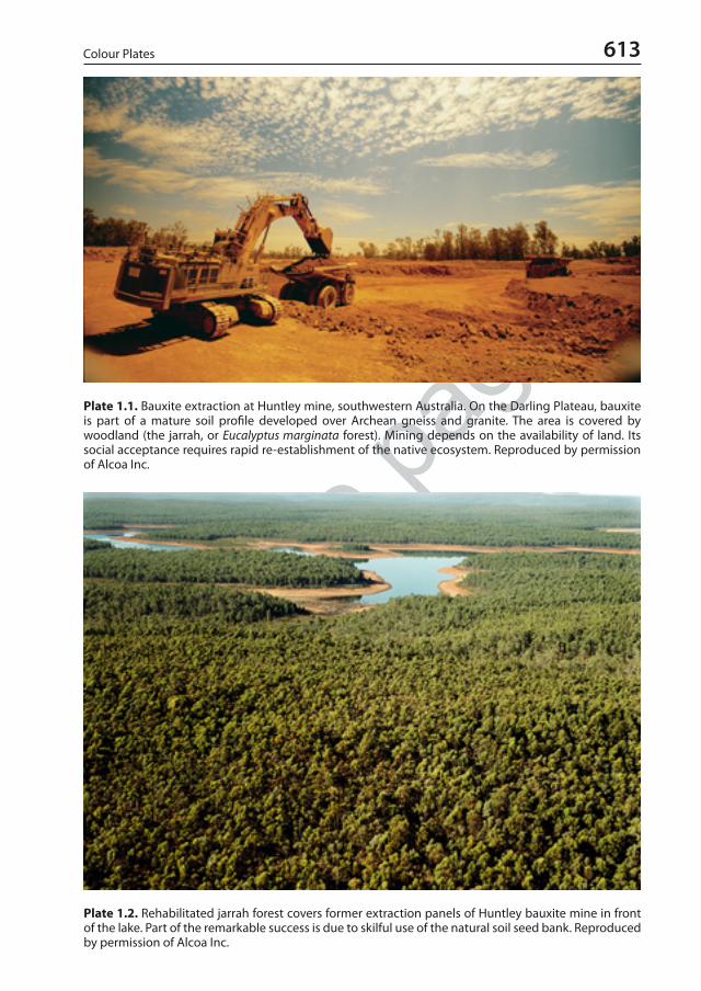
sample
page
s
613Colour Plates
Plate 1.1. Bauxite extraction at Huntley mine, southwestern Australia. On the Darling Plateau, bauxite is part of a mature soil profile developed over Archean gneiss and granite. The area is covered by woodland (the jarrah, or Eucalyptus marginata forest). Mining depends on the availability of land. Its social acceptance requires rapid re-establishment of the native ecosystem. Reproduced by permission of Alcoa Inc.
Plate 1.2. Rehabilitated jarrah forest covers former extraction panels of Huntley bauxite mine in front of the lake. Part of the remarkable success is due to skilful use of the natural soil seed bank. Reproduced by permission of Alcoa Inc.
eschweizerbart_xxx
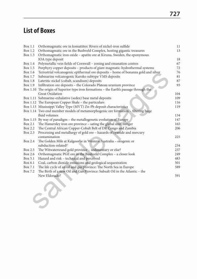
sample
page
s
727
List of Boxes
Box 1.1 Orthomagmatic ore in komatiites: Rivers of nickel-iron sulfide 11Box 1.2 Orthomagmatic ore in the Bushveld Complex, hosting gigantic treasures 13Box 1.3 Orthomagmatic iron oxide – apatite ore at Kiruna, Sweden, the eponymous
IOA type deposit 18Box 1.4 Polymetallic vein fields of Cornwall – zoning and emanation centres 67Box 1.5 Porphyry copper deposits – products of giant magmatic-hydrothermal systems 72Box 1.6 Terrestrial volcanogenic epithermal ore deposits – home of bonanza gold and silver 76Box 1.7 Submarine volcanogenic Kuroko subtype VMS deposits 81Box 1.8 Lateritic nickel (cobalt, scandium) deposits 87Box 1.9 Infiltration ore deposits – the Colorado Plateau uranium province 93Box 1.10 The origin of Superior type iron formations – the Earth’s passage through the
Great Oxidation 104Box 1.11 Submarine-exhalative (sedex) base metal deposits 109Box 1.12 The European Copper Shale – the particulars 116Box 1.13 Mississippi Valley Type (MVT) Zn-Pb deposit characteristics 119Box 1.14 Two end member models of metamorphogenic ore formation – filtering huge
fluid volumes 134Box 1.15 By way of paradigm – the metallogenetic evolution of Europe 147Box 2.1 The Hamersley iron ore province – sating the global steel hunger 165Box 2.2 The Central African Copper-Cobalt Belt of DR Congo and Zambia 206Box 2.3 Processing and metallurgy of gold ore – hazards of cyanide and mercury
contamination 225Box 2.4 The Golden Mile at Kalgoorlie in Western Australia – orogenic or
subduction-related? 234Box 2.5 The Witwatersrand gold province – sedimentary or else? 237Box 2.6 Orthomagmatic PGE ore in the Bushveld Complex – a closer look 249Box 5.1 Hazard and risk – technical and perceived 483Box 6.1 Coal, carbon dioxide emissions and geological sequestration 501Box 7.1 The life cycle of an oil and gas province: The North Sea in Europe 589Box 7.2 The Birth of a new Oil and Gas Province: Subsalt Oil in the Atlantic – the
New Eldorado? 591
eschweizerbart_xxx

sample
page
s
eschweizerbart_xxx

sample
page
s A-, M-, I- and S-type granitoids 31, 32Acanthite 240acid mine drainage (AMD), acid rock drainage
(ARD) 481, Río Tinto river pH 483, 487acid-sulfate steam-heated alteration 19acidity by sulfide precipitation (eq 1.18) 97active continental margin metallogeny 142, 144 Actualism: present-day geological processes are the
key to the past 2, 525adakitic magmas 144, 145, 228, 232, (Box 2.4)
Golden Mile 235advective fluid flow 59, 111, 131, 393African Surface 254aging of Fe(III) hydroxide into goethite and
hematite (eq 1.10) 85Agricola, Georgius (1556) opinions about mining
2, veins 62, Au 224, prospecting 450 Albite 343albitization, albitites 18, 40, 41, 60, emerald 295,
301, Ukraine U 302, talc 387, salt 429alkali-calcic alteration 19Alkaline igneous rocks 9, ore formation 26, carbon-
atite complex, fenitization 27, 31, 77, 143, 148, 152, 180, Lihir Au 230, 250, 256, Te 268, Zr 272, Ti 276, REE 279, diamond 339, F 346, vermicu-lite 366, apatite 371, 372, zeolite 393
allophane 355Alpine type carbonate-hosted Pb-Zn deposits 214alteration hydrothermal 59 ff.alteration supergene 82 ff.Aluminium 252 ff.alum salts 381Alum Shale in Sweden 148, V 196, Pb-Zn 216,
U 299, 381alunite 19, 44, formation (eq 1.6) 60, 62, 72, 76, 79,
85, 90, 126, Cu 210, Au Lihir 230, 251, Al ore 252, 256, 312, 357, alumstone 381, trass 390, Los Tollos alunite mine 452, 453, 459, 462
Amazon River annual C-export 107, 565amblygonite 289American Shale Composite 97amosite asbestos 315, BIF-hosted 317analcime 392anatase 274andalusite 312, Glomel mine 314, Groot Marico
district 314
anglesite 210anhydrite 352, karst 353Anhydrite see gypsumAnorthite 343anorthosite 16, 146, 160, 179, 181, (Box 2.6)
Bushveld 249, Ti 274, Lac Tio 275, 344Antimony 261 ff.Anthoinite 192Anthropocene, proposed and disputed new geolog-
ical time unit 3apatite (CaF) 345, 369, Khibiny 346, 372argillic alteration 61, 314, 387Arrhenius equation (eq 6.2) 534, 549, 567Arsenic 264 ff.arsenic toxic hazard in lowland river alluvium 266arsenopyrite (mispickel) 264asbestos risks 315, contamination 316asbolane 184Asphalt natural 560, 603atacamite 197Atlas orogen 124atmophile elements 8autunite 295awaruite 177
baddeleyite 271Banded iron formations (BIF) 87, 102 ff., Algoma
103, Superior 103, 104, Rapitan (Cryogenian) 106, 164, (Box 2.1) 165, 166, asbestos 317
Barite 318, deposits plotted compared to marine δ34S curve 320, Milos Island 320, Red Dog 321, Mazatán deposit 321
barrel [bl] 552basalts 9, 11, 21, gold source 131, trap 149, 180,
core-mantle sourced 179, Pb-Zn 211, Ag 241, Ti 275, provenance of sediments εNd 279
basinal brines, what is a brine (Table 1.7) 112, how to determine the origin of salinity in natural waters 113, tectonic (orogenic) brines 115
bastnaesite 278, lateritic ore at Ngualla 278battery metals 168, 178, 195, 241bauxite 6, 7, 85, 86, 125, Le Baux 150, 154, 196, Al
ore 252 ff., 254, karst 255, Ga 268, Sc 283, 330, 332, glass 344, 355, kaolin 357, alum 381, GPR 465
Bela Stena, or lacustrine magnesite 361, 362
General Index
• bold numbers point to colour plates or B&W photographs• italics lead to figures• eq. indicates an equation• mineral names refer mostly to information about the chemical composition, and other items of interest• underlined page (e.g. 211) provides a definition or other specific details
eschweizerbart_xxx

sample
page
s
730 General Index
Bendigo-Ballarat Au fields 236 berthierite 261bertrandite 292beryl 292, 294Beryllium 292 ff. Biodiversity 3, 205, 490, 491, 497, 578, 608, 646biophile elements V 196, Iodine 581bioremediation of hydrocarbons 611bischofite 399Bismuth 270 ff.bismuth native 270, Cerro Tasna mine 270, globally
largest Bi resource at polymetallic Shizhuyuan 270
bismuthinite 270 black shales highly metalliferous (HMBS) 97 Black smokers MOR seawater convection 22, vents
22, 23boehmite 252bonanza ore (Box 1.6) 77, 78boninites 21, 176bonus elements 445boracite 325, 399borax (tincal) 325, Kramer and Searles Lake depos-
its 326, Kirka 327bornite 197boron, borates 325, isotopes 326, brines at Salar de
Atacama 327, Dalnegorsk skarn 328botryoidal 58, 77, gossan 90, 109, Mn 168, Zn 210,
U 295 boudinage ore traps 65Bouger gravity anomaly across salt diapir 438Braggite 246brannerite 295brass 198, 211braunite 168breccia ore 15, 18, 27–28, 36, 46, 58, 62, 63, 67,
porphyry deposits 71, 74, epithermal 76, VMS 81, gossan 90, karst 94, Fe 102, 111, MVT (Box 1.13) 119, cave ore 120, 135, Cr 176, Ni-Cu 180, Mo 189
brine extraction collapse lakes 439Broken Hill district N.S.W. Pb-Zn-Ag 213bronze 198brucite 256, 358Brundtland-Report (1987) sustainable develop-
ment of non-renewable resources 3Bushveld Complex (Box 1.2), map 13 ff., V 161,
197, Cr 172, 174, 175, Sn 219, Au 237, PGE 246, (Box 2.6) 249, Merensky Reef 249, UG2 chro-mitite seam 250, Platreef 250, Waterberg deposit 250, andalusite 314, asbestos 318, diamond 335, F 347, 348
Cadmium, battery recycling, Niujiaotang deposit 269
calamine 210, 212calaverite 224calcite marble 328, Kristallina-Pardaun mine 330Cañon Diablo meteorite 50, 51carbon dioxide 502, sequestration 503, climate 504,
CO2 (atm) Cambrian to present 525, in natural gas 557
Carbonate rocks 328, fillers 329carbonatite-associated REE deposits (CARDs) 281,
Bayan Obo, Mt. Weld, Ngualla 281Carbonatites 27, section of complex, fenitization
27, volcano Oldoinyo Lengai 27, 380, ore depos-its Khibiny, Palabora, Mountain Pass, Byan Obo 27, Cu 199, Loolekop Cu and Bingham Canyon mine 200, Ti 276, REE 279–281 ff.
carbonatization 61, 260, 295, 360 (eq 3.97)carbonization 511, 513, 519, 529Carlin gold deposits 46, 227, 236, 239, Kyrgyz Hg
260, Sb 262, As 266, Te-Se 267, soil Geochemis-try 457, Biochemistry 458
Carnallite 256, 257, 358, 398, 399, 400, 407, dehy-dration (Table 4.8) 426
carnotite 195, 295carrolite 184cassiterite 218, precipitation (eq 2.5) 220causes of ore (mineral) deposit formation 2celestite 318, Coahuila deposits, Escúzar and Mon-
tevive mines 318, 319cement Portland, Fondu, cementitious materials
(SCM), pozzolans 330cerussite 210Cesium 289chabazite-Na 392chalcocite 197chalcophile (or thiophilic) elements 8, 10, komati-
ites 12, source of 34, flash boiling 64, Cu 198 chalcopyrite 197channel iron ore 163Chernobyl (1986) 392chlorargyrite 240chromite 172, stratiform 174, podiform 175, nod-
ular 176chromite chemistry controlled by petrogenesis 174chromite podiform ore bodies 175Chromium 172 ff.chrysocolla 197chrysotile asbestos 315, formation (eq 3.1) 316,
Thetford mines 317cinnabar 258Classification of non-metallic mineral deposits
(Table 3.1) 312Classification of ore and mineral deposits 151 ff.Clay and clay rocks 331, refractory 332, ceramic,
expanding 333, sealing 334
eschweizerbart_xxx

sample
page
s
731General Index
climate past 21, 43, Mt. Tambora (1815) 70, 83, 84, 85, 97, 102, 107, 108, 140, 164, 170, 196, 206, Al 253 ff., Dead Sea 257, As 267, solar activity 293, U 305, 325, 341, diatomite 343, 352, 354, kaolin 356, 361, 377, O-H-isotopes 404, Atacama 410, Dead Sea 411, Permian 420, 456, carbon dioxide 504, 505, 522, flora 523, Eocene 568, oil and gas 609
climate engineering sulfur 382, calcite 505climate archives 524climate regulation by wetlands 524, decarbonation
548 climate present-day globally exceptionally arid 410climatic optimum Eocene 83, 87, 107, 118, 150,
164, 183, 204, 357, 481–482, 489, 524, 525, 559, oil 568, 569, 612
Climax type Mo deposit ore formation system 189, 190
clinoptilolite-K 392closure temperature 48, zircon 51, 271, molybde-
nite 186, rutile, titanite 274, apatite 369Club of Rome (Meadows-Report 1974) 4, 474clumped isotope compositions 50, 56, 331, 360,
394, 515, in gas 559, 567, 611Coal 500 ff., reserves and resources, CO2, seques-
tration 501, types 505, classification 506, petrog-raphy 508, telinite 509, sporinite 510, fusinite, swamp facies 511, chemical composition 511, cellulose 512, volatile matter, sulfur 513, isotopes, water, gas 516, ash 517, density, heat energy, cokeability 518, synfuels 519, supergene alteration 536
Coal exploration 537, drilling 538, core 539, coal bed methane (CBM), Weibei gas 539, gas-in-place (eq 6.4) 540
Coal mining geology 541, Daxing water inrush, hanging wall rock subsidence above longwall, environmental issues, hazardous air pollutants 543, coal mine water, open pit water manage-ment 544, open pit reclamation 545, combus-tion residues, mine closure, biomass consumes protons in acid lakes (eq 6.5) 547, geothermal use of flooded coal mines 547
Coal permeability 540Coal reserve estimation 540 ff., large diameter core
541Coal seam fires 537, 546Coal, carbon dioxide emissions and geological
sequestration (Box 6.1) 501, Sleipner 502Coalification, geochemical 530, measuring coal
rank (vitrinite reflectance and Rock-Eval pyrol-ysis) 531, thermal metamorphism Tungus 532, 533, Arrhenius (eq 6.2), peak T (eq 6.3) 634, oil window 635
coastal and shelf placers 101 ff., 155, 161, dunes at Taharoa and Waikato 164, Cr 173, Sn 220, Au 227, Zr 273
Cobalt 184 ff.cobaltite 184coffinite 295cold submarine seeps 320, 321colemanite 325, zoning in host lakes 327 colloids, colloform 58, colloidal 80Columbia (Nuna) Supercontinent 146, 202, 209,
213, 281columbite group minerals (CGM) 282, dating by
CGM 285common salt minerals of Mg, Na, Ca, B (Table 4.2)
399compatible elements 33, 34, 120conduit style ore deposit 179constructive plate boundaries 142contact metamorphism 21, 68, 125, Ni 182, 301,
313, 315, 350, Lutang graphite 351, periclase 358, quartzite 376, wollastonite 391, salt 428
continental hotspots 141, collision 146continuous accumulations of oil and gas 570conventional/unconventional oil and gas 553, 570,
reservoir rocks, Shetland Islands granite 573conversion energy coal-gas-lignite-oil (Table 7.1)
553cooperate 246Copper 197 ff.Copper Belt in S-Central Africa 184, (Box 2.2)
206–207 stratigraphic column and modelCoulomb-Mohr failure (eq) 64coulsonite 195covellite 197critical point of pure water 36, salinity 44, 54critical raw materials 4, 28, deep sea nodules 109,
157, Mn 169, Co 184, W 195, PGE 246, Sb 264, 309, 311, graphite 352, 444, 447, Europe list (Table 5.3) 448, energy 645
crocidolite asbestos 315crosscutting veins 65Crust of the Earth 7, 9Cryogenian System of the Neoproterozoic
(720–635 Ma), Snowball Earth 106cryogenic salt precipitation 409cuprite 197Cu-tennantite 197Cu-tetrahedrite 197cyanide 225, 239, 446, 486Cyprus type Zn-Cu-Au deposits 6, 21 ff., fluid
convection 22, 26, 70, 95, 112, 142, 144, 148, 150, 163, Mn 170, Cu 199, pillow lavas and dyke 202, 203, Pb-Zn 212, Au 226, Sr 319
eschweizerbart_xxx

sample
page
s
732 General Index
Darwin, Charles 151, 448Davis Tube 158Dead Sea salts 257, 358, 398, Br 403, 406, 410 ff.,
salt reefs 413Deccan traps 141, 339, diamond 338, F Amba
Dongar 347Deep water evaporates 417 ff., saline giants 417dehydration 6, 25, 32, 46, 69, 123, 124, 128, 129,
131, dehydration reactions (eq 1.26) 132, 135, 145, (Box 1.15) 147, 220, 228, 232, 326, 339, 352, 353, 359, 362, 393, 404, 405, 426, dehydration reactions of salts (Table 4.8) 427, 447, 536, 566, 570, 571
deposit types, styles, classes 152Depth zones of hydrothermal ore deposits: epizon-
al-mesozonal-hypozonal (Table 1.3) 56destructive plate boundaries 142desulfidation (eq 1.25) 126, 128diagenetic basinal flow systems 115, tectonic brines
115diagenetic carbonate hosted Pb-Zn-F-Ba deposits
118 ff., dolomitization halos 119diagenetic hydrothermal metasomatic ore 121Diagenetic ore formation 112 ff.Diamond 334 ff., Cullinan 335, isotopes 335, mi-
crodiamonds, diamond formation (eq 3.2) 336, Clifford’s rule 338, kimberlite 338, kimberlite tuff 338, pipes 337, 338, lamproites, Argyle octahedra 339, synthetic diamonds 341
diamond mines mentioned Diavik 335, Premier, Letseng, Jagersfontein, Koffeefontein, Ekati 338, De Beers Kimberley, Argyle 339, Orange River 340, Victor, Gahcho Kué, Renard 341
diamond placers Gbenko, Bow River, Vila Nova 340, Ekati heavy minerals 340
diamondoids 570diaspore 252Diatomite 342, diatom from Adami Tulu Sida 342,
mines at Lompoc, Myvatn Lake, Murat, Lüne-burg, Jutland
Dickite 355differentiation and fractionation 34digenite 197digitization, digital 155, 443, 447, 448, 449, 453,
454, 460, 468, 470, 471, 473, 546, 588, 612discovery history Olympic Dam, Mt. Isa, Skaer-
gaard, Voisey’s Bay, Lisheen 449Disposal of dangerous waste 492 ff., safe reposito-
ries 492, variants, multiple barriers 493, Konrad mudrock, salt rock repository Herfa-Neurode, Gorleben 494, radioactive waste in salt 495
disposal of mining and processing waste 122, 252, 257, 398, 441, 481, 490, 544, 545, 609
distinction of Yanshanian U ore by HFSE versus U/Pb ages 302
Disturbance of the groundwater system near salt mines 441
divergent plate boundaries 140dolomite 256dolomite 328, hydrothermal formation 331dolomitization 61 ff., 119, 211, 214, 242drilling salt 438Drilling: rotary percussion hammer bit 466, 467,
air core and sonic, diamond coring 467, core recovery, coiled tubing, directional drilling, borehole deviation, logging 468, planning drillholes, hydro- and geotechnical data, sealing holes 469, pre-feasibility study 470
dysoxia – hypoxia – anoxia (euxinic) conditions 110
earthquakes and seismic activity, induced Fukush-ima Daiichi incidence (2011) 297, 389, salt 429, 440, hazard and risk (Box 5.1) 483, 485, 486, 490, 543, 599, 609
Earth wax (ozocerite) 560Earth’s arid latitudes and salt formation 409Economic Geology what is it? 1, 8, 47, geother-
mometers 53, Europe 147, terms and classes 152, Practice 443 ff., New Age 645
Economical controls of mining, cut-off grade 444, critical raw materials 444, resources and reserves 444, risk economic 444, giants and su-per-giant deposits 444, large-scale mining 445, feasibility of beneficiation 445, 446, geological situation 445, geographic and social conditions 446
ecosystem services 3, 547, 646ecosystem restoration 489Eh/pH near surface iron phases distribution 159Electronic metals 267 ff.electrum 240elements – H, C, N, O, S and P – major elements
required to build all biological macromolecules 369
emanation centres 67emerald 293, Mariinsky district, Muzo
deposit 294empressite 240enargite 197endogenetic (endogenic) 8enlightened environmentalism 3environment (geologic, geodynamic) 80, 103, 151,
152, 159, 167, 173, 179, 202, 208, 274, 309, 416environment (natural and human) 3, 4, 78, 83, 90,
95, 96, 97, 100, 105, 110, 112, 120, 185, 192, 196, 199, 212, 214, 219, cyanide 225, Au 226, Ag 241, PGE 247, Hg 258, As 266, U 296 ff., 329, cement 330, F 346, 451, mining 481 ff., coal 543 ff., hydrocarbons 605 ff.
eschweizerbart_xxx
sample
page
s
733General Index
Environmental management of oil and gas produc-tion 606 ff., Los Angeles, Apsheron Peninsula, Kuwait (1991), oil seeps natural, Exon Valdez (1989), Macondo (Deepwater Horizon 2010) 607, natural vents 608, water management Surat 608, Seven Golden Rules (IEA 2012), subsid-ence, seismic activity, climate, GHG methane in the atmosphere, Sleipner CO2 609
Eoalpine orogeny Eastern Alps Europe 133Eocene hothouse 83, 87, 107, 118, 150, 164, 183,
204, 357, AMD 481–482, 489, 524, 525, 559, oil 568, 569, 612
epigenetic (Table 1.2) 8, 26, 52, 55, 61, 88, 92, 94, 97, 113, 115, 116, 118, 122, 123, 129, 149, 169, Cu 208, 536
epithermal 56, 73, 76 ff., fluids 77Epithermal ore deposits (Box 1.6) 76 ff., Ag-Sn
Cerro Rico de Potosí 243, 244, 245epsomite 399erionite-K 392erythrite 184essential trace elements 160, 169, 173, 177, 185,
187, 192, 196, 198, 267, 325euclase 292Europe metallogeny (Box 1.15) 147 ff., Eastern
Alps 147European Copper Shale 116 ff., schematic of fluid
flow, redox and Cu-Pb-Zn zoning 116, diagenet-ic model 118
eutrophication by P mitigated 370euxinic 116Evaporites - diagenesis and metamorphism 425 ff.,
dehydration (Table 4.8) 426, diagenetic facies map 427, contact metamorphism of salt rocks, orogenic metamorphism 428
exogenetic (endogenic) 8Exploitation of hydrocarbons 592 ff., reservoir
porosity and permeability, fluids, viscosity, satu-ration, pressure/overpressure, lithostatic and hy-drostatic stress (eq 7.8) 593, field development 594, coal bed methane, hydraulic fracturing 595, Barnett Shale 596, unconventional oil Bakken Formation 596, drive mechanisms 597, seawater flooding, hydromechanical fracturing 598, field growth, petroleum mining 599, well head pump 602
Exploration 447 ff., targeting, prospectivity anal-ysis, spending 448, geological 448, brownfield, greenfield 448 ff., models 450, reconnaissance, follow-up, evaluation 451
Exploration for hydrocarbons 584 ff., geophysical methods 586, geochemical methods, seismic detection and sniffer 587, drilling, geophysical well logging 588, sonic P-wave velocity (Table 7.7) 590
fahlore 198fayalite (FeII) 367Fe isotopes 159feasibility study 451FeCl2 extraction from melt (eq 2.1) 162Feldspar, feldspar-rich igneous rocks 343, e.g.
nepheline syenite, aplite, alaskite, albitite, phonolite, rhyolite, anorthosite White Mountain (Qaqortorssuaq) deposit 344
fenite, fenitization 27, 148, 282fergusonite 278ferrierite-Mg 392ferrimolybdenite 188ferroan granite 31fertility indicators granites 30, 34, porphyry 76,
146, tin granite 219, Sb 262fertilization mantle 12, 75, 140, 335, crust 227 Finite Earth, finite resources? 4, 474, 645, 646flare-up 143flashing 45, flash boiling 43, 64, 303, smelting 178,
heating 365Fluid inclusions 53 ff., geothermometers, fluid
inclusion assemblage (FIA) 54fluid inclusions in salt 401fluid mobile elements 80fluid pressure 36, determination of 56, 63, reducing
normal stress (eq) 64, 534, oil reservoir 593fluid/melt phase 34, 36, 40, 132, Dajishan W 193,
wodginite 283fluids in the Earths’ crust 47Fluor 345 ff. fluorite (Fluorspar) 345, Las Cuevas, Amba Dongar,
Witkop, Chaillac, Rossignol 348foam textures 125, 128formation of native metals (eq 1.14) 91formation of supergene enriched Cu ore
(eq 1.13) 91formation water 44, 45, 46, stable isotopes 49,
Cornwall 67, 97, salinity 113, redox 114, heat 115, Cu-Shale 117, salt diapirs 123, siderite 162, Copper Belt 209, Pb-Zn 215, Hg 259, U 299, Mg 331, Ca 347, 363, 404, 440, 492, CO2 502, oil 556, gas 567, 573, 574, hydrodynamic traps 580, oil 581, 608
forsterite (Mg) 256, 367, 368Fossil energy 499 ff., units (Table 6.1) 499, con-
sumption 500fossil fuels main elements C-H-S-N-O % (Table
7.2) 554frac sand 378, glass, foundry, building sand and
gravel 379fractionation and differentiation 34freibergite 240fS2/fO2 diagram of hydrothermal iron
phases 160
eschweizerbart_xxx

sample
page
s
734 General Index
Fukushima Daiichi nuclear power plant incidence 297
functional replacement 4, Mn for Co 186
galena 210Gallium 268garnierite 177Gas in salt 401, in salt mining 441Gas natural (methane) 556, sour/sweet/dry/wet
557, H2S, N, CO2, origin, isotopic differentiation 558, world’s largest dry gas field South Pars (Iran) - North Field (Qatar), coal sourcing gas 566, microbial methanogenesis (eq 7.4), Antrim Shale 567, gas emplacement dating Qingshen gas field 573, Troll gasfield, Ekofisk oil chalk 574, Hugoton gas 585
gel, hydrosol, colloids, botryoidal textures 58Geochemical exploration 454, sampling variety,
anomalies, primary and secondary dispersion, pathfinder elements 455, stream sediments 456, BLEG (Bulk Leachable Extractable Gold), soil samples Carlin, rock samples 457, soil gas and air, plant material, water, analytical methods 458, sequential extraction, accuracy and preci-sion, QAQC, indicator minerals, fingerprinting 459, environmental geochemistry 460
Geochemistry of salt 401 ff., sodium, potassium 402, chlorine, Cl-isotopes 402, bromine 402, 403, B-isotopes, sulfur isotopes, O- and H-iso-topes 404, isotopic dating of salt 404, iodine isotopes 404
Geochronology 48 ff.geoengineering 158, sulfur 382, calcite 505geological mapping 446, mapping and sampling
mines 470, 472geological thermometers 53Geological Time Chart 9Geophysical exploration 460, deep exploration
Yinkeng, Athabasca, Sudbury, background vs. anomaly 461, magnetometry, solar activity, electric current 462, electromagnetic (EM) 463, magnetotelluric (MT), gravity, radi-ometric 464, tomographic methods, borehole surveys 465
geothermal electricity 43geothermal gradient 533geothermal system 77geothermal waters 42Germanium 268Giant Gold Mine by-product arsenic waste 265giant Li-K-B-Mg brine resources (Salar de Uyuni)
292, Salar de Atacama Li-K-B 292gibbsite 252, formation (eq 2.9) 253 goethite 157Gold 224 ff.
gold amalgamation is the world's largest mercury polluter 258
gold deposit formation process systems 7, 45, 56, 60, tectonic control 64, 71, 78, lateritic 86, meta-morphogenic 130, orogenic 133, 134, collisional 146, 227 ff.
gold native 224, giant deposit Lihir 445gold ore processing (Table 2.3) 225, cyanide, mer-
cury 225Gondwana coal depositional setting 523, 529Gondwana orogenic gold deposits 134, 236, Sri
Lanka graphite 352Gondwana Supercontinent naming by Suess 140,
Panafrican welding 141, Altaid suture and met-allogenetic peak in Europe 146, breakup 202
Gondwanan continental glaciations 419–420, 524Gossan 89, 90, 91, 449granite-related Sn Erzgebirge 222granite-related Sn-W-Au deposits 30, 32 Granites and ore formation 29 ff., Sn-Ta granite
Shuiximiao 29, fractionation column 30, grani-toid types 31, redox state 32, fractionation, rare element granites 33, differentiation, fertility, plu-tons, water solubility in magma 34, supercritical hydrous fluid/melt phase 35, first and second boiling, pneumatogenic (pneumatolytic) phase 36, geothermal convection, HHP granites 37
granitophile elements 33, 202 Graphite 349, battery mineral, Raman geother-
mometer 349, flake graphite, microcrystalline ‘amorphous’ graphite, Lac Knife, Kaisersberg mine, Graphite Lake, Lutang deposit, Sri Lanka, volcanogenic Borrowdale 351, Woxna 352
graphite formation hydrothermal (eq 3.3) 351Great Oxidation (2.5–1.8 Ga) 104, (eq 1.19) 105, Fe
160, U 299, seawater 414 Great Unconformity marking the explosion of Life
on the Earth 414 green mining 3, 492, 497, 504, 549greenhouse gas emissions from mines 317greenhouse, hothouse and icehouse global climate
phases 83, 84, 164, 204, 253, 255, 256, 357, 482, 489, 504, 548, 559, 563, 564, 568, 610
Greenstone Belts (Box 2.4) Golden Mile 234, 235greisenization 61, 70, 222, 357ground penetrating radar (GPR) 465 gypsum 352, karst-like gypsum surface 354, lagoon
354, gypsum synthetic 355Gypsum and anhydrite 352 ff., hydration and dehy-
dration (eq 3.4) 353, 426
Haber-Bosch nitrogen production Fe catalyst 158, ammonia production (eq 7.2) 552
Hadley-Ferell Circulation 408Hafnium 271
eschweizerbart_xxx

sample
page
s
735General Index
halite 399, halitite 426halloysite 355Halokinesis and salt tectonics, terms 435, 430, salt
domes and diapirs, active diapirism 431, devel-opment of a salt dome 432, passive diapirism 432, salt glacier 433, linear and isolated diapirs Gorleben region 433, section of Gorleben salt diapir 433
Hard rock mining of salt 440hausmannite 168hazardous air pollutants (HAP’s) 297, 543Heat flow from the Earth’s interior at the surface 2Heat production in Crust and Lithosphere (Table
2.3) 298hectorite 322Helium 557hematite 157, enrichment by leaching of Fe(II) (eq
2.2) 167hemimorphite 210Hemlo Au mine 65, 129, 126, 128, 129, 229, 231Hess Crust 22hessite 240heterogenite 184Hg giant Almadén deposit 261HHP (high heat production) granite average versus
crust 37high field strength elements (HFSE) 27, 31, 33, 145,
193, 272, 275, 279, 284high grade hematite deposit 87, 92, 104, 112, 121,
152, 161, 164, Hamersley (Box 2.1) 165, 166, Mt. Tom Price 167
high heat production (HHP) granites 37, 68, 78high sulfidation 73, 78, (Table 1.4) 79, 81, 150, Au
229, 230, Ag 242, kyanite 315, kaolin 357highly siderophile elements 226hot springs deposits 76hothouse see greenhouseHubbert Curve fitting method 552,
peak oil 553hydration 71, 73, 134, 144, 155, 182, 351, 353, 354,
357, 362, 367, 389, 404hydrocarbon (HC) fluids, permeability for different
fluids (eq 7.6) 572Hydrocarbon reserves and resource estimation 599
ff., volumetric (eq 7.9), material balance (eq 7.10), Kern River field growth 601
Hydrocarbons 551 ff., origin organic, abiotic 562, eogenesis, catagenesis, metagenesis 567, 568, high heat flow basins Gulf of California, Salton Sea, Viking Graben, Vøring and Møre Basins 569, oil and gas traps Troll oil 575, Zubair and Rumaila oil 576, classification of hydrocarbon traps (Table 7.5), Hedinia oil 577, Draugen 578, Munster gas 579, Ghawar oil 579, Cantarell oil, giant and supergiant deposits (Table 7.6) Taaken
diapir inversion 580, tectonic settings and age 583, source potential, seeps 585
hydrogen production (eq 7.1) 552Hydrogen economy 552hydromagnesite 358hydrosilicate liquid 283, see fluid/melt phasehydrostatic stress (eq 7.8) 593 hydrothermal exhalative 96, 98, (Box 1.11) sedex
110, Mn 168, 170Hydrothermal rock alteration 59 ff. Hydrothermal ore formation 42 ff., alteration 59,
volcanogenic 70 ff., diagenetic 112 ff., duration 132, metamorphogenic 129 ff.
Hydrothermal veins 62 ff. hydrozincite 2010hypogene 8, 60, 67, 72, 94, 103, 167, 199, 212, Hg
258, kaolin 356, magnesite 361, mica 367
Iberian Pyrite Belt Cu-Pb-Zn-Ag-Au VMS prov-ince 204, 205
Ilmenite 274, Titania mine 274, 276, Lac Tio anorthosite deposit 275, coastal placers 276
immobile elements 130, 253impact magma 15, effects 106, 125, ore 137, Sud-
bury 180incident solar irradiance at the Earth’s surface 2incompatible elements 33, 37, 42, 140, 145, 192,
tin 220, Be 293, U 298, Ba-Sr 319, B 326, P 370, Li-Cs-Ta 285
Indium, Mt. Pleasant mine 269infiltration ore deposits U (Box 1.9) 93in-situ leaching (ISL) of U 296inversion tectonics 150, 183, 208, 213, 217, 218,
237, 400, 430, 579, 580, 587, 590, 594IOA evolving into IOCG 20IOCG see iron-oxide copper gold (IOCG) deposits iodine 581Irish type carbonate-hosted Pb-Zn-Ag deposits
214, stratiform and faultbound ore bodies, seawater convection 215
Iron 157 ff.iron ore belt Chile-Peru 19, 20, 161, 202iron-oxide copper gold (IOCG) deposits 17, 18, 19,
20, 31, 49, 142, 144, 148, 152, 153, 154, 160, 161, 162, 189, 199, 200, 201, 213, 227, 301, 429, see also Olympic Dam
iron-oxide pigments 158ironstone 107Island arc ore deposits 144 island arc, primitive 9, 21, 31, 69, 142, 143, W
Felbertal 194, Cu 199 isotope fractionation as deviation from a standard
(eq 1.3) 47–48isotope geochemistry 47 ff., water 49, carbon 50,
sulfur 50, Sr, Pb 52, B 52, Cu 199
eschweizerbart_xxx

sample
page
s
736 General Index
isotopic age dating by radioactive decay (eq 1.4) 48, 296
isotopic age dating of salt 404isotopic mass-dependent fractionation (termed δ
values) and mass-independent fractionation (designated as Δ values) 259
jadarite 325, Jadar mine 327juvenile water 47
Kaolin 355 ff., formation (eq 3.5a) 356, filler, Ama-zonia, Cornwall, Lipari Island 357
kaolin below laterite 84karst ore formation 94, limestone dissolution (eq
1.15) 94, Pb-Zn 94, bauxite 255, Uston 255kbar (kilobar) 1 kbar equals ca. 3.85 km rock of
density 2.6 or a 10 km water column 35kernite (rasorite) 325, Kramer 326Kerogen 560 ff., types 561, Rock-Eval pyrolysis 562,
water sourcing hydrogen (eq 7.5) 567kieserite 399, 400Kimberlites 27 ff., lamproites 28, 337, diamonds 28,
334 ff.Kipling, Rudyard (1888) tales about coal mining
537Kiruna type, or iron oxide apatite (IOA) deposits
17, (Box 1.3) 18, 19, 144, 148, 153, 161, 370, 473, 484
komatiites (Box 1.1) 11, 139, 153, Ni-Co 186, Ni 233
Kotalahti Ni Belt 181Kraubath type magnesite or ‘bone’ magnesite 359,
magnesite formation from dunite (eq 6.7) 360
Kuroko VMS deposits (Box 1.7) 81kyanite 312, Willis Mountain mine 314Ladolam, Lihir gold deposits 230, 231land use by mining 3, 329, 334, 379, 462, 606, 609large igneous province (LIP) Bushveld 13, hothouse
83, metallogenesis 136, Ni 179, IOCG 201, Emeishan 255, carbon cycle 504
large ion lithophile elements (LILE) 33largest metal concentrations on Earth 167lateral secretion 8, 128, 131, 315lateritic ore 84, Ni-Co-Sc (Box 1.8) 87,
Fe 163, Ni 183, exploration 184, byproduct Co 185, bauxite 254, Weipa 254
layered mafic intrusions (Box 1.2 Bushveld) 13 ff., 15, 16, 21, 22, 125, 148, 153, 174, 196, Rusten-burg 197, Skaergaard 228, 449, PGE Great Dyke 248, PGE Bushveld (Box 2.6) 249, 252, 288, P 371, Sept Îsle Complex P-Ti 372
Lead and Zinc 210 ff.lepidocrocite 157lepidolite 289
Lid Tectonics 7, 139, 147, 154, 156, 174, Au 227, 233
Life cycle of hydrocarbon provinces, the mature North Sea (Box 7.1) 590, the birth of a new province: Subsalt in the South Atlantic Pão de Açúcar (Box 7.2) 592
life-index or reserves/production (R/P) ratio 4, 501Limestone 328, 329limonite 158linnaeite-siegenite 184listwaenitization 60, 61, hosting Au 235, 361Lithium 289 ff.lithium saltworks Salar de Atacama precipitation
sequence 405lithophile elements 8, 33, 48, 49, 193, Pb 211, Sn
219, Al 252, Mg 257, Zr 271, Ti 274, REE 279, Nb/Ta 284, Li 290, Be 293, U/Th 298, Ba/Sr 219, B 326, F 346, Si 373, S 382, Na 402, Cl 402, Br 403, I 581
loellingite (leucopyrite) 264loparite 278low sulfidation 43, 77, 78, (Table 1.4) 79, Kuroko
81, 151, Lihir Au 230, Ag 242
maghemite 157magma ocean stage of the Earth 7, 12, 50, 157, 225Magmatic ore formation systems 9 ff. magma impact 9, orthomagmatic 10 ff., R-factor
(eq 1.1) 10, komatiites (Box 1.1) 11, gravitation-al settling 12, Bushveld (Box 1.2) 13, Sudbury impact 15, 16, anorthosite Ti 16, Fe-rich melts, flotation of magnetite microlites 17, iron ox-ide-apatite (IOA) or Kiruna-type deposits (Box 1.3) 18, pyroclastic magnetite ore El Laco 19, deep orthomagmatic IOA evolving into shallow IOCG system 20, fractional crystallization 21, differentiation and fractionation 34 ff., magma oxidation 75
magmato-hydrothermal space 152magnesia 358magnesite 256, 358Magnesite 358 ff., synthetic, or seawater magnesia
production (eq 6.6) 359magnesite-talc-serpentine rocks 361Magnesium 256 ff.Magnetite 157, in porphyry Cu 73, 92, 121, geo-
chemical discrimination 157, ore grade 158, Bushveld V-Ti-mag 197
major plate reorganisations 141malachite 197Manganese 168 ff.manganese (polymetallic) nodules and crusts 102,
108, 109, 142, (Table 1.6) 153, 172, Ni-Co 184, 186, Mo 188, W 191, V 196, Cu 198, PGE 247, Cd 269, 447
eschweizerbart_xxx

sample
page
s
737General Index
manganese dissolution by microbes (eq 1.20) 108manganese formations 68, 102, 106, 171manganese umber 24, 109, 142, 170, 203manganite 168mantle metasomatism 26, 145mantle fertilized see fertilization mantlemantle melting 7, 9, 10, 75, 176, 336mantle plume 8, 12, 13, 14, 140, Ni 179mantle primitive 7, 8, 11, 21, 140, Au 225, Pt 247,
Bi 270, Ce 279, Nb-Ta 284, F 346, K 402, Cl 402 marine salt lagoon Lake Assal 412, 417marine sedimentary BIF 103, 140, Mn 108, 161,
164, Mn 169, 170, 171, magnesite Witchelina type 359
marlstone 328, cement production 330 martite 87, supergene 92, 104, 157, 161, 165, 166MASH (melting, assimilation, storage, and homog-
enization processes 30, 74, 145measuring dissolved solids in saline waters (eq
1.21) 113melt/water solubility, miscibility and supercritical
fluid/melt phase 35Mercury 258 ff., metalloid toxic, global emissions 258 mercury native volatile 258, vapour formation (eq
2.10) 259Merensky, Hans (1871–1952) honored Pt 248Messinian Sr 319, gypsum 353, sulfur deposits 383metal sulfide precipitation 45, 46, 74, 94, (eq. 1.18)
97, (eq 1.23) 115, Co 185, 214, 217, 227, Au 228metalliferous black shales 97, Ni 182, 183, Mo 190,
Ag 241metallogenesis 5, 8, mixed 59, salt diapir 124,
impact related 137, mid-oceanic 143, 162, saline fluids, Cu 298
metallogenetic (metallogenic) terms 8, 17, province 31, boundaries 52, potential 82, agents 118, systems 121, brines 123, domains 137, map 138, factories 140, heredity 141, realm 193, knowl-edge 450, models 474, 645, role 563
Metallogeny 5, 6, 136 ff., 8, 14, 18, 20, quantifica-tion 139, 142, 147, Europe 147 ff., Pb-Zn 210, Sn 220, Ag 241, PGE 248, digitization 447, 449
metallogeny 8, Bushveld 14, Kiruna 18, ophiolites 21, 136 ff., lid tectonics 139, plate tectonics 139, 142, 147, Europe metallogeny (Box 1.15) 147 ff., digitized 155, prospectivity 447, Au 448
metallotect 138Metamorphism and ore formation 125 ff., orogenic,
regional, intrusion-related metamorphic dehydration (eq 1.26) 132metamorphic fluids 115, 121, 132Metamorphic ore formation 125 ff. metamorphic oxidation/reduction (eq 1.25) 126metamorphic sulfidation/desulfidation
(eq 1.25) 126
Metamorphogenic ore 129 ff., 130, models (Box 1.14) 134
Metamorphosed ore 125 ff., very-low-grade meta-morphosed ore 127
Metasomatic deposits 121 ff., siderite (eq 1.24) 122, Erzberg 122, metasomatic boundaries and front 123
metasomatizing (fertilizing) the mantle 8, 14, 75, 140, 145, lower crust 227, 238, REE 280, diamond 336
meteorites 2, 7, 8, 33, W 191, Au 225, PGE 247, Ga 268, diamonds 336
methane seepage natural from coal and oil basins 547
Mg isotopes 257, 363, 394Miargyrite 240Mica 364 ff. Microlite 283mid-ocean ridges (MOR) 9, 21, 22, 25, Sr 51, 81,
105, 108, 109, 142, 144, 225mid-ocean submarine hydrothermal systems 22, 25Milankovich periodicities 418, orbital signals 380,
504, 524, 526, 548, source rocks 563, 605millerite 177Minamata Convention on Mercury (UN 2013) 258mine closure 489, are closed mines an asset? Gebeit
Au, Kolwezi Cu-Co 491, Kidston Au 492mineral system analysis 42, 57, 136, BIF 152, 155,
166, Ni 183, Pb-Zn 218, Au 233, 239, PGE 250, REE 280, sedex Ba 321, prospectivity modeling 447
minerals 5, 25, ore 157, battery 279, industrial 311, salt 399, indicator 459
Mining and climate change 488 ff.Mining environment: lignite pit and captive power
station, Río Tinto AMD 481, Environmental Impact Assessment (EIA), pit recultivation 482, potential problems 482 ff., Hazard and Risk (Box 5.1), seepage into mine (eq 5.8) 483, 484, tailings 485, waste rock acid drainage (ARD) treatment 487, aeration (eq 5.9) cascade, reed bed treatment 488, precipitates from AMD (Ta-ble 5.4) 489, climate change 488 ff., reclamation, matallophytes, soil remediation 490, pit lakes 491, green mining 497
Mining geology 470 ff., mine section 471, grade control 472, subsampling, geometallurgy, ore domains 473
mirabilite or Glauber’s salt, cryogenic 381, 399Mississippi Valley type (MVT) Pb-Zn deposits
(Box 1.13) 119, cave ore 119, Viburnum Trend (Box 1.13) 119, 120, 214
Mohr-Coulomb shear stress/normal stress failure diagram 64
Molybdenum 186 ff.
eschweizerbart_xxx

sample
page
s
738 General Index
molybdenite 186monazite 278monazite 295moncheite 246montmorillonite 322Montreal Protocol (1987) ban on halone and CFCs
(chlorofluorocarbons) and ‘The Kigali amend-ment 2016’ 346
montroseite 195mordenite 392Mt. Isa Cu-Pb-Zn-Ag mining district 52, 63, 91,
111, 132, 146, 154, Cu 199, 208, 209, 210, Pb-Zn-Ag 212, U 300, Valhalla 302, Phosphate Hill mine 371, metallurgy 445
Murrin Murrin lateritic Ni-Co 185, 186muscovite 364
NaCl solubility as a function of T 0–100°C (Table 4.4) 405
Nacrite 355nahcolite 380natron cryogenic 380, 399natural capital 3, 490natural gas hydrates (clathrates) Blake Ridge 559,
Mallik 560natural nuclear reactor Oklo mining district 300Nb-carbonatite Araxá 286nelsonite 17, 18, 275, 312nepheline 252Nickel 177 ff. nickel seven virtues 177nickeline 177niobite 283Niobium and Tantalum 282 ff.nitrogen fertilizer 551, Haber-Bosch process (eq
7.2) 552noble metals replace ‘common’ metals
(eq 1.2) 45Nuna (Columbia) Supercontinent 146, Lala Cu 202,
Mt. Isa 209, Bayan Obo 281
ochre 24, 34, 43, 142, 159, 188, 192, 203, 205, 261, 483, 488
Oil shale immature 604 ff., Estonia 605, Green River Basin, Julia Creek 606
oil reservoir fluids 593 ff.Olivine (Dunite) 367, 368Olympic Dam new class of Iron Oxide Copper
Gold (IOCG) deposits 17, 199, geological map 201, Au 229, U 296, 301, exploration success 349, perseverance 451, 469, geophysics 464
oolitic manganese ore 107, 108, 170opaline silica phases 78open cast lakes 546open space filling 57, 123, 230
Ophiolites 9, 21 ff., 142, 145, 148, 150, Balkans 163, 170, Cr 147, hosting Au 236, PGE 248, magne-site from dunite (eq 3.7) 359, 360, olivine 367, 368, talc 385, CO2 control 504
Ophthalmia orogen 129Ore deposits (mineral deposits), what are they? 1,
5, 6, 8, Hadean asteroids 9, orthomagmatic 10, ophiolites 27, magmatic-hydrothermal 36 f., vol-canogenic 70, diapir related 123
ore microscopy 57ore minerals 5, 25, 157; see respective element or
raw materialore shoots in veins 66Ore, what is ore? 5, prefeasibility and feasibility
studies 470, grade control 472, geometallurgy 473, cut-off grade 477
Ore-forming Processes and Systems 6, 7, 8, Mag-matic 9 ff., Supergene 82 ff., Sedimentary 95 ff., Diagenetic 112 ff., Metamorphism 121 ff., Metallogeny – Space, Time, Geodynamics 136 ff., Genetic Classification of Ore Deposits 151 ff., clans, superclass, classes (Table 1.6) 153
Orogen accretionary New Zealand Alps Au 129, 143
orogenic Au deposits 133, 134, 233orogenic collapse 151orogenic metamorphism 126, 127orthoclase (microcline) 343Orthomagmatic ore deposits 10 ff. orthomagmatic Fe 161, Ni 179, PGE (Box 2.6) 249overpressure reservoir fluid abnormal 594oxidation of ferrous to ferric iron is a prolific
source of acidity (eq 4.1) 412oxidation of sulfides (eq 1.12) 89, supergene en-
richment and vertical zonation from gossan to primary ore 90
oxidation of the Earth step 2 (0.8–0.6 Ga) 106oxygen fugacity or redox state of melt 12, 30, 31,
32, 35
Pacific Ring of Fire 143palygorskite (attapulgite) 322Pangaea Carboniferous (Pennsylvanian) to Permi-
an coal 524Pangaea Supercontinent 82, 118, break-up 121, 146,
149, 150, 162, 171, 194, 204, 218, 221, 348, 363, evaporites 409, 415, 419, 430, 524, 596
paragenesis, paragenetic sequence 56 ff., 57parisite 278partition coefficient (D) (eq 2.3) 178passive continental margins 142pathfinder elements 239, 267patronite 195PDB belemnite isotopic standard 50Peak Oil 553, Hubbert Curve fitting method 552
eschweizerbart_xxx
sample
page
s
739General Index
Peat formation 519, Latrobe peat, Fushun deposit 520, Lausitz 522, wetlands and swamps, Sar-awak 522, Leoben raised bog 523, climate 523, present-day wetlands 524, palaeoenvironmental reconstructions 525, cyclothems 526, coal host rocks 526, footwall-hanging wall of seams 527, marker beds 528, Karroo coal section 529
Peatification 529, redox stratification, humification 530
Pegmatites 37 ff., pegmatite P/T field 38, zonation 39pegmatites of the Li-Cs-Ta (LCT) type 286 ff., 288penalty elements 168, 177, 198, 446Penrose Crust 22Penrose ophiolite pseudo-stratigraphy 21Pentlandite 177peralkaline melts 33, 41, Ghurayyah granite 287,
Borborema spodumene 40, 285, 290 peraluminous melt 32, 284, metaluminous 31periclase 358peridiapiric ore 124 Periodic Table 33perlite 389permafrost As at Giant Mine 265, 462, 499, 560,
575, Messoyakha 580, 581, 612permeability of rock salt 404–405permeability of veins (eq. 1.8) 63Permian biggest mass extinction of life 422Permian evaporites in the Eastern Alps (‘Hasel-
gebirge’ Austria), tectonite or modified mass flow 423, 425, Altaussee salt mine 425
Petalite 289petrogenetic systems 8, 10, indicators 33, 130, 271,
classification 151, 152, 153–154, Pt 248, Ti 275, graphite 250, magnesite 259
Petrogenetic-tectonic classification of ore deposits (Table 1.6) 153 ff.
Petroleum or crude oil, chemical components 554, 555, biomarkers 555, density and API-gravity (eq 7.3), condensate, distillation (Table 7.3), isotopes 556, marine source rocks Belaya River 563, oil window 569, oil play, petroleum system 570, migration, P-T-time modelling 571, altera-tion/degradation 582, oxidation of methane (eq 7.7) 583, offshore Bonga oil 612
petroleum geomechanics 592phillipsite-K 392phlogopite 364, 365phoscorite 371Phosphates 369, Phosphate Hill, Al Jalamid 371,
Khibiny 372, Kovdor mines 372phosphorite 369photosynthesis (eq 6.1) 512Placer deposits 98 ff., eluvial-
colluvial-fluviatile 99, Au in braided alluvial fan 101, coastal 101, PGM Inagli 251
planetesimals 7Plate Tectonics 6, 7, 21, Mn 108, 137, 139ff., Cr 174,
Cu 200, 309, diamonds 394plate reorganization 121, 136, 141, F 348Platinum, platinum-group metals (PGM) or ele-
ments (PGE) 246 ff.platinum native 246pluton 16, 21, 25, 29, 31, 34, 37, 67, 69, 71, 72, 138,
143, Ni 179, Mo 189, Cu 202, Iberian pyrite belt 204, Au 228, 229, Ag 242
Poisson’s ratio 594polar wander path 141polybasite 240polyhalite 399polymetallic shale Ni-Cu-Co-Zn 182, 183polymetallic vein fields 67Popper, Sir Karl 152Porphyry Cu deposits 31, 36, Dinkidi 38, brines
and fluids 55, 56, 60, micro-veining 62, ore shell 63, 71 ff., Chuquicamata (Box 1.5) 72, alteration and ore shells 73, breccia ore 74, MASH column from the mantle, magma oxidation 75, byprod-uct Mo 187
porphyry Cu-Mo-Au fluid P/T 55Porphyry molybdenum deposits 188potassium salts 398, Muga mine, K-salt minerals
(Table 4.1) 399, potassites (K-salt rocks) (Table 4.3) 400, 426
powellite 186pozzolan 330, 333, 389, 392, 545precious metals concentration in sulfides
(eq 1.1) 10pressure of ore formation 56probertite 325prograde metamorphogenic model 135propylitization 61, 73, 189, Sn 223prospecting divining rod 16th Century 450proustite 240psilomelane 168pumice and pumicite 388pyrargyrite 240Pyrobitumen 560, 603, cracking equation (eq 7.11),
impsonite, gilsonite and uintahite 604pyrochlore 283pyrolusite 168pyrophyllite 384, 387
Quartz 373, crystals 374Quartz sand and Gravel 377Quartzite 375
radioactive decay of U and Th (Table 2.1) 296radiogenic Sr characterizes sedex fluids-brines 112Raman geothermometer 349, kerogen maturity
determination 570
eschweizerbart_xxx

sample
page
s
740 General Index
Rare Earth Elements (REE) or lanthanides 277 ff., age dating 279
rare element granites 33rare elements 33, 36, 37, 40, 223recycling 4, Pb 211, Ag 246, PGE 251, Hg 258, Sb
264, 380, waste rock 491, 495Red Dog sedex deposits 111red mud from bauxite digestion 252Red Sea floor metal mud 26regolith 84, 86, 87, 88, 89, 98, 99, 179, 185, 223, 280,
281, 285, 286, 340, 357, 409, 454, 457, 460, 482, 536, 573
Remote sensing 451, hyperspectral mapping 452, aerial photographs 454, drone (UAV) 454
reserves/production (R/P) ratio of coal, natural gas and oil 501
reservoir oil fluids 593 ff.residual placers 85residual REE enrichment blanket deposits 282Resources and Reserves 473 ff., undiscovered prog-
nostic resources: USGS three-part assessment system 474, discovered resources, reserves, JORC-Code 475, simple reserve scheme 476, calculating in-situ tonnage (eq 5.1), recoverable metal (eq 5.2) 476, ore volume from wire-frames (eq 5.3) 477, the principle of weighting (eq 5.4), cut-off grade 477, geostatistics semivariogram 478, kriging, Key Lake, nugget problem 479, ultimate recoverable resources 645
resources versus reserves 4, 473 ff.retrograde metamorphogenic model 135, Ni 182R-factor (eq 1.1) 10, 12, 178Rhenium 186rhenium-osmium dating 48, 186, 191rhodochrosite 168Rio Declaration (UN 1992) 3Rock salt (halite) 397, 399rock stress (eq 7.8) 593/594, principal stresses 36,
63, 64, 71, 78, 131, 132, 133, 141, 143, 230, 233, 264, 427, 428, 432, 465, 518, 531, 534, 539, 542, 573, 589
Rock-Eval pyrolysis 531, 561, 562, 563, Vaca Muer-ta 564, 566, 569, 605, 611
Rodinia Supercontinent 16, Cryogenian 106, 118, 146, 148, 188, 206, 213, 219, 275, 287, accretion 291
Room and pillar mining K-salt 431Rubidium 289rutile 274
Sabkha 412 salinity terms of natural waters (Table 1.7) 112salt diapir or brine related Pb-Zn deposits 216Salt formation actualistic 405, industrial salt pro-
duction 405
Salt formation in the geological past 413, evaporite formation periods 415, geodynamic settings of past evaporite formation 416, Messinian salt 416, rift-bound evaporites 417, basin models 418, 419, Zechstein salt in Northern Europe 419 ff., halotolerant organisms 564
Salt lakes (playa lakes, salars) Beypazari 410, Dead Sea halite focusing 411, salt rafts Lake Katwe 411, life in salt lakes, surviving enclosed in salt 411, pH from extremely alkaline to acid (eq 4.1), brine chemistry 412
Salt mine closure 441salt pedogenic iodine-nitrate Atacama 409salt rock deformability, creep (eq 4.2) 429, thermal
conductivity 434salt rocks halitite 399, 400, potassites (Table 4.3)
400, Haselgebirge 400 sandstone-hosted Pb-Zn Laisvall 216, Jinding Tibet
217saprolite and saprock 84sapropel, euxinic, Black Sea, oceanic 564, Ordos
Basin, Vaca Muerta 565, Rock Eval 566Sb mine orogenic Costerfield 263, 264Sb ore sedex Xikuanshan 263Scandium 283scheelite 191, Felbertal ore UV illuminated 194sea floor spreading 142seawater density 405, dissolved salts, salinity, vol-
ume global oceans 406, main evaporation stages 406, precipitation path in Mg-SO4-K2 space 407, salt precipitation including back reactions 407, six stages of progressive evaporation (Table 4.5) 408, relative thickness of salts deposited in a closed system (Table 4.6) 409
Seawater in the geological past 414 ff., secular vari-ations in the Phanerozoic 415
sedex isotopic Sr-signal 206sedimentary exhalative (sedex) ore of Zn-Pb-Ba
109, 110, Cu-Zn sedex ore 110, barite 320
Sedimentary ore formation systems 95 ff.seismic pumping 50, 63Selenium 267, Se-only deposits La’erma, Qiongmo,
Yutangba China 267 senarmontite 262sepiolite 322, Vallecas deposit 322 sericite phyllites, leucophyllites 365 sericitization 61 (eq 1.7), 70, 73, 189, 204, Sn 220,
243, 365shale gas play Barnett Shale 596Shallow water evaporitic sediments, Dead Sea salt
reefs 413, saltern 417, paleogeography 418sheeted veins 62, 67, 152Shungite, Lake Onega district 604 Siberian traps (252 Ma) extinction 414
eschweizerbart_xxx

sample
page
s
741General Index
Sibson seismic pumping 50, 63, Costerfield Au-Sb 263, magnesite 360, talc 385
siderite 157, metasomatic 162siderophile elements 7, 8, core 12, Re-Os dating 48,
Fe 159, Ni 178, Co 184, Mo 187, Au 225, PGE 247, P 370
silicification 31, 40, 57 , 58, 60, 77, 79, 88, Climax mine 189, Rammelsberg mine 205, Sn 222
Silicon 270, 373 Silicon semiconductor-grade 270sillimanite 312Sillitoe, R.H. (2008) the most critical metallogenic
topic 136Silver 240 ff.silver in galena lattice coupled substitution (eq 2.8)
240silver mines Guanajuato 242, 243silver native 240, crystals 46Skaergaard gold 228skarn 30, 31, 36, 68 ff., Sn-Cu 70, 144, 148, Fe 162,
polymetallic 188, scheelite 193, Cu 210, Pb-Zn-Ag 217, Sn 222, Au 228, 235, Ag 242, Be 294, B 326, talc 387, wollastonite 390
slab rollback, break-off 143, foundering 143, win-dow failure 144, rupture 151
smaltite 184smectites 322Smith, Adam (1776) Ag 240smithsonite 210Smith, William (1815) first geological map 446Sn-Ta-Li pegmatite Greenbushes 286, 291Sodium carbonate (soda ash), soda lakes, brines,
synthetic soda production (eq 3.11) 380Sodium sulfate 381solar climate engineering using calcite 329, using
sulfur 382Solution mining of salt 439specularite 158sperrylite 246sphalerite 210spodumene 289, 291stable isotope fields of natural waters 49stannite 219stephanite 240stibnite (antimonite) 261stockscheider (border) pegmatite 29, 39, 189, 194,
221stockwork ore 26, 31, 62, 81, magnesite 89, W 150,
Cu-Zn-Ag-Au 204, Au 227Stokes’ law (eq 1.5) 58Stone-Age hunting and gathering 4stratabound 8, Sn 222, Hg 261, Zn-Cd 269, celestite
319, borate 328, dolostone 331, magnesite 359stratiform 8, Be 293, Sr-Ba 318, 319, 320, F 347,
magnesite 362, S 383, pyrobitumen 603
stress principal, effective, mean 36, 62, 63, tectonic, orogenic, normal 64, 65, 71, 78, 131, 132, 133, 141, 143, 230, transpressional field 264, salt permeable 427, 428, salt creep (eq 4.2) 429, 430, 432, 440, 465, lithostatic horizontal-vertical 518, 531, 534, cleats 536, 539, coal permeability 540, 542, simulated 573, 589, World Stress Map 590, petroleum geomechanics 592, 593, lithostatic and hydrostatic stress/pressure (eq 7.8) 593, 594, 596, induced earthquakes 609
strontianite 318Strontium 318Subduction earliest events 140, 142, 143 ff., trench
retreat 142, rollback 143, erosion 145submarine volcanogenic massive sulfide (VMS)
deposits 79 ff.Suess, Eduard 140sulfate reduction microbial anaerobic (eq 1.16) (eq
1.17) 96sulfidation classes of epithermal deposits (Table
1.4) 79sulfidation reaction producing Au ore (eq 1.27) 133Sulfide liquid/silicate melt partition coefficients
(Dsulf/melt) for Cu 198Sulfur Bank Hg Mine 260sulfur disproportionation (eq 1.9) 78Sulfur elemental 381, conversion of H2S to ele-
mental sulfur (eq 3.12) 382, deposit formation volcanogenic, diagenetic and biogenic, abiotic (eq 3.13) 383, diapiric caprock 384, in oil 555, in gas 557
Supercontinents 11, 16, 37, 82, 106, assemblage and breakup 146 f., 148, Pangaea 149, 188, 194, 202, 204, 206, 209, Pb-Zn resources 213, 218, 219, 221, 236, 275, 281, 287, 348, 352, 363, 409, 415, 419, 430, 523, 524, 529, 596
supercritical fluid-melt phase (SCFM) 40supercritical fluids 36Supergene ore formation 82 ff.Supergene alteration of salt deposits 435, subrosion,
earthfalls, sinkholes, caprock 436, vertically zoned alteration of K-seams (eq 4.3) 437
Supergene enrichment deposits 89, Fe ore 92, Mn 171
supergene oxidation of pyrite and chalcopyrite (eq 1.12) 89
suprasubduction volcanic arcs 17, ophiolites, boninites 21, 29, Pacific Ring of Fire 78, 125, 136
suprasubduction zone (SSZ) 21, water in magma, composition of magma 34, Cu-Au 71
surface waters Eh/pH 82sustainable 3, 309, 379, 380, 397, 481, 482, 492, 497,
500, 504, 610, 646sylvanite 224sylvite 399
eschweizerbart_xxx

sample
page
s
742 General Index
syngenetic (Table 1.2) 8, 47, (Box 1.7) 81, 92, (Box 1.11) 109, Mn 170, polymetallic shale 182, Cop-per Belt 208, B 326
szaibelyite (ascharite) 325, metamorphic Wengquangou B-Fe 327
Ta granite Abu Dabbab 287tachhydrite 399talc 384, Lahnaslampi mine 385, Trimouns 386,
387Talc and pyrophyllite 384, formation of talc from
dunite (eq 3.15) 385, formation by carbonation of serpentine (eq 3.16) 385, formation of talc from dolomite (eq 3.17) 386
tantalite 283Tantalum and Niobium 282 ff. Tar 560, Athabasca 602, Muskeg tar quarry 607targeting exploration 446 ff. Tellurium 268temperature of ore formation, komatiites (Box 1.1.)
11, 19, 23, 25, melt solidus 35, pegmatite 40, geothermal 42, 53, 265, 267, 271, 274, 285, 290, 295, 298, 314
terms mine to metal (Table 5.2), run-of-mine ore, ore dressing or processing, metal recovery, tailings, metallurgical processing 445
Tethys Ocean 423tetrahedrite (antimony fahlore) 261thenardite 381, 399Theory of Plate Tectonics 140 ff. thermochemical sulfate reduction (eq 1.22) 114thermochronology 48 ff.thorianite 295thorite 295Thorium 295, 299Thucholite 296Tin 218 ff., tin granites 219, porphyries and epith-
ermal Sn-Ag 223, vein and breccia deposit San Rafael, Peru 222
Tin-tungsten-tantalum-gold (3TG) metals targeted by US Dodd-Frank Act (2010) 195, 224, 288
Titanium 274 ff.Torlesse Terrane N.Z. conveyor belt producing Au
fluids 129tourmalinization 61, Sn 223, Au 228, 244, 459, 460traps and coal in Siberian Tungus basin 422, 529,
532, 533, 548trass and other pozzolanic materials 389Tree of Life 83trona 380, giant Eocene province underground
mining USA 380, Holocene Magadi 380Troy ounce, abbreviated oz tr 224Tungsten (wolfram) 191 ff., Tungsten Belt in East-
ern Asia 193tungstenite dissolving (eq 2.5) 191
tungstite 192tyuyamunite 195
U mines orthomagmatic Rössing 301, magmatic hydrothermal Olympic Dam 301, Athabasca unconformity deposits Key Lake 303, McAr-thur River 303, sandstone-hosted Königstein 305, paleochannel (Honeymoon) and calcrete deposits (Langer Heinrich) 306, granite-related vein-style U in the German Erzgebirge 307, supergene enrichment Ronneburg 307
ulexite 325, zoning in host lakes 327 ulvospinel (titanomagnetite) 157 umber see manganese umberunderground coal gasification 541Urals-Alaska type intrusions, Inagli 15, 248, 251uraninite (pitchblende) 295Uranium and Thorium 295 ff., Olympic Dam,
Cigar Lake, Key Lake 303, Königstein 305, Langer Heinrich, Mc Arthur River 296, natural U isotopes (Table 2.2) 298
Uranium-Thorium/Helium thermochronology 48uranothorite 295U-series disequilibrium dating method 353USGS mineral deposit models 152
Valuation 479, present value of future income (eq 5.5), cost-benefit analysis, NPV (eq 5.6) 480, feasibility study 481
vanadinite 195Vanadium 195 ff.vein style Pb-Zn-Ag Harz district 218Veitsch type, or marine carbonate-hosted magne-
site 362, Mg-metasomatism (eq 3.8) 363vents 22, 23 ff., 77, 106, 111, 185, 230, 231, 260, 294,
321, 338, 559, 568, 578, 585, 607 vermiculite 364, 365violarite 177vitrinite reflectance 531, 532volatile metals and metalloids such as As-Hg-Sb-
Te-Tl 265Volcanic arcs continental (Cordilleran) 143Volcanic island arcs oceanic 143Volcaniclastic rocks 388Volcanogenic massive sulfide (VMS) deposits, in-
cluding ophiolitic Cyprus type 25, 26, 70, 79 ff., Kuroko type (Box 1.7) 81, Solwara Cu-Au-Ag 82
volcanogenic Spor Mt. Be deposits 294
wad 168water in granite 34, 35water isotopes 48, 49water resources protection 608 ff. Water in formations and hydrocarbon reservoirs
581 ff.
eschweizerbart_xxx

sample
page
s
743General Index
white smokers 25willemite 210WIM-style heavy mineral (HM) deposits 273witherite 319 Witwatersrand gold (Box 2.5) 237, microscopic
gold 238wodginite 283wolframite (ferberite-huebnerite) 191wolframite precipitation at Panasqueira mine,
Portugal 60wolframite replacing scheelite (eq 2.4) 191Wollastonite 390, formation of wollastonite (eq
3.18) 390, Willsboro district mines, Lapeenran-ta, contact-bound wollastonite prospects 391
world population growth 4, 379World Stress Map 590wulfenite 186
xenotime 278
Zechstein Basin evaporites 419, 420, lithostratigra-phy (Table 4.7) 421, 422, sulfate wall 423
Zeolites 392, mineral zonation in saline lakes 394, pozzolans 394
Zinc 210 ff.zinnwaldite 289Zirconium 271 ff.zircon 271, 272, 273zonation of hydrothermal alteration 59, 73, 81, 131,
166, 204, 223, 231, 233, 239, 244, 294, 295, 357 zonation by secondary enrichment 87 ff.zonation of metals in veins 66, in VMS 80 ff. zone refining 10, 41, 80 ff., 111, Li 286, Ba 320 zones of hydrothermal depths (Table 1.3) 56
eschweizerbart_xxx

sample
page
s
eschweizerbart_xxx

sample
page
s
Location Index
• Bold numbers point to colour plates or photographs• italics lead to figures• underlined page (e.g. 211) provides information
Abu Dabbab leucogranitic Ta-Sn, Eastern Desert Egypt 65, 221, 285, 287
Adami Tulu Sida diatom, Ethiopia 342Aheim olivine mining district, W Norway 367Aiani-Kozani basin hydromagnesite, Greece 361Aitik Cu-Mo-Au-Ag, northern Sweden 148Al Jalamid phosphate mine, Saudi Arabia 371Albert Rift lacustrine source rocks, Uganda 42, 556Algoma Fe formation, New Brunswick, Canada 80Alligator River U district, N Australia 303Almadén Hg mine, Spain 149, 260, 261Almklovdalen olivine, W Norway 368Alpine carbonate-hosted Pb-Zn, Europe 214 Alquife siderite, southern Spain 122Altaid metal-endowed suture Gondwana/
Eurasia 146Alum Shales (kerogen-V-U-Mo-Ni), Sweden
357, 381Amazon basin kaolin, Brazil 357Amazon River C-Fe export 107Amba Dongar fluorite mine, Gujarat India 347Andernach trass (pozzolan) deposit, Laacher See
Eifel Germany 390Andes Cordilleran high-flux magmatism (episodes,
flare-ups) 143, 144Angren underground coal gasification (UCG),
Uzbekistan 519Antrim Shale biogenic gas in source rock, Michi-
gan 566, 604Apex Ge mine, Utah 268Appalachian Mountain Belt tectonic brines 115Apsheron Peninsula oil contamination,
Azerbaijan 606Araxà Nb carbonatite, Brazil 285, 286Arendsee salt diapir, N Germany, geology and
Bouguer gravity section 436, subrosion collapse lake 438
Argyle diamond mine, NW Australia 28, 339Asse salt mine K-seam Stassfurt, N Germany 400Asse salt mine underground laboratory,
N Germany 427Asse salt mine, N Germany halitite permeability
405, flow foliation in salt 430Aswan Fe oolite, Egypt 106Atacama Desert atacamite, Chile 90Atacama Desert nitrate-iodine, Chile
409, 410
Atacama Desert provenance of cations from vol-canic rocks 412
Athabasca tar (heavy and extra heavy oil) province, Canada 602
Athabasca U ore body seismic discovery, Canada 465
Athabasca U province deep geophysical explora-tion, Canada 461
Athabasca U province, Canada 44, 303 ff.Atlantis II Deep, Red Sea 26, Ag 241
Bad Aussee halitite breccia (‘haselgebirge’), Austria 400
Bad Grund Pb-Zn-Ag veins, Harz Mts. Germany 217
Baia de Aries Au mine tailings dam, Romania 485Baia Mare Au mine tailings cyanide release (2000),
Romania 486Bakal siderite, Urals Russia 162Bakken Formation unconventional oil, Williston
Basin USA-Canada 596Ballarat shale hosted Au, SE Australia 46, 80, 236Baltic oil shale (kukersite), Estonia and Russia 605Baltic Sea amber, Northern Europe 508Barents region oil and gas fields marked by exten-
sive surface As anomalies, Russia 587Barnett shale unconventional gas, Texas 595, 596Basque-Cantabrian Basin Pb-Zn, Northern
Spain 125Bathgate earliest torbanite retorting, Midland
Valley Scotland 604Bathurst VMS mining camp, Canada 80Bayan Obo (Baiyenabo) Nb-REE, Inner Mongolia,
N China 28, 279, 280, 281, 286Beauvoir Ta granite, France 33Bela Stena magnesite, Serbia 361Belaya River Maikop hydrocarbon source rocks,
Russia 563Bendigo shale hosted Au, SE Australia 80, 236Bent Hill MOR deposit 21Benue Aulacogen Sn granites, Nigeria 219Bergslagen IOA multimethod geophysical logging,
Sweden 465Bergslagen skarn Fe-Cu mining district, Sweden 68Bermudez Lake asphalt, Venezuela 603Bernic Lake rare metal pegmatite, Manitoba
Canada 289
eschweizerbart_xxx

sample
page
s
746 Location Index
Beverly U, South Australia 304Beypazari Basin Miocene playa lakes trona-gyp-
sum-oil shale-lignite, Turkey 410, zeolites in coal ash 517
Beypazari trona deposit, Turkey 380Bigadiç borate mine, Turkey 327Bigadiç clinoptilolite below borate seams, Turkey
392Bihar coal seam underground fires, India 546Bilbao iron ore district, northern Spain siderite
123, 162 Bingham Canyon porphyry Cu-(Mo-Au), Utah
USA 200Black Hills district Na bentonite, E Wyoming USA
324Black Sea sapropel formation 564, euxinic Mn 108Blake Ridge gas field and gas hydrate section, off-
shore N Carolina 559, giant resources 560Bleiberg Pb-Zn mines, Austria 214Boddington bauxite-Au mine, Western Australia 86Boliden Cu-Zn, Sweden 148Bolivian Sn belt porphyry 223Bondi East ilmenite-zircon-rutile placer, Murray
Basin, SE Australia 272Bonga offshore oil field, Nigeria 612 Borborema Sn-Ta-Li pegmatite, Brazil 40, Ta 284,
Li 290Borrowdale graphite pipes, Lake District England
351Bou Azzer Ag-Co, Morocco 129Bougainville Panguna Cu-Au mine, Papua New
Guinea 92Bougainville porphyry Cu-Au mine drilling, Pap-
ua-New Guinea 469Bow River placer diamonds, NW Australia 340Bowden Close polishing reed bed, Durham U.K.
488Bowen Basin drillhole spacing, Queensland Aus-
tralia 538Bravo Dome gas field producing CO2 for EOR,
New Mexico 503, 558Breitenau magnesite deposit, Styria Austria 363,
364Broken Hill Pb-Zn-Ag, New South Wales Australia
52, 126, 128, 141, 146, 201, 208, 212, 213 ff., 214, 241, 245, 246
Brooks Range hydrocarbon generation in depth-time-temperature space, Alaska 571
Buffalo fluorite deposit, South Africa 347Bugarama W mine, Rwanda 66Burton Downs mine drillhole spacing, Queensland
Australia 538Bushveld Complex Cr-PGE-V, South Africa 12 ff.,
(Box 1.2) , map 13, lithostratigraphy 14, 38, 137, 141, 155, Fe 161, 172, Cr 174 ff., 178, V-Ti 197,
200, 219, 237, 246, Pt-Pd 248, 249, 251, 313, 315, 317, 335, 347, 449, 645
Butte mining field, USA 73
California Coast Ranges Au-Ag-Hg-Sb-As, USA 260, 78
Cannington Ag-Pb-Zn, Australia 245, 246Cañon Diablo meteorite, USA 50, 51Cantabrian chain Fe-Mn-Pb-Zn, northern Spain 95 Cantarell impact-related oil field, Gulf of Mexico
579Cappadocia erionitic (zeolite-altered) rhyolite
ignimbrites, Turkey 392Carlin carbonate-hosted Au-As, Nevada 46, 229Carlsbad Radioactive Waste Isolation Pilot Plant
(WIPP), New Mexico USA 495Carlsbad viable spores in salt, New Mexico 401Caroline Pb-Ag mine, Freiburg, Germany 57Carpentaria Zn belt, N Australia 111Carrara marble, Italy 330Centennial U, Saskatchewan Canada 304Central African Cu-Co belt, DR Congo and Zam-
bia 46, 118, 185, 199, 206 ff. Central African Cu-Co Shale 98Cerro de Mercado volcanic Fe, Mexico 18, 19, 161Cerro de Pasco Cordilleran deposits, Peru 78Cerro Rico de Potosi epithermal Ag-Sn-Zn-Cu-Pb,
Bolivia 88, 89, 221, 223, 242 ff., 244, 245Cerro Tasna (or Tazna) Bi-W-Cu mine, S Bolivia
270Cesar-Ranchería intermontane coal basin, Colom-
bia 529Chaitén rhyolite volcano, Chile 34Challenger Au, South Australia 129Chang-7 shale lacustrine HC source rock, Ordos
Basin China 565Chernobyl 1986 nuclear accident use of zeolites,
Russia 392Chiatura Mn, Georgia 170Chicxulub impact oil, Gulf of Mexico 137Chile active continental margin metallogeny 143,
145Chile Coastal Cordillera Fe (IOA) and Cu-Au
(IOCG) deposits 202Chilean iron ore belt 161Chilean Iron Ore Belt 17, 20Chixculub impact iridium anomaly Cretaceous/
Tertiary, New Zealand 524Chuquicamata porphyry Cu mine, Chile 72, 74,
200, iodine isotopes 410, supergene oxide ore 90Chu-Sarysu basin U, Kazakhstan 304Cigar Lake U mine, Athabasca Basin Saskatchewan
Canada 296Clarion-Clipperton-Zone (CCZ) polymetallic
nodules, Central Pacific 109
eschweizerbart_xxx
sample
page
s
747Location Index
Climax Mo mine, Colorado, USA 189, 190Cloncurry district IOCG, western Queenland 450Coahuila Sr (celestite) deposits, NE Mexico 318Coeur d’Alene Ag-Pb-Zn-Cu, Idaho USA 245Colorado Plateau U deposits, USA 93, 304Colorado River, USA 43 Columbia (Nuna) Supercontinent 146, 202, 209,
213, 281Cook Islands polymetallic nodules, Central Pacific
109Cornwall kaolin, England 58, 61, 357Cornwall tin granites, England 37, 298Cornwall W-Sn-Cu, England 63, 67 ff., 149, 150,
199, 220, 221, 223Cortez Au mine geochemical plant anomaly, Carlin
USA 457Costerfield Sb-Au mine, Eastern Australia 263, 264Cymric oilfield Hg, California 259Cyprus Island ophiolite 21, 23Cyprus Island ophiolite-hosted Cu 6, 202, 203
Dachang Sn, China 220, 222Dajishan W deposit, S China 193Dalnegorsk B skarn, Russia 326, 328Dalongshan granite related U, Anhui province
China 302Damiao Fe-Ti-P-V mine, N China 17, 275, 276Dampier evaporation pans, W Australia 405 Danville Seam thermal alteration of coal in contact
with lamprophyre dykes 532Dashuigou Te mine, SW China 268Daxing coal mine water inrush, China 542De Beers Kimberley diamond pipe, South Africa
338Dead Sea brine K2O, Mg2Cl, MgO, HCl, NaOH,
Mg0, Israel-Jordan 257Dead Sea bromine, Israel-Jordan 403Dead Sea, Israel-Jordan varves 410, 411, anthropo-
genic salt reefs 413Decar awaruite Ni, BC Canada 182Deccan plateau bauxite, India 98, 254Deccan traps large igneous province (LIP), India
141, 338, 347Diavik mine diamonds, NW Territories Canada
334Dinkidi Cu-Au pegmatite, Philippines 38Dominion no.25 coal mine AMD oxidation cas-
cade, Cape Breton Island Canada 488Don Juan Pond hypersaline lake, Antarctica 409Donets coal methane content, Ukraine 516 Dongwanzi ophiolite, China 21Dorset ball clay, England 333Douamis siderite mine, Ouenza, Algeria 123Douglas ilmenite-zircon-rutile placer, Murray
Basin, SE Australia 272, 277
Draugen oil field offshore Trondhejm, Norway 578, development plan 597
Eagle Ford oil shale, Texas 604Earth lid tectonics 137, 139Earth plate tectonics 137, 139 ff.Earth’s atmospheric CO2 contents from Cambrian
to Present 525Earth’s orbital insolation controls 526Eastern Alps Permian (‘Haselgebirge’) evaporites,
Austria 401, 417, 423 ff., 423, 425, 429Eastern Alps synorogenic fluid province 133, 150Eastern Alps, Austria prealpine W 194, graphite
350, mica 365, talc 387, magnesite 394Ekati diamond mine, Northwest Territories Canada
338, 340, 341Ekofisk field oil window, Viking Graben 568, chalk
porosity 574El Gordo salt diapir asymmetric paleotemperature
field, Mexico 434El Laco volcanic Fe, Chile 18, 19, 16, 56, 161El Romeral Fe, Chilean Iron Ore belt 17El Teniente porphyry Cu mine, Chile 72Elba Fe skarn, Italy 151Ellendale diamond pipes, NW Australia 339Elliot Lake U, Canada 100, oil biomarkers in peb-
bles, Canada 555Elm Coulee oil field Bakken Formation unconven-
tional oil, Dakota 596Elsburg Au mine, S Africa 237, 238Endako Mo deposit, Canada 187 Erzberg siderite, Austria 121, 122, 150Erzgebirge Sn-W-U, Germany and Czechia veins
68, 220, 221 f.Erzgebirge tin granites 32, 33, 61, 220 ff.Escuzar celestite mine, Spain 319Etna volcano, Sicily 34Europe metallogenetic evolution 147 ff. Europe metallogenetic maps 138European Cu Shale (Kupferschiefer), Germany-Po-
land 98, 116 ff.,, Ag 241, 248, U 299European Eastern Alps metamorphogenic ore
formation 136, 147
Feijão Fe mine tailings dam failure (2019), Minas Gerais Brazil 484
Felbertal (near Mittersill) W (scheelite) deposit, Austria 51, 191, 194
Fen alkali-carbonatite complex, southern Norway 148
Fenglin mine W, China 192Flinders Ranges Witchelina type magnesite, S
Australia 359Florence travertine, Italy 50Florida phosphate REE tenors, USA 279
eschweizerbart_xxx

sample
page
s
748 Location Index
Fort a la Corne kimberlite field, Saskatchewan Canada 337
Fort Worth region unconventional gas, Texas 596Freiberg Pb-Zn-Ag, Saxony Germany 65, 68Fushun bituminous coal and oil shale, Liaoning
China 520
Gahcho Kue diamond mine, Northwest Territories Canada 341
Gandese porphyry Cu-Mo belt, Tibet 71f.Ganges River alluvial As, India-Bangladesh 266Gaosong Sn-Cu skarn deposit, Gejiu SW China 66,
70, 222Gatumba Sn-Ta district stream sediment sampling,
Rwanda 456Gatumba Sn-Ta-Be pegmatite district, Rwanda 41,
287, 288, Be 294Gbenko mine placer diamonds, Guinea 334Gebeit Au mine historic tailings, Red Sea Hills
Sudan 491Geiseltal chlorophyll in lignite, Germany 513,
Eocene fauna 514 Geiselthal lignite pit recultivation, Germany 482 Gejiu Sn-Cu-Pb-Zn-W district, Yunnan China 222George Fisher Pb-Ag-Zn discovery, Australia 449 George Fisher Pb-Zn-Ag mine, Australia 210Ghawar supergiant oil field unique play, Saudi
Arabia 141, 442, 578, 579, 33Ghurayyah Ta-Nb-Zr-REE granite resource, Saudi
Arabia Ta 285, 287Giant Mine Au-As, Yellowknife Canada 265Gifurwe W, Rwanda 65Gippsland offshore oil and gas sourced from La-
trobe basin rivers 565Global present climate of exceptional aridity 410Glomel andalusite mine, N France 314Golden Mile orogenic Au deposit, Kalgoorlie, W
Australia 45, 234 ff., Ag 245Gondwana coal depositional setting 523, 529, con-
tinental glaciations 524Gondwana orogenic gold deposits 134, 236, Sri
Lanka graphite 352Gondwana Supercontinent naming by Suess 140,
Panafrican welding 141, Altaid suture and met-allogenetic peak in Europe 146, breakup 202
Goonbarrow kaolin, Cornwall England 357Göpfersgrün talc, S Germany 387Gora Magnitnaja Fe, Urals Russia 162Gorleben region salt structures, N Germany 433Gorleben salt diapir dissolution (subrosion) sur-
face, N Germany 435, subrosion rate 436Gorleben salt diapir evolution, N Germany
432, 433Gorleben salt diapir supergene alteration of salt,
N Germany 437
Gorleben salt mine hot radioactive waste reposito-ry, N Germany 494
Green River Basin orbital control of oil shale formation, Wyoming 605
Green River Basin trona mines, Wyoming USA 380Green River Shales kerogen type, USA 562Greenbushes Sn-Ta-Li pegmatite, W Australia 38,
221, As 284, 286, Li 290, Be 291Grenville U-Mo-REE pegmatites, Canada 38Grimsel ‘Alpine fissures’, Switzerland 130Groningen gas field Hg tenor, Netherlands 558, gas
is coal-derived 516, 558Groningen giant natural gas field causing ‘Dutch
desease’, Netherlands 486Groot Marico andalusite deposits, NW Province of
South Africa 314Groote Eylandt Mn, N Australia 108, 169–171Guanajuato Cordilleran Ag-Pb-Zn-Cu vein depos-
it, Mexico 86, 87, 242, 243Guaymas Basin, Gulf of California 44Gulf of California seafloor hydrocarbon fluid vents
568Gulf of Mexico deep salt deformation enhancing
permeability 429Gulf of Mexico Macondo (Deepwater Horizon) oil
spill (2010), Texas 607Gulf region diapir caprock native sulfur, S USA
383, 384Hamersley Fe ore province, W Australia 123, 165 ff.Hamersley Gorge BIF, Australia 104Haraucourt collapse fields caused by solution min-
ing, France 439Hardin district Na bentonite, E Wyoming USA 324Hartenstein U mine, Erzgebirge Germany 307Harz Mts. Ag-Pb-Zn, Germany 65, 66Hauraki goldfield in New Zealand 78Hector Li tuff, California 290Hedinia oil field, Papua New Guinea 577Helmstedt industrial sand, N Germany 377Hemerdon/Drakelands Sn-W mine, England 67Hemlo Au-Mo, Ontario Canada 65, 126, 128, 129,
229, 231Hengdong Co deposit, S China 185Herfa-Neurode salt mine and waste storage, Ger-
many 430, toxic industrial waste 494Highveld coalfield section, Karroo Basin South
Africa 528Hilton Pb-Ag-Zn discovery, Australia 449Himalaya Cu-Mo porphyries, Tibet 146Hohentauern Veitsch type magnesite, Styria Aus-
tria 362Holocene lowland valleys As contamination 266Honeymoon paleochannel U deposit, S Australia
296, 305Hope salt mine monitoring during planned flood-
eschweizerbart_xxx

sample
page
s
749Location Index
ing, Germany 442Hormuz salt glaciers, Iran 429Huanglongpu carbonatite-hosted Mo, China 187Huaziyu magnesite deposit, N China 363Hugoton-Panhandle gas field producing He, Kan-
sas-Texas 558, hydrodynamic trap? 580, 585Hugoton-Panhandle oil field 580, 585Huntley bauxite mine, SW Australia 6, 7, Huqf
(Hormuz) evaporites hosting light oil, Oman 584
Hwanggangri talc in skarn, Korea 387
Iberian Pyrite Belt Cu-Sn-Pb-Zn-Au, Spain-Portu-gal 98, 149, 199, 204, 205
Ilmen Mts. near Miask, Urals Russia 276In Salah field CO2 sequestration, Algeria 607, 609Inagli Ring Complex Cr-Pt, Russia 15Inagli ultramafic ring complex PGM placer, Rus-
sian Far East 95, 248, 250, 251Ingessana nodular Cr, S Sudan 176Irish Midlands Zn-Pb-Ag model 215Irish type carbonate-hosted deposits 214Isua Belt Fe formations, Greenland 102Ivigtut cryolite, W Greenland 345
Jachymov (Joachimsthal) Bi-Co-Ni (U-Ag) deposit, Czech Republic 270
Jacinth-Ambrosia zircon-ilmenite-rutile mine, Eucla Basin S Australia 273
Jadar Basin Li-B, Serbia 327Jerissa siderite, Tunesia 124Jianchaling Ni, South China 182Jiangxi ion-adsorption clay REE, South China 278,
282Jinchuan Ni, NW China 181Jinding siliciclastic Pb-Zn, China 212, 217Jinhe mine natural analogue for CO2 storage in
coal, China 503Joachimsthal (Jachymov) U-radium mine, Czechia
306Joggings upright standing Pennsylvanian trees,
Nova Scotia Canada 523Joma Cu-Zn mine, Norway 56, 127Joplin Pb mine, USA 52Julia Creek immature oil shale, Queensland
Australia 605Julia Creek shale-hosted V, Australia 196Jutland ‘moler’ diatomite, Denmark 343
Kabanga Ni, Tanzania 177Kaisersberg graphite mine, Austria 350Kalahari Mn field, Transvaal S. Africa 106, 169, 171Kambalda, komatiitic Ni-Cu-PGE mining district,
W. Australia 11 ff. (Box 1.1), 11Kangdian Cu belt, SW China 202
Kankberg Te, Skellefte VMS district, Sweden 268Kazan trona deposit, Turkey 380Kenticha Sn-Li-Cs-Ta pegmatite, Ethiopia 39, 287Kermadec arc VMS, NE New Zealand 82Kern River oil field sealed by tar, California 580,
vapour flooding 599, reserve growth 601Key Lake U deposit wire frames, Canada 477Key Lake U mine estimation error in ore tonnage
and grade, Canada 479Key Lake U mine, Athabasca Basin Saskatchewan
Canada 296, 303Khibiny alkali ring intrusion magnetite-apa-
tite-nepheline, Kola Peninsula, Russia, Nb 28, 148, REE 278, 372
Kibaran Sn-W-Ta province, central Africa 219 Kidd Creek VMS district, Noranda, Canada 12Kidston Au mine pit lakes conversion to produce
and store electricity, Australia 492Kinyiki Hill magnesite, Tsavo Kenya 360Kipushi Zn-Cu-Pb-Ge, DR Congo 212, 215, 216Kirka mine borate, Turkey 327Kiruna orthomagmatic Fe oxide-apatite (IOA)
mining field, N Sweden 17, 14 ff., 18 (Box 1.3), 18, 161, mine geometallurgy 473, surface sub-sidence 484
Kiya-Shaltyr nepheline mine, S Siberia Russia 256Koivusaarenneva ilmenite mine, Finland 276Kolwezi Cu-Co mine tailings reworking project,
DR Congo 491Kongsberg magmatic-hydrothermal Ag-Hg-Sb,
Norway 44, 45, 46, 64, 148, 241Königstein U, Saxony Germany 304, 305Konrad Fe mine mid- to low-level radioactive
waste repository, N Germany 495Kos Island perlite, Greece 389Kotalahti Nickel Belt, Finland 181Kotzen salt diapir paleotemperature field,
Germany 434Kovdor alkali ring intrusion apatite, Kola Peninsula
Russia 372Kovdor hard rock Zr mine,
Russia 271Kramer borate deposits, California 326Kraubath magnesite, Styria Austria 359Kristallina-Pardaun Ca marble mine, Vitipeno
(Sterzing) N Italy 330Krivoy Rog/Kryvyj Rig Fe, Ukraine 129Kunwarara magnesite, Queensland Australia 361,
362Kuroko Cu-Pb-Zn VMS deposits, Japan 81, 199,
sulfate δ34S 320Kuweit desert oil contamination (1991) 607Kwinana Al plant, W Australia 253Kyrgyz Republic Carlin type Hg, Sb, As, Au, F, Tl
229, 261
eschweizerbart_xxx

sample
page
s
750 Location Index
La’erma Se deposits, Qingling Mts. China 267Lac des Iles Pd pegmatite, Canada 38Lac Knife graphite, Quebec 349Lac Tio (Allard Lake) ilmenite mine, Québec,
Canada 16, 275 ff. Lac Tio mine Ni contamination 490Lachlan Fold Belt granites, Australia 32Lacq gas field producing sulfur, France 557Ladolam Au mine, Lihir Island, Papua New Guinea
75, 78Lafatsch Pb-Zn mine, Karwendel, Tyrol 119Lahnaslampi ultramafic hosted talc-Ni deposit,
Finland 385Laisvall siliciclastic Pb-Zn, Sweden 148, 212, 216Lake Alexandrina gypsum, S Australia 354Lake Assal saturated brine, Djibouti 413Lake Katwe salt formation, W Uganda 411Lake Macleod gypsum, W Australia 354Lake Magadi trona, East African Rift Valley, Kenya
380Lake Mildred tar (heavy and extra heavy oil), Ath-
abasca Canada 602Lake Onega Basin shungites, NW-Russia 583, 604Lake Tyrell acidic water precipitates halite-gyp-
sum-alunite-jarosite 411Lala Cu-Mo-Au deposit, SW China 202Langer Heinrich calcrete U, Namibia 296, 305Lapeenranta wollastonite, S Finland 391Lardarello boron, Toscana Italy 326Las Cuevas volcanic fluorite deposit, Zaragoza
Mexico 347Latrobe Valley drillhole spacing, Victoria Australia
538, coal quality 540Latrobe Valley lignite depositional setting, Victoria
Australia 520Lausitz lignite district subglacial erosion, E Germa-
ny 522, marine regression 522Lausitz region coal mining pit lakes, Germany 546Leoben Miocene coal depositional setting, Austria
523Les Baux district bauxite, southern France 150Letseng mine diamonds, Lesotho 334Levack mine, Sudbury impact melt Ni, Canada 180Levante flow velocity of Messinian salt, E Mediter-
ranean Sea 430Libby vermiculite, Montana 366Lihir Ladolam Au-Te deposit, on Niolam (or Lihir)
Island, Papua New Guinea 73ff., 75, 144, 230, 231, 445, 446
Lijiagou spodumene deposit, Sichuan Province, Tibet, China 291
Lincang lignite mine Ge, China 514Lisheen Zn-Pb-Ag discovery, Ireland 449Llallagua (also known as Siglo XX) porphyry tin
deposit, Bolivia 223
Lodève U deposit, near Montpellier France 304Lompoc diatomite, California 343Loolekop Cu orebody, Palabora S.A. 200Los Angeles city oil and gas regulations, California
606Los Colorados Fe deposit, magmatic-hydrothermal
transition, Chile 17, 162Lost City hydrothermal field, Mid-Atlantic 21Lovozero REE, Kola Peninsula Russia 278Lüneburg glacial diatomite, N Germany 343Lutang graphite deposit, Hunan China 351
Macondo (Deepwater Horizon) oil spill 2010, N Gulf of Mexico 607
Macraes Au mine, New Zealand 63Maghreb peridiapiric Pb-Zn-Ba, North Africa 94,
216Maikop hydrocarbon source rocks, Eastern Parate-
thys region 563, petroleum potential 585Mainpur kimberlite field, India 338Majiagou Te mine, SW China 268Mallik Richards Bay Island gas hydrate extraction
pilot project, Canada 560Mammoth Cu mine, Queensland 63Manono Sn-Ta-Li, D.R. Congo 39, 287, Li 291Mansfeld Cu Shale, Harz District, Germany 116,
117Manus back arc basin, Papua New Guinea 80Maqsad podiform Cr, Oman 175Marcellus shale unconventional gas, central USA
596, 609Mariinsky emerald district, Urals Mts. Russia 294Mawatwan Mn mine, S. Africa 15Mazatán barite deposit, Sonora Mexico 321McArthur (HYC) Zn-Pb-Ag deposit, N Australia
111, 210McArthur River U mine, Athabasca Basin Sas-
katchewan Canada 296, 303McDermitt caldera U-Zr, Nevada-Oregon 302McDermitt caldera Zr-U, Nevada 272Mengyejing K deposit, S China 403Menzengraben mine gas and salt ourburst, Germa-
ny 441Merapi volcano, Indonesia 76Merensky Reef Pt-Pd, Bushveld Complex, S Africa
38, 93, 246, 249Merida wollastonite, SW Spain 391Merlin Mo, NW Queensland, Australia 189Mesloula MVT deposit, Algeria 124Messinian salt, Mediterranean realm 416Messoyakha gas field thick gas hydrate seal, W
Siberia 580Mianhuakeng U vein deposit, Nanling S China 302Michipicoten Basin Fe formation, Canada 102Mid-Atlantic Ridge graben black smoker 23
eschweizerbart_xxx
sample
page
s
751Location Index
Milos Island perlite, Greece 389Milos Island bentonite, Greece 324Minami-Kanto field natural gas + iodine dissolved
in brines, offshore Tokyo Japan 581 ff.Minasraga V, Peru 195Mississippi Valley Pb-Zn (MVT) deposits, USA
118, 119, 120, 214Mittersill (Felbertal) W, Austria 51, 150, 191, 194Miyove Au, Rwanda 30Moanda Mn ore drilling, Gabon 467Mokai Au-Ag geothermal field, New Zealand 43Mole granite, New South Wales Australia 36Moledeshnoje Mn, Urals Kazakhstan 176Monte Amiata Hg, Italy 151Montevives Sr (celestite) mine, Spain 151, 319Moosburg bentonite, Bavaria Germany 322, 325Mountain Pass REE, USA 28, 279, 280Mt. Isa Cu-Pb-Ag-Zn discovery, Australia 449Mt. Isa Cu-Pb-Zn-Ag district, N Australia 52, 111,
132, 141, 46, 154, 199, 201, 208, 209, 210, 212, 245, 300, 302, 371, 445, 449, 450
Mt. Keith Ni, W Australia 181Mt. Oxide Cu mine in Mt. Isa province, Australia
91, 450Mt. Pinatubo eruption 1991 cooling global climate,
Philippines 505Mt. Pleasant mine In, New Brunswick, Canada 269Mt. Tom Price high-grade hematite deposit, W
Australia 87, 104, 166 ff., 168Mt. Weld REE, W Australia 281, 282, Ta 285, 286Muga K (sylvite) mine, Spain 398Munster typical gas play, N Germany 579Murat diatomite, France 343Murray Basin placers, Australia 102Murrin Murrin lateritic Ni-Co, W. Australia 185,
186Muruntau stockwork Au, Uzbekistan 229Musha Sn pegmatites and quartz veins, Rwanda 30,
Sn 221Muskeg mine oil sand extraction, Athabasca Can-
ada 607Muzo emeralds, Colombia 294 ff.Myvatn diatomite, Iceland 343
Nanling Metallogenetic Belt U, S China 301, 302Nanling Sn-W metallogenetic province, China 31,
193, 219Nanling W-Sn province, South China 141Napartulik temperate Middle Eocene forest, Axel
Heiberg Island arctic Canada 524Navan Pb-Zn, Ireland 61Nazca Plate subduction 142, 144Nchanga Cu-Co deposit model, Zambian copper-
belt 207Neves Corvo Cu-Zn-Sn-Pb-Ag 205, 223
New Almaden Hg mine, California 260New Caledonia Ni laterite deposits
87 ff.New Zealand Southern Alps ‘gold conveyor belt`
227Ngara Sn-Ta, eastern Rwanda 99Ngawha geothermal power station Hg-Sb, New
Zealand 260, 262Ngualla REE mine, Tanzania 278, 282Nikopol Mn, Ukraine 107, 108, 170Niobec Nb mine, Quebec Canada 285Niujiaotang Zn-Cd deposit, SW China 269Nizhny Tagil PGE, Ural Mts. Russia 250Noril’sk-Talnakh Cu-Ni-PGE, Siberia 15, 140, 178,
180, 199, 248, 250North Atlantic Eocene basalt sills ‘cooking’ organic
matter 568, 569North Sea petroleum and gas, N Europe 589–590Nsuta Mn, Ghana 170, 172Nuna (Columbia) Supercontinent 146, 281Nuweibi rare metal granite quartz cap, Eastern
Desert Egypt 374
Ohaaki Pool Au-Ag-Sb, Taupo Volcanic Zone, New Zealand 43
Oklo (Okelobondo) natural nuclear reactors, Gabon 299, 300
Oldoinyo Lengai carbonatite volcano, East African Rift Valley, Kenya-Tanzania 26, 380
Olympic Dam Cu-Au IOCG discovery by geophys-ics, Australia 449, 464, drilling 469
Olympic Dam Fe-Cu-Au, South Australia 199, 201, Au 229
Olympic Dam IOCG Cu-Au, S Australia 17, 20, 199, 201, 202, 229, 296, 300, 301, 449, 451, 464, 469
Olympic Dam U, S Australia 296, 300, 301Oman ophiolite 21Orange River diamonds, South Africa 340Ouenza siderite, Algeria 121, 124Outokumpu Cu-Co-Zn, Finland 186, 199, 203Owens Lake soda brines, California 380
Pacific Ocean ‘ring of fire’ 143Pacific shore Permian coal seam outcrop, New
South Wales Australia 526Pacmanus vent field, Bismark Sea 80Palabora (Phalaborwa) Cu in carbonatite, northern
Transvaal, South Africa 28, 200Palabora hard rock mines S Africa, Cu 28, 200, Zr
272, Th 299Palabora ultramafic-carbonatitic apatite, South
Africa 371Panasqueira W mine Portugal, fluid inclusions 55,
59, 64, 149, 194
eschweizerbart_xxx

sample
page
s
752 Location Index
Pangaea Supercontinent 82, 118, 121, 146, 149, 150, 162, 171, 194, 204, 218, 221, 348, 363, 409, 415, 419, 430, 524, 596
Pangaea Supercontinent stage of Carboniferous (Pennsylvanian) to Permian peat deposition and coal formation 524
Pangaea ubiquitous evaporite deposition 409Pão de Açúcar subsalt hydrocarbon discovery,
offshore Rio de Janeiro Brazil 592Penge area amosite asbestos, NE Transvaal South
Africa 317Pensylvanian bituminous coal, USA, vitrinite 509,
collotelinite and sporinite 510, fusinite 511Phosphate Hill mine near Mt. Isa in Queensland,
Australia 371Pico de Itabira Fe deposit, Brazil 164Pine Point Pb-Zn-Sr, Canada 44, 119Pingguo karst bauxite, Guangxi S China 256Pipeline Au mine geochemical groundwater anom-
aly, Carlin USA 458Pitch Lake asphalt, Trinidad Island 603Pittsburgh coal mine water may heat and cool
numerous homes, USA 547Pittsburgh Pennsylvanian bituminous coal seam,
Pennsylvania USA 520Platreef Pt-Pd, northern Bushveld Complex, S
Africa 250Plutonic Au mine use of hand-held XRF, W Aus-
tralia 473Pomfret crocidolite asbestos, S Africa 317Porgera Au mine, Papua New Guinea 64Powder River Basin coal seam methane extraction,
Wyoming 595Powder River Basin natural coal seam fires, USA
546Powder River coal, USA 529, 537Premier mine diamonds, South Africa 334Prince William Sound Exon Valdez oil spill (1989),
Alaska 607Pueblo Viejo Au deposit, Dominican Republic 78Punta Gorda oxide Ni, Cuba 183
Qingshen gas field dating emplacement, NE China 573, 585
Qiongmo Se deposits, Qingling Mts. China 267
Quadrilatero Ferrifero Fe, Brazil 121Quaking Houses constructed wetlands for passive
AMD treatment, Newcastle U.K. 487Quincy-Attapulgus attapulgite, Georgia Florida
USA 322
Rabenwald talc, Austria 150Rammelsberg mine folded Cu-Zn ore, Germany
110, 127
Rammelsberg sedimentary-exhalative Zn-Pb-Cu-Ag-Au, Germany 149, 205, 206, 211
Rapakivi granites, Finland 31Rapitan ice age locality, Mackenzie Mts. NW
Canada 106Red Dog Zn-Pb-Ge-Ag sedex deposits, Alaska 111,
211, barite 321Renard diamond mine, Quebec Canada 341Reykjanes geothermal field, Iceland 25Rhine Graben salt bromine in halite, France-Ger-
many 403Rhine graben shoulders Pb-Zn-F-Ba, France and
Germany 141Rhine Graben syn-rift evaporites, France-Germany
417Rio Tinto Cu-Pb-Zn-Au-Ag, Spain and Portugal
199, 204Río Tinto river estuary attests to Copper Age min-
ing, Spain 481, river receives acid mine drainage (AMD) 481, chemical characteristics of AMD 483
Robe and Marillana river ‘channel Fe ore deposits’, W Australia 163 ff.
Rodalquilar Au hyperspectral alteration map 452Rodalquilar volcanic Au-Cu-Te mines, southern
Spain 151, 452Rodinia Supercontinent 16, 118, 146, 148, 188, 206,
213, 219, 275, 287 Ronneburg U mine, Thüringen Germany 307Roşia Montană Au-Ag-Te, Apuseni Mountains,
Romania 231Rossignol fluorite-barite mine, Massif Central
France 348Rössing U deposit, Namibia 141, 300, 301Rotokawa Au-Ag geothermal field, New Zealand 43Roy Hill hematite mine, Pilbara W Australia 168Ruby Creek Mo deposit, Canada 187Ruhr coal district marine marker beds, Germany
528, wet gas in bituminous coal 531Ruhr coal district Pb-Zn vein mines, Germany 536Rumaila oil field, Iraq 567Rutongo Sn deposit tourmalinization halo, Rwanda
460Rutongo Sn mine, Rwanda 30, 62, 220Ruwenzori Mts., NW Uganda geothermal
springs 42
Sabero mine tuff marker (‘tonstein’) in coal, Spain 528
Sacarimb Au-Te, Apuseni Mountains, Romania 232Salar de Atacama B-K-Li-Rb-Cs brines, Chile 290,
292, 327Salar de Atacama Li brine precipitation,
Chile 405Salar de Uyuni Li brine, Bolivia 290, 292
eschweizerbart_xxx

sample
page
s
753Location Index
Salt Range thin-skinned fold and thrust belt, Paki-stan 430
Salton Sea Pt-Ag-Zn in geothermal brines, Califor-nia 43, Ag 241, Pt 248
Salzgitter oolitic Fe, N Germany 167San Rafael Sn-Cu, Peru 66, 199, 220, 222Sangerhausen Cu Shale, Germany 116, 117Sarawak Island ‘domed peat’ accumulation, Malay-
sia 523 ff.Sarbai Fe, Urals Russia 162Satka magnesite deposit, Urals Russia 363Schöningen lignite pit and captive power station,
Germany 481Schöningen pit calcite concretions in lignite 514Scorpion mine green gemstone grossular, SE Kenya
131Searles Lake borate deposit, California 326Searles Lake soda brines, California 380Sempaya geothermal springs, NW Uganda 42Sept-Iles Complex apatite, Quebec Canada 372Shizhuyuan distal Pb-Zn-Ag, Hunan China 242Shizhuyuan scheelite skarn, S China 69, 193Shizhuyuan W-Sn-Mo-F-Be-Bi deposit, China 217,
270Shuiximiao Sn-Ta-Nb, SE China 29, 220, 221, 285Shyorongi W mine, Rwanda 30, 193Siberia large igneous province (LIP) Ni-Cu-PGE
140Siberian gas fields hydrate sealed 575Siberian salt giant, Russia 416Siberian trap LIP Hg amplifying extinction 259Sicily native sulfur, Italy 383Siilinjärvi apatite-phlogopite, Finland 365, apatite
370, 371Silesia coal field Ra precipitated by phosphogyp-
sum, Poland 544Silesia Cu Shale, Poland 116, 117Silesian coal basin maturity controls, Poland 531Silvermines Pb-Zn-Ag, Ireland 111, 215Skaergaard intrusion Au-Pt-Pd, E Greenland 10,
228, 449Skaergaard Platinova Reef Pt-Au, Greenland 251Skellefte Cu, Sweden 199Skorpion Zn mine, Namibia 212Sleipner field CO2 sequestration, North Sea off
Norway 609Sleipner offshore platform is the paradigm of deep
CO2 sequestration, Norway 502Sokli carbonatite apatite-Nb-REE,
Finland 148Soma mining district tonstein, Turkey 528Sonne chimney field Cu ore, Central Indian Ocean
24Sonnenschein coal seam in Bochum basin suggests
pre-folding coalification, Germany 534
South Atlantic Albian salt extension structures, offshore Brazil 430
South Crofty Sn-Cu mine, England 68South Pars (Iran) – North Field (Qatar) supergiant
dry gas field 565Southern Atlantic subsalt oil Eldorado? 591–592Southern Cross greenstone belt skarn Au, Western
Australia 69, 229Sperrgebiet coastal diamond placers, Namibia 340Spetzugli lignite mine Ge, Russia 514Spor Mountain Be mining district, Utah 294Spruce Pine alaskite quartz mines, North Carolina
375Sri Lanka graphite vein fields 129, 351St. Austell kaolin, Cornwall England 357Streltsovka caldera U, Transbaikalia Russia 302Stromboli volcano, Italy 35Sudbury impact Igneous Complex (SIC) Ni-Co-
Cu-PGE, Ontario, Canada 15, map 16, 137, 178, 185, 199, Pt 246, 248
Sudbury province deep geophysical exploration, Canada 461
Suez rift hydrothermal dolomite, Egypt 331Sukhoi Log Au, Siberia Russia 229, 231Sulawesi lateritic Ni mines, Indonesia 183Sulfur Bank geothermal Hg, California 260Surat Basin LNG gas and clean water production
reconciled, Queensland Australia 608Surat Basin underground coal gasification (UCG)
project, Australia 519Swat emeralds, Pakistan 294Sydney Basin coal drilling, Australia 538Syrdarya basin U, Kazakhstan 304
Taaken salt diapir inversion and gas field, Germany 580
Tabba Tabba Be-Ta pegmatite, NW Australia 40, 287
TAG MOR hydrothermal mound, mid-Atlantic 26Taharoa and Waikato Ti-magnetite dunes, New
Zealand 98, 164Talvivaara Ni-Cu-Co-Zn black shale, Finland 148,
182, 183Tambora volcano eruption 1815, Indonesia 70Tanco Cs-Li-Rb-Ta mine, Manitoba Canada 289,
290Tanjung mine low sulfur low ash ‘Envirocoal’,
Borneo 16Tasman fold belt Sn granites, E Australia 219Tauern Mts. orogenic Au, Eastern Alps 136Taupo Volcanic Zone geothermal field, New Zea-
land 43, 7Tazhong reef hydrocarbon reservoir, Tarim Basin
China 578Tenkeli tin placer, northern Jakutia, Russia 67, 223
eschweizerbart_xxx

sample
page
s
754 Location Index
Tetzintla mine, Molango Mn district, Mexico 170 Teutschenthal salt mine earthquake, Germany 429Texas Palo Duro halite isotopes 402The Geysers geothermal power field Hg, California
259Thetford asbestos, Quebec Canada 316, 317Thunderbird ilmenite prospect, NW Australia 277Timor Sea deep oil deposits leaking because of
inversion tectonics are found by sniffers 587Titania ilmenite mine, Tellnes Norway 274, 276Titusville oilfield, Pennsylvania 552Tongkeng-Changpo Sn, South China 62Torlesse Terrane Au source unit, New Zealand
129–130Torres del Paine granite fluids, Patagonia, Chile 54Trepĉa (or Trepce) Pb-Zn-Ag skarn 217Trimouns near Luzenac carbonate hosted talc
deposit, Pyrenees France 150, 386, 387Tri-State Zn-Pb district, USA 120Troll gas field, offshore Norway 575, reservoir sand
porosity and permeability 574Troodos ophiolite Cu-Zn, Cyprus 23Tsumeb polymetallic (Pb- Zn- Cu- Cd- Ge) depos-
it, Namibia 91, 141Tungus Basin thermal alteration of coal related to
trap basalts, Siberia 532Tuva Republic REE carbonatites, Siberia Russia 280Tynagh Pb-Zn-Ag, Ireland 111
UG2 chromitite Pt-Pd, Bushveld Complex, S Africa 250
Upper Silesia Pb-Zn, Poland 94Ural Mts. Cr-Pt-Ni, Russia 149Urucum district Fe-Mn formation, Brazil 106, 171Uston karst bauxite, Languedoc France
99, 255
Vaca Muerta Formation unconventional oil, Néuquen Argentina 564, map 565, Rock-Eval data 566
Valhalla albitite U, Mt. Isa province Australia 302Valhalla Pb-Ag-Zn discovery, Australia 449Vallecas sepiolite, Madrid Spain 322Valley of the Ten Thousand Smokes F in fumaroles,
Alaska 346Veendam bore hole salt solution mining, Nether-
lands 440Veendam Mg, Netherlands 256Vergenoeg fluorite deposit, South Africa 347Viburnum Trend Zn-Pb, Missouri USA 119 ff.Victor diamond mine, Ontario Canada 341Victoria Province Au, Australia 65, 236Voisey’s Bay Ni-Cu-Co discovery, Canada
11, 181, 449
Volta Grande (Mibra) Ta-Nb-Sn mine, Brazil 287Vøring and Møre basins Eocene basalt sills ‘cook-
ing’ organic matter, N Atlantic 568, 569Wadi Essel gypsum, Red Sea Coast Egypt 354Wadi Essel Sr (celestite), Red Sea coast Egypt 319Waikato Ti-magnetite dunes, New Zealand 98Wallarah-Great Northern coal seam core, Sydney
basin, Australia 41Waterberg Pt-Pd, Bushveld Complex, S Africa 15,
250Weardale HHP granite, Northern England 37Weibei bituminous coal seam gas data, Ordos
China 539Weipa bauxite, Cape York Peninsula, Australia 254Wengquangou Fe-B deposit, NE China 328Werra salt district K-seam facies, Thüringen Ger-
many 427; basalt dykes 428White Island volcano, New Zealand 34White Mountain (Qaqortorssuaq) anorthosite
deposit, SW Greenland 344, 467White Pine Cu, Michigan USA 118Willis Mountain kyanite, central Virginia 314, 315Willsboro district wollastonite, Adirondack Moun-
tains New York State 391WIM 150 ilmenite-zircon-rutile placer, Murray
Basin, SE Australia 273Witbank coalfield section, Karroo Basin South
Africa 528Witkop fluorite mine, W Transvaal South Africa
347Witwatersrand Au province, S Africa 81–82, 99,
100, Steyn Mine 101, 237 ff.Witwatersrand U, South Africa 296, 301, 305Wodgina Li-Cs-Ta deposit, Pilbara, W Australia
291Woxi Au-Sb-W deposits, China 263Woxna graphite deposit, Sweden 352Wulandele sheeted Mo-quartz veins, N China 190Wulantuga lignite mine Ge, China 514Wulong Au, NE China 48
Xikuanshan sedex Sb, Hunan China 263Xishimen iron skarn, N China 70
Yallourn mine lignite δ13C, Australia 515Yangtze platform Mo-Ni-Zn shales, South China
190Yeelirrie calcrete U, W Australia 301,
305, 306Yellowstone geothermal field, Idaho and Wyoming
76Yellowstone hotspot complex, Wyoming 70, 140Yichun Sn-Ta deposit, China 34, 285Yilgarn Craton Ni, W Australia 11
eschweizerbart_xxx

sample
page
s
755Location Index
Yinkeng W-Ag-Pb-Zn ore field deep exploration, China 461
Yishui Fe formation, North China 102Yoganup Geographer Bay Zr placers, W Australia
272Yucca Mountain radioactive waste disposal project,
USA 493Yutangba Se deposits, Hubei China 267
Zabuye Lake Li brine, Tibet China 292Zechstein salt formation in Pangaea, Northern
Europe 417, 418, 419 ff., 420, 423Zhonggu Fe mining field, China 17Zinnwald Sn-Li greisen, Erzgebirge Germany 291Zubair oil field, Iraq 567
eschweizerbart_xxx

Students and teachers of economic geology and related dis-ciplines worldwide will nd the great lines of thinking and tangible information throughout the book. For profession-als in mining and exploration, in inter-governmental and non-governmental organizations (NGOs), the service sector and state administrations, current professional practice is introduced.

E
Students and teachers of economic geology and related disciplines worldwide will nd the great lines of thinking and tangible information throughout the book. For professionals in mining and exploration, in inter-governmental and non-govern-mental organizations (NGOs), the service sector and state administrations, current professional practice is introduced.
20 Metalliferous Ore Deposits
by rapid crystal growth in a hot volcanic mag-matic gas plume saturated in iron during erup-tion of iron-oxide liquid. Together, Nyström & Henriquez (2016) and Tornos et al. (2017) pro-vide a vivid tableau of orthomagmatic-extru-sive and pyroclastic formation of iron ore at El Laco (“the surface venting of an IOA system”: Knipping et al. 2015).
In conclusion, orthomagmatic deposits of iron oxides and apatite in intermediate to felsic igneous rocks (intrusive and extru-sive styles) share a number of features with IOCG deposits. Both may originate by mix-ing and mingling of mafic and silicic melt (Clark & Kontak 2004) or by assimilation of crustal material (Tornos et al. 2017). Knip-ping et al. (2015) deduce from their results that IOA deposits may be the deeper, high-T
magmatic section of lower-T magmatic-hy-drothermal IOCG systems (Fig./Plate 1.11). Transitional cases between the end-member types are possible.
Lower sections of ophiolites also contain orthomagmatic ore deposits. This includes dunite bodies with streaky or lenticular (podiform) disseminated and massive chro-mitite. The dunites are mainly sited within deformed refractory harzburgite of tec-tonized mantle. Tabular chromitite seams are found in the lowermost ultramafic cu-mulates of gabbroic magma chambers. Both cases are considered to be a consequence of chromite segregation from the melts that rise from the mantle beneath oceanic spreading ridges. The metallogeny of ophiolites is con-sidered in more detail below.
Fig. 1.11 (Plate 1.11). Transi-tional vertical stacking of deep orthomagmatic IOA evolving upwards into a magmatic-hydrothermal IOCG system, induced by a translithospheric to volcanic column in the Chilean iron ore belt. Modified from Barra et al. (2017).
Economic Geology SchweizerbartE
88 Metalliferous Ore Deposits
• Top: Massive goethitic or hematitic iron crusts (ferricrete; French cuirasse); low residual nickel concentration;
• Limonite zone: with residual manganese, chromium and aluminium; mostly bright red-coloured because of hematite traces; earthy or concretionary texture; nickel, cobalt, magnesium, calcium and silica are leached and strongly depleted; in rare cases, residual nickel is exploitable;
• Nontronite zone: Ferrallitic, earthy, red and yellow clays are the norm, but in some profiles massive or network silicification is prominent (opal, chalcedony, jasper, etc.); cobalt may occur in exploit-able pockets of asbolane (“earthy cobalt”, a variety of wad); occasionally, nickel and manganese are enriched to exploitable grades; the depletion of magnesium is minor, SiO2 contents are equal to those in unaltered parent rock;
• Saprolite zone: In New Caledonia this zone holds most of the Ni mineralization. It is altered parent rock with clearly recognizable structures and textures of the ultramafics; alteration is controlled by joints; in lower parts of the profile, altered rock includes increasingly fresh cores of parent rock until the base of surficial weathering is reached; nickel ore consists of veinlets, pockets and irregular masses of green garnierite (± chalcedony and magnesite); in the saprolite, olivine and pyroxene are altered to colloform magnesium silicates that age into the minerals antigorite (serpentine), talc and smectitic clays; from percolating soil seepage, nickel is taken up by these minerals in their lattice by cation ex-change of Mg2+ and may reach several percent in the garnieritic ore; along tectonic fractures, veins of garnierite can penetrate far into the unaltered rock below the regular base of the regolith; vein gar-nierite and red-brown microcrystalline quartz are hydrothermal epigenetic, not supergene, formed at ~50–1000C, possibly during obduction of the peridotite nappe (Cathelineau et al. 2017).
• Bottom: Unaltered hard rock with rare garnierite in joints and fractures.
Fig. 1.58 (Plate 1.58). Typical regolith profile of exploitable nickel laterite in New Caledonia, based on a large borehole data set. Note the control of garnierite-quartz veinlets by joints and fractures in peridotite. Modified from Quesnel et al. (2017).
Table 1.5 Chemical characteristics (wt. %) of the iron oxide and silicate sections of nickel laterite deposits in New Caledonia (Gleeson et al. 2003).
MgO Fe2O3 SiO2 NiO
Ferricrete 0.5 84 2 1.2Limonite and nontronite 1.0 70 2.2 1.8Saprolite 12.5 11.5 63.2 5.3Peridotite (little altered) 42.7 9.1 41.3 0.3
207Economic geology of metals
sediments illustrate the transition from terrestrial rift settings with playa lakes to coastal sabkhas and shallow-marine conditions. The top of the Roan is capped by the glaciogenic “Grand Conglomérat”, a diamictite (tillite?) that may have been deposited in the Sturtian “Snowball Earth” event at ~717–660 Ma (Rooney et al. 2015; Sillitoe et al. 2010, Hoffmann et al. 1998) but is reported to be constrained between two volcanic horizons with zircon U–Pb SHRIMP ages of 765 ± 5 Ma and 735 ± 5 Ma (De Waele et al. 2008). The Roan is overlain by marine sandstones, shales and carbonates of the Nguba and Kundelungu Groups. Pan-African orogenic deformation (locally called the Lufilian orogeny) terminated sedimentation and created a large orogenic belt (Lufilian Arc) that is characterized by outward vergent folds and nappes. Greenschist metamorphic grade is common but increases towards the center of the orogen where amphibolite facies with sporadic eclogites is attained and basement windows are ubiquitous.
The Katanga basin formed by rifting and crustal extension that created a wide ocean that opened after 890 Ma (880–735 Ma). Meter to kilometer scale mafic and ultramafic bodies in the Lufilian and
Fig. 2.22. Stratigraphic column of the Neoproterozoic Katanga Supergroup, the host of giant Cu-Co resources (adapted after Sillitoe et al. 2017).
Fig. 2.23. Genetic model of the Nchanga Cu-Co deposits in the Zambian Copperbelt (modified from McGowan et al. 2003, 2006). With kind permission from Springer Science+Business Media. Upflowing oxidized, sulfate-rich basinal fluids (with Cu and Co) are focussed by permeable beds and tectonic structures. Low-permeability metapelites above sandstones seal traps that probably contained methane. Methane reacting with anhydrite and/or sulfate of the fluids formed H2S (thermochemical sulfate reduction), precipitating the metals.
254 Metalliferous Ore Deposits
(Tardy 1993). Of course, climatic changes may cause later re-adjustment of bauxite mineral-ogy. Textural varieties of bauxite soils com-prise massive, concretionary, pisolitic, spongy, earthy and cellular types. The quality of baux-ite can be directly related to the source rock chemistry: Both the Dekkan and West Austra-lian bauxites above dolerite have high Fe and Ti contents. Generally, the lower part of a lat-erite profile is often clayey, and several bauxite mines co-produce high-grade kaolin or smec-tite clay from the same pits.
Australia hosts some of the largest laterite bauxite districts of the world including Weipa (Cape York Peninsula), Gove (Northern Terri-tory), and the Darling Ranges (Figs/Plates 1.1 and 1.2) and Kimberley (Western Australia).
The Weipa bauxites form bright red cliffs on the shore of the Gulf of Carpentaria that had already been observed by the earliest Dutch explorers. Their potential was only recognized in 1955 during an oil (!) exploration campaign. Extraction started in 1963 (Fig. 2.43/Plate 2.43). Soon, mining will shift to a nearby site (Amrun). The bauxite laterite originated from Paleogene arkosic sand, silt and clay, and in some areas over Cretaceous marine sediments. Bauxite extends over an area of ~11,000 km2 with a thickness of 3–12 m. It consists of loose and weakly cemented pisoliths formed from concentric layers of gibbsite and boehmite, with accessory kaolinite, quartz, anatase and hematite (Taylor & Eggleton 2004). Boehmite prevails near the surface. Grades of the bauxite bed in the mine is 45–55 wt. % Al2O3, 0–20% SiO2 and 5–20% Fe2O3 (Abzalov & Bower 2014). The horizon is underlain by 1–2 m of ferricrete marking the wet season water table, and a kaolinitic saprolite. Normally, soil pisoliths form in a substrate. At Weipa, winnowing processes seem to have eroded part of the fine matrix, while the pisoliths were hardly transported as evidenced by geochemical relations to the bedrock (Taylor
& Eggleton 2004). The total endowment of the 350 km long Cape York bauxite plateau exceeds 4,000 Mt of ore (Clements et al. 2017).
Large bauxite blankets derived from phyl-lites, greenschists and gneisses occur in tropi-cal western Africa (Guinea, Ghana and Sierra Leone). They mark the African Surface that is the product of a single long-duration cycle of erosion since ca. 200 Ma although most lat-erites and bauxites formed during the great global bauxite-forming episode from 70–40 Ma. Since ~30 Ma, this surface has been dis-sected by rifting and warped by Africa-wide basin-and-swell formation (Burke & Gunnel 2008). Across the Atlantic Ocean, important bauxite provinces include the Guiana Shield (e.g. Surinam) and the Amazon Basin in Bra-zil. Worldwide, bauxite provinces are found in humid and warm climate zones that, like the African plate, have hardly changed their latitu-dinal position since the Mesozoic. Pre-Meso-zoic bauxites are rare and have little economic significance. This appears to be mainly due to the high geological probability of soil erosion compared with its preservation.
Fig. 2.42. Sketch of morpho-logical styles of bauxite de-posits in the Dekkan Plateau (India).
Fig. 2.43 (Plate 2.43) . Weipa bauxite mine in the background. Loading an aluminium ore vessel from stacks situated in the middle ground. Courtesy Rio Tinto, Weipa.
454 The Practice of Economic Geology
black-and-white photographs at scales be-tween 1:20,000 and 1:50,000. Repeated runs many years apart may be available and are very useful for retracing the landscape evolution, which is essential for environmental work. Different vegetation, moisture and illumina-tion may reveal subtle features. Newer digital photography with high-resolution cameras provides excellent images that can be orthorec-tified and used as a base for topographic (e.g. mine site construction) and geological maps. Orthophoto-like images are produced by sur-veying pits and the mine surroundings with unmanned aerial vehicles (UAVs or “drones”; Fig. 5.3/Plate 5.3). Remote sensing merges into the new world of 3D geological mapping (Pav-lis & Mason 2017).
Optimal results of remote sensing are ob-tained in arid and semi-arid regions that have little soil and vegetation cover (e.g. in Oman: Rajendran 2016). Thick regolith covering wide expanses of Africa and Australia veils bed-rock. Similarly, humid landscapes yield little geological information, apart from structures revealed by morphology. Vegetated hydrother-mal alteration can rarely be mapped although anomalous heavy metal contents may be dis-cernible by stressed plants because their reflec-tion deviates from that of healthy ones.
5.2.4 Geochemical exploration
Data by itself does not make a discovery; it is the intellectual input
Neil Phillips 2012
A modern overview of distribution and mobil-ity of elements in the Earth was first written by V.M. Goldschmidt and posthumously pub-lished (Goldschmidt 1958). White (2018) ed-ited a voluminous and comprehensive presen-tation of geochemistry. Encyclopedias such as this are valuable sources for applied geochem-istry, equally in exploration and environmen-tal investigations. The website Geochemical Earth Reference Model (GERM 2018) allows free access to data on the geochemistry of Earth reservoirs and partition coefficients.
Geochemical methods of exploration are an important component of mineral systems research. Many ore bodies are centres of zones (halos) that deviate chemically from average continental crust and ordinary host rocks. Chemical deviations may be expressed by enrichment or depletion of certain minerals, elements, isotopes and by other systematic dif-ferences. Ore deposit types and classes display characteristic halos, which can be found by analyzing samples of rocks, soil, plants, water, soil gas (Fig. 5.4) and of sediments in streams
Fig. 5.3 (Plate 5.3). Unmanned aircraft system (UAS), better known as a drone, cruising above a rock fall that terminated exploitation of this quarry. The drone carries a digital camera and a LIDAR system for precise mapping. Data collected over time are contrasted in order to identify rock movement and possible acceleration, which may lead to renewed rock falls that threaten traffic on adjacent road and railway.
637Colour Plates
Plate 5.8. Down-the-hole hammer (DTH) drilling at White Mountain (Qaqortorssuaq) in southwestern Greenland on a ridge of white anorthosite (cf. 3.10). Courtesy Hudson Resources Inc. (2018).
Plate 5.15. Río Tinto (the red river in Spanish) in Southern Spain, some kilometers downstream of the mining area where AMD and ARD make up most of the inflow. The conspicuous yellow precipitates consist mainly of hydronium jarosite [(H3O)Fe3+
3(SO4)2(OH)6].
sample pages

Order form
Prices are subject to change without notice. Invoices to be paid after receipt of the books. We accept VISA-, MASTER-, ACCESS- and EURO-CARD. To our customers in the USA and Canada: We invoice in US$. US$-cheques are accepted. Airmail delivery at an extra charge. Printed in Germany 06.2020/8.000
Economic Geology B
____ Cop. Economic Geology (softcover) ISBN 978-3-510-65435-2 € 79.00____ Cop. Economic Geology (hardcover) ISBN 978-3-510-65441-3 € 94.00____ Cop. Petrascheck‘s Lagerstättenlehre ISBN 978-3-510-65212-9 € 59.00____ Cop. American and Tethyan Fold-
Thrust Belts ISBN 978-3-443-11032-1 € 84.00
____ Cop. Base-metal Sulphide Ore ISBN 978-3-510-95975-4 € 29.00____ Cop. Supply and Demand of the Steel
Industry ISBN 978-3-510-95959-4 € 14.00____ Cop. Atlas of Mineral Deposit Models ISBN 978-3-510-65183-2 € 150.00____ Cop. Towards Sustainable Land Use ISBN 978-3-510-65370-6, € 96.50
E Schweizerbart Borntraeger
Atlas of Mineral Deposit ModelsRepublic of KazakhstanEd.: S. Zh. Daukeev; B. S. Uzhkenov; Kh. A. Bespaev; L. A. Miroshnichenko; A. K. Mazurov; M. A. Sayduakasov; Committee of Geology and Subsoil protection
of the Minstry of Engergy and Mineral Resources of the Republic of Kazakhstan; K.I. Satpaev Institute of Geological Sciences2004. 141 pages, 321 figures, 1 table, 30 x 42 cm ISBN 978-3-510-65416-1, bound, 150.00 €www.schweizerbart.de/9783510654161
Supply and Demand of the Steel Industry in the EU Countries and the PR ChinaScientific Cooperation between BMWi/BGR and MLR/ICMLREd.: Liu Shuchen; Ge Zhenhua; Liu Ji Xiang; Hermann Wagner; ; Thomas Thielemann; Dieter Huy; Markus Wagner2006. 24 pages, 10 figures, 7 tables, 30 x 21 cm(Rohstoffwirtschaftliche Länderstudien, Band XXXV)ISBN 978-3-510-95959-4, paperback, 14.00 €www.schweizerbart.de/9783510959594
Michael O. Schwartz:Base-metal Sulphide Ore in the Man Shield (Archean and Paleoproterozoic in West Africa)2008. 63 pages, 28 figures, 3 tables, geological map 1:2000000, 24 x 17 cm(Geologisches Jahrbuch Reihe B, Band B 99)ISBN 978-3-510-95975-4, paperback, 29.00 €www.schweizerbart.de/9783510959754
Christoph Kippenberger:Materials Flow and Energy Required for the Production of Selected Mineral CommoditiesSummary and Conclusions2001. 55 pages, 18 figures, 7 tables (Sonderhefte Reihe H – Geol. Jahrb., Heft 13)ISBN 978-3-510-95874-0, paperback, 22.80 €www.schweizerbart.de/9783510958740
Dietrich Roeder:American and Tethyan Fold-Thrust Belts2009. VII, 168 pages, 123 figures, 25 x 18 cm(Beiträge zur regionalen Geologie der Erde, Band 31)ISBN 978-3-443-11032-1, bound, 84.00 €www.borntraeger-cramer.de/9783443110321
Walter L. Pohl:W. u. W. E. Petrascheck‘s LagerstättenlehreMineralische und Energie-Rohstoffe. Eine Einführung zur Entstehung und nachhaltigen Nutzung von Lagerstätten. 5. vollständig überarbeitete Aufl.2005. VII, 527 Seiten, 189 Abbildungen, 24 x 17 cm ISBN 978-3-510-65212-9, brosch., 59.00 €www.schweizerbart.de/9783510652129
W
Shales and Mudstones, Vols. I and III. Basin Studies, Sedimentology and Paleontology. II. Petrography, Petrophysics, Geochemistry and Economic Geology.Ed.: Jürgen Schieber; Winfried Zimmerle; Parvinder S. Sethi1998. 1. edition, X, 680 pages, 257 figures, 56 tables, 3 plates, 24 x 17 cm ISBN 978-3-510-65183-2, paperback, 108.00 €www.schweizerbart.de/9783510651832
Towards Sustainable Land UseFurthering Cooperation Between People and Institutions Volume I and IIEd.: H.-P. Blume; H. Eger; E. Fleischhauer; A. Hebel; C. Reij; K.G. Steiner1998. 1560 pages, 401 figures, 361 tables, Catena ISBN 978-3-923381-42-5, US-ISBN 1-59326-239-6, 24 x 17 cm
(Advances in Geoecology, Volume 31)ISBN 978-3-510-65370-6, bound, 96.50 €www.schweizerbart.de/9783510653706