pluto 4d marine seismic survey environment plan summary · pluto 4d marine seismic survey...
TRANSCRIPT

Pluto 4D Marine Seismic Survey Environment Plan Summary
Geotechnical Operations Division Rev 1
November, 2015

THIS PAGE HAS BEEN INTENTIONALLY LEFT BLANK

Pluto 4D Marine Seismic SurveyEnvironment Plan Summary
This document is protected by copyright. No part of this document may be reproduced, adapted, transmitted, or stored in any form by any process (electronic or otherwise) without the specific written consent of Woodside. All rights are reserved.
Controlled Ref No: Revision: 1 Native file DRIMS No: 10500757 Page vi
Uncontrolled when printed. Refer to electronic version for most up to date information.
TABLE OF CONTENTS
1. INTRODUCTION ..................................................................................................... 7
2. LOCATION OF THE ACTIVITY .............................................................................. 7
3. DESCRIPTION OF THE ACTIVITY ........................................................................ 9
3.1 Timing of the Activities ...................................................................................................... 10
4. DESCRIPTION OF THE RECEIVING ENVIRONMENT ....................................... 10
4.1 Physical ............................................................................................................................. 10
4.2 Biological ........................................................................................................................... 10
4.3 Socio-Economic and Cultural ............................................................................................ 15
5. ENVIRONMENTAL IMPACTS AND RISKS ......................................................... 16
5.1 Risk Identification and Evaluation ..................................................................................... 16
5.2 Planned (Routine and Non-routine) Activities ................................................................... 18
5.3 Unplanned (Accidents/Incidents) Activities ....................................................................... 18
6. ONGOING MONITORING OF ENVIRONMENTAL PERFORMANCE ................. 19
6.1 Environment Plan Revisions ............................................................................................. 20
7. CONSULTATION .................................................................................................. 20
7.1 Engagement Activities ...................................................................................................... 20
7.2 Ongoing consultation ........................................................................................................ 21
8. TITLEHOLDER NOMINATED LIAISON PERSON ............................................... 22
APPENDIX A: ENVIRONMENTAL IMPACTS AND RISKS .............................................. 23
APPENDIX B: SUMMARY OF RESPONSE ARRANGEMENTS FROM OIL POLLUTION EMERGENCY PLAN ............................................................................................ 32
APPENDIX C: SUMMARY OF STAKEHOLDER FEEDBACK AND WOODSIDE’S RESPONSE .......................................................................................................... 37
List of Tables
Table 2.1 Proposed Boundary Coordinates for the Petroleum Activities Program Operational Area 8 Table 3.1 Pluto 4D MSS acquisition parameters .............................................................................. 9 Table 4.1 Summary of Established Marine Protected Areas (MPAs) and other Sensitive Locations ........................................................................................................................................................ 11 Table 8.1 Pluto 4D MSS control mitigation measures for potential environmental impacts associated with response activities ................................................................................................. 35
List of Figures
Figure 2.1: Location of Petroleum Activities Program ....................................................................... 8 Figure 4.1 Established and Proposed Commonwealth and State Marine Protected Areas in relation to the Operational Area ................................................................................................................... 12 Figure 5.1: Key steps in Woodside’s Risk Management Framework .............................................. 16

Pluto 4D Marine Seismic SurveyEnvironment Plan Summary
This document is protected by copyright. No part of this document may be reproduced, adapted, transmitted, or stored in any form by any process (electronic or otherwise) without the specific written consent of Woodside. All rights are reserved.
Controlled Ref No: Revision: 1 Native file DRIMS No: 10500757 Page 7 of 41
Uncontrolled when printed. Refer to electronic version for most up to date information.
1. INTRODUCTION
Woodside Burrup Pty Ltd (Woodside), as titleholder, under the Offshore Petroleum and Greenhouse Gas Storage (Environment) Regulations 2009 (Cth) (referred to as the Environment Regulations), proposes to undertake a marine seismic survey of the Pluto reservoir for the project known as the Pluto Four Dimensional Marine Seismic Survey (Pluto 4D MSS), and hereafter, referred to as the Petroleum Activities Program, where relevant to do so. The Petroleum Activities Program will enable a review of gas saturation in the Pluto reservoir, as a result of production activities.
This Environment Plan (EP) Summary has been prepared to meet the requirements of Regulations 11(3) and 11(4) of the Environment Regulations, as administered by the National Offshore Petroleum Safety and Environmental Management Authority (NOPSEMA). This document summarises the Pluto 4D MSS Environment Plan, accepted by NOPSEMA under Regulation 10A of the Environment Regulations.
2. LOCATION OF THE ACTIVITY
The proposed Petroleum Activities Program is located in Commonwealth waters approximately 25 km north-west of the Montebello Islands; 21 km west of Rankin Bank; 150 km north-west of Dampier; and 155 km north-east of the Ningaloo Coast World Heritage Area (Figure 2.1). The south-east corner of the Petroleum Activities Program extends into the Montebello Commonwealth Marine Reserve (CMR) (as described in Section 4.2).
The area in which the Petroleum Activities Program can occur is defined by the Operational Area, and includes the following permits, production licences and retention leases:
Woodside Burrup titles within the survey acquisition area:
- WA-34-L, WA-350-P R1
Woodside Burrup titles outside of the survey acquisition area but within the Operational Area:
- WA-1-IL
Non Woodside Burrup titles within the survey acquisition area:
- WA-47-L, WA-46-L, WA-48-L, WA-49-L, WA-21-R, WA-23-R, WA-500-P, W14-14, W14-20
Non Woodside Burrup titles outside of the survey acquisition area but within the Operational Area.
- WA-5-R, WA-427-P, WA-444-P, WA-15-R, WA-253-P, WA-356-P

Pluto 4D Marine Seismic SurveyEnvironment Plan Summary
This document is protected by copyright. No part of this document may be reproduced, adapted, transmitted, or stored in any form by any process (electronic or otherwise) without the specific written consent of Woodside. All rights are reserved.
Controlled Ref No: Revision: 1 Native file DRIMS No: 10500757 Page 8 of 41
Uncontrolled when printed. Refer to electronic version for most up to date information.
Figure 2.1: Location of Petroleum Activities Program
The proposed Pluto 4D MSS has a total survey area of about 780 km2, surrounded by a 15 km buffer making up a total Operational Area of approximately 3,710 km2. The survey area is the area in which the seismic acoustic emissions will occur for the proposed duration of acquiring data, and the buffer area is the area in which the seismic source may be discharged at or below full capacity (power) for the purpose of run-outs, source testing and soft starts.
The proposed Pluto 4D MSS survey area is included within the Operational Area and covers petroleum permits WA-34-L, WA-350-P R1, WA-47-L, WA-46-L, WA-48-L, WA-49-L, WA-21-R, WA-23-R, WA-500-P, W14-14 and W14-20. The proposed Pluto 4D MSS Operational Area covers the additional petroleum permits of WA-1-IL, WA-5-R, WA-427-P, WA-444-P, WA-15-R, WA-356-P and WA-253-P.
The Operational Area ranges in water depth from 50 – 1350 m. The coordinates outlining location details for the Petroleum Activities Program Operational Area are shown in Table 2.1.
The Operational Area defines the spatial boundary of the petroleum activities that will be managed under the EP. Transit to and from an Operational Area by the seismic vessel and support vessels; and, port activities associated with the support vessels, is not within the scope of the EP.
Table 2.1 Proposed Boundary Coordinates for the Petroleum Activities Program Operational Area
Location Point Latitude Longitude
Datum: GDA 1994
Survey Acquisition Area1
a 19°44'2.462"S 115°4'37.853"E
b 20°4'37.104"S 115°4'37.946"E
c 20°4'39.019"S 115°16'23.684"E

Pluto 4D Marine Seismic SurveyEnvironment Plan Summary
This document is protected by copyright. No part of this document may be reproduced, adapted, transmitted, or stored in any form by any process (electronic or otherwise) without the specific written consent of Woodside. All rights are reserved.
Controlled Ref No: Revision: 1 Native file DRIMS No: 10500757 Page 9 of 41
Uncontrolled when printed. Refer to electronic version for most up to date information.
Location Point Latitude Longitude
Datum: GDA 1994
d 19°44'11.842"S 115°16'28.8044"E
Operational Area
A 19°34'52.462"S 114°56'1.581"E
B 20°15'52.579"S 114°55'47.206"E
C 20°15'53.340"S 115°15'55.885"E
D 20°4'49.005"S 115°24'48.265"E
E 19°34'30.004"S 115°24'54.989"E
1 The final acquisition area may be subject to slight modifications as the survey scope becomes better defined. However no
changes will exceed the Operational Area as defined in this EP.
3. DESCRIPTION OF THE ACTIVITY
Woodside intends to conduct a Pluto 4D (time lapse) MSS survey which will acquire a broadband seismic volume to provide an accurate image of the Pluto reservoir and surrounds to observe changes in the reservoir due to hydrocarbon extraction, and for future production well positioning.
Seismic data will be collected using a purpose-built seismic survey vessel, towing dual acoustic source arrays and hydrophone cables; also known as streamers. The acoustic emissions from the source arrays will be detected by the hydrophone cables and recorded onboard the seismic vessel. The reflected sound is then processed to provide information about the structure/ composition of geological formations below and seabed, to identify potential hydrocarbon reservoirs. The acquisition parameters are outlined in Table 3.1.
The seismic vessel will traverse the survey acquisition area in a series of pre-determined lines at a speed of approximately 7 to 9 km/h. A support vessel will be present during the survey.
Table 3.1 Pluto 4D MSS acquisition parameters
Parameter Pluto 4D MSS
Aco
us
tic E
mis
sio
n Airgun capacity
Dual source, up to 4000 cubic inch volume
Operating pressure Nominally 13,800 kPa (2,000 psi)
Airgun tow depth 6 – 8 m (-/+1m)
Planned distance between seismic lines Approximately 300 m
Shotpoint interval (flip/flop) Approximately 18.75 m
Peak source sound pulse (SPL) 245-260 dB re 1 μPa (at 1m)
Peak frequency range 2-200 Hz
Aco
us
tic
Rece
pti
on
No. of streamers 10 -14
Streamer length Up to 7km
Streamer depth 15 m (+/-5 m)
Streamer type Solid

Pluto 4D Marine Seismic SurveyEnvironment Plan Summary
This document is protected by copyright. No part of this document may be reproduced, adapted, transmitted, or stored in any form by any process (electronic or otherwise) without the specific written consent of Woodside. All rights are reserved.
Controlled Ref No: Revision: 1 Native file DRIMS No: 10500757 Page 10 of 41
Uncontrolled when printed. Refer to electronic version for most up to date information.
3.1 Timing of the Activities
The proposed Petroleum Activities Program is scheduled to commence in November 2015, and is planned to take up to approximately 30 days to complete. The actual survey commencement and duration will be dependent on survey vessel availability, operational constraints and prevailing weather conditions.
4. DESCRIPTION OF THE RECEIVING ENVIRONMENT
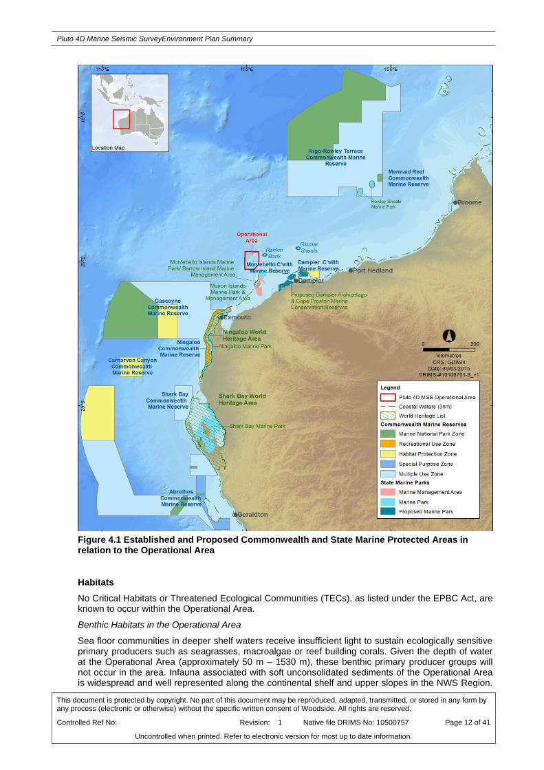
There are three key marine values within the Operational Area namely, the Montebello Commonwealth Marine Reserve (CMR) (Figure 4.1), and two Key Ecological Features (KEFs), the Ancient coastline at 125 m depth contour (see Section 4.1) and the Continental Slope Demersal Fish Communities (see Section 4.2).
4.1 Physical
The Operational Area is located in Commonwealth waters within both the North West Shelf (NWS) Province and the North West (NW) Province (herein referred to as the NWS Region), approximately 151 km north-west of Dampier and in water depths of approximately 50 to 1350 m.
The NWS Region is part of the wider North West Marine Region (NWMR), as defined under the Integrated Marine and Coastal Regionalisation of Australia (IMCRA v4.0). The NWS Province encompasses the continental shelf between North West Cape and Cape Bougainville, and varies in width from approximately 50 km at Exmouth Gulf to greater than 250 km off Cape Leveque and includes water depths of 0 to 200 m. The NW Province occurs offshore between Exmouth and Port Hedland and consists entirely of continental slope, covering an area of 178 651 km2, with water depths ranging between 1000-3000 m.
The climate in the NWMR is dry tropical, exhibiting a hot summer season from October to April and a milder winter season between May and September. Rainfall in the NWMR typically occurs during the wet season, with highest falls observed during late summer, often associated with the passage of tropical low pressure systems and cyclones. Tropical cyclones are relatively frequent for the region and can occur between November and April. There are often distinct transition periods between the summer and winter regimes, which are characterised by periods of relatively low winds.
Water circulation in the NWS Region and Operational Area is primarily influenced by the Indonesian Throughflow (ITF) and the Leeuwin Current. During the summer, when the ITF is weaker, south-west winds cause intermittent reversals in currents. These events may be associated with occasional weak, shelf upwellings. Tides in the NWS Region are semi-diurnal and have a pronounced spring-neap cycle, with tidal currents flooding towards the south-east and ebbing towards the north-west.
The bathymetry of the NWMR is characterised by four distinct zones: the inner continental shelf (0 – 30 m), the middle continental shelf (30 – 120 m), the outer shelf/continental slope (occurs at approximately 120 m) and the abyssal plain (occurs beyond the shelf break). The Operational Area is located on the continental shelf where the seabed slopes steeply in a north-west south-east direction and into the abyssal plain. An escarpment occurs along the seabed slope at a depth of approximately 125 m, which was formed as a result of Holocene sea level changes. This escarpment is known as the Ancient Coastline and is a KEF identified from the Environmental Protection and Biodiversity Conservation Act (Cth) (EPBC Act) Protected Matters Search Report as occurring within the Operational Area.
Seabed composition features of the Operational Area include limited areas of deep water hard substrate, namely rock pinnacles on the upper continental slope and exposed cliff-like features and relatively soft expanses of mudstone outcrop on the mid continental slope.
4.2 Biological
The offshore environment of the NWS Region contains environmental assets/receptors of high value or sensitivity, including habitats and species within Commonwealth offshore waters and coastal waters such as the Montebello/Barrow Island group. Furthermore, the region is noted for its resident, temporary or migratory marine fauna, including EPBC Act listed species such as marine mammals,
Pluto 4D Marine Seismic SurveyEnvironment Plan Summary
This document is protected by copyright. No part of this document may be reproduced, adapted, transmitted, or stored in any form by any process (electronic or otherwise) without the specific written consent of Woodside. All rights are reserved.
Controlled Ref No: Revision: 1 Native file DRIMS No: 10500757 Page 11 of 41
Uncontrolled when printed. Refer to electronic version for most up to date information.
turtles and birds. The marine environment of these offshore locations is pristine and many sensitive receptor locations are protected as part of Commonwealth and State managed areas.
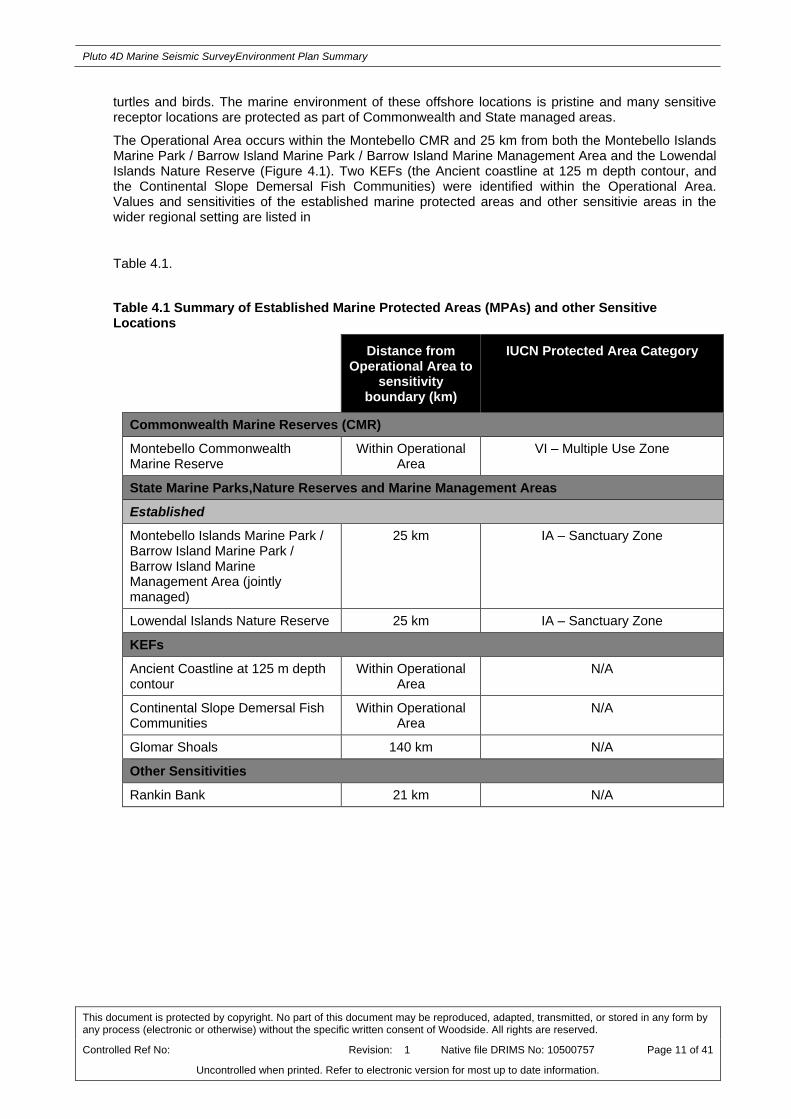
The Operational Area occurs within the Montebello CMR and 25 km from both the Montebello Islands Marine Park / Barrow Island Marine Park / Barrow Island Marine Management Area and the Lowendal Islands Nature Reserve (Figure 4.1). Two KEFs (the Ancient coastline at 125 m depth contour, and the Continental Slope Demersal Fish Communities) were identified within the Operational Area. Values and sensitivities of the established marine protected areas and other sensitivie areas in the wider regional setting are listed in
Table 4.1.
Table 4.1 Summary of Established Marine Protected Areas (MPAs) and other Sensitive Locations
Distance from Operational Area to
sensitivity boundary (km)
IUCN Protected Area Category
Commonwealth Marine Reserves (CMR)
Montebello Commonwealth Marine Reserve
Within Operational Area
VI – Multiple Use Zone
State Marine Parks,Nature Reserves and Marine Management Areas
Established
Montebello Islands Marine Park / Barrow Island Marine Park / Barrow Island Marine Management Area (jointly managed)
25 km IA – Sanctuary Zone
Lowendal Islands Nature Reserve 25 km IA – Sanctuary Zone
KEFs
Ancient Coastline at 125 m depth contour
Within Operational Area
N/A
Continental Slope Demersal Fish Communities
Within Operational Area
N/A
Glomar Shoals 140 km N/A
Other Sensitivities
Rankin Bank 21 km N/A
Pluto 4D Marine Seismic SurveyEnvironment Plan Summary
This document is protected by copyright. No part of this document may be reproduced, adapted, transmitted, or stored in any form by any process (electronic or otherwise) without the specific written consent of Woodside. All rights are reserved.
Controlled Ref No: Revision: 1 Native file DRIMS No: 10500757 Page 12 of 41
Uncontrolled when printed. Refer to electronic version for most up to date information.
Figure 4.1 Established and Proposed Commonwealth and State Marine Protected Areas in relation to the Operational Area
Habitats
No Critical Habitats or Threatened Ecological Communities (TECs), as listed under the EPBC Act, are known to occur within the Operational Area.
Benthic Habitats in the Operational Area
Sea floor communities in deeper shelf waters receive insufficient light to sustain ecologically sensitive primary producers such as seagrasses, macroalgae or reef building corals. Given the depth of water at the Operational Area (approximately 50 m – 1530 m), these benthic primary producer groups will not occur in the area. Infauna associated with soft unconsolidated sediments of the Operational Area is widespread and well represented along the continental shelf and upper slopes in the NWS Region.

Pluto 4D Marine Seismic SurveyEnvironment Plan Summary
This document is protected by copyright. No part of this document may be reproduced, adapted, transmitted, or stored in any form by any process (electronic or otherwise) without the specific written consent of Woodside. All rights are reserved.
Controlled Ref No: Revision: 1 Native file DRIMS No: 10500757 Page 13 of 41
Uncontrolled when printed. Refer to electronic version for most up to date information.
Given that habitat is known to be contiguous across the region, the benthic habitat within the Operational Areas is considered to be of relatively low environmental sensitivity.
Benthic grab sampling in the vicinity of the Pluto Platform (within the Operational Area) revealed a sparse abundance, high variabilitiy and high diversity of infauna dominated by polychaetes, nemerteans, sipunculids and crustaceans. Higher, albeit low, infauna density was reported at the shelf break (200 m) compared to deeper areas on the continental slope.
Epifaunal sled surveys carried out in the vicinity of the Pluto Platform, in water depths of up to 800 m, most commonly identified deep-water cnidarians, crustaceans (mostly decapods), bony fish and sponges. Urchins, seastars and brittlestars were also frequently recorded and it was noted that some epifaunal groups showed variation in abundance with depth.
Additional deep water benthic habitats observed within the Operational Area include rock pinnacles that provide habitat for fish, shrimp, hydroids and anemones in the vicinity of the Pluto Platform. Anemones and fish were observed in deep sloping areas (approximately 1000 m deep) among the cliff-like features where sediment had accumulated, but no epifauna was observed on exposed rock. At approximately 900 to 1000 m, mudstone outcrops were dominated by glass sponges.
Habitats in the Wider Region
The wider region, including the Montebello Islands and other sensitive areas such as Rankin Bank, comprise important benthic primary producer habitats such as coral reefs, seagrass beds and macroalgae communities, and magroves. The nearest location to the Operational Area with these benthic primary producer habitats is the Montebello/Barrow/Lowendal Islands Group (located approximately 25 km south-east). Rankin Bank (located approximately 21 km east of the Operational Area) is the nearest coral reef habitat. Coral reefs habitats have a high diversity of corals and associated species of both commercial and conservational importance, and are an integral part of the marine environment. Seagrass beds represent a key food source for many species and provide key habitats and nursery grounds, and mangrove habitats provide complex structural habitats as well as nurseries and feeding sites for many marine species.
Resident/Demersal Fish Populations
Fish communities in the NWS Region comprise small and large pelagic fish, as well as demersal species. Large pelagic fish include commercially targeted species such as skipjack tuna, blue marlin and broadbill swordfish. The Operational Area Protected Matters Search Report identified the Continental Slope Demersal Fish Communities as a KEF in the region. Diversity of demersal fish assemblages on the continental slope between North West Cape and the Montebello Trough is the highest in Australia (>500 species of which 76 are endemic). Demersal fish species occupy two distinct demersal community types (biomes) associated with the upper continental slope (water depth of 225 to 500 m) and the mid continental slope (750 to 1000 m). Higher-order consumers may include carnivorous fish, deepwater sharks, large squid and toothed whales. Key fish biodiversity in the vicinity of the Operational Area include the coral reef habitats of Rankin Bank.
Species
A total of 57 EPBC Act listed marine species were identified as potentially occurring within the Operational Area. Of those listed, 13 are considered threatened marine species and 20 migratory species under the EPBC.
Operational Area
Pygmy blue whales (Balaenoptera musculus brevicauda) are likely to occur in the Operational Area during their migration north (April – August) and south (October – January). Pygmy blue whale migration is thought to follow along the 500 m to 1000 m depth contour on the edge of the continental slope, which has been defined by the Department of Environment (DoE) as a biologically important area (BIA) within the Operational Area for this species. The Pluto 4D MSS partially overlaps the pygmy blue whale migratory corridor and there are no known critical feeding, resting, breeding areas or confined migratory routes (defined as biologically important habitats within Policy Statement 2.1) associated with the Pluto 4D MSS operational area.

Pluto 4D Marine Seismic SurveyEnvironment Plan Summary
This document is protected by copyright. No part of this document may be reproduced, adapted, transmitted, or stored in any form by any process (electronic or otherwise) without the specific written consent of Woodside. All rights are reserved.
Controlled Ref No: Revision: 1 Native file DRIMS No: 10500757 Page 14 of 41
Uncontrolled when printed. Refer to electronic version for most up to date information.
Transitory humpback whales (Megaptera novaeangliae) may traverse the Operational Area between June and October. The migration corridor for humpback whales has been defined as a BIA by the DoE, however a review of the Conservation Values Atlas confirmed that the BIA lies outside the Operational Area. The Operational Area may be visited by other cetacean species, but it is likely to be in infrequent and of a transitory nature.
There is the potential for five species of marine turtle (listed as threatened and migratory) to occur within the Operational Area. These are the loggerhead turtle (Caretta caretta), green turtle (Chelonia mydas), leatherback turtle (Dermochelys coriacea), hawksbill turtle (Eretmochelys imbricata) and the flatback turtle (Natator depressus). The Operational Area does not contain any known critical habitat for any species of marine turtle, however, a Biologically Important Area (BIA) for internesting flatback turtles overlaps with the southern boundary of the Operational Area. This BIA is considered very conservative as it is based on the maximum range of the interesting females (80 km from nesting beaches).
The protected matters search highlighted 14 species of sea snake listed under the EPBC Act may occur within the Operational Area. Although turtle and seasnake species have the potential to be found in the Operational Area, the distance offshore, depth range or offshore waters of the Operational Area and absence of potential nesting and foraging sites indicates that individual turtles and sea snakes are not expected to be encountered in the Operational Area in high densities.
Whale sharks (Rhincodon typus) are listed as Migratory and Vulnerable and are likely to traverse the vicinity of the Operational Area during their migrations to and from Ningaloo Reef (March – July). The DoE has defined a BIA for foraging whale sharks (post aggregation at Ningaloo) centred on the 200 m isobath from July to November. This area extends northward from the Ningaloo aggregation area and intersects the Operational Area. Whale shark presence within the Operational Area would likely be of a relatively short duration and not of significant numbers given the main aggregations are recorded in coastal waters, particularly the Ningaloo Reef edge.
Four other shark/ray species, including the great white shark (Carcharodon carcharias) (listed as vulnerable and migratory), shortfin mako (Isurus oxyrinchus), longfin mako (Isurus paucus) and giant manta ray (Manta birostris) (listed as migratory) may be present within the Operational Area, for short durations when individuals transit the area.
Migratory shorebirds may be present in, or fly through the Operational Area between July and December and again between March and April. A BIA defined by the DoE for the migratory wedge-tailed shearwater during it’s breeding period (August – April) overlaps with the Operational Area. The Endangered Southern Giant-Petrel (Macronectes giganteus) and Vulnerable Australian Fairy Tern (Sternula nereis) were identified as potentially occurring within the Operational Area but no critical habitat associated with these species have been identified within the Operational Area.
Wider Region
The Antarctic Minke whale (Balaenoptera bonaerensis), Bryde’s whale (Balaenoptera edeni) and Sperm whale (Physeter macrocephalus) migrate up the West Australian coast, however, their frequency within the Operational Area is likely to be a remote occurrence and limited to a few individuals transiting the area. Dugong occurrence within the Operational Area is considered unlikely due to lack of seagrass habitat.
Four of the EPBC listed turtle species (green, loggerhead, flatback and hawksbill) have significant nesting beaches along the mainland coast and islands in the region including the Montebello Islands, Barrow Island Dampier Archipelago, Muiron Islands, the North West Cape and Ningaloo Reef. With consideration of the distance offshore (approximately 50 km north-west of the Montebello Islands at its closest point), depth range of the offshore waters of the Operational Areas (approximately 180 – 830 m), and absence of potential nesting or foraging sites (i.e. no emergent islands, reef habitat or shallow shoals) the Operational Areas are not considered an important habitat for marine turtles.
Whale sharks are known to aggregate annually (from March to July) in areas off Ningaloo and North West Cape and these areas are also important for manta rays in autumn and winter.
The Montebello Islands (approximately 25 km south-west of the closest point of the Operational Areas) are important seabird and shorebird nesting and foraging habitats. The Operational Area may be occasionally visited by migratory shorebirds, but it does not contain critical habitats for any species.

Pluto 4D Marine Seismic SurveyEnvironment Plan Summary
This document is protected by copyright. No part of this document may be reproduced, adapted, transmitted, or stored in any form by any process (electronic or otherwise) without the specific written consent of Woodside. All rights are reserved.
Controlled Ref No: Revision: 1 Native file DRIMS No: 10500757 Page 15 of 41
Uncontrolled when printed. Refer to electronic version for most up to date information.
4.3 Socio-Economic and Cultural
There are no known sites of Indigenous or European cultural or heritage significance, or historic shipwrecks, within the vicinity of the Operational Area.
A number of Commonwealth and State fisheries are located within, adjacent to, or in the region of the Operational Area. None of these fisheries have significant catches within or adjacent to the Operational Area except the North West Slope Trawl Fishery. However, the Operational Area is located in a ‘closed to fishing’ area of the fishery.
Commonwealth fisheries operating within or adjacent to the Operational Area include the North West Slope Trawl Fishery, Western Tuna and Billfish Fishery, Southern Bluefin Tuna Fishery and the Western Skipjack Tuna Fishery. The majority of fishing effort for these fisheries occurs outside of the Operational Area.
State fisheries operating within of adjacent to the Operational Area include the West Australian Mackerel Fishery, North Coast Demersal Scalefish Fisheries (comprised of the Pilbara Trawl, Trap and Line Fisheries), and the Onslow Prawn Managed Fishery. The Pearl Oyster Managed Fishery, the Marine Aquarium and Specimen Shell Collection Fisheries and the Beche de Mer (sea cucumber) Fishery operate in the region. There are no aquaculture activities within or adjacent to the Operational Area.
There are no designated traditional, or customary, fisheries recorded within or adjacent to the Operational Area as these are typically restricted to shallow coastal waters and/or areas with structure such as reef.
No known tourism activities take place specifically within or adjacent to the Operational Area, however, the wider regional context includes recreational beaches and tourist spots. The Montebello Islands are the closest location for tourism to the Operational Area with some charter boat operators taking visitors to these remote islands. Many areas along the coast are popular and support recreational activities such as boating, diving, sightseeing, swimming, fishing and wildlife viewing. Occasional recreational fishing occurs at Rankin Bank and Glomar Shoals (located approximately 21 km and 140 km from the Operational Area respectively).
The region supports significant commercial shipping activity, the majority of which is associated with the mining, oil and gas industry. Major shipping routes in the area are associated with entry to the ports of Dampier and Barrow Island.
The Operational Area is located within an area of oil and gas operations, with the Woodside operated Pluto Platform and the Amarda Claire FPSO (Balnaves) located within the Operational Area. As such, there is subsea infrastructure in the area, including subsea wellheads, subsea umbilicals and flowlines.
In order to inform the consideration of the potential cumulative impacts from concurrent seismic activities, Woodside engaged with multiple proponents to identify potential marine seismic surveys planned to be acquired concurrent with the Pluto 4D MSS. Two potential concurrent seismic surveys were identified within 50km from the Pluto 4D MSS Operational Area:
the Gorgon Ocean Bottom Node Seismic Survey planned to commence in November 2015
the Monuments MC3D – Other Potential Additional Project Areas (OPAPA), however it is not confirmed to proceed at this stage
There are designated defence practice areas in the offshore marine waters off Ningaloo and the North West Cape. The Operational Area overlaps with the northern tip of one of the defence practice areas. Consultation with Defence confirmed that there was no objection to the proposed seismic survey activities.

Pluto 4D Marine Seismic SurveyEnvironment Plan Summary
This document is protected by copyright. No part of this document may be reproduced, adapted, transmitted, or stored in any form by any process (electronic or otherwise) without the specific written consent of Woodside. All rights are reserved.
Controlled Ref No: Revision: 1 Native file DRIMS No: 10500757 Page 16 of 41
Uncontrolled when printed. Refer to electronic version for most up to date information.
5. ENVIRONMENTAL IMPACTS AND RISKS
5.1 Risk Identification and Evaluation
Woodside undertook an environmental risk assessment to identify the potential environmental impacts and risks associated with the proposed Program and identification of the control measures to manage the identified environmental impacts and risks to as low as reasonably practicable (ALARP) and an acceptable level. This risk assessment and evaluation was undertaken using Woodside’s Risk Management Framework.
The key steps of Woodside’s Risk Management Framework are shown in Figure 5-1. A summary of each step and how it is applied to the proposed Program is provided below.
Establish the Context• Internal and external context
• Risk management context
• Define risk criteria
• Determine risk assessment method
Establish the Context• Internal and external context
• Risk management context
• Define risk criteria
• Determine risk assessment method
Risk Identification• What can happen, When and where, How and why
Risk Identification• What can happen, When and where, How and why
Risk Analysis• Identify existing controls
• Analyse risk level
Risk Analysis• Identify existing controls
• Analyse risk level
Risk Evaluation• Compare against risk criteria
• Accept or treat risk
Risk Evaluation• Compare against risk criteria
• Accept or treat risk
Mo
nit
or
an
d R
evie
wM
on
ito
r an
d R
evie
w
Co
mm
un
icate
an
d R
ep
ort
Co
mm
un
icate
an
d R
ep
ort
Risk Control Improvement• Prepare and implement control improvement plan
Risk Control Improvement• Prepare and implement control improvement plan
Treat
risks?
Risk Assessment
Establish the Context• Internal and external context
• Risk management context
• Define risk criteria
• Determine risk assessment method
Establish the Context• Internal and external context
• Risk management context
• Define risk criteria
• Determine risk assessment method
Risk Identification• What can happen, When and where, How and why
Risk Identification• What can happen, When and where, How and why
Risk Analysis• Identify existing controls
• Analyse risk level
Risk Analysis• Identify existing controls
• Analyse risk level
Risk Evaluation• Compare against risk criteria
• Accept or treat risk
Risk Evaluation• Compare against risk criteria
• Accept or treat risk
Mo
nit
or
an
d R
evie
wM
on
ito
r an
d R
evie
w
Co
mm
un
icate
an
d R
ep
ort
Co
mm
un
icate
an
d R
ep
ort
Risk Control Improvement• Prepare and implement control improvement plan
Risk Control Improvement• Prepare and implement control improvement plan
Treat
risks?
Risk Assessment
Figure 5.1: Key steps in Woodside’s Risk Management Framework
1. Establish the Context
The objective of a risk assessment is to assess identified risks and apply appropriate control measures to eliminate, control or mitigate the risk to ALARP and to determine if the risk is acceptable.
Hazard identification workshops aligned with NOPSEMA’s Hazard Identification Guidance Note (N-04300-GN0107) were undertaken by multidisciplinary teams made up of relevant personnel with sufficient breadth of knowledge, training and experience to reasonably assure that risks and associated impacts were identified and assessed.
2. Risk Identification
The risk assessment workshop for the proposed Program was used to identify risks with the potential to harm the environment. Risks were identified for both planned (routine and non-routine) and unplanned (accidents/incidents) activities.
3. Risk Analysis (Decision Support Framework)
Risk analysis further develops the understanding of a risk by defining the impacts and assessing the appropriate controls. Risk analysis for the proposed Program considered previous risk assessments for the facility, review of relevant studies, review of past performance, external stakeholder consultation feedback and review of the existing environment.

Pluto 4D Marine Seismic SurveyEnvironment Plan Summary
This document is protected by copyright. No part of this document may be reproduced, adapted, transmitted, or stored in any form by any process (electronic or otherwise) without the specific written consent of Woodside. All rights are reserved.
Controlled Ref No: Revision: 1 Native file DRIMS No: 10500757 Page 17 of 41
Uncontrolled when printed. Refer to electronic version for most up to date information.
To support the risk assessment process, Woodside applied the UKOOA (1999) Industry Guidelines on a Framework for Risk Related Decision Support (HS006) during the workshops to determine the level of supporting evidence that may be required to draw sound conclusions regarding risk level and whether the risk is acceptable and ALARP.
This is to ensure:
Activities do not pose an unacceptable environmental risk;
Appropriate focus is placed on activities where the risk is anticipated to be tolerable and demonstrated to be ALARP; and
Appropriate effort is applied to the management of risks based on the uncertainty of the risk, the complexity and risk rating.
Identification of Control Measures
Woodside applies a hierarchy of control measures when considering Good Practice and Professional Judgement. The hierarchy of control is applied in order of importance as follows; elimination, substitution, engineering control measures, administrative control measures and mitigation of consequences/impacts.
Risk Rating Process
The risk rating process is undertaken to assign a level of risk to each impact measured in terms of consequence and likelihood. The assigned risk level is the residual risk (i.e. risk with controls in place) and is therefore undertaken following the identification of the decision type and appropriate control measures.
The Consequence Level is selected by determining the worst case credible outcomes associated with the selected event assuming some controls (prevention and mitigation) have failed. Where more than one impact applies (e.g. environmental and legal/compliance), the consequence level for the highest severity impact is selected. The Likelihood Level is selected by determining the description that best fits the chance of the selected consequence actually occurring, assuming reasonable effectiveness of the prevention and mitigation controls.
The ENVID for the Petroleum Activities Program identified 15 sources of environmental risk. These risks are divided into two broad categories: planned (routine and non-routine); and unplanned (accidents/incidents) activities. The 15 sources of environmental risk comprised seven planned and eight unplanned sources of risk.
Generally, the sources of risk from planned activities present a lower environmental consequence compared to the potential impact from unplanned accident or incident events. The EP contains a variety of mitigation and control measures which ensure potential impacts and risks will be reduced to ALARP and will be of an acceptable level. A summary of the key environmental risks and control measures have been presented in Appendix A.
4. Risk Evaluation
Environmental risks, as opposed to safety risks, cover a wider range of issues, differing species, persistence, reversibility, resilience, cumulative effects and variability in severity. The degree of environmental risk and the corresponding threshold for whether a risk/impact has been reduced to ALARP and is acceptable has been adapted to include principles of ecological sustainability (given as an objective in the Environment Regulations and defined in the EPBC Act), the Precautionary Principle and the corresponding environmental risk threshold decision-making principles are used to determine acceptability.
Demonstration of ALARP
In accordance with Regulation 10A(b) of the Environment Regulations, Woodside demonstrates risks are reduced to ALARP where:
The residual risk is low:
Good industry practice or comparable standards have been applied to control the risk, because any further effort towards risk reduction is not reasonably practicable without sacrifices grossly disproportionate to the benefit gained.

Pluto 4D Marine Seismic SurveyEnvironment Plan Summary
This document is protected by copyright. No part of this document may be reproduced, adapted, transmitted, or stored in any form by any process (electronic or otherwise) without the specific written consent of Woodside. All rights are reserved.
Controlled Ref No: Revision: 1 Native file DRIMS No: 10500757 Page 18 of 41
Uncontrolled when printed. Refer to electronic version for most up to date information.
The residual risk is medium or high:
Good industry practice is applied for the situation/risk
Alternatives have been identified and the control measures selected reduce the risks and impacts to ALARP. This may require assessment of Woodside and industry benchmarking, review of local and international codes and standards, consultation with stakeholders etc.
Demonstration of Acceptability
In accordance with Regulation 10A(c) of the Environmental Regulations, Woodside applies the following process to demonstrate acceptability:
Low residual risks are 'Broadly Acceptable', if they meet legislative requirements, industry codes and standards, regulator expectations, Woodside Standards and industry guidelines.
Medium and High residual risks are ‘Acceptable’ if ALARP can be demonstrated using good industry practice and risk based analysis, if legislative requirements are met and societal concerns are accounted for and the alternative control measures are grossly disproportionate to the benefit gained.
In undertaking this process for medium and high residual risks, Woodside evaluates the following criteria:
- Principles of Ecological Sustainable Development (ESD) as defined under the EPBC Act
- Internal context - the proposed controls and residual risk level are consistent with Woodside policies, procedures and standards
- External context – consideration of the environment consequence and stakeholder expectations
- Other requirements – the proposed controls and residual risk level are consistent with national and international standards, laws and policies.
Severe residual risks are ‘Intolerable’ and therefore unacceptable. These risks require further investigation and mitigation to reduce the risk to a lower and more acceptable level. If after further investigation the risk remains in the severe category, the risk requires appropriate business sign-off to accept the risk.
5.2 Planned (Routine and Non-routine) Activities
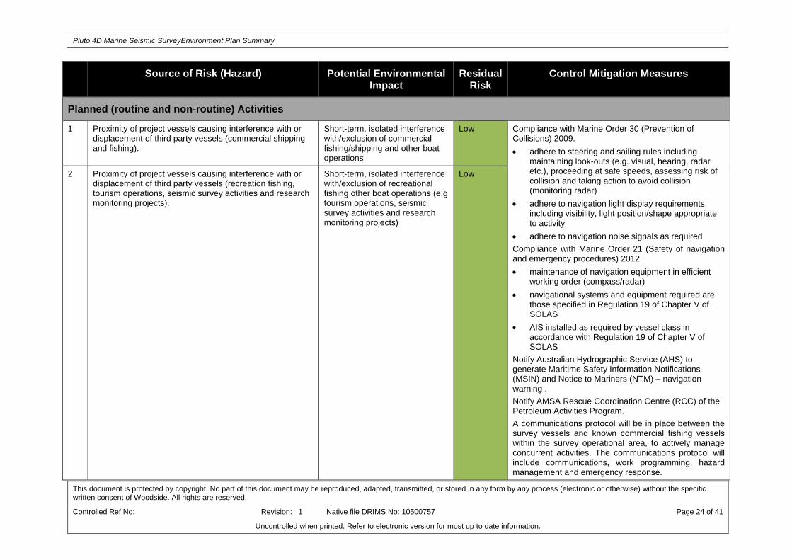
The majority of the sources of environmental risk identified for the proposed Petroleum Activities Program relate to those activities which are planned and either undertaken on a routine or non-routine basis. These sources of risk include:
Proximity of project vessels causing interference with or displacement of third party vessels (commercial shipping and fishing)
Proximity of project vessels causing interference with or displacement of third party vessels (recreation fishing, tourism operations, seismic survey activities and research monitoring projects)
Interference with existing oil and gas operations
Generation of noise from project vessels and mechanical equipment during normal operations (excluding seismic survey equipment)
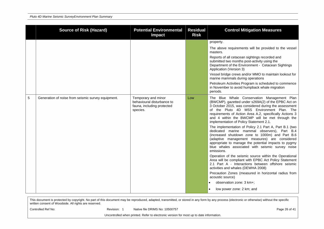
Generation of noise from seismic survey equipment
Internal combustion engines on survey vessel, supply vessel(s) and machinery engines
Discharge of bilge water, grey water, sewage and putrescibles wastes from the survey and support vessels to the marine environment.
5.3 Unplanned (Accidents/Incidents) Activities
During the risk assessment process a number of potential environmental impacts which may occur from unplanned activities were also identified. These sources of risk range from small scale chemical

Pluto 4D Marine Seismic SurveyEnvironment Plan Summary
This document is protected by copyright. No part of this document may be reproduced, adapted, transmitted, or stored in any form by any process (electronic or otherwise) without the specific written consent of Woodside. All rights are reserved.
Controlled Ref No: Revision: 1 Native file DRIMS No: 10500757 Page 19 of 41
Uncontrolled when printed. Refer to electronic version for most up to date information.
spills with a low environmental consequence to large scale hydrocarbon spill events with high environmental consequence. These sources of risk include:
Hydrocarbon release to the marine environment due to a vessel collision (due to collision between survey vessels or a third party)
Hydrocarbon release to the marine environment during bunkering activities
Accidental discharge of other hydrocarbons/chemicals from survey or support vessel deck activities and equipment (e.g. cranes and winches)
Accidental loss of solid hazardous or non-hazardous wastes to the marine environment
Accidental collision between project vessels and threatened and migratory marine fauna
Physical loss of seismic streamers and/or acoustic source
Introduction of invasive marine species associated with ballast water transfer
Transportation of invasive marine species via vessel hull, internal niches or in-water equipment.
6. ONGOING MONITORING OF ENVIRONMENTAL PERFORMANCE
The Petroleum Activities Program will be managed in compliance with the Pluto 4D MSS Environment Plan accepted by NOPSEMA under the Environment Regulations, other relevant environmental legislation and Woodside’s Management System (e.g. Woodside Environment Policy).
The objective of the EP is to identify, mitigate and manage potentially adverse environmental impacts associated with the Petroleum Activities Program, during both planned and unplanned operations, to ALARP and an acceptable level.
For each environmental aspect (risk), and associated environmental impacts (identified and assessed in the Environmental Risk Assessment of the EP) a specific environmental performance outcome, environmental performance standards and measurement criteria have been developed. The performance standards are control measures (available in Appendix A) that will be implemented (consistent with the performance standards) to achieve the environmental performance outcomes. The specific measurement criteria provide the evidence base to demonstrate that the performance standards (control measures) and outcomes are achieved.
The implementation strategy detailed in the Pluto 4D MSS Environment Plan identifies the roles/responsibilities and training/competency requirements for all personnel (Woodside and its contractors) in relation to implementing controls, managing non-conformance, emergency response and meeting monitoring, auditing, and reporting requirements during the activity.
Woodside and its Contractors undertake a program of periodic monitoring during the proposed Petroleum Activities Program, starting at mobilisation of each activity and continuing through the duration of each activity until activity completion. This information is collected using appropriate tools and systems, developed based on the environmental performance outcomes, performance standards and measurement criteria in the EP. The tools and systems collect, as a minimum, the data (evidence) referred to in the measurement criteria. The collection of this data (and assessment against the measurement criteria) forms part of the permanent record of compliance maintained by Woodside and the basis for demonstrating that the environmental performance outcomes and standards are met, which is then summarised in a series of routine reporting documents.
Monitoring of environmental performance is undertaken as part of the following:
Environmental Performance Report will be submitted to NOPSEMA within 3 months of the activity completion to assess and confirm compliance with the accepted environmental performance objectives, standards and measurement criteria outlined in the EP
Activity based inspections undertaken by Woodside’s environment function to review compliance against the Pluto 4D MSS Environment Plan, verify effectiveness of the EP implementation strategy and to review environmental performance
Environmental performance is also monitored daily via daily progress reports during the proposed Program; and

Pluto 4D Marine Seismic SurveyEnvironment Plan Summary
This document is protected by copyright. No part of this document may be reproduced, adapted, transmitted, or stored in any form by any process (electronic or otherwise) without the specific written consent of Woodside. All rights are reserved.
Controlled Ref No: Revision: 1 Native file DRIMS No: 10500757 Page 20 of 41
Uncontrolled when printed. Refer to electronic version for most up to date information.
Senior management regularly monitors and reviews environmental performance via a monthly report which detail environmental performance and compliance with Woodside standards.
Woodside employees and Contractors are required to report all environmental incidents and non-conformance with environmental performance outcomes and standards in the EP. Incidents will be reported using an Incident and Hazard Report Form, which includes details of the event, immediate action taken to control the situation, and corrective actions to prevent reoccurrence. An internal computerised database is used for the recording and reporting of these incidents. Incident corrective actions are monitored to ensure they are closed out in a timely manner.
The EP is supported by an assessment of the environmental impacts and risks associated with potential oil spill scenarios and oil spill preparedness and response measures in relation to the risk assessment and the identified oil spill scenarios. A summary of Woodside’s response arrangements in the oil pollution emergency plan is provided in Appendix B.
6.1 Environment Plan Revisions
Revision of the Pluto 4D MSS EP will be undertaken in accordance with the requirements outlined in Regulations 17, Regulation 18 and Regulation 19 of the Environment Regulations. Woodside will submit a proposed revision of the Pluto 4D MSS EP to NOPSEMA including as a result of the following:
When any significant modification or new stage of the activity that is not provided for in the EP is proposed
Before, or as soon as practicable after, the occurrence of any significant new or significant increase in environmental risk or impact not provided for in the EP
At least 14 days before the end of each period of five years commencing on the day in which the original and subsequent revisions of the EP is accepted under Regulation 11 of the Environment Regulations; and
As requested by NOPSEMA.
7. CONSULTATION
7.1 Engagement Activities
Woodside conducted a stakeholder assessment based on the proposed activity location, timing and potential impacts, and engaged with relevant stakeholders to inform decision-making and planning for the Petroleum Activities Program.
For the purposes of this Plan and consistent with Section 11A of the Environment Regulations, Woodside considers relevant stakeholders for routine operations as those that undertake normal business or lifestyle activities in the vicinity of the existing facility (or their nominated representative) or have a State or Commonwealth regulatory role.
Woodside also made available advice about the Petroleum Activities Program to other stakeholders who have previously expressed an interest in being kept informed about Woodside’s activities in the region.
Woodside provided information about the Petroleum Activities Program to the following stakeholders:
Stakeholder
Department of Industry
Department of Mines and Petroleum
Australian Maritime Safety Authority (maritime safety)
Australian Hydrographic Service
Department of Fisheries (Western Australia)
Commonwealth fisheries

Pluto 4D Marine Seismic SurveyEnvironment Plan Summary
This document is protected by copyright. No part of this document may be reproduced, adapted, transmitted, or stored in any form by any process (electronic or otherwise) without the specific written consent of Woodside. All rights are reserved.
Controlled Ref No: Revision: 1 Native file DRIMS No: 10500757 Page 21 of 41
Uncontrolled when printed. Refer to electronic version for most up to date information.
Western Tuna and Billfish Fishery
North West Slope Trawl Fishery
Western Skipjack Fishery
Southern Bluefin Tuna
Western Australian Fisheries
Mackerel Fishery
Onslow Prawn Fishery
Northern Demersal (including Pilbara Trap and Trawl, and Pilbara Line)
Department of Defence – Defence Property Services Group
Australian Maritime Safety Authority (marine pollution)
Department of Transport (marine pollution)
Department of Parks and Wildlife
Australian Customs Service – Border Protection Command
Department of Broadband, Communication and the Digital Economy
Commonwealth Fisheries Association
Western Australian Fishing Industry Council
Pearl Producers Association
Recfishwest
WWF
Australian Conservation Foundation
Wilderness Society
International Fund for Animal Welfare
APPEA
AMOSC
Woodside received feedback on the proposed Petroleum Activities Program from a range of stakeholders, including government agencies and commercial fishing organisations. Issues of interest or concern included the location of the proposed activities across commercial fishing areas. A summary of feedback and Woodside‘s response is presented in Appendix C.
7.2 Ongoing consultation
A consultation fact sheet was sent electronically to all stakeholders identified through the stakeholder assessment process prior to lodgement of the EP with NOPSEMA for assessment and acceptance. This advice was supported by engagement with potentially affected stakeholders Consultation activities for the proposed Program build upon Woodside’s extensive and ongoing stakeholder consultation for offshore petroleum activities in this area.
Woodside considered this feedback in its development of control measures specific to the proposed Petroleum Activities Program.
Feedback received through community engagement and consultation will be captured in Woodside’s stakeholder database and actioned where appropriate through the proposed Petroleum Activities Program Project Manager. Implementation of ongoing engagement and consultation activities for the proposed Petroleum Activities Program will be undertaken by Woodside Corporate Affairs consistent with Woodside’s External Stakeholder Engagement Operating Standard.

Pluto 4D Marine Seismic SurveyEnvironment Plan Summary
This document is protected by copyright. No part of this document may be reproduced, adapted, transmitted, or stored in any form by any process (electronic or otherwise) without the specific written consent of Woodside. All rights are reserved.
Controlled Ref No: Revision: 1 Native file DRIMS No: 10500757 Page 22 of 41
Uncontrolled when printed. Refer to electronic version for most up to date information.
8. TITLEHOLDER NOMINATED LIAISON PERSON
For further information about this activity, please contact:
Kate McCallum
Woodside Energy Ltd
Woodside Plaza, 240 St Georges Terrace, Perth WA 6000
T: +61 8 9348 4000
Toll free: 1800 442 977

Pluto 4D Marine Seismic SurveyEnvironment Plan Summary
This document is protected by copyright. No part of this document may be reproduced, adapted, transmitted, or stored in any form by any process (electronic or otherwise) without the specific written consent of Woodside. All rights are reserved.
Controlled Ref No: Revision: 1 Native file DRIMS No: 10500757 Page 23 of 41
Uncontrolled when printed. Refer to electronic version for most up to date information.
APPENDIX A: ENVIRONMENTAL IMPACTS AND RISKS
Pluto 4D Marine Seismic SurveyEnvironment Plan Summary
This document is protected by copyright. No part of this document may be reproduced, adapted, transmitted, or stored in any form by any process (electronic or otherwise) without the specific written consent of Woodside. All rights are reserved.
Controlled Ref No: Revision: 1 Native file DRIMS No: 10500757 Page 24 of 41
Uncontrolled when printed. Refer to electronic version for most up to date information.
Source of Risk (Hazard) Potential Environmental Impact
Residual Risk
Control Mitigation Measures
Planned (routine and non-routine) Activities
1 Proximity of project vessels causing interference with or displacement of third party vessels (commercial shipping and fishing).
Short-term, isolated interference with/exclusion of commercial fishing/shipping and other boat operations
Low Compliance with Marine Order 30 (Prevention of Collisions) 2009.
adhere to steering and sailing rules including maintaining look-outs (e.g. visual, hearing, radar etc.), proceeding at safe speeds, assessing risk of collision and taking action to avoid collision (monitoring radar)
adhere to navigation light display requirements, including visibility, light position/shape appropriate to activity
adhere to navigation noise signals as required
Compliance with Marine Order 21 (Safety of navigation and emergency procedures) 2012:
maintenance of navigation equipment in efficient working order (compass/radar)
navigational systems and equipment required are those specified in Regulation 19 of Chapter V of SOLAS
AIS installed as required by vessel class in accordance with Regulation 19 of Chapter V of SOLAS
Notify Australian Hydrographic Service (AHS) to generate Maritime Safety Information Notifications (MSIN) and Notice to Mariners (NTM) – navigation warning .
Notify AMSA Rescue Coordination Centre (RCC) of the Petroleum Activities Program.
A communications protocol will be in place between the survey vessels and known commercial fishing vessels within the survey operational area, to actively manage concurrent activities. The communications protocol will include communications, work programming, hazard management and emergency response.
2 Proximity of project vessels causing interference with or displacement of third party vessels (recreation fishing, tourism operations, seismic survey activities and research monitoring projects).
Short-term, isolated interference with/exclusion of recreational fishing other boat operations (e.g tourism operations, seismic survey activities and research monitoring projects)
Low

Pluto 4D Marine Seismic SurveyEnvironment Plan Summary
This document is protected by copyright. No part of this document may be reproduced, adapted, transmitted, or stored in any form by any process (electronic or otherwise) without the specific written consent of Woodside. All rights are reserved.
Controlled Ref No: Revision: 1 Native file DRIMS No: 10500757 Page 25 of 41
Uncontrolled when printed. Refer to electronic version for most up to date information.
Source of Risk (Hazard) Potential Environmental Impact
Residual Risk
Control Mitigation Measures
At least one dedicated chase vessel will be employed to assist seismic and support vessels to mitigate interference associated with concurrent seismic and third party vessel operations.
Woodside will engage with proponents identified as having potential concurrent MSS prior to commencing the Petroleum Activities Program. A concurrent operations plan including communications, work programming, hazard management and emergency response will be developed for any concurrent surveys identified within 50 km of the Pluto 4D MSS.
3 Interference with existing oil and gas operations
Potential isolated and short-term interference to operating facility activities.
Low Comply with Marine Orders 30 & 21 (as described in row 1 & 2)
Breaches of existing oil and gas infrastructure exclusion zones will be recorded.
When operating within 500 m of existing oil and gas facility, project vessels will operate in accordance with the Pluto 4D MSS Communications Protocol between the survey vessel and existing operational oil and gas facilities.
The seismic sail-lines planned to meet the technical objectives of the survey as well as providing for safe operations.
Streamers to be equipped with real time monitoring equipment to ensure that streamer location in relation to the seabed is known at all times.
4 Generation of noise from project vessels and mechanical equipment during normal operations (excluding seismic survey equipment).
Temporary and minor behavioural disturbance (e.g. avoidance or attraction) to fauna, including protected species.
Low Woodside will comply with EPBC Regulations 2000 – Part 8 Division 8.1 Interacting with cetaceans: Support vessels will not travel greater than 6 knots within 300 m of a whale (caution zone) and not approach closer than 100 m from a whale; and a vessel will not approach closer than 50 m for a dolphin and/or 100 m for a whale (with the exception of animals bow riding).
The above requirements do not apply in emergency circumstances or when compliance with the requirement would increase the risk of harm to the environment of
Pluto 4D Marine Seismic SurveyEnvironment Plan Summary
This document is protected by copyright. No part of this document may be reproduced, adapted, transmitted, or stored in any form by any process (electronic or otherwise) without the specific written consent of Woodside. All rights are reserved.
Controlled Ref No: Revision: 1 Native file DRIMS No: 10500757 Page 26 of 41
Uncontrolled when printed. Refer to electronic version for most up to date information.
Source of Risk (Hazard) Potential Environmental Impact
Residual Risk
Control Mitigation Measures
property.
The above requirements will be provided to the vessel masters.
Reports of all cetacean sightings recorded and submitted two months post-activity using the Department of the Environment - Cetacean Sightings Application (Version 3)
Vessel bridge crews and/or MMO to maintain lookout for marine mammals during operations
Petroleum Activities Program is scheduled to commence in November to avoid humpback whale migration periods.
5 Generation of noise from seismic survey equipment. Temporary and minor behavioural disturbance to fauna, including protected species.
Low The Blue Whale Conservation Management Plan (BWCMP), gazetted under s269A(2) of the EPBC Act on 3 October 2015, was considered during the assessment of the Pluto 4D MSS Environment Plan. The requirements of Action Area A.2, specifically Actions 3 and 4 within the BWCMP will be met through the implementation of Policy Statement 2.1.
The implementation of Policy 2.1 Part A, Part B.1 (two dedicated marine mammal observers), Part B.4 (increased shutdown zone to 1000m) and Part B.6 (adaptive management measures) are considered appropriate to manage the potential impacts to pygmy blue whales associated with seismic survey noise emissions.
Operation of the seismic source within the Operational Area will be compliant with EPBC Act Policy Statement 2.1 Part A - Interactions between offshore seismic activities and whales (DEWHA 2008)
Precaution Zones (measured in horizontal radius from acoustic source)
observation zone: 3 km+;
low power zone: 2 km; and

Pluto 4D Marine Seismic SurveyEnvironment Plan Summary
This document is protected by copyright. No part of this document may be reproduced, adapted, transmitted, or stored in any form by any process (electronic or otherwise) without the specific written consent of Woodside. All rights are reserved.
Controlled Ref No: Revision: 1 Native file DRIMS No: 10500757 Page 27 of 41
Uncontrolled when printed. Refer to electronic version for most up to date information.
Source of Risk (Hazard) Potential Environmental Impact
Residual Risk
Control Mitigation Measures
shut-down zone: 1 km
Operation of the seismic source within the Operational Area will be compliant with EPBC Act Policy Statement 2.1 (Part B.6) - Interactions between offshore seismic activities and whales (DEWHA 2008) – Blue Whale adaptive management measure.
If the survey is required to shutdown/power-down three or more times per day for three consecutive days as a result of sighting blue whales*, then the seismic operations must not be undertaken thereafter at night-time or during low visibility conditions. Seismic operations cannot resume at night-time or during low visibility conditions, until there has been a 24-hour period, which included seismic operations during good visibility conditions, during which no shutdowns/power-downs have occurred for blue whale* sightings.
*Note: The definition of “Blue Whale” includes any whales sighted whose species are unable to be determined.
To minimise the potential impacts from underwater noise to whale sharks and marine turtles, procedures to manage the operation of the seismic source in relation to whale sharks and marine turtles will be implemented as outlined below:
observation and shutdown zone (500 m).
pre start-up and soft start visual observations
start-up delay procedure
operations and stop work delay procedures
observation and compliance reporting.
Reports of all cetacean sightings recorded and submitted two months post-activity using the Department of the Environment - Cetacean Sightings

Pluto 4D Marine Seismic SurveyEnvironment Plan Summary
This document is protected by copyright. No part of this document may be reproduced, adapted, transmitted, or stored in any form by any process (electronic or otherwise) without the specific written consent of Woodside. All rights are reserved.
Controlled Ref No: Revision: 1 Native file DRIMS No: 10500757 Page 28 of 41
Uncontrolled when printed. Refer to electronic version for most up to date information.
Source of Risk (Hazard) Potential Environmental Impact
Residual Risk
Control Mitigation Measures
Application (Version 3).
No discharge of the seismic source outside of the operational area.
Woodside will re-engage with proponents identified as having potential concurrent MSS activities as described in row 1.
Survey planned to avoid southern and northern humpback whale migration.
Two trained MFOs will be employed to undertake observations for EPBC Act Policy Statement 2.1 applicable species (including whale sharks and marine turtles) during daylight hours.
The seismic source will only be discharged outside the acquisition (survey) area for the purpose of run-outs, source testing and soft starts.
6 Internal combustion engines on survey vessel, supply vessel(s) and machinery engines.
Reduced local air quality from atmospheric emissions.
Low Compliance with Marine Order 97 (Marine pollution prevention – air pollution) vessels have a valid IAPP Certificate, where required by class, and use of low sulphur fuel when available.
7 Discharge of bilge water, grey water, sewage and putrescibles wastes from the survey and support vessels to the marine environment.
Localised and temporary eutrophication of the water column and localised and temporary adverse effect to marine biota in offshore waters.
Low Compliance with Marine Order 96 (Pollution prevention – sewage), as required by vessel class.
Compliance with Marine Order 95 (pollution prevention – garbage), as required by vessel class.
Bilge water contaminated with hydrocarbons must be contained and disposed of onshore, except if the oil content of the effluent without dilution does not exceed 15 ppm or an IMO approved oil/water separator (as required by vessel class) is used to treat the bilge water.
Unplanned (accidents or incidents) Activities
8 Hydrocarbon release to the marine environment due to a vessel collision (due to collision between survey vessels or
Minor and temporary disruption to protected species such as
Low Comply with Marine Orders 30 & 21 (as described in row 1 & 2)
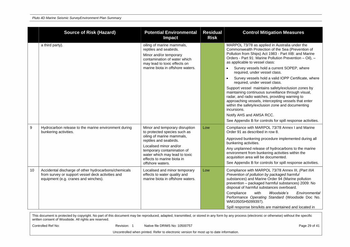
Pluto 4D Marine Seismic SurveyEnvironment Plan Summary
This document is protected by copyright. No part of this document may be reproduced, adapted, transmitted, or stored in any form by any process (electronic or otherwise) without the specific written consent of Woodside. All rights are reserved.
Controlled Ref No: Revision: 1 Native file DRIMS No: 10500757 Page 29 of 41
Uncontrolled when printed. Refer to electronic version for most up to date information.
Source of Risk (Hazard) Potential Environmental Impact
Residual Risk
Control Mitigation Measures
a third party). oiling of marine mammals, reptiles and seabirds.
Minor and/or temporary contamination of water which may lead to toxic effects on marine biota in offshore waters.
MARPOL 73/78 as applied in Australia under the Commonwealth Protection of the Sea (Prevention of Pollution from Ships) Act 1983 - Part IIIB: and Marine Orders - Part 91: Marine Pollution Prevention – Oil), – as applicable to vessel class:
Survey vessels hold a current SOPEP, where required, under vessel class.
Survey vessels hold a valid IOPP Certificate, where required, under vessel class.
Support vessel maintains safety/exclusion zones by maintaining continuous surveillance through visual, radar, and radio watches, providing warning to approaching vessels, intercepting vessels that enter within the safety/exclusion zone and documenting incursions.
Notify AHS and AMSA RCC.
See Appendix B for controls for spill response activities.
9 Hydrocarbon release to the marine environment during bunkering activities.
Minor and temporary disruption to protected species such as oiling of marine mammals, reptiles and seabirds.
Localised minor and/or temporary contamination of water which may lead to toxic effects to marine biota in offshore waters.
Low Compliance with MARPOL 73/78 Annex I and Marine Order 91 as described in row 8.
Approved bunkering procedure implemented during all bunkering activities.
Any unplanned release of hydrocarbons to the marine environment from bunkering activities within the acquisition area will be documented.
See Appendix B for controls for spill response activities.
10 Accidental discharge of other hydrocarbons/chemicals from survey or support vessel deck activities and equipment (e.g. cranes and winches).
Localised and minor temporary effects to water quality and marine biota in offshore waters.
Low Compliance with MARPOL 73/78 Annex III, (Part IIIA Prevention of pollution by packaged harmful substances) and Marine Order 94 (Marine pollution prevention – packaged harmful substances) 2009: No disposal of harmful substances overboard.
Compliance with Woodside’s Environmental Performance Operating Standard (Woodside Doc No. WM1050SH5099397).
Spill response bins/kits are maintained and located in

Pluto 4D Marine Seismic SurveyEnvironment Plan Summary
This document is protected by copyright. No part of this document may be reproduced, adapted, transmitted, or stored in any form by any process (electronic or otherwise) without the specific written consent of Woodside. All rights are reserved.
Controlled Ref No: Revision: 1 Native file DRIMS No: 10500757 Page 30 of 41
Uncontrolled when printed. Refer to electronic version for most up to date information.
Source of Risk (Hazard) Potential Environmental Impact
Residual Risk
Control Mitigation Measures
close proximity to hydrocarbon storage areas and vessel deck equipment / bunkering areas for use to contain and recover deck spills.
11 Accidental loss of solid hazardous or non-hazardous wastes to the marine environment
Pollution and contamination of the environment and secondary impacts on marine fauna (e.g. ingestion or entanglement).
Low Compliance with Marine Order 94 & 95 as described in row 10.
Compliance with MARPOL73/78 Annex V.
The Contractor Waste Management Plan is consistent with the Woodside Waste Management Plan and implemented on vessel.
Equipment and materials dropped to the marine environment are recovered where safe and practicable to do so.
Current Safety Data Sheets (SDS) for all hazardous materials readily available onboard vessels.
Implementation of SOPEP in the event of an unplanned discharge of hazardous or non hazardous solid waste.
12 Accidental collision between project vessels and threatened and migratory marine fauna.
Potential injury or fatality of an individual or a number of marine fauna with no threat to overall population viability
Low EPBC Regulations 2000 – Part 8 Division 8.1.
Streamer tail buoys are purpose built to mitigate entrapment of marine turtles
Two dedicated Marine Fauna Observers onboard the seismic vessel.
13 Physical loss of seismic streamers and/or acoustic source. Localised short-term damage of benthic subsea habitats in the immediate location of the dropped seismic streamers and/or acoustic source.
Low Comply with Marine Order 21 (as described in row 1 & 2)
Deployment, retrieval, and operation of streamers will be carried out as per predetermined procedures.
Streamers will be inspected pre-mobilisation and throughout survey periodically to confirm bio-fouling does not pose a risk to streamer integrity.
Lost streamers will be relocated and recovered where safe and practicable to do so.
Steerable fins installed on streamers to provide the ability to control streamer depth.

Pluto 4D Marine Seismic SurveyEnvironment Plan Summary
This document is protected by copyright. No part of this document may be reproduced, adapted, transmitted, or stored in any form by any process (electronic or otherwise) without the specific written consent of Woodside. All rights are reserved.
Controlled Ref No: Revision: 1 Native file DRIMS No: 10500757 Page 31 of 41
Uncontrolled when printed. Refer to electronic version for most up to date information.
Source of Risk (Hazard) Potential Environmental Impact
Residual Risk
Control Mitigation Measures
Streamers will be equipped with real time monitoring equipment (see row 3).
Streamers will be solid (foam-filled) with low toxicity streamer fluid (in fluid filled end sections).
Damaged or leaking sections of streamer (when detected) will be recovered as soon as is practical and repaired or replaced to prevent further leakage.
Streamers will include pressure-activated SRDs designed to bring the equipment to the surface if lost.
14 Introduction of invasive marine species associated with ballast water transfer.
Disturbance, damage, or alteration of the receiving natural ecosystem
Low Compliance with the AQIS, DoA Australian Ballast Water Management Requirements as defined and enforced under the Quarantine Act (1908).
Compliance with the Woodside Invasive Marine Species Management Plan (IMSMP) (Woodside Doc No. A3000AH4345570).
The WA Department of Fisheries (DoF) will be notified within 24 hours of any known or suspected introduced marine species detected in Western Australian State waters.
Any known or suspected introduced marine species detected within Western Australian State waters will be reported internally using the Woodside First Priority Incident Reporting System.
15 Transportation of invasive marine species via vessel hull, internal niches or in-water equipment.
Disturbance, damage, or alteration of the receiving natural ecosystem
Low

Pluto 4D Marine Seismic SurveyEnvironment Plan Summary
This document is protected by copyright. No part of this document may be reproduced, adapted, transmitted, or stored in any form by any process (electronic or otherwise) without the specific written consent of Woodside. All rights are reserved.
Controlled Ref No: Revision: 1 Native file DRIMS No: 10500757 Page 32 of 41
Uncontrolled when printed. Refer to electronic version for most up to date information.
APPENDIX B: SUMMARY OF RESPONSE ARRANGEMENTS FROM OIL POLLUTION EMERGENCY PLAN

Pluto 4D Marine Seismic SurveyEnvironment Plan Summary
This document is protected by copyright. No part of this document may be reproduced, adapted, transmitted, or stored in any form by any process (electronic or otherwise) without the specific written consent of Woodside. All rights are reserved.
Controlled Ref No: Revision: 1 Native file DRIMS No: 10500757 Page 33 of 41
Uncontrolled when printed. Refer to electronic version for most up to date information.
Woodside’s Oil Spill Planning Arrangements
The key response planning scenarios associated with the Petroleum Activities Program are vessel based spills. Therefore, upon notification from the Vessel Master, AMSA will assume the role as Control Agency under the conditions of the National Plan for Maritime Environmental Emergencies. If requested by AMSA, Woodside can provide support to a spill response, based on the capabilities detailed below:
Woodside Corporate Oil Spill Emergency Arrangements (Australia)
This document outlines the emergency and crisis management incident command structure (ICS) and Woodside’s response arrangements to competently respond to and escalate an oil spill event. The document interfaces externally with Commonwealth, State and industry response plans and internally with Woodside’s ICS.
Woodside’s Oil Pollution Emergency Arrangements (Australia) details the following support arrangements:
Master services agreement with Australian Marine Oil Spill Centre (AMOSC) for the supply of experienced personnel and equipment;
Participating membership with Oil Spill Resources Limited (OSRL), which allows access to OSRL’s international holding of response equipment and response capabilities, including incident management expertise and specialist personnel;
Other support services such as 24/7 oil spill trajectory modelling and satellite monitoring services as well as ‘on-call’ aerial, marine, logistics and waste management support.
Mutual Aid Agreements with other oil and gas operators in the region for the provision of assistance in an oil spill response.
Pluto 4D MSS Oil Pollution First Strike Plan
The Pluto 4D MSS Oil Pollution First Strike Plan is an activity specific document which provides details on the tasks required to mobilise a first strike response for the first 24 hours of a hydrocarbon (oil) spill event. These tasks include key response actions and regulatory notifications. The intent of the document is to provide immediate oil spill response guidance to the Incident Management Team until a full Incident Action Plan specific to the oil spill event is developed.
The seismic vessel and support vessel will have Ship Oil Pollution Emergency Plans (SOPEPs) in accordance with the requirements of MARPOL 73/78 Annex I. These plans outline responsibilities, specify procedures and identify resources available in the event of a hydrocarbon or chemical spill from vessel activities. The Oil Pollution First Strike Plan is intended to work in conjunction with the SOPEPs.
Woodside’s oil spill arrangements are tested by conducting periodic exercises in which the seismic vessel and support vessel responds to incidents and emergencies. These exercises are conducted to test the response arrangements outlined in the Pluto 4D MSS Oil Pollution First Strike Plan and to ensure that staff are familiar with spill response procedues, in particular, invidual roles and responsibilities and reporting requirements.
Oil Spill Preparedness and Response Mitigation for Pluto 4D MSS
Woodside has developed an oil spill preparedness and response position in order to demonstrate that risks and impacts associated with loss of hydrocarbons from the proposed Program can be mitigated and managed to as low as reasonably practicable (ALARP) and be of an acceptable level.
Woodside’s response approach is intended to ensure that the level of preparedness would be in place to support AMSA, if requested, with the timely implementation of the range of identified feasible responses. The following oil spill response strategies were evaluated and subsequently identified as potential response strategies for a significant oil spill event (level 2 or 3 under the National Plan) from the proposed Petroleum Activities Program:
1. Monitor and Evaluate - To gain an understanding of the spill event, its movement and to direct mitigation activities to the optimal locations, the following Operational Monitoring Programs (OMPs) are available for implementation:

Pluto 4D Marine Seismic SurveyEnvironment Plan Summary
This document is protected by copyright. No part of this document may be reproduced, adapted, transmitted, or stored in any form by any process (electronic or otherwise) without the specific written consent of Woodside. All rights are reserved.
Controlled Ref No: Revision: 1 Native file DRIMS No: 10500757 Page 34 of 41
Uncontrolled when printed. Refer to electronic version for most up to date information.
- Predictive modelling of hydrocarbons to assess resources at risk;
- Surveillance and reconnaissance to detect hydrocarbons and resources at risk;
- Monitoring of hydrocarbon presence, properties, behaviour and weathering in water;
- Pre-emptive assessment of sensitive receptors at risk; and
- Monitoring of contaminated resources and the effectiveness of response and clean-up operations.
2. Oiled Wildlife Response – Staging sites will be established for shoreline or vessel based oiled wildlife response teams. Once recovered to a staging site, wildlife will be transported to the designated oiled wildlife facility for stabilisation and treatment.
3. Waste Management – The objectives of Woodside’s waste management response are:
- To mobilise waste storage and transport resources on day one of a potential oil spill event to support containment and recovery and shoreline protection responses; and
- Arrange for sufficient waste storage, handling, transport and disposal capability to support continuous response operations.
To achieve these objectives, Woodside has access to waste storage in Exmouth and Karratha as well as waste storage equipment from AMOSC, AMSA and OSRL.
Scientific Monitoring
In addition to the above response strategies, a scientific monitoring program (SMP) will be activated following a significant oil spill (defined as a level 2 or 3 spill). The nature and scale of the spill event would dictate the implementation and operational timing of the SMP. Targeted scientific monitoring programs may be implemented to address a range of physical-chemical (water and sediment) and biological receptors (species and habitats) including EPBC Act listed species, environmental values associated with Protected Areas and socio-economic values such as fisheries. The SMPs that may be implemented are as follows:
Assessment of the presence, quantity and character of hydrocarbons in marine waters;
Assessment of the presence, quantity and character of hydrocarbons in marine sediments;
Assessment of impacts and recovery of subtidal and intertidal benthos;
Assessment of impacts and recovery of seabird and shorebird populations;
Assessment of impacts and recovery of nesting marine turtle populations;
Desk-top assessment of impacts to other non-avian marine megafauna;
Assessment of impacts and recovery of marine fish;
Assessment of physiological impacts to important fish and shellfish species (fish health and seafood quality/safety) and recovery.
A summary of the control mitigation measures for risk associated with response activities is provided in Error! Reference source not found..

Pluto 4D Marine Seismic SurveyEnvironment Plan Summary
This document is protected by copyright. No part of this document may be reproduced, adapted, transmitted, or stored in any form by any process (electronic or otherwise) without the specific written consent of Woodside. All rights are reserved.
Controlled Ref No: Revision: 1 Native file DRIMS No: 10500757 Page 35 of 41
Uncontrolled when printed. Refer to electronic version for most up to date information.
Table 8.1 Pluto 4D MSS control mitigation measures for potential environmental impacts associated with response activities
Source of Risk / Response Activity
Potential Environmental Impact Control Mitigation Measures
Monitor and evaluate (Operational Monitoring) and Scientific Monitoring
Air and noise emissions
Vessel operational discharges, presence and anchoring
Proximity to other vessels (shipping and fisheries)
Lighting for night work/ navigational safety
Invasive Marine Species (IMS)
Collisions with marine fauna
Potential impacts of the response activities will be monitored and reported back for input into the daily planning and operational Net Environmental Benefit Analysis (NEBA) process.
Operational NEBAs undertaken to determine if there is net environmental benefit to continuing response activity.
SMP documentation to include an SMP Operational Plan, SMP Implementation Plan and SMP Process and Methodology Guideline used to steer SMP planning and execution.
SMP will be continually reviewed and updated based on the situational awareness information generated by the OMPs.
Oiled wildlife response Air and noise emissions
Vessel operational discharges and anchoring
Proximity to other vessels (shipping and fisheries)
IMS
Capturing and transporting wildlife
Stabilisation
Cleaning and rinsing (including post-cleaning stabilisation)
Rehabilitation (diet quality, cage sizes etc.)
Release
Waste generation/ disposal
Lighting for night work/ navigational safety
Collisions with marine fauna
OMPs and SMPs outline the programs that will apply during the wildlife response.
Potential impacts of response activities will be monitored and reported back for input into the daily planning and operational NEBA process.
Operational NEBAs undertaken to determine if there is environmental benefit to continuing the response activity.
Implementation in accordance with the primary, secondary and tertiary response strategies outline in the Pilbara Regional Oiled Wildlife Response Plan.
Waste management contract for safe disposal of carcasses after necessary autopsies.
Waste management Air and noise emissions
Waste generation/ disposal
Waste management contractor has identified relevant legislation, conventions and standards that must be complied with and has established it’s own management systems certified in accordance with the following standards:
AS/NZS 4801 OHS Management System
ISO 14001 Environmental Management System
ISO 9001 Quality Management System.
The plan includes a regular review of available resources.
In environmentally sensitive locations, the impact of waste management activities will
Pluto 4D Marine Seismic SurveyEnvironment Plan Summary
This document is protected by copyright. No part of this document may be reproduced, adapted, transmitted, or stored in any form by any process (electronic or otherwise) without the specific written consent of Woodside. All rights are reserved.
Controlled Ref No: Revision: 1 Native file DRIMS No: 10500757 Page 36 of 41
Uncontrolled when printed. Refer to electronic version for most up to date information.
Source of Risk / Response Activity
Potential Environmental Impact Control Mitigation Measures
be monitored and appropriate controls implemented based on regular NEBAs.

Pluto 4D Marine Seismic SurveyEnvironment Plan Summary
This document is protected by copyright. No part of this document may be reproduced, adapted, transmitted, or stored in any form by any process (electronic or otherwise) without the specific written consent of Woodside. All rights are reserved.
Controlled Ref No: Revision: 1 Native file DRIMS No: 10500757 Page 37 of 41
Uncontrolled when printed. Refer to electronic version for most up to date information.
APPENDIX C: SUMMARY OF STAKEHOLDER FEEDBACK AND WOODSIDE’S RESPONSE

Pluto 4D Marine Seismic SurveyEnvironment Plan Summary
This document is protected by copyright. No part of this document may be reproduced, adapted, transmitted, or stored in any form by any process (electronic or otherwise) without the specific written consent of Woodside. All rights are reserved.
Controlled Ref No: Revision: 1 Native file DRIMS No: 10500757 Page 38 of 41
Uncontrolled when printed. Refer to electronic version for most up to date information.
Stakeholder Summary of Stakeholder Feedback Woodside assessment of feedback
Woodside Response
AMSA (maritime safety) The Authority acknowledged by email that it had received advice about Woodside’s proposed petroleum activities.
AMSA advised that the Pluto 4D MSS operational area crosses over a shipping fairway. Commercial vessel traffic will be encountered within the shipping fairway and local traffic will be encountered in the operational and survey areas.
AMSA advised that the operational and survey crosses the Montebello Commonwealth Marine Reserve.
The Authority noted that additional caution should be exercised with respect to marine traffic in the vicinity of the seismic survey area.
The Authority requested appropriate day shapes, lights, streamers and reflective tail buoys are displayed by the seismic vessel to indicate when towing.
AMSA advised that visual and radar watches must be maintained on the bridge at all times.
Additionally, AMSA advised that the Australian Hydrographic Service must be contacted no less than two working weeks before coring commences to support Notices To Mariners.
AMSA requested feedback following the MSS activity and interaction with commercial shipping.
Woodside acknowledges the Department’s response.
AMSA data is consistent with Woodside’s assessment of commercial shipping in the region.
Section 5.6.1 of the EP details the risk assessment for the physical presence of the seismic survey and support vessels and interactions with other users in the area including shipping.
This section outlines the performance standards and measurement criteria including all notification requirements identified by AMSA.
Woodside notes AHS communications advice and timing, which has been included in the appropriate performance standard and measurement criteria.
No response/action required.

Pluto 4D Marine Seismic SurveyEnvironment Plan Summary
This document is protected by copyright. No part of this document may be reproduced, adapted, transmitted, or stored in any form by any process (electronic or otherwise) without the specific written consent of Woodside. All rights are reserved.
Controlled Ref No: Revision: 1 Native file DRIMS No: 10500757 Page 39 of 41
Uncontrolled when printed. Refer to electronic version for most up to date information.
Stakeholder Summary of Stakeholder Feedback Woodside assessment of feedback
Woodside Response
Department of Fisheries (Western Australia)
The Department acknowledged by letter that it had received advice about Woodside’s proposed petroleum activities.
The Department recommended that Woodside engage WAFIC, Pearl Producers Association and directly with fishers.
The Department advised Woodside that its advice was valid for 6 months from 29 April 2015 and was valid for the duration of the EP subject to the activity commencing within six months and provision of regular updates.
The Department requested that Woodside re-consult with all fishing industry stakeholders, three months prior to the commencement date of any proposed activity, with stakeholder objections or claims resolved prior to the commencement of the proposed activity.
The Department requested that specific strategies are developed in the EP to mitigate impacts on fish spawn. The Department provided a list of species.The Department provided advice on State fisheries in or close proximity to the proposed activities. It also noted that customary, recreational and charter fishing may occur within the proposed area of activities.
The Department provided advice on vessel cleanliness and its policy on reporting of suspected marine pests. The Department requested that the policy be forwarded directly to vessel operators associated with the proposed activities.
Woodside notes the Department’s advice. Woodside will re-engage the Department in the event that the activity does not commence by November 2015.
Based on Woodside’s assessment (above) and advice from the Department, Woodside provided advice to the licence holders in the Mackerel, Onslow Prawn, Northern Demersal Scalefish Fisheries, Pilbara Trap and Trawl, Pilbara Line, WAFIC, Pearl Producers Association and Recfishwest.
Section 5 of the EP assesses the potential impacts of the planned and unplanned activities including impacts on commercial fishing.
Woodside will re-engage the Department in the event that the activity does not commence by November 2015.

Pluto 4D Marine Seismic SurveyEnvironment Plan Summary
This document is protected by copyright. No part of this document may be reproduced, adapted, transmitted, or stored in any form by any process (electronic or otherwise) without the specific written consent of Woodside. All rights are reserved.
Controlled Ref No: Revision: 1 Native file DRIMS No: 10500757 Page 40 of 41
Uncontrolled when printed. Refer to electronic version for most up to date information.
Stakeholder Summary of Stakeholder Feedback Woodside assessment of feedback
Woodside Response
Commonwealth fisheries:
Western Tuna and Billfish Fishery
North West Slope Trawl Fishery
Western Skipjack Fishery
Southern Bluefin Tuna Fishery
Australian Southern Bluefin Tuna Industry Association advised the MSS area is outside of the area that the southern bluefish tuna engage in spawning activity. The Association advised it had no objections to the Pluto 4D MSS.
Based on stakeholder feedback Woodside does not expect the proposed activity to impact Commonwealth fishers.
Woodside believes it has given potentially affected fishers adequate time and information upon which to provide feedback about the proposed activity.
No response/action required.

Pluto 4D Marine Seismic SurveyEnvironment Plan Summary
This document is protected by copyright. No part of this document may be reproduced, adapted, transmitted, or stored in any form by any process (electronic or otherwise) without the specific written consent of Woodside. All rights are reserved.
Controlled Ref No: Revision: 1 Native file DRIMS No: 10500757 Page 41 of 41
Uncontrolled when printed. Refer to electronic version for most up to date information.
Stakeholder Summary of Stakeholder Feedback Woodside assessment of feedback
Woodside Response
Department of Parks and Wildlife
The Department advised by email on that it had received advice about Woodside’s proposed petroleum activities.
The Department recommends Woodside acquire and interpret the below information to the satisfaction of the regulator:
an inventory, relevant to the survey period, of species that may occur within the Montebello Islands Marine Park and are specially protected under the Wildlife Conservation Act 1950 including turtle species that have migrated to breed, and cetaceans such as migrating pigmy blue whales;
maximum received sound exposure levels (SELs) within the Montebello Islands Marine Park;
a comparison between the received SELs and levels likely to trigger the behavioural disturbance of specially protected species during the proposed seismic survey; i.e. levels that may divert migrating pigmy blue whales or breeding turtles within their interesting habitats; and survey timing, design and operational management procedures that will be implemented in order to avoid, or minimise impacts on protected wildlife and marine park values.
Woodside notes the Departments advice and Sections 4 and 5 of the EP addresses their recommendations.
No response/action required.