plate tectoni cs
DESCRIPTION
eifdshfkujTRANSCRIPT

11

22
CARIBBEAN STUDIESCARIBBEAN STUDIES
PLATE TECTONICSPLATE TECTONICSModule 1, Objective 5 (i) (a), (b), (c)Module 1, Objective 5 (i) (a), (b), (c)
The Impact of plate tectonics Caribbean The Impact of plate tectonics Caribbean society and culturesociety and culture

33
Plate tectonics theorists:Plate tectonics theorists: 1912 - German geologist, Alfred Wegener observed that 1912 - German geologist, Alfred Wegener observed that the shapes of the continents, fit together like a jigsaw the shapes of the continents, fit together like a jigsaw puzzle. He developed the theory of puzzle. He developed the theory of continental driftcontinental drift - - t the he continents were once joined in one large landmass continents were once joined in one large landmass ( supercontinent), over a long period of time they broke up ( supercontinent), over a long period of time they broke up and drifted apart. and drifted apart.
Canadian geophysicist J. Tuzo Wilson, stated that the Canadian geophysicist J. Tuzo Wilson, stated that the earth’s crust is a dynamic assembly of earth’s crust is a dynamic assembly of moving platesmoving plates whose interactions explain most geological phenomena, whose interactions explain most geological phenomena, including volcanoes and earthquakes. including volcanoes and earthquakes.

44
What is plate tectonics?What is plate tectonics?• The theory that the earth’s crust is made
up of a series of rigid plates which float on a soft layer of the mantle and are moved by convection currents in the earth’s interior.
• The study of the movement of the plates on the earth’s surface and the resultant landforms.

55
Why plate tectonics is usefulWhy plate tectonics is useful
• Plate tectonics helps to explain many geological events, such as earthquakes and volcanic eruptions as well as mountain building and the formation of the oceans and continents.

66
World tectonic plate boundariesWorld tectonic plate boundaries
•
•

77
Size of platesSize of plates• Largest plates: the Pacific plate, the North
American/Atlantic plate, the Eurasian plate, the Antarctic plate, and the African plate.
• Smaller plates: the Cocos plate, the Nazca plate, the Caribbean plate, and the Gorda plate.
• Plate sizes vary: The Cocos plate is 2000 km (1400 mi) wide; the Pacific plate is almost 14,000 km (nearly 9000 mi) wide.

88
Rate of plate movement Rate of plate movement • Tectonic plates move at an average
speed of 2 – 3 inches (4 – 7 cm) per year.
• Movement is slow and continuous and has been taking place for millions of years

99
Internal structure of the earthInternal structure of the earth

1010
Components of the layersComponents of the layers• The inner core is made up of dense iron; the outer core
is made up of liquid iron.
• The lower mantle is made up of molten rock surrounded by partially molten rock in the asthenosphere.
• Part of the upper mantle and crust (lithosphere) is made up of solid rock. It is a rigid layer.

1111
Why do plates move?Why do plates move?• The upper mantle and crust (lithosphere) lie on
the lower mantle which is fluid. The rocks in the lower mantle (asthenosphere) move in a fluid manner because of the high temperatures and pressures in it.
• Currents in the lower mantle form convection cells which cause the plates to float.
1212
Types of plate boundaries/movementsTypes of plate boundaries/movementsThe region where plates meet is called a boundary
1. Divergent plate boundaries • Occur where two plates are moving apart from each
other. In the oceanic crust, this process is called seafloor spreading. Magma, or molten rock material, rises to the sea floor surface along the rupture and forms new oceanic crust.
• On land, divergent plate boundaries create rift valleys—deep valley depressions formed as the land slowly splits apart.

1313
Divergent plate boundary (sea floor Divergent plate boundary (sea floor spreading) – mid Atlanticspreading) – mid Atlantic

1414
2. Transform plate boundary.
• The plates slide past or slip alongside each other.
• A transform boundary is located where the Caribbean plate and South American plates meet

1515
Transform and divergent plate boundariesTransform and divergent plate boundaries..

1616
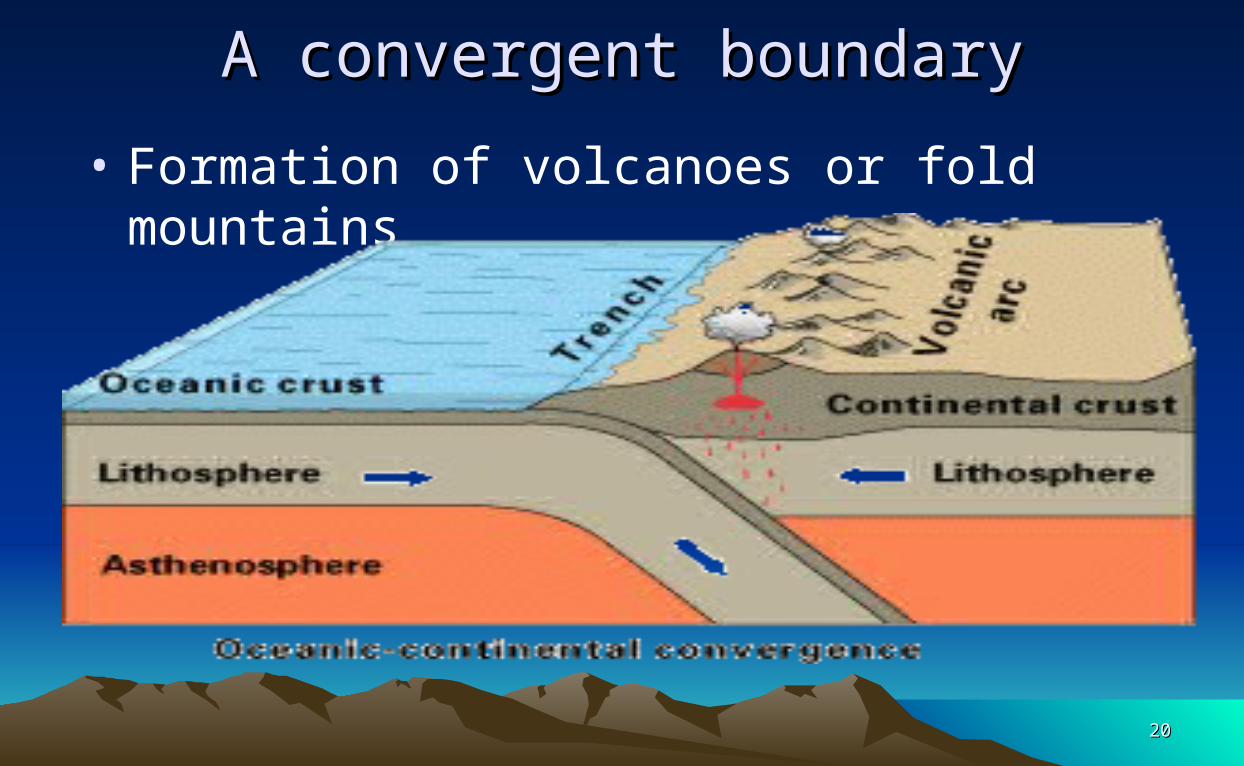
3. 3. Convergent boundaryConvergent boundary(Also known as destructive boundary or subduction
zone) • Plates move towards one another; the plates are
consumed, or recycled back into the earth’s mantle.
• Earthquakes, volcanoes, oceanic ridges, deep sea trenches, island arcs, (e.g the West Indies, the Japanese islands), and fold mountains occur at convergent boundaries

1717
Formation of the CaribbeanFormation of the Caribbean
• The eastern Caribbean islands lie on a convergent plate boundary.
• As the Atlantic/America plate sinks beneath the Caribbean plate, magma rises to the surface, it may erupt to form a volcano, resulting in the formation of the islands of the eastern Caribbean, (about 140 million years ago).
•

1818
The Caribbean & Atlantic Plate BoundariesThe Caribbean & Atlantic Plate Boundaries
•-
-- --

1919
A convergent boundaryA convergent boundary• Molten material comes to the surface and
forms islands
2020
A convergent boundaryA convergent boundary
• Formation of volcanoes or fold mountains

2121
Effects of plate tectonics on the CaribbeanEffects of plate tectonics on the Caribbean• 1) Volcanoes. • A volcano is a vent or opening in the earth’s crust
through which hot molten rock (magma) and gases from the interior of the earth are released.
• Volcanoes occur as the oceanic crust sinks under the continental crust. Magma escapes and rises to the surface and forms volcanoes.
• Eighty percent of the world’s active volcanoes occur at convergent zones.

2222
Live volcanoes in the Eastern CaribbeanLive volcanoes in the Eastern CaribbeanThere are 19 ‘live’ volcanoes in the Eastern Caribbean

2323
Major volcanic eruptions in the Eastern Major volcanic eruptions in the Eastern CaribbeanCaribbean
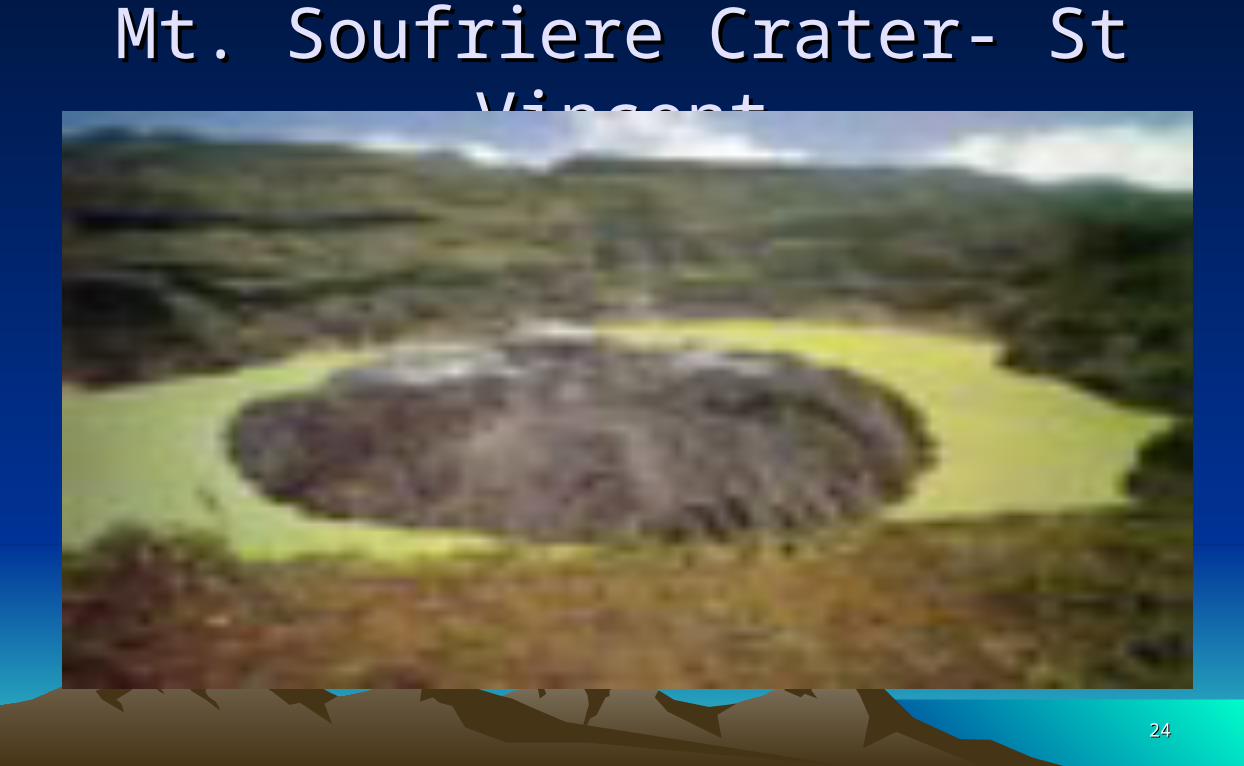
Year Volcano Effects1718 Mt. Soufriere,
St. VincentUnknown number of casualties among Caribs
1812 Mt. Soufriere,St. Vincent
80 killed; major damage to sugar industry
1902 Mt Pele`,Martinique
30 000 killed; St Pierre destroyed; economic cost US$1 000 000 000
2424
Mt. Soufriere Crater- St VincentMt. Soufriere Crater- St Vincent

2525
Major volcanic eruptions in the Eastern Major volcanic eruptions in the Eastern CaribbeanCaribbeanYear Volcano Effects
1902 Mt. Soufriere,St. Vincent
1600 killed; major damage to the sugar industry; economic cost: US$200 000 000
1976 - 77
Soufriere,Guadeloupe
No casualties. Economic cost: US$100 000 000
1979 Mt. Soufriere,St. Vincent
No casualties. Massive ash fall. Economic cost: US$100 000 000

2626
MontserratMontserrat

2727
Soufriere Hills eruption – Montserrat (1995)Soufriere Hills eruption – Montserrat (1995)

2828
Pyroclastic flow and surgePyroclastic flow and surge• A pyroclastic flow : a hot (100 – 6000C), fast moving
mixture of ash, rock fragments and gas. It usually travels down valleys and cause total destruction of the area over which it flows. This has been the main cause of destruction and loss of life in Montserrat
• A pyroclastic surge is a dilute turbulent cloud of gases and rock debris that moves over the ground at great speeds. It is formed in a similar way to a pyroclastic flow, but the effect is more widespread.

2929
A pyroclastic flowA pyroclastic flow

3030
Major volcanic eruptions in the regionMajor volcanic eruptions in the regionYear Volcano Effects
1995 - 1997
Souffriere Hills, Montserrat
19 deaths; destruction of capital, Plymouth; southern portion of island evacuated; relocation of population; mass migration; population reduction from 12, 771 (1996) to about 4000; economy devastated; economic cost: US$500 000 000

3131
Soufriere Hills volcanic glowSoufriere Hills volcanic glow

3232
Soufriere Hills ash cloud - MontserratSoufriere Hills ash cloud - Montserrat

3333
Montserrat- pyroclastic flow damageMontserrat- pyroclastic flow damage

3434
Damage from Soufriere Hills eruptionDamage from Soufriere Hills eruption

3535
Plymouth – under ash and mudPlymouth – under ash and mud

3636
Plymouth MontserratPlymouth Montserrat

3737
Montserrat – loss of propertyMontserrat – loss of property
3838
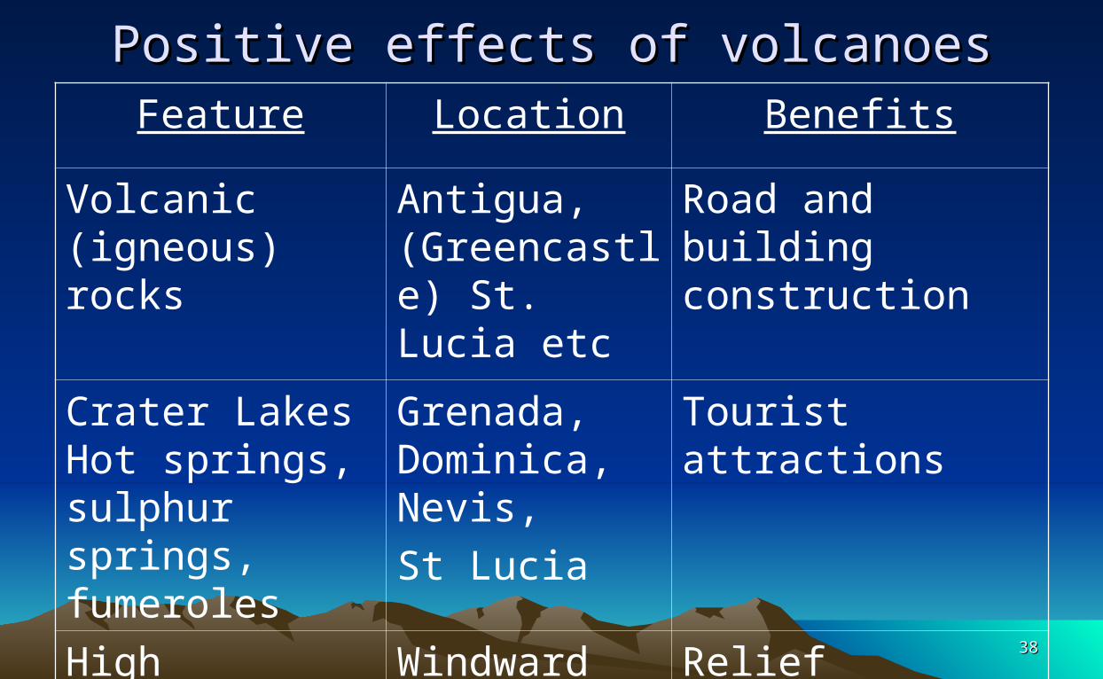
Positive effects of volcanoesPositive effects of volcanoesFeature Location Benefits
Volcanic (igneous) rocks
Antigua, (Greencastle) St. Lucia etc
Road and building construction
Crater Lakes Hot springs, sulphur springs, fumeroles
Grenada, Dominica, Nevis, St Lucia
Tourist attractions
High mountains and fertile soil
Windward Islands, Bendals, Old Road etc.
Relief rainfall -agriculture – food production.

3939
Effects of plate tectonics on the CaribbeanEffects of plate tectonics on the Caribbean
• 2) Earthquakes • An earthquake results from slow build up of
pressure within the crust at convergent boundaries. If pressure is suddenly released, then the plates jerk past each other resulting in vibrations in the crust.
• Over 600 earthquakes occur in the Caribbean annually.

4040
Earthquakes for October 17Earthquakes for October 17thth – 24 – 24thth 2005 2005 Red 30 km deep; purple 30 – 70 km deep; blue 70 -100 km
deep; black > 100 km deep

4141
The Richter ScaleThe Richter Scale
•

4242
General effects of earthquakesGeneral effects of earthquakes• loss of life• loss of property• fires from broken gas, or power lines• disruption of transport and other services• exposure due to lack of shelter• shortage of food• shortage of clean water• disease from polluted water supplies.

4343
Selected Caribbean earthquakesSelected Caribbean earthquakesYear Island Effects
1692 Port Royal, Jamaica
2000 killed, a part of the city was submerged, buildings destroyed.
1842 Haiti More than 700 killed. In addition 200 killed in tsunami in Port-de-Paix.
1843 Antigua, Nevis, Montserrat
Major structural damage; St John’s Cathedral damaged. A tsunami also affected Antigua

4444
Selected Caribbean earthquakesSelected Caribbean earthquakesYear Island Effects
1867 Virgin Islands
20 killed
1907 Kingston,Jamaica
Major destruction by fire and tidal wave
1946 Dominican Republic
100 killed by a tsunami in the town of Mantanzas

4545
Selected Caribbean earthquakesSelected Caribbean earthquakesYear Island Effects
1974 Antigua Structural damage
2004 North of Dominica (6.3 magnitude)
Structural damage to churches in Portsmouth and Vielle Case. One death in Guadeloupe. Also felt in Antigua, St Maarten, Nevis, Montserrat and St. Vincent

4646
Structural damage – Dominica 2004Structural damage – Dominica 2004

4747
Structural damage – Dominica 2004Structural damage – Dominica 2004

4848
Some earthquakes in 2005Some earthquakes in 2005
Date Location Magnitude
Feb 7th North east of Dominica 4.8Feb 14th North of DominicaMarch 22nd Near Trinidad 4.6March 23rd Northwest of Trinidad 3.91st May Northeast of St. Lucia 3.7June 23rd 9 quakes N. of Dominica 3.6 – 4.5Aug 4th Northwest of Trinidad 4.5Aug 30th Northeast of Martinique 5.1Oct 24th Northwest of Trinidad 4.9

4949
Implications for construction & disaster Implications for construction & disaster preparednesspreparedness• What disaster mitigation methods are in place?• Construction of earthquake resistant buildings?• Restrictions on the height of buildings?• Emergency exits in buildings? • Adequate medical facilities to handle disasters?• Regular public education/awareness?• Earthquake drills in schools?• ARE WE PREPARED TO HANDLE MAJOR
DISASTERS?

5050
Some landforms formed by plate tectonicsSome landforms formed by plate tectonics
• Landforms: a natural physical feature of the earth’s surface, for example, a valley, mountain, or plain, beaches, marshes, caves, waterfalls.

5151
Landforms and their useLandforms and their useLandform Territory Benefits
Waterfall Dominica, Jamaica, Guyana
Recreation, tourist attraction
Boiling Lake, Dominica Tourist attraction,
Sulphur springs
Dominica, Nevis Therapeutic
Mountains Windward Islands, Jamaica
Rainfall, agriculture, forestry,

5252
Landforms and their useLandforms and their useLandform Territory Benefits
MarshesMangroves
All islands Prevents coastal erosion; a spawning area for fish; protection for young marine life
Lagoons Barbuda Fishing, coastal protection
Plains Trinidad etc
Agriculture, settlement
Beaches Leeward Islands
Recreation, fishing, tourism, sand mining

5353
ReferencesReferences• Reid, Ruel B., (2002), Caribbean Studies, pg. 1 – 4, 21 – 25
• Waugh, David. (2002). Geography An Integrated Approach, Ch. 1
• Microsoft Encarta Reference Library 2005, Articles: Plate Tectonics, Earthquake, Volcano
• www.wikipedia.org, Article: Plate Tectonics
• www.uwiseismic.com (The Seismic Research Unit of the UWI at St Augustine, Trinidad)
5454
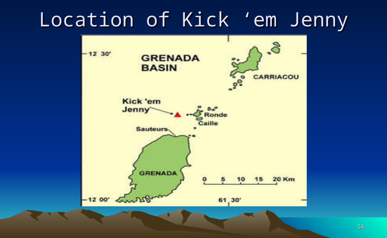
Location of Kick ‘em JennyLocation of Kick ‘em Jenny

5555
Kick `em JennyKick `em Jenny• A shallow submarine volcano• Located 8km ( 5 miles ) north of Grenada• The summit is 180m (590 ft) below sea level• The only ‘live’ submarine volcano in the Caribbean• Erupted twelve times since 1939• It is actively degassing• Most closely monitored volcano in the Caribbean• It is not growing towards the surface• It is a serious threat to shipping and there is a 1.5 km (approx 1
mile) exclusion zone around it.

5656
Trenches and TroughsTrenches and Troughs• Trenches/Troughs: Bartlett Trough, between
Cuba and Jamaica, over 20 000 feet deep. • Brownson Trough, north of Puerto Rico and
the Virgin Islands, 30, 000 feet deep
• Anegada Trough, between the Caribbean Sea and the Atlantic Ocean?

5757
Tsunamis in the CaribbeanTsunamis in the Caribbean• An ocean wave caused by large scale disturbance of the ocean floor or surface
that displaces a large mass of water.
• Waves can reach 15m high (50 ft) and travel 600 kph (372 mph)
• Caused by earthquakes, volcanic eruptions and landslides into the sea.
• Ten earthquake generated tsunamis in the past 500 years, only 450 people have been killed by tsunamis
• Volcanoes, earthquakes and hurricanes have killed 30 000, 15 000, and 15000 people respectively
• In 2003 a major dome collapse of Soufriere Hills Volcano, caused a tsunami 4m high in Montserrat and 1 m high in Guadeloupe.
• Scientists believe that there is a low probability of a major tsunami in the region

5858
Earthquake terminologyEarthquake terminology• A violent shaking of the Earth’s crust that may cause
destruction to buildings and installations and results from the sudden release of tectonic stress.
• Focus or hypocenter: the point within the earth where an earthquake originates
• Epicenter: the point on the earth’s surface directly above the focus
• Earthquakes also contain surface waves that travel out from the epicenter along the surface of the earth. Two types of these surface waves occur: Rayleigh waves, named after British physicist Lord Rayleigh, and Love waves, named after British geophysicist A. E. H. Love. Surface waves also cause damage to structures, as they shake the ground underneath the foundations of buildings and other structures.

5959
Piton, St LuciaPiton, St Lucia

6060
Tectonic plates and volcanoesTectonic plates and volcanoes

6161
The CaribbeanThe Caribbean

6262
Divergent boundary – rift valleyDivergent boundary – rift valley