planning proposal: sydney local environmental plan 2012 … · central sydney planning committee...
TRANSCRIPT

ATTACHMENT A
PLANNING PROPOSAL: SYDNEY LOCAL ENVIRONMENTAL PLAN 2012 – REZONING OF SITES IN PYRMONT
ATTACHMENT A


Planning Proposal Sydney LEP 2012 – Rezoning of Sites in Pyrmont
City of Sydney Town Hall House 456 Kent Street Sydney NSW 2000
February 2016
ATTACHMENT A

Contents Introduction ........................................................................................................................ 3 PART 1 – OBJECTIVES & INTENDED OUTCOMES ....................................................... 8 PART 2 – EXPLANATION OF PROVISIONS ................................................................... 8 PART 3 – JUSTIFICATION ................................................................................................ 9 Section A – Need for the planning proposal .................................................................... 15 Section B – Relationship to strategic planning framework .............................................. 15 Section C – Environmental, social and economic impact................................................ 20 Section D – State and Commonwealth interests ............................................................. 21 PART 4 – MAPPING ........................................................................................................ 22 PART 5 – COMMUNITY CONSULATION ....................................................................... 24 PART 6 – PROJECT TIMELINE ...................................................................................... 25
2 /Planning Proposal: Sydney Local Environmental Plan 2012 - Rezoning of Sites in Pyrmont
ATTACHMENT A

Introduction This Planning Proposal explains the intent of, and justification for, the proposed amendment to the planning controls for specific sites in Pyrmont. This Planning Proposal will change the planning controls for the following sites in Pyrmont: • 11 Bowman Street, • 1A Distillery Drive, • 1 Distillery Drive, • 3 Distillery Drive, • 15 Bowman Street, • 25 Bowman Street, • 35 Bowman Street, • 5 Tambua Street, and • 66 Bowman Street. The objectives of this Planning Proposal are to ensure the zoning reflects the existing land uses and secures public open space. The objectives will be achieved by amending the land use zoning maps to rezone certain sites from Mixed Use to General Residential or Public Recreation. These sites are shown in the Figures 1 through to 4. The planning controls for the Pyrmont sites are in the Sydney Local Environmental Plan 2012 (the LEP) and came into effect in December 2012. This Planning Proposal is prepared in response to community submissions made during the exhibition of the draft Sydney Local Environmental Plan 2011 (LEP 2011). When Council and the Central Sydney Planning Committee adopted the Sydney LEP 2012 in March 2012, they resolved to prepare a Planning Proposal to rezone a number of sites in Pyrmont from B4 Mixed Use to R1 General Residential. This was to ensure the zoning reflected the existing uses that have been developed and reflected the resulting character and uses. Two parks in Pyrmont were also intended to be zoned for public recreation. However, the parks were zoned B4 mixed use because they had not been subdivided from the development sites. Because these sites have now been subdivided this planning proposal intends to rezone the parks to RE1 Public Recreation to secure public existing open space. This planning proposal has been prepared in accordance with section 55 of the Environmental Planning and Assessment Act 1979 (the Act) and the relevant Department of Planning & Environment Guidelines, including ‘A Guide to Preparing Planning Proposals’ and ‘A Guide to Preparing Local Environmental Plans’.
3 /Planning Proposal: Sydney Local Environmental Plan 2012 - Rezoning of Sites in Pyrmont
ATTACHMENT A

Site identification The planning proposal affects the sites shown in Table 1 and Figures 1 to 4. Table 1- Site Description and Proposed Amendment
Site Property Information
Current Uses
Proposed Amendment
11 Bowman Street, Pyrmont
Lot 93 DP 1182885 Park Rezone from B4 Mixed Use to RE1 Public Recreation
1A Distillery Drive, Pyrmont
Lot 92 DP 1182887 Park Rezone from B4 Mixed Use to RE1 Public Recreation
1 Distillery Drive, Pyrmont
Lots 1-43 SP 86684; Lot 91 DP 270215
Strata residential
Rezone from B4 Mixed Use to R1 General Residential
3 Distillery Drive, Pyrmont
Lot 90 DP 1186529 Park Rezone from B4 Mixed Use to RE1 Public Recreation
15 Bowman Street, Pyrmont
Part Lot 86 DP 270215; Lots 1-100 SP 86806
Strata residential
Rezone from B4 Mixed Use to R1 General Residential
25 Bowman Street, Pyrmont
Part Lots 1-132 SP 84689; Lot 83 DP 270215
Strata residential
Rezone from B4 Mixed Use to R1 General Residential
35 Bowman Street, Pyrmont
Part Lot 63 DP 270215, Lots 1-29 SP 76418
Strata residential
Rezone from B4 Mixed Use to R1 General Residential
5 Tambua Street, Pyrmont
Part Lot 81 DP 270215; Lots 1-107 SP 82306
Strata residential
Rezone from B4 Mixed Use to R1 General Residential
66 Bowman Street, Pyrmont
Part Lot 26 DP 270215; Lots 1-150 SP 65564
Strata residential
Rezone from B4 Mixed Use to R1 General Residential
4 /Planning Proposal: Sydney Local Environmental Plan 2012 - Rezoning of Sites in Pyrmont
ATTACHMENT A

Figure 1: Aerial of Bowman Street, Distillery Drive and Tambua Street sites affected
by this planning proposal are outlined in red.
11 Bowman Street
15 and 25 Bowman Street
35 Bowman Street
5 Tambua Street
3 Distillery Drive
1A Distillery Drive
1 Distillery Drive
5 /Planning Proposal: Sydney Local Environmental Plan 2012 - Rezoning of Sites in Pyrmont
ATTACHMENT A

Figure 2: Existing zoning of Bowman Street, Distillery Drive and Tambua Street sites
affected by this planning proposal are outlined in red.
1 Distillery Drive
1A Distillery Drive
11 Bowman Street
15 and 25 Bowman
35 Bowman Street
5 Tambua Street
3 Distillery Drive
6 /Planning Proposal: Sydney Local Environmental Plan 2012 - Rezoning of Sites in Pyrmont
ATTACHMENT A

Figure 3: Aerial of 66 Bowman Street affected by this planning proposal outlined in
red.
Figure 4: Existing zoning of 66 Bowman Street by this planning proposal outlined in red.
66 Bowman Street
66 Bowman Street
7 /Planning Proposal: Sydney Local Environmental Plan 2012 - Rezoning of Sites in Pyrmont
ATTACHMENT A
PART 1 – OBJECTIVES & INTENDED OUTCOMES The objectives are to ensure the zoning is consistent with the existing land uses and secures public open space.
PART 2 – EXPLANATION OF PROVISIONS To achieve the proposed outcomes, the Planning Proposal seeks to amend the planning controls for the following sites as described below: (1) 1 Distillery Drive, 15 Bowman Street, 25 Bowman Street, 35 Bowman Street, 5 Tambua Street and 66 Bowman Street Amend the land use zoning map to change the zone from B4 Mixed Use to R1 General Residential. (2) 11 Bowman Street, 1A Distillery Drive and 3 Distillery Drive Amend the land use zoning map to change the zone from B4 Mixed Use to RE1 Public Recreation. (3) Road Reservation along Distillery Drive adjoining sites 1 Distillery Drive, 15 Bowman Street, 25 Bowman Street and 5 Tambua Street Amend the land use zoning map to change the zone from B4 Mixed Use to R1 General Residential. (4) Road Reservation along Bowman Street adjoining sites 2 Bowman Street, 4 Bowman Street and 6 - 50 Bowman Street Amend the land use zoning map to change the zone from B4 Mixed Use to RE1 Public Recreation.
8 /Planning Proposal: Sydney Local Environmental Plan 2012 - Rezoning of Sites in Pyrmont
ATTACHMENT A
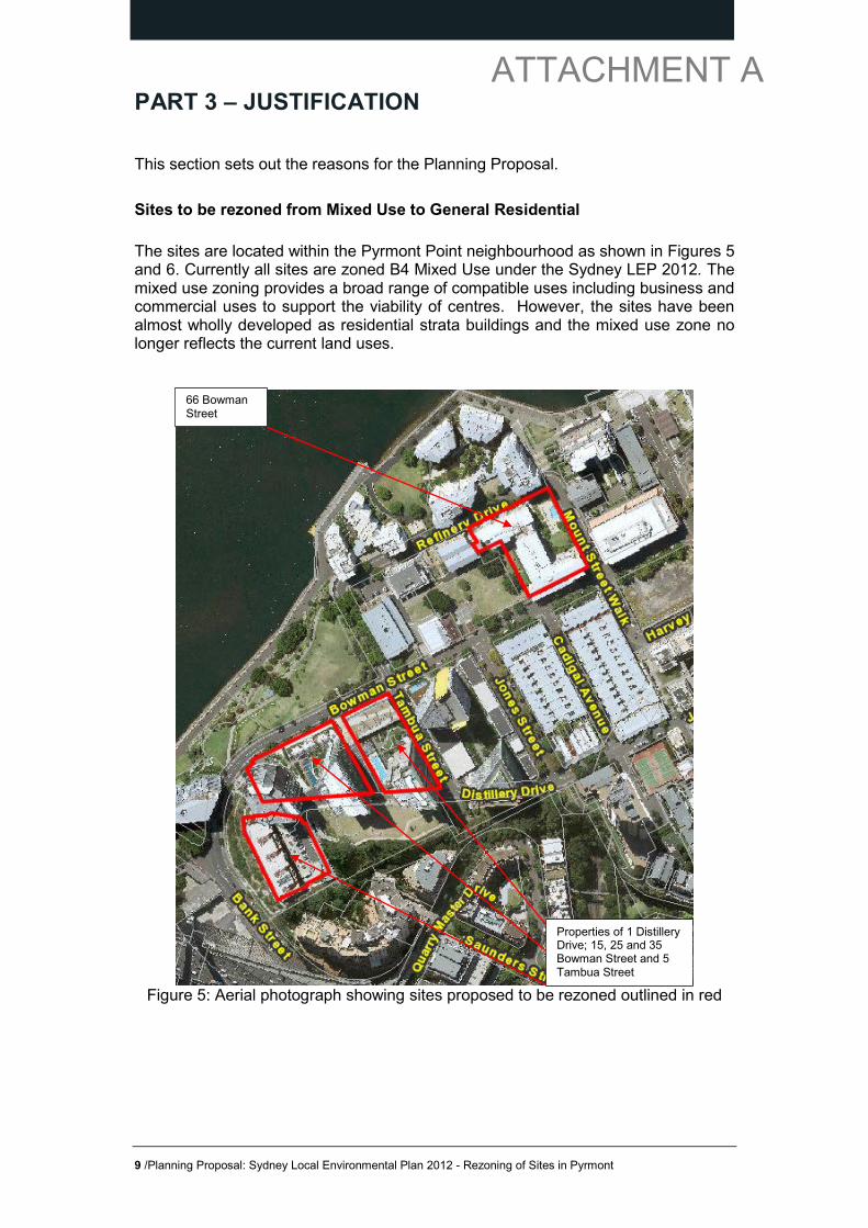
PART 3 – JUSTIFICATION This section sets out the reasons for the Planning Proposal. Sites to be rezoned from Mixed Use to General Residential The sites are located within the Pyrmont Point neighbourhood as shown in Figures 5 and 6. Currently all sites are zoned B4 Mixed Use under the Sydney LEP 2012. The mixed use zoning provides a broad range of compatible uses including business and commercial uses to support the viability of centres. However, the sites have been almost wholly developed as residential strata buildings and the mixed use zone no longer reflects the current land uses.
Figure 5: Aerial photograph showing sites proposed to be rezoned outlined in red
66 Bowman Street
Properties of 1 Distillery Drive; 15, 25 and 35 Bowman Street and 5 Tambua Street
9 /Planning Proposal: Sydney Local Environmental Plan 2012 - Rezoning of Sites in Pyrmont
ATTACHMENT A

Figure 6: Existing land use zoning map, Sydney LEP 2012
Historically, these sites were zoned Residential and Residential-Business under the previous planning controls of the Sydney Regional Environmental Plan 26 (SREP 26) and Sydney Local Environmental Plan 2005 (LEP 2005), as circled in black on Figures 7 and 8 below. The objectives of the residential–business zone were to accommodate a mixture of residential and employment generating development on the land. This zone was part of the overall vision for the area for a sustainable mixed use precinct under SREP 26. The current mixed use zoning in Sydney LEP 2012 is a translation of the previous zoning.
66 Bowman Street
Properties of 1 Distillery Drive; 15, 25 and 35 Bowman Street and 5 Tambua Street
10 /Planning Proposal: Sydney Local Environmental Plan 2012 - Rezoning of Sites in Pyrmont
ATTACHMENT A

Figure 7: Ultimo-Pyrmont Urban Development Plan-Update 1999 – Prepared under SREP 26
Figure 8: Sydney Local Environmental Plan 2005 During public exhibition of the draft Sydney LEP 2011, the City received submissions from the community about the appropriateness of the B4 Mixed Use zoning. In response to the submissions the City reviewed the land uses and found the sites had been developed as strata residential buildings. It was recommended the sites be zoned R1 General Residential rather than B4 Mixed Use. CSPC and Council resolved to prepare a planning proposal to rezone the sites to R1 General Residential when they adopted Sydney LEP 2012 on 8 and 12 March 2012. Despite the zonings and mixed use intent for the area under SREP 26, the redevelopment of Pyrmont resulted in more residential development than envisaged. A recent survey of land uses has confirmed the subject sites have been developed as strata residential flat buildings. It is unlikely that employment uses will take advantage of the mixed use zoning because of the market demand for residential and existing constraints of strata. This rezoning will ensure the land use zoning is consistent with the existing land uses expected from the community. The social and environmental benefits include protection of residential amenity and reduction in environmental effects from other activities that can be developed on the land. The road reservation along Distillery Drive will be rezoned to residential to match the proposed zoning for land uses to the north and west.
11 /Planning Proposal: Sydney Local Environmental Plan 2012 - Rezoning of Sites in Pyrmont
ATTACHMENT A

Sites to be rezoned from Mixed Use to Public Recreation 11 Bowman Street, 1A Distillery Drive and 3 Distillery Drive, Pyrmont are located at the western end of Bowman Street and Distillery Drive. The sites are parks owned by the Department of Planning and located within a predominantly residential area. They were dedicated as part of the development of the Jackson Landing precinct and are expected to be transferred over to Council. The location of these sites are shown in figure 10. The road reservation along Bowman Street will be rezoned to public recreation to match western end of Bowman Street and the adjoining land use to the north.
Figure 10: Aerial photograph showing the location of 11 Bowman Street, 1A and 3
Distillery Drive, Pyrmont
11 Bowman Street
1A Distillery Drive
3 Distillery Drive
12 /Planning Proposal: Sydney Local Environmental Plan 2012 - Rezoning of Sites in Pyrmont
ATTACHMENT A
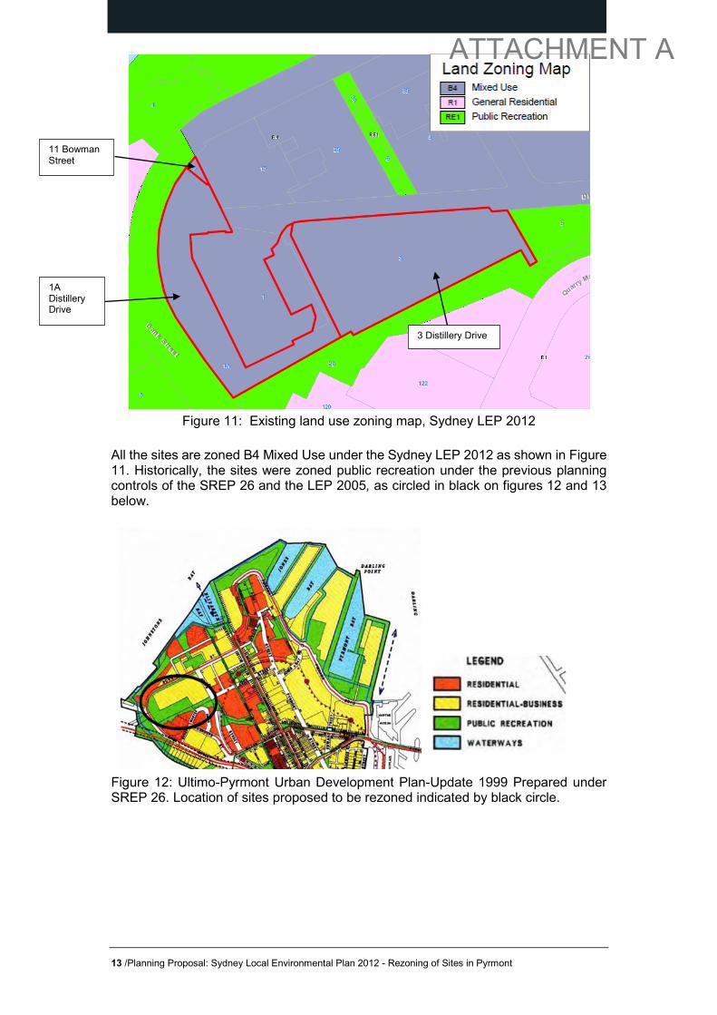
Figure 11: Existing land use zoning map, Sydney LEP 2012
All the sites are zoned B4 Mixed Use under the Sydney LEP 2012 as shown in Figure 11. Historically, the sites were zoned public recreation under the previous planning controls of the SREP 26 and the LEP 2005, as circled in black on figures 12 and 13 below.
Figure 12: Ultimo-Pyrmont Urban Development Plan-Update 1999 Prepared under SREP 26. Location of sites proposed to be rezoned indicated by black circle.
3 Distillery Drive
1A Distillery Drive
11 Bowman Street
13 /Planning Proposal: Sydney Local Environmental Plan 2012 - Rezoning of Sites in Pyrmont
ATTACHMENT A

Figure 13: Sydney Local Environmental Plan 2005. Location of sites proposed to be rezoned indicated by black circle. During the public exhibition of the draft Sydney LEP 2011, submissions were received from the community, raising concerns with the proposed B4 Mixed Use land use zone for these sites. The City proposed to zone the sites public recreation, however the Department of Planning and Infrastructure directed the City to zone the sites to B4 Mixed Use. This was because only one zone could be applied to a single lot and the public recreation land was part of a development site but not yet subdivided. As the sites have now been developed, subdivided and dedicated to the Minister for Planning, it is proposed to rezone the sites to public recreation to be consistent with the existing parks. These parks are an important part of the local open space network which contributes to the amenity of the Pyrmont area. The rezoning to public recreation will reduce the range of uses can be developed on the relevant sites. The objectives of the B4 Mixed Use zone are to provide a mixture of compatible land uses and integrate suitable business, office, residential, retail and other development in accessible locations so as to maximise public transport patronage and encourage walking and cycling. The mixed use objectives will not protect the intended public recreation outcomes because it allows a range of uses to be developed. The objectives of the RE1 Public Recreation zone are to enable land to be used for public open space or recreational purposes, provide a range of recreational settings and activities and compatible land uses and retain and promote access by members of the public to areas in the public domain including recreation facilities. The rezoning will secure public open space by permitting appropriate uses to reflect the intended use of the land from previous planning controls and the land uses developed and provide certainty for the community.
14 /Planning Proposal: Sydney Local Environmental Plan 2012 - Rezoning of Sites in Pyrmont
ATTACHMENT A
Section A – Need for the planning proposal Is the planning proposal a result of any strategic study or report? No. The planning proposal will update the Sydney LEP 2012 to reflect the uses that have been developed. The proposed public recreation zones are consistent with the previous planning controls and master plans. The proposed residential zones reflect the uses that have been developed on the sites and the market preferences to develop residential uses rather a mix of residential and business uses. Is the planning proposal the best means of achieving the objectives or intended outcomes, or is there a better way? The planning proposal is the best means of achieving the objective of reflecting the uses that have been developed. Not proceeding with the planning proposal would mean the zoning would be inconsistent with community expectations for the types of uses permitted in strata residential buildings or on land intended for public recreation.
Section B – Relationship to strategic planning framework
Is the planning proposal consistent with the objectives and actions contained within the applicable regional or sub-regional strategy (including A Plan for Growing Sydney and the exhibited draft strategies)? A Plan for Growing Sydney In December 2014, the NSW Government published A Plan for Growing Sydney, the new strategic plan for the Sydney metropolitan area over the next 20 years. It envisages a globally competitive Sydney with a population increase of 1.6 million more people, including 689,000 new jobs and 664,000 new homes by the year 2031. A Plan for Growing Sydney sets out four goals: • A competitive economy with world-class services and transport; • A city of housing choice with homes that meet our needs and lifestyles; • A great place to live with communities that are strong, healthy and well connected;
and • A sustainable and resilient city that protects the natural environment and has a
balanced approach to the use of land and resources. The key priorities for the Central Subregion, including the Pyrmont-Ultimo precinct, directly related to this Planning Proposal are “retain a commercial core in Pyrmont for long-term employment growth” and “support the land use requirements of the creative digital technology knowledge hub in Pyrmont-Ultimo”.
15 /Planning Proposal: Sydney Local Environmental Plan 2012 - Rezoning of Sites in Pyrmont
ATTACHMENT A
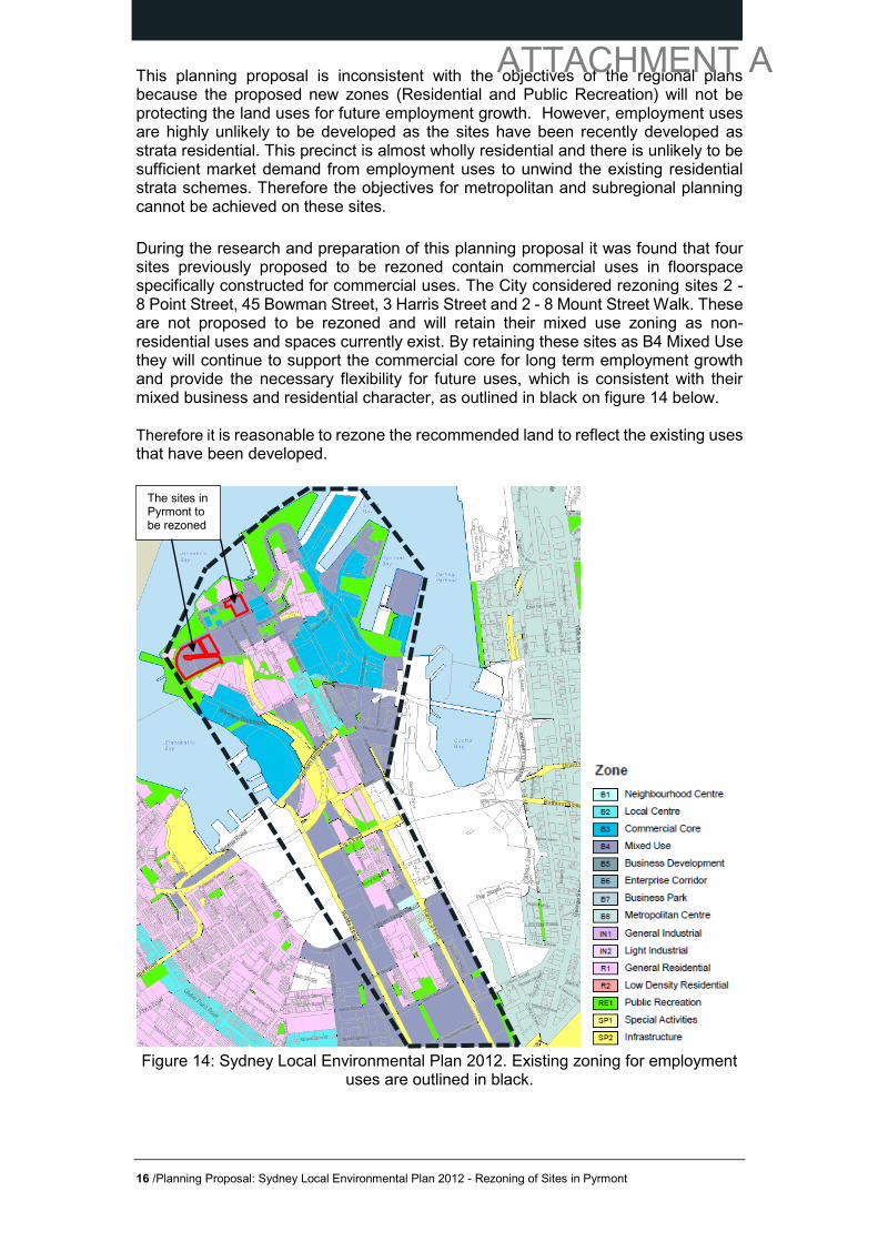
This planning proposal is inconsistent with the objectives of the regional plans because the proposed new zones (Residential and Public Recreation) will not be protecting the land uses for future employment growth. However, employment uses are highly unlikely to be developed as the sites have been recently developed as strata residential. This precinct is almost wholly residential and there is unlikely to be sufficient market demand from employment uses to unwind the existing residential strata schemes. Therefore the objectives for metropolitan and subregional planning cannot be achieved on these sites. During the research and preparation of this planning proposal it was found that four sites previously proposed to be rezoned contain commercial uses in floorspace specifically constructed for commercial uses. The City considered rezoning sites 2 - 8 Point Street, 45 Bowman Street, 3 Harris Street and 2 - 8 Mount Street Walk. These are not proposed to be rezoned and will retain their mixed use zoning as non-residential uses and spaces currently exist. By retaining these sites as B4 Mixed Use they will continue to support the commercial core for long term employment growth and provide the necessary flexibility for future uses, which is consistent with their mixed business and residential character, as outlined in black on figure 14 below. Therefore it is reasonable to rezone the recommended land to reflect the existing uses that have been developed.
Figure 14: Sydney Local Environmental Plan 2012. Existing zoning for employment
uses are outlined in black.
The sites in Pyrmont to be rezoned
16 /Planning Proposal: Sydney Local Environmental Plan 2012 - Rezoning of Sites in Pyrmont
ATTACHMENT A

Draft Sydney City Subregional Strategy The draft City of Sydney Subregional Strategy (2008) identifies five major precincts within the Subregion including the Pyrmont – Ultimo Precinct. The precinct is a location for the information technology, communications and media sector, as well as destination for tourists and visitors. The draft Strategy aims to promote and strengthen these emerging clusters in response to growth in workers, residents and visitors. As described above in the responses to A plan for Growing Sydney above inconsistency with the draft subregional strategy is appropriate as the recent development of the recommended land does not allow the objectives of the draft strategy to be achieved and no changes to the zoning is proposed for the commercial core of Pyrmont. Is the planning proposal consistent with the local council’s Community Strategic Plan, or other local strategic plan? Sustainable Sydney 2030 outlines the Council’s vision for a ‘green’, ‘global’ and ‘connected’ City, with targets, objectives and actions to achieve that vision. The vision was adopted by Council in 2008. Strategic directions and actions of Sydney 2030 that align with the planning proposal are: • Direction 6: Vibrant local communities and economies - The planning proposal
responds to objective 6.1 maintain and enhance the role and character of the Villages. The zoning of the sites to residential or public recreation will have positive social and environmental impacts including consistency with community expectations for amenity in residential areas and protection of open space.
• Direction 9: Sustainable development, renewal and design - The planning proposal is consistent with action 9.4.1 to regularly review and streamline development controls. The planning proposal seeks to improve the operation of the controls. It reflects the intended use of the land from previous planning controls and the land uses developed. It will also provide certainty for the community, proponent and the City.
Is the planning proposal consistent with applicable state environmental planning policies? The proposal is consistent with the relevant State Environmental Planning Policies (SEPPs) and Regional Environmental Plans (REPs).
SEPPS with which the planning proposal is consistent Not applicable SEPPs that are not applicable to the planning proposal
State Environmental Planning Policy No 1—Development Standards; State Environmental Planning Policy No 14—Coastal Wetlands; State Environmental Planning Policy No 15—Rural Land sharing Communities; State Environmental Planning Policy No 19—Bushland in Urban Areas; State Environmental Planning Policy No 21—Caravan Parks; State Environmental Planning Policy No 26—Littoral Rainforests; State Environmental Planning Policy No 29—Western Sydney Recreation Area; State Environmental Planning Policy No 30—Intensive Agriculture; State Environmental Planning Policy No 32—Urban Consolidation (Redevelopment of Urban Land); State Environmental Planning Policy No 33—
17 /Planning Proposal: Sydney Local Environmental Plan 2012 - Rezoning of Sites in Pyrmont
ATTACHMENT A

Hazardous and Offensive Development; State Environmental Planning Policy No 36—Manufactured Home Estates; State Environmental Planning Policy No 39—Spit Island Bird Habitat; State Environmental Planning Policy No 44—Koala Habitat Protection; State Environmental Planning Policy No 47—Moore Park Showground; State Environmental Planning Policy No 50—Canal Estate Development; State Environmental Planning Policy No 52—Farm Dams and Other Works in Land and Water Management Plan Areas; State Environmental Planning Policy No 55—Remediation of Land; State Environmental Planning Policy No 59—Central Western Sydney Regional Open Space and Residential; State Environmental Planning Policy No 62—Sustainable Aquaculture; State Environmental Planning Policy No 64—Advertising and Signage; State Environmental Planning Policy No 65—Design Quality of Residential Flat Development; State Environmental Planning Policy No 70—Affordable Housing (Revised Schemes); State Environmental Planning Policy No 71—Coastal Protection; State Environmental Planning Policy (Affordable Rental Housing) 2009; State Environmental Planning Policy (Building Sustainability Index: BASIX) 2004; State Environmental Planning Policy (Exempt and Complying Development Codes) 2008; State Environmental Planning Policy (Housing for Seniors or People with a Disability) 2004; State Environmental Planning Policy (Infrastructure) 2007; State Environmental Planning Policy (Kosciuszko National Park—Alpine Resorts) 2007; State Environmental Planning Policy (Kurnell Peninsula) 1989; State Environmental Planning Policy (Major Development) 2005; State Environmental Planning Policy (Mining, Petroleum Production and Extractive Industries) 2007; State Environmental Planning Policy (Miscellaneous Consent Provisions) 2007; State Environmental Planning Policy (Penrith Lakes Scheme) 1989; State Environmental Planning Policy (Rural Lands) 2008; State Environmental Planning Policy (SEPP 53 Transitional Provisions) 2011; State Environmental Planning Policy (State and Regional Development) 2011; State Environmental Planning Policy (Sydney Drinking Water Catchment) 2011; State Environmental Planning Policy (Sydney Region Growth Centres) 2006; State Environmental Planning Policy (Three Ports) 2013; State Environmental Planning Policy (Urban Renewal) 2010; State Environmental Planning Policy (Western Sydney Employment Area) 2009; State Environmental Planning Policy (Western Sydney Parklands) 2009. REPs with which the planning proposal is consistent Sydney Regional Environmental Plan (Sydney Harbour Catchment) 2005
REPs that are not applicable to the planning proposal Sydney Regional Environmental Plan No 8 (Central Coast Plateau Areas);Sydney Regional Environmental Plan No 9—Extractive Industry (No 2—1995); Sydney Regional Environmental Plan No 16—Walsh Bay; Sydney Regional Environmental Plan No 18—Public Transport Corridors; Sydney Regional Environmental Plan No 19—Rouse Hill Development Area; Sydney Regional Environmental Plan No 20—Hawkesbury-Nepean River (No 2—1997); Sydney Regional Environmental Plan No 24—Homebush Bay Area; Sydney Regional Environmental Plan No 26—City West; Sydney Regional Environmental Plan No 30—St Marys; Sydney Regional Environmental Plan No 33—Cooks Cove.
Table 2 – Consistency with SEPPS and REPS Is the planning proposal consistent with applicable Ministerial Directions (s. 117 directions)? The Planning Proposal has been assessed against the s117 Ministerial Directions and with each of the relevant matters, as outlined below.
18 /Planning Proposal: Sydney Local Environmental Plan 2012 - Rezoning of Sites in Pyrmont
ATTACHMENT A

Ministerial Directions which this planning proposal is consistent N/A Ministerial Directions which this planning proposal is inconsistent 1.1 Business and Industrial Zones; 7.1 Implementation of A Plan for Growing Sydney Ministerial Directions which are not applicable to the planning proposal 1.2 Rural Zones; 1.3 Mining, Petroleum Production and Extractive Industries; 1.4 Oyster Aquaculture;1.5 Rural Lands; 2.1 Environmental Protection Zones; 2.2 Coastal Protection; 2.3 Heritage Conservation; 2.4 Recreation Vehicle Areas; 3.1 Residential Zones; 3.2 Caravan Parks and Manufactured Home Estates; 3.3 Home occupations; 3.4 Integrating Land Use and Transport; 3.5 Development Near Licensed Aerodromes; 3.6 Shooting Ranges; 4.1 Acid Sulfate Soils; 4.2 Mine subsidence and Unstable land; 4.3 Flood Prone Land; 4.4 Planning for Bushfire Protection; 5.1 Implementation of Regional Strategies; 5.2 Sydney Drinking Water Catchments; 5.3 Farmland of State and Regional Significance on the NSW Far North Coast; 5.4 Commercial and Retail Development along the Pacific Highway, North Coast; 5.8 Second Sydney Airport, Badgerys Creek; 5.9 North West Rail Link Corridor Strategy; 6.1 Approval and Referral Requirements; 6.2 Reserving Land for Public Purposes; 6.3 Site Specific provisions
Table 3 – Ministerial Directions
Direction 1.1 Business and Industrial Zones The objectives of this direction are to encourage employment growth in suitable locations, protect employment land in business and industrial zones and support the viability of identified strategic centres. This planning proposal is inconsistent with the direction as it changes the zoning on the identified sites from mixed use to residential or public recreation. The direction allows planning proposals that are inconsistent if they are of minor significance. The planning proposal is of minor significance because the sites have been developed as strata residential or public open space and are therefore highly unlikely to be redeveloped for business uses and achieve the objectives of the zone. Therefore it is recommended the zoning reflects the existing uses that have been developed. Direction 6.2 Reserving Land for Public Purposes This is not applicable to this planning proposal as the rezoning of relevant sites relates to land that was zoned public recreation in previous planning instruments and has been dedicated to the Minister for Planning. The land is not identified on the land reservation maps. Direction 7.1 Implementation of A Plan for Growing Sydney The direction requires planning proposals to be consistent with A Plan for Growing Sydney. The direction allows planning proposals that are inconsistent if they are of minor significance and achieve the overall intent of a Plan for Growing Sydney and do not undermine the achievement of its planning principles, directions and priorities for subregions, strategic centres and transport gateways.
19 /Planning Proposal: Sydney Local Environmental Plan 2012 - Rezoning of Sites in Pyrmont
ATTACHMENT A

The planning proposal is of minor significance because the sites have been developed as strata residential or open space and are therefore highly unlikely to be redeveloped for business. The priorities for the Pyrmont-Ultimo precinct will not be undermined because there are no changes proposed to the commercial core. Therefore the overall intent of the plan is achieved. Section C – Environmental, social and economic impact Is there any likelihood that critical habitat or threatened species, populations or ecological communities, or their habitats, will be adversely affected as a result of the proposal? The planning proposal will not adversely affect any critical habitat or threatened species, populations or ecological communities, or their habitats. Are there any other likely environmental effects as a result of the Planning Proposal and how are they proposed to be managed? No. The proposed amendments will not result in environmental impacts that cannot be addressed through development assessment processes. This Planning Proposal seeks to amend the zoning in the Sydney LEP 2012 to recognise the existing residential uses by rezoning sites to R1 General Residential. How has the planning proposal adequately addressed any social and economic effects? The Planning Proposal has the potential to result in social benefits including securing existing public land for open space purposes. The Planning Proposal will not result in negative economic effects from changing the zoning. It is unlikely that employment uses will be able to take advantage of the mixed use zone on the subject sites due to market demand for residential use and the constraints of strata.
20 /Planning Proposal: Sydney Local Environmental Plan 2012 - Rezoning of Sites in Pyrmont
ATTACHMENT A

Section D – State and Commonwealth interests Is there adequate public infrastructure for the planning proposal? There is no change to infrastructure needs because the sites have already being developed. The sites are located 2km from Sydney CBD and serviced by public transport infrastructure being in close proximity to light rail at John Street Square and a number of bus services which travel to a variety of destinations. What are the views of state and Commonwealth public authorities consulted in accordance with the Gateway determination? The City has discussed the rezoning of the public recreation sites with NSW Department of Planning and Environmental officers who have raised no objection to the proposed rezoning. The public recreation sites were dedicated through development and are currently owned by the Minister for Planning. They are intended to be handed over to Council in time. The Gateway Determination will advise the full list of public authorities to be consulted as part of the Planning Proposal process.
21 /Planning Proposal: Sydney Local Environmental Plan 2012 - Rezoning of Sites in Pyrmont
ATTACHMENT A

PART 4 – MAPPING The following map shows the intended changes to the zoning. SLEP2012_LZN_007_20151223
22 /Planning Proposal: Sydney Local Environmental Plan 2012 - Rezoning of Sites in Pyrmont
ATTACHMENT A

ATTACHMENT A
PART 5 – COMMUNITY CONSULATION Statutory Requirements If supported, the planning proposal will be exhibited for a period of not less than 14 days in accordance with section 4.5 of ‘A Guide to Preparing Planning Proposals’ and ‘A Guide to Preparing Local Environmental Plans’, to allow for proper consultation with the community and affected landowners. Public exhibition will include: (a) advertisement on the City of Sydney website; (b) advertisement in The Sydney Morning Herald and relevant local newspapers (c) written notification to the affected and adjoining landowners of the subject sites. Exhibition material is proposed to be on display at the following City of Sydney customer service centres: CBD Glebe Level 2, Town Hall House 186 Glebe Point Road (Corner Wigram Road) Glebe NSW 2037 456 Kent Street Sydney NSW 2000 The exact requirements for community consultation are to be set out in the Gateway Determination issued by the Greater Sydney Commission.
24 /Planning Proposal: Sydney Local Environmental Plan 2012 - Rezoning of Sites in Pyrmont
ATTACHMENT A

PART 6 – PROJECT TIMELINE
The indicative timeframe for the completion of the planning proposal is as follows
FEB 2016
MAR 2016
APR 2016
MAY2016
JUN 2016
JUL2016
AUG 2016
SEP 2016
OCT 2016
Commencement/ submit to DP&E for Gateway Determination
Gateway Panel consider Planning Proposal
Receive Gateway Determination
Public Exhibition of Planning Proposal
Consideration of submissions
Post Exhibition report to Council and CSPC
Council meetings
Draft and finalise LEP
LEP made (if delegated)
Plan forwarded to DP&E for notification
25 /Planning Proposal: Sydney Local Environmental Plan 2012 - Rezoning of Sites in Pyrmont
ATTACHMENT A