planning proposal - kmc.nsw.gov.au · this planning proposal relates to land in drovers way,...
TRANSCRIPT
PLANNING PROPOSAL
To amend Ku-ring-gai Local Environmental Plan (Local Centres) 2012 to change Zoning, Height, FSR on the Lindfield Community Hub site
at Woodford Lane and Drovers Way, Lindfield
July 2016
Prepared by Ku-ring-gai Council Post-Gateway Determination
Ku-ring-gai Council Planning Proposal Contents
INTRODUCTION ............................................................................................................................ 1
PART 1 – OBJECTIVE AND INTENDED OUTCOMES................................................................... 5
PART 2 – EXPLANATION OF PROVISIONS ................................................................................. 7
PART 3 – JUSTIFICATION ........................................................................................................... 10
A. Need for the planning proposal ............................................................................ 10
B. Relationship to strategic planning framework ....................................................... 17
C. Environmental, social and economic impact ......................................................... 27
D. State and Commonwealth interests ..................................................................... 29
PART 4 – MAPPING ..................................................................................................................... 31
PART 5 – COMMUNITY CONSULTATION ................................................................................... 36
PART 6 – PROJECT TIMELINE ................................................................................................... 37
REFER TO SEPARATE CD FOR ALL APPENDICES
APPENDIX A – Checklist of Consistency with Section 117 Directions and SEPPs
APPENDIX B – Council Report – 10th November 2015
APPENDIX C – Council Resolution – 10th November 2015
APPENDIX D – Lindfield Hub Masterplan, 2014-2016, SJB Architects
APPENDIX E – Lindfield Local Centre Transport Network Model Study Report, 2013/14,
Peopletrans
– Supplementary Report, 2015/16, Peopletrans
APPENDIX F – Phase I Site Investigation Report
Ku-ring-gai Council Planning Proposal
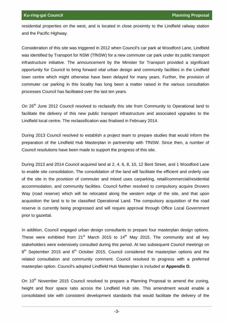
INTRODUCTION Overview
This Planning Proposal relates to land in Drovers Way, Woodford Lane, Beaconsfield Parade and
Bent St, Lindfield, referred to as the ‘Lindfield Hub site’ and illustrated in Figure1. All the land is in
Council ownership with the exception of Drovers Way whose acquisition is currently being
negotiated. All parcels of land comprising the Lindfield Hub site are classified as Operational
including the sites currently zoned RE1 Public Recreation at 1 Woodford Lane, 2, 4, 6, 8, 10, 12
Bent St, Lindfield. These sites became Operational at the time of their acquisition by Council.
Figure 1 – Lindfield Hub Site
-1-

Ku-ring-gai Council Planning Proposal The Planning Proposal seeks to amend the Ku-ring-gai Local Environmental Plan (Local Centres)
2012 (KLEP(LC)2012) to modify the zoning, height and FSR of the Lindfield Hub site. This will result
in the amendment of the KLEP(LC)2012 Zoning, Height, FSR, and Land Reservation Acquisition
Maps.
The proposed amendments will enable the implementation of Council’s adopted masterplan for the
Lindfield Hub site which has been the result of extensive investigation and community consultation
which commenced in 2012.
The Planning Proposal has been prepared in accordance with section 55 of the Environmental
Planning and Assessment Act 1979 (EP&A Act) and the relevant Department of Planning Guidelines
including ‘A Guide to Preparing Local Environmental Plans’ and ‘A Guide to Preparing Planning
Proposals’.
Land to which the Planning Proposal applies
This Planning Proposal relates to the Lindfield Hub site which comprises 24 parcels of land as
illustrated in Figure 1. Additional maps, including current development standards, are provided in
Part 4 – Mapping of this Planning Proposal.
The Lindfield Hub site is located west of the Pacific Highway within the Lindfield town centre. It is
bound by Bent Street to the north, Beaconsfield Parade to the south, Woodford Lane to the east,
and residential properties to the west. The site has good access to retail, commercial and transport
facilities and is surrounded by R4 High Density Residential land to its north and west, and B2 Local
Centres land to its east and south.
The land is currently utilised as a Council-owned car park serving the strip shops along the Pacific
Hwy. It is currently zoned B2 Local Centres for the bulk of the land, with RE1 Public Recreation to
six lots fronting Bent Street and Pacific Highway, and one lot at 2 Bent St being part R4 Residential
High Density, part RE1 Public Recreation and part SP2 Local Road under the KLEP(LC)2012. The
site has some biodiversity mapping but no riparian or heritage lands.
The total land area for the Lindfield Hub Site is 10551.51sqm including 3952.9sqm of land currently
zoned RE1 Public Recreation.
Background
The Lindfield Hub is a strategic urban site well placed to support and service Lindfield’s local
community and businesses. The site is situated between the Lindfield shops on the east and
-2-
Ku-ring-gai Council Planning Proposal residential properties on the west, and is located in close proximity to the Lindfield railway station
and the Pacific Highway.
Consideration of this site was triggered in 2012 when Council’s car park at Woodford Lane, Lindfield
was identified by Transport for NSW (TfNSW) for a new commuter car park under its public transport
infrastructure initiative. The announcement by the Minister for Transport provided a significant
opportunity for Council to bring forward vital urban design and community facilities in the Lindfield
town centre which might otherwise have been delayed for many years. Further, the provision of
commuter car parking in this locality has long been a matter raised in the various consultation
processes Council has facilitated over the last ten years.
On 26th June 2012 Council resolved to reclassify this site from Community to Operational land to
facilitate the delivery of this new public transport infrastructure and associated upgrades to the
Lindfield local centre. The reclassification was finalised in February 2014.
During 2013 Council resolved to establish a project team to prepare studies that would inform the
preparation of the Lindfield Hub Masterplan in partnership with TfNSW. Since then, a number of
Council resolutions have been made to support the progress of this site.
During 2013 and 2014 Council acquired land at 2, 4, 6, 8, 10, 12 Bent Street, and 1 Woodford Lane
to enable site consolidation. The consolidation of the land will facilitate the efficient and orderly use
of the site in the provision of commuter and mixed uses carparking, retail/commercial/residential
accommodation, and community facilities. Council further resolved to compulsory acquire Drovers
Way (road reserve) which will be relocated along the western edge of the site, and that upon
acquisition the land is to be classified Operational Land. The compulsory acquisition of the road
reserve is currently being progressed and will require approval through Office Local Government
prior to gazettal.
In addition, Council engaged urban design consultants to prepare four masterplan design options.
These were exhibited from 21st March 2015 to 14th May 2015. The community and all key
stakeholders were extensively consulted during this period. At two subsequent Council meetings on
8th September 2015 and 6th October 2015, Council considered the masterplan options and the
related consultation and community comment. Council resolved to progress with a preferred
masterplan option. Council’s adopted Lindfield Hub Masterplan is included at Appendix D.
On 10th November 2015 Council resolved to prepare a Planning Proposal to amend the zoning,
height and floor space ratio across the Lindfield Hub site. This amendment would enable a
consolidated site with consistent development standards that would facilitate the delivery of the
-3-

Ku-ring-gai Council Planning Proposal preferred and financially viable masterplan option that was adopted by Council. This Council report
is provided at Appendix B and the resolution is at Appendix C.
The adopted Lindfield Hub Masterplan consists of a mix of residential, commercial, retail, community
facility and recreational open space uses. The proposed maximum building height of 26.5m was
calculated to accommodate potential retail/commercial uses to the first two levels and to house
service over-runs on the top floors. The proposed height and FSR would enable a financially viable
development with the desired mix of uses, including the relocation of recreational open space which
is currently situated at 2-12 Bent St.
A Phase 1 Preliminary Site Investigation was conducted on the Lindfield Hub site. This determined
that the potential risk of contaminated soils was low across all potential sources of contamination,
with a medium potential risk of contamination in the case where any imported fill material might have
been introduced to the site. The investigation concluded that generally the site is suitable for the
intended redevelopment as the Lindfield Community Hub subject to a Phase 2 Detailed Site
Investigation being conducted. The Phase 2 investigation is currently being conducted to confirm
suitability for the proposed development, and should any contaminants be found, the extent of
remediation works necessary will be determined. The Phase 1 report is provided at Appendix F.
-4-

Ku-ring-gai Council Planning Proposal PART 1 – OBJECTIVE AND INTENDED OUTCOMES A statement of the objectives and intended outcomes of the proposed instrument
The Planning Proposal seeks approval for the amendment of the Ku-ring-gai Local Environmental
Plan (Local Centres) 2012 (KLEP(LC)2012) to modify the zoning, height and FSR of land parcels
within the Lindfield Hub site to facilitate the implementation of the Council adopted Lindfield Hub
Masterplan (Appendix D).
The Lindfield Hub site comprises the following properties and standards:
Address-Lot-DP EXISTING
Zoning Height FSR 1 Woodford Lane, Lindfield Lot A DP 445535 RE1 Public Recreation nil nil
2 Bent St, Lindfield Lot 9 DP 1090427 RE1 Public Recreation nil nil
4 Bent St, Lindfield Lot 10 DP 3498 RE1 Public Recreation nil nil
6 Bent St, Lindfield Lot 3 DP 667420 RE1 Public Recreation nil nil
8 Bent St, Lindfield Lot 1 DP 724823 RE1 Public Recreation nil nil
10 Bent St, Lindfield Lot 1 DP 980108 RE1 Public Recreation nil nil
12 Bent St, Lindfield Lot 5 DP 666521 (split zoning)
RE1 Public Recreation - 50m2
P Area 1 17.5m
Q Area 5 1.3:1 SP2 Local Road - 545m2
R4 High Density Residential - 490m2 1B Beaconsfield Parade, Lindfield Lot 1 DP 929131 B2 Local Centres L - 11.5m N - 1.0:1
19 Drovers Way, Lindfield Lot 1-16 DP 1099330 B2 Local Centres L - 11.5m N - 1.0:1
Drovers Way B2 Local Centres L - 11.5m N - 1.0:1 Woodford Lane (split heights)
Part road adjacent to 2 Bent St only B2 Local Centres nil N - 1.0:1
Remainder of road B2 Local Centres L - 11.5m N - 1.0:1
At present there is inconsistency in the zoning and development standards across the consolidated
site comprising the properties as listed in the above table. This prevents the delivery of a meaningful
development outcome that is able to accommodate the multiple facilities proposed through the
Council adopted masterplan for the site. The approved masterplan has been the result of extensive
investigation and community consultation which commenced in 2012.
This Planning Proposal will result in outcomes with both local and strategic benefit including the
following:
• ensuring the orderly and economic use of land within the Lindfield local centre;
-5-
Ku-ring-gai Council Planning Proposal • facilitating the progress of the Council approved masterplan for the site which will deliver the
TfNSW commuter carparking that triggered consideration of this site;
• enable consistent development standards across the entire consolidated Lindfield Hub site;
• improve the poor quality of the existing site through provision of retail, business, residential, open
space and carparking facilities that are characteristic and supportive of the Lindfield local centre;
• incorporate a low impact interface and transition to neighbouring R4 High Density Residential
sites by relocating Drovers Way to the western boundary of the site;
• enabling the existing R4 High Density Residential portion on 12 Bent St to be consolidated into
the adjacent R4 High Density Residential land on the neighbouring 14 Bent St by rationalising the
triple zoning (R4 High Density Residential, B2 Local Centres, RE1 Public Recreation) to a split
zoning (R4 High Density Residential and B2 Local Centres), with the remaining B2 Local Centres
land being consolidated into the Lindfield Hub site;
• removal of reservations from the KLEP(LC)2012 as all land is now in Council ownership, and the
open space will be relocated as proposed within the Council approved masterplan.
-6-

Ku-ring-gai Council Planning Proposal PART 2 – EXPLANATION OF PROVISIONS
This Planning Proposal seeks approval for the amendment of the Ku-ring-gai Local Environmental
Plan (Local Centres) 2012 (KLEP(LC)2012) to modify the following:
• Zoning, height and FSR of land parcels within the Lindfield Hub site.
The modification will allow the consolidation and consistency of development across the site in
accordance with Council’s approved masterplan seeking to deliver commuter carparking,
communal facilities including library and open park area, retail, business and residential facilities;
• Land reservations placed on certain lots within the Lindfield Hub site.
As Council has now acquired these sites for the intended reserved purposes identified in the LEP
there is no longer a requirement for the reservations to appear on the KLEP(LC)2012 Land
Reservation Acquisition Map.
It is proposed that these modifications be enabled by an amendment to the KLEP(LC)2012
Mapping. The modifications are stated below:
Amendments to Mapping
1. Modification to the Zoning Map
- to rezone the following sites to B2 Local Centre as listed below and illustrated in Part 4
Mapping of this Planning Proposal:
Address-Lot-DP ZONING Existing Proposed
1 Woodford Lane Lot A DP 445535 RE1 Public Recreation B2 Local Centre
2 Bent St Lot 9 DP 1090427 RE1 Public Recreation B2 Local Centre
4 Bent St, Lot 10 DP 3498 RE1 Public Recreation B2 Local Centre
6 Bent St Lot 3 DP 667420 RE1 Public Recreation B2 Local Centre
8 Bent St Lot 1 DP 724823 RE1 Public Recreation B2 Local Centre
10 Bent St Lot 1 DP 980108 RE1 Public Recreation B2 Local Centre
12 Bent St Lot 5 DP 666521 (split zoning)
RE1 Public Recreation - 50m2 B2 Local Centre SP2 Local Road - 545m2 B2 Local Centre R4 High Density Residential - 490m2 R4 - No change
-7-
Ku-ring-gai Council Planning Proposal
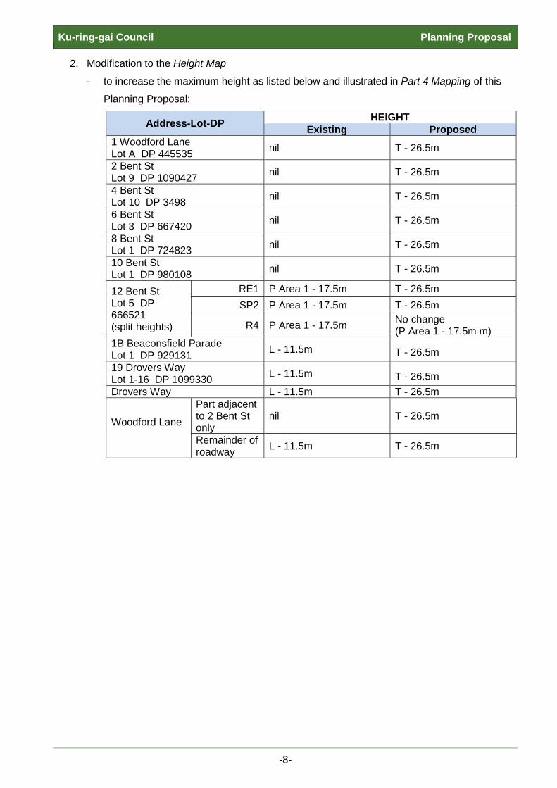
2. Modification to the Height Map
- to increase the maximum height as listed below and illustrated in Part 4 Mapping of this
Planning Proposal:
Address-Lot-DP HEIGHT Existing Proposed
1 Woodford Lane Lot A DP 445535 nil T - 26.5m
2 Bent St Lot 9 DP 1090427 nil T - 26.5m
4 Bent St Lot 10 DP 3498 nil T - 26.5m
6 Bent St Lot 3 DP 667420 nil T - 26.5m
8 Bent St Lot 1 DP 724823 nil T - 26.5m
10 Bent St Lot 1 DP 980108 nil T - 26.5m
12 Bent St Lot 5 DP 666521 (split heights)
RE1 P Area 1 - 17.5m T - 26.5m SP2 P Area 1 - 17.5m T - 26.5m
R4 P Area 1 - 17.5m No change (P Area 1 - 17.5m m)
1B Beaconsfield Parade Lot 1 DP 929131 L - 11.5m T - 26.5m 19 Drovers Way Lot 1-16 DP 1099330 L - 11.5m T - 26.5m Drovers Way L - 11.5m T - 26.5m
Woodford Lane
Part adjacent to 2 Bent St only
nil T - 26.5m
Remainder of roadway L - 11.5m T - 26.5m
-8-

Ku-ring-gai Council Planning Proposal
3. Modification to the Floor Space Ratio (FSR) Map
- to increase the FSR as listed below and illustrated in Part 4 Mapping of this Planning
Proposal:
4. Modification to the Land Reservation Acquisition Map
- to delete the reservation for Public Recreation (RE1), and reservation for Local Road
(SP2) applying to the land as listed below and illustrated in Part 4 Mapping of this
Planning Proposal:
Address-Lot-DP Land Reservation Existing Proposed
2-10 Bent Street Lot 9 DP 1090427 Lot 10 DP 3498 Lot 3 DP 667420 Lot 1 DP 724823 Lot 1 DP 980108
Local Open Space (RE1) None
1 Woodford Lane Lot A DP 445535 Local Open Space (RE1) None
12 Bent Street (part) Lot 5 DP 666521 Local Road (SP2) None
Address-Lot-DP FSR Existing Proposed
1 Woodford Lane Lot A DP 445535 nil Q - 1.3:1
2 Bent St Lot 9 DP 1090427 nil Q - 1.3:1
4 Bent St Lot 10 DP 3498 nil Q - 1.3:1
6 Bent St Lot 3 DP 667420 nil Q - 1.3:1
8 Bent St Lot 1 DP 724823 nil Q - 1.3:1
10 Bent St Lot 1 DP 980108 nil Q - 1.3:1
12 Bent St Lot 5 DP 666521 (split FSR)
RE1 Q Area 5 - 1.3:1 Q - 1.3:1 SP2 Q Area 5 - 1.3:1 Q - 1.3:1
R4 Q Area 5 - 1.3:1 No change (Q Area 5 - 1.3:1)
1B Beaconsfield Parade Lot 1 DP 929131 N - 1.0:1 Q - 1.3:1 19 Drovers Way Lot 1-16 DP 1099330 N - 1.0:1 Q - 1.3:1 Drovers Way N - 1.0:1 Q - 1.3:1 Woodford Lane N - 1.0:1 Q - 1.3:1
-9-

Ku-ring-gai Council Planning Proposal PART 3 - JUSTIFICATION
A. Need for the planning proposal
Q1. Is the planning proposal a result of any strategic study or report?
Yes, the Planning Proposal is the result of numerous studies and reports.
A significant amount of work has been undertaken to plan for the future of Lindfield. This
Planning Proposal is the direct result of multiple studies and reports to Council,
commencing in 2012, which have culminated in the Council approved Lindfield Hub
Masterplan whose delivery this Planning Proposal seeks to facilitate.
The amendments to the zoning, height and FSR of the Lindfield Hub site will enable the
coordinated and orderly use of land in accordance with planning strategies incorporated
into the KLEP(LC)2012 and the Local Centres Development Control Plan, including
development opportunities close to public transport. The amendments will facilitate the
delivery of Council’s approved Lindfield Hub Masterplan providing community facilities,
commuter and public carpark, retail and residential apartments, and recreational open
space, at this location.
Relevant strategic documents/reports prepared with relation to the proposal include:
• Council Reports 26th June 2012 and 30th July 2013
Reclassification of 1B Beaconsfield Parade and 19 Drovers Way, Lindfield
(Woodford Lane Car Park) to Operational Land.
12th November 2013; 24th June 2014; 21st April 2015
Acquisition of land at Bent St, Woodford Lane, Drovers Way
26th February 2013; 9th December 2014; 28th May 2013; 8th September 2015;
6th October 2015
Preparation and progress of Council’s approved Lindfield Hub Masterplan.
Initially, four options were prepared by consultants and exhibited (21st March to
14th May 2015). Local community and all key stakeholders were extensively
consulted. Council adopted a preferred masterplan option on 6th October 2015
which consisted of a mix of residential, commercial, retail and open space uses,
at a maximum height of seven storeys and a floor space ratio (FSR) of 1.3:1.
-10-

Ku-ring-gai Council Planning Proposal
10th November 2015
Council resolved that a Planning Proposal be prepared to amend zoning, height
and FSR to enable the progress of the adopted Lindfield Hub masterplan.
The 10th November 2015 Council Report may be viewed at Appendix B.
The 10th November 2015 Council Resolutions may be viewed at Appendix C.
• Ku-ring-gai Community Facilities Strategy, March 2014, Elton Consulting
The Ku-ring-gai Community Facilities Strategy provided a framework for the future
provision of community facilities within the local government area. Development of
this strategy included a review of existing Council-owned community facilities and
identification of provision gaps. The review and analysis determined that while Ku-
ring-gai has a high number of community facilities, many of these are smaller, older
facilities that are not built for the purpose they are used for; and, they are not easily
adapted to the changing needs of the community. In particular, this Strategy
identified the need for a larger, centrally located library and a multi-purpose
community centre in Lindfield.
• Lindfield Community Facilities Study, April 2014, Elton Consulting
The Lindfield Community Facilities Study prepared an audit of the existing
community facilities in Lindfield. The Study found that both of Council’s facilities
required replacement. The report recommended development of a community hub
consisting of a co-located library and multipurpose community facility, together with
other land-uses, west of the Lindfield local centre on the Woodford Lane/Lindfield
Hub site.
• Lindfield Local Centre Transport Network Model Study, 2013/14, Peopletrans; and, Supplementary Report, 2015/16, Peopletrans
Transport consultants, Peopletrans, were commissioned by Ku-ring-gai Council in
late 2013, and again during 2015, to undertake the Lindfield Transport Network
Model Study, the key objectives of which were as follows:
• To determine, in traffic terms, an acceptable land use scale and mix for the
Lindfield Community Hub site, of the Pacific Highway such that Ku-ring-gai
Council could appoint an Urban Design Consultant to provide more clarity and
detail around the built form for this site.
-11-

Ku-ring-gai Council Planning Proposal
• To develop a transport solution which supports the preferred land use options
for the Council owned car park and library sites, and which also
accommodates the future anticipated development of the wider Lindfield local
centre.
A number of land use options were analysed utilising the functionality of the
nanosimulation transport model, to determine the existing and future road network
operation of Lindfield. Traffic Management Options were developed to support these
future increases in land use without impacting detrimentally on the operation of the
Lindfield road and transport network. These traffic management options were tested
against the various land use options to come up with a preferred transport scheme.
Ku-ring-gai Council staff and their transport consultants met with Roads and
Maritime Services (RMS) Network & Road Safety and Transport Management
Centre staff in late 2015, to present the findings of the Lindfield Network Model
Study and to get in-principle agreement on the proposed traffic management plan
for Lindfield. At this meeting all traffic & transport reports and the commuter traffic
models were provided electronically to RMS for their information and review as
required. The preferred transport scheme is still the subject of ongoing discussions
between Ku-ring-gai Council and RMS.
The two Peopletrans reports may be viewed at Appendix E.
• Economic Feasibility Assessment, 2013-2016, Jones Lang LaSalle (JLL)
During 2013 to 2016 a series of feasibility analyses were conducted by JLL. The
studies determined that only two out of the four masterplan options would be viable.
One viable option solely comprised residential development and provided no
community benefit or direct connections to the Lindfield local centre. The other
viable option was found to result in a ‘break-even’ development and comprised of
seven storey development accommodating a mix of retail/commercial/residential
uses that would support the viability of the community facilities (library, open spaces,
childcare). This option eventuated into the Council approved masterplan.
• Lindfield Hub Masterplan, 2014-2016, SJB Architects
In late 2014, urban design and landscape consultants, SJB Architects, were
engaged via a competitive tendering process to prepare four master plan options for
-12-

Ku-ring-gai Council Planning Proposal
the Lindfield Hub site; the options were exhibited between 21st March 2015 and 14th
May 2015. The community and all key stakeholders were extensively consulted
during this period. At the 11th November 2014 Council meeting, Council adopted a
set of evaluation criteria for the assessment of the development options to ensure
the transparency of Council’s decision-making process.
The preferred masterplan option for the Lindfield Hub site was selected based on
the assessment against the evaluation criteria and the results of extensive
community consultation, including feasibility studies and market sounding. The
preferred masterplan option was adopted at the Council meeting of 6th October
2015.
The 6th October 2015 resolution adopted a set of mandatory requirements for the
project, including the following elements:
• construction of a community hub building, with total area 3,000sqm, comprising a
café, new branch library, community centre and child care centre;
• public park of a minimum consolidated area of 3,000sqm, with deep soil and tree
planting on the perimeter;
• public plaza comprising a minimum area of 1,000sqm;
• minimum of 167 public car parking spaces accommodated within basement
levels;
• up to 140 commuter car parking spaces, funded by TFNSW, accommodated
within basement levels;
• Up to 5,000sqm of retail floor space including a supermarket with a minimum size
of 3,000sqm;
• up to 95 residential apartments;
• streetscape upgrade works to Bent Lane, Bent Street, Woodford Lane,
Beaconsfield Parade;
• road works to Bent Lane and Woodford Lane;
• relocation of Drovers Way to connect Bent Street and Beaconsfield Parade;
• construction of a new kiss & ride zone on Woodford Lane to support rail usage;
• modifications to traffic signals works at the intersections of Tryon Place/Pacific
Highway & Balfour Street/Pacific Highway; and
• installation of new traffic signals at intersection of Beaconsfield Parade and
Pacific Highway.
• a civic frontage to Bent Street, a built frontage to Drovers Way, public space
frontage to Woodford Lane, residential frontage to Beaconsfield Parade, active
retail/commercial frontage to a new public square and open space;
-13-

Ku-ring-gai Council Planning Proposal
• improved connection between new and existing retail/commercial areas and
Lindfield train station and Pacific Highway bus routes.
The adopted masterplan was revised to include Council’s amendments. This was
completed in March 2016 and may be viewed at Appendix D.
• Community Engagement Outcomes Report, 2015, CRED
Consultants, CRED, were engaged by Ku-ring-gai Council to direct and analyse the
extensive consultation carried out with community and key stakeholders including
surveys and submissions on the masterplan options.
• Market Sounding Report, 2015, Property Based Solutions (PBS)
Market sounding was conducted by consultants Property Based Solutions (PBS) to
gauge interest in the project from private sector parties. The market sounding
process was carried out via a series of face to face and telephone interviews with a
representative selection of the development industry and companies of varying
financial resources and track records. The results of the market sounding process
were positive; the companies endorsed the location, mixed-use nature of the
development concept, and the engagement process with the private sector.
• Hornsby and Ku-ring-gai Subregional Employment Study, 2008, SGS Economics and Planning
This study was based on the population projections under the Metropolitan Strategy
2036 for the North Subregion and therefore formed the basis for future growth in
housing and employment currently accommodated for in the KLEP(LC)2012 and
KLEP 2015. The study informed the zoning and planning controls for Ku-ring-gai’s
commercial centres. The Study presents strategies that
• ensure local employment land strategies facilitate opportunities for the
subregional employment targets for the North Subregion;
• ensure that the distribution of additional jobs supports existing centres;
• identify opportunities to provide employment lands in accordance with the
strategic areas identified in the Metropolitan Strategy, including ‘Economy and
Employment’;
• develop a strategy for zoning, land use and controls for employment lands that is
consistent with current strategic planning guidance;
-14-
Ku-ring-gai Council Planning Proposal
• develop a strategy for the provision of employment lands to encourage economic
growth to complement population growth;
• identify employment lands in strategic areas that are accessible to residents and
workers and are linked into the transport network.
This study is still relevant and valid as there has been very limited growth and
development within the retail centres since the study was completed.
• Phase 1 Preliminary Site Investigation, Lindfield Community Hub, Lindfield NSW. ADE Consulting Group. 2016
A. D. Envirotech Australia Pty Ltd (ADE) was engaged to undertake a Phase 1
Preliminary Site Investigation to assess the potential for contamination at the
proposed Lindfield Hub site. The study comprised the following:
• desktop site review of
- Land title records;
- Section 149 certificates;
- WorkCover NSW;
- NSW Environment and Heritage;
- EPA contaminated lands register for notations; and
- Dial Before You Dig service search.
• review of past and current activities on the site;
• review of past and current activities on neighbouring sites and identification of
any potential onsite/off-site sources of contamination;
• review of past aerial photographs of the site and its surrounds to identify the
locations of any previous buildings and/or other infrastructure associated with
activities that could be on-site/offsite sources of contamination;
• review of local geology and hydrogeology (including groundwater bore search);
• site inspection by an experienced environmental consultant; and
• preparation of a Phase 1 PSI report outlining:
- detailed information on the results of the desktop review and site inspection;
- conclusions regarding the potential for contamination at the site;
- conclusions regarding the site’s suitability for the proposed development; and
- recommendations for a Phase II Detailed Site Investigation (DSI).
The Phase 1 Preliminary Site Investigation determined that the potential risk of
contaminated soils was low across all potential sources of contamination, with a
-15-
Ku-ring-gai Council Planning Proposal
medium potential risk of contamination in the case where any imported fill material
might have been introduced to the site. The investigation concluded that generally
the site is suitable for the intended redevelopment as the Lindfield Community Hub
subject to a Phase 2 Detailed Site Investigation being conducted. The Phase 2
investigation is currently being conducted to confirm suitability for the proposed
development, and should any contaminants be found, the extent of remediation
works necessary will be determined by that study. The Phase 1 report is provided at
Appendix F.
-16-

Ku-ring-gai Council Planning Proposal
Q2. Is the planning proposal the best means of achieving the objectives or intended outcomes, or is there a better way?
Yes, the Planning Proposal is the best means of achieving the objectives or intended
outcomes for the Lindfield Hub site.
The current varied zoning and development standards across the site prevent it from
being treated as one consolidated parcel of land, and hence does not facilitate the
orderly and economic use of the site as proposed through the Council approved Lindfield
Hub Masterplan which seeks to deliver a viable high quality local centre precinct.
Consistent standards and increased height and FSR to the site will facilitate the
provision of community facilities and a retail/commercial area that supports the local
centre, and residential development that both positions dwellings close to the Lindfield
road and rail transport nodes and enables the viability of facilities that will benefit the
greater community.
A Planning Proposal for the site is therefore considered appropriate.
B. Relationship to strategic planning framework
Q3. Is the planning proposal consistent with the objectives and actions of the applicable regional or sub-regional strategy (including the Sydney Metropolitan Strategy and exhibited draft strategies)?
Yes. The Planning Proposal is consistent with the NSW State Government’s A Plan for
Growing Sydney (the Sydney metropolitan strategy).
The plan for the North District has not yet been released. In its absence, the key
directives relevant to local centres within Ku-ring-gai, as identified in the Plan for
Growing Sydney indicate that economic growth should be concentrated in town centres.
The subject site forms part of the Lindfield local centre and as such is consistent with this
objective as the proposal will support and contribute to the local centre character and
support adjacent retail/commercial uses through augmenting the retail/commercial area.
Further, it will provide community facilities, additional housing, and both commuter and
public carparking.
A Plan for Growing Sydney was released by the NSW Department of Planning and
Environment in December 2014 and is the NSW Government’s 20-year plan for the
Sydney Metropolitan Area. It provides direction for Sydney’s productivity, environmental
-17-

Ku-ring-gai Council Planning Proposal
management, and liveability; and for the location of housing, employment, infrastructure
and open space.
The Plan includes four goals for Sydney. This Planning Proposal supports each goal as
follows:
• Goal 1: A competitive economy with world-class services and transport
The Planning Proposal will allow the redevelopment of a site which is located near the
Lindfield Railway Station. The proposal will facilitate Council’s adopted masterplan for
the Lindfield Hub site and allow the co-location of services and commuter carparking
close to public transport infrastructure which promotes the use of rail travel. The
Planning Proposal also assists Council in realising financial gains from increasing the
utility of an underdeveloped site and rationalising of Council services including the
transfer of the outdated Lindfield Library to this site.
• Goal 2: A city of housing choice with homes that meet our needs and lifestyles
Changes resulting from the Planning Proposal will allow the increase in supply and
choice of housing in Lindfield. The location of the future housing will be in proximity to
transport and town centre facilities.
• Goal 3: A great place to live with communities that are strong, healthy and well
connected
Adding new community facilities, increased retail/commercial and residential density
into an existing centre will facilitate the strengthening of that centre. Realisation of
Council’s adopted Lindfield Hub Masterplan will enable the growth of the local
community within Lindfield in close proximity to the Lindfield railway station and assist
in supporting the goal for a well-connected place to live.
• Goal 4: A sustainable and resilient city that protects the natural environment and has
a balanced approach to the use of land and resources.
The Planning Proposal will allow the reasonable redevelopment of an existing, well-
located site. Moreover, increasing facilities (including public and commuter parking)
and residential accommodation near a railway station will promote sustainable living
through the use of local services and public transport. This is an efficient use of
resources in a well-serviced locality.
A Plan for Growing Sydney states three planning principles that will guide how Sydney
grows. This Planning Proposal supports two of the three principles as follows:
-18-

Ku-ring-gai Council Planning Proposal
• Principle 1: Increasing housing choice around all centres through urban renewal in
established areas
The Planning Proposal will allow the site, currently underdeveloped, to be
redeveloped to include new residential development which both benefits from, and
contributes to, the provision of the proposed community and retail/commercial
facilities in an established area within the local centre.
• Principle 3: Connecting centres with a networked transport system
The Lindfield town centre is already well connected to a networked transport system;
however, allowing more people to live in the locality, as proposed in the adopted
Lindfield Hub Masterplan, further connects people with the transport system.
Likewise, providing community facilities and retail/commercial areas close to transport
links will enable ease of travel to/from places of work on the Lindfield Hub site.
A Plan for Growing Sydney aims to create more vibrant places and revitalised suburbs
where people want to live. The State Government recognises that as the population
grows in existing suburbs, there is an opportunity to revitalise local communities by
providing more social infrastructure.
The Planning Proposal, in conjunction with the KLEP(LC)2012 will allow the site to be
developed for residential and business development in an area that has excellent access
to public transport. It will facilitate the provision of improved social infrastructure in
conjunction with the enhancement and revitalisation of the local centre.
As discussed above, the Planning Proposal is consistent with the goals and principles
contained within A Plan for Growing Sydney.
Q4. Is the planning proposal consistent with a council’s local strategy or other local strategic plan?
Yes. This Planning Proposal is consistent with the outcomes stated under the six themes
of the Ku-ring-gai Council Community Strategic Plan 2030. The themes seek to provide
for a sustainable environment for Ku-ring-gai’s future. This Planning Proposal supports
each theme as follows:
1. Community, People and Culture
Under the Community, People and Culture theme, the proposed rezoning and
increase in height and FSR will assist meeting the aim to make Council’s community
-19-
Ku-ring-gai Council Planning Proposal
and cultural programs and services accessible, affordable and meet current and
match emerging needs.
2. Natural Environment
Under the Natural Environment theme, the Planning Proposal will assist in the aim
of respecting and actively participating in the care and management of the
environment. The site is currently underutilised as a car park, and the potential
future development of the site will identify elements of the natural environment that
can be maintained or offset. This will be considered in detail during the Development
Application process.
3. Places, Spaces and Infrastructure
Under the Places, Spaces and Infrastructure theme, the proposed redevelopment of
the site as per Council’s adopted Lindfield Hub Masterplan, will assist in the aim of
achieving a well planned, quality neighbourhood and public space with a strong
character through the provision of community, retail/commercial and residential
accommodation. In particular, the Planning Proposal supports the long-term
objective stated under Issue P4 – Revitalisation of our Centres:
P4.1 Our centres offer a broad range of shops and services and contain lively
urban village spaces and places where people can live, work, shop, meet and
spend leisure time.
4. Access, Traffic and Transport
Under the Access, Traffic and Transport theme, the Planning Proposal will support
the aim that access and connection in and around Ku-ring-gai is effective. This
Planning Proposal seeks to facilitate the revitalisation of an under-utilised part of the
Lindfield local centre having regard to its proximity to public transport. In particular,
the proposed carparking facilities will ensure local parking to both support the
development on this consolidated site and existing neighbouring retail fronting
Pacific Hwy. In addition, the provision of commuter parking, funded by TfNSW will
improve usability of the local Lindfield railway station. The consolidation of zoning
and standards across the site will also facilitate the relocation of Drovers Way to
improve access into the site as indicated in the Council approved Lindfield Hub
Masterplan.
5. Local Economy and Employment
Under the Local Economy and Employment theme, the redevelopment of the site,
as per the adopted Lindfield Hub Masterplan, will assist in achieving Council’s aims
-20-
Ku-ring-gai Council Planning Proposal
by promoting employment opportunities in new community facilities and new
retail/commercial areas. The mix of uses will facilitate a vital and attractive location
for business investment and new employment.
6. Leadership and Governance
Under the Leadership and Governance theme, the proposed redevelopment will
assist in meeting the aim that Council effectively manages its financial position to
meet community expectations for projects and service delivery. The changes
proposed in this Planning Proposal will assist Council in the delivery of strategic
projects and facilities in the local centre.
In addition to consistency with the Ku-ring-gai Council Community Strategic Plan 2030,
this Planning Proposal is consistent with the Ku-ring-gai Sustainability Vision 2008-2033
which forms the foundation of Council's sustainability plan spanning 25 years. One of the
vision statements in the report is to create a “creative and liveable” Ku-ring-gai. The
Planning Proposal is consistent with the vision report in that the redevelopment of the
underutilised land in this strategic location will enable the new mix of development and
the addition of general and new commuter parking as indicated in Council’s approved
Lindfield Hub Masterplan.
The Ku-ring-gai Integrated Transport Strategy, July 2011 presents a vision for Ku-ring-
gai’s transport to 2020 and assigns plans and aims to short (5 years) and long term (10
years) time frames. The Strategy recognises that “…strategies for transport need to be
considered within a holistic context where transport is inherently linked to land use, the
built form, air quality, health and energy emissions.” (p.1). This Planning Proposal is not
inconsistent with the objectives of the strategy.
-21-

Ku-ring-gai Council Planning Proposal
Q5. Is the planning proposal consistent with applicable State Environmental Planning Policies?
The following table identifies the key applicable SEPPs and outlines this Planning
Proposal’s consistency with those SEPPs. A checklist of compliance with all SEPPs is
contained at Appendix A.
SEPP Comment on Consistency
SEPP 19 Bushland in Urban Areas When preparing draft local environmental plans for any land to which SEPP 19 applies, other than rural land, the council shall have regard to the general and specific aims of the Policy, and give priority to retaining bushland, unless it is satisfied that significant environmental, economic or social benefits will arise which outweigh the value of the bushland.
Consistent.
Whilst the site includes a tract of biodiversity mapping, SEPP 19 does not apply to this vegetation as it does not meet the SEPP 19 bushland definition. The site is lacking in a native understory and as such does not contain characteristic native species in all structural layers.
SEPP 32 Urban Consolidation (Redevelopment of Urban Land) This SEPP aims to promote orderly and economic use of land by enabling redevelopment for multi-unit housing where public infrastructure, transport and community facilities exist. It ensures that land for multi-unit housing is available and that redevelopment results in increased housing availability and diversity.
Consistent.
The Planning Proposal facilitates urban consolidation by increasing the amount of land available for redevelopment in the existing Lindfield urban area close to transport.
SEPP 55 Remediation of Land SEPP 55 requires a planning authority to give consideration to contamination issues when rezoning land which allows a change of use that may increase the risk to health or the environment from contamination and requires consideration of a report on a preliminary investigation where a rezoning allows a change of use that may increase the risk to health or the environment from contamination.
Consistent.
A Phase 1 and Phase 2 Site Investigations were prepared for the site for TfNSW in 2012 as part of the investigations for the development of a multi-storey commuter car park. The investigations concluded that the site could be made suitable for that particular land use and further assessment and management/remediation (if warranted) should be conducted if any asbestos or chemically contaminated soil is encountered during excavation for the proposed works. Council has conducted a Phase 1 Preliminary Site Investigation which determined that the potential risk of contaminated soils was low across all potential sources of contamination, with a medium potential risk of contamination in the case where any imported fill material might have been introduced to the site. The investigation concluded that generally the site is suitable for the intended redevelopment as the Lindfield Community Hub subject to a Phase 2 Detailed Site Investigation being conducted. The Phase 2 investigation is currently being conducted to confirm suitability for the proposed development, and should any contaminants be found, the extent of remediation works necessary will be determined by that study. The Phase 1 report is provided at Appendix F.
-22-
Ku-ring-gai Council Planning Proposal
SREPP Comment on Consistency
SYDNEY REP (Sydney Harbour Catchment) 2005 The SREP aims to establish a balance between promoting a prosperous working harbour, maintaining a healthy and sustainable waterway environment and promoting recreational access to the foreshore and waterways. It establishes planning principles and controls for the catchment as a whole.
Consistent.
At the time of any Development Application, all development will be required to manage drainage and stormwater arising from the development.
In summary, it is considered that this Planning Proposal is not inconsistent with any of
the above SEPPs. The proposal’s detailed compliance and consistency with the above
SEPPs would be determined during the assessment of any Development Application for
the site.
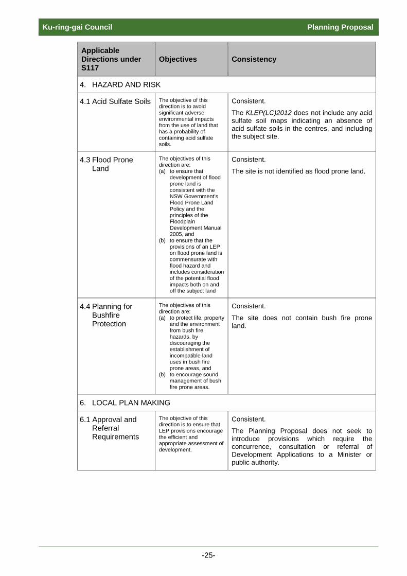
Q6. Is the planning proposal consistent with applicable Ministerial Directions (s.117 directions)?
The following table identifies applicable Section 117 Directions and outlines this Planning
Proposal’s consistency with those Directions. A checklist of compliance with all Section
117 Directions is contained at Appendix A.
Applicable Directions under S117
Objectives Consistency
1. EMPLOYMENT AND RESOURCES
1.1 Business and Industrial Zones
The objectives of this direction are to: (a) Encourage
employment growth in suitable locations,
(b) protect employment land in business and industrial zones, and support the viability of identified strategic centres.
Consistent.
The Planning Proposal will allow the Lindfield Hub site to be redeveloped in a way that will encourage employment growth within the local centre. The proposed new supermarket, shops, businesses and community facilities that will become viable through this Planning Proposal will generate new employment in close proximity to existing road and rail links.
2. ENVIRONMENT AND HERITAGE
2.1 Environment Protection Zones
The objective of this direction is to protect and conserve environmentally sensitive areas.
Consistent.
The site is not zoned environmental protection and does not include environmentally sensitive land.
2.3 Heritage Conservation
The objective of this direction is to conserve items, areas, objects and places of environmental Heritage significance and indigenous heritage significance.
Consistent.
The site does not contain nor does it adjoin any items of local or State heritage significance.
-23-
Ku-ring-gai Council Planning Proposal
Applicable Directions under S117
Objectives Consistency
3. HOUSING, INFRASTRUCTURE AND URBAN DEVELOPMENT
3.1 Residential Zones
The objectives of this direction are: (a) to encourage a variety
and choice of housing types to provide for existing and future housing needs,
(b) to make efficient use of existing infrastructure and services and ensure that new housing has appropriate access to infrastructure and services, and
(c) to minimise the impact of residential development on the environment and resource lands.
Consistent.
The Planning Proposal will result in additional residential dwellings being provided on this site. Further to this, the Planning Proposal will be consistent with the objectives of this Direction as explained below: - the proposal seeks to increase the
permissible residential density of the site; - the site will make more efficient use of
existing infrastructure and services associated with the local centre, such as the nearby Lindfield train station existing and new retail area and community facilities.
The Planning Proposal seeks to facilitate the Council adopted Lindfield Hub Masterplan which encourages housing choice in the Lindfield local centre that makes efficient use of existing infrastructure and is not likely to result in development that will unreasonably impact on the environment.
3.4 Integrating Land Use and Transport
The objective of this direction is to ensure that urban structures, building forms, land use locations, development designs, subdivision and street layouts achieve the following planning objectives: (a) improving access to
housing, jobs and services by walking, cycling and public transport, and
(b) increasing the choice of available transport and reducing dependence on cars, and
(c) reducing travel demand including the number of trips generated by development and the distances travelled, especially by car, and
(d) supporting the efficient and viable operation of public transport services, and
(e) providing for the efficient movement of freight.
Consistent.
The site is located within an established residential and retail area that has excellent access to existing public transport infrastructure, including Lindfield train station and local bus routes which supports the reduced reliance on car usage for both residents and employees within the proposed Lindfield Hub development that this Planning Proposal seeks to facilitate. The Planning Proposal will enable a consolidated development on the site and provide retail, community and residential facilities which will increase local employment in the vicinity where there is an established rail and bus network. The proposal facilitates support reduced travel demand by co-locating employment and residential uses that may enable local accommodation of workers within the Ku-ring-gai area. The proposed uses will provide highly accessible facilities for local pedestrians as well as those using public transport or private vehicles. The integration of commuter parking onsite will facilitate the reduction of car use and support the use of public transport.
-24-
Ku-ring-gai Council Planning Proposal
Applicable Directions under S117
Objectives Consistency
4. HAZARD AND RISK
4.1 Acid Sulfate Soils The objective of this direction is to avoid significant adverse environmental impacts from the use of land that has a probability of containing acid sulfate soils.
Consistent.
The KLEP(LC)2012 does not include any acid sulfate soil maps indicating an absence of acid sulfate soils in the centres, and including the subject site.
4.3 Flood Prone Land
The objectives of this direction are: (a) to ensure that
development of flood prone land is consistent with the NSW Government’s Flood Prone Land Policy and the principles of the Floodplain Development Manual 2005, and
(b) to ensure that the provisions of an LEP on flood prone land is commensurate with flood hazard and includes consideration of the potential flood impacts both on and off the subject land
Consistent.
The site is not identified as flood prone land.
4.4 Planning for Bushfire Protection
The objectives of this direction are: (a) to protect life, property
and the environment from bush fire hazards, by discouraging the establishment of incompatible land uses in bush fire prone areas, and
(b) to encourage sound management of bush fire prone areas.
Consistent.
The site does not contain bush fire prone land.
6. LOCAL PLAN MAKING
6.1 Approval and Referral Requirements
The objective of this direction is to ensure that LEP provisions encourage the efficient and appropriate assessment of development.
Consistent.
The Planning Proposal does not seek to introduce provisions which require the concurrence, consultation or referral of Development Applications to a Minister or public authority.
-25-

Ku-ring-gai Council Planning Proposal
6.2 Reserving Land for Public Purposes
The objectives of this direction are: 1. to facilitate the
provision of public services and facilities by reserving land for public purposes, and
(b) to facilitate the removal of reservations of land for public purposes where the land is no longer required for acquisition.
Consistent
The proposed seeks to remove the reservations for local road and local open space currently applying to 2-12 Bent Street. As Council has now acquired these sites for the intended reserved purposes identified in the LEP there is no longer a requirement for the reservations to appear on the KLEP (LC) 2012 Land Reservation Acquisition Map. Further to this, this Planning Proposal also seeks to rezone 2-12 Bent St from RE1 Public recreation to B2 Local Centre. The quantum of recreational open space that was to be provided at 2-12 Bent Street will now be relocated elsewhere on the site as indicated within the Council approved Lindfield Hub Masterplan at Appendix D. Council has resolved to compulsory acquire Drovers Way (road reserve) which will be relocated along the western edge of the site, and that upon acquisition the land is to be classified Operational Land. The compulsory acquisition of the road reserve is currently being progressed and will require approval through Office Local Government prior to gazettal.
6.3 Site Specific Provisions
The objective of this direction is to discourage unnecessarily restrictive site specific planning controls.
Consistent
Consistent. The proposal does not contain any restrictive site specific planning controls.
7. METROPOLITAN PLANNING
7.1 Implementation of the Metropolitan Strategy
The objective of this direction is to give legal effect to the vision, land use strategy, policies, outcomes and actions contained in the Metropolitan Strategy.
Consistent.
The Planning Proposal, in conjunction with the KLEP(LC)2012 will allow the site to be developed for retail, community, residential and business development in an area that has excellent access to public transport. It will facilitate the provision of improved social infrastructure in conjunction with the enhancement and revitalisation of the local centre. The Planning Proposal is consistent with the goals and principles contained within A Plan for Growing Sydney.
Should the Planning Proposal be supported at the Gateway Determination, further
details on consistency with Ministerial Directions will be provided following consultation
with the relevant public and private authorities.
-26-

Ku-ring-gai Council Planning Proposal C. Environmental, social and economic impact
Q7. Is there any likelihood that critical habitat or threatened species, populations or ecological communities, or their habitats, will be adversely affected as a result of the proposal?
There is no identified critical habitat that will be adversely affected by this Planning
Proposal. A number of threatened species may potentially occur within the Lindfield Hub
site including Glossy Black-Cockatoo (Calyptorhynchus lathami), Little Lorikeet
(Glossopsitta pusilla), Grey-headed Flying-fox (Pteropus poliocephalus), Fork-tailed
Swift (Apus pacificus), White-throated Needletail (Hirundapus caudacutus), Rainbow
Bee-eater (Merops ornatus), Black-faced Monarch (Monarcha melanopsis) and the
Powerful Owl (Ninox strenua), however, there are no recorded sightings of any such
species. Due to the small size of the habitat and the high level of disturbance on the site,
the on-site habitat consists of occasional foraging resources only. Resources include
possums and rats, winter flowering eucalypts (eg. Eucalyptus paniculata) and a fig tree.
It is noted however that the proposal is unlikely to impact on the local population of
possums or rats and that numerous Eucalypts and one other Fig Tree was recorded
outside of the Lindfield Hub area, ensuring that alternative foraging resources are still
provided.
This Planning Proposal will result in the removal of approximately 0.216 hectares of
Sydney Turpentine Ironbark Forest. The on-site vegetation consists of adult native
canopy trees with an understory of exotic ground cover and a shrub layer that is largely
non-existent, apart from approximately two native shrubs adjacent to the existing
carpark. The Sydney Turpentine Ironbark Forest on site is considered to be below the
condition thresholds for protection under the Environment Protection and Biodiversity
Conservation Act 1999.
Assessment of impacts and the associated offset strategy for the removal of Sydney
Turpentine Ironbark Forest and threatened species habitat on the site is to be addressed
through the submission of a section 91 licence application (under the Threatened
Species Conservation Act 1995, administered by The Office of Environment and
Heritage (OEH)). The section 91 licence application assesses the proposed action to
determine the likely impact on threatened species in accordance with the Environmental
Planning and Assessment Act 1979. All applications are placed on the OEH online
section 91 public register.
-27-

Ku-ring-gai Council Planning Proposal
Q8. Are there any other likely environmental effects as a result of the planning proposal and how are they proposed to be managed?
Any effects to the environment as a result of the Planning Proposal will be managed
through the inclusion of environmentally sensitive design as proposed in the Council
approved Lindfield Hub Masterplan, including water sensitive urban design and building
design to achieve a 6-star Greenstar rating. Further impacts relating to construction,
such as sedimentation, traffic and construction noise, will be addressed at the
Development Application stage.
Q9. Has the planning proposal adequately addressed any social and economic effects?
Yes, this planning proposal has adequately addressed the resultant social and economic
effects.
This Planning Proposal will result in positive social and economic outcomes by providing
a more orderly and economic development of the site. The proposal seeks to revitalise
the western portion of the Lindfield local centre through facilitating new uses which will
provide both social and economic benefit by providing the following:
• increased employment opportunities via new retail and community facilities;
• improved local services and facilities for local residents and visitors with
associated onsite parking;
• improved parking that will facilitate easy access and use of the existing town
centre businesses fronting Pacific Highway;
• new commuter parking to enable better access and encourage the use of public
transport.
Council has the responsibility to renew its assets to ensure continued provision of
services to the local community. To assist in managing its assets, Council commissioned
the Lindfield Community Facilities Study (2014). The Study considered the current
provision of library and community facilities in the Lindfield locality and identified issues
such as inadequate size and poor design. The Study nominated the location of a new
community hub in the western side of the Lindfield town centre, incorporating a library
and community centre with other uses such as café and an outdoor space. The Council
approved Lindfield Hub Masterplan seeks to provide the uses identified in the Study. The
masterplan includes the delivery of Council services in an integrated, vibrant,
development providing up to date facilities. The social effects resulting from this Planning
Proposal will be very positive for both the local residents and visitors to the Lindfield
centre.
-28-
Ku-ring-gai Council Planning Proposal
The Lindfield Hub site urban design and feasibility studies conducted, by SJB and JLL,
as outlined in Part A of this Planning Proposal, have resulted in Council’s adopted
Lindfield Hub Masterplan which will be facilitated by this Planning Proposal. The
masterplan seeks to deliver a positive economic impact by ensuring the orderly and
economic development of the site including the introduction of new community facilities
and retail/commercial areas that will generate additional employment in this locality. The
Planning Proposal will result in positive economic outcomes for the area. The Lindfield
Hub Masterplan may be viewed at Appendix D.
D. State and Commonwealth interests
Q10. Is there adequate public infrastructure for the planning proposal?
The Planning Proposal may result in a minor increase in demand for facilities in an
existing urban area where all utility services are available. Consultation with key
agencies about the capacity to service the site has not been undertaken prior to
submitting this Planning Proposal to the Department of Planning and Environment.
Consultation with State and Commonwealth agencies will be undertaken upon Gateway
Determination and be in accordance with Section 5 of this Planning Proposal.
In terms of transport and infrastructure, traffic modelling has been undertaken for the
Lindfield Hub site by transport consultants, Peopletrans. This study sought to determine
an acceptable land use, scale and mix for the site and develop a transport solution which
would both support the preferred land use options and accommodate the future
anticipated development of the wider Lindfield local centre. In late 2015 Ku-ring-gai
Council staff and Peopletrans met with Roads and Maritime Services Network & Road
Safety and Transport Management Centre staff (RMS), to present the findings of the
Lindfield Network Model Study and to get in-principle agreement on the proposed traffic
management plan for Lindfield. The preferred transport scheme is still the subject of
ongoing discussions between Ku-ring-gai Council and RMS. The Traffic studies may be
viewed at Appendix E.
The Council approved Lindfield Hub Masterplan proposes the provision of basement
levels to accommodate parking for the retail/commercial and residential uses, and
commuter carparking that will be funded by TfNSW. The parking provision seeks to
accommodate both local and wider needs associated with the development of the
Lindfield Hub site and with its proximity to the Lindfield rail link. In addition, the
Masterplan seeks to relocate Drovers Way to the western edge of the site to facilitate
-29-

Ku-ring-gai Council Planning Proposal
improved circulation around and into the site. The Masterplan may be viewed at
Appendix D.
Q11. What are the views of state and Commonwealth public authorities consulted in accordance with the Gateway determination?
At this stage, the appropriate State and Commonwealth public authorities have not been
identified or consulted, and the Gateway Determination has yet to be issued by the
Minister for Planning and Infrastructure. Consultation with the following Government
authorities, agencies and other stakeholders are proposed:
• Roads and Maritime Services NSW
• Office of Environment and Heritage
• Transport for NSW
• Sydney Water
• Ausgrid
• Energy Australia
Council seeks confirmation of the above list and any other addition through the Gateway
Determination.
-30-
Ku-ring-gai Council Planning Proposal PART 4 - MAPPING Maps, where relevant, to identify the intent of the planning proposal and the area to which it applies
The amendments sought in this Planning Proposal will require changes to the KLEP(Local Centres)
2012 mapping sheets.
Indicative maps are included in this section and show excerpts of the site with its current mapping
alongside its proposed mapping.
Amendments to the following KLEP(Local Centres) 2012 maps are proposed:
1. Zoning map
2. Height of Building map
3. Floor Space Ratio map
4. Land Reservation Acquisition map
-31-
Ku-ring-gai Council Planning Proposal
1. Zoning Map
-32-

Ku-ring-gai Council Planning Proposal
2. Height of Building Map
-33-

Ku-ring-gai Council Planning Proposal
3. Floor Space Ratio Map
-34-

Ku-ring-gai Council Planning Proposal
4. Land Reservation Map
-35-
Ku-ring-gai Council Planning Proposal PART 5 – COMMUNITY CONSULTATION Details of the community consultation that is to be undertaken on the planning proposal
This Planning Proposal will require exhibition in accordance with the requirements of Section 57 of
the Environmental Planning & Assessment Act and/or any other requirements as determined by the
Gateway process under Section 56 of the EP & A Act.
Community consultation on the Planning Proposal will be undertaken by Council (subject to
receiving a determination to proceed at the Gateway) in accordance with the publication “A Guide to
Preparing Local Environmental Plans”. The notification and consultation process will be initiated
after the s.55 submission has been sent to the Department of Planning and Environment.
The Planning Proposal satisfies the criteria of being of low impact under the Department of
Planning’s “A Guide to Preparing Local Environment Plans” which states a low impact proposal to
be one that
• is consistent with the pattern of surrounding land use zones and/or land uses;
• is consistent with the strategic planning framework;
• presents no issues with regard to infrastructure servicing;
• is not a principal LEP;
• and does not reclassify public land.
Council’s consultation methodology will include, but not be limited to:
• forwarding a copy of the Planning Proposal, the gateway determination and any relevant
supporting studies or additional information to State and Commonwealth Public Authorities
identified in the gateway determination;
• giving notice of the public exhibition in the main local newspaper (the North Shore Times);
• exhibiting the Planning Proposal in accordance with the Gateway Determination for an
exhibition period of 28 days;
• exhibiting the Planning Proposal pursuant to s.57 and all supporting documentation at
Council’s Administration Centre and on Council’s website;
• notification of the Planning Proposal’s exhibition on Council’s website, including providing
copies of the Planning Proposal, all supporting studies, additional information and the
Gateway Determination;
• notifying affected landowners and adjoining land owners where relevant.
-36-

Ku-ring-gai Council Planning Proposal PART 6 – PROJECT TIMELINE
It is anticipated that the Planning Proposal will take effect towards the end of 2016. The timeline for
the progression of this Planning Proposal is indicated in the following table:
Stage Timing
Anticipated commencement date (date of Gateway determination)
Date: 24 May 2016
Timeframe for government agency consultation (pre and post exhibition as required by Gateway determination)
Date: 17 June 2016 to 8 July 2016 - 21 days run concurrently with exhibition period.
Commencement and completion dates for public exhibition period
Date: 24 June 2016 to 22 July 2016 - 28 days exhibition - plus notification and advertisement period
Dates for public hearing (if required)
Date: N/A
Timeframe for consideration of submissions
Date: July/August 2016
Timeframe for the consideration of a proposal post exhibition (Targeted Dates for Ordinary Meeting of Council)
Date: 23 August 2016 - 2 weeks for reporting
Date of submission to the department to finalise the LEP
Date: September 2016
Anticipated date RPA will make the plan (if delegated)
Date: N/A
Anticipated date RPA will forward to the department for notification.
Date: N/A
-37-

Ku-ring-gai Council Planning Proposal APPENDICES A-F
REFER TO SEPARATE CD FOR ALL APPENDICES
APPENDIX A – Checklist of Consistency with Section 117 Directions and SEPPs
APPENDIX B – Council Report – 10th November 2015
APPENDIX C – Council Resolution – 10th November 2015
APPENDIX D – Lindfield Hub Masterplan, 2014-2016, SJB Architects
APPENDIX E – Lindfield Local Centre Transport Network Model Study Report,
2013/14, Peopletrans
– Supplementary Report, 2015/16, Peopletrans
APPENDIX F – Phase I Site Investigation Report
-38-