planning proposal for pollution control and waste
TRANSCRIPT

Planning Proposal for Pollution Control and
Waste Management Of Channenahalli Village,
Bengaluru: an Approach to Microlevel Planning
Ms. Gireeja Mukund Sarangdhar1 Lecturer,
Department of Civil Engineering
Thakur Polytechnic Mumbai,
India
Mr. Swaraj Sanjay Patil2 Civil Engineer & Urban Planner
Rajsiddhi Consulting Engineers & Land Surveyors
Bhiwandi, India
Mrs. Vandanaben Vaibhav Kotak3 Lecturer,
Department of Civil Engineering
Thakur Polytechnic Mumbai, India
Abstract—“Plan today for a better tomorrow” rightly said
by someone and this is what is practiced in Planning
Organizations. On a broader context, the Urban and Regional
Development Plans Formulation & Implementation guidelines
provides us with a typical planning process which takes into
account the Regional Plan, Development Plan, Town Planning
Schemes, Comprehensive Mobility Plans, Zonal Plans, etc. And
for better implementation, there are various Town Planning
Acts followed by the state governments to fasten and judicialize
the process. The Maharashtra Regional & Town Planning Act
provides sections and laws for the regional plan, development
plan and town planning scheme whereas the Karnataka Town
& Country Planning Act focuses on Master Plan and Town
Planning Scheme only which is still a bigger scale to work on and
eventually the problems on the minor scale are often neglected
or not given much importance. Thus to bridge the gap between a
Town Planning Scheme and a neighbourhood plan there must
be a microlevel plan. Micro level Plan aims to consider various
parameters such as water supply and storage, sanitation, power
generation, infrastructure, basic and fundamental amenities,
housing, recreation, waste management, etc. This paper focuses
mainly on urban planning and urban design to reduce the
generation of waste and pollution or look for its sustainable
solutions on a microlevel scale for a village named
Channenahalli in Bengaluru.
Keywords— Town planning scheme, Microlevel plan,
Neighbourhood plan, Waste management, Waste reduction, ICT,
Smart Bin
I. INTRODUCTION
Development Plans are prepared by Planning Authorities
with the accordance of State Government to structure the
development within a region scaling from 1:10000 to 1:8000
(as per state provision) and to implement these development
plans, several town planning scheme models are adopted. A
Town Planning Scheme is majorly focused on Land
Acquisition and Land Readjustment, the laying out or re-
laying out of land either vacant or already built upon
including areas of comprehensive development to carve out
plots for housing, circulation, recreation, social infrastructure
and sale by planning authority for commercial, residential or
industrial purposes. Town Planning Scheme is however a
typical plan on a paper which specifically tells about the
location and nature of an attribute. But when the same plan
comes on ground for implementation, it however takes a huge
time span for its implementation and thus microlevel
planning is needed to work in detail about this TP Scheme
(Town Planning Scheme). For example the plan would show
a road by hatching it in typical grey colour or a canal inblue.
Microlevel Plan works in detailing this grey coloured road
with its street architecture, urban design, cross sections, etc.
However planning and carving out plots alone can’t develop
a region, planning according to the human habitat is also
required.Microlevel planning is simply planning from the lowest
level i.e., from the functional community upward to a clearly defined region to fulfil the need of the local areas and ensuring the process of integration of the different areas with an objective to attain balanced regional development. The concern of balanced spatial development social equity has come to the forefront. Micro-planning is suggested for the all-around socioeconomic and fundamental development. As the space in which people reside is real, we however cannot ignore it. Ignoring this space and its community is actually alike ignoring the basic reality of interface between human habitat its society and also its economy. Microlevel-planning takes into cognizance the evolution of the spatial pattern of human activities without which economic, social and environmental goals of planning cannot be achieved up to expectation. And thus this microlevel planning will take into consideration planning perspectives to the lowest levels, focusing on waste management and pollution control for a better promising tomorrow.
II. PROBLEM STATEMENT
Anything which is not useful later turns out to be waste
and this waste is actually the problem we face on a larger
scale today. Also the human tendency and bad habits lead to
more and more generation of waste and thus results into
pollution which then leads to global issues such as climate
change, global warming, etc. As a planner, if we look forward
to alter some designs, or plan more precisely it may surely
lead to a change for better social upliftment. Hence this paper
focuses on methods to eliminate the problems related to waste
management and pollution of a village in Bengaluru.
III. STUDY AREA PROFILE
Karnataka is the only state in India to have an exclusive Directorate of Urban Land Transport (DULT). The directorate has been set up in 2007 by the State Government close on the heels of the National Urban Transport policy coming into force, to coordinate planning and implementation of urban transport matters in the State. For the first time qualified personnel trained in urban transport planning were introduced into the government system. The Directorate is in general
International Journal of Engineering Research & Technology (IJERT)
ISSN: 2278-0181
Published by, www.ijert.org
NREST - 2021 Conference Proceedings
Volume 9, Issue 4
Special Issue - 2021
183
responsible for overseeing all the urban land transport initiatives in Urban/ Local Planning Areas of Karnataka. And from 8th July 2019 to 31st August 2019 ie. for 8 weeks an internship program was conducted for Master Level Students and being a part of that internship program, I and my two colleagues Ms. Sushmita Paul and Ms. Ruchika Tater were allotted with the project of Microlevel Planning under the guidance of Urban Planner Ms. Ann Jacob.
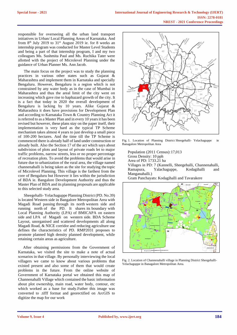
The main focus on the project was to study the planning practices in various other states such as Gujarat & Maharashtra and implement them in Karnataka and specially Bengaluru. However, Bengaluru is a region which is not constrained by any water body as in the case of Mumbai in Maharashtra and thus the areal limit of the city went on increasing which gave rise to haphazard growth of the city. It is a fact that today in 2020 the overall development of Bengaluru is lacking by 10 years. Alike Gujarat & Maharashtra it does have provisions for Development Plan and according to Karnataka Town & Country Planning Act it is referred to as a Master Plan and in every 10 years it has been revised but however, these plans stay on the paper itself, their implementation is very hard as the typical TP Scheme mechanism takes almost 4 years to just develop a small piece of 100-200 hectares. And the time till the TP Scheme is commenced there is already half of land under construction or already built. Also the Section 17 of the act which says about subdivision of plots and layout of private roads let to major traffic problems, narrow streets, less or no proper percentage of recreation plots. To avoid the problems that would arise in future due to urbanization of the rural area, the village named channenahalli is being taken as the site for studying the topic of Microlevel Planning. This village is the farthest from the core of Bengaluru but However it lies within the jurisdiction of BDA ie. Bangalore Development Authority and thus the Master Plan of BDA and its planning proposals are applicable to this selected study area.
Sheegehalli- Yelachaguppe Planning District (PD. No.39) is located Western side in Bangalore Metropolitan Area with Magadi Road passing through its north western side and running north of the PD. It shares its boundary with Local Planning Authority (LPA) of BMICAPA on eastern side and LPA of Magadi on western side. BDA Scheme Layout, unorganised and scattered developments all along Magadi Road, & NICE corridor and reducing agriculture use defines the characteristics of PD. RMP2031 proposes to promote planned high density planned development, while retaining certain areas as agriculture.
After obtaining permissions from the Government of
Karnataka, we visited the site to make a note of actual
scenarios in that village. By personally interviewing the local
villagers we came to know about various problems that
existed present and also some of them that would create
problems in the future. From the online website of
Government of Karnataka portal we obtained this map of
Channenahalli Village which contained the basic information
about plot ownership, main road, water body, contour, etc
which worked as a base for study.Futher this image was
converted to .tifff format and georectified on ArcGIS to
digitize the map for our work
Fig. 1. Location of Planning District Sheegehalli- Yelachaguppe in Banagalore Metropolitan Area
Population (2011 Census):17,013 Gross Density: 10 pphArea of PD: 1733.21 haVillages in PD: 7 (Kannelli, Sheegehalli, Channenahalli, Ramapura, Yalachaguppe, Kodagihalli and Manganahalli.)Gram Panchayats: Kodagihalli and Tavarakere
Fig. 2. Location of Channenahalli village in Planning District Sheegehalli-
Yelachaguppe in Banagalore Metropolitan Area.
International Journal of Engineering Research & Technology (IJERT)
ISSN: 2278-0181
Published by, www.ijert.org
NREST - 2021 Conference Proceedings
Volume 9, Issue 4
Special Issue - 2021
184

Fig. 5. Satellite Image of Channenahalli Village
IV. PLANNING PROPOSAL FOR STUDY AREA
A. Lakefront Development
Fig. 3. Village map of Channenahalli
Fig. 6. Satellite Image of Lake in Channenahalli village
Fig. 4. Enlarged village map of Channenahalli
A.
International Journal of Engineering Research & Technology (IJERT)
ISSN: 2278-0181
Published by, www.ijert.org
NREST - 2021 Conference Proceedings
Volume 9, Issue 4
Special Issue - 2021
185

Fig. 9. Domestic waste on sit
B. Domestic and Household Waste
Household waste which is generated on daily basis is also
a major issue. Heaps of garbage gets collected in the landfills
some being piled for years and some being incinerated
causing pollution. Almost 70% of the household waste
contains the kitchen waste which is completely
decomposable. What if we carve plots besides plant nurseries
or parks/ open spaces which would collect the everyday
kitchen waste from houses and convert them into fertilizers
for plants. Also a separate bin may be located at every 500m
on the streets which would be Wifi enabled. As in the bins
would send alert on the collection centre when they will be
completely occupied. Depending upon how much the waste
is collected the collection centre would optimize their
collection routes and such a way even the fuel consumption
of collector vehicles by running on all the routes everyday
will be reduced. Such a way even the stress on the
government agencies of waste collection and disposal would
be reduced. Smart Bin Technology is one which works on the
same principle which is surely need of the hour.
Fig. 7. Actual Image of Lake in Channenahalli village
Though Channenahalli lies in metropolitan area but still it is a village and we noticed that the villagers rely on this lake water for their daily purposes as a result this lake is on the verge of completely drying up and also this lake is getting polluted because the people wash their clothes in the same water and also this area has large industrial estate in its vicinity and thus the industries tend to pollute this water. To prevent this land and water pollution a buffer zone must be properly planned and designed in the lakefront area ensuring the water table is not polluted. By constructing a small scale screening unit and purification unit, the pollution can be controlled. Also a microlevel plan is needed to provide the connectivity between this lakefront and the adjoining industrial area, commercial area and main highway.
Fig. 10. Smart bin Technology (https://www.smartbin.com/)
Fig. 8. Development Plan Reservations
C. Animal Droppings on roads
Animal Droppings on road which are often neglected but
think in rainy seasons, this droppings flush into the storm
water drains and then they find their way into reclamation
centres. Even there are projects which recycle storm water
and supply it back to us. Imagine you are consuming
someone’s excreta. Also these stray animals, who often reside
on roads blocking the traffic, inviting diseases and sometimes
also death. Even they have their right to exist in nature and
our Town Planning Acts or Guidelines don’t provide
provisions for their living. The Town and Country Planning
Organization Guidelines suggests that at least 5% of total TP
Area must be reserved for Open Space and Recreation. For
an area of 100 ha, 5% means 5 ha should consist of Open
Spaces.
What if as an urban planner, we plan some areas within this
5% as animal shelters. Animal Shelters will ensure a roof for
B.
C.
e
International Journal of Engineering Research & Technology (IJERT)
ISSN: 2278-0181
Published by, www.ijert.org
NREST - 2021 Conference Proceedings
Volume 9, Issue 4
Special Issue - 2021
186
E.
this stray animals, and the advantages would be they won’t
defecate on public lands, won’t create traffic jams and also
their casualty and mortality rate would be reduced. And these
animal shelters would also look after their vaccinations so
that they don’t spread diseases. Even today there are various
NGO’s working for these stray animals. One of them is
Bhutdaya Foundation in Nashik, which is an NGO run by my
student of Sandip Polytechnic Mr. Rushikesh Bhalerao and
his team. And as the land for animal shelter would be within
the land reserved for open spaces, it’s ownership would lie
with the government or planning agencies/ authorities and
minimal funds can be raised by the government to look after
their needs.
Fig. 11. Animal Shelter
Fig. 12. Bhutdaya Foundation
Biogas from tree litter
Every other house in our country relies on LPG for cooking
and day by day even the prices of LPG are increasing a
sustainable solution for this could be Biogas. Biogas can be
easily produced from plant residues such as dry leaf litter,
branches, etc. Also the leaf litter on roads and parks is a waste
which is eventually burnt causing air pollution.
As an Urban Planner, a simple thing what we can do is revise
the cross sections of the road. Instead of concreting the plant
roots and paving them we can excavate a trench around it and
elevate the non-motorized vehicle tracks and pedestrian paths
so that these dried leaves gets accumulated in the trenches
protecting the plant roots and after a particular time period,
the road sweepers would easily collect these leaf litter to
convert it into biogas. The trench would actually help in
segregating other water such as papers, wrappers, etc. from
the tree litter and also ensuring that the waste is collected and
stored at the place right where it is created. This would also
create a source of income for the sweepers and garbage
pickers and the Non-renewable LPG consumption can be
reduced from waste.
Fig. 13. Biogas from tree litter
(https://ahmedabadmirror.indiatimes.com/ahmedabad/cover-story/turning-
dried-leaves-into-eco-friendly-fuel/articleshow/35639376.cms)
Optimization of NMV Tracks
NMV stands for Non Motorized Traffic. We all know the
situation of Delhi few months ago. The smog was so harmful
that it may cost a number of lives. To avoid this situation, the
pollution must be reduced and the main reason for this
pollution is the vehicles on road. Strategies like odd and even
also didn’t proved to be much fruitful so in order to provide a
sustainable solution, as a planner we can search for
alternatives such as electric vehicles which produce minimal
pollution but the problem would be their charging stationsso
what if we plan sites specially as charging stations. Solar
Energy is the best renewable energy source so making use of
solar paving materials for the charging stations of electric
vehicles. This will even reduce the import of fuel from other
countries and help support our economy.
Fig. 14. Solar Pavement (https://interestingengineering.com/6-examples-of-
solar-powered-roads-that-could-be-a-glimpse-of-the-future)
International Journal of Engineering Research & Technology (IJERT)
ISSN: 2278-0181
Published by, www.ijert.org
NREST - 2021 Conference Proceedings
Volume 9, Issue 4
Special Issue - 2021
187

V. CONCLUSION
According to me, the main motive of this study was to highlight the need of a microlevel plan. Because, the concept of neighbourhood planning is still a restricted or limited one which fragments the society in parts. Today we see large projects taking place in the form of Townships or small cities but somewhere this must be integrated with the planning of the Planning Authorities and the government. Not just a Town Planning Scheme but Microlevel planning is needed to efficiently develop a region or to implement the Development Plan. The various proposals suggested in this paper are a part of the internship program held at DULT Bangalore which were proposed by we student interns and we hope such sustainable solutions are considered by the government agencies for a better tomorrow.
ACKNOWLEDGMENT
I would like to appreciate the efforts taken by my project
partners Mrs. Ruchika Tater & Miss. Sushmita Paul during
our internship period and helping build the thought process
together for better planning of future and fulfillment of the
project requirement. This entire study wouldn’t get shaped
without the guidance of our mentors namely Ms. Ann Jacob
and Mr. Prashob Raj. Frequent interactions with other
officials and Joint Directors of DULT helped to gain a lot of
knowledge from their experience. Also I would like to thank
my colleagues Mr. Swaraj Patil, Miss. Sharanya B.S., Miss.
Soujanya and Miss. Shrutadevi Rajmane for helping me and
my project partners throughout the internship period. Last but
not the least I would like to express a sense of gratitude to Mr.
Shishir Dadhich, Assistant Professor and PG Co- Ordinator
at School of Engineering & Technology, Sandip University
Nashik who have always encouraged me in learning new
things throughout the academic year.
Ms. Sushmita Paul (M.A. Geography, Mumbai University) , Ms. Ann Jacob
(Mentor of the project at DULT, Urban Planner, Govt. of Karnataka),
Ms. Gireeja Sarangdhar (M.Tech Town & Country Planning, Sandip University Nashik) & Ms. Ruchika Tater (M.Arch Urban Design,
R.V.College of Architecture)
REFERENCES
[1] Karnataka Town & Country Planning Act
[2] Maharashtra Regional & Town Planning Act
[3] Urban and Regional Development Plans Formulation &
Implementation guidelines
[4] Town & Country Planning Organization guidelines
[5] Directorate of Urban Land Transport, Urban Development Department, Government of Karnataka.
http://www.urbantransport.kar.gov.in/
[6] Bhutdaya Foundation, Nashik
https://www.facebook.com/pages/category/Non-Governmental- Organization--NGO- /%E0%A4%AD%E0%A5%82%E0%A4%A4%E0%A4%A6%E0%A 4%AF%E0%A4%BE- %E0%A4%AB%E0%A4%BE%E0%A4%8A%E0%A4%82%E0%A 4%A1%E0%A5%87%E0%A4%B6%E0%A4%A8- 439943293418293/
[7] Google Earth and GIS planning studio, School of Engineering and Technology, Sandip University Nashik.
[8] Peter Jones, Stephen Marshall, Natalya Boujenko, Professor, Centre for Transport Studies University College London ,London, UK, Senior Lecturer, Bartlett School of Planning University College London, London, UK, Independent Consultant London, UK, “Creating More People-friendly Urban Streets Through Link And Place”,Street Planning And Design, February 19, 2008,Elsevier, https://reader.elsevier.com/reader/sd/pii/S0386111214601965?token= BB424AF5082D1DFD88EE1E6F09B682E924DE4487940D40C104 AF9047D4221F6283C0564CD9E6100347FBC5AC94FA680E
[9] Shelly Shah, Micro-Planning: Needs, Aims and Objectives of
Micro- Planning,Sociology Discussion,
http://www.sociologydiscussion.com/planning/micro-planning-needs- aim-and-objectives-of-micro-planning/1085
[10] OpenCity Urban Data Portal www.opencity.in
[11] OpenStreetMap https://www.openstreetmap.org/#map=15/12.9764/77.4329&layers=T
[12] Mrs. Rupali P Zope, Assistant Professor, Civil Engineering Department, Symbiosis Institute of Technology, Planning Strategies For Urban Land Use Pattern: A Case Study Of Pune City, India, , Pune July 2013, International Journal of Innovative Research in Science, Engineering and Technology Vol. 2, Issue 7 Micro-Planning: Needs, Aims and Objectives of Micro-Planning, Shelly Shah, Sociology Discussion
[13] Micro Level Planning Approach for Ru-Urban Development – A Case Study of Palsana Town, Gujarat, June 2014, Civil Engineering Department, SCET Surat – Gujarat (India) IJRSI ISSN 2321 – 2705 Volume I, Issue I, June 2014
[14] Creating Places, achieving quality in residential developments,
incorporating guidance on layout and access , May 2000
[15] Shirley Ballaney, The Town Planning Mechanism in Gujarat, India, , The International Bank for Reconstruction and Development /The World Bank 1818 H Street, N.W. Washington, D.C. 20433, U.S.A. January 2015
[16] Smart Bin Technology https://www.smartbin.com
[17] Biogas from tree litter
https://ahmedabadmirror.indiatimes.com/ahmedabad/cover- story/turning-dried-leaves-into-eco-friendly- fuel/articleshow/35639376.cms
[18] Solar Pavement https://interestingengineering.com/6-examples-of- solar-powered-roads-that-could-be-a-glimpse-of-the-future
International Journal of Engineering Research & Technology (IJERT)
ISSN: 2278-0181
Published by, www.ijert.org
NREST - 2021 Conference Proceedings
Volume 9, Issue 4
Special Issue - 2021
188