planning proposal bass & flinders 27 june13 - … proposal bass & flinders gateway project,...
TRANSCRIPT

Planning Proposal
Bass & Flinders Gateway Project, Wollongong Amendment to Wollongong LEP 2009 Submitted to Wollongong City Council On Behalf of Gateway Wollongong Pty Ltd
June 2013 12810
Reproduction of this document or any part thereof is notpermitted without prior written permission of JBA UrbanPlanning Consultants Pty Ltd.
JBA Urban Planning Consultants Pty Ltd operates under a Quality Management System. This report has been prepared and reviewed in accordance with that system. If the report is notsigned below, it is a preliminary draft.
This report has been prepared by: Alexis Cella
Signature Date 27/06/13
This report has been reviewed by: Terry Wetherall
Signature Date 27/06/13

Bass & Flinders Gateway Project, Wollongong Planning Proposal | June 2013
Contents
JBA 12810 i
1.0 Introduction 1
1.1 Background 3 1.2 Probity 4
2.0 Strategic Planning Background 5
2.1 Illawarra Regional Strategy 5 2.2 Wollongong City Centre Vision 5 2.3 Wollongong City Centre Civic Improvement Plan 6 2.4 Wollongong CBD Action Plan 6
3.0 Site Description 8
3.1 Site Location and Context 8 3.2 Legal Description 14 3.3 Topography 14 3.4 Surrounding Land Use and Development 14
4.0 Key Current Planning Controls 17
4.2 Wollongong Development Control Plan 21
5.0 Planning Proposal 22
5.1 Objectives and Intended Outcomes 22 5.2 Explanation of Provisions of Draft Plan 22 5.3 Relationship of Planning Proposal to Relevant Clauses of LEP 25
6.0 Justification 27
6.1 Need for the Planning Proposal 27 6.2 Relationship to Strategic Planning Framework 29 6.3 Environmental, Social & Economic Impacts 34 6.4 State and Commonwealth Interests 39 6.5 Community Consultation 40
7.0 Indicative Timelines 41
8.0 Conclusion 42
Figures
1 Figure 1 – Representative scheme illustrating potential for Gateway development on the site 2
2 Figure 2 – Site Ownership 4 3 Figure 3 – Location of key development sites within the CBD 7 4 Figure 4 – Site Location 8 5 Figure 5 – Regional Context 9 6 Figure 6 – Aerial photo existing development 10 7 Figure 7 – Southern end of the site fronting Smith Street 10
Bass & Flinders Gateway Project, Wollongong Planning Proposal | June 2013
Contents
ii JBA Planning 12810
8 Figure 8 – Northern end of the site fronting Gilligan’s Island 10 9 Figure 9 –View of site looking south along Keira Street 11 10 Figure 10 – Corner of Keira Street and Campbell Street 11 11 Figure 11 – View of site looking north along Flinders Street 12 12 Figure 12 – View of site looking south along Flinders Street 12 13 Figure 13 – View of corner of Flinders Street and Campbell Street 13 14 Figure 14 – View of site looking east along Campbell Street. 13 15 Figure 15 – Aerial Photograph of the site and surrounds 15 16 Figure 16 – Surrounding land use and built form plan 16 17 Figure 17 – Wollongong LEP 2009 Zoning Map Extract 18 18 Figure 18 – Wollongong LEP 2009 Height Map Extract 18 19 Figure 19 – Wollongong LEP 2009 FSR Map Extract 19 20 Figure 20 – Wollongong LEP 2009 Key Sites Map Extract 20 21 Figure 21 – Wollongong LEP 2009 Heritage Map Extract 20
Tables
1 Table 1 – Summary of existing achievable floor space across the site 19 2 Table 2 – Summary of proposed floor space across the site 24 3 Table 3 – Consistency with relevant SEPPs 31 4 Table 4 – Assessment against Section 117 Directions 32
Bass & Flinders Gateway Project, Wollongong Planning Proposal | June 2013
Contents
JBA 12810 iii
Appendices
A Draft Master Plan Report
SPARK
B Draft LEP Maps
JBA
C Urban Design Report
JBA Planning
D Economic Impact Assessment
Hill PDA
E Traffic Impact Assessment
Bitzios Consulting


Bass & Flinders Gateway Project, Wollongong Planning Proposal | June 2013
JBA 12810 1
1.0 Introduction This Planning Proposal is submitted to Wollongong City Council (the Council) to request an amendment to the Wollongong Local Environmental Plan 2009 (Wollongong LEP 2009) for land bounded by Flinders Street, Campbell Street, Smith Street and Keira Street, Wollongong (the site). The purpose of this Planning Proposal is to principally rezone the site from ‘B6 Enterprise Corridor’ to ‘B4 Mixed Use’ together with increasing the maximum building height and floor space ratio on the site. These amendments aim to support Council’s vision for the site as a ‘Gateway’ and promote sustainable development that achieves design excellence, will complement and contribute to the vibrancy and vitality of the Wollongong City Centre (the Regional Centre) and deliver real public benefits. JBA Planning has prepared this Planning Proposal on behalf of Gateway Wollongong Pty Ltd, who has entered into contract negotiations to purchase the site from Council. As required by Section 55 of the Environmental Planning & Assessment Act 1979 (EP&A Act), this Planning Proposal includes the following:
a statement of the objectives or intended outcomes of the proposed instrument;
an explanation of the provisions that are to be included in the proposed instrument;
the justification for those objectives, outcomes and provisions and the process for their implementation (including whether the proposed instrument will comply with relevant directions under Section 117 of the EP&A Act);
draft LEP amendment maps; and
details of community consultation.
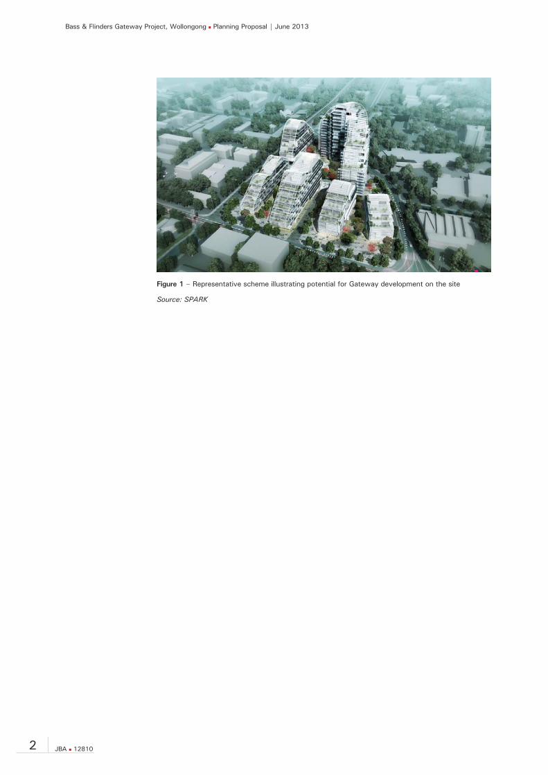
The Planning Proposal has been prepared having regard to "A guide to preparing local environmental plans" and "A guide to preparing planning proposals” published by the Department of Planning and Infrastructure (DP&I). The Planning Proposal follows close involvement with the Council (in recognition of the site’s Gateway status and due to the Council’s vested interest as current land owner of part of the site), DP&, and Roads and Maritime Services (RMS). The intended outcome of the Planning Proposal is to principally amend the zoning, height and floor space controls in the Wollongong LEP 2009 that applies to the site and insert new controls to enable the delivery of a landmark and iconic portal (refer to representative scheme included at Figure 1), consistent with Council’s vision for the site.
Bass & Flinders Gateway Project, Wollongong Planning Proposal | June 2013
2 JBA 12810
Figure 1 – Representative scheme illustrating potential for Gateway development on the site
Source: SPARK

Bass & Flinders Gateway Project, Wollongong Planning Proposal | June 2013
JBA 12810 3
1.1 Background
Key Site Located on the northern periphery of the Wollongong City Centre CBD, the site has been earmarked since 2007 as a key site which has the potential to influence the quality of buildings in the City and have a profound impact on the experience of the CBD by residents and visitors alike.
History of Development Applications Development consent was issued in August 2005 for a Development application (No.2004/1755) involving the redevelopment of the majority of the site for a mixed use development including ground and lower level commercial and retail, 281 residential apartments and parking for 803 cars. In March 2008, Council commenced proceedings in the NSW Land & Environment Court for a declaration that the consent was void for a number of reasons. On 5 February 2009, the determination of Council made on 15 August 2005 was set aside by the NSW Land & Environment Court. On 24 February 2009 Council resolved to refuse the development application.
Ownership That part of the site that was the subject of the refused mixed use redevelopment proposal was subsequently purchased by Council in late 2011, with rationale behind the purchase being1:
Provide an opportunity to improve this key site at the northern entrance to the CBD. The site is currently dominated by vacant buildings and is untidy;
Maintain a large consolidated site and allow Council to master plan to ensure the best outcomes for the City; and
Provide additional parking in this area where there is demonstrated demand.
Following an expressions of interest process to develop the site, Council subsequently agreed to sell the site to Gateway Wollongong Pty Ltd in August 2012 (subject to a number of conditions, notably of which is a requirement for the development of a Master Plan for the whole site). Gateway Wollongong Pty Ltd was selected as the preferred buyer and developer given its experience and capability in delivering a high quality development on such an important entrance to the City. As illustrated within Figure 2, Council is the majority owner of the site, with land located within the north-east and north-west corners owned by other parties.
1 Source: Council business paper of 14 November 2011

Bass & Flinders Gateway Project, Wollongong Planning Proposal | June 2013
4 JBA 12810
Figure 2 – Site Ownership
Master Plan Process Following the selection of Gateway Wollongong Pty Ltd as the preferred buyer of the site, Gateway Wollongong Pty Ltd appointed an expert team to develop a draft Master Plan for the site in collaboration with Council officers. Key members of the team included:
Project manager – Turner & Townsend;
International and local architectural and design firms - SPARK and Architects Edmiston Jones;
Urban designers and town planning consultants – JBA;
Landscape Designer – Taylor Brammer;
Traffic engineering and Transport Planners – Bitzios Consulting;
Land economist – Hill PDA; and
Structural and mechanical engineers – AECOM.
The draft Master Plan presented in support of this Planning Proposal (refer to Appendix A) has been developed over 6 months, and with the broader community’s involvement will be further refined to deliver a framework and guideline in which Council’s and Gateway Wollongong Pty Ltd’s vision can be turned into a reality.
1.2 Probity With Council as part land owner and planning authority for the site, Council identified the need for a Probity Plan for the planned management and development of the site. Council has accordingly prepared and adopted a Probity Plan, which applies to its role in providing input into and assessing this Planning Proposal.

Bass & Flinders Gateway Project, Wollongong Planning Proposal | June 2013
JBA 12810 5
2.0 Strategic Planning Background The site, forming part of the Wollongong City Centre, is included broadly in various State, regional and local strategic planning documents, and has been identified as providing a significant contribution towards meeting Government housing and employment targets. The relevant Strategic planning framework is discussed below.
2.1 Illawarra Regional Strategy The Strategy covers the local government areas of Wollongong, Shellharbour and Kiama, and is the agreed NSW Government position to guide sustainable growth and economic development within the Illawarra for the period 2006 - 2031. The vision outlined within the Strategy focusses on a prosperous, diverse and sustainable future for the Illawarra, including of particular note: Attracting economic investment and new jobs;
Revitalising Wollongong City Centre;
Providing a mix of housing types such as detached, medium density and apartments; and
Development and growth is sustainable, community minded, and supports public transport.
Wollongong is categorised as a Regional City, supported by Major Regional Centres of Warrawong and Shellharbour, and a Planned Major Regional Centre at Dapto. The key functions of Wollongong as a Regional City include:
– Providing the region with higher order administrative, education, health services, cultural and recreational facilities, higher density commercial and residential;
– Commercial centre focus with large retail and commercial floor area, including department store/s. Focal point for roads and major public transport; (rail and bus) with access by walking and cycling; and
– Achieving the key functions of a regional city whilst delivering a safe and accessible environment.
The strategy has a strong focus on job creation and will assist in providing community and investor certainty, in regards to the region’s long-term growth. Wollongong is identified as having capacity for 10,000 new jobs and additional medium and high-density housing.
2.2 Wollongong City Centre Vision As one of a network of 6 regional cities, Wollongong plays an important part in the State’s economic growth. This importance is reflected in the then State Government preparing the document ‘Wollongong City Centre Vision’, which describes a vision for the regional city, provides information on the history and development context and includes an action plan to facilitate the city centre’s growth. It sets a strategic framework for the city centre to grow into a prosperous, vibrant and attractive city. Key principles identified within the ‘Wollongong City Centre Vision’ include: Growing jobs in the heart of the City Centre;
Encouraging diversity of economic opportunities around the city core;
Creating a living city with mixed use development that supports the City Centre‘s employment role;
Developing a distinct role and character for the City Centre;
Bass & Flinders Gateway Project, Wollongong Planning Proposal | June 2013
6 JBA 12810
Providing for high quality design of buildings and public areas;
Enhancing transport links to and from the City Centre; and
Maintaining and enhancing the natural environment.
2.3 Wollongong City Centre Civic Improvement Plan
The Civic Improvement Plan (CIP) builds on the City Centre Vision and provides more detail for public domain improvements and infrastructure that may be required to achieve the desired outcomes. The CIP designates the Flinders Street frontage of the site as being of “High Street” character, maintaining an active retail frontage, accommodating intense use and a high quality of public domain. Campbell and Keira Streets are designated major residential streets.
2.4 Wollongong CBD Action Plan The Wollongong CBD Action Plan addresses the following:
Co-ordination of all stakeholders to allow a unified approach in delivering the actions for the city centre;
Identification of new opportunities and initiatives that will continue drive the development of the city centre; and
Provide business confidence to existing and future operators in investing in Wollongong.
The Action Plan outlines 10 Priority Projects for the CBD, the majority of which are based on current strategic policies including:
1. Crown Street Mall upgrade
2. Business and Investment Attraction program
3. Streetscape upgrades in Keira and Crown Streets between Market Street and the railway bridge
4. Streetscape upgrades in Burelli Street and redevelopment of MacCabe Park
5. Streetscape upgrades in Crown Street-East (between Corrimal Street and the coast)
6. Upgrade of Civic Plaza and its edges
7. Encouraging quality building outcomes for key development sites in and around the CBD
8. Traffic improvements in and around the CBD including:
Several upgrades of pedestrian amenities
Passenger Transport initiatives (train and bus)
Increased supply of car parking
Measures aimed at improving traffic flows
9. Restoration of the Bathers Pavilion Precinct
10. Develop a vision for Wollongong-South
Bass & Flinders Gateway Project, Wollongong Planning Proposal | June 2013
JBA 12810 7
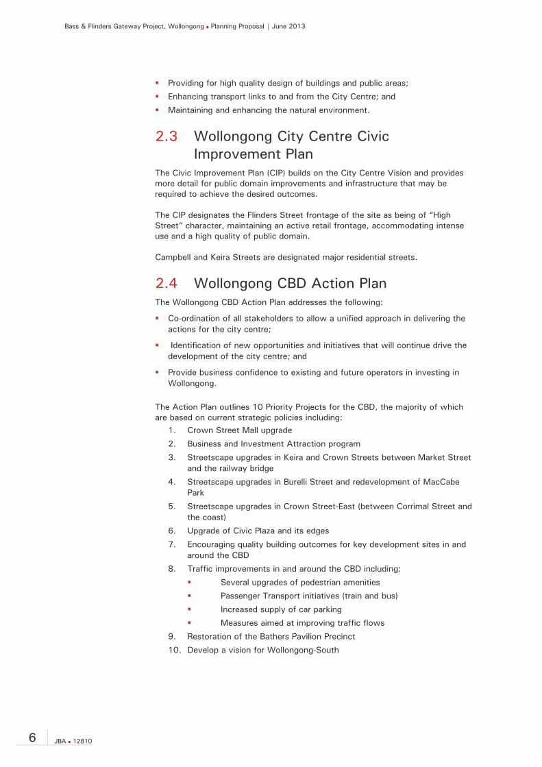
CBD Priority Project 7 is of particular relevance to the site, given it is identified as a key site (refer to Figure 3) and it is expected that development will deliver improved urban design outcomes and have a profound impact on the experience of the CBD. The action plan also provides indicative timeframes for project implementation, including Council’s concept for the Western bypass along Throsby Drive. This action may aid in reducing the traffic flow along Flinders Street and Keira Street to the south and into the city centre.
Figure 3 – Location of key development sites within the CBD
Source: Wollongong City Council
Bass & Flinders Gateway Project, Wollongong Planning Proposal | June 2013
8 JBA 12810
3.0 Site Description This chapter briefly describes the site. Further detail is provided in the sections describing the different elements of the existing environment.
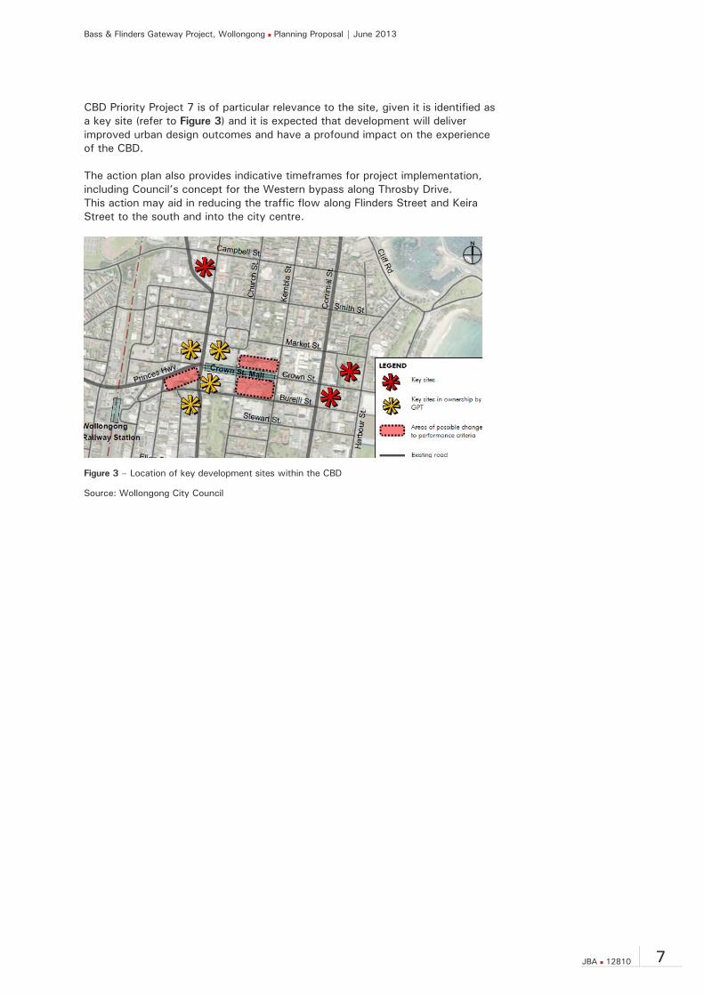
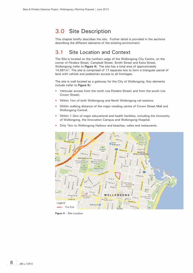
3.1 Site Location and Context The Site is located on the northern edge of the Wollongong City Centre, on the corner of Flinders Street, Campbell Street, Smith Street and Keira Street, Wollongong (refer to Figure 4). The site has a total area of approximately 14,681m2. The site is comprised of 17 separate lots to form a triangular parcel of land with vehicle and pedestrian access to all frontages. The site is well located as a gateway for the City of Wollongong. Key elements include (refer to Figure 5):
Vehicular access from the north (via Flinders Street) and from the south (via Crown Street).
Within 1km of both Wollongong and North Wollongong rail stations.
Within walking distance of the major retailing centre of Crown Street Mall and Wollongong Central.
Within 1-2km of major educational and health facilities, including the University of Wollongong, the Innovation Campus and Wollongong Hospital.
Only 1km to Wollongong Harbour and beaches, cafes and restaurants.
Figure 4 – Site Location
Bass & Flinders Gateway Project, Wollongong Planning Proposal | June 2013
JBA 12810 9
Figure 5 – Regional Context
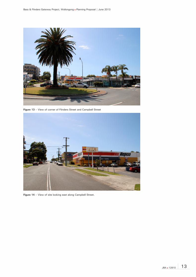
The site is occupied by a number of buildings with pedestrian access and vehicle access from all frontages. The uses consist of retail, industrial and services including a veterinary hospital and dog grooming, supermarket, video store, tyre and auto centre, and computer game store. Other site improvements have recently been demolished (those located on that part of the site currently owned by Council); with that part of the site also undergoing remediation works. An aerial photo of the site is provided at Figure 6. Photographs of the existing development are shown below in Figures 7 - 14.

Bass & Flinders Gateway Project, Wollongong Planning Proposal | June 2013
10 JBA 12810
Figure 6 – Aerial photo existing development
Figure 7 – Southern end of the site fronting Smith Street
Figure 8 – Northern end of the site fronting Gilligan’s Island

Bass & Flinders Gateway Project, Wollongong Planning Proposal | June 2013
JBA 12810 11
Figure 9 –View of site looking south along Keira Street
Figure 10 – Corner of Keira Street and Campbell Street

Bass & Flinders Gateway Project, Wollongong Planning Proposal | June 2013
12 JBA 12810
Figure 11 – View of site looking north along Flinders Street
Figure 12 – View of site looking south along Flinders Street
Bass & Flinders Gateway Project, Wollongong Planning Proposal | June 2013
JBA 12810 13
Figure 13 – View of corner of Flinders Street and Campbell Street
Figure 14 – View of site looking east along Campbell Street.

Bass & Flinders Gateway Project, Wollongong Planning Proposal | June 2013
14 JBA 12810
3.2 Legal Description The site is located with frontage to the Flinders Street, Campbell Street, Smith Street and Keira Street, Wollongong. The site includes the following title particulars:
Lot 201 DP 801956 Lot 100 DP 712640 Lot 101 DP 1015945 Lot 1 & 2 DP 544681 Lot 12 DP 840017 Lots A & B DP 153806* Lots C & D DP 164178* Lot 3 & 4 DP 152256* Lots 11 & 12 DP 231424* Lot 1 DP 657220* Lot A DP 159938* [* Land currently owned by Wollongong City Council and subject of sale to Gateway Wollongong Pty Ltd] Reference to ‘site’ in this Planning Proposal means all allotments in the list above and as included within Figure 2.
3.3 Topography The site is located approximately 4.5km east of the Illawarra escarpment and only 1km to the west of low lying land at the foreshore to the Tasman Sea. The site sits slightly to the west of a prominent ridge line which runs north south, parallel to the Keira Street frontage. To the east of the site and running between Campbell and Smith Streets, the topography forms a valley which runs all the way to the foreshore. This valley provides greater opportunity for water views from upper levels on the site. The site falls toward the intersection of Flinders and Campbell Streets, with the highest point on the site at the southern corner (approximately RL 21). A fall in the landform of around 10m from this point to the western corner of the site, and a steep fall from the Keira Street frontage will influence the built form outcome.
3.4 Surrounding Land Use and Development The site is located on the northern periphery of the Wollongong City Centre with development surrounding the site characterised by a mix of low – medium scale residential, commercial, retail and community buildings. On the western side of Flinders Street is a range of varying types of bulky-goods retailing including motorcycle sales shop, sports (surf/snow/skate) shop, and hardware store. Also opposite the site along Flinders Street is Collegians Rugby League Football Club. To the north across Campbell Street are residential dwellings in the form of a residential flat building and townhouse developments along with a tyre and auto centre. Further to the north-west of the site is the Smith’s Hill High School.
Bass & Flinders Gateway Project, Wollongong Planning Proposal | June 2013
JBA 12810 15
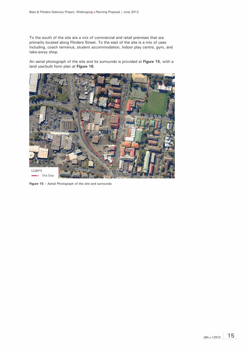
To the south of the site are a mix of commercial and retail premises that are primarily located along Flinders Street. To the east of the site is a mix of uses including, coach terminus, student accommodation, Indoor play centre, gym, and take-away shop. An aerial photograph of the site and its surrounds is provided at Figure 15, with a land use/built form plan at Figure 16.
Figure 15 – Aerial Photograph of the site and surrounds

Bass & Flinders Gateway Project, Wollongong Planning Proposal | June 2013
16 JBA 12810
Figure 16 – Surrounding land use and built form plan
Bass & Flinders Gateway Project, Wollongong Planning Proposal | June 2013
JBA 12810 17
4.0 Key Current Planning Controls 4.1.1 Wollongong Local Environmental Plan 2009 The Wollongong LEP 2009 is the principal planning instrument applying to the site.
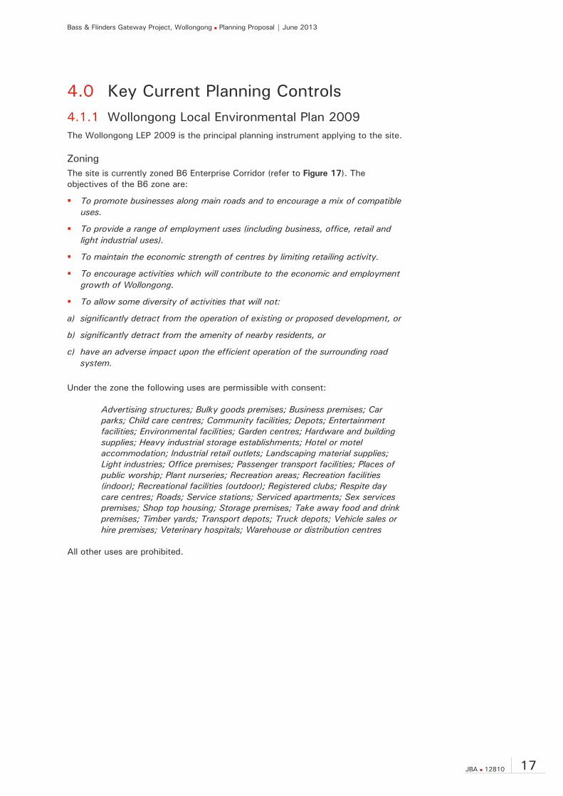
Zoning The site is currently zoned B6 Enterprise Corridor (refer to Figure 17). The objectives of the B6 zone are:
To promote businesses along main roads and to encourage a mix of compatible uses.
To provide a range of employment uses (including business, office, retail and light industrial uses).
To maintain the economic strength of centres by limiting retailing activity.
To encourage activities which will contribute to the economic and employment growth of Wollongong.
To allow some diversity of activities that will not:
a) significantly detract from the operation of existing or proposed development, or
b) significantly detract from the amenity of nearby residents, or
c) have an adverse impact upon the efficient operation of the surrounding road system.
Under the zone the following uses are permissible with consent:
Advertising structures; Bulky goods premises; Business premises; Car parks; Child care centres; Community facilities; Depots; Entertainment facilities; Environmental facilities; Garden centres; Hardware and building supplies; Heavy industrial storage establishments; Hotel or motel accommodation; Industrial retail outlets; Landscaping material supplies; Light industries; Office premises; Passenger transport facilities; Places of public worship; Plant nurseries; Recreation areas; Recreation facilities (indoor); Recreational facilities (outdoor); Registered clubs; Respite day care centres; Roads; Service stations; Serviced apartments; Sex services premises; Shop top housing; Storage premises; Take away food and drink premises; Timber yards; Transport depots; Truck depots; Vehicle sales or hire premises; Veterinary hospitals; Warehouse or distribution centres
All other uses are prohibited.

Bass & Flinders Gateway Project, Wollongong Planning Proposal | June 2013
18 JBA 12810
Figure 17 – Wollongong LEP 2009 Zoning Map Extract
Source: Wollongong City Council
Building Height Pursuant to Clause 4.3 of Wollongong LEP 2009, the site has a current height limit of 24m (refer to Figure 18).
Figure 18 – Wollongong LEP 2009 Height Map Extract
Source: Wollongong City Council

Bass & Flinders Gateway Project, Wollongong Planning Proposal | June 2013
JBA 12810 19
In terms of maximum heights of buildings surrounding the site, the LEP seeks to step and increase heights closer towards the centre of the CBD (with maximum heights increasing from 30m and heading upwards of 120m).
Floor Space Ratio Pursuant to Clause 4.4 and Wollongong LEP 2009, the site has a base maximum floor space ratio of 1.5:1 (refer to Figure 19). Additional Wollongong City Centre provisions applying to the site include:
For buildings used only for residential purposes – 2.5:1
For buildings used for purposes other than residential – 3:1
Therefore, the FSR for the site is between 2.5:1 and 3:1 dependent upon use and floor space mix.
Figure 19 – Wollongong LEP 2009 FSR Map Extract
Source: Wollongong City Council
If the floor space across the site were totalled, an overall maximum floor space range of approximately 36,702m2 - 44,043m2 would theoretically be achievable (refer to Table 1).
Table 1 – Summary of existing achievable floor space across the site
Site area (approx.)
Maximum FSR Equivalent floor space
Residential 14,681m2 2.5:1 36,702m2 Other than residential
14,681m2 3:1 44,043m2

Bass & Flinders Gateway Project, Wollongong Planning Proposal | June 2013
20 JBA 12810
Key Sites Recognising the importance of the site as a gateway, the site is identified as a ‘Key Site’ under the Wollongong LEP 2009 (refer to Figure 20).
Figure 20 – Wollongong LEP 2009 Key Sites Map Extract
Source: Wollongong City Council
Heritage The Site is not affected by heritage listing or located within a heritage conservation area. There are, however, a number of heritage items that surround the site (refer to Figure 21), including:
Item 6251 - 60 Keira Street, house (Local)
Item 6252 - 62 Keira Street, house (Local)
Item 6395 - 86 Smith Street, house (Local)
Item 6396 - 88 Smith Street, Masonic hall (Local)
Item 6397 - 90 Smith Street, “ Ken Elm” (Local)
Figure 21 – Wollongong LEP 2009 Heritage Map Extract
Source: Wollongong City Council

Bass & Flinders Gateway Project, Wollongong Planning Proposal | June 2013
JBA 12810 21
4.2 Wollongong Development Control Plan The Wollongong Development Control Plan (DCP) builds upon and provides more detailed provisions than the Wollongong LEP 2009. Generally, the provisions of the DCP will be more relevant as part of the future redevelopment of the land. The DCP locates the site within the Wollongong City Centre Precinct. The Desired Future Character for the Wollongong City Centre is outlined within Section 3.32 of the DCP, and key aspects are reproduced below:
The Wollongong City Centre will continue as the regional centre of the Illawarra with a focus on employment, key regional services, cultural activity, entertainment and tourism.
In line with the Illawarra Regional Strategy, the 25 year vision for our city centre is for the creation of an additional 10,000 new jobs and to welcome 6,000 new residents.
With its rich history, unrivalled water front location, and as a focus for transport services, there is great potential to increase the appeal of the centre as a destination for shopping, business, entertainment and cultural activities, high quality health and medical services, and as a place to live.
The vision is for a vibrant city with a strong economy that attracts investors, new business, visitors, cultural expression and new residents.
Development principles for this regional city centre include:
– Grow jobs in the heart of the city centre;
– Encourage diverse precincts around the city centre;
– Create a living city by encouraging mixed use development that complements the centre’s core employment role;
– Develop a distinct role and character for the centre;
– Ensure high quality design of buildings and public areas;
– Enhance transport links to and from the centre; and
– Improve the natural environment.
The Centre will accommodate an increased range of mixed use developments, including commercial and retail developments complemented by residential, cultural, community and entertainment uses.
Increased opportunities for higher density housing, both within the CBD and North Wollongong area, will provide greater housing choice for a diversity of age and income groups.
An emphasis will be to enhance public spaces and ensure good amenity and solar access.
Design excellence provisions will ensure quality future building outcomes.

Bass & Flinders Gateway Project, Wollongong Planning Proposal | June 2013
22 JBA 12810
5.0 Planning Proposal This Planning Proposal has been prepared in accordance with section 55 of the EP&A Act and the guide prepared by the Department of Planning and Infrastructure entitled A guide to preparing planning proposals which requires the following matters to be addressed:
objectives and intended outcomes of the amendment to the LEP;
explanation of provisions;
justification;
maps, where relevant, to identify the intent of the planning proposal; and
details of community consultation.
5.1 Objectives and Intended Outcomes The Planning Proposal is a site specific amendment to the Wollongong LEP 2009 to change the zone, height, and floor space ratio controls that apply. The key objectives of the planning proposal are:
To enable the re-development of the site for a landmark/iconic development which achieves design excellence;
To facilitate high quality development on an identified key site that contributes towards the revitalisation of the Wollongong City Centre;
To fulfil Council’s vision for the site as a gateway into and out of the Wollongong City Centre; and
To support the city strategic position through design excellence.
5.2 Explanation of Provisions of Draft Plan The overarching purpose of the planning proposal is to facilitate the development of the site for a landmark and iconic portal into the Wollongong City Centre. To achieve this desired outcome, a number of amendments to the Wollongong LEP 2009 are proposed:
Amendment to the “Land Zoning Map”;
Amendment to the “Height of Buildings Map”;
Amendment to the “Floor Space Ratio Map”;
Amendment to Clause 4.4A Floor space ratio – Wollongong city centre;
Amendment to Local provisions - Clause 7.13 Ground floor development on land within business zones; and
Amendment to Local provisions Wollongong City Centre - Clause 8.6 Building separation within Zone B3 Commercial Core or zone B4 Mixed Use.

Bass & Flinders Gateway Project, Wollongong Planning Proposal | June 2013
JBA 12810 23
Land Zoning The zoning of land to which Wollongong LEP 2009 applies is shown on the “Land Zoning Map”. Amending the zoning of the site is achieved by amending the Wollongong LEP 2009 Land Zoning Map (Sheet LZN_025), which zones the subject land. A draft Land Zoning Map is included at Appendix B. It is proposed to change the zoning for the site from B6 Enterprise Corridor to B4 Mixed Use. The B4 zone is considered to be an ideal zone that is compatible with the site’s characteristics and surrounding context.
Heights of Buildings Building heights within Wollongong are controlled by Clause 4.3 of Wollongong LEP 2009 which sets the objectives of the height controls and sets out the maximum height of buildings as shown on the Heights of Buildings Map. The Heights of Buildings Map that applies to the subject land under Wollongong LEP 2009 specifies a maximum height of 24m across the site. Introducing new height limits is achieved by amending the Wollongong LEP 2009 Height of Buildings Map (Sheet HOB_025). A draft Height of Buildings Map is included at Appendix B. A varied height limit ranging from 24m to 60m is proposed, and reflects the draft master plan prepared for the gateway site (refer to Section 6.1).
Floor Space Ratio Floor space within Wollongong is controlled by Clause 4.4 of Wollongong LEP 2009 which sets the objectives of the floor space ratio controls and sets out the maximum floor space ratio for buildings as shown on the Floor Space Ratio Map. The Floor Space Ratio Map that applies to the subject land currently specifies a maximum floor space ratio of 1.5:1 across the site. Additional to the Floor Space Ratio Map, Clause 4.4A of Wollongong LEP 2009 establishes an FSR for the site between 2.5:1 (residential purposes) and 3:1 (other than residential purposes). Amending the floor space limit is achieved by amending the Wollongong LEP 2009 Floor Space Ratio Map (Sheet FSR_025) along with incorporating a new site specific clause. A draft Floor Space Ratio Map is included at Appendix B. The proposed wording of the draft LEP amendment to Clause 4.4A is generally as follows:
Despite subclause (2), the floor space ratio for development of a type specified in Column 2 of the table to this subclause in an area specified opposite in Column 1 of the table and identified on the Floor Space Ratio Map must not exceed the ratio for that development specified opposite in Column 3 of the table. Column 1 Column 2 Column 3 Area Development type Floor space ratio Area 1 Residential purposes 2.5:1 Other than residential purposes 3.5:1 Area 2 Residential purposes 2.5:1 Other than residential purposes 3.5:1 Area 3 Residential purposes 3.5:1
Other than residential purposes 3.5:1

Bass & Flinders Gateway Project, Wollongong Planning Proposal | June 2013
24 JBA 12810
The proposed amendment seeks to generally reflect the standard controls that would apply to the B4 Mixed Use Zone within the City Centre (i.e. 2.5:1 for residential and 3.5:1 for development other than residential). The exception is for a portion of the site where it is proposed for a combined maximum FSR for all development types of 3.5:1. Table 2 provides an overview of the resulting area of floor space potentially achievable through amending the floor space ratio controls. As Table 2 demonstrates, the proposed amendment increases the base allowable floor space area for residential purposes across the site to 45,803.5m2. This represents an increase of 9,101.5m2 over the current controls. For other forms of development other than residential the proposed amendment increases the base allowable floor space area to 51,383.5m2, an increase of 7,340.5m2. The proposed FSR across the site reflects the density of development envisaged within the draft Master Plan for the Gateway site (refer to Section 6.1).
Table 2 – Summary of proposed floor space across the site
Proposed Maximum FSR
Site Area approx.
Proposed Equivalent Floor Space
Area 1 2.5: 1 – residential 3.5:1 – other than residential
3,620m2 9,050m2
12,670m2 Area 2 2.5: 1 – residential
3.5:1 – other than residential 1,960m2
4,900m2
6,860m2 Area 3 3.5: 1 – residential / other
than residential 9,101m2 31,853.5 m2
Total - 14,681m2 Residential - 45,803.5 m2 Other than residential - 51,383.5m2
Ground floor activation A number of local provisions apply in Wollongong, including the requirement for active uses to be provided at street level in most business zones (clause 7.13). Given the master planned nature of the development site, it is not considered appropriate for this provision to apply for all development. The key streets in terms of activation and pedestrian movement are Flinders Street and Keira Street. It is therefore proposed to amend the wording of Clause 7.13 to enable the ground floor of buildings fronting Campbell Street and other internal spaces of the site not directly fronting Flinders Street or Keira Street to include residential accommodation at ground level. The proposed wording of the draft LEP amendment to Clause 7.13 is generally as follows:
(4) Clauses (1), (2), and (3) only applies to buildings on land identified as “Flinders Street Gateway” on the Key Sites Map that directly front Flinders and/or Keira Streets.
Bass & Flinders Gateway Project, Wollongong Planning Proposal | June 2013
JBA 12810 25
Building Separation In addition to the general Local provisions that apply in Wollongong, there are further detailed provisions that apply in the Wollongong City Centre (which the site is located within). This includes building separation requirements within the B3 Commercial Core B4 Mixed Use zones (clause 8.6). Typically such detailed prescriptive requirements are not now adopted within standard instrument LEPs, letting relevant DCP and other environmental planning instruments and guidelines provide such guidance. Again, given the site is linked to a comprehensive master plan process that has investigated and tested appropriate building separation requirements, it is proposed that the provisions of Clause 8.6 not apply to the site. The proposed wording of the draft LEP amendment to Clause 7.13 is generally as follows:
(5) Clauses (1), (2), and (3) do not apply to buildings on land identified as “Flinders Street Gateway” on the Key Sites Map.
5.3 Relationship of Planning Proposal to Relevant Clauses of LEP
Clause 4.3 - Height of Buildings The Planning Proposal seeks to amend the specific controls that apply to the site with respect to the height of buildings. The amended heights will continue to ensure the objectives of Clause 4.3 are met, as follows:
Clause 4.3(1)(a): The proposed amendment retains certainty and clarity regarding building heights across the site, with the testing of mass and form being undertaken through an urban design process to ensure floor space as proposed can be achieved.
Clause 4.3(1)(b): The amended buildings heights will facilitate a high quality urban form and ensure a landmark development is delivered for the City. Without the proposed increase in height across part of the site, the Gateway attributes of the site will not be realised and the City would miss out on a significant boost towards its revitalisation.
Clause 4.3(1)(c): The amended heights will continue to ensure that existing and future new buildings and public areas have views open to the sky and receive appropriate sunlight.
Clause 4.4 – Floor Space Ratio The Planning Proposal seeks to introduce a new floor space ratio for part of the site. The amended FSRs will continue to ensure the objectives of Clause 4.4 are met, as follows:
Clause 4.4(1)(a): The site reflects a significant landholding strategically positioned at the main northern entry to the Wollongong City Centre. With a relatively small number of separate landowners, there is the ability to deliver a form of development appropriate for its size and that recognises the site’s importance as a gateway to the City Centre.
Clause 4.4(1)(b): The proposed FSRs will continue to regulate the density of development on the land to an acceptable level within the context of the site’s gateway and City Centre location and proximity to public transport. It will not generate an unacceptable level pedestrian or vehicular traffic that cannot be accommodated within existing infrastructure.
Bass & Flinders Gateway Project, Wollongong Planning Proposal | June 2013
26 JBA 12810
Clause 4.4(1)(c): the proposed amendments purposefully seeks to support and facilitate a development that differs from the immediate surrounding context. This said, it will deliver a development of a bulk and scale that more broadly is consistent and compatible with the site’s City Centre location. The amendments will importantly set the tone and visual experience of the City Centre for residents and visitors alike.
Clause 7.13 - Ground floor development on land within business zone The Planning Proposal seeks to specify areas of the site in which clause 7.13 applies. Importantly, the objective of this clause will be met as the primary street frontages of the site (being Finders Street and Keira Street) will retain the requirement for active uses to be provided. Through focusing activation along the key pedestrian desire lines relevant to the site’s context it will ensure the movement of people and interaction is optimised.
Clause 8.6 – Building separation within Zone B3 Commercial Core or Zone B4 Mixed Use The objective of Clause 8.6 will remain a key and pertinent aspect to any future development on the site. Building separation is however not considered to be a provision that an LEP should be dealing with. Given the future development of the site will follow on from a master planning process there is considered to be grounds to ‘turn-off’ the provisions of this clause to future development on the site.
Bass & Flinders Gateway Project, Wollongong Planning Proposal | June 2013
JBA 12810 27
6.0 Justification
6.1 Need for the Planning Proposal
6.1.1 Is the Planning Proposal a result of any strategic study or report?
The subject land has been identified for over 5 years (since the then Wollongong City Centre LEP 2007) as a key site that is expected to deliver the City of Wollongong with a gateway development at the entry to the City Centre. This expectation to deliver an iconic development within the City Centre responds directly to the State Government’s strategic planning objectives embedded within the Illawarra Regional Strategy and Wollongong City Centre Vision, which includes a focus on revitalising the Wollongong City Centre, providing high quality buildings and public areas, and attracting investment and new jobs. As noted in Section 2.0, Council commissioned in 2010 the preparation of a 5+ Year CBD Action Plan. One of the priority projects includes the encouragement/delivery of high quality buildings on key CBD development sites, including the subject site. The importance of the site to the success and revisitation of the City Centre has been recognised by Council purchasing the majority of the site and embarking down a master planning process to inform the future development on the key/gateway site. As the preferred buyer, Gateway Wollongong Pty Ltd has been charged with preparing a draft master plan for the whole site. As a first step, Gateway Wollongong Pty Ltd engaged JBA to undertake an Urban Design Study (the study) for the land (included at Appendix C). This provided an important foundation for the master plan in understanding the site’s attributes, characteristics and constraints and opportunities. With this knowledge Gateway Wollongong Pty Ltd then embarked on engaging a multidisciplinary consultant team led by renowned international architects SPARK to develop a draft Master Plan for site. A copy of the draft Master Plan is included within Appendix A. The Master Plan is based on findings from the analysis of the site and surrounds, the setting of a clear vision, the establishment of master plan principles, the testing and analysis of five (five) massing options, and targeted consultation with key state and local agencies. The vision for the Wollongong Gateway master plan is the formation of a bold urban neighbourhood, a model for sustainable urban living woven into the fabric of the existing City. Key features of the preferred Master Plan for site includes:
A new generous pedestrian focussed arrival point at the north-west corner of the site;
The introduction of built form that responds to the site’s topography and moderates the varying nature of adjacent developments from domestic scale to civic and landmark scale;
Focusing increased height in a sculptured and iconic form along Flinders Street that rises as the precinct meets the City Centre and reinforces a sense of arrival;
Bass & Flinders Gateway Project, Wollongong Planning Proposal | June 2013
28 JBA 12810
The creation of a new public grain that connects and integrates the site with the City Centre and welcomes people;
The continued activation and extension of Keira Street as an ‘eat street’; and
The creation of new urban green pockets.
The Planning Proposal will enable the Master Plan to be realised by providing for mixed use development of a scale and form commensurate with the site’s recognition as a gateway to the Wollongong City Centre.
6.1.2 Is the Planning Proposal the best means of achieving the objectives or intended outcomes, or is there a better way?
The Planning Proposal is the best and most appropriate means of achieving the desired future redevelopment of this land. Under the existing Wollongong LEP 2009, the nature and form of development that is permissible on the land is relatively restrictive, including for example prohibiting restaurants or cafes, as well as residential flat buildings. It is noted that residential development is presently permissible on the site in the form of shop top housing. Further, whilst variations to development standards (e.g. building height and floor space ratio) are possible utilising the provisions of Clause 4.6 (exceptions to development standards), it is considered that the extent of variation proposed is more appropriately addressed by a change of the site’s underlying planning controls. Also, it is considered important that the master planning process undertaken deliver certainty regarding built form so as to avoid seeking variations to the Wollongong LEP at the Development Application stage. Therefore, without rezoning and amending relevant development controls, mixed use development on the land of an appropriate gateway form will not be able to be delivered. To ensure the Master Plan vision for The Wollongong Gateway site is realised and to support investment and economic development within the Illawarra’s key and internationally competitive Regional Centre, the Planning Proposal will rezone the land and amend relevant development standards/controls. The draft master plan included at Appendix A illustrates the form of buildings within a current ‘complying’ development across the site. It is clear that such an outcome on the site would not reflect Council’s vision and ambition for the site and would likely deliver buildings of an uninspiring form.
6.1.3 Is there a net community benefit? Hill PDA have undertaken a net community benefit test (included within the Economic Impact Assessment at Appendix D) in accordance with the guidance provided within the draft NSW Centres Policy (2009). The test has been based on the representative scheme presented within the master plan. In summary, Hill PDA concludes that:
The planning proposal would yield a significant positive net community benefit from a community welfare perspective with all impacts considered resulting in either ‘neutral’ or a ‘positive’ benefit, with most resulting in a ‘significant positive benefit’.
In economic terms, greater density in residential would yield greater economic benefits in terms of population, retail expenditure, construction costs etc.
Bass & Flinders Gateway Project, Wollongong Planning Proposal | June 2013
JBA 12810 29
The planning proposal would secure greater community benefit from the redevelopment of the subject site compared to the base case (do nothing scenario).
6.2 Relationship to Strategic Planning Framework
6.2.1 Consistency with the Illawarra Regional Strategy The key strategic planning strategy relevant in the consideration of this Planning Proposal is the Illawarra Regional Strategy. The Planning Proposal is consistent with the objectives and strategies of the Strategy in that it will:
Enable design excellence in the built form and public realm;
Support a revitalised Wollongong City Centre, attracting significant investment and jobs;
Strengthening Wollongong City Centre through enabling opportunities for medium and high density living;
Add to the breadth of housing choice and affordability in a highly accessible area close to jobs, education and other essential services;
Maintain and not detract from the economic wellbeing of the commercial core;
Contribute towards meeting the regions housing target of 38,000 new dwellings by 2031;
Provide residential development at appropriate densities that will support the employment and economic activities within the Wollongong City Centre; and
Contribute towards the achievement of the employment target for Wollongong (having a capacity for 10,000 new jobs.
The Planning Proposal is therefore entirely appropriate in terms of its strategic and regional planning context.
6.2.2 Consistency with Council’s Community and Strategic Plans
Wollongong 2022: Community Strategic Plan 2012 The Strategic Community Plan sets out the future vision for Wollongong. The plan set the desired outcomes and the aspirations of the community, and the goals and strategies on how they will be achieved. The vision set for Wollongong is: From the mountains to the sea, we value and protect our natural environment and we will be leaders in building an educated, creative and connected community. There are six broad goals identified to deliver the vision for Wollongong: 1. We value and protect our environment
2. We have an innovative and sustainable economy
3. Wollongong is a creative, vibrant city
4. We are a connected and engaged community
5. We are a healthy community in a liveable city
6. We have sustainable, affordable and accessible transport

Bass & Flinders Gateway Project, Wollongong Planning Proposal | June 2013
30 JBA 12810
The Planning Proposal is consistent with the Strategic Plan as it will facilitate the redevelopment of the site for mixed use purposes, which in turn will:
Ensure development is focussed on appropriate urban zoned land, that is well served by infrastructure and services and highly accessible;
Supports the delivery of a landmark and iconic development on a key gateway site that will contribute towards the revitalisation of the Wollongong City Centre;
Encourage and generate investment within the Wollongong City Centre;
Support Wollongong as the place to visit through reinvigorating visitor attractions (e.g. providing for iconic architecture that achieves design excellence);
Encourage more sustainable travel behaviour through locating residential development within the City Centre and adjacent a strategic bus corridor and nearby to heavy rail;
Reduce the demand for travel through providing more local jobs; and
Contribute towards increasing housing affordability/lowering housing stress through the creation of new residential dwellings.
Wollongong City Centre Economic Development Strategy 2005 The City Centre Economic Development Strategy provides the foundations for the city of the next 10-20 years that will be delivered through economic growth and planning and infrastructure decisions. The strategy is built around two key elements:
Growing the City – creating an Innovative City through business expansion in key activities in the city including – including business services, retail, health and cultural industries.
Improving the Place – creating a Living City and Connected City through improved city structure and facilities; through private investment in retail, commercial and residential; and public investment in infrastructure and public space.
The planning proposal supports these two key elements through:
Enabling the delivering of a major new attraction (landmark) for the City;
Reinforcing the City as a place to live, work and visit;
Improving public space and connections within the City;
Creating opportunities for increased private investment in retail and commercial development;
Achieving a master planned outcome on a strategic land parcel on the entry to the City Centre; and
Promoting high quality urban design that achieves design excellence.
Bass & Flinders Gateway Project, Wollongong Planning Proposal | June 2013
JBA 12810 31
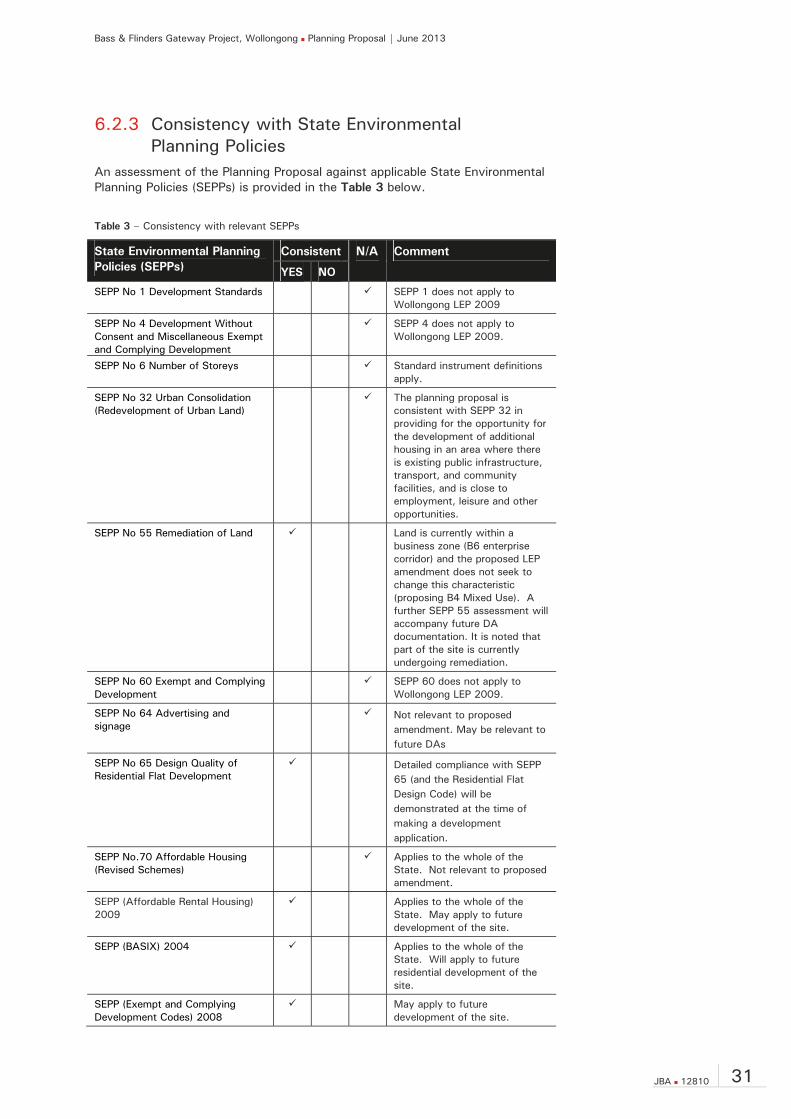
6.2.3 Consistency with State Environmental Planning Policies
An assessment of the Planning Proposal against applicable State Environmental Planning Policies (SEPPs) is provided in the Table 3 below.
Table 3 – Consistency with relevant SEPPs
State Environmental Planning Policies (SEPPs)
Consistent N/A Comment
YES NO
SEPP No 1 Development Standards SEPP 1 does not apply to Wollongong LEP 2009
SEPP No 4 Development Without Consent and Miscellaneous Exempt and Complying Development
SEPP 4 does not apply to Wollongong LEP 2009.
SEPP No 6 Number of Storeys Standard instrument definitions apply.
SEPP No 32 Urban Consolidation (Redevelopment of Urban Land)
The planning proposal is consistent with SEPP 32 in providing for the opportunity for the development of additional housing in an area where there is existing public infrastructure, transport, and community facilities, and is close to employment, leisure and other opportunities.
SEPP No 55 Remediation of Land Land is currently within a business zone (B6 enterprise corridor) and the proposed LEP amendment does not seek to change this characteristic (proposing B4 Mixed Use). A further SEPP 55 assessment will accompany future DA documentation. It is noted that part of the site is currently undergoing remediation.
SEPP No 60 Exempt and Complying Development
SEPP 60 does not apply to Wollongong LEP 2009.
SEPP No 64 Advertising and signage
Not relevant to proposed amendment. May be relevant to future DAs
SEPP No 65 Design Quality of Residential Flat Development
Detailed compliance with SEPP 65 (and the Residential Flat Design Code) will be demonstrated at the time of making a development application.
SEPP No.70 Affordable Housing (Revised Schemes)
Applies to the whole of the State. Not relevant to proposed amendment.
SEPP (Affordable Rental Housing) 2009
Applies to the whole of the State. May apply to future development of the site.
SEPP (BASIX) 2004 Applies to the whole of the State. Will apply to future residential development of the site.
SEPP (Exempt and Complying Development Codes) 2008
May apply to future development of the site.

Bass & Flinders Gateway Project, Wollongong Planning Proposal | June 2013
32 JBA 12810
State Environmental Planning Consistent N/A Comment SEPP (Infrastructure) 2007 Applies to the whole of the
State. May apply to future development of the site.
SEPP (State and Regional Development) 2011
The future development of the site is likely to be deemed as ‘regional development’ (meeting the relevant thresholds under Schedule 4A of the EP&A Act), with the JRPP acting as the determining authority.
6.2.4 Consistency with applicable Ministerial Directions A summary assessment of the Planning Proposal against the Directions issued by the Minister for Planning under Section 117 of the EP&A Act is provided in Table 4 below.
Table 4 – Assessment against Section 117 Directions
Ministerial Directions Consistent N/A Comment
YES NO
1. Employment and Resources
1.1 Business and Industrial Zones
The Planning Proposal seeks to retain the business zoning applying to the site, however proposes to change the underlying zone from B6 Enterprise Corridor to B4 Mix Use. The extent of business zones in the City Centre will therefore not change. The business zoning change will facilitate a broader diverse range of uses to be provided on the site, including cafes and restaurants and residential flat buildings. Together with the changes to the heights and floor space controls apply to the site, the planning proposal will support in the delivery of a key gateway site and further generate significant investment and growth in the City Centre. The LEP controls that will apply to the site will ensure an appropriate mix of development is achieved, including ground/lower level non-residential uses that support employment and activation and that will contribute to the vitality and success of the Regional City.
1.2 Rural Zones Not applicable
1.3 Mining, Petroleum Production and Extractive Industries
Not applicable
1.4 Oyster Aquaculture Not applicable
1.5 Rural Lands Not applicable
2. Environment and Heritage
2.1 Environment Protection Zones
Not applicable
2.2 Coastal Protection Not applicable
2.3 Heritage Conservation Not applicable
2.4 Recreation Vehicle Areas Not applicable

Bass & Flinders Gateway Project, Wollongong Planning Proposal | June 2013
JBA 12810 33
Ministerial Directions Consistent N/A Comment 3. Housing, Infrastructure and Urban Development
3.1 Residential Zones The Planning Proposal will encourages the provision of housing that will broaden the choice of building types (including making residential flat buildings permissible), will make more efficient use of existing infrastructure and services, and reduce the consumption of land for housing and associated urban development on the urban fringe. The planning proposal supports an increase in residential density on the site, commensurate with the site’s gateway location and position on the northern periphery of the City Centre.
3.2 Caravan Parks and Manufactured Home Estates
Not applicable
3.3 Home Occupations Not applicable
3.4 Integrating Land Use and Transport
The Planning Proposal will support residential and employment in a central location to support public transport and improve access to jobs and services by walking, cycling and public transport.
3.5 Development Near Licensed Aerodromes
Not applicable
3.6 Shooting Ranges Not applicable
4. Hazard and Risk
4.1 Acid Sulphate Soils Wollongong LEP contains acid sulphate soils provisions and this Proposal does not seek to amend them. Acid sulphate soils investigations and analysis will accordingly be undertaken as part of any future development of the land.
4.2 Mine Subsidence and Unstable Land
Not applicable
4.3 Flood Prone Land Not applicable
4.4 Planning for Bushfire Protection
Not applicable
5. Regional Planning
5.1 Implementation of Regional Strategies
The Planning Proposal is consistent with the objectives and strategies of the Illawarra Regional Strategy as noted at Section 6.2.1.
5.2 Sydney Drinking Water Catchments
The Planning Proposal does not change the business zoning of the site and accordingly is considered to have a negligible impact on the drinking water catchment.
5.3 Farmland of State and Regional Significance on the NSW Far North Coast
Not applicable
5.4 Commercial and Retail Development along the Pacific Highway, North Coast
Not applicable
5.8 Second Sydney Airport: Badgerys Creek
Not applicable
Bass & Flinders Gateway Project, Wollongong Planning Proposal | June 2013
34 JBA 12810
Ministerial Directions Consistent N/A Comment 6. Local Plan Making
6.1 Approval and Referral Requirements
No new concurrence provisions are proposed.
6.2 Reserving Land for Public Purposes
The Planning Proposal does not seek to create, alter or reduce existing zoning or reservations of land for public purposes. No new road reservation is proposed.
6.3 Site Specific Provisions Planning Proposal amends existing and introduces new site specific provisions, without being unnecessarily restrictive. The planning proposal follows on from a master planning process, and accordingly site specific controls to be introduced are considered essential in order to deliver development that supports the vision.
7. Metropolitan Planning
7.1 Implementation of the Metropolitan Plan for Sydney 2036
Not applicable
6.3 Environmental, Social & Economic Impacts
6.3.1 Impact on Critical Habitat, Threatened Species and Ecological Communities
The land is situated within a city centre context and is currently used for a mix of retail and commercial purposes and has historically been developed for urban purposes. Given the site is highly modified, the Planning Proposal will not affect any critical habitat or threatened species, populations or ecological communities, or their habitats nor is it expected to have any adverse environmental effects.
6.3.2 Environmental Effects of the Planning Proposal
Built Form As discussed at Section 6.1, SPARK has prepared a draft Master Plan for the redevelopment of the site (see Appendix A). The master plan builds upon the urban design study prepared by JBA, establishes a set of principles, investigates a number of massing options and provides design guidance for future detailed development proposals based on a preferred master plan option. Also included within the master plan is an overview of a potential representative scheme that reflects a form of development that may be developed as a result of the proposed amendments to the Wollongong LEP 2009 and meets the design parameters and vision of the master plan.

Bass & Flinders Gateway Project, Wollongong Planning Proposal | June 2013
JBA 12810 35
The master plan has been developed around the following opportunities:
The site is identified as gateway into the City Centre;
The site has been identified as contributing towards the built form quality of the City Centre, achieving design excellence;
The site is strategically located on the north periphery of the City Centre;
The site benefits from high exposure from along Flinders Street (Princes Highway);
The topography of the site supports a form of development that can result in a sculptured form and emphasise the arrival for residents and visitors to the City Centre and that can offer a story of history and geology through architecture;
The potential to enliven and create a northern anchor to the retail/café/restaurant strip along Keira Street;
The ability to integrate and recreate urban fabric and connections that are meaningful, direct, accessible, enjoyable and safe;
The site is within walking distance to jobs, educational facilities, community facilities and other essential services and infrastructure;
Potential high quality views are available from the site (both towards the escarpment and water views);
The site is removed from lower scale residential development to the north and east, thereby reducing any potential impacts caused by the proposal in terms of solar access and overshadowing; and
There is the potential to improve activation and develop more appealing streetscapes along Flinders Street and Keira Street.
As noted, numerous massing/built form options have been considered and tested for their urban form, feasibility, and community outcomes. Whilst the final built form will be subject of a future detailed design process, the master planning undertaken by SPARK has shown that an appropriate built form can be achieved under the proposed LEP amendments that delivers:
A stepped form of buildings along Flinders Street that rises with the topography of the site and supports iconic buildings up to 60m high;
Delivery of a master plan and whole of site landmark development which acts as a visual marker improving orientation for residents and visitor alike and promoting movement towards the city Centre;
Relief to the urban form through a series of connected urban/green spaces;
Retention of existing height controls along the northern portion of the site fronting Campbell Street, supporting the transition of the gateway site into the existing surrounding urban fabric;
New public domain spaces and pedestrian access ways that improve the civic features of the site and its permeability; and
New retail and commercial activation along Flinders Street and Keira Street, along with an activated central plaza.
Overall, the proposed changes to building height and FSR across the site will facilitate and enable the delivery of the following positive urban design outcomes for the Wollongong City Centre and region more broadly:
Locating building mass in taller and elegant tower forms aesthetically complements the commercial core attributes of the City Centre and aids in the creation of a skyline commensurate with the regional city’s status.

Bass & Flinders Gateway Project, Wollongong Planning Proposal | June 2013
36 JBA 12810
Flinders Street and Keira Street are able to be activated.
a larger, iconic development maintaining a strong degree of congruency with the surrounding streetscapes and urban fabric.
The 24 meter height limit along Campbell Street keeps development within the scale of the existing built character.
The stepped nature of the built form and the relief provided through urban/green open spaces and connections maintains adequate sun access to the public domain and surrounding development;
A maximum height of 60m and a FSR of 3:5:1 on Area 3 will yield a built form that delivers a landmark development and achieves Council’s vision for a northern gateway for the City Centre;
Creating a new pedestrians main entry to the city that connects through a highly permeable site offering a number of north-south and east-west connections that will support a pedestrian friendly and rich character.
Height The height increase (up to a maximum of 60m) being proposed as part of the planning proposal for the site is considered to be an appropriate response, especially in light of the following:
It will contribute towards raising the city spirit and making for a more prosperous and sustainable city;
It represents a sign of continued economic vitality and success;
It compliments other strategic projects across the City, including GPT development;
Represents a city enhancing project with benefits reaching far and wide;
The height being aligned to maximise the city gateway attributes of the site as it rises with the natural landform;
The site should make a contribution to the city skyline and be visible from key vantage points across the City;
A focus on ensuring that the building sits comfortably in the backdrop and context of the Illawarra escarpment;
Providing for a bookend to the retail/commercial uses along Keira Street, drawing pedestrians and activity along this ‘eat street’; and
Responding to the future city context and ensuring that the site preserves its gateway role.
Furthermore, as illustrated in the master plan, the built form that would result under the existing controls would be a series of squat and bulky buildings that would not deliver on Council’s and the communities expectations of a gateway site for Wollongong City Centre. Moreover, the height and bulk of a development produced under the current height and FSR controls would be less likely to neither contribute to the revitalisation of Wollongong’s City Centre nor engender a high quality built form outcome that achieves design excellence.
Bass & Flinders Gateway Project, Wollongong Planning Proposal | June 2013
JBA 12810 37
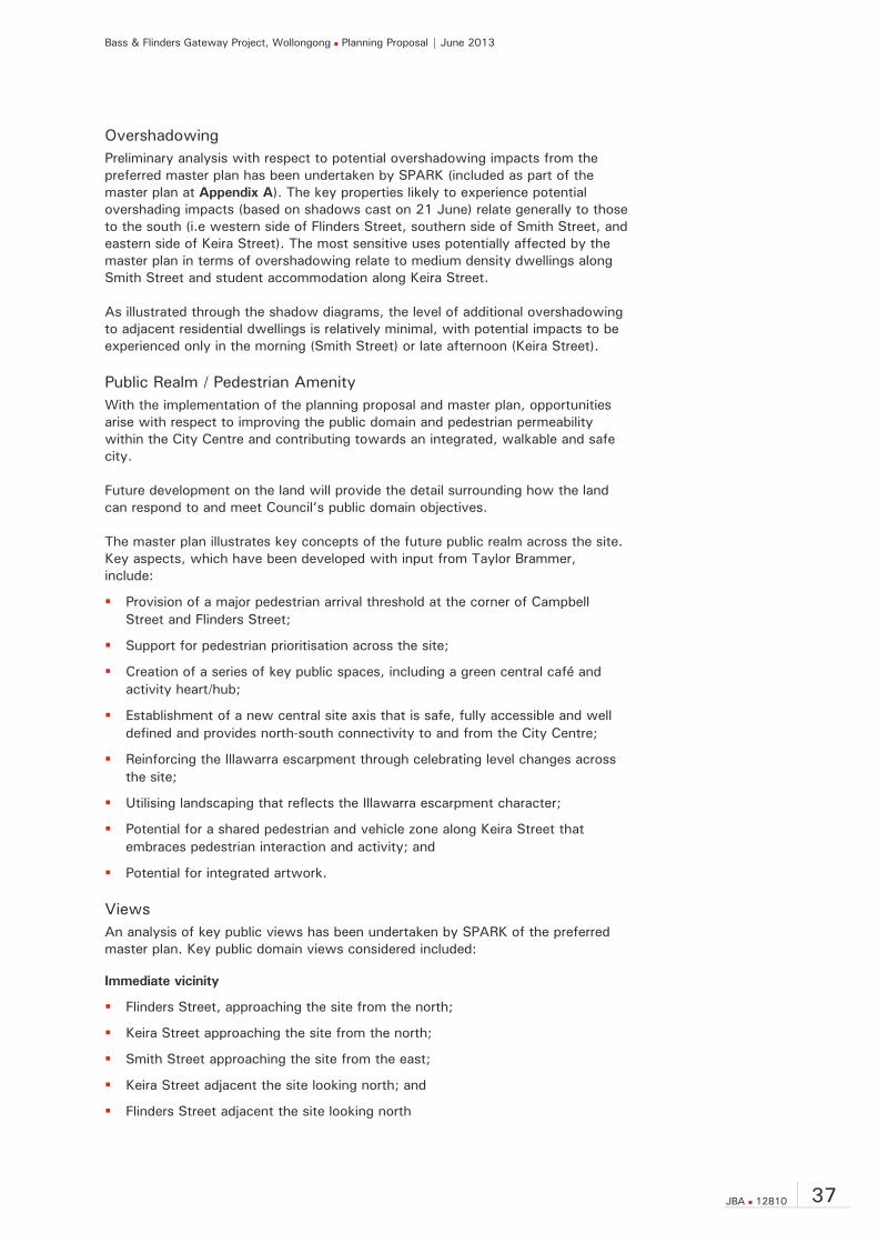
Overshadowing Preliminary analysis with respect to potential overshadowing impacts from the preferred master plan has been undertaken by SPARK (included as part of the master plan at Appendix A). The key properties likely to experience potential overshading impacts (based on shadows cast on 21 June) relate generally to those to the south (i.e western side of Flinders Street, southern side of Smith Street, and eastern side of Keira Street). The most sensitive uses potentially affected by the master plan in terms of overshadowing relate to medium density dwellings along Smith Street and student accommodation along Keira Street. As illustrated through the shadow diagrams, the level of additional overshadowing to adjacent residential dwellings is relatively minimal, with potential impacts to be experienced only in the morning (Smith Street) or late afternoon (Keira Street).
Public Realm / Pedestrian Amenity With the implementation of the planning proposal and master plan, opportunities arise with respect to improving the public domain and pedestrian permeability within the City Centre and contributing towards an integrated, walkable and safe city. Future development on the land will provide the detail surrounding how the land can respond to and meet Council’s public domain objectives. The master plan illustrates key concepts of the future public realm across the site. Key aspects, which have been developed with input from Taylor Brammer, include:
Provision of a major pedestrian arrival threshold at the corner of Campbell Street and Flinders Street;
Support for pedestrian prioritisation across the site;
Creation of a series of key public spaces, including a green central café and activity heart/hub;
Establishment of a new central site axis that is safe, fully accessible and well defined and provides north-south connectivity to and from the City Centre;
Reinforcing the Illawarra escarpment through celebrating level changes across the site;
Utilising landscaping that reflects the Illawarra escarpment character;
Potential for a shared pedestrian and vehicle zone along Keira Street that embraces pedestrian interaction and activity; and
Potential for integrated artwork.
Views An analysis of key public views has been undertaken by SPARK of the preferred master plan. Key public domain views considered included:
Immediate vicinity
Flinders Street, approaching the site from the north;
Keira Street approaching the site from the north;
Smith Street approaching the site from the east;
Keira Street adjacent the site looking north; and
Flinders Street adjacent the site looking north
Bass & Flinders Gateway Project, Wollongong Planning Proposal | June 2013
38 JBA 12810
Distant views
Flagstaff Hill;
Princess Highway (Northern Distributor overpass); and
Illawarra escarpment.
The imagery prepared demonstrates that the planning proposal will support a master plan that can deliver upon Council’s vision for the site in terms of creating a new gateway at the northern entry to the City Centre. Further, it is considered that the creation of a new gateway development on the site will result in a positive contribution to the skyline, reinforcing the role of Wollongong as a regional city and providing a visual marker at the northern end of the City Centre. The form and massing of future development on the site will also sit in balance with other City landmarks from key vantage points.
Heritage There are no heritage items, heritage conservation areas or archaeological sites identified within Wollongong LEP 2009 that effect the subject land.
Traffic Given the planning proposal involves a change within the business zoning from B6 Enterprise Corridor to B4 Mixed Use and with it bringing a range of different uses being permissible along with an increase in the height and floor space controls there is a need to consider the potential impacts of such changes on the operation of road and transport networks. Bitzios Consulting has accordingly prepared a Traffic Impact Assessment in support of this planning proposal, included at Appendix E. The assessment has considered the potential for redevelopment across the whole site with reference and assumptions made based on the preferred master plan for the site. Master Plan vehicle access is proposed as follows:
Main access via Keira Street;
Left-in and left out via Flinders Street, with an ability to exit onto Campbell Street;
No vehicle access will be provided from Campbell Street to the development site; and
Left turn from Keira Street to Smith Street to remain.
The key findings of the Traffic Impact Assessment include:
The development of the master plan is estimated to generate 260 vehicle trips during each peak hour. This equates to a maximum of two (2) vehicle movements ‘in’ or ‘out’ of any single access in a one minute period;
The development generated traffic has a negligible impact on the operational performance of Flinders Street, Campbell Street and Keira Street fronting the subject site;
Car parking to meet the needs of the future redevelopment of the site is intended under the Master Plan to be accommodated at basement level and complies with the Wollongong DCP.
The development is highly accessible by public transport (bus) and active transport modes (walking and cycling).

Bass & Flinders Gateway Project, Wollongong Planning Proposal | June 2013
JBA 12810 39
The base case 2012 ‘with development’ models show no impacts on the surrounding road network. The future year modelling highlights that with or without the development a number of intersections fail in the surrounding area suggesting no infrastructure requirements are necessary as a direct result of the proposed development.
In summary, Bitzios Consulting advise that the proposed development does not introduce any significant traffic or transport impacts that would preclude its support by Council.
6.3.3 Social and Economic Effects Hill PDA have undertaken an Economic Impact Assessment (included at Appendix D) in support of the proposed Planning Proposal. The focus of the assessment has been to determine and quantify the economic impacts arising as a result of the planning proposal. It is noted that the assessment has only specifically addressed part of the site (i.e. the land currently owned by Council and the subject of sale to Gateway Wollongong Pty Ltd) in accordance with the master plan and planning proposal (i.e. the representative scheme). Hill PDA concludes that the planning proposal would deliver a significant net community benefit compared to the current use and the range of potential economic benefits associated with the proposal includes:
Housing – increasing the supply of residential units, including small dwellings, in walking distance of major infrastructure. Small dwellings are the most affordable type and in high demand in this location.
Employment – support additional jobs on-site and in the surrounding area through the construction process (approximately 388 direct jobs) and through operations post-development (approximately 111 jobs).
Retail – provide modest retail facilities to support residents on-site and in the surrounding area. These would offer a differentiated provision to Wollongong City Centre and would undermine the vitality or viability of the City Centre.
Ecologically Sustainable Development – provide high density development within walking distance of local amenities, reducing the need to travel and promoting pedestrian movement.
Urban Activation – acting as a northern anchor for Wollongong City Centre and increasing pedestrian activity along Keira Street (including anchoring the ‘eat street’).
Urban Renewal – maximising the potential for this important gateway site to deliver economic and community benefits, support the City Centre and encourage the regeneration of adjacent sites to yield uses of higher economic value.
Planning Policy – support the aims and objects of planning policy and guidance by increasing residential supply, jobs and investment without prejudicing the primary of Wollongong City Centre.
6.4 State and Commonwealth Interests There are no significant Commonwealth or State interests in the Planning Proposal other than in general for a more appropriate planning and development outcome on the site consistent with the State’s regional strategies and planning framework described above.
Bass & Flinders Gateway Project, Wollongong Planning Proposal | June 2013
40 JBA 12810
6.4.1 Public Infrastructure It is expected that given the site’s Wollongong City Centre location, the existing infrastructure serving the site has the capacity to accommodate development as envisaged under this planning proposal/master plan, subject to any necessary expansion and augmentation at the detailed application stage. The development is in close proximity to the North Wollongong and Wollongong rail stations and to the north of the Wollongong City Centre. It is accordingly in the interest of the State Government to intensify employment generating and residential development in close proximity to these strategic transport hubs and thereby increase patronage of this significant infrastructure investment. As noted the site adjoins a classified road (Flinders Street). Future development will accordingly need to have regard to the operation of this road corridor.
6.4.2 Consultation with State and Commonwealth Authorities
Consultation has occurred with both Roads and Maritime Services and the Department of Planning and Infrastructure as part of the master planning process. Further input from state agencies including the Roads and Maritime Service will be required as part of the determination of any future Development Application for the site. Where necessary, further consultation with relevant authorities will be undertaken as required in accordance with initial Gateway determination. State and Commonwealth authorities will have the opportunity to provide comment on the Planning Proposal as part of its formal exhibition.
6.5 Community Consultation Gateway Wollongong Pty Ltd recognises the importance of community input and consultation as part of the master planning process and in finalising the planning proposal. To complement the statutory public exhibition of the Planning Proposal (post Gateway determination), Gateway Wollongong Pty Ltd plans to engage with the community through a range of different avenues and mediums. This is expected to complement Council’s plans to also seek preliminary feedback from the public on the master plan and planning proposal before making any recommendations about forwarding the planning proposal to the Department of Planning and Infrastructure for gateway determination.
Bass & Flinders Gateway Project, Wollongong Planning Proposal | June 2013
JBA 12810 41
7.0 Indicative Timelines Below is an indicative timeline for the planning proposal.
Submission of Planning Proposal and draft master plan to Council: June 2013
Reporting of planning proposal and draft master plan to Council: September/October 2013
Referral to Minister for Gateway Determination: November 2013
Date of Gateway determination: January 2014
Commencement and completion dates for public exhibition period: February/March 2014
Timeframe for government agency consultation (pre-and post-exhibition as required by Gateway determination): March-April 2014
Timeframe for consideration of submissions: April 2014
Reporting of exhibition of planning proposal and draft master plan to Council: June 2014
Date of submission to the Department to finalise the LEP: July 2014
Anticipated date RPA will make the plan (if delegated): September 2014
Anticipated date RPA will forward to the department for notification: October 2014

Bass & Flinders Gateway Project, Wollongong Planning Proposal | June 2013
42 JBA 12810
8.0 Conclusion The draft master plan demonstrates that changes to the zoning along with the existing height and floor space controls (as proposed by this Planning Proposal) will support a built form outcome that is appropriate in the context of the site. The site has been identified as a gateway site for over 5 years. The current controls do not incorporate flexibility or sufficient breadth to develop a building of significance as a prominent gateway site. The built form for the site has arisen from a series of studies and investigations undertaken by the internationally renowned architect SPARK to develop an appropriate built form and iconic marker for the site. It is therefore considered appropriate for the controls of the site to be modified to reflect the findings of this work. The development of a mixed use residential development on the northern periphery of the Wollongong City Centre is considered to be in the public interest as it will bring additional activity to the City and catalyse further development in this precinct, will provide ongoing employment within the centre and will contribute to Wollongong’s status and growth as a regional city. The provision of residential apartments provides an appropriate complement to the City Centre, activating the City beyond business hours and allowing housing close to jobs, thereby supporting the viability and vitality of the City. The iconic architecture and public spaces to be delivered across the site will be a marker for residents and which showcases Wollongong to visitors to the City. The provision of new public domain and landscaping will substantially improve the quality of these existing and future public spaces. In this context, it is considered that there is sufficient planning justification to warrant a departure from the existing development standards which apply to the subject site. This Planning Proposal will facilitate development that has demonstrable urban design, social and economic benefits for the region. Without the amendments to the zoning, and height and floor space controls (amongst others) proposed under this Planning Proposal, the opportunity will be missed to bolster the Wollongong City’s standing as a vibrant and successful Regional City. It is therefore requested that the Council resolve to forward this Planning Proposal to the Department for Gateway Determination in accordance with the EP&A Act.