planning proposal 60-80 southern cross avenue & 45-65 hall
TRANSCRIPT

Pacific Planning
Property | Planning | Project Management
T 0437 521 110
ABN 88 610 562
PLANNING PROPOSAL
60-80 Southern Cross Avenue & 45-65 Hall Circuit, Middleton Grange
Prepared for Manta Group Pty Ltd
Submitted to Liverpool Council
Revised June 2018

Planning Proposal – Middleton Grange Town Centre
Table of Contents
Introduction 1
Background 2
Site Identification 4
Principle Development Standards 5
Planning Proposal Background 7
Proposed Development Scenario 11
PLANNING PROPOSAL
Part 1 – Statement of Objectives 12
Part 2 – Explanation of Provisions 13
Part 3 – Justification 15
Section A - Need for the Planning Proposal 15
Section B – Relationship to the strategic planning framework 15
Section C – Environmental, social and economic impact 25
Section D – State and Commonwealth interests 37
Part 4 – Mapping 39
Part 5 - Community Consultation 42
LIST OF TABLES
TABLES NAME PAGE No.
Table 1 Site Development Standards 5
Table 2 Proposed Development Controls 13
Table 3 SEPPs 19
LIST OF FIGURES
FIGURE NAME PAGE No.
Figure 1: Aerial view of the subject site 1
Figure 2: Existing subdivision plan 3
Figure 3 Site plan (Source: Six Maps) 4
Figure 4 Zoning Map 5
Figure 5 Maximum Building Height Map 6
Figure 6 Floor Space Ratio Map 6
Figure 7 Indicative building massing 11
Figure 8 Indicative development cross section 11
Figure 9 DCP Traffic Concept 27

Planning Proposal – Middleton Grange Town Centre
Figure 10 Site Access and Circulation Concept 28
Figure 11 Proposed Land Zoning Map 39
Figure 12 Proposed Maximum Height of Buildings Map 40
Figure 13 Proposed Maximum FSR Map 40
Figure 14 Proposed Land Reservation and Acquisition Map 41
Figure 15 Proposed Flood Mapping Map 41
APPENDICES
APPENDICIES TITLE
Appendix A Approved Subdivision DA
Appendix B Gateway Determination
Appendix C Flood Assessment and correspondence
Appendix D Urban Design Report
Appendix E Agency submissions and response
Appendix F Traffic and Transport
Appendix G Economic Analysis
Appendix H Social Impact Assessment
Appendix I DCP Plans

Planning Proposal – Middleton Grange Town Centre
1 | P a g e
Introduction
This planning proposal is submitted in accordance with Section 3.33 of the Environmental Planning and Assessment (EP&A) Act 1979 and provides an outline and justification for the proposed amendments to the development controls at 60-80 Southern Cross Avenue and 45-65 Hall Circuit, Middleton Grange (“the site”). The proposal amends Liverpool Local Environmental Plan (LEP) 2008.
The Planning Proposal was originally lodged with Liverpool City Council in June 2015. The matter was considered by Council at its meeting of 16 December 2015, where Council supported the progression of the Planning Proposal to the next stage in the Part 3 Plan Making process. A Gateway determination was issued by the delegate of the Greater Sydney Commission on 15 August 2016. The Gateway endorsed the Planning Proposal subject to conditions that would need to be addressed and approved prior to the progression of the proposal to the next stage being consultation and exhibition.
This planning proposal will ensure redevelopment of the site for mixed use buildings, providing opportunities for retail and commercial investment within the Middleton Grange Town Centre. It will likely incorporate retail uses such as a supermarket, specialty retail, discount department stores and restaurants. It will also attract health and community services and a town square which will support new residents and generate new jobs for the region. The population of the suburb will be around 5,000-6,000 people and may possibly go to 10,000 people once fully developed. Middleton Grange Town Centre is located 7 km west of Liverpool CBD and 5 km north-east of Leppington Station. It is bound by Southern Cross Avenue to the north, Bravo Road and the Middleton Grange Public School to the east, Flynn Avenue & Hall Circuit to the south with existing residential development to the west.
Figure 1: Aerial view of the subject site

Planning Proposal – Middleton Grange Town Centre
2 | P a g e
In accordance with relevant NSW Department of Planning and Environment guidelines, including ‘A Guide to Preparing Local Environmental Plans’ (2016) and ‘A Guide to Preparing Planning Proposals’ (2016), this planning proposal comprises the following parts:
Part 1 A statement of the objectives or intended outcomes of the proposed instrument
Part 2 An explanation of the provisions that are to be included in the proposed instrument
Part 3 The justification for those objectives, outcomes and the process for their implementation based on technical studies
Part 4 The existing controls that apply to the site based on the Councils LEP Maps
Part 5 Details of the community consultation to be undertaken on the planning proposal
This planning proposal forms part of a package of supporting documents for further consideration by the Gateway under Section 3.33 of the EP&A Act 1979 and in accordance with the conditions of the Gateway determination issues on 15 August 2016. The Planning Proposal application is supported by the specialist studies appended to this report.
Background
Development Application DA 64/2007 and modification DA 64/2007/A for Road and Drainage Construction are in place for the site. On 11 July 2008, a Construction Certificate (CC) for road and drainage works was issued by Council. The trunk drainage system design within the town centre included culverts appropriate to the 1% AEP event flood scenario. A portion of these works were completed in 2009.
Furthermore, on 16 August 2011 the NSW Office of Water gave approval for an enclosed drainage channel directing the flow of Southern Creek through the site for the subdivision and construction of roads on previous Lot 100, 101 and 102 Seventeenth Avenue, Middleton Grange. This enclosed drain over the site was noted by the NSW Office of Water as an acceptable solution in the context. A copy of this correspondence is included at Appendix C.
Development Application (DA 74/2015) was approved by Council on 1 April 2015 for the super lot subdivision of the site into eight (8) lots. The proposal involved subdivision and no physical works were proposed as part of this application. A subdivision certificate has been issued by the Land & Property Information Service. The approved DA Plan is included at Figure 2 and Appendix A. Further resolution to the design has been undertaken to define a future road and building layout and this is subject to future applications and approval.

Planning Proposal – Middleton Grange Town Centre
3 | P a g e
Figure 2: Existing subdivision plan
Planning Proposal – Middleton Grange Town Centre
4 | P a g e
Site Identification
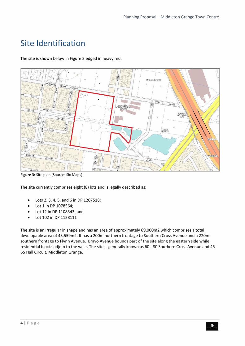
The site is shown below in Figure 3 edged in heavy red.
Figure 3: Site plan (Source: Six Maps)
The site currently comprises eight (8) lots and is legally described as:
• Lots 2, 3, 4, 5, and 6 in DP 1207518;
• Lot 1 in DP 1078564;
• Lot 12 in DP 1108343; and
• Lot 102 in DP 1128111
The site is an irregular in shape and has an area of approximately 69,000m2 which comprises a total developable area of 43,559m2. It has a 200m northern frontage to Southern Cross Avenue and a 220m southern frontage to Flynn Avenue. Bravo Avenue bounds part of the site along the eastern side while residential blocks adjoin to the west. The site is generally known as 60 - 80 Southern Cross Avenue and 45-65 Hall Circuit, Middleton Grange.

Planning Proposal – Middleton Grange Town Centre
5 | P a g e
Principle Development Standards
Table 1 below summarises the principle standards that currently apply to the subject site as set out in Liverpool LEP 2008. Figure 4 below shows the zoning map that covers the site.
Land Zoning Maximum Building Height
Maximum Floor Space Ratio (FSR)
Other
B2 – Local Centre
R1 – General Residential
RE1 – Public Recreation
SP2 - Drainage
18m (“P”)
8.5m (“I”)
1.5:1 (“S1” - Area 4)
0.75:1 (“I”)
Flood Planning
Dwelling Density
Table 1: Site Development Standards
Figure 4: Zoning Map

Planning Proposal – Middleton Grange Town Centre
6 | P a g e
Figure 5: Maximum Building Height Map
Figure 6: Maximum Floor Space Ratio Map

Planning Proposal – Middleton Grange Town Centre
7 | P a g e
Planning Proposal Background
A Gateway determination was issued by the delegate of the Greater Sydney Commission on 15 August 2016. The Gateway endorsed the Planning Proposal subject to conditions that would need to be addressed and approved prior to the progression of the proposal to the next stage being consultation and exhibition. In approving the Planning Proposal, the Gateway included the following conditions:
1. In relation to s117 Direction 4.3 (now 9.1) Flood Prone Land, prior to public exhibition, Council is required to: a. Undertake and provide relevant flood studies that demonstrate consistency with this Direction;
and b. Include a Flood Planning Area Map in the proposal.
2. Prior to public exhibition, Council must revise the planning proposal to include the flooding
information and to provide additional information regarding:
a. Transition of proposed heights to existing neighbouring zones and overshadowing impacts.
b. Proposed controls for proposed commercial uses in residential zones, for example, this may include proposed controls to limit, or encourage certain commercial floor areas, or controls to ensure a proportion of residential uses, and
c. Provide the revised planning proposal to the Department for review. 3. Prior to public exhibition, consultation is required with the following public authorities under section
56(2)(d) of the Act and to comply with the requirements of relevant S117 Directions:
• Office of Environment and Heritage;
• Roads and Maritime Services
• Transport for New South Wales
• Sydney Water
• Department of Education
• State Emergency Service.
Each public authority is to be provided with a copy of the planning proposal and any relevant
supporting material, and given at least 21 days to comment on the proposal. The proposal must
address any comments made.
4. Community consultation is required under sections 56(2)(c) and 57 of the Act as follows: a) The planning proposal must be made publicly available for a minimum of 28 days; and
b) The relevant planning authority must comply with the notice requirements for public
exhibition of planning proposals and the specifications for material that must be made publicly available along with planning proposals as identified in section 5.5.2 of A
Guide to Preparing LEPs (Department of Planning and Infrastructure 2013).
5. A public hearing is not required to be held into the matter by and person or body under section 56(2)(e) of the Act. This does not discharge Council from any obligation it may otherwise have to conduct a public hearing (for example, in response to a submission or if reclassifying land).
6. The timeframe for completing the LEP is to be 18 months from the week following the date of the
Gateway determination.

Planning Proposal – Middleton Grange Town Centre
8 | P a g e
Table 2 below demonstrates compliance with the specific conditions in the determination.
Condition Relevant Section / Technical Investigation
1. In relation to s117 Direction 4.3 (now 9.1) Flood Prone Land, prior to public exhibition, Council is required to:
a. Undertake and provide
relevant flood studies that
demonstrate consistency
with this Direction; and
Refer also to discussion on Section 9.1 Directions –
Direction 4.3 Flood prone land
A Flooding report has been prepared (Appendix C) which
addresses s9.1 Direction 4.3 Flood Prone Land by
demonstrating the suitability of the site to accommodate a
trunk drainage culvert as previously approved by Liverpool
Council (11 July 2008, CCE-31/2008). This report models
how the proposed system can accommodate water flows
up to the 1 in 100 year flood and thereby reducing the
effective flood risk for the site.
b. Include a Flood Planning Area
Map in the proposal.
A Flood Planning Area map has been provided with the
proposed new maps (See Part 4 of this Planning Proposal).
2. Prior to public exhibition, Council
must revise the planning
proposal to include the flooding
information and to provide
additional information
regarding:
a. Transition of proposed heights to existing neighbouring zones and overshadowing impacts.
Revised massing analysis has been undertaken to improve the transition of heights across the entire site to surrounding neighbouring zones, and ensure minimal overshadowing impacts. A revised Urban Design Report, which includes massing analysis has been prepared by Pacific Planning with input from Christiansen O’Brien Architects and Mosca Pserras Architects (Appendix C). These plans illustrate how building mass is distributed from the centre of the development across the site to neighbouring zones. Building heights have been reduced with direct interface to the west, north and south to ensure an appropriate transition and improve solar amenity to these areas.
b. Proposed controls for proposed commercial uses in residential zones, for example, this may include proposed controls to limit, or encourage certain commercial floor areas, or controls to ensure a proportion of residential uses, and
Liverpool LEP 2008 Clause 5.4 provides “Controls relating
to miscellaneous permissible uses.” As agreed with Council
officers on the 31 July 2017, the planning proposal has
been further amended to reduce the number of additional
permitted uses on parts of the site. The proposal now
seeks to amend Schedule 1 – Development for Certain
Additional Purposes to use the R1 General Residential
zoned part of the site for a ‘restaurant and café’ and a
‘hotel or motel accommodation’ within the proposed B2
Local Centre zone.

Planning Proposal – Middleton Grange Town Centre
9 | P a g e
c. Provide the revised planning proposal to the Department for review.
Noted. This is the revised proposal.
3. Prior to public exhibition, consultation is required with the following public authorities under section 56(2)(d) of the Act and to comply with the requirements of relevant S117 Directions:
Noted. Council provided a copy of the planning proposal
to the relevant authorities on 2 September 2016 for
comment. The final response from authorities was
received on 10 February 2017. Relevant details have been
included in the relevant sections of the Planning Proposal
and a copy of all submissions and responses are attached
in Appendix E.
- Office of Environment and
Heritage
Refer to Appendix E.
- Roads and Maritime Services An assessment of the proposed internal road layout dated 6
February 2017 is attached at Appendix F. Updated traffic
modelling using the AIMSUN model has also been
undertaken. The work is in accordance with the
requirements of RMS and Council (as per the agreed and
confirmed scope set out at the meeting with Council and
RMS on 27 February 2017). A copy of this assessment is
also included at Appendix F.
Note: The RMS advised that it raised no objection to the
planning proposal being public exhibited subject to
AIMSUM modelling work being undertaken. A copy of this
correspondence is also included with the Assessment.
- Transport for New South Wales Refer to notes above. Work undertaken with RMS also
addresses the issues raised by TfNSW on the need for a
revised Traffic Impact Assessment.
- Sydney Water The site is currently serviced by Cecil Park Water Supply Zone for drinking water. Sydney Water has confirmed that there is sufficient trunk capacity for the initial proposed zoning changes. The site is serviced by 100-200mm water mains. Extensions and upsizing will be required from the existing mains in the area to ensure there is sufficient capacity for the development. Detailed requirements, including water main extensions or relocations/diversions, will be provided at the DA stage. The site is also serviced with Recycled Water from the Hoxton Park scheme.
Planning Proposal – Middleton Grange Town Centre
10 | P a g e
The site is located within the Malabar Wastewater System
and is currently serviced by the Hoxton Park Carrier.
Sydney Water has confirmed there is sufficient trunk and
treatment capacity for the initial development. For
wastewater, the development can be connected to the
225mm wastewater mains within the development.
Detailed requirements, including water main extensions or
relocations/diversions, will be provided at the DA stage.
- Department of Education The Department of Education provides no objection to the
planning proposal. The Department of Education has
provided comment on the potential impacts on the
Middleton Grange Public School which is located to the east
of the site.
The Department of Education suggests upper level setbacks
and the use of non-reflective building materials.
Appropriate controls can be contained within the relevant
Development Control Plan.
- State Emergency Service Noted.
Each public authority is to be
provided with a copy of the
planning proposal and any
relevant supporting material, and
given at least 21 days to
comment on the proposal. The
proposal must address any
comments made.
Noted. Council provided a copy of the planning proposal to
the relevant authorities on 2 September 2016. The
Planning Proposal has been updated wherever relevant in
order to integrate the comments raised.

Planning Proposal – Middleton Grange Town Centre
11 | P a g e
Proposed Development Scenario
Figure 7: Indicative building massing
Figure 8: Indicative development cross section

Planning Proposal – Middleton Grange Town Centre
12 | P a g e
PLANNING PROPOSAL
Part 1 – Statement of Objectives
The main objectives of this Planning Proposal are:
• To enable a broader range of permissible uses within the Middleton Grange Town Centre.
• To allow for a higher density of development on the site.
• To extend the existing B2 Local Centre zone to encompass land to the north and west and rationalise the zoning boundary between the B2 and R1 zoned land on the site to reflect lot boundaries and reduce the amount of split zoning.
• To relocate the public open space area to accommodate a public through-site link that will have active uses at ground level. This will rezone part of the site zoned RE1 Public Recreation to B2 Local Centre and rezone part of the site currently zoned B2 Local Centre to RE1 Public Recreation. There is no change in the quantum of RE1 land area.
The proposed amendment will facilitate the creation of a new town centre compromising a range of mixed use buildings up to 10 to 12 storeys in height with a total site GFA of 112,050, achieved with a split FSR of part 1:1 and part 2.3:1. The new Town Centre would comprise the following approximate uses:
• 86,031m2 of residential space;
• 20,240m2 of retail;
• 2,533m2 of other commercial uses;
• 912 new dwellings;
• 180 place childcare centre;
• new roads and infrastructure;
• new town square; and
• open space areas and parks.
Indicative concept and massing diagrams are included in the attached urban design report (Appendix D).

Planning Proposal – Middleton Grange Town Centre
13 | P a g e
Part 2 – Explanation of Provisions
SUMMARY OF PROPOSED CHANGES TO LEP CONTROLS
Current (LLEP 2008) Proposed
Zoning B2 – Local Centre
R1 – General Residential
RE1 – Public Recreation
SP2 - Drainage
No changes other than internal boundary adjustments
Floor Space Ratio 1.5:1 (“S1” - Area 4) 0.75:1 (“I”)
2.3:1 (“T1”) for B2 land 1:1 (“N”) for R1 land
Height of Buildings 18m (“P”)
8.5m (“I”)
9.5m (“J”) 14m (“N”) 20m (“Q”) 32m (“U1”) 35m (“V”)
Table 2: Proposed Development Controls
This Planning Proposal seeks to amend the Liverpool LEP 2008 to achieve the outlined objectives. The following are the operative provisions:
1. Amend the Liverpool Local Environmental Plan 2008 Floor Space Ratio Map to part 1:1 and part 2.3:1 as shown on the proposed map at Part 4.
2. Amend the Liverpool Local Environmental Plan 2008 Height of Building Map to part 9.5 metres, 14 metres, 20 metres, 32 metres and 35 metres as shown on the proposed map.
3. Amend the Liverpool Local Environmental Plan 2008 Zoning Map by making internal boundary adjustments to B2 zoned land affecting Lots 4, 5, 6 of DP 1207518 and Part Lot 12 of DP 1108343 as shown on the proposed map.
4. Amend the Liverpool Local Environmental Plan 2008 Zoning Map by adjusting certain RE1 and B2 zoned land to create a future through site link, affecting Part Lot 102 of DP 1128111 and Lot 12 of DP 1108343 as shown on the proposed map.
5. Amend the Liverpool Local Environmental Plan 2008 Land Reservation Acquisition Map as it relates to RE1 zoned land on the site, as shown on the proposed map.
6. Amendment of the Liverpool Local Environmental Plan 2008 by adding the following provisions to Schedule 1: “Use of certain land at Middleton Grange
(1) This clause applies to Lots 2, 3, 4, 5, and 6 in DP 1207518; Lot 1 in DP 1078564; Lot 12 in DP 1108343; and Lot 102 in DP 1128111, known as 60 - 80 Southern Cross Avenue and 45-65 Hall Circuit, Middleton Grange.

Planning Proposal – Middleton Grange Town Centre
14 | P a g e
(2) Development for the purposes a “restaurant or café” 1 within R1 zoned land and “hotel or motel accommodation” 2 within B2 zoned land.
(3) Development for the purposes a ‘hotel or motel accommodation’ within B2 zoned land.”
1. “Restaurant or café” means a building or place the principal purpose of which is the preparation and serving, on a retail basis, of food and drink to people for consumption on the premises, whether or not liquor, take away meals and drinks or entertainment are also provided.
2. “Hotel or motel accommodation” means a building or place (whether or not licensed premises under the Liquor Act 2007) that provides temporary or short-term accommodation on a commercial basis and that:
(a) comprises rooms or self-contained suites, and
(b) may provide meals to guests or the general public and facilities for the parking of guests’ vehicles,
but does not include backpackers’ accommodation, a boarding house, bed and breakfast accommodation or farm stay accommodation.

Planning Proposal – Middleton Grange Town Centre
15 | P a g e
Part 3 – Justification
Section A - Need for the Planning Proposal
1. Is the planning proposal a result of any strategic study or report?
No. The Planning Proposal facilitates the future redevelopment of the site and represents the activation of the Middleton Grange Town Centre.
2. Is the planning proposal the best means of achieving the objectives or intended outcomes, or is there a better way?
The planning proposal is an appropriate means of achieving the stated objectives and intended outcomes.
Section B – Relationship to the strategic planning framework
3. Is the planning proposal consistent with the objectives and actions of the applicable regional or sub-regional strategy?
A Plan for Growing Sydney
In December 2014, the NSW Government published A Plan for Growing Sydney, the new strategic document to manage the growth of Sydney over the next 20 years. It is intended to guide land use planning decisions and presents a strategy for accommodating Sydney’s projected population growth. It envisages a globally competitive Sydney with a population increase of 1.6 million people, including 689,000 new jobs and 664,000 new homes by the year 2031.
The plan sets out four goals:
1. A competitive economy with world class services and transport; 2. A city of housing choice and homes that meet our needs and lifestyles; 3. A great place to live with communities that are strong, healthy and well connected; and 4. A sustainable and resilient city that protects the natural environment and has a balanced
approach to the use of land and resources.
The site is located in the Liverpool Strategic Centre with direct transport connections to Sydney Airport, the Western Sydney Airport and the South West Growth Centre. Liverpool is central to the “Western City” and will retain the commercial core for long-term employment growth, provide new mixed use development and health-related services.
While not within a key strategic area, the Planning Proposal is consistent with Direction 2.2 – Accelerate urban renewal across Sydney – Providing homes closer to jobs. The Planning Proposal facilitates appropriate housing around a local centre which promotes living closer to job-generating land uses which supports transport initiatives and reduces road congestion.

Planning Proposal – Middleton Grange Town Centre
16 | P a g e
Draft South West District Plan
The Draft South West District Plan adopts a 20 year housing target of 143,000 new dwellings by 2036. The proposal to accommodate approximately 939 residential apartments in the Middleton Grange Town Centre is in line with the overall intention of the Draft South West District Plan.
The draft plans aim to accelerate housing supply, improve housing choice and affordability, as well as create resilient neighbourhoods. They also promote the expansion of local employment opportunities. The proposal is consistent with the overall objectives of the Draft South West District Plan in that it increases housing supply of smaller dwelling units (apartments and townhouses) around Middleton Grange.
The new retail and commercial floor space will assist in meeting the needs of new and existing residents, providing essential services and meeting recreational needs. This will create local employment opportunities for the community, in addition to construction jobs.
The Planning Proposal will assist in providing additional housing and employment opportunities around Middleton Grange Town Centre to help meet the targets set for the District by increasing the density with the B2 zoned land. Local Centres such as those proposed complement major and strategic centres rather than competing with them. An Economic Impact Assessment Report is included at Appendix _ to support the benefits of the additional floor area.
Draft Centres Policy / SEPP (Competition) 2010
In July 2010, the NSW Government released a draft policy which seeks to reduce barriers to competition between retail and commercial businesses. The policy encourages competition between retail businesses and thereby place downward pressure on prices, promote economic growth and remove anti-competitive behaviour.
The key points from this document are that:
• The viability of a proposed development is not a matter to be taken into consideration by the consent authority.
• The impacts of a proposed commercial development on the viability of other commercial uses are not matters for the consent authority. The extent to which the impacts may affect the adequacy and efficacy of overall community facilities and services is relevant.
• To place no restrictions on the number and type of retail premises in any commercial development. Impacts of scale however are relevant.
• To place no restrictions on the proximity of a particular type of retail premises to another retail premises of that type.
The intention of this policy is to restrict existing retailers from blocking additional competition. It ensures the provision of new retail development considered appropriate to meet market needs and achieve a community benefit. This planning proposal does seek to extend the area of B2 land enabling a better town centre configuration and a greater amount of employment generating floor space along with increased residential density.

Planning Proposal – Middleton Grange Town Centre
17 | P a g e
4. Is the planning proposal consistent with a council’s local strategy or other local strategic plan?
Liverpool Retail Centres Hierarchy Review (2012):
In 2012, Hill PDA prepared a retail centres hierarchy review for Council based largely on existing and imminent centres. It excluded potential centres in the South West Growth Centre (SWGC) given that land use configurations within the SWGC were unclear at the time of the review. The Middleton Grange Town Centre was noted as an imminent centre. The centre had been zoned for retail and commercial purposes but had not been developed. At the time of preparing the review, Hill PDA estimated the catchment area for retail centres within the Liverpool LGA to contain about 398,000 residents, increasing to around 526,000 by 2031. The review determined existing demand for retail floor space in the Liverpool LGA would increase from approximately 397,000m2 in 2012 to 511,000m2 by 2031. This represents an increase of 6,000 m2 per year. Whilst the study does not specify demand for retail floor space at Middleton Grange, the proposed concept and estimated floor areas would represent just 3.5 years of required retail demand across the Liverpool LGA.
Business Centres and Corridors Strategy Review 2013
Council carried out a review of its business centres and corridors strategy in 2013. The purpose of the strategy and review was to consolidate the LGA’s ability to cater for growth generally in the professional services sector.
The strategies identified by the review were:
1. Preserve a commercial core area (excluding residential) in the Liverpool CBD for future business, office and retail growth.
2. Limit professional office premises to business zones to capitalise on, and concentrate infrastructure and services.
3. Establish and maintain Liverpool’s Retail Centre Hierarchy. 4. Support the expansion of existing retail and business centres in accordance with the adopted Retail
Centres Hierarchy 2012. 5. Ensure that new centres complement existing centres and do not impact upon their viability. 6. Expand start-up business opportunities (and restrict residential) in extended enterprise corridor
zones leading into main centres and nodes. 7. Support growth of existing bulky goods clusters in accordance with the retail centre hierarchy and
limit other locations to serve a district role.”
The planning proposal seeks to establish and extend a local centre, creating a more functional and viable town centre. It will not derogate from Liverpool as a centre but provide appropriate local uses for future residents. These uses will encourage affordability and encourage start-up businesses and local connections. The proposal is consistent with the objectives above.
Draft Community Strategic Plan – Growing Liverpool 2023
The draft community strategic plan has been in preparation since 2011. When completed, this Plan will guide Liverpool City Council’s policies, including land use policies. Currently the strategy identifies broad strategies and objectives which seek to improve economic prosperity, encourage inclusiveness and create an accessible urban centres. The proposal would be consistent with the draft strategy given it would cater

Planning Proposal – Middleton Grange Town Centre
18 | P a g e
for the retail, commercial, community needs of the Middleton Grange community and broader surrounding residents. The main street design would encourage inclusiveness and create an accessible urban form.
The planning proposal has been considered against relevant actions and goals of a local strategy or plan as follows:
5. Is the planning proposal consistent with applicable State Environmental Planning Policies?
The consistency of this Planning Proposal with applicable State Environmental Planning Policies (SEPPs) is outlined in Table 3 below.
ASSESSMENT AGAINST SEPPS
State Environmental Planning Policy Comment
SEPP No 1—Development Standards Consistent
SEPP No 14—Coastal Wetlands N/A
SEPP No 19—Bushland in Urban Areas N/A
SEPP No 21—Caravan Parks N/A
SEPP No 26—Littoral Rainforests N/A
SEPP No 30—Intensive Agriculture N/A
SEPP No 33—Hazardous and Offensive Development
N/A
SEPP No 36—Manufactured Home Estates N/A
SEPP No 44—Koala Habitat Protection N/A
SEPP No 47—Moore Park Showground N/A
SEPP No 50—Canal Estate Development N/A
SEPP No 52—Farm Dams and Other Works in Land and Water Management Plan Areas
N/A
SEPP No 55—Remediation of Land In accordance with clause 6 of SEPP No. 55, a planning authority is to consider whether the land to which a planning proposal relates is contaminated, and if the land is contaminated, the planning authority is satisfied that the land is suitable or will be suitable after remediation for the purposes for which the land is proposed to be used. The potential for contamination across the site is considered low and is unlikely to prevent the planning and development of land for the proposed uses. Further assessment can be undertaken at DA stage.
SEPP No 62—Sustainable Aquaculture N/A
SEPP No 64—Advertising and Signage Consistent
SEPP No 65—Design Quality of Residential Flat Development
This planning proposal envisages residential flat buildings on the site. The detailed design of future buildings will be subject to the provisions of the Apartment Design Guide (ADG) at the DA stage. The

Planning Proposal – Middleton Grange Town Centre
19 | P a g e
concepts presented in the Urban Design Report have regard to the rules of thumb set out in the ADG, particularly in regard to building separation distances, privacy and solar access.
SEPP No 70—Affordable Housing (Revised Schemes)
Consistent
SEPP No 71—Coastal Protection N/A
SEPP (Affordable Rental Housing) 2009 Consistent
SEPP (Building Sustainability Index: BASIX) 2004 Consistent
SEPP (Exempt and Complying Development Codes) 2008
Consistent
SEPP (Housing for Seniors or People with a Disability) 2004
Consistent
SEPP (Infrastructure) 2007 Consistent
SEPP (Integration and Repeals) 2011 Consistent
SEPP (Kosciuszko National Park— Alpine Resorts) 2007
N/A
SEPP (Kurnell Peninsula) 1989 N/A
SEPP (Major Development) 2005 N/A
SEPP (Mining, Petroleum Production and Extractive Industries) 2007
N/A
SEPP (Miscellaneous Consent Provisions) 2007 Consistent
SEPP (Penrith Lakes Scheme) 1989 N/A
SEPP (Rural Lands) 2008 N/A
SEPP (State and Regional Development) 2011 N/A
SEPP (State Significant Precincts) 2005 N/A
SEPP (Sydney Drinking Water Catchment) 2011 Consistent
SEPP (Sydney Region Growth Centres) 2006 Consistent
SEPP (Three ports) 2013 N/A
SEPP (Urban Renewal) 2010 Consistent
SEPP (Western Sydney Employment Area) 2009 N/A
SEPP (Western Sydney Parklands) 2009 N/A
Table 3: SEPPs
6. Is the planning proposal consistent with applicable Ministerial Directions (s.9.1 directions)?
This Planning Proposal has been assessed against each relevant Section 9.1 Direction. Consistency or otherwise is addressed in Table 2 below.
ASSESSMENT AGAINST SECTION 9.1 DIRECTIONS
No. Title Comment
1. Employment and Resources
1.1 Business and Industrial Zones The proposal provides for new job-generating land uses that will include retail, recreation, commercial and medical uses. The subject site is currently zoned for employment opportunities and this proposal

Planning Proposal – Middleton Grange Town Centre
20 | P a g e
seeks to extend the area of land available for employment uses. The site is in proximity to major access routes including Cowpasture Road, M7 Motorway and Fifteenth Avenue. The planning proposal seeks to enhance an already identified strategic centre (i.e. Middleton Grange Town Centre). The planning proposal is generally consistent with the objectives of this direction.
1.2 Rural Zones N/A
1.3 Mining, Petroleum Production and Extractive Industries
N/A
1.4 Oyster Aquaculture N/A
1.5 Rural Lands N/A
2. Environment and Heritage
2.1 Environment Protection Zones N/A
2.2 Coastal Protection N/A
2.3 Heritage Conservation Consistent. No impact on heritage items.
2.4 Recreation Vehicle Areas N/A
2.5 Application of E2 and E3 Zones and Environmental Overlays in Far North Coast LEPs
N/A
3. Housing Infrastructure and Urban Development
3.1 Residential Zones
The objectives of this direction are:
(a) to encourage a variety and choice of housing types to provide for existing and future housing needs,
(b) to make efficient use of existing infrastructure and services and ensure that new housing has appropriate access to infrastructure and services,
(c) to minimise the impact of residential development on the environment and resource lands.
The proposal is consistent with this objective. It provides housing choice and meets future housing needs around a local centre in a high growth area of Sydney. It represents an efficient and effective use of infrastructure and will attract new infrastructure and services to benefit the broader population.
The site will be developed in an integrated fashion meaning that impacts can generally be managed within the overall site. The building heights are proposed to transition to respect the allowable heights of adjoining lands.
3.2 Caravan Parks and Manufactured Home Estates
N/A
3.3 Home Occupations Consistent
3.4 Integrating Land Use and Transport
(1) The objective of this direction is to ensure that urban structures, building forms, land use locations, development designs, subdivision and street layouts achieve the following planning objectives:
(a) improving access to housing, jobs and services by walking, cycling and public transport, and
The Planning Proposal is consistent with these objectives. It provides for the development of Middleton Grange Town Centre which will provide improved access to housing, jobs and health and community services by walking, cycling and public transport. Mixed uses will allow for multi-purpose trips by visitors and residents.

Planning Proposal – Middleton Grange Town Centre
21 | P a g e
(b) increasing the choice of available transport and reducing dependence on cars, and
(c) reducing travel demand including the number of trips generated by development and the distances travelled, especially by car, and
(d) supporting the efficient and viable operation of public transport services, and
(e) providing for the efficient movement of freight.
The site is located in proximity to local bus networks and future capital works may occur in the future. Employment uses near housing directly supports the objectives of placing homes near to jobs.
3.5 Development Near Licensed Aerodromes N/A
3.6 Shooting Ranges N/A
4. Hazard and Risk
4.1 Acid Sulfate Soils
4.2 Mine Subsidence and Unstable Land N/A
4.3 Flood Prone Land
The objectives of this direction are:
(a) to ensure that development of flood prone land is consistent with the NSW Government’s Flood Prone Land Policy and the principles of the Floodplain Development Manual 2005, and
(b) to ensure that the provisions of an LEP on flood prone land is commensurate with flood hazard and includes consideration of the potential flood impacts both on and off the subject land.
The site is partially flood prone and comments from the State Emergency Service (SES) have been sought as a part of the agency consultation process. The SES recommended that an assessment of the flood risk of the site be undertaken so that a proper assessment can be carried out. It suggested:
• Zoning should not enable development that will result in an intolerable increase in risk to life, health or property of people living on the flood plain.
• Risk assessment should consider the full range of flooding, including events up to the Probable Maximum Flood (PMF) and not focus only on the 1% AEP flood.
• Risk assessment should have particular regard to flooding warning and evacuation demand on existing and future access/egress routes. Consideration should also be given to the impacts of localised flooding on evacuation routes.
• In the context of future development, self-evacuation of the community should be achieved in a manner should be achieved in a manner which is consistent with the NSW SES’s principles for evacuation.
• Future development must not conflict with the NSW SES’s flood response and evacuation strategy for the existing community.
• Evacuation must not require people to drive or walk through flood water.
• Development strategies relying on an assumption that mass rescues may be possible where

Planning Proposal – Middleton Grange Town Centre
22 | P a g e
evacuation either fails or is not implemented are not acceptable to the NSW SES.
• The NSW SES is opposed to the imposition of development consent conditions requiring flood evacuation plans rather than the application of sound land use planning and flood risk management.
Due to portions of the site being below the Probable Maximum Flood (PMF) level, the Office of Environment and Heritage (OEH) raised similar issues. The OEH suggested that a Flood Study be undertaken for both existing and developed conditions. Specifically, it should comprise:
• A comprehensive understanding of the flood risk to people and properties for the full range of the floods up to and including the PMF event for existing and future conditions.
• An assessment of the impact of the proposal on the existing flood behaviour including any potential reduction of floodway and flood storage areas or redistribution of flow which may result in increasing of flood levels on adjacent, downstream or upstream areas.
• Identification of appropriate mitigation measures, if necessary, to offset potential flood risk arising from the project. Any proposed mitigation work should be modelled and assessed on an overall catchment basis in order to ensure it fits its purpose and meets criteria of the Council where it is located. This will help ensure that the proposal has no adverse impact on surrounding areas.
• An assessment of the impacts of earthworks and filling around the flood prone land up to the PMF level. The assessment should be based on understanding the cumulative flood impacts of various development within the catchment. The proposal should ensure that any filling is limited to flood fringe areas identified in accordance with the Floodplain Development Manual (2005).
• A sensitivity analysis to determine the potential impacts from climate change on flooding behaviour.
• An emergency response plan should be prepared in consultation with the State Emergency Service (SES) Regional Controller in order to manage floods and overland flow above the flood planning level. This plan should include an assessment of the flood evacuation needs to ensure that risk to people is minimised.

Planning Proposal – Middleton Grange Town Centre
23 | P a g e
A flooding and stormwater management Strategy has been prepared (August 2017) by J. Wyndham Prince and is included at Appendix C. The Strategy has been prepared to further assess the flood impacts of a section of the Southern Creek within Middleton Grange.
In relation to the SES submission, the Strategy notes:
“the site is located well clear of regional flooding and based on contours in the area, evacuation could easily occur towards a higher area with a rising grade. On this basis, we note that many of SES’s comments in their letter to Liverpool City Council, dated 10th February 2017, are not applicable to the site and are therefore satisfied”.
In relation to the OEH submission, the Strategy also notes:
• 1% AEP and PMF results of flooding are provided in Appendix B
• Flood Impacts are provided in Appendix B and show no impact to the surrounding properties.
• It is noted that no mitigation works are required to support this development since there is no impact on surrounding areas.
• The site is not located in flood prone land from Cabramatta Creek (Bewsher 2011) and therefore does not affect flood storage nor require compensatory works.
Further, on 12 January 2018, Council staff confirmed that it is “generally satisfied with the flood impact assessment report and flood mapping”.
Therefore, for the purposes of Section 9.1 Direction 4.3, the Planning Proposal has satisfied the condition of the Gateway determination.
4.4 Planning for Bushfire Protection N/A
5. Regional Planning
5.1 Implementation of Regional Strategies Consistent
5.2 Sydney Drinking Water Catchments Consistent
5.3 Farmland of State and Regional Significance on the NSW Far North Coast
N/A
5.4 Commercial and Retail Development along the Pacific Highway, North Coast
N/A
5.8 Second Sydney Airport: Badgerys Creek N/A
5.9 North West Rail Link Corridor Strategy N/A
Planning Proposal – Middleton Grange Town Centre
24 | P a g e
5.10 Implementation of Regional Plans N/A
6. Local Plan Making
6.1 Approval and Referral Requirements
6.2 Reserving Land for Public Purposes
The objectives of this direction are:
(a) to facilitate the provision of public services and facilities by reserving land for public purposes, and
(b) to facilitate the removal of reservations of land for public purposes where the land is no longer required for acquisition.
The Planning Proposal removes the reservation of land for “community facilities” and “public open space”. The removal will allow the Town Centre and associated infrastructure (including road network) to be constructed in a logical format that reflects the site boundaries. Importantly, the proposal does not result in a reduction of public open space or community facilities. A 500m2 community facility is located at the western area of the site. Land reserved for public open space is proposed to be rezoned RE1 Public Recreation.
6.3 Site Specific Provisions None provided. A VPA will comprise part of the Proposal to potentially deal with site-specific matters.
7. Metropolitan Planning
7.1 Implementation of A Plan for Growing Sydney
Strategically, the planning proposal is consistent with the NSW Government’s A Plan for Growing Sydney 2014 and the draft District Plan. This has been demonstrated within this overall Planning Proposal:
• Proposes to allow greater density near town centres and transport routes;
• Proposes multi-unit residential housing within a nominated urban area;
• Supports the viability of existing public transport infrastructure through the creation of additional demand for services;
• Places housing near employment uses;
7.2 Implementation of Greater Macarthur Land Release Investigation
N/A
7.3 Parramatta Road Corridor Urban Transformation Strategy
N/A
7.4 Implementation of North West Priority Growth Area Interim Land Use and Infrastructure Plan
N/A
7.5 Implementation of Greater Parramatta Priority Growth Area Interim
Land Use and Infrastructure Implementation Plan
N/A
7.6 Implementation of Wilton Priority Growth Area Interim Land Use and
Infrastructure Implementation Plan
N/A
7.7 Implementation of Glenfield to Macarthur Urban Renewal Corridor
N/A
Table 4: s9.1 Directions

Planning Proposal – Middleton Grange Town Centre
25 | P a g e
Section C – Environmental, social and economic impact
7. Is there any likelihood that critical habitat or threatened species, populations or ecological communities, or their habitats, will be adversely affected as a result of the proposal?
The site presently comprises five dwelling houses and ancillary structures and has very little vegetation. The site does not contain any critical habitat for threatened species, populations or significant ecological communities. There will be no significant impact on these matters.
8. Are there any other likely environmental effects as a result of the planning proposal and how are they proposed to be managed?
Building Envelopes and Urban Design Report
In preparing the concept plan a number of design principles were considered which are summarised below:
• Good site access and vehicular circulation; • High level pedestrian permeability and street amenity; • Building forms that transition in scale to surrounding low density areas; • Provide active street edges; • Provide a public plaza and pedestrian through site link, reconfigured open space area; • Good solar access within and around the site with north south orientated envelopes;
The arrangement of building heights transition down to lower density buildings adjoining the site. The 9.5m building height to the west highlight this transition. The proposed envelopes also create an appropriate transition within the site to ensure a high level of amenity can be achieved without significant overshadowing or loss of privacy. The building heights proposed for the middle lots at 35m are capable of accommodating a range of built form scales on these lots from up to 11 storeys.
The proposed building forms also adopt an appropriate height to create strong presentations to Southern Cross Avenue and Hall Circuit. The proposed building forms are setback at the upper levels from the street edge creating a conventional street facade. The proposed heights within the B2 zoned land provide clear legibility as to the location of the town centre. This creates a sense of place and visual connections.
Note: The Gateway determination on 15 August 2016 included the following condition relating to this matter:
2. Prior to public exhibition, Council must revise the planning proposal to include the flooding information and to provide additional information regarding:
a) transition of proposed heights to existing neighbouring zones and overshadowing impacts.
b) proposed controls for proposed commercial uses in residential zones, for example, this may include proposed controls to limit, or encourage certain commercial floor areas, or controls to ensure a proportion of residential uses, and
c) provide the revised planning proposal to the Department of review.
Following confirmation from Council officers on 13 April 2018 that Council in principle supports the modifications made to address the above condition, the Planning Proposal and UDR have been amended. Specifically, the changes can be summarised as follows:

Planning Proposal – Middleton Grange Town Centre
26 | P a g e
• Transition of proposed building heights down to existing neighbouring zones to the north, east and west. Height within the western portion of the site are now 9.5m and 14m and the FSR of the western portion of the site is reduced to 1:1.The FSR in the central and east portion has also been reduced to 2.3:1.
• Commercial uses in residential zones are limited to “restaurants or cafes” and “hotel or motel accommodation”.
• 6 storey buildings fronting South Cross Ave, Flynn Avenue and both sides of the new east-west access street (Rene Avenue)
A massing and overshadowing analysis has been prepared and is included at Appendix D. The analysis shows that by adjusting building height within the central and western portions of the site an improved relationship to the south and west is achieved.
Overshadowing:
Hourly overshadowing analysis is included in the Urban Design Report at Appendix D and reflects the revised massing to improve the transition of height and achieve a high standard of solar amenity to neighbouring zones. The overshadowing analysis makes the following findings:
1 Minimal impact to residential properties to the west, and no impact after 10.00am (+5hrs clear solar access between 9.00am and 3.00pm).
2 Minimal impact to properties south of Flynn Avenue. (Basically no shadow impact to existing residential properties to the south between 10.00am and 2.00pm - +4hrs clear solar access between 9.00am and 3.00pm).
3 Minimal impact to town park. (No significant shadows cast before 1.00pm +4hrs clear solar access between 9.00am and 1.00pm).
4 Minimal impact to school. (No significant shadows cast before 2.00pm +5hrs clear solar access between 9.00am and 2.00pm).
5 Good solar access to private open space (on Podium between 10.00am-1.00pm – 3hrs) 6 Good solar access to ground floor active uses along Licata Avenue and Middleton Drive at various
parts of the day
Overlooking:
The lower building height at the western edge of the site reduces overlooking and creates a buffer between adjoining homes and the higher rise buildings on the site. Street boundaries around the site create good separation to all other lands and the school to the east.
Traffic:
The proposed locations and alignment of future internal roads (Middleton Drive, Licata Avenue and Qantas Boulevard) vary the suggested Liverpool DCP 2008 road layouts (shown in Figure 9 below). The proposed concept aims to provide a more efficient lot layout and a more regular road pattern and appropriate through-site linkages. Key intersections would be controlled by traffic signals, with all turns permitted. Liverpool DCP 2008 identifies Flynn Avenue as a “neighbourhood centre street”, with a 26.7 metre reserve, including four traffic lanes, a two metre median and 4.5m – 5.0m verges. A right turn bay would be provided into Flynn Avenue at the traffic signals.

Planning Proposal – Middleton Grange Town Centre
27 | P a g e
Figure 9: DCP traffic concept
Traffic signals at Flynn Avenue with the new eastern north-south street provides pedestrian links between southern properties and the new Town Centre. A right turn bay would also be likely into Flynn Avenue at its intersection with the new western north-south street. Turns at this intersection would be left in/left out, with right turns into the site from Flynn Avenue. The eastern north-south street is to be 21.4m in width including the verge and will be of a similar configuration to the “southern or northern connector streets” identified in Council’s DCP. The western north-south street is to be 17.4m in width including 4m verges and a 9.4m carriageway.
The new eastern north-south street could also provide on-street parking and bus routes to the town centre, as necessary.
A roundabout is proposed at the intersection of the new eastern north-south street with Southern Cross Avenue, subject to appropriate pedestrian access across Southern Cross Avenue. The proposed extension of Qantas Boulevard into the site and onto Flynn Avenue would be appropriate as a “local access street type 1”, within a 15.2 metre reserve, comprising a 7.2m carriageway and 4m verges. Its intersection with Flynn Avenue would likely be controlled by a roundabout.
An east-west oriented town square provides cross-site connections, linking open space, town centre and the school precinct. Appropriate pedestrian linkages will be included in all road links.
Traffic will be resolved as the design continues to be finalised through the Planning Proposal consultation process. The finalisation of intersection designs and road reserve sizes will be subject to DA scrutiny before being finally resolved. For this reason the proposed new LEP maps do not reference the proposed new roads.

Planning Proposal – Middleton Grange Town Centre
28 | P a g e
Figure 10: Site access and circulation concept (Source: Middleton Grange Urban Design Report, 26 November 2015, Urbis )
Parking within the town square would be under the buildings. Access points to parking and loading areas would be appropriately provided from the new north-south streets. Access to the south-eastern area of the site is proposed from the Qantas Boulevard extension. The total number of parking spaces will be outlined in future detailed development applications once the final land uses are known.
Following the Gateway Determination and feedback from RMS and TfNSW, further transport work has been undertaken by consultants TRAFFIX. This takes the form of two separate Transport Impact Assessments. One is an assessment of the impact on the surrounding road network and key intersections, and the second assesses the internal road network proposed within the site (Appendix F).

Planning Proposal – Middleton Grange Town Centre
29 | P a g e
The TRAFFIX report has assessed the impact on the following key intersections:
• Cowpasture Road / Flynn Avenue / Collarenebri Road; • Cowpasture Road / Fifteenth Avenue / Hoxton Park Road; • Fifteenth Avenue / Kingsford Smith Avenue / Second Avenue; • Kingsford Smith Avenue / Flynn Avenue; • Flynn Avenue / Onslow Gardens; and • Southern Cross Avenue / Bravo Avenue
Roads within Middleton Grange are being constructed or upgraded in association with adjacent development. The TRAFFIX assessment identified that upgrades to the following intersections:
• Cowpasture Road/ Flynn Avenue/ Collarenebri Road and • Cowpasture Road / Fifteenth Avenue / Hoxton Park Road signalised intersections.
The report notes that existing traffic volumes result in poor performance to parts of Flynn Avenue, Southern Cross Avenue and Hall Circuit. These roads are yet to be upgraded.
Public Transport:
Middleton Grange is currently served by bus route 853. This service links Carnes Hill and Liverpool via Middleton Grange and Hoxton Park Road. It operates along Flynn Avenue, immediately south of the site. Potential new bus routes serving the northern part of Middleton Grange is being considered in the future.
Community Facility:
Within the concept plans a 2,000m2 community facility will be provided. This will be located adjacent to the public open space at the western part of the site. It is well defined and easily accessed from all streets and from the Town Centre. Car parking will be provided on-site and/or nearby. It is also likely to have good access to future public transport.
Public Open Space
The proposal includes approximately 3,600m2 of public open space:
• 2,000m2 public park towards the west of the site; and • 1,583m2 through-site link.
It is intended that all this land is to be dedicated to Council.

Planning Proposal – Middleton Grange Town Centre
30 | P a g e
9. Has the planning proposal adequately addressed any social and economic effects?
The proposal has a number of social and economic benefits:
• new pedestrian circulation within the site connecting with surrounding areas; • new quality commercial and retail space; • new community facilities and services such as a community centre, public open space and health
service facilities that will meet the needs of residents, workers and visitors; • new residential dwellings that assist with housing affordability and are located near to employment
lands; • retail activity will encourage new service providers; • permanent and construction-related employment opportunities; • natural surveillance and improved safety within the site and onto surrounding streets; • activation of streets within the site during the day and night by locating retail and commercial uses
at street level; • the construction of the Middleton Grange Town Centre; and
An economic analysis was undertaken by MacroPlan Dimasi (Appendix G) which demonstrates that there will be no adverse impacts on the roles and functions of the higher order centres in the region. It notes that local centres serve local residents. This ensures that no significant impact will occur on other local shops nearby. Certain community services may have a larger catchment but new services are positive to all residents in these catchments.
Other general benefits include:
• Reduced travel distances for current and future residents accessing retail uses, local amenities and community and entertainment uses.
• Additional retail choice and competition. • Improved housing choice and improved affordability. • Improved job access for future residents of the Middleton Grange town centre. • Increased investment into the Liverpool LGA. • Supporting local council strategic plans and policies which outline a need for additional retail and
commercial floor space across the Liverpool LGA and identify Middleton Grange as a key town centre within the centres hierarchy.
The Economic Assessment provides an assessment of the trade area and catchment served by the centre. It looks at the need and demand for employment generating uses, provides an overview of the hierarchy of centres and an assessment of economic and community benefits. The conclusions of the report are:
A supplementary report (also at Appendix G) has been prepared by PPM Consulting that analyses the impact of a lower FSR at Middletown Grange Town Centre. The report outlines the consequences of a reduction in FSR, and notes that If the project is made unviable, it will not produce any of the benefits outlined in the MacroPlan Dimasi report. This includes retail choice, housing cost, choice and affordability, and a VPA worth between $15 million and $20 million. The FSR has been revised but achieves the same GFA of around 112,000sq.m to ensure the viability of the project.

Planning Proposal – Middleton Grange Town Centre
31 | P a g e
Trade Areas
The extent of the trade area or catchment that is served by any shopping centre is shaped by the interplay of a number of critical factors:
• The relative attraction of the facility, in comparison with alternative competitive retail facilities. The factors that determine the strength and attraction of any particular facility are primarily its scale and composition (in particular the major trader or traders that anchor the centre); its layout and ambience; and car-parking, including access and ease of use.
• The proximity and attractiveness of competitive retail centres. The locations, compositions, quality and scale of competitive retail facilities all serve to define the extent of the trade area which a shopping centre is effectively able to serve.
• The available road network and public transport infrastructure, which determine the ease (or difficulty) with which customers are able to access a shopping centre, or retail facility.
• Significant physical barriers which are difficult to negotiate, and can act as delineating boundaries to the trade area served by an individual shopping centre, or retail facilities.
We have had particular regard to the following factors in determining the potential trade area served that could be served by the proposed development concept envisaged for the Middleton Grange Town Centre:
• The surrounding road infrastructure such as Elizabeth Drive to the north, the M7 to the east and the accessibility afforded by roads such as Cowpasture Road and Fifteenth Avenue.
• The lack of medium to large supermarkets west of Cowpasture Road, in particular, the small IGA supermarkets at Austral and Tenth Avenue.
• The scale and composition of the proposed development concept, which could include a discount department store, one large supermarket and potentially a second smaller supermarket (like an Aldi), specialty retail, and a range of other sub-regionally oriented facilities such as a tavern, larger gym and a large medical centre.
• A lack of sub-regional shopping facilities to the immediate north-east of the subject site, and a lack of any such facilities west of the subject site.
• Carnes Hill Marketplace, which contains a Big W and a Woolworths supermarket, in addition to an Aldi supermarket adjacent to the centre.
• The future Leppington Major Centre and other future centres across the SWGC.
Having regard to the above, Figure 34 prepared by MacroPlan Dimasi illustrates the potential trade area that could be served by the proposed development, which has been defined to include two primary sectors and four secondary sectors, as follows:
• The primary sector is bounded north to Elizabeth Drive and bounded to the east by the M7 Motorway. It encompasses the growing suburb of Middleton Grange and parts of Cecil Park, Cecil Hills, Hoxton Park and West Hoxton.
• The secondary east sector is bounded to the west by the M7 Motorway and contains suburbs of Elizabeth Hills, Len Waters Estate and part of Hinchinbrook.
• The secondary south sector is bounded to the south by Camden Valley Way/Bringelly Road and to the west by the Sydney Water channel and includes suburbs of Horningsea Park and part of West Hoxton.
• The secondary west sector is bounded to the south by Tenth Avenue and includes the suburb of Austral and parts of Cecil Park and Kemps Creek.

Planning Proposal – Middleton Grange Town Centre
32 | P a g e
• The secondary outer west sector extends about 8 km to the west of the site to include the North Rossmore and Kemps Creek release areas (which are much longer term release areas).
Trade Area Population
The main trade area population is estimated at 36,400 as at 2014, including 10,600 within the key primary sector. Over the most recent intercensal period (2006 – 2011), the main trade area population increased at an average rate of 2.7% per annum, increasing by more than 800 residents per annum.
Population growth in the short to medium term will be driven by high volumes of residential development underway in the primary sector, i.e. the growing suburb of Middleton Grange, which could potentially support in excess of 10,000 persons, with the Middleton Grange Town Centre, potentially accommodating around 5,000 – 6,000 persons, as well as continued growth around Horningsea Park/Carnes Hill.
Medium to longer term population growth will be focussed in the secondary west sector in the SWGC precinct of Austral. The Austral precinct has been rezoned to allow urban development and is planned to accommodate some 8,000 dwellings, supporting at least 22,000 residents once fully developed.
The North Rossmore and Kemps Creek precincts, which are also included in the main trade area, are yet to be released for planning. These precincts are expected to accommodate 6,500 dwellings and 1,000 dwellings, respectively, once developed. We have conservatively assumed that these areas would support development from 2026 onwards.
Having regard to the above factors, we estimate the main trade area population to grow at an average annual rate of 3.0% to 2031, reaching 60,050 by this time. The population of the primary sector is estimated to grow to 20,300 by 2031, reflecting growth of 3.9% per annum.
Traditional Retail Expenditure
MacroPlan Dimasi estimates retail expenditure capacity generated by the main trade area residents based on information sourced from Market Data Systems (MDS), which utilises a detailed micro simulation model of household expenditure behaviour for all residents of Australia. The model takes into account information from a wide variety of sources including the regular ABS Household Expenditure Surveys, national accounts data, Census data and other information. We consider MarketInfo data to be quite an accurate measure of available retail expenditure and it is widely relied on in the retail industry.
Total retail expenditure is detailed in a number of categories, as follows:
• Take-home food and groceries – goods typically sold in supermarkets and specialty fresh food stores.
• Packaged liquor – packaged beer, wine and spirits such as those purchased at bottle-shops and liquor outlets.
• Food catering – cafes, take-away outlets and restaurants, including liquor consumed on such premises.
• Apparel – clothing, footwear, fashion and accessories. • Household Goods – giftware, electrical, computers, furniture, homewares, and hardware goods. • Leisure – sporting goods, music, DVDs, games, books, newsagents and film
processing/photography.

Planning Proposal – Middleton Grange Town Centre
33 | P a g e
• General Retail – pharmaceutical goods, cosmetics, toys, florists, mobile phones. • Retail Services – retail services such as key cutting, shoe repairs, hair and beauty.
The report details the estimated retail expenditure capacity of the main trade area population over the period 2014 to 2031, by trade area sector. The retail expenditure capacity of the main trade area population is estimated to grow from $385.2 million in 2014 to $725.2 million by 2031, at an average annual rate of 3.8%.
Existing centres hierarchy
Middleton Grange Town Centre is a designated Local Centre with the same zoning as the existing Carnes Hill Town Centre and future town centres such as Austral and Edmondson Park. Middleton Grange is therefore already part of the established centres hierarchy defined by Liverpool Council.
The Liverpool City Centre is the dominant centre in the surrounding hierarchy. The southern parts of Liverpool LGA are growing rapidly and will continue to do so. Two of the existing sub-regional centres in the locality (Carnes Hill Marketplace and Casula Mall) trade strongly, indeed, at the upper end of the spectrum for centres of their classification, which tends to be a general indicator that demand for additional retail facilities could be warranted.
Future convenience based retail and higher order retail, is planned within the new growth areas in the SWGC. These centres will evolve as the populations in their immediate locality reach requisite minimum critical mass thresholds.
Retail Trading Impacts
The purpose of an impact assessment is to provide guidance as to whether or not there is likely to be a net community benefit or dis-benefit from any proposed development. In particular, if there is a real possibility of some existing facilities potentially being impacted to such a degree that they may be lost to the community and if the service or services provided by those facilities are not at the very least replaced by the proposed new facilities, then a community dis-benefit could result.
In order to understand whether any particular centre may be impacted to the extent that its continued viability may be in question, we have estimated specific retail impacts that we expect across the surrounding competitive network if the proposed development at the subject site were to proceed as planned.
These estimates provide indications as to whether the scale of the proposed retail development is reasonable and whether any surrounding centres are likely to be at risk to the extent that the community would suffer a net dis-benefit, attributable to the proposed retail development, and whether any future planned centres may be impacted to the extent that their role and function is affected, and their timing is impacted. In considering likely trading impacts on any individual centre or individual retailer, it must first be acknowledged that such estimation can only realistically expect to provide a broad indication of likely outcomes, since there are many factors which can change in response to any new retail development, and which will have a bearing on the consequent outcomes. The competitive response of each relevant centre or trader is one such factor, as are further redevelopments/ improvements which one or more of the competitive network of centres might implement.

Planning Proposal – Middleton Grange Town Centre
34 | P a g e
Context of Proposed Town Centre Expansion
The assessment summarises our estimates of the potential retail sales that could be generated by the proposed retail component of the development concept at the subject site. For the purposes of this assessment, we have assumed that the development is staged over time, with the first stage developed by mid-2018 (i.e. first full year of trade around 2018/19) and a second stage, potentially developed around 2023/24.
We have estimated the first stage of the development could potentially generate sales in the order of $85.6 million in its first full year of trade, at an average RTD of $6,000 per sq.m, equating to a market share of available main trade area expenditure of around 15.7%. By 2023/24 we estimate that the an additional stage of development could result in centre sales of around $109 million, equivalent to around $6,140 per sq.m, and a main trade area market share of around 16.7%. This equates to an incremental uplift of around $15.4 million in the year 2023/24 compared with a scenario where only Stage 1 were to proceed – in order to determine the impacts from Stage 2 specifically.
A projection of likely impacts on individual centres must be regarded as indicative only, since there are many factors that will go to determine the future sales performance of any shopping or activity centre. Not least amongst those factors are the initiatives or changes which the centre in question might choose to implement, particularly as a competitive response to improvements at another centre.
The factors that are most likely to determine the extent to which each of the competitor centres will be impacted include the proximity of the centre and also the direct competitive relevance of the centre in question. We estimate impacts resulting from the proposed Stage 1 development are generally less than 8% for all centres, except for Carnes Hill Town Centre, where we estimates in the first stage could be in the order of 12.5%.
MacroPlan Dimasi estimate the proposed Stage 2 expansion will result in very minor impacts of less than 2.5% for any individual centre. It might well prove to be the case that some of the impacts on some of the centres might be a little lower than these estimates, while others might be a little higher, again depending on competitive responses which each of these centres might choose to make. However, these impacts are considered to be minor, and will be temporary in nature, with impacts across all centres expected to dissipate quickly, given the significant projected population and retail market growth within the trade area.
Generally, retail trading impacts between 10% and 15% are considered by the industry to be significant but acceptable, with impacts less than 10% considered relatively moderate, and impacts less than 5% generally considered to be minor/negligible. However, other factors such as the current trading performance, potential loss of services to the community, expected growth in the region and overall net community benefit should also be considered.
This analysis demonstrates that the roles and functions of none of the higher order centres, or indeed proposed town centres will be compromised by the proposed development. Nor will the proposed development have a detrimental effect on the role of the surrounding neighbourhood shopping centre network, as these centres will continue to serve the convenience and top-up shop needs of their respective local catchments.

Planning Proposal – Middleton Grange Town Centre
35 | P a g e
In summary, the proposed development is not expected to impact on the existing or proposed centres hierarchy in the region, and represents a suitable development within a designated centre. We recommend a staged development that would serve to minimise/mitigate trading impacts across the network.
Employment Impacts
The proposed will support significant permanent employment will the usual multiplier advantages. New supply chain jobs will be created across industries servicing the retail and commercial tenants at the site. This will include transport workers, wholesalers, cleaners, maintenance staff and the like.
The proposed development concept could potentially result in around 883 jobs on site (i.e. 741 full-time equivalent (FTE) jobs). Allowing for a small redistribution of employment elsewhere across the region, estimated to be in the order of 5%, the overall incremental employment that could be created at the centre is estimated 839 jobs, or around 678 FTE jobs. Based on employment multipliers from the ABS, the economic report estimates this would also lead to a further 336 jobs across the broader economy. The activation of the town centre will stimulate the local economy.
Social and Community
A detailed Social Impact Assessment (SIA) is included at Appendix _. The findings establish key social impacts and makes appropriate recommendations.
Populations Change
The proposal will result in an increase in population of approximately 1,600, an 18% increase over the anticipated population of the Middletown Grange suburb based on existing planning controls.
Housing
The proposal will increase the supply of high quality housing in an accessible location. The provision of a mix apartment sizes will a range of housing options are available to the community at an affordable price point. In addition, it is recommended that 5% of the dwellings (or an equivalent cash payment to Council) be provided as affordable housing to be managed by a Registered Community Housing Provider to be dedicated as affordable rental housing in perpetuity. It is also recommended that 5-10% of dwellings be adaptable or accessible housing.
Accessibility
The proposal will improve accessibility for current and future residents of Middleton Grange and surrounding suburbs through the creation of a new town centre offering a range of services which will reduce the need to travel outside of the area for resident’s day to day needs.
Community and Recreation Services/ Facilities
The proposal will result in an increase in population of approximately 1,600 people or an 18% increase over the anticipated population of the Middletown Grange suburb based on existing planning controls. This will result in a corresponding increase in demand for community services/ facilities. The proposal will result in increased Section 94 Developer Contributions payable to Liverpool City Council which will fund the creation of new community and recreation services and facilities or the upgrade of existing ones to support the increased demand resulting from the proposal.

Planning Proposal – Middleton Grange Town Centre
36 | P a g e
Cultural and Community Significance
The proposal will not have any impact on items of cultural or community significance.
Community Identity and Sense of Belonging
The proposal will enhance community identity and sense of belonging by creating a focal point for the suburb of Middleton Grange. In particular, social cohesion will be enhanced through the provision of public open spaces that will be made available to a full range of groups in users.
Housing affordability is currently a leading concern for all levels of Government. The rate of population growth in Liverpool between 2006 and 2011 exceeded that of the Greater Sydney region (6%) and New South Wales (5%). It is projected that the population of the Liverpool LGA will continue its strong growth. Median individual, household and family incomes in Liverpool have increased slightly since 2006, however people in Liverpool continue to pay a large proportion of their income on rent – 12% pay more than 30 percent of their household income on rent. Median monthly mortgage repayments in Liverpool are the same as the Sydney median at $2,167, however this represents a 20 percent increase since 2006. More people in Liverpool pay over 30% of their household incomes on mortgage repayments, being 17% compared to 12% in Sydney. This demonstrates the considerable "housing stress" in Liverpool.
The successful development of the Middleton Grange Town Centre is important if the high level of ongoing housing demand in South Western Sydney is to be met. As a consolidated holding, the site, the subject of this planning proposal, is capable of speedy and well planned development. The provision of appropriate and affordable housing is an essential prerequisite to achieving a range of government policy priorities in the fields of economic development, strong communities, and social sustainability. Greater housing choice is needed to address these needs.

Planning Proposal – Middleton Grange Town Centre
37 | P a g e
Section D – State and Commonwealth interests
10. Is there adequate public infrastructure for the proposal?
Road and transport services are available to the site. The upgrade of roads has been described as outlined in the specialist report attached.
Services are available to the site and will be augmented as appropriate.
11. What are the views of state and Commonwealth public authorities consulted in accordance with the Gateway determination?
The applicant has held a number of discussions with Council officers in 2014 and 2015 regarding the broad concepts of the Planning Proposal and the required technical studies. Ongoing meetings with The Department of Planning and Environment and Council officers in 2016 and 2017 have occurred leading into and out of the Gateway approval for the site.
In relation to traffic and transport, the following consultation has been carried out since Gateway Determination:
Response from Transport for New South Wales (TfNSW) to the Planning Proposal
As a condition of the Gateway Determination, TfNSW was consulted. TfNSW identified that there is a need for a more detailed Transport Impact Assessment due to the scale of development, in particular the increase in mixed use development which adds approximately 800 – 900 dwellings to the Town Centre. In Particular, TfNSW has identified that the Transport Impact Assessment should address the following matters:
• Identify accurate details of the current daily and peak hour vehicle, public transport, pedestrian and bicycle movements and existing traffic and transport facilities provided on the local road network. The effects of the additional development traffic would be assessed at the development application stage, following traffic counts and analysis.
• Estimate the total daily and peak hour trips anticipated to be generated by the proposal, including accurate details of the future daily and peak hour vehicle movements, the split of light and heavy vehicles, and the type of heavy vehicles likely to be used and detail routes used to access key freight locations/routes. NOTE: TfNSW does not support use of the 0.15 PM peak rate for high density residential flat dwellings. The referenced rate applies to a CBD environment which provides multiple public transport choices. Middleton Grange does not fit this classification and should consider the Regional Average rate.
• Assessment of the cumulative impact of traffic volumes from the proposal together with existing and approved development in the area. NOTE: The TIA needs to consider the cumulative impacts of all approved development within the Middleton Grange Precinct.
• Assess the impacts of the traffic generated on the surrounding existing road network and consideration of future/planned (if any) road infrastructure projects. The study should include assessment of impacts on road safety, intersection capacity (e.g. Cowpasture Rd at Hoxton Park Rd and other regional/State roads) and the potential need/associated funding for upgrading or road works. The assessment needs to be supported by appropriate modelling and analysis to the satisfaction of Roads and Maritime Services.

Planning Proposal – Middleton Grange Town Centre
38 | P a g e
• Assess the impact of the proposal on existing and future public transport and walking and cycling infrastructure within and surrounding the site.
• The study should identify suitable measures that could be included in planning controls or conditions of consent to promote sustainable means of transport including public transport usage and pedestrian and bicycle linkages.
• Detail any upgrades to road and transport infrastructure required to mitigate impacts of future developments including appropriate funding mechanisms to implement upgrades infrastructure in consultation with Department of Planning and Environment.
Response to TfNSW comments
The traffic generation rate of 0.15 PM peak rate for high density residential flat dwellings is more appropriate to areas with comprehensive access to several forms of public transport options beyond those which currently exist at Middleton Grange. For this reason the Traffic Impact Assessment for the internal road network has adopted the a rate of 0.29 for the AM and PM peak rate for high density residential flat dwellings from the RMS Guide to Traffic Generating Developments for high density residential flat building in a metropolitan sub-regional centre. Adopting this higher rate a traffic generation for the residential component of the proposal as recommended by TfNSW ensures that all additional traffic generated at the Middleton Grange Town Centre has been accurately modelled to demonstrate how all traffic will be accommodated across the road network.
After discussions with RMS, it has been agreed that a higher rate of 0.40 trips per residential unit in the AM and PM peaks shall be included in the revised traffic modelling. Updated trip rates are detailed in the revised assessment. The study area is also expanded at the request of RMS.
A Microsimulation model is being developed in Aimsun to reflect the new inputs. This enables the inclusion of dynamic route choice behaviour and additional behavioural parameters.
The purpose of developing a microsimulation model for this study is to assess future impacts associated with development and testing future options, including background growth and network upgrades. This ‘Base Case Development Model’ provides the foundation for further detailed analysis. A final draft version of this base model has been submitted to RMS for review (a copy of which is included at Appendix F). It is noted that at the meeting with Council officers, RMS and the proponent on 27 February 2017, RMS advised that it raised no objection to the planning proposal being public exhibited subject to AIMSUM modelling work being undertaken. A copy of this correspondence is also included at Appendix F.

Planning Proposal – Middleton Grange Town Centre
39 | P a g e
Part 4 – Mapping
Maps illustrating the current Liverpool LEP 2008 controls, including the land zoning, maximum height of buildings and floor space ratio maps are located in the Introduction to this Planning Proposal.
The maps for the proposed amendments to the Liverpool LEP 2008 maximum height of buildings map and maximum floor space ratio map (and any others) are included below.
Figure 11: Proposed Land Zoning Map

Planning Proposal – Middleton Grange Town Centre
40 | P a g e
Figure 12: Proposed Maximum Height of Buildings Map
Figure 13: Proposed Maximum Floor Space Ratio Map

Planning Proposal – Middleton Grange Town Centre
41 | P a g e
Figure 14: Proposed Land Reservation and Acquisition Map
Figure 15: Proposed Flood Mapping Map

Planning Proposal – Middleton Grange Town Centre
42 | P a g e
Part 5 Community Consultation
Public consultation will be undertaken in accordance with the requirements of the Gateway Determination.
A Gateway determination was issued by the Department of Planning and Environment, as delegate of the Greater Sydney Commission, on 15 August 2016. Condition 4 of the determination requires:
“4. Community consultation is required under sections 56(2)(c) and 57 of the Act as follows:
(a) The planning proposal must be made publicly available for a minimum of 28 days; and (b) The relevant planning authority must comply with the notice requirements for public
exhibition of planning proposals and the specifications for material that must be made publicly available along with planning proposals as identified in section 5.5.2 of A Guide to Preparing LEPs (Department of Planning and Infrastructure 2013).”
Therefore, the planning proposal will be publicly exhibited for a period of not less than 28 days in accordance with the requirements of Section 5.5.2 of the Department of Planning and Environment’s publication A Guide to Preparing Local Environmental Plans.
Further, it is proposed that, at a minimum, consultation will involve the notification of the public exhibition of the Planning Proposal:
• On the Liverpool City Council website;
• At the information desk of the Liverpool City Council offices;
• In the relevant local newspaper(s); and
• In writing to the owners and occupiers of adjoining and nearby properties and relevant community groups.