planning obligations (s106 agreements ... obligations (s106 agreements) – principles and...
TRANSCRIPT

Planning Obligations (S106 Agreements) – Principles And Priorities September 2014 1
PLANNING OBLIGATIONS (S106
AGREEMENTS) – PRINCIPLES AND
PRIORITIES1
Policy as agreed by Hart District Council’s Cabinet August 20142:
A. Planning Obligations will only be sought:
a) On a case-by-case basis, and
b) Taking into account development viability, and
c) Where they meet the three policy tests as set out in the NPPF, and
d) Where, there are agreed projects that meet the criteria set out in an advice
note issue by the planning inspectorate, and
e) Where an agreed programme exists to implement the infrastructure.
B. That the list of Projects in Appendix B – be pursued.
C. The principle of the Hampshire County Council “Developers’ Contributions towards
Children’s Services Facilities policy is adopted.
D. That, having regard to the evidence of existing deficiencies, developer contributions will
only be sought towards resolving educational capacity issues within Hart District where
Hampshire County Council can demonstrate that the requirement for a contribution
meets all the necessary tests as set out in Point1 above.
E. The principle of the Hampshire County Council Transport Contributions policy is adopted
but that no contributions be sought unless the contribution is to be used for:
a) The implementation of the Fleet Town Access Plan; or
b) The implementation of a scheme set out in the Hart District Local Plan; or
c) Any other highway related scheme where the contribution sought accords with the
evidence based approach as set out in Point 1 above.
F. That the proposed contribution levels as set out in Appendix C are adopted as an interim
measure pending final confirmation of the District infrastructure needs that is to be
developed through the emerging Local Plan.
1. THE BASIS FOR SECURING S106 DEVELOPER CONTRIBUTIONS
1.1 The basis for securing S106 developer contributions is set out in Appendix A. Developer
1 This document has been updated as to September 2014 to include:
The Cabinet decision to update the project list and sums sought as of 7 August 2014
The adoption of the draft Policy for Developer Contributions towards Leisure and Open Space
Facilities as an interim planning policy for development control purposes as from 1 November
2012
Updating of the housing expected in line with objectively assessed needs
Factual updating of the need for contributions or changes to Government policy such as the
replacement of Circular 05/2005 by the National Planning Policy Framework and expenditure
on projects
Additional projects as agreed by the Council.
2 Report and minutes.

Planning Obligations (S106 Agreements) – Principles And Priorities September 2014 2
contributions are increasingly used to support the provision of services and infrastructure,
such as highways, recreational facilities (local and district wide), education, health and
affordable housing.
1.2 The money is normally held by the District Council (although certain highway contributions
are paid direct to Hampshire County Council). Subject to any specific restrictions
contained with the S106 Planning Obligation contributions will only be spent for the
purposes against which it was collected – i.e. to mitigate the direct impact that arises from
new development. Pooling of contributions is allowed. The District Council is however,
ultimately accountable for ensuring that any contributions secured are properly audited
and spent correctly.
2. FUNDAMENTAL PRINCIPLES
2.1 Planning permission must not be bought or sold. The purpose of planning obligations is
solely to make acceptable development which would otherwise be unacceptable in
planning terms.
2.2 There are three policy tests which must be met when seeking planning obligations3. They
should be:
(i) Necessary to make the development acceptable in planning terms;
(ii) Directly related to the development; and
(iii) Fairly and reasonably related in scale and kind to the development.
2.3 It is unlawful for a planning obligation to be taken into account in determining a planning
application if it does not meet all the necessary statutory tests (Regulation 122 of the
Community Infrastructure Levy Regulations). Therefore, any request for a contribution must
ensure that the necessary evidence is provided to enable this assessment to be made.
2.4 Information in the Planning Practice Guidance reiterates this advice. The Government is
clear that obligations must be fully justified and evidenced. Local planning authorities are
cautioned that when requiring affordable housing obligations or tariff style contributions to
infrastructure, they should be flexible in their requirements. Their policy should be clear that
such obligations will take into account specific site circumstances.
2.5 While the precise circumstances of each case will vary, to justify each request it must
specifically address the following4:
a) The relevant development plan policy or policies,
b) Quantified evidence of the additional demands on facilities or infrastructure, which
are likely to arise from the proposed development,
c) Details of existing facilities or infrastructure, and up-to-date, quantified evidence of the
extent to which they are able or unable to meet those additional demands,
d) The methodology for calculating any financial contribution which is shown to be
necessary to improve existing facilities or infrastructure, or provide new facilities or
infrastructure, to meet the additional demands, and
e) Details of the facilities or infrastructure on which any financial contribution will be
spent.
2.6 Any approach to securing benefits through the S106 process must therefore, be grounded
in evidence-based policy. In addition, developers should only be expected to pay for or
contribute to the cost of all, or that part of, additional infrastructure provision which is
caused by their development. Planning obligations should not be used solely to resolve
existing deficiencies in infrastructure provision or to secure contributions to the
3 See Paragraph 204 of the National Planning Policy Framework 4 See Planning Inspectorate Good Practice Note 16/2010

Planning Obligations (S106 Agreements) – Principles And Priorities September 2014 3
achievement of wider planning objectives that are not necessary to allow consent to be
given for a particular development.
2.7 This requires a list of specific projects to which the contributions would be directed or to a
report informing the community of the various benefits resulting from planning obligations.
Any spending plans must make clear how much of the cost is reasonably to be carried by
the new development and where any supplementary funding is to be secured to take
account of the cost of providing that part of the improvement that is not generated by the
new development.
2.8 The evidence base approach adopted by the Council in December 2010 has been
supported by the Planning Inspectorate on appeal:
Appeal Ref: APP/N1730/A/13/2208766
Kandy House, Reading Road North, Fleet, Hampshire GU51 4HT
Appeal Dismissed (decision date 28 January 2014) Written representations
Appeal Ref: APP/N1730/A/13/2198562
Land to the rear of Chantreyland, New Road, Chequers Lane, Eversley Cross, Hook,
Hampshire RG27 0NX
Appeal Dismissed (decision date 3 March 2014) Written representations
APP/N1730/A/13/2205141
Former Queen Elizabeth Barracks, Sandy Lane, Naishes Lane and Leipzig Road, Church
Crookham, Fleet, Hampshire, GU13 0BF
Appeal Allowed (decision date 9 April 2014) – Hearing
See Appendix D for relevant extracts
2.9 On each of these occasions, the request for developer contributions was assessed by the
Inspector against the tests set out the National Planning Policy Framework, and the
Community Infrastructure Levy Regulations 2010. With respect to the transport infrastructure
the policy background is set out in the Local Transport Plan and associated documents
with a range of projects, including improvements to local cycle-ways etc. Regarding the
leisure and education facilities contribution, all the Inspectors were satisfied, where
appropriate, that the Council had identified deficiencies in provision and that the Council
had in place a structure for ensuring that funds received for individual applications were
recorded in their component elements for different types of facilities and related to
particular identified schemes. One each occasion the Inspector was able to conclude
that the requirements for these developer contributions would meet the test of Regulation
122.
2.10 However, where the Council has been unable to produce evidence to support its request
for developer contributions the Council has had the request for contributions rejected:
Appeal Ref: APP/N1730/A/13/2209022
3 Crookham Road, Fleet, Hampshire GU51 5DJ
Appeal Allowed (20 February 2014) – Written representations
Again, see Appendix D for relevant extracts
3. ASSESSMENT OF LEISUE/OPEN SPACE NEEDS
3.1 An interim review exercise of need has recently been carried out and the views of parish
councils and other important leisure providers within Hart District have been sought. Since
January 2010 the Council has worked with, parishes, and other stakeholders to prepare

Planning Obligations (S106 Agreements) – Principles And Priorities September 2014 4
projects based upon needs created by new development. An initial two month
consultation was carried out throughout the summer with key stakeholder, parish councils,
District councillors, and applicants and agents who had submitted planning applications
to the Council over the past 2 years. At the same time the Council completed a full audit
of all leisure facilities within the District. This work was subject to full consultation with parish
councils and developers in late in the summer/autumn 2010 and the comments received
were taken into account by the Council’s Cabinet in December 2010.
3.2 Appendix B sets out the various projects that have been agreed following assessment:
a) Section 1 of the Appendix identifies those projects that are considered to be District
projects that will attract visitors from a far wider area than an individual parish. Given
the scale of these projects the assessment is that they should form a 20 year project
plan.
b) Section 2 of the Appendix comprises Parish specific local projects. These are local
projects that are expected to be delivered over the next 7 years. They have been
assessed against the needs identified in the Hart PPG17 Assessment, the Hart Leisure
Strategy, and the Council’s adopted Community Strategy. Where a parish plan is in
place that too has been taken into account. An assessment has also been made of
the amount of development that would be required to fund the project if no other
supplementary funding were to be available and whether the parish is likely to deliver
sufficient development to meet the funding requirement.
3.3 Where properly justified projects have been identified with an evidence base of need,
then these projects should be used on a case by case basis as a starting point for
negotiation with developers on a case-by-case basis.
4. EDUCATION INFRASTRUCTURE
4.1 Hampshire County Council, as the Local Education Authority (LEA) has confirmed that
there is a critical shortage of both primary and secondary school places within the
catchment of schools within the Fleet/Church Crookham area. This includes the parishes of
Fleet, Elvetham Heath, Church Crookham, Crookham Village, Ewshot, Crondall, and
Dogmersfield. In addition there is a similar critical shortage of secondary school place
within the catchment of Robert Mays School in Odiham. This catchment includes the
parishes of Odiham, Greywell, South Warnborough, Long Sutton, Hook, Hartley Wintney,
and Rotherwick.
Primary Schools
Area Net
capacity
Number
on roll
% surplus
places
Net
Capacity
Number
on roll
% surplus
places
Oct 2013 Oct 2013 Oct 2013 2018 2018 2018
Fleet/Church
Crookham
3,631 3,737 -2.9% 3,9375 4,077 -3.6%6
Hook/Odiham 1,802 1,727 4% 2,1857 1,758 24%8
5 This includes expansion as follows: Tavistock Infant School – expansion to provide 90 places per
year group (from 64) Tweseldown Infant School – expansion to provide 90 places per year group
(from 70) Church Crookham Junior School – 1 form entry expansion All Saints CE Junior School – 1
form entry expansion (equates to 35 places per year group) 6 Without this expansion the surplus would be -6.5% 7 This includes expansion as follows: Hook Infant School – 1 form entry expansion, Hook Junior
School – 0.5 form entry expansion, Oakwood Infant School – 1 form entry expansion, Greenfields
Junior School – 1 form entry expansion 8 Without the addition the surplus would be 18.4%
Planning Obligations (S106 Agreements) – Principles And Priorities September 2014 5
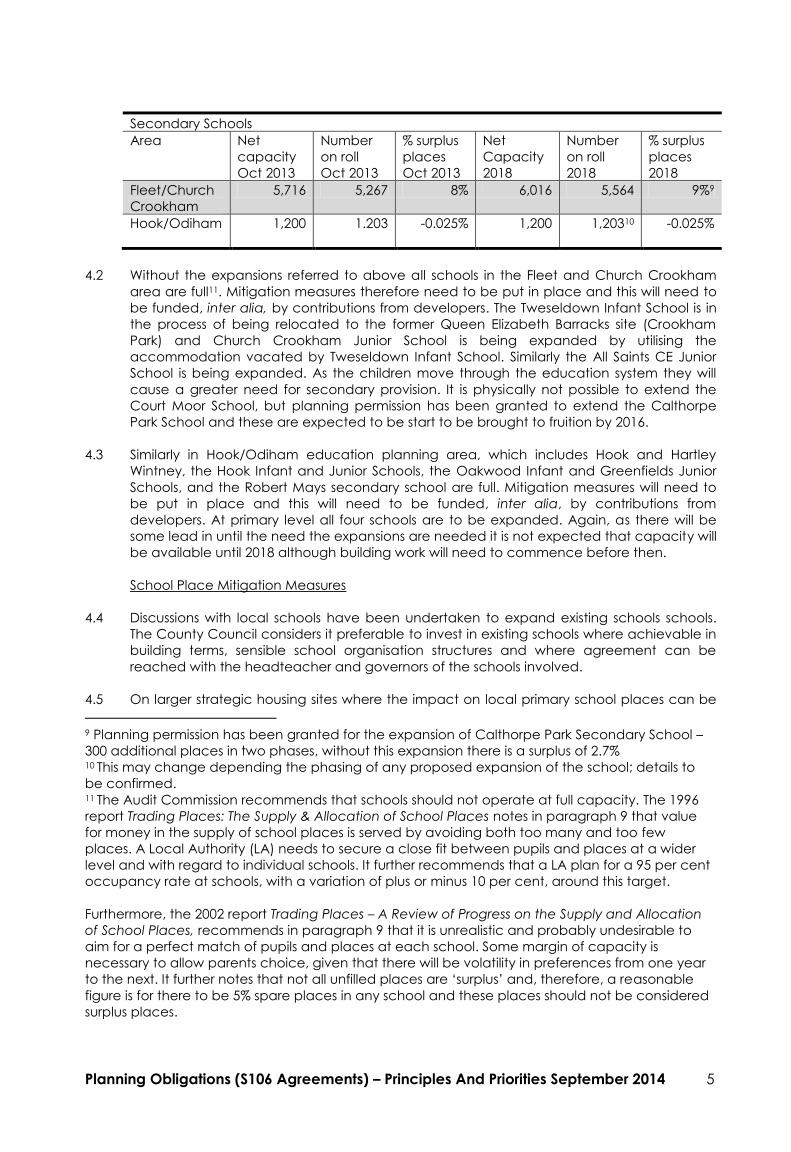
Secondary Schools
Area Net
capacity
Number
on roll
% surplus
places
Net
Capacity
Number
on roll
% surplus
places
Oct 2013 Oct 2013 Oct 2013 2018 2018 2018
Fleet/Church
Crookham
5,716 5,267 8% 6,016 5,564 9%9
Hook/Odiham
1,200 1.203 -0.025% 1,200 1,20310 -0.025%
4.2 Without the expansions referred to above all schools in the Fleet and Church Crookham
area are full11. Mitigation measures therefore need to be put in place and this will need to
be funded, inter alia, by contributions from developers. The Tweseldown Infant School is in
the process of being relocated to the former Queen Elizabeth Barracks site (Crookham
Park) and Church Crookham Junior School is being expanded by utilising the
accommodation vacated by Tweseldown Infant School. Similarly the All Saints CE Junior
School is being expanded. As the children move through the education system they will
cause a greater need for secondary provision. It is physically not possible to extend the
Court Moor School, but planning permission has been granted to extend the Calthorpe
Park School and these are expected to be start to be brought to fruition by 2016.
4.3 Similarly in Hook/Odiham education planning area, which includes Hook and Hartley
Wintney, the Hook Infant and Junior Schools, the Oakwood Infant and Greenfields Junior
Schools, and the Robert Mays secondary school are full. Mitigation measures will need to
be put in place and this will need to be funded, inter alia, by contributions from
developers. At primary level all four schools are to be expanded. Again, as there will be
some lead in until the need the expansions are needed it is not expected that capacity will
be available until 2018 although building work will need to commence before then.
School Place Mitigation Measures
4.4 Discussions with local schools have been undertaken to expand existing schools schools.
The County Council considers it preferable to invest in existing schools where achievable in
building terms, sensible school organisation structures and where agreement can be
reached with the headteacher and governors of the schools involved.
4.5 On larger strategic housing sites where the impact on local primary school places can be
9 Planning permission has been granted for the expansion of Calthorpe Park Secondary School –
300 additional places in two phases, without this expansion there is a surplus of 2.7% 10 This may change depending the phasing of any proposed expansion of the school; details to
be confirmed. 11 The Audit Commission recommends that schools should not operate at full capacity. The 1996
report Trading Places: The Supply & Allocation of School Places notes in paragraph 9 that value
for money in the supply of school places is served by avoiding both too many and too few
places. A Local Authority (LA) needs to secure a close fit between pupils and places at a wider
level and with regard to individual schools. It further recommends that a LA plan for a 95 per cent
occupancy rate at schools, with a variation of plus or minus 10 per cent, around this target.
Furthermore, the 2002 report Trading Places – A Review of Progress on the Supply and Allocation
of School Places, recommends in paragraph 9 that it is unrealistic and probably undesirable to
aim for a perfect match of pupils and places at each school. Some margin of capacity is
necessary to allow parents choice, given that there will be volatility in preferences from one year
to the next. It further notes that not all unfilled places are ‘surplus’ and, therefore, a reasonable
figure is for there to be 5% spare places in any school and these places should not be considered
surplus places.

Planning Obligations (S106 Agreements) – Principles And Priorities September 2014 6
specifically identified e.g. a one form expansion of existing schools, building plans are
produced and costed, with that cost being sought from the developer. In the case of
individual additional dwellings the overall increased demand on school places can be
identified, but not the specific impact from each individual dwelling on a specific school
project.
4.6 Where large housing developments are planned, specific strategies can be developed to
meet additional demand for school places, such as at Queen Elizabeth Barracks where the
plan is to expand the local infant and junior school. However, where new housing
developments are small in number and located in a variety of areas the solution for
provision of additional places is more complex. Schools are ideally organised into classes of
30 pupils across the age range to support curriculum delivery relevant to the pupil year
group and to meet statutory class size regulations, whereby no class can be larger than 30
for pupils aged 4 to 6. It is not practical, therefore, for school’s to marginally increase their
capacity, have larger than ideal class sizes, or create a budget deficit due to the need to
employ an additional teacher for very small increases to pupil numbers.
4.7 It is not possible to respond to additional demand for school places from every new
individual dwelling by providing one or two additional spaces at the local catchment
school. The number of small planning applications involving developments of less than 10
dwellings will, when taken together, create additional pressure on school places in the
area.
4.8 Tweseldown Infant and Church Crookham Junior schools are being expanded by 180
places to reflect demand from the QEB development and an addition expansion of
Tavistock Infant and All Saints Junior schools by 180 places due to demand from the
Edenbrook development, and to provide places to reflect the demand for places from the
wider area. The Tweseldown/Church Crookham Junior project is estimated to cost £5.5m,
and the Tavistock/All Saints project £4.5m. The additional places are detailed in the table
above which highlights a continued shortfall of places following these expansions.
4.9 At secondary level an expansion of Calthorpe Park School is planned linked to the
expected rise in pupil numbers as a result of new populations within new housing
developments. The Local Education Authority has a projected build programme that
subject to funding will mean that there will some primary capacity created by 2013, and
secondary school capacity created by 2017. The total cost is £16.1 million of which £13
million relies exclusively on the QEB development proposal. Even then, there is a shortfall of
£3.1million. Additional funding is therefore required if the education needs of new
development is to be met.
4.10 In the Hook/Odiham catchment, there has already been additional demand from the Dilly
Lane (St Mary’s Park) development in Hartley Wintney which requires the expansion of both
the Oakwood Infant and Greenfields Junior Schools. Further development will only
exacerbate this requirement. At Hook, where again the infant and junior schools are full,
the planned North East Hook development will require additional provision by the
expansion of the Hook Infant and Junior Schools. These schemes have been agreed by the
County Council for delivery in the period to 2016.
4.11 Similarly at Robert Mays School the Local Education Authority has a projected build
programme that subject to funding will create additional secondary capacity by 2018. The
total cost of this has yet to be defined but is likely to be in the order of £15 million. This
principally relies on Section 106 funding.
4.12 Further information is provided in Appendix E.
5. THAMES BASIN HEATHS SPECIAL PROTECTION AREA FOR BIRDS.
Planning Obligations (S106 Agreements) – Principles And Priorities September 2014 7
5.1 Much of the Distinct is within 5km of the Thames Basin Heaths Special Protection Area for
Birds. The Special Protection Area (SPA) comprises tracts of heathland covered by a
number of local authority areas across Hampshire, Berkshire and Surrey, including much of
Hart District. The heathland is part of Natura 2000, a European- wide network of sites of
international importance for nature conservation established under the European
Community Directives (i.e. Special Protection Areas and Special Areas of Conservation).
The lowland heath supports distinctive flora and fauna, some of which are under threat
and in decline. The Thames Basin Heaths SPA was designated on 9 March 2005 and is one
of the South East's most important natural assets as it supports important populations of
vulnerable ground-nesting birds. The harm that can be caused by disturbance to the birds
arises from a growth in the number of walkers, cats and dogs frequenting the heathland,
and other recreational uses created by additional housing.
5.2 The proximity of the SPA means that the requirements of the Habitat Regulations 2010 must
be met. There is much research that indicates that additional residential development
results in a deterioration of the quality and interest features of the SPA habitat. No
additional housing will be therefore, permitted within 400 metres of the SPA. New
additional housing within 400m - 5 km of the SPA will be required to demonstrate that it can
avoid any likely effect. This can be done using the following measures: first is the provision
of Suitable Alternative Natural Greenspace (SANG) at an agreed standard of 8ha per
1,000 new residents, and the second is through the delivery of Strategic Access
Management and Monitoring Measures (SAMM).
5.3 Having regard to the Habitats Regulations 2010, the NPPF and Circular 06/2005, pooled
financial contributions towards mitigation measures is an appropriate means of
ameliorating identified harm. A pooled financial contribution would assist in safeguarding
nature conservation interests within the European designated areas. A formal Interim
Avoidance Strategy has been in operation to deliver mitigation financed collectively by
developer contributions. Natural England supports this strategy. This approach has already
been tested and found to meet the requirements of Regulation 122 of the Community
Infrastructure Levy Regulations 2010.
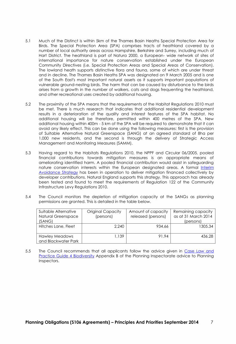
5.4 The Council monitors the depletion of mitigation capacity at the SANGs as planning
permissions are granted. This is detailed in the table below.
Suitable Alternative
Natural Greenspace
(SANG)
Original Capacity
(persons)
Amount of capacity
released (persons)
Remaining capacity
as at 31 March 2014
(persons)
Hitches Lane, Fleet
2,240 934.66 1305.34
Hawley Meadows
and Blackwater Park
1,139 91.94 436.28
5.5 The Council recommends that all applicants follow the advice given in Case Law and
Practice Guide 4 Biodiversity Appendix B of the Planning Inspectorate advice to Planning
Inspectors.

APPENDIX A
Planning Obligations (S106 Agreements) – Principles And Priorities September 2014 8
S106 Contributions/ Obligations – Current Policy Basis
1. Affordable Housing:
Hart District Council Local Plan Policies:
ALT GEN 13: The Council will seek to negotiate affordable housing on a site by site basis
based upon an overall guideline of 40% of housing to be affordable on sites that are 0.5ha
or larger or that would provide 15 or more dwellings. In settlements with a population of
less than 5000 however the policy applies to sites which are 0.2ha or larger or that provide
5 or more dwellings.
2. Transportation
Hart District Council Local Plan Policies:
T16 – Policy sets out the circumstances where contributions will be sought to fund works
where improvements to the local transport infrastructure are necessary by new
development or redevelopment. – Includes improvements of local public transport,
highways, cycle ways, footpaths and public car parking.
GEN1 (xi) – Development should include provision for any necessary improvements to
infrastructure and utilities resulting from the development.
Hampshire County Council North Hampshire Transportation Strategy (NHTS), Fleet Town
Centre Access Plan (FTAP) and Hampshire County Council’s Highways Contribution Policy
are also relevant policy documents.
3. Open Space/ Leisure
Hart District Council Local Plan Policies:
URB23 – new developments of 20+ dwellings require open space on the site.
Developments between 5 and 19 dwellings will be expected to make provision in
accordance with the standards, having regard to the level of deficiency of open space in
the locality. Off-site open space can be a substitution.
For development within the rural areas where there is any evidence of need Policy GEN1
(xi) – “Development should include provision for any necessary improvements to
infrastructure and utilities resulting from the development” is relevant. Improvements to the
well being of the Community are a priority objective as set out in the Hart District
Community Strategy. Hart District Council Leisure Strategy is also relevant as sets out some
of the Council’s overarching policies. The Hart Planning Policy Guidance 17 Audit Report
2006 also sets out in more details the needs of the District and an audit was done of all
open space/recreational facilities within Hart in the summer of 2010.
Hart Local Plan: Draft Policy: Developer Contributions towards Leisure and Open Space
Facilities
LOS1: - new development involving a net increase of one or more dwellings will only be
permitted where adequate provision is made for leisure and open space facilities, either
through on-site provision, through financial contributions towards off-site provision, or a
combination of both.
4. Education
Hart District Council Local Plan Policies:
URB20 – the text of this policy relates to proposal which retain or provide new schools
(amongst other local services and community facilities) however the last paragraph of the
supporting text states that if there is inadequate provision of a particular services then
developers may be asked to enter into agreements whereby a contribution is made

APPENDIX A
Planning Obligations (S106 Agreements) – Principles And Priorities September 2014 9
towards its provision. This policy relates to urban areas, there is no equivalent in rural areas.
For development within the rural areas where there is any evidence of need Policy GEN1
(xi) – “Development should include provision for any necessary improvements to
infrastructure and utilities resulting from the development” is relevant.
The evidence of educational need is set out in the Hampshire County Council School
Places Plan which is updated annually by Hampshire County Council. This evidence base
is supplemented by for Developers’ Contributions towards Children’s Services Facilities
Policy, again, updated annually by Hampshire Children’s Services.
5. Special Protection Area:
Hart District Council Local Plan Policies:
CON1- Development will not be permitted if it adversely affects the nature conservation
value of SPAs unless there are no alternative solutions and there are imperative reasons of
over-riding public interest.
CON5 – Protected species, planning permission will not be granted for development that
would have a significant adverse effect on plant or animal species or their habitats
protected by law unless conditions are attached or planning obligations entered into
requiring the developer to take steps to secure their protection.
Hart District Council Interim Avoidance Strategy: sets out mitigation strategy using Hitches
Lane and Hawley Meadows as the SANGS. The Avoidance Strategy will be further
updated as other SANGS become available.
South East Plan Policies:
NRM6 – this policy specifically relates to the Thames Basin Heaths Special Protection Area
and sets out requirements for mitigation (SANGS).
APPENDIX B
Planning Obligations (S106 Agreements) – Principles And Priorities September 2014 10
District-Wide and Local Project Lists
District-Wide Projects
Project Source Funding
Required
Policy Basis Collection Criteria
Fleet Leisure Centre
In July 2014 the Council agreed to appoint consultants to take the project through a pre-construction detailed design and that developer
contributions allocated to Leisure infrastructure as the primary funding for the leisure centre. In the meantime, outline planning permission for
anew leisure centre was granted (13/02513/MAJOR). The total project cost is £21,000,000 of which £7,000,000 has already been secured.
Provision of
replacement
Leisure Centre at
Hitches Lane
Hart District
Council
£14,000,000 Hart District Council Corporate Plan 2013–2016
Provide new and upgraded leisure facilities – build
a replacement for the Hart Leisure Centre
Hart Sustainable Community Strategy 2008-18:
Priority Aim A Beacon of Good Health
Hart PPG17 Assessment 2006: more and better
football pitches identified through local need and
quantity of provision available.
Hart Open Space, Sport and Recreation
Assessment Update 2012: identified grass pitch
deficit within the district and grass pitches
highlighted as local need by number of parish
councils.
Hart Leisure Strategy 2007-2017: Meets policy
FD1: refurbishment of Hart and Frogmore Leisure
Centres, FD3: Development of Hart Leisure
Centre as the indoor facility hub of the proposed
Calthorpe Sports Village and FD5: investigation
into the provision of a new teaching/studio
swimming pool or negotiated access to other
externally operated facilities
All residential development
within the District.
Hitches Lane Country Park, Fleet

APPENDIX B
Planning Obligations (S106 Agreements) – Principles And Priorities September 2014 11
In January 2011, the Council appointed consultants to undertake a needs assessment for the provision of a potential new Country Park in the
District. The aim of the report was to identify
a) The likely catchment area for a new Country Park in Hart District
b) All existing similar provision, including that in neighbouring authorities, and any ‘gaps’ that exist
c) And assess current and future demand for a Country Park
d) Likely modes of travel to a Country Park
e) The likely visitor numbers for a Country Park in Fleet who will specifically come from elsewhere in the District, based on industry accepted
modes of travel
f) And assess the range and nature of activities in which visitors to the Country Park would want to participate, and
g) The range of facilities visitors would expect to find in Country Park.
Given the requirements of this needs assessment, the approach taken involved:
a) A residents’ questionnaire promoted across the District
b) An audit of Country Parks and similar provision around Hart District
c) An audit of similar open spaces in Hart District
d) A review of population growth estimates, and new housing development
e) Identification of the catchment area for a new Country Park within the District
f) Identification of the demand for a new Country Park and what facilities it should include
g) Identification of likely visitor numbers to a new Country Park, and their modes of travel.
The assessment confirmed the need for a Country Park in Hart District for a number of reasons, including population growth of 11,220
(minimum) as a consequence of 3740 new homes by 2028, delivery on Hart District Council policy objectives for provision of open space in
relation to new housing, current levels of physical activity, and clear latent demand for walking, cycling and outdoor sport and recreational
activities, as well as the need to mitigate against the impact of residential development on SPA/SSSIs, and respond to corporate objectives for
sustainable transport, community health and well-being and quality of life.
In addition, although there are high levels of use of existing open space, residents have aspirations for better quality provision at local level,
with a wide range of amenities on one site. This is currently a ‘gap’ at local level.
There is sufficient catchment area population within a 20 minute drive time to sustain a Country Park; development of a Country Park in Hart is
likely to reduce the level of usage of similar facilities outside the District by Hart residents, whilst also stimulating and attracting visits from those
living outside Hart. Development of a Country Park in Hart is also likely to increase local levels of both walking and cycling, which would
provide a significant contribution to the sustainability of the local transport infrastructure.
Although residents think there is currently sufficient open space in the District, their comments do not take account the increase in population

APPENDIX B
Planning Obligations (S106 Agreements) – Principles And Priorities September 2014 12
and the consequent demand for a range of provision, including open space, which will result. The responses to the residents’ survey highlight
that some existing open space is of poor quality, vandalised, and that signage, and information about open space sites could be improved.
Provision of a new Country Park would provide the opportunity to address current and perceived barriers to use of open space at local level,
and could therefore increase demand given that the Country Park will be well-designed, planned and managed, provide a safe environment,
and be appropriately promoted.
Given the above conclusions, there is a case for a new Country Park in Hart. Provision of a Country Park at Hitches Lane will provide a critical
mass of high quality community provision, and consequently economies of scale, which can be effectively and efficiently managed and
delivered to benefit the people of Hart District and the wider sub region.
Funding for the project will be through:
Hart District Council Capital Programme
S106 Contributions
S106 Land provision from Berkeley Homes
It should be noted that this project is in addition to the creation and provision of the Country Park as a Suitable Alternative Natural Greenspace
(SANG) providing mitigation for the effects of residential development on the Thames Basin Heaths Special Protection Area (SPA).
Provision of site
BBQ Area
Hart District
Council
£20,000 Hart Sustainable Community Strategy 2008-18:
Priority Aims An Environmentally Conscious
Community and a Sustainable District, A Beacon
of Good Health.
Hart PPG17 Assessment 2006: A need for a country
park for active recreation rather than
conservation, including the provision of BBQ
facilities identified.
Hart Open Space, Sport and Recreation
Assessment Update 2012: Acknowledged since
2006 Study a country park has been provided at
Hitches Lane as part of mitigation measures for
development likely to have an impact on the SPA.
The site will also be used to attract other residents
and a number of facilities were identified to
enhance the site for recreation, including a BBQ
area.
Hart Leisure Strategy 2007-2017: Meets policy FD12:
Any new development that
lies within a 20 min drive
(10000m) ‘as the crow flies’
catchment of Hitches Lane
Country Park.

APPENDIX B
Planning Obligations (S106 Agreements) – Principles And Priorities September 2014 13
development of informal open space/countryside
to include but not be limited to Hitches Lane
Country Park.
Bike area and
play area for
people with
disabilities/speci
al needs
Hart District
Council
£100,000 Hart Sustainable Community Strategy 2008-18:
Priority Aims An Environmentally Conscious
Community and a Sustainable District, A Beacon
of Good Health.
Hart PPG17 Assessment 2006: A need for a country
park for active recreation rather than
conservation identified.
Hart Open Space, Sport and Recreation
Assessment Update 2012: Acknowledged since
2006 Study a country park has been provided at
Hitches Lane as part of mitigation measures for
development likely to have an impact on the SPA.
The site will also be used to attract other residents
and a number of facilities were identified to
enhance the site for recreation, including
children/young people’s play. Identified need for
further children’s play and young people’s
facilities throughout the District.
Hart Leisure Strategy 2007-2017: Meets policy FD12:
development of informal open space/countryside
to include but not be limited to Hitches Lane
Country Park.
Incidental
Seating
Hart District
Council
£15,000 Hart Sustainable Community Strategy 2008-18:
Priority Aims An Environmentally Conscious
Community and a Sustainable District, A Beacon
of Good Health.
Hart PPG17 Assessment 2006: A need for a country
park for active recreation rather than
conservation identified.
Hart Open Space, Sport and Recreation

APPENDIX B
Planning Obligations (S106 Agreements) – Principles And Priorities September 2014 14
Assessment Update 2012: Acknowledged since
2006 Study a country park has been provided at
Hitches Lane as part of mitigation measures for
development likely to have an impact on the SPA.
The site will also be used to attract other residents
and a number of facilities were identified to
enhance the site for recreation.
Hart Leisure Strategy 2007-2017: Meets policy FD12:
development of informal open space/countryside
to include but not be limited to Hitches Lane
Country Park.
Sensory
Interpretation
Hart District
Council
£25,000 Hart Sustainable Community Strategy 2008-18:
Priority Aims An Environmentally Conscious
Community and a Sustainable District, A Beacon
of Good Health.
Hart PPG17 Assessment 2006: A need for a country
park for active recreation rather than
conservation identified.
Hart Open Space, Sport and Recreation
Assessment Update 2012: Acknowledged since
2006 Study a country park has been provided at
Hitches Lane as part of mitigation measures for
development likely to have an impact on the SPA.
The site will also be used to attract other residents
and a number of facilities were identified to
enhance the site for recreation.
Hart Leisure Strategy 2007-2017: Meets policy FD12:
development of informal open space/countryside
to include but not be limited to Hitches Lane
Country Park.
Access Controls Hart District
Council
£35,000 Hart Sustainable Community Strategy 2008-18:
Priority Aims An Environmentally Conscious
Community and a Sustainable District, A Beacon
of Good Health.

APPENDIX B
Planning Obligations (S106 Agreements) – Principles And Priorities September 2014 15
Hart PPG17 Assessment 2006: Local needs
identified a need for better management and
maintenance of green space resource, and the
need to address the sense of safety in the
countryside.
Hart Leisure Strategy 2007-2017: Meets policy FD12:
development of informal open space/countryside
to include but not be limited to Hitches Lane
Country Park.
Notice/Interpret-
ation boards and
waymarks
Hart District
Council
£30,000 Hart Sustainable Community Strategy 2008-18:
Priority Aims An Environmentally Conscious
Community and a Sustainable District, A Beacon
of Good Health.
Hart PPG17 Assessment 2006: Local needs
identified a need for better management and
maintenance of green space resource, and the
need to address the sense of safety in the
countryside.
Hart Leisure Strategy 2007-2017: Meets policy FD12:
development of informal open space/countryside
to include but not be limited to Hitches Lane
Country Park. .
Picnic Site
Furniture
Hart District
Council
£16,000 Hart Sustainable Community Strategy 2008-18:
Priority Aims An Environmentally Conscious
Community and a Sustainable District, A Beacon
of Good Health.
Hart PPG17 Assessment 2006: A need for a country
park for active recreation rather than
conservation identified.
Hart Open Space, Sport and Recreation
Assessment Update 2012: Acknowledged since
2006 Study a country park has been provided at
Hitches Lane as part of mitigation measures for
development likely to have an impact on the SPA.

APPENDIX B
Planning Obligations (S106 Agreements) – Principles And Priorities September 2014 16
The site will also be used to attract other residents
and a number of facilities were identified to
enhance the site for recreation.
Hart Leisure Strategy 2007-2017: Meets policy FD12:
development of informal open space/countryside
to include but not be limited to Hitches Lane
Country Park.
County Park
Visitor Centre
Hart District
council
£350,000 Hart Corporate Plan 2013-2016 - Develop the role of
Edenbrook County Park as an active leisure site with
a visitor centre and allotments.
Hart Community Strategy 2005-2015 (Priority Aim
Health and Wellbeing),
Hart PPG17 Assessment 2006 (Local Needs: Key
Conclusions: - Quantity of Provision (more and better
football pitches), and Countryside Issues (need for a
country park designed for active recreation),
Hart Leisure Strategy 2007-2017 (Policy FD12)
Frogmore Leisure Centre, Yateley
The Sports Centre serves a local catchment area comprising Eversley, Yateley, Blackwater and Hawley. It offers a wide range of indoor and
outdoor facilities which include;
90 station gym,
2 dance studios hosting ballet, jazz and over 60 fitness classes a week,
Sports hall for badminton, trampolining, gymnastics and much more,
2 squash courts
Sauna and steam,
Crèche for centre and non-centre users,
Sun beds and spray tan booth,
An air conditioned function room,
Treatment room,
Floodlit artificial turf pitch with 3 five a side leagues every Tuesday, Wednesday, Thursday and Sunday,
Visitor surveys and customer demand has confirmed that the sports centre is operating at capacity with excess demand for hall use and all

APPENDIX B
Planning Obligations (S106 Agreements) – Principles And Priorities September 2014 17
weather training facilities. The Council has within its capital programme proposals to refurbish the hall facilities to increase flexibility and use of
the hall. Overspill parking from the site takes place on adjoining highways and therefore there is an associated need to improve parking
provision. These measures will ensure that the Centre can accommodate any increased demands placed upon it through new housing
development and also ensure that increased use does not exacerbate on street parking within the vicinity of the Centre.
Funding for the improvements will be through Hart District Council Capital Programme and S106 Contributions.
Enhancements
to sporting
facilities to
increase
capacity and
flexibility of use
Hart District
Council
£325,000 Hart Sustainable Community Strategy 2008-18:
Priority Aim A Beacon of Good Health
Hart PPG17 Assessment 2006: more and better
football pitches identified through local need and
quantity of provision available.
Hart Open Space, Sport and Recreation
Assessment Update 2012: identified grass pitch
deficit within the district and grass pitches
highlighted as local need by number of parish
councils.
Hart Leisure Strategy 2007-2017: Meets policy FD1:
refurbishment of Hart and Frogmore Leisure
Centres, and FD5: investigation into the provision
of a new teaching/studio swimming pool or
negotiated access to other externally operated
facilities.
Any new development that
lies within a 10 minute drive
time (5000m) ‘as the crow
flies’ catchment of Frogmore
Leisure Centre.
Additional car
parking space to
increase usability
Hart District
Council
£95,000 Hart Sustainable Community Strategy 2008-18:
Priority Aim A Beacon of Good Health.
Hart PPG17 Assessment 2006: more and better
football pitches identified through local need and
quantity of provision available.
Hart Open Space, Sport and Recreation
Assessment Update 2012: identified grass pitch
deficit within the district and grass pitches
highlighted as local need by number of parish
councils.
Hart Leisure Strategy 2007-2017: Meets policy FD1:
refurbishment of Hart and Frogmore Leisure

APPENDIX B
Planning Obligations (S106 Agreements) – Principles And Priorities September 2014 18
Centres.
Fleet Pond, Fleet
Fleet Pond Local Nature Reserve is a primary resource for informal recreation for residents of Fleet and the surrounding area. Visitor surveys
confirm the value of the site for a range of informal activities. Walking, dog walking and cycling predominate. Visitors have mentioned peace,
tranquillity and naturalness as the main attractions. The site provides an experience of wilderness and close proximity to nature has been
appreciated. The value of this experience is enhanced by the fact it is close to their homes.
The main feature of interest to visitors is the lake (a designated Site of Special Scientific Interest (SSSI)). Open water is always an attraction and
feeding the ducks comes high on the list of activities, especially for young children. The woodland walks are very popular for pure relaxation
and, notably, for dog walking. A visitor survey undertaken in 2005 confirmed the public liking for the woodlands and open heaths as giving the
impression of "naturalness".
Aquatic flora and fauna has been largely lost as a result of silt pollution. Agreement between the owners Hart District Council and the Ministry
of Defence towards measures to reduce silt inflow have been mostly successful in significantly reducing silt deposits. Heavy rain which causes
flow through the traps results in the deposition of further silt. The potential for restoration of the aquatic life exists and a programme of dredging
is required to improve the depth contours of the lake. Turbidity remains a problem until deeper water can be created and it might be
necessary to include measures to reduce the Bream population and restock with other species. Bream tend to stir the soft silt on the bed of the
lake when feeding, increasing turbidity.
The humid heath (Wood Lane Heath) would benefit from removal or substantial reduction of the dominant Molinia grass tussocks. A better
diversity of flora would result. The Dry Heath would also benefit from measures to remove coarse grasses to increase diversity. It needs to be
cleared of trees and scrub to deter the spread of Wood Ant colonies. These are depleting the diversity of other invertebrates. Both heaths
need to be kept free of invading tree seedlings and scrub.
The dry woodland will improve naturally to a climax woodland of oak with hazel under-storey. Little human intervention is required except for
some thinning of the more dense stands of secondary woodland. The creation of additional glades within the woodland structure would
encourage a diversity of invertebrate life.
The Nature Reserve, because it is so accessible, is the subject of intense pressure through the demand for recreational access. Not only is it
suffering from the current levels of public access (damage to walkways, and erosion of footpaths etc) but new development will place greater
demands on its relatively fragile physical infrastructure. This additional pressure must be mitigated as part of a comprehensive management
plan. This is underpinned by an adopted Management Plan.
The Council’s overall Management Plan objective is to:

APPENDIX B
Planning Obligations (S106 Agreements) – Principles And Priorities September 2014 19
a) Manage Fleet Pond Local Nature Reserve in accordance with its status as a Site of Special Scientific Interest and designation as a Local
Nature Reserve.
b) Maintain habitat diversity.
c) Safeguard all notable species.
d) Encourage the educational use of the site.
e) Enable visitors to access the site without compromising nature conservation interests.
f) Provide informal recreational activities which enable a greater understanding of the Nature Reserve to be developed without
compromising the nature conservation interests.
g) Provide interpretative facilities which develop an awareness of the natural history interest of the site.
Funding for the project will be from three sources:
a) Natural England Higher Level Environmental Stewardship: Special Project & Higher Level Environmental Stewardship: Ordinary Project;
b) Hart District Council S106 fund allocated for Fleet Pond.
c) Further funding may become available (e.g. the Fleet Pond Society’s Clearwater Campaign).
Access
management
and Stage 1
Management
Plan to include
access track
provision,
parking provision
and bridge
alterations
Hart District
Council/Fleet
Pond Society
£180,000 Hart Sustainable Community Strategy 2008-18:
Priority Aims An Environmentally Conscious
Community and a Sustainable District, A Beacon of
Good Health.
Hart PPG17 Assessment 2006: local needs identified
the need for better access to the countryside. Site
specific needs were identified to create improve
access. Highlighted need for better management
and maintenance of existing green spaces.
Hart Open Space, Sport and Recreation
Assessment Update 2012: Acknowledges that
there is a management plan for site with objectives
including the need to enable visitors access to the
site without compromising nature conservation
interests,
Hart Leisure Strategy 2007-2017: Meets policy FD17:
completion of an environmental assessment of
Fleet Pond as a natural resource for informal and
supervised recreational use, implementation of an
improvement programme.
Any new development that
lies within a 10 minute drive
time (5000m) ‘as the crow
flies’ catchment of Fleet Pond.

APPENDIX B
Planning Obligations (S106 Agreements) – Principles And Priorities September 2014 20
Stage 2
Management
Plan to include
protective
measures on
ecological
features as
mitigation
against damage
from increase
visitor pressure,
including
fencing,
restoration of
damaged
features etc.
Hart District
Council/Fleet
Pond Society
£250,000 Hart Sustainable Community Strategy 2008-18:
Priority Aims An Environmentally Conscious
Community and a Sustainable District, A Beacon of
Good Health.
Hart PPG17 Assessment 2006: Identified site specific
issues to provide ranger service with administration
support and reduce vandalism. Highlighted need
for better management and maintenance of
existing green spaces.
Hart Open Space, Sport and Recreation
Assessment Update 2012: Acknowledges that
there is a management plan for site with objectives
including managing the site in accordance with its
status as a Site of Special Scientific Interest and
Local Nature Reserve, Maintain habitat diversity,
safeguard all notable species, and the need to
enable visitors access to the site without
compromising nature conservation interests,
Hart Leisure Strategy 2007-2017: Meets policy FD17:
completion of an environmental assessment of
Fleet Pond as a natural resource for informal and
supervised recreational use, implementation of an
improvement programme
Stage 3
Engineering
works to remove
silt from ponds to
increase
biodiversity and
prevent loss of
critical water
mass
Hart District
Council/Fleet
Pond Society
£120,000 Hart Sustainable Community Strategy 2008-18:
Priority Aims An Environmentally Conscious
Community and a Sustainable District, A Beacon of
Good Health.
Hart PPG17 Assessment 2006: Highlighted need for
better management and maintenance of existing
green spaces.
Hart Open Space, Sport and Recreation Assessment
Update 2012: Acknowledges that there is a
management plan for site with objectives including
managing the site in accordance with its status as
a Site of Special Scientific Interest and Local Nature

APPENDIX B
Planning Obligations (S106 Agreements) – Principles And Priorities September 2014 21
Reserve, and maintain habitat diversity, safeguard
all notable species.
Hart Leisure Strategy 2007-2017: Meets policy FD17:
completion of an environmental assessment of
Fleet Pond as a natural resource for informal and
supervised recreational use, implementation of an
improvement programme
Basingstoke Canal
The Basingstoke Canal is of national importance for its wealth of wildlife. Most of the waterway has statutory protection as a Site of Special
Scientific Interest. The canal has other important functions, being especially highly valued as a linear public park providing recreation and
amenity. It forms a linear country park in which the towpath is much frequented by walkers and provides a traffic-free ‘green corridor’ in urban,
suburban and rural areas. The canal’s easy public accessibility is particularly valuable because it runs through areas in which other accessible
green spaces are limited and decreasing. Availability as a quiet and safe place to walk, cycle, picnic and exercise dogs is probably
overwhelmingly the canal’s greatest asset, in terms of numbers of people and hours spent along the waterway.
Other recreational users include boaters and anglers. Although they are much smaller groups numerically, they are vital to the overall
waterway scene, as well as gaining much enjoyment from their chosen activity and providing some income towards maintenance of the
canal. National surveys have shown that public appreciation of canals as places at which to spend time is crucially dependent on those
waterways being perceived as ‘living’, in the sense that they are well maintained navigations on which moving boats are seen on a more or
less regular basis. There are no current user estimates of numbers of towpath users specifically for the Basingstoke Canal, but nationally the
trend is upward. On the British Waterways system, towpath visits were estimated as 130 million in 1995 and 268 million in 2006. The Canal
Authority assesses that regular uses particularly at weekends will travel up to 3 miles to access the Canal for recreational activities such as
walking and cycling in particular. The level of use has significant implications for the robustness of the towpath which is essentially unmetaled
and prone to significant wear and tear through constant use by bicycles. This damage to the surface has implications for those who wish to
walk and goes on further to prejudice access by people with disabilities. There are therefore a series of significant on-going programmes
involving canal towpath upgrades proposed along the whole length of the canal including local schemes. These will all increase the capacity
of the towpath to accommodate additional access pressure created by new development. These programmes comprise part of the Canal
Authority’s Capital Programme which is reviewed annually. For the year 2010/11 the Canal Authority Capital Programme for repairs and
improvements is approximately £203,000.
Funding: Day-to-day management of the Canal is the responsibility of the Basingstoke Canal Authority, whose staff are employed by
Hampshire County Council who, along with Surrey County Council, own the Canal. The budget for the Basingstoke Canal Authority is made up
from financial contributions from 8 local authorities (including the County Councils) and from income from charges, grants, S106 contributions,
etc. The contributions are assessed annually under an agreed financial formula. The budget is approved by the Joint Management Committee

APPENDIX B
Planning Obligations (S106 Agreements) – Principles And Priorities September 2014 22
which has delegated responsibility for managing the Canal.
Enhancement to
recreational
towpath and
woodland to
improve access
for pedestrians,
cyclists and
people with
disabilities
Basingstoke
Canal Authority
£75,000 Hart Sustainable Community Strategy 2008-18:
Priority Aims An Environmentally Conscious
Community and a Sustainable District, A Beacon
of Good Health.
Hart PPG17 Assessment 2006: Highlighted local
needs for an improved Rights of Way network,
including the use of the Basingstoke Canal to
ensure the route can be used by cyclists, walkers
and fishermen. Site specific need highlighted the
need for better access,
Hart Open Space, Sport and Recreation
Assessment Update 2012: Highlighted need to
improve accessibility and existing green corridors.
Hart Leisure Strategy 2007-2017: Meets policy FD18:
completion of an assessment of the role of the
Council in the management of Basingstoke Canal,
implementation of chose response.
A new development that lies
within 5000m ‘as the crow flies’
catchment from Basingstoke
Canal.
Hazeley Heath, Hartley Wintney
Hazeley Heath is one of the largest surviving remnants of lowland heathland, an internationally endangered habitat, in the Thames Basin region
of north Hampshire. The extent of heathland on the site has declined in recent times due to encroachment by woodland and scrub. It is
generally accepted that active management is required to ensure the continued viability and status of the site, but views have differed as to
the best way to achieve this. Hence, a Management Plan was commissioned and following consultation was adopted in 2007.
Hazeley Heath is considered to be a local amenity, mainly used by the residents of Hartley Wintney and Mattingley and associated hamlets for
walking, horse riding and the enjoyment of nature and openness. This has been borne out by user surveys conducted in recent years in
connection with the pattern of use of the Thames Basin Heaths and how this may be affected by additional development in the area.
The visitor surveys have shown that almost all users originate from the local communities, particularly from Hartley Wintney as this has by far the
largest local population. Most users are dog walkers, arriving on foot from Hartley Wintney, who largely remain in the southern part of Hazeley
Heath. Horse riding is also popular notwithstanding the lack of bridleways in the surroundings, including use by some of the owners and
neighbours. This extends over most of the site to the east of the B3011, with more use observed in the southern areas. Hazeley Heath is well

APPENDIX B
Planning Obligations (S106 Agreements) – Principles And Priorities September 2014 23
known and used by local naturalists, including birdwatchers. There are infrequent guided walks and visits by school groups. A small lay-by on
the B3011 opposite Arrow Lane and small areas beside some of the access tracks are used for parking of visitors arriving by car.
A Management Plan has been prepared an adopted. The consultation process in preparing the Management Plan suggested that there is
little current conflict between the various users of Hazeley Heath, who generally agree that the needs of all users should be met in addition to
nature conservation requirements. However, some users feel that horse riding causes disproportionate damage to some of the paths through
wetter areas. The site was subject to illegal occupation by travellers in the 1980s, which has led to the provision of earthworks and timber posts
to prevent vehicle access from the B3011 and some of the side roads and tracks. The view is that no further major changes are necessary and
that any action taken should, therefore, be sympathetic and subtle.
Visitors, on the whole, treat Hazeley Heath as an asset to be enjoyed and respected and many of the access problems encountered on other
sites are absent. However, there are occasional problems with motorbike scrambling and other unauthorised vehicles, fire-starting and fly
tipping, which need to be tackled. There is currently no comprehensive formal approach to dealing with these issues and managing access to
Hazeley Heath for the benefit of both its users and nature conservation.
Because Hazeley Heath it is so accessible, it is the subject of pressure through the demand for recreational access. Not only is it suffering from
the current levels of public access (damage to walkways, and erosion of footpaths etc) but new development will place greater demands on
its relatively fragile physical infrastructure. This additional pressure must be mitigated as part of a comprehensive management plan. This is
underpinned by the adopted Management Plan. This in turn will increase the capacity of the Heath to accommodate any additional access
pressure created by new development.
The success of the Hazeley Heath Management Plan will depend on funding being available. There are a number of potential sources of
funding:
a) Funding towards the management of Hazeley Heath is already being provided by Natural England through existing Wildlife Enhancement
Scheme (WES) agreements.
b) The Heritage Lottery Fund (HLF) has two current funding schemes of interest - (i) Landscape Partnerships, which provides grants of between
£250,000 and £2 million for partnerships representing a range of heritage and community interests to tackle the needs of landscapes,
whose various elements may be in different ownership; and (ii) Heritage Grants offers grants of £50,000 or more to projects (including nature
conservation) that conserve and enhance our diverse heritage, encourage more people to be involved in their heritage, or both.
c) EU Life+ is the follow-on programme from the EU Life Programmes that finished at the end of 2006 and included funding for conservation
projects.
d) Environmental Stewardship is a new agri-environment scheme which provides funding to farmers and other land managers in England who
deliver effective environmental management on their land.
e) The Single Payment Scheme (SPS) may offer a potential avenue for funding for the common, if a joint approach can be agreed between
the owners of the common and commoners
f) Hart District Council as the owner of the Southern section of Hazeley Heath already funds dedicated staff and ongoing management

APPENDIX B
Planning Obligations (S106 Agreements) – Principles And Priorities September 2014 24
initiatives.
g) Section 106 funds.
Access
management
and Restoration
District Council £50,000 Hart Sustainable Community Strategy 2008-18:
Priority Aims An Environmentally Conscious
Community and a Sustainable District, A Beacon
of Good Health.
Hart PPG17 Assessment 2006: Identified need to
improve access to the countryside and to improve
existing greenspaces. Identified site specific needs
for remedial work due to the site being landfill,
maintain a ‘favourable’ condition through
sustainable grazing, and preventing vandalism.
Hart Open Space, Sport and Recreation
Assessment Update 2012: Acknowledges that
there is a management plan for site including the
need to reduce the conflict between users and
the need to meet nature conservation required.
Need for mitigation against additional pressure
due to accessibility of site,
Hart Leisure Strategy 2007-2017: Meets policy FD15:
commitment to the protection of commons and
heathlands as natural habitats open to informal
public use.
Any new development that lies
within a 5 minute drive time
(2500m) ‘as the crow flies’
catchment from Hazeley
Heath.
Odiham Common, Odiham
Odiham Common falls within the Odiham Common with Bagwell Green and Shaw Site of Special Scientific Interest (SSSI) which was notified
under Section 28 of the Wildlife Countryside Act.
In September 2010 the Council adopted a 10 year Management Plan for Odiham Common. The purpose of the Plan is to present a series of
management aims and actions for Odiham Common which have been agreed through consultation and which meet the aspirations of
stakeholders and legislative constraints. The Management Plan recognises that the Common is highly valued for the many qualities it currently
exhibits (particularly its tranquillity, wildlife and historic interest) which could be harmed by intrusive intervention. The various consultations that
took place during the preparation of the Plan elicited strong responses from local people, with most individual respondents wishing to see no

APPENDIX B
Planning Obligations (S106 Agreements) – Principles And Priorities September 2014 25
changes take place that would bring about a significant change in the current character of the Common. It is also clear that the Common is
changing through processes of natural succession and human use which are altering its character in ways that concern many people and will
alter its special qualities. Sensitive management, in many cases matching traditional activities that have taken place for centuries, is needed to
maintain the character of the Common that is valued by so many people.
The consultation responses suggest that radical changes in the way the Common is managed would not be appropriate. Nor would a strategy
of non-intervention since that would lead to change by default, would make the Common less accessible to local people and would run
contrary to centuries old historic traditions of use and management by commoners and others.
Because the Common is so accessible, it is the subject of pressure through the demand for recreational access. Not only is it suffering from the
current levels of public access (damage to walkways, and erosion of footpaths etc) but new development will place greater demands on its
relatively fragile physical infrastructure. This additional pressure must be mitigated as part of a comprehensive management plan. This is
underpinned by the adopted Management Plan. At the heart of it lies access management. It envisages carefully planned additions to the
network of paths and tracks, supported by leaflets and on-line information and possibly the revival of a nature trail, will give a range of circular
routes to be used by walkers, horseriders and cyclists. This in turn will increase the capacity of the Common to accommodate any additional
access pressure created by new development. Vehicles can impact on the common and people’s enjoyment of it– off-road motorcycling
and car parking concern local people and need to be addressed by measures that remove or localise the problem and involve the
community in the approaches that are taken.
The overall assumption in this Plan is that future changes to the way the Common is looked after should be gradual and incremental and that
new practices should be assessed regularly to ensure they are helping to deliver the agreed vision for the Common.
The Common is mainly used for informal recreation by local people, largely on foot with a small number of users on horseback or cycling. This
general analysis is supported through observations of use, views of users collected through previous consultation exercises and the recent
collation of stakeholder data (the majority are local residents or people who live in the immediate local area and the greatest proportion of
uses/ interests mentioned were walking, interest in ecology/wildlife and dog walking).
Funding towards the management of Odiham Common comes from:
a) The Heritage Lottery Fund (HLF) has two current funding schemes of interest - (i) Landscape Partnerships, which provides grants of between
£250,000 and £2 million for partnerships representing a range of heritage and community interests to tackle the needs of landscapes,
whose various elements may be in different ownership; and (ii) Heritage Grants offers grants of £50,000 or more to projects (including
nature conservation) that conserve and enhance our diverse heritage, encourage more people to be involved in their heritage, or both.
b) EU Life+ is the follow-on programme from the EU Life Programmes that finished at the end of 2006 and included funding for conservation
projects.
c) Environmental Stewardship is a new agri-environment scheme which provides funding to farmers and other land managers in England

APPENDIX B
Planning Obligations (S106 Agreements) – Principles And Priorities September 2014 26
who deliver effective environmental management on their land
d) The Single Payment Scheme (SPS) may offer a potential avenue for funding for the common, if a joint approach can be agreed between
the owners of the common and commoners.
e) Hart District Council as the owner of the Common already funds dedicated staff and ongoing management initiatives.
f) Section 106 funds.
Access
Management
Hart District
Council
£60,000 Hart Sustainable Community Strategy 2008-18:
Priority Aims An Environmentally Conscious
Community and a Sustainable District, A Beacon
of Good Health.
Hart PPG17 Assessment 2006: Identified need to
improve access to the countryside and to improve
existing greenspaces. Site specific needs identified
are need for a long term management plan,
better information and signage, better links
between the Common and Canal, reducing
conflict between bridleways and footpaths, and
tackling vandalism.
Hart Open Space, Sport and Recreation
Assessment Update 2012: Acknowledges that
there is a management plan in place which
highlights the need to mitigate against additional
visitor pressure due to the accessibility of the site,
provide additional footpaths and tracks, online
information and leaflets, and providing specific
routes for walkers, horseriders and cyclists.
Hart Leisure Strategy 2007-2017: Meets policy FD15:
commitment to the protection of commons and
heathlands as natural habitats open to informal
public use.
Any new development that
lies within a 5 minute drive
time (2500m) ‘as the crow flies
catchment’ of Odiham
Common.
Mitigation
against damage
from increase
visitor pressure,
Hart District
Council
£150,000 Hart Sustainable Community Strategy 2008-18:
Priority Aims An Environmentally Conscious
Community and a Sustainable District, A Beacon
of Good Health.

APPENDIX B
Planning Obligations (S106 Agreements) – Principles And Priorities September 2014 27
on site
infrastructure,
and ecology,
Hart PPG17 Assessment 2006: Identified need to
improve access to the countryside and to improve
existing greenspaces. Site specific needs identified
are need for a long term management plan,
better information and signage, better links
between the Common and Canal, reducing
conflict between bridleways and footpaths, and
tackling vandalism.
Hart Open Space, Sport and Recreation
Assessment Update 2012: Acknowledges that
there is a management plan in place which
highlights the need to mitigate against additional
visitor pressure due to the accessibility of the site,
provide additional footpaths and tracks, online
information and leaflets, and providing specific
routes for walkers, horseriders and cyclists.
Hart Leisure Strategy 2007-2017: Meets policy FD15:
commitment to the protection of commons and
heathlands as natural habitats open to informal
public use.
The Hartley Wintney Commons, Hartley Wintney
The Hartley Wintney Commons comprise the Central Common with Cricketer’s Green and Causeway Green, and to the south, the Phoenix
Green Commons and the area to the west of the A30 known as the Nature Trail Common. The wildlife associated with the commons is of
considerable interest, but could be improved with some management. The veteran oak trees are outstanding, and stands of old hornbeam
are unusual in Hampshire. Several local woodland plant species occur including broad-leaved helleborine and Solomon’s seal, and the
nationally scarce chamomile is found in the grassland. Many uncommon and local invertebrates including ants, bees and beetles as well as
nationally scarce and rare solitary wasps have also been recorded. Several interesting bird species have been recorded including the red
listed spotted flycatcher and amber listed tawny owl and woodcock.
The commons are a popular place for visitors with a recent survey calculating that there are over 2500 visits a week with the majority going to
the Central Common and the areas between Mitchell Avenue and Dilly Lane. Nearly 60% of visitors are dog walkers, with the other main
reasons for visiting being walking, getting exercise and taking children for an outing, and with a number of visitors simply using the common as
a shortcut around the village. Most visitors come on foot from Hartley Wintney and Phoenix Green, visit every day all year round and stay less
than an hour, although a small number arrive by vehicle from surrounding villages or further afield.

APPENDIX B
Planning Obligations (S106 Agreements) – Principles And Priorities September 2014 28
The commons are extremely important for local people who appreciate their informality and value their naturalness. Some areas are heavily
used, others much less so. On parts that are covered by a dense growth of trees and scrub, creating glades and clearings will allow visitors to
enjoy more of the commons. A Management Plan was adopted in November 2010. At the heart of it lies access management. It envisages
carefully planned additions to the network of paths and tracks, supported by leaflets and on-line information and possibly the revival of a
nature trail, will give a range of circular routes to be used by walkers, horseriders and cyclists. Vehicles can impact on the commons and
people’s enjoyment of them – off-road motorcycling and car parking concern local people and need to be addressed by measures that
remove or localise the problem and involve the community in the approaches that are taken. Indeed the participation of local people in the
future and management of these commons is a vital element of this plan. Provision of information and collection of opinions through one-to-
one contact, meetings, boards, newsletters and web-based material as well as providing opportunities for people to become actively
associated with the management of the commons are essential for their long-term future.
Because Commons are so accessible, they are the subject of pressure through the demand for recreational access. Not only is it suffering from
the current levels of public access (damage to walkways, and erosion of footpaths etc) but new development will place greater demands on
their relatively fragile physical infrastructure. This additional pressure must be mitigated as part of a comprehensive management plan. This is
underpinned by an adopted Management Plan.
Funding towards the management of Hartley Wintney Commons comes from:
a) Hart District Council as the owner of the Southern section of the Commons already funds dedicated staff and ongoing management
initiatives.
b) Section 106 funds.
Mitigation
against damage
from increase
visitor pressure,
on site
infrastructure,
and ecology.
Hart District
Council
£38,000 Hart Sustainable Community Strategy 2008-18:
Priority Aims An Environmentally Conscious
Community and a Sustainable District, A Beacon
of Good Health.
Hart PPG17 Assessment 2006: Identified need to
improve access to the countryside and to improve
existing greenspaces.
Hart Open Space, Sport and Recreation
Assessment Update 2012: Acknowledges that
there is a management plan in place which
highlights the need to mitigate against additional
visitor pressure due to the accessibility of the site,
Hart Leisure Strategy 2007-2017: Meets policy FD15:
Any new development that
lies within a 5 minute drive
time (2500m) ‘as the crow flies
catchment’ of Hartley
Wintney Central Commons.

APPENDIX B
Planning Obligations (S106 Agreements) – Principles And Priorities September 2014 29
commitment to the protection of commons and
heathlands as natural habitats open to informal
public use.
Cricket Hill Ponds, Yateley
To restore its
value as a water
course and
resource against
flooding.
to improve
the
biodiversity of
the pond and
surrounding
landscape
visitor furniture
for the
benefits of
the residents
and elderly
persons living
in the
adjacent
sheltered
housing.
Hart District
Council
£38,000 Hart Community Strategy 2005-2015 (Priority Aim
Health and Wellbeing),
Hart PPG16 Assessment 2006 (Local Needs: Key
Conclusions- The Quantity of Provision (better
management and maintenance of greenspace),
Quality of Provision (overall quality generally low),
Hart Leisure Strategy 2007-2018 (Policy FD15)
Any new development that
lies within a 5 minute drive
time (2500m) ‘as the crow flies
catchment’ of Cricket Hill
Pond.

APPENDIX B
Planning Obligations (S106 Agreements) – Principles And Priorities September 2014 30
Local Parish Projects
Scheme Source Funding Required Policy Basis
Blackwater and Hawley
Blackwater and Hawley Leisure
Centre – Sports field drainage
to increase capacity in use
Parish Council £25,000 Hart Sustainable Community Strategy 2008-18: Priority Aims
An Environmentally Conscious Community and a Sustainable
District, A Beacon of Good Health
Hart PPG17 Assessment 2006: highlighted need for more and
better grass pitch provision within the District, and need to
improve existing sites within the District.
Hart Open Space, Sport and Recreation Assessment Update
2012: compared with the population of Blackwater and
Hawley there is a surplus of provision of grass pitches within
the parish however not all of these sites are publicly
accessible. The assessment highlighted need for more and
better grass pitch provision within the District. This site scored
a quality rating of 3 but a value rating of 1, and identified as
in need for improvement by Parish Council during a
consultation on local need.
Provision of a Youth Shelter Parish Council £13,000 Hart Sustainable Community Strategy 2008-18: Priority Aims
An Environmentally Conscious Community and a Sustainable
District, A Beacon of Good Health
Hart PPG17 Assessment 2006: More youth provision should be
provided, as limited facilities available. Identified local need
for youth facilities.
Hart Open Space, Sport and Recreation Assessment Update
2012: identified need for further youth provision as only
limited facilities available throughout the District. There is no
specific existing provision in the Parish of Blackwater and
Hawley, resulting in an existing deficit, which will only be
further exacerbated by an increase in population from new
homes. The need for this provision has been identified by the

APPENDIX B
Planning Obligations (S106 Agreements) – Principles And Priorities September 2014 31
Parish Council during consultation on local need.
Hart Leisure Strategy 2007-2017: Meets policy FD13:
development of youth provision in Blackwater, South
Fleet/Church Crookham, and Crondall.
Bramshill
No projects
Church Crookham
Multi Use Games Area (MUGA),
Azalea Gardens
Parish Council £40,000 Hart Sustainable Community Strategy 2008-18: Priority Aim
Sustainable District, A Beacon of Good Health
Hart PPG17 Assessment 2006: More youth provision should be
provided, as limited facilities available. Identified local need
for youth facilities.
Hart Open Space, Sport and Recreation Assessment Update
2012: Need for further youth provision as only limited facilities
available throughout the District. There is no specific existing
provision in the Parish of Church Crookham resulting in an
existing deficit, which will only be further exacerbated by an
increase in population from new homes. The need for this
provision has been identified by the Parish Council during
consultation on local need.
Hart Leisure Strategy 2007-2017: Meets policy FD13:
development of youth provision in Blackwater, South
Fleet/Church Crookham, and Crondall.
Skate/wheeled area at Peter
Driver Sports Ground
Parish Council £100,000 Hart Sustainable Community Strategy 2008-18: Priority Aim A
Beacon of Good Health
Hart PPG17 Assessment 2006: More youth provision should be
provided, as limited facilities available. Identified local need
for youth facilities.
Hart Open Space, Sport and Recreation Assessment Update
2012: Need for further youth provision as only limited facilities
available throughout the District. There is no specific existing

APPENDIX B
Planning Obligations (S106 Agreements) – Principles And Priorities September 2014 32
provision in the Parish of Church Crookham resulting in an
existing deficit, which will only be further exacerbated by an
increase in population from new homes. The need for this
provision has been identified by the Parish Council during
consultation on local need.
Hart Leisure Strategy 2007-2017: Meets policy FD13:
development of youth provision in Blackwater, South
Fleet/Church Crookham, and Crondall.
Provision of Community Garden
at Sian Close
Parish Council £20,000 Hart Sustainable Community Strategy 2008-18: Priority Aim A
Beacon of Good Health
Hart Open Space, Sport and Recreation Assessment Update
2012: The study identified an existing deficit in terms of parks,
gardens and amenity greenspace within the parish. An
increase in population through development would
exacerbate the deficit which could be improved through the
provision of a community space.
Enhancements to play and
recreational facilities at Quetta
Park
Parish Council £50,000 Hart Sustainable Community Strategy 2008-18: Priority Aim A
Beacon of Good Health
Hart PPG17 Assessment 2006: Need for more children’s play
provision and a need to improve existing sites within the
District.
Hart Open Space, Sport and Recreation Assessment Update
2012: Need for more children’s play provision and need to
improve existing sites within the District. There is an existing
deficit in equipped play provision and teenage areas within
the parish that would be exacerbated through an increase in
population. Enhancements to this site would improve facilities
available to young children and teenagers and increase the
level of capacity of this site. The need for this provision has
been identified by the Parish Council during consultation on
local need.
Hart Leisure Strategy 2007-2017: Meets policy FD13:
development of youth provision in Blackwater, South
Fleet/Church Crookham, and Crondall.

APPENDIX B
Planning Obligations (S106 Agreements) – Principles And Priorities September 2014 33
Crondall
No projects
Crookham Village
No projects
Dogmersfield
No projects
Elvetham Heath
No projects
Eversley
Lower Common Play Area –
Junior Trim Trail
Parish Council £6,392 Hart Sustainable Community Strategy 2008-18: Priority Aim A
Beacon of Good Health
Hart PPG17 Assessment 2006: Need for more children’s play
provision and a need to improve existing sites within the
District.
Hart Open Space, Sport and Recreation Assessment Update
2012: Need for more children’s play provision and need to
improve existing sites within the District. This site scored a
quality rating of 3 but a value rating of 1 and has been
identified in need of improvement by the Parish Council
during consultation on local need.
Lower Common Play Area –
Adventurous Climbing and
Balancing Trail
Parish Council £13,500 Hart Sustainable Community Strategy 2008-18: Priority Aim A
Beacon of Good Health
Hart PPG17 Assessment 2006: Need for more children’s play
provision, including provision for older children, and a need
to improve existing sites within the District.

APPENDIX B
Planning Obligations (S106 Agreements) – Principles And Priorities September 2014 34
Hart Open Space, Sport and Recreation Assessment Update
2012: Need for more children’s play provision district wide,
including provision for older children, and need to improve
existing sites within the District. There is a deficit in areas
available for older children within the Parish, which will only
be exacerbated by an increase in population from
development. This site scored a quality rating of 3 but a value
rating of 1 and has been identified in need of improvement
by the Parish Council during consultation on local need.
The Great A Village Green –
Car Park. Improvements to
increase access to the site
which currently is reached by a
public footpath and a walk
alongside a busy road.
Parish Council £850 Hart Sustainable Community Strategy 2008-18: Priority Aim A
Beacon of Good Health
Hart PPG17 Assessment 2006: Identified need to improve
existing sites and create better access to sites.
Hart Open Space, Sport and Recreation Assessment Update
2012: This site scored a quality score of 3 but a value score of
1, highlighting the need for improvements to a well-used site.
There is an existing surplus in park, garden and amenity
greenspace provision; however the study highlighted the
need to improve existing areas. The connectivity of sites is
important and improvements to this site would make this a
more publicly accessible site to the residents of Eversley. The
parish council identified the need to improve access to this
site.
Hart Leisure Strategy 2007-2017: Meets policy FD14:
promotion of specific green corridors for walking and cycling.
Up Green Restoration Phase 1 –
provide effective drainage, thin
out undergrowth throughout
the site, create 3 or 4 small
clearings by removing
undergrowth and larger trees,
Create a path for people to
walk round in the inside of the
wood.
Parish Council £950 Hart Sustainable Community Strategy 2008-18: Priority Aims
An Environmentally Conscious Community and Sustainable
District A Beacon of Good Health.
Hart PPG17 Assessment 2006: local needs highlighted need
to have better access to countryside and have better
opportunities for active recreation in the countryside, as well
as improving existing sites.
Hart Open Space, Sport and Recreation Assessment Update
2012: Need to improve existing sites. This site only scored a

APPENDIX B
Planning Obligations (S106 Agreements) – Principles And Priorities September 2014 35
value rating of 3 but this is because the quality was only
rated as a 3 due to the need to manage the woodland and
drainage. With improvements this will provide better access
to an existing site.
Hart Leisure Strategy 2007-2017: Meets policy FD15:
commitment to the protection of commons and heathlands
as natural habitats open to informal public use.
Eversley Sports Association –
irrigation facility at the Fox Lane
Ground
Parish Council Contribution
towards £23,500
cost
Hart Sustainable Community Strategy 2008-18: Priority Aim A
Beacon of Good Health
Hart PPG17 Assessment 2006: Highlighted need to improve
existing facilities and a need for further playing pitch
provision.
Hart Open Space, Sport and Recreation Assessment Update
2012: Highlighted need to improve existing facilities and a
need for further playing pitch provision. There is a need for
further grass pitch across the District and within Eversley.
Agreed subject to guarantees about public access.
Ewshot
No projects
Fleet
Basingbourne Recreational
Area
- Adventure play facilities in the
wooded area, picnic tables,
youth shelter/mini MUGA,
refurbished skate park for
teenagers, cycle/segway track
Parish Council £131,500 Hart Sustainable Community Strategy 2008-18: Priority Aim A
Beacon of Good Health
Hart PPG17 Assessment 2006: need for more young people’s
provision within the District. Highlights the need to improve
existing spaces rather than create new.
Hart Open Space, Sport and Recreation Assessment Update
2012: Need for more young people’s provision within the

APPENDIX B
Planning Obligations (S106 Agreements) – Principles And Priorities September 2014 36
in wood District. There is an existing deficit of young people’s provision
within the parish which will be exacerbated by increase in
population from new development.
Calthorpe Park – Multi age
group playground, Youth
Shelter/MUGA, drainage of
Merivale pitches
Parish Council £270,000 Hart Sustainable Community Strategy 2008-18: Priority Aim A
Beacon of Good Health
Hart PPG17 Assessment 2006: need for more young people’s
provision and grass pitches within the District. Highlights the
need to improve existing spaces rather than create new.
Hart Open Space, Sport and Recreation Assessment Update
2012: Need for more young people’s provision and grass
pitches within the District. There is an existing deficit of young
people’s provision and grass pitches within the parish which
will be exacerbated by increase in population from new
development.
The Views – Upgrade toddler
play area, sloped area of
playground, landscaping and
gardens, skateboard park,
amphitheatre/bandstand
Parish Council £277,000 Hart Sustainable Community Strategy 2008-18: Priority Aim A
Beacon of Good Health
Hart PPG17 Assessment 2006: need for more children’s and
young people’s provision within the District and to improve
existing green spaces.
Hart Open Space, Sport and Recreation Assessment Update
2012: Need for more children’s play and young people’s
provision and need to improve existing sites within the District.
There is an existing deficit of equipped play areas and young
people’s provision within the parish which will be
exacerbated by increase in population from new
development.
Remembrance Gardens Parish Council £50,000 Hart Sustainable Community Strategy 2008-18: Priority Aim A
Beacon of Good Health
Hart PPG17 Assessment 2006: No specific standard for
cemetery space as provided for burial need not open space
need, but a need for accessible open spaces.
Hart Open Space, Sport and Recreation Assessment Update
2012: No specific standard for cemetery space as provided

APPENDIX B
Planning Obligations (S106 Agreements) – Principles And Priorities September 2014 37
for burial need not open space need, but a need for
accessible open spaces.
Greywell
No projects
Hartley Wintney
Provision of a small multi-
purpose grass sports pitch for all
ages, but in particular youth
football and cricket in the
existing open space land at
Church View, Hartley Wintney
Parish Council £20,000 Hart Sustainable Community Strategy 2008-18: Priority Aim A
Beacon of Good Health
Hart PPG17 Assessment 2006: highlighted need for more and
better grass pitch provision and more young people’s
provision within the District.
Hart Open Space, Sport and Recreation Assessment Update
2012: highlighted need for more and better grass pitch
provision and for more young people’s provision within the
District. There is a deficit of grass pitches and teenage areas
within the Parish. Although there are some grass pitches
within the parish there is no formal provision for youth football
and cricket. The provision of a site would help the parish and
the overall District wide need for grass pitches which will be
exacerbated by new housing development. The need for a
new site was identified by the parish council during
consultation on local need.
Hart Leisure Strategy 2007-2017: Meets policy FD6:
development of one multi-pitch with changing facilities.
Provision of a large (around 7
acre) dedicated sports facility
for Hartley Wintney to include a
club house, cricket pitch,
football pitch, up to 5 tennis
courts and a bowling green.
Parish Council £10,000 Hart Sustainable Community Strategy 2008-18: Priority Aim A
Beacon of Good Health
Hart PPG17 Assessment 2006: highlighted need for more and
better grass pitch provision within the District.
Hart Open Space, Sport and Recreation Assessment Update
2012: highlighted need for more and better grass pitch
provision and a need for tennis courts within the District. There
is an existing deficit within the Parish for bowling green, grass

APPENDIX B
Planning Obligations (S106 Agreements) – Principles And Priorities September 2014 38
pitch and tennis provision. The parish also lies outside any
catchment for tennis courts. This issue will only increase if
further housing development comes forward within the
parish. The need for a new site was identified by the parish
council during consultation on local need.
Hart Leisure Strategy 2007-2017: meets policy FD6:
development on one multi-pitch with changing facilities,
policy FD7: development of at least two artificial turf pitches,
and policy FD8: promotion of outdoor/indoor bowls facilities
in Hook, Hartley Wintney, and where opportunities present
themselves.
Land off Springfield Avenue,
Hartley Wintney (known as Lot
2) - Springfield Avenue
Community Open Space
Parish Council £20,000 Hart Sustainable Community Strategy 2008-18: Priority Aim A
Beacon of Good Health
Hart PPG17 Assessment 2006: need for more children’s and
young people’s provision within the District and to improve
existing green spaces.
Hart Open Space, Sport and Recreation Assessment Update
2012: Need for more children’s play and young people’s
provision and need to improve existing sites within the District.
There is an existing deficit of equipped play areas and young
people’s provision within the parish which will be
exacerbated by increase in population from new
development.
Extension and upgrades to St
Mary’s Church (phase two) -
Upgrades to paths including
materials to match existing
church
Parish Council £17,000 Hart Sustainable Community Strategy 2008-18: Priority Aim An
Environmentally Conscious Community and a
Sustainable District.
Additional population puts an increasing burden on the
burial provision. This has been addressed with the purchase
of the land for the new site. As phase two of this project we
now need to improve the access to the site for visitors
through re-grading and resurfacing of paths to enable all
users to access the site including disabled and elderly users.
£17,000 would mean that overall 25% of the funding is
requested from new development with the rest of the
APPENDIX B
Planning Obligations (S106 Agreements) – Principles And Priorities September 2014 39
funding having been met by existing residents through
precept.
Community Room (hub) within
the Appleton Hall - IT facilities
and furniture, phone line,
internet access point, self-
check out desk for library and
mobile book stack.
Parish Council £35,000 Hart Sustainable Community Strategy 2008-18: Priority Aim An
Environmentally Conscious Community and a
Sustainable District.
Over the next 5 years the population of Hartley Wintney is
likely to increase to nearly 6,000 and this requires us to
respond in providing facilities to reflect the needs and wants
of those people who want more services provided locally.
There is no “community room” in the Parish were people can
freely access the internet or local information. All the
community buildings are hired out most days and other
facilities are not prepared to give up a room which they
could hire out to be used free of charge as a community
hub.
Heckfield
No projects
Hook
Provision of allotments (4 acres)
– a site has been made
available at Reading Road
Parish Council £100,000 Hart Sustainable Community Strategy 2008-18: Priority Aims
An Environmentally Conscious Community and a Sustainable
District, A Beacon of Good Health
Hart PPG17 Assessment 2006: highlighted a need for further
provision of allotments due to limited sites across the District.
Hart Open Space, Sport and Recreation Assessment Update
2012: highlighted a need for further provision of allotments
across the District. There is no allotment provision within the
Parish and it does not fall within the catchment of either of
the two facilities. Although there is a need for provision across
the District only Hook and Odiham highlighted the need for
allotments through the consultation process. The need for a
new site was identified by the parish council during

APPENDIX B
Planning Obligations (S106 Agreements) – Principles And Priorities September 2014 40
consultation on local need,
Hart Leisure Strategy 2007-2017: meets policy FD16:
investigation into the provision of allotments and
implementation of outcomes.
Long Sutton and Well
No projects
Mattingley
No projects
Odiham
Provision of allotments with
associated parking
Parish Council £40,000 Hart Sustainable Community Strategy 2008-18: Priority Aims
An Environmentally Conscious Community and a Sustainable
District, A Beacon of Good Health
Hart PPG17 Assessment 2006: highlighted a need for further
provision of allotments due to limited sites across the District.
Hart Open Space, Sport and Recreation Assessment Update
2012: highlighted a need for further provision of allotments
across the District. There is no allotment provision within the
Parish and it does not fall within the catchment of either of
the two facilities. Although there is a need for provision across
the District only Hook and Odiham highlighted the need for
allotments through the consultation process. The need for a
new site was identified by the parish council during
consultation on local need,
Hart Leisure Strategy 2007-2017: meets policy FD16:
investigation into the provision of allotments and
implementation of outcomes.

APPENDIX B
Planning Obligations (S106 Agreements) – Principles And Priorities September 2014 41
North Warnborough Recreation
Ground – enhancement to play
areas
Parish Council £60,000 Hart Sustainable Community Strategy 2008-18: Priority Aims A
Beacon of Good Health
Hart PPG17 Assessment 2006: need to provide further
children’s play provision and improve existing sites.
Hart Open Space, Sport and Recreation Assessment Update
2012: need to provide further children’s play provision and
improve existing sites. There is deficit of equipped play area
space within the Parish. This improvement would enhance
existing facilities and increase capacity of the site. This site
was rated as 4 for quality and a value rating of 3 highlighting
the need for full improvements to this site to bring it back into
use. This site was identified for improvement by the parish
council during consultation on local need.
Rotherwick
Hudson Copse Woodland -
footpath and access
improvements and nature trail
creation
Parish Council £10,000 Hart Sustainable Community Strategy 2008-18: An
Environmentally Conscious Community and Sustainable
District.
New housing developments immediately opposite and
adjacent to Hudson Copse has highlighted the need for
safer pedestrian footpaths linking the village, the new
developments will increase demand for countryside
recreation amenity areas in the immediate vicinity. Hudson
Copse is also located immediately adjacent to the 1st
Bramshill Rotherwick Beaver Scout Group Hut; delivery of this
restoration and improvement project would enhance the
accessibility and safe enjoyment of Hudson Copse for this
group for outdoor activities.
South Warnborough
South Warnborough Recreation
Ground, Gaston Lane - remove
worn triple tyre climber, as
advised by ROSPA, and replace
Parish Council £24,659 Hart Sustainable Community Strategy 2008-18: Priority Aims A
Beacon of Good Health.
Hart PPG17 Assessment 2006: need to provide further
children’s play provision and improve existing sites.

APPENDIX B
Planning Obligations (S106 Agreements) – Principles And Priorities September 2014 42
with new post and monkey
bars, replace 1 toddler swing
with disabled friendly seat and
replace worn tyre swing with
new nest swing suitable for
disabled children, install 2 new
flat swings for older children
with grass growing through
matting, install 50m hard
surface area by existing
basketball post as requested by
local children, New
Cradle/DDA Swings, MUGA
Hart Open Space, Sport and Recreation Assessment Update
2012: need to provide further children’s play provision and
improve existing sites. There is deficit of equipped play area
space within the Parish. This improvement would enhance
existing facilities and increase capacity of the site. This site
was rated as 3 for quality and a value rating of 1 highlighting
the need for improvements as the site is well used. This site
was identified for improvement by the Parish Council during
consultation on local need.
Winchfield
No projects
Yateley
Old Wellmore- Cricket Hill Pond
– accessible greenspace
Project
District Council £46,000 Hart Sustainable Community Strategy 2008-18: Priority Aims
An Environmentally Conscious Community and a Sustainable
District, A Beacon of Good Health.
Hart PPG17 Assessment 2006: Identified need to improve
access to the countryside and to improve existing
greenspaces.
Hart Open Space, Sport and Recreation Assessment Update
2012: Identified need to improve access to the countryside
and to improve existing greenspaces.
Hearsey Gardens – adaptation
of play area to meet
developing needs of the
community
District Council £100,000 Hart Sustainable Community Strategy 2008-18: Priority Aim A
Beacon of Good Health.
Hart PPG17 Assessment 2006: need to provide children’s play
provision and improve existing sites.
Hart Open Space, Sport and Recreation Assessment Update
2012: need to provide further children’s play provision and

APPENDIX B
Planning Obligations (S106 Agreements) – Principles And Priorities September 2014 43
improve existing sites. There is a deficit of equipped play
space and teenage provision within the Parish. Adaptation
of a site to meet local needs would increase the capacity of
the site. This site was identified for improvement by the District
Council during consultation on local need.
Skate Park Town Council £58,000
(contribution
towards)
Hart Sustainable Community Strategy 2008-18: Priority Aim A
Beacon of Good Health.
Hart PPG17 Assessment 2006: need to provide children’s play
provision and improve existing sites.
Hart Open Space, Sport and Recreation Assessment Update
2012: need to provide further children’s play provision and
improve existing sites. There is a deficit of equipped play
space and teenage provision within the Parish. Adaptation
of a site to meet local needs would increase the capacity of
the site. This site was identified for improvement by the District
Council during consultation on local need.

APPENDIX C
Planning Obligations (S106 Agreements) – Principles And Priorities September 2014 44
Proposed Contributions to be sought from 7 August 201412
1. District Leisure/Open Space/Community Development
Collection period 1 April 2014 - 31 March 2031
Dwellings Estimated: 458413
Capital Cost of strategic district wide projects: £9,675,173
Contribution per dwelling14:
1 bedroom £1,513
2 bedroom £3,026
3 bedroom £4,539
4 plus bedrooms £6,808
2. Parish Leisure/Open Space/Community Contribution
Collection period 1 April 2014 - 31 March 2021
Dwellings Estimated15: 1,604
Capital Cost of recommended local/parish projects: £1,783,327
Contribution per dwelling16:
1 bedroom £406
2 bedroom £812
3 bedroom £1,218
4 plus bedrooms £1,827
12 Inclusive of 5% District Council monitoring and collection fee
13 This is calculated on the delivery of 7,400,dwellings between the period 2011-2031 less as
at 1 April 2014 completions (965 dwellings) and planning permission granted (1851)
14 This is calculated on the capital cost of the District leisure/open space projects, divided
by the number of dwellings to be provided, proportioned on the identified housing mix as
recommended in the Hart Strategic Housing Market Assessment (SHMA)
15 This is calculated on the delivery of 7,400,dwellings between the period 2011-2031 less as
at 1 April 2014 completions (965 dwellings) and planning permission granted (1851)
16 This is calculated on the capital cost of the Parish area leisure/open space projects ,
divided by the number of dwellings to be provided between 2014 - 2021, proportioned on
the identified housing mix as recommended in the Hart Strategic Housing Market
Assessment (SHMA)

APPENDIX C
Planning Obligations (S106 Agreements) – Principles And Priorities September 2014 45
3. Education - Primary Schools
Collection period 1 April 2014 - 31 March 2031
Dwellings Estimated 3,300
Capital Cost of strategic projects17: £16,690,527
Contribution per dwelling18:
2 bedroom £3,370
3 bedroom £5,055
4 plus bedrooms £6,741
4. Education - Secondary Schools
Collection period 1 April 2014 - 31 March 2031
Dwellings Estimated19: 3,300
Capital Cost of strategic projects20: £20,311,154
Contribution per dwelling:
2 bedroom £4,101
3 bedroom £6,152
4 plus bedrooms £8,203
17 This is calculated by the number of dwellings to be provided multiplied by £5,057 which is the
County Council’s 2013 tariff where an existing primary school is to be extended (Hampshire
County Council, Developers’ Contributions towards Children’s Services Facilities 2013). Different
contribution levels may be required for new schools: where a new 1 form entry school is required
- £6,278 or where a new 2 form entry school is required - £4,944 per dwelling. Alternatively, where
a specific facility can be identified and costed, for example where a primary school lacks an
adequate school hall, the contribution will be based on the projected cost.
18 This is calculated on the capital cost of the Parish area leisure/open space projects , divided
by the number of dwellings to be provided between 2006-2017, proportioned on the identified
housing mix as recommended in the Hart Strategic Housing Market Assessment (SHMA)
19 This is calculated on the number of 2 or more bedroom dwelling to be provided between
2014-2031 less 20% to take account of limited development within the
Hawley/Blackwater/Yateley catchments and proportioned in accordance with the housing mix
as recommended in the Hart Strategic Housing Market Assessment (SHMA)
20 This is calculated by the number of dwellings to be provided multiplied by £6,154 which is the
County Council’s 2013 tariff where an existing secondary school is to be extended (Hampshire
County Council, Developers’ Contributions towards Children’s Services Facilities 2013).
Alternatively, where a specific facility can be identified and costed, for example where a
secondary school lacks adequate classrooms, the contribution will be based on the projected
cost.

APPENDIX C
Planning Obligations (S106 Agreements) – Principles And Priorities September 2014 46
5. Hampshire Transport Contribution21
Residential - Contribution per dwelling (net):
1 bedroom £2,079
2 or 3 bedroom £3,932
4 plus bedrooms £5,730
Employment - Contribution (net)
B1 – Business £4,516/100m2
B2 – General Industrial £1,811/100m2
B8 – Warehouse, storage, and
Distribution
£2,270/100m2
6. Thames Basin Heaths Special Protection Area (SPA) - Suitable Alternative Natural
Greenspace (SANG) Contribution
A. Hitches Lane
Contribution per dwelling (net):
1 bedroom £4,051
2 or 3 bedrooms £7,542
4 plus bedrooms £10,907
B. Hawley Meadow
Contribution per dwelling (net):
1 bedroom £3,549
2 or 3 bedrooms £6,067
4 plus bedrooms £9,555
7. Thames Basin Heaths Special Protection Area (SPA) – Strategic Access Management
and Monitoring (SAMM)
Contribution per dwelling (net):
1 bedroom £359
2 or 3 bedrooms £668
4 plus bedrooms £967
21 Hampshire County Council: Transport Contributions Policy A New Approach to Calculating
Transport Contributions in Hampshire

APPENDIX E
Planning Obligations (S106 Agreements) – Principles And Priorities September 2014 47
RELEVANT EXTRACTS FROM PLANNING APPEAL DECISIONS
Appeal Ref: APP/N1730/A/13/2208766
Kandy House, Reading Road North, Fleet, Hampshire GU51 4HT
Appeal Dismissed (decision date 28 January 2014) Written representations
13. The site lies within 5km of the Thames Basin Heaths Special Protection Area (SPA), an
internationally designated site of nature conservation importance. The unilateral undertaking
submitted by the Appellant covenants to pay a contribution towards the maintenance,
improvement and management of the Hitches Lane Country Park (a Suitable Alternative Natural
Greenspace) and towards Natural England’s Strategic Access Monitoring and Management
Strategy. This would provide the necessary mitigation in accordance with the Council’s adopted
Interim Avoidance Strategy to ensure no significant effect on the SPA. The contribution therefore
meets the requirements of Regulation 122 of the Community Infrastructure Levy Regulations 2010.
14. The undertaking further provides contributions towards the North Hampshire Transport
Strategy, towards leisure and open space and towards primary and secondary education. In
respect of each of these subject areas the Council has identified existing deficiencies, has
calculated contributions based on the predicted increase in population and has identified
relevant projects where the monies would be spent in order to mitigate any adverse effect arising
from the development. Once again the contributions would meet the requirements of Appeal
Decision Regulation 122 of the Community Infrastructure Levy Regulations 2010. The undertaking
overcomes reasons for refusal 2, 3, 4 and 5 and ensures no conflict with the related relevant
policies of the Development Plan.
Appeal Ref: APP/N1730/A/13/2198562
Land to the rear of Chantreyland, New Road, Chequers Lane, Eversley Cross, Hook, Hampshire
RG27 0NX
Appeal Dismissed (decision date 3 March 2014) Written representations
15. In its appeal statement, the Council has gone into the detail as to why a legal agreement to
secure the provision of both on site and off site affordable housing; to provide mitigation to
ensure no significant effect on the Thames Basin Heaths Special Protection Area; and to address
the effects on local infrastructure (transport and leisure) are necessary. Included is evidence of
the need and policy justification, information as to how contributions related to the scale of the
development have been arrived at and an indication of where the contributions would be used
in mitigation. I am satisfied that the agreement is necessary and that it meets the relevant
statutory and policy tests.
APP/N1730/A/13/2205141
Former Queen Elizabeth Barracks, Sandy Lane, Naishes Lane and Leipzig Road, Church
Crookham, Fleet, Hampshire, GU13 0BF
Appeal Allowed (decision date 9 April 2014) – Hearing
3. A statement of common ground (SOCG) signed by both the appellant and the Council and
dated January 2014 was submitted with the appeal documentation. This SOCG made clear that,
the Council had resolved to withdraw ... the reasons for refusal subject to the completion of legal
agreements that would ensure the provision of affordable housing and a range of contributions
designed to mitigate the effects of the proposed development. Two such agreements, both
dated and signed, one between the appellant and Hampshire County Council and Hart District
Council, and one between the appellant and Hart District Council and Church Crookham Parish
Council, were included with the SOCG.
18. The above mentioned section 106 legal agreements would provide for the affordable housing
and contributions towards the extension of the community building, a skate park, primary and

APPENDIX E
Planning Obligations (S106 Agreements) – Principles And Priorities September 2014 48
secondary education, leisure facilities and recreation areas, transport improvements and
monitoring and management of the SPA.
19. Community Infrastructure Levy (CIL) Regulation 122 and the National Planning Policy
Framework in paragraph 204 both make clear that planning obligations should only be sought
where they are necessary to make the development acceptable in planning terms, are directly
related to the development and fairly and reasonably related in scale and kind to the
development. Whilst the appellant has not contested the contributions it is still incumbent upon
me to assess the required contributions against regulation 122 of CIL.
20. To justify the contributions I have been supplied with a variety of documents contained in
appendix four of the SOCG. For each of the required contributions they give the relevant policies,
the necessity and quantum justification. In light of the supplied information I am satisfied that the
contributions are in line with regulation 122 and I can therefore take the two Section 106
agreements into account in this decision.
Appeal Ref: APP/N1730/A/13/2209022
3 Crookham Road, Fleet, Hampshire GU51 5DJ
Appeal Allowed (20 February 2014) – Written representations
Thames Basin Heaths Special Protection Area
20. The development would be located within 5km of the Thames Basin Heaths Special Protection
Area (SPA). The SPA comprises heathland important for birds which is protected under the
European Habitat Regulations. These birds are particularly susceptible to disturbance from
walkers, dogs and cat predation due to nests being on or close to the ground. Residents of the
development would generate such disturbance which, in combination with that associated with
other developments, would affect the nature conservation interests of the SPA.
21. South East Plan Policy NRM6 and LP Policies CON1 and CON2 require adequate measures to
be put in place to mitigate any harmful adverse effects which would arise from new residential
development. Such measures include open space areas, Suitable Accessible Natural
Greenspace (SANGS), designed to attract visitors away from SPA and a co-ordinated visitor
management and monitoring plan known as Strategic Access Management and Monitoring
(SAMM). As part of SAMM, the monitoring plan seeks to ensure mitigation is effective. These are
detailed in the Interim Avoidance Strategy for the Thames Basin Heaths Special Protection Area
(IS) which has been updated and is soundly based on a detailed financial assessment.
22. Based on this IS, the Council have indicated a contribution requirement of £18,717 towards
the Hitches Lane SANG and the SAMM which are detailed in the submitted S106 agreement.
There has been no objection from the Council to this part of the agreement. Although the IS does
not have the status of a Supplementary Planning Document, Natural England agrees with the
approach taken within IS. In these circumstances, I consider the contribution is reasonable and
necessary to make the development acceptable and is fairly and reasonable related in scale
and kind and meets the tests set out in Regulation 122. On the evidence before me, the
contribution would mitigate the harmful impact of the development on the nature conservation
interests of the SPA and comply with the above mentioned policies.Transport infrastructure
23. LP Policy T16 states that the Council will seek highway contributions to fund improvements to
local infrastructure where they are necessary as a result of development. The Hart District
Transport Statement (TS) sets out a local transport strategy framework for the district and identifies
a number of transport schemes to be funded from different sources. Within the TS, an objective is
to enhance existing bus stop waiting facilities and provision of better bus information. The
Community Infrastructure Policy (CS) titled Planning Obligations (S106 agreements) – Principles
and Priorities was adopted by the Council’s Cabinet in December 2010. Within this document, a
Hampshire County Council Transport Contributions policy is referred to and it is indicated that

APPENDIX E
Planning Obligations (S106 Agreements) – Principles And Priorities September 2014 49
contributions would be sought towards the implementation of the Fleet Town Access Plan,
schemes in the Hart District Local Plan and any other highway related scheme
24. The Council state that the development would increase transport movements. They have
identified a contribution requirement of £8,316 which would be put towards upgrading bus stops
within Fleet Town Centre, a scheme identified within the TS. Although this complies with an
objective of TS, there is no evidence before me on how the contribution figures were derived and
the methodology used. Furthermore, it is unclear whether these documents have been through a
formal consultation and adoption process and this would further limit the weight that can
attached to them.
25. Accordingly, I am unable to form a view on whether the contribution is fairly and reasonably
related in scale and kind to the development. Therefore, the obligation would not meet the tests
of Regulation 122 and this element of the obligation has not been taken into account. Leisure
facilities
26. The Council has not referred to any specific policy in the development plan in respect of
leisure facilities. However the adopted Leisure Strategy (LS) and the CS concluded a deficiency in
leisure infrastructure and with future house building, a need for further leisure facilities. The CS
indicates that a full audit of leisure facilities has been undertaken with consultation with parishes
and developers. Subsequently, a list of projects has been detailed taking into account needs and
whether the amount of developer’s contributions would be sufficient to fund the projects. Costs
have been estimated and formulae for estimating contributions derived.
27. Based on this, the Council has indicated that future occupants would be likely to visit Hitches
Lane Country Park, Fleet Pond and Basingstoke Canal. Furthermore, there are projects to
upgrade the play area, landscaping and skate park at The Views and play ground and youth
facilities at Calthorpe Park which future occupants would make use of. As such, it is indicated a
contribution of £5092 would be required to mitigate the effects of the development. 28. On this
basis, I find the methodology robust and approach taken reasonable given the costing and
formulae used even though the LS and CS have not been through a formal process of
consultation and adoption. Thus I am satisfied that the contribution is necessary and meets the
tests in Regulation 122. Accordingly, this part of the obligation has been taken into consideration.

APPENDIX E
Planning Obligations (S106 Agreements) – Principles And Priorities September 2014 50
EDUCATION INFRASTRUCTURE – FLEET/CHURCH CROOKHAM & ROBERT MAYS
Additional Information
HAMPSHIRE COUNTY COUNCIL DEVELOPERS’ CONTRIBUTIONS TOWARDS CHILDREN’S SERVICES
FACILITIES POLICY
1. Policy Approach
1.1 The County Council’s Developers Contributions Policy can be found at
www3.hants.gov.uk/education/school/school-places
1.2 The Policy meets the criteria stated in the National Planning Policy Framework on planning
obligations and that the cost of providing additional school places required as a direct
consequence of additional development should be met by developer’s contributions. The
evidence for seeking the planning obligation, in line with the Planning Inspectorate Advice
Note 16/2010, is:
A. The relevant development plan policy or policies, and the relevant sections of any
SPD or SPG
The planning of school places is a statutory function for Local Authority’s responsible
for education provision. As such the LEA is working closely with Hart District Council to
identify issues with school place planning caused by additional housing development
in the District, and seeking the adoption of the Developers Contributions Policy as a
SPD. The LEA’s Developers’ Contributions towards Children’s Services Facilities Policy
underwent the appropriate consultation process with District and Borough Councils
and has been adopted by the LEA. The Policy is reviewed on an annual basis.
B. Quantified evidence of the additional demands on facilities or infrastructure which
are likely to arise from the proposed development
There is demonstrable shortfall in school places in the Fleet/Crookham area (see table
above). The additional housing proposed will further contribute to the shortfall of
school places. Plans are being formulated with local schools to provide additional
school places for which financial contributions are being sought in line with the
Hampshire Children’s Services Developers’ Contributions Policy.
C. Details of existing facilities or infrastructure, and up-to-date, quantified evidence of
the extent to which they are able or unable to meet additional demands
The total number of primary and secondary places available in the area and number
on roll details are provided in the table above. All schools in the area are full and the
continued rise in pupil numbers from new housing developments cannot be
accommodated without the provision of additional school places. It is not possible for
small ad-hoc increases in the size of schools to be provided as schools are limited in
the number of pupils they can admit due to;
Having a maximum admission limit for each year group called a published
admission number
Pressure on accommodation, both teaching classrooms and general spaces,
which would be exacerbated by accepting further children.
The requirement to meet class size of 30 legislation for key stage 1 pupils (pupils
aged 5 to 7)
Budget pressures created by having to recruit additional teaching staff if they
have to accept more pupils. Hampshire schools are funded on the ratio of one
teacher to twenty eight pupils.

APPENDIX E
Planning Obligations (S106 Agreements) – Principles And Priorities September 2014 51
D. The methodology for calculating any financial contribution which is shown to be
necessary to improve existing facilities or infrastructure, or provide new facilities of
infrastructure, to meet additional demands22
Each year Hampshire County Council reviews the cost of building new schools, or
expanding existing, in Hampshire based on actual projects. These costs are used to
calculate the contribution required from each new dwelling. Where a new housing
development is of a sufficient size, and a specific solution to the need for additional
school places can be identified, then the cost of that provision will be sought from the
developer. For smaller developments contributions are required which will be pooled
towards a strategic school place planning solution.
E. Details of the facilities or infrastructure on which any financial contribution will be
spent.
Primary provision
a) Fleet
Existing sites at Edenbrook and Queen Elizabeth have resulted in additional
primary places being provided through the use of modular buildings at
Tavistock Infant School, Tweseldown Infant School and Church Crookham Junior
School. Permanent facilities are to be provided as follows;
o Tweseldown Infant and Church Crookham Junior schools – 1FE (210
places) expansion to cater for the development at Queen Elizabeth
Barracks to be provided for September 2014 at an estimated cost of
£4.5m
o Tavistock Infant and All Saints CE(A) Junior schools – 1FE (210 places)
expansion to cater for the Edenbrook development. To be provided for
September 2014 at an estimated cost of £4.1m.
A further 653 dwellings have been identified within Fleet in the new Local Plan.
Opportunities exist to provide additional places at Tweseldown Infant and
Church Crookham Junior schools, and at other existing schools within Fleet.
b) Hook/Hartley Wintney/Odiham
The primary places required as a result of 1,000 new dwellings identified in the
above locations will be provided through the expansion of Hook Infant and
Junior Schools by up to 420 places. Work is currently underway with the school
22 The cost of providing the additional facilities is:
School Cost
£m
Number of
places
Project
completion+
Developers’ contribution
required £m
Tweseldown Infant/Church
Crookham Junior
5.1 210 2013 5.1*
Tavistock Infant and All Saints
Junior
4.0 210 2015 4.0
Heatherside Infant and Junior 2.7 180 2017 2.7
Calthorpe Park (QEB
expansion)
11.0 150 2016 7.9*
Calthorpe Park (West Fleet
expansion
TBC TBC 2020 TBC
Calthorpe Park (Town Centre
expansion)
TBC TBC 2020 TBC
Total 22.8

APPENDIX E
Planning Obligations (S106 Agreements) – Principles And Priorities September 2014 52
to develop a costed building feasibility study. The timing of the additional
places will be governed by the timing of the new housing, the current estimate
being 2015.
A new primary school site was identified as part of the new strategic housing site
in Hook to provide options for providing any additional school places required.
This is no longer required..
Secondary provision
a) Fleet
Calthorpe Park School’s published admission number will rise from 210 to 224 for
admissions from 2013 and beyond following increases in accommodation to
meet demand for school places. Further expansion is planned to meet demand
going forward;
o To an admission number of 252 for admissions in 2015 and beyond
o To an admission number of 280 for admissions in 2017/2018 and beyond,
depending on a further review of pupil number forecasts
Additional land is required to expand the school. A sum of £10m was included in
the 2014/15 Children’s Services Capital Programme approved in March this
year.
As there is to be additional houses provided in Fleet through the LDF process
further expansion of Calthorpe Park will be needed. Work has been undertaken
to assess the implications of expanding Calthorpe Park to 1800 places and the
impact of this is as follows;
o An increase in the site area of a minimum 1.5 hectares to provide
additional grass playing pitches to account for existing pitches becoming
a multi-use games area and all-weather pitch
o Additional buildings of 3,416m2 to deliver the required curriculum and
support accommodation (in addition to the expansion detailed above)
o External provision – Additional hard play, games courts, grass playing
pitches, informal and social areas etc.
o Additional car parking spaces.
o Improvements to the services infrastructure to reflect the increase in
buildings
Hart Leisure Centre Site
If the Leisure Centre were to move from the existing co-located site, this would
yield an additional site area of 1.29 hectares for use by the School. As this is
currently taken up with buildings and car parking, the area would be used to
address the School’s additional accommodation and car parking requirements.
Whilst increasing the overall site area, it would not address the School’s need for
additional sports pitches unless the centre were to be demolished and, if
possible, the land remediated to bring to playing field standard (which would
not be economically viable).
c) Hook/Hartley Wintney/Odiham
The 1,000 new dwellings identified in Hart’s Local Plan and located within Robert
May’s School’s catchment area will require an expansion of the School by up to
300 places, likely constructed in two phases.. The timing will depend on when
the new housing sites are developed but it is unlikely prior to 2018. Initial building
feasibility work has been undertaken and discussions are taking place with the
school community on the expansion plans

APPENDIX E
Planning Obligations (S106 Agreements) – Principles And Priorities September 2014 53
Additional land is required to expand the school and has been identified in
Hart’s Local Plan.
2. CONCLUSION
2.1 There is a demonstrable shortfall in existing education capacity within the catchment areas
of all schools within Fleet/Church Crookham. Projections in 2015 confirm that the situation
will get worse. The LEA has a projected build programme that subject to funding will mean
that there will some primary capacity created by 2013, and secondary school capacity
created by 2017. The total cost is £16.1 million of which £13 million relies exclusively (subject
to planning permission being granted and implemented) on the QEB development
proposal. Even then, there is a shortfall of £3.1million. Additional funding is therefore required
if the education needs of new development is to be met.