planning green-blue infrastructure for urban climate
TRANSCRIPT

Planning Green-Blue Infrastructure for Urban Climate Adaptation
A Study Related to Urban Flooding Issues in Dhaka
HM Nahyan

Planning Green-Blue Infrastructure for Urban Climate Adaptation
A Study Related to Urban Flooding Issues in Dhaka
HM Nahyan

i
Master Thesis Land Use Planning, LUP-80436
Wageningen University the Netherlands. Author Hossain Mohammad Nahyan ar. [email protected] Wageningen, 23rd May 2017 Supervisors Dr. Ir. WGM (Wim) van der Knaap Land Use Planning group, Wageningen University Droevendaalsesteeg 3 6708PB Wageningen Reviewer MJ (Maarten) van der Vlist Landscape Architecture, Wageningen University Research Theme Urban Climate Change Adaptation

ii
ACKNOWLEDGEMENT
First and foremost, I would like to express my deepest gratitude to my supervisor Dr. Ir. WGM (Wim) van
der Knaap for giving continuous inspiration and support for this research. Especially, his thoughtful
guidance was always forthcoming in many difficult moments and I couldn’t have imagined a better
supervisor and mentor for my master’s thesis.
Besides my supervisor, I would like to express my sincere gratitude to all of my teachers from the Master
of Urban and Environmental Management (MUE) program for their valuable teachings and fostering for
my intellectual inquiry. I would like to acknowledge the Land-use planning group for offering this master’s
thesis course, graduation internship and other interesting courses for specialization in this master
program. I would also like to express my indebtedness to Netherland Fellowship program (NFP) for
funding my study.
For this research, I’m especially grateful to Ir. Catharien Terwisscha van Scheltinga for all of her kind
supports. She personally introduced me with many experts from her network in Bangladesh and provided
working place at Wageningen Project Office, Dhaka. Without her strong guidance and facilitation this
research would be much more difficult for me. I also give my heartfelt thanks to Koushik Ahmed and
Tushar Mustafa, my cherished juniors from Khulna University and young professionals in Dhaka for helping
me with my research.
I would like to acknowledge my teacher Dr. Qazi Azizul Mowla who has always given me his best advice
and motivation for my education. In this research, he provided valuable resources including his own
scholarly works. I would like to express my sincere appreciation to all of the experts from BUET, IWFM,
IWM, CEGIS, VITTI Ltd and authorities of government organizations including RAJUK, DWASA, WARPO for
their kind and thoughtful feedbacks.
My thanks go to my MUE classmates, especially to Maarten Wansink and Feiqian Wu whom inspiration
and warm friendship have made my study memorable.
Finally, I’m grateful to my family for their unconditional love which motivates me in every moment of my
life.
HM Nahyan, 16th May, Rotterdam 2017
iii
ABSTRACT To make the cities more resilient to climate change issues, there are opportunities for planners and
designers to consciously deal with the green and blue spaces in the urban landscape. Environmental
considerations in urban planning have been playing leading role in the development of planning theory
and practice, but the Idea of applying green-blue infrastructure (GBI) is comparatively new. This study
focuses on the role of GBI planning as a tool of this adaptation process, particularly in the context of urban
flooding. Inland flooding is a common phenomenon in Dhaka during monsoon seasons and the continuous
wetland encroachment, unplanned urbanization and several growth-oriented developments are
worsening the situation. Climate change-risk has added new concern in the current flood-management
regime. In that case, this study offers a comprehensive framework of GBI planning that aims to deal with
the urban flooding phenomenon as well as the unplanned human-development in Dhaka by increasing its
adaptive capacity. The proposed framework addresses the bio-physical and socio-political aspects of GBI
and their relationship with relevant sectors such as urban planning and flood-risk management. A mixed
method technique was applied to test the framework, including expert’s interview, policy exploration and
social survey. This cross-sectional study of the current planning system showed that, there are
developments in institutional domains, but the development scenario is not balanced. Different technical
approaches often lack social relevance which consequently lose efficiency. In the institutional
environment, policies and programs related to climate change adaptation have been developed, but at
local level, collaboration and multi actors’ participation is not properly evident. In this situation, parallel
development that interplays between technical and socio-political system is urgent to deal with flood
adaptation. In this regard, some recent initiatives in the study area related to GBI development showed
promising upgradation of the current system.
Key words: Green-blue infrastructure, Urban flooding, Climate change, Urban planning, Flood-risk
management.

iv
ACKNOWLEDGEMENT II
ABSTRACT III
LIST OF FIGURES VI
LIST OF TABLES VII
ABBREVIATIONS VII
1.INTRODUCTION 1
1.1. BACKGROUND INFORMATION: 1 1.2. BACKGROUND OF THE STUDY AREA: 2 1.3. PROBLEM STATEMENT: 3 1.4. RESEARCH OBJECTIVE & RESEARCH QUESTION: 4 1.5. SCIENTIFIC RELEVANCE OF THE RESEARCH: 6 1.6. SOCIAL RELEVANCE OF THE RESEARCH: 6
2. THEORETICAL FRAMEWORK: 7
2.1. THE CONCEPT OF GBI: 7 2.2. DEFINITIONS OF GREEN INFRASTRUCTURE (GI): 8 2.3. THE STUDY’S CONCEPTUAL FOCUS OF GBI: 8 2.4. URBAN CLIMATE ADAPTATION: 10 2.5. GBI FOR ADAPTATION PLANNING: 11 2.6. THE THEORETICAL FRAMEWORK: 12
2.6.1. The practice-domain: 13 2.6.2. The functional domain: 14
2.7. THE CONCEPTUAL FRAMEWORK: 19
3. RESEARCH METHODOLOGY: 21
3.1. MIXED METHODS RESEARCH: 21 3.2. CROSS-SECTIONAL STUDY: 21 3.3. CASE STUDY: 22 3.4. THE STUDY AREA AND SELECTION OF CASE STUDIES: 22
3.4.1. study area: 22 3.4.2. Selection of the case studies: 25
3.5. DATA COLLECTION AND ANALYSIS METHODS: 26 3.5.1. Interviews: 26 3.5.2. Document study: 27 3.5.3. Questionnaire survey: 28 3.5.4. Description of the selected locations and their spatial configuration: 28 3.5.5. Methods of analysis: 31
4. RESULTS 32
4.1. INTERVIEWS: 32 4.1.1. Socio-political aspects: 32 4.1.2. Bio-physical aspects: 39 4.1.3. Interview results per case studies: 41 4.1.4. Interview Conclusion: 43
4.2. DOCUMENT SURVEY: 44 4.2.1. National level policy and plans: 45

v
4.2.2. Local level strategic plan: 48 4.2.3. Water and urbanization related Acts: 52 4.2.4. Study on urban Hydrology of the study area: 54
4.3. QUESTIONNAIRE SURVEY: 58 4.3.1. Case 1: 58 4.3.2. Case 2: 62
5. DISCUSSION & CONCLUSION: 65
5.1 THE ROLE OF CLIMATE CHANGE IN URBAN FLOODING IN THE STUDY AREA: 65 5.2 THE EXISTING BIO-PHYSICAL SITUATION AND ITS RELATIONSHIP WITH URBAN FLOODING: 66 5.3. INSTITUTIONAL CAPACITY FOR GBI PLANNING: 68 5.4. SOCIAL ATTITUDE AND INTERACTION TOWARDS GBI: 70 5.5. REFLECTION ON THE METHODS: 71 5.6. REFLECTION ON THE GBI FRAMEWORK: 72 5.7. CONCLUSION: 73
5.7.1 Limitations 74 5.7.2. Recommendation for further research: 74
REFERENCES 75
ANNEXES I: 83
INDEX OF INTERVIEWEES: 83 INTERVIEW TRANSCRIPTS: 83
ANNEXES II: 112
LIST OF CODES FOR EXPERTS INTERVIEWS: 112 LIST OF CODES FROM QUESTIONNAIRE SURVEY: 113
ANNEX III 115
QUESTIONNAIRE FORMS: 115

vi
LIST OF FIGURES FIGURE 1:MAP OF THE GBM CATCHMENT AREAS AND THE LOWEST RIPARIAN BANGLADESH. (SOURCE: AHMED, 2006) 2 FIGURE 2:TREND OF ANNUAL RAINFALL (1971-2004) SHOWING THE DAYS WITHOUT RAINFALL HAS INCREASED WITH NO SIGNIFICANT
DECREASE IN ANNUAL RAINFALL. (SOURCE: ALAM & RABBANI, 2007) 3 FIGURE 3: EFFECTED AREAS BY THE MAJOR FLOOD EVENT IN 1998, MOSTLY INUNDATED EASTERN PART OF THE CITY. (SOURCE: ALAM &
RABBANI, 2007) 4 FIGURE 4: CHRONOLOGICAL WETLAND LOSS OF DHAKA. (SOURCE: MAHMUD ET AL., 2011) (MODIFIED BY AUTHOR) 5 FIGURE 5:THE FOCUS OF SUSTAINABLE URBAN DRAINAGE SYSTEM (SUDS), GREENE INFRASTRUCTURE (GI) AND URBAN CLIMATE
ADAPTATION (UCA) TOWARDS FLOOD ADAPTATION. (SOURCE: AUTHOR) 12 FIGURE 6: PLANNING AND DESIGN FRAMEWORK OF SUDS DEVELOPED BY FRYD ET AL., (2012). (SOURCE: FRYD ET AT., 2012) 13 FIGURE 7: CONCEPTUAL MODEL OF GI FOR CLIMATE ADAPTATION DEVELOPED BY MATTHEWS ET AL., (2015) (SOURCE: MATTHEWS ET AL.,
2015) 15 FIGURE 8:GBI PLANNING FRAMEWORK FOR URBAN FLOOD ADAPTATION. 18 FIGURE 9:THE CONCEPTUAL DIAGRAM FOR GBI PLANNING. 20 FIGURE 10:THE IMAGE SHOWS THE DIFFERENT ADMINISTRATIVE BOUNDARIES (1) DHAKA CITY CORPORATION (DCC), OLD BOUNDARIES
BEFORE 2011 (2) DHAKA METROPOLITAN AREA (DMA) (3) DHAKA STATISTICAL METROPOLITAN AREA (DSMA) AND (4) DHAKA
METROPOLITAN DEVELOPMENT PLANNING (DMDP) AREA. (SOURCE: RABBANI ET AL. 2011) 23 FIGURE 11: THE STUDY AREA, CORRESPONDING TO THE DMDP AREA (GREATER DHAKA) AND LOCATIONS OF CASE STUDY AREAS. SOURCE:
RAJUK, DHAKA 2016 (MODIFIED BY THE AUTHOR) 24 FIGURE 12: DATA COLLECTION METHOD OF THIS STUDY. 26 FIGURE 13: THE SNOW-BALLING NETWORK OF THE SAMPLING PROCESS OF INTERVIEWEES. 27 FIGURE 14: ARIAL IMAGES OF CASE 1 (A) AND CASE 2 (B) INCLUDING THE SURVEY LOCATIONS. (SOURCE: GOOGLE MAPS 2017)
(MODIFIED BY THE AUTHOR). 29 FIGURE 15:UNPLANNED RESIDENTIAL AREAS OF LOCATION-1,2 (A); URBAN SLUM AREAS OF LOCATION-3,4 (B) AND PLANNED RESIDENTIAL
AREAS OF LOCATION-5,6 (C). (SOURCE: GOOGLE MAPS 2017) (MODIFIED BY THE AUTHOR) 30 FIGURE 16:PROPOSED MASTER PLAN FOR DHAKA EAST AND WEST AREA FROM FAP 8.A (SOURCE JAICA, 1991) 49 FIGURE 17: STRATEGIC PLAN OF DMDP (SOURCE: RAJUK, 1995) 50 FIGURE 18: PROPOSED LAND-USES OF DAP (2010-2015) (SOURCE: RAJUK, 2010) 51 FIGURE 19: STANDARD PLANNING PROCESS OF GBI ADAPTATION ACCORDING TO ADOPTED POLICIES 53 FIGURE 20: FLOODING SITUATION IN EXISTING SITUATION INCLUDING CLIMATE CHANGE (1) AND IN A1F1-2050 SCENARIO (2) (SOURCE:
IWM, 2014) 55 FIGURE 21: THE FLOODING SITUATION IN THE EXISTING LAND-USE WITH 2004S (100YRS) RAIN EVENT (1) AND FLOODING SITUATION OF
SAME RAIN EVENTS IN 2025 WITH CHANGED LAND-USES AND IMPROVED DRAINAGE CONDITION (2). (SOURCE: IWM, 2014) 56 FIGURE 22: ADAPTATION OPTION ‘DRY POND’ IN A PART OF THE STUDY AREA FOR FLOOD REDUCTION (SOURCE: IWM, 2014) (MODIFIED
BY AUTHOR) 57 FIGURE 23: HATIRJHEEL LAKE AREA. (SOURCE: SWO, BANGLADESH ARMY 2017) 58 FIGURE 24: MULTIFUNCTIONAL PREFERENCES IN THE EXISTING AREA (RESPONSE FORM LOCATION-1,2). 59 FIGURE 25: PREFERENCE ON THE TYPES OF ADAPTATION MEASURES (RESPONSE FORM LOCATION-1,2). 60 FIGURE 26: ONGOING WORK OF GULSHAN-BANANI LAKE PROJECT AND KORAIL SLUM AREA. (SOURCE: AUTHOR, 2016) 60 FIGURE 27: MULTIFUNCTIONAL PREFERENCES IN THE EXISTING AREA (RESPONSE FORM LOCATION-3,4). 61 FIGURE 28: PREFERENCE ON THE TYPES OF ADAPTATION MEASURES (RESPONSE FORM LOCATION-3,4). 62 FIGURE 29: DHANMONDI LAKE AREA. (SOURCE: AUTHOR, 2016) 62 FIGURE 30: MULTIFUNCTIONAL PREFERENCES IN THE EXISTING AREA (RESPONSE FORM LOCATION-5,6). 63 FIGURE 31: PREFERENCE ON THE TYPES OF ADAPTATION MEASURES (RESPONSE FORM LOCATION-5,6). 64
vii
LIST OF TABLES TABLE 1: LIST OF DOCUMENTS RECOMMENDED BY THE EXPERTS AND SELECTED FOR REVIEW. 45 TABLE 2: MAXIMUM RESPONSES ON MULTIPLE FUNCTIONALITY FROM THE SURVEYED AREAS 64 TABLE 3:MAXIMUM RESPONSES ON PREFERRED TYPES OF ADAPTATION MEASURES FROM THE SURVEYED AREAS 64
ABBREVIATIONS
BCCSAP Bangladesh Climate Change Strategy and Action Plan
BUET Bangladesh University of Engineering and Technology
CEGIS Center for Environment and Geographic Information Service
DAP Detail Area Plan
DMA Dhaka Metropolitan Area
DMDP Dhaka Metropolitan Development Plan
DNCC Dhaka North City Corporation
DSCC Dhaka South City corporation
DWASA Dhaka Water and Sewage Authority
FAP Flood Action Plan
GBI Green-blue infrastructure
GBM Ganges-Brahmaputra-Meghna
GHG Green House Gas
IWM Institute of Water Modelling
IWFM Institute of Water and Flood Management
MoEF Ministry of Environment and Forests
NAPA National Adaptation Programme of Action
RAJUK Rajdhani Unnayan Kortipokkho
SUDS Sustainable Urban Drainage System
UHI Urban Heat Island
WARPO Water Resource Planning Organization
1
1.INTRODUCTION
1.1. BACKGROUND INFORMATION: On one hand, climate changes around the world are stressing urban areas with increased number of heat
waves, instance droughts and inland flooding, especially for the coastal regions threats are even
devastating with frequent storm surges and sea level rise (Rosenzweig et al., 2011). On the other hand, it
is largely argued that cities are majorly contributing to the global climate change with increasing
consumption and waste generation (Roy, 2009). More than half of the world’s population are living in
urban areas (UN, 2014) and by the year 2025, the urban population will represent more than two-thirds
of the global population including more than 90% of new population from developing countries (UNFPA,
2007). Thus, the higher concentration of people and built-infrastructure within the cities are also
vulnerable to various locally induced climate change impacts (Bigio, 2002). Since cities are the major cause
of anthropogenic warming and emission of greenhouse gases (IPCC, 2007) urban adaptation is an
approach for minimizing the vulnerability against present and future impacts of climate change rather
than the mitigation measures to minimize causes of climate change. Although synergies between
mitigation and adaptation can take place in the urban mechanism, urban adaptation has wider prospect
for comprehensive actions relating different sectors (Carmin et al., 2012). This adaptation can also take
many forms (e.g. structural, non-structural) where structural urban adaptation involves novel techniques
and implementations and non-structural adaptation involves communication and management plan.
To make the cities more resilient to climate change issues, there are opportunities for planners and
designers to consciously deal with the green and blue spaces in the urban landscape (Demuzere et al.,
2014). Environmental considerations in urban planning is not a new idea and have been playing a leading
role in the development of planning theory and practice, but specifically the idea of green infrastructure
is comparatively new (Benedict and McMahon, 2006; Kambites and Owen, 2006; Walmsley, 2006; Mell,
2008; Demuzere et al., 2014). Other similar approaches in the planning regime are sustainable
development and eco-system services. The concept of sustainable development is quite broad and fuzzy
(Phillis & Andriantiatsaholiniaina 2001) and an eco-system service approach is more focused on ecological
functions for the human benefit (Haines-Young & Potschin, 2007). In this context, the green- blue
infrastructural (GBI)1 approach can be considered as tool for delivering eco-system services in
environmental policies of planning (Demuzere et al., 2014).
There are several potentials of GBI to upgrade the quality of built environment by its eco-system services.
For example, increasing bio-diversity, pluvial flood prevention, reduction of ambient temperature and
urban heat island (UHI) effects, improvement of air-quality, increasing carbon storage, protection from
storm surge, lowering energy demand and further (Foster et al, 2011). These are bio-physical
performances of the GBI. There are socio-political factors that influence GBI’s performance and this is
relatively a less explored dimension of GBI planning (Matthews et al., 2015). Despite of the generalized
global concern, it is argued that climate change adaptation can take place in different spatial and social
scales and its success depends on how it is evaluated against different criteria of that different scales
(Adger, Arnell, & Tompkins, 2005). So, depending on the different local circumstances the adaptation can
be operated focusing on the significant environmental, social as well as economic factors. In this research,
1 I’ll use the term, ‘Green-blue infrastructure (GBI)’ throughout paper which is derived from the term ‘Green Infrastructure (GI)’ or ‘Green Urban Infrastructure (GUI)’ that have been widely applied in many articles.

2
the potentials of GBI for adaptation are targeted for specific local climate change impacts in urban flooding
issues. In the following discussion, some relevant background study will provide the context of the
research area with some focuses for urban climate adaptation.
1.2. BACKGROUND OF THE STUDY AREA: The study area is Dhaka city, the capital of Bangladesh. Although the country is one of the lowest
contributor to global GHG emissions, it is facing climate-related issues and is listed as one of the most
vulnerable countries due to climate change (Haque, 2012). Situated in the world’s largest delta (i.e.
Ganges Delta) the country is exposed to adverse coastal hazards. The country has one of the most complex
river system in the world with the three major rivers Ganges, Brahmaputra and Meghna (GBM) united
within the geography (Khorshed, 2003) (see figure 01). Due to the country’s geographical location in this
GBM, it is most vulnerable to climate change risks; as studies showed, about 5% increase in precipitation
over the GBM basins combined with approximately 1°C temperature increase could result in up to a 20%
increase in the flood area in Bangladesh (Dasgupta et al., 2011). Climate change and consequent sea-level
rise is evident which has altered the natural rivers flows and the vast low land of the river beds are more
prone to flooding. Different modeling studies based on the IPCC scenario studies showed increase of
average monsoon rain fall up to 20% and the sea level rise up to 100cm by 2050 (Ahmed, 2006). Apart
from many natural impacts the major cities are becoming more vulnerable to climate-related effects
because of the rapid urbanization that brings higher population density, encroachment of green and water
retention areas and more built-up areas with solid surfaces. Among others, the capital city Dhaka has the
highest population increase with migration from the rural areas and facing difficulties to cope with the
increasing population (BBS, 2014).
Figure 1:Map of the GBM catchment areas and the lowest riparian Bangladesh. (Source: Ahmed, 2006)

3
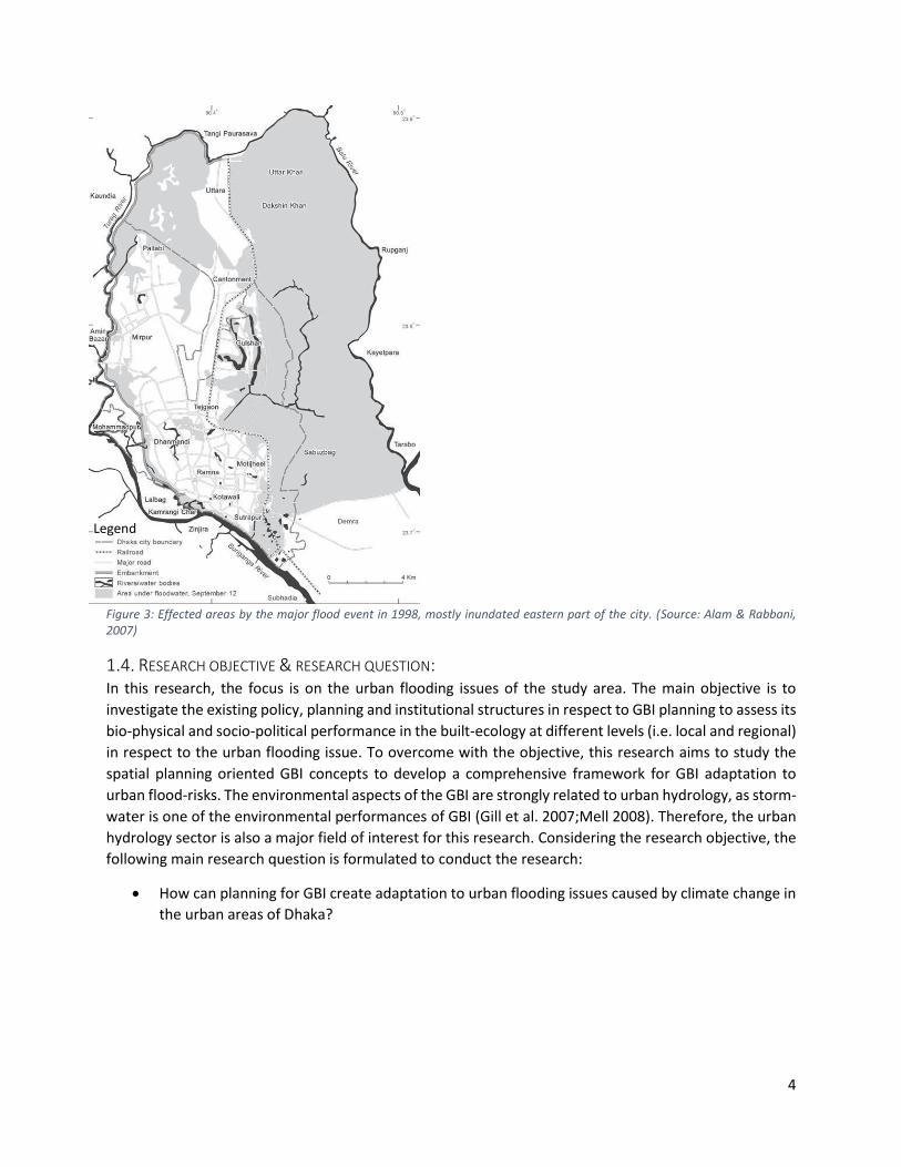
1.3. PROBLEM STATEMENT: Dhaka city’s environmental problems are mostly human induced but climate change is posing major
threats in particularly flooding and heat stress (Alam et al. 2007). The rainfall patterns are erratic with
higher intensity during the monsoon and less rainfall throughout the year (see figure 02), which is related
to frequent pluvial flooding, and the city is also located in an active river tidal zone where low areas are
often inundated by the surrounding rivers (Haque, 2012). The flooding problem in Dhaka damages the
built-structures, roads and other transport infrastructures as well as hinders social activities that leads to
huge economic and social loss. “The 1998 flood caused damage to more than 262,000 shelter units, or 30
per cent of the 860,552 units in the Dhaka Metropolitan Area, at a cost of Tk. 2.3 billion” (Alam & Rabbani,
2007, p-89). During that flood event, water from excessive rainfall got clogged inside the protected areas
of the city and could not drain-out to the surrounding rivers since the river water-level was higher (Huq &
Alam, 2003). This is quite a common phenomenon during monsoon seasons that the low laying areas
suffers short term flooding and remain inundated until the surrounding river stage recedes. The drainage
infrastructure is also not capable to handle the added pressure from excessive rainfall during extreme
events. To worsen the situation, most of the existing canals and water-bodies are either being completely
filled-up or losing depth due to heavy pollution. Alam & Rabbani (2007) discussed vulnerabilities of Dhaka
due to climate change and argued for new adaptive techniques to deal with inland pluvial flooding where
conventional dikes are failing. New measures can be taken for the comparatively underdeveloped eastern
part of Dhaka (see figure 03) which is presently more vulnerable to river flooding but also could be at risk
of pluvial flooding if same flood defensive measure is implemented. The rapid change of Land-use and
land cover in Dhaka plays a major role in its flooding process (Dewan, & Yamaguchi, 2009). Land grabbing
and illegal development on natural wetlands and river banks are causing obstruction to cities in-built
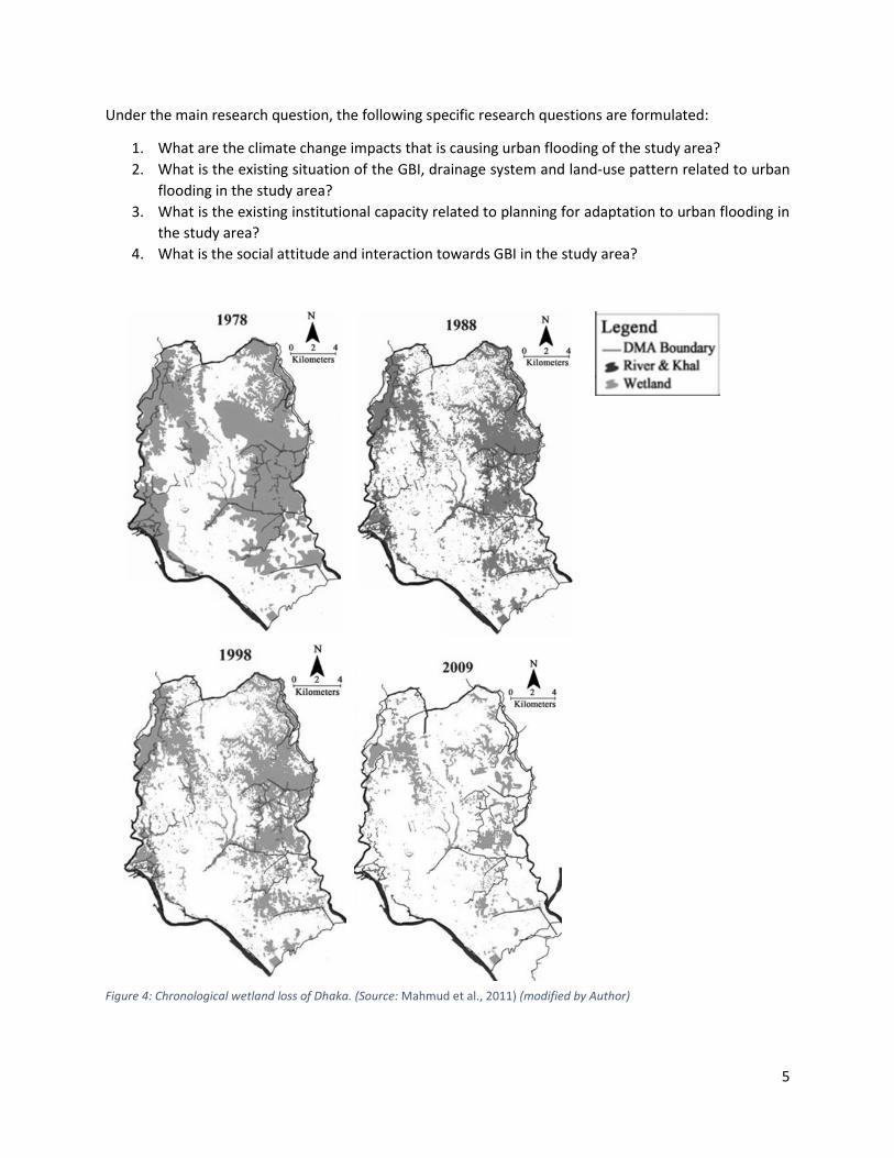
natural drainage. The city is losing its wetland very rapidly (see figure 04). In the developing context of
Dhaka, importance of GBI is being ignored since the continuous loss of greenery is also evident from
several studies. Studies like Byomkesh et al, (2012) and Ansari, (2008) show the challenges of urban
greening in relation to rapid urbanization. Studies showed that approximately 80% of areas of greater
Dhaka had non-urban land-uses with open greenspaces and agriculture but the number has shrunk up to
40% by the year 2005 (Dewan & Yamaguchi, 2008; BCAS, 2006; Byomkesh et al, 2012).
Figure 2:Trend of annual rainfall (1971-2004) showing the days without rainfall has increased with no significant decrease in annual rainfall. (Source: Alam & Rabbani, 2007)
4
Figure 3: Effected areas by the major flood event in 1998, mostly inundated eastern part of the city. (Source: Alam & Rabbani, 2007)
1.4. RESEARCH OBJECTIVE & RESEARCH QUESTION: In this research, the focus is on the urban flooding issues of the study area. The main objective is to
investigate the existing policy, planning and institutional structures in respect to GBI planning to assess its
bio-physical and socio-political performance in the built-ecology at different levels (i.e. local and regional)
in respect to the urban flooding issue. To overcome with the objective, this research aims to study the
spatial planning oriented GBI concepts to develop a comprehensive framework for GBI adaptation to
urban flood-risks. The environmental aspects of the GBI are strongly related to urban hydrology, as storm-
water is one of the environmental performances of GBI (Gill et al. 2007;Mell 2008). Therefore, the urban
hydrology sector is also a major field of interest for this research. Considering the research objective, the
following main research question is formulated to conduct the research:
• How can planning for GBI create adaptation to urban flooding issues caused by climate change in
the urban areas of Dhaka?
Legend
5
Under the main research question, the following specific research questions are formulated:
1. What are the climate change impacts that is causing urban flooding of the study area?
2. What is the existing situation of the GBI, drainage system and land-use pattern related to urban
flooding in the study area?
3. What is the existing institutional capacity related to planning for adaptation to urban flooding in
the study area?
4. What is the social attitude and interaction towards GBI in the study area?
Figure 4: Chronological wetland loss of Dhaka. (Source: Mahmud et al., 2011) (modified by Author)

6
1.5. SCIENTIFIC RELEVANCE OF THE RESEARCH: Applying GBI approach for climate change adaptation is a challenge for spatial planners (Matthews et al.,
2015). Specially in the developing context of the study area, there is dominant socio-economic and
political pressure in planning institutions. Results from this research provide guidelines for developing a
strategic framework for future climate related risks. Research on the environmental service, specifically
for climate change adaptation, is a very new and evolving approach of green infrastructure (Wright, 2011).
This research can contribute in this new dimension. As a developing country, most of the researcher’s
attentions are towards community-based adaptation and policy-oriented development measures. Diverse
environmental services form GBI as a part of urban eco-system can unfold new dimensions in climate
adaptation for renewal of the built-up areas as well as strategic guidelines for future development of the
city.
1.6. SOCIAL RELEVANCE OF THE RESEARCH: As this research relates the bio-physical functions with the socio-political aspects of GI planning, the
investigation on institutional environmental of urban planning and flood-risk management have possibly
revealed ways s for innovative institutional approach to tackle the growth-oriented planning process
existing in the study area. A social survey for analyzing the cultural and behavioral relation with GBI and
the users can contribute to the knowledge on the future participation in practice of GBI oriented design
and planning. It has indicated the public appeal to new environmental development and can open-up new
multi-functional uses related to business, recreation and health benefits. Climate change impacts in deltas
is a very well addressed topic in the intellectual domain. Specially in the study area there are many
researches on the affects and vulnerabilities of CC in urban and rural areas. Also, unplanned urbanization
is another challenge which is well addressed in researches. But researches in adaptation methods,
especially in the spatial planning policy domain are still inadequate. Long-term climate policy, integration
of flood-risk management and spatial planning, mainstreaming CC are very recent questions in the local
context. GBI is very recent concept in urban landscape ecology, and in other domains of urban studies. As
the GBI concepts, have already gained popularity in the global cities for urban climate adaptation, it is
very relevant to investigate for this research where the climate change issues are prominent. Bangladesh
has become a lower-middle income country and starting to realize the importance of environmental
issues over economic gain. So, this research will offer new knowledge on urban adaptation practices.
1.7. STRUCTURE OF THE REPORT: In this report, chapter 1 is the introductory part. It includes background of the study area, problem
statement, research objective and questions and also scientific and social relevance of this research.
Chapter 2 is the theoretical basis of this research and it contains the theoretical framework. The next
chapter 3 is on research methodology. It describes the nature of this research and includes description
and selection process of the study area, data collection and analysis methods. Chapter 4 includes the
results from the data collection methods which are interview, document survey and questionnaire survey.
Chapter 6 in the final chapter and answers the research questions in its discussions, reflects on the
methods and theoretical frameworks and concludes the research.
7
2. THEORETICAL FRAMEWORK: In this chapter, I’ll explain my theoretical lens, which helped to analyze my research questions. I’ll explain
the concept of GBI theories associated with to understand and analyze the existing urban flood related
environmental and spatial planning factors which are relevant for this research. This study will help to put
the context of this research into perspective. In this chapter, my effort is on delineating the theoretical
framework for this study, which has later shaped the empirical findings of this work.
2.1. THE CONCEPT OF GBI: The GBI is a relatively new approach in the urban planning regime to address the leading concern of climate adaptation (or resilience). The research on GBI paradigm can be divided into two distinct categories; conceptualization and practical application (Mell, 2008). In this part, I briefly discuss the conceptual aspects of GBI to establish the under-laying rationales of planning implications of GBI. I also explain the development of this concept in brief. It will help to grasp the fundamental ideas and some theoretical orientations of this GBI approach.
Many scholars have defined this concept (e.g. Walmsley, 2006; Sandström, 2002; Benedict and McMahon, 2006; Turner, 2006; Ahern, 2007; Tzoulas et al., 2007; Madureira et al., 2011; Demuzere et al., 2014; Matthews et al., 2015 ) and the principal ideas of GBI has been evolved from landscape oriented disciplines such as landscape ecology, planning and human geography (Mell, 2008).
The importance of green-space within and around the city was realized in form of structuring urban development for recreational aspects and urban-aesthetics. The works of Ebenezer Howard and Frederick Law Olmsted laid the foundation of realizing green-space as a continuous space. Later in the 20th century the concept of ‘continuity’ was adopted widely in the landscape ecology principles and showed the importance of strategic spatial planning of green-blue spaces (Ahern, 2007). And growing attentions towards natural environment for eco-system services (e.g. restoring biodiversity, regulating pollutions) led the idea of multiple environmental functions and their valorizing of these green-blue spaces (Madureira et al., 2011).
Use of the term ‘infrastructure’ had significant impact on realizing urban green-blue spaces for public good as it promoted the concept towards large-scale, public infrastructural investment for human benefits (e.g. waste-water treatment, storm-water drainage, transportation, energy infrastructures) (Matthews et al., 2015). The quality of life has also become an important part of GBI concept. It is associated with social benefits such as health, physical activities and social interactions with outside environment, leisure and other social activities related with public satisfactions (Mansor, Said, & Mohamad, 2012)
The economic conceptualization of the GBI concept is another major turn for establishing the concept in practical field. Fiscal constrains dominate environmental ideals and uncertainty of climate-risk creates difficulties for strategic policy-making. The economic rational introduced the cost-benefits or trade-off between environmental imperatives and urban-growth in the GBI concept. Now, seeing GBI as a ‘natural capital’, the focus-shift has given more opportunities to the planners to use the multiple benefits of GBI and establish policy (Matthews et al., 2015).

8
2.2. DEFINITIONS OF GREEN INFRASTRUCTURE (GI): Now, in the following, I’ve introduced the definitions of GI to portray a concise sense of it. At the same time, it will show the varying focus of GI from previous researches.
Madureira et al. (2011, p.141) defined GI as,
“an integrated and coherent system of multifunctional green areas that links the city with the countryside through biophysical and social infrastructure”.
Demuzere et al. (2014) and Ahern (2007) interpreted GI as a hybrid system of green-blue space and built structure which can contribute to environmental and social benefits through its ecosystem services. According to Ahern (2007, p. 267);
“Green infrastructure is an emerging planning and design concept that is principally structured by a hybrid hydrological/drainage network, complementing and linking relict green areas with built infrastructure that provides ecological functions”.
In this definition, the blue (water) element is defined and considered as an inseparable part of GI concept. Authors e.g. Matthews et al. (2015), Kambites & Owen (2006), Tzoulas et al. (2007), Benedict and McMahon (2006), highlighted the need of strategic planning and systematic management of GI for an inter-connected and multifunctional network to provide ecological, social and economic benefits. Same policy focus by the Natural England (2009, p. 7);
“Green Infrastructure is a strategically planned and delivered network comprising the broadest range of high quality green spaces and other environmental features”
There are many definitions of GI by various scholars. Many of them has varying ideas (Wright, 2011). But, I’ve selectively mentioned the above definitions to show the core ecological basis and theory orientation of the GI and later the addition of blue and planning consents with it which made the concept more effective for practical interpretation. Wright (2011), analyzed different concepts of GI and identified the core consisting ideas. They are; connectivity, multi-functionality and green. Here, green implies not only the natural green-blue objects but also the infrastructural element which improves environmental quality (e.g. renewable energy structures).
In that aspect Mell et al. (2013, p. 297)’s derivation of GI in my opinion, is showing the planning control over the ecology and more specified for urban environment. They defined GI as;
“the biological resources in urban areas that are human-modified and primarily serve an overt ecological function’ and which are ‘intentionally designed and deployed primarily for widespread public use and benefit”.
2.3. THE STUDY’S CONCEPTUAL FOCUS OF GBI: From the above discussions on the conceptualization of GI, it is perceptible that the range of GBI approach is quite broad. In this research, I find it necessary to explain the wider-aspect of the GI and at the same time to focus on the flooding issue. The GI concept has developed from ecological theories and has been evolving with diverse narratives from many disciplines (e.g. geography, spatial planning, development studies). This process of development has branched out to two different planning fields; conceptual and practical (Mell, 2008). It can be also divided into environmental theory and socio-economic policy (Wright, 2011). The practice-oriented
9
approach of GI includes the multifunctionality, the complex relationship between environment, society and economy and also sustainable development concepts. These ideas have been developed in the geography, development studies and planning disciplines. Whereas, the theory based rationales have been developed in the landscape ecology disciplines which are focused on ecological networking or connectivity (Mell, 2008). GI has no distinct theoretical foundation (Mell, 2008) but, the key ideas in GI are from landscape principles (Ahern, 2007). In that case, ‘connectivity’ is one of the key principles of GI which is often considered as ecological-networking. From the landscape-ecological perspective, the concept of ‘connectivity’ depends on the multi-scale approach with strong relationship of landscape pattern and its process. This approach is fundamentally grounded in ‘hierarchical theory’, realizing landscape as a hierarchical network-system that functions at multiple scales (Ahern, 2007). Multi-scale approach is well established in ecological science to understand the dynamic structure of nature. Also, social-structure must be understood at multiple scales to address the emerging institutional need in understanding the interactions between human and nature agency. In that aspect, the hierarchy theory can be used for conceptualizing both ecological and sociological system (Warren, 2005). So, it is imperative to understand the holistic manner of the GBI concept rather than interpreting theories for specific sectors. Now referring to the practice-oriented part of GI approach, the multifunctionality and their complex relationships, policy and practice integration these ideas are in focus of the present advancement of GI research (Mell, 2008). The climate change issue also extended the functions of GI to climate change adaptation and mitigation (Ahern, 2007; Gill et al., 2007). The GI concept is relatively new in theory and this focus-shift has made it more likely to change, similar to planning theory (Wright, 2011). This is a transition towards practice. This transition refers to the integration of planning-policy, cooperation between organizations, multi-functionality and combinedly they can contribute to the development of planning policy (Mell, 2008). This can be justified under the larger socio-economic and environmental benefits, but the core principles of GI can be contested if interpreted into policy and practice (Wright, 2011). But on the other hand, these diversified ideas and consequent functions will create more scope of integration and application. Ahern (2007, p. 282) therefore, provided some directions for GI practice; “for green infrastructure to advance and to make legitimate contributions to urban sustainability, it must be practiced in a transdisciplinary manner – for it must meet the needs of stakeholders, benefit from the support of decision makers, engage scientists and engineers and challenge planners and designers to innovate. The proof of its success depends on the extent to which monitoring and systematic evaluations of long and short term results are made.” The climate change issue has created a more desirable platform for the GI adaptation especially, in the environmental policy and management sector. Now GI practice is more risk-based approach to cope with the uncertainty primarily from anthropogenic adversities and being realized as climate adaptation strategy (Matthews et al., 2015). GI has already reached high levels of policy-making (i.e. European Commission, 2010) and being deployed in planning policies at regional and city level (Wright, 2011). In that context, the practical orientation of GI is important in planning and management related policy-making for climate adaptation, but these decisions are also dependent on the system’s ecological and social capacity for resilience. Therefore, I’ll keep the focus on planning for adaptation where both theoretical and policy aspects of GI will contribute through an integrated framework. Now in the following section I’ll elaborate on GI’s position in urban climate adaptation specially for urban-flooding (in respect to the main research objective) and later explain the significant components of theory-practice relationship of GI in the framework.

10
2.4. URBAN CLIMATE ADAPTATION: In the previous discussion on GI conceptualization, I’ve explained the recent state of the GI approach
which is more holistic in nature. To plan for urban areas, the synergies of existing landscape and urban
system can be achieved by this GBI approach if it is adopted in an integrated manner. The arguments
related to it was grounded by the ‘theoretical and practice-oriented’, ‘technical and social’ viewpoints of
GBI planning. Now, in the following part, I would briefly explain the urban adaptation, especially from a
planning perspective. Later, this discussion will lead to explaining the position the GBI planning as an urban
adaptation from flooding issues due to climate change and anthropogenic causes.
Many scholars (Adger et al., 2005; Brooks, 2003; Carmin & Zhang, 2009; Huq et al., 2004) explained climate
change adaptation based on the definition by IPCC (2001) which is, the system’s (human or nature;
ecological, social or economic) adjustment in response to present or expected climate change effects to
regulate the adversities or to take advantage from new beneficial opportunities. Here, the adaptation can
be individual or public, proactive or reactive, autonomous or planned.
So, from this definition it is understandable that, the process of adaptation has been distinguished
between standalone action for a short-term goal and inter-related actions of managing multiple risks for
a long-term goal. In relation to that, adaptation-planning is based on long-term objectives. The adaptation
planning gives recommendations based on the current and future climate-risks and their interaction with
other sustainable policy-objectives such as natural resource management, water management, disaster
preparedness, urban planning, sustainable development, poverty reduction, etc. (Füssel, 2007). So,
planning for climate-adaptation requires inclusive understanding of the current and future risks and non-
climatic factors related with present climatic change effects. This planning approach is dependent on
wider policy context and inclined to mainstreaming of climate adaption for multiple benefits. The policy
domain of adaptation is not independent from other development sectors. Because, adaptation action is
not an isolated process and decisions for adaptation actions or plans also depend on the other
demographic, cultural and economic changes associated with climate change effects in local and global
context (Adger et al., 2005). So, inclusiveness in the planning approach is imperative in a sense that it
should include the necessary strategic changes in physical and social environment to cope with the future
vulnerabilities as well as current variabilities of climate change.
Policy development for adaptation planning is an emerging field (IPCC, 2007) and there are diverse factors
that can influence the adaptation activities (e.g. predictability of climate events, climate sensitive and
non-climatic sectors, technical and institutional measures, spatial and temporal factors, wide range of
actors) (Füssel, 2007). So, more knowledge input is necessary in this particular field by combining different
theoretical and practical approaches. For that, Füssel (2007, p. 267) argued for a flexible approach of
measuring and planning adaptation by combining different practices suitable for that particular decision
context. He explained a ‘complex integrative approach’ for assessing and planning adaptation where
mainstreaming of adaptation will happen in the planning and management context by integration of
climate-based adaptation and other sustainable development goals. Countries are integrating
mainstream adaptation to their national policies where major climate change threats are prominent (Huq
et al., 2004) and there are guidelines for integrated adaptation plan such as the UNDP-GEF Adaptation
Policy Framework which is internationally being applied in several adaptation projects (e.g.
Mainstreaming Adaptation to Climate Change, MACC project) (Burton et al. 2005).

11
2.5. GBI FOR ADAPTATION PLANNING: From the previous discussion, it is perceivable that planning for climate-change adaptation is an inclusive
or comprehensive process. I’ve also explained the GI approach which has a similar perception. In both
discussions, the commonality is the integrated approach that includes the social and technical aspects in
GI and climatic and non-climatic factors in adaptation from planning perspective. In this part, I’ll explain
the role of GI approach as a tool of this adaptation process particularly, in the context of urban flooding.
Predicted future-risk of intensification of hydrological cycle and consequent increase in climate calamities
due to climate change and future-risk regarding non-climatic reasons such as population increase and
land-use change is creating conceptual challenges for the water managers (Hennessy et al., 2007;
Kundzewicz et al., 2007; Short et al., 2012). Under this circumstance, adaptation in the water management
sector refers to more innovative solutions which relate the conventional drainage-based system with
more ecological techniques. Sustainable Drainage Systems (SUDS), Low Impact Development (LID), storm-
water Best Management Practices (BMPs), Water Sensitive Urban Design (WSUD) all these approaches
are based on the same principle under different labels which is initiating natural drainage process through
GI (see figure 05); in general, they can be addressed as sustainable urban drainage system (SUDS) (Fryd,
Dam, & Jensen, 2012). Water retention, infiltration, transpiration, evaporation, natural passage etc. are
the natural processes that the hybrid hydrological techniques primarily aim to achieve by designed water
infrastructures (e.g. constructed wetlands, swales, water-parks, retention ponds) into the system.
As a sustainable development, GI also addresses the social, economic dimensions along with its
environmental functions. For example, a designed flood-plain can also be an aesthetical urban place which
will increase health and nature restorative services. From the economic point of view it’s a trade-off
between development and maintenance costs and multiple ecological and social services (Demuzere et
al., 2014). Therefore, the sustainable drainage infrastructures can be seen as a part of GI infrastructure
which enhances the ecological and social functions by synergistic interventions within the system that
connect and protect the built and natural areas (Ahern, 2007). From the climate change point of view,
the role of water has major importance in the GI concept to research new means of managing and
regulating thus promoting the value of the concept (Mell, 2008). As an adaptation and mitigations
measure, the GI provides eco-system services that has multiple benefits to ecosystem and human-
wellbeing (Demuzere et al., 2014) and along with these other benefits the GI approach can be a very
appropriate adaptation strategy (Gill et al., 2007). Therefore, the Blue (water) component is essential in
the GI concept and Green-blue infrastructure (GBI) is more appropriate term for my research.
Now, in the adaptation context managing GBI primarily is about managing risk from the challenging
anthropogenic activities and present planning system has limited institutional capacity to realize large
scale GBI initiatives through spatial planning (Matthews et al., 2015). The sustainable water-management
sector also has the requirement of integrating spatial strategies with other technical and human aspects
for inter-disciplinary decision making (Fryd et al., 2012). Whereas, the conventional water-resource
planning is not so much aligned with the critical socio-economic domains as the urban planning is which
is necessary for large-scale climate change adaptation (Short et al., 2012). Therefore, for governance and
operationalization of GBI approach the institutional structure is also susceptible to change according to
the climate change context.

12
Figure 5:The focus of Sustainable urban drainage system (SUDS), Greene infrastructure (GI) and Urban climate adaptation (UCA) towards flood adaptation. (source: Author)
2.6. THE THEORETICAL FRAMEWORK: Now, in this section I explain the framework with its relevant elements of GBI planning. This framework is
derived from previously explained conceptualization of GBI approach, especially based on the scholarly
work of authors who have conceptualized GBI from integrated socio-technical perspectives such as Byrne
& Yang (2009), Matthews et al. (2015), Chappin & van der Lei (2014) and Fryd et al. (2012).
According to these studies, there are two poles of the GBI concept i.e. bio-physical and socio-political. The
bio-physical and socio-political capacities are inter-dependent and successful adaptation of GBI depends
on synergistic development on both sides. Byrne & Yang (2009, p. 38) have mentioned that four inter-
connected factors are necessary for GBI adaptation; (1) biophysical characteristics of the built
environment; (2) planning philosophy (3) governance structure and (4) residents' perceptions In GBI
projects.
Later, Matthews et al. (2015) further developed this idea and re-conceptualized these four aspects into
two major categories (i.e. bio-physical capacity and socio-political capacity which includes 2,3 and 4 from
Byrne & Yang’s model). They introduced the nature and climate agencies into the framework. The climate
agency refers to the uncertainty of climate change impacts which will influence the decision-making
process, such as vegetation suitability for future climatic conditions. The nature agency refers to the
environmental effects from the GBI itself, such as health hazards through the inhalation of pollen. But, in
general, their work is inclined towards institutional development for GBI with respect to ‘risk-based’
approach (i.e. considering uncertainty of climate agency) in the mainstreaming climate-adaptation debate
rather than capital-based approach (i.e. multifunctionality and economic utilization of GBI). Chappin &
van der Lei (2014) also showed these two inter-connected poles for infrastructural development for
climate adaptations in the form of a socio-technical infrastructural system.
Therefore, different interconnected variables which are import for the efficacy of GBI in terms of urban
flooding will be addressed in this framework as functional-domain considering these two major (i.e. bio-
physical and socio-political) categories. But, another important aspect of GBI is its practice-orientation
(previously mentioned in section 2.3). It is important to indicate a proper practice-approach and positions
of the practitioners in the GBI planning process. In this regard, the previously mentioned models generally

13
indicate the factors which can determine or influence the capacity. Whereas, there are different
disciplinary attitudes to interpret or utilize these factors and should be integrated in a mutually beneficiary
way. For example, the hydrological thinking can determine the quantitative aspects of space for water
whereas, the connectivity of water for multiple ecological and social benefit can be explained from
landscape ecological study. For that, the planning framework developed by Fryd et al. (2012) (see figure
06) has a praiseworthy contribution. They explained three professional perceptions which are; (1) bio-
physical process by engineers, (2) spatial strategies by architects and spatial planners and (3) adaptive
strategies by management experts (see Fryd et al. 2012, p. 868). Integrating this practice aspect in the GBI
framework will give useful indication on professional engagement and can help the decision-making
process. But this practice-domain should be flexible and indicative rather than determinative. Because, it
is explained earlier that the adaptation process of GBI is complex and dynamic and should be implemented
in a transdisciplinary manner (Ahern, 2007). Particular approach can be adopted in an integrated manner
depending on the factors which are constraining the capacity of the process and their severity. For
example, if there is social resistance against environmental protection more managerial approach would
be necessary to involve multiple actors to realize the project. In the following part, I’ve elaborated on the
elements of the practice and functional domains and their interactivity in the GBI planning framework.
Figure 6: Planning and design framework of SUDS developed by Fryd et al., (2012). (source: Fryd et at., 2012)
2.6.1. THE PRACTICE-DOMAIN: In this section, I explain the practical-domain mostly based on Fryd’s framework. Other scholerly works
i.e. (Ahern, 2007), (Mell, 2008) have provided conceptual support in this topic. Fryd et al. (2012) used the
human value, space and time concepts from Agarwal et al. (2002) and aligned the three concepts with the
practice approaches. The ‘human decision-making’ (or human-values) represents the values of actors
involved in the decision-making process, the ‘space’ represents interconnected scale of the system (e.g.
local to regional) and the ‘time’ represents the system’s coping capacity per time-duration and past,
present and future state.

14
2.6.1.1. URBAN HYDROLOGY:
Urban hydrology involves the quantitative and qualitative aspects of the bio-physical process of urban
areas for GBI adaptation. It is a more technocentric approach and related to water-engineering disciplines.
According to Fryd et al. (2012)’s model, the urban hydrology approach is situated in the ‘time-space’
domain. For example, the drainage system’s design based on the return period of storm-event and their
spatial limits. Fryd’s framework argued for an inter-disciplinary manner where positions between human-
values and time are important for decision-making process. In my opinion, this approach will also have
strong influence by the ‘human value’ aspects depending on the socio-political conditions regarding the
desired transdisciplinarity. For example, intervention of novel techniques can be challenged by the
cultural-context in which it is designed for (Castro, Barrera, & Martinez, 2004).
2.6.1.2. SPATIAL STRATEGY:
Spatial strategies employ protective, defensive, offensive or opportunistic spatial strategies based on the
adaptation goal and spatial context. Connectivity, pattern and scale are the most important terms in
landscape to understand its ecological and human functions. Especially ‘connectivity’ is most relevant for
water (blue) networks in the highly modified landscapes of urban areas (Ahern, 2007). The multi-scale
adaptation of GBI is also another consideration in this discipline to harmonize the society and ecology
(Warren, 2005). It deals with strategic decisions regarding land availability for GBI and applies spatial
techniques such as greening of existing infrastructures, connecting and hybridizing built and natural
networks etc. In Fryd’s model, it is situated in the ‘space-human value’ domain but the temporal factor is
also an important consideration for climate-change uncertainty.
2.6.1.3. ADAPTATION MANAGEMENT:
I’ve mentioned that, managing GBI for climate change effects is mostly about managing risks. Therefore,
‘uncertainty’ is the most challenging term for this approach. It is a more collaborative or communicative
approach and deals with multiple actors, temporal issues and multiple governance level. Therefore, it is
more tending towards mainstreaming of GBI or more generally climate-change policies to tackle the
dynamic problems. Multi-functionality is one of the strategic aspect of GBI management, although it can
be defined from a capital-based approach but also valorization of the associate social and ecological
benefits makes it acceptable as trade-off. Multi-stakeholder platform is an participatory or democratic
process of conflict management and it is emerging in the water-management sector (Warner, 2005). In
Fryd’s model it is situated in the ‘human value-time’ domain, but decision and implementation also
depends on different institutional and governance levels. Because a successful adaptation strategy means
it should meet its own individual goal along with improving others to reach their goals and consequently
involving multiple scales for evaluating and implementation (Adger et al., 2005).
2.6.2. THE FUNCTIONAL DOMAIN: The functional domain of the framework consists of bio-physical aspects and socio-political aspects of GBI
in terms of adaptation planning. In the following sections, I’ll elaborate on these aspects.
2.6.2.1. BIOPHYSICAL ASPECTS:
In this section, I’ve discussed the biophysical aspects of GBI planning from multi-disciplinary perspective
(i.e. urban hydrology, spatial planning and management) to identify the important elements or indicators
which are relevant for particular problem of urban flooding in the study context. Previously mention

15
concepts (i.e. GBI, SUDs, UCA) and relevant scholarly works (i.e. Fryd et al. 2012; Matthews et al. 2015;
Byrne & Yang 2009) has provided the theoretical basis for this. The diagram of figure 07 is showing the
conceptualization of GI for climate adaptation developed by Matthews et al., (2015).
Figure 7: Conceptual model of GI for climate adaptation developed by Matthews et al., (2015) (Source: Matthews et al., 2015)
The bio-physical aspects of GBI primarily concern the ecological interactions of green-blue spaces with the
built-up system. For vegetation purposes; plant characteristics and appropriateness for the specific
location, soil-conditions, local macro and micro-climatic conditions (e.g. temperature, wind flow,
precipitation), structural condition of the buildings for plantation etc. are the most important aspects
which are recognized by empirical researches (Matthews et al., 2015). There is still need of empirical
knowledges on the bio-physical capacity of greenspaces which can help the designers, residents or city
managers to respond the greenspace requirements in the built conditions and their trade-offs (Byrne &
Yang, 2009)
For urban flood adaptation, the storm-water management issues of GBI are important and can be
understood as more technical environmental service of GBI (Wright, 2011). For storm-water
management purposes; local precipitation pattern, surface cover and elevation of the terrain, dynamics
of evaporation, transpiration, irrigation, interception etc. are the important quantitative measures that
need to be addressed for controlling storm-water run-off. The quality control of this storm-water run-off
is another emerging issue for GBI or SUDS approach because of the contamination problem if blended
with other natural and built system (e.g. playing fields for temporary wetlands) (Fryd et al., 2012). These
quantitative and qualitative aspects of storm-water runoff are related to urban hydrology disciplines and
the hybrid drainage system can be designed according to the variable parameters of water flows. There
are other aspects such as, scale, land-use and area available for GBI, networks of these structures etc.
which are more related to spatial planning disciplines.

16
2.6.2.1.1. NATURAL FEATURES:
Selection of plants for urban greening is important depending on its physiology. The biogenic services
from a plant (e.g. interception, evaporation, transpiration) depends on its physiology (Farrugia et al. 2013
cited in Matthews et al. 2015) and constraints for plantations in urban areas such as, interference with
service lines, soil requirements, tolerance level from pollution are important factors that require careful
section of plant species for GBI design (Matthews et al., 2015). Soil type is very important for storm-water
runoff because of the infiltration capacity for example, sandy soil has faster infiltration and clay soil has
slower infiltration (Fryd et al., 2012; Gill et al., 2007).
For climate change adaptation, risk associated with adverse climate effects is a prior concern in GBI
planning. The uncertainty factor makes it difficult to measure accurately rather, it is understood in
probabilistic terms (Matthews et al., 2015). Matthews et al. (2015) explained that, although it is difficult
to determine the exact effects of the changing climate, the trend of this change and probable future
effects should be an important actor for GBI adaptation. For example, the vegetation implemented in an
urban area should also be able to sustain in its future climatic context. The local climatic conditions (e.g.
precipitation pattern, temperature, wind flow) effect the quantitative aspects of water management need
to be considered in the planning process to determine the service level of the system. For example, the
drainage system can be designed targeting the ‘return period’2 and duration of a major rain event but also
considering the variability of it as the climate change makes it uncertain (Fryd et al., 2012).
2.6.2.1.2. HUMAN-SETTLEMENT FEATURES:
The surface cover, surface elevation, land-uses and urban form these are relevant urban features for GBI
and its performance in flood management. The rainwater run-off depends on the surface types and the
slope of the area (Fryd et al., 2012; Gill et al., 2007). More permeable and vegetated surface decreases
the storm-water runoff (Demuzere et al., 2014; Gill et al. 2007; Fryd et al., 2012).
The urban morphology is more appropriate for GBI if perceived as continuous element of different spatial
scales (e.g. regional, local) and forms (corridor, patch, matrix) and very useful in spatial strategic thinking
(see previous section 2.6.1.2). But, discretely it is a major physical element that allows green intervention
in the settlement. For example, the green roofing, wall greening etc. depends on the structural condition
(e.g. longevity and load barring capacity) of that built form. Compact and small-grain urban form can
create more options for urban greening within the city and large open space in the periphery for more
infiltration area and flood plains (Hamin & Gurran, 2009). In that sense, the sustainable urban form
concept can be aligned with GBI development. The existing land-use will show a possible area for GBI and
natural drainage provisions in the city.
The drainage infrastructural conditions such as; its drainage and storage capacity, sewage system (i.e.
combined or separated) have effect on the quantity and quality of the water-flow. Various storm-events
challenge the drainage system in various ways. For example, intensive storm events generate high flow
rates and employ large pressure on the storm water drainage elements. Whereas, the rain events with
lower intensity but long duration generate large run-off volumes which challenge the capacity of storm-
2 Return period is the interval period of a rain event. For example, a 5-year rain-event means a similar rain-event will occur in every 5 years.

17
water storage elements. In terms of water quality, the combined system (sewage and storm water in a
single pipe) collects household and industrial waste water with the storm water which need to be treated
in waste water treatment plants. But, in separate system (individual pipes for household, industrial waste
and storm water), storm water is generally discharged directly into the natural water bodies (Fryd et al.,
2012). Therefore, implementation of GBI (or SUDS) measures need to deal with the existing drainage
system to reach the environmental goals through optimal alterations.
2.6.2.2. SOCIO-POLITICAL ASPECTS:
The socio-political aspects of GBI are more related to management approach and depend on the
institutional arrangements. According to Matthews et al. (2015, p. 161), “these factors are less readily
resolved through technical planning and management approaches, and are less understood”.
2.6.2.2.1. GOVERNANCE PRACTICE:
The political context in which the planning decisions are made influences the GBI planning (Young &
McPherson, 2013 cited in Matthews et al. 2015) . In this case, the attitude of the government for climate
adaptation and more specifically urban flood management is a concern. Alignment with the global plans
and political agendas, local agendas, mainstreaming of climate change policy, planning philosophy of the
leaders, administrative hierarchy etc. are the influential factors for GBI adaptation. The discrepancy
between growth based development and climate mainstreaming can indicate the attitude towards GBI
development (Füssel, 2007; Lim et al., 2004).
2.6.2.2.2. INSTITUTIONAL ASPECTS:
The institutional and operational capacity of the governing agencies are deciding factors of socio-political
function of GBI. The complete realization of plans, maintenance and monitoring depend on this. For
example, partial development of a highly technical solution can fail the complete system. Significant
efforts in understanding the agency and institutional dimensions can lead to better understanding of the
role of GBI in urban areas which are preparing for climate change (Matthews et al., 2015).
Policy instruments, strategic plans, environmental laws etc. are governance tools to regulate and control
the settlement development (see also p. 19). To promote GBI, its regulatory barriers should be identified
and requirement should be modified to facilitate the choice of GBI (Dunn, 2010). Land-use regulations
and strategies can create scopes and can also constrain GBI planning. Mainstream policy discourse related
to climate change is an important aspect for GBI realization (Matthews et al., 2015). There are
internationally developed adaptation assessment programs such as the National Adaptation Programmes
of Action (NAPA), the Climate Change Adaptation through Integrated Risk Reduction (CCAIRR) which are
being adopted in the national policy by developing countries (e.g. Bangladesh) for alternative adaptation
actions. Building codes and regulations can also include guidelines and rules to support GBI planning.
Budget allocation for implementing and maintaining GBI project is an important issue for the governing
authorities. Other economic sectors will challenge the GBI planning such as property value increase,
commercial growth etc. In this case, the wide range of social and economic benefits from a GBI project
have been given priorities to GBI practice, by offering multiple socio-economic functions and also
promoting other economic growths (Wright, 2011). So, financial capacity of the implementing agencies as
well as their ability to involve other financial stakeholders play a significant role in GBI planning. Difficulties

18
in budget allocation and urgency can constrain municipal initiatives to change traditional approaches
(Dunn, 2010).
2.6.2.2.3. SOCIAL ASPECTS:
Resident’s perception and utilization of the green-blue spaces will influence the decision making of GBI
planning. It is important to manage GBI developments in a social participatory system where people often
take stewardship of their surrounding environment and contribute in improving the quality according to
their suitability (Demuzere et al., 2014). The effectiveness of climate adaptation partly depends on the
social acceptance of the strategic options (Anger, 2003).
Designing and planning GBI for an urban area is related to the demography of that area. Issues related to
rapid population change such as urban densification and urban shrinkage are uncertain factors that
challenge city’s storm water management (Fryd et al., 2012). Compact growth can be good for the
environment as it minimizes infrastructural requirements and frees more space for natural ecosystem,
but rapid growth as in the developing cities poses enormous management challenges (Cohen, 2006). In
this aspect, the time and scale of urbanization caused by population fluctuation is an important
consideration in managing city’s utility services. Uncontrolled population increase can challenge the
capacity of the drainage system by increased waste water generation, transforming important natural
features into settlements etc. Therefore, the risk of population fluctuation (in this case, population
increase) is a significant management aspect of GBI development. The following diagram summarizes the
several aspects related to GBI planning for urban climate change adaptation to flooding which have been
discussed in the previous sections (see figure 08).
Figure 8:GBI planning framework for urban flood adaptation.

19
2.7. THE CONCEPTUAL FRAMEWORK: In the previous sections, I’ve explained the key factors of GBI planning under the practice and functional
domain. Different elements of GBI planning and the narratives of their inter-relations were perceivable.
In this section, I’ve illustrated the inter-connectivity of these elements in a conceptual diagram (see figure
07). In this case, Fryd et al. (2012)’s work shows the relationship between the practical approaches of GBI
where Matthews et al. (2015)’s work explains the inter-connectivity of different bio-physical and socio-
political features.
In the practice domain (see previous section 2.6.1), I’ve mentioned the concept of time, space and human-
value in the three disciplinary approaches i.e. urban hydrology, spatial planning and adaptation
management. Although it is argued that the wide-ranging success of GBI adaptation depends on the
transdisciplinary practice specially in the implementation phase (Ahern, 2007). But at the same time there
are technicalities regarding hydrological designs (e.g. SUDS) that can be better realized by the inter-
disciplinary relationships. In this regard, Fryd et al. (2012)’s model is used considering the influences of
the three concepts (i.e. time, space and human-values) in each professional practice (i.e. urban hydrology,
spatial planning and adaptation management). The positioning of the concepts in the diagram of figure
09 is followed by Fryd’s model where they showed that the urban hydrology thus the quantitative and
qualitative aspects are more related to city’s bio-physical features especially, soil types, surface cover and
elevation, and drainage infrastructures. The spatial strategies deal with connectivity, pattern and scale of
bio-physical features of the urban environment. Plantation as a part of urban landscape, is related to
spatial design, but as a GBI element its environmental services are more realized by landscape ecology
along with its aesthetical purposes. In GBI, the drainage infrastructure is not only hidden drainage pipes
and storage areas but also multipurpose spaces which are well integrated with human and natural
systems. It is also dominant in urban environment designed by aesthetical principles. Therefore, in GBI
planning the natural and built feature are strongly inter-depended. Climate is an important natural
phenomenon in GBI planning which is explained as a natural feature in the previous discussion (see
previous section 2.6.2.1.1). Matthews et al. (2015) emphasized that, GBI should consider climate actions
more explicitly as it shapes biogenic services (e.g. evapotranspiration, absorption of particle matters) of
GBI and also influences decision-making process due to its high impact (e.g. extreme weather events) on
human settlements. So, it has an influence both in bio-physical process and socio-political sectors. The
adaptation management on the other hand is more related to the socio-political aspects (see Fryd et al.,
2012). It manages the wide range functions or services offered by the GBI through a multi-stakeholder
environment and analyzes trade-offs for decision making. Within the socio-political factors, the
governance (or political) practice influences the institutional measures, such as planning regulation for
development options. But, the capacity of the institutions can be constrained by other social and financial
issues as well as the spatial limits, such as budget and land availability for GBI development and social
reactions to it. Here, climate change effect is an extraneous force that influences governance policies,
such as mainstreaming climate adaptation.

20
Fig
ure
9:T
he
con
cep
tua
l dia
gra
m f
or
GB
I pla
nn
ing
.

21
3. RESEARCH METHODOLOGY: In this part, I discuss the methodological approach for this research and also explain the methods of data
collection and analytical approach.
3.1. MIXED METHODS RESEARCH: Mixed methods research is a synthesis of practical and intellectual knowledge. It is a pragmatic approach
that imports useful logic from qualitative and quantitative researches. Fundamentally, qualitative
research is based on a constructivist or post-structuralist principle whereas quantitative research is based
on a (post-)positivist principle. Mixed methods research combines principles for conceptualizing a
particular research problem as well as for data collection and analyzing. But, depending on the problem
the position of the research could be qualitative-dominant, quantitative-dominant or equally balanced
(Johnson et al., 2007). In this regard, my research is based on a mixed methods approach and can be
positioned towards qualitative-dominant research. In the background literature study, I’ve found
discourses based on the notion of transdisciplinarity and socio-technical integration of GBI planning
specially when it is related to climate change adaptation. The studied articles commonly showed
discourses between GBI theory and practice, and its bio-physical and socio-political factors. The adopted
framework for GBI planning is also inclusive and requires critical investigation of both bio-physical and
socio-political aspects. The bio-physical aspects of GBI are more technical and rely on a quantitative study
and the socio-political aspects are more policy-oriented and rely on a qualitative study. According to the
research objective, this study focuses on the planning of GBI for climate-change adaptation to urban
flooding. In this research, qualitative analysis on political, institutional and social sectors were conducted
from interviews, policy-planning documents and social survey. And related quantitative hydrological
aspects were reviewed and discussed to delineate a comprehensive GBI adaptation scenario in the current
context of flooding. As I mentioned, I’ve collected primary and secondary data from various sources (i.e.
interviews, questionnaire and document study) so the data collection method is a triangulation method.
This technique allowed me to accumulate multi-disciplinary information within the limited time and
resources available. And information from various sources improved the validity of this research.
3.2. CROSS-SECTIONAL STUDY: According to Kumar (2014), the cross-sectional study is suitable to develop an overall understanding of a
phenomenon as it is designed to investigate the phenomenon by taking a cross-section of it at a single-
time of the research. In this regard, my research is based on the cross-sectional design. It represents the
present socio-infrastructural situation related to climate-change and urban flooding in the study area and
evaluates the scopes for GBI implementation for adaptations purposes. Primary Data (specially
questionnaire and interviews) were collected at a single time point in respect to the present situations
but, secondary data (e.g. climate, flood, urban growth and population) were collected from different
research works and policy-documents where historical development and future scenarios were discussed
for better understanding of the existing planning issues in the relevant governance sectors.

22
3.3. CASE STUDY: Case-study is a method to study, especially social phenomenon from an individual case and offers more
scopes for intensive analysis of specific details from the case (Kumar, 2014). In this regard, I’ve studied
two cases to gather case-specific information which strengthened my understanding of the problem and
provided more information for my research objective. In the theoretical framework, multi-level planning
and governance of GBI has been emphasized. The appropriate scales for analyzing urban landscape for
GBI planning are city or regional-level, districts or neighborhood-level and household or individual-level
(Ahern, 2007). Therefore, the biophysical and socio-political indicators from the adopted framework were
applied on the specific cases to see the neighborhood-level capacities where the study area (i.e. Dhaka
city) represents the city or regional-level. In this way, the variability between different spatial levels and
their possible dependency has been realized in this study. The biophysical indicators and planning related
(i.e. governance practice and institutional capacity) indicators were investigated from available research
and planning documents and from interviews of involved experts. But the social acceptance of GBI
planning requires resident’s feedbacks on their perception and usage of the GBI projects. Therefore,
questionnaire survey in the case study area and the neighboring residential areas were conducted to study
the societal aspects of GBI planning within the context. These survey processes are explained later in the
data collection methods (see section 3.5).
3.4. THE STUDY AREA AND SELECTION OF CASE STUDIES: In the background information, I’ve already mentioned my research focus on Dhaka. I’ve selected this city
based on the problem statement and also according to my convenience for field survey and
communication. In this part, I’ll delineate the study boundary and introduce my specific case studies for
clear contextual understanding of the results.
3.4.1. STUDY AREA: My objective was to conduct the study in both city (or regional) level and neighborhood level. For a city
level study of Dhaka, I’ve decided to delineate the study extent according its political or administrative
boundary. But the administrative boundary of this city had four (4) delineations in physical extents (see
figure 10) depending on the different governmental agencies (Rabbani et al. 2011). Generally, Dhaka city
referred to the Dhaka metropolitan area (DMA) which covers 306 sq.km (Mahmud et al. 2011)( see figure
10.2). Before 2011, this DMA area was mostly corresponding to the administrative boundary of former
self-governing local agency named Dhaka city corporation (DCC) with some restricted areas under Airport
and Cantonment authority. But presently there are two agencies called Dhaka south city corporation
(DSCC) and Dhaka north city corporation (DNCC) divided from the DCC under the Local Government (City
Corporation) Act 2009, (Amendment-2011) (Ahmed et al. 2014; DNCC website; BDNews24.com, 2011).
Presently, at the time of this research the jurisdiction areas are 82 sq.km for DNCC and 45 sq.km for DSCC
but there are governmental proposals by the National Implementation Committee for Administrative
Reforms (NICAR) to expand their jurisdiction area by adding 114.58 sq.km to the DNCC and 64.17 sq.km
to the DSCC (The Daily Star, 2016). So, there was ongoing development in the governing institutions
regarding the administrative territory in respect to governance issue. There is also a strategic boundary
delineated by the Dhaka’s development authority or ‘Capital Development Authority’ (RAJUK) who are
responsible for planning and implementing urban development plans. (SENES Consultants Ltd., 2007). It
covers 1528 sq.km including the DMA (including DNCC & DSCC) area, the DND area, and the other urban

23
fringe areas namely, Savar, Gazipur, Tongi and Narayanganj (see figure 10.4. This broader area is defined
as Dhaka metropolitan development plan (DMDP) area for long term strategic urban development. This
area is also identified as the ‘greater Dhaka’ in many planning and policy reports.
In this case, I’ve decided to adopt the Dhaka metropolitan development plan (DMDP) area boundary as
an extent of my study area (see figure 11). This is because, the research focuses on the urban flooding
issue with underpinning GBI adaptation, so a broader research boundary will help to generate strategic
understanding of this topic. Specially, when the larger strategic context can reveal alternative options for
long-term and higher adaptation goals (Fryd et al., 2012). So, the term ‘Dhaka city’ refers to the DMDP
area as study area in this research.
Figure 10:the image shows the different administrative boundaries (1) Dhaka City Corporation (DCC), old boundaries before 2011 (2) Dhaka Metropolitan area (DMA) (3) Dhaka statistical metropolitan area (DSMA) and (4) Dhaka metropolitan development planning (DMDP) area. (Source: Rabbani et al. 2011)
1 2
3 4

24
Figure 11: The study area, corresponding to the DMDP area (Greater Dhaka) and locations of case study areas. Source: RAJUK, Dhaka 2016 (modified by the Author)
Case 1
Case 2
25
3.4.2. SELECTION OF THE CASE STUDIES: “The assignment of projects at neighborhood and city level are expected to have particular importance,
as this is where sustainable urban development is given its spatial and visible shape" (Fryd et al. 2012,
page 878). In this study, I’ve selected two cases which have shown such importance not only as
environmental projects but also as breathing space for the city. These projects have multiple objectives
other than environment restoration and water retentions such as storm-water drainage, circulation,
recreations and can be identified as GBIs (or SUDS) within the study area. They are situated in the central
location (see figure 11) and serve the core population of the city.
These projects are- Case 1: Integrated development of Hatirjheel lake and surrounding area (including
Gulshan and Banani lake) and Case 2: Dhanmondi lake and lakeside area development.
3.4.2.1. BACKGROUND OF THE CASE STUDIES: CASE 1:
During the research, there were several ongoing projects in Dhaka which can be defined as GBI (or SUDS)
projects due to their environmental objectives (specially water retentions and urban greening). In the
RAJUK website, I’ve found list of current projects titled as ‘Lake improvement/ Beautification’. From that
list, I’ve selected the ‘Integrated Development of Hatirjheel Area Including Begun Bari Khal Project’ and
‘Gulshan-Banani-Baridhara Lake Improvement & Beautification Project’ as a combined case study area as
they are situated in the same area. These projects are generally wetland restoration projects but also
integrated with other public place-making, landscaping and transportation goals. Among the two project
(i.e. Hatirjheel, Gulshan-Banani), the project on Hatirjheel lake is more significant for its many social issues
and city-scale development goals. It started in 2007 and opened in 2013 after completing most of its goals
(The Daily Star, 2013) but, the project was undergoing with new architectural integration during the time
of this research. Whereas, the project on Ghulshan-Banani lake was started in 2010 with less
development goals (i.e improving water quality and surrounding landscape environment) (Sultana R,
2013). It was at its initial stage during the time of this research. The extent of this combined case study
area includes the lakes (wetlands) and surrounding residential areas (i.e. Baridhara, Gulshan, Banani,
Korail, Begunbari, Merul Badda, West Rampura, Ullan, Nayatola) under Ward3 no. 18, 19, 20, 21, 22, 24,
35 and 36 (of DNCC).
3.4.2.2. BACKGROUND OF THE CASE STUDIES: CASE 2:
Compared to the first case study, this case study is a more neighborhood oriented development. It was a
landscape project of the Dhanmondi lake and lake-side area in an important residential zone (i.e.
Dhanmondi R/A) undertaken by the DCC (former city corporation) in 1998 (Hakim A, 2014) and completed
in 2000 (VITTI Ltd. website). Its objective was restoration and conservation of the existing lake and
improving lakeside environment through water-body management and design interventions (VITTI Ltd.
website). Since this project was realized in a different time-period and being experienced by the users for
more than a decade, I’ve selected this project as a case study to get variant feedbacks from the residents
as well from its planning processes. The extent of this case study area is the Dhanmondi lake and lakeside
residential area under Ward no. 15 (of DSCC).
In this research, these two cases will represent the GBI (more specifically, SUDS) development in the study
area and will give in-depth understanding of the GBI planning. The extents of the case-study areas were
3 ‘Ward’ is the smallest electoral unit of the city.

26
selected to accommodate the large urban wetlands (i.e. Hatirjheel, Gulhan-Banani and Dhanmondi lake)
situated at the core city that have neighborhood-level and city-level environmental and spatial impacts.
But in this research, my major objective is to investigate the user’s or resident’s responses on the on-going
development along with its other biophysical and planning aspects discussed in the framework.
3.5. DATA COLLECTION AND ANALYSIS METHODS: The data collection method is a mixed methods approach. In this research, I’ve conducted expert’s
interviews, document studies and a questionnaire survey. Each of the methods are focused at a particular
aspect of the GBI planning framework but also have overlaps in subject matters to triangulate the data
(see figure 12). In the following part, I’ll briefly explain each method.
Figure 12: Data collection method of this study.
3.5.1. INTERVIEWS: In the GBI planning framework I’ve discussed three disciplinary approaches (i.e. urban hydrology, spatial
planning and adaptation management) in the practice domain and I’ve portrayed the significance of
transdisciplinary knowledges for the flood adaptation context. Therefore, my target groups were experts
from these three disciplinary backgrounds. I’ve selected eight (8) experts for interviews through snow-
ball sampling techniques. It is a useful technique to study knowledge distribution within a group (Kumar,
2014). In this research, this approach also showed the communications among the agencies and
institutions. Most importantly, I had little knowledge about present organizations in the flood-
management sector, therefore it helped me to establish fast connection between experts. I’ve started my
snow-balling from Wageningen University, Dhaka office as an initial contact and eventually communicated
with experts from governmental agencies i.e. Dhaka Water Supply and Sewage Authority (DWASA), Water

27
Resources Planning Organization (WARPO), Capital Development Authority (RAJUK), local consulting
institutes i.e. Institute of Water Modelling (IWM), Institute of Water and Flood Management (IWFM),
Bangladesh University of Engineering and Technology (BUET) and private firms involved with selected
cases and relevant works i.e. VITTI Ltd, JPZ Consulting Ltd. (see figure 13). Finally, I’ve categorized the
experts in two disciplines (i.e. spatial planning and hydrology engineering) depending on their disciplinary
backgrounds (see Annex I).
Figure 13: The snow-balling network of the sampling process of interviewees.
I’ve conducted face to face interview with a semi-structured questionnaire. The interview questions had
two major segments (i.e. institutional aspects of urban planning and flood management and technical
information about inland water management) in respect to the GBI adaptation. These questions
correspond with my specific research questions and was guided by the GBI planning framework. I
combined questions from each disciplinary topic for all the interviewees. For example, drainage
management issues are more relevant to urban hydrologist and land-use strategies are related to urban
planners but I’ve presented both issues to the planner and hydrologist to understand the interdisciplinary
attitude among experts and their organizations. There were also some specific questions on the selected
case studies depending on the expert’s insolvency in the project.
3.5.2. DOCUMENT STUDY: Along with the interviews, I’ve gathered information from secondary sources mostly through government
publications, existing researches and consultancy reports. Main reason for this document study was to
explore the existing knowledge development in the parallel scientific and policy-domains within the study
context. Due to data limitations, empirical research on the existing bio-physical condition was not
considered, rather results from previous hydrological studies showed the bio-physical aspects of the
realized GBI projects and the whole drainage condition of the study area. In the interview sessions, the
scientific aspects were also explored, but factual data on climate condition, performance of existing
drainage system and invested GBI project (i.e. Hatirjheel lake) were reviewed from scientific researches
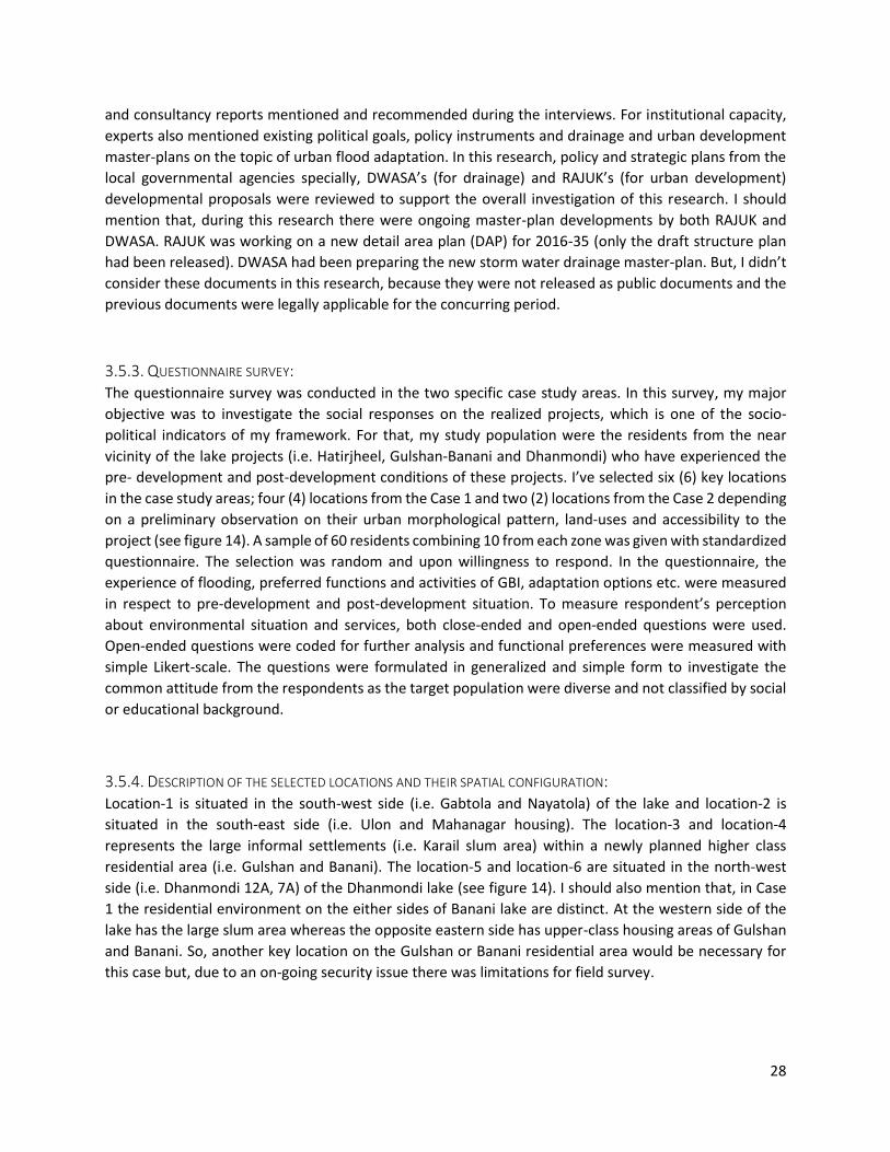
28
and consultancy reports mentioned and recommended during the interviews. For institutional capacity,
experts also mentioned existing political goals, policy instruments and drainage and urban development
master-plans on the topic of urban flood adaptation. In this research, policy and strategic plans from the
local governmental agencies specially, DWASA’s (for drainage) and RAJUK’s (for urban development)
developmental proposals were reviewed to support the overall investigation of this research. I should
mention that, during this research there were ongoing master-plan developments by both RAJUK and
DWASA. RAJUK was working on a new detail area plan (DAP) for 2016-35 (only the draft structure plan
had been released). DWASA had been preparing the new storm water drainage master-plan. But, I didn’t
consider these documents in this research, because they were not released as public documents and the
previous documents were legally applicable for the concurring period.
3.5.3. QUESTIONNAIRE SURVEY: The questionnaire survey was conducted in the two specific case study areas. In this survey, my major
objective was to investigate the social responses on the realized projects, which is one of the socio-
political indicators of my framework. For that, my study population were the residents from the near
vicinity of the lake projects (i.e. Hatirjheel, Gulshan-Banani and Dhanmondi) who have experienced the
pre- development and post-development conditions of these projects. I’ve selected six (6) key locations
in the case study areas; four (4) locations from the Case 1 and two (2) locations from the Case 2 depending
on a preliminary observation on their urban morphological pattern, land-uses and accessibility to the
project (see figure 14). A sample of 60 residents combining 10 from each zone was given with standardized
questionnaire. The selection was random and upon willingness to respond. In the questionnaire, the
experience of flooding, preferred functions and activities of GBI, adaptation options etc. were measured
in respect to pre-development and post-development situation. To measure respondent’s perception
about environmental situation and services, both close-ended and open-ended questions were used.
Open-ended questions were coded for further analysis and functional preferences were measured with
simple Likert-scale. The questions were formulated in generalized and simple form to investigate the
common attitude from the respondents as the target population were diverse and not classified by social
or educational background.
3.5.4. DESCRIPTION OF THE SELECTED LOCATIONS AND THEIR SPATIAL CONFIGURATION: Location-1 is situated in the south-west side (i.e. Gabtola and Nayatola) of the lake and location-2 is
situated in the south-east side (i.e. Ulon and Mahanagar housing). The location-3 and location-4
represents the large informal settlements (i.e. Karail slum area) within a newly planned higher class
residential area (i.e. Gulshan and Banani). The location-5 and location-6 are situated in the north-west
side (i.e. Dhanmondi 12A, 7A) of the Dhanmondi lake (see figure 14). I should also mention that, in Case
1 the residential environment on the either sides of Banani lake are distinct. At the western side of the
lake has the large slum area whereas the opposite eastern side has upper-class housing areas of Gulshan
and Banani. So, another key location on the Gulshan or Banani residential area would be necessary for
this case but, due to an on-going security issue there was limitations for field survey.

29
3.5.4.1. THE SPATIAL CONDITION OF THE LOCATIONS:
It is important to integrate the concepts of spatial configurations, scale and connectivity to understand
the ecological or bio-physical process of GBI (Ahern, 2007). I’ve mentioned the important relationship
Figure 14: Arial images of Case 1 (A) and Case 2 (B) including the survey locations. (Source: Google maps 2017) (modified by the Author).
between urban forms and GBI in the bio-physical part of the framework (previously discussed in section
2.6.2.1.2). To quantification the biophysical performances (e.g. storm water runoff estimation), it is very
important to characterize the urban morphology (Gill et al., 2007). Quantification of such biophysical
functions was not the objective of the questionnaire survey, but to understand the user’s responses on
GBI projects. Therefore, it is important to identify the spatial conditions of the selected locations to relate
the resident’s responses according to their livelihood conditions. Here, I’ve presented the spatial
5
B
6
Dhanmondi lake
2
A
3
4
1
Hatirjheel lake
Gulshan lake
Banani lake

30
categories of the selected key locations. This is not an outcome of an in-depth physical survey. Only
satellite images and on-site visual observations were used for a general orientation.
3.5.4.1.1. UNPLANNED RESIDENTIAL AREA:
The locations near the Hatirjheel lake area (i.e. Location-1,2) are unplanned residential areas (see figure
15). These areas are organically developed with different sized plots, narrow streets, and mid-rise
settlements. For location 1, the major connection with the lake area is the Mahanagar housing road and
for location 2 is Modhubag road. But pedestrian and hand-pull vehicles (i.e. rickshaws) are restricted on
the major vehicular roads around the Hatirjheel lake project. The area (i.e. Ward-22) that the locations
are situated has about 20,205 households per square kilometer (BBS, 2014).
3.5.4.1.2. SLUM AREA:
The locations besides Banani lake (i.e. Location-3,4) are situated in the largest slum area (i.e. Karail) in the
study area. Most of the households are either temporary or semi-permanent settlements (in local terms
‘kacha’ and ‘semi-pakka’). The internal roads are only pedestrians and no formal arrangements for public
infrastructures (i.e. municipal drainage, water and electricity supply) are there. The area is surrounded by
government or privately owned buildings allowing a very limited access to the internal areas. Before, boat-
crossing was an important means for the community to access the surrounding areas but it was restricted
due to the Gulshan-Banani lake project. The overall area (i.e. Ward -19, including Gulshan-Banani housing)
has about 7132 households per square kilometer (BBS, 2014).
3.5.4.1.3. PLANED RESIDENTIAL AREA:
The Dhanmondi lake adjacent areas (i.e. Location-5,6) are part of the Dhanmondi housing area which is a
planned residential area from 60s. This area is planned in grid-iron pattern with regular sized plots. There
are different height restrictions according to the master-plan but in general the settlements are midrise
apartments. The area has many access to the lake project including peripheral walkways. The Dhanmondi
area (i.e. Ward- 19) has the lowest household density among the study areas with about 6297 households
per square kilometer (BBS, 2014).
Figure 15:Unplanned residential areas of location-1,2 (A); urban slum areas of location-3,4 (B) and planned residential areas of location-5,6 (C). (source: Google maps 2017) (modified by the Author)
A B C
House hold: 20,205/km2 House hold: 6297/km2 House hold: 7132/km2

31
3.5.5. METHODS OF ANALYSIS: In the following section, I explain the methods of analysis which include content analysis of the expert’s
interviews and analysis of the questionnaire survey.
3.5.5.1. INTERVIEW:
For the expert’s interview, a qualitative analysis was conducted. For the interviews, open questions were
developed related to the specific research questions of this study which guided the interview sessions
(see Annex III). During the interview sessions discussions were recorded and later typed for written
transcript (see Annex I). Most of the interviews were in the local language (i.e. Bangla) which were later
translated into English. The content of the interviews was analyzed with the support of a qualitative data
analysis software namely, Atlas.ti (version: 7.0.70). The analysis was conducted in a deductive approach.
Topics from the theoretical framework were adopted as initial codes for the content analysis. The analysis
process was iterative and new codes were formulated along the process. Sub-codes were also given to
specify certain narratives (see Annex II). From the interview transcripts, narratives were identified and
categorized according to the codes. The importance given by the interviewees and number of counts were
considered to rank certain codes for importance. Important narratives (as quotes) were deducted from
the discussions. The conceptual framework was considered to compare inter-relationship between
certain narratives. Finally, the outcomes were discussed in the following result chapter under related
topics from the GBI planning framework.
3.5.5.2. QUESTIONNAIRE SURVEY:
The questionnaire for the case study mostly had close ended questions (see Annex III). For some questions
(i.e. question no: 3,5,8,9), the respondent had to choose from given options and some questions (i.e.
question no: 1,2,4,6,7) the respondent replied with specific answers. The specific answers were coded
(see Annex II) for simplification and were indexed using the spreadsheet software tool Microsoft Excel
(version: 2016 MSO, 16.0.7830.1018). The responses were categorized according to locations under case-
study areas. Most of the responses were analyzed using the command (=countif) to check the count of
each response. For the question 5, a Likert scale was used in the questionnaire which was analyzed by
Microsoft Excel to construct bar graphs.

32
4. RESULTS
In the previous chapter, I’ve explained the methods of this research. In the data collection method, I’ve
mentioned that I’ve conducted interviews, document study and questionnaire survey to investigate the
different GBI planning aspects from the framework and to answer my research questions. In the following
sections, I present the results from different data collection methods. I’ve organized the results according
to the data collection methods that I’ve explained in section 3.5 and later I’ve combined them for an
overall understanding. As I’ve explained in section 3.5, the interview and document study were focused
on the overall study area including the case study areas (local and neighborhood level) and the
questionnaire survey was focused on the cases (neighborhood level). Therefore, I’ll also try to explain the
different GBI planning aspects in relation to these different levels.
4.1. INTERVIEWS: The interviews were focused on the socio-political aspect of the GBI planning for climate adaptation from
urban flooding (previously explained in section 3.5.1). During the interview sessions, the governance and
institutional aspects were given importance. But, the experts also explained relevant bio-physical aspects
in respect to the potential GBI adaptation for the study area. Therefore, I’ll also present those bio-physical
aspects in a way that it will give a holistic view of the existing situation through the lens of the experts. In
the interviews, there was a section for the case studies and most of the experts gave their critical
observations on the cases depending on their inviolacy with the projects on which the case studies are
based.
4.1.1. SOCIO-POLITICAL ASPECTS: As the interviews were conducted for gathering the socio-political knowledge of GBI planning prospect in
the study area, the sessions started with the general study area level discussions on the topics which are
related to socio-political section of the framework. Therefore, I will present those topics first followed by
the bio-physical aspects which are also mentioned by the experts.
4.1.1.1. GOVERNANCE PRACTICE:
Realization of the GBI in a metropolitan context needs appropriate governance and an institutional
environment in which multiple stakeholders can participate in a strategic manner for advancement of the
GBI adaptation process (Young & McPherson, 2013). It was important to understand the political context
and its alignment with climate change agendas, attitude of governing bodies, thus the existing situation
of governance practice in the study area. In the GBI planning framework of this study, I described
governance practice as a significant element which gets influenced by the climate features (climate risks
and existing climate) and interrelated with institutional and social features to configure the socio-political
aspect for GBI adaptation. It is difficult to define the state of the governance in respect to GBI because it
is related to a higher level of climate-governance. The global nature of climate change issues challenges
organization of governance across the temporal and spatial scales (Adger, 2001).There are global
governance mechanisms (e.g. UN framework Convention on Climate Change) for legalizing international
actions, and agreement with such policies would enforce the governments to adopt certain climate
change mitigation and adaptation goals in their national agendas. But the adaptation can also occur as a

33
spontaneous response to changing social, economic and environmental circumstances (Adger, 2001). To
realize the appropriate governance situation for GBI adaptation in the metropolitan area, the concept of
urban environmental governance can give some insights. This environmental governance involves of
institutional reformation to create new platforms for public, private, scientific and community sectors to
act jointly in resolving complex environmental problems (Young & McPherson, 2013). From the expert’s
interviews, necessity of such governance practice emerged in respect to the GBI adaptation in the study
context.
From the background of this research, the country’s (i.e. Bangladesh) general situation of climate change
stress should be understood. Recently, the government is aiming to reach MIC (Middle Income Country)
status from LMIC (Lower Middle Income Country) by 2021 and major advancements are envisioned in
infrastructural and export-oriented industrial sectors (Chakraborty & Vasanthagopal 2015). New
initiatives in infrastructural sectors are consequent to its recent strive for economic growth. As the capital
city Dhaka has the government’s prior attention. The possible positive outcome of such attentions can be
related to recent city-beautification and environmental restorations initiatives, but economic actors are
also stressing urbanization by housing and industrial development within the city. On the other hand,
from expert’s () explanations it is understandable that, the national level policy reformation for climate
change reflects the government’s alignment with global climate change governance. So, there is a tension
between climate-stress and economic-growth influencing the current governance practice. The following
discussion will stretch this dichotomy of governance for GBI adaptation in the local level4 (Dhaka city).
ECONOMIC AND CLIMATE CHANGE ACTOR IN EXISTING GOVERNANCE:
In the study area, I find basically traditional governance practice where most of the public developments
are planned and implemented by the governmental agencies. The political environment plays a strong
role in the development process. The private sectors are not formally associated in the planning of climate
adaptation such as GBI. In the decision-making process, economic benefit plays an important role but the
benefits are not carefully planned and most of the cases are controlled by the market or private sectors.
The land-use planning experts UP-03 explained the land development situation and how the development
activities eventually transfer to the private real estate sectors. As critic to this situation, the hydrology
expert UH-02 argued for a more cautious governance approach where equity should be ensued in the GBI
adaptation process. To describe the situation, he said;
“There is a political-economy behind our developments…There are things which are more political
than pure public benefits. There are external and internal benefits of infra-structural investments”
In the current situations, the focus is on a growth-based development. Land development for
accommodating urbanization is major concern in the land-use governance. The flood control and flood
protection attitude is dominant in the water and flood management regime. In this regard, UP-01 said;
“in Dhaka response to climate change issues are more infrastructural… Till today Dhaka is mostly
relaying on the ‘gravity-based’ drainage, but the water management sector (mostly WASA) are going
towards full pump based system, which I think is not a good approach to deal with the historic problem of
flooding and logging (river flood) and also climate change issues.”
4 The governance of the study area defines Dhaka as local-level, it is per governmental documents.

34
In that context, the governance is more reactive, specially to the flooding issues. Major initiatives were
taken in the past after major flooding incidents. And the initiatives were isolated flood control and
protection measures taken by designated agencies, rather than a joint approach by multiple agencies. UH-
03 mentioned;
“These approaches were taken as a reaction to the big flood events in 80s (1988). At that time,
the strategy was to separate the urban areas from the river through embankments and use pumps to
evacuate water. That mentality is still there. The mentality to live with the flood or adapting to it hasn’t
reach Dhaka.”
As I’ve mentioned that the flooding issue is an important consideration in governance, now the climate-
risks are adding more stress to the current situation. Therefore, now the climate change effects have
influence on the decision-making process and government agencies are shifting towards a long-term
approach such as adaptation. But, there is a struggle to this shift. UP-03 explained this situation;
“Traditionally, Planners didn’t consider the data regarding hazards or vulnerability aspects. Before
it was more based on demographic status but now there is a shift towards resilience. Now it is a part of
governmental goals or visions. So, climate change is playing an important role in the policy domain.”
At the national level governance, the climate policies are adopted but the local level governance is yet to
establish coherent strategies for implementation. This is a challenge for comprehensive GBI practice. Up-
03 explained the lack of concerns on the interconnected issues and mentioned;
“If we talk about heat-stress, there are no specific policies or that, but there are policies for urban
greening or plantation. In the city corporation mandate, there are plantation goals, but generally they are
not given priorities in implementation. But, for flood issue there is much concern, the climate change
effects are a recent addition to it…”
Now, traditionally the private sectors are not involved in the environmental development. It was sole
responsibility of the government. But the recent initiatives showed multi actors involvement and also
private-public partnerships which is indicative to a governance shift. Mostly in the Hatirjheel project (it
will be explained as one of the cases, later in the result section). In this regard, UH-01 stated,
“Now, there are not many examples of public-private partnerships for environmental restoration
works. Mostly the governmental agencies are working in this sector. But now that the Hatirjheel project is
a good example for private investors to see the economic benefit from environmental restoration it will
have good impact on the public-private collaboration practice. If the wetlands are developed with multiple
development objective, there will be more scope for economic growth and the private agencies will be
interested to share the costs and benefits”.
So, there are political, economic and environmental actors influencing the traditional governance
situation to undergo with changes. Growth based development and climate-risk are two major drivers in
this governance shift.
Another issue which was repetitively mentioned as a governance challenge is the implementation issue.
Most of the experts stated that the Dhaka’s governing agencies are lacking implementation of the
strategies. The reason behind this problem is somewhat unclear. It can be related to institutional
coordination, funding, social cohesion or other management issues within the governance structure.

35
During the discussions, the anthropogenic activities are given importance by the experts for urban
flooding. There are other issues such as encroachment of the dedicated wetlands and channels which
indicate lack of sincerity to the adaptation strategies by the governing agencies. UH-03 stated that;
“the weaknesses are in terms of implementations and enforcement. Before financing was a big
problem but now-a-days, I think we have enough finances to implement some of these flood-management
projects (GOB funding, not from donors). The weakness is in terms of delays of formulating the projects
and implementing the plans. Day by day more people are coming in the city and less case is available to
put in green-blue infrastructures and costs will also go up”.
From urban hydrologist and GIS expert UH-04’s explanation, another dimension was revealed. UH-04 said;
“Actually, partial implementation is the problem…Funding doesn’t appear in proper time, or there
are overlaps in the work. Sometimes, there are repetitive works due to lack of coordination. I would say
time is a very important factor, because lot of the flood management issues requires timely development
but delayed work eventually lose the functionality of the whole system”
From the experts comments it appears that the temporal and spatial factors are not under proper
consideration within the governance practice for adaptation works. The global climate change
phenomenon poses challenge to governance structure at all spatial and temporal levels (Adger, 2001).
The successful adaptation decisions depend on the scale of implementation and the principles of defining
it (Adger et al., 2005). Therefore, the distinct goal for each governance level and their inter-connectivity,
timeframe for implementations are important considerations for adaptation.
4.1.1.2. INSTITUTIONAL ASPECTS:
Institutional structure, planning legislations and budget allocation are important institutional aspects in
the GBI planning framework. In the following sections I’ll discuss the issues which were found related to
the institutional aspects.
4.1.1.2.1. INSTITUTIONAL STRUCTURE:
The desired governance practice for GBI adaptation requires its institutionalization (Young & McPherson,
2013). GBI planning in Dhaka operate through the existing institutional structure and understanding the
applicability of GBI depends on understanding the role of its agencies and institutions. From the previous
discussion, it appeared that the adaptation is a new trend to the current system. So, effective operation
of adaptation initiatives will require new institutionalization or a reformation of existing structure.
The local governments basically facilitate implementation of climate policies through institutionalization
of the works translated from the climate policies (Anguelovski & Carmin 2011). In this research, the
exploration on institutional structures is specified as local level governance structures operational in the
study area specifically for planning, budgeting, implementing and monitoring climate adaptation action
plans attained from the national and local level policies and regulations. In this part, I will explain the
expert’s observations and opinions on the questions for institutionalization of GBI adaptation in the study
area.
In the context, governmental agencies are dominant in governing GBI works. Therefore, the experts
exerted to comment mainly on the organizational situation of the current governing institutions. Apart
from the governmental institutions, there are non-governmental and private institutions working on local
36
adaptation programs. Generally, their efforts are more on the community level adaptation for
vulnerability reduction.
CAPACITY AND COORDINATION CHALLENGE AT THE LOCAL LEVEL:
Responsibility of local level institutions in climate adaptation is high and with increasing climate risks it is
necessary to increase institutional capacity and institutional coordination (Agrawal et al. 2008). But for
the study area, based on the interviews the situation seems stagnant.There are capacity limitations and
inter department coordination problems. The experts commonly admitted on the lack of resources,
capacityand coordination problem. But demand for institutional change specially for new implementation
authority is mentioned. There is a major organization (i.e. RAJUK) for developing strategic plans for Dhaka
but no separate organization for operationalizing the plans. Most of the experts put their concern in this
respect due to the issue of dominant single governing body and credibility of the execution of strategic
plans. Experienced practitioner UP-02 mentioned in that aspect;
“I believe, planning is a continuous process, we should keep updating and refining it but until the
plan is implemented it has no value. I’m very much upset about that, still from 2010 we are waiting to have
an implementing authority. Our planning authority (RAJUK) is playing as the mother-organization for doing
all the implementation where it was not entitled to it. There should be a separate independent
implementation authority, that is how the law was passed.”
Enforcing the legislations and monitoring is also difficult due to the lack of capacity of the existing
institutions. For example, there are legalized adaptation tools for individual development within the
administrative area but practically less effective due to proper monitoring. The planning expert UP-01
explained this situation with an example;
“In every plot, there must be a certain percentage of open surface, but in reality, people are paving
because there is lack of monitoring. These are only small examples of our institutional lacking”.
Institutional coordination is a challenge for GBI adaptation works within the institutional structure of the
study area. The structure should clearly establish jurisdictions of activities in order to maintain efficiency
(Ivey et al.,2004). Whereas, in the existing situation, the experts highlighted the jurisdiction and
communication problems between governmental agencies and argued for coordination for implementing
adaptation plans. Expert UH-04 mentioned;
“particularly in governing agencies, there are gaps between inter-agency coordination. They have
overlaps in works, funding delay etc. These issues happen because of inter-agency communication gap. At
the city-level it is a problem. But at secondary town level (Pouroshova) it is well refined. At the secondary
town level, there is ‘coordination committee’…which organize a coordination meeting and exchange plans.
But, in Dhaka corporations are independent and have lengthy communication”.
Another experienced urban hydrologist UH-02 stated the lack of planning attitude and coordination result
in conflicts between organizations;
“Planning integration is also absent in our water sectors. The water and flood-risk management
regime was more inclined towards flood-control. We still have conflicts over such issues. There are conflicts
between organizations. The conflict mitigation is absent in our system. Adaptation is more like a co-
operation approach. But there are so many different agencies in related field that do not have integration
between them. They are under different ministries and it makes it more difficult”.

37
4.1.1.2.2. PLANNING LEGISLATIONS:
In many cities, GBI adaptation depends on the suitability to comply with the regulatory environment
(Bosselmann 2006). So, if there are existing legislations which are appropriate for GBI then the
applicability become easier in that system. In this case, the research is focused towards storm-water
management functions of GBI. So, for example, the wetland preservation and drainage related legislations
can support GBI to be adopted as a part of the land-use strategic plan for climate adaptation within the
jurisdiction level of those legislations. In that sense, the experts mentioned some legislations or acts which
can correspond with GBI planning, although there is no specific policy for GBI. Another aspect is the
national level climate policy and its integration in the strategic plan. It is possible that, as the policies have
some level of definitional deficit, it can be misinterpreted at the implementation stage (Urwin & Jordan,
2008). These types of complexities are also discussed by the experts when explaining the prospect of
policy and legislation in term of GBI in the study area.
STRATEGIC PLAN CRISIS AT LOCAL LEVEL:
Translating the national level climate policies into a local level adaptation plan is a challenge for the
existing planning sectors. The local institutions are struggling to develop robust action plans which will
strengthen the legislation process of climate adaptation, thus GBI practice. It is possible that policies,
adopted for a larger scale can have different effects when adopted in local situations (Brooks & Adger
2005). In this case, there are national level climate policies but a translation of those policies into a
strategic plan is still under development. Two reasons are mentioned by the experts, one is about the
interpretation of a general overall climate policy into a specific strategic plan for Dhaka and the other is
about a delayed planning and legislation process in deploying the strategic plans and legislative tools.
Describing the difficulties to adopt the climate policy into local level strategic plan expert UP-03
mentioned;
“Particularly, climate change policy is more general, it says we should adopt to climate change.
So, for implementation it requires more supporting policies specific to flooding problem. Now, policies or
laws are there, we have also strategic plans but the development authorities are failing in implementation.
I think they could’ve taken stronger role…”
Expert UH-04 also mentioned;
“In terms of climate change, there are mostly national level policies and plans, such as the national
adaptation program for action (NAPA), final report 2005, Bangladesh Climate change strategy and action
plan (BCCSAP) 2009. I think in any strategy, its translation towards local level is difficult. In our cases,
policies are open-ended and difficult to transfer in a detailed spatial plan. I think it is now necessary to
transfer the BCCSAP’S plans to DAP for Dhaka”.
Most of the experts expressed their concern on the climate adaptation specially the flood safety aspect
of Dhaka’s strategic plan (In that case DAP). The fact that is, there are constant changes in the strategic
plan while shifting from one period to other and delays in delivering plans consequently reduces the
implementation period. The climate policies are newer documents than the strategic plan, so there are
ongoing discourses regarding adaptation of climate policies in the plans. In light of this situation, the
professor of urban planning UP-03 explained the public debates and legislation process of the current
detail area plan (DAP). Another expert UH-01 also explained the delaying process and stated;

38
“the strategies for Dhaka are developed before the climate adaptation plans and I don’t think the
DAP considered detailed climate adaptation studies, they included some options based on the available
documents during that time…we took long time to develop polices and plans and even though, after
adopting the strategies, the implementation starts late and between that period most of the land-uses
changes in unplanned manner”.
4.1.1.2.3. BUDGET ALLOCATION:
In this topic, generally the experts didn’t discuss much. Some experts (i.e. UH-03, UH-04) mentioned that
development agencies are mostly relaying on government budgets and there is less dependency on donor
agencies than in previous terms. In terms for budget allocation, there are some delays which they
described as coordination lacking rather than fund shortage. In this aspect, the expert UH-04 said;
“Before, funding was a major issue but now only about 5-10% of our development fund are
international funds (according to gov.). So, the challenge is more a coordination gap than funding. But we
do have inadequate resources and lack of capacity in the technical sectors”.
4.1.1.3. SOCIAL ASPECTS:
In the research methodology I’ve explained that the social acceptance of GBI in the study area were
studied by the social survey, conducted on the case study areas where the residents represented their
opinion in this issue. Therefore, in the interview questions this topic was not stated. But during the
sessions the experts strongly mentioned some social issues related to large-scale development projects
and in this case environmental projects. These are given a new code (i.e. urban renewal and displacement)
in my content analysis of the interviews and I’ll present these in the following section.
4.1.1.3.1. URBAN RENEWAL AND DISPLACEMENT ISSUES:
Adaptation decisions are taken by representatives of the society, but the decisions rest on a set of
interests which eventually create winners and losers during the adaptation process (Anger, 2003). In this
case, the experts explained that in the adaptation process potential ‘losers’ could be the most vulnerable
groups. In the study area, low-income communities are living in the marginal areas of urban settlements
and areas most vulnerable to flooding. In many cases, urban-poor or low-income communities have their
households are on the low lands or wetlands and restoration of these areas will possibly displace them.
In the recent projects, experts mentioned many setbacks in the realization process and displacement was
a major social challenge for those projects. On the other hand, creating public spaces from the inaccessible
and encroached wetlands are related to collective benefits where those places can be commonly accessed
and utilized. But migration or relocation is arguably the last choice among the various adaptation
measurements (Johnson & Krishnamurthy 2010) and the social equity should be a concern due to social
causes of vulnerability (individual or social groups lacking the capacity to adopt) in adaptation from future
risks (Adger, 2001). This social displacement issue and concerns for equity in the GBI adaptation process
were highlighted by the experts. Expert UH-01 mentioned;
“there is concern for the low-income population. From my experience from Hatirjheel and similar
projects, I’ve realized that there is not much inclusive practice regarding the low-income communities.
Most of the cases they don’t have legal rights over the land and get evicted or the economic pressure
influence them to move out. In such conditions, the authorities should include that affected population and
accommodate them within the area”.

39
Another expert, UP-02 said;
“As an Architect and urban designer here we have to face that your development always wipe out
the scope of people who are originally there in the underdeveloped areas. I’m not sure, this is may be one
common phenomenon embedded in any development within our system. There are social issues…,
economic issues and many other dynamics”.
So, in this case the displacement issue is much more complex in nature and not only related to future
adaptation measures, and rather depends on the social, political and economic factors.
4.1.1.3.2. POPULATION FLUCTUATION
In general, urbanization and rapid population growth is a significant threat to many of the urban sectors.
The experts expressed their concern in this aspect but more as a general under-laying driver for urban
flooding issues. Some experts (i.e. UP-03, UH-03) did mention the uncertainty of population size due to
constant in-migration that makes it difficult to design any infrastructure, but the issue is too obvious in
the study area that most of the experts defined it as a general problem for urban flooding.
4.1.2. BIO-PHYSICAL ASPECTS: Quantification of GBI requirements in the study area and performance of adopted GBI depends on the
definitive values of bio-physical aspects (e.g. plantation character, soil type, drainage system, surface
cover and surface elevation, land use and urban form). And the objective of the interviews was not to
gather bio-physical information on GBI on the study area, but rather unfold the overall situation which
will explain the socio-political conditions related to GBI. Therefore, the experts spontaneously mentioned
some cases which were relevant to describe the situation. In the following discussions, I’ll present the
results which appeared as bio-physical aspects of GBI and were given priorities by the experts.
4.1.2.1. CLIMATE CHANGE EFFECTS ON URBAN FLOODING:
Climate is an important consideration in the bio-physical aspects of the GBI framework of this research
which includes the future prediction of climate change as well as the current micro-climatic environment
for the GBI’s sustenance. From the interviews, the impact of climate change was discussed previously
under the governance practice which showed how the climate change impact influences the decision-
making process at national and local level. As much as the experts explained the politics behind the climate
change related governance, there were less discussions on the causes of urban or pluvial flooding by the
observable climate change effects. Although all of the experts mentioned climate change as one of the
major actors of the flooding issue of Dhaka, most of the interviewees elaborated on the development
issues for the existing flood-vulnerable condition of the city. Among the interviewees, mainly two (2)
experts (i.e. UH-3, UH-4) explained the effects of climate change on flooding from a hydrological point of
view. From their discussions it was understandable that the drainage system of this city is not at its optimal
condition due to infrastructural lacking and other management oriented issues (e.g. encroachment of
natural drainage, waste disposal). And climate change phenomenon such as prolonged monsoon,
increased river level, shorter return period of intense storm-event has added more challenges to the
system. The urban hydrologist UH-3 explained that the city’s drainage system is dependent on the
surrounding river system. The existing drainage system works based on gravity and pumping. During the
monsoon, the drainage system relies on pumping when the surrounding river-level is higher. Based on

40
modelling studies he mentioned, the water level of the peripheral rivers has a trend to go up which means
the existing drainage system will have to depend on pumping for a longer period if other measures were
not taken.
4.1.2.2. EXISTING URBAN MORPHOLOGY AND CHALLENGES IN GBI ADAPTATION:
With GBIs, specially for flood-risk management, the idea is to create new systems and also create synergy
with existing drainage system by retrofitting (Fryd et al., 2012). In the study area, the experts have put
their concerns on the issue of rapidly changing urban environment and increasing challenges in the
adaptation approach by incorporating the natural system. The lack of foresightedness in the earlier
designs have brought more environmental problems. The water and flood management sectors are
moving towards pumping and dams which might cater more built-up areas and less natural drainages.
Describing the situation, expert Up-01 said;
“42 khals (canals) were filled up by the urbanization from British rule till now. There are few
remaining canals which are either disconnected or covered by roads and ‘box culverts’… In Arshad’s regime
lot of engineering measures were introduced such as these ‘box culverts’, dams, pumping stations etc. was
introduced. These developments didn’t consider the social and natural context of our city”.
Hydrology expert UH-03 said;
“They are also increasing the pump capacities in response to the loss of retention ponds. In some
areas, they have doubled it and yet again they are thinking of increasing the capacity more because they
are expecting that there will be lesser areas for retention from the present trend of development. But these
are still traditional thinking in terms of flood managing. So, again it’s not an optimal situation when you
are putting all your eggs in one basket”.
Generally, the experts stated the traditional reactionist attitude of flood-risk management which results
in more dams, culverts and high roads that disconnects the natural drainages with the urban environment
and could make things difficult in future flood-events. Because, the traditional flood-risk management
approach ignores the pro-active, local level bottom-up initiatives which are necessary for building
resilience for future impacts (Tippett & Griffiths, 2007).
4.1.2.3. URBAN HYDROLOGICAL APPROACH AND PRACTICAL BARRIERS:
Another important remark from the experts is the suitability of hydrological infrastructures in the social
context and their practicalities. In the past, some measures were taken by the engineers which in practice
didn’t work due to the social-behavioral and managerial issues of the context. For example, engineers
implemented box-culverts over natural canals for creating roads but didn’t consider issues like waste
dumping and sludge accumulation. Those actions rather invented new environmental and management
problems. Expert UP-03 mentioned;
“The ‘box-culvert’ type engineering solutions are not suitable for our context. For say, we can stop
house hold waste dumping…but what about the natural waste, (e.g. dusts, plant leaves), construction
waste etc.? Our municipalities do not have that much-sophisticated management”.
Throwing waste into the drainage structures is a major problem for water and flood-risk management
sectors. It makes it very difficult for the experts to model the system and develop adaptation scenarios.
Also, water quality is a major problem due to waste dumping. With such polluted water, it will be difficult

41
to allow the multipurpose uses of GBI structures (e.g. playground as temporary wetlands). Hydrology
expert UH-03 mentioned;
“one of the biggest challenge for us is to keep the water clean. As a megacity, we only have one
water treatment plant. And it is not functioning optimally. It is not getting enough waste water because
of the problems of the sewer collection system. So, with a separated system we can have lots of options
with storm water (e.g. recycling, reusing for irrigation and other uses)”.
Different hydrological techniques became irrelevant because of lack of civic sense and social awareness
and failed to cope with the practical context. UH-03 shares;
“What happened few years ago, some pillars were put to demarcate the navigation route of the river for
the dry season. So, people started to fill up the river up to that boundary for more lands without knowing
the actual reason behind it. So, very unfortunately what was initially a good idea, had a bad impact”.
As a summary, at the city level the role of the governance and institutional set backs were signified by the
experts. Specially, lack of implementation and enforcing planning instruments were given importance as
constrains for city’s adaptation process. Two important poles of climate-risks and growth-based economic
pressure were dominant on the governance-discussions. In terms of environmental regulation and
legislation, the experts mentioned about the existing planning legislations which are aligned with GBI
approaches but also mentioned their practice-gaps. Need for a robust strategic land-use plan that
incorporates the water-based adaptation concepts supportive to the national-level climate policies was
recommended by most of the experts. Urban management issues such as inter-agency coordination and
timely deployment of services are addressed at the local level governance. They also reflect on the social
challenges (e.g. social displacement) of GBI implementation and place it as one of the fundamental
considerations for GBI implementation. The bio-physical aspects were also explained focusing on the
traditional flood-management attitude and its impacts on the morphology of landscape. Practical barriers
of technical hydrological or GBI designs were indicated and the complexity of hydrological modeling was
explained. With all these aspects, the discussions indicate the existing inter-relations between the bio-
physical and socio-political aspects of the study area.
4.1.3. INTERVIEW RESULTS PER CASE STUDIES: In the previous sections, I’ve presented the experts responses on the overall study area. Now, according
to the previous mention (see section 4.1), I’ll present the case specific comments in the following sections.
There were topics which were only mentioned during case-level discussions and I find it important for this
research to mention these neighborhood or project-level discussion as there are elements which are
unique to the previous city-level responses. Most of the cases, the experts gave references to the projects
(specially, Hatirjheel lake) which are part of the case-studies to give detailed examples respect to the GBI
planning issues in the study area.
4.1.3.1. CASE 01:
This case study is based on the Hatirjheel lake and Gulshan-Banani lake projects (see section 3.4.2). The
Gulshan-Banani lake is situated next to the Hatirjheel lake and was realized following the foot-steps of the
Hatirjheel project during this research. The environmental concerns for the lakes around the selected
case-study area raised in the institutional and public domains, started with the Hatirjheel-lake project due
42
to its strategic importance and deteriorating conditions. It was also the most recent large-scale GBI
realization during this study. Therefore, in the interviews, experts mainly mentioned this particular project
(i.e. Hatirjheel-lake) as reference-point to their discussions. So, for the following section, the planning
process related to Hatirjheel-lake is presented.
According to the experts, the problems of the Hatirjheel lake project were diversified and extremely
complex. On the other hand, the potentiality was very high for the urban environment. The large wetland
at the center of the city had significant environmental potentialities including inland flood-risk
management for the city by storm-water detention. The economic value of the area and its strategic
location for urban transportation made it more desirable for development. Therefore, there were
different development proposals from the governmental agencies. But, according to the experts, those
proposals vastly ignored the environmental services that the area could offer and didn’t materialize from
any strategic plan rather it was grounded with growth-oriented rationales. Besides that, there were
ongoing researches in the academia and scientific communities that were concerned about the
environmental issues of this lake area. The experts advocated for its drainage values over transportation
and other developments that might promote built-up areas. Initially, the economic drivers were the main
priority of the planning authority and the environmental knowledge had less influence on the planning
process. But in 2004, there were extreme rain events and water logging situations. Reaction to that the
local government decided a more participatory approach between agencies and experts for decision-
making about this area. Among the different actors, the experts could negotiate the environmental
function (in that case water detention and drainage) based on the academic researches and the focus was
shifted towards GBI development instead of road and housing development.
Multifunctionality was a major consideration for realization of this project. This project initiated with two
major rationales (i.e. rain water detention and east-west road connection). The major objectives were
developed through negotiation between actors (e.g. transport authority, development planning authority,
experts) and the design was formulated by a team of multi-disciplinary experts. Before the detail design,
the proposal was modified several times for political and budgetary issues and the experts facilitated the
trade-off between environmental and transportation goals. Later, recreational and public amenities were
added to the design to make it more for financially viable. The multi-functional approach speeded up the
decision making and administrative process for realization of project. The concept of this multiple
rationales became so acceptable in the administrations that even after the official completion in 2013,
new spatial developments are being integrated with this project for its optimal utilization. One of the lead
designer of this project said;
“There were many “dreams” around this project which cannot be realized in this context, we had
to realize the integrality or multifunctionality of this project. Otherwise, with only environmental rationales
it would never be realized”.
In the implementation phase, experts specially mentioned the social distress from the equity perspective
of the project. Most of the development areas including the lake were government-owned public land.
But the area was under encroachment threats with lot of illegal developments. To restore the area and
implement the plan, the authority evicted illegal settlements and acquired land from private owners. This
process created winner-loser situations and there were lot of arguments over the land rights. Some
compensation mechanisms were adopted but the experts specially expressed their concern on the social
43
displacement as many low-income households were forced to leave the area due to legal issues. So, in
this case in-site social issue was a major implementation challenge.
4.1.3.2. CASE 02:
This second case is based on another lake project i.e. Dhanmondi lake (see section 3.4.2.2 ). Unlike the
Hatirjheel project, it is smaller in scale and situated in a residential neighborhood. It was one of the first
lake restoration projects and became a popular meeting spot for people. It was planned as a
neighborhood park for the nearby residents including environmental restoration objectives but became a
cultural attraction for the whole city. About this case, the hydrology experts didn’t responsed much
because when the project was realized, there were no extensive water-modeling or detention design. But
the spatial planners mentioned its strategic importance as it was historically interlinked with the Hatirjheel
lake. The urban design expert UP-02 explained the planning and realization process of this project. Within
the area, there were local communities organized (e.g. landowner’s associations) and had common
interest on upgradation of their residential area. So, they were influential actors and had active
participation in the development process. There was not debate about its objective between the agencies
and due to it neighborhood-scale the interest group was small and manageable. The multi-functionality
played an important role in this project. Place-making was an important consideration in the design and
small businesses and activities were introduced. But in this case the functions which were designed per
local demands became insufficient due to the increasing pressure from outside visitors. The expert UP-02
specifically mentioned that this project was an important example for planning experts to realize that the
environmental development can promote economic growth. It also showed the importance of vitalizing
environmental sites with public activities.
As a summary, the discussions on the case studies were more like an exploration of the actual situation
at the project-level. The experts mentioned these cases as examples to support their arguments directed
to the multi-actor and multi-stakeholder involvement, the role of expert knowledge and multi-
functionality of the GBI adaptation. And they gave lot of background on the planning process of the
projects. Therefore, I’ve presented the case-results in an explorative manner. These cases showed
different decision-making and implementation challenges and their practical resolutions. The differences
in the site-specific governance and planning issues reveals the spatial factors GBI adaptation in different
spatial scales.
4.1.4. INTERVIEW CONCLUSION: Analyzing the interviews different issues were surfaced under the socio-political and biophysical aspects
of GBI planning in the study area. Those aspects have temporal and spatial effects and they were
presented during the discussions. For example, the rapidly changing urban landscape and implementation
delay of the GBI adaptation process increase climate vulnerability of the study area. The general discussion
on the aspects indicated the city-level issues and the case studies showed their practical effects in the
adaptation process. Discussion on these different spatial scales also indicates the increasing complexity in
governance and environmental sectors with increasing spatial limits. Basically, the overall discussion
raised issues which need normative interpretations such as environmental governance, concept of equity
in environmental practices and the case-level discussions provided ground for their application with real-
life examples. In general, the city-level discussions identified challenges on local governance level which

44
have consequential effects on implementation of GBI. The under-laying economic and climate change
drivers were discussed and conditional gaps agencies were given priorities in the governance practices. In
this regard, the case studies showed significant possibilities by explaining the multi-actors and multi-
functional approaches of the selected projects. Other than that, different priorities in the two important
disciplinary sectors (i.e. spatial planning and urban hydrology) is also visible. The spatial planning experts
mostly argued for a robust strategic plan given the importance on spatial adaptation whereas the
hydrology experts mentioned the technical complexity of storm-water management in the existing social
context and argued for better municipal management of drainage-infrastructures.
4.2. DOCUMENT SURVEY: In the document survey, I’ve reviewed national and local level policy and planning documents including
policies, strategic plans, environmental and building legislations from governmental agencies for climate
change adaptation, flood-risk management, spatial planning and technical papers in the field of and urban
hydrology to relate adopted GBI framework with the planning context (see table 01). The effort is to
triangulate with the interview results according to the mixed method approach I’ve explained earlier.
Most of the reviewed articles are selected via recommendation from the experts. Other than I’ve also
mentioned relevant documents which will help further elaborate research in this field. It is important to
mention that; the objective is not to develop a complete policy review, but rather an inspection of the
selected policy documents. The technical paper which I’ve reviewed in this research was an outcome of
an extensive study on hydrological modeling of the study area according to their individual methods. I’ve
discussed on their methods and results to comprehend some of the bio-physical conditions of the study
area as per the GBI framework.

45
Table 1: List of documents recommended by the experts and selected for review.
Type Governance level
Tittle Ministry/Agency Authors Research area Status
Policy & planning
National Bangladesh climate change strategy and action plan (BCCSAP)
Ministry of Environment and Forest (MoEF) of Gov. of Bangladesh
Consultant team of MoEF
Climate Change Adaptation
Final Report, 2009-2018
Policy & planning
National National Adaptation Programmes of Action (NAPA) for Bangladesh
Ministry of Environment and Forest (MoEF) of Gov. of Bangladesh
Consultant team of MoEF
Climate Change Adaptation
Final Report, November 2005 till present
Strategic Development plan
Local Greater Dhaka Flood Protection Project FAP 8A
Flood Plan Coordination Organization, Gov. of Bangladesh
Consultant team JAICA
Drainage and Flood-risk management
Adopted in 1991, yet to realize
Strategic Development plan
Local Dhaka Integrated Flood Protection Project. FAP 8B
Flood Plan Coordination Organization, Gov. of Bangladesh
Louis Berger International, Inc. & Associates
Drainage and Flood-risk management
Adopted in 1991, partially realized
Strategic Development plan
Local Dhaka Metropolitan Development Plan (DMDP) Detail Area Plan (DAP)
RAJUK RAJUK Urban Land-Use Planning
Developed for 1995-2015, ongoing
Strategic Development plan
Local Detail Area Plan (DAP) of DMPD Area
RAJUK RAJUK Urban Land-Use Planning
Developed for 2010-2015, ongoing
Gov. Legislations
Wetland Conservation Act 2000, Water Act 2013, Local Government Act 2009, Dhaka Metropolitan Building Construction Rules 2008
Local Government, RAJUK, DWDB
Gov. of Bangladesh
Water and Flood-risk management, Housing
Applicable for the study area
Hydrological Model
Local Urban Flooding of Greater Dhaka in a Changing Climate Building Local Resilience to Disaster Risk
The World Bank, IWM, BCCRF
Authors from various organizations
Flood-risk Management, Urban Hydrology
Published 2014
4.2.1. NATIONAL LEVEL POLICY AND PLANS: In the following section, I’ve reviewed the national level policies focusing on the climate adaptation issues.
Previously mentioned two policy documents (i.e. BCCSAP and NAPA) were briefly presented and also,
relevant policies were mentioned to explain the policy domain around the topic of this research.
4.2.1.1. BANGLADESH CLIMATE CHANGE STRATEGY AND ACTION PLAN (BCCSAP):
This is a national level climate -policy document adopted as per the government’s commitment to the Bali
action plan launched in the 13th conference of parties to the UN framework convention of Climate Change
(UNFCCC) in 2007. The goal is to integrate the climate change adaptation and mitigation strategies with
the overall development strategies to meet country’s vision of economic development and eradicate
poverty by 2021 without environmental degradation.
The BCCSAP has six pillars (i.e. Food security, social protection and health; Comprehensive disaster
management; Infrastructure; Research and knowledge management; Mitigation and low carbon
development; Capacity building and institutional) and there are 44 programs under those pillars. Among
those pillars ‘infrastructure’ and ‘capacity building and institutional’ are mostly relevant for this research.

46
The following strategies are mentioned in different sections which are important for GBI planning for
climate adaptation;
• Improvement of urban drainage capacity
• adaptation of flood by implementing flood management infrastructures, flood plain zoning and
non-structural flood proofing measures
• Adaptation of existing and under construction building for rain-water collection and storage
• mainstreaming climate change in all national, sectoral policies and strategies for planning and
spatial development with appropriate involvement of relevant stakeholders
• Improving institutional capacity for climate change management through inter-ministerial and
inter-institutional coordination, organizational reform and strengthening key governmental and
other agencies
For implementing the plans for improving urban drainage and flood adaptation the BCCSAP proposed
medium to long term actions and for revising policies for climate resilience the BCCSAP indicated
immediate actions in its program details. According to the plan, relevant ministries (e.g. Ministry of Local
Government, Ministry of Water Resource, Planning Commission), their agencies, private sectors and NGOs
shall take the responsibilities of such actions. There are other strategies in BCCSAP which are important
of GBI adaptation but not directly. For example, modeling climate change in sub-national level, flood
forecasting and signaling, waste management, monitoring external and internal migration and support
for resettlements.
4.2.1.2. NATIONAL ADAPTATION PROGRAMME OF ACTION (NAPA)
This policy document was adopted as a response to the 7th session of the Conference of the Parties of the
on United Nations Framework Convention Climate Change (UNFCCC). In NAPA, actions are divided into
two major types (i.e. intervention type measure and facilitating type measure). The activities within these
types were prioritized by poverty reduction and livelihood security with gender perspective. 15 projects
were developed from the prioritized activities. The following strategies are important for this research;
• Capacity building and conflict management for integrating climate change in planning and
designing of infrastructure
• Mainstreaming climate change adaptation into policies and programs in different sectors (mainly
disaster management, water, agriculture, health and industry)
• Enhancing urban resilience to climate change
According to this document the implementing agencies are the department of environment (DoE), Water
Resource Planning Organization (WARPO), Local governments and NGOs for the mentioned strategies.
This policy document is also focusing on adaptation measures but suggested community-based or social
adaptation more than infrastructural adaptation.
At the national level, there are many other policies relevant (e.g. flood-risk management and spatial
planning) sectors which are not fully committed to mainstreaming of climate change but covered several
aspects regarding environmental preservation and flood safety. For example, the National Wetland Policy
(draft) gives main attention to wetland preservation and their sustainable use, integration of wetland
functions in resource management etc. but the policy-set is mostly focused towards sustainable resource
management related to farming (e.g. fisheries, agriculture) of the natural wetlands and rather on urban

47
drainage and flood-risk management. The National Water Policy (1999) similarly prescribed for
preservation of natural water bodies, maintaining their environmental quality and facilitate natural
drainage. It also mentioned decentralizing and involving private-sectors in water resource development
and management. Jolmohal Management Policy (2009) addressed the management of closed water
bodies and their regulatory scales. There is a National Water Management Plan (2001) which sets a
comprehensive framework for operationalize the National Water policy. This plan included water
management programs for towns or urban areas to anticipate future water supplies and infrastructure
requirement rather than responding to demand. The Flood Action Plan (1989-1995) was a nation-wide
elaborate flood-risk management study which developed flood-control measures and improved drainage-
system for urban centers. In the national level their objective was to enhance agricultural production and
livelihood protection through flood-control. This plan had particular studies for Dhaka (the study area)
which is later explained in section 4.2.2.1.
In the urban spatial planning sector, there is the National Housing policy (1993 and 2001) which stated
housing affordability for all social groups specially for low-income people, reducing standard for improving
existing slums, financial mechanisms for affordability and rehabilitation. The National Urban Sector Policy
(2011) has the objective to ensure regionally balanced urbanization by decentralizing development and
has a policy for protection of urban environment specially water bodies and optimum utilization of land-
resources. The Sixth Five-Year Plan (2011-2015) which follows the government’s Outline Perspective Plan
(OPP) 2021 as well as the goals of the Millennium Development Goals (MDGs) has strategies and plans for
managing spatial growth, ensuring social protection, ensuring environmental sustainability, institutional
reform for governance improvement, realistic scale for climate change assessment etc. For proper
utilization of land-resources the government has the Land-use Policy (2001). Particularly for
environmental protection, there is the National Environmental Policy and Implementation plan (1992).
From the above exploration, it was clear that in the policy-domain there are sufficient policies which
indicate environmental governance through institutional reformation, decentralization for strengthening
local governments, environmental protection specially for water bodies, flood-risk management for urban
areas, social protection for low-income community and rehabilitation facilities, proper land-use for
compact growth etc. The initially described two policy-set (i.e. BCCSAP and NAPA) mentioned by the
experts particularly stated climate change mainstreaming and its immediate application in
institutionalization. So, the policy environment at the national level appears ideal but their
implementation in the local-level is a matter of concern for climate adaptation through GBI
implementation.
During this research, there was another policy work in development, namely, the Bangladesh Delta Plan
2100. It is a major policy and plan reformulation study grounded by the objective of integrating all policy
and planning from delta related sectors to develop a holistic long-term plan for the whole country. The
inspiration of this plan came from the delta planning process as used in the Netherlands but rooted in the
Bangladesh context. The aim was to finalize and approve this plan in September 2016, but the process
was ongoing and yet to appear as public document during this research. The study process developed and
published baseline reports where Dhaka (the study area) is one of the hotspots for a strategic plan. In
those reports several policies were reviewed and evaluated which gave an indication for the
implementation-gap in the study area regarding adaptation strategies.
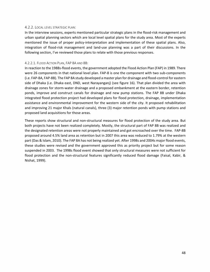
48
4.2.2. LOCAL LEVEL STRATEGIC PLAN:
In the interview sessions, experts mentioned particular strategic plans in the flood-risk management and
urban spatial planning sectors which are local level spatial plans for the study area. Most of the experts
mentioned the issue of proper policy-interpretation and implementation of these spatial plans. Also,
integration of flood-risk management and land-use planning was a part of their discussions. In the
following section, I’ve reviewed those plans to relate with those previous responses.
4.2.2.1. FLOOD ACTION PLAN, FAP 8A AND 8B:
In reaction to the 1988s-flood events, the government adopted the Flood Action Plan (FAP) in 1989. There
were 26 components in that national level plan. FAP-8 is one the component with two sub-components
(i.e. FAP-8A, FAP-8B). The FAP 8A study developed a master plan for drainage and flood-control for eastern
side of Dhaka (i.e. Dhaka east, DND, west Narayanganj) (see figure 16). That plan divided the area with
drainage zones for storm-water drainage and a proposed embankment at the eastern border, retention
ponds, improve and construct canals for drainage and new pump stations. The FAP 8B under Dhaka
integrated flood protection project had developed plans for flood protection, drainage, implementation
assistance and environmental improvement for the western side of the city. It proposed rehabilitation
and improving 21 major Khals (natural canals), three (3) major retention ponds with pump stations and
proposed land acquisitions for those areas.
These reports show structural and non-structural measures for flood protection of the study area. But
both projects have not been realized completely. Mostly, the structural part of FAP 8B was realized and
the designated retention areas were not properly maintained and got encroached over the time. FAP-8B
proposed around 4.5% land area as retention but in 2007 this area was reduced to 1.79% at the western
part (Das & Islam, 2010). The FAP 8A has not being realized yet. After 1998s and 2004s major flood events,
these studies were revised and the government approved this as priority project but for some reason
suspended in 2003. The 1998s flood event showed that only structural measures were not sufficient for
flood protection and the non-structural features significantly reduced flood damage (Faisal, Kabir, &
Nishat, 1999).

49
Figure 16:Proposed master plan for Dhaka East and West area from FAP 8.A (Source JAICA, 1991)
West side
East side
DND
Narayanganj west
Tongi
Savar
r

50
4.2.2.2. DHAKA METROPOLITAN DEVELOPMENT PLAN, DMDP AND DETAIL AREA PLAN, DAP:
Dhaka Metropolitan Development Plan (DMDP) is a long term (1995-2015) strategic plan for the greater
Dhaka area. It consists of three (3) plans (i.e. Structure Plan, Urban Area Plan and Detail Area Plan). The
DMDP has sectoral policies and strategies for urban development of the metropolitan development area.
DMDP defined set of policies and developed strategies for the city’s future growth. It designated green
belts, retention ponds, preservation of wetlands, agricultural low lands and flood flow zones, circular
waterways (see figure 17) to sustain healthy urban environment and protection from urban and river
flooding. This plan was published in 1997. Its structure plan identified 26 strategic planning zones (SPZ) as
sub-areas and later in 2010 the DAP was published. DAP proposed detail land-use plan (see figure 18) with
implementation guidelines.
Flood safety was one of the primary component of DAP but it didn’t properly adopt the flood-control
measures from DMDP or FAP-8B (BanDuDeltAS, 2015). In fact, DAP has proposed built infrastructures (e.g.
road, land development) over the designated retention ponds (e.g. Goranchatbari, Kallyanpur) shown in
FAP 8B (Das & Islam, 2010). Many local experts have criticized DAP for contradicting the development
guidelines from its strategic plan (i.e. DMDP) (Mowla, 2011, 2013). During this research, this DAP was the
regulatory land-use plan for the study area.
Figure 17: Strategic plan of DMDP (Source: RAJUK, 1995)

51
Figure 18: Proposed land-uses of DAP (2010-2015) (Source: RAJUK, 2010)

52
4.2.3. WATER AND URBANIZATION RELATED ACTS: The government of Bangladesh has a large number of water related Acts. By law public open spaces and
wetlands are protected and privately own wetlands are also defined by these laws and need authority’s
permission for any development. Different agencies are assigned for implementing these legislations at a
specific governance level. For example, the Department of Environment is responsible for implementing
the Natural water reservoir Conservation Act 2000 and it is under the jurisdiction of the District
Commissioner; the Local Government Act 2009 is deployed by the authorities of specific levels (i.e. City
corporation, Municipal, Union Council). In the urban areas, all open spaces, play grounds and natural
water bodies are protected by the law of “Playgrounds, Open Area, Park and Natural Water Reservoir in
Municipal Area of City, Divisional Town & District Town Conservation Act 2000”. The government
announced the Bangladesh Water Act 2013 to implement the National Water Policy. Large set of water
bodies and important land areas (e.g. ‘foreshore’) for water and flood-risk management is marked through
this legislation.
Some other water related Acts are National River Protection Commission Act 2013, Bangladesh Water
Development Board Act 2000, Water Supply and Drainage Authority Act 1996, Bangladesh Environment
Conservation Act 1995, Water Resource Planning Act 1992, Ground Water Management Ordinance 1985,
The Embankment & Drainage Act 1952, The Tanks Improvement Act 1939, The Public Parks Act 1904, The
Irrigation Act 1876, The Canal Act 1864 etc. There are constructions rules and regulations for example,
Bangladesh National Building Codes 2010, Dhaka Metropolitan Building Construction Rules 2008, Private
Housing Project Land Development Rule 2004 which include mandatory open space in private housing,
regulation for water storage and drainages etc. which are good instruments for implementing GBI in built
environment.
As a summary, this exploration in the policy, strategic planning and legislations explains the policy
environment, governance and implementation process of GBI in the study area. The climate change
policies gave presidency to climate mainstreaming for institutional reform where different agencies will
align their sectoral policies with national level policies and plan the implementation process in
collaboration with actors from private sectors, NGOs and experts from the civic society. According to the
policies, it appears as an ideal situation but in practice it needs to ensure strong leadership for
coordinating. The BCCSAP and NAPA is developed by the Ministry of Environment and Forests (MoEF)
and it is central to formulate adaptation related tasks. But other ministries and organizations such as
Water resource, Local governments, Planning Commission, Water Resource Planning Organization
(WARPO) are designated in relevant programs for flood-risk management for climate adaptation.
Agencies under these ministries will be important governmental actors in implementing strategic plans in
their jurisdiction areas. For the study area, primarily the Local Government and its agencies such as RAJUK,
DWASA, LGED and DCCs are responsible for planning and spatial development of adaptation works. In
most of the policy frameworks, relevant ministries are identified but inter-ministerial and inter-agency
coordination for policy adaptation in local level is a challenge. For example, the National Wetland policy
identified five (5) ministries and 12 agencies but didn’t identify any central coordination body to
coordinate the adopted programs (BanDuDeltAS, 2015).
This has effects in decision-making for the strategic plan. For Dhaka, RAJUK is responsible for planning and
implementing development works and has the constitutive power to coordinate between different
sectors and their plans. But in structure plan formulation from DMDP, this coordination was lacking and
eventually the final plan raised many inconsistencies (SENES Consultants Ltd., 2007). In a sense,

53
coordination is a problem. But in this case, the driver for proper initiation and implementation is lacking
specially when it comes to environmental development. From that perspective, experts criticize the
RAJUK’s combined role of execution and monitoring as a conflicting practice (Mowla, 2011). Competition
between actors becomes challenging in such monopolistic environment.
In terms of legislative support for GBI adaptation, such as utilizing open spaces and natural water bodies,
there are sufficient laws specially, in preserving wetlands. But using those regulatory instruments for
strategic purposes is rare. The ongoing encroachment in the urban area is an unmistakable evidence of
that. In this regard, developing institutional capacity for monitoring illegal development as well as the
tasks of responsible agencies is essential (BanDuDeltAS, 2015). In respect to the social displacement
concern raised by the experts during interviews, the National Housing Policy gives precedence to slum-
improvement and discourage relocation. Whereas, from the case study it was clear that the real situation
is no pro-poor and in infrastructural development slum-dwellers are the most vulnerable community for
force-relocation.
From the national level policy making to local level strategic plan, the planning process for climate
adaptation indicates a top down approach. The following diagram will show the standard planning process
of climate change adaptation idealized in the reviewed policies in respect to the urban flooding issue. In
this case, the outcome of such process is GBI implementation as an adaptation measure.
Figure 19: Standard planning process of GBI adaptation according to adopted policies
54
4.2.4. STUDY ON URBAN HYDROLOGY OF THE STUDY AREA: Understanding the biophysical functions of GBI of the study area will require extensive technical research.
I’ve previously explained that (see previous section 2.5), SUDS are more relevant to GBI adaptation
methods for flood-risk management. To implement GBI (or SUDS) for a flood-proof urban landscape, it is
imperative to have knowledge about local hydrology and modern technologies. In the international
context, there are profound scientific knowledge and planning guidelines on the biophysical aspects of
GBI (Matthews et al., 2015) specially in UK and North America (Mell, 2008). But, for Dhaka, GBI (or SUDS)
adaptation for urban flooding is a new concept. There are several hydrological researches mainly on
existing hydrological processes and the flooding issue of the study area, but future requirement of
drainage in respect to climate change risks is comparatively a new area for research. During the interviews,
the hydrology experts mentioned the modeling complexity and lack of current data for local urban
hydrological study and advocated for more research based knowledge to promote the water-based
adaptation in decision-making. Now, for this research, it is also necessary to explore the biophysical
aspects of the GBI within the study context. In this regard, this research relied on secondary sources and
expert’s responses. Based on the experts recommendation, I’ve reviewed the Dasgupta et al. (2015)’s
work which includes a hydrology model study on the study area regarding climate change and urban
flooding issues.
4.2.4.1. HYDROLOGY MODELING OF GREATER DHAKA:
4.2.4.1.1. REGIONAL LEVEL FINDING:
The Dasgupta et al.(2015) study was conducted to support the local agency (i.e. DWASA) for developing
Dhaka’s drainage capacity for flood mitigation. For this, a hydrological model was developed considering
climate change scenario. The extent of their modeled area (i.e. DMDP area or greater Dhaka) corresponds
with the study area of this research. Although, due to the lack of proper drainage infrastructural data, it
excluded some underdeveloped areas (e.g. peri-urban, rural) from the initially adopted area, the overall
result of that model will represent my research’s city-level hydrological condition. Their research also has
7 sub-models for detail study and one of those areas (namely ‘central Dhaka’) represents the Hatirjheel
lake surrounding area thus corresponds with the neighborhood-level hydrological situation of case 1.
The Dasgupta et al.(2015) study considered two (2) climate change scenarios (i.e. B15 for 25 years , A1FI6
for 50 years). They included external river-flooding and used IWM’s North Central Regional Hydrodynamic
(NCRHD) Model for regional flood modeling of the Greater Dhaka area. NCRHD provided water level and
water flow from the surrounding river. Data about surface cover change, meteorology (i.e. rain fall,
temperature), topography using digital elevation model (DEM), drainage infrastructure (based on
DWASA’s master plan), and external drainage (i.e. river stage, river flow, river sections, slope and
alignment), evapotranspiration were used. But the model did not consider urban vegetation or plant
character for either scales (i.e. greater Dhaka, detail area). Other information such as wastewater inflows,
Subsidence, Sea level rise (SLR) was considered negligible for this 50 years’ model. They have analyzed
time series data of daily rainfall from different BWDB (Bangladesh Water Development Board) stations
around Dhaka, and selected 2004s rain event (in 13th September 2004, 341mm/day) for simulation.
However, there were another recorded extreme event (in 28th July 2009 448mm/day) but the 2004s
5 IPPC scenario with future based on a high level of environmental and social consciousness with global coherence for sustainable development 6 IPPC scenario with future based on fossil fuel–intensive development

55
event was of interest for their study as it caused major flooding in Dhaka and corresponds well with the
availability of other datasets (such as land-use data). The selected 2004s rain event was 100yrs7 event and
simulated with the increase (16%) from A1F1 scenario of 2050, so in 50yrs 396m/day.
It is worth mentioning that their analysis of extreme precipitation data shows a clear trend of increasing
frequency of intense rainfall events. It showed that return periods are decreasing, meaning larger events
are occurring more frequently.
One of the major consideration in hydrological model is surface cover change and elevation (Gill et al.,
2007). For existing elevation, the experts used DEM (25m x 25m grid) from IWM of the year 2004 and the
surface cover was used from to the DAP study. For the future scenarios, they considered the land-use
proposal from DAP assuming that the city will develop according to it. They used the population increase
and land-development trend which shifted the main land-level category (in terms of height) from 3-4m to
7-8m in 20508. This is a major decision where most of the areas at eastern part of the city is a low-laying
area and susceptible to river flooding. The following figure (see figure 20) shows their results on flooding
in existing and future situations.
Figure 20: Flooding situation in existing situation including climate change (1) and in A1F1-2050 scenario (2) (Source: IWM, 2014)
7 classified by IWFM, JAICA classified it as 1000yrs or more 8 Expecting that existing unurbanized low areas will be raised up per proposed land-uses
1 2

56
4.2.4.1.2. CASE-LEVEL FINDINGS:
For detail area modeling, the Dasgupta et al.(2015) study considered more local scenarios. In this case 4
scenarios were sequentially investigated the situation. Along with the earlier climate change (CC) (i.e. B1-
2025, A1F1-2050) and future socio-economic changes (SE) (which represents surface cover change due to
future developments), two scenarios i.e. planned drainage developments (PDIs) and additional
improvements (AIs) were added to simulate the areas performance to achieve the predefined criteria (i.e.
90% of the administrative area must have less than 0.25m flooding and no inundation more than 12
hours). The planned improvements refer to the future developments in drainage per RAJUK’s and
DWASA’s plan. In the site-specific situation, their study proposed some additional adaptation options. But
the adaptations are mostly and engineered approach such as new pumps with increased capacity, sluice
gates etc. In the central Dhaka area (which represents case 1), despite of having the largest existing water
retention area (i.e. Hatirjheel and Gulshan-Banani lake), there is more chance of flooding with longer
duration with actual rain events (100yrs event) even if the model includes planned improvement for the
future scenario (see figure 21). This is due to the increase of impervious land cover change according to
the proposed urbanization.
Figure 21: the flooding situation in the existing land-use with 2004s (100yrs) rain event (1) and flooding situation of same rain events in 2025 with changed land-uses and improved drainage condition (2). (Source: IWM, 2014)
For this area the experts proposed new pipelines and pumps, and a sluice gate to divert the excess water
to another lake (i.e. Dhanmondi lake). Another case study in a more densely populated area with less
1 2

57
water sheds (i.e. the old Dhaka) showed interesting results in this regard. The experts sugested a
playground to design as ‘dry-ponds’ (see figure 22)as there were less chances of fututure development.
The result showed sucessesful outcome in reducing shallow flooding after adopting to this measure. In
some areas (e.g. Gulshan, Banani) where there are chances for future drainage developments, the experts
suggested separate sewerage and storm-water drainage for better efficiency.
Figure 22: Adaptation option ‘dry pond’ in a part of the study area for flood reduction (Source: IWM, 2014) (modified by Author)
In summary, the study suggested lot of adaptation measures, but mostly from engineering perspective.
Though, it showed some interesting results such as ‘dry-ponds’ which indicate the potentiality of GBI
adaptation in the specific settings. An important aspect of this study is that the experts made lots of
assumptions (e.g. all storm waters are properly draining out through the system, no waste accumulation
in future) which are idealistic as per the study context. As the land level rise (from future senarios of
population increase and land-development) played an important role in reducing flooding, their study
highlights the importance of local-level changes in land development for adaptation to future-risks of
flooding.

58
4.3. QUESTIONNAIRE SURVEY: In the GBI planning framework of this research, the social aspect is one of the major elements of socio-
political aspects of GBI which was studied by questionnaire surveys in the case study areas. The objective,
survey locations and analysis methods were explained in the methodology part (see sections 3.5.3 &
3.5.5). In the following section, I’ll present the findings of the survey per cases. According to the
questionnaire, the respondent’s comments on flooding effects, preferences on GBI functions and
adaptation options are presented here.
4.3.1. CASE 1: In case 1, there were four (4) locations, the location-1,2 represent the unplanned residential areas
adjacent to the Hatirjheel lake project (area showing at the right side of figure 23). The resident’s
responses from the location-1,2 are therefore reflect their experiences regarding the Hatirjheel lake
project. Location-3,4 represent the urban slum areas next to the on-going Gulshan-Banani lake project
and the dwellers expressed their comments regarding the ongoing development.
Figure 23: Hatirjheel lake area. (Source: SWO, Bangladesh Army 2017)
4.3.1.1. LOCATION 1,2:
Within these locations, the majority respondents confirmed that the recent developments have
significantly reduced the water logging due to rainfall. Before realization of the project (i.e. Hatirjheel
lake), the area was susceptible to urban flooding and with regular rain-events during monsoon period (i.e.
mostly June-July). The main reason was insufficient drainage. After the development, the drainage system
around the project area is much more efficient. Most of the residents stated that the area namely, Ulon
was less effected by flooding due to its higher elevation. But, other areas such as Mahanagar housing,

59
West Rampura, Wapda road, Amtola were regularly suffering from flooding. Still there are some areas
(e.g. East Noyatola, TNT & Gabtola, Majar road to Staff area, Chairmangoli) where the storm water
accumulates due to intense rain event. In the previous situation, roads and settlements below the road
level were mostly effected by flooding and the water used to stay there up to months depending on the
weather. There were other environmental issues (e.g. household and industrial waste, mosquito) in this
area which have significantly reduced by the restoration of the existing lake. After the realization of the
project there are more socio-economic activities in this area regarding housing development, higher
house-rent, outside visitors, food shops etc. Transport connection to distant areas are much better due
to new high speed link-roads around the lake. The residents mentioned some negative impacts of this
new development. Among those negative comments, a newly implemented boundary wall is mostly
addressed. The boundary wall enclosed the residential areas leaving selected access points to the main
road. Now, there are restrictions on pedestrian activity in the link-roads to maintain the desired traffic
flow. Some users mentioned that, due to these restrictions there is less pedestrian access to their areas.
Some local businesses (e.g. restaurants, shops) were developed because of the public attraction to this
place but these regulations are hindering such business environment. Three (3) inhabitants strongly
mentioned that, there are more traffic incidents because of this new high-speed traffic next to the
residential areas. There are some complains about the water quality of the detention lake that the water
is deteriorating rapidly and spreading odor in particular areas. The respondent’s comments varied in same
topic based on the existing spatial situation. For example, most of the residents from Mahanagar housing
area (which has easy access to lake side area) accepted the existing situation whereas, the residents from
Ulon area (which has less access) complained about the wall and traffic regulations. As a response to the
question on multi-functionality of GBI, the respondents from these locations were more aware of the
benefits of GBI (or SUDS) from their present situation and appeared as pro-environment compared to the
other locations (see table 2, p. 64). They preferred developments related to environment, connectivity,
health and recreations in GBI projects (see figure 24). In terms for adaptation options, the residents mostly
preferred community-based waste management, more play-grounds and individual adaptation such as
elevating property area which are categorized as ‘other’ in graphs (see figure 25). Many users also
mentioned urban forestry as a suitable adaptation option for their area.
Figure 24: Multifunctional preferences in the existing area (response form location-1,2).
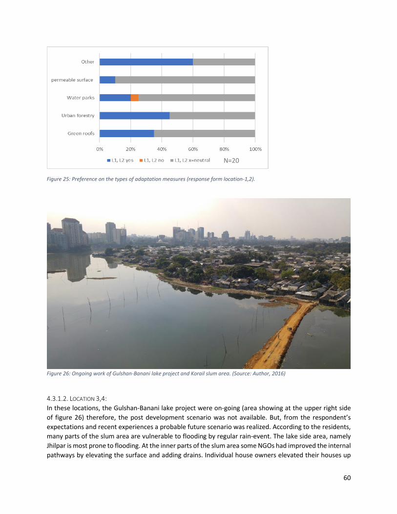
60
Figure 25: Preference on the types of adaptation measures (response form location-1,2).
Figure 26: Ongoing work of Gulshan-Banani lake project and Korail slum area. (Source: Author, 2016)
4.3.1.2. LOCATION 3,4:
In these locations, the Gulshan-Banani lake project were on-going (area showing at the upper right side
of figure 26) therefore, the post development scenario was not available. But, from the respondent’s
expectations and recent experiences a probable future scenario was realized. According to the residents,
many parts of the slum area are vulnerable to flooding by regular rain-event. The lake side area, namely
Jhilpar is most prone to flooding. At the inner parts of the slum area some NGOs had improved the internal
pathways by elevating the surface and adding drains. Individual house owners elevated their houses up
N=20

61
to the pathways so houses bellow the pathway level were demarked as more vulnerable to flooding by
the inhabitants. During intense rain-events the area gets inundated and usually the water takes about 2-
3hr to drain out. In the lake-side area, the situation is much aggravated. The area stays inundated for
months during monsoon depending on the water level of the lake. During the flood period, the inhabitants
have to move to houses on the higher ground with higher expenses. There is no governmental initiative
to improve their livelihood condition because the community has no legal right over the land. In this
situation, the ongoing Gulshan-Banani lake project does not have any direct effect on the community yet
but, the people from the lakeside area are worried about possible eviction. As the surrounding area is
being developed, there are new restrictions on peddling business, rickshaw garages and other small
businesses on which the community depends on. The authority had put boundary walls surrounding the
slum areas and restricted boat use for crossing the lake. The pedestrian accessibility is much limited due
to the boundary walls and transport expenses are higher (because the boat cost was much cheaper than
other transports). As a response to the preferred functionality, most of the respondents had chosen
business and connectivity from the environmental projects such as Gulshan-Banani lake project (see figure
27). In terms of adaptation options, the respondents mentioned local management for cleaning drainage
blocks, good leadership, less living expenses which are categorized as other measures in the result (see
figure 28).
Figure 27: Multifunctional preferences in the existing area (response form location-3,4).

62
Figure 28: Preference on the types of adaptation measures (response form location-3,4).
4.3.2. CASE 2: The case-2 had two (2) locations (i.e. location-5,6) and those locations represent planned residential area
in this research. The locations are next to the Dhanmondi lake (see figure 29) which is a historic lake and
had been restored in 2000 under the ‘Dhanmondi lake and lakeside area development’ project. The
respondents replied on this project as a GBI development. As the project had been realized for long time,
the residents have experienced its impact in their neighborhood.
Figure 29: Dhanmondi lake area. (Source: Author, 2016)
N=20

63
4.3.2.1. LOCATION-5,6:
Compared to the other locations in case-2, the area of these locations is well planned and had less
experience of flooding. Only in the significant flood events (i.e. in 1988 and 1998) the area was inundated.
But before the lake project, there were environmental issues regarding the lake. The water was polluted
by household waste disposal. Some flooding issues within the lake area was reported by the respondents.
Due to extreme rain-event some part of the lake area gets inundated and the water usually takes 5-6
hours to drain out depending on the weather. After the project had been realized, there were significant
changes in the neighborhood. The respondents mentioned that the lake project had generated socio-
economic activities mainly in real estate development, cultural activities, health and recreational
activities, food business. There are some negative feedbacks from the users. Most the residents
mentioned that the detention capacity is not enough as the water level gets very high during monsoon.
The lake area gets lots of visitors in evening hours and in special occasions it gets over crowded. The
respondents also mention that, there are much commercial activities within this residential area that
generates outside traffic and cause traffic jams specially during school hours. This area is greener than
many other neighborhoods in Dhaka. Responding to the multifunctionality question, the residents mainly
mentioned health and recreation from GBI projects (see figure 30). For the adaptation options, there are
already some good examples (e.g. green roofing) in the vicinity and many of the respondents were aware
of their benefits and preferred green integration to their individual households for environmental and
aesthetics reasons (see figure 31).
Figure 30: Multifunctional preferences in the existing area (response form location-5,6).

64
Figure 31: Preference on the types of adaptation measures (response form location-5,6).
In the following table, functional preference of GBI projects from all the surveyed locations were
summarized based on the maximum mentions by the respondents. For example, in location ‘L5, L6’
‘health’ is considered as ‘immediate’ by the maximum number of respondents.
Table 2: Maximum responses on multiple functionality from the surveyed areas
Locations
Functions L1, L2 L3, L4 L5, L6
Connectivity (++) (-+) (--)
Health (+),(++) (--) (++)
Business (-) (+),(++) (--)
Recreation (+) (--) (-+)
Environment (-+) (--) (-) (--) = strongly irrelevant, (-) =irrelevant, (-+) = relevant, (+) = necessary, (++) = immediate
Similarly, the following map is showing the preferences on different types of adaptation measures were
maximum mentions were summarized from the previous graphs.
Table 3:Maximum responses on preferred types of adaptation measures from the surveyed areas
Locations
Adaptation options L1, L2 L3, L4 L5, L6
Other (+) (+) ( )
Permeable surface ( ) ( ) ( )
Water parks ( ) ( ) (+)
Urban forestry ( ) ( ) (+)
Green roofs ( ) ( ) (+)
(+) = Yes, (-) = No, ( ) = Neutral
N=20

65
5. DISCUSSION & CONCLUSION: In the previous chapter, results were presented from different data collection methods. In this chapter, I
answer the research questions based on the results. I’ll also reflect on the adopted methods and the
theoretical framework of this research. Finally, the main findings of this research are presented related to
the framework.
The key objective of this research was to understand the current situation in the study area related to
urban planning that deals with climate change adaptation to urban flooding issues. According to the
objective, the main research question (RQ) was- how planning for GBI can create adaptation to urban
flooding issues caused by climate change in the urban areas of Dhaka? In respect to this main objective,
GBI-planning was conceptualized with the focus of adaptation to urban flooding and a framework was
formulated. That GBI planning framework provided the theoretical basis of this research. To deal with the
main objective, the main research question was divided into four (4) specific research questions (SRQ). In
the following section, I’ll present the answers to SRQs based on the results.
5.1 THE ROLE OF CLIMATE CHANGE IN URBAN FLOODING IN THE STUDY AREA: In this section, I discuss on the first SRQ, which is: What are the climate change impacts that is causing
urban flooding of the study area?
To plan for climate adaptation, it is a prerequisite to understand the complexity associated with the
increasing risk caused by climate change (Wamsler, Brink, & Rivera, 2013). Understanding urban flood-
risk requires assessment of the impacts of floods and their spatial and temporal distribution where
impacts are tend to be more complex with climate change uncertainty (Zevenbergen, Veerbeek,
Gersonius, & Van Herk, 2008). In this research, the objective for this SQR was to understand the nature
of such complexity of urban flooding issue raised by the climate change phenomenon and relevant actors
in relationship with its scale and time. To deal with this, I relied on expert’s observation and document
survey. I’ve analyzed the responses from the professionals in the field of urban hydrology and spatial
planning. The scientific hydrological explanations were triangulated with a hydrological model study
conducted by Dasgupta et al. (2015). To study urban flooding and its relationship with climate change, it
is imperative to predict the average rain fall, stream flows, extreme flows and storms, changes in
groundwater yields in future situations (Muller, 2007). Such prediction of climate change are often
realized by probabilistic terms (Matthews et al., 2015). The country is also susceptible to sea-level rise and
subsidence besides the increase in precipitation and river flow (A. U. Ahmed, 2006). The Dasgupta et al.
(2015) study used a regional model (i.e. North Central Region Hydrodynamic or NCRHD) considering the
relevant climate and physical data. Their climatic prediction of 2050, showed that the return period of
intense rain fall event is decreasing, the internal rainfall is increasing and the river level is increasing
around the study area. Despite all these climate change stresses the result showed decrease in the area
of flooding of the study area. In their baseline study, total flood free area (<0.25m depth) was 22% and in
2050 with climate change scenario the area increased up to 39%. This surprising result can be related to
a significant assumption for their model. In their study, they assumed that in future Dhaka will develop
according to the current land-use proposal (i.e. DAP) and the low laying area will be raised and developed
up to the flood free level. This is, in my opinion, a very idealistic assumption regarding the current progress
of DAP’s implementation. The Dasgupta et al. (2015) study also assumed other planned infrastructural

66
improvements (e.g. new pumps, clean drainage pipes, sluice gates) including the eastern dam (i.e. Eastern
Dhaka Bypass Project) at the unprotected low laying part of the study area. With all these assumed
interventions, the model promoted an optimistic future situation which can influence the decision-making
environment where dependency on socio-economic actors (such as land-development) is high. They
suggested many technological interventions which may indicate that climate change protections cost is
high. In this regard, models using large set of assumptions and mean values to predict future-risks can
hardly represent the actual diversity of the spatial environment and related flood impacts on multilevel
economic networks (Zevenbergen et al., 2008). Despite being a contemporary tool for determining the
normative principles for possible climate change, the complexity of the models cannot represent the
actual complexity of climate in nature and its wide-ranging future impacts in the bio-physical and social
environment (Zhang, Yang, & Singh, 2014). From the hydrological perspective, the interviewees commonly
stated that increase in monsoon rainfall and surrounding river water level rise are the major climate
change threats for the study area. The city depends on the surrounding river system for its drainage and
the eastern part of the city has no flood protection dam. Therefore, in the regional level river-system
climate change risks pose a significant threat of river flooding to the city and consequently more
dependency on dams and pumping. The regional dynamics play a significant role in the flood risk
management and with the climate change risks it will be difficult to quantify the impacts and costs for the
measures (Muller, 2007). Due the country’s geographical location in the GMB river basin, slight increase
in precipitation in the upstream will consequently inundate large areas of the country (S. Dasgupta et al.,
2011). In terms of inland or pluvial flooding, it was realized that the responses depend on location specific
measures and local level management. In such situation, planning for climate adaptation to urban flooding
should consider the complexity of scale, time and social effects of the vulnerability. To manage responses,
understanding of cross-scale interactions of adaptation measures and how they will affect flood
vulnerability is similarly important (Zevenbergen et al., 2008). Apart from the negative environmental
effects, the experts mentioned the political impact of the climate change vulnerability which has
influenced a governance shift towards mainstreaming adaptation approaches. The government is aligned
with global climate change agreements (i.e. United Nations Framework Convention Climate Change or
UNFCCC) and in the national level policies, the government has adopted climate change risks in future
development goals. Climate change has become an important driver in the paradigm-shift towards flood
resilience (Zevenbergen et al., 2008). In the context of the study area, it is prominent, especially at the
national level, that there is significant interests in adaptation to flooding associated with climate change
risks.
5.2 THE EXISTING BIO-PHYSICAL SITUATION AND ITS RELATIONSHIP WITH URBAN FLOODING: In this section, I discuss on the second SRQ, which is related to the bio-physical part of the adopted
framework. The question is: What is the existing situation of the GBI, drainage system and land-use
pattern related to urban flooding in the study area?
The bio-physical aspects of GBI includes the plantation or green characteristics, natural and built drainage
networks, urban morphology, surface cover and elevation etc. Related to urban flooding issues, the
quantity and quality of storm water are considerable aspects of urban hydrological aspects but, for GBI
(or SUDS), the sustainable development means the interplay between quantitative and qualitative aspects
of hydrological designs and spatial strategies (Fryd et al., 2012). For comprehensiveness, this research

67
acknowledges both aspects of the bio-physical situation, but despite climate change risks, the results
showed that, the drainage system is already under current risks of failing due to human induced causes.
For example, sludge accumulation in the drainage pipes due waste dumping casing overflow during
regular rain-events. The encroachment of river and canals prevent water from natural drainage. The rapid
urbanization and population increase are major drivers for such anthropogenic activities. However, the
existing drainage system is dependent on the natural blue-networks for most part of the year. The western
part of the city is highly urbanized and the natural watershed is almost lost but the eastern part of the city
is still environmentally rich but also a low laying area and vulnerable to river-flooding. The city had
adopted some flood protection measures and shifted from gravity to pump-based drainage as a reaction
to major flood events. Now, there is an apparent dichotomy on the feasible approach of flood
management for the eastern part. From the socio-economic perspective, flood-protection approach will
complement the expected urbanization of the eastern part whereas more GBI incorporated ecologically
oriented approach would require land compensation for retention areas for water. In the strategic plan
(i.e. DAP) there is a proposal for drainage for the eastern part, which is more or less based on the flood
protection principle including a dam and retention areas. This proposal reflects the alignment of the
existing flood management regime towards a centralized and technocentric approach. This approach
would potentially increase the adaptation cost for the city. Increasing dependency on a centralized system
develops greater technical complexity and reduces the system’s adaptability as it exhibits large impact
form failure (Zevenbergen et al., 2008). Whereas the ecologically oriented or GBI approach refers to built-
natural hybrid system comprising interconnected smaller systems. This approach is new to the current
flood-management regime and would take longer in implementation. The GBI adaptation involves an
incremental implementation as the knowledge advances (Fryd et al., 2012). The storm-water
management works at multiple spatial levels (Tjallingii, 1996) and the efficiency of GBI depends on
ecological networks, spatial configuration (i.e. corridor, patch and matrix) and other bio-physical
conditions (i.e. soil types) (Gill et al., 2007). Therefore, the GBI adaptation is more site specific and decision
making is difficult without scientific observations. In this case, the studied model developed by Dasgupta
et al. (2015) did not offer much knowledge as it adopted the DAP land use as the spatial data which doesn’t
represent the existing landscape. But, for the western part, the land-use is mostly built-up and therefore
their results of the baseline study can be discussed to indicate an apparent flooding situation. In such
built-up areas, there is not much options for GBI rather than opportunistic strategies (Ahern, 1995) to
retrofit existing buildings or small scale green spaces in individual or neighborhood level. In this regard,
the Dasgupta et al. (2015)’s study showed an innovative adaptation option (i.e. dry-pond) to reduce the
flood impacts in the old Dhaka area (see previous section 4.2.4.1.2). Regarding existing drainage
infrastructure in the study area, infrastructural domination hindered its natural drainage area. For
example, to build new roads, engineers adopted ‘box-culverts’ over natural canals which eventually failed
to operate in the socio-cultural context. As the climate change risk is a major concern and the city has lost
lot of its historic watersheds, these box-culverts should be removed to restore the original drainage areas.
With the increasing uncertainty of climate change, the hydrological systems should be reconsidered to
overcome future-risks (Muller, 2007). Also, roads are strategically planned to disconnect the water
channels to prevent flooding, which is also a reason that the western parts and the eastern parts are
hydrologically disconnected. Roads are the greatest contributor to fragmentation of urban environment
(Forman et al., 2003). However, Dhaka has legislation for greening public spaces such as roadside, river
banks and railway lines. For adapting GBI, the roads, railways and canal-banks might be good
opportunities for green corridors within the city depending on the specific contexts. The recent draft

68
DMDP structure plan (2016-2035) conceptualized green corridor by proposing greening the inter-city
railway line across the city. According to legislation it is fair, but in Dhaka, a large number of people live in
slums situated alongside the railway lines. So, in reality, such social issues might constrain GBI
implementations. Hatirjheel project is a great example of social displacement; although the survey of this
study showed that, after realization the surrounding residents have reported significant environmental
improvement of their neighborhood. Effects of the adaptive responses depends on different level,
adaptation for an individual might not be helpful for the large system and the effect is vice-versa (Adger
et al., 2005). It is also important to consider how the effects of the responses are interconnected in
different spatial and economic environment (Zevenbergen et al., 2008). Urbanization is a vital issue in
transforming the ecological characteristics of the study area and economic drivers are powerful.
Adaptation to non-climatic drivers can elevate climate change vulnerability (Adger et al. 2005). In that
respect, land-development issue was strongly mentioned by the experts which stresses the environmental
principles for climate change adaptation. For example, the housing development proposals (indicated as
overlay-zone in DAP) on the designated flood-flow zones reflect that the socio-economic benefit often
supersede environmental benefit in the governance environment.
5.3. INSTITUTIONAL CAPACITY FOR GBI PLANNING: This part discusses the SRQ that states: What is the existing institutional capacity related to planning for
adaptation to urban flooding in the study area?
In this discussion, the institutional capacity refers to the existing governance structure, its planning
instruments, knowledge and public-private partnerships. On the socio-political topic, the interview
responses and planning-documents summaries are compared in this discussion. In the policy discussions,
the respondents (and policy documents) mentioned different levels of governance namely, national level
and local level. For this particular aspect, the local level represents the study area according to the
governmental definition. In the interview results, I’ve mentioned some governance challenges brought up
by the experts in general and per case-studies. In this research, these responses represent the existing
institutional situation and the policy documents represent desired institutional environment according to
the governance system. The existing governance practice can be described as traditional system with
central or top-down governing structure. The relevant sectors studied in this research are flood-risk
management and urban planning. Dhaka is governed by the city corporations (DNCC, DSCC) under the
ministry of Local Government. There are several local governmental agencies which operate in the study
area such as RAJUK, DWASA, LGED, RHD, WARPO, BWDB and are centrally governed by relevant
ministries. Ministries are the national level governing body and have their individual policies. This research
did not however had the objective to evaluate the general urban planning or flood-management
governance structure. Rather, relevant agencies and institutions were identified related to GBI planning
by the adopted methods (i.e. interview, case-study and document survey). The key local agency
responsible for planning and implementing spatial development is RAJUK; and DWASA develops city’s
drainage infrastructure. At national level climate change policies (i.e. NAPA, BCCSAP) and relevant
programs were developed by the Ministry of Environment and Forests (MoEF); other ministries such as
Ministry of Water Resource, Local Government, Planning Commission are involved in climate change and
flood-risk management issues. Now, in terms of decision making the political hierarchy play a very
important role. Although, according to the policies (i.e. NAPA, BCCSAP) adaptation related decision should
69
be taken in an integrated manner, considering the related sectoral policies, and involving different local
agencies and private actors (i.e. experts, society representatives, NGOs). But, according to the experts,
major challenge of the institutionalizing adaptation is inter-ministerial and inter-agency cooperation or
coordination. Several studies showed that, cooperation between urban actors is one of the strategies to
incorporate climate change adaptation into urban planning (Wamsler et al., 2013). Moreover, in Dhaka,
separate agencies are independent in terms of implementation,and coordination is lackingand
jurisdictional conflicts are more prominent than progressive competition.
The functionality of GBI, especially when it’s comes to flood-risk management, depends onits technical
design (Fryd et al., 2012). In this case, conflict mitigation is a primary need for the governmental agencies
as the experts noted partial implementation or implementation bottlenecks often challenge realization of
immediate adaptation needs. However, shifting towards environmental governance with higher level of
private participation is an option to speed-up the adaptation initiatives, but without compromising of
public accountability (Young & McPherson, 2013). Climate change impacts and future risks have been a
dominant factor in the governance practice, at least at the national level, but as the most prominent urban
center for business and administration, in Dhaka, the political economy plays a dominant role in the
development. Organizational mainstreaming by modification of institutional structures for local level
adaptation programs is one of the mainstreaming strategies to integrate climate change into urban
sectors (Wamsler et al., 2013). In the national policies, climate change mainstreaming and
decentralization of actions for adaptation are present but its realization at the local level authorities is still
a major concern. Distribution of the adaptation action across scale and legitimacy of decision-making is
important, so that the authorities cannot rule out the action as “somebody else’s problem” (Adger et al.,
2005). In Dhaka, most of the establishments for flood-safety are reaction to major flood events and result
of pragmatic actions. Bottom-up management is one of the prerequisites for increasing adaptability to
urban flooding (Zevenbergen et al., 2008) whereas, in Dhaka’s case it was evident that, many top-down
initiatives had failed to acknowledge the diverse complexity of the urban areas. For example, road
development over a natural canal was instant traffic solution for Dhaka, but eventually it is being realized
as a major reason for environmental loss. In this regard, experts mentioned (i.e. UH-2 strongly stated),
deviation form authoritarian practice towards democratization and public empowerment of the
adaptation process is essential to deal with comprehensive development process. Complexity in strategy
formulation for local spatial-implication was evident in this study. The experts have mentioned that, there
are sufficient policy framework in climate adaptation and in this study, I’ve identified several strategies
which are related to adaptation planning for the study area (see previous section 4.2.1). But at the local
level, the struggle for a robust strategic plan is explained by the experts. In the document study, I’ve given
some observations on the strategic land-use plan which indicates gaps between initial policy and adopted
plan. Legislations to support GBI implementation are also identified and discussed, but a major concern
for deploying these legal instruments were noted from the interviews. In that respect, the experts (i.e.
UP-1, UP-2, UH-4) identified the combined jurisdiction of RAJUK in implementation and monitoring as
problematic.
Storm water management for flood adaptation requires specific scientific knowledges on the bio-physical
conditions of the built-environment (Fryd et al., 2012). The government agencies often depend on local
consultancy institutes such as IWM, IWFM, BUET, CEGIS and also international organizations. Interviewees
from those institutes shared their experience in light of the existing knowledge and information available

70
on climate change, flood adaptation and GBI. During this research, two aspects were mostly realized.
Firstly, there are several researches ongoing in the different agencies, but between the two sectors (i.e.
urban planning and flood-risk management) no formal integration is present. There is no central database
for flood-risk or spatial planning at the local level. Different governmental agencies have individual
databases which are often developed and maintained by external agencies. There is some form of
dependency between governing and consultancy agencies, but it depends on the individual agencies.
Secondly, application of novel techniques is challenging due to inadequate governmental initiatives and
social awareness to cope with it. However, the result from the case studies offered deeper understanding
on the previously discussed aspects, particularly from case 1. The realization process of the Hatirjheel lake
project described by the involved experts explained the socio-political challenges that the project had to
overcome with as an environmental development. In that case, the existing knowledge and intellectual’s
advocacy offered a key role in the decision-making process. Another notable and very promising aspect is
the benefit of multi-functionality and its role in the planning and decision making process regrading GBI
adaptation. Studies showed that multifunctionality is an important aspect of GBI from management and
environmental perspectives (Demuzere et al., 2014; Hansen & Pauleit, 2014; Matthews et al., 2015). In
the Hatirjheel case, it played a significant role and also showed that, flexibility in planning is necessary for
continuous and incremental development of the GBI. The complexity of the GBI project was also
addressed by stakeholder’s engagement and public-private partnership in the Hatirjheel project and most
of the experts referred it as a model. But, the downside was the equality issues raised by obvious winner-
loser situation and social displacement due to the project.
5.4. SOCIAL ATTITUDE AND INTERACTION TOWARDS GBI: The last SRQ is: What is the social attitude and interaction towards GBI in the study area? Here, elaborate
the outcomes on the social acceptance of the concurrent GBI developments from the user’s perspective,
their preferences and interactions with those developments.
In the adopted GBI planning framework, this topic is part of socio-political factors of GBI. It is important
for the planning process as the contextuality and usefulness of GBI in future depends on it. And also
important in implementation as there may be possible constrains or supports by the inhabitants from the
location where the adaptation is needed. To investigate such aspects, the questionnaire survey on the
selected cases were primarily considered. Experts also mentioned social issues regarding the GBI projects
which are also compared to give a comprehensive scenario. Survey outcomes on the different GBI projects
indicated that the preferences depend on site-specific situations. In this study, selected locations were
categorized under different spatial conditions. Although I did not conduct an in-depth demographic survey
on socio-economic aspects, the spatial categories were distinct and represented communities from
different classes. The results showed that, the communities are well-aware of the environmental benefits
of the water-bodies mostly related to water logging issues because of their continuous association with
flooding, and people from the areas where GBI developments had already realized are experiencing
drastic changes. But yet the preferences are gravitated towards local needs such as communications,
health or business opportunities from the environmental projects. Therefore, the multifunctionality
becomes an essential quality of GBI to cope with existing socio-physical situations.
A Participatory process can encourage self-regulation and sustainable use of the environmental resources
(Anger, 2003). In some cases, such as Dhanmondi lake project, community’s participations in the design
71
process indicated that public involvement in the planning and design process can generate a form of
stewardship for the new developments where locals will take the responsibility to protect and maintain
the system. Community management for drainage and waste as adaptation measure preferred by most
of the study population indicates their willingness to take initiatives to deal with the individual or
communal risks. In Dhaka, a major concern from the social perspective is the displacement issue due to
infrastructural developments. The low-income communities who live on the urban edges are most
vulnerable to flooding; in the DAP those areas are designated as flood flow zones. Within the core urban
area, informal settlements occupying wetland areas are also vulnerable to inland flooding. In this
situation, eviction or force displacement is a substantial issue for spatial development for flood
adaptation. From the case studies, it was also evident that many local inhabitants had to leave their
properties for water retention area. To avoid force displacement, studies showed that some local
governments adopted the way to directly engage the climate change vulnerable community in the
development program (Anguelovski & Carmin, 2011). In the study area, the displacement is happening
due to economic stress from the urban renewal by GBI, rather than direct climate risks. It is specific per
case, not in all GBI like roadside greening, mostly in the encroached water shed. In that case, social
protection for displacement issues by focusing on economic migration (Johnson & Krishnamurthy, 2010)
can offer equitable development for the society.
5.5. REFLECTION ON THE METHODS: This research was conducted by a mix method approach where interview, document study and
questionnaire were the three data collection methods. For the interview, I’ve explained the snow balling
in the research methodology part (see previous section 3.5.1). Related to my theoretical framework, my
initial intention was to gather information from urban managers along with the hydrology and planning
experts. In the snow-balling there are governing agencies such as WARPO, RAJUK and DWASA.
Representatives from those agencies helped me with gathering public documents, reports and news-
letters of updates about ongoing and upcoming projects, but no formal interview was conducted with
their experts. One practical reason was to avoid official authorization process as the survey period was
limited, another theoretical reason was that the managerial posts are represented by either planner or
hydrology engineers. In that case, I preferred planning and hydrology experts from the technical institutes
such as BUET, IWFM, IWM to represent the two sectors (i.e. urban planning and urban hydrology) in this
research. In my opinion, their observations were scientific and critical on the current situation. The SWO
is a military based organization assigned for the construction of the Hatirjheel Lake project. Their
representative discussed their experiences during the implementation phases, but those comments were
not quoted in this research due to security reasons. In the questionnaire survey, there were also some
setbacks in collecting social information. More study locations under planned residential areas at the
eastern side Gulshan-Banani lake were initially selected to compare feedbacks from location 3,4 (urban
slum area), as there were contrasting urban characters on the either sides of the lake. But the housing
societies disapproved household survey due to a concurrent security crisis. Data availability was an issue
for the quantitative approach for the biophysical part of this research. Specially in the land-use planning,
no recent existing land-use data were available on the overall study area, only available land-use data was
from RAJUK, 2004. The hydrological model study adopted in this research also used that land-use
information as they simulated the major rain-event in 2004 for baseline scenario.

72
5.6. REFLECTION ON THE GBI FRAMEWORK: In this section, I briefly reflect on the adopted framework and its relationship with the main research
objective of this research which helped this discussion to summarize the SRQ’s answers.
In the framework, Fryd et al.(2012)’s work was followed. In their work, they’ve described the adaptation
concepts from a planning and designing point of view. According to them, the mentioned approaches
were not exhaustive in the current theoretical and practical domains, mainly the socio-economic aspects
were not made explicit. My research is also planning-oriented, but it is also important to address the GBI
from social and economic perspectives. In that case, the functional domain of the framework offered
much directions in the socio-political aspects, but the economic factors were not explicitly investigated in
this research. For the functional domain, Matthews et al. (2015)’s work was followed. Their conceptual
model was adopted and modified according to the flood-adaptation (thus SUDS) and its contextual focus
for my research. For example, the population growth and urban in-migration is important in my study
context and was incorporated in the framework, and the biophysical factors were described from urban
drainage perspective. However, the Matthews et al. (2015)’s model had provided a comprehensive
guideline for this research. The bio-physical aspects included several elements under the natural and
physical categories, this categorization is based on mere physical nature and doesn’t represent that they
are separate elements. In urban areas, both natural and man-made elements formulate a complex
ecological environment (Ahern, 2007). Under the socio-economic aspects, the framework considers
budgetary aspects for GBI planning and implementation and the research also showed that, the economic
driver is a key factor in urban climate adaptation in the study area. Therefore, economic conceptualization
of GBI is important in current planning sectors. Now, from the given discussions on the specific questions,
the following summary can be developed in reference to the adopted GBI framework.
Related to the practice domain, there is a lack of integration in planning and flood-risk management both
in governance and research fields. Experts interviews and study on current governing system indicated
such outcome. Multifunctionality appeared as an important prospect of GBI for adaptation management.
The research also indicates that strategic spatial measures are lacking in historic and recent practices in
flood-risk management in the study area. Climatic factors, especially due to climate change, have
significant impact on the bio-physical environment. The climate change issues have substantial impact on
socio-political aspects as well, especially on governance practice. In terms of institutional capacity, the
coordination between agencies and proper implementation are lacking depending on various governance
levels. Social issues are much more complex in the study area than social acceptance on the GBI approach.
There are underlaying challenges regarding social exclusion and rapid population increase. Therefore,
possible improvements in the following aspects can address the existing lacking:
1. Integration of urban planning and flood-risk management for comprehensive adaptation planning
2. Prioritize Local responses and social participation for efficient adaptation avoiding, system failure.
3. Adopting to multifunctional GBI development through negotiation between actors and
stakeholders.
4. Mainstreaming climate change in the local level through institutionalization and coordination.
5. Incorporating GBI adaptation measures in the local strategic plan.
6. Finding trade-off between environmental and socio-economic actors such as; Compact
development vs land-development.

73
7. Create opportunities for rehabilitation of the affected communities from environmental
development works.
5.7. CONCLUSION: This chapter concludes the research. Limitations of this research are mentioned and thoughts are
provided for further researches in similar topic at the end of this chapter.
I’ve explained the conceptual focus of the GBI which guided this study towards a holistic GBI planning that
considers different sectors related to urban climate change adaptation. Different theoretical narratives
related to landscape ecology and human geography were discussed to express the theory-practice
dichotomy of GBI and the necessity of a comprehensive approach of GBI planning in this research. In terms
of urban flood adaptation, the character of GBI was narrowed downed to SUDS as an integral part of GBI
concept. This research deals with the two major urban sectors (i.e. urban planning and flood-risk
management) for investigating GBI planning aspects in the study area related to its urban flooding issues.
To overcome with the objective, I’ve developed a conceptual framework based on theoretical studies such
as Fryd et al.(2012) and Matthews et al. (2015). The framework has provided the theoretical guidelines
for conveying the investigation. With the help of the framework, this research strived for understating the
relationship between the bio-physical and socio-political aspects of GBI and the practitioner’s (i.e. urban
planner, hydrologist) role in those aspects. During the course of this research, several factors were
identified; among them, the socio-political issues constraining the adaptation process were prominent.
The Matthews et al. (2015)’s study mentioned that a primary objective of their GBI model was to find out
the institutional issues created by GBI adaption initiatives. In this case, my research also indicates several
gaps in the institutional environment for GBI planning and implementation. In the study area, rapid
urbanization is a paramount problem which relates to many environmental and social problems.
Therefore, the primary goal of investigating the climate change issues for urban flooding often contested
by the overwhelming human-induced causes such as water body encroachment, waste dumping,
increasing built-surface areas. In that case, dealing with urbanization problems and uncertainties
generated by anthropogenic activities is an inherent goal of GBI. This principle of GBI can promote the
climate change related adaptation in such developing circumstances of the study area.
In the existing situation, there are developments in technical and socio-political (or institutional) fields,
but the development scenario is not balanced. Different technical approaches often lack social relevance
which consequently lose efficiency in real life situations. In the institutional environment, policies and
programs related to climate change adaptation have been developed, but at local level their application
is not properly evident. In this situation, parallel development that interplays between technical and
socio-political system is urgent to deal with the adaptation. The factors that decide over adaptation
initiatives depend on the fact that, how the specific system is being defined for adaptation (Brooks, 2003).
And in Dhaka’s case it is a primary requirement that the authorities and experts have to decide how they
will tackle the present and future flood situation. The socio-economic drivers are strong in Dhaka which
pressing the development dilemma related to eastern part of the city. Under this circumstance, finding a
trade-off between spatial and hydrology infrastructural approach is very important due to the socio-
economic and climate change actors.

74
Due to the global concern and the country’s vulnerable position, the climate change risks have created a
suitable platform for the GBI adaptation, especially in the national environmental policy and management
sectors. Now, at the local level, mainstreaming is required as a driver for power-shift and institutional
reformations towards a multi-actor governance practice. Incorporation of knowledge and multipurpose
rationales of GBI should be given priority to tackle the growth-oriented development practice such as
expanding the city into flood flow zones, covering canals for roads, land development for urban
expansions etc. Planning agencies often justify these developments by theoretical rationales, but the
social context should be considered too. Previous experiences showed that, encroachment and lack of
law enforcement threaten the watershed. This tendency of illegal occupation of natural spaces is still
present. The western dam offered flood-safety which allowed fast urbanization of the western river banks.
So, taking the same initiative in the eastern part of the city will possibly create less options for natural
integration for adaptation. Natural and municipal storm-water drainage areas are considered as waste
dumping areas within the communities. Infrastructural developments such as box-culverts have created
spatial disconnection with the natural drainage and those spaces eventually became less attractive to
public. So, multiple uses of the drainage areas as per GBI principles can ensure their appeal through social
interactions. From the case studies it was evident that, due to economic responses to GBI implementation,
the multi-purpose functions invite new developments. This multi-functionality notion is argued as
promising feature of GBI for popularizing its demand. But it should also be considered that, such
developments should not contribute to more environmental problems such as inviting more traffic thus
more exhaustions, heat and pollution.
Transformation of the existing water and flood management regime towards GBI (or SUDS) adaptation
will require time. Incremental knowledge development and social awareness will be necessary for the bio-
physically and socio-politically balanced adaptation process. Integration of GBI into the existing drainage
system is a starting point of this process where achieving climate change resiliency with intergenerational
equity is a distant goal for Dhaka.
5.7.1 LIMITATIONS The following limitations in this research were:
1. In the bio-physical part, some aspects were less addressed in this research, such as plant
characters and climate suitability for GBI planning.
2. In this research, no quantitative study was formulated to identify the required amount of GBI in
the current bio-physical condition to deal with pluvial flooding in the study area.
3. During this research, latest land-use data (e.g. GIS) was not available to investigate the exact land-
use condition, in this case this research had to rely on previous reports and satellite images.
4. during the time of this research, there were two major public documents (i.e. DAP for 2016-2035
and Dhaka city storm-water masterplan) were under preparation stage. So, in further research it
is important to evaluate those plans for Dhaka’s climate adaptation aspects.
5.7.2. RECOMMENDATION FOR FURTHER RESEARCH: The following recommendations will help further studies in this research topic:

75
1. The role of economic actors and economic feasibility including possible development cost and
benefits of GBI to help the decision-making process to find possible trade-off.
2. Quantitative study on the capacity of the existing GBI and future requirement will be necessary
for upcoming strategic plans.
3. A synthesized framework was developed with a specific focus on urban flooding issue. This
framework can be tested for other GBI related developments.
REFERENCES Adger, W. N. (2001). Scales of governance and environmental justice for adaptation and mitigation of
climate change. Journal of International Development, 13(7), 921–931. https://doi.org/10.1002/jid.833

76
Adger, W. N., Arnell, N. W., & Tompkins, E. L. (2005). Successful adaptation to climate change across
scales. Global Environmental Change, 15(2), 77–86. https://doi.org/10.1016/j.gloenvcha.2004.12.005
Agrawal, A., Mearns, R., Duarte, M., Gambarelli, G., Mcsweeney, C., Siegel, P., … Ahmad, N. (2008). The
Role of Local Institutions in Adaptation to Climate Change 1 EXECUTIVE SUMMARY THE ROLE OF LOCAL
GOVERNANCE AND INSTITUTIONS IN LIVELIHOODS ADAPTATION TO CLIMATE CHANGE, (February).
Retrieved from http://www.icarus.info/wp-content/uploads/2009/11/agrawal-adaptation-institutions-
livelihoods.pdf
Ahern, J. (1995). Greenways as a planning strategy. Landscape and Urban Planning, 33(1–3), 131–155.
https://doi.org/10.1016/0169-2046(95)02039-V
Ahern, J. (2007). Green infrastructure for cities: the spatial dimension. Cities of the Future:Towards
Integrated Sustainable Water and Landscape Management, 267–283. Retrieved from
http://scholar.google.com/scholar?hl=en&btnG=Search&q=intitle:Green+infrastructure+for+cities+:+Th
e+spatial+dimension#0
Ahmed, A. U. (2006). Bangladesh Climate Change Impacts and Vulnerability. Climate Change Cell,
Department of Environment, Comprehensive Disaster Management Programme, Government of the
People’s Republic of Bangladesh.
Ahmed, B., Hasan, R., & Maniruzzaman, K. M. (2014). Urban Morphological Change Analysis of Dhaka
City, Bangladesh, Using Space Syntax. ISPRS International Journal of Geo-Information, 3(ward 72), 1412–
1444. https://doi.org/10.3390/ijgi3041412
Alam, M., & Rabbani, M. D. G. (2007). Vulnerabilities and responses to climate change for Dhaka.
Environment and Urbanization, 19(1), 81–97. https://doi.org/10.1177/0956247807076911
Anger, W. N. (2003). Social capital, collective action, and adaptation to climate change. Economic
Geography, 79(4), 387–404. https://doi.org/10.1126/science.11.277.620
Anguelovski, I., & Carmin, J. (2011). Something borrowed, everything new: Innovation and
institutionalization in urban climate governance. Current Opinion in Environmental Sustainability, 3(3),
169–175. https://doi.org/10.1016/j.cosust.2010.12.017
BanDuDeltAS. (2015). Bangladesh Delta Plan 2100 Formulation Project: Baseline Report on Urbanization
and Settlement, Draft Fina(February).
BBS. (2014). Bangladesh Population and Housing Census 2011, National Report, Volume-3, 2014,
Bangladesh Bureau of Statistics (BBS), Statistics and Informatics Division (SID), Ministry of Planning.
BCAS. (2006). Dhaka City State of Environment. Bangladesh Centre for Advanced Studies, Dhaka.
BDNews24.com., (2011). (29 November). "DCC split into two". Archived from the original on November
30, 2011. Retrieved 6 September 2013. Website:
https://web.archive.org/web/20111130233931/http://www.bdnews24.com/details.php?id=212488&ci
d=3
Benedict, MA, & McMahon, ET, (2006). Green infrastructure. Island, Washington, DC.
Bigio, A. G. (2003). Cities and climate change. Building safer cities: The future of disaster risk, 91-100.

77
Brooks, N. (2003). Vulnerability, risk and adaptation: A conceptual framework. Tyndall Centre for
Climate Change Research, 38(November), 20. https://doi.org/Yes
Brooks, N., Adger, W.N., (2005). Assessing and enhancing adaptive capacity. In: Urwin, K. & Jordan,
A., (2008). Does public policy support or undermine climate change adaptation? Exploring policy
interplay across different scales of governance. Global Environmental Change, 18(1), pp.180–191.
Bosselmann, K., 2006. Poverty alleviation and environmental sustainability through improved regimes of
technology transfer In: Dunn, A. D. (2010). Sitting green infrastructure: legal and policy solutions to
alleviate urban poverty and promote healthy communities. Boston College Environmental Affairs Law
Review, 41, 41–66.
Byomkesh, T., Nakagoshi, N., & Dewan, AM (2012). Urbanization and greenspace dynamics in Greater
Dhaka, Bangladesh. Landscape and Ecological Engineering , 8 (1), 45-58.
Byrne, J., & Yang, J. (2009). Can urban greenspace combat climate change?: towards a subtropical cities
research agenda. Australian Planner, 46(4), 36–43. https://doi.org/10.1152/ajpcell.00303.2005
Carmin, J., Anguelovski, I., & Roberts, D. (2012). Urban climate adaptation in the global south planning in
an emerging policy domain. Journal of Planning Education and Research, 32(1), 18-32.
Carmin, J. & Zhang, Y., (2009). Achieving Urban Climate Adaptation in Europe and Central Asia. ,
(October), pp.1–33.
Castro, F. G., Barrera, M., & Martinez, C. R., J. (2004). The cultural adaptation of prevention
interventions: Resolving tensions between fidelity and fit. Prevention Science, 5(1), 41–45.
Chakraborty, R & Vasanthagopal, R. (2015). Country Status by 2021 : Achievements Challenges and
Actions, 4(5), 614–617.
Chappin, E. J. L., & van der Lei, T. (2014). Adaptation of interconnected infrastructures to climate
change: Asocio-technical systems perspective. Utilities Policy, 31, 10–17.
https://doi.org/10.1016/j.jup.2014.07.003
Cohen, B. (2006). Urbanization in developing countries: Current trends, future projections, and key
challenges for sustainability. Technology in Society, 28(1–2), 63–80.
https://doi.org/10.1016/j.techsoc.2005.10.005
Das, B., & Islam, I. (2010). Analyzing the Proposals of FAP 8B Project of Dhaka and Present Context of
Retention Pond Areas and Canals, 3(December), 89–102.
Dasgupta, S., Huq, M., Zahirul Huq Khan, Sohel Masud, M., Manjur Murshed Zahid Ahmed, Mukherjee,
N., & Pandey, K. (2011). Climate Proofing Infrastructure in Bangladesh: The Incremental Cost of Limiting
Future Flood Damage. The Journal of Environment & Development, 20(2), 167–190.
https://doi.org/10.1177/1070496511408401
Dasgupta, S., Zaman, A., Roy, S., Huq, M., Jahan, S., & Nishat, A. (2015). Urban Flooding of Greater Dhaka
in a Changing Climate: Building Local Resilience to Disaster Risk. Directions in Development:
Environment and Sustainable Development. https://doi.org/10.1596/978-1-4648-0710-7
78
Demuzere, M., Orru, K., Heidrich, O., Olazabal, E., Geneletti, D., Orru, H., … Faehnle, M. (2014).
Mitigating and adapting to climate change: Multi-functional and multi-scale assessment of green urban
infrastructure. Journal of Environmental Management, 146, 107–115.
https://doi.org/10.1016/j.jenvman.2014.07.025
Dewan, A., Kumamoto, T., & Nishigaki, M. (2006). Flood hazard delineation in Greater Dhaka,
Bangladesh using an integrated GIS and remote sensing approach. Geocarto International, 6049(October
2013), 33–38. https://doi.org/10.1080/10106040608542381
DNCC, Website: http://www.dncc.gov.bd/site/page/aa6ca01d-9bd1-48c8-9bf4-9e5e83e639ce/History
Dunn, A. D. (2010). Sitting green infrastructure: legal and policy solutions to alleviate urban poverty and
promote healthy communities. Boston College Environmental Affairs Law Review, 41, 41–66.
https://doi.org/10.3402/ijch.v72i0.21162
EU Project proposal. (2010). Green Infrastructure. Challenges.
Faisal, I., Kabir, M., & Nishat, A. (1999). Non-structural flood mitigation measures for Dhaka City. Urban
Water, 1(2), 145–153. https://doi.org/10.1016/S1462-0758(00)00004-2
Forman, R.T.T., Sperling, D., Bissonette, J., Clevenger, A.P., Cutshall, C.D., Dale, V.H., Fahrig, L., France,
R., Goldman, C.R., Heanue, K., Jones, J.A., Swanson, F.J., Turrentine, T., andWinter, T.C. (2003). Road
Ecology: Science and Solutions, Island Press,Washington. In: Ahern, J. (2007). Green
infrastructure for cities: the spatial dimension. Cities of the Future:Towards Integrated Sustainable
Water and Landscape Management, 267–283.
Foster, J., Lowe, A., & Winkelman, S. (2011). The value of green infrastructure for urban climate
adaptation. Center for Clean Air Policy, 750.
Fryd, O., Dam, T., & Jensen, M. B. (2012). A planning framework for sustainable urban drainage systems.
Water Policy, 14(5), 865–886. https://doi.org/10.2166/wp.2012.025
Füssel, H. M. (2007). Adaptation planning for climate change: Concepts, assessment approaches, and
key lessons. Sustainability Science, 2(2), 265–275. https://doi.org/10.1007/s11625-007-0032-y
Gill, S., Handley, J., Ennos, R., & Pauleit, S. (2007). Adapting cities for climate change: the role of the
green infrastructure. Built Environment (1978-), 30(1), 97–115.
Haines-Young, R., Pots Chin, M., & Somper, C. (2007). The ecosystem concept and the identification of
ecosystem goods and services in the English policy context. Review Paper to Defra, Project Code NR0107
, 21.
Hakim A, M. Q. A. (2014). apprisal of intervention in the innercity neighborhood lakefronts.pdf. SEU
Journal of Science & Engineering, 8(December), 50–55.
Hamin, E. M., & Gurran, N. (2009). Urban form and climate change: Balancing adaptation and mitigation
in the U.S. and Australia. Habitat International, 33(3), 238–245.
https://doi.org/10.1016/j.habitatint.2008.10.005
79
Hansen, R., & Pauleit, S. (2014). From multifunctionality to multiple ecosystem services? A conceptual
framework for multifunctionality in green infrastructure planning for Urban Areas. Ambio, 43(4), 516–
529. https://doi.org/10.1007/s13280-014-0510-2
Haque, AN, Grafakos, S., & Huijsman, M. (2012). Participatory integrated assessment of flood protection
Measures for climate adaptation in Dhaka. Environment and Urbanization, 24 (1), 197-213.
Hennessy, K. J., Colman, R., Pearce, K., Holper, P., Hopkins, M., Bouma, W., ... & Power, S. (2007). Global
climate change projections. Climate Change in Australia–Technical Report, 36-48.
Huq, S., & Alam, M. (2003). Flood management and vulnerability of Dhaka City. Building Safer Cities: The
Future of Disaster Risk. Washington, DC, 121-135.
Huq, S., Reid, H., Konate, M., Rahman, A., Sokona, Y., & Crick, F. (2004). Mainstreaming adaptation to
climate change in Least Developed Countries (LDCs). Climate Policy, 4(1), 25–43.
https://doi.org/10.1080/14693062.2004.9685508
IPCC (2007) In: Parry MI, Canziani OF, Patulikof JP, Van der Linden PA, Hanson CE (eds) Climate change
2007: impacts, adaptation and vulnerability. Contribution of working group II to the fourth assessment
report of the intergovernmental panel on climate change. Cambridge University Press, Cambridge.
Ivey, J. L., Smithers, J., De Loë, R. C., & Kreutzwiser, R. D. (2004). Community Capacity for Adaptation to
Climate-Induced Water Shortages: Linking Institutional Complexity and Local Actors. Environmental
Management, 33(1), 36–47. https://doi.org/10.1007/s00267-003-0014-5
JICA. (1991). Greater Dhaka Flood Protection Project, Interim Report on FAP 8A, Dhaka.
Johnson, C. A., & Krishnamurthy, K. (2010). Dealing with displacement: Can “ social protection” facilitate
long-term adaptation to climate change? Global Environmental Change, 20(4), 648–655.
https://doi.org/10.1016/j.gloenvcha.2010.06.002
Johnson, R. B. B., Onwuegbuzie, A. J. A. J., & Turner, L. A. L. A. (2007). Toward a Definition of Mixed
Methods Research. Journal of Mixed Methods Research, 1(2), 112–133.
https://doi.org/10.1177/1558689806298224
Kambites, C., & Owen, S. (2006). Renewed prospects for green infrastructure planning in the UK 1.
Planning Practice and Research, 21(4), 483–496. https://doi.org/10.1080/02697450601173413
Khorshed, A (2003), Cleanup of the Buriganga River: Integrating the Environment into Decision-making,
PhD thesis, Murdoch University, Perth.
Kundzewicz, Z. W., Mata, L. J., Arnell, N. W., Döll, P., Jimenez, B., Miller, K., ... & Shiklomanov, I. (2008).
The implications of projected climate change for freshwater resources and their management.
Kumar, R. (2014). Research Methodology. New Age International.
https://doi.org/http://196.29.172.66:8080/jspui/bitstream/123456789/2574/1/Research%20Methodol
ogy.pdf
LANDac. (2016). Food Security and Land Governance Factsheet: Bangladesh. Royal Tropical Institute
(KIT), The Netherlands., 1–14. https://doi.org/10.1080/03066150.2010.512463

80
Lim, B., Spanger-siegfried, E., Burton, I., Malone, E. L., & Huq, S. (2004). Adaptation Policy Frameworks
for Climate Change: Developing Strategies, Policies and Measures. CAMBRIDGE UNIVERSITY PRESS.
Louis Berger International, Inc. (1991). “Dhaka Integrated Flood Protection Project” Final Report on FAB-
8B, Dhaka.
Madureira, H., Andresen, T., & Monteiro, A. (2011). Green structure and planning evolution in Porto.
Urban Forestry and Urban Greening, 10(2), 141–149. https://doi.org/10.1016/j.ufug.2010.12.004
Mahmud, M. S., Masrur, A., Ishtiaque, A., Haider, F., & Habiba, U. (2011). Remote Sensing & GIS
Based Spatio-Temporal Change Analysis of Wetland in Dhaka City, Bangladesh. Journal of Water
Resource and Protection, 3(November), 781–787. https://doi.org/10.4236/jwarp.2011.311088
Mansor, M., Said, I., & Mohamad, I. (2012). Experiential Contacts with Green Infrastructure’s Diversity
and Well-being of Urban Community. Procedia - Social and Behavioral Sciences, 49, 257–267.
https://doi.org/10.1016/j.sbspro.2012.07.024
Matthews, T., Lo, A. Y., & Byrne, J. A. (2015). Reconceptualizing green infrastructure for climate change
adaptation: Barriers to adoption and drivers for uptake by spatial planners. Landscape and Urban
Planning, 138, 155–163. https://doi.org/10.1016/j.landurbplan.2015.02.010
Mell, I. C. (2008). Green Infrstructure: concepts and planning. FORUM Ejournal, 8(June), 69–80.
https://doi.org/10.1177/0956247806063947
MoEF, (2009). Bangladesh Climate Change Strategy and Action Plan 2009. Ministry of Environment and
Forests, Government of The People’s Republic Of Bangladesh, Dhaka, Bangladesh. Xviii+76pp.
Mowla, Q. A. (2011). Crisis in the Built Environment of Dhaka: An Overview. Proceedings of the
Conference on Engineering Research, Innovation and Education 2011 CERIE 2011, (January), 11–13.
Mowla, Q. A. (2013). Natural Drainage System and Water Logging in Dhaka: Measures to address the
Problems. Journal of Bangladesh Institute of Planners, 6(December), 23–33. Retrieved from
http://www.bip.org.bd/SharingFiles/journal_book/20140918130707.pdf
Muller, M. (2007). Adapting to climate change: water management for urban resilience. Environment
and Urbanization, 19(1), 99–113. https://doi.org/10.1177/0956247807076726
Phillis, YA, & Andriantiatsaholiniaina, LA (2001). Sustainability: an ill-defined concept and its assessment
using fuzzy logic. Ecological economics , 37 (3), 435-456.
Rabbani, G., Rahman, AA, & Islam, N. (2011). Climate Change Implications for Dhaka City: A Need for
Immediate Measures to Reduce Vulnerability. Resilient Cities. Springer Netherlands., (February 2017),
531–541. https://doi.org/10.1007/978-94-007-0785-6
RAJUK, Website: http://www.rajukdhaka.gov.bd/rajuk/projectsHome?type=current
RAJUK, (1995). Dhaka Metropolitan Development Plan (DMDP) 1995-2015, GOB, Dhaka.
RAJUK, (2010). Detail Area Plan (DAP) for Dhaka Metropolitan Development Area, GOB, Dhaka.

81
Rosenzweig, C., Solecki, W. D., Hammer, S. A., & Mehrotra, S. (Eds.). (2011). Climate change and cities:
First assessment report of the urban climate change research network. Cambridge University Press.
Roy, M. (2009). Planning for sustainable urbanisation in fast growing cities: Mitigation and adaptation
issues addressed in Dhaka, Bangladesh. Habitat International, 33(3), 276-286.
Sandström, U. G. (2002). Green Infrastructure Planning in Urban Sweden. Planning Practice & Research,
17(March), 373–385. https://doi.org/10.1080/0269745032000074461
Sayed, M. Ben, & Haruyama, S. (2017). Flood Risk Measuring under the Flood Protection Embankment
Construction in Dhaka Metropolitan Zone, 5(2), 46–58. https://doi.org/10.12691/jgg-5-2-1
SENES Consultants Ltd. (2007). Dhaka Metropolitan Development Plan: Strategic Environmental
Assessment. Final Report. Washington, DC.
Short, M. D., Peirson, W. L., Peters, G. M., & Cox, R. J. (2012). Managing adaptation of urban water
systems in a changing climate. Water Resources Management, 26(7), 1953–1981.
https://doi.org/10.1007/s11269-012-0002-8
Sultana R, C. U. (2013). Development Prospect of Gulshan-Baridhara Lake And Lake-Side Area: Learning
From The Dhanmondi Lake Experience. International Journal of Civil Engineering (IJCE), 2(4), 15–30.
Retrieved from http://www.iaset.us/view_archives.php?year=2013&jtype=2&id=11&details=archives
The Daily Star, (2013). (Wednesday, January 2). Hatirjheel Project: How it came into being by
Muhammad Abdul Mazid. Website: http://archive.thedailystar.net/newDesign/cache/cached-news-
details-263437.html
The Daily Star, (2016). (12:00 AM, May 07). ‘Govt to double size of Dhaka city area’, The Daily Star
newspaper, (last modified: 03:46 AM, May 07, 2016) Website:
http://www.thedailystar.net/frontpage/govt-double-size-dhaka-city-area-1219972
The World Bank, (2007). Dhaka Metropolitan Development Plan Strategic Environmental Assessment,
Final Report, Washington, DC Prepared.
Tippett J. & Griffiths E.J. (2007). New approaches to flood risk management - implications for capacity-
building. In: Zevenbergen, C., Veerbeek, W., Gersonius, B., & Van Herk, S. (2008). Challenges in urban
flood management: travelling across spatial and temporal scales. Journal of Flood Risk Management,
1(2), 81–88.
Tjallingii, S. P. (1996). Ecological conditions – strategies and structures in environmental planning. PhD
Thesis. Delft University of Technology, The Netherlands. In: Fryd, O., Dam, T., & Jensen, M. B.
(2012). A planning framework for sustainable urban drainage systems. Water Policy, 14(5), 865–886.
Turner, T. (2006). Greenway planning in Britain: recent work and future plans. Landscape and Urban
Planning, 76(1–4), 240–251. https://doi.org/10.1016/j.landurbplan.2004.09.035
Tzoulas, K., Korpela, K., Venn, S., Yli-Pelkonen, V., Kaźmierczak, A., Niemela, J., & James, P. (2007).
Promoting ecosystem and human health in urban areas using Green Infrastructure: A literature review.
Landscape and Urban Planning, 81(3), 167–178. https://doi.org/10.1016/j.landurbplan.2007.02.001
VITTI Ltd., Website: http://vitti.com.bd/?post_type=project

82
United Nations (UN), (2014). World Urbanization Prospects: The 2014 Revision, Highlights, Department
of Economic and Social Affairs, Population Division, (ST/ESA/SER.A/352).
UNFPA, (2007). State of World Population 2007, Unleashing the Potential of Urban Growth, United
Nations Population Fund, ISBN 978-0-89714-807-8.
Urwin, K., & Jordan, A. (2008). Does public policy support or undermine climate change adaptation?
Exploring policy interplay across different scales of governance. Global Environmental Change, 18(1),
180–191. https://doi.org/10.1016/j.gloenvcha.2007.08.002
Walmsley, A. (2006). Greenways: multiplying and diversifying in the 21st century. Landscape and Urban
Planning, 76(1–4), 252–290. https://doi.org/10.1016/j.landurbplan.2004.09.036
Wamsler, C., Brink, E., & Rivera, C. (2013). Planning for climate change in urban areas: From theory to
practice. Journal of Cleaner Production, 50, 68–81. https://doi.org/10.1016/j.jclepro.2012.12.008
Warner, J. (2005). Multi-stakeholder platforms: integrating society in water resource management?
Ambiente & Sociedade, 8(2), 4–28. https://doi.org/10.1590/S1414-753X2005000200001
Warren, W. A. (2005). Hierarchy Theory in Sociology, Ecology, and Resource Management: A Conceptual
Model for Natural Resource or Environmental Sociology and Socioecological Systems. Society and
Natural Resources, 18(5), 447–466. https://doi.org/10.1080/08941920590924981
Wright, H. (2011). Understanding green infrastructure: the development of a contested concept in
England. Local Environment, 16(10), 1003–1019. https://doi.org/10.1080/13549839.2011.631993
YA Phillis, LA Andriantiatsaholiniaina, (2001). Sustainability: an ill-defined concept and its assessment
using fuzzy logic, Ecological Economics, Elsevier
Young, R. F., & McPherson, E. G. (2013). Governing metropolitan green infrastructure in the United
States. Landscape and Urban Planning, 109(1), 67–75.
https://doi.org/10.1016/j.landurbplan.2012.09.004
Zevenbergen, C., Veerbeek, W., Gersonius, B., & Van Herk, S. (2008). Challenges in urban flood
management: travelling across spatial and temporal scales. Journal of Flood Risk Management, 1(2), 81–
88. https://doi.org/10.1111/j.1753-318X.2008.00010.x
Zhang, S., Yang, H., & Singh, L. (2014). Increased information leakage from text. CEUR Workshop
Proceedings, 1225(February), 41–42. https://doi.org/10.1023/A
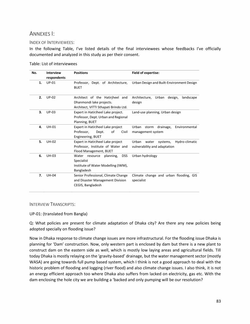
83
ANNEXES I:
INDEX OF INTERVIEWEES: In the following Table, I’ve listed details of the final interviewees whose feedbacks I’ve officially
documented and analyzed in this study as per their consent.
Table: List of interviewees
No. Interview
respondents
Positions Field of expertise:
1. UP-01
Professor, Dept. of Architecture,
BUET
Urban Design and Built-Environment Design
2. UP-02
Architect of the Hatirjheel and
Dhanmondi lake projects.
Architect, VITTI Sthapati Brindo Ltd.
Architecture, Urban design, landscape
design
3. UP-03
Expert in HatirJheel Lake project.
Professor, Dept. Urban and Regional
Planning, BUET
Land-use planning, Urban design
4. UH-01
Expert in HatirJheel Lake project
Professor, Dept. of Civil
Engineering, BUET
Urban storm drainage, Environmental
management system
5. UH-02
Expert in HatirJheel Lake project
Professor, Institute of Water and Flood Management, BUET
Urban water systems, Hydro-climatic
vulnerability and adaptation
6. UH-03
Water resource planning, DSS
Specialist
Institute of Water Modelling (IWM),
Bangladesh
Urban hydrology
7. UH-04
Senior Professional, Climate Change
and Disaster Management Division
CEGIS, Bangladesh
Climate change and urban flooding, GIS
specialist
INTERVIEW TRANSCRIPTS:
UP-01: (translated from Bangla)
Q: What policies are present for climate adaptation of Dhaka city? Are there any new policies being
adopted specially on flooding issue?
Now in Dhaka response to climate change issues are more infrastructural. For the flooding issue Dhaka is
planning for ‘Dam’ construction. Now, only western part is enclosed by dam but there is a new plant to
construct dam on the eastern side as well, which is mostly low laying areas and agricultural fields. Till
today Dhaka is mostly relaying on the ‘gravity-based’ drainage, but the water management sector (mostly
WASA) are going towards full pump based system, which I think is not a good approach to deal with the
historic problem of flooding and logging (river flood) and also climate change issues. I also think, it is not
an energy efficient approach too where Dhaka also suffers from lacked on electricity, gas etc. With the
dam enclosing the hole city we are building a ‘backed and only pumping will be our resolution?

84
Now, planning for-climate change in our country is motley about adaptation, epically I community level
management sectors (NGOS, local Gov.) are building community resilience in the climate-vulnerable
areas, (coastal, river bank areas). We are not focusing on mitigation.
Now, in the national level experts are working on a climate change policy. It will help the government to
get more international attentions which is Ok. But only focusing on climate change or main streaming
climate change shouldn’t ignore our traditional development problem of our urban areas where there is
lack of good governance and planning-practice.
For Dhaka, we had previous master plans. Those were well-thought out plans. For example, in 1917 Sir
Patrick Geddes (Scottish planner) planed for Dhaka. That is the earliest modern plan we have. In his plan)
even though it was centuries ago) he particularly focused of the natural canal-system and small water
bodies which were existing throughout the city. Historically, Dhaka’s growth started from the Buriganga
river mainly from the area around ‘Dholaikhal’. In his plan, Geddes argued for the water front character
there and planned the city respecting the wands (canals, lakes and even small ponds). He not only planned
for a beautiful water front for the urbanized Burignanga river side’s but also realized environmental
importance for all the water bodies, especially for drainage issue. The mentioned in his report to keep
those are preserved for public use.
In, 1982 we had DMIUDP (Dhaka metropolitan integrated urban development plan) which contained some
of these concerns that Geddes showed for the natural drainage. It was later followed by the DMDP (Dhaka
Metropolitan development plan) for a long –term period from, 1995-2015. In that plan, the natural
detention/retention areas were fixed. But to implement it the DAP (Detail area plan) was not there. The
work for DAP started very late and eventually lots of natural areas were urbanized Now, there is situation
like past, the new DAP for 2016-35 is already due and RAJUK only prepared a draft structure plan which is
from my point of view a worth less plan. My observation about the land is it has no reflections on the
previous lands and most importantly significance of the water-retention has lost.
Q: Why there is such inconsistency in the plans? Are there not enough supporting policies?
Actually, we have such policies that defend our natural water bodies. For example, we have water-act
2000; we have laws for ‘fore-shore protection’. The ‘Physical planning division’ of the planning
commission is responsible for preparing our national goals for land-uses.
There is a land-fixation policy for agricultural lands yet, from a study (in 2003) I saw 1% of agricultural land
is lost each year. To accommodate the urbanization, we are expanding our cities towards suburbs and
pillages, even building on flood plains. We are filling up rivers and erecting building on it! Now that the
river camels are narrow or closed, it is affecting the down streams. So, does, the encroachment have
anything to do with the ‘climate-change’?
Our ‘wetland act 2000’ says natural or historical water bodies cannot be filled up without authority’s
permission. But in a sense our development authority is filling up natural areas in the name of
development. RAJUK is developing housing (ex: Purbachal, Jhilmil) on the designate flood plain areas. So,
they are promoting expansion rather making policies for compact planning.
Even if the land development is a dire necessity (From their point of view) they must compensate the
nature by constructing more wetlands and canals. These wetlands, water-retentions are new concepts for
our cities. But in our rural culture, we have long tradition of such adaptation. In our vernacular house-

85
holds there is a system that we first dig ponds and build our houses with the mud, higher the plinth we
need the deeper the pond we cut, that is our traditional way of adaptation from river flooding.
Now you can see our governing agencies have management problem and lacks vision for this city. There
is classic example of cities planned with canals, like Amsterdam. Where, Dhaka was naturally geographical
character, but due to bad planning it is lost. 42 khals (canals) were filled up by the urbanization from
British rule till now. There are few remaining canals which are either disconnected or covered by roads
and ‘box culverts’. Not very long before, in 80’s the Dhanmondi lake but now there is that ‘Panthapath
Road’ over the connection and you want find any trace of the existing channel. In Arshad’s (autonomous
president of that time) regime lot of engineering measures were introduced such as these ‘box culverts’,
dams, pumping stations etc. was introduced. These developments didn’t consider the social and natural
context of our city.
In national level, we have issues due to wrong water management. Our country is an ‘active delta’s our
low-laying areas are prone to get flooded. At one side, we get flood but on the other side we have ‘Chars’
(fertile land from sedimentations). But in 60’s, our national objective was ‘green-revolution’ in agriculture.
For that we made dams and polders. We managed to stop flooding of our agricultural lands but eventfully
we’ve lost land fertility and damaged the natural river system.
That is one example of our lack of vision and expert knowledge. In Dhaka, there are plenty of examples.
For Dhaka, it is more management problem than lack of expertise. In adaption, only the land use
regulation and proper governance could’ve played big role. But as I’ve told you earlier, we are still
struggling to develop a (honest) land use for the city. I’ve spoken in many public forums ad published
several researches advocating the ‘water urbanism’ for the city, but it barley has any effect on the attitude
of the authorities.
Q: What is your comment on the recent environmental projects (such as Hatirjheel lake project)?
I will explain the back ground of this project first. As I was saying, in the academic research there are plenty
of studies on Dhaka (in urban- inaction related issue) at least in the local institutions. But the governing
agencies do not usually incorporate these studies. In BUET we design many projects but the RAJUK or
planning ministry or LGED do not show much interest. But the Hatirjheel project was an exception in that
case. Before the actual project, there was a Bachelor thesis on the area, for urban place-making and
transport development. In that presentation, we (BUET, Architecture department) the planning minister
during that period, the was so amazed by the ideas presented in the thesis. Later when the project was
initiated the LGED contacted BUET for expert opinion. Then BUET (through BRTC) formed a consultancy
committee including planer, engineers, and designers, in the initial proposal they (BRTC) considered the
student’s research for the spatial design part. In the original research, more wet and areas managed with
minimum intervention, the main connection road was proposed elevated and the ground area was left
open detentions and green corridor.
The encroachment issue (tendency to fill up illegally) was considered and only light pedestrian road was
proposed on the edge of the like. But all of these considerations were ignored in the latter phases of the
project. Instead of focusing the environmental goals (greenery and detention) the transportation and
beautification gained more importance. I think it is not the economic problem for such deviation (as there
are more build structures now). Rather lack of sensitivity, lake of interdisciplinary communication
(especially designer and hydrology experts) and main influence from different private actors hindered the
86
environmental rationales. Now there is too much roads, very close to the neighborhoods, concrete pane
areas. All of these might increase the UHI effect instead of cooling it. The Karwanbazar area (same area
that Hatirjheel is situated in) has a heat island issue and there is an ongoing research on that area. After
the realization of this project present data indicates such issue, now there is increased mobility in that
area which might be a reason but after all it should not contrib. Ute to the UHI problem.
Instead of soloing the problem with a single elevated road, now there are multiple bridges and roads with
lot of intersections. It is not an ideal situation for the surrounding residential area, mostly when they are
designed for high speed traffic. Never the les, a large member of households had to be demolished to
introduce these connections which will eventually change the existing urban fabric and the social
environment. For example, if you to genre no, you’ll sees only the community mosques are there, the
community have been evicted. I, think the hydrological design of that lake is also not functioning well. The
lake was not supposed to collect ante water from surroundings but recently there are bad order coming
from the lake, may be the drainage system is mal functioning. In overall sense, due to the project now we
have the lake projected from encroaching but there is lot of drawbacks.
Q: In Your opinion, what re major challenges for adaptation of green- blue infrastructure in Dhaka?
In my opinion, adaption is the best way for our city, as I’ve always argued for that. And for that our
governing institutions are not prepared. They, lacked capacity. Implementing the policies (also proper
translation of policies into strategies) and then involving experts and stakeholders in the process could a
solution. There is no set base-line or goal for compact land uses, even though, before proposing new urban
land-use no prior studies are conducted. So, the policy instruments are not being deployed properly by
the authority itself! Dhaka has FAR, building construction rule, BNBC etc. In every plot, there must be a
certain percentage of open surface but in reality, people are paving because there is lack of monitoring.
These are only small examples of our institutional lacking.
UP-02: (conducted in English)
Q: What are the prospects of environmental projects as an urban space? Are there any conflicts?
Every city has its own identity, a unique physical configuration. This configuration has influence in
functionality, growth and also in sustainability. It also explains the relationship between natural green and
blue networks. In that sense, Dhaka has its own character which is not like Melbourne or not like
Amsterdam. So, context is important. I think, this nature of identity is deeply rooted with its historical
relationship with green and water. This is one aspect. Another aspect is the human relationship with green
and water. This relationship is perceived differently in urban and rural environment and in different
cultures. So, these ideas were considered in both Dhanmondi and Hatirjheel urban projects. They are
unique in their set-up and part of our water-urbanism.
In Dhaka, there was large natural blue-networks consist of water bodies like Dhanmondi and Hatirjheel
lake. Land was fragmented in smaller islands by those streams. But unplanned and uncontrolled
urbanization disconnected these natural networks and few isolated lakes remain. After liberation, political
centralization made Dhaka more attractive as a capital and from than it has grown 26 times in terms of
population. In terms of spatial size, grown 18 times larger. This high-density development has influence
over nature and in Dhaka, the existing natural spaces (green and blue) became relief points.
87
Until the lake projects were in place, these areas were negative urban spaces of unplanned settlements.
As a consequence, those spaces had lost their desirability to the city. In Dhanmondi area, very few houses
were approached by the lake. Lake was their backyard and the housing area grew facing towards roads
blocking city’s connection with the lake. During that period, housing development was more depended
on transportation and electricity. In the design, we wanted to interpret the lake as green-blue refuge
space for neighboring housing area, beside its environmental function of storm-water retention. The
existing green belt surrounding the lake was also under encroachment threat and lake water was polluted
by household waste dumping. So, ecological restoration was also one of the objectives. We have made
practiced couple of interventions in the existing Dhanmondi lake. First, an encircling pathway was
designed to stop the encroachment tendency, combinations of spatial sequences of green, pathways and
resting spaces and housing were developed to create dynamic landscape. Secondly, all the waste from
sewers, households etc. had been diverted as a separate drainage system and only the storm water runoff
was allowed into the lake. And thirdly, we introduced crossing bridges and new connections to integrate
the lake within the existing space matrix where previously it was segregating the area into different blocks.
Apart from that, we carefully introduced pocket-like spaces for businesses to generate income for this
project. We have observed in Dhaka, it is suffering from lack of public spaces. Saying public spaces, I
strongly mean ‘democratic space’ (literally translated from Bangla ‘Gonotantric porishor’). Our public
spaces do not comply with the ideal meaning of ‘public space’. Due to lack of governing policies and
capitalist attitude, this city ignores many special groups for example, elderlies, women, physically
challenged and financially weaker communities. So, existing public places were failing to serve as all-
inclusive spaces. So, for Dhanmondi lake another concern was to make it all inclusive space. Now whether
you call the Dhanmondi lake a democratic space or democratization of space that is another argument
but that was one of the issue which was a design consideration of ours. From that idea, we proposed new
activities in the area which can make this project economically self-sustainable. For example, boat club,
coffee shops, floating restaurants (which was initially a swimming pool and health facility but wasn’t
commercially successful) etc. Apart from these, cultural space like amphitheater (Rabindra shorobor)
were designed so that local people can use it for recreation. Although, due to lack of such environment in
this city these spaces are overcrowded and became an ‘urban lake’ from a ‘community lake’. That is
another issue, we often fail to understand that development is not an isolated process. Now there is an
argue for such development around the city to reduce pressure to one. It was obvious that being an initial
design it will have visitors pressure unless there are more similar developments. So, from a simple water
detention new issues such as connectivity, integration, environmental restoration and regeneration,
inclusive public space etc. became part of this project. And the Dhanmondi lake finally got its own image
converging those issues. Now from 5am to 10pm people from any occupation, any ages or any classes can
access this area for public uses. And due to that, the development attitude of this Dhanmondi area has
also changed drastically. The previously mentioned lake-blocking housings development have been
redeveloping to lake-facing development. For example, lake-view, lake-side, lake shore these are the
common title for real-estate developments. That means this lake project had influence over the
surrounding spatial development. This doesn’t mean that there is no miss-use of it but at the same time
the attitude of water front or reviving water urbanism became very important for the city. As in 1917, Sir
Patrick Geddes envisioned water front development of Dhaka through the ‘Dholai khal’ (a lake at old
Dhaka) which has been forgotten during the course of Dhaka’s urban development, has restarted by this
project. The Dhanmondi lake has become the successor of the old Dholai Khal area started the water front
culture. Its continuation is the Hatirjheel retention pond realized as a consequence of 5-6 years’ active
88
environmental movements. Instead of following the specific plan for the Hatirjheel lake area in the 1997’s
the strategic transport plan for Dhaka and urban area plan for Dhaka there were attempts for making
housing or CBDs in that area which we protested for almost 6 years (he played an active role in BAPA; an
environmental movement group who protested against new proposals and speaking as a part of that
movement) and finally it has become a project. But as project, initially there were ideas of water retention
and connections for missing-link between ‘Kazi Nazrul Islam road’, ‘Taj Uddin Ahmed road’ and ‘Progoti
Sharani road’. Later on, when many experts were engaged (as masterplan was developed by BUET, VITTI
was commissioned by LGED for architectural and landscape design etc.) we tried to turn the project again
into a place for water urbanism. So, according that concept we introduced water transportation,
surrounding walkways, cantilevered viewing decks so that people can closely experience the water.
Connection (vehicular and pedestrian) was a major issue and we created lot of new streets to bridge the
old and new developing part of the city. A finally it became a successful integrated development and at
the same time it brought back the image of water based growth as the historical development of Dhaka
from Buriganga river. I think it’s a new attitude of bringing back the water front character within the city.
It was started with Buriganga river to Dhulai Khal lake and then the Dhanmondi lake and finally the
Hatirjheel lake and should be an ongoing process. It is more of a legacy of reviving our originality, the
unique configuration of this city. Actually, this is how I conceive these projects.
You mentioned about the inclusiveness of these projects, can you please elaborate on that? How inclusive
were the planning and design process for these cases? And from your experience, how is the practice of
involving people in such spatial development in the context?
As you mentioned spatial or urban planning and design, it is not only shaped by the external forces but
also the people. Keeping that in mind we undertook some collaborative initiatives. In Dhanmondi lake
project we didn’t plan the design in computers, it was hand drawn. In that process, we wanted feedbacks
from the communities. Several times we sit with 6 or 7 public heads in community centers around the
lake area for public hearing. It was a bitter experience for us, but was an important experience which
shaped our inner understanding of the whole project. The problem is that, initially people couldn’t
understand what public hearing is about. Most of them thought it is a session for complaining. But it
wasn’t, it was more about finding the dream or scoping session for the project. But, as you know it is not
a common practice in our context so, initially we got 20 feedbacks and of half of them were complains or
mistrusts based on assumptions. They protested this initiative thinking that we are going to destroy this
natural area. From the other half, we got like 6 good and rational ideas and about 4 of them were
completely unrealistic. That was one picture. But, I can still remember the inauguration day of the
Dhanmondi lake where all these public heads were there such as ex-ministers, secretaries. The leaders
and peoples who were involved in the process such as representative from Dhanmondi walkers’
association, Abahoni club, Dhanmondi club, lake viewers club, women walkers’ association. Most
important guardianship was played by the Dhanmondi walkers’ associations where most of the members
were ex-bureaucratic people living in the area. Although the participatory sessions were not very pleasant
and we didn’t get expected feedback during the process, on that very day at the opening ceremony all of
these representatives claimed that it is for them and their guidance the design is so beautifully realized.
On that moment, I was very proud, instead of getting sad because I saw that people have taken the
stewardship of the lake and realizing it as one of their own creation. This is what we wanted. We were
advocating for these stakeholders and finally they toke the guardianship of this project. This project later
gave us courage to make efforts in urban spatial intervention projects participatory.

89
In Gulshan lake project we are also making such efforts. We have communicated with at least 6 parties
from different layers. For example, we invited the surrounding societies such as Baridhara society,
Gulshan society, Banani society, the combined Gulshan club and Gov. ministries for participation sessions.
We have already got some feedbacks for the design. So yes, along with your own investigative ideas the
public participations give you people’s purview of integration, which we did. In our Facebook page and
website, we’ve also published these summaries of our analysis on Hatirjheel and other projects. So also,
try to share it in the public domain. It is true that this process is not common and in case of Hatirjheel
project the public incorporation was difficult due to many circumstances. But we took efforts, for example,
there were 2 public sessions (jonotar moncho) on 2 sites. I was an activist on the streets for 6 years and
together with many groups we made many demonstrations for Hatirjheel. So, we knew some of the
peoples demands. For that, we organized the sessions where two MP’s including the present Home
minister were elected members from the 2 sites. And with the deep participation from our honorable
Prime minister we tried to make this process more co-public. But you have to understand the different
scale of this Hatirjheel project compare to the Dhanmondi lake. In Hatirjheel, there were more diverse
multi-community participation where in Dhanmondi it was more like one single community which is
Dhanmondi. For Hatirjheel, there were Gulshan, Mogbazar, Malibugh, Rampura, Badda, Baridhara and
Begunbari communities. In all of these, there were not many organized groups and associations. So, this
was one of the issues. But we’ve got many feedbacks diverse feedbacks. There were reports and articles
on the hatirjheel area which also helped us prepare the design. It is true for any designer, architect or
planner to open his or her eyes and ears first to be able to observe and listen beyond the lines. When we
were involved in such projects that have large spatial interventions we were also motivated in such way
to deal with people’s interest.
Q: But there are many criticism about the process and also set backs from the locals. What are the
challenges for planning and designing such projects?
This planning and design processes get much easier if there are consensus among the people regarding
environment. We need greater preparations for that. We need the city dwellers to understand what is
good for them and what to ask for. It was interesting to see that there was much public awareness for the
Hatirjheel area. Formally, do we have any institutions that are motivating people, making aware of their
own resources? Is there any public platform for discussing sustainable urbanism? No, we are lacking such
platforms and when we talk about development, we always talk about urbanization, urban development.
But where is the urbanism in our development context? We couldn’t even plan or design for any urban
development plans until today (he means until the Hatirjheel project as an urban project). We had the
Detail area plan (DAP) which is the first ever detailed development plan of DMDP. But unfortunately, from
2010 we couldn’t even carefully implement it. The city with such expansions in terms of population, in
terms of volume yet to going into the process of planned development making it very difficult and unique
situations to solve! Look at the density we have in our city now! It is unbelievable that we have more than
40,000 people per square kilometer is too much comparison to any city you may. More than the city-
based countries like Singapore, or high density city like Tokyo. Our current stage is; without plan, with
unbearable density, without any urban philosophy. So, what we can do in such chaos! It is a very difficult
job my friend! And I can tell you, we (as planners) should take all the blames. Still I can tell you in my 25
years of career these 3 projects (Dhanmondi, Hatirjheel and Gulshan-Banani lakes) are the toughest jobs
ever. Because, this was my dream too (as a citizen of Dhaka)! When I was in the design table with all the
multi figures people, I was thinking of myself too. It’s contagious, you cannot be oblivious when you are

90
designing! I’m sorry, I’m saying it very harshly but it is the fact…this is a city only for the powerful people,
physically and financially…only for the able and powerful people. This city denies the very existence of 44
to 46th percent of the poor people because they are economically weak, it denies around 11 to 12th
percentage of physically challenged people who are there but not ‘there’, this city denies around 10th
percentage of adolescent female, can you see them playing around the city freely! This is what it is! And
you are working in that perspective thinking that you will manage every bodies inclusiveness? But can
challenge you that, if you go to the Dhanmondi lake now will see all of those people owning that place.
And go to Hatirjheel see if there is any foot over bridge, any footpath which is not accessible by physically
challenge people. We tried to make it all accessible. But do you think that was easy to establish as most
of the ‘people’ (authorities) doesn’t feel like that. I’m clamming that, you go and observe the Hatirjheel
site and you will see at the Begunbari area those people who are very poor, they are all using the lake side
as a living room (they are personalizing that place as if their own backyard). Some people stood up and
blamed me! Are you stupid? Look what you’ve done! I said why? This place is not yours, it is everybody’s.
I couldn’t restrict a place by design, it was designed such a way that everybody can use it. I’m bot craving
that this project is a big success but at least these issues were in my mind, not only mine but in the minds
of our whole design team. We debated on such issues, we fought for these issues days after days.
It was after the Dhanmondi lake project in 1999, I’ve decided that I have to become an activist. And till
1999 I’m working as an urban activist. But I don’t know when I’ve become an activist. And I took this role
not for pleasure. After that I’ve faced many threats on my life, even got threats like they will abduct by
kids. I’ve went through such time. When I was fighting against Bashundhara housing nobody was with me,
no architects were there. I was almost in the jail standing in front of the magistrate to hear the verdict
whether I will go to jail or not because I was fighting for Dhanmondi 8 play field. Do you think my children
are that small? I wasn’t for my kids but for all the rights for all. It is not the architect who was crying, it
was the father, the fatherhood within myself, the ownership of the city within myself, the stewardship of
the city within myself, the city I dream within myself! It is every bodies right, some of us takes
responsibility and some of us don’t. The bottom line is, it should be responsible and responsive act of any
professionals not only for the architects. That is how city grows.
Q: Now, you might have already mentioned many of these on the Dhanmondi and Hatirjheel projects, but
I would like to ask you some detail questions about functions. You talked about urban place-making of
these areas, but how did you incorporate the environmental objectives? Were there any contradictions
with spatial design?
Three things were very important. The Hatirjheel was not meant to be an urban space. Its objective was
mainly restoration of water retention area and creating some communications. But we felt it could be an
opportunity for creating some breathing spaces where were not so many initiatives taken after the
Sorwardi Uddan (one of the large city park in Dhaka) since the British period. The place making was mostly
to find out some pockets out of it. Not having any extravaganza, we tried to create something which is
more induced within the resources. For example, we made water works (which is presently withheld by
the army but will restart someday), cantilevered viewing decks. These are some small elements but the
decks would allow people to see their reflections on water. In a sense its self-reflection. It is about
celebrating our water culture. We Bangladeshis have intrigue relationship with water and its reflections.
We wanted to make ‘Ghats’ (traditional docks for boats), that is how the Bangladeshi people like to see
the water-edge. We made green-edge instead of concrete edges, and the landscape will change, the local
plants were selected. The green will fell off during dry seasons and look ugly but that was part of the plan
91
to make it more natural and local. We didn’t want it to look like Vienna, Vancouver or Paris (as developers’
pitch) we wanted the landscape to look like Bangladeshi water edge. We added couple of things off
course. We designed an amphitheater which is floating (not occupying water) and has capacity for 1000
people just to create a place-making situation. But for that we also had to propose a multi-storied car
parking connected to the that place with over bridge because there was not enough space to
accommodate the parking that the function will generate. We considered the traffic impacts from the
places we tried to make. We designed parking lots for the Boating stations, parking building for the
amphitheater along with a children park. Initially there was not such activities. We are promoting a new
modality which is water bus and will add extra connectivity to this area. One interesting thing we are
thinking now which is not in the master plan, that is a bio-diversity island isolated to people as a bio-
diversity compensation area for the project. This is a minor symbolic initiative to promote environment
responsive attitude.
Q: What about generating businesses like Dhanmondi lake in Hatirjheel project? It is much larger in scale,
what is developing situation in the surrounding? Was is considered in the master plan?
You should understand one thing that, we have only worked on the edge of the lake area where all the
surrounding areas are vigorously waiting for to develop. We rather made some macro level action plans
by-laws to ensure that the sun never get blocked by the surrounding development. By that, we are trying
to control that development, the control is mostly in terms of building height and floor area ratio. If I could
show the pictures before Dhanmondi lake project, you could’ve understood. There, before the project
was only 1-2 or sometimes 3 storey buildings, but now 6-12 storey buildings are surrounding the lake.
Those developments were not planned. They automatically grew for the lake, more like instantaneous
response actions by the real-estate sector. Now in Hatirjheel these types of developments are coming,
like hotels, condominiums, restaurants, luxurious housing. But let them be growing out of private
investments. I’m pretty sure all these up-coming private developments will take advantage of the lake
project.
Q: But will this area be permeable from far neighborhoods, as you talked about large developments
adjacent to lake? I’ve seen some restrictions on accessing the lake area and the situation is difficult for
some of the surrounding neighborhood.
The thing is, the plan was developed to have new road accesses. But if you allow everybody to access, this
road will be unbearable. But the developments which are coming up, have other alternative connections
on the other side of their plots. We’ve given 26 connections for the plots who had no other alternatives
to access their houses, other than those 26, all have alternative roads. Bu given that, those who had lost
their direct connections will always have the visual and environmental benefit from the lake. Detail plan
for the surrounding developments is being done by a different consultant namely, JPZ Ltd. Initially, I was
involved in their study phase and wanted to work jointly buy I became frustrated. I think that study was
lacking in-depth research. I wasn’t persuasive to getting the action-plan project. Professionals were
thinking of I’m after the project and money, but I didn’t do injustice to the whole plan. Whatever the
circumstances are, I together with Dr. Ishrat and lot of other experts as an advisory committee we tried
to guide the plan.
Q: Do you think there are chances that out-side investors or real-estates will benefit from that surrounding
plan rather than the local who are more effected during the project?

92
It is true. Let me tell you one thing! The people who were living here for long time had the right to take
the full advantages from the project. Out of this project there was 256 families who were compensated
financially for their land. But they were legal owners of those lands with houses on it. So, there were
always claims from those effected families that, “you gave us money but we’ve lost our chance to be
here!”. In our first presentation to the Honorable PM we raised this issue. We proposed to acquire more
land and accommodate the displaced families in a cost-effective way. She took this seriously and showed
precedence to this matter. She asked, “Is there any example?” I showed the Khilgoan-Malibugh
rehabilitation housing for the Komolapur Rail project and other rehabilitation housings such as in Gulshan,
Bhatara or Badda. She replied, “this isn’t the question of money, it is the question of right.” And she agreed
for this proposal. Now there are two apartments for those families. although someone else have designed
those very unimpressively.
Now I know 90% of the people who were living around cannot live here anymore. They are selling their
lands to developer. This transformation of land tenure-ship is beyond my control. That is something which
has always sadden me. As an Architect and urban designer here we have to face that, your development
always wipe out the scope of people who are originally there in the underdeveloped areas. I’m not sure,
this is may be one common phenomenon embedded in any development within our system. There are
social issues (sometimes son pressurize their parents to sell for profits), economic issues and many other
dynamics.
Q: Was it a part of your design consideration? And how was it considered in the planning process?
It was bothering me, but to be honest I couldn’t do anything. What can I do? They (LGED) didn’t give me
that opportunity. My working territory was limited, the wall you see? That was my limit. I didn’t even
want that wall. That is a stupid solution. It was done in overnights. At least, I could’ve designed a better
fence to allow light and more accessibility.
Q: Do you think the project could be designed with less built-up areas (e.g. concrete surfaces, roads)?
Some experts have mentioned critics about that and also the roads are still not enough for particularly
the locals because there is not enough pedestrian accessibility allowed.
I think most of the people do not understand the positivism of this project. Some think it is another project
like the Dhanmondi lake, unfortunately. I’m telling you very frankly, it was more likely a city level
connectivity project (road development) with a retention pond. It is not a park project, it is not a lake
project. We had to deal with the functionalities of this project. There were many “dreams” around this
project which cannot be realized in this context, we had to realize the integrality or multifunctionality of
this project. Otherwise, with only environmental rationales it would never be realized. I can assure you,
there are adequate trees planted, may be at this initial stage it is not appearing but, we have planted
thousands of trees and they this shade this area within another 3-5 years. Another thing is, since we’ve
to design roads on the ground we avoided intersections with different layers which reduced travel time.
Now the circular bus services have already been started. This a local business generated by our designed
bus route. This project need 75 million tk. Per year to maintenance and we had to develop some earning
sources out of it. We have managed to create opportunities to earn about 80 million tk. from circular bus,
water bus, parking, mobile food carts, amphitheater and children’s park. So, it is a self-sustainable project
like the Dhanmondi Lake. It was not an easy job to incorporate all these without hampering the objectives.
No government agencies would not be interested if they realize they have to pay 75 million tk. each year.

93
Our governing agencies face difficulties because they ignore the maintenance costs of the infrastructure
and after realizing the maintenance cost became a burden.
Q: In this aspect, what institutional lacking do we have? Are there lack of planning and governing tools?
Firstly, I think integration between agencies is most important. Secondly, for implementation, having
comprehensive and holistic perspective is very difficult area. And last but not the least, ensuring public
participation to generate appropriateness is another most difficult area in our practice. Where now
involved in another project which is in Narayangonj, it is riverside and canal development project where
our design approach will be very similar with the previous ones but in this case, we are hoping to integrate
the public insolvency under the leadership from Mayor. The demand for developing those important
public areas came from the people, so in that sense it is bottom up. But from the moment, she (the mayor)
has taken the initiative the issue became more important. So, we need strong leadership also, when it is
committed, it should be implemented. I believe, planning is a continuous process, we should keep
updating and refining it but, until the plan is implemented it has no value. I’m very much upset about that,
still from 2010 we are waiting to have an implementing authority. Our planning authority (RAJUK) is
playing as the mother-organization for doing all the implementation where it was not entitled to it. There
should be a separate independent implementation authority, that is how the law was passed.
Thank you for your generous support. I’m thankful to you and your office for managing such elaborate
session within your very busy schedule.
UP-03: (translated from Bangla)
Q: What Policies are there for Urban Climate adaptation in Dhaka City?
If we see what are the climate change risks in Dhaka city, the major two issues appear-1. Food risk and 2.
UHI, or heat stress. If we talk about heat-stress, there are no specific policies or that, but there are policies
for urban greening or plantation. In the city corporation mandate, there are plantation goals, but generally
they are not given priorities in implementation. But For flood issue there is much concern, the climate
change effects are a recent addition to it but also, when there was major flood event in 1988, a flood
action plan was developed for the whole country. And under that FAP there as 8A and 8B section which
was developed for Dhaka. Policies from that document were adopted in the structure plan of Dhaka.
Basically, there were considerations of developing embankment, (both western and eastern), excavation
of canals, areas for retention (creating and maintaining retention ponds), flood flow zone and sub-flood
flow zones. These are the summary of FAP 8A, 8B which are incorporated in 1995’s structure plan of
Dhaka. But in reality, the structure plan was violated many times. When the work of detail area plans
(DAP) started, it was already late as many flood flow zones or wetland were encroached or filled-up. So,
in DAP the authority changed the hypothetical locations mentioned in the structure plan and designated
some retention areas along the proposed eastern embankment, and merged the sub-flood flow and flood
–flow zone together. That is how the DAP was developed. Now, for Dhaka the main problem despite the
policies and plan is that, the implementation is very poor. That is my main observation on Dhaka’s
governance. If we see the studies on wet land loss even after the gazette notification of DAP we have lost
many wet lands which are marked in DAP for conservation. Another interesting issue is, RAJUK prepared
DAP where they designated wetland areas or flood-flow zones and recently they are proposing housing
94
development on the same area which was designated for flood –flow zone. Jhilmil project is one example
of that. So, I would say policies and laws like water body conservation act, climate change policies etc. are
there which are related to flooding issues. The water-body conservation act 2000 is applicable for any
kind of water bodies (e.g. which retains, flows) in anywhere cannot be filled up. Particularly, climate
change policy is more general, it says we should adopt to climate change. So, for implementation it
requires more supporting policies specific to flooding problem. Now, policies or laws are there, we have
also strategic plans but the development authorities are failing in implementation. I think they could’ve
taken stronger role (even penalties are not given normally).
Q: So, the authorities need more development opportunities from the plan. In this case, what should be
done (e.g. Public involvement, trade-offs, knowledge sharing)?
There is public consensus, but there is no platform to express. When the first draft of DAP was proposed,
we (academicians) played activist’s role to update it and there were many demonstrations against it. In
the initial plan (RAJUK) violated many wetlands and natural spaces from the structure plan. Mainly. Since
then, the concern about wetlands was raised. It spread in public-domains, like TV media, newspapers. The
political context was different (The caretaker government was ruling). We went to the gov. advisors,
secretaries, even finally in the end-workshop (where the plan was presented in public) we opposed the
plan under special permission from the advisor. We were allowed to give a feedback presentation and
after that we were able to change their opinion about it with the forum’s support. After that event, the
initial DAP was canceled and suggested for revision. Then, the main concern was about the wetland
preservation and agriculture land. But in the present DAP there are many mistakes. Still we are facing
issues such as khal (canals) and river enchainment. Local public are involved is such activities but in smaller
number, mainly strong private actors are involved in these illegal activities. And as we know, the flood-
flow zones are mostly privately owned land. Due to large developments, the local people are getting
displaced. It not only an environmental problem, but also a social problem. There is a social dimension to
it. From my PhD. research I’ve seen it the people who are living in those areas have owned those lands
for centuries, these very traditional farming lands but in the name of development they are becoming
displaced. In public projects, usually land readjustment or similar policies are taken where there is some
form of negotiation. But in the surrounding areas of Dhaka, people are getting displaced from their original
homestead. Anyway, there are different dimensions of our development problem. Now we’re doing
project which similar to your question which is assessment of climate policies and their implementation
process, to see whether there are any missing links?
Q: Now in this regard, how well do you think our flood-risk management and spatial planning are
integrated in the policy documents?
In this regard, the risk-sensitive land-use planning is having professional attentions. Here the risk-sensitive
land-use planning concept is not very old. Recently, the risks associated with climate change are being
incorporated in the plans. Traditionally, Planners didn’t consider the data regarding hazards or
vulnerability aspects. Before it was more based on demographic status but now there is a shift towards
resilience. Now it is a part of governmental goals or visions. So, climate change is playing an important
role in the policy domain. In the strategies plan level, we don’t have many examples. The Mymensing city
now has a strategies plan where such issues are considered, including earthquake initially, started by a
foreign funded project, later, UDD developed it as federal strategies plan. For Dhaka, there are separate
projects, we always advocate for those studies to incorporate in the strategies. Now earthquake is also

95
being considered besides flooding and he stress. The recent structure plan (2016-2035) considered the
earth-quake risk (at least the authority argues) but if they’ve considered the earthquake risk, there should
not be too discrepancy with earth quake risk map. They’re also combined agricultural and other
conservation land. So far, I’ve noticed there is lack of study, especially lack of primary data. First of all, the
exiting DAP could be extended as many of the areas have not been developed rather new DAP has been
initialed, if so there should be more field level studies and recent primary dates to support the plan. Which
I think, is still lacking.
I’ve attended the workshops for this recent structure plan. There are many reservations from the public
and stakeholders, not only on the disaster-risk issue but also in many other sectors. Mostly participation
was a major issue. They failed to involve important stake holders (even public governing bodies) in the
planning process of this structure plan.
I think. I’ve explained the situation which will answer your question. In the policy documents, mostly in
national level such as plan developed in 1965, 1975, sustainable development strategies, environment
related policies, recent climate strategies all these documents in some extent mentioned adaptation
approach for flooding, in strategic plan it is adopted, may not up to the required level due to lack of study
but in implementation level there are paramount deviation Jolshiri (Project of military/army housing),
Jhilmil all are violation of DAP.
Q: Is there any government or private level incentive for implementing sustainable or green development?
Or is there any specific goal for green-blue infra-structure development in Dhaka.
So far, I know, there is no goal for specific green or blue infrastructures in the government sector. But
there are concerns about retention pond. The problem is in more metropolitan level. If the 1995’s DMDP
was realized properly, the landscape would be different now. In that sense, proper land-use is more
important. Much can be controlled by land-use. there are some small-scale, project-level initiatives,
Hatirjheel project is a good example of that. It has achieved many objectives. There are new
transportation options, it restored the old lake area, people are enjoying the area in many events, but
how well it can maintain the water quality is still an issue. Dhanmondi lake was a good example, now
Gulshan Lake, Uttara-Baridhara lake areas are being developed. But the problems on internal canals
(Khals) and surrounding rivers (which are more important for drainage) are under threats. The ‘box-culvert
type engineering solutions are not suitable for our context. For say, we can stop house hold waste
dumping, because now there are good waste management (collection) in many neighborhoods, but what
about the natural waste, (e.g. dusts, plant leaves), construction waste etc.? Our municipalities do not have
that much-sophisticated management. And my question is why should we still go for ‘box culverts’. The
khals (canals) are already there, we do not have to create them by demolishing properties and they are
not private, these khals are all gov. land, even 200 meter on both sides are also gov. owned. So, developing
these water channels are less difficult than the retention pond or flood flow zones which are privately
owned lands. To develop those area gov. would face challenges and can opt some mechanism such as
transfer of development rights, or any other incentives to balance their economic loss, not by force or
land acquiring.
There is one thing I’ve to mention, when we develop plans we do not think about how to manage it, such
as introducing regulatory tools (e.g. taxation, incentives). We don’t reach the deeper level of planning. Is
it true that we are losing wetlands only for accommodating people? How many people are buying those
lands? If we grossly say, we have 20 million (although it is not yet!) people in Dhaka at least more than

96
60% of these people cannot buy these lands (as 30-40% people live in slums or squatters). Do we really
know how much land were require for accommodating people? No, we don’t. But it is the major argument
of our development authorities. In the land-use plan, acres of lands are proposed for housing, and
industrial development. But, is there any land indexing that shows- it has been calculated? Dhaka is the
heart of our country; it is true that we have booming business in Dhaka. Here, we don’t have the luxury
to have big villas. There should be strict land restrictions or control on how much land we can own here?
That is another question. We are buying lands in city center and also in the suburbs (!) We should have
more strict land policy. We have a land ceiling act which is very flexible. If you build houses on your land,
you have to give property taxes and many other bills. But land price gets higher very quick, so there are
people who are making business out of lands. They don’t build anything just buy lands and wait for profit,
which is a very unproductive. Yes, there will be buildings eventfully but, thing about the time frame. So,
these are some root causes which contribute to the loss of natural open spaces. Do we need everybody
to migrate in Dhaka and start buying houses or living is slums? It a part of national level thinking.
Q: The DAP court’s the surrounding areas also (which is now greater Dhaka). So, in the regional scale what
difficulties do we have creating housing, or commercial areas to release urbanization pressure?
In their structure plan for Greater Dhaka, 5 area were shown as satellite towns (where Purbachal was the
last one to develop). We only showed the areas but we didn’t think about the communication roles.
Although, the vision was to develop self –sustaining satellite towns but to some extent they have to have
good communications with central Dhaka. So, in a sense, the real estate developers are much more
intelligent than the police mares or planners. Topographically Dhaka is high t middle part and both sides
are low and closer to river. The real-estate developer saw there are vast piece of land, agricultural lands
so, they were able to buy large area from single owner and those areas were law land, so they bought in
cheap price and they easily developed those areas because those were close to Dhaka. But as a planner
we didn’t think of restricting those areas as retention or flood-flood. Whereas, we opt for fringe areas at
eastern side, which is low-laying areas with no embankment and restoration areas (which are being filled
by private sectors). So, those fringe areas will be vulnerable to both river flooding and inland flooding.
This is the situation of Eastern part, in western side the ‘Goranchand-Bari area is reserved as retention
area and in the kollanpur area there was another retention area (about 200 acre) shown in the map, but
not properly reserved in and already filled-up by encroachment. So, these two are major retention areas
at the eastern idea. There are almost no natural canals existing in the western side but it is still possible
to protect the natural canals existing in the eastern area.
Now, all these plan violations are difficult to explain in the academic researches. I think you should
consider the political dynamics of our planning process, then you can some-how explain the real scenario
of our context.
Q: what are your remarks on the Hatirjheel project?
Apart from the many physical benefits (water detention connectivity,) my main observation is –who are
the real beneficiaries of this project? In a large project like this there are big costs and also benefits, it is
true that many of the people were living there illegally, if we see the surrounding areas, from the Its tire
people were evicted, some of them are rehabilitated (still many family did not get the position in the
apartment) and many of them are displaced with only the standard compensation fee (which is v very low

97
compare to the recent market land price). The from the 2nd tire are now at the like front and having real
opportunities to benefit from the project. But their individual lands/plots are very small (1000-2000 sqfts).
No what is happening there is, big real estate developers are coming to this areas ad trying to buy big
chunk of lands, in some cases, they have strong influences and eventually the owner ill sell. So, it is
happening because people were not fully aware since the beginning of the project, many of them didn’t
know the plan and couldn’t negotiate properly or manage between neighbors. So, during the realization
there were many law-sues. It was possible to proceed with the project because of the army involvement.
But to the wall people access to the lake is more limited now. It was necessary to introduce some form of
control, but they (army) should be more considerate and allow more connections to the neighborhoods.
Presently there are huge development scopes but we should create such situation where the local people
would be displaced. For example, now there are concerns that the ‘Korail Slum’ (next to the Banani Lake)
will be demolished. There are gov. lands, (from National Housing Authority), But we’ve always advocated
for improving those areas without relocating the people, there are many mechanisms to get profit, (or
recovering cost) from such social housing developments fortunate that, it happens in gov. housing
developments. Why there are quotas for gov. officials? Why giving land to privileged member of the
society without considering the local inhabitants first? If the gov. has to develop housing or land for
housing, the first priority should be the low income and middle income group, because the market doesn’t
do anything for them. And even if we do something for low or middle income group, why do we develop
land instead of housing, they cannot afford to build houses on it and eventually give it to the private real
estate companies. This is what happening in the Purbachal Housing area, entire area is now under real-
estate developers and it will supersede the estimated population and planned services. The FAR (Flood
area ratio) was introduced but in small plots it is not offering much open surfaces. We need combined
open areas for water infiltration and managing run off. In small plots if (FAR) is not offering the vertical
growth which we need for compact development and drainage management. In FAR, it is regulated that
you cannot cover more than 60% of your land, but having mall pieces of lands and combined green land
ha different effects in runoff management such as on-site water storage, retention pond as public pools
etc.
UH- 01: (Translated from Bangla)
Q: What policies and strategic plans are present/adopted for urban climate adaptation of Dhaka city?
In terms of climate change policy particularly for Dhaka city, there is none. But in national level we have
NAPA and BCCSAP. These are public documents developed by the Department of Environment. We also
have an old document FAP (component 8A & 8B) developed by JAICA, Japan. There you will find much
detail urban drainage study and flood management guidelines. And for spatial plan, mostly RAJUK does
all the planning in Dhaka city. The latest strategy we have is from 1995, the DMDP and DAP is its detail
plan. Now, the planning horizon of DAP was 1995-2015 and they (RAJUK) is working on a new DAP. But
the thing is, the strategies for Dhaka are developed before the climate adaptation plans and I don’t think
the DAP considered detailed climate adaptation studies, they included some options based on the
available documents during that time.
98
Q: So, what are the challenges in the planning for climate change adaptations for Dhaka city?
As you can see, for adaptation planning we only have the national level policies and they came after the
federal strategic plan (DAP). NAPA was published in 2005 and BCCSAP was in 2009. So, the policies came
late. Another issue is, we took long time to develop polices and plans and even though, after adopting the
strategies, the implementation starts late and between that period most of the land-uses changes in
unplanned manner. Implementing the plan in this situation will require lot of re-developments. Only in
the under developed areas (mostly the Eastern Dhaka), we can implement the plan without lot of turmoil.
For the eastern part, it is already getting late. The land-use change has already been started. The
agricultural lands are being bought by private real-estates and the water bodies are being filled up
violating the plan. When the new DAP will come, by that time the Eastern Dhaka will be an unplanned
built-up area too and the implementation cost will be high. Hatirjheel area is a good example of that. It
was an unplanned built-up area and to save the lake we implemented plan with a lot of costs.
Q: Can you explain the planning process of the Hatirjheel lake project?
I should say the Hatirjheel lake project was not an outcome of standard planning process. It was more like
a negotiation process between different actors. This project was not realized from strategic documents
or any planning program. I think I should give the background for that. Before 2007 when this project was
started, there were lot of development proposals from government agencies. Experts were also involved
in researches to promote the potentialities of this wetland area (Hatirjheel lake). In 1998, the RAJUK came
up with a development proposal where they proposed a narrow canal at the middle and the both sides
were zoned and plotted out for residential, commercial, industrial etc. development. In between 2001
and 2002, we (BUET) had couple of studies (mainly on the drainage potentialities) of this wetland. Based
on those, we nullified their (RAJUK) proposal and sent a recommendation to them. In that
recommendation, we showed at least 100’ wide canal from Sonargoan Hotel to Tongi diversion road to
be ensured and from Tongi diversion road to Rampura road the 265 acres of land must be acquired to
protect the lake. But as you may know, this type of research-based recommendations has little impact on
our administration and our recommendation was laying on RAJUK’s desk. In 2004, there was another
proposal from DCC for constructing an east-west connection road from Tongi diversion road to Rampura
in the middle of the lake. This was the most alarming proposal among the all development proposals. They
had designed that road and proceeded with all the clearance processes with the planning ministry without
conducting any environmental studies. Their focus was traffic jam but, as they proposed the road in the
middle filling up the lake eventually they were creating more opportunities for illegal encroachments.
They had got all the approvals and were tendering. Fortunately (or unfortunately), in 2004 there was
extreme rain events and Dhaka was having lot of logging issues. So, an important inter-ministerial meeting
was called to discuss the solution for Dhaka’s drainage problems. In that meeting, different stakeholders
were invited. High-level government officials, representatives for different organizations, environmental
activists, experts and academicians, all the development agencies were there. I was also invited in that
meeting as an expert and academician (may be architect Iqbal Habib was also there as an environmental
activist). In that meeting, we (experts) strongly advocated to protect the lake. The DCC’s role was against
us and they were supporting their road project. During that meeting, I explained our drainage problem in
very simple language and said to the chairperson of that meeting, “if we build the road on this lake its
reflection will be front of your houses, water will flood your houses.” The meeting was presiding by the
existing minister of the Local Government Ministry. We were lucky that, after all the arguments the
ministers dropped the DCC’s road project in that meeting and send it to revision. Later the DCC came to
99
BRTC (BUET) for suggestions on that transport issue (east-west missing link). We gave them an initial
outline drawing of an elevated express road with a lake-surrounding services road at the ground. The
service road will increase the neighborhoods mobility but our main intension was to protect the lake from
encroachments. In the executive summery we mainly focused on the service road and explained the issue.
But the DCC were only interested in the express way and start mobilizing with that part to gather
permission and funding. Because, their first proposal (road on lake) was about 400 million tk. where with
the elevated road this new project became almost 5400 million tk. project. Again, we were lucky that the
finance ministry denied funding due to the large financial requirement of that proposal (there was other
political reasons) and sent it back for feasibility study. Later, there was nation-wide political instability and
this proposal was stopped. But in 2007, under the Caretaker Government this project was re-opened in
another inter-ministerial meeting. The Advisor of Local Government Ministry was impressed by the
environmental and transportation rationales of that project. But, the budget required for the elevated
road was high and the authority decided to transform the elevated express-way into a ground level
express way combing with the initial service road. It was a quick pragmatic decision from the existing body
(as you know the administrations was backed by the military power in that caretaker period and they
wanted to initiate as soon as possible). In that meeting, it was decided that, due to the complex nature
the SWO will do the construction, the RAJUK will do the wetland management (sludge removal and
excavation works), the WASA will do the drainage part (waste water diversion) and the LGED will construct
the roads. The project DPP was approved very quickly from planning commission in October 2007 and the
Hatirjheel project officially started in November 2007. After the caretaker government period, the new
government also approved the project for continuing especially due to its environment restoration issue.
So, this project had to overcome the administrative barrier in different political environment. You can see
there is a political dimension to its development process.
Then there were lot of implementation challenges during the realization process. This project had to deal
with the illegal occupants, lower and upper level criminals owning informal settlements (mainly tong-
houses) and influential private groups (e.g. BRAC, Eastern housing, Hotel Hilton) to regain the land. We
have wet land conservation act 2000 (that states even if you own wetland you cannot change the
character of the land) that helped us enforcing the land acquiring. There are lot of legal land owners too.
For the road construction, we had to acquired their lands. There is land requisition law (any place can be
acquired by the government for public development work except religious places) but only financial
compensation would be unjust for the owners (the government rate was very low compared to the actual
market price of that area). So, after many negotiations the Work Ministry agreed to manage some lands
for the evicted legal tenants and constructed two housing tower for them. For that, the space was
managed from the masterplan by the designers. But that provision is not adequate from my perspective.
There may be about 40-50 apartments where almost 200 households were demolished. There is also
possibility for transparency within the selection process. That is how the land issue was resolved. There
were areas where the low-income communities had houses which were taken by the project. Authorities
couldn’t do anything for then, only compensated the legal house owners. This is an important social effect
of this project.

100
Q: In that aspect, during the social survey I’ve observed some negative reactions about the wall around
Hatirjheel. What is your opinion about it and are there other design issues that conflict with the existing
housing character?
In Dhaka, there is much scarcity of public places. When the Hatirjheel project was opened, it was
overwhelmed by public gathering in special occasions. Many road side houses started to open food shops
and the road side and footpaths became public recreation place.The local living style was effecting the
traffic in the express roads because, the such interventions was new to this area and people living in this
area are not use to with certain urban manners (road crossings, pedestrian uses etc.). So, the wall was
introduced by the army to restrict the access to the express way. I personally don’t support this but it is
also a fact that, something had to be done about the frequent crossing. May be a different method could
be applied. This project was designed as an urban drainage infrastructure and finally the public recreation
became a major attraction of it. Whereas, it is not fully designed for recreation rather recreation was a
partial goal. As an urban drainage infrastructure, I think it is an exemplary work which will promote
awareness about wetlands in Dhaka. There are some drawbacks. This multi diverse objective made it
difficult to achieve the full drainage potentiality and ecosystem restoration. But, there will be many
ecosystem services. For example, water detention, ground water recharge (may be fishing in future). In
the architectural design, I had to intervened for the water detention and drainage issues. The design
process was based on this type of discussions between different experts.
Q: What is your understanding from this project that can be helpful for planning and implementing similar
projects in Dhaka?
If we can master plan the complete area including the recent additions (e.g. elevated U-loops) which are
organically coming up due to the new development scopes, then it would be more efficient. To plan
everything at the beginning is the standard planning approach in our infrastructural projects and then can
be realized in phases. But, in this case the planning of this project developed by the arguments and
discussions. This discursive approach allowed us to interfere other wrong decisions and establish the
environmental principles. Even if we could plan the project combing all the objectives, there was a
possibility that seeing the enormous amount of work and budget the authority could’ve backed off from
it. I think, for all the challenging projects the government should adopt such discursive approach and also
should include the scientific research to plan based on scientific evidence. The scientific knowledge is very
important for decision making for the environmental projects. In the Hatirjheel case, we could strongly
hold our stand because of the academic researches on that area. These are my learnings from this
Hatirjheel project.
Now after the realization, the social and political attitude has changed. The government is very proud of
the project and new supports are coming for integrating more developments with this project. So, the
project was mainly completed in June 2013 but still ongoing after many extensions and budget increase.
The social and economic benefits are there as it improved the living environment and surrounding land
price are increasing. It can influence the development agencies to change their common land
development attitude. But there is concern for the low-income population. From my experience from
Hatirjheel and similar projects, I’ve realized that there is not much inclusive practice regarding the low-
income communities. Most of the cases they don’t have legal rights over the land and get evicted or the
economic pressure influence them to move out. In such conditions, the authorities should include that
affected population and accommodate them within the area. In the Hatirjheel project, the people who
101
were affected by the land accusation and only got financial compensation also have the right to live in
that area. In that case, government can provide houses by rent-purchase basis. Development will be
meaningful if it can accommodate the affected communities. We are not asking the authority to avoid the
development pressure but to consider these social and environmental issues while planning those
projects.
Q: What is the situation of public-private partnership for implementing such environmental projects?
Now, there are not many examples of public-private partnerships for environmental restoration works.
Mostly the governmental agencies are working in this sector. But now that the Hatirjheel project is a good
example for private investors to see the economic benefit from environmental restoration it will have
good impact on the public-private collaboration practice. If the wetlands are developed with multiple
development objective, there will be more scope for economic growth and the private agencies will be
interested to share the costs and benefits. This could be a strategy for the government agencies to develop
Dhaka’s watershed and easily achieve city’s sustainability goals. Even re-building the green-blue networks
demolishing the box-culverts (Dholai khal, Panthapath to Dhanmondi Khal etc.) will be possible if private
sectors are involved to share the large investment costs.
UH-02: (translated from Bangla)
Q: What are the cause of urban flooding in Dhaka? And what are the important climate change factors in
flooding problem?
In general, for Dhaka city urbanization related issues are more prominent in our flood management. There
is climate change effects-mostly UHI and high inanity rain-fall. But we are experiencing these aspects in
micro-climatic scales, these are more anthropogenic developments rather direct impact of global climate.
In the national level, there are major threats such as sea-level rise and water level problems in our down-
streams, these are global climate change threats. But we must realize that, our highly urbanized and poor
management are causing significant problems in water management.
Q. What policies and plans are present for the flooding in Dhaka? Are there climate change
considerations?
Specially for Dhaka’s Flood management FAP (Flood action Plan) 8A, 8B and partially 9A, 9B are the
planning documents. The FAP was developed by JAICA (Japan International Corporation Agency. Other
than that, we have national level policy and strategic plans. Most of the cases, the donor agencies have
developed strategic plans for our government, so many of them are not public documents (gazetted). In
our national level policies, there are broad scopes and mostly ideal talks, such as build with nature, respect
the nature and so. Recently, climate policy is there. But I Think the climate policies should be more
relevant. It is a good document to full fill the international conditions but we should also think about
generating specific strategic tools out of it. And this aspect we are very much lacking, implementing the
police is the main challenge. We have integration problem between agencies, we have governance
problem. In this situation, we need public empowerment.
I’ll explain some of our development scenarios. It will help you understand on the climate change and
development problem dilemma. From the here beginning we are lacking planning the flood management.

102
The experts didn’t realize the planning issues of the flood. It was about flood control. After liberation.
When urban planning. For Dhaka was developed the original natural drainage system was heavily ignored.
There were some major flood events in Dhaka between 80’s and 90’s. After the 1988’s flood, pumping
was introduced in Dhaka. 3 Pumping stations were implemented within the city. So, the gravity-base
drainage was altered they (development agencies) transformed the western part of Dhaka as a “polder”.
A “Dam” was implemented at the western side and on the other side (now the margin between west and
east part) north-south elongated ‘Pragati sharani’ (a highway road) was constructed. That road was
elevated above the flood level and the natural water connections from eastern side were disconnected.
So, planning integration is also absent in our water sectors. The water and flood-risk management regime
was more inclined towards flood-control. We still have conflicts over such issues. There are conflicts
between organizations. The conflict mitigation is absent in our system. Adaptation is more like a co-
operation approach. But there are so many different agencies in related field that do not have integration
between them. They are under different ministries and it makes it more difficult. But in terms of infra-
structure, we have inadequate drainage and also non-functioning infrastructures. It is mainly because of
management problem instead of financial or technical during field visits we often see such miss
managements, for example, we saw WASA in pumping out water in a temporary logging situation where
the pumped water channeling back to the area, because the drains were blocked. If the DCC and WASA
doesn’t co-ordinate our drainage system will not function. We mostly depend on surface drainage and
water blocking the drains is a common issue for our water logging. As the surface drains are under DCC
(City corporation)’s jurisdiction the WASA doesn’t clean the drains while pumping out the water and
eventually water runs back to the system. There is no formal co-ordination between them. But yes, we
are politically “democratic” and we say everything goes through the democratic process. So, no one is
here accountable. Every institute in Dhaka they are operating individually.
There is a political-economy behind our developments. Why Dhaka is going for many fly-over roads (free-
ways) rather investing on mass-transport? Is it supported by any planning studies? Or any statistics shows
people can afford individual transport? There are things which are more political than pure public benefit.
There are external and internal benefits of infra-structural investments. We often use the term “economic
incentive” for people. Is it a transparent process? For who’s benefit we are doing it? there are no “equity”
in the process. That is why I said we need public empowerment and also institutional reformation within
our system.
Q: In that sense, Hatirjheel is Project which initiated lot of social conflicts. As you were one of the experts
of the consul-tency team, what is your experience? What environmental services are there also?
Yes. I did the detention design of the Hatrijheel project. It is a detention lake, not retention. That means
the water will be kept here for short-term. In the planning process, I’ve faced some challenges designing
it. The main concern was to restore the lake and enhance it environmental services, but in the name of
“Integrated system” the main objective of storm-run off retention was ignored. The system is not
integrated, it is rather separate. One of the reasons is that, It was named “integrated” where the initial
plan was to incorporate the adjacent Gulshan-Bannai Like into the detention design. (and also, develop
urban amenities out of the whole area), But row they (RAJUK and LGED) are doing the Gulshan Banai Lake
project separately. If we could’ve design the water system combining all the wetlands it would be more
efficient. During the study, we saw the existing Hatirjheel lake area was not enough for the catchment
area. So, it was a better approach to combine the other two water bodies. But now a ware is added to

103
detain the water inside Hatirjheel lake. They should’ve initiated the projects together. Secondly, we had
to compensate almost 100’ width land on both sides for road (70’) and landscaping (20-25’). It reduced
significant amount of defection capacity. Now there are new opportunities and more built structures are
coming up. All these dynamic objectives hampered the main objective of this project. Initially there was
only peripheral pedestrian connection proposed (for stopping encroachment and improving the
neighborhoods accessibility. Elevated road was proposed to prioritize the detention, the ground area was
planned as green corridor with less public interference. Now different things were done. And after
finishing the project, they are doing the (spatial) planning of the area (surrounding area of Badda,
Begunbari). Whereas, if it was included in the Hatirjheel lake master Plan we would have more options to
improve / design the drainage of the surrounding areas. But more or less, some up gradation was done
for the drainage lines and surface drains during the project. Now it is a public recreation place, so certain
level of water in the lake has to be maintained. There is new pumping station at the connection point with
the ‘Balu River’ channel which maintain the water during intense raining specially, in monsoon. It also
functions on gravity during regular period.
Q: Can you explain (and share) more information about the hydrology design (or models) of this project?
The project is still on-going. We used modeling for the defection design, but I’m unable to share the details
of the model because, it now LGED’S material. I’ve used the dynamic programming approach and there is
a master’s thesis (from IWFM) which I’ve supervised followed the similar methods. This research also
included the whole are combining Gulshan-Bannai and Hatirjheel lake. I would recommend you to study
that research for further understanding.
Q: Now, how well do you think such detail hydrological knowledge? Specially, for urban flood
management are considered in the spatial strategic plan in Dhaka.
For Dhaka, I don’t think the hydrological analysis played important role in the strategic plan (DAP). There
are (in DAP) flood management considerations but are very general. Now we have climate policies, urban
adaption is a major concern (specially for flooding) So recently strategic planning is considering
hydrological studies for decision making. For example, UDD (Urban development directorate) recently
developed strategic plan for Mymensing city (an adjacent city Dhaka). Climate adaptation played an
important role in that. They (UDD) used hydrological Model and obscuration date for planning. The has
been legalized already but Mymensing municipality doesn’t have the institutional body to implement and
monitor it. So, they are planning for adding new department. I was also involved in the planning process
and I think it is an exemplary work specially, considering the flood adaptation.
UH-03: (conducted in English)
The usual in terms of causes is insufficient drainage capacities, excessive sedimentations and solid waste
blocking the inlets and also the drains, then unplanned/ uncontrolled urbanization. So as an example, area
has a drainage system or waste water system designed for 1000 people/households and now due to
unplanned growth has 10,000 people/households. So, the waste water volume was way beyond than
what was originally designed. Also, the combined sewer and drainage network is part of the problem.
Because, the sludge that enters the system are hindering drainage flows and causing congestion. Most of
the areas of the city does not have separate or proper sewer system, so it is a matter of infrastructural

104
problem for flooding. You can also consider one of the under-laying drivers of in-migration of population
growth of Dhaka city. This is one of the major drivers of the un-controlled growth/development. Given all
that, how important is the role of climate change? Personally, I think it’s not that important. Because, the
socio-economic aspects still dominate. We are consistently dumping waste in our canals, drains, manholes
and thus our water system is dis-functional. But obviously, in top of that if you put climate change, the
situation gets worse. But, this is not an exceptional case that the system is functional at its full capacity
and climate change comes and tips it over. We are not at that sort of situation at that moment. Moving
on to the next question of about flood risk management strategies/action plans for Dhaka, we do have
lots of plans; recently, Dhaka WASA has completed the drainage, sewer and water supply master plans
for greater DHAKA (DMDP area). And Dhaka Water Development Board (with help of IWM) is doing a
study on the flood protection of Eastern Dhaka (Eastern Dhaka is the area from the Airport road and DIT
road to the Balu River) which is at the moment very vulnerable to river flood. Large areas of that part get
flooded every year by river water (not pluvial). Once we put an embankment to the right side (eastern
part) than this area will be susceptible to inland/pluvial flooding. So, this is the dilemma for the plan for
Eastern part of Dhaka. Generally, in the plans there are proposal for separate drainage and sewer lines,
new pumping stations (at Rampura Hatirjheel outlet, in the North-west Guwanchandbari) beside the
existing pump stations at Kollanpur, Dholaikhal, Maniknagar near Komolapur Railway station (newer than
the previous ones). These pump stations pump out water from the city side to outer side of the flood
embankment. So, the newer pump stations will improve the capacity of the system to pump out water
during the monsoon. But the problem is, if the water is not coming into the drains due to blockages the
pumps are not going to help that much. So, in terms of risk management strategies one established
strategy is to protect the flood plains. I know that in your research you are focusing on the inland flooding
but, there is an import relationship between what is happening in the rivers and inside the city. It is like
this, along these embankments especially at the pump stations there are sluice gate structures. Generally,
they are open for gravity-based water drainage. For example, in this month of December the water level
is low in the rivers and in the city water going to the ponds and canals and later drain into the rivers. In
May-July the water level of the river will rise to a certain level when water will enter the city through
canals (khals) inundating low pockets of the city. That is why they close the gates during monsoon. And
then the city relies on the pumps. We rely on the system of catching and draining storm water into the
lake/retention ponds and then to pumps. This system continues about 2-3 months and then again, we
move back to gravity based system. So, this urban flooding phenomenon is relevant for 2-3 months (now
in some extent 4 months). Now, to see climate change impacts, we’ve done model studies in the
peripheral rivers and their water level have a trend to go up (due to more flow from the upstream
catchments from rainwater and in downstream with the sea level rise in long term future there will be
less ability to drain). That means we should close the gate earlier and for longer period. So, over time
climate change will force us to depend on the pumps for longer periods. This is purely from the climate
change point of view, but there are other anthropogenic impacts too. For example, you can see in many
areas the river width has been squeezed. It is being encroached and the flood plain (or foreshore) is gone.
What happened few years ago, some pillars were put to demarcate the navigation route of the river for
the dry season. So, people started to filling up the river up to that boundary for more lands without
knowing the actual reason behind it. So, very unfortunately what was initially a good idea, had a bad
impact. At the western side of Dhaka in Turag river, Buriganga river and at the eastern side in Balu river,
there are areas which are very much constrained. You can understand from a hydrological point of view,
if you have only one of these bottle-necks in upstream the water level will go up. And that is already having

105
an effect before climate change. Water levels are going up more than before and therefore the sluice
gates are had to be closed earlier and we are susceptible to pluvial flooding for longer period. In terms of
risk-management strategies, we should go backwards to protect our river corridors and flood plains. Even
if you look here (in the DAP map; Purbachal area) it was a flood flow zone which was given to housing
development, this area is naturally a higher area but have lots of natural drainage canals. But the new
plan still incorporates those blue networks. Conceptually/ theoretically it shouldn’t have any impact but
in reality, how much of these open canals will be left open is a question. We are facing that sort of
challenges from the land-use or land control point of view. Other strategies that are in place e.g. Flood
forecasting warning system (operated by the Water development board, FFWC website), signaling of
danger levels. But most of the signaling or warning system are more useful in the rural areas to reduce
the impact on agriculture. For the next topic (strengths and weaknesses of policy, strategies and plans)
generally, I think the policies and plans are strong (designs are generally ok) but the weaknesses are in
terms of implementations and enforcement. Before financing was a big problem but now-a-days, I think
we have enough finances to implement some of these flood-management projects (GOB funding, not
from donors). The weakness is in terms of delays of formulating the projects and implementing the plans.
Day by day more people are coming in the city and less case is available to put in green-blue infrastructures
and costs will also go up.
Q: Why there is so much dependency on pumps and infrastructure?
I definitely agree that the situation is not ideal. These approaches were taken as a reaction to the big
flood events in 80s (1988). At that time, the strategy was to separate the urban areas from the river
through embankments and use pumps to evacuate water. That mentality is still there. The mentality to
live with the flood or adapting to it hasn’t reach Dhaka. In some other parts of the country it is there but
in Dhaka due to its urban nature (high density commercial land-uses) the concepts of allowing water to
pass through is not present. If you do a little case study in the northern part, we have Uttara phase 3
project. This place was very ideal for water detention zone (with lots of wetlands, low areas, natural water
bodies). This area which in now under development by RAJUK, was naturally treating waste water and
helping percolation to a certain degree. Most importantly in the wet seasons it acted as a buffer. But now
we have totally changed it, we ‘ve filled it up and left little bit of canals and lakes. So, again we are putting
this area to more vulnerable situations.
Q: Why not these issues are considered in the new flood management plans?
I think, the land value or potential land-use is the driver. From purely economic point of view, the land
was underutilized. For that case, all the surrounding land value was so high, there was pressure to develop
this land. From flood management point of view, these lands will reach to certain height (after
development) where historically internal flood water level will not reach. In the development area people
are building adaptation by elevating road level and plinth level etc. They are also increasing the pump
capacities in response to the loss of retention ponds. In some areas, they have doubled it and yet again
they are thinking of increasing the capacity more because they are expecting that there will be lesser areas
for retention from the present trend of development. But these are still traditional thinking in terms of
flood managing. So, again it’s not an optimal situation when you are putting all your eggs in one basket.
But due to the immense pressure Dhaka also doesn’t have the luxury to dedicate land for the wetlands.
So in my opinion, the problem is more fundamental and Dhaka should learn how to deal with the
development pressure. There are some options which we’ve thought about and learned from modeling,

106
there are still some remaining parks and playgrounds which can be used as dry ponds. In big events, you
can allow those areas to flood in controlled manner. And when the peak of the flood events start to
subside, you can drain those spaces. So, it’s a distributing solution and should be low cost. But, that option
is still not viable as long as the waste water is connected to the storm water. We are constantly facing
large rain events and the drains over flow with heavily polluted water. So, allowing such water to the
playgrounds and fields are going to create health hazards. May be in 10-20 years of time some part of the
city can have these options because some part of the city is already separating their sewer system from
storm water system (Gulshan, Banani). In those areas, we have parks and open spaces and we can lower
the level and make some functions (e.g. amphitheater). That will give the drainage system some breathing
space. But, like I’m saying this for future situations, at this moment due to the water quality issue it’s not
an option.
Q: What was the consequences of covering natural canals with culverts? How to utilize the old canal
system?
There were 47 (approx.) canals (khals) in Dhaka, if you look at the broader map of Dhaka all the rivers
around it are draining towards Dhaka. Gravity is pulling the water to Dhaka. Historically, not far back (like
in 70s) the water used to pass through the canals. Only in the extreme cases like 1988, 1998 the river level
was very high the city got inundated. So, the reaction was embankment. The box culverts were built to
develop new road over the canal system, there were no sufficient east-west road connections. Reviving
those canals will be a huge undertaking due to the piles of solid waste and sludges underneath the
culverts. It will be a challenge to manually or mechanically remove the suited-up material. If those
structures were designed properly and the system were maintained and cleaned properly, theoretically it
could’ve worked. In the Kualalumpur, Malaysia they have done it. The Kaulalumpur city is situated at the
conference of rivers and they also had natural canals. But they also had taken engineering approach and
maintained it. So here our water logging issue is mostly because of the solid waste issue. I hopefully will
see some improvements because the City corporation has taken the waste management issue very
seriously and taking initiatives. I’m positive about the regular flooding issue and hopefully it will have
reduced if the system is maintained. But for extreme events it depends. We have done some simulations
for the extreme events based on the design capacities of the primary drainage system. The result was not
very bad and can absorb 30-year design event in our recent studies. But again, “it was assuming that water
comes into the drains properly”.
Q: In the recent report of IWM why it is mentioned that in coming 2030 and 2050 scenarios less areas
within Dhaka will be inundated?
The developed area in that study really applies for outside the built-up area of Dhaka. We did a very course
level estimate for the development area. So, showed that due to population and other development
activities land levels are tend to go up. And because of that, some areas will become flood free. But within
the existing built-up area we had some important assumptions. One was the whole separation of storm
water and waste water. Not only does that reduce the volume but also there is less chance to have
sedimentation (sludge, fiscus materials) in the drains. We did assume a certain amount of sedimentation
in the drainage and the new pumps will come online. So, based on that, in the model the system showed
good capacity to absorb a medium size event. As you know in Dhaka, the street drains are managed by
City corporations (DSCC, DNCC). And WASA manages the large drains and canals which are connected to
the Khals. In that study, we focused on the large canals and their new plans. That study showed the value
107
of these new plans. It gives a reference point that, if those plans are implemented than we don’t need
much adaptations. The city has some level of resilience, but in reality, we are deviating from the plans.
Implementation has been delayed and at that time most of the areas in the DAP designated as detention
could be filled up. Otherwise if we can implement our existing plan maintain the system, we may not
need an embankment at the eastern side.
Q: Now Dhaka is rushing into the new developments in the eastern side but the service infrastructures
(road, drainage) are not ready yet. What possibilities do you think eastern part has on protecting Dhaka
from flooding?
If the development goes as DAP’s land-use plan, the built-up area get elevated up to 5-6m PWD level and
the natural canals (khals) are left open than, there is much less change of vulnerability and that area can
cope with the river. Still it can be entuned with the concept of living with the water. But in western Dhaka
we can’t really avoid the dependency on pumps. So, for now it will be a great mistake if we don’t control
the development. DND area in Dhaka is an example of that. It was a low land, bucket shaped. Initially was
an irrigation land and now has very dense unplanned houses with narrow streets. And now is the most
flood prone area of area of Dhaka. So, there is risk for eastern Dhaka to became another disaster like DND
area. It is important to develop the eastern side of Dhaka in a planned manner to release some pressure
from the western side.
The average life span of Dhaka’s building structures are 50 years (approx.), so in coming 15-20 years we
have the chance to re-develop/ re-engineer western Dhaka’s landscape. The embankment on eastern side
is also seen as a future road-rail link. We still can have road and rail connections with bridges allowing
canals to flow, for eastern Dhaka that option is still available. The eastern side will always have the under
laying pressure of urbanization. It is very clear from the economic perspective. Now this area has some
business (e.g. fisheries, agriculture, water navigation but the household income at that part is too low
comparing to the western part. So, if we hold that pressure, more pressure will build up at the western
Dhaka. So, for eastern part the trade-off is between land area for urban development and its natural
drainage and retention capacity. So, now the government is trying to find the trade-off to develop that
eastern part in proper way. It is sticking that the either sides of Dhaka have quite opposite landscape
characters. And it is not at all natural. So, eventually the development will spread out and release pressure
from one side.
Q: As you mentioned the contrasting situations of the either sides, could those areas be compatible from
hydrological point of view?
In my opinion, not really. The embankment of Pragati Sharani (at the eastern side of western Dhaka) has
totally cut of the drainage between the two parts. The disconnect is there between east and west. So,
presently the eastern side is not directly providing any service to the western side in terms of flood events.
So, we modeled the two part as separate system to represent the flooding processes.
As I mentioned earlier, one of the biggest challenge for us is to keep the water clean. As a megacity, we
only have one water treatment plant. And it is not functioning optimally. It is not getting enough waste
water because of the problems of the sewer collection system. So, with a separated system we can have
lots of options with storm water (e.g. recycling, reusing for irrigation and other uses). The new sewer
master plan has envisaged 11 sewage treatment plants (STPs) in and around Dhaka. Recently proposed
108
STP at Dasherkandi area is a part of such development. The waste water collection from the new sewer
networks of Gulshan, Banani, Baridhara areas will be treated at the Daserkandi STP.
Q: What are the regulatory tools that can stop the solid waste dumping into drainage in case of the
separate storm water sewage?
I don’t think there are many. I think the National building code (BNBC) still goes with the septic tank
approach for main urban area. Outside of main city, in the townships (e.g. Savar, Ashuliia) I don’t know if
there are any specific guidelines. Dhaka is also surrounded by areas with clay soil. So, it is another problem
that the onsite solutions are limited by the soil condition. Some direct strategies for water management
is to control the water consumptions (less water consumption will lower the volume of drainage). So, one
strategy is (which still hasn’t been improved) that, the water tariff will be ‘block tariff’ instead of flat tariff
(one for domestic and one for commercial use). In the coming master plan of WASA, they have proposed
3-step tariff.
Q: As an expert of hydrology, you have discussed many important spatial planning issues and their possible
solutions. Do you think such spatial measures are important to consider in water/flood management
strategies?
Yes. I think it is. And there are already some indications. Such as, certain amount of space must be
permeable/pervious for ground water recharge and absorption. There are a large number of small ponds
in Dhaka. Some of them are privately owned. These ponds are identified by DAP. These small ponds should
be protected by laws. Now all of these ponds are not connected with storm-water (due to the water
quality) but, if these ponds are acquired by the government, there is much possibilities to develop a
network for distributed flood-management approach. There are some projects like lake projects at Uttara
3rd phase which are well not designed for storm water retention. Such as, the Dhanmondi lake was
designed to collect storm water runoff only at a small peripheral level and now is not connected at all. So,
the lakes are only collecting water from direct rainfall.
Q: Are there any national databases on flood management information? What flood management
policy/plans are available?
No. not so much database on national or city level (DEM, existing land use). For land-use planning there
is DAP. Presently, the water development board is doing a feasibility study of eastern Dhaka. They are
updating the FAP developed by JAICA, HARCRO for the recent development issues in eastern part. May in
the middle of next that document will be available for public. And the WASA sewer master plan is also
going to be published as public document very soon. Now, the draft structure plan is probably available.
Q: Are lake projects like Dhanmondi, Hatirjheel, Gulshan-banani locally community driven or outcome of
management strategies?
I think these are not solely developed from the flood management plan. The process was partially
inclusive. Experts from different communities played an important role in those projects. I think they have
advocated for these historical lake areas to be realized designed projects. They played an important role
in promoting their ideas but the decision was top-down (from the ministry level). There were difficulties
in implementation level also. In the Hatirjheel project, lot of the land had to be recovered from
109
encroachments and government had to involve the army to speed up the process. But, initially, when they
opened that area for public it was very much vibrant and attracting. But suddenly the army management
put boundary wall in front of the surrounding houses which I believe, very much against the nature of that
place. Probably, there are some social or management issues which was not considered in the initial
design. There are also other technical problems. Recently, there are complains about the water quality of
the lake. The lake was designed in such way that, only in the monsoon seasons it will collect water from
the drainage system (by outlets underneath the lake) and in the dry seasons the waste water will bypass
the lake and directly flow to plants. This is because, in the rainy seasons the waste water is somewhat
diluted with rain water and fresh lake water, and in dry seasons the waste water is more concentrated
and the lake has less amount of water. But now, I think this system is leaking/over flowing because of
blockage of sludge and solid waste. Another consideration was to have certain amount of water in the
lake throughout the year for recreation. In the Kollanpur water detention pond it was also design to have
water at certain level (5m) due to encroachment issues. But, before any large events (if any signal from
water forecasting) these lakes will pump out water to make more room for rain water.
Q: Are there any other design initiatives (besides detention ponds)?
There were some pilot projects. Such as, WASA has considered the option of artificial ground water
recharge. In our subsoil layers, we have deep clay soil. So, unless we inject water deep into the aquifer
level it is difficult to recharge ground water. Such artificial recharge points are being piloted done by WASA
(e.g. Shegunbagicha and Lalmatia recharge points). But a silly mistake of those projects was, these are
situated close to WASA pumping stations. So, it is difficult to see the results of these experiments. There
are some inter-departmental initiatives, such as in the new national building code (BNBC) building above
a certain FAR Floor area ratio) must have their individual rain water harvesting system. For green roofing,
there are many challenges. In our climate during monsoon, green roof will be very effective for slowing
the runoff and can also cool down building temperature. But, the down sides are it will increase costs. In
the dry seasons people, will spend lot of drinking water to maintain the plants which will inflict water cost
and structural cost of the building will be high. This approach will be more suitable if maintained by
recycled gray water or harvested rain water. Over water consumption in household is a big issue for the
government. Considering the lower income population, government is maintaining low price for water.
But, other than that it is important to have an optimal pricing signal to stop miss-use of water. As a delta
with lots of river, we think that we have good access to water but it is not true for the whole country.
When we pump close to the river, indirectly we are pumping river water for house-hold uses. More than
seven months we don’t have rain and this period is getting longer. In some districts (e.g. Rajshai) they are
even suffering from droughts.
Q: For flood-events how WASA is considering climate forecasting? Do the management agencies plan
measure for upcoming monsoon from seasonal forecasting?
There is not yet good connection between WASA and Meteorological Department to use forecasting. But,
some pro-active engineers use update information to maintain water level of the detentions. Seasonal
forecasting is not considered by WASA before monsoon and I think, it is not necessary yet because, the
pumps have enough capacity to drain and lowering the water. What I think is necessary is good
communication network and signaling system should be established.
Thank you very much for this long session. I’m much obliged by your feedbacks in this research.

110
UH-04: (translated from Bangla)
Q: What are the causes of urban flooding of Dhaka city and how important is the role of climate change?
The role of climate change is very important in urban flooding issue. Most of our urban areas are situated
very close to river and therefore, very vulnerable to river flooding. The river flow system is affected by the
climate change effects. But urbanization also plays part in that, rivers, canals, water retention areas are
being filled up for buildings. There is siltation of river and canals. With intense rainfall, there are more
chances of inland flooding as the water cannot flow to the river system. All these aspects are stressing the
drainage process in the urban areas. The urban growth enhances the climate change effects.
Q: What policies are present for urban climate adaptation of Dhaka city? Are the strategic plans reflecting
the climate policies?
In terms of climate change, there are mostly national level policies and plans, such as the national
adaptation program for action (NAPA), final report 2005, Bangladesh Climate change strategy and action
plan (BCCSAP) 2009. I think in any strategy, its translation towards local level is difficult. In our cases,
policies are open-ended and difficult to transfer in a detailed spatial plan. I think it is now necessary to
transfer the BCCSAP’S plans to DAP for Dhaka.
Q; Do you think spatial planning and flood –risk management are integrated in the police? What is the
institutional context of such integrated approach?
Yes, there are some integration in the policy documents, but to a limited extent. For institution,
particularly in governing agencies, there are gaps between inter-agency coordination. They have overlaps
in works, funding delay etc. These issues happen because of inter-agency communication gap. At the city-
level it is a problem. But, at secondary town level (Pouroshova) it is well refined. At the secondary town
level, there is ‘coordination committee (the committee title may differ from area to area but works in
same principle) which organize a coordination meeting and exchange plans. But, in Dhaka corporations
are independent and have lengthy communication.
Q: How to develop communication/dialogue between the two sectors (land-use and flood management)
for integrated policies?
I think, through arranging expert-level workshop from the initiation of any project which require
integrated planning is an important step. In this case, the Hatirjheel project is a good example of that.
They involved multi-disciplinary experts in this project.
Q: In implementation, what are the institutional/governance structures present in different levels and
what are their actions?
At national level, the ministries and Bangladesh water development board operate. In local level, city
corporations, Municipalities, Department of Environment, DWASA, RAJUK are the major agencies
responsible for implementing the climate change policies or flood-risk management plans and necessary
infrastructures.

111
Q: What legally binding instruments/tools (e.g. zoning plan) are there for implementation the climate
change policies? And what are the challenges in operationalizing?
The Dhaka Detail Area Plan (DAP), 2010, Dhaka Metropolitan Development Plan (DMDP), Environmental
Conservation Guidelines, Building Construction Rules, EIA guidelines etc. are the existing instruments of
our governing agencies. But, proper implementation seems problematic. It is wrong that; the agencies do
not implement. Actually, partial implementation is the problem. For example, in Bhola district they are
struggling to control flood because they’ve been constructing dam partially. Funding doesn’t appear in
proper time, or there are overlaps in the work. Sometimes, there are repetitive works due to lack of
coordination. I would say time is a very important factor, because lot of the flood management issues
requires timely development but delayed work eventually lose the functionality of the whole system.
Another problem is, conflicts over jurisdiction. In the Hatirjheel project, (the SWO mentioned that) there
were too much confusion about who is going to do the water quality maintenance structure. Neither
WASA nor LGED was sure whether it is there responsibility or not. Before, funding was a major issue but
now only about 5-10% of our development fund are international funds (according to gov.). So, the
challenge is more a coordination gap than funding. But, we do have inadequate resources and lack of
capacity in the technical sectors.
Q: As an urban adaptation measure, what specific vision/goal is there for Green infrastructure of Dhaka?
In the new structure plan (2016-35), there are objectives for green (and blue) networks and they
mentioned some tools for that. But it is more in conceptual stage and hopefully they will incorporate it in
the future detail plan. In the green-network concept plan the railway line and major traffic roads are
shown as a green corridor which is can be possible as there is a law for it. The dams, railway, highway have
the ownership of certain setback areas on both sides and also have policies for greening those areas. It
appears that, RAJUK is considering this green-blue infrastructural approach for their coming strategic
plans but, the WASA doesn’t have any planning for this green-blue approach. I think they (WASA)
shouldn’t rather they should plan for incorporating their drainage plan with the RAJUK land-use plan. My
opinion is, there should be separate planning and implementation authorities. Why in our Dhaka planning
and implementation agency (namely RAJUK) is same? Then there is more chance of corruptions.
Q: What is the public-private partnership or skate holder’s participation level for implementing green
infrastructural projects?
Currently, good public-private partnership for implementing green infrastructure is in place in Dhaka. One
example is the Hatirjheel Project. In that project, there were private consulting agencies and constructions
groups including SWO. Now there are some business opportunities such as bus services, which are given
to private companies.
Q: What are the scientific methods/knowledges available for urban climate adaptation (e. g. Urban
hydrological model, surface covers changes)?
Hydrodynamic models for flood, Adaptation Planning approaches, GIS-RS based models etc. are the
scientific methods for studying adaptation from urban flooding. Recent landuse or climate data is not
publicly available but, there is the National Water Resources Database developed by CEGIS and
maintained by WARPO. RAJUK, DWASA maintains their own individual databases. Modeling for flooding
is challenging, if detail data is not available it can give wrong information and miss-interpretation can

112
happen. In terms of drainage management, the challenges are huge in quantifying the capacity. The
drainage capacity has to be calculated using the volume of the entire drainage system. There are ongoing
and previous drainage studies for adaptation but they are not well addressed in the strategies.
Q: How the spatial planning, land-uses, zoning can help the urban climate adaption (specially from urban
flooding) of Dhaka city? And what human benefits can be associated with is?
Spatial applications of adaptation measures can greatly reduce the flooding impacts. If the spatial plan
creates opportunities for environmentally improves areas for adaptation such as Hatirjheel project, there
will be less chance of urban flooding. These places will also offer recreational, healthy and breathable
environment.
ANNEXES II:
LIST OF CODES FOR EXPERTS INTERVIEWS:
Table: list of interview codes
Categories Codes Respondents Sub codes Respondents Comments
Bio-physical climate UP-1, UH-2, UH-3, UH-4
drainage system UH-2, UH-3, UP-1
Box-culverts UP-1, UP-2, UP-3, UH-2, UH-3
land-use pattern UP-1, UP-3 Land development
UP-3
plant character UP-2
soil types UH-3
surface cover UP-1, UP-3, UH-3
surface elevation UP-3, UH-3
urban form UP-1, UP-3, UH-3
urban renewal UH-3
Socio-political social acceptance UP-1, UP-2, UP-3, UH-1, UH-2
social practices UP-1, UP-2, UP-3, UH-3
Waste dump, encroachment
UP-3, UH-3
UP-3, UH-3
population fluctuation
UP-3, UH-3
planning legislation UP-1, UP-2, UP-3, UH-1, UH-2, UH-4
institutional structure
UP-1, UP-2 UH-1, UH-2, UH-4
governance practice UP-1, UP-2, UP-3, UH-1, UH-2
politics governance level
UH-1, UH-2

113
displacement/ rehabilitation
UP-1, UP-2, UP-3, UH-1, UH-4
scientific/institutional knowledge
UH-2, UH-3, UH-4,
local/traditional knowledge
UP-1
economic driver UP-2, UH-2
budget allocation UP-2, UH-1 development fund
UP-1, UH-2, UH-4
GBI_ spatial planning communications connectivity
UP-1, UP-2, UP-3, UH-1
scale UP-1, UP-2, UP-3, UH-4
GBI_ hydrology water quality UH-3
water quantity UH-2, UH-3
GBI_ management multi stakeholder UP-2, UP-3, UH-1
multi functionality UP-2, UH-1, UH-4
Professional constrains time UP-2, UH-1
space UP-1, UP-2, UP-3
human value UP-2, UP-3, UH-1, UH-2
LIST OF CODES FROM QUESTIONNAIRE SURVEY:
Table: List of codes from questionnaire survey (location-1,2)
Question coding results
Q1 C1L1L2Q1-monsoon; prolonged monsoon; rarely Monsoon
Q2 C1L1L2Q2-intenseevent; regular event; predevelopment; post development
regular event (predevelopment) extreme event (R#1, Wapda, Noyatola, Banasri, Rampura, Bagunbari slum areas) (post development)
Q3 C1L1L2Q3-residence; shop, road; open field; road level; predevelopment; post development
shops; residences; bellow road level; open field; road (predevelopment)open field (post development)
Q4 C1L1L2Q4-2-3hrs; half day; whole day; weeks; months; predevelopment; post development
Months (max value) predevelopment
Q5 C1L1L2Q5 Figure
Q6 C1L1L2Q6-postdevelopment; housing; activity; wall, roads roads, wall (post development) food(predevelopment)
Q7 C1L1L2Q7-pros-plantation; clean; activity; house rent; distant connection; health. cons-water quality; accidents; pedestrian; unsafe; wall
text
Q8 C1L1L2Q8 30%yes, 5%no,65%neutral
Q9 C1L1L2Q9 Figure

114
Other C1L1L2other-management, surrounding land use, wall, inequity, accident, water quality, recreation, health
text
Table: List of codes from questionnaire survey (location-3,4)
Question coding results
Q1 C1L3L4Q1-monsoon; prolonged monsoon; rarely Monsoon
Q2 C1L3L4Q2-intense event; regular event; lake side; inner side Extreme event (Jamaibazar, Jhilpar, lake side areas)
Q3 C1L3L4Q3-residence; shop, road; open field; road level; lakeside slums; inner slums
residences; bellow road level;(lake side slum)
Q4 C1L1L2Q4-2-3hrs;1day;1week; weeks;1months; months;(lake side slums) (inner slums)
Months (max value) lake side slums;2-3hr (inner slums)
Q5 C1L3L4Q5 Figure
Q6 C1L3L4Q6-post development; less income; high expenses; less communication
text
Q7 C1L3L4Q7-pros-NGO works. cons- water quality; road blocks; wall; no boasts; no rickshaws; possible eviction
text
Q8 C1L3L4Q8 1yes, 19neutral
Q9 C1L3L4Q9 Figure
Other C1L3L4other - local management, inequity, slow displacement; informal compliance and high cost, need good leaderships
text
Table: List of codes from questionnaire survey (location-5,6)
Question coding results
Q1 C2L5L6Q1-monsoon; prolonged monsoon; rarely Monsoon
Q2 C2L5L6Q2-intense event; regular event intense event
Q3 C2L5L6Q3-residence; shop, road; some part of park Some part of park (post development)
Q4 C2L5L6Q4-1-2hrs; half day; whole day; 1week Half day
Q5 C2L5L6Q5 Figure:
Q6 C2L5L6Q6-postdevelopment; housing; activity; visitors; access; safety Text
Q7 C2L5L6Q7-pros-plantation; clean; activity; food; housing; safety; pedestrian access cons – crowds; traffic; schools; detention capacity
Text
Q8 C2L5L6Q8 35%yes, 65%neutral
Q9 C2L5L6Q9 Figure
Other C2L5L6other-management, surrounding land use, water based activity, shift use
Text

115
ANNEX III
QUESTIONNAIRE FORMS:
Questionnaire Urban climate adaptation
Land-use Planning, WUR, Netherlands
MSc Thesis 2016
Interview questions:
Users/residents, slum dwellers, Visitors
General information
Name:
Occupation:
Area of residency/Address:
Contacts: Email: Phone No.:
1. Which time of the year your neighborhood gets flooded mostly?
2. How frequently your neighborhood get flooded during that period?
3. Which type of settlements get affected by the water logging?
Residence
Shop
Road
Other (e.g. park, pond, playground)
4. Generally, how long the water logging extends and in which parts?
5. How do you find the nearby natural spaces (e.g. parks, road side green, lakes, ponds) useful?
Or, what functions you prefer in these areas?
Environmental 0 1 2 3 4 5
Recreational/cultural 0 1 2 3 4 5
Business 0 1 2 3 4 5
Health 0 1 2 3 4 5
Connectivity 0 1 2 3 4 5

116
(use of Likert scale) 0=no comments 1=strongly irrelevant 2=not relevant 3=relevant
4=necessary 5=immediate
6. Are there any significant changes after the development of the following projects in their
surrounding areas?
7. What positive and negative effects are these developments/ land-use changes have in your
neighborhood?
Pros Cons
Environmental
Recreational/cultural
Financial
Health
Connectivity
8. Do you find urban adaptation measures (e. g. increasing vegetation and water retention areas)
urgent for the flooding of your area?
Y) N)
9. What kind of adaptive measures do you find more applicable in your neighborhood for urban
flooding and why? Will you apply them by yourself?
Green roofs
Urban forestry
Water parks, Wetlands
permeable surface materials
Others
Interview questions:
Planners, City managers,
General information
Name:
Occupation:
Organization:
Position:
Contacts: Email: Phone No.:
1. What policies are present/adopted for urban climate adaptation of Dhaka city?

117
2. Do you think spatial planning and flood risk management are well integrated in the policy
documents? If not, what are the scopes for that?
3. How to develop communication/dialogue between the two sectors for integrated policies?
4. What are the strengths and weaknesses in the current policy and what are the options to
improve?
5. What legally binding instruments/tools (e.g. zoning plan) are there for implementation such
policies? And how they are operationalized?
6. In implementation, what are the institutional/
governance structures present in different levels and what are their actions?
Regional
Local
7. What are the challenges for implementation of these adopted policies?
Institutional
Political
Economic
Social
Technical
8. As an urban adaptation measure, what specific vision/goal is there for Green infrastructure of
Dhaka?
9. What is the public-private partnership, skate holder’s participation level for implementing green
infrastructural projects? Please explain.
10. What are the roles of different stakeholders/groups in the planning process of the following
projects?
Hatirjheel Lake Dhanmondi lake Gulshan Lake
Public/users
Private investors
Experts
Politicians
NGOs

118
Interview questions:
Urban hydrologist
General information
Name:
Occupation:
Organization:
Position:
Contacts: Email: Phone No.:
1. What are the causes of urban /inland/pluvial flooding of Dhaka city and how important is the
role of climate change?
2. What flood risk management strategies/action plans are there for Dhaka and how they deal
with urban /inland/pluvial flooding?
3. What are the strengths and weaknesses in the current strategies/action plans and what are the
options to improve?
4. What are the scientific methods/knowledges available for urban climate adaptation (e. g. Urban
hydrological model, surface covers changes)?
5. Are there specific models to quantify the requirements of green infrastructures and surface
cover/land-use changes for Dhaka city (or particular zone)?
6. How well these knowledges are addressed in urban climate adaptation policies?
7. What are the drainage capacities of Dhaka metropolitan area? What are the infrastructural/
management challenges for overcoming urban flooding?
8. What are the environmental potentialities (e.g. Rain water runoff retention) of the following
places?
Hatirjheel Lake
Dhanmondi lake
Gulshan Lake
(Please discuss other urban places if necessary)
9. Are there digital (GIS) maps available for analyzing climate change affects (e.g. flooding), land-
use changes and water resources?

119
10. Is there any available (national or city level) database on water resources/user’s
information/systems?
Interview questions:
Architects, Urban designers
General information
Name:
Occupation:
Organization:
Position:
Contacts: Email: Phone No.:
1. How the spatial planning, land-uses, zoning can help the urban climate adaption (specially from
urban flooding) of Dhaka city?
2. Are there any aesthetical conflicts in the climate adaptation and urban design?
3. How the spatial growth/development is contributing to the urban flooding in Dhaka city?
4. How environmental projects (e.g. Hatirjheel lake) can be an active urban/public places? And
what are the opportunities of ‘place-making’ of such projects?
5. What human benefits (e.g. social, economic, educational, health) does these projects offer
besides environmental protection?
Hatirjheel Lake
Dhanmondi lake
Gulshan Lake
(Please discuss other green infrastructure projects if necessary)
6. What are the roles of different stakeholders/groups in the design process of the following
projects?
Hatirjheel Lake Dhanmondi lake Gulshan Lake
Public/users
Private investors
Experts
Politicians
NGOs

120