planning for natural hazards: key elements of a ... · project future needs for such lands, and...
TRANSCRIPT
Chapter 2-1
Planning for Natural Hazards:
Key Elements of a Comprehensive Plan
Special Acknowledgements to:
Community Planning Workshop Researchers:Andre LeDuc — Community Planning WorkshopCraig Shillinglaw — Community and Regional Planning Masters Candidate
This chapter of the Natural Hazards Technical Resource Guide is based upon sections from a documententitled A Citizen’s Guide to the Oregon Coastal Management Program, Published by the Department ofLand Conservation and Development.
Special thanks to the following persons for their guidance in thedevelopment of this chapter:
The Natural Hazards Technical Resource Guide Steering Committee
PLANNING FOR NATURAL HAZARDS:Key Elements of a Comprehensive Plan in Oregon’sStatewide Land Use Planning ProgramJuly 2000
Oregon Department of Land Conservation &Development635 Capitol Street NE, Suite 150Salem, OR 97301503-373-0050
Community Planning WorkshopCommunity Service Center1209 University of OregonEugene, OR 97403541-346-3889
Natural Hazard Technical Resource Guide
Chapter 2-2
Table of Contents
Introduction: A Partnership ........................................................................................................................................................2-3Section 1: Statewide Planning Requirements ...........................................................................................................................2-4
1.1 Summary of Goals ..........................................................................................................................................................2-5Section 2: Comprehensive Plans ..............................................................................................................................................2-8
2.1 What is a Comprehensive Plan? ....................................................................................................................................2-82.2 Why is Hazard Assessment Important? .........................................................................................................................2-132.3 What are the Challenges that Local Communities Face in Developing a Factual Base? ..............................................2-132.4 How can the Natural Hazard Technical Resource Guide help your Community in Developing a Factual Base? ..........2-14
Section 3: Key Participants, Citizens and Other Governments ................................................................................................2-143.1 Citizen Involvement ........................................................................................................................................................2-153.2 Coordination ...................................................................................................................................................................2-15
Section 4: Changing Times, Changing Plans ............................................................................................................................2-154.1 Post Acknowledgement Plan Amendment Process (PAPA) ...........................................................................................2-164.2 Measure 56 .....................................................................................................................................................................2-164.3 Periodic Review Process ................................................................................................................................................2-16
Section 5: Plan Implementation ................................................................................................................................................2-175.1 Local Planning Decisions... Yes or No to Specific Uses .................................................................................................2-18
Section 6: The Appeals Process ...............................................................................................................................................2-196.1 Who can Appeal? ...........................................................................................................................................................2-196.2 Local Appeals .................................................................................................................................................................2-196.3 State-Level Appeals ... The LUBA Process ....................................................................................................................2-20
Section 7: Additional Information on Land Use Planning in Oregon .........................................................................................2-21

Chapter 2-3
Planning for Natural Hazards:
Key Elements of a Comprehensive Plan
Oregon’s Land Use Planning Partnership
����
� ������ ��� �������������������������� ���� �
� ������ ������������� ������ � ��� ������
� � ������������ �� ����������� �� �� �������
� � �� ���� ��� ���������������� � ������������ �
���� ������!"�"#"$%�&�!'()*
��"�$!������&# "�$!
� ���������� � ��� ����������������� ������ ��� �����
� +�, ������� �� �����������-������ ������ .������ �������
� �� ���������������� � ������������ ���� ���������� �������������������� �� /��� � ��
���� ������!"�"#"$!%�&�!�0'1��00)*
Introduction:A Partnership
In Oregon, state and local governments share the job of planning.The state, through the Land Conservation and Development Com-mission (LCDC), sets the overall rules for planning decisions andoversees the statewide planning program. Cities and counties adoptplans to comply with the statewide requirements. Day-to-day landuse decisions are made by local governments in conformance withtheir state-approved plans.

Natural Hazard Technical Resource Guide
Chapter 2-4
660-001 Procedural Rules
660-002 Delegation of Authority tothe Director
660-003 Acknowledgment Process
660-004 Exception Process
660-006 Forest Lands
660-007 Metropolitan Housing
660-008 Housing
660-009 Industrial & CommercialDevelopment
660-011 Public Facilities Planning
660-012 Transportation Planning
660-013 Airport Planning
660-014 Incorporation of New Cities
660-015 Statewide Planning Goals& Guidelines
660-016 Goal 5
660-017 Classifying Oregon Estuaries
660-018 Plan Amendment ReviewProcess
660-020 Willamette River Greenway
660-021 Urban Reserve Areas
660-022 Unincorporated Communities
660-023 Goal 5 (new)
1 Citizen Involvement
2 Land Use Planning
3 Agricultural Lands
4 Forest Lands
5 Natural Resources, Scenic &Historic Areas, and OpenSpace
6 Air, Water and LandResources Quality
7 Areas Subject to NaturalDisasters and Hazards
8 Recreational Needs
9 Economic Development
10 Housing
11 Public Facilities and Services
12 Transportation
13 Energy Conservation
14 Urbanization
15 Willamette River Greenway
16 Estuarine Resources
17 Coastal Shorelands
18 Beaches and Dunes
19 Ocean Resources
660-025 Periodic Review Process
660-030 State Agency Coordination
660-031 State Permit Compliance
660-033 Agricultural Lands
660-034 Park Planning
660-035 Federal Consistency
660-036 Ocean Planning
660-037 Coastal Shorelands
660-040 Public Records
660-045 Enforcement Orders
Related OregonAdministrative Rules(OAR)
Oregon Land UsePlanning Goals
Section 1: Statewide Planning Requirements
The Statewide Planning Goals are Oregon’s mandatory standards forcomprehensive planning. Goals set requirements for comprehensiveplans and how land use decisions are to be made. For example, thegoals require that local governments provide opportunities for citizeninvolvement. They also set standards on how certain types of land areplanned and zoned. The goals also apply to state agencies when theymake decisions affecting land use. LCDC is responsible for adoptingrules to interpret the goals and land use planning laws. LCDC — thecommission — is a seven-person panel appointed by the Governor,and confirmed by the Senate. The commission meets regularly andcommissioners serve without compensation. The Department of LandConservation and Development (DLCD) carries out commissiondecisions and administers other parts of the state’s land use laws.

Chapter 2-5
Planning for Natural Hazards:
Key Elements of a Comprehensive Plan1.1 Summary of GoalsThe 19 Statewide Planning Goals reflect Oregonians’ desire to protectthe state’s landscape and to provide orderly planning for urban andrural development. The goals reflect five general themes:
• Planning for People• Protecting Farm and Forest Lands• Managing Urban and Rural Development• Protecting Natural Resources• Managing Coastal and Ocean Resources
Planning for PeopleGoal 1
Goal 1 calls for “the opportunity for citizens to be involved in allphases of the planning process.” It requires each community tohave a citizen involvement program that includes an officiallyrecognized committee for citizen involvement and opportunitiesfor citizens to be involved in all phases of the planning process.
Goal 2Goal 2 outlines the basic procedures for Oregon’s statewideplanning program. It requires that each city and county inOregon have a comprehensive plan that includes factualinformation, policies and implementing measures. Goal 2contains procedures for reviewing and amending comprehen-sive plans.
Protecting Farm and Forest LandsGoal 3
Goal 3 reflects Oregonians’ desire to protect agricultural landfrom development. The goal defines “agricultural land” andrequires counties to inventory such lands and to “preserve andmaintain” agricultural land through exclusive farm use zoning.The goal recognizes that not all agricultural land has the samevalue or needs the same level of protection. Details on the usesallowed in farm zones are found in Oregon Revised Statute(ORS) Chapter 215 and in Oregon Administrative Rules (OAR)Chapter 660, Division 033.
Goal 4Goal 4 defines forest lands and requires counties to inventorythem and adopt policies and ordinances that will “conserveforest lands for forest uses.” It reflects the importance of for-estry to Oregon’s economy. Details on the uses allowed in forestzones are found in ORS Chapter 215 and in OAR Chapter 660,Division 006.
Natural Hazard Technical Resource Guide
Chapter 2-6
Managing Urban and Rural DevelopmentThere are several Statewide Planning Goals that help local govern-ments plan and manage the growth of Oregon’s cities and unincorpo-rated communities.
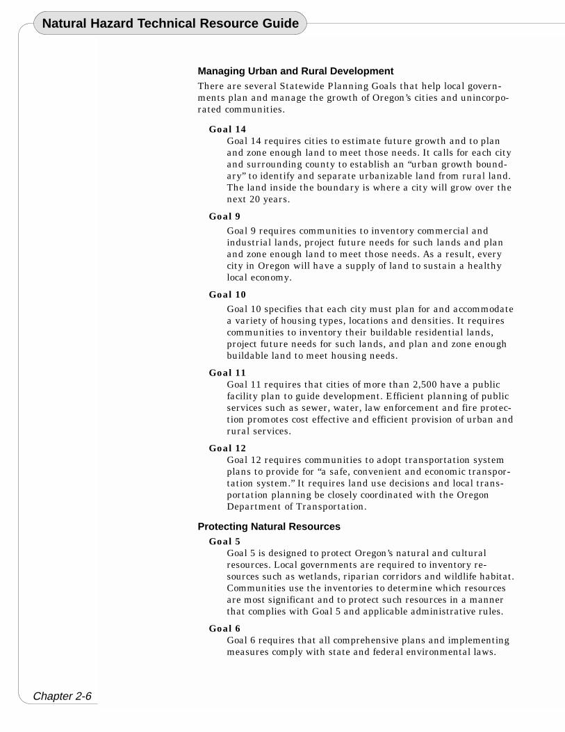
Goal 14Goal 14 requires cities to estimate future growth and to planand zone enough land to meet those needs. It calls for each cityand surrounding county to establish an “urban growth bound-ary” to identify and separate urbanizable land from rural land.The land inside the boundary is where a city will grow over thenext 20 years.
Goal 9Goal 9 requires communities to inventory commercial andindustrial lands, project future needs for such lands and planand zone enough land to meet those needs. As a result, everycity in Oregon will have a supply of land to sustain a healthylocal economy.
Goal 10Goal 10 specifies that each city must plan for and accommodatea variety of housing types, locations and densities. It requirescommunities to inventory their buildable residential lands,project future needs for such lands, and plan and zone enoughbuildable land to meet housing needs.
Goal 11Goal 11 requires that cities of more than 2,500 have a publicfacility plan to guide development. Efficient planning of publicservices such as sewer, water, law enforcement and fire protec-tion promotes cost effective and efficient provision of urban andrural services.
Goal 12Goal 12 requires communities to adopt transportation systemplans to provide for “a safe, convenient and economic transpor-tation system.” It requires land use decisions and local trans-portation planning be closely coordinated with the OregonDepartment of Transportation.
Protecting Natural ResourcesGoal 5
Goal 5 is designed to protect Oregon’s natural and culturalresources. Local governments are required to inventory re-sources such as wetlands, riparian corridors and wildlife habitat.Communities use the inventories to determine which resourcesare most significant and to protect such resources in a mannerthat complies with Goal 5 and applicable administrative rules.
Goal 6Goal 6 requires that all comprehensive plans and implementingmeasures comply with state and federal environmental laws.

Chapter 2-7
Planning for Natural Hazards:
Key Elements of a Comprehensive PlanGoal 7
Goal 7 addresses natural hazards. It requires that local gov-ernments apply “appropriate safeguards” when planning fordevelopment in areas of natural hazards, such as floodplainsand areas subject to landslides.
Goal 8Goal 8 calls for each community to evaluate its recreationalareas and facilities and develop plans to deal with the pro-jected demand for new recreational opportunities
Goal 13Goal 13 requires communities to manage and control theirlocal land uses in ways that promote energy conservation.
Goal 15Goal 15 establishes procedures to guide urban and ruraldevelopment along the Willamette River.
Managing Coastal and Ocean ResourcesGoal 16
Under Goal 16, LCDC classified Oregon’s 22 major estuariesinto three broad categories: natural, conservation and develop-ment. Coastal communities have adopted estuary plans tocomply with Goal 16.
Goal 17Goal 17 specifies how coastal shorelands and resources are tobe managed and protected.
Goal 18Goal 18 regulates development on beaches and dunes.
Goal 19Goal 19 is designed to “conserve the long-term values, benefitsand natural resources of the near-shore ocean and the conti-nental shelf.” It addresses issues such as dumping dredgespoils and discharging waste products into the open sea.

Natural Hazard Technical Resource Guide
Chapter 2-8
Implementing Measures/Ordinances
Plan Policies
Inventory/Factual Base
ComprehensivePlan Inventories:
“The findings, data,and technical analysis onwhich a plan’s policies arebased. In smaller jurisdictionsthe inventory material often isincluded in the same documentas the plan’s policies andadopted with them. The entiredocument then is described as‘the Plan’. In larger jurisdic-tions the inventory is usuallypresented in one or morevolumes separate from the planpolicies. The inventory andpolicies are usually adoptedtogether; however, communi-ties may adopt inventories andpolicies separately. State lawrequires communities formallyadopt both components intotheir comprehensive plans.
“The separate volumes ofinventory material are variouslydescribed as background reports,technical reports, or supportdocuments. Common synonymsfor ‘inventory’ include ‘factualbase,’ ‘data base,’ and ‘back-ground material.’ ”1
1. Rohse, M. (1987). Land-Use Planning inOregon: A No-Nonsense Handbook in PlainEnglish. Corvallis, OR: Oregon StateUniversity Press.
Sidebar
Section 2:Comprehensive Plans
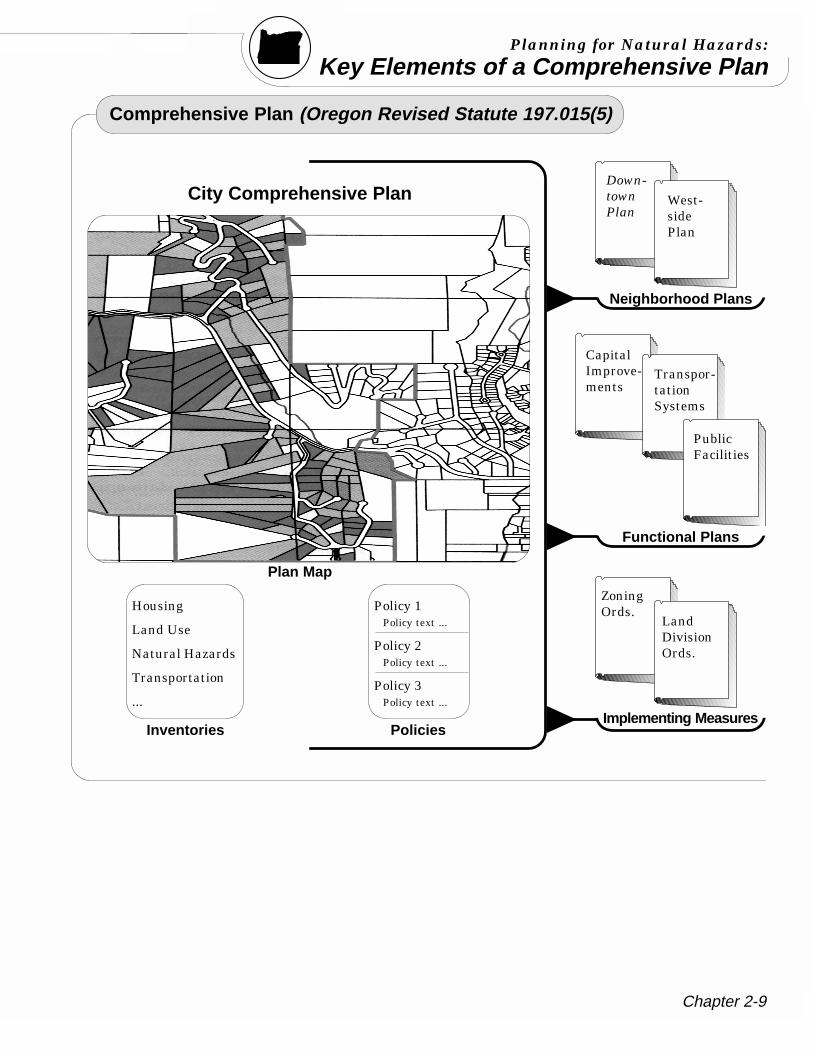
2.1 What is a Comprehensive Plan ?A comprehensive plan is an official document adopted by a city orcounty which sets forth the general, long range policies on how thecommunity’s future development should occur. Local plans must:
1) Address all the applicable topics in the Statewide PlanningGoals, as well as issues of local concern.
2) Anticipate and provide for future land use needs (20 years).3) Include plan elements corresponding to each statewide goal
(e.g., citizen involvement, agricultural lands, natural hazards,transportation, coastal resources, etc.).
4) All implementing measures must comply with the statewide goalsand be consistent with and carry out comprehensive plan policies.
2.1.1 The Key Components of a Plan Required by Statewide Goal 2A comprehensive land use plan combines the following:(1) An inventory of existing conditions (factual base);(2) General goals and objectives;(3) Policies; and(4) Implementing ordinances and regulations.
2.1.2 Components of the Comprehensive PlanThe diagrams on the next two pages illustrate the relationshipof the required components of a comprehensive plan.
Inventories provide the basis for plan policies. The term In-ventory is often used synonymously with factual base as acomprehensive plan component.
The figure below shows the relationship between the planinventory/factual base, plan policies, and implementing mea-sures. The figure is in the shape of a pyramid because eachsuccessive component is both dependent on, and more specificthen the previous component. The inventory factual baseprovides the basis and justification for plan policies. The planpolicies provide general guidance in review of land use pro-posal. The implementing measures/ordinances provide thespecific standards and criteria against which developmentproposals are reviewed.
Chapter 2-9
Planning for Natural Hazards:
Key Elements of a Comprehensive Plan
Comprehensive Plan (Oregon Revised Statute 197.015(5)
City Comprehensive Plan
Plan Map
Policies
Down-townPlan
Neighborhood Plans
CapitalImprove-ments
Functional Plans
Implementing Measures
Housing
Land Use
Natural Hazards
Transportation
...
Inventories
Policy 1Policy text ...
Policy 2Policy text ...
Policy 3Policy text ...
ZoningOrds.
LandDivisionOrds.
West-sidePlan
Transpor-tationSystems
PublicFacilities
Natural Hazard Technical Resource Guide
Chapter 2-10
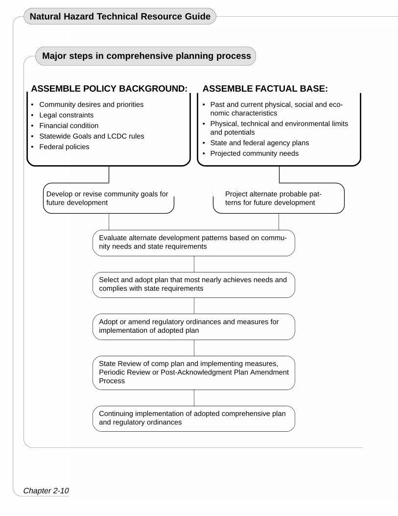
Major steps in comprehensive planning process
ASSEMBLE POLICY BACKGROUND:
• Community desires and priorities
• Legal constraints
• Financial condition
• Statewide Goals and LCDC rules
• Federal policies
Develop or revise community goals forfuture development
Evaluate alternate development patterns based on commu-nity needs and state requirements
ASSEMBLE FACTUAL BASE:
• Past and current physical, social and eco-nomic characteristics
• Physical, technical and environmental limitsand potentials
• State and federal agency plans
• Projected community needs
Project alternate probable pat-terns for future development
Select and adopt plan that most nearly achieves needs andcomplies with state requirements
Adopt or amend regulatory ordinances and measures forimplementation of adopted plan
State Review of comp plan and implementing measures,Periodic Review or Post-Acknowledgment Plan AmendmentProcess
Continuing implementation of adopted comprehensive planand regulatory ordinances

Chapter 2-11
Planning for Natural Hazards:
Key Elements of a Comprehensive Plan
The Three Levels of Hazard Assessment
Community-WideHazard Identification Risk Analysis
Community- WideVulnerability Assessment
The Factual Base“For natural hazards
to play a significantrole in land use managementdecisions, the factual basedetailing the nature andseverity of the hazard must beat least as credible as that forthe host of other issues that gointo determining appropriateland use… Hazard assessmentis the mechanism that providesthis factual basis.”2
Tip Box
Natural Hazards Inventory Checklist:Your communities inventory should contain the following
elements:
❐ Description of Each Hazard❐ History of Events for Each Hazard❐ Generalized Boundaries of All Known Hazards: flood, landslide,
slope, seismic, coastal, and wildfires.❐ Inventory of Critical Facilities, Lifelines and Other Key Facilities❐ A Vulnerability Assessment❐ A Risk Assessment
Tip Box
2.1.3 Inventories and Fact BaseWhile much of this chapter provides a broad discussion ofOregon’s Statewide Planning Program, this section focuses onapproaches to developing a natural hazards inventory. A thor-ough examination of factual base for natural hazards can foundin Cooperating with Nature: Confronting Natural Hazards withLand-Use Planning for Sustainable Communities.1 The follow-ing overview draws on information from that publication.
1) Community-Wide Hazard Identification is the basis forhazard assessment, and is commonly found in comprehensiveplans. It is the process of estimating the geographic extent ofthe hazard, its intensity, and its probability of occurrence.3
This process usually results in a hazard map. Such maps areeffective in providing information about the nature and extentof natural hazards.
Community-wide hazards maps provide a general outline ofareas where a more thorough review of development shouldoccur due to potential hazards. Overlay zones are often used torequire specific development review standards.
Using hazard maps at a scale of 1 inch to 2,000 feet usually issufficient for general land use planning and for decisions aboutlocating public facilities.4 Yet, it is not always possible todiscern the precise location of hazardous areas on specificparcels of property at this scale. To review development appli-cations at the specific parcel level, the maps should distinguishindividual parcels.
Natural Hazard Technical Resource Guide
Chapter 2-12
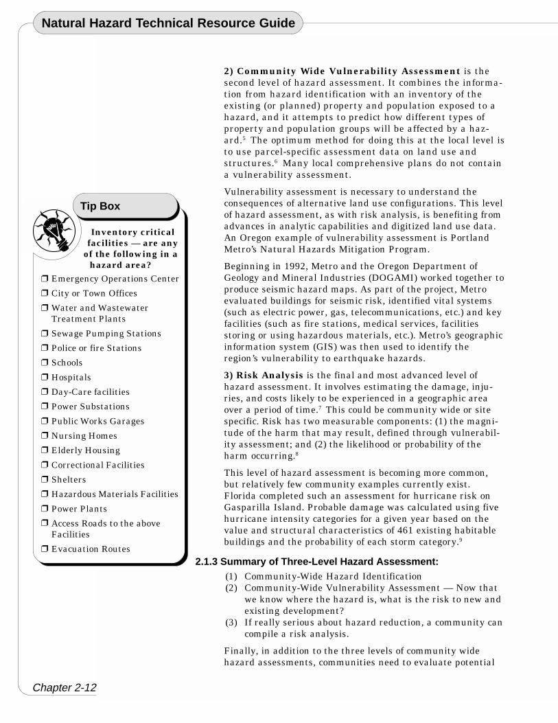
Inventory criticalfacilities — are any
of the following in ahazard area?
Emergency Operations Center
City or Town Offices
Water and WastewaterTreatment Plants
Sewage Pumping Stations
Police or fire Stations
Schools
Hospitals
Day-Care facilities
Power Substations
Public Works Garages
Nursing Homes
Elderly Housing
Correctional Facilities
Shelters
Hazardous Materials Facilities
Power Plants
Access Roads to the aboveFacilities
Evacuation Routes
Tip Box
❐
❐
❐
❐
❐
❐
❐
❐
❐
❐
❐
❐
❐
❐
❐
❐
❐
❐
2) Community Wide Vulnerability Assessment is thesecond level of hazard assessment. It combines the informa-tion from hazard identification with an inventory of theexisting (or planned) property and population exposed to ahazard, and it attempts to predict how different types ofproperty and population groups will be affected by a haz-ard.5 The optimum method for doing this at the local level isto use parcel-specific assessment data on land use andstructures.6 Many local comprehensive plans do not containa vulnerability assessment.
Vulnerability assessment is necessary to understand theconsequences of alternative land use configurations. This levelof hazard assessment, as with risk analysis, is benefiting fromadvances in analytic capabilities and digitized land use data.An Oregon example of vulnerability assessment is PortlandMetro’s Natural Hazards Mitigation Program.
Beginning in 1992, Metro and the Oregon Department ofGeology and Mineral Industries (DOGAMI) worked together toproduce seismic hazard maps. As part of the project, Metroevaluated buildings for seismic risk, identified vital systems(such as electric power, gas, telecommunications, etc.) and keyfacilities (such as fire stations, medical services, facilitiesstoring or using hazardous materials, etc.). Metro’s geographicinformation system (GIS) was then used to identify theregion’s vulnerability to earthquake hazards.
3) Risk Analysis is the final and most advanced level ofhazard assessment. It involves estimating the damage, inju-ries, and costs likely to be experienced in a geographic areaover a period of time.7 This could be community wide or sitespecific. Risk has two measurable components: (1) the magni-tude of the harm that may result, defined through vulnerabil-ity assessment; and (2) the likelihood or probability of theharm occurring.8
This level of hazard assessment is becoming more common,but relatively few community examples currently exist.Florida completed such an assessment for hurricane risk onGasparilla Island. Probable damage was calculated using fivehurricane intensity categories for a given year based on thevalue and structural characteristics of 461 existing habitablebuildings and the probability of each storm category.9
2.1.3 Summary of Three-Level Hazard Assessment:(1) Community-Wide Hazard Identification(2) Community-Wide Vulnerability Assessment — Now that
we know where the hazard is, what is the risk to new andexisting development?
(3) If really serious about hazard reduction, a community cancompile a risk analysis.
Finally, in addition to the three levels of community widehazard assessments, communities need to evaluate potential

Chapter 2-13
Planning for Natural Hazards:
Key Elements of a Comprehensive Planrisks from natural hazards when siting new development. Mostinventories conducted at community and/or regional scale lackthe detail for site-specific analysis. Therefore communities mayneed to require site specific evaluation in areas of knownhazards prior to allowing new development to proceed.
2.1.4 Site Specific Risk AnalysisCommunities can use a regulatory process to assist in evaluat-ing development in hazard-prone areas. If the site is locatedwithin the boundary of a known hazard area, the developer canbe required by local government regulations to retain a profes-sional to evaluate level of risk at the proposed site and providerecommendations on mitigation measures. During the review ofthe site development plan, planners must rely on detailedtechnical information to obtain the most accurate evaluation.
2.2 Why is Hazard Assessment Important?For natural hazards, hazard assessment provides a factual base; thefactual base is the supporting foundation for a comprehensive plan’spolicies and implementing measures. Ultimately, the more sophisti-cated the level of hazard assessment, the stronger the local support forpolicies and ordinances. An important consideration in hazard assess-ment is the level of precision needed to support decisions about whereto locate boundaries that determine allowable land uses or imposedifferent development regulations.10
2.3 What are the Challenges that Local Communities Face inDeveloping a Factual Base?Unfortunately, increasing the level of detail and the accuracy ofhazard identification and vulnerability assessment increases the costof completing the factual base. Your community will have to decidewhether the benefits of better information justify the cost. The level ofhazard assessment depends on the severity of the local hazard, avail-ability of community resources, and public support.
Another challenge for local communities may be the availability anduse of technology. Many local governments identify staff trainingamong the most serious problems they encounter in implementingGIS and other advanced technologies.11 The staff expertise availableto apply these techniques to natural hazards problems is likely tocontinue to be a major constraint in many jurisdictions.
In Oregon, educational resources like the Metro Area Disaster Geo-graphic Information System (MAD GIS) CD-ROM12 and the StateService Center for Geographic Information Systems (http://www.sscgis.state.or.us) are helpful tools in addressing this prob-lem. Also, local academic institutions may have faculty or studentswith technological expertise that could be utilized by local govern-ments in hazard assessment.
Natural Hazard Technical Resource Guide
Chapter 2-14
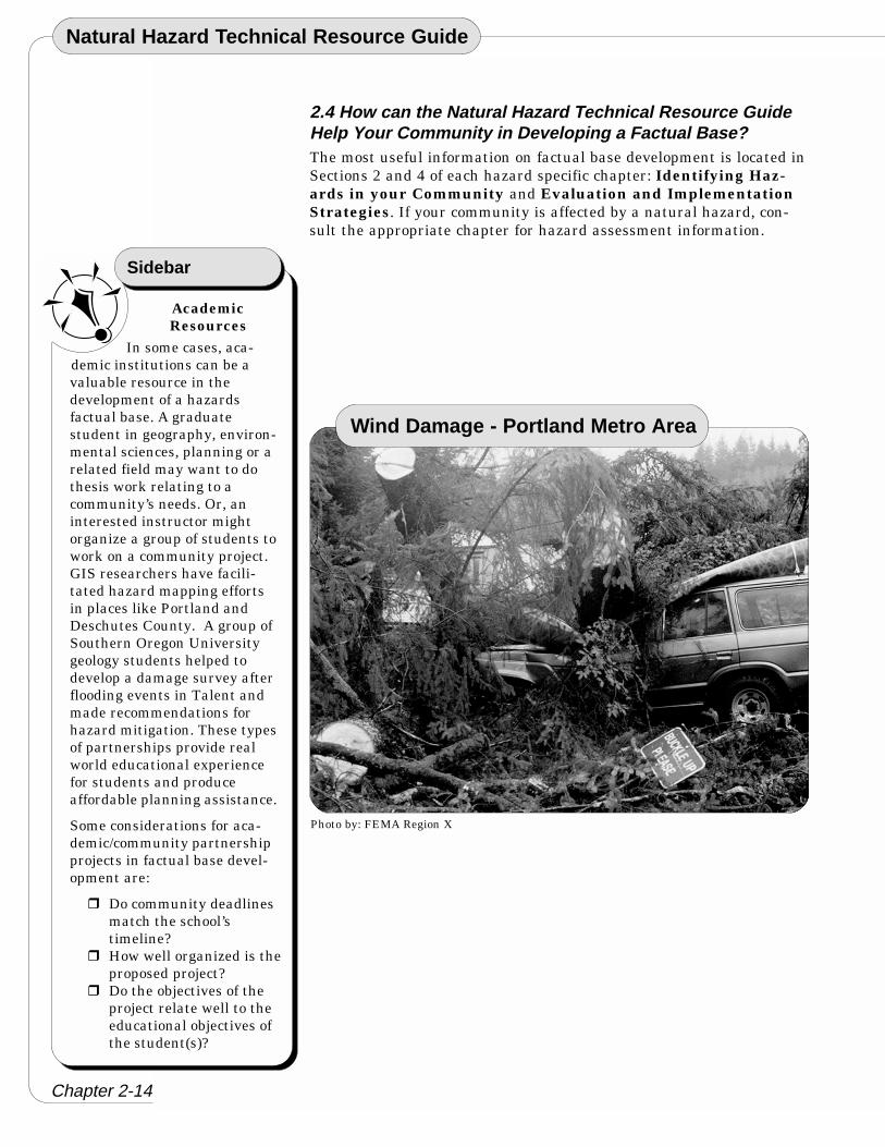
Photo by: FEMA Region X
Wind Damage - Portland Metro Area
AcademicResources
In some cases, aca-demic institutions can be avaluable resource in thedevelopment of a hazardsfactual base. A graduatestudent in geography, environ-mental sciences, planning or arelated field may want to dothesis work relating to acommunity’s needs. Or, aninterested instructor mightorganize a group of students towork on a community project.GIS researchers have facili-tated hazard mapping effortsin places like Portland andDeschutes County. A group ofSouthern Oregon Universitygeology students helped todevelop a damage survey afterflooding events in Talent andmade recommendations forhazard mitigation. These typesof partnerships provide realworld educational experiencefor students and produceaffordable planning assistance.
Some considerations for aca-demic/community partnershipprojects in factual base devel-opment are:
� Do community deadlinesmatch the school’stimeline?
� How well organized is theproposed project?
� Do the objectives of theproject relate well to theeducational objectives ofthe student(s)?
Sidebar
2.4 How can the Natural Hazard Technical Resource GuideHelp Your Community in Developing a Factual Base?The most useful information on factual base development is located inSections 2 and 4 of each hazard specific chapter: Identifying Haz-ards in your Community and Evaluation and ImplementationStrategies. If your community is affected by a natural hazard, con-sult the appropriate chapter for hazard assessment information.

Chapter 2-15
Planning for Natural Hazards:
Key Elements of a Comprehensive Plan
Techniques for Citizen Involvement
EmergencyManagement
Coordination withlocal emergency managers andhazard mitigation plans helpslocal governments avoid andminimize damage caused bynatural hazards. For moreinformation contact OregonEmergency Management athttp://www.osp.state.or.us/oem/ and the Oregon Emer-gency Management Associationat http://www.oregonemergency.com
Tip Box
Section 3:Key Participants: Citizens and Other Governments
3.1 Citizen InvolvementCitizen participation is a hallmark of Oregon’s planning program.Citizens must be kept informed under Goal 1. Each city and countyplan includes an adopted citizen involvement program which de-scribes how the public can participate in each phase of the planningprocess. Local governments must periodically evaluate their efforts toinvolve citizens, and, if necessary, update their programs.
3.2 CoordinationCoordination simply means that government agencies must consultwith one another before making land use decisions. The benefits areobvious: by working together, local government, special districts, andstate and federal agencies can make decisions that support one anotherand avoid unnecessary duplication or policy conflicts. For example,coordinated plans help ensure that public spending on roads, sewer,water and other facilities occurs both where and when it is needed.Each local government and state agency has a process for coordinatingits decisions with other units of government. This usually involvesmailing notices of pending decisions to other agencies and giving theman opportunity to comment. Under Oregon law, state agency actionsaffecting land use must be compatible with acknowledged city andcounty comprehensive plans.
For many land use decisions, public notice is printed in the newspa-per, and notices are mailed to surrounding property owners. In Or-egon, land use decisions are made in meetings that must be open tothe public. Some local governments use neighborhood or area advisorycommittees to review major land use issues and make recommenda-tions to the planning commission or elected officials.
Natural Hazard Technical Resource Guide
Chapter 2-16
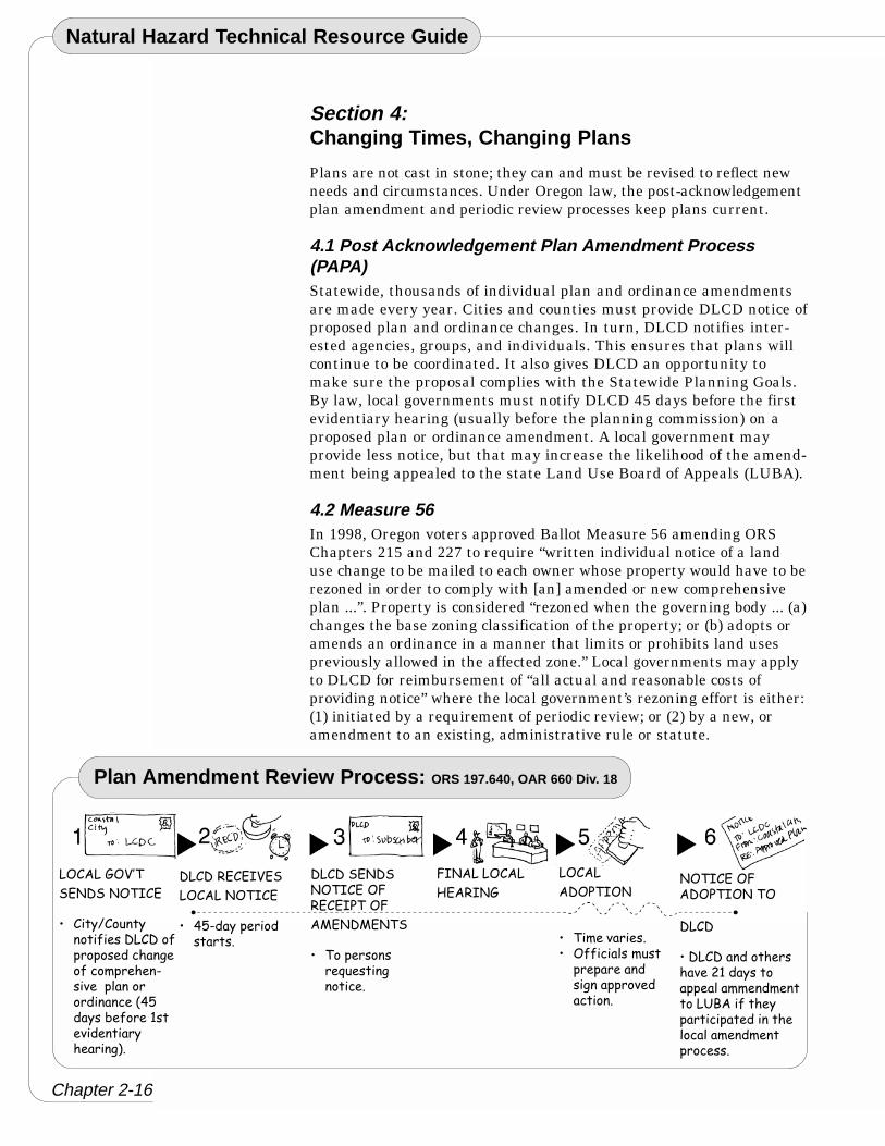
Plan Amendment Review Process: ORS 197.640, OAR 660 Div. 18
�&����2&34"
!$ �!� &"��$
� ���5��������-� �������-����� ������� �-������ � �.�� ����������������� ��61����7 -�� �' ��� ������ �����*�
������$�$�3$!
�&���� &"��$
� 61.����� �������
�����!$ �! &"��$�&8�$�$��"�&8
�+$ �+$ "!
� "��� ���� /� ������� �
8� ����&���
9$��� 2
�&���
��&�"�&
� "�� ����� �� &--���������� ��� �������������� �������
&"��$�&8��&�"�& �"&
����
������������� ���� �0'��������� ������ ��� ����#:���-�� ��������� ������ �������� ��� ����� �
Section 4:Changing Times, Changing Plans
Plans are not cast in stone; they can and must be revised to reflect newneeds and circumstances. Under Oregon law, the post-acknowledgementplan amendment and periodic review processes keep plans current.
4.1 Post Acknowledgement Plan Amendment Process(PAPA)Statewide, thousands of individual plan and ordinance amendmentsare made every year. Cities and counties must provide DLCD notice ofproposed plan and ordinance changes. In turn, DLCD notifies inter-ested agencies, groups, and individuals. This ensures that plans willcontinue to be coordinated. It also gives DLCD an opportunity tomake sure the proposal complies with the Statewide Planning Goals.By law, local governments must notify DLCD 45 days before the firstevidentiary hearing (usually before the planning commission) on aproposed plan or ordinance amendment. A local government mayprovide less notice, but that may increase the likelihood of the amend-ment being appealed to the state Land Use Board of Appeals (LUBA).
4.2 Measure 56In 1998, Oregon voters approved Ballot Measure 56 amending ORSChapters 215 and 227 to require “written individual notice of a landuse change to be mailed to each owner whose property would have to berezoned in order to comply with [an] amended or new comprehensiveplan ...”. Property is considered “rezoned when the governing body ... (a)changes the base zoning classification of the property; or (b) adopts oramends an ordinance in a manner that limits or prohibits land usespreviously allowed in the affected zone.” Local governments may applyto DLCD for reimbursement of “all actual and reasonable costs ofproviding notice” where the local government’s rezoning effort is either:(1) initiated by a requirement of periodic review; or (2) by a new, oramendment to an existing, administrative rule or statute.
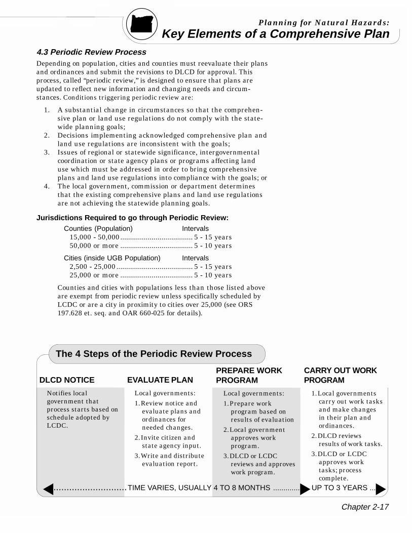
Chapter 2-17
Planning for Natural Hazards:
Key Elements of a Comprehensive Plan
The 4 Steps of the Periodic Review Process
DLCD NOTICE
Notifies localgovernment thatprocess starts based onschedule adopted byLCDC.
PREPARE WORKPROGRAM
Local governments:1.Prepare work
program based onresults of evaluation
2.Local governmentapproves workprogram.
3.DLCD or LCDCreviews and approveswork program.
EVALUATE PLAN
Local governments:1.Review notice and
evaluate plans andordinances forneeded changes.
2.Invite citizen andstate agency input.
3.Write and distributeevaluation report.
...............................TIME VARIES, USUALLY 4 TO 8 MONTHS ............... UP TO 3 YEARS ...
CARRY OUT WORKPROGRAM
1.Local governmentscarry out work tasksand make changesin their plan andordinances.
2.DLCD reviewsresults of work tasks.
3.DLCD or LCDCapproves worktasks; processcomplete.
4.3 Periodic Review ProcessDepending on population, cities and counties must reevaluate their plansand ordinances and submit the revisions to DLCD for approval. Thisprocess, called “periodic review,” is designed to ensure that plans areupdated to reflect new information and changing needs and circum-stances. Conditions triggering periodic review are:
1. A substantial change in circumstances so that the comprehen-sive plan or land use regulations do not comply with the state-wide planning goals;
2. Decisions implementing acknowledged comprehensive plan andland use regulations are inconsistent with the goals;
3. Issues of regional or statewide significance, intergovernmentalcoordination or state agency plans or programs affecting landuse which must be addressed in order to bring comprehensiveplans and land use regulations into compliance with the goals; or
4. The local government, commission or department determinesthat the existing comprehensive plans and land use regulationsare not achieving the statewide planning goals.
Jurisdictions Required to go through Periodic Review:Counties (Population) Intervals
15,000 - 50,000..................................... 5 - 15 years50,000 or more ..................................... 5 - 10 years
Cities (inside UGB Population) Intervals2,500 - 25,000 ....................................... 5 - 15 years25,000 or more ..................................... 5 - 10 years
Counties and cities with populations less than those listed aboveare exempt from periodic review unless specifically scheduled byLCDC or are a city in proximity to cities over 25,000 (see ORS197.628 et. seq. and OAR 660-025 for details).
Natural Hazard Technical Resource Guide
Chapter 2-18
Section 5:Plan Implementation
5.1 Local Planning Decisions ... Yes or No to Specific UsesPlan policies contain general decisions about what land uses gowhere. Policies generally include procedures and standards outlininghow subsequent planning decisions will be made. Actual developmentusually requires a permit or approval from the city or county to makesure the development meets plan policies and ordinance standards.
Most planning decisions are routine — they only involve a buildingpermit for a use allowed outright by the plan. Uses that are notpermitted outright are subject to more detailed review. Specificstandards for approving proposed land uses are stated in the develop-ment ordinance or the local plan. The public usually receives notice inadvance of this type of review. Such reviews give a city or county anopportunity to consider the details of a proposed use and how it fitswith the site and surrounding uses. They also provide an opportunityfor neighbors and the public to review and comment.
Some local land use decisions (e.g., zone changes) require post ac-knowledgment plan amendments (PAPA) requiring advance notice toDLCD prior to adoption.
The process for making land use decisions is designed to make surethat affected parties have an opportunity to comment and thatdecisions are made fairly. Check your local zoning ordinance forspecific requirements.
Chapter 2-19
Planning for Natural Hazards:
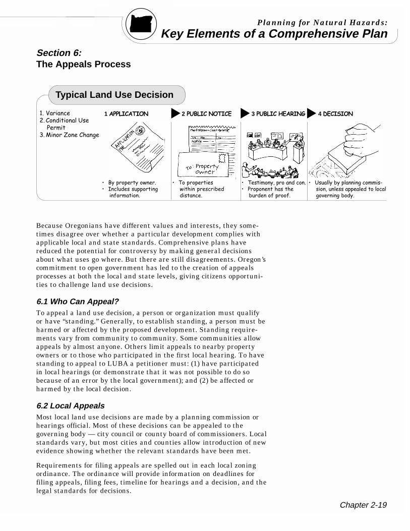
Key Elements of a Comprehensive Plan
Typical Land Use Decision
'� 3������ 0� �����������# � ���
;�+�����<�� ������
1����������� 2������������ 3������� ����� 4��������
� :������ ������ ��� ������ �����������-��������
� "������ �� �������� ���7 ������ �
� " �����=�������������� ������ ������ 7��� ���-�����-�
� #������7����������������.���=���� ���� �� ������������ ������7����
Section 6:The Appeals Process
Because Oregonians have different values and interests, they some-times disagree over whether a particular development complies withapplicable local and state standards. Comprehensive plans havereduced the potential for controversy by making general decisionsabout what uses go where. But there are still disagreements. Oregon’scommitment to open government has led to the creation of appealsprocesses at both the local and state levels, giving citizens opportuni-ties to challenge land use decisions.
6.1 Who Can Appeal?To appeal a land use decision, a person or organization must qualifyor have “standing.” Generally, to establish standing, a person must beharmed or affected by the proposed development. Standing require-ments vary from community to community. Some communities allowappeals by almost anyone. Others limit appeals to nearby propertyowners or to those who participated in the first local hearing. To havestanding to appeal to LUBA a petitioner must: (1) have participatedin local hearings (or demonstrate that it was not possible to do sobecause of an error by the local government); and (2) be affected orharmed by the local decision.
6.2 Local AppealsMost local land use decisions are made by a planning commission orhearings official. Most of these decisions can be appealed to thegoverning body — city council or county board of commissioners. Localstandards vary, but most cities and counties allow introduction of newevidence showing whether the relevant standards have been met.
Requirements for filing appeals are spelled out in each local zoningordinance. The ordinance will provide information on deadlines forfiling appeals, filing fees, timeline for hearings and a decision, and thelegal standards for decisions.
Natural Hazard Technical Resource Guide
Chapter 2-20
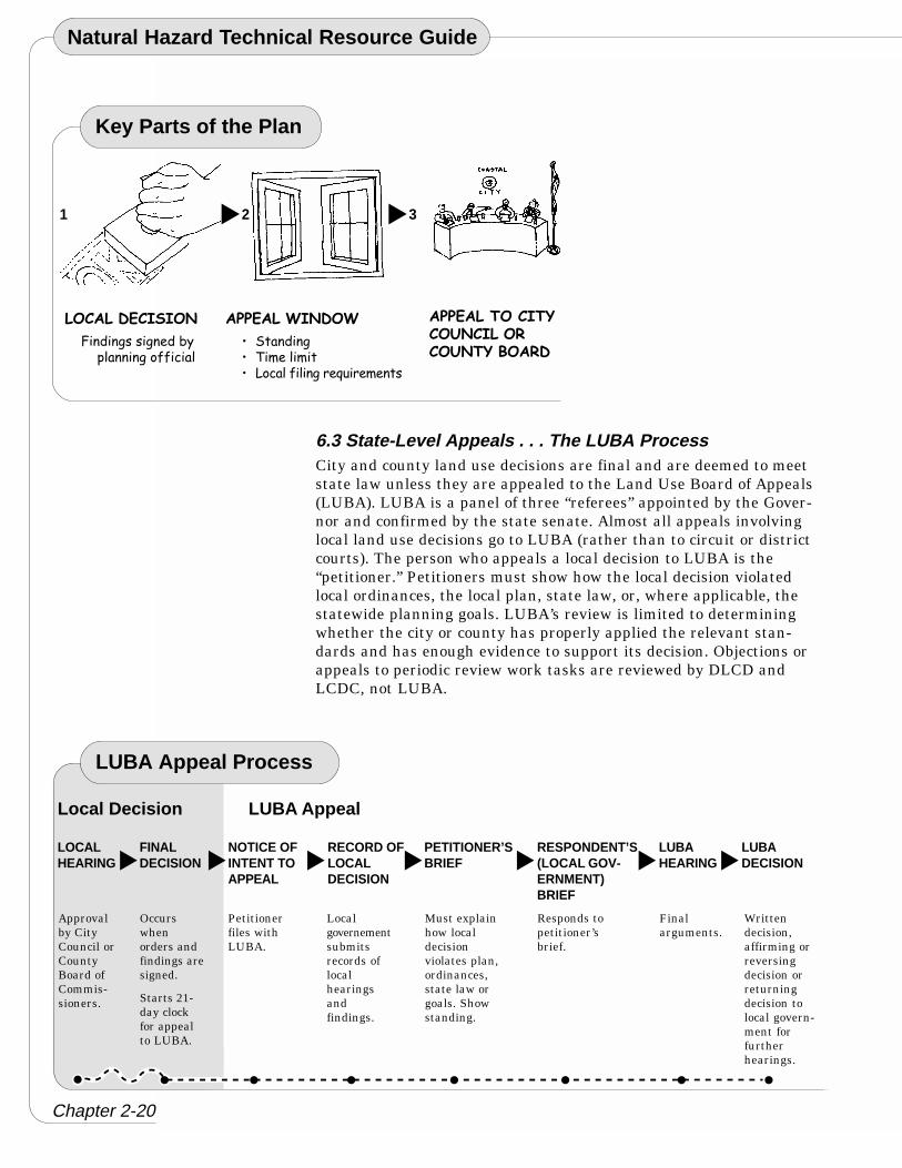
6.3 State-Level Appeals . . . The LUBA ProcessCity and county land use decisions are final and are deemed to meetstate law unless they are appealed to the Land Use Board of Appeals(LUBA). LUBA is a panel of three “referees” appointed by the Gover-nor and confirmed by the state senate. Almost all appeals involvinglocal land use decisions go to LUBA (rather than to circuit or districtcourts). The person who appeals a local decision to LUBA is the“petitioner.” Petitioners must show how the local decision violatedlocal ordinances, the local plan, state law, or, where applicable, thestatewide planning goals. LUBA’s review is limited to determiningwhether the city or county has properly applied the relevant stan-dards and has enough evidence to support its decision. Objections orappeals to periodic review work tasks are reviewed by DLCD andLCDC, not LUBA.
LUBA Appeal Process
LOCALHEARING
FINALDECISION
NOTICE OFINTENT TOAPPEAL
Local Decision LUBA Appeal
RECORD OFLOCALDECISION
PETITIONER’SBRIEF
RESPONDENT’S(LOCAL GOV-ERNMENT)BRIEF
LUBAHEARING
LUBADECISION
Approvalby CityCouncil orCountyBoard ofCommis-sioners.
Occurswhenorders andfindings aresigned.
Starts 21-day clockfor appealto LUBA.
Petitionerfiles withLUBA.
Localgovernementsubmitsrecords oflocalhearingsandfindings.
Must explainhow localdecisionviolates plan,ordinances,state law orgoals. Showstanding.
Responds topetitioner’sbrief.
Finalarguments.
Writtendecision,affirming orreversingdecision orreturningdecision tolocal govern-ment forfurtherhearings.
Key Parts of the Plan
2 3
�������������
8���������� ��7�����������--�����
������������
� !������� "�� ������ ������-������� /��� � �
��������������
��������
����������
1
Chapter 2-21
Planning for Natural Hazards:
Key Elements of a Comprehensive PlanSection 7:Additional Information on Land Use Planningin Oregon
As mentioned at the beginning of this document, Oregon’s land useplanning program is a working partnership between the state andcities and counties. The statewide land use program is really a net-work of 277 state-approved city and county comprehensive plans.Plans reflect the interests of both local communities and the state. Asinterests change, so too must the plans. The Department of LandConservation and Development provides both funds and technicalassistance to help Oregon’s local government maintain their compre-hensive plans. The following section describes some of DLCD’s otheractivities and provides information on how to contact the agency.
DLCD provides grants to local governments to help them with plan-ning issues. These funds may be used to conduct inventories, reviseplans and ordinances, implement programs and conduct periodicreviews of their comprehensive plans.
Technical assistance to local governments is one of DLCD’s mostimportant functions. Assistance is provided by technical specialistsbased in Salem and by regional representatives in Bend, CentralPoint and Portland. Assistance includes conducting workshops,publishing technical bulletins and public outreach materials, andproviding responses to written and phone requests for land useplanning information. DLCD provides information to local govern-ments and the public regarding changes to land use statutes andadministrative rules. DLCD’s website provides more, up-to-dateinformation in an easily accessible format.
One of DLCD’s primary technical-assistance responsibilities is towork with local governments to ensure that local comprehensive plansare up-to-date.
Natural Hazard Technical Resource Guide
Chapter 2-22
DLCD participates with four other state agencies (Department ofTransportation, Environmental Quality, Economic and CommunityDevelopment, and Housing and Community Services) as part of theCommunity Solutions Team (CST). The purpose of the CST is tocoordinate state agency programs, investments and actions with stateand local growth management objectives. Currently, there are nine (9)regional CSTs made up of field staff from each of the five agencies.
For additional information regarding DLCD and its programs, pleasecontact the department at: 503-373-0050.
Fax: 503-378-6033
DLCD also has several field offices:
Bend 541-388-6424 or 541-388-6157.Fax: 541-388-6480
Central Point 541-858-3152Fax: 541-858-3142
Portland 503-731-4065Fax: 503-731-4068
Written requests for information can be sent to:
Oregon Department of Land Conservation and Development, 635Capitol Street NE Suite 150, Salem, Oregon 97301.
Copies of state land use statutes, statewide planning goals and LCDCadministrative rules and information about DLCD’s program andpublications are available on the department’s web site atwww.lcd.state.or.us.
Chapter 2-23
Planning for Natural Hazards:
Key Elements of a Comprehensive PlanKey Elements of a Comprehensive Plan Endnotes:1 Burby, R. (Ed.). (1998). Cooperating with Nature. Washington, D.C.: Joseph Henry Press.
2 Deyle, R., French, S., Olshansky, R., & Paterson, R. (1998). Hazard assessment: the factual basis forplanning and mitigation. In R. Burby (Ed.), Cooperating with Nature. (pp. 119-166). Washington,D.C.: Joseph Henry Press.
3 (ibid.)
4 (ibid.)
5 (ibid.)
6 (ibid.)
7 (ibid.)
8 (ibid.)
9 (ibid.)
10 (ibid.)
11 French, S., & Wiggins, L. (1989). Computer adoption and use in California planning agencies:implications for education. Journal of Planning Education and Research, 8(2), 97-107.
12 Metro. (1997). Metro Area Disaster Geographic Information System: GIS Tools for EmergencyManagement Planning. Portland, OR.