planning department phone: (760) 878-0263 168 north
TRANSCRIPT

Planning Department
168 North Edwards Street
Post Office Drawer L
Independence, California 93526
Phone: (760) 878-0263
FAX: (760) 872-2712
E-Mail: [email protected]
AGENDA ITEM NO.: 7 (Action Item – Public Hearing)
PLANNING COMMISSION
MEETING DATE: May 27, 2020
SUBJECT: Telecommunications Plan Update 2020-
01/Smartlink -ATT
EXECUTIVE SUMMARY
Smartlink LLC, representing ATT, has submitted an application to update ATT’s existing
Telecom Plan to add a co-location site on an already approved and built tower. ATT’s current
plan (adopted in April of 2003) includes a total of eleven existing wireless communication
facilities. Six of these were approved in the 2003 plan. Others were approved under different
carriers subsequently bought out by ATT and some are co-located on SBA, an independent
owner’s, towers. The current ATT network consists of the eleven sites within Inyo County with
one of them located inside the Bishop City limits and not under the County’s jurisdiction. This
application is to update the current ATT Wireless Telecommunications Plan to include a co-
location site in west Bishop on a tower recently approved for and built by Verizon Wireless. The
update to ATT’s telecom plan also includes a future site within the Bishop City limits. ATT is
required to include this site in their telecom plan, but the County has no jurisdiction over its
approval. This project is Exempt for CEQA.
PROJECT INFORMATION
Supervisory District: 2
Applicants: ATT, represented by Smartlink, LLC
Landowners: The tower is owned by Verizon Wireless, who leases the pole
site from Alice and Richard Cassel.
Address/Community: 950 Tu Su Lane, Bishop
A.P.N.: 011-120-64
2
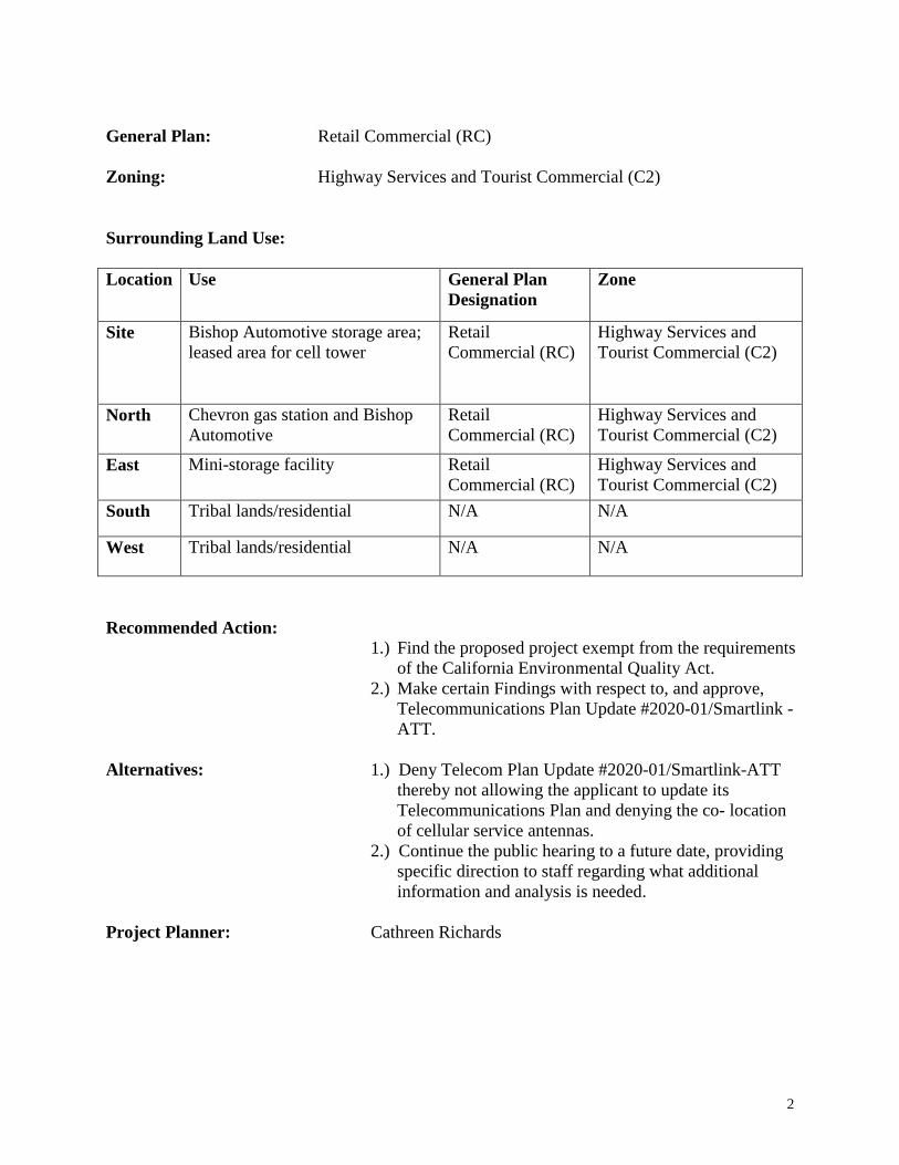
General Plan: Retail Commercial (RC)
Zoning: Highway Services and Tourist Commercial (C2)
Surrounding Land Use:
Location Use General Plan
Designation
Zone
Site Bishop Automotive storage area;
leased area for cell tower
Retail
Commercial (RC)
Highway Services and
Tourist Commercial (C2)
North Chevron gas station and Bishop
Automotive
Retail
Commercial (RC)
Highway Services and
Tourist Commercial (C2)
East Mini-storage facility Retail
Commercial (RC)
Highway Services and
Tourist Commercial (C2)
South Tribal lands/residential N/A N/A
West Tribal lands/residential N/A N/A
Recommended Action:
1.) Find the proposed project exempt from the requirements
of the California Environmental Quality Act.
2.) Make certain Findings with respect to, and approve,
Telecommunications Plan Update #2020-01/Smartlink -
ATT.
Alternatives: 1.) Deny Telecom Plan Update #2020-01/Smartlink-ATT
thereby not allowing the applicant to update its
Telecommunications Plan and denying the co- location
of cellular service antennas.
2.) Continue the public hearing to a future date, providing
specific direction to staff regarding what additional
information and analysis is needed.
Project Planner: Cathreen Richards

3
BACKGROUND
Project Description
This is a request for the approval of an update to ATT’s existing telecommunications plan on file
with the County. Smartlink, LLC has submitted an application to the County for a building
permit to: co-locate a new 15’x30’ equipment area for a generator and electrical equipment
cabinets; add nine 6’antennas and add one microwave antenna to an existing 100’ mono-pine-
pole located at 950 Tu Su Lane in the community of west Bishop. This location is not included in
the approved ATT telecom plan on file with the County, which makes this update necessary per
the County’s Telecommunications Ordinance and that requires approval by the Planning
Commission.
Inyo County Code
Wireless Communication in Inyo County is governed by Chapter 18.76 of the Inyo County Code
– Regulation of Wireless Communication Facilities. Section 18.76.050(A) requires all
Telecommunications Plans in the County be approved by the Planning Commission and under
18.76.050(K) it requires that once they are approved, any amendments to telecommunications
plans must also be approved by the Planning Commission. It also establishes that in considering
an amendment, the planning commission shall be guided by the relevant portions of Chapter
18.76. In this particular case the applicant has provided the materials needed to address the
relevant portions with regard to the plan update (Plan Update attached). This project is designed
to fill service gaps between existing telecommunication’s sites, specifically in the Bishop area.
Under Chapter 18.76, the County encourages the placement and joint use or “co-location” of
wireless communications facilities on existing structures, as opposed to the construction of new
structures and facilities.
STAFF ANALYSIS
General Plan Consistency
The Inyo County General Plan designates this site as Retail Commercial (RC). The RC
designation provides for retail and wholesale commercial uses, service uses, offices, public and
quasi-public uses, and similar and compatible uses. The communications facility is consistent
with the use as a quasi-public use for utility provision.
In addition to the General Plan land use designation, the proposed project is consistent with the
following two General Plan Policies, which are located within the Public Services & Utilities
Element:
1. Policy PSU 7.1: Provision of Services: The County shall encourage the provision of
communications and telecommunications service and facilities to serve existing and
future needs.
2. Policy PSU 7.5: Communication Towers: The County shall require compliance with the
Wireless Communications Guidelines for siting of communication towers in
unincorporated areas of the County.
4
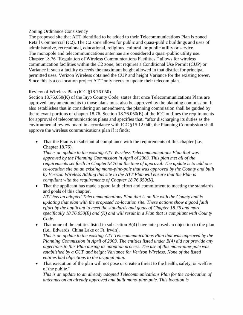
Zoning Ordinance Consistency
The proposed site that ATT identified to be added to their Telecommunications Plan is zoned
Retail Commercial (C2). The C2 zone allows for public and quasi-public buildings and uses of
administrative, recreational, educational, religious, cultural, or public utility or service.
The monopole and telecommunications antennae are considered a quasi-public utility use.
Chapter 18.76 “Regulation of Wireless Communications Facilities,” allows for wireless
communication facilities within the C2 zone, but requires a Conditional Use Permit (CUP) or
Variance if such a facility exceeds the maximum height allowed in that district for principal
permitted uses. Verizon Wireless obtained the CUP and height Variance for the existing tower.
Since this is a co-location project ATT only needs to update their telecom plan.
Review of Wireless Plan (ICC §18.76.050)
Section 18.76.050(K) of the Inyo County Code, states that once Telecommunications Plans are
approved, any amendments to those plans must also be approved by the planning commission. It
also establishes that in considering an amendment, the planning commission shall be guided by
the relevant portions of chapter 18.76. Section 18.76.050(E) of the ICC outlines the requirements
for approval of telecommunications plans and specifies that, “after discharging its duties as the
environmental review board in accordance with ICC §15.12.040, the Planning Commission shall
approve the wireless communications plan if it finds:
That the Plan is in substantial compliance with the requirements of this chapter (i.e.,
Chapter 18.76).
This is an update to the existing ATT Wireless Telecommunications Plan that was
approved by the Planning Commission in April of 2003. This plan met all of the
requirements set forth in Chapter18.76 at the time of approval. The update is to add one
co-location site on an existing mono-pine-pole that was approved by the County and built
by Verizon Wireless Adding this site to the ATT Plan will ensure that the Plan is
compliant with the requirements of Chapter 18.76.050(K).
That the applicant has made a good faith effort and commitment to meeting the standards
and goals of this chapter.
ATT has an adopted Telecommunications Plan that is on file with the County and is
updating that plan with the proposed co-location site. These actions show a good faith
effort by the applicant to meet the standards and goals of Chapter 18.76 and more
specifically 18.76.050(E) and (K) and will result in a Plan that is compliant with County
Code.
That none of the entities listed in subsection B(4) have interposed an objection to the plan
(i.e., Edwards, China Lake or Ft. Irwin).
This is an update to the existing ATT Telecommunications Plan that was approved by the
Planning Commission in April of 2003. The entities listed under B(4) did not provide any
objections to this Plan during its adoption process. The use of this mono-pine-pole was
established by a CUP and height Variance for Verizon Wireless. None of the listed
entities had objections to the original plan.
That execution of the plan will not pose or create a threat to the health, safety, or welfare
of the public.”
This is an update to an already adopted Telecommunications Plan for the co-location of
antennas on an already approved and built mono-pine-pole. This location is
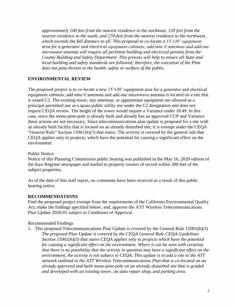
5
approximately 180 feet from the nearest residence to the northeast, 120 feet from the
nearest residence to the south, and 270-feet from the nearest residence to the northwest,
which exceeds the fall distance to all. This proposal to co-locate a 15’x30’ equipment
area for a generator and electrical equipment cabinets; add nine 6’antennas and add one
microwave antenna will require all pertinent building and electrical permits from the
County Building and Safety Department. This process will help to ensure all State and
local building and safety standards are followed; therefore, the execution of the Plan
does not pose threats to the health, safety or welfare of the public.
ENVIRONMENTAL REVIEW
The proposed project is to co-locate a new 15’x30’ equipment area for a generator and electrical
equipment cabinets; add nine 6’antennas and add one microwave antenna is located on a site that
is zoned C2. The existing tower, any antennas, or appurtenant equipment are allowed as a
principal permitted use as a quasi-public utility use under the C2 designation and does not
require CEQA review. The height of the tower would require a Variance under 18.49. In this
case, since the mono-pine-pole is already built and already has an approved CUP and Variance
these actions are not necessary. Since telecommunications plan update is proposed for a site with
an already built facility that is located on an already disturbed site, it is exempt under the CEQA
“General Rule” Section 15061(b)(3) that states: The activity is covered by the general rule that
CEQA applies only to projects, which have the potential for causing a significant effect on the
environment.
Public Notice:
Notice of this Planning Commission public hearing was published in the May 16, 2020 edition of
the Inyo Register newspaper and mailed to property owners of record within 300 feet of the
subject properties.
As of the date of this staff report, no comments have been received as a result of this public
hearing notice.
RECOMMENDATIONS
Find the proposed project exempt from the requirements of the California Environmental Quality
Act; make the findings specified below; and, approve the ATT Wireless Telecommunications
Plan Update 2020-01 subject to Conditions of Approval.
Recommended Findings
1. This proposed Telecommunications Plan Update is covered by the General Rule 15061(b)(3)
The proposed Plan Update is covered by the CEQA General Rule CEQA Guidelines
Section 15061(b)(3) that states CEQA applies only to projects which have the potential
for causing a significant effect on the environment. Where it can be seen with certainty
that there is no possibility that the activity in question may have a significant effect on the
environment, the activity is not subject to CEQA. This update is to add a site to the ATT
network outlined in the ATT Wireless Telecommunications Plan that is co-located on an
already approved and built mono-pine-pole on an already disturbed site that is graded
and developed with an existing tower, an auto repair shop, and parking area.

6
2. The proposed Telecom Plan Update is consistent with the Inyo County General Plan.
The Plan Update conforms to the land use designation of Retail Commercial that allows
for quasi-public uses. The communications facility is consistent as a quasi-public use for
utility provision.
The Plan Update also complies with Policy PSU 7.1: Provision of Services: The County
shall encourage the provision of communications and telecommunications service and
facilities to serve existing and future needs; and, Policy PSU 7.5: Communication
Towers: The County shall require compliance with the Wireless Communications
Guidelines for siting of communication towers in unincorporated areas of the County.
3. The proposed Telecom Plan is consistent with the Inyo County Zoning Chapter 18.48
Highway Services and Tourist Commercial (C2).
The Telecom Plan Update, as proposed, meets all the requirements of Chapter 18.48 of
the Inyo County Code, and the required findings as set forth in ICC §18.76 as described
above.
4. This Commission further finds that the proposed Telecom Plan is consistent with Chapter
18.76 of the ICC required findings as discussed above:
a. That the plan is in substantial compliance with the requirements of this chapter;
b. That the applicant has made a good faith effort and commitment to meeting the
standards and goals of this chapter;
c. That none of the entities listed in subsection B.4. (military) have objected to the
plan; and
d. That execution of the plan will not pose or create a threat to the health, safety, or
welfare of the public.
5. This Commission further finds that the existing public and private services are adequate
to meet the requirements of the proposed Telecom Plan without the need for their
expansion.
All services are currently in place at the pre-existing tower site proposed in the Telecom
Plan update, including electrical power and roadway access. This project will not result
in the expansion of existing services, nor require the development of additional services,
the construction of which could cause significant environmental effects.
Recommended Conditions of Approval for Telecommunications Plan Update #2020-01/Smart
Link
1. Hold Harmless:
The applicant, landowner, and/or operator shall defend, indemnify and hold harmless
Inyo County, its agents, officers and employees from any claim, action, or proceeding
against the County, its advisory agencies, appeal boards, or its legislative body
concerning said approval of Telecommunications Plan Update #2020-01/Smart Link.
2. Conformance with Approved Wireless Telecom Plan:
All subsequent development of wireless communications facilities under this Telecom
Plan including this update shall be in substantial conformance with the approved ATT

7
Telecommunications Plan. If future proposals are not in substantial conformance with the
approved Plan, a request for approval of a modification to the approved Plan shall be
submitted to the Planning Commission for approval prior to consideration of any
subsequent applications, or development of wireless communications facilities in Inyo
County.
ATTACHMENT:
ATT Proposed Telecom Plan Update

Smartlink, LLC
3300 Irvine Ave Suite #300
Newport Beach, CA 92660
AT&T Wireless
Wireless Communications Plan – Inyo County, California
[-Proposed Network Design for Inyo County-]
September 4, 2002
Revised 2/14/03
Revised 3/30/20
On Behalf of

1.0 Introduction
AT&T is one of several providers licensed by the Federal Communications Commission to provide cellular service to the County of Inyo. AT&T Wireless (“AW”) is federally mandated to provide coverage in areas where it is a licensee.
Currently, AW has eleven (11) wireless communications facilities in Inyo County.
Through this existing and revised Wireless Service Telecom Plan and its accompanying applications, AT&T is continuing its commitment to provide its services throughout this region to help ensure wireless communications access to emergency and public safety personnel. This includes AT&T’s win of a bid from the US Federal Government for FirstNet, a proprietary network frequency solely for First Responders and law enforcement. Significant planning has gone into the network’s design for FirstNet, and for Inyo County to ensure the existing and proposed facilities will benefit the health, welfare, safety and convenience of Inyo County residents as well as those who visit and/or do business in the County.
2.0 Network Development Summary
To continue addressing consumer demand and the growing need of wireless service in Inyo County, AT&T (*Smartlink on behalf of AT&T*) is proposing the development of two (2) wireless telecommunication facilities: one as a collocation on an existing Verizon mono-pine at 950 North Tu Su Lane, Bishop, CA 93514 and another at 993 North Main Street, Bishop, CA 93514 that is not being processed by Smartlink, LLC.
As a wireless service provider the focus of AW’s network deployment is on the use on the use of collocation on existing structures. Existing wireless facilities, commercial, or industrial buildings and public utility structures, such as, water tanks and electric utility poles are sought as the primary candidates for wireless sites due to their minimal visual impacts.
AW, through its turf vendor for leasing and entitlements, Smartlink LLC, is pursuing the least visually obtrusive means of filling a significant gap in coverage for its Inyo County network. An existing facility which was structurally capable, land use compliant, radio frequency engineering feasible and within AW’s business parameters were selected. The result of this diligence results in AT&T CSL02817 at North Tu Su Lane as a collocation.
3.0 Project Objectives
A wireless carrier requires the installation of a cell site within a specified area to close a “significant gap in coverage.” Other criteria for selecting sites include the following:
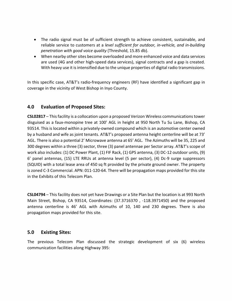
• The radio signal must be of sufficient strength to achieve consistent, sustainable, and reliable service to customers at a level sufficient for outdoor, in-vehicle, and in-building penetration with good voice quality (Threshold, 15.85 db).
• When nearby other sites become overloaded and more enhanced voice and data services are used (4G and other high-speed data services), signal contracts and a gap is created. With heavy use it is intensified due to the unique properties of digital radio transmissions.
In this specific case, AT&T’s radio-frequency engineers (RF) have identified a significant gap in coverage in the vicinity of West Bishop in Inyo County.
4.0 Evaluation of Proposed Sites:
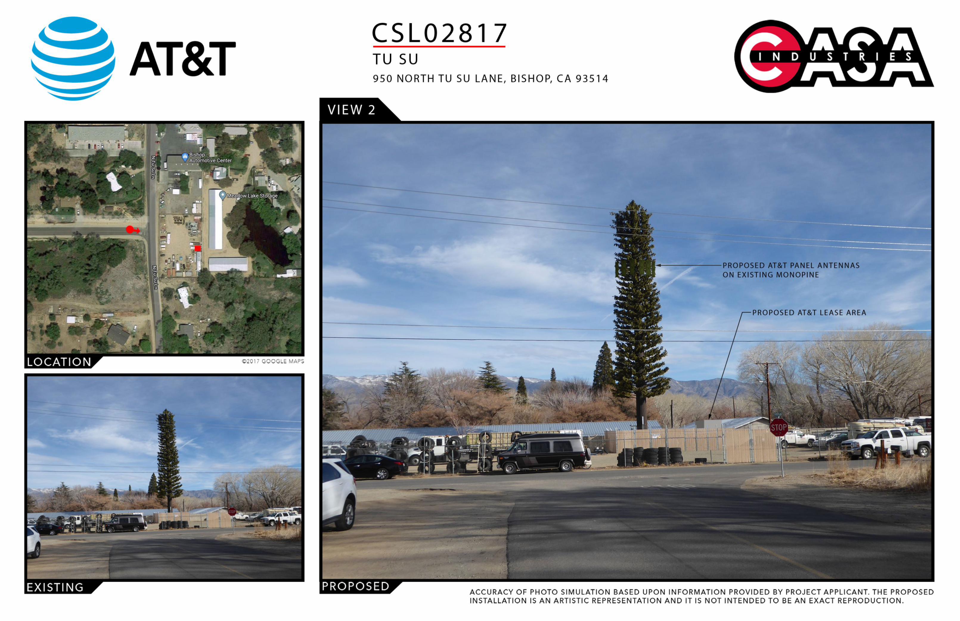
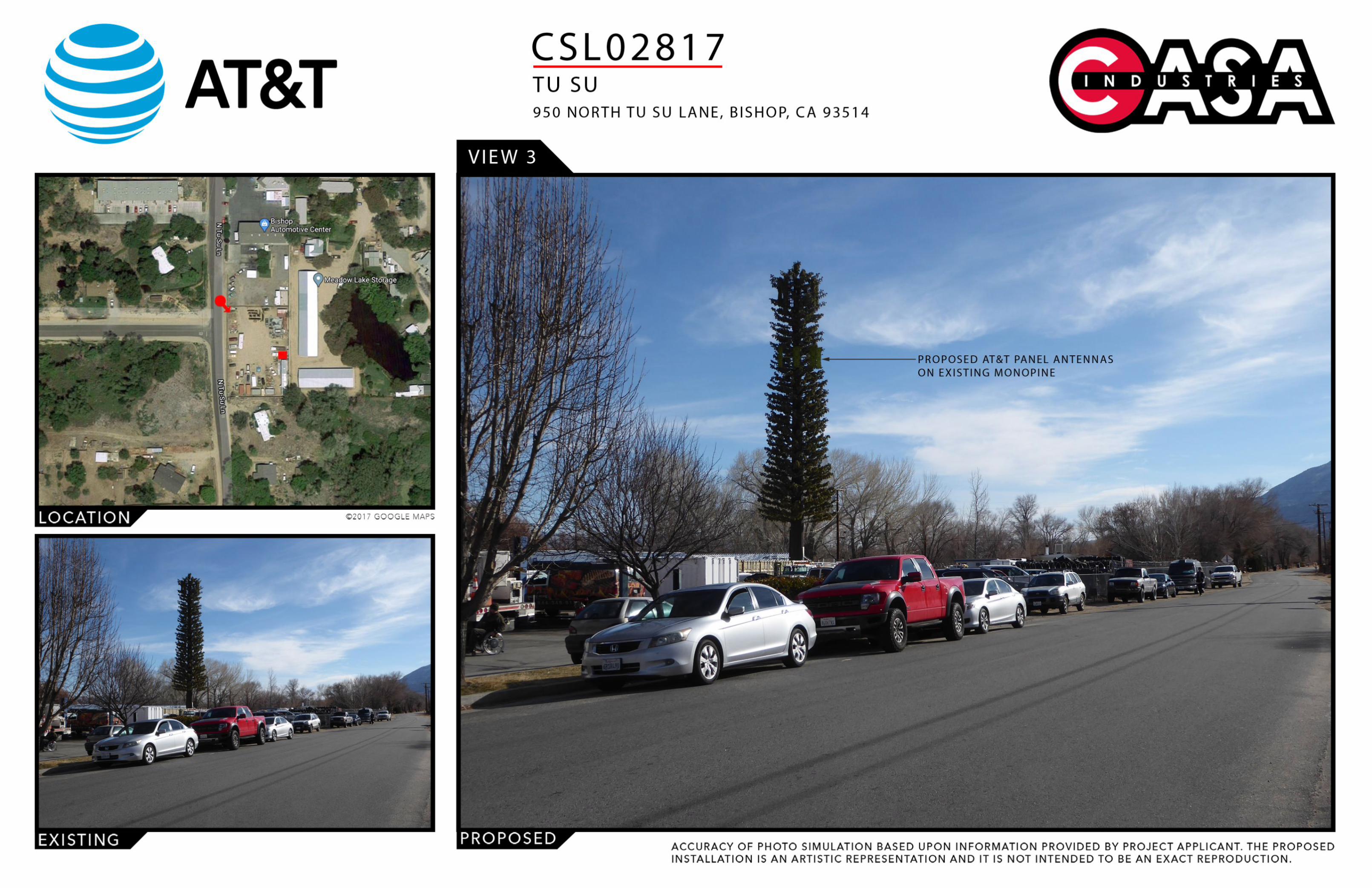
CSL02817 – This facility is a collocation upon a proposed Verizon Wireless communications tower disguised as a faux-monopine tree at 100’ AGL in height at 950 North Tu Su Lane, Bishop, CA 93514. This is located within a privately-owned compound which is an automotive center owned by a husband and wife as joint tenants. AT&T’s proposed antenna height centerline will be at 73’ AGL. There is also a potential 2’ Microwave antenna at 65’ AGL. The Azimuths will be 35, 225 and 300 degrees within a three (3) sector, three (3) panel antennae per Sector array. AT&T’s scope of work also includes: (1) DC Power Plant, (1) FIF Rack, (1) GPS antenna, (3) DC-12 outdoor units, (9) 6’ panel antennas, (15) LTE RRUs at antenna level (5 per sector), (4) Dc-9 surge suppressors (SQUID) with a total lease area of 450 sq ft provided by the private ground owner. The property is zoned C-3 Commercial. APN: 011-120-64. There will be propagation maps provided for this site in the Exhibits of this Telecom Plan.
CSL04794 – This facility does not yet have Drawings or a Site Plan but the location is at 993 North Main Street, Bishop, CA 93514, Coordinates: (37.3716370 , -118.3971450) and the proposed antenna centerline is 46’ AGL with Azimuths of 10, 140 and 230 degrees. There is also propagation maps provided for this site.
5.0 Existing Sites:
The previous Telecom Plan discussed the strategic development of six (6) wireless communication facilities along Highway 395:

(Table 1)
The relationship between these 6 initially applied sites is they complement and amplify each other along the 395 Freeway. See attached Propagation Maps from the older Telecom Plan to understand this relationship better. Antennas need a line of sight to neighboring towers and to be connected to 3 other sites simultaneously to create a honeycomb connection to the area between and around the towers. Thus all 6 of these are linked along the freeway to create a vertical area of coverage along the highway its installed in. This network has been successful in providing reliable coverage to the area.

This is an updated list of the current on-air sites in Inyo County:
Site ID ADDRESS CITY COUNTY STATE ZIP FA Antenna size/Type
Design Configuration
CSL01028 LONE PINE NARROW GAUGE ROAD
LONE PINE INYO CA 93545 10139957 4' panel 3 sectors @ 130'
CSL01012 SW 1/4 NW 1/4 S 19 T 6 S R 35 E
BISHOP INYO CA 93514 10139951 2' panel 3 sectors @ 23'
CSL01052 TOWNSHIP 16 STATE LONE PINE INYO CA 93545 10139959 8' Omni & 4' panel
2 Sectors @ 33'
CSL01027 155 PIONEER LANE BISHOP INYO CA 93514 10139950 8' panel 3 Sectors @ 183'
CSL01015 801 REDDING CANYON ROAD
BISHOP INYO CA 93514 10068052 8' panel 3 Sectors @ 57'
CSL01031 HIGHWAY 395 AND LITTLE LAKE ROAD
LITTLE LAKE INYO CA 93542 10094644 8' panel 3 Sectors @ 70'
CSL01030 50 GIL STATION ROAD LONE PINE INYO CA 93545 10086810 8' panel 2 Sectors @ 149'
CSL01029 1241 SAGE FLAT ROAD OLANCHA INYO CA 93549 10094643 6' panel 3 sectors @ 131'
CSL01022 1090 MAZOURKA CANYON INDEPENDENCE INYO CA 93526 10068054 6' panel 3 sectors @ 134'
CSL01019 700 POVERTY HILLS ROAD BIG PINE INYO CA 93513 10068053 8' panel 3 Sectors @ 105'
CSL01032 HIGHWAY 395 AND PEARSON ROAD
OLANCHA INYO CA 93549 10086797 4' panel 2 Sectors @ 148'
(Table 2)
Frequencies per Call sign:
CALL SIGN BLOCK COUNTY STATE Bandwidth FREQUENCIES TX FREQUENCIES RX
WPWV247 C Inyo CA 12 740-746 710-716
WQKH494 B Inyo CA 12 734-740 704-710
KNKN209 A Inyo CA 25 869-880 824-835
KNKN209 A Inyo CA 25 890-891.5 845-846.5
KNLF205 B35 Inyo CA 20 1955-1965 1875-1885
KNLG472 D Inyo CA 10 1945-1950 1865-1870
WQHT993 B14 Inyo CA 10 1950-1955 1870-1875

These sites are spread across the County to provide service to all areas its needed. Individually they are not as critical but the overall interconnection and mesh network from the establishment of all these sites and the frequency/networks connections they make is a crucial aspect to AT&T’s coverage across the country. The sites in the same cities, CSL01012, CSL01027 CSL01015 and the newly proposed CSL02817 are all in Bishop and responsible for each others’ ability to provide coverage or capacity in an area where there is a significant gap. CSL01028, CSL01030 and CSL01052 are all around the Lone Pine area and have interconnecting sectors that can help amplify and/or offload a triggering sector with too much network demands that it wouldn’t be able to provide without the connection between the other towers. The two Olancha sites similarly help each other, CSL01029 and CSL01032. Although upon initial view a lot of these sites could be considered far from the other sites, but it needs to be said that in a County with lots of empty area with little network hindrances the need for individual towers is lessened because they are taller and provide a large line of sight with minimal obstruction vertically or horizontally. Thus, some of these 100ft+ towers are able to link up to towers miles away because of the lack of interference and the clean, high line of sight to neighboring towers.
6.0 GENERAL INFORMATION
Site Selection
Customer demand drives the need for new cell sites. Data relating to incomplete and dropped calls is gathered, drive-tests are conducted, and scientific modeling using sophisticated software is evaluated. Once the area requiring a new site is identified, a target ring on a map is provided to a real estate professional to begin a search for a suitable location.
During an initial reconnaissance, properties selected for evaluation for installation of a cell site must be located in the general vicinity of the ring, possess an appropriate zoning designation, and appear to have enough space to accommodate an antenna structure and supporting radio equipment. The size of this space will vary depending on the objective of the site. The owners of each prospective location are notified to assess their interest in partnering with AT&T.
Four key elements are considered in the selection process:
• Leasing: The property must have an owner who is willing to enter into a long-term lease agreement under very specific terms and conditions.
• Zoning: It must be suitably zoned in accordance with local land-use codes to allow for a successful permitting process.
• Construction: Construction constraints and costs must be reasonable from a business perspective, and the proposed project must be capable of being constructed in accordance with local building codes and safety standards.

• RF: It must be strategically located to be able to achieve the RF engineer’s objective to close the significant gap with antennas at a height to clear nearby obstructions.
The Benefits to the Community
Approximately 90-percent of American adults subscribe to cell phone service. People of all ages rely increasingly on their cell phones to talk, text, send media, and search the Internet for both personal and business reasons. More and more, they conduct these activities in their homes, therefore, becoming reliant on adequate service within residential neighborhoods. In fact, 50-percent of people who relocate are not signing up for landline service at their new location and are using their cell phone as their primary communication method.
The installation and operation of the proposed facility will offer improved:
• Communications for local, state, and federal emergency services providers (i.e., police, fire, paramedics, and other first-responders).
• Personal safety and security for community members in an emergency, or when there is an urgent need to reach family members or friends. Safety is the primary reason parents provide cell phones to their children. Currently 25 percent of all preteens, ages 9 to 12, and 75 percent of all teens, aged 13 to 19, have cell phones.
• Capability of local businesses to better serve their customers. • Opportunity for a city or county to attract businesses to their community for greater
economic development. • Enhanced 911 Services (E911) – The FCC mandates that all cell sites have location
capability. Effective site geometry within the overall network is needed to achieve accurate location information for mobile users through triangulation with active cell sites. (Over half of all 911 calls are made using mobile phones.)
Safety – RF is Radio
The FCC regulates RF emissions to ensure public safety. Standards have been set based on peer-reviewed scientific studies and recommendations from a variety of oversight organizations, including the National Council on Radiation Protection and Measurements (NCRP), American National Standards Institute (ANSI), Institute of Electrical and Electronics Engineers (IEEE), Environmental Protection Agency (EPA), Federal Drug Administration (FDA), Occupational Safety and Health Administration (OSHA), and National Institute for Occupational Safety and Health (NIOSH).
Although the purview of the public safety of RF emissions by the FCC was established by the Telecommunications Act of 1996, these standards remain under constant scrutiny. All AT&T cell sites operate well below these standards, and the typical urban cell site operates hundreds or even thousands of times below the FCC’s limits for safe exposure.

AT&T Company Information
AT&T is one of the fastest growing nationwide service providers offering all digital voice, messaging and high-speed data services to nearly 30 million customers in the United States.
AT&T is a “telephone corporation”, licensed by the Federal Communications Commission (FCC) to operate in the 872-1962 MHz and 827-1877 MHz frequencies, and a state-regulated Public Utility subject to the California Public Utilities Commission (CPUC). The CPUC has established that the term “telephone corporation” can be extended to wireless carriers, even though they transmit signals without the use of telephone lines.
AT&T will operate this facility in full compliance with the regulations and licensing requirements of the FCC, Federal Aviation Administration (FAA) and the CPUC, as governed by the Telecommunications Act of 1996, and other applicable laws.
We believe the information contained in this plan, and its accompanying site applications represent good land use planning principles, which are in conformity with the Inyo County Wireless Communications Facilities Codes and Regulations. Therefore, AT&T respectfully requests a favorable determination and approval of these Planning and Building applications to build the proposed facilities and hopefully more in the future. Please contact Alexis Dunlap at (949) 838-7313 or at [email protected] or Robert Sturtevant (AT&T PM) at [email protected]
Respectfully submitted,
Smartlink, LLC on behalf of AT&T Wireless

Exhibit A List of Military Installations and Others Copied
United States Air Force
Edwards Air Force Base
Dr. Robertson, David K.
Executive Director
Air Force Test Center
1 South Rosamond Blvd.
Edwards Air Force Base, CA 93524-1001
-------------------------------------------------------------------------------------------------------------------------------
United States Navy
China Lake Naval Air Weapons Station
China Lake Quarterdeck
1 Administration Circle (Bldg 00001)
Ridgecrest, CA 93555
-------------------------------------------------------------------------------------------------------------------------------
United States Army
Fort Irwin, California
Building #109
Fort Irwin, CA 92311-0000
-------------------------------------------------------------------------------------------------------------------------------
County Airports
P.O. Drawer “Q”
Independence, CA 93526

-------------------------------------------------------------------------------------------------------------------------------
Owens Valley Radio Observatory – Caltech (CIT)
1200 East California Blvd
Pasadena, CA 91125
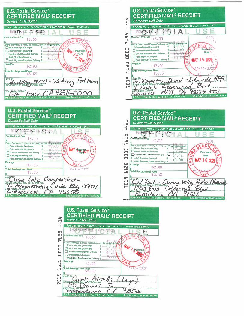
Exhibit B Applicant’s Commitment to Comply with Inyo County Ordinance
The Applicant, AT&T Wireless, in accordance with Section 1, Chapter 18.76.050(B3), Wireless Communications Plans and Subsequent Applications, attests to comply with the standards and measures in the Inyo County Code.
The Applicant will design, construct, deploy, operate and maintain its facilities in compliance with all applicable Federal, State of California, and Inyo County codes.

Exhibit C Applicant’s Agent Information
In compliance with Chapter 18.76.050(B5) of the Inyo County Code, please find below the name and address of the party to receive all correspondences and notices from Inyo County on the Applicant’s behalf:
Dino Romeo - Real Estate Specialist
Smartlink, LLC on behalf of AT&T
3300 Irvine Avenue #300
Newport Beach, CA 92660
[email protected] / (949) 444-4871
Alexis Dunlap - Project Manager
Smartlink, LLC
[email protected] / (949) 838-7313
Robert Sturtevant - Project Manager
AT&T Mobility – NSB Site Acquisition
[email protected] / (714) 473-7268

Exhibit D Photosimulations of Proposed Facilities

Exhibit E Propagation Maps for CSL02817, CSL04974, the original 6-site deployment, and current
network coverage for all of Inyo County

LTE Justification Plots
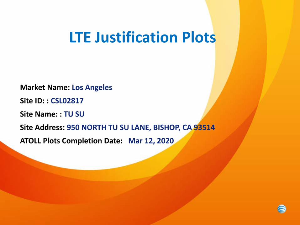
Market Name: Los Angeles
Site ID: : CSL02817
Site Name: : TU SU
Site Address: 950 NORTH TU SU LANE, BISHOP, CA 93514
ATOLL Plots Completion Date: Mar 12, 2020

CSL02817
Page 3© 2008 AT&T Knowledge Ventures. All rights reserved.
AT&T is a registered trademark of AT&T Knowledge Ventures.
LTE Coverage Before site CSL02817

Page 4© 2008 AT&T Knowledge Ventures. All rights reserved.
AT&T is a registered trademark of AT&T Knowledge Ventures.
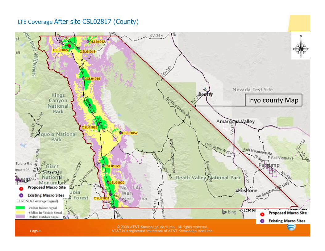
LTE Coverage After site CSL02817
CSL02817
Page 5© 2008 AT&T Knowledge Ventures. All rights reserved.
AT&T is a registered trademark of AT&T Knowledge Ventures.
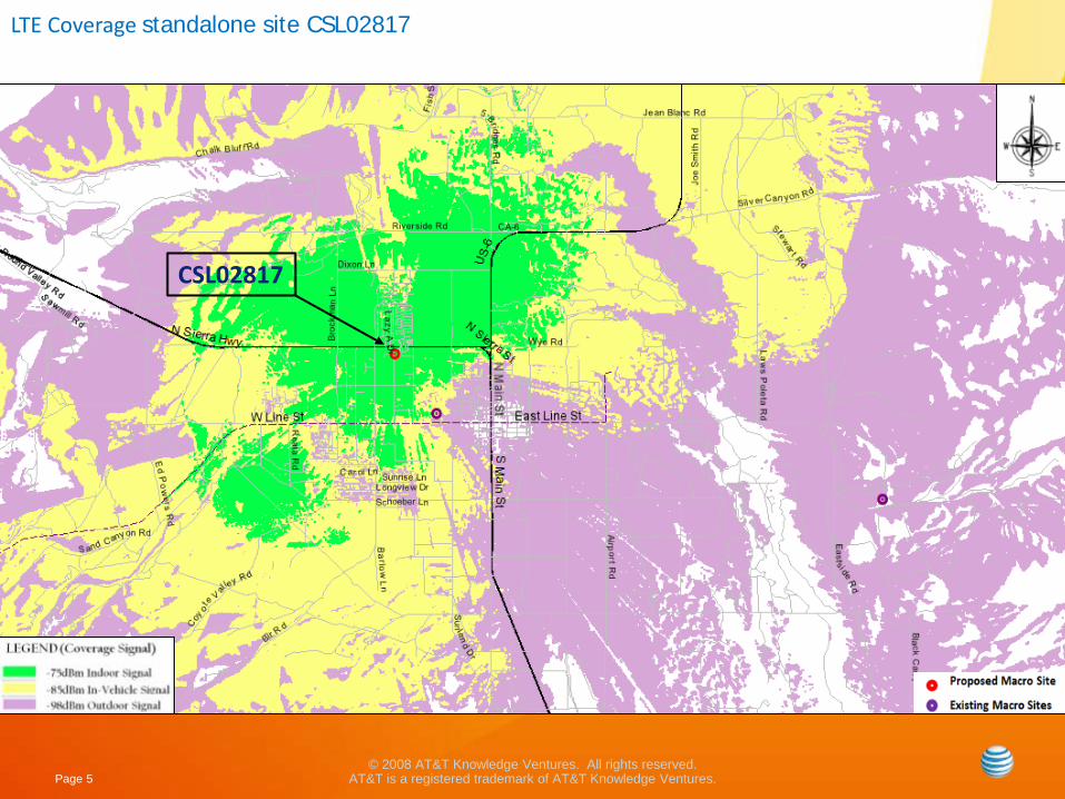
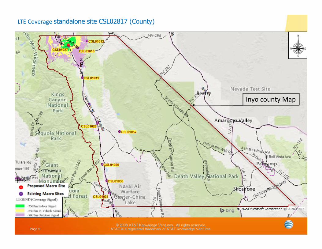
LTE Coverage standalone site CSL02817
CSL02817

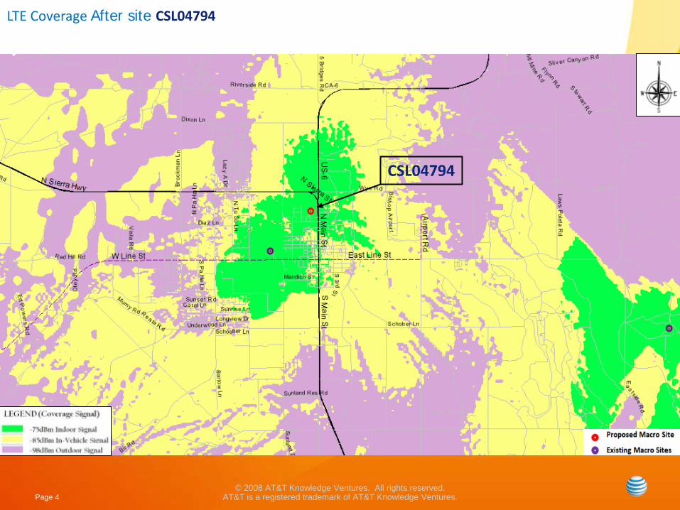
Coverage Legend
In-Building Service: In general, the areas shown in dark green should have the strongest signal strength and be sufficient for most in-building coverage. However, in-building coverage can and will be adversely affected by the thickness/construction type of walls, or your location in the building (i.e., in the basement, in the middle of the building with multiple walls, etc.)
In-Transit Service: The areas shown in the yellow should be sufficient for on-street or in-the-open coverage, most in-vehicle coverage and possibly some in-building coverage.
Outdoor Service: The areas shown in the purple should have sufficient signal strength for on-street or in-the-open coverage, but may not have it for in-vehicle coverage or in-building coverage.
LTE Justification Plots
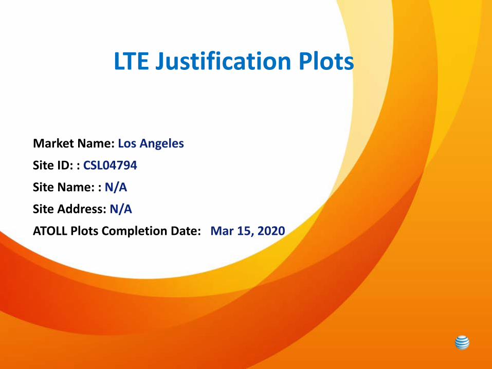
Market Name: Los Angeles
Site ID: : CSL04794
Site Name: : N/A
Site Address: N/A
ATOLL Plots Completion Date: Mar 15, 2020

Page 3© 2008 AT&T Knowledge Ventures. All rights reserved.
AT&T is a registered trademark of AT&T Knowledge Ventures.
LTE Coverage Before site CSL04794
CSL04794
Page 4© 2008 AT&T Knowledge Ventures. All rights reserved.
AT&T is a registered trademark of AT&T Knowledge Ventures.
LTE Coverage After site CSL04794
CSL04794

Page 5© 2008 AT&T Knowledge Ventures. All rights reserved.
AT&T is a registered trademark of AT&T Knowledge Ventures.
LTE Coverage standalone site CSL04794
CSL04794


Page 6© 2008 AT&T Knowledge Ventures. All rights reserved.
AT&T is a registered trademark of AT&T Knowledge Ventures.
(County Map showing all On Air sites )
Inyo county Map

Page 7© 2008 AT&T Knowledge Ventures. All rights reserved.
AT&T is a registered trademark of AT&T Knowledge Ventures.
LTE Coverage Before site CSL02817 (County)
Inyo county Map
Page 8© 2008 AT&T Knowledge Ventures. All rights reserved.
AT&T is a registered trademark of AT&T Knowledge Ventures.
LTE Coverage After site CSL02817 (County)
Inyo county Map
Page 9© 2008 AT&T Knowledge Ventures. All rights reserved.
AT&T is a registered trademark of AT&T Knowledge Ventures.
LTE Coverage standalone site CSL02817 (County)
Inyo county Map