planning approval - sjshire.wa.gov.au
TRANSCRIPT

20
20
20
20
20
20
20
20
21
21
21
21
21
21
21
2121
21
21
21
21
21
21
21
21
21
21
22
22
22
22
22
22
22
22
22 24 2426 22
24
24 24
24
26
26
28
28
30
30
COOK INDUSTRIAL MINERALS - LOT 422 KING ROAD, OLDBURY
EXISTING AND CONCEPT FINAL CONTOURS
Landform ResearchQuarries - Land Systems - Environment - Geology
ABN 29 841 445 694
Areas of active mining and processing
Aerial photography, Landgate mid 2018
Contours NRINFOFebruary 2019
PA18/44
1
P1SHIRE OF SERPENTINE-JARRAHDALE
PLANNING APPROVAL
Date Signed (Authorised Officer) 23/05/2019
10.1.6 - attachment 3
Ordinary Council Meeting - 14 December 2020

PA18/44
1
P2SHIRE OF SERPENTINE-JARRAHDALE
PLANNING APPROVAL
Date Signed (Authorised Officer) 23/05/2019
10.1.6 - attachment 3
Ordinary Council Meeting - 14 December 2020
Lindsay StephensBSc - Geology, Msc - Botany
Mem Aust Geomechanics Society
Mem WA Env Cons Assoc
LANDFORM RESEARCHQuarries - Land Systems
08 9397 5145
LOT 422 KING ROAD OLDBURYANNUAL REPORT 2003 - 2004
COOK INDUSTRIAL MINERALSDOLA Air Photo Dec 2003 November 2004
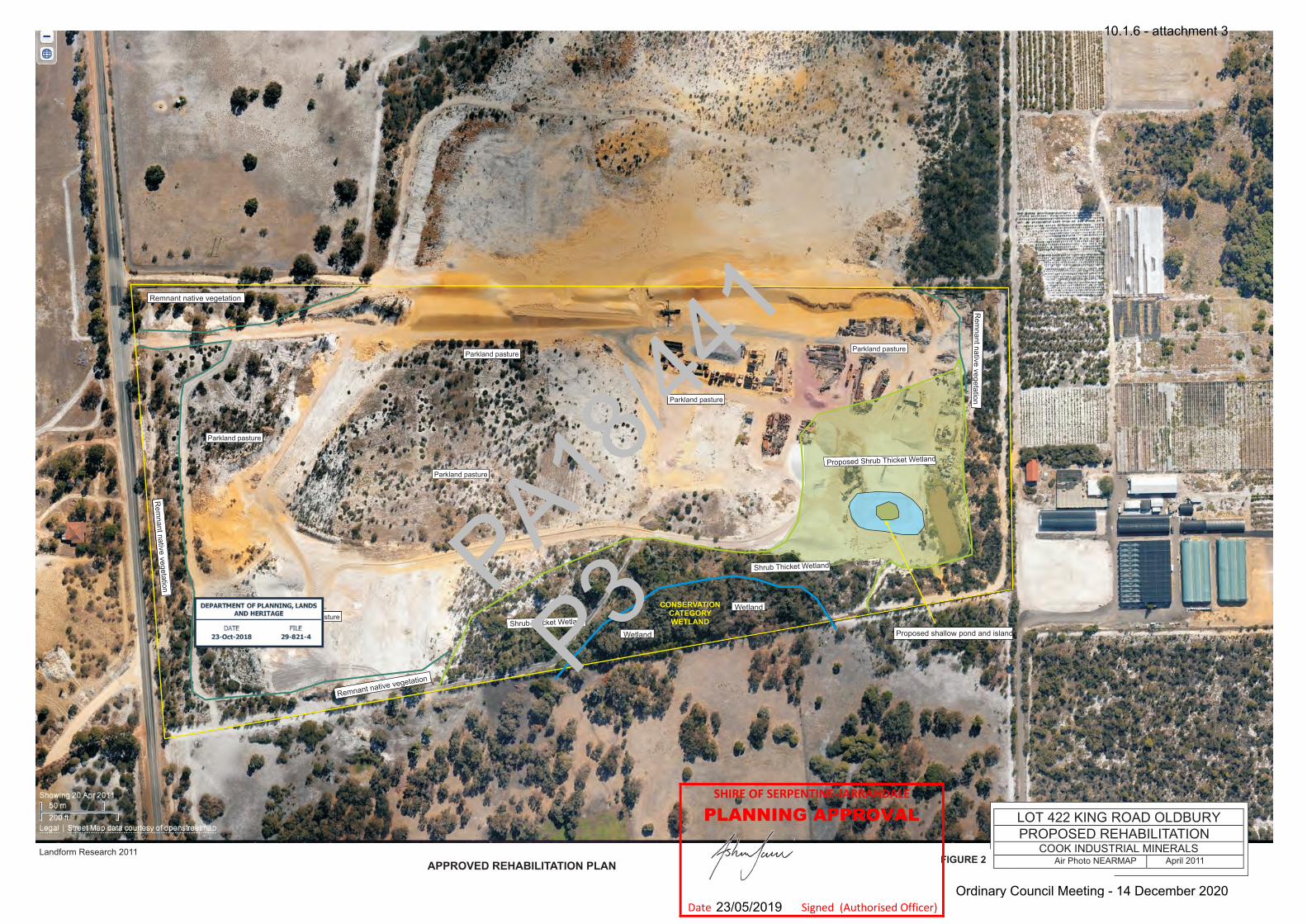
Shrub Thicket Wetland
Wetland
Wetland
Parkland pasture
Parkland pasture
Parkland pasture
Parkland pasture
Parkland pasture
PROPOSED REHABILITATION
CONSERVATION CATEGORY WETLAND
Air Photo NEARMAP April 2011
Parkland pasture
Proposed Shrub Thicket Wetland
Shrub Thicket Wetland
Proposed shallow pond and island
Remnant native vegetation
Rem
nant native vegetation
Rem
nant native vegetation
Remnant native vegetation
Rem
nant native vegetation
Rem
nant native vegetation
Remnant native vegetation
Rem
nant native vegetation
Rem
nant native vegetation
Remnant native vegetation
Rem
nant native vegetation
Rem
nant native vegetation
Remnant native vegetation
FIGURE 2Landform Research 2011
APPROVED REHABILITATION PLAN
PA18/44
1
P3
SHIRE OF SERPENTINE-JARRAHDALE
PLANNING APPROVAL
Date Signed (Authorised Officer) 23/05/2019
10.1.6 - attachment 3
Ordinary Council Meeting - 14 December 2020

AERIAL PHOTOGRAPH FEBRUARY 2018
Compare the revegetation and activity in 2018 to 2011 (Figures 2 and 3)LOT 422, aerial photograph February 2018
COOK INDUSTRIAL MINERALS
Landform Research February 2018 FIGURE 3
PA18/44
1
P4SHIRE OF SERPENTINE-JARRAHDALE
PLANNING APPROVAL
Date Signed (Authorised Officer) 23/05/2019
10.1.6 - attachment 3
Ordinary Council Meeting - 14 December 2020

LOT 422, aerial photograph February 2018COOK INDUSTRIAL MINERALSOLD HOLCIM (READYMIX) QUARRY
Note, the orange line is more accurate as it is based on updated photography
FIGURE 4
PA18/44
1
P5
SHIRE OF SERPENTINE-JARRAHDALE
PLANNING APPROVAL
Date Signed (Authorised Officer) 23/05/2019
10.1.6 - attachment 3
Ordinary Council Meeting - 14 December 2020

Figure 5
PA18/44
1
P6SHIRE OF SERPENTINE-JARRAHDALE
PLANNING APPROVAL
Date Signed (Authorised Officer) 23/05/2019
10.1.6 - attachment 3
Ordinary Council Meeting - 14 December 2020
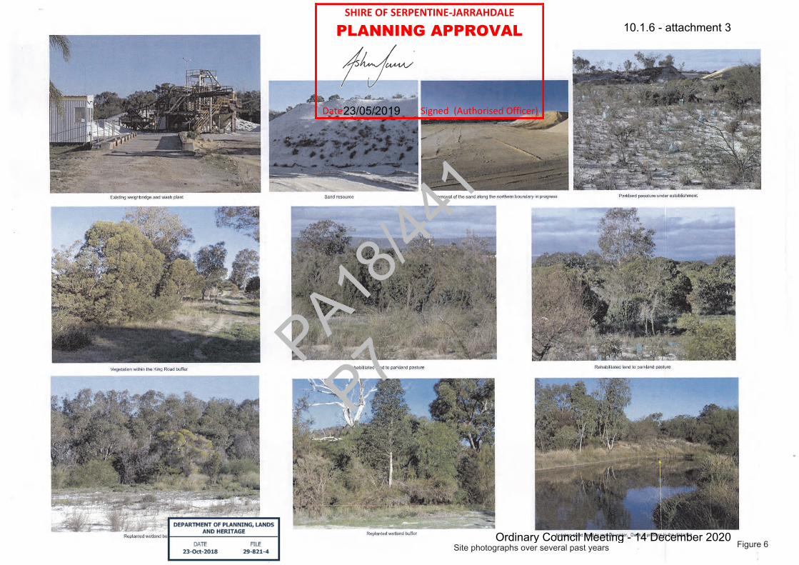
Figure 6Site photographs over several past years
PA18/44
1
P7
SHIRE OF SERPENTINE-JARRAHDALE
PLANNING APPROVAL
Date Signed (Authorised Officer) 23/05/2019
10.1.6 - attachment 3
Ordinary Council Meeting - 14 December 2020
RENEWAL OF SAND EXCAVATION
EXCAVATION and REHABILITATION
MANAGEMENT PLAN
Cook Industrial Minerals (CIM) Lot 422, King Road,
Oldbury
Shire of Serpentine - Jarrahdale
April 2018
PA18/44
1
10.1.6 - attachment 3
Ordinary Council Meeting - 14 December 2020

Excavation – Rehabilitation Management Plan, Renewal Sand Excavation, Lot 422, King Road, Oldbury
Cook Industrial Minerals
EXCAVATION and REHABILITATION
MANAGEMENT PLAN
Cook Industrial Minerals (CIM) Lot 422, King Road,
Oldbury
Contact can be made through Cook Industrial Minerals Pty Ltd
Cutler Road, Jandakot Phone 9417 1111
Landform Research LindsayStephensBSc(Geology),MSc(PlantEcology) 49ABirdwoodAvenue,ComoWA6152
MemAusGeomechanicsSoc–MEIANZ–FIQATel0894743978,[email protected]
PA18/44
1
10.1.6 - attachment 3
Ordinary Council Meeting - 14 December 2020

Excavation – Rehabilitation Management Plan, Renewal Sand Excavation, Lot 422, King Road, Oldbury
Cook Industrial Minerals
Summary The excavation of sand has been undertaken on Lot 422, King Road, Oldbury since 1984 through an Extractive Industries Licence and Development Approval granted by the Shire of Serpentine-Jarrahdale. The Extractive Industries Licence and Development Approval have conditions attached to control the excavation. A wash plant washes the sand that has been excavated for specialty uses. In recent years the rate of excavation has slowed, with most sand being washed for special use graded sands. Only small amounts of sand are produced on site, mainly for specialty sands such as foundry and filter sand. This documentation provides the support for a renewal of Planning Approval. The Extractive Industry Licence is current. Excavation of the sand quarry has continued to be guided by the Rehabilitation Criteria and Plan which was proposed on 28 July 2005 and was updated in 2011. See Figure 2. This application carries forward the earlier approvals and management. The same closure and rehabilitation as previously approved is continued. In recent years only small amounts of sand have been extracted. Compare Figures 2 and 3. There are no proposed changes to the scale and intensity of sand excavation, the operational times or methods of extraction from the site. The sand excavation is nearly complete, with only 1.5 hectares of resource remaining. There is also a requirement to provide a consistent land surface along the western boundary to ensure that the land drops from the 26 metres AHD at King Road to the approved floor at 21 metres AHD. This process has commenced in the southern end of the western buffer and does involve the removal of some interim rehabilitation and then replanting and rehabilitation. The southern portion of the western face has been recontoured and spread with topsoil. Tube stock have been purchased for planting in winter 2018. The northern portion of the western boundary is still to be completed. Cook Industrial Minerals seeks Planning Consent for ten (10) years to enable the special use sands to be extracted and the site to be rehabilitated.
PA18/44
1
10.1.6 - attachment 3
Ordinary Council Meeting - 14 December 2020

Excavation – Rehabilitation Management Plan, Renewal Sand Excavation, Lot 422, King Road, Oldbury
Cook Industrial Minerals
Table 1 Site Summary ASPECT PROPOSAL CHARACTERISTIC EXCAVATION Total area of Lot 422 20.6 hectares (approx) Date commenced 1984 Life of project 10 years Current Areas Active excavation – 0.7 ha
Future resource – 1.5 ha Rehabilitated parkland pasture and wetland – 11.6 ha Roads and hard stand 3.0 ha Ground waiting for rehabilitation, etc – 2.2 ha
Dewatering requirements Nil
Maximum depth of excavations Approved elevation of floor 21.0 metres AHD dropping to 20.0 m AHD in the wetland buffer
WASHING AND STOCKPILING Current Areas Wash plant and stockpiles – 2.8 ha
Area of water recycling ponds 2 x 90 m2 included in above.
Fuel storage No fuel storage TRANSPORT Truck movements Variable but approximately 1 - 5 laden trucks per day on 3 – 5
days per week. Access Existing access road to King Road WORKFORCE Operation The workforce will vary, depending on the level of operation and
market demands, but usually 1 to 2 persons can be expected to be working on site.
Hours of operation Hours of operation, will be 6.00 am to 5.00 pm Monday to Friday inclusive, excluding public holidays for transport, processing and excavation.
PA18
/441
10.1.6 - attachment 3
Ordinary Council Meeting - 14 December 2020

Excavation – Rehabilitation Management Plan, Renewal Sand Excavation, Lot 422, King Road, Oldbury
Cook Industrial Minerals
CONTENTS SUMMARY RISK MANAGEMENT 1.0 INTRODUCTION 1 1.1 Background and Proposal 1 1.2 Proponent 1 1.3 Location and Ownership 1 1.4 Project Objectives 2 2.0 PLANNING ASSESSMENT 4 2.1 Current Land Use 4 2.2 Proposed Land Use 4 2.3 Land Zoning and Policies 4 2.3.1 State Government Policies and Planning Schemes 4 2.3.2 Local Government Policies and Planning Schemes 7 2.3.3 End Use – Sequential Planning 7 2.3.4 Legislative Framework - Stakeholders 7 3.0 BUFFERS AND SOCIAL IMPACTS 11 3.1 Consideration of nearby sensitive premises 11 3.2 Policies 11 3.3 Heritage 13 3.4 Complaints mechanism 14 4.0 PHYSICAL ATTRIBUTES 15 4.1 Geology and Geomorphology 15 4.2 Regolith and Soils 15 4.3 Climate 15 4.4 Hydrology 16 PROJECT DESCRIPTION 18 5.1 Construction 18 5.2 Excavation 18 5.3 Pit Design and Staging 19 5.4 Processing 20 5.5 Stockpiles 20 5.6 Equipment 20 5.7 Hours of Operation 21 5.8 Access and Security 21 5.9 Water Use 22 5.10 Workforce 22 5.11 Safety 22 6.0 DUST MANAGEMENT 24 6.1 Environmental Dust 24 6.2 Assessment of Dust Risk 26 6.3 Buffers 27 6.4 Occupational Dust 27 6.5 Actions and Management 27
PA18/44
1
10.1.6 - attachment 3
Ordinary Council Meeting - 14 December 2020
PA18/44
1
10.1.6 - attachment 3
Ordinary Council Meeting - 14 December 2020

Excavation – Rehabilitation Management Plan, Renewal Sand Excavation, Lot 422, King Road, Oldbury
Cook Industrial Minerals
1
1.0 INTRODUCTION 1.1 Background and Proposal
Cook Industrial Minerals (CIM) is applying for renewal of Planning Consent for sand excavation on Lot 422 King Road, Oldbury. The Extractive Industry Licence is current. The excavation of sand has been undertaken on Lot 422, King Road, Oldbury since 1984 through an Extractive Industries Licence and Development Approval granted by the Shire of Serpentine-Jarrahdale. A wash plant washes the sand that has been excavated, removing traces of clay and organic matter. The sand is mainly used for specialty sands such as filter sand. Over the years a number of documents have been produced for the sand excavation and these will be referenced, rather than the information being rewritten. In the past few years excavation on site has slowed, but resource still remains and therefore planning approval is required to enable excavation to continue. Excavation of the sand quarry has continued to be guided by the Rehabilitation Criteria and Plan which was proposed on 28 July 2005 that was updated in 2011. The plan built on the completion criteria from the 2000 approved Revegetation Plan. For an explanation of the various areas see the attached Figures 2 and 3, and the Section 11.0 Closure Planning. This application carries forward the management from the earlier approvals. The same closure and rehabilitation as previously approved is continued. In recent years only small amounts of sand have been extracted. Figure 1. There are no proposed changes to the scale and intensity of sand excavation the operational times or methods of extraction from the site. Conditions relating to the previous Excavation Licence have been incorporated into this Excavation and Environmental Management Plan. Rehabilitation will follow excavation, assisting in minimising the amount of open ground. 1.2 Proponent The proponent is the landholder, Cook Industrial Minerals Pty Ltd. Contact can be made through Cook Industrial Minerals Pty Ltd Cutler Road, Jandakot Phone 9417 1111 1.3 Location and Ownership Lot 422, King Road, Oldbury Volume 1926 Folio 99
PA18/44
1
10.1.6 - attachment 3
Ordinary Council Meeting - 14 December 2020
Excavation – Rehabilitation Management Plan, Renewal Sand Excavation, Lot 422, King Road, Oldbury
Cook Industrial Minerals
2
1.4 Project Objectives The proposal is to continue to provide a source of local specialty sand to assist in minimising the cost of construction in the local and wider area. The aims of the proposal are to; The aims of the proposal are to;
Ø Allow completion and rehabilitation of excavation on Lot 422.
Ø Continue to remove the sand from the western boundary to provide a consistent land surface.
Ø Reform the land surface and improve the soils to a form suitable for parkland
pasture whilst at the same time maintaining and enhancing the remnant vegetation on site.
Ø To comply with State Planning Policy No 2.4, Basic Raw Materials, which states
that basic raw materials should be taken prior to sterilisation of the area by development.
Importance and Rationale The sand is a sub rounded to rounded quartz sand varying from fine to medium grained; with a significant portion of the grains being larger than 1.5 mm. It is white to yellow. The remaining sand occurs in the west of Lot 422 (Figure 1). Uses The sand is graded and used for a wide variety of uses. It is used by the Water Corporation in Perth, Bunbury, Albany, Shenton Park, Wanneroo, Harvey, Jandakot, Australind, Nannup and Dunsborough, to name a few locations, for water treatment and filtration. Rounded sand is more widely used for filter sand because it does not pack as tightly. Filter sand is used by the Muja Power Station for filtration. The sand is used for swimming pool filtration by the Shire of Busselton, Beatty Park Superdome, Shire of Margaret River and many other local Government pools. It is widely used throughout the State for filtration in bores. Most of the sand excavation on site is for washing to produce clean graded sand for specialty uses. This means that production and on site activity is much lower than most other sand pits. Cook Industrial Minerals owns Lot 422 and does not hold any other sand resource of the Bassendean type. A summary of the documentation of basic raw materials is listed below.
Ø Western Australian Planning Commission, State Planning Policy 2.4, Basic Raw Materials. (superseded locally by SPP 2.5 but has background information).
Ø Western Australian Planning Commission, State Planning Policy No 2.5,
Agricultural and Rural Land Use Planning 2016.
PA18/44
1
10.1.6 - attachment 3
Ordinary Council Meeting - 14 December 2020
Excavation – Rehabilitation Management Plan, Renewal Sand Excavation, Lot 422, King Road, Oldbury
Cook Industrial Minerals
3
Ø Department of Planning 2016, Basic Raw Materials Fact Sheet.
Ø Abeysinghe P B, 2003, Silica Sand Resources of Western Australia, Geological Survey of Western Australia, Mineral Resources Bulletin 21.
Ø Department of Planning 2009, Basic Raw Materials – Applicants Manual.
PA18/44
1
10.1.6 - attachment 3
Ordinary Council Meeting - 14 December 2020
Excavation – Rehabilitation Management Plan, Renewal Sand Excavation, Lot 422, King Road, Oldbury
Cook Industrial Minerals
4
2.0 PLANNING ASSESSMENT 2.1 Current Land use The site was rural land prior to sand extraction and will be returned to that use, albeit with a much greater density of local native trees and shrubs. 2.2 Proposed Land use Renewal of sand extraction with an end use of parkland pasture and local native vegetation. The wetland on the southern boundary is retained and has been rehabilitated. The contoured surface will therefore be restored slopes and form that match the adjoining land and land uses. 2.3 Land Zonings and Policies 2.3.1 State Government Policies and Planning Schemes
Ø State Planning Policy 1.0, State Planning Framework Policy The State Planning Policy Framework provides for the implementation of a planning framework through the recognition and implementation of Regional Planning Policies above Local Planning Schemes and Policies. A number of State Policies have been released under the State Planning Framework Policy.
State Planning Policy 2.0, Environment and Natural Resources Policy State Planning Policy 2.4, Basic Raw Materials State Planning Policy No 2.5, Agricultural and Rural Land Use Planning State Planning Policy No 4.1, State Industrial Buffer Policy
These are considered in turn. A number of other key State Government Policies are also relevant to the local regional planning.
Ø State Planning Policy 2.0, Environment and Natural Resources Policy
This policy provides for the protection of all natural resources under a number of sections;
5.1 General Measures 5.2 Water Quality including stormwater and wetlands 5.3 Air Quality 5.4 Soil and Land Quality 5.5 Biodiversity 5.6 Agricultural Land and Rangelands 5.7 Minerals Petroleum and Basic Raw Materials 5.8 Marine Resources and Aquaculture 5.9 Landscape 5.10 Greenhouse Gas Emissions and Energy Efficiency.
PA18/44
1
10.1.6 - attachment 3
Ordinary Council Meeting - 14 December 2020
Excavation – Rehabilitation Management Plan, Renewal Sand Excavation, Lot 422, King Road, Oldbury
Cook Industrial Minerals
5
In addition to recognising the importance of protecting air quality, soil and land quality, water and wetlands and landscapes, the importance of Basic Raw Materials to the community is identified with reference to SPP 2.4 Basic Raw Materials, State Gravel Strategy 1998 and State Lime Strategy 2001. Section 5.7 of SPP 2.0, deals with Minerals, Petroleum and Basic Raw Materials. Part of Section 5.7 states; Basic raw materials include sand, clay, hard rock, limestone and gravel together with other construction and road building requirements. A ready supply of basic raw materials close to development areas is required in order to keep down the cost of land development and the price of housing. Planning strategies, schemes and decision making should:
Identify and protect important basic raw materials and provide for their extraction and use in accordance with State Planning Policy No 10 (2.4); Basic Raw Materials. Support sequencing of uses where appropriate to maximise options and resultant benefits to community and the environment.
The other factors of the natural environment are provided with the best protection possible, by this management plan, by selection of the site, operational staging and footprint and rehabilitation, bearing in mind the constraints of excavating and processing the resource.
Ø State Planning Policy 2.4, Basic Raw Materials This policy makes many statements on the intent and actions, which local authorities should use to protect and manage basic raw materials. Section 3.4 is very specific in explaining that basic raw materials need identification and protection because of increased urban expansion and conservation measures, (3.4.1), (3.4.2) and (3.4.4). Sections 3.4.5 and 3.4.6 recognise that environmental and amenity matters need to be considered. There are specific provisions in Section 6.2 Local Planning Scheme Provisions, such as;
No support for the prohibition of extractive industries in zones that permit broad rural land uses. Providing an appropriate P, D or A use. Not precluding the extraction of basic raw materials on land which is not identified as a Priority Resource Location, Key Extraction Area or Extraction Area (6.4.2).
Currently the Department of Planning and Department of Mines and Industrial Regulation are reviewing and updating the basic raw materials policy over the whole Swan Coastal Plain and near areas and onto the Darling Scarp. State Planning Policy No 2.4, Basic Raw Materials, makes provision for the extraction of basic raw materials. SPP 2.4. It states in Section 6.3.2 that before determining an application within 1000 metres of a sensitive land use “the Commission or Local Government must consider the following as appropriate.
An application may require referral to the Department of Environment Protection,
PA18/44
1
10.1.6 - attachment 3
Ordinary Council Meeting - 14 December 2020
Excavation – Rehabilitation Management Plan, Renewal Sand Excavation, Lot 422, King Road, Oldbury
Cook Industrial Minerals
6
The significance of the resources in terms of whether it is a key extraction area, priority resource area or extraction area; The likely effects of vehicular traffic, noise blasting, dust, vibration arising from the extractive industry on the proposed land use or development.”
SPP 2.4 goes on to state in Section 6.4.1
Applications for extractive industry operations are to be accompanied by a management plan and report which: Demonstrates that sensitive land uses within 1 000 m of the proposal will not be adversely affected by the extractive industry operations; Identifies appropriate buffer distances, being those distances required for extraction that are needed to buffer the impact of operations to adjacent land users. Provides details of the proposed use, development and management of the site including the environmental and water resource management standards, quarry areas, stockpiles, machinery maintenance areas, processing plants, fuel storage and on site access roads, parking of cars and other vehicles used on the site and proposals for landscaping to screen activity on the site; Describes arrangements for access to the site, including the roads which it proposes will be the main vehicular access and likely traffic flows; and Sets outs proposals for the progressive and ultimate rehabilitation for its intended use.
All the potential impacts on nearby residences have been considered and addressed within this documentation for the quarry proposal.
Ø State Planning Policy No 4.1, State Industrial Buffer Policy SPP 4.1 discusses the need to consider adjoining land uses when locating buffers but does not prescribe set buffers for operations such as this. The development and processing of the resource has been designed to maintain maximum buffer distances. In situations where the buffers are less, actions such as the provision of perimeter bunding to provide visual and noise management, tree planting and operational procedures are used to mitigate and reduce impacts. This is discussed further in Section 2.11 Surrounding Landuses and Buffers of this document.
Ø Directions 2031 and Beyond (WAPC 2010) Directions 2031 and Beyond provides data on the land uses and growth of the Perth Metropolitan and Peel areas over the 20 years to 2031.
Ø Perth and Peel @ 3.5 million Perth and Peel @ 3.5 million EPA provides strong support for the need for basic raw materials for the growth of Perth. Perth and Peel @ 3.5million, developed by the Western Australian Planning Commission has determined that the Metropolitan Area will grow significantly between to 2050 by around 650 000 dwellings.
PA18/44
1
10.1.6 - attachment 3
Ordinary Council Meeting - 14 December 2020

Excavation – Rehabilitation Management Plan, Renewal Sand Excavation, Lot 422, King Road, Oldbury
Cook Industrial Minerals
7
The Planning Framework 2018 reiterated the protection and staged use of basic raw materials. 2.3.2 Local Government Policies and Planning Schemes Shire of Serpentine Jarrahdale Town Planning Scheme 2 Shire of Serpentine Jarrahdale Town Planning Scheme 2 lists the zoning of Lot 422 as “Rural”. “Industry Extractive” is an AA use in the Rural Zone which means that Council, at its discretion, may permit the use of an extractive industry. The intent and purpose of the Rural Zone is to “allocate land and to accommodate the full range of rural pursuits and associated activities. Quarrying is not a rural pursuit in name but is increasingly being considered as such in planning policies such as the SPP 2.5. The Shire of Serpentine – Jarrahdale has a number of policies that are relevant; Local Planning Policy No 68 – Sustainability Assessment The principles and objectives of sustainability have been incorporated into the quarry operations. The opening of the quarry is related to sustainability of the Perth Metropolitan Area with respect to the sourcing of basic raw materials. Even so sustainability has been incorporated into the proposal by way of reducing the footprints and impacts. The Shire has an Extractive Industry Local Law. Even though Planning Consent will be provided by the Shire, the Shire normally also provides an Extractive Industry Licence prior to commencement. The proposed quarry is designed continue to be compliant with the Local Law. 2.4.3 End Use – Sequential Planning The extraction of sand is seen as an interim use prior to a return of the area to pasture, No sequential land planning can be made because the future use is not known. Therefore the most appropriate end use is to restore the existing cleared and parkland pasture land with native vegetation around the perimeter and in strategic locations. This would enable semi-rural land uses and rural uses to be used on the landform. Any use other than rural will require rezoning of the land. Even so the proposed revegetation would be suitable for rural living if rezoning was to occur at some point in the future. 2.4.4 Legislative Framework - Stakeholders There have been no significant changes to the scale and nature of the local land uses over the past few years. Sand excavation has been approved to the south and the adjoining lot to the east.
PA18/44
1
10.1.6 - attachment 3
Ordinary Council Meeting - 14 December 2020

Excavation – Rehabilitation Management Plan, Renewal Sand Excavation, Lot 422, King Road, Oldbury
Cook Industrial Minerals
8
Table 1 Legislative Framework
Legislation Environmental Factor regulated/affected
Discussion Action
Aboriginal Heritage Act 1972
Aboriginal heritage sites
Records Heritage Sites A database search of DPLH has been conducted and no site recorded
A commitment is made to halt activities if any heritage material is found during excavation, pending assessment by consultants.
Planning and Development Act 2005
Development approvals for on site constructions and any ensuing environmental impacts.
Planning Consent is required from the Shire of Serpentine - Jarrahdale and the WAPC. This is a renewal of the quarry which has operated since 1984.
A concurrent renewal application for development approval is lodged.
Shire of Serpentine -Jarrahdale Extractive Industry Local Law
The operations of the quarry are regulated by both the Planning Approval and Extractive Industries Licence
An Extractive Industries Licence is required and is in place. This is a renewal of the quarry that has operated since 1984.
The Extractive Industry Licence is current.
Health Act 1911 Environmental and health impacts from waste water treatment and community health.
No matters of significance that would trigger this legislation have been identified.
The proposal complies with the Health Department Guideline for Dust separation. (See Dust Management) No waste materials will be disposed of on site.
Department of Planning, Land and Heritage Transport Impact Guidelines 2016
New developments may need to consider transport options.
This is an existing operation with no changes to the access and scale of activities or transport.
No assessment is required because there are no significant changes to the transport operations.
Western Australian Planning Commission Planning Bulletin 111/2016
New developments may need to consider fire risk and mitigation such as a bushfire policy and BAL attack document.
This is an existing operation with no changes to the access and scale of activities or transport or fire risk. The pit acts as a fire management zone as it is devoid of vegetation. The quarry has operated since 1984.
No assessment is required because there are no significant changes to the fire risk or the proposal.
Environmental Protection Act 1986 Part IV - Assessment
Referred to the EPA if the project is or may constitute a significant environmental impact.
This is a previously operated quarry.
No referral to the EPA will be required. The quarry has operated since 1984 and is a renewal to enable the final sand to be taken and the site closed and rehabilitated.
Environmental Protection Act 1986 Part V – DWER Licence
Environmental factors that may be significantly impacted related to Prescribed Premises. Processing and Screening
If screening in excess of 5 000 tonnes per year the operation will require a Department of Water Environment Regulation Licence.
A DWER Licence will be applied for prior to crushing and screening which triggers the “Prescribed Premises”; 5 000 tonnes of hard rock per annum.
Environmental Protection (Noise) Regulations 1997
Noise impacts. The excavation is a renewal of an existing sand quarry that operates several days per week. The quarry has a demonstrated operational record.
Noted. See Noise Management.
Environmental Protection (Clearing of Native Vegetation) Regulations 2004
Clearing and disturbance of native vegetation.
Clearing Permit under the Environmental Protection (Clearing of Native Vegetation) Regulations 2004 is required under the Regulations.
A Clearing Permit will not be required as no clearing of native vegetation is required. Some interim revegetation on the western boundary may be necessary to provide a conformable landform.
Environment Protection and Biodiversity Conservation Act
Matters listed on the EPBC database.
There are no matters listed.
The proposal does not require the clearing of Black Cockatoo habit or other listed matters.
PA18/44
1
10.1.6 - attachment 3
Ordinary Council Meeting - 14 December 2020

Excavation – Rehabilitation Management Plan, Renewal Sand Excavation, Lot 422, King Road, Oldbury
Cook Industrial Minerals
9
1999 (Commonwealth)
Wildlife Conservation Act 1950
Provides for the protection of flora and fauna.
The clearing of vegetation is covered under the Environmental Protection (Clearing of Native Vegetation) Regulation.
No clearing of native vegetation is required. Some clearing of the interim revegetation on the western boundary may be necessary to provide a conformable landform.
Conservation and Land Management Act 1984
Parks and Reserves and issues relating to flora and fauna.
There are no factors that trigger this legislation.
Noted. The site has previously been excavated and initially this proposal will utilise the previously excavated areas and rehabilitate them as the pit moves forwards. No clearing of native vegetation is required. Some clearing of the interim revegetation on the western boundary may be necessary to provide a conformable landform.
Biodiversity Conservation Act 2016
The legislation seeks to protect and manage biodiversity in all its forms through regulation, conservation and restoration.
There are no factors that trigger this legislation.
Noted. The site has previously been excavated and initially this proposal will utilise the previously excavated areas and rehabilitate them as the pit moves forwards. No clearing of native vegetation is required. Some clearing of the interim revegetation on the western boundary may be necessary to provide a conformable landform.
Heritage of Western Australia Act 1990
Heritage No heritage matters are identified locally or on quarry footprint. DPLH databases were searched.
Noted.
Waterways Conservation Act 1976
Water quality and management of surface water
There are no watercourses on site. A Water Management Plan has been prepared and is included. No changes to past approvals are requested.
Rights in Water and Irrigation Act 1914
Water quality and management of surface water
There are no watercourses on site. Noted
Country Areas Water Supply (CAWS) Act 1947
Water supplies The site does not lie within a country surface or groundwater control area.
Noted
State Agreement Acts
Specific acts that relate to certain large projects that may impact on some locations.
Not applicable
Contaminated Sites Act 2003
Contaminated materials that may arise from excavation or be used in excavation and processing.
One factor that is likely to fall under this category is the storage and use of maintenance items and on site maintenance and the storage of machinery. The other factor is the presence of cleaning materials left over from the recycling and cleaning of garnet sand some ten years ago. This material was retained in the sumps. DWER has inspected the site and the sumps have been tested and are either below the required limits or just over and falling.
A Water Management Plan has been prepared that includes commitments to remove any contaminated soils or other material regularly and at the end of excavation as part of the closure actions.
Dangerous Goods Safety Act 2004
Potential for dangerous good to impact on the environment.
Refers to fuel, which is required and blasting under the Dangerous Goods Safety (Explosives) Regulations 2007.
CIM will comply with the requirements for fuel through management plans that will be implemented. Fuel and Servicing Management Plans
PA18/44
1
10.1.6 - attachment 3
Ordinary Council Meeting - 14 December 2020

Excavation – Rehabilitation Management Plan, Renewal Sand Excavation, Lot 422, King Road, Oldbury
Cook Industrial Minerals
10
are included in the attached Water Management Plan.
PA18/44
1
10.1.6 - attachment 3
Ordinary Council Meeting - 14 December 2020
Excavation – Rehabilitation Management Plan, Renewal Sand Excavation, Lot 422, King Road, Oldbury
Cook Industrial Minerals
11
3.0 BUFFERS AND SOCIAL IMPACTS There are no proposed changes to the scale and nature of the excavations. The access points and intensity of excavation will not change. 3.1 Consideration of nearby sensitive premises The quarry is designed to maximise the setbacks to the closest sensitive premises, even though these buffers are relatively small. The quarry has operated since 1984. There have been no changes to the setbacks and buffers. As part of the development of the management plans for the proposed quarry, extensive analysis of the local landform, land uses and location of sensitive premises were made by Landform Research from the available sources of published information, aerial photography, historical aerial photography, site mapping, review of the nearby and surrounding land uses, local and regional planning and local and wider environmental attributes. The main environmental issues identified in relation to buffers and setbacks to sensitive premises, in addition to those generally recognised by the various Government and Published guidance’s are;
• Visual amenity • Dust management • Noise management • Blasting • Local amenity • Cumulative impacts of quarries
3.2 Policies A number of Government Policies relate to buffer distances and the protection of basic raw materials. State Planning Policy No 4.1, State Industrial Buffer Policy, (draft July 2004) discusses the need to consider adjoining land uses when locating buffers but does not prescribe set buffers for operations such as this. SPP 4.1 discusses the need to provide buffers both on site and offsite with respect to industry, including extractive industries. It does not however specify any distance for the buffer, but notes that site specific studies should be prepared that will demonstrate that the extractive industry can operate in a manner compatible with nearby sensitive premises. The State Industrial Policy 4.1 does not specify a set buffer distance, but notes that buffers are to be based on “scientific study” and are flexible. It further specifies the buffers by reference to other documentation such as the Environmental Protection Policies, EPA and DWER standards and DPLH Generic Industrial Buffer Guidelines; that is the EPA 1 000 metre generic buffer used in SPP 2.4 and SPP 2.5 that are used in the absence of supporting or scientific studies and information. The buffer referred to can be both on site and offsite although in this case only on site buffers are required. SPP 2.5 supports preventing conflicting land uses (5.12.1), supports the generic buffers recommended by other Government documents such as the EPA Guidelines for separation distances (5.12.3), and seeks to restrict subdivision from impinging on basic raw material resources.
PA18/44
1
10.1.6 - attachment 3
Ordinary Council Meeting - 14 December 2020
Excavation – Rehabilitation Management Plan, Renewal Sand Excavation, Lot 422, King Road, Oldbury
Cook Industrial Minerals
12
The Policy SPP 2.5 is also supported by Guidelines that seek to protect the Landscape and secure Transport Routes. Currently SPP 2.4 Basic Raw Materials is being revised and is to have similar provisions to SPP 2.5, hence the references to SPP 2.5. EPA guidance "Separation Distances between Industrial and Sensitive Land Uses", June 2005 lists the generic buffers for sand quarries as 300 – 500 metres depending on the extent of processing. The EPA issued Draft Generic Buffer Guidelines 2015, but these have been withdrawn. EPA guidance "Separation Distances between Industrial and Sensitive Land Uses", June 2005 lists the generic buffers for sand pits as 300 - 500 metres depending on the extent of processing. A generic buffer relates to the distance at which there are unlikely to be any problems without some further investigations and does not mean that smaller buffers are not acceptable. The issue of appropriate buffers is a matter of the distance and protection measures to prevent impact on adjoining land users. This applies mainly to noise, dust and visual impact, all of which are treated separately. Based on the nature of the sand, equipment used and excavation methods, the extraction of sand has potentially the lowest impact and could be less if significant impacts are confined. Even so, the walls of the pit, perimeter bunding and nature of the ridge landform are used to reduce noise transmission. Excavation is worked from inside out on the floor of the pit working below natural ground level. There is also a building to the east associated with a horticulture/market garden, and would not be classified as a sensitive premises as it is part of a commercial operation. That facility is located behind a significant perimeter bund some 3 - 4 metres high. There are two dwellings to the west across King Road that are 90 metres from the western edge of the pit rehabilitation. It is not known whether the dwelling is still used as a dwelling because sand extraction occurs on that property. Most activities on Lot 422 are much further away and are protected by the elevation of the active face. Sand extraction activities on the property are closer to the dwellings than activities on Lot 422. Traffic noise from King Road will also impact on the dwelling but would be unlikely to require taking into account for the Noise Regulations. Under Schedule 1 of the Noise Regulations the premises on which the extraction of basic raw materials are extracted, is classified as Industrial Land for the purposes of calculating influencing factors. This was defined as the whole cadastral boundaries in State Administrative Tribunal decision {2013} WASAT 139, Bushbeach v City of Mandurah. Therefore the property to the west on which the dwelling lies, and has sand excavation, will be classified as industrial land for the purposes of the Noise Regulations and the dwelling would not be classified as a sensitive premises but might be classified as a caretakers cottage for the Noise Regulations. See Figure 1. The traffic on King Road is not frequent enough to provide influencing factors for the assigned noise levels at the residences. There is a dwelling to the south which is 190 metres away from the closest part of rehabilitation and further away from other parts of the pit. This dwelling is located behind a vegetation belt. See Figure 1. The remaining sand resource is further away from this dwelling.
PA18/44
1
10.1.6 - attachment 3
Ordinary Council Meeting - 14 December 2020

Excavation – Rehabilitation Management Plan, Renewal Sand Excavation, Lot 422, King Road, Oldbury
Cook Industrial Minerals
13
The pit and rehabilitation is operated and completed using a single loader as the only noise source. A truck may accept sand from the face and therefore would visit the site intermittently, perhaps once per hour on some days. The infrequency of truck activity, and the sand excavation not operating every day, is likely to introduce averaging for the purposes of the Noise Regulations and allowances for activities less than 10% of the time. The distances to these buildings and dwellings has not changed in the past ten years. Cook Industrial Minerals is not aware of any complaints within the last 5 years from any of the nearby dwellings. The issue of appropriate buffers is a matter of the distance and protection measures to prevent impact on adjoining land users. This applies mainly to noise, dust and visual impact, all of which are treated separately. The buffers are no different to the sand quarries currently operating in the local area or have operated for the last ten years.
3.3 Heritage
A search of the Department of Aboriginal Affairs database does not reveal aboriginal sites on Lot 422. The site has been totally disturbed now and it is most unlikely that any heritage sites will now be found, However should any archaeological site be uncovered, work will cease in that area pending an assessment of the site by an independent consultant, traditional owners and the Department of Planning Lands and Heritage as required.
PA18/44
1
10.1.6 - attachment 3
Ordinary Council Meeting - 14 December 2020
Excavation – Rehabilitation Management Plan, Renewal Sand Excavation, Lot 422, King Road, Oldbury
Cook Industrial Minerals
14
3.4 Complaints Mechanism
The following complaints mechanism is proposed.
1. The contact details will be displayed at the entrance to the operations.
2. A complaints book is provided and maintained.
3. Upon receipt of a complaint the complaint is investigated and action taken if the complaint is determined to be legitimate.
4. When a complaint is found to be legitimate, any reasonable actions to mitigate the
cause of the complaint will be taken, to prevent a recurrence of the situation in the future.
5. Details of any complaints, the date and time, means by which the complaint was
made, the nature of the complaint, the complainant, investigations and any resulting actions and the reasons, will be recorded in the Complaints Book.
6. The Shire of Serpentine - Jarrahdale will be informed of any complaint or any other
report provided to a Government Department within 3 working days.
7. The complaints book will be made available for viewing or requested details made available to the Shire or any other official upon request.
PA18/44
1
10.1.6 - attachment 3
Ordinary Council Meeting - 14 December 2020

Excavation – Rehabilitation Management Plan, Renewal Sand Excavation, Lot 422, King Road, Oldbury
Cook Industrial Minerals
15
4.0 PHYSICAL ATTRIBUTES 4.1 Geology and Geomorphology The site is a cleared to parkland cleared, ridge of sand, adjacent to King Road rising to 26 metres AHD. See Figure 4. The site was formerly part of a dune ridge of typical Bassendean Sand; a white to yellow silica sand of high purity. 4.2 Regolith and Soils The soils and excavation of Bassendean Sands are well known from the many sand pits that have operated and currently operate across the Perth Metropolitan Area. The resource profile listed above summarises the soil horizons. As noted above the horizons vary across the Bassendean Sands, in response to changes in elevation and the groundwater. The resource typically has a grey sand overburden up to 300 mm thick over leached white silica sand of several metres. This overlies a yellow brown weak ferricrete horizon that varies in depth depending on the elevation of the sand above the water table. Soils on the site consist predominantly of leached white sand which have a thin layer of grey sand containing a small proportion of organic matter. 4.3 Climate The climate of the area is classified as Mediterranean with warm to hot summers and cool wet winters. The climate data is sourced from Weatherzone. Wind direction is predominantly from the east in the morning and from the south west in the afternoon during the summer months. Wind speed exceeds 10 kph for >50 % of the time at 9.00 am and >70 % of the time at 3.00 pm. During the winter months the directions are more variable due to the presence of winter lows.
PA18/44
1
10.1.6 - attachment 3
Ordinary Council Meeting - 14 December 2020
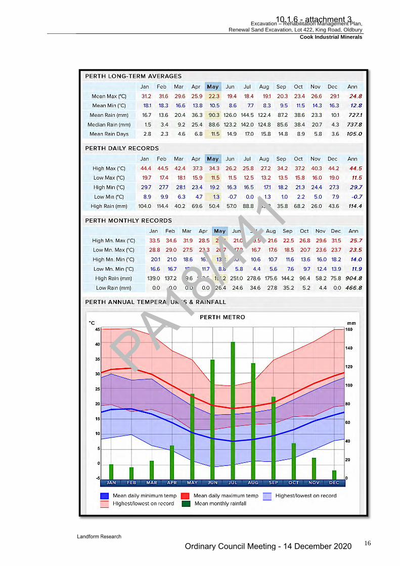
Excavation – Rehabilitation Management Plan, Renewal Sand Excavation, Lot 422, King Road, Oldbury
Cook Industrial Minerals
16
PA18/44
1
10.1.6 - attachment 3
Ordinary Council Meeting - 14 December 2020

Excavation – Rehabilitation Management Plan, Renewal Sand Excavation, Lot 422, King Road, Oldbury
Cook Industrial Minerals
17
4.4 Hydrology See Section 9.0 Water Management Plan Surface Water There is no surface runoff of water due to the porosity and permeability of the sand, with precipitation draining to the water table. Groundwater All drainage from the active working areas and excavation is to the base of the excavation, and thus all surface water is retained on site. See Section 9.0 Water Management Plan
PA18/44
1
10.1.6 - attachment 3
Ordinary Council Meeting - 14 December 2020

Excavation – Rehabilitation Management Plan, Renewal Sand Excavation, Lot 422, King Road, Oldbury
Cook Industrial Minerals
18
5.0 PROJECT DESCRIPTION 5.1 Construction The site is an existing sand pit that has operated since 1984. There is no proposed expansion to the scale of the operations or the amount of ground open at any one time, therefore not enlarging but rather reducing in area as resource is extracted and land is rehabilitated. This proposal is a continuation of the previous operations.
Construction Time Not applicable as this is an operating pit in the last phase of extraction and rehabilitation.
5.2 Excavation Excavation methods are unchanged and are carried out as a sequence. The sand excavation is nearly complete, with only 1.5 hectares of resource remaining. There is also a requirement to provide a consistent land surface along the western boundary to ensure that the land drops from the 26 metres AHD at King Road to the approved floor at 21 metres AHD. This process has commenced in the southern end of the western buffer and does involve the removal of some interim rehabilitation and the replanting and rehabilitation. Figure 4. The southern portion of the western face has been recontoured and spread with topsoil. Tube stock have been purchased for planning in winter 2018. The northern portion of the western boundary is still to be completed. 1. Any shrub vegetation that is cleared will be used for rehabilitation. 2. Topsoil will be removed and recovered for spreading directly onto areas to be
revegetated. 3. Sand will then be excavated from the floor of the pit to an elevation of 21 metres AHD. 4. The sand used for fill will be loaded by loader directly to road truck. 5. Where sand is to be washed it will be transferred to the wash plant in the east by the
loader. 6. The wash plant will remain in its current location in the east of Lot 422. 7. At the end of excavation the floor of the quarry will be covered by a layer of overburden
and top soil and rehabilitated with pasture and local indigenous tree/shrub species. 8. Approval has been obtained to excavate around and under the Western Power lines
which are not used but remain on site. 9. All excavation and mining activities will be contained within the excavation area. 10. The access road is bitumen with internal roads being limestone or hard stand. 11. Rehabilitation will progressively follow mining, wherever possible with completed areas
of the excavation being revegetated as soon as practicable.
PA18/44
1
10.1.6 - attachment 3
Ordinary Council Meeting - 14 December 2020

Excavation – Rehabilitation Management Plan, Renewal Sand Excavation, Lot 422, King Road, Oldbury
Cook Industrial Minerals
19
5.3 Pit Design and Staging Table 2 Pit Attributes ASPECT PROPOSAL CHARACTERISTIC EXCAVATION Total area of Lot 422 20.6 hectares (approx) Date commenced 1984 Life of project 10 years Current Areas Active excavation – 0.7 ha
Future resource – 1.5 ha Rehabilitated parkland pasture and wetland – 11.6 ha Roads and hard stand 3.0 ha Ground waiting for rehabilitation, etc – 2.2 ha
Dewatering requirements Nil
Maximum depth of excavations Approved elevation of floor 21.0 metres AHD dropping to 20.0 m AHD in the wetland buffer
WASHING AND STOCKPILING Current Areas Wash plant and stockpiles – 2.8 ha
Area of water recycling ponds 2 x 90 m2 included in above.
Fuel storage No fuel storage TRANSPORT Truck movements Variable but approximately 1 - 5 laden trucks per day on 3 – 5
days per week. Access Existing access road to King Road WORKFORCE Operation The workforce will vary, depending on the level of operation and
market demands, but usually 1 to 2 persons can be expected to be working on site.
Hours of operation Hours of operation, will be 6.00 am to 5.00 pm Monday to Friday inclusive, excluding public holidays for transport, processing and excavation.
Final Contours There are no proposed changes to the rehabilitation on site. At the completion of excavation, the final soil slope on the floor of the excavation will be flat and slightly undulating. The batters will be graded to ensure the final slopes form an interim stable land surface in compliance with the Mines Safety and Inspection Act (1994) and Regulations (1995) at 1 : 4 vertical to horizontal. The sand excavation is nearly complete, with only 1.5 hectares of resource remaining. The final surface will drop from the 26 metres AHD at King Road to the approved floor at 21 metres AHD. This process has commenced in the southern end of the western buffer and does involve the removal of some interim rehabilitation and the replanting and rehabilitation. The wetland buffer is at an approved elevation of 20 metres AHD to enable wetland species to be used and successful. Figures 2 and 4. The Concept Final Contours are shown in the attached plan. A section line from Nearmap is attached. Figure 4.
PA18/44
1
10.1.6 - attachment 3
Ordinary Council Meeting - 14 December 2020

Excavation – Rehabilitation Management Plan, Renewal Sand Excavation, Lot 422, King Road, Oldbury
Cook Industrial Minerals
20
Rehabilitation will continue to be progressive, but because of the nature of the excavation will be restricted to completed faces. 5.4 Processing The sand that is washed and screened is washed through a series of spirals and centrifuges where the finer organic matter and traces of clay are removed. Generally only the white sand is washed. When excavated it is often grey with organic matter. The water from the washing is drawn from a licenced bore located on the eastern edge of the operations. From there the water travels to the plant and returns to two ponds in the south eastern corner. Water enters the first pond where the fine organic matter is separated and settles. From there the water travels to the second pond from which the water is drawn for additional washing. From time to time the organic matter settling in the ponds is reclaimed with an excavator, and, being organic matter derived from the soil, it is a natural product and is therefore spread over areas to be rehabilitated, to stabilise and improve the rehabilitated soils. Sand is also screened to size the materials. From the screening and washing plants the various sized sand grades are stored in low stockpiles in the central east of the site. Figure 1. A DWER Licence will be required under Part IV of the Environmental Protection Act 1986 for screening if the annual volumes exceed 5 000 - 50 000 tonnes. (Category 70 Prescribed Premises). 5.5 Stockpiles Stockpiles will continue to enable white and washed sand to be stored separately. Small stockpiles will be created on the floor of the pit for the types of sand. Figure 1. 5.6 Equipment Excavation No changes are proposed to the excavation or processing plant that has operated on site. All static and operational equipment will continue to work on the quarry floor to provide maximum sound and visual screening. Site office and/or containers May be required for the management and security of small items. Toilet system A serviced portable or other approved toilet system is available when the
site is operating. Wash plant Preparation of washed sand products. . Screening plant Sizing of the various grades of sand. Water tanker Used for dust suppression on the access roads and working floors. Loader Loading and excavating sand. Fuel Refueling is conducted from mobile tanker in the pit. There is no fuel
PA18/44
1
10.1.6 - attachment 3
Ordinary Council Meeting - 14 December 2020

Excavation – Rehabilitation Management Plan, Renewal Sand Excavation, Lot 422, King Road, Oldbury
Cook Industrial Minerals
21
stored on site. Weighbridge A weighbridge is located at the eastern end of the site. Maintenance Major maintenance will continue to be conducted offsite. Excavation A loader is used for exaction, feeding sand to the wash plant and loading
trucks. Occasionally other mobile plant is required such as an excavator. This is the same as currently operating.
Plant Storage The equipment stored on site is ancillary to the extractive industry and has been on site for over 20 years. The equipment is used for spare parts and temporary storage between being brought on site and then taken to another site. Within the last ten years the equipment has been reduced in area and number of plant. The storage areas have been raised to ensure a 2 metre separation from the water table and the equipment tidied, sorted and old plant removed from site. At the time of the last approvals discussions were held between CIM and the Shire with respect to the equipment storage and the recommendations of the Shire were all carried out. Shire officers have inspected Lot 422 regularly and have noted the changes. DWER officers also inspect the operations from time to time. No changes to the storage areas will be made, apart from them reducing in size as the excess plant is removed from site. All plant will be removed at the end of excavation. 5.7 Hours of Operation Hours of operation will be 6.00 am to 5.00 pm Monday to Saturday inclusive, excluding public holidays. This is similar to the operations of nearby quarries in the local area and past operations, although in recent times the quarry has not been operated on every day of the week. Transporting material on Saturday should not present a problem because of the high traffic volumes using local roads and low numbers of dwellings. 5.8 Access and Security The quarry will continue to be accessed along the current limestone access road from King Road. The site is secured by locked gates when it is not being actively worked. The boundary fencing is maintained to prevent inadvertent and unauthorised entry. Transport Truck access will continue to be from King Road and along the dedicated access road using the current crossover. A variety of contractor road trucks service the site. This represents a continuation of the transport methods used in the past and involves no anticipated overall increase. A variable number of trucks access the site but normally around 1 - 5 laden trucks per day on 3 – 5 days per week.
PA18/44
1
10.1.6 - attachment 3
Ordinary Council Meeting - 14 December 2020

Excavation – Rehabilitation Management Plan, Renewal Sand Excavation, Lot 422, King Road, Oldbury
Cook Industrial Minerals
22
5.9 Water Use No changes are proposed to the water usage that has operated for the past 20 years. Water is normally used for washing the sand and is recycled through two sumps. A licence (No 41536) is maintained from the Department of Water Environment Regulation for the water usage Drinking water will continue to be brought to the site as needed. The existing licence allocations have proven effective and sufficient and will be sufficient for all dust suppression. A rounded figure of 1 000 litres or 1 kL water use per day is anticipated based on past experience for dust suppression. For 150 days of full water requirements in a year, considering the low extraction volumes, winter and other wet days, the water requirements are anticipated to be 1 500 kL of water for dust suppression annually. A Dwelling normally uses around 300 kL per year as a comparison. The water used is recycled through two sumps. 5.10 Workforce The workforce will vary, depending on the level of operation and market demands, but usually 1 - 2 persons will continue to work on site plus truck drivers as they access the operations. 5.11 Safety Excavation is conducted to Mines Safety and Inspection Act 1994 and Regulations 1995. Excavation practices, and operations procedures are in compliance with the Act. Health and safety issues are overseen by the Department of Mines Industry Regulation and Safety. Although outside the approval processes of the Shire, CIM has procedures in place to manage safety, health, environmental impact, site completion and rehabilitation. All workers are required to wear full protective safety and high visibility gear when on site. All vehicles have two way radio capability. No light vehicles are permitted on site without registering with mobile plant on site. Full personal protection is required for all persons on site at all times. All personnel are provided with site induction, safety and environmental awareness training. Emergency The site is within mobile phone contact and all vehicles are equipped with two way radios.
Ø The loader will continue to excavate from the face using an in – out movement, only approaching the face from a perpendicular movement which is the safe option. The face will be no higher than the reach of the bucket, unless the sand free falls at the angle of repose in which case the face can be higher. For higher faces, benches or an excavator will be used.
PA18/44
1
10.1.6 - attachment 3
Ordinary Council Meeting - 14 December 2020

Excavation – Rehabilitation Management Plan, Renewal Sand Excavation, Lot 422, King Road, Oldbury
Cook Industrial Minerals
23
Ø Personal protection is worn by all persons on site, with a minimum of hi – viz, safety boots, long clothing, hearing and eye protection and helmets when near the face or operating machinery.
Ø Road trucks are separated from the operating loader. Site warning signs and
directions will be installed as required to maintain safety. Ø Safety bunds or temporary fences will be used above any active vertical faces as
required.
Ø Warning signs are maintained as required. Ø Emergency preparedness procedures are in place.
Fire Management The excavation area and access road forms a natural firebreak. Water available on site can be used for fire fighting. A Bushfire Management Plan is in place and remains valid as there have been no significant changes to the operations. Normally new developments require a bushfire management plan to be provided however, Western Australian Planning Commission Planning Bulletin 111/2016 provides for an exemption of a bushfire plan requirement because there will be no structures that will burn and the open ground will form a fire break. It also provides for an exemption where the proposed activity is a continuation of existing activities. This applies to this continuation of sand extraction and operations on site. The existing bushfire management, that has been approved by the Shire is attached. The management actions that are used to minimise fire risk are summarised below.
• Vehicles will be restricted to operational area, particularly on high fire risk days. • Diesel rather than petrol powered vehicles are used. • Perimeter fire breaks will be maintained for Lot 422. • The mobile plant on site will be available to assist with emergency fire management
when safe to do so. • Water supplies will be drawn from existing sump on site, • The farm fire fighting unit is available for fire management. • The site is secured from unauthorised access by maintaining the existing fencing
and locked gates. • Public access is not permitted. • An emergency muster area is provided. • On site communications and worker induction and training is provided as required. • The site is within mobile phone range, the surrounding area is relatively flat and any
bushfire smoke will readily be noticed.
PA18/44
1
10.1.6 - attachment 3
Ordinary Council Meeting - 14 December 2020

Excavation – Rehabilitation Management Plan, Renewal Sand Excavation, Lot 422, King Road, Oldbury
Cook Industrial Minerals
24
6.0 DUST MANAGEMENT 6.1 Environmental Dust Background Excessive dust has the potential to impact on both the workers and the adjoining land, and its potential for generation must be taken in context. There are a number of key aspects to dust impacts;
Ø What is the source of particles? Ø What is the potential for the particles to be disturbed? Ø What is the nature of the particles and how are they likely to behave? Ø What types of impacts are the particles likely to have if they move? Ø What management actions can be used to mitigate or reduce dust impacts?
Most dust on site will be generated during vehicle movements. Commonly called "dust," scientists and regulators refer to the term particulate matter (or PM) to describe the range of particles that exists in the air breathed in. Particulate matter exists naturally in the atmosphere, eg sea-salt spray and pollens. PM can be increased due to human activities such as vehicle exhaust, industrial processes, power stations, mining, farming and wood heaters, or smoke from bushfires. Exposure to PM can be associated with health and amenity impacts if the exposure is excessive. The likely risk of these impacts depends on a range of factors including the size, structure and composition of the PM and the general health of the person. Particulate matter needs to be suspended in the air to carry any distance. The particles must be smaller than sand grains, which will only carry short distances because the grains are too large to move at any more than bouncing. The particles that are able to be suspended are called Suspended Particulate Matter and the total amount of that is referred to as TSP. Little published data is available from general mining in Western Australia even though monitoring is undertaken at some sites. There is data specifically from mining, (predominantly coal) from New South Wales (NSW Health) where particulate levels have been measured to be; PM <2.5 microns as 2 – 5% of emissions (One micron is 1 / 1000 of 1 mm).
PM< 2.5 are invisible and called “fine particles”. They are the main health issue and are caused by vehicle emissions whether they are along roads or on private land. Vehicle emissions will not occur at night or at other times when the site is not active.
PM 2.5 – PM10 microns as 15 – 45%
PM 10 (particles between 2.5 and 10 microns) are invisible and called “coarse particles”. They can be breathed in, but are removed by alveoli and mucous. (NSW Health). This dust may be generated when land is cleared and topsoil disturbed or the site is subject to traffic in summer.
PA18/44
1
10.1.6 - attachment 3
Ordinary Council Meeting - 14 December 2020

Excavation – Rehabilitation Management Plan, Renewal Sand Excavation, Lot 422, King Road, Oldbury
Cook Industrial Minerals
25
PM>10 microns as 50 – 70%
PM>10 is visible dust and will, based on the resource, be the vast majority of the particles.
Normally all sizes of dust are generated together, and there will be visible dust being generated when invisible dust is being formed. Therefore any visible dust present is a good sign and early indicator of a dust risk. A summary of the sources and proportions of dust is shown in; NSW EPA and NSW Ministry of Health Environmental Health Branch 2015, Review of the health impacts of emission sources, types and levels of particulate matter air pollution in the ambient air in NSW. This is backed up by occupational monitoring through the Department of Mines Industry Regulation and Safety. Unpublished data from those quarries shows quarries are compliant or can readily be made compliant with the health and safety and community standards through normal dust management practices. See Section 1.4 Occupational Dust. Sand Quarries
Sand excavation is at the lowest risk from dust, producing very little dust material, with the exception of the vehicle dust generated from unsealed roads and the dust from fine clays within the sand that can be disturbed by vehicles movements when dry. Once wet, these clay enriched sands readily crust and do not blow unless disturbed by vehicle movements. The main particles on site are large sand grains, which are not mobilised to the atmosphere and cannot be breathed in. The small amounts of fine clay and other particles from roads are “coarse particles” and do not provide a significant health risk even if generated.
Occupational dust associated with the quarrying processes falls under the Mines Safety and Inspection Act 1994 and Regulations 1995 overseen by the Department of Mines Industry Regulation and Safety who regularly inspect the site. Tree Belt - Buffers Dust particles are readily stopped by tree belts and distance, with which the site complies. Tree belts slow the wind and allow the dust to settle. See Planning Guidelines Separating Agricultural and Residential Land Uses, Department of Natural Resources Queensland 1997( Pages 65 – 111) and Department of Health WA, 2012, Guidelines for Separation of Agricultural and Residential Land Uses which uses the same criteria (Pages 112 – 118). The Queensland Guidelines predominantly relate to agricultural spray drift, but based on particle size also relate to dust. The Guidelines provide for a buffer of 300 metres for open agricultural land, dropping down to 40 metres where an effective tree belt is in place. The Western Australian Department of Health also uses the same guidelines. The Guidelines are based on field studies and demonstrate the effectiveness of tree belts and distance in providing screening against particulate travel. A minimum of over 40 metre vegetated buffer distances are available to the dwelling to the south and west, which complies with the Guideline and the Queensland research.
PA18/44
1
10.1.6 - attachment 3
Ordinary Council Meeting - 14 December 2020

Excavation – Rehabilitation Management Plan, Renewal Sand Excavation, Lot 422, King Road, Oldbury
Cook Industrial Minerals
26
6.2 Assessment of Dust Risk Dust Guidelines Dust management is an integral part of the extraction and processing of any basic raw material. The most common form of disturbance is by mobile plant and vehicle impacts. The potential for dust emissions falls under the Guidance for the Assessment of Environmental Factors, EPA, March 2000. Assessments of the potential dust risk are normally made using the Land development sites and impacts on air quality, Department of Environmental Protection and Conservation Guidelines, November 1996. These guidelines are still in place but are incorporated into the DEC (DER) 2011 Guideline for Managing the Impacts of Dust and Associated Contaminants from Land Development Sites, Contaminated Sites Remediation and other Related Activities. The DWER (DEC) in 2008 released a draft Guideline for the Development and Implementation of a Dust Management Plan. The site has operated for 20 years and effective dust management is in place and has proven to be effective. Even so a dust risk assessment has been completed using the DEC (DWER) 2011 Guideline. Table 3 Dust Risk Assessment from DWER (DEC)
PART A Number
Item
Score 1 Nuisance potential of the material Low for excavated material and with dust control in place - 2
2 Topography and vegetation
screening Screened and sheltered - 1
3 Area of site activities Active trafficked areas at any one time are 1 - 5 hectares in area - 3
4 Type of work being undertaken The small scale of excavation is equivalent to partial earthworks - 6
Summer total without dust
measures Maximum = 12
PART B Number
Item
Score 1 Distance to premises Premises 100 m to 500 m - 6 2 Effect of prevailing wind Isolated premises affected by one wind direction - 6
Total Part B Maximum = 12
PA18/44
1
10.1.6 - attachment 3
Ordinary Council Meeting - 14 December 2020
Excavation – Rehabilitation Management Plan, Renewal Sand Excavation, Lot 422, King Road, Oldbury
Cook Industrial Minerals
27
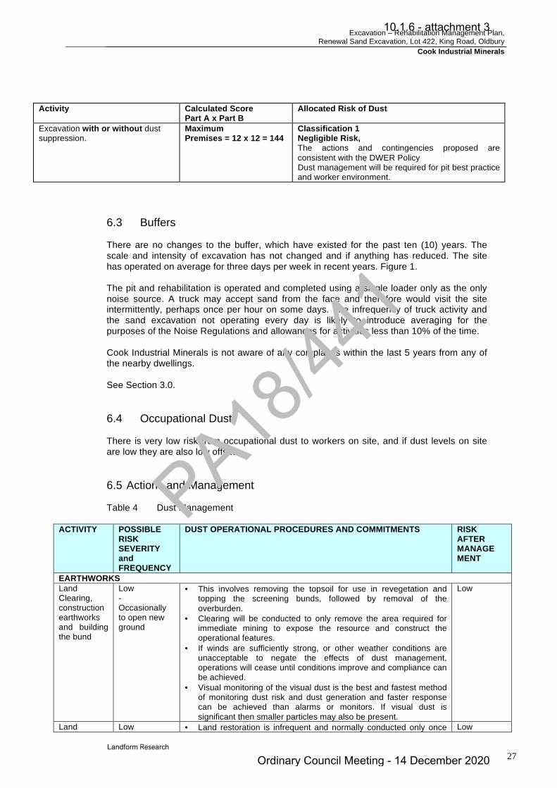
Activity Calculated Score
Part A x Part B Allocated Risk of Dust
Excavation with or without dust suppression.
Maximum Premises = 12 x 12 = 144
Classification 1 Negligible Risk, The actions and contingencies proposed are consistent with the DWER Policy Dust management will be required for pit best practice and worker environment.
6.3 Buffers There are no changes to the buffer, which have existed for the past ten (10) years. The scale and intensity of excavation has not changed and if anything has reduced. The site has operated on average for three days per week in recent years. Figure 1. The pit and rehabilitation is operated and completed using a single loader only as the only noise source. A truck may accept sand from the face and therefore would visit the site intermittently, perhaps once per hour on some days. The infrequency of truck activity and the sand excavation not operating every day is likely to introduce averaging for the purposes of the Noise Regulations and allowances for activities less than 10% of the time. Cook Industrial Minerals is not aware of any complaints within the last 5 years from any of the nearby dwellings. See Section 3.0. 6.4 Occupational Dust There is very low risk from occupational dust to workers on site, and if dust levels on site are low they are also low offsite. 6.5 Actions and Management Table 4 Dust Management
ACTIVITY POSSIBLE RISK SEVERITY and FREQUENCY
DUST OPERATIONAL PROCEDURES AND COMMITMENTS RISK AFTER MANAGE MENT
EARTHWORKS Land Clearing, construction earthworks and building the bund
Low - Occasionally to open new ground
• This involves removing the topsoil for use in revegetation and topping the screening bunds, followed by removal of the overburden.
• Clearing will be conducted to only remove the area required for immediate mining to expose the resource and construct the operational features.
• If winds are sufficiently strong, or other weather conditions are unacceptable to negate the effects of dust management, operations will cease until conditions improve and compliance can be achieved.
• Visual monitoring of the visual dust is the best and fastest method of monitoring dust risk and dust generation and faster response can be achieved than alarms or monitors. If visual dust is significant then smaller particles may also be present.
Low
Land Low • Land restoration is infrequent and normally conducted only once Low
PA18/44
1
10.1.6 - attachment 3
Ordinary Council Meeting - 14 December 2020

Excavation – Rehabilitation Management Plan, Renewal Sand Excavation, Lot 422, King Road, Oldbury
Cook Industrial Minerals
28
restoration - Once per year or less frequent
per year. • Scheduled activities such as ripping, overburden and topsoil
spreading will be conducted at times of low dust risk
EXCAVATION - PROCESSING Excavation Low
- a few days each week
• There are no changes to the sand excavation methods. • Sand excavation is moving away from the dwelling to the north • Excavation will be conducted on the floor of the pit to provide
maximum shelter for dust protection. • The treed buffers to the north provide compliance with
Government Guidelines.
Low
Loading and stockpile creation
Low - a few days per week
Few stockpiles are used. Loading from the face produces little dust and is covered under excavation.
Low
TRANSPORT Road condition
Low - the site has only open 3 days per week in recent years
• The access road is sealed. • All loads for transport outside the pit are covered. • The access road and crossover are maintained in good condition
(free of potholes, rills and product spillages).
Low
Health and Amenity
• Occupational dust associated with the quarrying processes falls under the Mines Safety and Inspection Act 1994 and Regulations 1995 overseen by the Department of Mines Industry Regulation and Safety who regularly inspect the site.
• A readily auditable trigger of no visible dust to cross the property boundary in line with DWER Licence and best practice in WA.
• The trigger for dust management is the generation of visual dust. • The loader operator will determine the amount of dust being
generated and they are in the best position to assess dust generation and to direct remediation.
• On site induction training will include observation and mitigation where possible of all dust emissions.
• Operations will temporarily cease if conditions occur where dust cannot be managed.
• The latest weather conditions to increase the awareness of dust risk.
Complaints • All complaints relating to dust are to be investigated immediately on receipt of a complaint.
• A record of all dust complaints is to be maintained together with the mitigation measures to be used to reduce the dust impacts.
6.6 Dust Monitoring Most dust generated from processing and vehicle movements has a very large visible component. The loader operator is in the best position to assess dust and implement management to mitigate or reduce the dust risk and generation. Human monitoring can detect potential dust risks prior, and take action prior, to significant dust being generated. They notice dust immediately such as from tyres, whereas machine monitoring has to rely on significant dust being generated, travelling to the boundaries of the premises and triggering an alarm. The operators would be negligent if they let the dust get to that level of impact prior to taking action.
PA18/44
1
10.1.6 - attachment 3
Ordinary Council Meeting - 14 December 2020

Excavation – Rehabilitation Management Plan, Renewal Sand Excavation, Lot 422, King Road, Oldbury
Cook Industrial Minerals
29
The auditable condition is visible dust crossing the boundary of the premises; the lot boundary. This is the condition used on Department of Water Environment Regulation Licences and all other quarries such as sand, limestone and hard rock quarries in Western Australia and has worked well in the past. The same method is also the method used by the Department of Mines Industry Regulation and Safety to rapidly assess occupational dust on site. All operators on site are instructed to be vigilant to dust generation and management and report any excessive dust or potential dust management issues. Visual monitoring is even more effective when complemented by an extensive reporting and complaints process and this is used. The effectiveness of the dust management is shown by no complaints regarding dust normally being received. No complaints are known relating to dust from excavation within the past five years.
PA18/44
1
10.1.6 - attachment 3
Ordinary Council Meeting - 14 December 2020

Excavation – Rehabilitation Management Plan, Renewal Sand Excavation, Lot 422, King Road, Oldbury
Cook Industrial Minerals
30
7.0 NOISE MANAGEMENT 7.1 Operations Noise Management is designed to comply with Best Practise, such as Institute of Quarrying Australia/Queensland Government, Noise Management. 7.2 Regulatory Framework Noise can originate from a number of operations and may impact on onsite workers, or travel offsite and impact on external sensitive premises. Both potential noise impacts are addressed by reducing the noise generated from the quarrying and processing operations. Offsite noise is governed by the Environmental Protection (Noise) Regulations 1997. The Environmental Protection (Noise) Regulations 1997, require that sensitive premises including dwellings in non industrial and rural areas, are not subjected to general noise levels (excluding blasting), during the hours 7.00 am to 7.00 pm Monday to Saturday that exceed 45 dBA. Allowable noise to 55 dBA is permitted for up to 10% of the time and to 65 dBA for 1% of the time. Noise levels are not to exceed 65 dBA during normal working hours. Between 9.00 am and 7.00 pm on Sundays and Public Holidays, and between 7.00 pm and 10.00 pm on all days, the base level is 40 dBA. At night, between 10.00 pm and 7.00 am Mondays to Saturday, and before 9.00 am on Sundays and Public Holidays the permitted level drops to 35 dBA. The 10% and 1% “time above” allowances apply at night and on Sundays and Public Holidays as well. There are penalties for tonality of 5 dB, modulation 5 dB and 10 dB for impulsiveness, that are added to the permitted levels. That is, if the noise is tonal or modulated the permitted levels drop by 5 dB. Impulsiveness is not likely to be relevant for the quarry under normal circumstances. The Noise Regulations provide for Construction Noise exemptions to enable construction of the site such as the building of the screening bund and opening the pits. Influencing factors that raise the allowable noise levels are activities such as external industrial noise, some nearby land uses and busy roads. These are not relevant to this site. Under Schedule 1 of the Noise Regulations the premises on which the extraction of basic raw materials are extracted, is classified as Industrial Land for the purposes of calculating influencing factors. This was defined as the whole cadastral boundaries in State Administrative Tribunal decision {2013} WASAT 139, Bushbeach v City of Mandurah. In this case the premises is quite small and approximates the area of disturbance and will have little impact on the influencing factors. At a distance greater than 15 metres from the sensitive premises (eg dwelling), and commercial premises, a base level of 60 dBA applies at all times, with the 10% time permitted to be up to 75 dBA and the 1% permitted to be up to 80 dBA. For industrial premises the base level is 65 dBA at all times with the 10% time permitted to be up to 80 dBA and the 1% permitted to be up to 90 dBA. A 60 dBA applies at the boundary of the premises, that is the boundary of the Lot.
PA18/44
1
10.1.6 - attachment 3
Ordinary Council Meeting - 14 December 2020
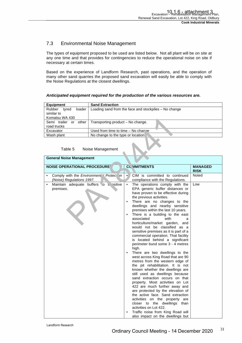
Excavation – Rehabilitation Management Plan, Renewal Sand Excavation, Lot 422, King Road, Oldbury
Cook Industrial Minerals
31
7.3 Environmental Noise Management The types of equipment proposed to be used are listed below. Not all plant will be on site at any one time and that provides for contingencies to reduce the operational noise on site if necessary at certain times. Based on the experience of Landform Research, past operations, and the operation of many other sand quarries the proposed sand excavation will easily be able to comply with the Noise Regulations at the closest dwellings. Anticipated equipment required for the production of the various resources are. Equipment Sand Extraction Rubber tyred loader similar to Komatsu WA 430
Loading sand from the face and stockpiles – No change
Semi trailer or other road trucks
Transporting product – No change.
Excavator Used from time to time – No change Wash plant No change to the type or location.
Table 5 Noise Management
General Noise Management NOISE OPERATIONAL PROCEDURES COMMITMENTS MANAGED
RISK • Comply with the Environmental Protection
(Noise) Regulations 1997. • CIM is committed to continued
compliance with the Regulations. Noted
• Maintain adequate buffers to sensitive premises.
• The operations comply with the EPA generic buffer distances or have proven to be effective during the previous activities.
• There are no changes to the dwellings and nearby sensitive premises within the last 10 years.
• There is a building to the east associated with a horticulture/market garden, and would not be classified as a sensitive premises as it is part of a commercial operation. That facility is located behind a significant perimeter bund some 3 - 4 metres high.
• There are two dwellings to the west across King Road that are 90 metres from the western edge of the pit rehabilitation. It is not known whether the dwellings are still used as dwellings because sand extraction occurs on that property. Most activities on Lot 422 are much further away and are protected by the elevation of the active face. Sand extraction activities on the property are closer to the dwellings than activities on Lot 422.
• Traffic noise from King Road will also impact on the dwellings but
Low
PA18/44
1
10.1.6 - attachment 3
Ordinary Council Meeting - 14 December 2020

Excavation – Rehabilitation Management Plan, Renewal Sand Excavation, Lot 422, King Road, Oldbury
Cook Industrial Minerals
32
would be unlikely to require taking into account for the Noise Regulations.
• Under Schedule 1 of the Noise Regulations the premises on which the extraction of basic raw materials are extracted, is classified as Industrial Land for the purposes of calculating influencing factors. This was defined as the whole cadastral boundaries in State Administrative Tribunal decision {2013} WASAT 139, Bushbeach v City of Mandurah. This will have little impact on the influencing factors. Therefore the property to the west on which the dwelling lies will be classified as industrial land for the purposes of the Noise Regulations and the dwelling would not be classified as a sensitive premises but might be classified as a caretakers cottage for the Noise Regulations.
• There is a dwelling to the south which is 190 metres away from the closest part of rehabilitation and further away for other parts of the pit. This dwelling is located behind a vegetation belt and is significantly further away from the remaining sand resource. Figure 1.
• Locate exposed features behind natural barriers and landform.
• Excavation is conducted on the floor of the pit behind the faces and natural landform to provide maximum noise screening. Perimeter bunding is used to provide maximum noise screening and safety protection.
Low
• Maintain all plant in good condition with efficient mufflers and noise shielding.
• This is used and is committed to. All plant is to be maintained in sound condition.
• The pit and rehabilitation is operated and completed using a single loader only as the only noise source. A truck may accept sand from the face and therefore would visit the site intermittently, perhaps once per hour on some days. The infrequency of truck activity and the sand excavation not operating every day is likely to introduce averaging for the purposes of the Noise Regulations and allowances for activities less than 10% of the time.
Low
• Maintain haul road and hardstand surfaces in good condition (free of potholes, rills and product spillages) and with suitable grades.
• No changes to the access roads are proposed.
• The haul road is not near dwellings.
Low
• A site code is implemented outlining requirements for operators and drivers for noise management.
• A site code is implemented and CIM is committed to site induction and training for all personnel for all
Low
PA18/44
1
10.1.6 - attachment 3
Ordinary Council Meeting - 14 December 2020

Excavation – Rehabilitation Management Plan, Renewal Sand Excavation, Lot 422, King Road, Oldbury
Cook Industrial Minerals
33
parts of the operations. • Shut down equipment when not in use. • Shutdown is used to save fuel and
maintenance costs in addition to noise minimisation.
Low
• Fit warning lights, rather than audible sirens or beepers, on mobile equipment wherever possible.
• Lights or low frequency frog beepers are to be used rather than high pitched beepers to restrict noise intrusion.
Low
• Provide a complaints recording, investigation, action and reporting procedure.
• A complaints recording and investigation procedure is proposed and will be implemented and maintained.
Low
• Provide all workers with efficient noise protection equipment.
• All personal noise protection equipment will be provided to staff as required.
Low
• Minimise and conduct at the least disruptive times.
• Quarrying is to be conducted during the approved working hours.
Low
7.4 Occupational Noise Occupational noise associated with the quarrying processes falls under the Mines Safety and Inspection Act 1994 and Regulations 1995. The management of occupational noise is normally handled by providing all necessary hearing protection, as well as conducting worker inductions and educational programs for all staff. As part of its commitments, CIM are pro-active with its worker safety awareness;
Ø by providing all necessary safety equipment such as ear protection, Ø identifying sections of the plant where hearing protection is required, as well as, Ø conducting induction and educational programs for its staff.
Warning signs are used to identify areas of potential noise associated with mobile plant. PA18
/441
10.1.6 - attachment 3
Ordinary Council Meeting - 14 December 2020

Excavation – Rehabilitation Management Plan, Renewal Sand Excavation, Lot 422, King Road, Oldbury
Cook Industrial Minerals
34
8.0 VISUAL MANAGEMENT There are a number of management actions that can be taken in quarries to minimise visual impact and these will be used wherever possible. Guidance on visual impact is contained in Department of Planning, 2007, Visual Landscape Planning in Western Australia (DoP 2007). Guidance can also be found in Forest Commission of Victoria, undated, Landscape Types of Victoria. Visual Impact can occur in a number of circumstances, by the operation being set too high in the landscape, by being too close to neighbours and by insufficient visual protection. The quarry is screened from King Road and adjoining land users by setbacks; the perimeter 20 metre buffers, 40 metre road buffer and existing remnant vegetation. These setbacks are unchanged, although the trees and shrubs in the buffers have grown within the last 5 years. Sand excavation has operated to the requirements of the Revegetation Plan Lot 422, King Road Oldbury which was approved by the Shire of Serpentine – Jarrahdale in December 2000. This plan addressed the buffers and visual management. The operation has been inspected by the Shire of Serpentine-Jarrahdale twice per year and has been licensed through an Extractive Industries Licence from the Shire of Serpentine-Jarrahdale in that time. As the last phase of excavation the western buffer is being recontoured and planted. Figure 1. The final land surface will be consistent with a variety of final land uses at 21 metres AHD, although the property will be returned to parkland pasture. At that time all equipment and plant will be removed from the site. See Section 11.0 Closure and compare Figures 2 and 3. There are a number of management actions that have been taken to minimise visual impact.
Ø The quarry is located behind natural barriers of the pit, western face and the intervening trees and King Road buffer.
Ø Excavation occurs from the floor of the pit below natural ground level Ø The haul and access road are at low elevation and truck movements along the
northern edge of the property. This has not changed since the pit opened. Ø The stockpiles and processing plant are set back 450 metres from King Road
behind a significant distance buffer of trees and rehabilitated land in the east of Lot 422. Much of Lot 422 has been rehabilitated and planted to scattered trees as can be seen on the aerial photographs.
Ø Progressive rehabilitation has been completed for the excavated or disturbed areas in the centre of the pit.
PA18/44
1
10.1.6 - attachment 3
Ordinary Council Meeting - 14 December 2020
Excavation – Rehabilitation Management Plan, Renewal Sand Excavation, Lot 422, King Road, Oldbury
Cook Industrial Minerals
35
9.0 WATER QUALITY MANAGEMENT 9.1 Water Source Protection Areas Lies within Groundwater Area GWA36 South West Coastal. The excavation on Lot 422 complies with DWER Guidelines for water management and separation to the groundwater of > 2 metres. 9.2 Water Requirements The pit is relatively small with short access roads and operated at a small scale. The water requirements are anticipated to be minimal and sourced from the sump. In most cases dust suppression will not be required. Around 1 500 kL per year is used for minor dust suppression and is sourced from a Licensed Bore, (No 41536). 9.3 Water Quality Protection Guidelines All facilities and procedures on site are designed to comply with the DWER – DMIRS Water Quality Protection Guidelines for Mining and Mineral Processing and are all complied with;
• Minesite stormwater • WQPN 15 Extractive Industries near sensitive water resources • Department of Water Environment Regulation – South West Region Guideline –
Water resource considerations for extractive industries.
9.4 Surface Water There is no surface water runoff, with all water infiltrating to the water table. There is no surface runoff of water due to the porosity and permeability of the sand, with precipitation draining to the water table. It has been estimated that perhaps 20% - 40% of the rainfall will reach the water table, based on the generally cleared nature of the sand and proximity of the water table. 9.5 Groundwater No changes are proposed to the water usage that has operated for the past 20 years. Water is normally used for washing the sand and is recycled through two sumps. A licence is current from Department of Water Environment Regulation for the water usage (No 41536). The elevation of the highest known water table is at 19 metres AHD (Perth groundwater Atlas). The final land surface will continue to be a minimum of 21 metres AHD which will be a minimum of 2 metres above the water table. This will comply with Department of Water Environment Regulation Guidelines.
PA18/44
1
10.1.6 - attachment 3
Ordinary Council Meeting - 14 December 2020

Excavation – Rehabilitation Management Plan, Renewal Sand Excavation, Lot 422, King Road, Oldbury
Cook Industrial Minerals
36
The water table is not exposed on site, but shown as being 19 metres AHD in the Perth Groundwater Atlas. There are however two small sumps which have been on site during the use of the wash plant and are a small window on the water table. The sumps have been inspected by Shire of Serpentine – Jarrahdale officers and officers of the DWER. A licence (No 41536) is held by Cook Industrial Minerals for the use of water from a sump and recycling dam near the eastern boundary. The final land surface is 21 metres, which was requested by the EPA in correspondence and discussions as part of an application for an alternative land use. An elevation of 21 metres AHD was required and has been monitored by the Shire of Serpentine – Jarrahdale since 2000. In the past ten years the surface of the land has been raised from the previously approved lower elevation to be 21 metres AHD to provide a separation of 2 metres across the excavated area. This lowers to 20 metres AHD in the wetland buffer. See attached Figure 4, the attached section line from Nearmap. Considering the nature of the operation, and the underlying geology, excavation will not lead to alteration of the groundwater systems in the area. The extraction of sand is regarded as one of the least polluting activities carried out within water source protection areas. Since 1984 there have been no recorded changes to ground water on site. The extraction of sand is a chemically free operation with the only liquids used being lubricants for machinery. 9.6 Wetland A conservation category wetland straddles the southern boundary of Lot 422. This remains uncleared apart from old firebreaks that have been rehabilitated and active firebreaks that are required for fire management. Figures 2 and 3. The wetland on the southern boundary provides significant habitat, and when combined with the remnant and buffer vegetation provides habitat and linkages. The low elevations around the existing recycling ponds are to be restored to wetland and wetland buffer. Access to the recycling ponds is required because Lot 422 has a water allocation and licence. Subsequent landholders will need to access the water sources. The wetland is being returned to local shrub wetland thicket with a wetland buffer. The wetland buffer has an elevation of 20 metres AHD to ensure that the wetland species planted in the buffer are close enough to survive. 9.7 Salinity Precipitation falling on the site is fresh. The groundwater obtained from the bore on site is fresh and there is no likelihood of significant or other salinity increases apart from minor evaporation, which is no different from any garden. The existing water recycling sump provides a monitoring point for water quality.
PA18/44
1
10.1.6 - attachment 3
Ordinary Council Meeting - 14 December 2020
Excavation – Rehabilitation Management Plan, Renewal Sand Excavation, Lot 422, King Road, Oldbury
Cook Industrial Minerals
37
9.8 Dewatering No dewatering is proposed or has been required in the past. All water is retained in the pit and infiltrates into the sand through the water recycling sumps. 9.9 Recharge Discussions of the recharge on sand and limestone areas can be found in Environmental Protection Authority in Bulletins 512, 788, 821 and 818, and whilst these do not specifically refer to the extraction of basic raw materials they do consider the impact of clearing, planting trees and rural residential developments. The area has no surface drainage because of the permeable and porous nature of the sand. There is no surface drainage from the excavation site. All excess water infiltrates the permeable sand. Drainage is to the water table, which has a separation of 2 metres from the excavated surface therefore providing allowance for any seasonal changes to the water table. The figure the EPA used for recharge from native vegetation was 10 – 15% rainfall, whereas cleared land had a recharge of 30 – 40 %. The floor of the quarry is also cleared and so there is not expected to be any reduction in recharge to the site. The site prior to excavation was pasture and will be returned to pasture even though it will be at a lower elevation. Most water used for dust suppression will evaporate, and the draw of 1 500 kL per year for minor internal dust suppression has had no discernible impact on the water table since commencement in 1984. No changes are proposed to the operational methods that will change the recharge conditions. Now effectively rehabilitated to pasture with scattered trees there will be no significance difference to recharge to the pre – excavation state, when the site was pasture. There have been significantly more trees planted than when the property was operated as agricultural land, and the wetland has been replanted with many more wetland species spread over a larger area. Water recycling is continued through the water recycling sumps. The proposed operation complies with all Government Policies and Guidelines and has been inspected by the Shire of Serpentine – Jarrahdale on regular occasions and the DWER. No changes are proposed to the previously approved revegetation plans. Potable water is brought to the site as needed.
PA18/44
1
10.1.6 - attachment 3
Ordinary Council Meeting - 14 December 2020

Excavation – Rehabilitation Management Plan, Renewal Sand Excavation, Lot 422, King Road, Oldbury
Cook Industrial Minerals
38
9.10 Acid Sulfate Risk Definitive survey procedure is produced in DEC (DWER) 2013, Identification of Acid Sulfate Soils and acidic Landscapes and within document Acid Sulfate Soil Management Advisory Committee NSW, 1998, Acid Sulfate Manual. This information forms the basis for much of the assessment procedures in Australia, including those adopted by the Western Australian Planning Commission and the Department of Environment Regulation. The main method of assessment is based on geological examination. If at risk conditions are identified than laboratory testing may be required but must be completed carefully because there is a high risk of false positives with the available testing regimes. Acid sulfate only becomes a potential risk when a number of circumstances are present. Acid Sulfate is a natural phenomena, that can be exacerbated by disturbance. For it to be present there needs to be;
Ø Rock, soil or regolith present that is carrying sulfides.
Ø Sulfide carrying materials from below the water table are to be exposed to the atmosphere.
Ø Excavation below the water table is to be carried out exposing the sulfide carrying
materials to oxygen in the atmosphere.
Ø Dewatering of the sulfide carrying materials is proposed, exposing them to oxygen.
Ø Exposure of peat or organoferricrete materials, that were permanently under
reducing conditions, to the air. Materials at risk under reducing conditions are normally grey in colour or have been grey with no brown or red brown iron oxides. Where exposed to the atmosphere there is a change to brown iron oxides, with yellow jarosite and other alteration minerals that are distinctive. The site has been inspected by Lindsay Stephens of Landform Research on many occasions. None of the at risk parameters are exposed on site. On site the soils are yellow sands that are oxidised and do not carry any risk of acid sulphate potential. Some minor iron induration is encountered in the faces of the pit, generally below the proposed base of the pit. This concurs with Nattaporn-Prakongkep, R J Gilkes, B Singh and S Wong, 2011, Mineralogy and chemistry of sandy soils in the Perth metropolitan area of the Swan Coastal Plain, Department of Environment and Conservation who concluded that there is no risk of acid sulfate soils in sands unless there is peat or organoferricrete present and excavation proceeds below the water table. In such situations no testing would be required because there is no risk. Excavation is not undertaken below the water table and there is a 2 metre separation maintained to the water table in line with Government policy. The sump is excavated but is a small window to the water table and therefore no sand or other materials from below the water table are exposed. Any sulfide minerals that may occur will only be present below the existing water table. A two metre separation to the water table is to be maintained therefore no regolith materials under reducing conditions will be disturbed.
PA18/44
1
10.1.6 - attachment 3
Ordinary Council Meeting - 14 December 2020
Excavation – Rehabilitation Management Plan, Renewal Sand Excavation, Lot 422, King Road, Oldbury
Cook Industrial Minerals
39
9.11 Unauthorised Access and Illegal Dumping
• There are no changes to the activities on site. • Access is restricted by current farm fencing and locked gates. • Wastes generated from on site operational activities will be recycled wherever
possible and periodically disposed of at an approved landfill site. • Any illegally dumped materials are to be removed promptly to an approved landfill
or other suitable site, depending on the nature of the material.
9.12 Wastewater Disposal – Recycling ponds Toilet System A serviced portable toilet is in place while the site is operating. Serviced means they are pumped out by a licensed contractor. Recycling Ponds For many years the wash plant was used to recycle and wash sand from site and that has resulted in organic matter and clay settling in the base of the sumps A much smaller amount of garnet sand has also been used for sand blasting was also washed and recycled. Garnet is insoluble, but some of the trace materials from the sand blasting contained metal. No garnet has been washed for around ten years. CIM has worked with the DWER to assess the metallic materials in the sumps. Testing of the fine sediment from around the edges and floor of the sump, revealed that all metals were below the levels which would trigger contamination. However tributyl tin was either under the level or just over the trigger level. The sumps were cleaned out by removing the collected washed sand from the base of the sumps using a large excavator. That material has been stored for later disposal to an approved landfill if it does not meet the DWER guidelines. It is noted that the sumps, even though they are used for recycling water are environmentally health because of the aquatic life in them in the form of water birds and a large number of frogs that use the sumps. CIM will continue to work with DWER with respect to the material removed from the sumps. 9.13 Refuelling Fuel management is in accordance with the relevant guidelines. The methods to be used are summarised below. Documents specific to the fuel and maintenance are the DOW – DMIRS Water Quality Protection Guidelines for Mining and Mineral Processing
• DWER - WQPN 15 - Extractive Industries near sensitive water resources.
PA18/44
1
10.1.6 - attachment 3
Ordinary Council Meeting - 14 December 2020

Excavation – Rehabilitation Management Plan, Renewal Sand Excavation, Lot 422, King Road, Oldbury
Cook Industrial Minerals
40
Refuelling - Fuel Management Plan
• There is no onsite fuel storage. The loader will continue to be refuelled on site from a mobile tank or tanker. This method is used on most mine and construction sites as well as many farming properties.
• Refuelling on site will occur in the active pit area of ether the pit or the wash plant
area to allow for containment if any spill did occur.
• The main risk of contamination is the minor drips that occur during the removal of hoses etc. Minor spills are quickly degraded by soil microbial matter.
• The only other risk is from a tank rupture, but tanks are designed to manage this
eventuality and are approved to the relevant standards. Soil contaminated by large spills will be removed from the site to an approved disposal area.
• The operators of the mobile refuelling facilities are trained in re-fuelling duties
including the management of any spills.
• In the event of a spill or adverse incident, activities will be stopped in that area until the incident is resolved.
• Spillage will be contained by shutting down plant or equipment if the plant or
equipment is the source of the spill (provided it is safe to do so). The sand will provide high absorbency and will retain any spill.
• Soil contaminated by spills will be scooped up and removed from the site to an
approved disposal area.
• All significant adverse incidents (such as a fuel spill of >5 litres) in one dump, are to be recorded, investigated and remediated. A record is to be kept of incidents, and DWER, and Shire of Serpentine – Jarrahdale notified within 24 hours of an incident. No such incidents have occurred during the past operations.
9.14 Servicing and Maintenance Documents specific to the fuel and maintenance are the DWER Water Quality Protection Guidelines for Mining and Mineral Processing
• WQPN 15 - Extractive Industries near sensitive water resources. The main risk of contamination comes from tank or hose rupture on earth moving machines.
• All major servicing of vehicles will be conducted off site.
• The loader will continue to be parked at a secure site at night near the wash plant, and minor servicing will be conducted there.
• Regular inspections and maintenance of fuel, oil and hydraulic fluids in storages
and lines are carried out for wear or faults.
• In the event of a small service item being required during operations, such as lubricating and maintenance activities, these will be carried out at the designated area near the wash plant.
PA18/44
1
10.1.6 - attachment 3
Ordinary Council Meeting - 14 December 2020

Excavation – Rehabilitation Management Plan, Renewal Sand Excavation, Lot 422, King Road, Oldbury
Cook Industrial Minerals
41
• Waste oil and other fluids derived from the routine maintenance of mobile machinery, are transported off site and disposed off at an approved landfill site. Grease canisters, fuel filters, oil filters and top-up oils arer stored in appropriate containers in a shed or brought to the site as required.
• If any spillage occurs, it will be contained in the plant and working areas by shutting
down plant or equipment if the plant or equipment is the source of the spill (provided it is safe to do so).
• Accidental spill containment and cleanup protocol will be implemented as
necessary.
• There will be no waste disposal on site. Waste materials will be recycled wherever possible and periodically disposed of at an approved landfill site. Any waste materials derived during routine maintenance activities are stored in appropriate containers within a designated storage area or taken from site and disposed of at an approved facility.
• Regular inspections (at least weekly) are conducted to ensure no wastes, litter and
the like are present in or around the excavation and processing area.
PA18/44
1
10.1.6 - attachment 3
Ordinary Council Meeting - 14 December 2020

Excavation – Rehabilitation Management Plan, Renewal Sand Excavation, Lot 422, King Road, Oldbury
Cook Industrial Minerals
42
10.0 BIODIVERSITY 10.1 Flora The vegetation of Lot 422 prior to clearing was described in Revegetation Plan Lot 422, King Road Oldbury, which was approved by the Shire of Serpentine – Jarrahdale in December 2000. (Figure 2 attached – compare to Figure 3). This document remains valid and describes the methods of rehabilitation approved by the Shire of Serpentine – Jarrahdale. The site was originally parkland pasture prior to excavation but had some regrowth of Kunzea glabrescnes (ericifolia) in the south eastern corner of the excavation area. A Conservation Category wetland straddles the southern boundary and was not cleared. The wetland has been protected, rehabilitated, and the edges and firebreak rehabilitated with local native species, as described in the annual reports. The eastern buffer was replanted to Banksia Woodland and forms a wildlife corridor. There is little resource area remaining, apart from reforming the buffer in the west of the pit to make the land surface consistent with King Road. No native vegetation is proposed to be cleared although some clearing of interim rehabilitation planted in the western buffer will be required to enable the land surface to be made consistent with the adjoining land surface and King Road. In any case, no Clearing Permit is required.
10.2 Fauna The fauna on site will already be significantly depleted by the clearing and past excavation, but with the rehabilitation carried out to date, and the widening and thickening of the wetland buffer, there is likely to be greater numbers of native fauna now than some 10 – 20 years ago. 10.3 Wetlands A conservation category wetland straddles the southern boundary of Lot 422. This remains uncleared apart from old firebreaks that have been rehabilitated and active firebreaks that are required for fire management. The wetland on the southern boundary provides significant habitat, and when combined with the remnant and buffer vegetation provides habitat and linkages. The low elevations around the existing recycling ponds are to be restored to wetland and wetland buffer. The two sumps are to be returned to wetland with a wetland buffer of local native vegetation to effectively increase the area of wetland habitat. This was approved by the Shire during the previous approvals and will be continued within this development. The wetland is being returned to local shrub wetland thicket with a wetland buffer. The wetland buffer has an elevation of 20 metres AHD to ensure that the wetland species planted in the buffer are close enough to survive.
PA18/44
1
10.1.6 - attachment 3
Ordinary Council Meeting - 14 December 2020
Excavation – Rehabilitation Management Plan, Renewal Sand Excavation, Lot 422, King Road, Oldbury
Cook Industrial Minerals
43
10.4 Plant Diseases Dieback of vegetation is often attributed to Phytophthora cinamomi even though there are other Phytophthora species and other diseases such as Armillaria that can cause dieback like symptoms. Microscopic soil-borne fungi of the genus Phytophthora kill a wide range of native plants and can cause severe damage to many vegetation types, particularly those from the families Proteaceae, Epacridaceae, Xanthorrhoeaceae and Myrtaceae. In most cases dieback is caused by a pathogen which infests the plant and causes it to lose vigour, with leaves dying, and overtime may kill the plant. As such the management of Dieback is essentially related to plant hygiene when coming onto a site and within a site. There are several guides to the management of Dieback.
Ø Department of Parks and Wildlife (DBCA) Dieback Hygiene Manual 1992 is a practical guide to Dieback management.
Ø Department of Parks and Wildlife (DBCA) Best Practice Guidelines for the Management of Phytophthora cinamomi, draft 2004.
Ø Dieback Working Group 2005, Management of Phytophthora Dieback in Extractive Industries.
Ø Dieback Working Group, 2000, Managing Phytophthora Dieback, Guidelines for Local Government.
Jarrah Dieback (Phytophthora cinnamomi) is scattered across this part of the State, but in many cases such as this site the vegetation is not interpretable because of the levels of disturbance. DBCA has determined that material such as sand, taken from deeper in the regolith profile where there is no organic and other plant matter, carries low risk of spreading dieback. (DEC 2004). There are no proposed changes to the dieback management on site. The site was originally parkland pasture and had been significantly disturbed as has all the surrounding land on adjoining properties. For example to the east there is a plant nursery/floriculture operation. There is no apparent dieback disease impacting on vegetation on site from observations made by Landform Research although the site is probably un-interpretable. On this site, even though there is no current evidence of dieback or other species normal best practice, plant disease management actions will continue to be used, a) During excavation, minimise the risk of entry of any additional plant pathogens to the
site. b) There is very little risk of the operations spreading dieback onto vegetation on adjoining
properties as there is no access to those properties and they are cleared. c) All vehicles and equipment used during land clearing or land reinstatement, are
vehicles from on site. Any vehicles new to site are cleaned prior to arriving on site. d) When removing topsoil and clearing, vehicles will run around the perimeter and then
push inwards where possible. e) No soil and vegetation is brought to the site apart from that to be used in rehabilitation
and that which is dieback free. f) Plants used in rehabilitation are sourced from certified as from dieback free sources.
PA18/44
1
10.1.6 - attachment 3
Ordinary Council Meeting - 14 December 2020

Excavation – Rehabilitation Management Plan, Renewal Sand Excavation, Lot 422, King Road, Oldbury
Cook Industrial Minerals
44
g) Illegally dumped rubbish is removed promptly. The Weed Management Policy is complied with. 10.5 Weeds Weed management is to be used to minimise impact on adjoining remnant vegetation and conservation wetland and rehabilitation. The management of weeds is essentially similar to that for plant diseases. The impact of weeds is really the impact within the local area and the more they are controlled the better. Weeds can be declared under the Agriculture and Related Resources Protection Act 1976 which requires that Declared Weeds are eradicated. Other weeds are not Declared but may be classified as Environmental Weeds because they are well known for impacting on vegetation. There is some African Love Grass on site, that has been the subject of discussion with the Shire during the previous applications and site inspections. African Love Grass was introduced as a pasture species for Bassendean Sand and was widely planted locally. Where it is grazed the grass is not as readily obvious, which is the situation on some adjoining properties. The grass is however present on those properties and forms the main pasture. It also occurs along the road verges of King Road. Removal of the African Love Grass is therefore impossible without killing all other species with a broad based weed killer or repeatedly killing all other grasses with a grass selective weed killer such as Fusilade. As the seeds will come in from the King Road reserve and adjoining properties these control methods are not acceptable and that has been accepted by Shire officers. Weeds are most likely to impact on;
Ø Disturbed areas such as overburden dumps, topsoil stockpiles.
Ø Edges of access roads.
Ø Edges of firebreaks adjacent to surrounding vegetation. The main sources of weeds are;
Ø Weeds from edge effects from access and local roads.
Ø Gradual creep of weeds along access roads.
Ø Incursions from the King Road reserve where there is known African Love Grass.
Ø Rubbish dumped by the public. This is not likely as the resource is set well back from King Road
Ø Materials or waste brought to site by employees.
Ø Soil and seeds from vehicles arriving at site. This often applies to trucks that have
carried something else such as grain, or vehicles to be used in earthworks.
Ø Wind blown seed from surrounding land.
PA18/44
1
10.1.6 - attachment 3
Ordinary Council Meeting - 14 December 2020

Excavation – Rehabilitation Management Plan, Renewal Sand Excavation, Lot 422, King Road, Oldbury
Cook Industrial Minerals
45
Ø Birds and other vectors. This is more common than is often given credit for. eg
Solanum species. Weed Management
Ø Inspections are to be conducted to monitor the presence and introduction of Environmental and Declared Weeds on an annual or more frequent basis. On identification, Declared and significant environmental weeds will either be removed, buried, or sprayed with a herbicide.
Ø All vehicles and equipment to be used during land clearing or land reinstatement,
are to be clean and free from soil or plant material when arriving at site.
Ø No soil and vegetation will be brought to the site apart from that to be used in rehabilitation.
Ø Plants to be used in rehabilitation are to be free from weeds.
Ø Weed affected top soils may need to be taken offsite, used in weed affected areas,
buried by 500 mm soil/overburden or taken offsite.
Ø Illegally dumped rubbish is the major source of weeds and is removed promptly.
Ø No weed contaminated or suspect soil or plant material is to be brought onto the site.
Ø When clearing land or firebreaks vehicles work in conjunction with dieback
principles and push from areas of better vegetation towards areas of lower quality vegetation.
Ø Weeds are to be sprayed with broad spectrum spray prior to planting or seeding in
weed affected soils as required. PA18
/441
10.1.6 - attachment 3
Ordinary Council Meeting - 14 December 2020
Excavation – Rehabilitation Management Plan, Renewal Sand Excavation, Lot 422, King Road, Oldbury
Cook Industrial Minerals
46
11.0 CLOSURE
11.1 Background The excavated area was cleared prior to excavation and will be returned to pasture with some clumps of trees and shrubs. It has been found by Landform Research at Jandakot that some non local species are not eaten as readily by kangaroos and yet the local species are. Therefore some clumps of non local native trees were previously selected for their ability to provide shade and food resources to fauna, and their ability to grow on sands and planted in the earlier rehabilitation. These were used in the centre of the floor of the pit. In addition when establishing parkland pasture there is a shortage of local tree species, and additional species are worthwhile to enhance the plantings. Experience by Landform Research and past rehabilitation has shown that when tube stock are planted at the correct time of the year, there is no need for irrigation of the rehabilitation. Since December 2000, Cook Industrial Minerals have been rehabilitating Lot 422 in accordance with the approved "Revegetation Plan, Lot 422, King Road, Oldbury". This plan was submitted to the Shire of Serpentine - Jarrahdale and accepted with modifications at Council meetings in December 2000. The rehabilitation procedures were updated in an updated Rehabilitation Plan submitted on 28 July 2005 and continue to form the basis for the final rehabilitation of the excavated area described in this management plan. See attached Figures 2 and 3. The Shire of Serpentine – Jarrahdale currently holds a rehabilitation bond for the closure of the operations. The rehabilitation is assessed and updated as required by CIM and inspected annually during site inspections by Shire officers. The approved original plan is superimposed on the attached aerial photography and shows improvements in revegetation over the last 5 years. Elevation of the Excavated floor
Rationale The excavated floor is to have a separation to the water table of two metres. Completion Criteria The excavated area is to be at an elevation of 21 metres AHD. Status The old floor has been raised to 21 metres AHD and all new excavation has a final floor of that elevation.
PA18/44
1
10.1.6 - attachment 3
Ordinary Council Meeting - 14 December 2020

Excavation – Rehabilitation Management Plan, Renewal Sand Excavation, Lot 422, King Road, Oldbury
Cook Industrial Minerals
47
Excavated floor – Parkland Pasture
Rationale The excavated floor is to have a separation to the water table of two metres.
The central/excavated part of Lot 422 has been progressively excavated since the 1980's. The end use has always been to be rural land uses and rehabilitation has always been to parkland pasture. Completion criteria in "Revegetation Plan, Lot 422, King Road, Oakford", dated 7 December 2000 was "strategically placed clumps of trees". Numbers of plants to be used were specified in the "Revegetation Plan, Lot 422, King Road, Oakford", dated 7 December 2000, and these have been exceeded and planted in each of the past five years. Compare Figures 2 and 3. A number of native plants, some of which are local species, have been planted. A substantial proportion over the years have not been locally native, in an attempt to provide faster and better cover. Topsoil has been spread and seeding used. This has resulted in original pasture species gaining a hold. These include types of Veldt and Love Grass. These persist because they are widespread across most local properties and road verges where grazing has not been carried out in recent years. There appears to be little suitable other grass species that are not likely in themselves to become weed species. There is also potential for seed incursion from adjoining properties and the street verge. The options for grass control are limited by;
Ø There not appearing to be any viable alternative pasture species for deep leached
white sands. Ø The lack of ability to graze the property whilst excavation is proceeding. Ø The number of small local native species and trees that are present in the pasture
which would be destroyed by slashing or mowing. Ø Lot 422 will return to rural land use. Ø The difficulties and implications of using significant amounts of herbicide which may
open the ground to wind erosion.
It is difficult to control the pasture species when the same species form the major pasture grasses on adjoining landholdings and are widespread along the road verges of King Road. The main difference with the site is the amount of grazing. Grazing in other paddocks takes the top off the clumps of grasses reducing the seed load and making the pasture appear to be different species. When this part of the site is returned to grazing at the end of excavation, the same control will be able to be maintained. In the meantime the control uses the methods outlined in the attached notes on “Pasture Grasses and Potential Weed Species” June 2005. Where the pasture grasses are impinging on the wetland, control is proposed by spraying and grubbing out.
Completion Criteria The excavated area is to be at an elevation of 21 metres AHD.
PA18/44
1
10.1.6 - attachment 3
Ordinary Council Meeting - 14 December 2020
Excavation – Rehabilitation Management Plan, Renewal Sand Excavation, Lot 422, King Road, Oldbury
Cook Industrial Minerals
48
Ø The central and northern portion of Lot 422 King Road is to be established as parkland pasture, to achieve:
Ø Stable soils resistant to wind erosion.
Ø A 90% cover over pastured areas of deep rooted perennial pasture species that
are not species considered to be aggressive environmental weeds in Banksia woodland and/or wetland communities.
Ø Clumps of locally occurring trees and large shrubs.
Ø A minimal and controlled weed burden of environmental and no Declared
weeds.
Status The old floor has been raised to 21 metres AHD and all new excavation has a final floor of that elevation. The parkland pasture is establishing with local trees and shrubs over pasture. Control as been used in some areas in the past but for the Veldt and Love Grasses has not been particularly effective. Broad scale spray will kill the regenerating native species which are growing and establishing through the central part of the site. Comparisons between the 2011 and 2018 aerial photography (Figures 2 and 3), show that the revegetation is establishing and that the areas retained as buffers have continued to be protected.
Removal of Mining Equipment
Rationale The equipment stored on site is ancillary to the extractive industry and has been on site for over 20 years. The equipment is used for spare parts and temporary storage between being brought on site and then taken to another site. Within the last ten years the equipment has been reduced in area and number of plant. The storage areas have been raised to ensure a 2 metre separation from the water table and the equipment tidied sorted and old plant removed from site. At the time of the last approvals discussions were held between CIM and the Shire with respect to the equipment storage and the recommendations of the Shire were all carried out. Shire officers have inspected Lot 422 regularly and have noted the changes. DWER officers have also inspected the operations from time to time. No changes to the storage areas will be made, apart from them reducing in size as the excess plant is removed from site. All plant will be removed at the end of excavation. Completion Criteria At the end of excavation, at closure, all mining equipment and foreign materials not required for future land use will be removed from site. The access road will be maintained.
PA18/44
1
10.1.6 - attachment 3
Ordinary Council Meeting - 14 December 2020
Excavation – Rehabilitation Management Plan, Renewal Sand Excavation, Lot 422, King Road, Oldbury
Cook Industrial Minerals
49
The sump will be maintained as a small water source for the water licence. Status The mining equipment has been reduced since the previous approvals, It has been sorted and equipment that has little value was removed and recycled as scrap iron. The equipment was moved and the floor of the excavated area lifted to 21 metres AHD which is a two metre separation to the water table.
Eastern Buffer Lot 422
The eastern boundary buffer is to provide an ecological linkage of Banksia woodland from the adjoining property in the north to the wetland in the south. Rationale The buffer has been excavated in the past and is a batter slope from the original ground surface, down to the current floor of excavated area. Since commencement of excavation in the 1980's the buffer has always been able to provide visual screening for the property to the east. A significant number of native plants have been planted although not all have been local native species in the early days. Completion Criteria Completion criteria in "Revegetation Plan, Lot 422, King Road, Oldbury", dated 7 December 2000 was "a minimum of 500 trees per hectares and a minimum of one local indigenous taller shrub per 3m2." The buffer complies with this completion criteria apart from the few small bare areas. A self-sustaining community of tree, shrub and ground-cover plant species, indicative of the community structure and ecological function of local Banksia Woodland. Existing bare areas planted with local trees and shrubs indicative of local Banksia Woodland. Weed levels that are not likely to impact on the established vegetation. Absence of environmental and declared weeds. Status Currently the buffer is well vegetated with several small areas of bare sand that can be infilled by local native species. The buffer is well vegetated and in compliance with past licence Conditions.
Wetland buffer and wetland
Rationale A conservation category wetland straddles the southern boundary of Lot 422. This remains uncleared apart from old firebreaks which are in the process of rehabilitation.
PA18/44
1
10.1.6 - attachment 3
Ordinary Council Meeting - 14 December 2020

Excavation – Rehabilitation Management Plan, Renewal Sand Excavation, Lot 422, King Road, Oldbury
Cook Industrial Minerals
50
The wetland on the southern boundary provides significant habitat, and when combined with the remnant and buffer vegetation provides habitat and linkages. The low elevations around the existing recycling ponds are to be restored to wetland and wetland buffer. Continued access to the recycling ponds is required because Lot 422 has a water allocation and licence. Subsequent landholders will need to access the water sources. Numbers of plants to be used were specified in the "Revegetation Plan, Lot 422, King Road, Oldbury", dated 7 December 2000. The wetland is being returned to local shrub wetland thicket with a wetland buffer. The wetland buffer has an elevation of 20 metres AHD to ensure that the wetland species planted in the buffer are close enough to survive.
The main issues with wetland restoration are the use of topsoil to improve plant growth versus the need to remove weed and pasture species. To use the topsoil will require significant amounts of herbicide spraying. To achieve high levels of native plants will require extensive seeding or the use of topsoil. Good topsoil is not available and seeding can be difficult when spreading across weed and pasture topsoils. Completion Criteria A wetland community is to be established within the wetland buffer and along portion of the southern section of Lot 422 King Road. A self sustaining community of locally occurring native tree, shrub and ground-cover plant species indicative of the community structure and species composition of adjoining wetlands and buffers. A minimum density of 3,000 stems per hectare (30 per 100m2) capable of achieving a minimum of 80% of the plants when at least three years old. A minimum density of 6 sedge and rush stems per square metre within clumps that are located along the rims of water source basins, such that the clumps cover a total area no less than one third of the area available for sedge and rush planting; A plant diversity of 10 local wetland and wetland buffer species per 100 m2 within the buffer. Wetland edges naturally have restricted numbers of species. The wetland buffer is to be at an elevation of 20 metres AHD dropping to the sump. Status The wetland and wetland buffer has been re-established, with the exception of the area to be revegetated at the completion of excavation and closure of the site. See the attached aerial photographs. The wetland buffer is not complete because the site is still operational.
PA18/44
1
10.1.6 - attachment 3
Ordinary Council Meeting - 14 December 2020

Excavation – Rehabilitation Management Plan, Renewal Sand Excavation, Lot 422, King Road, Oldbury
Cook Industrial Minerals
51
Visual Screening - Western Boundary Lot 422
Rationale The buffer occupies previously cleared land that was used for rural purposes prior to excavation and will be returned to rural land. Since commencement of excavation in the 1980's the buffer has always been established to provide visual screening for the property to King Road. As such a significant number of native plants have been planted as interim screening. Over the years a substantial proportion have not been locally native, in an attempt to provide faster and better interim visual screening. The ground was ripped and cleared in a number of lines and the old firebreaks planted. Seeding with local native species has been used. Although growth has been slow, in part due to the inherently poor soil quality, visual screening of the excavation activities has been good when combined with bunding in the north west and the lack of ability to plant under the Western power lines in the south west corner. In the final stages of excavation and for closure, the land surface from King Road down to the excavated surface at 21 metres AHD is being smoothed. Initially this has occurred in the south of the western buffer. The recontouring has resulted in some of the interim revegetation being removed and to be replaced by tube stock in winter 2018. The tube stock has already been ordered from Australian Native Nurseries who will organise the planting. Completion criteria in "Revegetation Plan, Lot 422, King Road, Oldbury", dated 7 December 2000 was "at two years (vegetation) is sufficient planting of shrub and tree species that will over time be capable of forming a screen of indigenous vegetation". Four to five rows of plants were to be established and this has been done. Visual screen planting is to be established and maintained along the western boundary, north western corner and south western corner, apart from the Western Power easement. Completion Criteria Native vegetation is to continue to be established to achieve an effective visual barrier from King Road although this is less required when the site is closed. A density of 150 stems per linear 100 metres in a minimum of five rows is to be used. Status The western buffer has been planted several times and is now left to grow and provide the buffer. Any disturbed areas are to be replanted as they are available. See above.
11.2 Closure Implementation The closure planning will be updated from time to time as the excavation progresses forwards. This will include both anticipated costs and procedures. The following procedures will be used for final closure and rehabilitation of any stage of excavation and on completion of the sand pit.
PA18/44
1
10.1.6 - attachment 3
Ordinary Council Meeting - 14 December 2020

Excavation – Rehabilitation Management Plan, Renewal Sand Excavation, Lot 422, King Road, Oldbury
Cook Industrial Minerals
52
Ø The closure of completed areas of the operations will be progressive with closure of all remaining ground at the end of operations.
Ø Maintenance and monitoring will be conducted until completion criteria is met. A
three year cut off is provided for rehabilitated soils.
Ø Unexpected or early closure will be completed in the same way as permanent closure below but the full rehabilitation will be completed as one operation.
Table 6 Closure and Rehabilitation Techniques
CLOSURE OBJECTIVE
Completion Criteria
Actions for Permanent Closure of any stage or the operations.
1.0 COMPLIANCE 1.1 All legally binding
conditions and commitments relevant to mine closure and rehabilitation will be met.
See Above for Completion Criteria of each area.
• Rehabilitate any areas that are no longer required. • Review the latest documentation. • Comply with legal requirements and commitments and conditions of approval. • Assess compliance with the conditions and commitments and end use. • Visually audit against all conditions.
2.0 LANDFORM AND SOILS 2.1 All non natural
structures, with mining will be removed.
See Above for Completion Criteria of each area.
• All non natural inert materials associated with quarrying will be collected and removed from site unless required for internal roads.
• Remove all mining plant and other equipment and structures not required for the land use at the end of excavation.
• All ground once occupied such as hardstand is to be deep ripped and soils reconstructed as required.
• If not required, roadbase, hardstand and any other inert materials left over from the site operations will be scraped and picked up and will be used to backfill the pit faces or reused.
• Visual audit of completed ground, to verify compliance. 2.2 All wastes will be
removed from site. See Above for Completion Criteria of each area.
• Visual audit of completed ground, to verify compliance with “no contamination to be left”.
• Soil testing will be undertaken if there is evidence of adverse materials remaining such as fuel spills.
• As a result of any testing remediation will be undertaken to ensure that the site is not contaminated.
• Check samples will be collected to verify a lack of contamination. 2.3 The land surface
will be visually similar to the surrounding landform and the concept final contour plan.
See Above for Completion Criteria of each area.
• Complete the activities to make the site safe. • Ensure that the batters are formed to comply with DMIRS and geotechnical
requirements. • Where possible match the landform to the adjoining excavated and non
excavated surfaces. • The land surface will be 21 metres AHD apart from the wetland buffer which
will be 20 metres AHD. • Push down or backfill faces and slopes. • Batter slopes less than 1 : 4 vertical to horizontal. • The excavated surface is to be resistant to wind and water erosion. • Visual observations and survey of the landforms to confirm compliance.
2.4 The land surface and soils are to be capable of supporting pasture with clumps of native vegetation – trees.
See Above for Completion Criteria of each area.
• The soils are to be constructed from overburden overlain by topsoil, leaf litter, vegetation fragments as available in areas of native vegetation.
• Deep rip the floors and batter slopes along contour. Deep rip any compacted hardstand or internal roads.
• At the end of the current excavation the overburden topsoil followed by the vegetation will be spread across the excavated area as the key part of the final rehabilitation.
• The topsoil cover of 50 – 100 mm where available will be pushed to the edge of the current excavation in separate windrows where available. This is
PA18/44
1
10.1.6 - attachment 3
Ordinary Council Meeting - 14 December 2020

Excavation – Rehabilitation Management Plan, Renewal Sand Excavation, Lot 422, King Road, Oldbury
Cook Industrial Minerals
53
usually the top 50 mm to 100 mm. Topsoil will be respread as the final surface covering.
• Visual observations and discussions with operators. 3.0 HYDROGEOLOGY 3.1 The reformed
surface be >2 metres above the highest groundwater table.
See Above for Completion Criteria of each area.
• Provide a separation of 2.0 metres to the winter water table with the exception of the wetland buffer.
• Visual observations and survey of the landforms to confirm compliance.
4.0 BIODIVERSITY 4.1 The rehabilitated
areas will, in time, form sustainable pasture with clumps of trees and local native vegetation.
See Above for Completion Criteria of each area.
Biological Hygiene • Implement the Dieback Management Plan. • Implement the Weed Management Plan.
Topsoil Recovery • Overburden will be removed by pushing to the perimeter of the proposed pit
to form perimeter bunding to the pit. This material will be used for later rehabilitation.
• When stored topsoil is used it may be diluted and mixed with fresh topsoil. Revegetation • Where possible any disturbed areas that are no longer required will be
rehabilitated using the methods described above within 12 months of becoming available.
• Topsoil and vegetation fragments will be transferred directly from an area being cleared and spread across the surface to provide seed sources and habitats wherever possible. If direct transfer is not possible, any material stored in dumps will be respread.
• Larger vegetation will be formed into occasional piles for habitat creation on the lower elevations.
• Pre-seeding weed control is only likely to be required where topsoils are used that contain weed species.
• Any weeds likely to significantly impact on the rehabilitation will be sprayed with Roundup or other herbicide or grubbed out, depending on the species involved. Fusilade will be used where grasses present an impediment to rehabilitation Weed affected topsoil and overburden will be buried.
Species List – (others may be substituted)
Acacia saligna Agonis flexuosa Banksia attenuata Banksia grandis Banksia ilicifolia Banksia menziesii Eucalyptus calophylla Eucalyptus marginata Eucalyptus rudis Eucalyptus todtiana Kunzea glabrescens Melaleuca preissiana Melaleuca thymoides Viminaria juncea Xylomelum occidentale
• Observations, discussions with operators and vegetation assessment.
4.2 The re-established surface will be free from Declared or Significant
See Above for Completion Criteria of
• Inspect the site for Significant Environmental and Declared Weeds. • If found, inspect adjoining native vegetation for edge effects. • Inspect rehabilitation and the edges of access roads. • Provide weed control using the methods outlined in the Weed Management.
PA18/44
1
10.1.6 - attachment 3
Ordinary Council Meeting - 14 December 2020

Excavation – Rehabilitation Management Plan, Renewal Sand Excavation, Lot 422, King Road, Oldbury
Cook Industrial Minerals
54
Environmental weeds that could compromise the success of the rehabilitation or impact on adjoining vegetation.
each area.
• Implement Dieback protection measures outlined in the Dieback Management Plan.
• Observations, discussions with operators and vegetation assessment.
PA18/44
1
10.1.6 - attachment 3
Ordinary Council Meeting - 14 December 2020
Excavation – Rehabilitation Management Plan, Renewal Sand Excavation, Lot 422, King Road, Oldbury
Cook Industrial Minerals
55
11.3 Monitoring Rehabilitation will be monitored against the completion criteria for 3 years. In some areas the completion criteria may not be achieved in terms of plant density or species richness but the vegetation will be meeting the other criteria and rationale for the revegetation. This particularly applies to the older revegetation. Revegetation reaches a point where it is established and is better to be left to self seed and improve rather than undertake significant disturbance in order to achieve a slightly better outcome and delaying the closure for some years because of that disturbance. All existing rehabilitation is deemed to have reached the completion criteria or a point where it should not be disturbed again.
PA18/44
1
10.1.6 - attachment 3
Ordinary Council Meeting - 14 December 2020

Excavation – Rehabilitation Management Plan, Renewal Sand Excavation, Lot 422, King Road, Oldbury
Cook Industrial Minerals
56
REFERENCES – READING Abeysinghe P B, 2003, Silica resources of Western Australia, Geological Survey of Western Australia, Mineral Resources Bulletin No 21. Australian Geomechanics Society, 2003, Engineering Geology of Perth, Parts 1 and 2, Volume 38 No 3 and No 4. Basic Raw Materials Resource Protection Working Plan, prepared for the Department of Planning and Urban Development (DPUD, 1996). Bastian L V, 1996, Residual soil mineralogy and dune subdivision, Swan Coastal Plain, Western Australia, Australian Journal of Earth Sciences 43, 31-44. Chamber of Commerce and Industry, 1995 and 1996, Managing the Basic Raw Materials of Perth and the Outer Metropolitan Region, Parts 1 and 2. Department of Water Environment Regulation, Perth Groundwater Atlas. Department of Conservation and Land Management, 1980, Atlas of Natural Resources of the Darling System. Department of Environmental Protection, 1996, Land development sites and impacts on air quality: A guideline for the prevention of dust and smoke pollution from land development sites in Western Australia. Department of Environmental Protection, Perth. Department of Environment and Conservation, 2011 Guideline for Managing the Impacts of Dust and Associated Contaminants from Land Development Sites, Contaminated Sites Remediation and other Related Activities. Department of Environmental Protection (1997b). Environment Protection (Noise) Regulations 1997: Summary of the Regulations. Department of Environmental Protection, Perth. Department of Minerals and Energy (1991). Environmental Management of Quarries: Development, Operation and Rehabilitation Guidelines. DOIR, Perth. Firman J B, 2006, Ancient weathering zones, pedocretes and palaeosols on the Australian Precambrian shield and in adjoining sedimentary basins: a review, IN Journal of the Royal Society of Western Australia, Volume 89 part 2. Gozzard J R, 1987, Information on Industrial Minerals - Coastal Plain between Lancelin and Fremantle, Geological Survey of Western Australia record 1978/11. Heddle et al, 1980, Vegetation Complexes of the Darling System, Western Australia in Atlas of Natural Resources, Darling System, Western Australia, Department of Conservation and Environment. Playford, P E, A E Cockbain and G H Low, 1976, Geology of the Perth Basin Western Australia, Geological Survey of Western Australia Bulletin 124. Western Australian Planning Commission, State Planning Policy 1.0 State Planning Framework. Western Australian Planning Commission, State Planning Policy 2.0, Environment and Natural Resources Policy. Western Australian Planning Commission, State Planning Policy No 2.4, Basic Raw Materials.
PA18/44
1
10.1.6 - attachment 3
Ordinary Council Meeting - 14 December 2020

Excavation – Rehabilitation Management Plan, Renewal Sand Excavation, Lot 422, King Road, Oldbury
Cook Industrial Minerals
57
Western Australian Planning Commission, State Planning Policy No 2.5, Agricultural and Rural Land Use Planning. Western Australian Planning Commission, State Planning Policy No 4.1, State Industrial Buffer Policy.
PA18/44
1
10.1.6 - attachment 3
Ordinary Council Meeting - 14 December 2020
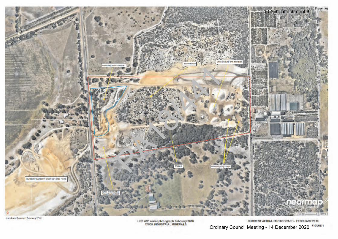
PA18/44
1
10.1.6 - attachment 3
Ordinary Council Meeting - 14 December 2020
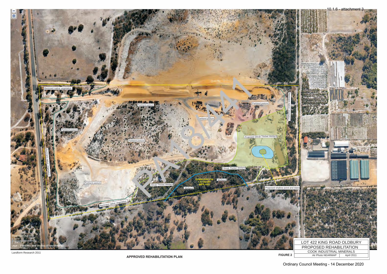
Lindsay StephensBSc - Geology, Msc - Botany
Mem Aust Geomechanics Society
Mem WA Env Cons Assoc
LANDFORM RESEARCHQuarries - Land Systems
08 9397 5145
LOT 422 KING ROAD OLDBURYANNUAL REPORT 2003 - 2004
COOK INDUSTRIAL MINERALSDOLA Air Photo Dec 2003 November 2004
Shrub Thicket Wetland
Wetland
Wetland
Parkland pasture
Parkland pasture
Parkland pasture
Parkland pasture
Parkland pasture
PROPOSED REHABILITATION
CONSERVATION CATEGORY WETLAND
Air Photo NEARMAP April 2011
Parkland pasture
Proposed Shrub Thicket Wetland
Shrub Thicket Wetland
Proposed shallow pond and island
Remnant native vegetation
Remnant native vegetation
Remnant native vegetation
Remnant native vegetation
Remnant native vegetation
Remnant native vegetation
Remnant native vegetation
Remnant native vegetation
Remnant native vegetation
Remnant native vegetation
Remnant native vegetation
Remnant native vegetation
Remnant native vegetation
FIGURE 2Landform Research 2011
APPROVED REHABILITATION PLAN
PA18/44
1
10.1.6 - attachment 3
Ordinary Council Meeting - 14 December 2020

AERIAL PHOTOGRAPH FEBRUARY 2018
Compare the revegetation and activity in 2018 to 2011 (Figures 2 and 3)LOT 422, aerial photograph February 2018
COOK INDUSTRIAL MINERALS
Landform Research February 2018 FIGURE 3
PA18/44
1
10.1.6 - attachment 3
Ordinary Council Meeting - 14 December 2020
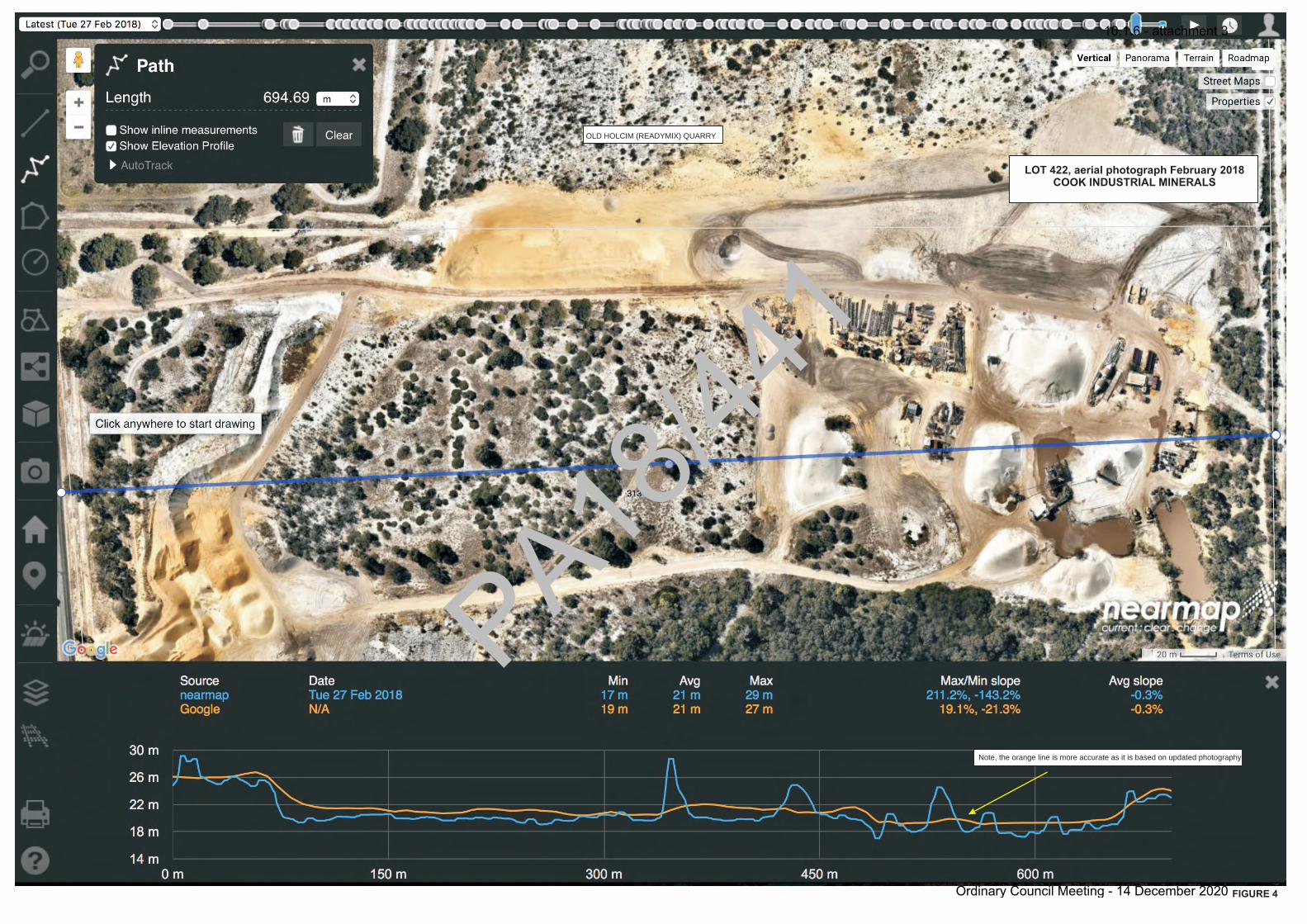
LOT 422, aerial photograph February 2018COOK INDUSTRIAL MINERALSOLD HOLCIM (READYMIX) QUARRY
Note, the orange line is more accurate as it is based on updated photography
FIGURE 4
PA18/44
1
10.1.6 - attachment 3
Ordinary Council Meeting - 14 December 2020
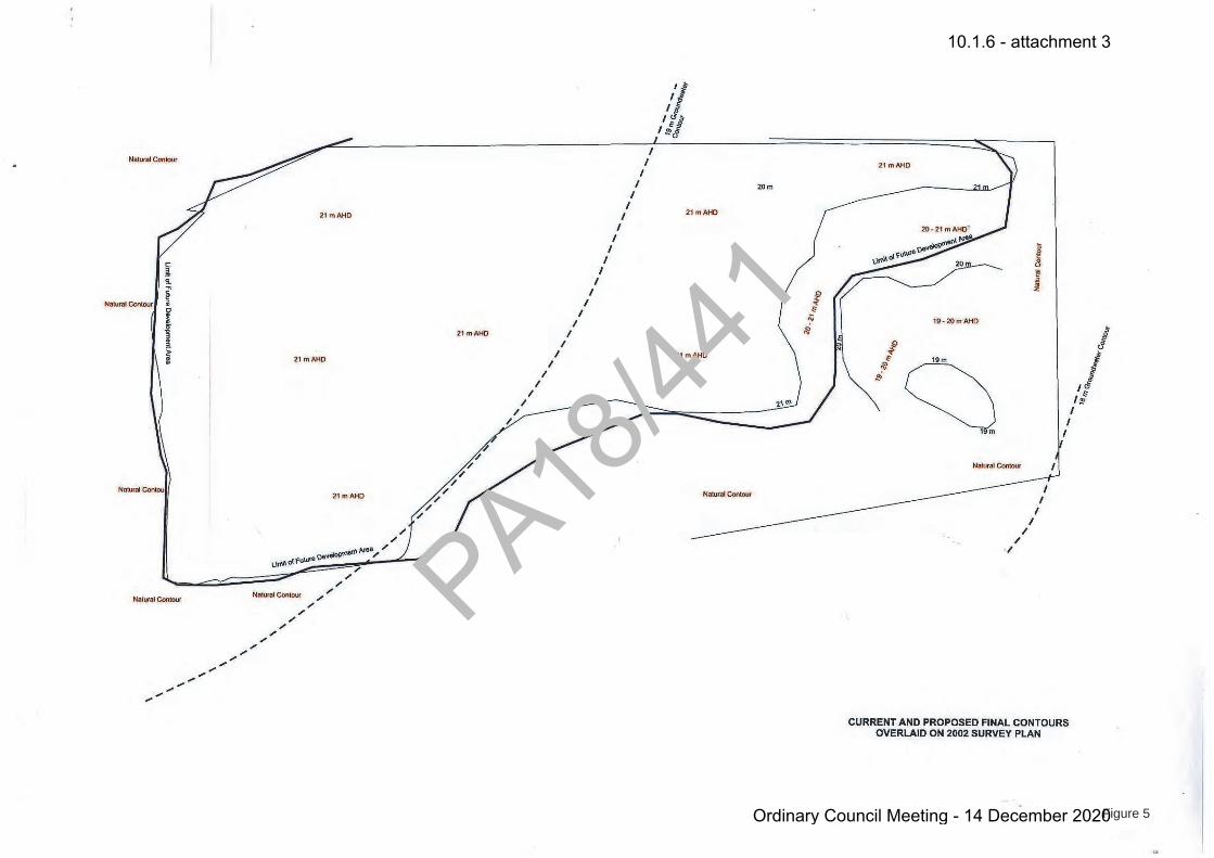
Figure 5
PA18/44
1
10.1.6 - attachment 3
Ordinary Council Meeting - 14 December 2020
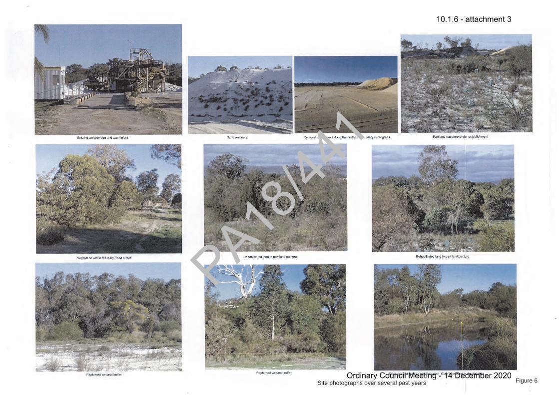
Figure 6Site photographs over several past years
PA18/44
1
10.1.6 - attachment 3
Ordinary Council Meeting - 14 December 2020