planning and urban design rationale … · all uses proposed on the site. this planning and urban...
TRANSCRIPT
PLANNING AND URBAN
DESIGN RATIONALE
REPORT
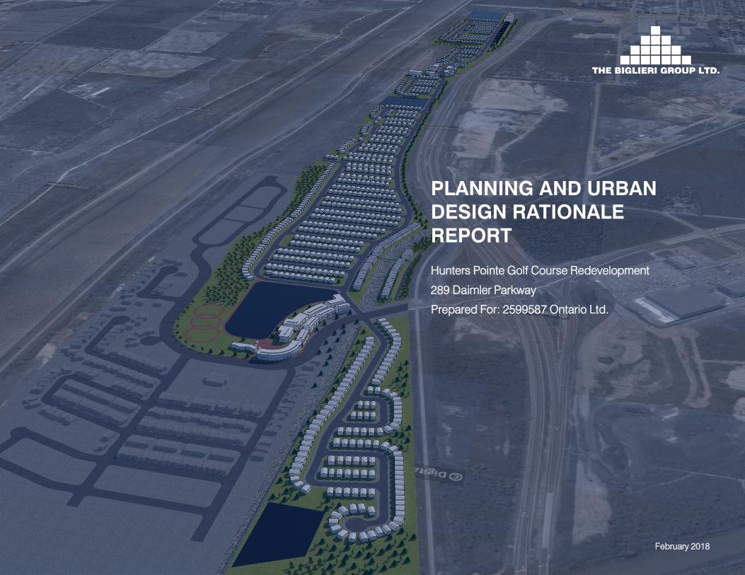
Hunters Pointe Golf Course Redevelopment
289 Daimler Parkway
Prepared For: 2599587 Ontario Ltd.
February 2018

Redevelopment of Hunters Pointe Golf Course, Welland
Planning and Urban Design Rationale Report
February 2018
TABLE OF CONTENTS page
1.0 INTRODUCTION ........................................................................................................................................................................... 1
2.0 SITE LOCATION AND CONTEXT .................................................................................................................................................... 2
2.1 The Site................................................................................................................................................................................................2
2.2 Surrounding Area .................................................................................................................................................................................3
2.3 Existing Road and Transportation Network............................................................................................................................................8
3.0 PROPOSAL .................................................................................................................................................................................11
3.1 Description of the Master Plan ........................................................................................................................................................... 11
3.2 Guiding Principles ..............................................................................................................................................................................15
3.3 Open Space Network .........................................................................................................................................................................15
3.4 Green Corridors .................................................................................................................................................................................15
3.5 Streets and Blocks .............................................................................................................................................................................17
3.6 Precincts ............................................................................................................................................................................................19
4.0 POLICY CONTEXT AND ANALYSIS ...............................................................................................................................................23
4.1 Overview ............................................................................................................................................................................................23
4.2 Provincial Policy Statement (2014) ......................................................................................................................................................23
4.3 Growth Plan for the Greater Golden Horseshoe (2017) ........................................................................................................................25
4.4 Niagara Regional Official Plan (2014) .................................................................................................................................................28
4.5 City of Welland Official Plan (2011) .....................................................................................................................................................32
4.6 City of Welland Zoning By-law ............................................................................................................................................................42
4.7 City of Welland Urban Design Guidelines ............................................................................................................................................44
5.0 SUMMARY OF PLANNING AND URBAN DESIGN RATIONALE ........................................................................................................48
5.1 Efficient Use of Land and Resources ..................................................................................................................................................48
i
The Biglieri Group Ltd.
20 Leslie Street, Suite 121, Toronto ON M4M 3L4
126 Catharine Street North, Hamilton ON L8R 1J4
5.2 Providing a Range of Housing Types and Tenures ..............................................................................................................................48
5.3 Providing for Increased Retail and Commercial Opportunities .............................................................................................................49
5.4 Multi-Modal Transportation System.....................................................................................................................................................49
5.5 Comprehensive Open Space Network ................................................................................................................................................49
6.0 SUPPORTING TECHNICAL DOCUMENTS .....................................................................................................................................51
6.1 Functional Servicing Report ................................................................................................................................................................51
6.2 Noise and Vibration Feasibility Study ..................................................................................................................................................53
6.3 Traffic Impact Study ...........................................................................................................................................................................53
6.4 Natural Heritage Existing Conditions Report .......................................................................................................................................54
7.0 CONCLUSION .............................................................................................................................................................................56
LIST OF TABLES
TABLE 1 – RESIDENTIAL LAND USE BREAKDOWN.................................................................................................................................11
TABLE 2 – SUMMARY OF THE SCHEDULE OF LAND USE ......................................................................................................................12
LIST OF FIGURES
FIGURE 1 – SITE LOCATION .................................................................................................................................................................. 2
FIGURE 2 – SURROUNDING AREA ......................................................................................................................................................... 3
FIGURE 3 – TO THE NORTH................................................................................................................................................................... 4
FIGURE 4 – TO THE SOUTHEAST ........................................................................................................................................................... 4
FIGURE 5 – TO THE SOUTH................................................................................................................................................................... 4
FIGURE 6 – TO THE WEST ..................................................................................................................................................................... 4
FIGURE 7 – EXISTING CLUBHOUSE ....................................................................................................................................................... 4
FIGURE 8 – EXISTING GOLFCOURSE POND........................................................................................................................................... 4
FIGURE 9 – LAND USE .......................................................................................................................................................................... 5
FIGURE 10 – COMMUNITY SERVICES AND FACILITIES ........................................................................................................................... 6
ii

Redevelopment of Hunters Pointe Golf Course, Welland
Planning and Urban Design Rationale Report
February 2018
FIGURE 11 – EXISTING OPEN SPACE AND NATURAL HERITAGE SYSTEM ............................................................................................... 7
FIGURE 12 – STREET NETWORK............................................................................................................................................................ 9
FIGURE 13 – TRANSPORTATION NETWORK ..........................................................................................................................................10
FIGURE 14 – PROPOSED DRAFT PLAN OF SUBDIVISION.......................................................................................................................13
FIGURE 15 – PROPOSED LAND USES ...................................................................................................................................................14
FIGURE 16 – WALKABILITY MAP ...........................................................................................................................................................16
FIGURE 17 – STREET NETWORK AND STREET SECTIONS .....................................................................................................................18
FIGURE 18 – STREET NETWORK AND STREET SECTIONS .....................................................................................................................20
FIGURE 19 – OPEN SPACE PRECDENTS ...............................................................................................................................................21
FIGURE 20 – BUILT FORM PRECEDENTS ..............................................................................................................................................22
FIGURE 21 – PROVINCIAL POLICY STATEMENT.....................................................................................................................................23
FIGURE 22 – GROWTH PLAN CONCEPT................................................................................................................................................26
FIGURE 23 – NIAGARA REGION OFFICIAL PLAN – REGIONAL STRUCTURE............................................................................................29
FIGURE 24 – CITY OF WELLAND OFFICIAL PLAN – SCHEDULE B LAND USE ..........................................................................................33
FIGURE 25 – CITY OF WELLAND OFFICIAL PLAN – SCHEDULE A CITY STRUCTURE ...............................................................................36
FIGURE 26 – CITY OF WELLAND OFFICIAL PLAN – SCHEDULE C CORE NATURAL HERITAGE SYSTEM...................................................39
FIGURE 27 – CITY OF WELLAND ZONING BY-LAW SCHEDULE...............................................................................................................43
iii


1.0 INTRODUCTION
The Biglieri Group Ltd. (“TBG”) has been retained by 2599587
Ontario Ltd. to prepare planning applications and to obtain the
municipal approvals required to implement the proposed
development as envisioned in the proposed Concept Master Plan
(the “Master Plan”) on the lands municipally known as 289 Daimler
Parkway, formerly the Hunter’s Pointe Golf Course. The Subject Site
(the “Site”) is legally known as Part of Lots 18, 19 and 20,
Concession 1 and 2 and Part of Lot 19, Concession 3 and 4 , and
Lots 47 to 56, Lots 25 to 34 and Part of Lots 23, 24, 35, 46 and 57 .
This Planning and Urban Design Rationale has been prepared in
support of an application for an Official Plan Amendment to the City
of Welland Official Plan (2011) and a Zoning By-law Amendment to
the City of Welland’s Zoning By-law 2017-117. The proposed
amendments will permit the development of a residential
community on the 85.45 hectare property.
The Site is located in northeast Welland, east of Highway 406, south
of the Welland River, and directly west of the Welland Canal and the
Welland Canal Seaway Service Road. The Site is in close proximity
to commercial/retail, public and catholic schools, daycares and
community centres. The Site is well-connected to the existing
transportation network and is within close proximity to Highway 406
for regional transportation connections.
The Site is designated as Built-Up Area in the Niagara Region
Official Plan. The Site is primarily designated as Open Space and
Recreation, with a small portion adjacent to the Welland River
Redevelopment of Hunters Pointe Golf Course, Welland
Planning and Urban Design Rationale Report
February 2018
designated as Core Natural Heritage System in the City of Welland
Official Plan. The Site is zoned as Community Open Space Zone
(O2), with a small portion zoned as Environmental Protection
Overlay (EP) and Neighbourhood Commercial (NC-26) under the
City of Welland Zoning By-law.
The Master Plan proposes 1194 residential units, including single-
detached houses, street townhouses, stacked townhouses, mixed
use nodes with neighbourhood commercial uses, parkland and a
comprehensive trail system.
In order to implement the Master Plan, an Official Plan Amendment
will be required to redesignate portions of the Site from Open Space
and Recreation to Residential in the City of Welland Official Plan. A
Zoning By-law Amendment will also be required in accordance with
all uses proposed on the Site.
This Planning and Urban Design Rationale Report has evaluated
the merits of the Master Plan in the context of all applicable
Provincial, Regional and City policies, as well as the existing and
planned surrounding land use framework. We have concluded that
the Master Plan is consistent with or conforms to the applicable
policy framework articulated in the Provincial Policy Statement, the
Growth Plan for the Greater Golden Horseshoe, the Niagara Region
Official Plan and the City of Welland Official Plan.
1
The Biglieri Group Ltd.
20 Leslie Street, Suite 121, Toronto ON M4M 3L4
126 Catharine Street North, Hamilton ON L8R 1J4
2.0 SITE LOCATION AND
CONTEXT
2.1 The Site
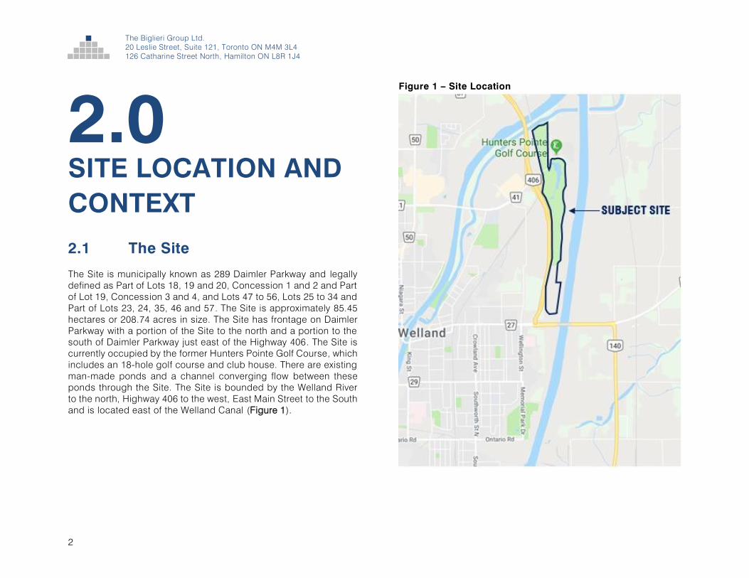
The Site is municipally known as 289 Daimler Parkway and legally
defined as Part of Lots 18, 19 and 20, Concession 1 and 2 and Part
of Lot 19, Concession 3 and 4, and Lots 47 to 56, Lots 25 to 34 and
Part of Lots 23, 24, 35, 46 and 57. The Site is approximately 85.45
hectares or 208.74 acres in size. The Site has frontage on Daimler
Parkway with a portion of the Site to the north and a portion to the
south of Daimler Parkway just east of the Highway 406. The Site is
currently occupied by the former Hunters Pointe Golf Course, which
includes an 18-hole golf course and club house. There are existing
man-made ponds and a channel converging flow between these
ponds through the Site. The Site is bounded by the Welland River
to the north, Highway 406 to the west, East Main Street to the South
and is located east of the Welland Canal (Figure 1).
Figure 1 – Site Location
2

2.2 Surrounding Area
The Site is located in northeast Welland and adjacent to the Welland
Canal. The Site has frontage on Daimler Parkway which connects
into Woodlawn Road (Figure 2). The Site’s surroundings are further described below.
North: To the immediate north of the Site is the Welland River. The
Site is also along the northern limits of the City of Welland, which
borders the City of Thorold. Northeast of the site is a new residential
development consisting of single-detached houses and
townhouses (Figure 3).
East: The Site is adjacent to the Welland Canal to the east as well
as the Seaway Service Road. Further east of the Canal is
agricultural lands that are located outside of the limits of the City of
Welland Figure 4).
South: To the immediate south, the site is bound by East Main
Street, or Highway 140, with the East Main Street Tunnel under the
Welland Canal. Further south of the site is residential development
with commercial development located southwest of the Site along
East Main Street (Figure 5).
West: To the west of the Site is SmartCentres Welland, Youngs
Sportsplex, and the Canal railway spur line operated by Trillium
Railway. Further west across Woodlawn Road is the Seaway Mall
and low density residential development (Figure 6).
Some images of the existing clubhouse and golf course pond are
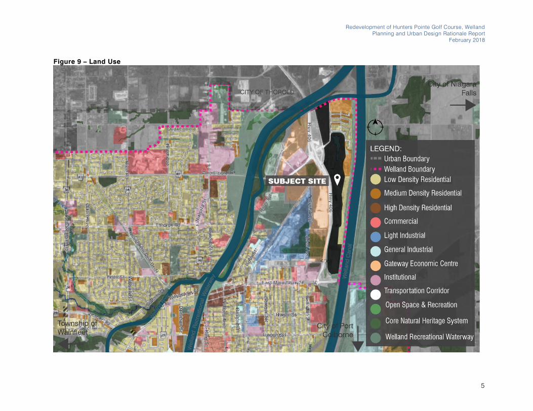
shown in Figures 7 and 8. An overview of the land uses surrounding
the Site are shown in Figure 9. There are existing community
services and facilities in close proximity to the site that will serve
area residents. Figure 10 provides an overview the schools,
daycares, libraries, fire stations, arenas and grocery stores in close
proximity to the Site. Figure 11 provides an overview of the open
space and natural heritage system in the City of Welland along with
major parks that serve the City at large.
Redevelopment of Hunters Pointe Golf Course, Welland
Planning and Urban Design Rationale Report
February 2018
Figure 2 – Surrounding Area
3

The Biglieri Group Ltd.
20 Leslie Street, Suite 121, Toronto ON M4M 3L4
126 Catharine Street North, Hamilton ON L8R 1J4
Figure 3 – To the North Figure 6 – To the West
Figure 7 – Existing Clubhouse
Figure 4 – To the Southeast
Figure 5 – To the South Figure 8 – Existing Golf Course Pond
4
Redevelopment of Hunters Pointe Golf Course, Welland
Planning and Urban Design Rationale Report
February 2018
Figure 9 – Land Use
5

The Biglieri Group Ltd.
20 Leslie Street, Suite 121, Toronto ON M4M 3L4
126 Catharine Street North, Hamilton ON L8R 1J4
Figure 10 – Community Services and Facilities
6

Redevelopment of Hunters Pointe Golf Course, Welland
Planning and Urban Design Rationale Report
February 2018
Figure 11 – Existing Open Space and Natural Heritage System
7

The Biglieri Group Ltd.
20 Leslie Street, Suite 121, Toronto ON M4M 3L4
126 Catharine Street North, Hamilton ON L8R 1J4
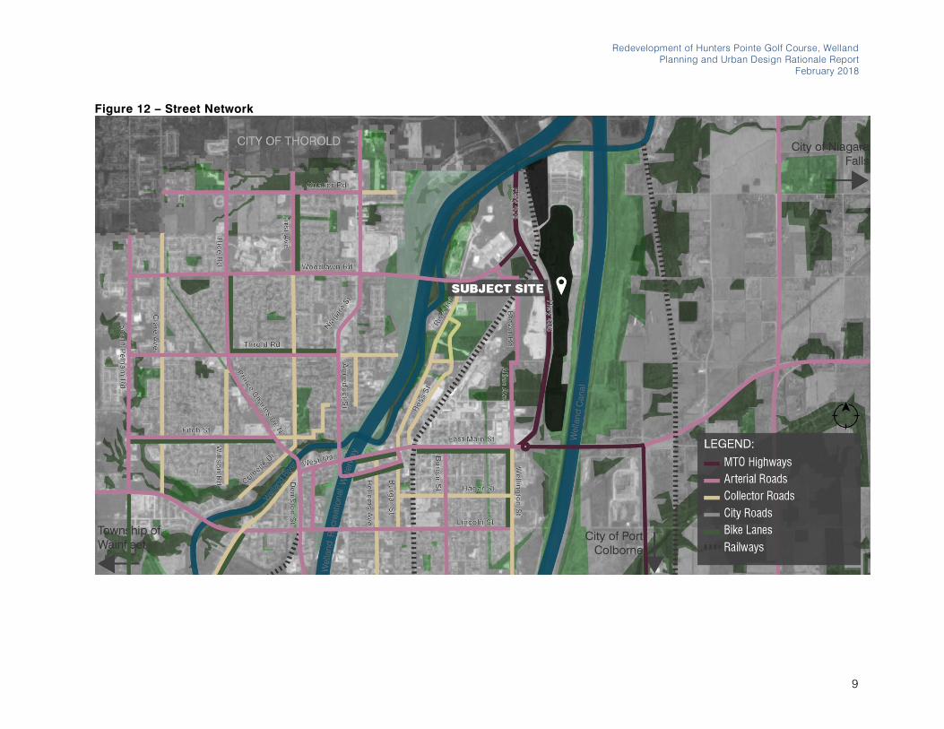
2.3 Existing Road and
Transportation Network
The Site has excellent access to the Regional transportation system
given its proximity to Highway 406 and Highway 140, which are both
MTO controlled Highways surrounding the Site. Daimler Parkway
connects to Woodlawn Road, an Arterial Road, providing
connections to downtown Welland (Figure 12).
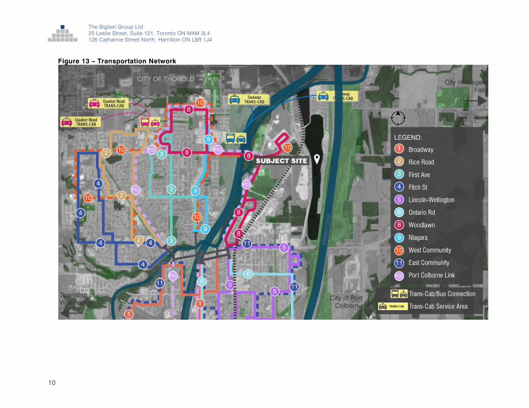
The Site is in close proximity to Niagara Transit bus routes No. 8
Woodlawn and No. 10 West Community, where bus stops are
located immediately north of Primeway Drive and Woodlawn Drive
(Figure 13). These routes provide riders with access to Seaway Mall
to the west or Downtown Welland to the south.
Welland Transit offers Trans-Cab services to the areas of the City
not served by regular transit buses, including northeast and
northwest Welland as shown in Figure 13. This service connects
residents from their doorstep to Welland Transit buses that connect
to downtown.
Preliminary discussions with the City of Welland have determined
that bus stops will be required on the Site to serve the future
residents of the neighbourhood.
8
Redevelopment of Hunters Pointe Golf Course, Welland
Planning and Urban Design Rationale Report
February 2018
Figure 12 – Street Network
9
The Biglieri Group Ltd.
20 Leslie Street, Suite 121, Toronto ON M4M 3L4
126 Catharine Street North, Hamilton ON L8R 1J4
Figure 13 – Transportation Network
10

3.0 PROPOSAL
3.1 Description of
the Master Plan
TBG has developed a Master Plan for the redevelopment of the
Hunters Pointe Golf Course lands. The Master Plan proposes a
neighbourhood comprised of low density residential, mixed-use
development with neighbourhood commercial, parks and open
spaces.
The Master Plan envisions a neighbourhood that is compatible with
the existing residential neighbourhood to the north of the Site, while
providing a mix of uses to develop a more complete community for
the northeast Welland area.
The Master Plan has been designed to include a full range of
housing types and will consist of single-detached houses with
various lot frontages, street townhouses, stacked townhouses, and
mixed-use development consisting of mid-rise buildings with
ground floor commercial. The residential built form transitions from
low density uses to medium density in the central mixed-use nodes.
Building heights are between two and four storeys. Appropriate
setbacks are provided between the two storey single-detached
houses and the mixed-use nodes with mid-rise buildings at four-
storeys in height.
The Site is primarily designated as Open Space and Recreation,
with a small portion adjacent to the Welland River designated as
Redevelopment of Hunters Pointe Golf Course, Welland
Planning and Urban Design Rationale Report
February 2018
Core Natural Heritage System in the City of Welland Official Plan.
The Site is zoned as Community Open Space Zone (O2), with a
small portion zoned as Environmental Protection Overlay (EP) and
Neighbourhood Commercial (NC-26) under the City of Welland
Zoning By-law.
In order to implement the Master Plan, an Official Plan Amendment
will be required to redesignate portions of the Site from Open Space
and Recreation to Residential in the City of Welland Official Plan. A
Zoning By-law Amendment will also be required in accordance with
all uses proposed on the Site, to include provisions for all
residential, mixed use and open space and recreation blocks on the
site.
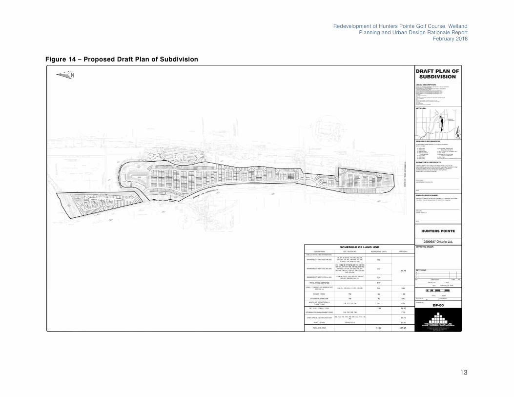
A Plan of Subdivision will be required to implement the Master Plan.
Lots and blocks will be created to accommodate the proposed uses
and built form (Figure 14). The proposed unit breakdown is
provided in Table 1. A summary of the proposed land uses with the
area and percentage of the site dedicated to each use is provided
in Table 2. A visual representation of the proposed land uses on the
site can also be seen in Figure 15.
Table 1 – Residential Land Use Breakdown
LAND USE NO. OF UNITS AREA (HA) DENSITY
(UPH)
Single-
Detached
747 32.77 22.8
Street
Townhouses
160 3.82 41.9
Condo Street
Townhouses
35 1.30 26.9
Stacked
Townhouses
51 0.92 55.4
Mixed-Use
(Residential and
Commercial)
201 units
with 60,000 sq. ft.
(5,574 sq. m.)
commercial
4.02 50
TOTAL 1194 42.83 27.9
11

The Biglieri Group Ltd.
20 Leslie Street, Suite 121, Toronto ON M4M 3L4
126 Catharine Street North, Hamilton ON L8R 1J4
Table 2 – Summary of the Schedule of Land Use
LAND USE AREA (HA) %
Residential 42.83 50.1%
Stormwater
Management
Ponds
7.10 8.3%
Open Space and
Recreation
17.69 20.7%
Right of Way 17.82 20.9%
TOTAL 85.45 100%
A Pre-Consultation meeting occurred with the City of Welland on
September 7, 2017. At this pre-consultation meeting we received
preliminary comments from all departments and agencies. The
comments received have informed the design of the Master Plan.
The Master Plan has been designed in accordance with its existing
context and has incorporated various setbacks to surrounding land
uses. Beacon Environmental has done a preliminary environmental
review of the environmental features on the property . Appropriate
setbacks have been provided to the Environmental Protection Area
along the Welland River at the northern boundary of the Site. The
golf course ponds, watercourses and ditches associated with the
golf course ponds are regulated by the NPCA. Beacon
Environmental has determined that these features provide limited
natural heritage function. The dug channel has been preserved in
the Master Plan with a fifteen metre buffer to maintain its current
function on Site. Seasonal field investigations will determine the
exact limits of the environmental features on the property which will
result in the setback limits being further refined.
At the Pre-Consultation meeting, the Ministry of Transportation of
Ontario (MTO) requested a 14 metre setback from the property line
shared with the Highway 406 on the western border of the Site. This
setback has been implemented in the Site design. Preliminary
discussions also occurred with MTO with regards to the potential of
a Highway 406 overpass to provide a secondary access to the
proposed development. The Traffic Impact Study prepared by R.J.
Burnside and Associates investigates this potential emergency
access. Further discussions are required with the City of Welland,
Niagara Region and MTO on the feasibility and requirements of this
overpass.
An adequate setback to the railway along the western border of the
site has also been implemented as per the CP Rail Guidelines. We
have been informed by our traffic engineer, R.J. Burnside and
Associates, that this rail line can be classified as a Spur line as per
the CP Rail requirements. Therefore, a setback of fifteen metres is
required between the property line shared with the railway line and
the proposed built form. This setback has been incorporated into
the Master Plan.
12
Redevelopment of Hunters Pointe Golf Course, Welland
Planning and Urban Design Rationale Report
February 2018
Figure 14 – Proposed Draft Plan of Subdivision
13

The Biglieri Group Ltd.
20 Leslie Street, Suite 121, Toronto ON M4M 3L4
126 Catharine Street North, Hamilton ON L8R 1J4
Figure 15 – Proposed Land Use Map
14
3.2 Guiding Principles
The Master Plan has been designed in accordance with four
Guiding Principles to respond to the existing and planned context
for the lands in northeast Welland, east of Highway 406. The four
guiding principles include: Enhance Open Space, Green Corridors,
Streets and Blocks and Precincts. The guiding principles are
discussed further below.
3.2.1 Enhance Open Space
The Master Plan proposes a network of open spaces to provide a
well-connected open space system that is integrated into the
proposed and existing community. The proposed open space
system offers multiple outdoor recreational possibilities for passive
and active recreational facilities.
3.2.2 Green Corridors
The Master Plan proposes green corridors through the site to
provide for opportunities for future connections to the surrounding
open space system. Green corridors will be established through a
trail system to contribute to the overall implementation of a
pedestrian scaled community with easy access for various types of
users to daily amenities. The pedestrian system will link parks and
streets and will promote safe and convenient connectivity between
these spaces.
3.2.3 Streets and Blocks
The Master Plan proposes a fine grain network of streets and blocks
that has been informed by the existing neighbourhood to the
northeast of the Site. The proposed street and block pattern has
been designed to encourage a variety of modes of transportation,
including walking and cycling through the implementation of a
multi-modal pathway.
Redevelopment of Hunters Pointe Golf Course, Welland
Planning and Urban Design Rationale Report
February 2018
3.2.4 Precincts
Precincts have been identified to ensure diversification of land uses
in the community and to ensure that all Precincts are well served by
infrastructure, community amenities and park space.
3.3 Open Space Network
The Master Plan has been designed with a comprehensive open
space system. There is a total of five parks proposed on the Site.
The parks system includes parks of various sizes and serve
different functions based on their planned size and location. The
central park will have an area of 6.16 hectares and combined with
the 2.8 hectare stormwater management pond block, makes up a
total area of 8.96 hectares. This park will serve as the main
neighbourhood park with various amenities for area residents.
Other parkettes have also been provided through the site, including
a 5.97 hectare park at the north end of the site, a 0.10 hectares
central parkette and two parkettes to the south having an area of
0.71 hectares and 0.72 hectares each. Together these parks
provide adequate park space to serve the Master Plan area. The
proposed parks have been strategically located throughout the site
to ensure that all residents are within a five-minute walking distance
to a neighbourhood park (Figure 16).
3.4 Green Corridors
The Master Plan has been designed to ensure connectivity among
its open space system to connect area residents to the open space
network via green corridors. The intention of the green corridors are
to facilitate forms of active transportation throughout the site, by
delineating pedestrians and cyclists from automobile traffic. The
Master Plan proposes green corridors through the site to connect
to the Welland River and to provide for opportunities for future
connections to the Welland Canal. Ensuring strong connections
throughout the site will contribute to the overall implementation
15

The Biglieri Group Ltd.
20 Leslie Street, Suite 121, Toronto ON M4M 3L4
126 Catharine Street North, Hamilton ON L8R 1J4
Figure 16 – Walkability Map
16

of a pedestrian scaled community with easy access for various
types of users to daily amenities. The pedestrian system will link
parks and streets and will promote safe and convenient connectivity
between these spaces.
The Master Plan has been designed to ensure that all residents are
within a five-minute walking distance to park space. Connectivity to
open space has been created through a system of green corridors,
shown as trails throughout the development and will also be
facilitated through the multi-use path extending north to south
throughout the Site.
3.5 Streets and Blocks
The Master Plan includes a fine grain network of streets and blocks.
The Street network consists of one major Collector Road running
north to south, Street A. This Collector Road is 20 metres in width.
The Local Roads, Streets B to Y, are also proposed with 20 metre
widths to allow for on street parking. Streets B through Y form
shorter blocks to allow for easy pedestrian connection to the main
corridor, Street A.
Streetscape Sections (Figure 17) have been prepared to provide a
visual for the street composition for the main Collector Road, Street
A, and the Local Roads, Streets B to Y.
Streetscape A represents the Local Roads. Within its 20 metre right-
of-way are two (2) 3-metre drive lanes, a 2.75 metre parking lane, a
2.6 metre landscape boulevard on each side, a 1 metre allowance
for street lights on each side and a 2 metre sidewalk allowance on
each side.
Streetscape B represents the Collector Road, the main north to
south artery through the site. Streetscape B includes two (2) 4.25
metre drive lanes, a 2 metre landscaped boulevard on each site, a
1.2 metres allowance for large streetlights, a 1 metre allowance for
pedestrian scaled lighting, two (2) 1.6 metre bike lanes for each
direction and a 2.1 metre sidewalk.
Redevelopment of Hunters Pointe Golf Course, Welland
Planning and Urban Design Rationale Report
February 2018
17

The Biglieri Group Ltd.
20 Leslie Street, Suite 121, Toronto ON M4M 3L4
126 Catharine Street North, Hamilton ON L8R 1J4
Figure 17 – Street Network and Street Sections
18

3.6 Precincts
The Master Plan includes seven (7) different Precincts that together
create a complete community. Overall, the majority of the
community consists of single-detached residential houses with lot
frontages ranging from 35 feet (9.1 metres) to 50 feet (15.24 metres).
The mixed-use nodes include stacked townhouse development and
mid-rise buildings at four storeys in height with ground floor
commercial uses having a total area of 60,000 square feet (5,574
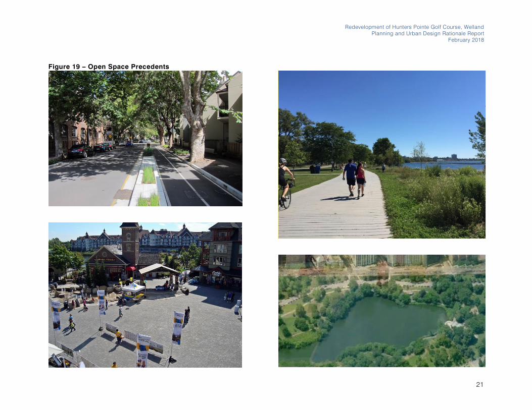
square metres). Precedent images have been provided in Figures
19 and 20 as representation of the built form and public realm
opportunities on the Site.
3.6.1 Precinct 1 – North Precinctf60,00
The north precinct consists of single-detached homes with
frontages ranging from 40 feet to 50 feet. The North Precinct
includes of a neighbourhood park sized at 5.97 hectares adjacent
to the Welland River. This open space will serve area residents in
the north precinct community.
3.6.2 Precinct 2 – Northeast Precinct
The Northeast Precinct is the central neighbourhood mixed-use hub.
This precinct provides mixed-use mid-rise development with
ground floor commercial uses and opportunities for retail, office
and institution uses. This Precinct will include the adaptive reuse of
the existing golf clubhouse building for commercial uses. This
neighbourhood hub contains the central neighbourhood park and
stormwater management pond, with a total size of 8.6 hectares.
This area will have active street frontages and create an inviting
pedestrian-oriented public realm.
3.6.3 Precinct 3 – Northwest Precinct
The Northwest Precinct consists of a condominium stacked
townhouse development backing onto the channel flowing through
Redevelopment of Hunters Pointe Golf Course, Welland
Planning and Urban Design Rationale Report
February 2018
the site. This area is within walking distance to the northeast
precinct and all its amenities.
3.6.4 Precinct 4 – Central North Precinct
The Central North Precinct consists of single-detached houses with
lot frontages ranging from 40 feet to 50 feet. This precinct and the
central precinct make up the majority of the single-detached
houses in the Master Plan area. The central neighbourhood park
continues along the eastern limits of the Central North Precinct, with
houses backing onto this open space system.
3.6.5 Precinct 5 – Central Precinct
The Central Precinct consists of single-detached houses with lot
frontages ranging from 40 feet to 50 feet. A central stormwater
management pond is located in this precinct with a small parkette
adjacent to it to be utilized by area residents.
3.6.6 Precinct 6 – Central South Precinct
The Central South Precinct is the second mixed-use node to serve
the southern portion of the Master Plan area. This node will consist
of mid-rise mixed-use development with ground floor commercial,
retail and office use.
3.6.7 Precinct 7 – South Precinct
The South Precinct consists of a greater variety to housing types,
including stacked townhouses, street townhouses, and single-
detached houses with 35 foot frontages. This precinct will provide
for more affordable housing options, with a variety of tenures. A
stormwater management pond is also proposed at the southern
limits of the Site. A hydro-corridor runs through the South Precinct
and will be utilized as open space with public trails for the
enjoyment of area residents.
19

The Biglieri Group Ltd.
20 Leslie Street, Suite 121, Toronto ON M4M 3L4
126 Catharine Street North, Hamilton ON L8R 1J4
Figure 18 – Street Network and Street Sections
20
Redevelopment of Hunters Pointe Golf Course, Welland
Planning and Urban Design Rationale Report
February 2018
Figure 19 – Open Space Precedents
21

The Biglieri Group Ltd.
20 Leslie Street, Suite 121, Toronto ON M4M 3L4
126 Catharine Street North, Hamilton ON L8R 1J4
Figure 20 – Built Form Precedents
22
4.0 POLICY CONTEXT
AND ANALYSIS
4.1 Overview
The Master Plan is consistent with the policies of the Provincial
Policy Statement, the Growth Plan for the Greater Golden
Horseshoe, the Niagara Regional Official Plan, and the City of
Welland Official Plan as further described below.
4.2 Provincial Policy Statement
(2014)
The Provincial Policy Statement 2014 (PPS) provides overall
direction on matters of provincial interest related to municipal
planning decisions. The Planning Act requires that decisions in
planning matters “shall be consistent with” the PPS.
4.2.1 Section 1.1 - Managing and Directing Land
Use to Achieve Efficient and Resilient
Development and Land Use Patterns
Section 1.1 of the PPS 2014 on Building Strong Healthy
Communities states that healthy, liveable and safe communities are
sustained by: promoting efficient development land use patterns
which sustain the financial well-being of municipalities over the long
Redevelopment of Hunters Pointe Golf Course, Welland
Planning and Urban Design Rationale Report
February 2018
Figure 21 – Provincial Policy Statement
23
The Biglieri Group Ltd.
20 Leslie Street, Suite 121, Toronto ON M4M 3L4
126 Catharine Street North, Hamilton ON L8R 1J4
term; accommodating an appropriate range and mix of residential,
employment, institutional, recreation, park and open space, and
other uses to meet long-term needs; and, promoting cost effective
development patterns and standards to minimize land consumption
and servicing costs.
The Master Plan will promote efficient, cost-effective development
and land use patterns by intensifying land within the built-up area
in the City of Welland that is in close proximity to existing municipal
services. The Master Plan includes a range of residential,
commercial and park and open space uses to meet the long term
needs for the City of Welland.
Policy 1.1.2 of the PPS 2014 on Building Strong Healthy
Communities states that sufficient land shall be made available to
accommodate an appropriate range and mix of land uses to meet
projected needs for a time horizon of up to 20 years. Within
settlement areas, sufficient land shall be made available through
intensification and redevelopment and, if necessary, designated
growth areas.
The Site represents an appropriate location to accommodate
residential land uses to meet the projected needs for the City of
Welland for a time horizon of up to 20 years. The Master Plan
proposes development within the built boundary of the City of
Welland.
Policy 1.1.3.1 of Settlement Areas states that Settlement areas shall
be the focus of growth and development, and their vitality and
regeneration shall be promoted. Section 1.1.3.2 of Settlement Areas
states that land use patterns within settlement areas shall be based
on densities and a mix of land uses which: efficiently use land and
resources; efficiently use the infrastructure and public service
facilities which are planned or available, and avoid the needs for
their unjustified and/or uneconomical expansion.
The Site is within the Settlement Area boundary of the City of
Welland. Lands within settlement areas shall be the focus of growth
and development. The Master Plan will efficiently use land,
resources, infrastructure and public service facilities in the City of
Welland. The proposed development can be connected to existing
services which are located within close proximity to the site.
Therefore, intensification of the Site is appropriate and avoids the
uneconomical expansion of existing services.
4.2.2 Section 1.4 on Housing
Policy 1.4.1 on Housing states that an appropriate range and mix
of housing types and densities are required to meet projected
requirements of current and future residents of the regional market
area. Planning authorities shall maintain at all times the ability to
accommodate residential growth for a minimum of 10 years through
residential intensification and redevelopment.
The Master Plan contributes to a greater range and mix of housing
types and densities in the City of Welland to serve the regional
market area. The Master Plan includes single-detached houses,
street townhouses, stacked townhouses and mid-rise buildings with
apartment units. The proposed redesignation of the Site for
residential purposes will assist the City of Welland in
accommodating residential growth for a minimum of 10 years
through residential intensification.
4.2.3 Section 1.5 on Public Spaces, Recreation,
Parks, Trails and Open Space
Policy 1.5.1 states that healthy, active communities should be
promoted by planning public streets, spaces and facilities to be
safe, meet the needs of pedestrians, foster social interaction and
facilitate active transportation and community connectivity. Further,
they should be planned to provide for a full range and equitable
distribution of publicly-accessible built and natural settings for
recreation, including facilities, parklands, public spaces, open
space areas, trails and linkages. Protected areas should be
preserved and negative impacts should be minimized in these
areas.
24

The Master Plan has been designed to promote healthy active living
through the creation of an integrated green corridor and open
space system. This system will promote safety for cyclists and
pedestrians and will facilitate active transportation and social
interaction.
4.2.4 Section 1.6 on Infrastructure and Public
Service Facilities
Policy 1.6.1 states that Infrastructure and public service facilities
shall be provided in a coordinated, efficient and cost-effective
manner that considers impacts from climate change while
accommodating projected needs. Section 1.6.2 states that
planning authorities should promote green infrastructure to
complement infrastructure.
The Master Plan proposes a comprehensive stormwater
management approach along with a fine-grain network of streets
and blocks with a mix of land uses to support active transportation.
4.2.5 Section 1.7 on Long-Term Economic
Prosperity
Policy 1.7.1 supports economic prosperity by encouraging
economic development, a sense of place and considering the
ecological benefits provided by nature.
The Master Plan will introduce opportunities for commercial and
retail uses and will create opportunities for economic development
and community investment. It will also encourage a sense of place
through publicly accessible parks and open spaces, mixed-use
community hubs, and quality architectural design.
4.2.6 Section 1.8 on Energy Conservation, Air
Quality and Climate Change
Policy 1.8.1 directs planning authorities to promote energy
efficiency and improved air quality through land use and
Redevelopment of Hunters Pointe Golf Course, Welland
Planning and Urban Design Rationale Report
February 2018
development patterns that promote compact form and a greater mix
of employment and housing choices to shorten commute journeys .
The Master Plan proposes a mix of residential, retail and
commercial uses. The proposed mix of land uses and development
pattern, together with a fine grain network of streets and blocks, will
serve to promote walkability and will assist in shortening commuting
times for neighbourhood residents.
4.2.7 Summary of Opinion
The Master Plan is consistent with the PPS and supports its vision
for strong communities supported by the efficient use of land,
resources, and infrastructure. The proposed redevelopment is on
lands located within an urban settlement area, which is to be the
focus of growth and development. The proposed redevelopment
will result in an efficient development pattern with a mix of land uses,
a fine grain network of streets and blocks and a diverse public realm,
and various forms of connectivity which will promote the use of
transit and active transportation measures. The incorporation of a
mix of uses including commercial and retail uses will create
opportunities for economic development. The proposed
redevelopment will also contribute to a greater mix of land uses
within the existing neighbourhood east of Highway 406, within the
settlement area of the City of Welland.
4.3 Growth Plan for the Greater
Golden Horseshoe (2017)
The Growth Plan for the Greater Golden Horseshoe (“Growth Plan”) was prepared by the Ministry of Public Infrastructure Renewal and
took effect on June 16, 2006. It was enacted under the Places to
Grow Act, 2005, for municipalities located within the Greater Golden
Horseshoe. The Growth Plan was further updated on May 17, 2017,
and came into effect on July 1, 2017.
The Growth Plan provides a framework for managing growth in the
Greater Golden Horseshoe including: direction on where and how
25

The Biglieri Group Ltd.
20 Leslie Street, Suite 121, Toronto ON M4M 3L4
126 Catharine Street North, Hamilton ON L8R 1J4
to grow, the provision of infrastructure to support growth, and
protecting natural systems and cultivating a culture of conservation.
The Growth Plan carries forward many of the principles and policies
of the PPS relating to transit, land use and conservation.
4.3.1 Chapter 1 - Introduction
Section 1.2.1 of the Growth Plan on Guiding Principles states that
the Plan supports the achievement of complete communities that
are designed to support healthy and active living and meet people’s needs for daily living throughout an entire lifetime. The Plan also
Figure 22 – Growth Plan Concept
prioritizes intensification and higher densities to make efficient use
of land and infrastructure and support transit viability.
The Master Plan will be a complete community with a range of land
uses and a comprehensive open space system to meet people’s daily needs for living and to support healthy and active living. The
Master Plan will aid in achieving the Growth Plan’s goal for intensification and higher densities that make efficient use of land
and infrastructure within close proximity to transit options.
4.3.2 Chapter 2 on Where and How to Grow
Section 2 of Where and How to Grow, particularly Section 2.2.1 on
Managing Growth states that the majority of forecasted growth will
be directed to Settlement Areas that have a delineated built
boundary, have existing or planned municipal water and wastewater
systems, can support the achievement of complete communities
and will be directed away from hazardous lands.
Section 2.2.6 on Housing states that municipalities will support the
achievement of complete communities by: planning to
accommodate forecasted growth to the horizon of this Plan;
planning to achieve the minimum intensification and density targets;
considering the range and mix of housing options and densities of
the existing housing stock; and, planning to diversify the overall
housing stock.
The Master Plan directs growth within the built boundary of the
Settlement Area of the City of Welland where there are existing and
planned municipal services. The Master Plan will achieve all
elements of a complete community, by ensuring an appropriate mix
of uses, range of housing opportunities, strong connections to
open space and connections to public transit and active
transportation. The Master Plan will aid the City of Welland in
achieving the population forecast allocations and minimum
intensification and density target of 40% as recommended by the
Region of Niagara. The Master Plan provides a mix of housing types
and densities, including single-detached, street townhouses and
26
stacked townhouses and will serve to aid the City of Welland in the
diversifying its overall housing stock in the municipality.
4.3.3 Chapter 3 on Infrastructure to Support
Growth
Section 3.2.2 on Transportation-General states that transportation
system planning and land use planning will be planned and
managed to: provide connectivity among transportation modes for
moving people; offer a balance of transportation choices that
reduces reliance upon the automobile and promotes transit and
active transportation; offer multimodal access to jobs, housing,
schools, cultural, and recreational opportunities, and goods and
services.
The Master Plan has been designed to ensure connectivity among
various modes of transportation including: pedestrian and cycling
connections through a comprehensive multi-use trail system that
connects to the City’s existing pedestrian network; a road network that connects to the City’s existing local road system and Provincial Highway 406 to provide regional connectivity; and, will implement a
bus route throughout the development to serve the area residents.
The implementation of these various options will ensure that there
is a balance of transportation choices for area residents that
reduces reliance upon the automobile and encourages transit and
active transportation. Residents will have options to choose their
paths of travel to places of employment, schools, cultural and
recreational opportunities and goods and services.
4.3.4 Chapter 4 on Protecting What is Valuable
Section 4.2.2 on Natural Heritage System states that new
development or site alteration will demonstrate that there are no
negative impacts on key natural heritage features or key hydrologic
features or their functions. Further, the natural heritage systems
identified in official plans that are approved and in effect as of July
01, 2017 will continue to be protected in accordance with the
relevant official plan.
Redevelopment of Hunters Pointe Golf Course, Welland
Planning and Urban Design Rationale Report
February 2018
The Master Plan has proposed setbacks and buffers from the
existing natural heritage lands identified in the City of Welland
Official Plan at the northern limits of the Site.
Section 4.2.5 on Public Open Space states that Municipalities,
conservation authorities, non-governmental organizations, and
other interested parties are encouraged to develop a system of
publicly-accessible parkland, open space, and trails that clearly
defines where public access is and is not permitted; and is based
on a co-ordinated approach to trail planning and development.
The Master Plan implements a system of publicly-accessible
parkland, open space and trails to serve the neighbourhood
residents and the City at large. The proposed multi-use path system
has been designed to ensure easy navigation and connectivity to
the entire neighbourhood while also ensuring external connections
are maintained.
4.3.5 Summary of Opinion
The Master Plan conforms to the Growth Plan. The Master Plan
supports the Growth Plan’s direction to develop complete communities with diverse land uses, multimodal transportation
infrastructure to provide transportation options to area residents,
parks and open spaces, and a vibrant public realm. The proposed
development directs growth to the built-up area in the City of
Welland through intensification to aid in achieving the population
forecast projections allocated to Welland by the Region of Niagara.
27

The Biglieri Group Ltd.
20 Leslie Street, Suite 121, Toronto ON M4M 3L4
126 Catharine Street North, Hamilton ON L8R 1J4
4.4 Niagara Regional Official Plan
(2014)
The Niagara Regional Official Plan was adopted by Regional
Council in November 1991. The Regional Official Plan was modified
and approved by the Minister of Municipal Affairs in December 1994.
There have been numerous minor amendments to the Official Plan
over the years with the current consolidation dated 2014. The
Niagara Region initiated a five-year review in 2013, under a
campaign titled “Imagine Niagara”.
The Niagara Regional Official Plan sets a land use and planning
framework for local Official Plans and decision-making. The policies
of the Niagara Regional Official Plan guide the physical, economic
and social development of the region to manage growth, economic
development, to protect the natural environment, resources and
agricultural lands, and also to provide infrastructure. The policies in
the Official Plan are meant to help co-ordinate more detailed
planning by local municipalities. The Niagara Regional Official Plan
dictates regional land use policies that have been adopted at the
local level by the City of Welland.
4.4.1 Section 3.C on Employment Lands
Policy 3.C.1 states that the Region and local municipalities will
ensure economic competitiveness by providing an appropriate mix
of employment uses, including industrial, commercial and
institutional uses to meet long term needs.
The Master Plan will introduce opportunities for commercial, retail
and office uses to create more opportunities for employment within
the Master Plan area.
4.4.2 Section 4.A on Shaping Growth in Niagara
Section 4.A.1 of Growth Management Objectives states that the
objectives of the Growth Management Policies of this Plan are to :
• Direct the majority of growth and development to Niagara’s existing Urban Areas;
• Direct a significant portion of Niagara’s future growth to the Built-up Area through intensification;
• Prevent urban development in inappropriate areas, thus
contributing to the conservation of resources such as the
Niagara Escarpment, the Greenbelt, aggregate areas, Core
Natural Areas, and prime agricultural land;
• Build compact, mixed use, transit supportive, active
transportation friendly communities in the Built-up Area and
Designated Greenfield Areas;
• Reduce dependence on the automobile;
• Provide a foundation for developing access to intra and
inter-city transit;
• Ensure the availability of sufficient employment and
residential land to accommodate long term growth in
Niagara to the year 2031;
• Provide a framework for developing complete communities
all across Niagara, including a diverse mix of land uses, a
range of local employment opportunities and housing types,
high quality public open spaces, and easy access to local
stores and services via automobile, transit and active
transportation; and,
• Direct growth in a manner that promotes the efficient use of
existing municipal sewage and water services.
The Site is designated as Built-up Area (Figure 23) in the Niagara
Regional Official Plan. The Master Plan will help the City of Welland
to achieve these objectives as further discussed below.
4.4.3 Section 4.C on Intensification and
Greenfield Growth
Policy 4.C.1.1 on General Intensification states that intensification
includes all forms of development that occur within the Built -up
Area as identified on Schedule A of this Plan. The Region will
promote intensification by working with local municipalities to
develop intensification strategies. Local municipalities are required
28

Redevelopment of Hunters Pointe Golf Course, Welland
Planning and Urban Design Rationale Report
February 2018
Figure 23 – Niagara Region Official Plan – Regional Structure
29
The Biglieri Group Ltd.
20 Leslie Street, Suite 121, Toronto ON M4M 3L4
126 Catharine Street North, Hamilton ON L8R 1J4
to implement a strategy and policies for promoting and achieving
the intensification targets set out in the Regional Official Plan
through sub-section 4.C.4. Local municipalities are to enforce the
built boundaries delineated in Schedule A and encourage
intensification throughout the Built-up Area.
The Master Plan proposes intensification within the Built-up Area
within the City of Welland.
4.4.4 Section 4.G on Urban Growth
Section 4.G.3 on Sustainable Urban Development states that the
Region encourages the local municipalities to establish official plan
policies and other measures supporting development that
addresses the principles of environmental sustainability , including:
• Designing development to optimize passive solar energy
gains;
• Providing appropriate stormwater infiltration at sources;
and,
• Integrating active transportation and transit into
development plans.
The Master Plan has been designed to achieve several
environmental sustainability objectives. The proposed development
street pattern and resulting building footprints will promote passive
solar energy gains. Stormwater management and infiltration has
been reviewed and considered to ensure there is an efficient
stormwater management strategy to effectively deal with water run-
off from a quantity and quality perspective. Further, active
transportation and transit connections have been prior itized as part
of the Master Plan to ensure connectivity for various users.
4.4.5 Section 4.G.7 on Urban Areas and Section
4.G.8 on Built-Up Areas
Section 4.G.7 on Urban Areas states that Urban Areas are defined
on Schedule A and are designated in local official plans. Urban
Areas have municipally provided services, including water and
sewage services. Urban Areas will be the focus of the Region’s long term growth and development.
Section 4.G.8 on Built-up Areas states that Built-up Areas are lands
located within Urban Areas which have been identified by the
Ministry of Infrastructure. Built-up Areas will be the focus of
residential and employment intensification and redevelopment
within the Region over the long term.
The Master Plan is located within the Built-up Urban Area of the City
of Welland. The Master Plan will facilitate residential growth and
intensify an existing built-up area within the City’s limits and is in
conformity with the Region’s strategy for long term growth.
4.4.6 Section 4.G.13 on Transportation
Corridors
Section 4.G.13 states that the Transportation Corridors shown on
Schedule A are intended to be the focus for moving people and
goods within Niagara and through the Region. These corridors
include the Welland Canal, the QEW and Highway 406.
The Site is located just east of Highway 406 with direct access to
the highway from Daimler Parkway. The Site’s easy access to Highway 406 provides a connection to QEW to the north, located
within a fifteen minute drive. The Site is just west of the Welland
Canal and has visual connectivity to this urban amenity. The Master
Plan is well served by Regional transportation options.
4.4.7 Section 7 on Natural Environment
Section 7 on the Natural Environment contains policies focused on
maintaining a Heathy Landscape throughout Niagara, while giving
particular attention to natural features of special significance within
the broader landscape. Policy 7.A.2 states that development should
maintain, enhance or restore ecosystem health and integrity in
order to avoid negative environmental impacts. Policy 7.A.2.6
states that a stormwater management plan is required depending
30

on the scale and nature of the proposal and site-specific
environmental conditions. Section 7.A.3 on Air Quality and Climate
change contains policies that promote energy efficiency; compact,
mixed-use development to reduce the need for travel; transit,
walking and cycling; and green space, tree planting and natural
heritage conservation.
The Master Plan proposes a complete community which has been
designed in accordance with its environmental context to ensure
avoidance of any negative environmental impacts to the natural
heritage features that are in close proximity to the Site. A stormwater
management plan has been prepared to ensure that stormwater is
dealt with effectively on site. The proposed development provides
for compact, mixed-use development to reduce the need for travel
by automobile, while supporting connections to transit and
increased opportunities for walking and cycling. Proximity to green
space has been prioritized with parkland provided strategically on
site to ensure ease of access.
4.4.8 Section 8 on Infrastructure
Section 8 of the Plan contains policies on Infrastructure Planning
for the current and future servicing requirements of the Region. This
Section contains policies for Water and Wastewater Systems, Solid
Waste Disposal, Utilities and Energy. The policies of the Plan
provide a framework for the optimization of existing infrastructure;
ensuring that urban development occurs with full municipal services;
providing public utilities in accordance with the servicing needs of
existing and future development; and establishing priorities for the
staging of works, particularly with regard to water supply and
sewage disposal systems.
The Master Plan proposes to implement a logical extension of
existing infrastructure in the City of Welland. The proposed
development will be serviced with full municipal services and will be
phased to ensure servicing is provided in a timely and cost efficient
manner.
Redevelopment of Hunters Pointe Golf Course, Welland
Planning and Urban Design Rationale Report
February 2018
4.4.9 Section 9 on Transportation
Section 9 on Transportation provides Policies for the Region’s transportation and roadway system. Policy 9.B.1 states that the
Region will ensure that corridors are identified and protected to
meet current and projected needs for various modes of travel
including active transportation; support opportunities for multi -
modal use where feasible; and to consider the separation of modes
within corridors where appropriate. Section 9.C contains policies on
the Region Road System, which is a network of arterial roads
providing access to and from various parts of the Region. Public
Transit planning and Active Transportation planning are prioritized
through policies of the Plan.
The Master Plan proposes a series of Local Roads that connect to
Daimler Parkway, a Local Road, which provides connections to the
Arterial road network. The internal Local Road system provides
options for multi-modal uses and has considered connections to
the existing Regional road network.
4.4.10 Section 10 on Creative Niagara
Section 10 of the Plan, particularly 10.F on Welland Canal Cultural
Heritage Landscape, contains policies that emphasize the
importance of the Welland Canal as a National Historic Site,
designated in 1929. The Plan states that the value of the Welland
Canal lies in the combination of the operating canal and its major
role in the shipping industry, its historic engineering works and
buildings, open spaces, natural features, and adjacent diverse
landscapes, which together constitute a cultural heritage resource
of outstanding significance. The Region encourages local
municipalities to implement policy direction in their Official Plans for
lands located within the Welland Canal Cultural Heritage
Landscape.
The Master Plan is not immediately adjacent to, and does not have
an immediate connection to, the Welland Canal; however, the
development has prioritized strategic open spaces and quality
31
The Biglieri Group Ltd.
20 Leslie Street, Suite 121, Toronto ON M4M 3L4
126 Catharine Street North, Hamilton ON L8R 1J4
urban design to ensure that the development upholds a high
standard of design due to its proximity to this cultural heritage
resource.
4.4.11 Housing and Community Services
Section 11.A on Residential Areas and Housing, particularly Policy
11.A.1, states that the Region encourages the provision of a variety
of housing types within urban communities and neighbourhoods to
serve a variety of people as they age through the life cycle. Policy
11.A.2 states that the Region encourages the development of
attractive, well designed residential development that: provides for
active transportation that encourages a variety of connections to
surrounding land uses; contributes to a sense of safety within the
public realm; and, enhances an aesthetically pleasing and
functional neighbourhood. Policy 11.A.3 states that the Region
encourages housing which allows people to work at home or in
relatively close proximity to work.
The Master Plan incorporates a range of housing types for the City
of Welland to serve a variety of people as they age through the life
cycle. The Master Plan provides options for active transportation
through the implementation of a multi-use trail that provides
connections from all residential to the proposed open space system,
commercial uses and the external road network, which serves as a
friendly streetscape. The Master Plan has been designed to ensure
safety among the public realm by delineating pedestrians and
cyclists from vehicles and through implementing a park system and
lot fabric that encourages “eyes on the street”. The mixed-use
nature of the Master Plan will foster connections between residential
and employment uses to promote a “live, work, play” community where people can live in close proximity to work.
Section 11.B on Community Facilities and Institutions, particularly,
Policy 11.B.1, states that community facilities include but are not
limited to active recreational areas such as parks, arenas and trails.
Policy 11.B.8 states that the Region encourages the planning of
integrated parks and open space systems which link urban to rural
areas via pathways, trails and cycling routes.
The Master Plan includes an integrated multi-use path and open
space system that create linkages within the urban residential
community via pathways, trails and cycling routes.
4.4.12 Summary of Opinion
It is our opinion that the Master Plan conforms with the Niagara
Regional Official Plan. The Master Plan proposes residential
development within the delineated built-up area in the Regional
Official Plan. The Master Plan has prioritized connectivity to the
Regional transportation network, while also ensuring multi-modal
connections are provided to serve various types of uses. The
Master Plan proposes a logical extension to existing infrastructure
and will include full municipal servicing that is phased. The Master
Plan will introduce opportunities for commercial, retail and office
uses to create more opportunities for employment within the Master
Plan area. The Master Plan will also provide increased residential
housing options with a mix of land uses and a well -designed public
realm to serve area residents.
4.5 City of Welland Official Plan
(2011)
The City of Welland Official Plan was adopted by the City of Welland
Council on May 4, 2010, by By-law 2010-55, and approved, in part,
with modifications and deferrals by Niagara Regional Council on
September 15, 2011.
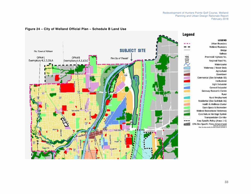
The Official Plan designates the majority of the Site as Open Space
and Recreation with a small portion designated as Core Natural
Heritage System. An Official Plan Amendment is required to permit
the Master Plan (Figure 24).
32
Redevelopment of Hunters Pointe Golf Course, Welland
Planning and Urban Design Rationale Report
February 2018
Figure 24 – City of Welland Official Plan – Schedule B Land Use
33

The Biglieri Group Ltd.
20 Leslie Street, Suite 121, Toronto ON M4M 3L4
126 Catharine Street North, Hamilton ON L8R 1J4
4.5.1 Section 2 on Community Strategic
Directions
Section 2.1 on Community Strategic Directions states that
Welland’s Community Strategic Directions should be considered in their entirety. Welland is:
• A leadership community;
• A complete community;
• An economic gateway;
• A sustainable City;
• A safe, healthy and accessible City;
• A proud and attractive City; and,
• A good neighbour.
Section 2.3 on A Complete Community, particularly Section 2.3.2 of
Strategic Directions states that Welland will: ensure that there is an
adequate supply of different housing types which cater to the wide
variety of its citizen’s needs; ensure that a sufficient supply of
housing is provided which is affordable to low and moderate
income households; will encourage residential and non-residential
development which is considered attractive to youth and young
families, supports family-building, and allows for aging-in-place;
and, promote neighbourhood design and a transportation system
which is accessible to all citizens.
The Master Plan provides for an increased supply of different
housing types to cater to a wide variety of citizen’s needs and
affordability levels, including single-detached houses, street
townhouses, stacked townhouse units and apartment units. The
Master Plan will provide a variety of unit types and sizes to support
the needs of youth, young families and seniors, allowing for aging-
in-place. The Master Plan includes a neighbourhood design that
prioritizes a strong transportation network for various types of users,
including pedestrians, cyclists, vehicles and will implement a new
transit route through consultation with the City of Welland. These
elements aid in the creation of a complete community as discussed
in the Section 2.3.
Section 2.6 on A Safe, Healthy and Accessibly City, particular ly
Section 2.6.2 on Strategic Directions, states that Welland will be a
leader in promoting a safe, healthy, and accessibly city; Welland
will enhance and create a culture of health and wellness in the
community by encouraging sport and public recreation
opportunities.
The Master Plan has been designed to prioritize the integration of
residential land uses with a well-designed multi-use trail and open
space system. Through encouraging active transportation in the
neighbourhood and increased access to open space and parks,
the Master Plan will promote safety, active living and accessibility
to all users. The integrated park system will encourage sport and
public recreation opportunities.
4.5.2 Section 3 on Growth Management
Strategy
Policy 3.1 on Welland’s Growth Management Strategy states that
the foundation of the growth management strategy is to direct all
urban growth to lands within the designated Urban Area Boundary
on land serviced with municipal water and sanitary wastewater
services. The City encourages appropriately planned infilling and
intensification along the Welland Recreational Waterway. Policy 3.2
on Planning Objectives states that the growth related objectives of
the Plan are to build compact, mixed-use, transit supportive,
pedestrian friendly areas within the Built Up Area; to provide a
framework for transforming Welland into a complete community;
and, to ensure the availability of a sufficient supply of designated
employment and residential land to meet the City’s projected long term growth. Policy 3.3.1 on Population Forecast provides the future
population growth for the City of Welland. The forecast population
to 2031 is 63,900, resulting in 27,590 units. Policy 3.3.3 on Housing
Distribution states that the following unit types are forecasted to
2031: 19,780 low density units, 3,210 medium density units, and
680 high density units. Policy 3.3.4 on Employment Forecast states
that 27,080 jobs are forecasted in Welland to 2031.
34
The Master Plan provides for urban infilling in the urban area built
boundary on lands serviced with municipal water and sanitary
wastewater services. The Master Plan area represents an infill
development located in close proximity to the Welland Recreational
Waterway, allowing for future residents to enjoy views and easy
access to this important piece of infrastructure in the City. The
Master Plan implements a compact, mixed-use, transit supportive
and pedestrian friendly community within the Built-up Area which
can be considered a complete community. The proposed
redesignation of the Site from Open Space to Residential will aid
the City of Welland in providing sufficient supply of residential land
with commercial and office uses to meet the City’s projected long term growth for population and employment.
Section 3.4, particularly Policy 3.4.2 on City Structure, states that
Welland’s Urban Boundary is the focus for all urban development
with lands that are already serviced, or are intended to be serviced,
with major roads, transit and piped sewer and water services. This
supply of land is comprised of two sub-areas: the Built-up Area
within the Built Boundary; and Greenfield Area. The Built Boundary
was determined by the Province in 2006 and subsequently finalized
in April, 2008. All growth which occurs within the Built Boundary is
considered to be “intensification”. The City of Welland’s Urban Boundary and Built Boundary are delineated on Schedule A (Figure
25).
The Site is located within the Urban Boundary and the Built
Boundary for the City of Welland and therefore, intensification of the
Site is appropriate and in conformity with provincial policy
implemented through the Regional Official Plan and City Official
Plan.
Section 3.4.4 on Intensification and Brownfield Redevelopment,
particularly Policy 3.4.4.1.C on Intensification Strategy states that
intensification will be encouraged since it offers opportunities for
economic development; is a viable approach to reducing the
amount of Greenfield land needed for growth; takes advantage of
already serviced but underutilized land; and helps to improve the
vibrancy and aesthetics of Welland’s existing areas. Intensification
Redevelopment of Hunters Pointe Golf Course, Welland
Planning and Urban Design Rationale Report
February 2018
is encouraged throughout the Built Up Area, however, Schedule A
identifies appropriate locations for intensification within the
Downtown, along key transit corridors and the Welland Recreational
Waterway. Policy 3.4.4.1.D on Intensification Target states that the
City will plan to meet its local municipal intensification target of 40%
as recommended by the Regional Municipality of Niagara.
Achieving the 40% target means that 40% of all annual housing
development should occur within the City’s Built up Area after 2015. Welland’s intensification unit target, based on the housing forecasts in Policy 3.3.3, is 1,975 units (2016-2031).
The Master Plan will provide for residential, office and commercial
uses to offer opportunities for economic development in the City of
Welland, will reduce the amount of Greenfield land needed for
growth, takes advantage of underutilized serviced land, and will
help to improve the vibrancy and connectivity of the existing
neighbourhood. The Master Plan is adjacent to intensification areas
within the neighbourhood east of the Highway 406 and Daimler
Parkway intersection, along the Welland Recreational Waterway.
The Master Plan will contribute to the creation of a more complete
community in this area, to provide increased connectivity,
commercial and office opportunities and increased park space for
the use of residents. The Master Plan will also help the City meet its
intensification target of 40% of development within the Built
Boundary.
4.5.3 Section 4 on Urban Area Land Use
Policies
Section 4.2 on Housing and Residential, provides Planning
Objectives and Land Use Policies for development. Policy 4.2.2.1
on Residential Hierarchy classifies residential land uses into three
land use categories including Low Density Residential, Medium
Density Residential and High Density Residential.
Policy 4.2.2.2 on Low Density Residential states that low density
residential is intended to provide housing for residential
development at a minimum density of 15 dwelling units per net
hectare of land and maximum density of 24 dwelling units per net
35

The Biglieri Group Ltd.
20 Leslie Street, Suite 121, Toronto ON M4M 3L4
126 Catharine Street North, Hamilton ON L8R 1J4
Figure 25 – City of Welland Official Plan – Schedule A City Structure
36
hectare of land. Permitted uses include single-detached, semi-
detached, triplex, townhouse and duplex housing units. Low
Density Residential uses will be encouraged to have a variety of
facades and use a variety of building materials.
Policy 4.2.2.3 on Medium Density Residential states that medium
density residential is intended to provide housing for residential
development at a minimum density of 25 dwelling units per hectare
of land and a maximum density of 60 dwelling units per net hectare
of land. Permitted uses include triplex, four-plex, townhouse,
stacked townhouse, and low rise apartment housing. Accessory
private recreation facilities or amenities for the benefit of the
immediate residents are permitted. Buildings should incorporate
landscaping in all yards to provide a buffer between the building
and adjacent sensitive land uses. Parking areas shall be located in
the side or rear yard and/or underground or structured parking.
Where underground or structured parking is provided, an
amendment to this Plan is not required for increased density,
provided that proposed built form is consistent with the design
policies of this Plan. The site will be designed to provide for the
collection and storage of recyclable wastes on site. Low and
Medium Density Residential designations permit Neighbourhood
commercial uses, in accordance with the Commercial policies of
Section 4.4 of the Plan. Low and Medium Density lots shall
accommodate low-rise dwellings which do not cause significant
issues with casting of shadows, obstruction of views and privacy
for adjacent lots. Low and Medium Density Residential uses will be
encouraged to have front porches or covered entrances. Attached
garages on housing units should be designed so that the resulting
streetscape is predominated by the front yard landscaping, front
doors, and front windows of the housing units instead of garages.
The Master Plan has been designed in accordance with Policy
4.2.2.2 and 4.2.2.3 to ensure that the low density and medium
density residential uses on the Site are in conformity with the design
objectives of the City of Welland. The Master Plan includes single-
detached dwellings, street townhouses and stacked townhouses
and neighbourhood commercial uses in accordance with Section
4.4 of the Plan. The Master Plan maintains the minimum densities
Redevelopment of Hunters Pointe Golf Course, Welland
Planning and Urban Design Rationale Report
February 2018
for both land use categories. The Master Plan envisions the
incorporation of a variety of facades, use of building materials, and
landscaping strategically planted throughout the site to aid in
establishing a landscaped character for the neighbourhood. The
mixed-use nodes will consist of stacked townhouses with ground
floor neighbourhood commercial uses. Parking will be provided at
the rear or underground where feasible. Waste collection will be
designed in accordance with the Regional Municipality of Niagara
requirements. Low and Medium density uses have been
appropriated sited to ensure limited shadows, obstruction of views
and privacy for adjacent lots. The Master Plan envisions residential
units with front porches that have covered entrances and attached
garages that are minimized from the view of the streetscape by
predominating the streetscape with landscaping, front doors and
front windows.
Policy 4.2.3.5 on Prevention of Neighbourhood Isolation states that
new neighbourhoods shall be connected to the rest of the City by
public streets and/or public trails. New streets and blocks should
be consistent with, and extend from, the existing street pattern. New
gated development or gated communities will not be a permitted
form of residential development.
The Master Plan has been designed as a complete community in
the area of Welland east of the Highway 406 and Daimler Parkway.
The Master Plan will improve connectivity in this area with these
lands to the rest of the City through implementing an overpass of
the Highway 406 and a pedestrian and cyclist connection to East
Main Street to the south of neighbourhood. The proposed streets
and blocks have been designed in a grid like pattern with
modifications as required, maintaining the existing orientation of the
streets recently designed and developed in the neighbourhood.
Policy 4.2.3.6 on Infill and Intensification Development states that
infilling and intensification is encouraged throughout the City’s existing built up residential areas. Intensification in residential areas
should address: land use and neighbourhood character
compatibility; lot pattern and configuration; the potential for
additional traffic and traffic maneuverability; the potential for transit
37

The Biglieri Group Ltd.
20 Leslie Street, Suite 121, Toronto ON M4M 3L4
126 Catharine Street North, Hamilton ON L8R 1J4
ridership; natural (including natural hazards) and built heritage
conservation/protection; the available capacity of municipal
infrastructure; and, residential intensification targets identified in
this Plan.
The Master Plan provides for infill and intensification within the
existing built boundary of the City of Welland. The Master Plan has
been planned and designed in accordance with the adjacent land
uses and neighbourhood character, providing appropriate
setbacks and buffering to existing residential. The proposed lot
fabric has been designed in accordance with adjacent development,
with a fine grain block and street network. The road network has
been designed to delineate the majority of road traffic to the main
north to south road, Street A, with pedestrian and cyclist pathways
delineated along this artery and through the site. A new bus route
through the site is envisioned and will encourage transit ridership.
The Master Plan has been designed to ensure appropriate buffers
to environmental features. The Master Plan can be serviced by
existing municipal infrastructure and will aid the City of Welland in
achieving its intensification targets within the built boundary.
Section 4.4 on Commercial Areas states that the City of Welland’s commercial structure is comprised of a distinct set of nodes and
corridors. Policy 4.4.2.7 on Neighbourhood Commercial states that
Neighbourhood Commercial areas are intended to provide for daily
or weekly convenience shopping and service needs of nearby
residents. Permitted uses within Neighbourhood Commercial areas
include small retail stores, personal services as well as small
restaurants which are intended to draw residents of the surrounding
neighbourhood(s). Residential units are permitted above
commercial uses within these buildings. Neighbourhood
Commercial areas are not shown on the land use schedules.
Neighbourhood Commercial areas are permitted within the City’s residential areas, provided that they are located at the intersections
of arterial and/or collector roads and fit within the context of the
surrounding land uses. Neighbourhood Commercial areas should
fit within the context of the surrounding neighbourhood. Individual
areas should not exceed 20,000 square feet of gross floor area.
The Master Plan includes neighbourhood commercial uses in the
mixed-use nodes on the Site. The mixed-use nodes will consist of
stacked townhouses with ground floor commercial uses. The
Master Plan will introduce opportunities for commercial, retail and
office uses to create more opportunities for employment within the
Master Plan area. The proposed mixed-use nodes will provide for
opportunities for community infrastructure, including opportunities
for office commercial uses which can include medical offices,
dental offices, government offices, etc.
4.5.4 Section 6 on City-Wide Land Use Policies
Section 6.1 on the Environment, particularly 6.1.2.1 on Core Natural
Heritage System, states that the planned function of the Core
Natural Heritage System is to provide for the protection,
maintenance, and enhancement of Welland’s natural systems . The
Core Natural Heritage System is also intended to provide a
framework for establishing the linkages among natural heritage
features, within the system and major surface water resources.
Policy 6.1.2.2.A on Delineation of Features and Modifications states
that the boundaries of Core Natural Areas may be defined more
precisely through Environmental Impact Studies. Only minor
boundary adjustments to Environmental Protection Areas will be
permitted without Amendment to this Plan.
Currently there is one Environmental Protection Area delineated on
the Site in the City of Welland Official Plan along the northern limits
where the Site meets the Welland River (Figure 26). In support of
the application, a preliminary Natural Heritage Evaluation has been
conducted by Beacon Environmental to determine the location of
potential natural heritage features on the property. Appropriate
setbacks to this Environmental Protection Area have been
maintained. The remainder of the Site has been disturbed and
consists of man-made ponds and dug channels, therefore, these
features require further seasonal investigation to determine their
significance.
38
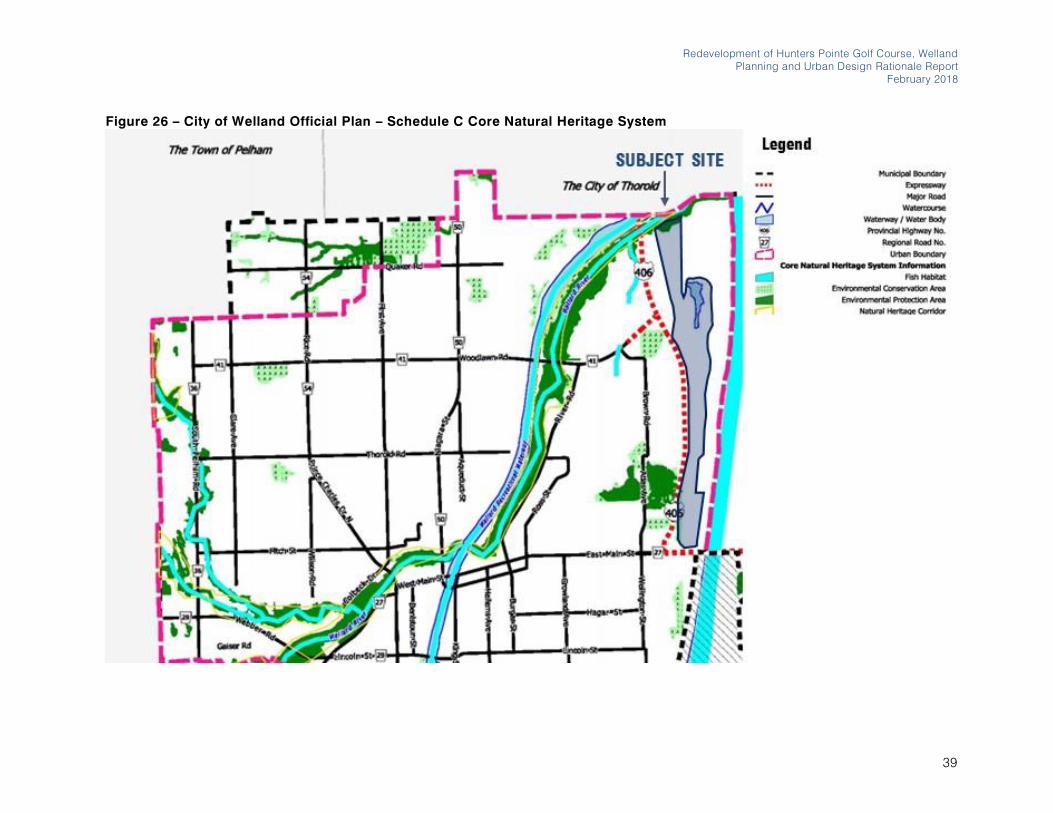
Redevelopment of Hunters Pointe Golf Course, Welland
Planning and Urban Design Rationale Report
February 2018
Figure 26 – City of Welland Official Plan – Schedule C Core Natural Heritage System
39
The Biglieri Group Ltd.
20 Leslie Street, Suite 121, Toronto ON M4M 3L4
126 Catharine Street North, Hamilton ON L8R 1J4
Section 6.2 on Parks, Open Space and Recreation, particularly
6.2.2.1 on Parks, Open Space and Recreation Facilities states that
the Parks, Open Space and Recreation designation includes lands
used for active and passive leisure activities. These open spaces
are intended to contribute to the environment through the provision
of green space and vegetation. Permitted uses include indoor and
outdoor active and passive recreational uses including parks, trails,
golf courses, arenas, curling rinks, sports fields and other similar
uses as well as open space areas. Compatible uses, such as public
and/or private utilities, environmental conservation, and community
gardens may also be allowed. The hierarchy of parks includes
Neighbourhood Parks that are meant to serve the immediate
recreation needs of a neighbourhood and are within walking
distance of the area being served; City-wide parks serve the
recreation needs of the residents of Welland; and, Regional parks
serve the recreation needs of the residents of Welland and also
attract tourists from other areas of Niagara and beyond. The City,
wherever possible, shall develop a well-maintained open space
system which links important destinations, such as the Downtown,
activity centres, residential neighbourhoods, workplaces,
waterfront areas, and parks using trails, natural areas, bicycle paths
and sidewalks. The City intends to achieve an overall ratio of 4
hectares of park space per 1,000 persons of population within
Welland. The standard size for a Neighbourhood Park is 1.0 hectare
per 1,000 people, for a City-wide park is 2.6 hectares per 1,000
people. Policy 6.2.3.1 on public Park Land Dedication provides that,
in accordance with the Planning Act, the City of Welland may
require the applicant to dedicate up to 5% of the gross area for the
provision of public open space, or one (1) hectare for every 300
dwelling units.
The Master Plan proposes approximately 17.69 hectares of open
space and parkland and has a total area of 85.45 hectares with
1194 residential units. The proposed 17.69 hectares of open space
and parkland represents approximately 20% of the gross area of
the Site. The proposed 20% parkland is above and beyond the 5%
of the gross area required (4.3 hectares) as well as the required 1
hectare for every 300 dwelling units (4 hectares). Our calculations
estimate the approximately 3082 people will live in the
neighbourhood based on 2.9 people per single-detached house
(747 units), 2.5 people per townhouse (95 units) and 1.7 people per
apartment unit (252 units). Therefore, the Neighbourhood Park is
required to be 3 hectares in size when considering 1.0 hectare of
park space per 1,000 people. The Neighbourhood Park proposed
for the center of the Master Plan area is 6.16 hectares. This central
neighbourhood park will provide many opportunities for active and
passive recreational uses to serve area residents. Other parks and
parkettes have also been provided through the site, ranging in s ize
from 5.97 hectares at the north end of the site, with a 0.10 hectares
central parkette and two parkettes having an area of 0.71 hectares
and 0.72 hectares to the south. Together these parks provide
adequate park space to serve the Master Plan area. The proposed
parks have been strategically located throughout the site to ensure
that all residents are within a five-minute walking distance to a
neighbourhood park.
Section 6.4 on Transportation, particularly, 6.4.2.1 on Roads, states
that all roads within the municipality are classified according to their
function as expressways, arterials, collectors and local roads as
shown on Schedule “E”. This hierarchy of roads is intended to optimize the roadway network. Roadway classifications are defined
and ranked. Expressways are a median or fully divided provincial
highway or undivided provincial highway with full access control
serving large volumes of inter-city traffic at high speeds; Arterial
Roads are a divided or undivided road primarily used for traffic
movement and servicing moderate to large volumes of inter-City
and/or through traffic at moderate speeds. Collector Roads are an
undivided road where traffic movements and land access are of
equal importance and serving moderate volumes of traffic at
moderate speeds. Local Roads are an undivided road primarily
used for land access and serving low volumes of traffic. Generally,
the planned minimum right-of-way widths for roads should be: 30.0
metres for Arterial Roads; 24.5 metres for Collector Roads; and,
20.0 metres for Local Roads.
The Master Plan proposes a series of Local Roads and a Collector
Road, each with a 20 metre right-of-way, that connect to the existing
arterial road network from Daimler Parkway to Woodlawn Road
40
which provides connections to the Highway 406, a provincial
highway. The main north-south Collector Road through the site,
Street A, serves as a Collector Road but the additional width is not
required as its sole purpose is to serve area residents. The function
of the Road is achieved at the 20 metre width as shown in Figure
17.
Section 6.4.2.2 on Transit states that, in the interests of overall
energy conservation, environmental protection, and public mobility,
the City shall promote the use of public transi t, wherever possible.
The City shall facilitate the provision of local transit services within
a reasonable walking distance of all urban land uses. The City may
require that 90% of the new residential and non-residential units in
a proposed subdivision are within 400 metres of a trans it stop.
Section 6.4.2.3 on Cycling states that the City shall implement, in a
staged program, the development of a continuous and safe system
of on-street and off-street cycling trails and development
applications shall incorporate cycling linkages where warranted.
Section 6.4.2.4 on Pedestrians states that transportation networks
shall include safe, convenient and attractive pedestrian systems. A
continuous sidewalk/walkway system providing accessible, safe,
convenient and enjoyable walking for all users shall be developed
and maintained. Sidewalks, walkways, and trails shall be designed
in a manner to reduce the walking distances between residential
development and transit, recreational/community facilities, schools
and commercial facilities. This requirement shall be evaluated at a
variety of scales.
The Master Plan envisions two new bus stops on the Site. The new
bus route and stops will have to be further reviewed and discussed
with the City of Welland and Niagara Region. Currently, the lands
east of Highway 406 are not served by public transit. The approval
of this Master Plan will make providing transit within this area more
feasible. New transit stops will be required on site to ensure
appropriate service to existing area residents and future residents.
Further, delineated cycling lanes and pedestrian connections have
been provided to ensure safety and to encourage active
transportation. These mutli-modal considerations also ensure
Redevelopment of Hunters Pointe Golf Course, Welland
Planning and Urban Design Rationale Report
February 2018
connectivity to recreational and community facilities, schools,
commercial facilities and places of employment.
Section 6.4.2.5 on Railways states that where development is
proposed adjacent to a rail corridor, the City together with the
railway authority, will consider the impact of the development on the
rail corridor and may require studies (including, but not limited to,
snow, noise, vibration, air quality studies) to demonstrate that the
rail corridor’s function is not negatively impacted and that potential negative impacts of the rail corridor on the proposed land use can
be mitigated.
The Master Plan has been supported by a Noise and Vibration
Report to address the rail corridor that is located adjacent to a small
portion of the Site. This rail corridor is a spur line and has minimal
activity and therefore poses minimal impact on the proposed
development from a noise and vibration perspective.
Section 6.4.2.6 on the Welland Canal, particularly 6.4.2.6.E, states
that the Welland Canal is recognized as having a built and cultural
heritage value to the City and opportunities will be sought to
promote and celebrate this heritage.
The Master Plan is not immediately adjacent to, nor does not have
an immediate connection to, the Welland Canal, however, the
development has prioritized strategic open spaces and good
quality urban design to ensure that the development upholds a high
standard of design due to its proximity to this cultural heritage
resource.
Section 6.5 on Infrastructure and Utilities, contains policies for
Water and Sanitary Sewage, Stormwater Management. All new
development within the Urban Area is required to be connected to
the water system and sanitary sewage system as a condition of
development. Stormwater Management Facilities should generally
be located at the edge of neighbourhoods; at the interface with
natural areas; and/or within large public open spaces, including
community parks. Stormwater Management Facilities shall be
designed to have a high level of public exposure and should be
41

The Biglieri Group Ltd.
20 Leslie Street, Suite 121, Toronto ON M4M 3L4
126 Catharine Street North, Hamilton ON L8R 1J4
integrated in, and contribute to, the enhancement of the
neighbourhood’s public realm. Where appropriate, Stormwater Management Facilities should be designed so that approximately
50% of the perimeter is adjacent to public areas such as parks,
trails and public road right-of-ways.
The Master Plan will be connected to full municipal servicing. The
Master Plan has designed its stormwater management system to
have a high level of public exposure, with stormwater management
ponds connected to proposed parkland to ensure that these
facilities are designed and considered as part of the public realm
for these open spaces.
4.5.5 Summary of Opinion
It is our opinion that the Master Plan conforms with the City of
Welland Official Plan. The Master Plan proposes a mixed-use
development with a variety of housing options ranging from s ingle-
detached houses to apartments as well as neighbourhood
commercial uses with opportunities for retail and office uses as well
as community infrastructure. The Master Plan will be serviced by
existing infrastructure and will represent a logical extension to
existing services. The proposed development will aid the City of
Welland in achieving its intensification targets for growth within the
built boundary which includes the entire limits of the Site.
4.6 City of Welland Zoning By-law
The City of Welland Zoning By-law 2017-117 was passed on
October 17, 2017. The Site is zoned as Community Open Space
Zone (O2), with a small portion zoned as Environmental Protection
Overlay (EP) and Neighbourhood Commercial (NC-26) under the
City of Welland Zoning By-law (Figure 27).
The Master Plan will require a Zoning By-law Amendment to
implement the proposed uses on the Site.
The Zoning By-law Amendment will implement the following zoning
categories:
• NC – Neighbourhood Commercial with site-specific
allowances to include medium density residential in order
to achieve the proposed mixed-use nodes;
• O2 – Community Open Space in order to implement the
proposed open space and recreation network;
• EP – Environmental Protection Overlay in order to preserve
the limits of the natural heritage features on the Site; and,
• RL2 – Residential Low Density 2 in order to implement the
single-detached houses, street townhouses and stacked
block townhouses.
The proposed Zoning By-law Amendment and Schedule will be
further reviewed and discussed with the City of Welland Planning
Department in order to achieve the land use breakdown as shown
in Figure 15.
42
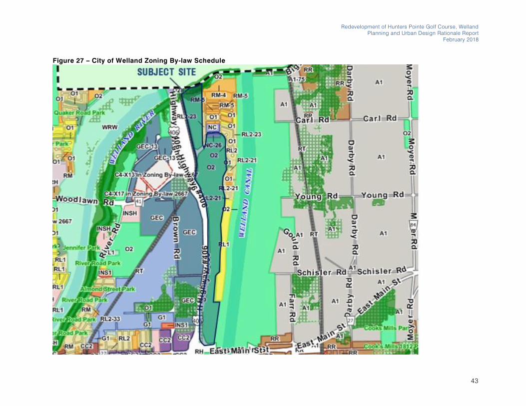
• Open Space
Redevelopment of Hunters Pointe Golf Course, Welland
Planning and Urban Design Rationale Report
February 2018
Figure 27 – City of Welland Zoning By-law Schedule
43
The Biglieri Group Ltd.
20 Leslie Street, Suite 121, Toronto ON M4M 3L4
126 Catharine Street North, Hamilton ON L8R 1J4
4.7 City of Welland Urban Design
Guidelines
The City of Welland’s Urban Design Guidelines are based on 7 main principles:
• Provide a Multi-Functional & Multi-Modal Streetscape
Network;
• Promote a Convenient & Connected Open Space Network;
• Protect and Enhance Natural Heritage;
• Preserve and Embrace Cultural Heritage;
• Establish Appropriate Built Form & Architecture;
• Cultivate Identity & Sense of Place; and,
• Incorporate Measures of Healthy Communities and
Sustainability through Urban Design.
The main principles are summarized below and a high-level review
has been provided indicating how the proposed development
conforms to these main principles.
4.7.1 Multi-Functional and Multi-Modal
Streetscape Network
The Guidelines state that walkability represents a vital measure of
assessing how successful a community will function now and into
the future. The Guidelines also state that along with ease of access
and advancing walkability, there should also be considerations
made for the encouragement of a variety of modes of transportation
which are sustainable and will also reduce the impacts of the
automobile.
The Master Plan has been designed to ensure walkability in the
residential community is a priority. The Master Plan incorporates a
multi-use trail system that allows for the delineation of cyclists and
pedestrians from vehicular traffic, providing for safe and enjoyable
use for all types of users.
4.7.2 Convenient and Connected Open Space
Network
The Guidelines state that there are several environmental
opportunities that can influence the character and development of
the City. These include, integrating a sustainable design approach
as a key strategy; providing a well-connected open space system,
integrated into the existing community, and offering multiple
outdoor recreational possibilities. The Guidelines state that an
important urban design objective is to create a well -integrated
pedestrian scaled community and easy access to daily amenities,
by providing a pedestrian system that links parks and streets,
further enhancing the existing conditions and promoting safe and
convenient connectivity between these spaces.
The Master Plan, through its five parks on the Site, will provide
multiple outdoor recreational opportunities to serve area residents.
The proposed development, through its fine grain network of blocks
and streets, facilitates a pedestrian-scaled community. All
neighbourhood residents will be within a 5 minute walking distance
to the proposed public parks. The proposed streets and block
network delineates pedestrians, cyclists and automobiles, to
ensure safe and convenient connectivity among these spaces.
4.7.3 Protect and Enhance Natural Heritage
The Guidelines state that the development of the Welland Canal and
Recreational Waterway have altered much of the natural watershed
system in the city and surrounding region. Further, much of the
original natural environment has been repurposed by human
settlement and natural systems which have been reengineered to
allow for shipping connections. Despite this reality it is important to
realize that natural systems and habitat have adapted to more
engineered processes. Therefore, natural heritage has uniquely
evolved to Welland’s agricultural, industrial and engineered landscapes.
The Master Plan has been designed to ensure appropriate buffers
to existing natural features on the property. The Master Plan
44
prioritizes a comprehensive open space network which
compliments the existing natural corridors. This open space
network provides open areas for area residents to utilize and enjoy
the natural setting given its close proximity to the Welland River and
the Welland Canal.
4.7.4 Preserve and Embrace Cultural Heritage
The Guidelines state that Welland was settled in 1788 as an
agricultural town. Welland expanded and became an important
landmark for trade as continual development of the Welland Canal
introduced shipping and industrial production to the city. This
history persisted until recently when a number of large
manufacturing firms reduced or closed operations, and Great Lakes
shipping was sharply reduced. However, this industrial heritage
continues to physically remain.
The Guidelines state that much of Welland’s rich cultural history is
still evident today, as evidenced by the array of heritage buildings,
bridges, landmarks and public art. Events such as the Niagara
Food Festival, Niagara Regional Exhibition, Welland Rose Festival,
IlluminAqua and the Dragon Boat Festival, showcase Welland’s evolving cultural heritage, attracting thousands of people each year.
Coupled with the year round activities of Market Square, the
Downtown boasts a tremendously successful display of Welland’s cultural heritage. The Guidelines state that through contextually
sensitive approaches, urban design measures will ensure that this
unique character is incorporated into everyday life for residents and
visitors.
The Master Plan strives to create contextually sensitive
development in light of its proximate to the cultural heritage
resource of significance for the City, the Welland Canal. The Master
Plan will propose high-quality architectural and built form to
complement this cultural landscape.
Redevelopment of Hunters Pointe Golf Course, Welland
Planning and Urban Design Rationale Report
February 2018
4.7.5 Appropriate Built Form and Architecture
The Guidelines state that it is important for the City of Welland, with
a rich history and culture, to ensure that any development,
redevelopment and intensification is responsive to the existing
conditions. New built form should be context sensitive to ensure
that the City of Welland retains its unique sense of place.
The Guidelines state that establishing appropriate built form and
architecture can be achieved in many ways. Building heights should
have a smooth transition to adjacent existing built form, in turn
protecting the existing stable neighbourhood. Development,
redevelopment and intensification through the provision of a mix of
densities, and encouraging higher density close to major street
intersections, can be achieved through moderately scaled buildings
varying in height. This built form scale responds well to the existing
built fabric as well as local market demands. It also promotes
liveability through pedestrian scaled development. The Guidelines
state that compact built form, sustainable development and
moderately scaled buildings are all means of establishing a built
form appropriate for the City of Welland. Tools such as building
articulation, massing and streetscaping should be utilized.
The Master Plan has been designed to ensure that it is responsive
to the existing built form and architecture found in the
neighbourhoods surrounding the Site. The site layout and design
has been strategically planned to ensure visual buffers and
setbacks from existing neighbourhood residential to the northeast
of the Site. The central neighbourhood park having an area of 6.16
hectares together with the 2.8 hectare stormwater management
pond, provide for an open space which serves to buffer the existing
residential to the proposed built form. Similarly, the channel running
north to south through the Site provides for a naturalized buffer from
the proposed residential in the North Precinct to the existing
residential just east of the channel.
The proposed built form has been strategically si ted to ensure an
appropriate transition from the existing stable neighbourhood to the
northeast. Similarly, the internal site design has been strategically
45
The Biglieri Group Ltd.
20 Leslie Street, Suite 121, Toronto ON M4M 3L4
126 Catharine Street North, Hamilton ON L8R 1J4
sited to ensure appropriate transitions between the single-detached
residential to the mid-rise mixed-use nodes. Townhouses and
stacked townhouses are proposed as transitional built form
between the mid-rise mixed-use nodes and single-detached
residential. The implementation of a pedestrian-oriented
environment will be achieved through landscaped public
boulevards that provide appropriate setbacks to built form.
4.7.6 Identity and Sense of Place
The Guidelines state that urban design presents a formal strategy
to promote an identity and a distinctive sense of place for a
community. The City has a number of successful icons that build
upon its history and cultural heritage. The Guidelines provide
parameters to expand physical measures that give rise to a
heightened sense of place in the city. Gateway signage, public art
commissions, unique landscape treatments and street trees can all
be identifiable markers to specific neighbourhoods in the city.
The Master Plan has been designed with a pedestrian-oriented
public realm. The proposed adaptive reuse of the existing golf
course clubhouse will act as a gateway feature to the
neighbourhood and will help to achieve identity and a sense of
place. Public art and landscape treatments will be further discussed
and reviewed with the City of Welland to help achieve identity and
a sense of place in this new community.
4.7.7 Healthy Communities and Sustainability
through Urban Design
The Guidelines state that the idea of building and designing cities
is intrinsically tied to the idea of creating healthy and sustainable
communities. Beyond public health measures, engineering
standards, air and water quality and brownfield mitigation, the
concept of healthy communities is now directly tied to the way we
envision, design and construct urban spaces and how we relate to
these spaces. Therefore it is important for urban design measures
to promote a healthier way of life. The Guidelines look to build upon
the cycling network in the Niagara Region, while looking for new
and exciting opportunities to advance active transportation through
other connections and facilities in Welland.
The Guidelines state that a more robust use of the Recreational
Waterway needs to be explored. This would include better ways to
utilize this amenity, access both physically and visually, and to
introduce new uses along the Waterway. These uses and
supporting infrastructure need to be designed to sustain or
introduce adaptable winter uses to reinforce healthy community
development and active transportation year-round.
The Guidelines also state that sustainable thinking must be a core
part of city building, and urban design presents a real and tangible
way of implementing more sustainable practices. Throughout the
urban context, sustainable ways of design and construction of our
environment must be considered and can range from large scale
initiatives to detailed design treatments. Urban design can work to
reduce the carbon footprint, increase oxygen production, reduce
the urban heat island effect, increase urban tree canopy, reduce
stormwater runoff, restore animal habitat, mitigate brownfields and
reduce energy demands. To reinforce this, the Guidelines
encourage mixed-used compact development; connecting open
spaces and onsite stormwater infiltration.
The Master Plan proposes development on underutilized lands
adjacent to both the Welland River and the Welland Canal. The Site
presents a unique opportunity to introduce new land uses adjacent
to these features, to encourage physical and visual access to these
features.
Active transportation is a priority in the design of this Master Plan.
The Master Plan looks to reduce the carbon footprint through
encouraging active transportation rather than reliance on the
automobile. The proposed development also looks to increase
urban tree canopy and to reduce stormwater runoff on the Site.
46

4.7.8 Summary of Opinion
It is our opinion that the Master Plan will implement the City of
Welland’s Urban Design Guidelines. The Master Plan proposes a
comprehensive open space network with green corridors through
the site providing for pedestrian-oriented development that
promotes walkability. The development will implement appropriate
buffers from the natural heritage features on the site. The Master
Plan will implement contextually sensitive development with high-
quality architecture and built form to compliment the cultural
heritage context, being in close proximity to the Welland Canal. The
development strives to create a strong sense of place through
prioritizing a pedestrian-oriented public realm, active transportation
and active and passive recreational opportunities.
Redevelopment of Hunters Pointe Golf Course, Welland
Planning and Urban Design Rationale Report
February 2018
47
The Biglieri Group Ltd.
20 Leslie Street, Suite 121, Toronto ON M4M 3L4
126 Catharine Street North, Hamilton ON L8R 1J4
5.0 SUMMARY OF
PLANNING AND
URBAN DESIGN
RATIONALE
5.1 Efficient Use of Land and
Resources
The Master Plan is located within a Settlement Area defined by the
PPS, the Built-Up Area defined by the Growth Plan, the Urban Area
defined by the Niagara Regional Official Plan and the Urban
Boundary and Built Boundary defined by the City of Welland Official
Plan. These areas are intended to be the focus of growth and
development and are intended to accommodate a s ignificant
portion of new growth through intensification. The Master Plan will
efficiently use land, resources, infrastructure and public service
facilities in the City of Welland. The proposed development can be
connected to existing services, and is also is in close proximity to
retail and commercial, schools and public transit. Therefore, the
Master Plan is consistent with and/or conforms with Policy 1.1.3.1
of the PPS on Settlement Areas, Section 2.2.6 of the Growth Plan
on Housing, Section 4.A.1 of the Niagara Regional Official Plan on
Growth Management Objectives, and Section 3.1 of the City of
Welland Official Plan on Growth Management Strategy.
5.2 Providing a Range of Housing
Types and Tenures
The Master Plan contributes to a greater range and mix of housing
types and densities in the City of Welland to serve the regional
market area. The Master Plan will provide a total of 1194 new
residential uses with a mix of housing types and tenures including
single-detached houses, street townhouses, stacked townhouses
and mid-rise buildings with apartment units. The proposed built
form has been strategically sited to ensure that the mid-rise
development is provided along the busiest intersections on the Site
and will serve as neighbourhood hubs to meet the daily needs of
area residents. Further, appropriate setbacks are provided from
existing neighbourhood residential to the northeast of the site to
ensure that these stable neighbourhoods are protected and that
their views and vistas of the natural surroundings are maintained.
This is also in accordance with the policies in Section 4.2 on
Residential and Housing in the City of Welland Official Plan.
The proposed redesignation of the Site for residential purposes will
assist the City of Welland in accommodating residential growth for
a minimum of 10 years through residential intensification. The
Master Plan will provide affordable housing options, primarily
located in the South Precinct. The range of housing types and
tenures on the Site is in accordance with Policy 1.4.1 of the PPS on
Housing, Section 2.2.6 of the Growth Plan on Housing, Section 11.A
on Residential Areas and Housing in the Niagara Regional Official
Plan and Section 4.2 on Residential and Housing in the City of
Welland Official Plan.
48

5.3 Providing for Increased Retail
and Commercial Opportunities
The Master Plan will include approximately 60,000 square feet
(5,574 square metres) of retail and commercial uses distributed
through the mixed-use nodes found in the Central Precinct and
Central South Precinct. These nodes will offer a range of retail and
commercial uses through ground floor commercial units as well as
an adaptive reuse of the existing golf clubhouse building. The
proposed mixed-use nodes will also provide for opportunities for
community infrastructure, including opportunities for office
commercial uses which can include medical offices, dental offices
and government offices to serve area residents. The provision of
retail and commercial uses through mixed-use nodes creates
opportunities for employment and will support economic
development and community investment. This is in accordance with
Policy 1.7.1 on Long-term Economic Prosperity in the PPS, Policy
3.C.1 of the Niagara Regional Official Plan on Employment Lands
and Section 4.4 on Commercial Areas in the City of Welland Official
Plan.
5.4 Multi-Modal Transportation
System
The Master Plan has been designed to ensure a strong multi-modal
transportation system. Currently, the lands east of Highway 406 are
not served by public transit. The approval of this Master Plan will
make providing transit within this area more feasible. New transit
stops will be required on site to ensure appropriate service to
existing area residents and future residents. The Master Plan
envisions two new bus stops on the Site. The new bus route and
stops will have to be further reviewed and discussed with the City
of Welland and Niagara Region.
A comprehensive multi-use trail system with delineated cycling
lanes and pedestrian connections have been provided to ensure
safety and to encourage active transportation.
Redevelopment of Hunters Pointe Golf Course, Welland
Planning and Urban Design Rationale Report
February 2018
The proposed road network provides connections to the City’s existing local road system as well as the Provincial Highway 406 to
provide regional connectivity.
The implementation of these various options will ensure that there
is a balance of transportation choices for area residents that reduce
reliance on the automobile and encourages transit and active
transportation. These options will allow residents to choose their
paths of travel to places of employment, schools, cul tural and
recreational opportunities and goods and services. The
transportation network has been designed to achieve the goals,
objectives and policies articulated in Section 3.2.2 on
Transportation-General in the Growth Plan, Section 9 on
Transportation in the Niagara Regional Official Plan and Section 6.4
on Transportation in the City of Welland Official Plan.
5.5 Comprehensive Open Space
Network
The Master Plan has been designed to promote healthy active living
through the creation of an integrated green corridor and open
space system. The Master Plan implements a system of publicly -
accessible parkland, open space and trails to serve the
neighbourhood residents and the City at large. The proposed multi-
use system will ensure safety and will facilitate active transportation.
This is in accordance with Policy 1.5.1 of the PPS on Public Spaces,
Recreation, Parks, Trails and Open Space and Section 4.2.5 on
Public Open Space in the Growth Plan.
The Master Plan proposes approximately 17.69 hectares of open
space and parkland. The proposed open space network represents
approximately 20% of the gross area of the Site. The proposed 20%
of the Site for parkland is above the required 5% of the gross area
of the Site (4.3 hectares) as well as the required 1 hectare for every
300 dwelling units (4 hectares). Our calculations estimate that
approximately 3082 people will live in the neighbourhood based on
49
The Biglieri Group Ltd.
20 Leslie Street, Suite 121, Toronto ON M4M 3L4
126 Catharine Street North, Hamilton ON L8R 1J4
2.9 people per single-detached house (747 units), 2.5 people per
townhouse (95 units) and 1.7 people per apartment uni t (252 units).
Therefore, the formula of 1.0 hectare of park space per 1,000
people generates a requirement of 3 hectares of parkland.
The Neighbourhood Park proposed for the center of the Master Plan
area is 6.16 hectares. This central neighbourhood park will provide
many opportunities for active and passive recreational uses to
serve area residents. Other parks and parkettes have also been
provided through the site, ranging in size from 5.97 hectares at the
north end of the site, a 0.10 hectares central parkette and two
parkettes having an area of 0.71 hectares and 0.72 hectares
respectively and are located in the southern portion of the Site.
Together these parks provide adequate park space to serve the
Master Plan area. The proposed parks have been strategically
located throughout the site to ensure that all residents are within a
five-minute walking distance to a neighbourhood park. The
proposed open space network is in accordance with Policy 6.2.2.1
on Parks, Open Space and Recreation Facilities of the City of
Welland Official Plan.
50
6.0 SUPPORTING
TECHNICAL
DOCUMENTS
6.1 Functional Servicing Report
A Functional Servicing Report has been prepared by Valdor
Engineering. This Report concludes that the proposed residential
subdivision can be adequately serviced with full municipal services
(watermain, wastewater and storm) in accordance with the
standards of the City of Welland, the Region of Niagara and the
Niagara Peninsula Conservation Authority (NPCA) design criteria,
and consists of the following:
6.1.1 Water
The City of Welland is serviced by the Welland water system which
is supplied by the Welland Water Treatment Plant. Lake Erie (via the
Welland Canal) serves as the water source for the plant. Based on
the Region’s Master Servicing Plan, the Welland Water Treatment
Plant has sufficient capacity to support growth to year 2041. A
booster pumping station will be required to improve service to the
existing neighbourhood and to provide sufficient pressure for the
subject development. The existing neighbourhood is currently
serviced by the 300mm diameter Daimler Parkway watermain which
Redevelopment of Hunters Pointe Golf Course, Welland
Planning and Urban Design Rationale Report
February 2018
is fed by the 400mm diameter Woodlawn Road watermain. In order
to address the security of the water supply for the existing
neighbourhood and the proposed development, the existing
150mm diameter Oxford Road watermain is to be extended under
Highway 406 to the subject site. The local water distribution system
within the subdivision will consist of watermains ranging in diameter
from 150mm to 300mm. This internal water system will connect to
the existing 300mm diameter Daimler Boulevard watermain and to
the 150mm diameter Oxford Road watermain to complete a loop.
The maximum day demand plus fire flow has been calculated to be
188.0 L/s.
6.1.2 Waste Water
The existing neighbourhood is serviced by a 300mm diameter
sanitary sewer on Daimler Parkway which drains westerly across
Highway 406 to the existing 825mm diameter trunk sanitary sewer
on Woodlawn Road. The trunk sewer drains westerly to the 1050mm
diameter trunk sewer on River Road which drains southerly to the
Welland Wastewater Treatment Plant (WWTP). Due to the length of
the site and the topography of the site as well as the invert elevation,
it is not possible to service the entire property with the Daimler
Parkway sanitary sewer. The southern part of the property will
therefore have to drain to the existing Oxford Road sanitary sewer.
With regards to the portion of the property north of Daimler Parkway,
due to the topography, a pumping station will be required. Some
upgrades will be required to the existing sanitary sewers
surrounding the site. A local sanitary sewer system will be
constructed along the roads to provide service to the proposed
dwellings and will discharge to the Daimler sewer. The total
wastewater flow from the proposed development has been
calculated to be 53.4 L/s including the peaking factor and infiltration
allowance.
6.1.3 Storm Drainage
The majority of the subject site is tributary to the Welland River to
the north of the site. The southern portion of the site drains to the
Welland Canal. The subject site will be serviced by a minor system
51
The Biglieri Group Ltd.
20 Leslie Street, Suite 121, Toronto ON M4M 3L4
126 Catharine Street North, Hamilton ON L8R 1J4
comprised of a municipal storm sewer sized for the 2 year storm
event. The storm sewers will outlet to the proposed stormwater
management ponds. The major system will be comprised of an
overland flow route which will convey runoff from rainfall events in
excess of the capacity of the municipal storm sewer to the
stormwater management ponds. The proposed development will
include dwellings with basements which will have foundations that
require weeping tile. In accordance with City standards the weeping
tile will be drained by a sump pump which will discharge to grade.
6.1.4 Stormwater Management
Four stormwater management facilities will be required to service
the site due to the size, length and topography of the site. These
facilities have been designed as wet ponds to provide water quality
treatment, extended detention for erosion control and flood control
in accordance with the requirements for each receiving watercourse
and discharge location. The wet ponds consist of a sediment
forebay and a main cell separated by a forebay berm. Thermal
mitigation measures are to be incorporated in the design of the
pond including bottom draw pipe and a planting strategy to provide
shading around the pond perimeter.
6.1.5 Site Water Balance
A site water balance assessment has been undertaken to ensure
that pre-development infiltration volumes are maintained. Based on
the analysis it was determined that mitigation measures are
required in the form of roof downspout disconnection and infiltration
trenches.
6.1.6 Vehicular and Pedestrian Access
Vehicular access to the neighbourhood is currently only available
from Daimler Parkway. Given the number of existing and proposed
dwellings in the neighbourhood, a second vehicular access may be
required in the form of a fly-over bridge to cross Highway 406 and
facilitate the easterly extension of Oxford Road. The proposed
municipal roads will be constructed to urban standards. The local
roads will have a road allowance width of 20 metres and a 8.5 metre
pavement width. Pedestrian access will be provided by 1.5 metre
wide concrete sidewalks along the road allowances. A north-south
corridor will be provided through the subdivision to accommodate
an off-road trail to enhance pedestrian connectivity.
6.1.7 Grading
Earthmoving will be required to achieve the proposed subdivision
grading necessary to meet the criteria of the City. A detailed
analysis of the earthworks will be conducted at the detailed design
stage to optimize the cut and fill volumes. Based on the preliminary
design, no significant difficulties are anticipated in achieving the
municipal grading design standards. A permit will be required from
NPCA prior to commencing earthworks.
6.1.8 Erosion and Sediment Control During
Construction
Erosion and sediment control measures are to be implemented
during construction to prevent silt laden runoff downstream in
accordance with the Erosion and Sediment Control Guidelines for
Urban Construction (December 2006). The ESC plans are to be
prepared at the detailed engineering design stage and are to reflect
the various construction stages.
6.1.9 Subdivision Engineering Design
Detailed design for the proposed development is to be prepared at
the subdivision engineering stage. This detailed design is to include
servicing and grading plans as well as stormwater management
report based on the criteria established in the Functional Servicing
Report.
52
6.2 Noise and Vibration Feasibility
Study
A Noise and Vibration Feasibility Study has been prepared by
Aercoustics. This Report concludes that the combined rail and
traffic noise level predictions indicate that the future noise levels at
the outdoor points of reception located on the central and south
side of the proposed development may be above the applicable
limits. Therefore, physical noise control measures would be
required to mitigate the noise levels at these potential outdoor living
areas (OLAs) to below 60dBA. Additional OLA calculations are
recommended when final grading plans are available. Noise fences
will likely be required along the west side of the residential lots
(exterior side yards), closest to Highway 406. The worst case
impact of the daytime road traffic predicts a level of 65 dBA at the
west face of the townhouse block located nearest to Hwy 406.
Central air conditioning is not likely mandatory for any of the
residential development areas. However, some dwelling units will
require the provision for adding air conditioning by the occupants.
This requirement applies to the townhome blocks located on the
west side of the development, facing Hwy 406 and the Trillium
Railway line. The exterior walls of the first row of dwellings next to
the railway tracks are likely to be required to be constructed from
brick veneer or masonry equivalent, from the foundation to the
rafters to ensure that the indoor noise requirements are satisfied.
Warning clauses are required and sample wording is provided in
the Noise Report. An additional warning clause is also required to
address the site’s proximity to the Trillium Railway line.
With the incorporation of the noise controls discussed in the Noise
report, the sound levels at the sensitive receptors of the proposed
residential development should comply with the noise guidelines of
the MOECC. As indicated in the Municipality’s and MOECC implementation guidelines, where mitigation is required or noise
may be a concern, future occupants will be advised through
warning clauses.
Redevelopment of Hunters Pointe Golf Course, Welland
Planning and Urban Design Rationale Report
February 2018
6.3 Traffic Impact Study
A Traffic Impact Study has been prepared by R.J. Burnside and
Associates. This Report concludes that under existing conditions
during all peak hours, all study intersections are operating with
excess capacity and a level of service E or better with the exception
of the Woodlawn Road and Brown Road / Primeway Drive
intersection. During the weekday PM peak hour, the northbound
left turn movement at this latter intersection is experiencing a delay
of 71 seconds with a level of service F, but has excess capacity with
a volume to capacity ratio of 0.70. In addition, the northbound left
turn queue currently exceeds its storage. It is recommended that
the Region monitor this intersection for possible improvements.
6.3.1 Future Total Road Network Operations
Under background and total conditions, all study intersections are
projected to operate with excess capacity and a level of service E
or better with a few exceptions.
The northbound left movement during both morning and afternoon
peak hours at Woodlawn Road and Brown Road / Primeway Drive
intersection is projected to experience high delay. The northbound
left turn queue also will exceed its storage by 33 metres in 2032
during the afternoon peak hour. Site traffic does not contribute to
this movement and the delay is mainly due to existing and
background conditions. The above suggested removal of the split
phase on both the northbound and southbound directions would
result in acceptable future operations. It is recommended that the
Region monitor this intersection for possible improvement.
During the afternoon peak hour, the southbound left turn movement
at the Woodlawn Road / Daimler Parkway and Highway 406 SB Off
ramp intersection is projected to exceed capacity and will
experience a high delay. The southbound left turn queues are also
projected to exceed its storage during the afternoon peak hour
under 2032 total conditions. These queues could possibly extend
onto the highway. A traffic signal is warranted based on the
53

The Biglieri Group Ltd.
20 Leslie Street, Suite 121, Toronto ON M4M 3L4
126 Catharine Street North, Hamilton ON L8R 1J4
intersection’s projected operations. With a traffic signal, the intersection will operate with excess capacity and within MTO’s volume to capacity ratio threshold and significantly reduced queues.
At Daimler Parkway and Highway 406 NB Off ramp intersection, the
northbound left turn movement is projected to exceed capacity and
will experience a high delay. The northbound left turn queue is also
projected to exceed its storage during the afternoon peak hour
under 2032 total conditions. The queue could possibly extend onto
the highway. A traffic signal is warranted based on the
intersection’s projected operations. With a traffic signal implemented, operation of the intersection is expected to have
excess capacity and within MTO’s volume of capacity threshold and significantly reduced queues.
At the East Main Street and Wellington Street intersection, the
westbound left turn queue exceeds its storage under background
2032 conditions and will exceed its storage by 69 metres in 2032
during the afternoon peak hour. Site traffic adds only 14 vehicles
to this movement, which represents 3% of the volume, which would
not be noticeable in the traffic volume. The Region should monitor
the intersection and extend the left turn lane when appropriate.
It is recommended that a roundabout be implemented at the
proposed intersection on Daimler Parkway. In addition, it is
recommended that an eastbound right turn by-pass lane be
included in its design to minimize eastbound queueing across the
railway crossing to the west.
6.3.2 Railway Crossing
It is recommended that “Do Not Block the Intersection” signs be
implemented at both the Daimler Parkway / Highway 406 NB Off
Ramp intersection and the development’s proposed roundabout on Daimler Parkway.
6.3.3 Second Access Review
It is recommended that the discussion of the second access timing
be deferred pending further discussion with the City, Region and
MTO.
6.3.4 Parking Review
The proposed parking supply will exceed the requirements of the
City’s Zoning By-law.
6.4 Natural Heritage Existing
Conditions Report
A Natural Heritage Existing Conditions Report has been prepared
by Beacon Environmental. This Report concludes that a full
Environmental Impact Study will be required with seasonal field
investigations to determine the exact limits of the environmental
features on site and to ensure that appropriate setbacks are
maintained from these features.
Areas identified as Environmental Protection Area or Environmental
Conservation Area occur along the Welland River at the northern
boundary of the Site. This includes a top of bank. The top of bank
requires a 7.5m setback and this has been shown as an area of
high constraint. Fish habitat is associated with the Welland River to
the north, the Welland Canal to the east and a dug channel that
runs parallel to the railway lands along the western boundary of the
subject property. These features are also regulated by the NPCA.
The Welland River along the northern limit of the subject property is
identified as critical fish habitat and a maximum setback of 30 m
could be required, with a minimum setback of 15 m subject to
detailed seasonal surveys. The Welland River and a 30m buffer
have been shown as areas of high constraint. The Welland Canal is
identified as marginal fish habitat and would need a 15 m setback,
which would not encroach into the eastern boundary of the subject
54
property. The dug channel along the railway is also considered to
represent marginal fish habitat, and as a maximum, a 15 m
buffer/setback would be required. A 15m buffer to each of these
watercourses has been shown as an area of high constraint. The
river bank along the Welland River to the north of the subject
property is identified as Provincially Significant Wetland (PSW),
named the Welland River Wetland Between the Canals. This area
also represents Significant Riparian Woodland and wildlife corridor.
A 30m buffer to the boundary of the PSW is an area of high
constraint. These buffers have been implemented in the Master
Plan.
The golf course ponds provide limited natural heritage function.
These features are regulated by the NPCA. Seasonal fie ld surveys
and consultation with the agencies will be required to determine if
the ponds can be infilled or altered to meet plan of subdivision
design requirements. However, if removal is proposed and a NPCA
permit is issued, a wildlife and fish rescue would also be required
prior to removal. A number of watercourses/ditches associated
with the golf course ponds are regulated by the Niagara Peninsula
Conservation Authority; however, their alteration and or removal can
occur following a permit process with the NPCA. Further study will
be required to confirm that these features are not considered to be
a constraint to subdivision design requirements. The ponds and the
drainage features have been identified as areas that require further
study. A permit will be required for development with the regulated
area of these features.
Redevelopment of Hunters Pointe Golf Course, Welland
Planning and Urban Design Rationale Report
February 2018
55
The Biglieri Group Ltd.
20 Leslie Street, Suite 121, Toronto ON M4M 3L4
126 Catharine Street North, Hamilton ON L8R 1J4
7.0 CONCLUSION
The Master Plan has been reviewed in the context of all applicable
policy documents, including the Provincial Policy Statement (2014),
the Growth Plan for the Greater Golden Horseshoe (2017), the
Niagara Regional Official Plan (2014), and the City of Welland
Official Plan (2011). Based on this assessment, it is our opinion that
the proposed Official Plan Amendment, Zoning By-law Amendment
and Draft Plan of Subdivision conform to or are consistent with the
applicable policy framework and represent good planning because:
• The Site is located within a Settlement Area defined by the
PPS, the Built-Up Area defined by the Growth Plan, the
Urban Area defined by the Niagara Regional Official Plan
and the Urban Boundary and Built Boundary defined by the
City of Welland Official Plan. These areas are intended to
be the focus of growth and development and are intended
to accommodate a significant portion of new growth
through intensification;
• The Master Plan supports the Growth Plan’s direction to develop complete communities with diverse land uses,
multimodal transportation infrastructure to provide
transportation options to area residents, parks and open
spaces, and a vibrant public realm;
• The Master Plan conforms to the Urban Area land use
policies in the City of Welland Official Plan, which prioritize
infill and intensification within the built boundary of the City.
The land uses proposed for the Site are consistent with the
components associated with “Housing and Residential
Areas” as defined in the City of Welland Official Plan. The
Master Plan also maintains the character of the existing
“Residential” lands northeast of the Highway 406 in the City
of Welland and represents a logical expansion of this
residential community;
• The Master Plan provides intensification through compact
built form with land uses that provide a mix of residential ,
employment, and park and open space uses. The medium
density uses are proposed together with the
neighbourhood commercial uses in the form of mixed-use
nodes at strategic locations to serve area residents.
Appropriate transitions between different land uses are
incorporated to ensure a graduation in building height
between the medium density development to low density
development;
• The Master Plan will provide for active and passive
recreational opportunities. An open space and recreation
system is proposed through the site and existing natural
features are preserved and protected by providing
appropriate environmental buffers. A significant park
system is provided throughout the site, connected by a trail
system to serve area residents;
• Existing infrastructure will be efficiently utilized through
connections to the existing water and wastewater
management systems. Stormwater management quality
and quantity controls will be implemented on site to ensure
that post development flows are controlled to pre-
development flow rates;
• The proposed mixed-use nodes will provide for
opportunities for community infrastructure, including
opportunities for office commercial uses which can include
medical offices, dental offices, government offices, etc. and
will provide employment and encourage economic
development;
• A multi-modal transportation system is proposed consisting
of roads, a new transit route through the Site, and
pedestrian and cycling multi-use paths. The proposed
street network has been designed to ensure connectivity
between all neighbourhood precincts while offering a
balance of transportation choices for all types of users. The
provision of transportation options in the community will
56

ensure support for transit and encourage active
transportation alternatives; and,
• The Welland Canal is an important cultural heritage feature
in the City of Welland. The Master Plan creates contextually
sensitive development in light of its proximity to the cultural
heritage resource of significance for the City, the Welland
Canal. The Master Plan envisions high-quality architectural
built form to foster good quality, creative design.
Therefore, we conclude that the Master Plan represents good
planning, is in the public interest and should be approved.
Redevelopment of Hunters Pointe Golf Course, Welland
Planning and Urban Design Rationale Report
February 2018
Respectfully submitted,
THE BIGLIERI GROUP LTD.
Anthony Biglieri, MCIP, RPP
Principal
Melinda Holland, M.Pl.
Planner
57

- -
- -
THE BIGLIERI GROUP LTD.
TORONTO OFFICE
20 Leslie Street, Suite 121, Toronto ON, M4M 3L4
HAMILTON OFFICE
126 Catharine Street North, Hamilton ON, L8R 1J4
T: 416 693 9155
F: 416 693 9133