plan recommendations - cleveland city planning...
TRANSCRIPT

City of Cleveland
West 25th Corridor / America's Byway Enhancement Plan
Plan Recommendations
Project Sponsors / Supporters
Project Team: Abe Bruckman, AICP. LEED-AP.
Mark Duluk, AIA. LEED-AP. Arkinetics Architecture & Urban DesignAndrew Baqué Atwell-Hicks Consultants

West 25th
Corridor
/
America's Byway Planas a Strategic Land Use Planning Process:
• Helps Tell the Story: Survey of Cultural and Historic Assets to Preserve.
• Identifies and establishes future links (neighborhood spurs) to the Towpath Trail.
• Promotes streetscape improvement and frontage enhancement projects that support the Scenic Byway
• Encourage upgrades of public transit use areas and the pedestrian realm at key sites
• Suggests collaborative investment strategy within catalytic project redevelopment areas.


The development of the Scenic Byway System -
the Towpath Trail,
neighborhood trail spurs, the historic and cultural story that the Byway weaves together, has now been conceptually developed –
except in the Plan area.
Image Source: Canalway Ohio.
Plan area

Why is this West 25th
Corridor
/
Byway Plan
important?
•
W. 25th
is a commuter corridor and “gateway”
into City. Proposed action steps outlined in plan will improve the profile
and image of the City of Cleveland.
•
Could benefit adjacent neighborhood areas.
Improvements on the corridor will help adjacent residential streets.
•
Fills a “gap”.
This portion of 25th
Street Corridor has not experienced the same level of positive redevelopment as seen to the north and south of Plan study area.
This is the one portion of the Scenic Byway System that has not benefited from prior planning and adopted a program of recommendations related to its status as a portion of the America’s Byway System.
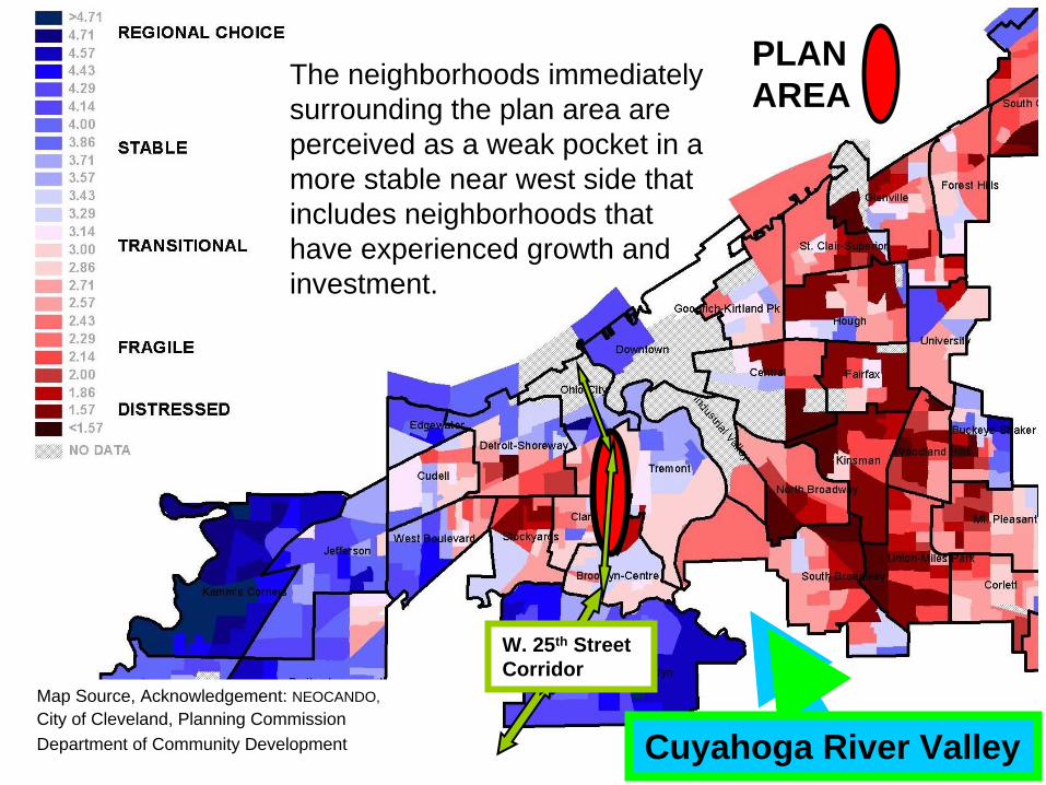
Cuyahoga River Valley
PLAN AREAThe neighborhoods immediately
surrounding the plan area are perceived as a weak pocket in a more stable near west side that includes neighborhoods that have experienced growth and investment.
W. 25th
Street Corridor
Map Source, Acknowledgement: NEOCANDO,City of Cleveland, Planning CommissionDepartment of Community Development
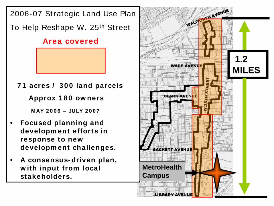
2006-07 Strategic Land Use Plan
To Help Reshape W. 25th Street
Area covered
71 acres / 300 land parcels
Approx 180 owners
MAY 2006 – JULY 2007
• Focused planning and development efforts in response to new development challenges.
• A consensus-driven plan, with input from local stakeholders.
MetroHealth Campus
1.2 MILES

The planning process
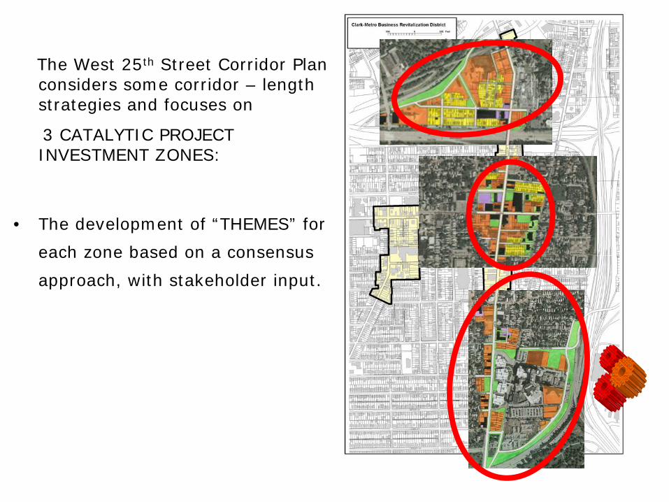
The West 25th Street Corridor Plan considers some corridor – length strategies and focuses on
3 CATALYTIC PROJECT INVESTMENT ZONES:
• The development of “THEMES” for
each zone based on a consensus
approach, with stakeholder input.
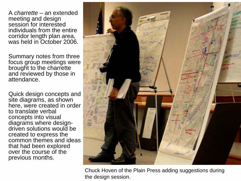
A charrette –
an extended meeting and design session for interested individuals from the entire corridor length plan area, was held in October 2006.
Summary notes from three focus group meetings were brought to the charrette and reviewed by those in attendance.
Quick design concepts and site diagrams, as shown here, were created in order to translate verbal concepts into visual diagrams where design-
driven solutions would be created to express the common themes and ideas that had been explored over the course of the previous months.
Chuck Hoven
of the Plain Press adding suggestions during the design session.

CULTURAL CORE
Pedestrian-oriented mixed-use buildings
New public spaces and plazas History: "Crossroads of Cultures“
Guiding Comments / insights from charrette of October 2006. This area could be a microcosm of Cleveland and its history. We need to develop with this neighborhood an overall business plan to
support small and medium sized businesses. We need increased security – and a means to have a business-to-business
set of relationships and involvements We need more neighborhood cohesiveness We need to reduce vacancies We could use some form of “Community Relations” presence, perhaps as
an intern to focus on helping with outreach and media contacts. Our “Public View” is not good right now. “Community Morale” is not what it should be. Lack of Public Space. This part of Clark Metro is like a “Historic Preserves” area. Youth is an untapped resource here right now for this neighborhood –
Lack of opportunities for youth to be engaged with / in the public. No programs for such a purpose, and to get them to help, to do good
work. Outreach and public involvement could be accomplished with local youth
and participation/guidance from local institutions in and around the Cultural Core area.
Inviting the community and the outside public at large to multi-cultural events / religious and community events, and special services, to promote the community and develop our sense of specialness.
Local Events need to be developed and implemented for many reasons: To bring in business volume (customers) To attract visitors Perhaps sidewalk events and temporary markets, like City Fresh, can help. Types of businesses that are here right now do not always complement
each other. There are two very different set of characteristics to this area, for day and
night. Guiding Comments about scope. Key ingredients to focus on are:
Input from area stakeholders and interested parties was compiled.
Input is summarized / arranged by categories.
Themes –
Overall goals and concepts are developed for project.
Planning and Development follows an Investment Strategy
– which is established using information gathered from all sources.
Community and stakeholder input helps refine development process, and provides other benefits.
Planning and
Design Solutions

IDENTIFICATION OF KEY STRATEGIC STAKEHOLDERS IN MAIN PLANNING FOCUS AREAS:
1. METROHEALTH NEIGHBORHOODS
2. CULTURAL CORE
3. FOUNDRY HILL
Participants in process
3
2
1
( Train Avenue C
orridor )
Steelyard Commons
MetroHealth
Ohio City NWDC
Tremont CDC
Old Brooklyn Dev Corp
City
Council Ward 15
City
Council Ward 14
Ohio Erie Canal Assoc.
City Planning Commission
■ City Department of Community Development
Other agency participation
Strategic stakeholders hold significant properties or represent major business, cultural, religious, or institutional groups and activity generators within the corridor. Input was gathered through small group meetings and separate interview sessions.

Recommendations in Plan
Corridor-length treatments to support and foster W. 25th
as one of America’s Byways.
Identify and establishes future links (neighborhood spurs) to the Towpath Trail.
Preserve cultural and historic assets. Tell the Byway’s story.
Support the introduction of additional amenities that support the use of public transit and improve the public realm.

Recommendations in Plan
Corridor-length treatments to support and foster W. 25th
as one of America’s Byways.
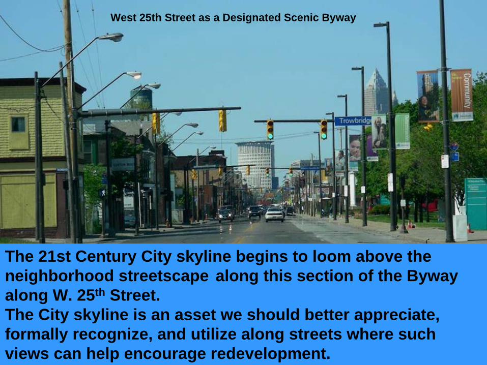
The 21st Century City skyline begins to loom above the neighborhood streetscape
along this section of the Byway
along W. 25th
Street. The City skyline is an asset we should better appreciate, formally recognize, and utilize along streets where such views can help encourage redevelopment.
West 25th Street as a Designated Scenic Byway

Current shot of W. 25th
Streetscape, from MetroHealth looking north
Recommended use of streetscape enhancements that can serve as a visual compliment and neutral element to in relation to both historic and contemporary architecture.
Visual integration and relationship between neighborhood scale and City skyline is key.
Recommendation: Continue program of placing utility lines underground and replacing older street lamps with contemporary model.

Street lamps with slim profile on both sides of street will enhance the view and approach into the city center.
Making W. 25th
Street –
A designated Scenic Byway –
Into one of Cleveland’s Great Gateway Streets. Planning and
Design Solutions
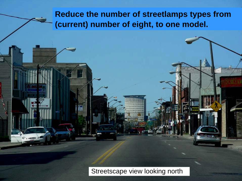
Streetscape view looking north
Reduce the number of streetlamps types from (current) number of eight, to one model.

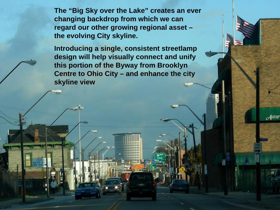
The “Big Sky over the Lake”
creates an ever changing backdrop from which we can regard our other growing regional asset –
the evolving City skyline.
Introducing a single, consistent streetlamp design will help visually connect and unify this portion of the Byway from Brooklyn Centre to Ohio City –
and enhance the city skyline view

GREY TO GREEN Improve approximately 2900 linear feet
(30% of the corridor within the Plan area) of current streetscape frontage with new landscape enhancements.
Corridor–length strategies

Frontage Landscape Opportunity Sites
▬
Total -
2890 Linear FeetGRAY
TO GREEN
( 2900 linear feet is 30% of streetscape
)
Given the variety of building types, one also has to look for corridor-length
treatments, to help define the Byway.
There are many opportunity sites –
some small and some large, where enhanced landscape treatments can add up and collectively make a significant difference
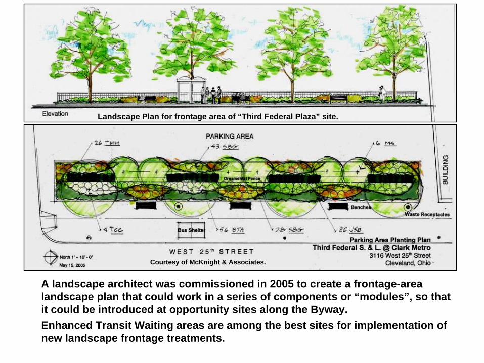
A landscape architect was commissioned in 2005 to create a frontage-area landscape plan that could work in a series of components or “modules”, so that it could be introduced at opportunity sites along the Byway. Enhanced Transit Waiting areas are among the best sites for implementation of new landscape frontage treatments.
Landscape Plan for frontage area of “Third Federal Plaza”
site.
Courtesy of McKnight & Associates.

Example / Case Study
Enhanced Transit Waiting Area –
Intersection of West 25th
Street and Clark Avenue.
Process•
Land donation / site work (Third Federal Bank)
•
$10,000 grant (Parkworks)•
Bus shelter (GCRTA) •
Bike racks (City Cleveland). •
Site maintained by owner.
Pilot Project –
Landscaped frontage introduced.
Streetscape amenities help screen parking lot and supportenhanced transit waiting area.

Recommendations in Plan
Corridor-length treatments to support and foster W. 25th
as one of America’s Byways.
Identify and establishes future links (neighborhood spurs) to the Towpath Trail.

Promote a gateway treatment for a neighborhood connector route -
from West 25th Street to the Train Avenue Towpath
Trail neighborhood spur, via Barber Avenue
and
West 30th.
Identify / Establish / Strengthen Connections to Towpath Trail.
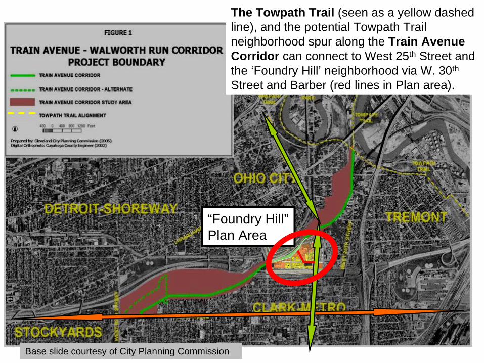
“Foundry Hill”
Plan Area
Base slide courtesy of City Planning Commission
The Towpath Trail (seen as a yellow dashed line), and the potential Towpath Trail neighborhood spur along
the
Train Avenue Corridor can connect to
West 25th
Street and the ‘Foundry Hill’
neighborhood via W. 30th
Street and Barber (red lines in Plan area).

Base slide courtesy of City Planning Commission
West 30 th
Proposed link from Train Avenue spur spur
to West
25th
Street via West 30th
St.

West 30th
Street, looking towards Train Avenue
Planning and
Design Solutions

Proposed Neighborhood spursand bike routes.
Interpretive Signage Directional signage
Tremont,
Steelyard
Commons
Trail Marker
Interpretive Signage Site
Scranton Residential areas
MetroHealth Systems Campus

Detail of MetroHealth area neighborhoods:
Potential Towpath TrailNeighborhood spur connections
By way of –
1. Scranton Historic District SpurScranton Road to Scranton & Connect to Towpath via Brooklyn Centre to Harvard spur.
2. Brooklyn Center SpurW. 25th
Street / Scranton Road mergeConnect to Towpath via Brooklyn Centre to Harvard spur.
3. Steelyard Spur
View Drive along boundary of Metro campus.
Converted lane of W. 14th flyover bridge –Connect to Towpath at Steelyard Commons.
1.
2.
3.
MetroHealth Systems Campus

Install Signage Station to help mark trail and help tell the story of MetroHealth neighborhood sites and area.
Proposed Towpath Trail neighborhood spur to connect Clark Fulton / MetroHealth area neighborhoods to Towpath Trail via Brooklyn Centre and Steelyard Commons in Tremont.
Jones Home

Next Steps: Public realm enhancements at traffic “gateway”
to campus
MetroHealth
ODOT Parcel
Jones Home
Trinity
Riverside Cemetery
Find new design solutions and funding to physically improve pedestrian realm in these important transitional areas between Brooklyn Centre and the MetroHealth Neighborhood areas.
Pedestrian realm improvement areas
Wes
t 32nd
Stre
et
Brooklyn Centre Historic District
Brooklyn Centre Historic District

Current conditions
The sidewalk area seen at right, and the crosswalk area at the entry ramp to Interstate 71, are a critical juncture for the continuation of the Towpath Trail neighborhood spur to connect the Brooklyn Centre and Clark Fulton areas, to permit another linkage via the Metro Hospital and Scranton corridors to other parts of the Byway system.

Current Condition
An improved landscape and fencing treatment here would serve to support the status of W. 25th as a scenic byway, and this area as a gateway to the MetroHealth area neighborhoods and the Brooklyn Centre Historic District.
Sites like this can also be used to strengthen gateway identity for adjacent Historic District.

Recommendations in Plan
Corridor-length treatments to support and foster W. 25th
as one of America’s Byways.
Identify and establishes future links (neighborhood spurs) to the Towpath Trail.
Preserve cultural and historic assets. Tell the Byway’s story.
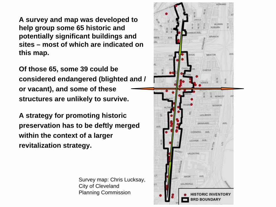
A survey and map was developed to help group some 65 historic and potentially significant buildings and sites –
most of which are indicated on this map.
Of those 65, some 39 could be considered endangered (blighted and / or vacant), and some of these structures are unlikely to survive.
A strategy for promoting historic preservation has to be deftly merged within the context of a larger revitalization strategy.
Survey map: Chris Lucksay,City of Cleveland Planning Commission

As the 21st
Century skyline of the City center continues to grow, the presence of a singular historic structure on a strategic site along a high visibility corridor, as seen here, can help tell the story of West 25th
Street in a vivid way.
Historic Preservation and the Scenic Byway

Recommendations in Plan
Corridor-length treatments to support and foster W. 25th
as one of America’s Byways.
Identify and establishes future links (neighborhood spurs) to the Towpath Trail.
Preserve cultural and historic assets. Tell the Byway’s story.
Support the introduction of additional amenities that support the use of public transit and improve the public realm.

City of Cleveland - West 25th Street CorridorStrategic Land Use Plan
Project Sponsors / Supporters
WEST 25TH
STREET: A RE-EMERGING TRANSIT
ORIENTED DEVELOPMENT CORRIDOR Corridor–length strategies Small Steps Catalytic Project sites
Excerpts from
Project Team: Abe Bruckman, AICP. LEED-AP.
Mark Duluk, AIA. LEED-AP. Arkinetics Architecture & Urban DesignAndrew Baqué Atwell-Hicks Consultants
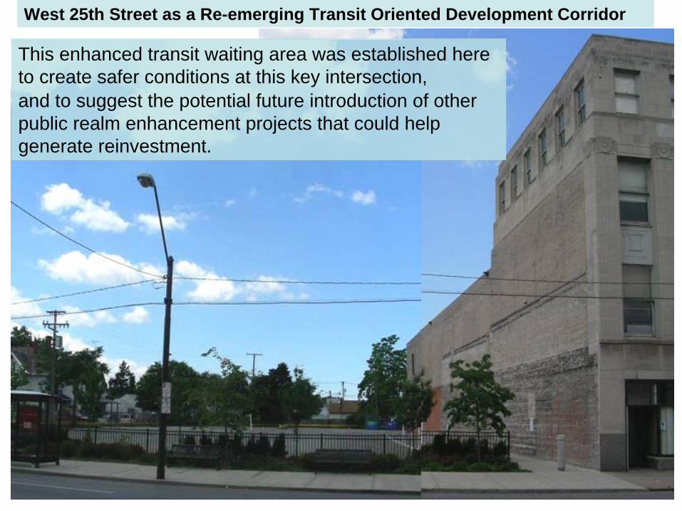
This enhanced transit waiting area was established here to create safer conditions at this key intersection, and to suggest the potential future introduction of other public realm enhancement projects that could help generate reinvestment.
West 25th Street as a Re-emerging Transit Oriented Development Corridor
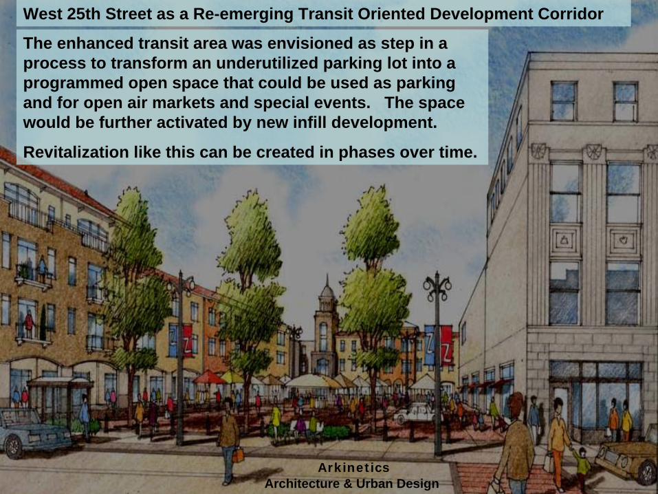
The enhanced transit area was envisioned as step in a process to transform an underutilized parking lot into a programmed open space that could be used as parking and for open air markets and special events. The space would be further activated by new infill development.
Revitalization like this can be created in phases over time.
ArkineticsArchitecture & Urban Design
West 25th Street as a Re-emerging Transit Oriented Development Corridor
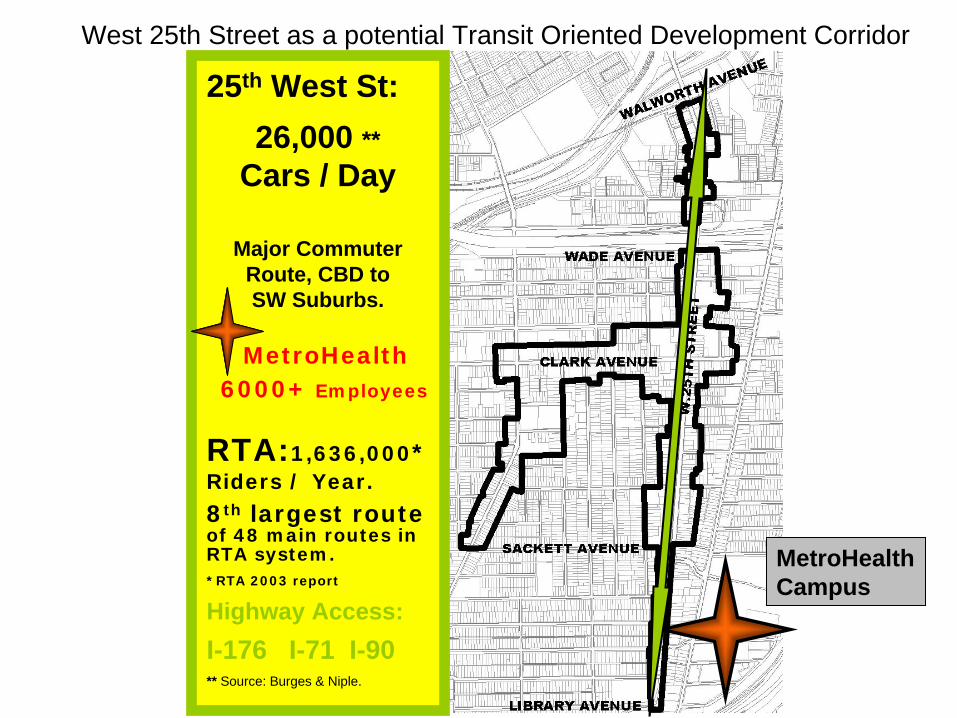
MetroHealth Campus
25th
West St:26,000 **
Cars / Day
Major Commuter Route, CBD to SW Suburbs.
MetroHealth6000+ Employees
RTA:1,636,000* Riders / Year.
8th largest route of 48 main routes in RTA system.*RTA 2003 report
Highway Access:I-176 I-71 I-90** Source:
Burges & Niple.
West 25th Street as a potential Transit Oriented Development Corridor
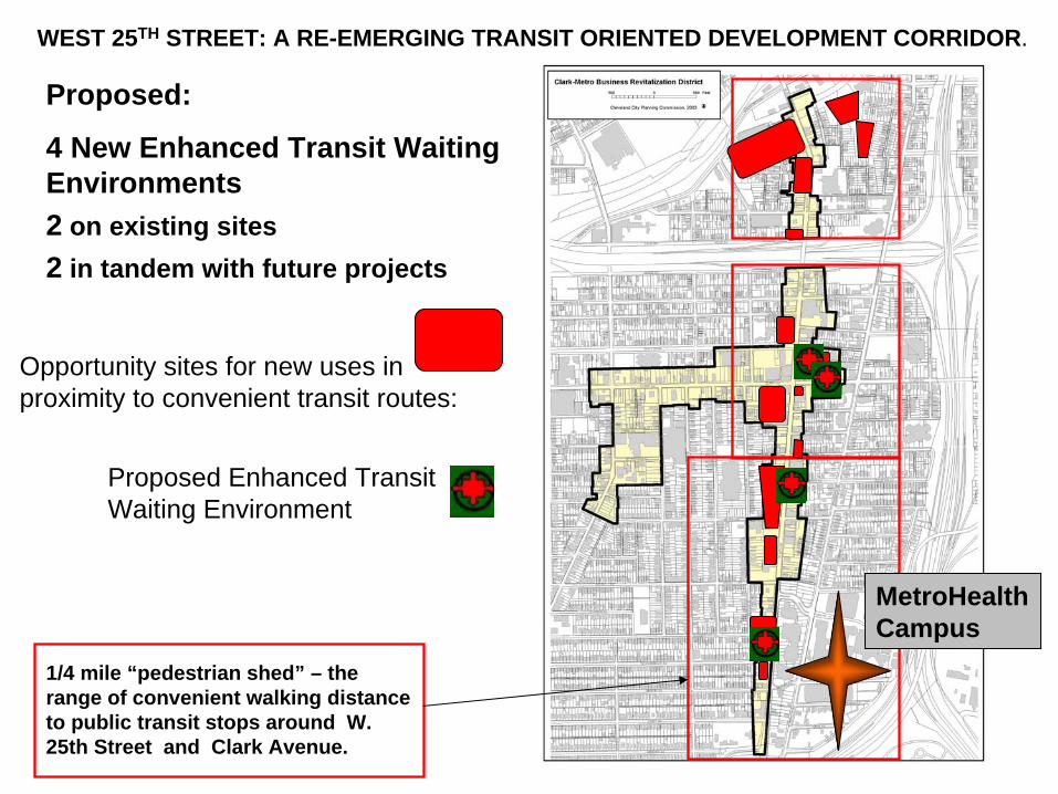
Opportunity sites for new uses in proximity to convenient transit routes:
WEST 25TH
STREET: A RE-EMERGING TRANSIT ORIENTED DEVELOPMENT CORRIDOR.
1/4 mile “pedestrian shed”
–
the range of convenient walking distance to public transit stops around W. 25th Street and Clark Avenue.
Proposed:
4 New Enhanced Transit Waiting Environments 2
on existing sites2
in tandem with future projects
MetroHealth Campus
Proposed Enhanced Transit Waiting Environment

Existing GCRTA stop, above, and in map view.
■
Large numbers of Lincoln West High School students, and visitors to a nearby medial services center use this stop.
■
The convenience store is a stable business in a mid-corridor location.
■
Public realm enhancements here, in tandem with RTA shelter amenities, would improve streetscape conditions and help adjacent property owners, some of whom have had long-term vacancies.
■
The former Aragon Ballroom, a vacant cultural landmark with an uncertain future, is nearby. It has no parking and future redevelopment could be facilitated by the presence of enhanced transit amenities.
Lincoln West High School 1,500 students
◙
Medical services Center
Jay’s Market
Proposed new enhanced transit waiting environment site:
Jay’s Market 3203 West 25th
Street.
Aragon Ballroom

Comparison Study: 2008 TLCI Project –
Metro District Recommendations
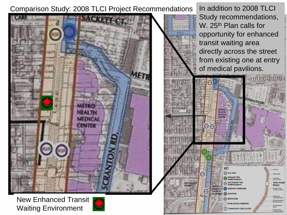
Comparison Study: 2008 TLCI Project Recommendations In addition to 2008 TLCI Study recommendations, W. 25th
Plan calls for opportunity for enhanced transit waiting area directly across the street from existing one at entry of medical pavilions.
New Enhanced Transit Waiting Environment

This pedestrian bridge connects the Pavilions to rest of the Hospital complex –
and provides a direct walking route to an RTA stop on West 25th
Street.

Somewhat mirrored by exterior facing W. 2th Street.
Interior Atrium Space
Enhanced Transit Waiting Environment
Pedestrian bridge to main hospital campus
ProposedRelocate existing RTA stop on street to new open space site where sufficient space exists to establish enhanced transit waiting area.
Opportunity sites for new development near activity generators along this corridor should be encouraged to amenities that will support transit use.
Current Bus Stop ◙
◙
Planning and
Design Solutions
WEST 25TH
STREET: A RE-EMERGING TRANSIT ORIENTED DEVELOPMENT CORRIDOR.
City of Cleveland - West 25th Street CorridorStrategic Land Use Plan
Plan Recommendations
Project Sponsors / Supporters
Project Team: Abe Bruckman, AICP. LEED-AP.
Mark Duluk, AIA. LEED-AP. Arkinetics Architecture & Urban DesignAndrew Baqué Atwell-Hicks Consultants