plan of study, salinas and carmel rivers basin study · bureau of reclamation mid-pacific region...
TRANSCRIPT

EXHB

Bureau of Reclamation Mid-Pacific Region
Plan of Study
Salinas and Carmel Rivers Basin Study
January 2017

Mission Statements
The mission of the Department of the Interior is to protect and provide access to our
Nation’s natural and cultural heritage and honor our trust responsibilities to Indian
Tribes and our commitments to island communities.
The mission of the Bureau of Reclamation is to manage, develop, and protect water
and related resources in an environmentally and economically sound manner in the
interest of the American public.

Table of Contents
Salinas and Carmel Rivers Basin Study | iii
Table of Contents
Page
Chapter 1 – Introduction ................................................................................................................ 1
1.1 Purpose of the Basin Study .......................................................................................... 1
1.2 Basins Study Goals and Objectives ............................................................................. 1
1.3 Description of the Basin Study Area ........................................................................... 2
1.3.1 The Salinas River ................................................................................................ 4
1.3.2 The Carmel River ................................................................................................ 8 1.3.3 Monterey Peninsula Watershed .......................................................................... 10
Chapter 2 – Study Description ..................................................................................................... 13
2.1 Project Background ...................................................................................................... 13
2.2 Problems, Needs, and Opportunities ............................................................................ 15
2.2.1 Water Shortages .................................................................................................. 15
2.2.2 Basin Study Area Supplies and Demands ........................................................... 16 2.2.3 Instream Flows .................................................................................................... 20
2.2.4 Groundwater ....................................................................................................... 22 2.3 Previous Work and Available Data.............................................................................. 23
2.3.1 Hydrology Models .............................................................................................. 24 2.3.2 Select Studies Which Support the Basin Study .................................................. 25
Chapter 3 – Study Approach and Management ........................................................................... 28
3.1 Basin Study Management Structure............................................................................. 28
3.2 Roles and Responsibilities of the Study Management Teams and Groups ................. 29
U.S. Bureau of Reclamation ........................................................................................ 29 U.S Geological Survey.................................................................................................. 30
Executive Team ............................................................................................................ 31 Study Team ................................................................................................................... 31 Technical Working Group ............................................................................................ 31
Technical Sufficiency Review Team(s) ........................................................................ 32 3.3 Change Management Plan ........................................................................................... 32
3.4 Risk Management Plan ................................................................................................ 33
3.5 Technical Sufficiency Review Plan ............................................................................. 34
Chapter 4 – Basin Study Work Plan ............................................................................................ 36

Table of Contents
iv | Salinas and Carmel Rivers Basin Study
4.1 Basin Study Requirements ........................................................................................... 36
4.2 Summary Work Plan .................................................................................................... 37
Task 1: Develop Study Metrics .................................................................................... 37 Task 2: Characterize Climate Change and Sea Level Rise .......................................... 38
Task 3: Develop Study Scenarios ................................................................................ 38 Task 4: Develop Modeling Tools and Inputs ............................................................... 38 Task 5: Evaluate Water Supplies, Demands, and Operations (No Action) ................. 39 Task 6: Develop Adaptation and Mitigation Strategies ............................................... 39 Task 7: Evaluate Adaptation and Mitigation Strategies .............................................. 39
Task 8: Prepare Basin Study Report ............................................................................ 40 4.3 Detailed Work Plan ...................................................................................................... 40
Task 1: Develop Study Metrics .................................................................................... 40 Task 2: Characterize Climate Change and Sea Level Rise .......................................... 43 Task 3: Develop Study Scenarios ................................................................................ 47 Task 4: Develop Modeling Tools and Inputs ............................................................... 51
Task 5: Evaluate Water Supplies, Demands, and Operations (No Action) ................. 59 Task 6: Develop Adaptation and Mitigation Strategies ............................................... 61
Task 7: Evaluate Adaptation and Mitigation Strategies .............................................. 63 Task 8: Prepare Basin Study Summary Report............................................................ 65
Chapter 5 – Communications and Outreach Plan ........................................................................ 68
5.1 Goal and Objectives of the Communications and Outreach Plan ................................ 68
5.2 Approach ...................................................................................................................... 69
5.3 Study Audiences .......................................................................................................... 69
Reclamation and Basin Study Partners ......................................................................... 69
Technical Experts.......................................................................................................... 70 Key Stakeholders .......................................................................................................... 70 General Public ............................................................................................................... 70
5.4 Outreach Activities ...................................................................................................... 70
Executive Team Meetings............................................................................................. 71 Study Team Meetings ................................................................................................... 71
Technical Working Group Meetings ............................................................................ 71
Technical Sufficiency Review ...................................................................................... 71 Stakeholder and General Public Meetings .................................................................... 71 Public Outreach and Information Meetings .................................................................. 71 Coordination Meetings with Related Efforts ................................................................ 72 Additional Meetings with Interested Stakeholders ....................................................... 73 Study Information and Updates .................................................................................... 73 Study Website ............................................................................................................... 73

Table of Contents
Salinas and Carmel Rivers Basin Study | v
Outreach Materials ........................................................................................................ 73
Stakeholder Mailing List/Study Updates ...................................................................... 73 Designated Point-of-Contact ......................................................................................... 74 Review of Draft Study Documents ............................................................................... 74
Appendix A – Basin Study – Agency and Partner Tasking Table ............................................... 76
Appendix B – Table of Major Study Tasks, Budgets w/Projected Timelines84
List of Tables
Table X. Salinas and Carmel Basin Supply, Demands and Unmet Demand by
Sub-Basins ............................................................................................................................. 18
Table X. Existing Hydrology Models Developed by the Partners in the Salinas
and Carmel Basins ................................................................................................................. 25
List of Figures
Figure 1. Map of Salinas and CRBs.............................................................................................. 4
Figure 2. San Luis Obispo County Land Use ............................................................................... 6
Figure 3. San Luis Obispo County Groundwater Basins .............................................................. 7
Figure 4. Salinas River in Monterey County ................................................................................ 8
Figure 5. Monterey County Area Map .......................................................................................... 9
Figure 6. Carmel River Confluence with Monterey Bay ............................................................ 10
Figure 7. The Monterey Peninsula and Carmel River Watershed .............................................. 11
Figure 8. Paso Robles Groundwater Basin ................................................................................. 19
Figure 9. Basin Study Management Structure ............................................................................ 29
Figure 10. Basin Study Management Team Descriptions .......................................................... 30
Figure 11. Relationship Diagram for the Salinas- Carmel Basin Study and the
Monterey Drought Contingency Plan .................................................................................... 40
Figure 12. Map of Salinas and CRB Sub-Areas. ........................................................................ 52
Figure 13. Salinas and Camel Basin Study Schedule ................................................................. 66
APPENDIX A Agency and Partner Tasking Table
APPENDIX B Table of Major Tasks, Budgets and Timelines

Table of Contents
vi | Salinas and Carmel Rivers Basin Study
This page intentionally left blank

Chapter 1 – Introduction
Salinas and Carmel Rivers Basin Study | 1
Chapter 1 – Introduction
1.1 Purpose of the Basin Study
The purpose of the Salinas and Carmel Rivers Basin Study (Basin Study) is to inform and guide
future courses of action in response to existing and potential future imbalances between water
supplies and demands in the Salinas and Carson River Basins (CRB). This Basin Study is a
collaborative effort between four local partner agencies, and is supported by two Federal
agencies. It will identify existing water supplies and demands, model future water supplies and
demands, accounting for uncertainties in future climate conditions, population growth, and other
socioeconomic trends.
In response to identified imbalances between supplies and demands, the Basin Study will
examine a variety of strategies that may be employed to reduce or mitigate these imbalances.
Ultimately, this Basin Study will identify a portfolio of strategies to achieve long-term balance
between supplies and demands in the Salinas and CRBs.
Four partner agencies (Partners) have proposed to collaborate with Reclamation to complete the
Basin Study, with technical contributions to be made by each partner, Reclamation, and the U.S.
Geological Survey (USGS). The four partner agencies are:
San Luis Obispo County Flood Control and Water Conservation District (SLOCFCWCD)
Monterey County Water Resources Agency (MCWRA)
Monterey Peninsula Water Management District (MPWMD)
Monterey Regional Water Pollution Control Agency (MRWPCA)
The Basin Study will be developed in coordination with the Monterey Peninsula Drought
Contingency Plan (DCP), which is being managed by the MPWMD. Developed together and
sharing hydrology, climate data and other common elements, these two studies will provide a
robust view of how potential future climate conditions may impact water supplies and demands.
Ultimately, these studies will be used to represent how imbalances between future water supplies
and demands may be mitigated or reduced by implementing various actions and adaptation
strategies.
1.2 Basin Study Goals and Objectives
The following are overarching goals for this Basin Study:
To assist water managers in the Salinas and CRB to make sound decisions regarding
water use
Ensure that sufficient water supplies will be available in the future
Propose adaptation strategies which address potential impacts to water supplies caused by
projected climate change

Chapter 1 – Introduction
2 | Salinas and Carmel Rivers Basin Study
Improve water conservation and promote long-term sustainability
Provide data and tools which can assist the non-Federal Partners in developing
groundwater management plans which are consistent with the requirements of the State’s
sustainable groundwater management plan requirements
To meet these goals, the following general objectives of the Basin Study are:
1. Improve regional collaboration in the development of a comprehensive assessment of
supplies and demands in each river basin and sub-basins
2. Identify a set of potential future climate conditions to year 2100 and assess the impacts of
these future conditions to existing and projected future supplies and demands
3. Identify solutions and adaptation strategies which respond to the imbalances projected
between supplies and demands
The Basin Study will include the following elements to achieve these objectives:
1. Projections of future water supply and demand within the basin, considering specific
impacts resulting from climate change (as defined in Section 9503(b)(2) of the SECURE
Water Act);
2. Analysis of how existing water and power infrastructure and operations will perform
given any current imbalances between water supply and demand and in the face of
changing water realities due to climate change (including extreme events such as floods
and droughts) and population growth (as identified within Section 9503(b)(3) of the
SECURE Water Act);
3. Development of appropriate adaptation and mitigation strategies to meet future water
demands; and
4. An analysis of the adaptation and mitigation strategies identified, including analysis of all
proposed strategies in terms of their ability to meet the study objectives, the extent to
which they minimize imbalances between water supplies and demands and address the
possible impacts of climate change, level o stakeholder support, the relative cost (when
available), the potential environmental impacts, and other attributes common to the
strategies.
1.3 Description of the Basin Study Area
The Basin Study encompasses the entire watersheds of the Salinas and CRBs, including the
Monterey Peninsula (Figure 1). Together, the two basins encompass an area of approximately
4,500 square miles and have a combined population of roughly 370,000. Tourism brings an
additional nine million people to these basins annually. Annual water demands for all uses in
these two basins is approximately 600,000 acre-feet per year. The Salinas and CRBs include
some of the world’s most fertile agricultural lands and are internationally known for their natural
beauty; ecological diversity; multi-national cultural history; and recreational opportunities such
as fishing, auto racing, and golfing.

Chapter 1 – Introduction
Salinas and Carmel Rivers Basin Study | 3
The area is oftentimes referred to as the “salad bowl of the world” or “America’s salad bowl”
because of the variety of crops grown. Agriculture represents a major economic driver for the
local economy, with a combined annual agricultural production in Monterey and San Luis
Obispo counties exceeding $5.5 billion per year in recent years. Approximately one third of the
State’s annual strawberry yield is grown in these basins. Wine grapes are so important and
distinctive that there are three designated “American Viticultural Area” domains within the area.
Monterey County is the fourth highest agricultural producing county in California. Combined
with the agricultural production of San Luis Obispo County, the area proposed in this Basin
Study is one of the most important agricultural areas in California and the western United States.

Chapter 1 – Introduction
4 | Salinas and Carmel Rivers Basin Study
Figure 1. Map of Salinas and CRBs
In addition to their agricultural resources, these basins support important natural resources.
National forest lands occupy a large portion of the upper watersheds, with runoff flowing to the
Monterey Bay National Marine Sanctuary (MBNMS). The Salinas and Carmel watersheds also
support the largest sustainable west coast run of Oncorhynchus mykiss, a salmonid species
commonly referred to as South-Central California Coast (SCCC) steelhead trout, a
Federally- listed threatened species. Numerous ongoing management activities for SCCC
steelhead are currently focused on providing reliable water supplies, while improving the ability
of SCCC steelhead trout to recover. For the purposes of the Basin Study, the geographic area is
divided into four sub-areas: the San Luis Obispo County portion of the Salinas River watershed,
the Monterey County portion of the Salinas River watershed, the Carmel River watershed in
Monterey County, and the Monterey Peninsula watershed.
1.3.1 The Salinas River The Salinas River is the largest river on California’s central coast, originating in the center of
San Luis Obispo County and flowing 170 miles north and northwest to its outfall in the
MBNMS, about 80 miles south of San Francisco. The length of the Salinas River is about 170
miles (270 km); the watershed area encompasses approximately 4,160 square miles. The main
stem Salinas River originates in San Luis Obispo County in the La Panza Range in the Los
Padres National Forest and drains 4,160 square miles, from Santa Margarita Lake at 2,400 feet, it
flows northwest to the Pacific Ocean. This watershed is more than twice the size of any other
California central coastal river system from San Mateo to Santa Barbara (Funk and Morales
2002). Tributaries to the Salinas River include the Estrella, Nacimiento, San Antonio, Arroyo
Seco, and San Lorenzo Rivers.

Chapter 1 – Introduction
Salinas and Carmel Rivers Basin Study | 5
Santa Margarita Lake in San Luis Obispo County
The largest reservoirs in the Salinas basin include Lake Nacimiento, Lake San Antonio, and the
smaller Santa Margarita Lake. Dams at the three reservoirs provide storage and flood protection
and are operated to provide approximately 288,000 acre feet per year (AFY) for municipal water
supplies, irrigation, recreation, groundwater recharge, and drought protection. The capacity of
the hydroelectric power generation plant at Nacimiento Dam has a capacity of 4.3 Mw-hours per
year.
The Salinas River’s groundwater resources are used extensively to meet the water supply needs
throughout the Salinas Valley. Agriculture in the watershed has been undergoing a transition
from cattle-grazing to vineyards and other crops that require irrigation. The following sections
provide a summary of land use patterns and water demands of the Salinas River Watershed in
San Luis Obispo and Monterey counties.
Salinas River Watershed in San Luis Obispo County
The Salinas River headwaters region is located in the Los Padres National Forest in San Luis
Obispo County, and is generally undeveloped open space. Land uses along the rest of the
Salinas River Valley in San Luis Obispo County is predominantly agricultural or urban
(Figure 2). Urban areas along the Salinas River Valley in San Luis Obispo County include
Atascadero (29,000 approximate), Templeton (population 8,000 approximate), and Paso Robles
(population 31,000 approximate). Strawberries, wine grapes, and cattle are the top agricultural
producers for this region, and San Luis Obispo County is currently the third largest producer of
wine in California. Cattle sales have increased in recent years as the lack of rangeland forage
and the high cost of supplemental feed has forced the sale of livestock.

Chapter 1 – Introduction
6 | Salinas and Carmel Rivers Basin Study
Figure 2. San Luis Obispo County Land Use
Groundwater is an important source of water supply to the region. Area groundwater basins are
shown in Figure 3. San Luis Obispo County obtains nearly 80 percent of its water from
groundwater sources and aboutt20 percent from surface sources including reservoirs.

Chapter 1 – Introduction
Salinas and Carmel Rivers Basin Study | 7
Figure 3. San Luis Obispo County Groundwater Basins
Salinas River Watershed in Monterey County
Much of Monterey County is located within the Basin Study area due to the extent of the Salinas
River Basin’s boundaries. Land uses in the Salinas River Valley in Monterey County is
predominantly agricultural. The use of the Salinas River and its associated groundwater basin
for irrigation has made the valley one of the most productive regions in the State. Monterey
County is the fourth highest agricultural producing county in California, with 220,000 irrigated
acres and 1.4 million acres total in agricultural production1.
Notable crops include strawberries, artichokes, broccoli, cauliflower, celery, lettuce, spinach,
carrots, peppers, potatoes, tomatoes, and wine grapes. Approximately one-third of California’s
annual strawberry yield is grown in this area. Urban areas of the Salinas River Valley in
Monterey County include King City (population 13,000 approximate), Greenfield (population
16,000 approximate), Soledad (population 25,000 approximate), and Salinas (population 155,000
approximate).
1 UC Davis virtual tour: http://vric.ucdavis.edu/virtual_tour/salinas.htm
Chapter 1 – Introduction
8 | Salinas and Carmel Rivers Basin Study
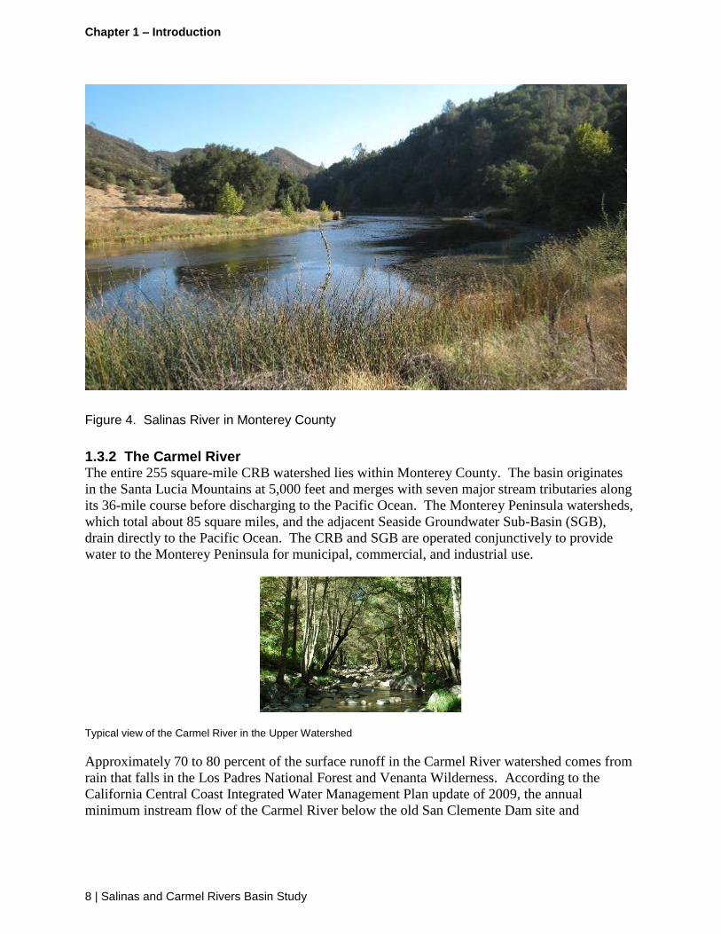
Figure 4. Salinas River in Monterey County
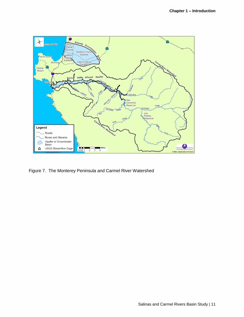
1.3.2 The Carmel River The entire 255 square-mile CRB watershed lies within Monterey County. The basin originates
in the Santa Lucia Mountains at 5,000 feet and merges with seven major stream tributaries along
its 36-mile course before discharging to the Pacific Ocean. The Monterey Peninsula watersheds,
which total about 85 square miles, and the adjacent Seaside Groundwater Sub-Basin (SGB),
drain directly to the Pacific Ocean. The CRB and SGB are operated conjunctively to provide
water to the Monterey Peninsula for municipal, commercial, and industrial use.
Typical view of the Carmel River in the Upper Watershed
Approximately 70 to 80 percent of the surface runoff in the Carmel River watershed comes from
rain that falls in the Los Padres National Forest and Venanta Wilderness. According to the
California Central Coast Integrated Water Management Plan update of 2009, the annual
minimum instream flow of the Carmel River below the old San Clemente Dam site and

Chapter 1 – Introduction
Salinas and Carmel Rivers Basin Study | 9
Reservoir is 3,620 acre-feet.2 The Monterey Peninsula area currently relies heavily on the
Carmel River and the Carmel Valley Aquifer for its water supply; however, the area is under a
Cease-and Desist Order to reduce diversions to the Monterey Peninsula from this basin by about
two-thirds by 2022.
Figure 5. Monterey County Area Map
The Carmel River had two major dams and one minor dam located within its watershed. San
Clemente Dam, constructed in 1921, was located 18.5 miles (29.8 km) upstream from the ocean,
and once provided drinking water throughout the Monterey Peninsula. With the declaration of
the dam as unsafe in a major flood or during a maximum credible earthquake and more than
90 percent loss of capacity due to sedimentation, the San Clemente Dam Removal Project was
proposed and completed at the end of 2015. This project included removal of the San Clemente
Dam and opening up of approximately 6.5 miles of historic steelhead habitat on the Carmel
River with added access to three major tributary creeks for habitat and spawning. The Los
Padres Dam, constructed in 1949, is located 25 miles upstream from the ocean. Its original
capacity was 3,030 acre feet, but due to sedimentation, its storage capacity has been reduced to

Chapter 1 – Introduction
10 | Salinas and Carmel Rivers Basin Study
only about 1,700 acre feet. With only about 1,400 acre-feet actually available, the reservoir
remains an important part of the local supply. The National Marine Fisheries Service has
declared that the dam impacts habitat downstream for steelhead, is also a passage barrier, and
should be studied to determine whether the dam should be removed.
The oldest dam on the Carmel River, commonly referred to as the “old Carmel River dam” or
“Chinese dam” was a small turn-out dam about 15 feet high constructed about 1880 by
Charles Crocker and the Pacific Improvement Company. This dam was constructed from hewn
and mortared granite blocks with a labor force that included approximately 700 Chinese workers
to build the dam and lay 25 miles of iron pipe to the Monterey Peninsula. The old Carmel River
dam was designed to divert water supply to the first Del Monte Hotel on the Monterey Peninsula
and was located approximately 2,000 feet downstream of the San Clemente Dam site. The San
Clemente Dam was removed in 2016 due to sedimentation which significantly reduced its
storage capacity and was a steelhead passage barrier.
Figure 6. Carmel River Confluence with the Pacific Ocean at Carmel
1.3.3 Monterey Peninsula Watershed The Monterey Peninsula includes six incorporated cities and a portion of unincorporated
Monterey County which collectively is home to over 100,000 people. Rainfall is the primary
source for water supply recharge to the Carmel River and its aquifers and to the Seaside Basin
aquifers. Annual rainfall in Monterey County ranges from just over 10 inches in the inland
valleys to more than 70 inches at the peaks of the Santa Lucia mountain range adjacent to the
coast. The annual average runoff from these local watersheds far exceeds use; however, the
region lacks adequate infrastructure to capture the episodic runoff events and to treat and store
the water. Annual minimum and maximum runoff has varied by orders of magnitude and
resulted in both severe floods and droughts.
Chapter 1 – Introduction
Salinas and Carmel Rivers Basin Study | 11
Figure 7. The Monterey Peninsula and Carmel River Watershed

Chapter 1 – Introduction
12 | Salinas and Carmel Rivers Basin Study
This page intentionally left blank

Chapter 2 – Study Description
Salinas and Carmel Rivers Basin Study | 13
Chapter 2 – Study Description
Basin studies are part of Reclamation’s WaterSMART Program and are a key component of
Reclamation’s implementation of the SECURE Water Act (Public Law 111-11). The
WaterSMART Program is specifically intended to address water supply challenges, including
water supply shortages due to increased demands, climate change, and heightened competition
for finite water supplies. Through Basin Studies, Reclamation engages with non-Federal
partners and stakeholders to identify strategies to adapt to and mitigate current or future water
supply and demand imbalances, including the impacts of climate change and other stressors on
water and power facilities.
2.1 Project Background
The Basin Study provides a significant opportunity for the four non-Federal Partner agencies to
work collaboratively with Reclamation to develop integrated strategies for managing regional
water supplies which will benefit agricultural, urban, and environmental water demands.
Strategies for adapting to climate change, including responses to changing precipitation patterns,
runoff, and sea level rise are anticipated to be developed and potentially integrated into the
management of the Salinas and CRBs. The Basin Study provides a scientific and collaborative
basis for developing and implementing sound planning which is intended to guide future
decisions for providing sustainable water supplies. This Basin Study provides opportunities to
develop solutions and strategies to fill gaps in supply and demand planning, reduce risks to
property and infrastructure associated with climate change, and improve sustainability of
aquifers and surface flows in order to provide adequate water supplies for the benefit of all users
well into the future.
One of the important characteristics of the proposed Basin Study is to identify what potential
future climate conditions may be like. The climate analysis in the Basin Study will include a
range of climate scenarios as well as consider increases in uncertainty. Water years 2012-15
stand as one of California’s driest four-year periods since historical observations began, which
occurred with record warming resulting in new temperature records set in 2014 and 2015 for
statewide averages.
The basins and sub-basins included in the Basin Study are currently experiencing challenges in
meeting demands and are projected to have insufficient water supplies in the future. Assuming
that warming conditions continue, the Basin Study process is specifically designed to propose
strategies which respond to potential impacts to surface and groundwater facilities, urban and
agricultural demands, meeting water quality and temperature standards, riparian habitats and
other environmental conditions.
The local agencies who are partnering with Reclamation in the Basin Study (MCWRA,
MPWMD, MRWPCA, SLOCFCWCD) are responsible for stewardship of local water resources
and have a significant interest to collaborate in the Basin Study with Reclamation. This Basin
Study is anticipated to augment ongoing water planning by building a common understanding of
potential future climate characteristics and planning for a range of possible responses to

Chapter 2 – Study Description
14 | Salinas and Carmel Rivers Basin Study
changing future conditions. By creating several different scenarios which represent potential
future growth, agricultural demands and environmental conditions with different climate
scenarios, the Basin Study provides a unique opportunity for Partners and Reclamation to
evaluate possible adaptation strategies which are designed to moderate or mitigate uncertain
future climate conditions.
The Basin Study will also evaluate risks to other environmental conditions such as fisheries and
Endangered Species Act (ESA) habitats which may be degraded by the impacts of future climate
change. The potential impacts of changes in flood frequency and magnitude will also be
analyzed in the Basin Study. With substantial agricultural and urban development within the
100-year floodplains along the Salinas and Carmel Rivers, a large magnitude flood could place
billions of dollars of urban and agricultural property at risk. Other resources which may be
adversely impacted by climate change include forest areas which may experience increased fire
risk. In essence, the Basin Study will provide each non-Federal Partner agency a “stress test” of
each area’s ability to cope with potential future climate changes.
National forest lands are particularly susceptible to the impacts of climate change. The Los
Padres National Forest is the only national forest along California’s Central coast and was
originally established to prevent fires and protect the pristine water sources for the coastal
communities surrounding the forest. The forest areas surrounding the Salinas and Carmel basins
remain of high strategic importance since they provide most of the runoff within the basins.
However, many of the adjacent forest areas now have high fuel loads. The recent Soberanes
Fire, in the summer and fall of 2016, burned over 132,000 acres with more than 70 percent of the
fire occurring within the Los Padres National Forest near Monterey. To protect firefighters, fire-
fighting organizations mandated that private landowners clear fire-safe zones on access roads
and around structures in order to be eligible for protection. The inaccessibility of the steep,
rugged terrain contributed to the spread of the fire and in wilderness areas, fire managers and
firefighting crews used MIST (Minimum Impact Suppression Tactics) as much as possible.
Aircraft support was essential to controlling hotspots with helicopters dipping buckets into local
ponds and reservoirs at a time when supplies were at critical lows as a result of ongoing drought.
This illustrates how outreach to the public about prevention of human caused fire and forest fuels
management is now acknowledged to be critically important to maintain healthy watersheds.
Improved forest management can directly reduce the risk of catastrophic fires and prevent
significant amounts sedimentation which often fills reservoirs after these types of fires. The
impacts of sea level rise and sea water intrusion will also be addressed in the Basin Study,
particularly how these conditions may impact the aquifers and infrastructure which are adjacent
to the MBNMS.
Water management in the Salinas and CRBs is also constrained under various regulatory
restrictions on use of surface and groundwater supplies. Developing a sustainable balance
between supplies and demands is vital for this region for long-term reliability in managing its
water supply, as well as complying with legal mandates, coping with climate change, and
improving economic and environmental conditions. Management of surface and groundwater
resources in the study area is divided among multiple layers of local, regional, State, and Federal
agencies, as well as for-profit entities such as private utilities. The Basin Study Partners are

Chapter 2 – Study Description
Salinas and Carmel Rivers Basin Study | 15
actively engaged in complying with sustainable groundwater management in accordance with the
requirements of California’s Sustainable Groundwater Management Act (SGMA).
Together, the Partners are proposing to develop plans for sustainable groundwater management
plans in these basins. The Partners have implemented changes in conjunctive use programs to
improve steelhead recovery and are (or will) participate in one another’s public outreach
processes. The Partners and Reclamation are dedicated to pursuing and evaluating the
challenges of water resource management so that they will collectively ensure that future
generations are provided with the tools to adapt available water supplies and demands.
2.2 Problems, Needs, and Opportunities
Consequences of water supply and demand imbalances in the Salinas and Seaside Basins have
included declining groundwater levels, seawater intrusion into coastal aquifers and increased
competition for limited groundwater supplies. Supply and demand imbalance in the CRB results
in seasonal dewatering of up to eight miles of the Carmel River and a lowering of aquifer levels.
Due to the limited capacity of the aquifer, it is fully recharged by runoff nearly every year. Legal
and regulatory repercussions include adjudication of water rights in the Seaside Basin,
designation of minimum in-stream environmental flows, and Dease and Desist Orders (CDO)
from the State Water Board for reduction of groundwater pumping in portions of the CRB and
and requirements from the California Department of Water Resources (DWR) to develop a plan
for sustaibable use of parts of the Salinas River basin. The observed historical imbalances are
likely to be further exacerbated by projected future climate conditions which may include more
severe and longer drought periods.
2.2.1 Water Shortages The primary water supply challenges in both Monterey and San Luis Obispo counties, which
create or lead to imbalances between supply and demand, revolve around storage, distribution,
and water quality. Within the Salinas and CRBs, an imbalance between water supplies and
demands is being exacerbated by extended drought, increasing (and often competing) demands,
and climate change. Understanding, anticipating, and adapting to these impacts by implementing
various structural and non-structural strategies is one of the primary objectives of the Basin
Study.
Due to extended droughts along California’s Central Coast compounded by limited storage to
capture runoff in years with abundant rainfall, the Salinas and CRBs have faced water supply and
management challenges for over half a century. Monterey County is not a State Water Project
contractor nor a Federal Central Valley Project contractor. Even though SLOCFCWCD is a
State Water Project contractor, due to limited water available and uncertainty of receiving their
full allocation, they have wisely decided to rely as much as possible on local supplies. Being
virtually self-reliant on local water supplies, this region is substantially dependent on in-basin
supplies. Drought conditions which affect all of California are especially difficult for this area
due to reliance on limited local supplies.
The consequences of the historical imbalances between supply and demand have resulted in
declining groundwater levels, seawater intrusion, impaired water supplies, regulatory actions in
the form of a CDO on pumping, adjudication, and requirements for minimum in-stream flows to
Chapter 2 – Study Description
16 | Salinas and Carmel Rivers Basin Study
support ESA threatened steelhead. These historical imbalances and consequences are likely to
be further exacerbated by climate change effects, with projections of possibly longer and more
severe drought periods followed by periods of extreme precipitation events which may cause
severe damage to property, infrastructure and critical habitats alike.
Although several recent studies have identified underlying problems and issues, the Basin Study
will provide a forum for stakeholders and partner agencies to engage in providing a variety of
possible solutions. Building on the hydrology model tools developed by the partners for the
CRB and the Paso Robles and Salinas Valley sub-basins, the Basin Study will analyze how the
various strategies will perform under various potential climate futures. This aspect of the Basin
Study is unique and provides an informed picture of which strategies may perform best across
various possible future climate conditions and also which would be the best investment.
The four Basin Study Partner agencies have participated in the development of State Integrated
Regional Water Management (IRWM) plans to address water supplies and demands as well as
climate change. The Partners have also prepared numerous individual studies on sub-areas of the
basins. However, a basin-wide comprehensive study of the potential effects of climate change
on water supplies, demands, and imbalances within the Salinas and CRBs has not yet been
performed. More importantly, the Basin Study provides a structured opportunity and means to
develop comprehensive and coordinated adaptive strategies to address climate change risk to the
Basins’ water supplies and demands. (Move Table 1 to this location…)
2.2.2 Basin Study Area Supplies and Demands The Basin Study area is comprised of four major sub-basins: Salinas Valley Basin (SVB), CRB,
SGB, and the Paso Robles Groundwater Basin (PRGB). All four of these sub-basins within the
larger Salinas and Carmel basins are in a current state of imbalance between supply and demand,
as demonstrated by seawater intrusion and groundwater level declines. While many studies and
projects were conducted to find solutions to these issues, a projected imbalance remains that will
be exacerbated by climate change. Table X below summarizes the current and projected future
supply and demand imbalances for each sub-basin. Imbalances in the demands will be re-
evaluated as a part of the Basin Study, in light of climate, population and other changes.
Paso Robles Groundwater Basin
The current water demand for the PRGB is largely estimated, as the only metered water users are
within water purveyor boundaries. In 2014, an integrated watershed/basin model was utilized to
estimate historical demands within the PRGB on an average annual basis for the period of 1980
through 2011, as well as the perennial yield. Due to the imbalance between water demand and
supply within the PRGB, groundwater levels have been declining over the past 30 years.
Declining groundwater levels have led to the need for deeper wells across the basin. Some water
users located along the edge of the basin have lost access to the groundwater and are now drilling
into fractured rock formations.

Chapter 2 – Study Description
Salinas and Carmel Rivers Basin Study | 17
The Paso Robles Basin is an Important Wine Grape Region
Impacts to this aquifer have resulted in multiple conflicts and actions, and the formation of
various stakeholder groups. Most recently, a two-year urgency ordinance (August 2013)
followed by a permanent ordinance (October 2015) was adopted by the San Luis Obispo County
Board of Supervisors requiring new development and irrigated agriculture within portions of the
PRGB to offset new demands on the PRGB by a ratio of 1 to 1 (under the permanent ordinance,
the offset requirements are in effect until a groundwater sustainability plan is adopted);
formation of different types of water districts were and are being pursued; and several
landowners within the PRGB have filed a quiet title action against public and private water
suppliers within the PRGB (as well as the SLOFCWCD). Continuing declines in groundwater
levels in the PRGB are anticipated to lead to the need for residential landowners to lower wells
where possible, find alternate sources of water or vacate the area. Declining groundwater levels
may also result in the loss of smaller agricultural operations unable to afford coping with
recurring drought, or energy and treatment costs associated with pumping water from lower
levels. The California DWR, in its 2016 update of Bulletin 118, determined that a portion of the
Paso Robles Basin was sequestered from receiving groundwater from the Paso Robles basin due
to the Rinconada Fault. This groundwater basin is called the Atascadero Basin and is located
adjacent to and west of larger Paso Robles Basin. An integrated watershed/basin model prepared
by the County of San Luis Obispo in 2014 projects that groundwater levels in the Atascadero
Basin will remain stable beyond year 2040.

Chapter 2 – Study Description
18 | Salinas and Carmel Rivers Basin Study
Table 1. Salinas and Carmel Basins Supply, Demands and Unmet Demand by Sub-Basins
Basin Area User Supply (acre-feet) Demand (acre-feet) Unmet Demands
PRGB (Current) Agriculture1 89,600
4 76,000 3,600
5
M&I1 17,200
Environmental2 74,090 41,010 No unmet demands
Recreation3 Min pool: 2000 Reached 1 time in 30 years Est. 3 percent of the
time
PRGB (2040) Agriculture1 89,600
4 91,072 17,344
5
M&I1 6,250
6 22,122
Environmental2 74,090 41,010 No unmet demands
are projected
Recreation3 Min pool: 2000 Reached 1 time in 30 years Est. 3 percent of the
time
CRB and SGB (Future)
Agriculture1 Included in M&I Included in M&I
M&I1 8,500
7 20,000
8 11,500
8
Environmental2 Minimum instream flow
and adjudication requirements are in effect
Minimum instream flow and adjudication requirements are in effect
Minimum instream flow and adjudication requirements are in effect
CRB and SGB (Current)
Agriculture1 Included in M&I Included in M&I Unknown
M&I1 5,000 (legal)
7 15,500
9 10,500
Environmental2 Basins are
overappropriated and subject to cutbacks
Basins are overappropriated and subject to cutbacks
Basins are overappropriated and subject to cutbacks
SVB (Current) Agriculture 446,00010
418,00011
177,00011
M&I 45,00011
Environmental The need for allocations is mentioned but not quantified
The need for allocations is mentioned but not quantified
The need for allocations is mentioned but not quantified
SVB (Future) Agriculture 429,00010
358,00011
140,00011
M&I 85,00011
Environmental The need for allocations is mentioned but not quantified
The need for allocations is mentioned but not quantified
The need for allocations is mentioned but not quantified
1. 1980-2011 Average Annual Basis; Paso Robles Groundwater Basin Model Update, Geoscience, 2014
2. Water Planning Area 13,Master Water Report, Carollo, 2009
3. Salinas Reservoir
4. Paso Robles Groundwater Basin estimated perennial yield; Geoscience Update
5. Unmet Demands for the purposes of the Paso Robles Sub Area means the extent to which demands exceed the
perennial yield of the PRGB and Nacimiento water contract allocations ona an average annual basis, which results in
sustained basin drawdown
6. Nacimiento Water Contracts = 6,250 AFY
7. Existing firm riparian, appropriative, and percolating rights determined by State Water Resources Control Board,
SGB Adjudication, and annual well reports
8. Cal-Am estimate, CPUC Application A12-04-019 plus 2014 Monterey Peninsula IRWM Plan Update with estimate
of 20-year General Plan build-out demand
9. Estimated demand within the Cal-Am service area as descirbed in testimony, CPUC A.12-04-019, Monterey

Chapter 2 – Study Description
Salinas and Carmel Rivers Basin Study | 19
Peninsula Water Supply Project
Figure 8. Paso Robles Groundwater Basin
Carmel River Alluvial Aquifer and Seaside Groundwater Basins
More than 105,000 people reside in the MPWMD service area, which is dependent for water
supplies from two sources: runoff from Carmel River Alluvial Aquifer in the CRB and
groundwater from the SGB. The CRB currently supplies about 70 percent of domestic supply
for the Monterey Peninsula; however, in 2009, the State Water Resources Control Board
(SWRCB) issued a CDO to the local water provider, California American Water (Cal-Am). The
CDO required Cal-Am to find replacement supplies for two-thirds of the annual diversions from
the CRB by January 1, 2017. The SWRCB recently extended the deadline for compliance to
Water Year 2022.
The SGB is at the northwest corner of the Salinas Valley, adjacent to Monterey Bay. Historical
and persistent low groundwater elevations caused by pumping led to basin adjudication in 2006
and an amended court decision in 2007 that created the Seaside Basin Watermaster and ordered a
ramp down in production from about 5,600 AFY to the Natural Safe Yield of 3,000 AFY by
2021. Cal-Am’s right to appropriate water from the SGB will be reduced to less than half of the
Natural Safe Yield by 2021. No seawater intrusion is occurring presently, but water levels are
lower than those required to protect against seawater intrusion. Recharge into the basin aquifers
will be beneficial for protection against seawater intrusion.
Both basins are being pumped in excess of legal rights to do so, which places the community at
risk of heavy fines or severe rationing of up to 50 percent. Figure 3 shows that the estimated
replacement need for the Monterey Peninsula is approximately 10,000 AFY. The MRWPCA’s

Chapter 2 – Study Description
20 | Salinas and Carmel Rivers Basin Study
Pure Water Monterey Groundwater Replenishment (GWR) Project would provide 3,500 AFY of
highly treated recycled wastewater to the SGB and Cal-Am's proposed desalination plant on the
coast south of the Salinas River would provide the balance of the replacement supplies. The
GWR Project has received several approvals and is expected to begin delivering water as early as
2019. The desalination component of the replacement water supply project is currently under
environmental review, with completion anticipated by 2020.
Habitat for steelhead in the CRB has been degraded and annual returns of adult steelhead have
fallen below 10 percent of the estimated potential for the run. Years 2014 and 2015 show the
lowest fish densities ever recorded and a rebound in returning adults from the 2012-2015 drought
is extremely weak. Usable surface storage in the CRB is small (about 1,400 AF) and shrinking
due to reservoir sedimentation.
It is anticipated that most of the climate change scenario conditions will occur over the entire
study area; however, where local variations exist, additional evaluation will be conducted to
determine local impacts. For example, sea level rise scenarios will be important to consider for
the coastal portions of this study area and the adjacent aquifers, but would not be generally
applicable in the upper Salinas River or CRB areas.
While multiple tools exist to evaluate future supply and demand conditions under future climate
change scenarios, the Salinas and Carmel Basin Study is proposing to use the USGS and
Reclamation’s technical support to better determine the interaction between basin sub-areas and
to define how changes in one sub-basin can affect other sub-basins. With Reclamation’s
oversight and USGS participation, predictive models and tools can be employed to evaluate each
scenario on a basin-wide basis. The tools and models will be also be modified during the Basin
Study to update temperature and precipitation assumptions as identified by Reclamation and
USGS.
2.2.3 Instream Flows Instream flow issues in the Carmel and Salinas Rivers include required cutbacks to Carmel River
diversions, the variability of the natural flows of the Salinas River, the decline in steelhead
fisheries and the ability of the region to meet the flow and temperature requirements of the
National Marine Fisheries Service (NMFS) and the Regional Water Quality Control Board.
Carmel River
The Carmel River has long-served as the main water supply for the Monterey Peninsula. After
finding that the Carmel River alluvial aquifer was declining through use as the primary water
supply for the Monterey Peninsula community, the California SWRBC first ordered a 70 percent
cutback in 1995 and then followed up in 2009 with a CDO to protect critical habitat for
threatened species after little progress had been made to replace supplies. The pumping cutbacks
were scheduled to begin on December 31, 2016, but the Monterey Peninsula requested an
extension to December 31, 2021, which the SWRCB granted.
A coalition including the Monterey Peninsula Regional Water Authority, MPWMD, Cal-Am,
Pebble Beach Company, and the City of Pacific Grove had asked for the extension on the most
significant cutback to 2021 in order to advance progress on replacement water supplies before
losing the current Carmel River water supply.

Chapter 2 – Study Description
Salinas and Carmel Rivers Basin Study | 21
The coalition stated that the Monterey Peninsula is among the lowest per capita water users in
the State and that a cutback of more than half of its current river water supply would have major
public health and safety and economic impacts on the area. The proposed replacement water
supplies include a groundwater replenishment project that could come online by 2018 and a
proposed Cal-Am desalination plant which may be delayed until 2021.
Salinas River
Another risk to water supplies is the timing and quantity of runoff in the Salinas River. As noted
previously, many climate scientists now believe that future climate conditions will include longer
drought periods with some occasional heavy rainfall events. Both reduced and increased runoff
can create supply risks. The Salinas River is a "flashy" system, and increased runoff could result
in increased flooding and damage to water supply infrastructure. Reduced runoff causing
multi-year droughts would also reduce percolation and aquifer recharge resulting in reduced
groundwater storage and potential declines in aquifer water levels.
Steelhead Fisheries in the Salinas and Carmel Rivers
SCCC steelhead are an anadromous fish of the Salinas and Carmel rivers and their tributaries.
They spend approximately the first two years of their life in the freshwater of these rivers and
then migrate out to the Pacific Ocean. They return after several years to the rivers to spawn.
Steelhead can live as long as eleven years, but many do not due to deteriorating river habitat
conditions. The coastal steelhead is able to spawn more than once in a lifetime, but they
typically only survive long enough to spawn once. Due to diversions in both basins, both rivers
can be dewatered for long periods of time and may not open to the ocean during droughts. This
has resulted in some anadromous steelhead becoming resident trout; however, it appears that the
anadromous gene has not been eradicated in resident populations.
Coastal steelhead trout
The Study Area historically had a large population of steelhead, but changes in water quantity
and quality and the course and speed of these rivers and their tributaries has negatively impacted
steelhead’s ability to survive. The headwaters were historically used for spawning and rearing
while the lower waterways served primarily as migration corridors during times when flows
were sufficient to reach the ocean. Only limited areas of the valley portions of these rivers

Chapter 2 – Study Description
22 | Salinas and Carmel Rivers Basin Study
currently provide suitable spawning and rearing habitat for steelhead. The substrates are sandy
and silty as opposed to gravelly, and the water temperatures often exceed recommended
maximums for good habitat conditions during warmer months. The construction of dams,
changes in flows and timing due to reservoir releases, stream course straightening, diversions of
stream flow, groundwater pumping, loss of riparian vegetation, and passage barriers to perennial
headwaters have caused a dramatic decline to the point that NMFS believes SCCC steelhead are
likely to become an endangered species within the foreseeable future in these rivers unless
conditions are improved.
2.2.4 Groundwater Groundwater issues in the area include declines in groundwater elevations, water quality
reductions and seawater intrusion. A notable recent development in groundwater management
efforts is, California’s SGMA. These groundwater issues are described below:
Seaside Groundwater Basin
The Seaside Groundwater Basin provides about 30 percent of urban supplies for the Monterey
Peninsula. It is recharged through percolation of rainfall and by excess winter flows in the
Carmel River that are diverted and pumped into the local distribution system, and then injected
into the basin for recovery in the dry season. The Seaside groundwater basin was adjudicated in
2006 and is subject to a series of production cutbacks in order to provide a sustainable yield by
2021. The cutback will result in native SGB water being about 15 percent of urban supplies.
Seawater Intrusion in Aquifers Adjacent to Monterey Bay
Seawater intrusion in the coastal groundwater basins is expected to be exacerbated with sea level
rise associated with climate change. Seawater intrusion causes groundwater in those basins to
become more saline and less desirable as a supply water source. Natural groundwater recharge
and active injections of freshwater in the SGB by MPWMD and Cal-Am are occurring in several
areas and are designed to keep seawater intrusion from advancing inland.
California’s Sustainable Groundwater Management Act
Groundwater basins are one of the most cost-effective and environmentally sustainable places to
store water locally during wet years; and if managed well, can serve as a buffer against the
impacts of climate change and drought. On September 16, 2014,
Governor Edmund G. Brown Jr. signed three bills that comprise the SGMA. This legislation
created the framework for sustainable, local groundwater management for the first time in
California history. The legislation requires local agencies to craft groundwater management
plans that must incorporate long-term sustainability to meet their regional economic and
environmental needs.
There are two key principles in the SGMA groundwater legislation. The first is that groundwater
is best managed at the local or regional level and that local agencies should have the tools they
need to sustainably manage their resources. Since some local and regional agencies may not
have the tools necessary to manage their groundwater resources effectively; the SGMA
emphasizes that groundwater management by a local authority is preferred when that entity has a
desire to sustainably manage the resource and has sufficient technical information and the
financial resources to do so.

Chapter 2 – Study Description
Salinas and Carmel Rivers Basin Study | 23
The second principle is when local or regional agencies cannot or will not manage their
groundwater sustainably, the State will intervene until the local agencies develop and implement
a local governance entity to ensure the sustainability of a groundwater management plan. This
limited State intervention would be temporary – until an adequate local program is established –
to ensure the protection of the groundwater basin and its users from overdraft, subsidence, and
other problems stemming from unsustainable uses of groundwater resources.
The SGMA also includes certain timeframes for compliance, with those basins designated as
high priority being required to adopt a SGMA management plan earlier than other, lower priority
basins. The PRGB which extends into Salinas Valley, and a portion of the Salinas Valley
Groundwater Basin near the coast have been designated as high priority basins subject to critical
overdraft by the State DWR and a SGMA sustainable management plan must be prepared by
2020. The Carmel basins have been deemed a high basin but is not currently subject to critical
overdraft. The MPWMD is the designated Groundwater Sustainability Agency for the Carmel
Basin. In the spring of 2016, DWR agreed with the SWRCB determination that surface water in
the Carmel River flows through known and definite subterranean channels and is, therefore, not
subject to SGMA requirements; however, DWR declined to remove the basin from the State
Water Plan Bulletin 118.
2.3 Previous Work and Available Data
The Basin Study Partners have collected data and studied the basins for many decades. The
breadth and extent of the data available is extensive. The SGMA requires consistent data
(including groundwater elevation data, groundwater extraction date, surface water supply, total
water use, change in groundwater storage, water budgets, sustainable yield) to be used in
hydro-geologic analysis. The Basin Study Work Plan (Task 4) identifies processes and
procedures to ensure the models are consistently utilized, particularly at watershed and basin
model boundaries, prior to using the models to analyze the effect of various water supply and
demand projections, and assessing the benefits and performance of various adaptation strategies.
Table 2- Existing Hydrology Models (see below) summarizes the models and studies relevant to
the proposed Basin Study and identifies how they will be used in the development of the Basin
Study.
The three major objectives regarding how the models are proposed to be used in the Basin Study
are:
1. To evaluate and utilize existing hydrologic models developed for the Salinas and Carmel
Basins, and to leverage the investments made previously by the Partner agencies in these
models.
2. To develop a process or model tool(s) for both the upper and lower Salinas basins which
leverages data from the existing sub-basin models including the Paso Robles Basin and
the Carmel Valley models and others as appropriate.
3. To apply the most recent Coupled Model Intercomparison Project Phase 5 (CMIP5)
Global Climate Models (GCM

Chapter 2 – Study Description
24 | Salinas and Carmel Rivers Basin Study
4. ) which are appropriately downscaled to provide climate change impact data to the
models developed for assessing the effects to supplies and demands across the Basin
Study area.
2.3.1 Hydrology Models The proposed model framework for the Basin Study would include enhancing these models by
ensuring consistency, particularly at basin boundaries, and use the output from these local
models for its climate change impact analyses. Incorporated in these simulations will be the
magnitude and frequency of known or anticipated water shortages and all natural and
anthropogenic supply components. The shortages will be quantitatively analyzed and evaluated
based on the magnitude and timing of shortages. Since the Basin Study will address water
supply and the related effects of potential climate change on future water supply, it is essential to
have models that can simulate all the known and anticipated supply and demand conditions for
all types of water uses (agricultural, municipal and industrial, environmental needs, and
recreation). The modeling tools will be used to determine imbalances under certain conditions of
quantity and quality of water supplies. In particular, the effects from sea-water intrusion will be
simulated using increased demands and sea-level rise conditions. The potential consequences of
not addressing imbalances in supply and demand will be shown through tables, graphs, and other
figures. Also additional sources of water that are currently not captured or reused will be
identified.
Specifically, for the upper/lower Salinas Valley, the simulations will include connections to San
Antonio, Nacimiento, and Salinas Reservoirs. A review of the existing models will include
providing input on the code selection used to develop the models. For example, MF-OWHM
rev 2 is ideally suited as it will include the new Reservoir linkage Process (SWOPS) that
simulates the reservoir inflows, outflows, charges, and credits and demand driven releases of
agriculture. This approach has already been successfully used by Reclamation and USGS for the
Lower Rio Grande project Environmental Impact Statement which also includes an analysis of
potential climate change impacts. Incorporating these reservoirs will allow an analysis of how
this existing infrastructure and operations will perform in the face of changing water drivers,
such as population increases, changes in agricultural demands, and other conditions.

Chapter 2 – Study Description
Salinas and Carmel Rivers Basin Study | 25
Table 2. Existing Hydrology Models Developed by the Partners in the Salinas and Carmel Basins
Basin Area User Supply (acre-feet)
CRB/SGB 2006 Carmel River Flood Insurance Study and HEC-RAS CRBHM GSFLOW (PRMS linked to MODLFOW) – to be developed in 2015/16 2014 Canyon Del Ray HEC-HMS & HEC-RAS Seaside Groundwater Basin Model
Predict flood elevations/areas of inundation along Carmel River Simulate Carmel River flow, reservoir storage, aquifer storage, diversions, water system operation Predict flood magnitudes, elevations, and areas of inundation Simulate groundwater flow and contours with variable inputs/outputs to basin
PRGB 1991 Salinas Reservoir Expansion Feasibility Study 2012 Groundwater Management Plan 2014 Integrated Watershed/Groundwater Basin Computer Model Update (HSPF/Modflow) 2016 Model Refinement, and 2016 Supplemental Water Supply Options Study http://www.slocountywater.org/site/Water percent20 Resources/Water percent20Resources/Water percent20Forum/
Established PRGB sustainability objectives Used the model to assess impacts to groundwater supply by:
Repeating the 1980-2011 hydrology and reservoir operation information for the simulation period 2012-2040
Applying “no growth” and “growth” future demand pumping estimates to establish baselines for strategy comparison and compare to basin level stability objectives
Identified and tested management strategies with the model and compared the degree of benefit tradeoffs
SVB Integrated Groundwater Surface Water Model, Calibrated Baseline model (scheduled for complation early 2016) Groundwater elevation contours Pressure 180 ft and Eastside shallow aquifers 1994-2013 Groundwater elevation contours Pressure 400 ft and Eastside deep aquifers 1994-2013
Basin Sustainability:
Evaluate seawater intrusion on annual basis through 2030/buildout
Evaluate groundwater level elevations on annual basis through 2030/buildout
Evaluate total water demand on annual basis through 2030/buildout
Assess climate change effects and combined effects of groundwater pumping and rising sea level on the location of the freshwater-seawater interface over time and develop projects of changes in seawater intrusion volume
2.3.2 Select Studies Which Support the Basin Study Several local programs are working towards creating a sustainable framework for managing
water supplies and demands. Selected examples are included below.
San Luis Obispo County Flood Control and Water Conservation District, Paso Basin Supplemental Water Supply Options Study
The PRGB encompasses a 790 square mile area in the upper Salinas River watershed in Central
California. The Paso Basin is the primary water supply for North San Luis Obispo County,
providing water for agricultural, urban, and rural users. Water extraction from the Paso Basin

Chapter 2 – Study Description
26 | Salinas and Carmel Rivers Basin Study
has increased with the growth and expansion of both urban and rural populations and particularly
with agricultural use. The “perennial yield” point of the Paso Basin has been reached where
basin outflows are equal to or greater than basin inflows, and groundwater elevations have been
declining.
The San Luis Obispo County Board of Supervisors adopted an urgency ordinance in 2013 and a
permanent ordinance in 2015 requiring all new development and agriculture to offset new water
usage at a 1:1 ratio by either providing a new water supply or conserving water equal to what
will be used by the new development (under the permanent ordinance, the offset requirements
are in effect until a groundwater sustainability plan is adopted). In addition, to help ensure the
sustainability of the Paso Basin water supply, the SLOFCWCD initiated a feasibility study to
identify sources of water supply that could be obtained to supplement the Paso Basin. The study
examines in-basin water supplies, State water supplies, and recycled water supplies to prioritize
options and make recommendations for short and long-term water supply planning
Monterey Peninsula, Carmel Bay, and South Monterey Bay (Monterey Peninsula) Integrated Regional Water Management Plan (IRWMP or IRWM Plan) Integrated regional water management in California is designed to increase regional
self-sufficiency in solving water management problems. It encourages local water resource
managers to take a proactive role in collaboration with other area stakeholders, and to craft
innovative and effective strategies towards achieving water management objectives.
The 2014 IRWM Plan Update for the Monterey Peninsula, Carmel Bay, and South Monterey
Bay is an expansion and modification of a former plan, the Monterey Peninsula, Carmel Bay,
and South Monterey Bay IRWM Plan which was adopted in 2007. The IRWM Plan seeks to
coordinate the actions of stakeholder entities involved in water resource protection,
enhancement, and management in the region. The IRWM Plan lead agency is the MPWMD.
The MPWMD works to ensure that project proponents, stakeholders, and the general public are
well informed of IRWM activities.
The Monterey Peninsula Regional Water Management Group (RWMG) is the “working group”
that is ultimately responsible for the development and implementation of the IRWM Plan. It
includes seven local agencies and organizations. The RWMG members are expected to actively
participate in RWMG meetings and ensure public involvement in the decision-making processes.
Broad stakeholder involvement ensures that the IRWM Plan identifies local issues and needs;
that it promotes the formation of partnerships, and encourages coordination with State and
Federal agencies.
Beyond the 2014 update, the RWMG will meet on an ongoing basis to implement the IRWM
Plan and to continue IRWM planning. The IRWM Plan is a long-term planning document with a
minimum 20-year planning horizon. It will undergo periodic updates and revisions to reflect
changing conditions, and a review of the IRWM Plan may occur with each IRWM Plan project
solicitation. The review would be consistent with DWR IRWM Guidelines, which DWR
designed to be consistent with the California Water Plan, and would reflect any significant
changes that are relevant to the Region.

Chapter 2 – Study Description
Salinas and Carmel Rivers Basin Study | 27
North Monterey County Drought Contingency Plan
The North Monterey County DCP (DCP) is proposed to be initiated in December of 2016 and is
intended to be conducted in parallel and in coordination with the Salinas and Carmel Basin
Study. The managing agency for the DCP is the MPWMD. The DCP Plan Area encompasses
North Monterey County, including part of the Salinas Valley from the southern edge of the City
of Salinas to the Pacific Ocean, the western portion of Carmel Valley, and the urbanized
Monterey Peninsula area between the Salinas and Carmel valleys. Although the study area for
the DCP is a much smaller sub-region of the Basin Study area, this DCP sub-region is critically
impacted by drought as a result of competing demands between agricultural, ecological, and
urban water-users. The urbanized areas within the DCP Plan Area include Carmel, Monterey,
Pacific Grove, Seaside, Marina, Salinas, Del Rey Oaks, and the Castroville area.
Key water supply challenges in the DCP Area include: (1) negative impacts to regional surface
waters and groundwater through agricultural and rangeland water runoff, tail water, and
percolation; (2) the flood risk, river channel congestion, seawater intrusion, nitrate
contamination, and the distribution of water supplies in the Salinas River watershed; (3) water
reliability for the Monterey Peninsula which must develop new water supplies due to a CDO to
reduce water diversion from the Carmel River and an adjudication to reduce groundwater
pumping of the Seaside Groundwater Basin in order to reduce the threat of seawater intrusion;
and (4) the decline of area steelhead fisheries.
Both the Basin Study and DCP will use data created under the locally sponsored Salinas River
Groundwater Basin Investigation. This will provide synergy and consistency between the
studies while meeting the near-term drought response actions and organization needs of the DCP
and the long-term planning needs of the Basin Study. The DCP will focus on how to predict the
different stages or levels of severity of drought. It will identify and address near-term
vulnerabilities; as well as actions and activities to establish long-term resiliency to drought,
reducing the need for response actions.
The DCP will outline drought response actions and activities that can be implemented quickly
during a drought, and develop an operational and administrative framework for identifying who
is responsible for undertaking the actions necessary to implement plan elements. The MPWMD
is the lead agency and fiscal agent for the North Monterey County DCP and convener of the Plan
Task Force (Task Force). The Task Force includes MPWMD, MRWPCA, MCWRA, and
Monterey County Office of Emergency Services.

Chapter 3 – Study Approach and Management
28 | Salinas and Carmel Rivers Basin Study
Chapter 3 – Study Approach and Management
The Basin Study is unique given the large amount of information that has already been
developed and the strong collaborative foundation that has been created even before the Basin
Study is initiated. The emphasis of this study will be on understanding basin conditions under
various climate change scenarios and developing a range of adaptation strategies which will
mitigate or alleviate identified water supply and demand imbalances. The water management
strategies which are identified in the Basin Study will be evaluated using quantitative
performance metrics and other qualitative measures developed in the early tasks of the basin
study’s work program.
The Basins Study will involve evaluation of a number of adaptation strategies which will be
proposed at one or more stakeholder and Study Team meetings. The adaptation strategies will be
grouped under broad categories (or portfolios) which will aid their review. The portfolios will
then be evaluated to document changes in supply and demand if they were to be implemented
and the efficacy of the portfolios to address identified water supply imbalances. Following a
rigorous trade-off analysis, the project Partners and basin stakeholders will identify which
portfolios are projected to perform in the most cost-effective manner over the duration of the
analysis period. The results of this analysis will be included in the Summary Basin Study
Report. A detailed description work plan for the Basin Study follows in Section 4.
3.1 Basin Study Management Structure
The total funding needed for the Basin Study is projected to be $1.66 million. Reclamation will
provide funding as the Federal share, and the non-Federal cost-share Partners will match this
amount ($1.66 million) with in-kind services contributions. The non-Federal Partners’
contributions are listed in Appendix B of this Plan of Study (POS). Appendix B may be updated
from time to time to reflect changes proposed, including, for example, additional funding needed
for the basin study or additional sources of in-kind contributions as they become known during
the duration of the Basin Study preparation.
The four non-Federal Partners participating in the Basin Study with Reclamation represent
diverse geographic, economic and demographic regions throughout the Salinas and Carmel
Basins. The Partners involvement in the study process is crucial to the success of the Basin
Study as they provide local knowledge and guidance throughout the study development process,
including development of scenarios, assisting in formulating strategies and communicating
important results. The Partners are particularly important in working with the Study Team to
communicate information to and from stakeholders including municipal, industrial, agriculture,
environmental interests, and others as the Basin Study progresses.
The proposed organizational structure of the Basin Study is represented in Figure 9 . The
proposed structure should be regarded as dynamic and may be adjusted by Reclamation and the
Partners to add or change representatives or technical staff as needed. The over-arching purpose
of the study management structure is to ensure completion of the Basin Study in an effective,
technically-sound, cost-efficient, and timely manner. The study management structure is

Chapter 3 – Study Approach and Management
Salinas and Carmel Rivers Basin Study | 29
designed to facilitate direct communication among participating stakeholders and to provide for
efficient decision-making by the non-Federal Partners within the management structure created
by the Study Team.
Figure 9. Basin Study Management Structure
3.2 Roles and Responsibilities of the Study Management Teams and Groups
U.S. Bureau of Reclamation Reclamation’s Mid-Pacific Region will generally be responsible for overall management and
completion of the Basin Study. Through an agreement with Reclamation’s Technical Services
Center in Denver and initiating work with a contractor and the USGS, Reclamation will ensure
tasks identified in this POS are initiated and completed in a timely manner as guided by the
overall Project Schedule. Reclamation’s Project Manager will provide the day-to-day
management of the Basin Study. Responsibilities of the Project Manager include acting as the
executive manager of the Executive and Study Teams as well as maintaining regular
communications between the Partners, Technical Working Group (TWG), Study Team, and
Executive Team. The Project Manager, through the contractor, is also responsible for

Chapter 3 – Study Approach and Management
30 | Salinas and Carmel Rivers Basin Study
implementation of the Communication and Outreach Plan, and is responsible for organizing the
technical sufficiency review (TSR) when Basin Study content has been prepared which warrants
a review. Additional duties and responsibilities for Reclamation’s Project Manager include
maintaining required financial records, coordinating reports with Reclamation’s Denver Policy
Office, and working with the non-Federal cost-share Partners to provide periodic in-kind
contribution reports to Reclamation when requested.
Figure 10. Basin Study Management Team Descriptions
U.S Geological Survey Reclamation will engage the USGS via an interagency agreement to assist in development of
modeling and other technical work necessary for supporting the Basin Study. Specific tasks and
assignments will generally be to coordinate the hydrology and climate model tools used in the
Basin Study, and provide technical assistance to Reclamation and the non-Federal Partners as the
Basin Study is developed. Other anticipated work with the USGS involves assisting in
development of the climate scenarios, documentation of historical hydrology, and interpretation
of modeling results. The detailed requirements for the USGS’s work are identified in
Appendix A.

Chapter 3 – Study Approach and Management
Salinas and Carmel Rivers Basin Study | 31
Executive Team The Executive Team is composed of executive or policy-setting level representatives from
Reclamation and each of the non-Federal cost-share partner agencies. The Executive Team
determines all key and advanced policy issues (as may be elevated by the Project Manager) that
may not be able to be resolved at either the Study Team or TWG level. The Executive Team
also provides guidance on sensitive community and political issues and also provides
interpretation of existing policies and preferences of participating Partner agencies.
This structure maximizes use of the experience and knowledge of the Executive Team members
and provides a direct link to the Study Team and Project Manager to identify and resolve routine
Basin Study issues as well as advanced policy, project direction, and Basin Study decision
issues. The Executive Team will meet on an “as needed” basis as requested by the Project
Manager and Study Team to provide direction on specific issues. Joint meetings between the
Executive Team, TWG and other agencies may also be held from time to time on topic-specific
issues and will be coordinated on an as-needed basis.
Study Team The Study Team is the primary Basin Study management and advisory group who will work
closely with Reclamation’s Project Manager to assist in the preparation of the Basin Study with
Reclamation, USGS, and the non-Federal Partners. The Study Team provides guidance to
Reclamation, USGS, Partners, and the contractor at key points in the preparation of the Basin
Study. Composed of members from each of the four non-Federal Partner agencies, as well as the
USGS and the contractor’s team, the Study Team provides consistent direction and guidance and
acts as a sounding board for ideas, information, and problem solving suggestions during the
preparation of the Basin Study. The Study Team will meet regularly as identified in a meeting
schedule which will be coordinated with the production of the Basin Study.
A charter for the Study Team will be prepared which is anticipated to include directives to the
Study Team members to be open and inclusive, to consider alternative viewpoints and to employ
a best science approach when considering how to resolve issues and problems. The Study Team
generally operates by consensus under its charter and is expected to provide suggestions
throughout development of the Basin Study, including when certain technical issues need to be
referred to the TWG or elevated to the Executive Team.
Technical Working Group The TWG is formed to provide advisory technical recommendations to the Study Team and
Project Manager. The TWG is composed of management-level or senior technical staff from
Reclamation, the non-Federal cost-share partners and other agencies and organizations involved
in water management in the Salinas and CRBs.
The Project Manager or Study Team may refer technical concerns or issues identified in the
preparation of the Basin Study to the TWG for their review and recommendation. The TWG
will generally operate by consensus. However, the TWG Charter provides that members of the
TWG may provide a minority report. The Project Manager and TWG will provide status updates
and inform the Project Manager and Study Team of any issues they should be aware of in their
recommendations relating to the preparation of the Basin Study.

Chapter 3 – Study Approach and Management
32 | Salinas and Carmel Rivers Basin Study
Technical Sufficiency Review Team(s) Reclamation’s Directives and Standards require that all Basin Studies undergo a peer-level TSR
prior to the Basin Study being transmitted by the Mid-Pacific Region’s Director to the Director
of Policy and Administration. Section 3.4 identifies how the TSR process will be managed as
the Basin Study’s technical memoranda are prepared. In general, Reclamation’s Project
Manager will be generally responsible for transmittal of the technical memoranda to the TSR
team members. The TSR team members may be nominated by Reclamation, Study Partners, or
others. The Project Manager will inform the Study Team of the proposed members of the TSR
team.
The TSR team members will be contacted at the start of the Basin Study to determine if they can
serve on the TSR. At the time of nomination, a general schedule will be provided to the
prospective TSR team members which specifies when their particular TSR is anticipated to start.
Two technically-qualified TSR members are desired to review each technical memoranda. The
TSR team is anticipated to have different members for the various technical memoranda and
will, therefore, have a flexible organizational structure which is agile and adaptive and can
respond to changing conditions.
3.3 Change Management Plan
Change occurs on all projects as additional information is obtained and when conditions differ or
change from those assumed during project scoping and as described in this POS. The procedures
to be followed for documenting and executing change are described in this section.
A potential need for change in scope, schedule, and/or budget may be identified by members of
the Study Team. Identified issues will be raised to the Reclamation Project Manager who will
assess the relevance of the proposed change and develop a proposed approach for resolution.
Minor adjustments that can be accommodated without affecting scope, schedule, and/or budget
for major tasks may be approved by the Project Manager.
More significant changes that could affect scope, schedule, or budget for major tasks will be
documented in a change justification memorandum which will be reviewed by Reclamation
management. Where additional budget is needed, Reclamation Policy and Administration
Office/Basin Study Program Analyst will also be contacted if additional budget is requested.
For any change request that is proposed by the Study Team and/or by the Basin Study Project
Manager, an associated change justification memorandum will be prepared to document:
The nature of the requested change (changes will be numbered and dated)
Amount of budget impact, if any
Length of schedule impact, if any
Reason for change
Associated impacts and risks
Chapter 3 – Study Approach and Management
Salinas and Carmel Rivers Basin Study | 33
Change justification memorandums will be retained in the Basin Study’s project records by the
Project Manager and tracked through to completion. Upon approval of change requests by
Reclamation, the Project Manager will update relevant project documents and will communicate
the change to the Study Team members. A change justification memorandum that involves
deviation from scope, schedule, or approved budget as set out in established in the Memorandum
of Agreement (MOA) and POS will be documented in a memorandum from Reclamation's
Regional Director (or his/her representative) to the Director, Policy and Administration. Budget
or scope changes approved by Policy and Administration will be included in an amendment to
the POS and MOA, as appropriate.
3.4 Risk Management Plan
New projects like the preparation of the Basin Study involve considerable uncertainties
associated with developing new and unique model approaches, analyzing complex data, and
developing various types of scenarios which represent potential future conditions. In
undertaking the Basin Study, Reclamation and its Partners will make judgments about relevant
uncertainties which result in varying types of risk to the project’s budget, schedule, and scope.
In project terms, a risk is an uncertain event or condition that, if it occurs, has an effect (usually
negative) on one or more project objectives. The purpose of risk management plan is to establish
a framework for identification of risks and development of strategies to mitigate or avoid those
risks. The scope, schedule, and budget described in this POS provides the basis for developing a
risk management approach.
The approach for the Basin Study will be to implement a process for the Study Team to
proactively identify and assess various risks in order to implement mitigation strategies as early
as possible. The most likely and highest impact risks will follow a mitigation process in which
the risk is identified, accepted, removed via adjustment to the study framework, or mitigated
utilizing a risk response. Risk management will generally involve the following steps:
Include an agenda item for discussing risk at Study Team meetings.
Document identified risks in the Basin Study’s administrative records.
Utilize the experience of the Study Team to review the history of similar projects in order
to determine common risks and strategies used to mitigate those risks.
For identified risks, the Project Manager will work with the Study Team members to
assess probability and impact for each risk. This process will allow the Study Team to
prioritize risks based on the effect they may have on the project.
Risks determined to be most likely and to have the greatest potential impact will be
reported to the Study Team and monitored during the time the project is exposed to each
risk. Risk monitoring will be a continuous process throughout the term of the project.
The Project Manager and the Study Team will develop responses to each identified risk.
Responses may involve: avoidance (choose a different approach); mitigation (take action
to reduce probability and/or impact); or acceptance (carry the risk and develop a
contingency plan, if needed).

Chapter 3 – Study Approach and Management
34 | Salinas and Carmel Rivers Basin Study
3.5 Technical Sufficiency Review Plan
Reclamation’s Directives and Standards require that a basin study must undergo a TSR before it
may be publicly released. In Section 3.2, the general process for nomination of the TSR team
members is identified. This section outlines the approach and methods for reviewing technical
information, data, models, analyses, and conclusions of the Basin Study in compliance with the
Directives and Standards. The TSR plan involves:
Timing – Individual reviews on each technical memoranda prepared for the Basin Study
will be conducted at several steps, as reviewed with the Study Team, during preparation
of the seven major study tasks, i.e., to correspond to key modeling and analytical phases
of the work such as: (1) climate change and surface water analysis; (2) groundwater
modeling and analysis; and (3) water resource management modeling.
Scope – The TSR will focus on a review of the technical information, data, models,
analyses, and conclusions as developed for each of the relevant study tasks. The volume
and detail of information relevant for each phase of the TSR will vary in accordance with
the specific content of the corresponding technical report/memorandum.
Process – Reviews will be conducted largely through email transmittals of draft technical
reports and associated data. Review comments will be requested within a specific time
frame, as agreed to in advance with TSR reviewers, with the objective of maintaining
progress and meeting schedule targets. Reviewers will also be requested to clearly
identify and characterize scientific uncertainties and limitations. Comments received
from reviewers will be recorded along with descriptions of how each comment was
resolved, and any remaining technical uncertainties will be documented in the Final
Basin Study Report. All results from the TSR will be documented and made available to
Reclamation and the Study Team members. It is possible that previously completed peer
reviews and/or comparable review processes completed by contractors and/or
non-Federal parties may be sufficient for some portions of the Basin Study information
and/or analyses; such reviews will be documented and, thereby, incorporated into the
TSR record.
Number and Selection of Reviewers – It is anticipated that two TSR reviewers will be
designated for review of each technical memoranda prepared. If feasible, one reviewer
will be from within Reclamation and one from outside Reclamation. Potential TSR
reviewers with appropriate technical expertise and experience may be suggested by Study
Team members. Individuals to be considered should not have been directly involved
with conducting the specific analyses under review. The proposed composition of the
TSR team will be confirmed by Reclamation and the Study Team.

Chapter 3 – Study Approach and Management
Salinas and Carmel Rivers Basin Study | 35
This page intentionally left blank

Chapter 4 – Basins Study Master Schedule
36 | Salinas and Carmel Rivers Basin Study
Chapter 4 – Basin Study Work Plan
This section details the tasks that will be completed to achieve the Basin Study objectives (see
Section 1.2) and describes the technical approach that will be used to complete each task. This
section also describes the deliverable (work product) to be completed for each task and outlines
the roles and responsibilities of each partner under each task, including Reclamation, USGS, and
non-Federal study Partners, as well as a contractor to be retained by Reclamation.
In addition to the Basin Study, MPWMD is developing a DCP for northern Monterey County.
The DCP is being led by MPWMD, with financial support from Reclamation and with technical
participation from MCWRA, MRWPCA, and other local entities. The DCP encompasses a
portion of the Basin Study area in the northern Salinas Valley and Monterey Peninsula. The
DCP and Basin Study are being developed in tandem in order to leverage data, methods, and
modeling tools between the two studies, including future climate scenarios and corresponding
projections of future water supplies and demands.
Developing the studies in tandem will also improve stakeholder outreach, as the stakeholder
groups for the two studies are anticipated to overlap. The Summary Work Plan, provided below
in Section 4.2, includes a brief description of where information developed in each Basin Study
task will be shared with the DCP, or where information from the DCP will be shared with the
Basin Study.
4.1 Basin Study Requirements
A basin study must include four key elements, as detailed in the Reclamation Manual Directives
and Standards WTR TRMR-653. These elements include:
Projections of future water supply and demand, considering specific impacts resulting
from climate change, including any risk related to changes in snowpack; changes in the
timing and quantity of runoff; changes in groundwater recharge and discharge; and any
increase in the demand for water or the rate of reservoir evaporation as a result of
increasing temperatures.
Analysis of how existing water and power infrastructure and operations will perform
given any current imbalances between water supply and demand, and in the face of
changing water realities due to climate change (including extreme events such as floods
and droughts) and population growth. Analysis must consider the extent to which
changes in water supply will impact Reclamation operations and facilities, including:
water deliveries; hydropower generation; recreation; fish and wildlife habitat; species or
habitats protected under the ESA; water quality; flow-dependent ecological resiliency;
and flood control.
3 Reclamation Manual Directives and Standards (D&S) WTR TRMR-65 establishes the Bureau of Reclamation’s
requirements for reviewing, conducting, and approving Basin Studies under the WaterSMART (Sustain and Manage America’s Resources for Tomorrow) Basin Study Program. D&S WTR TRMR-65 is available at the following URL: http://www.usbr.gov/recman/temporary_releases/wtrtrmr-65.pdf

Chapter 4 – Basins Study Master Schedule
Salinas and Carmel Rivers Basin Study | 37
Development of appropriate adaptation and mitigation strategies to meet current and
future water demands. Adaptation and mitigation strategies may include, but are not
limited to, modification of existing reservoir or operating guidelines; new management,
operating, or habitat restoration plans; water conservation and demand reduction
strategies; new water infrastructure; new or improved models and decision support
systems; and monitoring plans and data acquisition to support future analysis.
Quantitative or qualitative trade-off analysis of identified adaptation and mitigation
strategies. Trade-off analysis must examine proposed strategies in terms of their ability
to meet the study objectives, the extent to which they minimize imbalances between
water supply and demand and address the possible impacts of climate change, the level of
stakeholder support, the relative costs (when available), the potential environmental
impacts, and other attributes common to the strategies.
4.2 Summary Work Plan
The Basin Study will address the four required Basin Study elements through eight technical
tasks. These tasks are outlined below and detailed in Sections 4.1-4.8. The technical
approaches, study partner roles and responsibilities, and deliverables for each task are discussed
below and summarized in Appendix A, Basin Study Task Assignment Table. A schedule for
each task is included in Section 5, along with a table which includes projected budgets for each
Task for each agency participating in the Basin Study.
Tasks 1-7 will each be documented in a technical memorandum to be prepared by the contractor
with assistance from the USGS and Reclamation. Results from Tasks 1-7 will then be compiled
and summarized in a final Summary Basin Study which includes an Executive Summary.
Technical memoranda will undergo TSR as outlined in Section 3.4. The final study report and
executive summary will undergo TSR as outlined in Section 3.4 and as further determined by
Reclamation and the Study Team.
Task 1: Develop Study Metrics Task 1 will define a suite of metrics to quantify and characterize current and future climate
conditions and water supplies, demands, and operations in the study area. Water supply and
demand metrics will address timing and quantity of runoff and reservoir outflow; groundwater
recharge, discharge, and aquifer levels; crop evapotranspiration and net irrigation requirement;
indoor and outdoor municipal water use; reservoir evaporation rates; and other relevant supply
and demand metrics identified by the study partners. Water operations metrics will address the
quantity and reliability of surface water and groundwater deliveries, flood control, and
hydropower generation, along with metrics or indicators associated with recreation, fish and
wildlife habitat, species or habitats protected under ESA, water quality, and flow-dependent
ecological resiliency.
DCP Interface
Water supply, demand, and operations metrics developed for the Basin Study will be shared with
the DCP, and vice versa, to facilitate consistency between the studies.

Chapter 4 – Basins Study Master Schedule
38 | Salinas and Carmel Rivers Basin Study
Task 2: Characterize Climate Change and Sea Level Rise Task 2 will characterize historical and projected variability and trends in climate and sea level
within the study area based on paleoclimate data, historical observations, and projections of
future climate and sea levels. Analysis of climate will focus on aspects of climate variability and
change that are likely to impact water supplies, demands, and operations in the study area,
including, but not limited to, precipitation, temperature, and humidity. Analysis of sea level will
focus on changes in mean sea level, with limited analysis of tidal fluctuation and storm surges.
Analysis will consider climate and sea level projections from multiple GCMs and emissions
scenarios, and may consider multiple downscaling methods.
DCP Interface
Initial work for the DCP will use available data to characterize climatic and hydrologic
variability over the DCP study area, including droughts. Additional data and information
regarding historical and projected climate and hydrology will be developed by the Basin Study
and incorporated into the DCP when available.
Task 3: Develop Study Scenarios Task 3 will develop the set of planning scenarios that will be used to evaluate water supplies,
demands, and operations under current and future conditions. Each scenario will represent the
broad spectrum of factors that affect water supplies, demands, and operations, including physical
factors such as climate and sea levels as well as socioeconomic factors such as population and
per capita water use; industrial water use; agricultural practices, including cropping and
irrigation patterns; and land use change throughout each sub-area. A baseline scenario will be
developed to represent current climate, sea level, and socioeconomic conditions within the study
area consistent with conditions in the year 2015. A suite of future scenarios will be developed to
represent the range of projected changes in climate, sea level, and socioeconomic conditions
within the Salinas Basin and CRBs. Future climate scenarios will be based on projections of
climate change (Task 2) and corresponding projections of sea level rise. Future socioeconomic
scenarios will be developed consistent with existing projections of population, land use, and
other socioeconomic factors developed by the study partners as part of other recent or concurrent
planning efforts. Future scenarios will represent transient changes in climate, sea level, and
socioeconomic conditions through the end of the 21st century.
DCP Interface
The Basin Study will leverage existing data and projections of population, land use, and other
socioeconomic factors compiled and/or developed for the DCP, as applicable.
Task 4: Develop Modeling Tools and Inputs Task 4 will develop the modeling tools and related input datasets that will be used to evaluate
current and future water supplies, demands, and operations. Hydrologic and/or water operations
models will be developed for each sub-area of the study area (see Section 1.1). Default
(historical) model input datasets will then be modified to represent projected changes in climate,
sea level, and socioeconomic conditions under each scenario considered in the Basin Study (see
Task 3). Where applicable, Task 4 will leverage existing modeling tools and datasets developed
by the study partners as part of other recent or concurrent efforts.

Chapter 4 – Basins Study Master Schedule
Salinas and Carmel Rivers Basin Study | 39
DCP Interface
The DCP will leverage modeling tools and input datasets developed for the Basin Study, as
applicable.
Task 5: Evaluate Water Supplies, Demands, and Operations (No Action Scenario) Task 5 will evaluate and characterize water supplies, demands, and operations under current and
future conditions in the absence of any change in surface water or groundwater management, i.e.,
assuming no change in water resources infrastructure or operations within the study area, often
referred to as the No Action Alternative. The models and inputs developed in Task 4 will be
used to simulate current and future conditions within each sub-area. Study metrics will then be
calculated from model results to characterize current and future supplies, demands, and
operations and to evaluate potential risks from climate change, sea level rise, and socioeconomic
factors.
DCP Interface
In addition to observed historical climate and hydrology data, the DCP will utilize simulations of
current and future water supplies, demands, and operations developed for the Basin Study in
evaluating drought risks and vulnerabilities within the DCP area, as applicable.
Task 6: Develop Adaptation and Mitigation Strategies In Task 6, study partners will work together and with local stakeholders to identify adaptation
and mitigation strategies to address current or projected imbalances in supplies and demands in
the study area. Adaptation and mitigation strategies may include, but are not limited to, changes
to the operation of existing infrastructure, development of new infrastructure, and/or water
conservation and demand reduction measures. Where applicable, Task 6 will leverage strategies
and alternatives developed by the study partners and/or local stakeholders as part of other recent
or concurrent efforts.
DCP Interface
The Basin Study will consider drought-related projects, actions, and strategies identified and
evaluated by the DCP as potential adaptation strategies in Task 6 of the Basin Study, as
applicable.
Task 7: Evaluate Adaptation and Mitigation Strategies In Task 7, the Study Team will evaluate selected adaptation and mitigation strategies. Strategies
developed in Task 6 will undergo initial review and screening, potentially including initial
analysis based on simulation results from Task 5 and simplified representation of a given
strategy. Selected strategies will then be evaluated in detail using the modeling tools developed
in Task 4.
Strategies will be simulated by modifying the configuration of modeling tools and/or input
datasets to represent water resources infrastructure and operations under proposed strategies, or
by post-processing model outputs to represent proposed strategies. Study metrics will then be
calculated from the model results and compared to study metrics from the No Action model
results (Task 5). A bracketing approach will be used to evaluate uncertainties regarding future
climate and socioeconomic conditions.

Chapter 4 – Basins Study Master Schedule
40 | Salinas and Carmel Rivers Basin Study
DCP Interface
The DCP will conduct preliminary analysis of drought-related projects, actions, and strategies
identified by the DCP; the Basin Study will leverage this preliminary analysis to streamline the
initial review and screening of adaptation and mitigation strategies as part of Task 7. The Basin
Study will then carry out detailed modeling and evaluation of selected strategies; the DCP will
leverage modeling tools and analysis of selected strategies, as applicable.
Task 8: Prepare Basin Study Report Finally, results from Tasks 1-7 will be compiled and summarized in a final study report and
executive summary. Technical memoranda detailing the data, methods, and results of each
previous task will be included as appendices to the final study report.
Figure 11. Relationship Diagram for the Salinas- Carmel Basin Study and the Monterey DCP
4.3 Detailed Work Plan
Task 1: Develop Study Metrics In order to meet the study objectives of evaluating current and future water supplies, demands,
and operations, the Study Team, with support from the TWG, will first define a set of metrics to
quantify and characterize conditions within the study area. For the purposes of the Basin Study,
a metric is a measure, statistic, or indicator that can be used to quantify and/or characterize
relevant conditions, as well as changes in those conditions, in response to climate variability and
change, and in response to changes in socioeconomic drivers, water management practices, or
other factors.
Quantitative metrics will be developed to characterize current water supplies and demands and to
assess specific impacts from climate change, including risks related to changes in timing and
quantity of runoff and streamflow including flood risk associated with extreme runoff events;
changes in groundwater recharge, reservoir outflow, discharge, storage, and aquifer levels;
changes in site-specific groundwater criteria such as seawater intrusion, land subsidence,
Chapter 4 – Basins Study Master Schedule
Salinas and Carmel Rivers Basin Study | 41
streamflow capture, or water quality degradation; and increases in water demand or reservoir
evaporation rates as a result of increasing temperatures.
Quantitative metrics will also be developed to characterize current and future operations,
including water deliveries and flood control (including tidal gates and inundation from storm
surge and sea-level rise). Additional quantitative or qualitative metrics will be developed to
characterize current and future hydropower generation; recreation; fish and wildlife habitat;
endangered, threatened, or candidate species and/or designated critical habitat; and water quality.
Metrics will be developed for each sub-area, and metrics may differ between sub-areas due to
differences in water supplies, demands, and operations throughout the Basin Study area.
The Study Team and TWG will consider key components of water supply and demand in
developing the study metrics for each sub-area, including, but are not limited to:
Surface water supply
Groundwater supply
Reclaimed (recycled) water supply
Agricultural water demand (crop evapotranspiration and/or net irrigation requirement)
Indoor municipal water demand
Outdoor municipal water demand
Industrial water demand
Environmental water demand
In addition to key components of supply and demand, the Study Team and contractor will define
metrics to characterize imbalances between water supply and demand. For the purposes of the
Basin Study, the term imbalance refers to two general situations:
Water supply deficit, defined as situations where the quantity, quality, timing, and/or
location of available water supplies is not sufficient to meet water demands.
Water supply excess, defined as situations where the quantity of available water supply
at a given time and location exceeds corresponding water demands and available water
storage capacity.
Imbalances depend on the relative magnitudes of supply and demand within a given sub-area.
Imbalances also depend on the ability of water resources institutions, infrastructure, and
management practices to convey available water supplies to beneficial uses, as well as to control
excess supplies to avoid flooding and other adverse impacts. It is important to note that water
supply deficits and excesses may occur simultaneously within a given sub-area.
For example, high runoff in one part of the sub-area may result in water supply excess. These
could include reservoir spills, excess outflow from the sub-area, and/or localized flooding.
Meanwhile, water supply deficits may occur in another part of the sub-area due to a lack of
infrastructure to capture and convey water to the locations where water is needed.

Chapter 4 – Basins Study Master Schedule
42 | Salinas and Carmel Rivers Basin Study
It is also important to note that water supply deficits and excesses are often transient in nature.
For example, a given sub-area may experience regular and recurring water supply excesses or
deficits on a seasonal basis, e.g., excesses during the wetter winter season and deficits during the
drier summer season. Similarly, a sub-area may experience water supply deficits that persist
multiple seasons or years during severe drought events, with no deficit under normal conditions.
The metrics developed for this study will allow for consideration of the frequency, duration, and
magnitude of water supply deficits and excesses in each sub-area.
Water operations metrics will consider primary operating objectives within the basin. Surface
water metrics will focus on the reliability of surface water deliveries, flood control and
management, and reliability of meeting target environmental flows, along with other objectives
identified by the Study Team and TWG.
Water operations metrics may also consider indicators related to groundwater management and
aquifer conditions, such as groundwater elevations at specified locations, frequency of
groundwater levels falling below target elevations, and indicators related to sea water intrusion in
coastal aquifers. As noted above, study partners will identify additional quantitative or
qualitative metrics to characterize important conditions in the basin that are affected by water
operations, including hydropower generation; recreation; fish and wildlife habitat; ESA species
and critical habitat; and water quality.
Metrics will ultimately be used to evaluate potential impacts of climate, sea level, and
socioeconomic changes on water supplies, demands, and operations. For example, metrics
characterizing water supply deficits will be used to identify where adaptation and mitigation
strategies are needed to meet current and future water demands. Metrics characterizing water
supply excesses, in turn, will be used to identify areas where excess water may be available and
thus where there may be opportunities for adaptation and mitigation strategies to capture and/or
convey excess water to alleviate water supply deficits.
Roles and Responsibilities
Reclamation and USGS will identify metrics to characterize climate conditions within each sub-
area and throughout the Basin Study area, with input and review from the contractor and
non-Federal study partners. Reclamation, supported by USGS and the contractor, will work with
local study partners to identify metrics to characterize water supplies, demands, and operations
relevant to each sub-area. Reclamation will prepare a brief technical memorandum describing
the study metrics; USGS, the contractor, and all non-Federal partners will review the technical
memorandum.
Task 1 Deliverable
Task 1 will be documented in a brief memorandum defining the metrics that will be used to
quantify and characterize water supplies, demands, and imbalances in each sub-area.
Reclamation and the contractor will develop an outline and template for the Task 1 technical
memorandum. The memorandum will then be prepared by the contractor and reviewed by the
Study Team and TWG consistent with Reclamation Manual Policy CMP P144 and the TSR plan
4 Reclamation Manual Policy CMP P14 establishes Reclamation’s policy for review of scientific information. Policy
CMP P14 is available from the following URL: http://www.usbr.gov/recman/cmp/cmp-p14.pdf

Chapter 4 – Basins Study Master Schedule
Salinas and Carmel Rivers Basin Study | 43
(see Section 3.4). The draft memorandum, review comments from each study partner, and final
memorandum will be included in the study’s administrative record.
Task 2: Characterize Climate Change and Sea Level Rise Projections of water supplies and demands under future climate conditions are a required
element of all Basin Studies. Weather and climate are two of the primary drivers of water supply
and demand. Reclamation, with support from the TWG, will, therefore, evaluate and
characterize historical and projected variability and trends in weather and climate over the study
area as the first step in evaluating future water supplies and demands.
Analysis will focus on climate variables that are most likely to affect water supplies and
demands, including, but not limited to, precipitation, temperature, and humidity. Historical and
current climate conditions over the study area will be characterized based on a combination of
weather station records and a gridded observational dataset.
In addition to historical and current climate conditions, historical and current hydrologic
conditions will be characterized based on available streamflow and groundwater records,
including relationships between climate and hydrologic variability within the Basin Study area.
Paleoclimate data, including reconstructions of historical climate and streamflow, will also be
evaluated to characterize long-term climate and hydrologic conditions in study area. Projected
changes in climate conditions over the 21st century will be analyzed based on an ensemble of
downscaled global climate projections. Climate projections analyzed in Task 2 will
subsequently serve as the basis for developing future climate scenarios in Task 3.
Current weather and climate will be characterized based on the 30-year period from 1980-2010.
Historical climate variability, including decadal variability and multi-decadal trends, will be
characterized based on the period of record of available weather and climate datasets for the
basin. Historical data will be obtained for weather stations within the study area, including but
not limited to weather stations from the California Irrigation Management Information System,
Remote Automated Weather Stations, and National Weather Service Cooperative Observer
Network observation networks. In addition to weather station data, streamflow and groundwater
data will be compiled in order to characterize hydrologic conditions and relationships between
climate and hydrologic variability within the study area.
Analysis will include consideration of large-scale climate and hydrologic teleconnections,
including relationships between climate and hydrologic variability and standard indices of the
El Niño-Southern Oscillation and the Pacific Decadal Oscillation. Weather station, streamflow,
and groundwater elevation data will be reviewed for quality assurance and corrected as needed
prior to use in analysis. In addition to station data, a high-resolution gridded observational
dataset will be used to characterize spatial and temporal variability over the study area.
Several gridded observational datasets are available that encompass the study area; a gridded
dataset will be selected for use in this study based on the spatial and temporal resolution, period
of record, and climate variables included in the dataset. Several observational datasets will be
considered for analysis, including the PRISM dataset developed by Daly et al. (2008), the
METDATA dataset developed by Abatzoglou et al. (2012), and the gridded climate datasets
developed by Maurer et al. (2002) and by Livneh et al. (2013), respectively.

Chapter 4 – Basins Study Master Schedule
44 | Salinas and Carmel Rivers Basin Study
Analysis of future climate conditions will consider projected climate change over the study area
for the period 2015-2100. Analysis will be based on an ensemble of downscaled global climate
projections from the CMIP5 Multi-Model Dataset (Taylor et al. 2012). CMIP5 is a large-scale
effort by the international climate science community to coordinate a set of global climate model
simulations.
The primary objectives of CMIP5 are to improve scientific understanding of the global climate
system and to provide projections of future climate change for use in evaluating climate change
impacts by scientists, policy makers, and decision makers (Taylor et al. 2012, Intergovernmental
Panel on Climate Change (IPCC) 2013 [Physical Science]). CMIP5 simulations of 20th century
climate and projections of 21st century climate served as the primary scientific basis for the
IPCC Fifth Assessment Report and constitute the most current resource for global climate
projection information.
The CMIP5 Multi-Model Dataset includes simulations of 20th century climate and projections of
21st century climate from a total of 61 GCMs from 27 modeling centers representing 15 different
countries (PCMDI 2015). Simulations were carried out with state-of-the-art GCMs that simulate
the physical processes governing large-scale weather and climate, including processes and
interactions between the atmosphere, ocean, land, and cryosphere.
GCMs were used to simulate weather and climate conditions under different scenarios
representing historical and projected atmospheric compositions, including one scenario based on
observed historical greenhouse gas and aerosol concentrations over the 20th century and several
scenarios representing a range of plausible trajectories of atmospheric composition over the 21st
century.
GCM simulations require substantial computer resources. Due to computational constraints,
GCM simulations in the CMIP5 Multi-Model Dataset were run at relatively coarse spatial
resolution, with model grid cells typically on the order of roughly 150km north-south by 150km
east-west over North America.
Local weather and climate conditions, by contrast, exhibit substantial variability over a distance
of 150 km due to variations in topography, land cover, and many other factors that affect local
climate. As a result, the spatial resolution of GCMs is too coarse to use in most regional or
basin-scale analyses. Applying GCM-based climate projections to support regional and
basin-scale planning and decision making thus requires that GCM results are downscaled to finer
spatial resolutions (Wood et al. 2004, Fowler et al. 2007, and IPCC 2013).
Numerous methods have been developed to downscale coarse-resolution GCM projections to
finer spatial resolutions for local and basin-scale analysis, planning, and decision making.
Downscaling methods fall into two broad categories: dynamical methods and statistical
(non-dynamical) methods. Dynamical downscaling methods use finer-resolution regional
climate models (RCM) to simulate the local-scale atmospheric response to global climate
change.
The RCM is nested inside the GCM over a selected region; the RCM then simulates weather and
climate conditions over the selected region at a finer resolution that is more applicable to a

Chapter 4 – Basins Study Master Schedule
Salinas and Carmel Rivers Basin Study | 45
planning and decision making. Statistical (non-dynamical) downscaling methods rely on
relationships between observed (historical) large-scale and finer-scale weather and climate
conditions. These relationships are applied to the large-scale GCM results to develop
GCM-based projections at the finer spatial scale.
Three options will be considered to obtain downscaled climate projections for the study area:
Statistical downscaling – Bias Correction and Spatial Disaggregation (BCSD) Method
Statistical downscaling – Multivariate Adaptive Constructed Analogs (MACA) Method
Statistical downscaling – Localized Constructed Analogs (LOCA) Method
All three options rely on existing datasets of statistically-downscaled GCM projections. The
BCSD dataset (Maurer et al. 2007, Reclamation 2013), MACA dataset (Abatzoglou et al. 2015),
and LOCA dataset (Pierce et al. 2015) were developed by statistically downscaling GCM
projections from the CMIP5 Multi-Model Dataset to finer spatial resolution over the continental
United States. The BCSD dataset provides monthly values of projected precipitation and
temperature for the full 21st century; the MACA and LOCA datasets provide daily values of
projected precipitation, temperature, humidity, and other atmospheric variables for the full 21st
century.
BCSD projections are provided at a grid resolution of 1/8° latitude by 1/8° longitude
(approximately 12 km by 12 km); MACA projections are provided at a grid resolution of 1/24°
latitude by 1/24° longitude (approximately 4 km by 4 km); and LOCA projections are provided
on at a grid resolution of 1/16° latitude by 1/16° longitude grid (approximately 6 km by 6 km).
The BCSD downscaling method uses a quantile-mapping bias correction5 approach to remove
GCM biases, followed by a simple mapping technique to spatially disaggregate GCM projections
to finer resolution.
By contrast, both the MACA and LOCA downscaling methods utilize a constructed analog6
approach to relate coarse-resolution GCM projections to finer-resolution weather and climate
conditions. Both the MACA and LOCA datasets also incorporate bias correction of GCM
projections prior to downscaling. The MACA and LOCA datasets differ primarily in the
statistical procedure by which analogs are constructed, as well as the gridded observational
dataset used to construct daily analogues.
Each dataset contains a large number of individual projections from different GCMs and
emissions scenarios; the BCSD dataset also contains multiple projections from a given
5 For the purpose of this Basins Study, the term bias correction refers to the use of a statistical procedure to adjust
GCM projections to remove differences between the probability distributions of simulated and observed climate conditions.
6 The constructed analogs approach involves identifying a set of observed daily climate patterns at the GCM
resolution such that a weighted linear combination of observed daily patterns closely approximates the bias corrected GCM pattern. For any given day in the GCM record, downscaling is achieved based on the corresponding weighted linear combination of observed daily conditions at the target downscaling resolution. See Hidalgo et al. (2008) and Reclamation et al. (2013) for additional details.

Chapter 4 – Basins Study Master Schedule
46 | Salinas and Carmel Rivers Basin Study
combination of GCM and emissions scenario, where projections differ only in the GCM’s initial
condition at the start of the projection. The Basin Study will compare projected climate change
between the three downscaled datasets to evaluate uncertainties in future projections resulting
from different downscaling methods. Reclamation, in coordination with the TWG, will then
select one dataset as the basis for analysis of future water supplies and demands for this study.
The Basin Study will consider all projections in the selected dataset in order to characterize
uncertainty in projected future climate conditions. It should be noted that secondary
downscaling will be applied to the selected dataset in Task 4 to develop model inputs for the
CRB, MPW, and SVB sub-area models. Secondary downscaling is needed to develop future
climate inputs at the spatial resolution of the hydrologic models that will be used in this study.
Analysis of sea levels will be based on historical observations and projections of sea level for the
central coast of California. Analysis of historical trends will be based on records from a network
of tidal gages along the California coast. The National Oceanic and Atmospheric Administration
operates and maintains a network of more than 15 tidal gages along the California coast,
including one gage located in Monterey Bay. Observed tidal gage records will be analyzed to
characterize recent variability and trends in sea levels along the central coast of California.
Analysis of sea level projections will consider projections from empirical models (NRC 2012)
and from process-based dynamical models (IPCC 2013 [Physical Science Basis]). Analysis will
characterize the range of projected change in mean sea level along the central coast region.
Projected changes in sea level variability, including storm surges, will be considered
qualitatively based on a review of recent scientific literature.
Roles and Responsibilities
Local study partners will provide Reclamation with any historical weather, climate, or sea level
data that the partner agencies typically use for planning and/or management purposes. In
addition to data provided by the partners, Reclamation will obtain a gridded observational
climate dataset and available sea level data for the study area. Reclamation will also obtain
climate projections for the study area from the datasets discussed above.
Reclamation will then characterize historical and projected climate conditions based on the
climate metrics defined in Task 1, including historical and projected averages, seasonal and
inter-annual, and long-term trends. USGS, the contractor, and non-Federal partners will provide
input and review through the TWG regarding data selection and statistical methods to
characterize historical and future climate.
Task 2 Deliverable
Task 2 will be documented in a technical memorandum detailing observed and projected changes
in climate over the study area. The Task 2 memorandum will be prepared by Reclamation and
reviewed by the Study Team and TWG consistent with Reclamation Manual Policy CMP P14
and the TSR plan (see Section 3.4). The draft memorandum, review comments, and final
memorandum will be included in the Basin Study’s administrative record.

Chapter 4 – Basins Study Master Schedule
Salinas and Carmel Rivers Basin Study | 47
Task 3: Develop Study Scenarios In order to evaluate water supplies, demands, and operations under current and future conditions,
the Study Team, with coordination and support from the TWG, will develop a set of planning
scenarios representing the broad range of factors that affect water supplies and demands in the
study area, including factors related to climate, sea level, and socioeconomic conditions. One
baseline scenario will be developed to represent current climate and sea level conditions in the
study area. This task will also be conducted in a way that meets Groundwater Sustainability Plan
regulations if reasonably feasible.
A suite of future scenarios will be developed to represent the range of projected changes over the
21st century. Future climate and sea level scenarios will be developed based on projections
analyzed in Task 2. Future socioeconomic scenarios will be developed to reflect a range of
potential population, per capita water use, industry, agricultural practices, and land uses in the
basin. A total of five future climate scenarios, five future sea level scenarios, and three future
socioeconomic scenarios are anticipated for this Basin Study.
Developing and analyzing multiple scenarios is a widely used approach to planning and
decision-making in situations characterized by a high level of uncertainty, where it is not
possible to accurately predict the most likely set of future conditions. Future water supplies and
demands will depend on a broad range of factors, including future weather and climate
conditions, sea levels, population and demographics, agricultural cropping and irrigation
practices, commercial and industrial development, and changes in land use, among others. The
evolution of each of these factors over the 21st century is highly uncertain.
When faced with such uncertainty, planners and decision makers commonly consider a suite of
scenarios that represent a range of plausible and equally likely future conditions, rather than
attempting to predict the actual or most likely trajectory of future conditions. By considering a
broad range of scenarios, planners and decision makers can address relevant “what if” questions
and develop robust and effective strategies despite large uncertainty in future conditions.
Future climate conditions, for example, will depend on future emissions of greenhouse gases and
aerosols. Future emissions, in turn, will depend on a number of factors, including regional and
global demographics, technological and socioeconomic developments, and potential national and
international efforts to limit or reduce emissions. The evolution of future emissions is thus
highly uncertain (IPCC 2000 [SRES Summary]).
As a result, it is not possible to accurately predict the actual or most likely trajectory of future
emissions, i.e., the quantity of emissions each month or year over the next century. Instead, the
climate science community has developed a suite of emissions scenarios (IPCC 2000 [SRES
Summary]) and representative concentration pathways (van Vuuren et al. 2010) that represent
“alternative images of how [future emissions] might unfold” (IPCC 2000 [SRES Summary]).
GCMs are then used to develop projections of future climate under a range of different emissions
scenarios, where each emissions scenario or representative concentration pathway is considered
equally likely.

Chapter 4 – Basins Study Master Schedule
48 | Salinas and Carmel Rivers Basin Study
Three types of scenarios will be developed for the Basin Study: climate scenarios, sea level rise
scenarios, and socioeconomic scenarios. Climate scenarios will specify transient (time-varying)
sequences of precipitation, temperature, and other climate variables relevant to water supplies
and demands. Climate scenarios will be used to develop inputs to hydrology and water
operations models in order to simulate future surface-water and groundwater supplies, demands,
and management within each sub-area (see Tasks 4-5). Similarly, sea level scenarios will
specify transient sequences of sea levels, and will be used to develop inputs to groundwater
models of coastal aquifers (e.g., Seaside Groundwater Basin).
Because changes in global sea level are strongly linked to global mean temperature, each sea
level scenario will be paired with a corresponding climate scenario. Socioeconomic scenarios
will specify transient sequences of population, land use, commercial and industrial conditions,
irrigated acreage and cropping patterns, and other non-climate factors that affect water demand
and use within the study area. Similar to climate scenarios, socioeconomic scenarios will be
used to develop inputs to hydrology and water operations models in order to simulate water
supplies, demands, and management under current and future conditions.
In order to ensure that projections of future water supplies, demands, and operations are carried
out consistently across the four sub-areas within the Basin Study area, the Study Team, with
coordination and support from the TWG, will develop a common set of scenarios for the Basin
Study. In particular, climate and socioeconomic scenarios will represent spatial and temporal
changes, including long-term trends, specific to each sub-area, but will be based on a common
set of climate projections and common set of assumptions regarding future socioeconomic
trends, respectively.
Baseline Scenarios
Baseline scenarios will be developed to represent conditions consistent with the 2015 water year.
The baseline socioeconomic scenario will essentially represent a snapshot in time consistent with
water demands and uses for the year 2015. The baseline socioeconomic scenario will be
developed from the best available data regarding population, municipal and industrial water
demands, agricultural cropping and irrigation practices, and other socioeconomic factors that
affect water demand and use within the study area. Similarly, the baseline sea level scenario will
be developed based on the best available data regarding average sea level adjacent to the study
area during the year 2015.
The baseline climate scenario, by contrast, will represent time-varying weather and climate
conditions, with the general characteristics of weather and climate, e.g., monthly and seasonal
averages and inter-annual variability, consistent with recent historical conditions over the period
from approximately 1975-2015. Observations from outside this period may be included to
provide a longer period of record for the baseline climate scenario; where historical observations
exhibit significant trends, trends may be removed to ensure consistent climate conditions over
the duration of the baseline climate scenario. If trends are removed, care will be taken to ensure
that low frequency climate variability such as the Pacific Decadal Oscillation is not removed
from the baseline climate scenario.

Chapter 4 – Basins Study Master Schedule
Salinas and Carmel Rivers Basin Study | 49
Future Scenarios
Future socioeconomic scenarios will be developed to represent projected trends in population,
land use, commercial and industrial development, irrigated acreage and cropping patterns, and
other non-climate factors that affect water demand and use within the study area over the
21st century. Given the considerable uncertainty regarding how socioeconomic factors will
evolve over the next century, it is anticipated that three socioeconomic scenarios will be
developed for each sub-area, including a slow growth, moderate growth, and aggressive growth
scenario.
In order to ensure that future socioeconomic conditions are represented consistently across the
study area, scenarios will be developed for each sub-area using a common set of methods and
assumptions regarding future growth. Where practicable, socioeconomic scenarios will leverage
existing population and land use projections, such as projections developed for County (or City)
General Plans and other recent planning efforts, including IRWM plans. Other studies, reports,
and documents identified by the Study Team or TWG as relevant to developing future scenarios
will also be considered.
Future climate scenarios will specify transient sequences of precipitation, temperature, and other
climate variables that will be used to evaluate water supplies, demands, and operations in each
sub-area over the 21st century. The IPCC describes climate scenarios as follows:
“A climate scenario is a plausible representation of future climate that has been
constructed for explicit use in investigating the potential impacts of anthropogenic
climate change. Climate scenarios often make use of climate projections (descriptions
of the modelled response of the climate system to scenarios of greenhouse gas and
aerosol concentrations), by manipulating model outputs and combining them with
observed climate data.” (IPCC 2001 [Physical Science])
Climate scenarios will be developed by combining downscaled climate projection from Task 2
with observed historical climate data for the study area. A set of five climate scenarios will be
developed for the Basin Study to represent the range of uncertainty in projected precipitation and
temperature. Scenarios will include:
Hot-Wet (90th percentile temperature, 90th percentile precipitation)
Hot-Dry (90th percentile temperature, 10th percentile precipitation)
Central Tendency (50th percentile temperature, 50th percentile precipitation)
Warm-Dry (10th percentile temperature, 10th percentile precipitation)
Warm-Wet (10th percentile temperature, 90th percentile precipitation)

Chapter 4 – Basins Study Master Schedule
50 | Salinas and Carmel Rivers Basin Study
Where percentiles7 are calculated based on the projected change in annual mean temperature and
precipitation for each ensemble member over the 21st century. Each scenario will incorporate
projected changes in precipitation, temperature, and other climate variables from one or more
downscaled climate projections. Several methods are available to construct climate scenarios
based on a combination of historical observations and climate projections.
The technical method used to develop climate scenarios for the Basin Study will be selected by
the Study Team, in coordination with the TWG, as part of this task. Several of the methods
available to develop future climate scenarios involve applying projected changes in the statistical
characteristics of precipitation, temperature, and other climate variables onto the observed
historical record of each variable.
These methods essentially combine projected climate change with historically observed climate
variability, while preserving the year-to-year sequencing of historical climate record. In many
cases, however, the reliability of surface water and groundwater supplies is sensitive to changes
in both the magnitude and sequencing of climate variability, including the timing and duration of
wet and dry periods. If a climate scenario method is selected that preserves the year-to-year
sequencing of historical climate variability, additional analysis will be carried out to evaluate
sensitivity of water supplies, demands, and operations to the sequencing of climate variability.
Five future sea level scenarios will be developed to represent the projected range of sea level rise
along the central coast of California during the 21st century. Scenarios will be based on
projections derived from empirical as well as process-based models. Trends in sea level are
strongly correlated with trends in global mean temperature (Cayan et al. 2009, NRC 2012).
Each sea level scenario will, therefore, be paired with a corresponding climate scenarios based
on projected change in temperature.
Roles and Responsibilities
Development of socioeconomic scenarios will be led by the contractor, with support from non-
Federal study partners and coordination and review from Reclamation and USGS. The
contractor will help to identify socioeconomic factors that must be considered in developing
scenarios and will coordinate discussion among the Study Team and TWG to identify existing
socioeconomic projections, reasonable assumptions, and plausible ranges of the identified
factors. Once the contractor and non-Federal partners have developed the conceptual scenarios
and corresponding assumptions, Reclamation will provide technical support to the study partners
in quantifying relevant socioeconomic factors under each scenario.
Development of climate and sea level scenarios will be led by Reclamation, with input and
review from USGS regarding the data and methods used to construct scenarios.
Task 3 Deliverable
Task 3 will be documented in two technical memoranda, one that details the baseline and future
climate and sea level scenarios developed for the Basin Study and one that details the baseline
7 In statistics, a percentile is a measure used to indicate the percentage of observations out of a group that fall below
a given value. For example, if 20 of the values in a group of observations fall below the value 10.5, then 10.5 is the 20
th percentile of the distribution of observations.

Chapter 4 – Basins Study Master Schedule
Salinas and Carmel Rivers Basin Study | 51
and future socioeconomic scenarios. Each technical memorandum will discuss the data,
methods, and assumptions used to develop each scenario for each sub-area. Reclamation and the
contractor will develop an outline and template for each of the Task 3 technical memoranda.
The Task 3 memorandum detailing climate and sea level scenarios will then be prepared by
Reclamation, with support and review from USGS.
The Task 3 memorandum detailing socioeconomic scenarios will be prepared by the contractor,
with support from the non-Federal partners. Both technical memoranda will be reviewed by the
Study Team and TWG consistent with Reclamation Manual Policy CMP P14 and the TSR plan
(see Section 3.4). The draft memoranda, review comments, and final memoranda will be
included in the administrative record.
Task 4: Develop Modeling Tools and Inputs The Basin Study will use hydrologic and water operations models to simulate water supplies,
demands, and operations under climate, sea level, and socioeconomics scenarios representing
current (baseline) and future conditions within the study area (see Task 3). Due to the diversity
of hydrologic conditions and complexity of water management strategies across the study area,
modeling will be carried out for five sub-areas, as described below.
Model results will be analyzed in detail for each sub-area and integrated across sub-areas to
allow for basin-scale analysis. Development of scenarios (Task 3) and corresponding inputs (this
task) will be coordinated across sub-areas to ensure that the sub-area modeling approach allows
for coherent analysis of current and future water supplies and demands at both sub-area and
basin scales.
The Basin Study area will be modeled as five sub-areas, listed below, and illustrated in
Figure XX below:
Paso Robles Sub-Area (PRB)
Salinas Valley Sub-Area (SVB)
Carmel River Sub-Area(CRB)
Seaside Groundwater Sub Basin (SGB)
Monterey Peninsula Watershed Sub-Area (MPW)
The study partners are currently developing or updating modeling tools for the PRB, SVB, CRB,
and SGB sub-areas. These models are briefly summarized below. In addition to the four
existing sub-area models, a new land surface hydrology model (rainfall-runoff model) will be
developed to simulate runoff within the MPW sub-area under current and future climate
conditions. If needed to achieve the study objectives, additional modeling tools may be
developed to simulate landscape and household water demands within the MPW sub-area.
Inputs to each of these models will be modified to represent each of the baseline and future
scenarios considered in the Basin Study, as summarized below. Model inputs may be modified
directly based on the scenarios developed in Task 3. For example, precipitation and temperature
inputs will be modified to represent future climate scenarios, and model inputs representing

Chapter 4 – Basins Study Master Schedule
52 | Salinas and Carmel Rivers Basin Study
municipal groundwater pumping will be modified to represent municipal water demands in
future socioeconomic scenarios. In some cases, additional modeling tools may be required to
develop modified inputs.
For example, crop demand models may be required to calculate irrigation-related inputs for
future climate scenarios. Similarly, soil water balance models may be required to calculate
recharge inputs to groundwater models for future climate scenarios. Urban water demand
models may also be required to calculate municipal and industrial water demands for future
scenarios. Where applicable, modeling tools used to develop modified inputs to sub-area models
will be determined by the Study Team and contractor as part of this task.
Figure 12. Map of Salinas and CRBs sub-areas. See text for discussion. (PRB is Paso Robles Groundwater Basin Sub-Area; SVB is SVB Sub-Area; SGB is Seaside Groundwater Basin Sub-Area; MPW is Monterey Peninsula Watershed Sub-Area; CRB is CRB Sub-Area)
Overview of Sub-Area Models
The Salinas and CRBs will be modeled as five sub-areas, as noted above. The PRB, SVB, and
SGB sub-areas all lie within the Salinas River Basin. The PRB sub-area encompasses the upper
portion of the Salinas River Basin in San Luis Obispo County and southern Monterey County.

Chapter 4 – Basins Study Master Schedule
Salinas and Carmel Rivers Basin Study | 53
The PRB sub-area includes the Paso Robles Area sub-basin of the Salinas Valley Groundwater
Basin (see California DWR 2003), along with the surrounding watersheds that contribute runoff
and recharge to the groundwater sub-basin.
The SVB sub-area encompasses the lower portion of the Salinas River basin in Monterey County
and northern San Luis Obispo County, and includes the remaining sub-basins of the Salinas
Valley Groundwater Basin and the surrounding watersheds that contribute to the groundwater
basin. The Seaside Groundwater Basin lies within the overall extent of SVB sub-area and
encompasses the adjudicated Seaside Groundwater Basin. The CRB sub-area encompasses all
watersheds and drainages that contribute to the Carmel River, and the MPW sub-area
encompasses several smaller watersheds and drainages that lie between the Salinas River and
CRBs and drain from the Monterey Peninsula directly to the Pacific Ocean.
The PRB and SVB sub-areas will be modeled using a combination of watershed and
groundwater models: Watershed models will be used to evaluate rainfall-runoff processes
throughout each sub-area, including runoff to streams and recharge to groundwater; groundwater
models will then be used to simulate groundwater storage, water table fluctuations, and
groundwater/surface-water interactions within the primary groundwater basins in each sub-area.
The CRB sub-area will be modeled using an integrated groundwater/surface-water model, and
the MPW watershed will be modeled using a land surface hydrology model (rainfall-runoff
model).
It should be noted that the SVB sub-area encompasses the SGB sub-area. The SGB sub-area
will, therefore, be modeled as part of the SVB sub-area; however, the groundwater model of the
adjudicated Seaside Groundwater Basin developed by the California-American Water Company
and later adopted by the Seaside Groundwater Basin Watermaster may be used by the Basin
Study if needed.
Paso Robles Sub-Area (PRB)
The PRB sub-area will be modeled using a combination of land surface (watershed) and
groundwater models. SLOCFCWCD contracted to develop a groundwater model of the PRGB
for use as a quantitative tool to evaluate future hydraulic conditions in the basin. SLOCFCWCD
subsequently contracted with Geoscience Support Services, Inc. and Todd Groundwater to
update the original groundwater model and to develop a watershed model to calculate inflow
components to the groundwater model. The resulting watershed model and updated groundwater
model will be used to model the PRB sub-area for the Basin Study.
The watershed model of the PRB sub-area encompasses the entire sub-area, which includes the
upper portion of the Salinas River watershed in San Luis Obispo County and portions of
southern Monterey County. The PRB watershed model uses the Hydrologic Simulation
Program-Fortran (HSPF) modeling software to simulate the land surface water balance
throughout the sub-area, including runoff, infiltration, evapotranspiration, and groundwater
recharge.

Chapter 4 – Basins Study Master Schedule
54 | Salinas and Carmel Rivers Basin Study
Simulated runoff, recharge, and evapotranspiration are subsequently used to develop inputs to
the PRB groundwater model. The PRB groundwater model uses the USGS Modular
Groundwater Flow Model (MODFLOW) to simulate groundwater storage, aquifer levels, and
groundwater/surface-water interactions for the major aquifers within the sub-area. Details of the
updated model are provided by Geoscience Support Services and Todd Groundwater (2014).
Salinas Valley Sub-Area (SVB)
The SVB sub-area will be modeled using an integrated hydrologic model of surface water and
groundwater in the Salinas Valley Groundwater Basin combined with a land surface (watershed)
model to simulate runoff and recharge from the surrounding drainages. MCWRA has contracted
with USGS to develop the combined modeling approach in order to support long-term planning
and management of groundwater and surface-water resources in the Salinas Valley Groundwater
Basin and throughout the SVB sub-area, including evaluation of water demands for existing and
future uses and analysis of groundwater levels and sea water intrusion.
The watershed model component of the combined modeling approach encompasses the entire
SVB sub-area and the an integrated hydrologic model component encompasses all major aquifers
of the Salinas Valley Groundwater Basin except for the Paso Robles Area sub-basin, which falls
within the PRB sub-area (California DWR 2003).
The watershed component of the SVB modeling approach simulates the land surface water
balance in the drainages surrounding the major aquifers, including surface runoff and recharge
from these drainages into the aquifers, as well as the movement and use of water across the
landscape of the Salinas Valley. Watershed processes will be simulated using two land surface
hydrology models (i.e., rainfall-runoff models), the Basin Characterization Model (BCM) and
the HSPF.
Both BCM and HSPF simulate surface runoff, infiltration and soil moisture, evapotranspiration,
and groundwater recharge. The two models use different approaches to representing individual
hydrologic processes; the use of two models thus allows for consideration of model uncertainties
in simulating runoff and recharge reaching the Salinas Valley aquifers.
The groundwater component of the SVB modeling approach, referred to as the Salinas Valley
Integrated Hydrologic Model (SVIHM), is being developed to delineate and characterize the
major aquifers of the Salinas Valley Groundwater Basin, with the exception of the Paso Robles
Area sub-basin, and to simulate groundwater flow and storage in all of the major aquifers above
the Monterey Formation.
SVIHM will use the integrated hydrologic modeling platform MODFLOW-OWHM (Hanson and
others, 2014), which allows for simulation of streamflow, reservoir operations, landscape
processes (e.g., land surface water balances for agricultural areas and native vegetation),
groundwater flow, and seawater intrusion, among other processes. SVIHM will simulate
hydrologic conditions in the Salinas Valley using monthly stress periods and bimonthly time
steps.

Chapter 4 – Basins Study Master Schedule
Salinas and Carmel Rivers Basin Study | 55
The model is calibrated to observed historical conditions over the period October 1967 through
December 2014, including measured groundwater heads, vertical head differences between
aquifers, streamflows, streamflow differences, streamflow diversions, estimates of seawater
intrusion, and reported agricultural pumpage. Because MODFLOW-OWHM calculates water
supplies and demands internally (as opposed to supplies and demands being provided as model
inputs), model inputs become relatively fundamental.
Model inputs include climate (precipitation and potential evapotranspiration), municipal and
industrial groundwater pumping, stream inflows and recharge along aquifer boundaries, changes
in sea level, and land use. Simulated conditions include groundwater recharge, surface runoff
and streamflow, reservoir storage and releases, surface water diversions and deliveries,
agricultural pumpage, agricultural return flows, actual evapotranspiration, and
spatially-distributed changes in groundwater storage and heads.
Carmel River Sub-Area (CRB)
The CRB sub-area will be modeled using the CRB Hydrologic Model (CRBHM). MPWMD has
contracted with USGS and Huntington Hydrologic to develop CRBHM as a replacement for the
district’s outdated Carmel Valley Simulation Model. Once completed, MPWMD will use
CRBHM as the primary planning tool to optimize water supply operations in the CRB, including
analysis of changes in river flows, groundwater storage, and groundwater/surface-water
interactions in response to changes in operation of Los Padres Dam and changes in municipal
groundwater pumping within the basin. CRBHM will also be used to evaluate and compare the
effects of various proposed water supply projects on aquifer storage, river flows, and steelhead
habitat in the CRB sub-area.
CRBHM will use the coupled groundwater and surface-water flow model GSFLOW. GSFLOW
is based on the integration of the USGS Precipitation-Runoff Modeling System, which simulates
the land surface water balance including infiltration, evapotranspiration, runoff, and recharge,
and the USGS MODFLOW, which simulates groundwater storage and movement, aquifer levels,
groundwater/surface-water interactions, and related processes. CRBHM will use GSFLOW to
simulate the entire CRB sub-area at a uniform horizontal grid resolution of 100m by 100m.
Model inputs include precipitation, municipal groundwater pumping from the Carmel Valley
Alluvial Aquifer by the California-American Water Company, and private groundwater pumping
from within the alluvial aquifer and surrounding mountain block aquifers. CRBHM is being
calibrated over the period 1995-2005 based on available observations of streamflow and
groundwater levels throughout the basin.
Seaside Groundwater Basin Sub-Area
The SGB sub-area encompasses the adjudicated Seaside Groundwater Basin, which is located
adjacent to and beneath the Monterey Bay in the vicinity of Seaside, California. The SGB
sub-area lies within the extent of the SVB sub-area. For the purposes of evaluating current and
future water supplies, demands, and operations as part of the Basin Study, the SGB sub-area will
be modeled as part of the SVB sub-area groundwater model, SVIHM, described above. If
warranted for the purpose of evaluating proposed mitigation and adaptation strategies, additional
analysis of the SGB sub-area may be carried out using the existing groundwater flow and

Chapter 4 – Basins Study Master Schedule
56 | Salinas and Carmel Rivers Basin Study
transport model of the adjudicated Seaside Groundwater Basin, referred to here as the SGB
model.
The SGB model was initially developed by the California-American Water Company and later
adopted by the Seaside Groundwater Basin Watermaster (Timothy J. Durban, Inc. 2007). The
SGB model uses a modified version of the USGS groundwater and solute transport modeling
software FEMFLOW3D (Durban and Bond 1998). The model simulates groundwater storage,
movement, and elevations within the SGB sub-area. The model also simulates the concentration
and movement of salinity within the groundwater system based on specified salinities at each
boundary (e.g., salinity at the freshwater-seawater interface and salinity of recharge from
precipitation). Key inputs to the SGB model include average annual recharge over the model
domain (spatially and temporally uniform); specified groundwater heads, fluxes, and salinities at
the model boundaries; and groundwater pumping rates throughout the model domain.
Monterey Peninsula Watershed Sub-Area (MPW)
There is no existing hydrologic model of the Monterey Peninsula Watershed sub-area. A
rainfall-runoff model of the MPW sub-area will be developed as part of the Basin Study in order
to evaluate hydrologic changes in the sub-area, such as changes in streamflow, infiltration and
recharge, and evapotranspiration. Three options will be considered to develop the MPW model:
Extend SVB watershed model (HSPF) to encompass MPW sub-area
Extend SVB watershed model (BCM) to encompass MPW sub-area
Utilize the Central Coast stormwater model (TELR) for the MPW sub-area
As summarized above, USGS is working with MCRWA to develop a new model of the SVB
sub-area. This model includes a groundwater model of the SVB along with a watershed model
of the surrounding tributary watersheds. USGS is developing two independent versions of the
watershed models for the SVB sub-area, one version using the HSPF and one using the BCM.
Either of these watershed models could be extended to encompass the MPW sub-area.
Alternatively, MRWPCA and MPWMD are currently participating in a project to develop a
collaborative regional Stormwater Resource Plan for the Monterey Peninsula, Carmel Bay, and
South Monterey Bay IRWM (RWM) planning area. This study will use a Stormwater Tools to
Estimate Load Reductions (TELR) model that encompasses the MPW sub-area. The TELR
model simulates runoff volumes within the MPW sub-area using a catchment-based approach.
This model will be reviewed and considered as a potential option for use in the Basin Study.
The software and modeling approach used to represent the MPW sub-area will ultimately be
determined by the study team as part of this task.
Development of Model Inputs for Basin Study Scenarios
Each of the modeling tools that will be used in this Basin Study has a unique set of input
requirements that depend on the model software and configuration. Default input datasets for
each model were developed in conjunction with model development, calibration, and
verification. These input datasets, referred to here as historical or calibration input datasets, were
developed based on historical data sources and represent observed historical conditions within

Chapter 4 – Basins Study Master Schedule
Salinas and Carmel Rivers Basin Study | 57
each sub-area, including historical weather and climate, water demands and uses, and water
management.
In order to simulate current and future water supplies, demands, and operations for the Basin
Study, calibration input datasets will be modified to represent the scenarios developed in Task 3.
While the input requirements of each model are unique, the Study Team, with support from the
TWG, will coordinate closely to ensure that the data and methods used to modify calibration
input datasets for each scenario are as consistent as possible across all sub-areas.
Climate and Sea Level Scenarios
Reclamation and USGS will coordinate with each non-Federal partner through the Study Team
and TWG to identify model inputs related to climate and sea level, and to modify or perturb
default (historical) inputs as needed to represent the baseline and future climate scenarios
developed in Task 3. For each sub-area, the partner who developed the modeling tool(s) for that
sub-area will provide all available model input datasets related to climate and sea level, along
with a detailed description of the data, methods, and assumptions used to develop the calibration
inputs.
Reclamation and USGS, with input and review from the TWG, will then develop and apply
technical methods to modify the calibration inputs to represent changes in climate and sea level
under the baseline and future climate scenarios.
Baseline climate and sea level inputs will likely be equal to historical inputs. In some cases,
however, long-term trends may be removed from historical inputs to ensure that baseline inputs
are consistent with climate and sea levels over the period 1980-2015. If trends are removed, care
will be taken to ensure that low frequency climate variability such as the Pacific Decadal
Oscillation is not removed from the baseline climate scenario.
Historical inputs will subsequently be modified to represent each of the future climate and sea
level scenarios developed in Task 3. Inputs will be modified by perturbing the statistical
distribution of historical inputs to reflect the transient change in weather and climate conditions
and sea levels under each future scenario. The data and methods used to develop climate-related
model inputs for future scenarios will be as consistent as possible across all sub-areas, and study
partners will have the opportunity to review the data and methods used to develop model inputs
for each scenario.
As noted above under Task 3, if future climate scenarios preserve the year-to-year sequencing of
observed historical climate variability, additional simulations will be carried out to evaluate
sensitivity of water supplies, demands, and operations to the sequencing of climate variability.
Model inputs for these simulations will be developed in a similar manner to climate scenario
inputs.
Socioeconomic Scenarios
Reclamation and USGS will coordinate with the contractor and non-Federal partners through the
Study Team and the TWG to identify model inputs that reflect socioeconomic conditions within
each sub-area, including inputs that relate to water demands for agricultural, municipal, and
industrial uses. Reclamation and USGS will then work together to develop methods to modify or

Chapter 4 – Basins Study Master Schedule
58 | Salinas and Carmel Rivers Basin Study
perturb historical socioeconomic inputs as needed to represent the baseline and future
socioeconomic scenarios developed in Task 3. Perturbations applied to historical socioeconomic
inputs in order to represent the baseline socioeconomic scenario may include adjusting historical
inputs based on time-varying historical water uses to be consistent with the population and per
capita water demand, agricultural conditions, and industrial water uses in each sub-area for the
year 2015.
Perturbations applied to represent future socioeconomic scenarios may include imposing trends
or changes in input values to reflect projected changes in socioeconomic conditions over the
simulation period. Similar to development of climate-related inputs, the data and methods used
to develop socioeconomic-related model inputs for baseline and future scenarios will be as
consistent as possible across all sub-areas, and Reclamation and the study partners will have the
opportunity to review the data and methods used to develop inputs for each scenario.
It should be noted that agricultural water demands depend on a combination of socioeconomic
factors—e.g., irrigated acreage, crop selection, irrigation methods, etc.—as well as weather and
climate conditions that affect crop water use. The socioeconomic components of agricultural
water demand under baseline and future scenarios will be led by the contractor, with support
from the non-Federal partners. The climate-related component of agricultural water demand will
be led by Reclamation, in close coordination with the Study Team and TWG. In addition to
socioeconomic factors and climate conditions, water quality may also affect irrigation demand.
For example, irrigation demand increases with salinity as additional water is required to flush
salts from the root zone. Effects of salinity on irrigation demand will be considered in this study
if identified as an important consideration by the Study Team, TWG, or stakeholders. The
methods used to consider salinity impacts on irrigation demand will depend on the sub-area
where those impacts are considered.
Roles and Responsibilities
The non-Federal partners will provide completed and calibrated sub-area models to USGS for
the CRB, SVB, PRB, and SGB sub-areas, including the model source code and/or executable(s),
as applicable, as well as all model configuration and input files required to simulate historical
conditions (i.e., all inputs required to run the model over its calibrated historical simulation
period).
Non-Federal partners will also provide documentation of climate-related or socioeconomic-
related model inputs to USGS, along with relevant data, scripts, and/or tools used to develop
those inputs. The Study Team, with coordination and support from the TWG, will subsequently
review the methods developed by Reclamation and USGS to incorporate the climate and
socioeconomic scenarios developed in Task 3 into each sub-area model.
USGS and Reclamation will coordinate with the non-Federal partners, through the Study Team
and TWG, to gain a detailed understanding of the configuration and inputs to sub-area models
for the CRB, SVB, PRB, and SGB sub-areas and the data, methods, and assumptions used to
construct climate-related and socioeconomic-related inputs. USGS will work with Reclamation
and the Study Team to identify any configuration parameters and model inputs that must be
revised to simulate water supplies, demands, and operations under the future climate and

Chapter 4 – Basins Study Master Schedule
Salinas and Carmel Rivers Basin Study | 59
socioeconomic scenarios developed in Task 3. USGS will work with Reclamation to develop
technical methods to modify relevant model inputs for each sub-area model as needed to
simulate future scenarios.
USGS will then prepare model inputs for each combination of climate and socioeconomic
scenario.8 The Study Team and TWG will provide preliminary review of the data and methods
used to develop scenario inputs and final review of the modified input datasets.
Task 4 Deliverable
Task 4 will be documented in a technical memorandum describing the modeling tools and inputs
developed and/or used in the Basin Study. The boundary conditions across each model will be
described in a way intended to help meet groundwater sustainability plan requirements regarding
inter-and intra-basin data and methodology consistency to the extent possible. Reclamation and
the contractor will develop an outline and template for the Task 4 technical memorandum. For
each sub-area, the non-Federal partner who developed the modeling tools for that sub-area will
provide a detailed description of the modeling tools and the corresponding historical model
inputs. USGS will then provide a detailed description of the datasets and methods used to
develop modified inputs for each future scenario.
The contractor will prepare the Task 4 technical memorandum based on the detailed descriptions
of models, default (historical) inputs, and modified inputs provided by USGS and non-Federal
partners. The Task 4 technical memorandum will be reviewed by the Study Team and TWG
consistent with Reclamation Manual Policy CMP P14 and the TSR plan (see Section 3.4). The
draft memorandum, review comments, and final memorandum will be included in the
administrative record.
Task 5: Evaluate Water Supplies, Demands, and Operations (No Action Scenario) Task 5 focuses on evaluating current and projected supplies, demands, and operations under the
baseline and future scenarios considered in this study and in the absence of any adaptation or
mitigation strategies. Water supplies, demands, and operations will be evaluated using the study
metrics developed in Task 1, and the modeling tools and inputs developed in Task 4. Study
metrics representing current conditions will be calculated for each sub-area from simulations of
the baseline scenario, and metrics representing future conditions will be calculated from
simulations of future climate, sea level, and socioeconomic scenarios.
Results will be used to characterize water supplies, demands, and operations within each
sub-area under each scenario. Results from baseline and future scenarios will be compared to
evaluate risks and impacts of projected changes in climate, sea level, and socioeconomic
conditions, and results will be compared among future scenarios to characterize future
uncertainties.
8 As discussed in Section 4.5, it is anticipated that simulations will be carried out for all combinations of future climate
conditions (five scenarios) and future socioeconomic conditions (three scenarios) for a total of 15 future scenarios.

Chapter 4 – Basins Study Master Schedule
60 | Salinas and Carmel Rivers Basin Study
Task 5 involves four primary steps:
Simulation of baseline and future scenarios
Calculation of study metrics
Characterization of current and future water supplies, demands, and operations
Comparison of water supplies, demands, and operations between current and future
scenarios
For each sub-area, USGS will carry out transient simulations under baseline and future scenarios
using the modeling tools and inputs developed in Task 4. Simulations will be carried out by
running the sub-area model or models with the model input datasets corresponding to each
baseline scenario and each future scenario, respectively. Simulations of future conditions will be
carried out for all combinations of the five future climate scenarios and three future
socioeconomic scenarios, for a total of 15 future scenarios.
As discussed in Section 4.3, future sea level scenarios are associated with future climate
scenarios and, therefore, do not increase the number of combined scenarios. USGS will
coordinate with Reclamation and non-Federal partners to address interactions and dependencies
between sub-areas. In general, where the model(s) for one sub-area depend on conditions in an
adjacent sub-area—e.g., inputs to one sub-area include streamflow out of an adjacent upstream
sub-area—inputs will be based on results from the adjacent sub-area model(s) under the
corresponding scenario.
USGS will post-process simulation results and compute study metrics for each sub-area under
each combined climate and socioeconomic scenario (see Task 1). Study metrics will typically be
calculated at the same timescale as the corresponding model’s time step; all metrics will then be
aggregated to seasonal and annual timescales to allow for consistent evaluation and comparison
across sub-areas.
Reclamation, in coordination with USGS and non-Federal partners, will then characterize water
supplies, demands, and operations in each sub-area under baseline and future scenarios.
Characterization will be based on descriptive statistics and time series analysis of study metrics
(see Task 1), including but not limited to consideration of averages, percentiles, inter-annual
variability, and trends. Characterization will include analysis of projected changes in flood risk
at selected locations using the approach developed by Condon et al (2015).
In addition, characterization may also consider the frequency with which a given metric crossing
a specified threshold value, such as the frequency of water supplies falling below a specified
level or frequency of water demands exceeding supplies. Finally, the contractor, in coordination
with non-Federal partners and with support from Reclamation and USGS, will interpret the
effects of projected changes in climate, sea level, and socioeconomic conditions on water
supplies, demands, and operations, including risks, impacts, and uncertainties associated from
climate and socioeconomic changes. The contractor will work with Reclamation, USGS, and
non-Federal partners to identify and interpret the potential risks and impacts of climate change in
each sub-area and within the study area as a whole.

Chapter 4 – Basins Study Master Schedule
Salinas and Carmel Rivers Basin Study | 61
Roles and Responsibilities
USGS will carry out simulations of all sub-areas under all combinations of future climate, sea
level, and socioeconomic scenarios. USGS will then post-process model results and calculate
the study metrics identified in Task 1 for each sub-area and scenario combination. Reclamation
will analyze the resulting study metrics to quantitatively characterize water supplies, demands,
and operations under each scenario combination, including analysis of future flood risk at
selected locations.
The contractor, in coordination with non-Federal partners and with support from Reclamation
and USGS, will qualitatively interpret projected changes in water supplies, demands, and
operations within each sub-area and for the Basin Study area as a whole, including consideration
of important conditions affected by water operations, including hydropower generation;
recreation; fish and wildlife habitat; ESA species and critical habitat; and water quality. The
Study Team and TWG will provide interim review and feedback regarding the approaches used
by USGS and Reclamation to simulate and characterize future water supplies, demands, and
operations.
Task 5 Deliverable
Task 5 will be documented in a technical memorandum describing current (baseline) and future
water supplies, demands, and operations within each sub-area and within the study area as a
whole. Reclamation and the contractor will develop an outline and template for the Task 5
technical memorandum. For each sub-area, USGS will provide a detailed summary of the model
simulations and the study metrics calculated from model results. Reclamation will then provide
a detailed summary of quantitative evaluation and characterization of study metrics under each
scenario and a comparison of study metrics between scenarios, including evaluation and
characterization of flood risks at selected locations.
Finally, the contractor will provide qualitative discussion and interpretation of the study results.
Discussion and interpretation will consider imbalances between water supplies and demands, as
well as important conditions in the basin that are affected by water operations, including
hydropower generation; recreation; fish and wildlife habitat; ESA species and critical habitat;
and water quality. Qualitative discussion will focus on identifying and describing the projected
risks, impacts, and uncertainties resulting from projected changes in climate, sea level, and
socioeconomic conditions.
The contractor will prepare the Task 5 technical memorandum by compiling detailed summaries
of each sub-area and the comparison of study metrics between scenarios. The Task 5 technical
memorandum will be reviewed by the Study Team and TWG consistent with Reclamation
Manual Policy CMP P14 and the TSR plan (see Section 3.4). The draft memorandum, review
comments, and final memorandum will be included in the administrative record.
Task 6: Develop Adaptation and Mitigation Strategies Task 6 will focus on development of adaptation and mitigation strategies to address current or
projected imbalances between water supplies and demands. The Basin Study may consider
potential infrastructure strategies involving the development of new infrastructure or
modification of existing infrastructure, as well as potential operational strategies involving
modification of surface water or groundwater management or operating criteria without changes

Chapter 4 – Basins Study Master Schedule
62 | Salinas and Carmel Rivers Basin Study
to existing infrastructure. In addition, strategies may involve a single project or element, or may
combine multiple projects or elements to form a coordinated portfolio. Project and elements
included in adaptation and mitigation strategies may include, but are not limited to:
Modification of an existing reservoir or operating guideline(s)
Development of new water management, operating, or habitat restoration plans
Development of water conservation and demand reduction strategies or projects
Development of new water infrastructure
Development or improvement of hydrologic models and other decision support systems
Development of a monitoring plan to acquire and maintain water resources data to
strengthen understanding of water supply and assist in future assessments and analyses
Adaptation and mitigation strategies will be identified and developed for each sub-area based on
the specific needs and conditions within that sub-area; some projects and elements may not apply
to all sub-areas, or may be developed differently for different sub-areas. Development of
adaptation and mitigation strategies for each sub-area will be led by the contractor, with support
from non-Federal partners with management responsibilities in that sub-area.
Reclamation and USGS will provide review and support to the contractor and non-Federal
partners in identifying and developing potential adaptation and mitigation strategies.
Reclamation and USGS will also provide coordination and technical support with respect to
developing potential adaptation strategies in sufficient detail to allow for simulation and/or
evaluation of proposed strategies.
Development of adaptation and mitigation strategies will be guided by analysis of current and
future supplies, demands, and operations carried out under Task 5, as well as results of previous
analyses of historical or current imbalances carried out as part of other planning efforts within
the Basin Study area. Strategies considered in the Basin Study may include adaptation and
mitigation strategies developed through the Basin Study as well as strategies developed as part of
other planning efforts.
Roles and Responsibilities
Identification of potential adaptation and mitigation strategies will be led by the contractor, with
significant input from local study partners. The contractor will coordinate and facilitate
discussion of adaptation and mitigation strategies among stakeholders, the Study Team, and
TWG; both Reclamation and USGS will provide technical support and review in identifying and
developing potential strategies.
Task 6 Deliverable
Task 6 will be documented in a technical memorandum summarizing adaptation and mitigation
strategies considered in the Basin Study. For each strategy or portfolio of strategies, the
technical memorandum will summarize the purpose and objectives of the strategy and the area
affected by the strategy. The technical memorandum will then provide a detailed description of
all new infrastructure, changes to existing infrastructure, and/or changes to water management

Chapter 4 – Basins Study Master Schedule
Salinas and Carmel Rivers Basin Study | 63
and operations that would be implemented as part of the proposed strategy. Reclamation and the
contractor will develop an outline and template for the Task 5 technical memorandum.
The description of each adaptation or mitigation strategy will be prepared by the contractor, with
input and review from the non-Federal partners involved in identifying and developing that
strategy. The contractor will then prepare the Task 6 technical memorandum by compiling these
descriptions of proposed strategies. The Task 6 technical memorandum will be reviewed by the
Study Team and TWG consistent with Reclamation Manual Policy CMP P14 and with the TSR
plan (see Section 3.4). The draft memorandum, review comments, and final memorandum will
be included in the Basin Study’s administrative record.
Task 7: Evaluate Adaptation and Mitigation Strategies Adaptation and mitigation strategies considered in the Basin Study will be evaluated through a
combination of quantitative and qualitative analysis. Strategies identified in Task 6 will undergo
initial review and screening by the Study Team, with input and support from the TWG. Initial
review and screening will be coordinated and facilitated by the contractor, with significant input
from the non-Federal partners and review and feedback from Reclamation and USGS. Initial
review and screening will involve qualitative evaluation of the anticipated benefits of each
strategy with respect to water supplies, demands, and operations, as well as anticipated
challenges, including technical, environmental, legal, and cost considerations.
Initial review and screening may also involve the use of simplified methods to estimate changes
in water supply, demand, or operations under a given strategy. Strategies will be selected for
further analysis based on results of initial screening and review. Strategies which have similar
characteristics, or those which are expected to perform synergistically if implemented together,
may be grouped into one or more portfolios to reduce the number of model runs needed for
detailed quantitative analysis under varying climate and socioeconomic conditions.
For strategies or portfolios selected for further analysis, detailed quantitative analysis will be
carried out based on simulation of water supplies, demands, and operations under proposed
adaptation and mitigation strategies. For each strategy or portfolio selected, the model (or
models) and corresponding input datasets for the sub-areas directly affected by that strategy will
be updated to represent proposed changes in infrastructure and/or operations under that strategy.
The model will then be used to simulate hydrologic conditions and/or water operations with the
strategy in place.
Similar to Task 5, model results will be processed to calculate study metrics. Effects of proposed
changes in infrastructure and/or operations on water supplies, demands, and operations will then
be quantified and evaluated by comparing study metrics between simulations with the strategy in
place (i.e., simulations carried out in Task 7) and simulations representing current infrastructure
and operations (i.e., simulations carried out in Task 5). Evaluation will consider water supply
and demand metrics, as well as metrics that characterize important conditions in the basin that
are affected by water operations, including hydropower generation; recreation; fish and wildlife
habitat; ESA species and critical habitat; and water quality.

Chapter 4 – Basins Study Master Schedule
64 | Salinas and Carmel Rivers Basin Study
If for any reason it is not feasible to represent a given strategy or portfolio directly using the
corresponding sub-area model(s), proposed changes in infrastructure and/or operations will be
evaluated through reanalysis of simulations representing current infrastructure and operations
(i.e., simulations carried out in Task 5). Reanalysis may include modifying simulated reservoir
releases, river diversions, and/or streamflow to represent proposed changes in surface water
infrastructure and/or operations, and estimating corresponding changes in seepage and recharge.
It should be noted that reanalysis methods may not be applicable for evaluating some strategies
involving desalination, water recycling and reuse, and groundwater management, including
strategies involving artificial or augmented recharge, or corresponding changes in
groundwater/surface-water interactions. If needed, evaluation of strategies or portfolios using a
reanalysis approach will be carried out by Reclamation, with input and support from the
contractor.
If a strategy or portfolio is evaluated by reanalysis, the analysis will be carried out by
Reclamation with input and support from the non-Federal partner(s) with management
responsibilities in the affected sub-area(s). The Study Team and TWG will be given an
opportunity to review the proposed reanalysis methodology to ensure that it provides a
reasonable representation of proposed changes.
In addition to quantitative analysis of changes in water supply, demand, and operations,
adaptation and mitigation strategies will be evaluated to identify potential effects on
environmental and socioeconomic conditions within the Basin Study area. Evaluation of
environmental conditions may consider, either quantitatively or qualitatively, potential effects on
recreation, fish and wildlife habitat, endangered species, water quality, and ecological resilience.
Where sufficient information is available, evaluation of socioeconomic effects may consider
relative costs and potential socioeconomic impacts of proposed changes in infrastructure and
operations.
In addition, qualitative evaluation may consider potential legal issues associated with proposed
strategies. Qualitative evaluation will be based on review of existing information, including
previous planning documents, environmental assessments, and appraisal studies, as well as the
knowledge and expertise of the Study Team; no new information or quantitative analysis of
environmental and socioeconomic conditions will be developed under the Basin Study.
Uncertainties in future climate and socioeconomic conditions will be considered in evaluating
adaptation and mitigation strategies through the use of a bracketing approach. Rather than
simulating all combinations of future climate and socioeconomic scenarios as done in Task 5,
simulations will be carried out for one scenario combination representing the central tendency or
median from Task 5 and two scenarios bracketing the lower and upper range of simulations from
Task 5. As noted above, the study team may also decide to combine individual adaptation and
mitigation strategies into portfolios, rather than simulating each selected strategy individually.
Roles and Responsibilities
Initial review and screening will be coordinated and facilitated by the contractor, with significant
input from the non-Federal partners and review and feedback from Reclamation and USGS.
Detailed analysis of selected strategies or portfolios will be carried out by USGS and

Chapter 4 – Basins Study Master Schedule
Salinas and Carmel Rivers Basin Study | 65
Reclamation, in coordination with the contractor and with input and review by non-Federal
partners. USGS will modify model configurations and/or inputs as needed to represent each
strategy or portfolio selected for detailed analysis. USGS will then simulate water supplies,
demands, and operations with selected strategies in place and post-process model results,
including calculation of relevant metrics from Task 1.
Reclamation will quantitatively characterize water supplies, demands, and operations based on
the simulated metrics provided by USGS. The contractor will then coordinate and facilitate
qualitative interpretation of evaluation results. The Study Team and TWG will provide input and
review throughout this task to ensure that strategies are simulated and evaluated in a manner that
supports local planning and decision making within the basin.
Task 7 Deliverable
Task 7 will be documented in a technical memorandum describing the simulated change in water
supplies, demands, and operations under each of the adaptation strategies or portfolios evaluated
in this task. Reclamation and the contractor will develop an outline and template for the Task 7
technical memorandum. For each strategy, USGS and Reclamation will provide a summary of
the model simulations and calculated study metrics developed under Task 7 and a summary of
changes in study metrics under the proposed strategy (i.e., change in study metrics between
simulations carried out under Task 7 compared to those under Task 5).
The contractor, with input from the affected non-Federal partner(s), will provide qualitative
discussion and of interpretation of evaluation results, including important conditions in the basin
that are affected by water operations, including hydropower generation, recreation, fish and
wildlife habitat, ESA species and critical habitat, and water quality.
The contractor will then prepare the memorandum by compiling the summaries and descriptions
for all strategies. The Task 7 technical memorandum will be reviewed by the Study Team and
TWG consistent with Reclamation Manual Policy CMP P14 and with the TSR plan (see Section
3.4). The draft memorandum, review comments, and final memorandum will be included in the
administrative record.
Task 8: Prepare Basin Study Summary Report The Contractor, with support from Reclamation, will prepare the final Basin Study summary
report and executive summary. The final summary report and executive summary will provide a
detailed summary of the study data, methods, and results of each study task, including key
findings and conclusions regarding current and projected water supplies, demands, and
operations, and potential mitigation and adaptations strategies to address the impacts of climate
change. The technical memoranda prepared under Tasks 1-7 will be included as appendices to
the final study report. The final study report and executive summary will be reviewed by the
Study Team and the USGS.
Roles and Responsibilities
The contractor will prepare a draft-final Basin Study summary report document which includes
an Executive Summary. The Study Team and Executive Team will provide a detailed review
and comment on the report outline and on the final report.
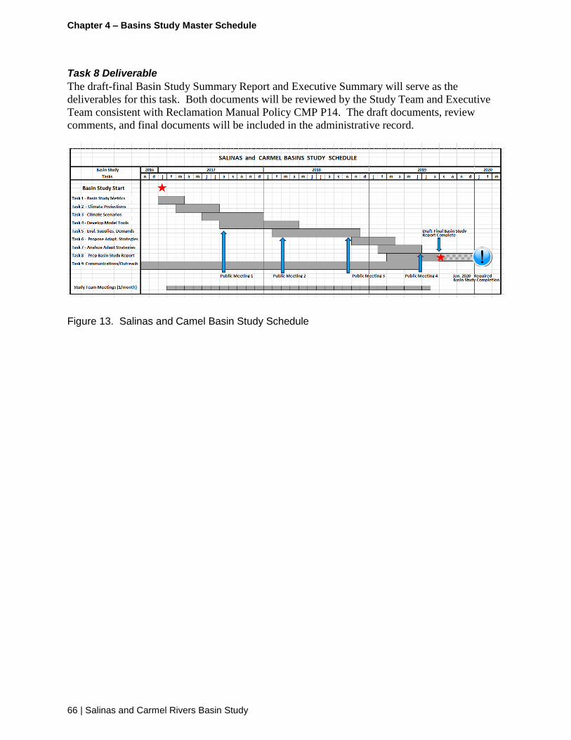
Chapter 4 – Basins Study Master Schedule
66 | Salinas and Carmel Rivers Basin Study
Task 8 Deliverable
The draft-final Basin Study Summary Report and Executive Summary will serve as the
deliverables for this task. Both documents will be reviewed by the Study Team and Executive
Team consistent with Reclamation Manual Policy CMP P14. The draft documents, review
comments, and final documents will be included in the administrative record.
Figure 13. Salinas and Camel Basin Study Schedule

Chapter 4 – Basins Study Master Schedule
Salinas and Carmel Rivers Basin Study | 67
This page intentionally left blank

Chapter 5 – Communications and Outreach Plan
68 | Salinas and Carmel Rivers Basin Study
Chapter 5 – Communications and Outreach Plan
5.1 Goal and Objectives of the Communications and Outreach Plan
This Communications and Outreach Plan (COP) outlines how Reclamation, the Study Team
(including the contractor) will communicate with and involve diverse stakeholders and the
interested public during the development and review of the Basin Study. In general, the
contractor is responsible for coordination and management of the COP and implementation of
the communication and outreach processes described in this section to support all meetings, the
website and other elements of the COP.
The Goal of the COP is to support the preparation of the Basin Study Report which: (1) is
broadly understood, and; (2) solicits and incorporates stakeholder input where feasible and
appropriate. Federal partners involved with Reclamation intend to create a variety of
participation opportunities to involve stakeholders, which include Federal agencies, State
agencies, and local government agencies including water districts, flood control agencies, as well
as scientific research groups, environmental groups, and agricultural groups.
The participation and outreach strategy for the Basin Study will focus on the following
objectives:
Reclamation will provide stakeholders with multiple, meaningful opportunities to learn
about and provide input on the content of the Basin Study
Reclamation will keep stakeholders well informed throughout the Basin Study
development process regarding the development of technical reports and the
opportunities for stakeholders to review and provide input for consideration
Opportunities for stakeholder participation through public workshops and meetings
Potential connections and linkages between the Basin Study, the DCP, and related efforts
Information about the Basin Study will be accessible and easy to understand;
Reclamation and Study Team representatives will be available to answer stakeholder
questions
Reclamation will, to the extent possible, work to integrate interests, needs, and
expectations from multiple stakeholder groups during the development of the Basin
Study
Reclamation will identify and, as appropriate, address key stakeholder concerns and
issues during the Basin Study development process

Chapter 6 – Communications and Outreach Plan
Salinas and Carmel Rivers Basin Study | 69
5.2 Approach
Several participation and outreach methods will be employed to maintain communication with
the Study Partners and interested stakeholders to provide and receive information.
In order to achieve the objectives articulated in this Chapter, Reclamation intends to utilize an
approach that is flexible and adaptive to the Basin Study development process and stakeholder
needs. The communications and outreach approach will:
Recognize that there are various stakeholders and audiences interested in the Basin
Study, and that each group will require a distinct approach
Identify the most effective and efficient activities to inform and engage stakeholders in
order to achieve participation and outreach objectives
Provide clear, timely information on how interested stakeholders can be involved; and
adhere to the following principles:
o The Basin Study will be developed in a transparent way
o Public outreach will begin early in the Basin Study development process and will
proceed in a timely and consistent manner
o Reclamation will avoid making redundant requests of stakeholders or communicating
inconsistent messages
The Basin Study will be developed in phases and stakeholder outreach will be planned around
milestones corresponding to these phases. As the Study progresses, the effectiveness of the
public involvement process will be assessed periodically, and adjustments will be made as
necessary to ensure that appropriate communication and feedback are occurring.
5.3 Study Audiences
A broad range of stakeholders have an interest in the development of the Basin Study. This COP
organizes Basin Study stakeholders into four main audiences: (1) internal/Study Partners; (2)
technical experts; (3) key stakeholders; and (4) the general public, recognizing that there will be
different levels of interest and decision-making, and that the communication and outreach
strategy should be designed to accommodate these audiences. Below are descriptions of the four
stakeholder audiences.
Reclamation and Basin Study Partners The study partners include Reclamation and the following agencies: MCWRA, SLOFCWCD,
MPWMD, and the MRWPCA. The partners are contributing resources to support the
development of the Basin Study; their staff will be contributing time to the Basin Study on a
variety of levels (policy, technical, etc.). The partners contribute information and data to the
process. Partner agencies are also responsible for ensuring their respective constituencies are
appropriately informed about the Basin Study process and have the opportunity to provide input.

Chapter 5 – Communications and Outreach Plan
70 | Salinas and Carmel Rivers Basin Study
Technical Experts Technical experts include recognized researchers and scientists in the earth sciences, including
climatology/meteorology, hydrology, geology, and other fields. Technical experts will provide
independent expert input and peer review of content for the Basin Study.
Key Stakeholders A number of stakeholder groups have a keen interest in the Basin Study and its outcomes. These
key stakeholders, made up of local and regional entities and nongovernmental groups, are
familiar with the landscape of water resources management in the Salinas and CRB area, and are
interested in providing input into specific technical aspects or the entirety of the Basin Study.
Key stakeholder groups may include:
Federal, State and local government agencies
Elected officials
Groundwater Sustainability Agencies
Flood control agencies
Reclamation districts
Water districts
Scientific research groups
Hydropower agencies and other representatives of the energy industry
Environmental groups
Agricultural groups
Representatives of the recreational industry
Related programs and initiatives such as the California Water Plan 2018 Update, local
IRWM Plans, groundwater plan updates and others
General Public The general public includes California residents and organizations that are not likely to closely
track the technical details of the Basin Study but would like to be updated periodically and
receive information that is easy to understand and helps explain what implications the Basin
Study will have on their lives and livelihoods.
5.4 Outreach Activities
Various coordinated activities will be conducted in order to inform and engage a variety of
stakeholder audiences. Activities will include regular internal meetings among Reclamation and
Study Partners, technically focused meetings, public meetings, coordination meetings with
related efforts, and briefings with key stakeholder groups. In addition, the contractor will
distribute regular email updates, allow for public review of draft documents, and share
information broadly through the Basin Study website and other outreach materials. These
activities support the outreach Goal and Objectives identified in Section 6.1.

Chapter 6 – Communications and Outreach Plan
Salinas and Carmel Rivers Basin Study | 71
Section 9.1 of the POS contains a project master schedule with important milestones. The
Master Schedule will be updated by the contractor to include indicators which illustrate when
specific outreach activities are proposed to be implemented in relation to the development of
Basin Study content. The Master Schedule will be revisited and updated as appropriate
throughout the development of the Basin Study.
Executive Team Meetings The Executive Team, comprised of Reclamation and Study Partner executives and senior
officials, will meet as needed when requested by the Study Team to provide high-level policy
direction.
Study Team Meetings Reclamation, USGS, and Study Partner representatives and consultant team staff compose the
Study Team. The Study Team will hold regular meetings to manage and provide policy and
technical direction throughout the Basin Study process. External stakeholders, including
members of the public, will not participate in these meetings.
Technical Working Group Meetings The TWG is comprised of technical staff from Reclamation, USGS, Study Partners and the
consultant team, will meet as needed requested by the Study Team to recommend or review key
technical work products. Examples of where the TWG may provide review or recommendations
include the following: metrics, water supply, water demand, and adaptation strategies.
Technical Sufficiency Review The TSR will involve both Reclamation and other experts in the earth sciences, including
climatology/meteorology, hydrology, geology, and other fields. The TSR will involve
professionals who are not directly engaged in the preparation of the Basin Study. The TSR, as
required by Reclamation’s Basin Study Directives and Standards, provides a "best science"
perspective and expert-level peer review of Basin Study methodology and work products. The
TSR team provides their review comments directly to Reclamation. A copy of the review
findings will also be submitted to Study Team. The TSR team will be convened by the Project
Manager and meet on an as-needed basis when there are technical memoranda available or other
recommendations are needed.
Stakeholder and General Public Meetings Meetings with stakeholders and the general public will be scheduled around milestones in the
Basin Study development process.
Public Outreach and Information Meetings Public meetings will be held at strategic points throughout the Basin Study, beginning with an
initial meeting in the spring/summer of 2017. The exact dates of these meetings will be
determined by the Study Team after work on the overall Basin Study is initiated and the
contractor is retained. The general concept in the COP is that prior to completion of certain key
major Basin Study phases, public meetings will be held to provide a summary of the results of
the previous phase(s) and to inform participants on the upcoming phases of the Basin Study. This
allows consideration of information and suggestions by the public for incorporation into the
Basin Study.

Chapter 5 – Communications and Outreach Plan
72 | Salinas and Carmel Rivers Basin Study
Public meetings are currently envisioned as follows:
Public Meeting #1 will focus on a presentation of information developed in Tasks 1, 2,
and 3. This includes study metrics, characterization of climate change and sea level rise,
and proposed study scenarios.
Public Meeting #2 will present an overview of Task 4, the model tools used for the Basin
Study, and Task 5, the information developed for water supplies, demands and
operations.
Public Meeting #3 will focus on the findings of Task 6, development of adaptation
strategies (includes receiving input (or nominations)) for certain adaptation strategies;
and, Task 7, the process for and analysis of the adaptation strategies proposed.
Public Meeting #4 will focus on presenting the findings and results from the analysis of
the adaptation strategies proposed and receiving public input on options and strategies.
Public Meeting #5 will focus on presentation of the findings and the results of the Basin
Study, includes the key vulnerabilities and the most robust and promising strategies.
Includes presentation of potential next steps and follow-up investigations to promote long
term sustainability.
Public meetings will generally be held via webinar in order to make them time and
resource efficient for the Study Team, Partners, and stakeholders, and to allow
participation from remote locations. The meetings will be recorded and archived for
future reference.
Coordination Meetings with Related Efforts Some of the stakeholders and general public interested in the Basin Study will overlap with those
engaged and involved in other related processes, such as the Drought Contingency Planning and
Groundwater Sustainability Plan preparation which are proposed to run concurrently with the
preparation of the Basin Study. Over the duration of the preparation of the Basin Study, there
may be opportunities to leverage related program meetings or interactions with these shared
stakeholders. Cross promotion and leveraging existing groups of engaged stakeholders can assist
in promoting the purpose of the COP and Basin Study outreach process in achieving the goals of
the communications plan without adding significant costs of additional meetings.
As part of the implementation of the COP, Reclamation and the contractor will coordinate with
other agencies and organization which are involved in programs which will inform the
development of the Basin Study. These include:
The California Water plan 2018 Update
The Monterey Peninsula DCP

Chapter 6 – Communications and Outreach Plan
Salinas and Carmel Rivers Basin Study | 73
Groundwater Sustainability Plan Development Entities
Stormwater Resource Plans
Other…TBD
In addition to coordinating project-specific efforts, Reclamation will also coordinate with
broader engagements, particularly where appropriate such as the Statewide Water Analysis
Network, which is a statewide network of stakeholders and experts convened by DWR to
improve California's analytical capabilities in support of water management decisions and
investments.
Additional Meetings with Interested Stakeholders During the course of the Basin Study, additional meetings will be held with interested
stakeholder groups to solicit additional input, expertise, data, and information. As appropriate,
representatives of key stakeholder groups may participate in specific Basin Study tasks to
facilitate incorporation of their input into the Basin Study.
Study Information and Updates The Study Team and contractor will develop outreach materials to inform and educate
stakeholders; tailoring materials for specific audiences when appropriate. What follows is a list
of materials and systems that are proposed to be developed to support stakeholder
communication and outreach. This list will be revisited after outreach activities are initiated and
updated accordingly.
Study Website The Basin Study website will be one of the most important outreach tools and the most important
outlet for communication and engagement with the general public.
A dedicated Basin Study website will be the repository for up-to-date information, including
upcoming opportunities for stakeholders to provide input. Website content will be updated
periodically, particularly at major milestones and prior to public meetings. In addition, the
website will function as a tool for stakeholders to contribute input and ideas to the Basin Study
process.
Outreach Materials Reclamation will develop informational materials that convey clear, consistent, and timely
information that helps members of the public to understand the Basin Study and how it relates to
their interests, and informs them on how to get involved. Outreach materials will be
easy-to-understand and visually appealing.
Stakeholder Mailing List/Study Updates Basin Study updates will be sent to stakeholders on the Basin Study mailing list (either
physically, electronically, or both) in anticipation of Basin Study milestones, including public
meetings. The updates will inform stakeholders of the Basin Study status, provide opportunities
for input, and provide meeting information including dates and locations of upcoming public
meetings

Chapter 5 – Communications and Outreach Plan
74 | Salinas and Carmel Rivers Basin Study
Individuals can request to be included on the mailing list through the Basin Study email address
or through attendance at a public meeting captured on the sign-in sheet. An initial mailing will
be made to a list of stakeholders provided by the Study Partners and stakeholders from similar
prior studies.
Designated Point-of-Contact The Basin Study will have designated point(s)-of-contact whom stakeholders can contact for
additional information, questions, or comments. The point-of-contacts' information will be
posted on the Basin Study website, and will be included in outreach materials.
Review of Draft Study Documents The project work plan anticipates preparation of a series of technical reports linked to tasks in the
Performance Work Statement including:
Metrics, sea level rise and climate scenarios
Study scenarios
Hydrologic models
Water supply, demands and operations
Adaptation strategy development
Adaptation strategy performance analysis
Findings (in the Summary Basin Study Report and Executive Summary)
The Study Team may provide opportunities for stakeholders to review and provide input on
content of the Basin Study’s technical reports at certain intervals. All reviews will occur after
the TSR review has been completed. The Study Team may review the TSR comments (and
involve the TWG as appropriate) and may incorporate pertinent comments into the technical
reports as appropriate, but will not respond to individual comments. All technical reports will be
considered interim drafts until they are released by Reclamation in the final Basin Study Report.

Chapter 6 – Communications and Outreach Plan
Salinas and Carmel Rivers Basin Study | 75
This page intentionally left blank

Appendix A – Basins Study – Agency and Partner Tasking Table
76 | Salinas and Carmel Rivers Basin Study
Appendix A – Basin Study – Agency and Partner Tasking Table

Appendix A – Basins Study – Agency and Partner Tasking Table
Salinas and Carmel Rivers Basin Study | 77
APPENDIX A
SALINAS AND CARMEL BASINS STUDY Task Assignments by Reclamation, USGS, Contractor and Local Agency Partners

Appendix A – Basins Study – Agency and Partner Tasking Table
78 | Salinas and Carmel Rivers Basin Study
Task Reclamation Contractor USGS MPWMD MCWRA SLOCPWD MRWPCA
1. Develop Study Metrics
1(a) Develop Climate Metrics Co-lead Coordinate / Support Co-lead Review Review Review Review
1(b) Develop Supply Metrics Coordinate / Support Coordinate / Support Limited Support / Review Co-lead (MP, CRB, SGB) Co-lead (SVB, SGB) Co-lead (PRB) Review
1(c) Develop Demand Metrics Coordinate / Support Coordinate / Support Limited Support / Review Co-lead (MP, CRB, SGB) Co-lead (SVB, SGB) Co-lead (PRB) Review
1(d) Develop Operations Metrics Coordinate / Support Coordinate / Support Limited Support / Review Co-lead (MP, CRB, SGB) Co-lead (SVB, SGB) Co-lead (PRB) Review
1(e) Task 1 Tech Memo Lead Review / Support Study Team
Review Review Review Review Review
2. Characterize Climate Change and SLR
2(a) Compile Climate Data – Observed Climate
Lead Coordinate / Support Study Team w/ data
Limited support (provide available data)
Provide available data Provide available data Provide available data Provide available data
2(b) Compile Climate – Global Projections
Lead N/A Review N/A N/A N/A N/A
2(c) Compile Climate – Downscaled Proj.
Lead N/A Review N/A N/A N/A N/A
2(d) Characterize Current Climate Lead N/A Limited support (discuss method options)
N/A N/A N/A N/A
2(e) Characterize Climate Trends – Observed
Lead N/A Limited support (discuss method options)
N/A N/A N/A N/A
2(f) Characterize Climate Trends – Projected
Lead N/A Limited support (discuss method options)
N/A N/A N/A N/A
2(g) Compile Sea Level Data – Observed Climate
Lead N/A Review N/A N/A N/A N/A
2(h) Compile Sea Level – Projections Lead N/A Limited support (discuss data options)
N/A N/A N/A N/A
2(j) Characterize Current Sea Level Lead N/A Limited support (discuss method options)
N/A N/A N/A N/A
2(k) Characterize Sea Level Trends – Observed
Lead N/A Limited support (discuss method options)
N/A N/A N/A N/A
2(l) Characterize Sea Level Trends – Projected
Lead N/A Limited support (discuss method options)
N/A N/A N/A N/A
2(m) Task 2 Tech Memo Lead Review / Support Study Team
Review Review Review Review Review
3. Develop Study Scenarios
3(a) Develop Climate Scenarios Lead N/A Limited support (discuss method options)
N/A N/A N/A N/A
3(b) Develop Sea Level Scenarios Lead N/A Limited support (discuss method options)
N/A N/A N/A N/A
3(c) Develop Socioeconomic Scenarios Coordinate / Support Lead Review Co-lead (MP, CRB, SGB) Co-lead (SVB, SGB) Co-lead (PRB) Co-Lead (SGB)
3(d) Task 3 Tech Memo Lead – outline/template
Lead – climate
Lead – sea level
Co-Lead – socio/econ
Lead – socio/econ scenarios
Support Study Team
Review Review – climate
Review – sea level
Co-lead – socio/econ (MP, CRB, SGB)
Review – climate
Review – sea level
Co-lead – socio/econ (SVB, SGB)
Review – climate
Review – sea level
Co-lead – socio/econ (PRB)
Review – climate
Review – sea level
Review – socio/econ

Appendix A – Basins Study – Agency and Partner Tasking Table
Salinas and Carmel Rivers Basin Study | 79
4. Develop Modeling Tools and Inputs
4(a) Develop modeling tools Coordinate / Support Coordinate / Support Study Team
Assist model tool transfer and documentation from Partners to USGS as needed.
Lead (all sub-areas)
Obtain models and inputs from partners
Identify model updates for basin study
Implement updates (if any)
Support (MP, CRB, SGB)
Provide calibrated model and default inputs
Provide documentation of model and inputs
Provide data/tools used to develop selected inputs
Discuss model updates required for basin study
Support (SVB, SGB)
Provide calibrated model and default inputs
Provide documentation of model and inputs
Provide data/tools used to develop selected inputs
Discuss updates required for basin study
Support (PRB)
Provide calibrated model and default inputs
Provide documentation of model and inputs
Provide data/tools used to develop selected inputs
Discuss updates required for basin study
Review
4(b) Develop model inputs – baseline
Coordinate / Support N/A Lead (all sub-areas)
Identify updates to inputs for baseline
Implement updates
Support (MP, CRB, SGB)
Identify and discuss input updates for baseline
Support (SVB, SGB)
Identify and discuss input updates for baseline
Support (PRB)
Identify and discuss input updates for baseline
Review
4(c) Develop model inputs – future climate
Support
Provide climate scenarios, collaborate on method to develop model inputs for scenarios
N/A Lead (all sub-areas)
Identify updates to inputs for all scenarios
Implement updates
Support (MP, CRB, SGB)
Identify and discuss input updates for future scenarios
Support (SVB, SGB)
Identify and discuss input updates for future scenarios
Support (PRB)
Identify and discuss input updates for future scenarios
Review
4(d) Develop model inputs – future sea level
Support
Provide sea level scenarios, collaborate on method to develop model inputs for scenarios
N/A Lead (all sub-areas)
Identify updates to inputs for all scenarios
Implement updates
Support (CRB, SGB)
Identify and discuss input updates for future scenarios
Support (SVB, SGB)
Identify and discuss input updates for future scenarios
Review Review
4(e) Develop model inputs – future socio/econ
Coordinate / Support / Review
N/A Lead (all sub-areas)
Identify updates to inputs for all scenarios
Implement updates
Support (MP, CRB, SGB)
Identify and discuss input updates for future scenarios
Support USGS in implementing updates
Support (SVB, SGB)
Identify and discuss input updates for future scenarios
Support USGS in implementing updates
Support (PRB)
Identify and discuss input updates for future scenarios
Support USGS in implementing updates
Review
4(f) Task 4 Tech Memo Lead – outline/template
Review – model development / updates
Co-Lead – climate inputs
Co-Lead – sea level inputs
Review – socio/econ inputs
Support Study Team Review
Co-Lead – model development / updates
Co-Lead – climate inputs
Co-Lead – sea level inputs
Co-Lead – socio/econ inputs
Review – climate inputs
Review – sea level inputs
Co-Lead – socio/econ inputs (MP, CRB, SGB)
Review – climate inputs
Review – sea level inputs
Co-Lead – socio/econ inputs (SVB, SGB)
Review – climate inputs
Review – sea level inputs
Co-Lead – socio/econ inputs
(PRB)
Review – climate inputs
Review – sea level inputs
Review – socio/econ inputs
5. Evaluate supplies, demands, and operations
5(a) Simulate Baseline Conditions Coordinate / Support N/A Lead (all sub-areas)
Carry out simulations of baseline conditions using models and inputs developed in Task 4
Support Support Support Review
5(b) Simulate Future Conditions Coordinate / Support N/A Lead (all sub-areas)
Carry out simulations of future conditions under future climate, socioeconomic, and sea level scenarios using models and inputs developed in Task 4
Support Support Support Review

Appendix A – Basins Study – Agency and Partner Tasking Table
80 | Salinas and Carmel Rivers Basin Study
5(c) Compute Study Metrics Co-Lead (all sub-areas)
Compute study metrics – historical (Compute from observations)
Discuss method options to compute study metrics for baseline + future scenarios
Coordinate / Support Study Team
Co-Lead (all sub-areas)
Discuss method options to compute study metrics for baseline + future scenarios
Compute study metrics – baseline + future
(Computed from model simulations carried out under Task 5(a-b))
Support (MP, CRB, SGB)
Provide historical data to compute metrics
Discuss method options to compute study metrics for baseline + future scenarios
Support (SVB, SGB)
Provide historical data to compute metrics
Discuss method options to compute study metrics for baseline + future scenarios
Support (PRB)
Provide historical data to compute metrics
Discuss method options to compute study metrics for baseline + future scenarios
Support (SGB)
Provide historical data to compute metrics
Discuss method options to compute study metrics for baseline + future scenarios
5(d) Evaluate/Characterize Historical Conditions
Lead
Quantitatively evaluate / characterize historical water supplies, demands, and operations based on study metrics from Task 5(c)
Co-Lead
Qualitatively interpret and discuss historical water supplies, demands, and operations based on quantitative evaluation / characterization
Support
Discuss approach to evaluating / characterizing historical conditions
Support
Discuss approach to evaluating / characterizing historical conditions
Support
Discuss approach to evaluating / characterizing historical conditions
Support
Discuss approach to evaluating / characterizing historical conditions
Support
Discuss approach to evaluating / characterizing historical conditions
5(e) Evaluate/Characterize Baseline Conditions (without adaptation/mitigation)
Lead
Quantitatively evaluate / characterize baseline water supplies, demands, and operations based on study metrics from Task 5(c)
Co-Lead
Qualitatively interpret and discuss baseline water supplies, demands, and operations based on quantitative evaluation / characterization
Support
Discuss approach to evaluating / characterizing baseline conditions
Support
Discuss approach to evaluating / characterizing baseline conditions
Support
Discuss approach to evaluating / characterizing baseline conditions
Support
Discuss approach to evaluating / characterizing baseline conditions
Support
Discuss approach to evaluating / characterizing baseline conditions
5(f) Evaluate/Characterize Future Conditions (without adaptation/mitigation)
Lead
Evaluate / characterize future water supplies, demands, and operations based on study metrics from Task 5(c)
Co-Lead
Qualitatively interpret and discuss future water supplies, demands, and operations based on quantitative evaluation / characterization
Support
Discuss approach to evaluating / characterizing future conditions
Support
Discuss approach to evaluating / characterizing future conditions
Support
Discuss approach to evaluating / characterizing future conditions
Support
Discuss approach to evaluating / characterizing future conditions
Support
Discuss approach to evaluating / characterizing future conditions
5(g) Evaluate/Characterize Projected Change (without adaptation/mitigation)
Lead – Compare baseline vs. historical
(historical vs. future w/o climate change, effects of socio/econ change)
Lead – Compare future vs. baseline (baseline vs. future climate scenarios, effects of climate change)
Co-Lead
Qualitatively interpret and discuss projected effects of climate change and socioeconomic change on water supplies, demands, and operations
Support
Discuss approach to evaluating / characterizing projected changes/effects
Discuss approach to evaluating / characterizing climate and socioeconomic uncertainties
Review Review Review Review
5(h) Task 5 Tech Memo Lead – outline/template
Lead – historical conditions
Lead – baseline conditions
Lead – future conditions
Lead – projected change
Co-Lead – historical conditions (qualitative interpretation)
Co-Lead – baseline conditions (qualitative interpretation)
Co- Lead – future conditions (qualitative interpretation)
Co-Lead – projected
Lead – simulations / results
Review – historical conditions
Review – baseline conditions
Review – future conditions
Review – projected change
Review – all Review – all Review – all Review – all

Appendix A – Basins Study – Agency and Partner Tasking Table
Salinas and Carmel Rivers Basin Study | 81
change (qualitative interpretation)
6. Develop mitigation/adaptation strategies
6(a) Define mitigation/adaptation objectives
Coordinate / Support (all sub-areas)
Discuss/review imbalances
Discuss/review adaptation objectives
Lead- Identify adaptation / mitigation objectives
Support (all sub-areas)
Discuss/review imbalances
Discuss/review adaptation objectives)
Co-Lead (MP, CRB, SGB)
Identify adaptation / mitigation objectives
Co-Lead (SVB, SGB)
Identify adaptation / mitigation objectives
Co-Lead (PRB)
Identify adaptation / mitigation objectives
Co-Lead (SGB)
Identify adaptation / mitigation objectives
6(b) Develop non-structural strategies (optional)
Coordinate / Support (all sub-areas)
Discuss/review non-structural strategies
Help as needed to develop concepts in sufficient detail to simulate/evaluate alternatives
Lead - Develop non-structural adaptation / mitigation strategies with Study Team
Support (all sub-areas)
Discuss/review non-structural strategies
Help as needed to develop concepts in sufficient detail to simulate/evaluate alternatives
Co-Lead (MP, CRB, SGB)
Develop non-structural adaptation / mitigation strategies
Co-Lead (SVB, SGB)
Develop non-structural adaptation / mitigation strategies
Co-Lead (PRB)
Develop non-structural adaptation / mitigation strategies
Co-Lead (SGB)
Develop non-structural adaptation / mitigation strategies
6(c) Develop structural strategies (optional)
Coordinate / Support (all sub-areas)
Discuss/review structural strategies
Help as needed to develop concepts in sufficient detail to simulate/evaluate alternatives
Lead - Develop structural adaptation / mitigation strategies with Study Team
Support (all sub-areas)
Discuss/review structural strategies
Help as needed to develop concepts in sufficient detail to simulate/evaluate alternatives
Co-Lead (MP, CRB, SGB)
Develop structural adaptation / mitigation strategies
Co-Lead (SVB, SGB)
Develop structural adaptation / mitigation strategies
Co-Lead (PRB)
Develop structural adaptation / mitigation strategies
Co-Lead (SGB)
Develop structural adaptation / mitigation strategies
6(f) Task 6 Tech Memo Lead – outline/template
Review – strategies (all sub-areas) Co-lead -- section(s)
describing proposed strategies
Review (all sub-areas) Co-lead (MP, CRB, SGB)
Contribute section(s) describing proposed strategies
Co-lead (SVB, SGB)
Contribute section(s) describing proposed strategies
Co-lead (PRB)
Contribute section(s) describing proposed strategies
Co-lead (SGB)
Contribute section(s) describing proposed strategies
7. Evaluate adaptation/mitigation strategies
7(a) Initial Screening or Evaluation of Proposed Adaptation / Mitigation Strategies
Coordinate / Support
Discuss screening criteria (qualitative)
Discuss method options for initial evaluation via simplified approach (quantitative)
Provide support in carrying out initial screening / evaluation
Lead – Facilitate discussion to identify and select screening criteria and method options for initial evaluation, including developing draft criteria and method options
Lead – Perform initial screening and evaluation w/ Study Team
Support
Discuss screening criteria (qualitative)
Discuss method options for initial evaluation via simplified approach (quantitative)
Co-Lead (MP, CRB, SGB)
Identify and select initial screening criteria
Identify and select option(s) for initial evaluation
Carry out initial screening and evaluation
Co-Lead (SVB, SGB)
Identify and select initial screening criteria
Identify and select option(s) for initial evaluation
Carry out initial screening and evaluation
Co-Lead (PRB)
Identify and select initial screening criteria
Identify and select option(s) for initial evaluation
Carry out initial screening and evaluation
Co-Lead (SGB)
Identify and select initial screening criteria
Identify and select option(s) for initial evaluation
Carry out initial screening and evaluation
7(b) Modify model configuration and/or inputs as needed to simulate adaptation / mitigation strategies
Coordinate / Support
Discuss method options to represent strategies in sub-area models
Co-Lead
Facilitate w/ Study Team - discuss options to represent strategies in sub-area models
Co-Lead
Discuss method options to represent strategies in sub-area models
Implement selected options
Co-Lead
Discuss method options to represent strategies in sub-area models
Co-Lead
Discuss method options to represent strategies in sub-area models
Co-Lead
Discuss method options to represent strategies in sub-area models
Co-Lead
Discuss method options to represent strategies in sub-area models
7(c) Simulate Baseline Conditions (with adaptation/mitigation
Coordinate / Support Facilitate review and discussion, including
Lead
Carry out simulations of baseline
Review Review Review Review

Appendix A – Basins Study – Agency and Partner Tasking Table
82 | Salinas and Carmel Rivers Basin Study
strategies) dissemination of simulation results to Study Team
conditions with adaptation/mitigation strategies in place using models/inputs developed in Task 7(a)
7(d) Simulate Future Conditions (with adaptation/mitigation strategies)
Coordinate / Support
Identify future climate scenarios to be simulated with adaptation/mitigation strategies (bracketing approach)
Facilitate, review and discussion, including dissemination of simulation results to Study Team
Lead
Carry out simulations of future conditions with adaptation/mitigation strategies in place using models/inputs developed in Task 7(a)
Review Review Review Review
7(e) Evaluate/Characterize Baseline Conditions (with adaptation/mitigation strategies)
Lead
Quantitatively evaluate / characterize baseline water supplies, demands, and operations based on study metrics with adaptation / mitigation strategies
Co-Lead
Qualitatively interpret and discuss baseline water supplies, demands, and operations based on quantitative evaluation / characterization
Support
Provide study metrics from simulations carried out in Task 7(c)
Discuss method options to evaluate / characterize conditions with strategies
Support
Discuss method options to evaluate / characterize conditions with strategies
Support
Discuss method options to evaluate / characterize conditions with strategies
Support
Discuss method options to evaluate / characterize conditions with strategies
Support
Discuss method options to evaluate / characterize conditions with strategies
7(f) Evaluate/Characterize Future Conditions (with adaptation/mitigation strategies)
Lead Quantitatively evaluate / characterize future water supplies, demands, and operations based on study metrics with adaptation / mitigation strategies
Co-Lead Qualitatively interpret and discuss future water supplies, demands, and operations based on quantitative evaluation / characterization
Support
Provide study metrics from simulations carried out in Task 7(d)
Discuss method options to evaluate / characterize conditions with strategies
Support
Discuss method options to evaluate / characterize conditions with strategies
Support
Discuss method options to evaluate / characterize conditions with strategies
Support
Discuss method options to evaluate / characterize conditions with strategies
Support
Discuss method options to evaluate / characterize conditions with strategies
7(g) Evaluate Adaptation/Mitigation Strategies
Co-Lead
Compare water supplies, demands, and operations between simulations with and without adaptation/mitigation strategies
Quantify effects of adaptation/mitigation strategies on water supplies, demands, and operations based on simulated change in study metrics
Compare effects of each adaptation / mitigation strategy to corresponding strategy objectives
Lead
Interpret results with the Study Team (with vs. without strategy) (MP, CRB, SGB, SVB, PRB)
Consider trade-offs
(quantitative trade-off with respect to water supply/demand; qualitative trade-off with respect to environmental and other considerations)
Support
Discuss method options for quantifying effects of adaptation / mitigation strategies
Co-Lead
Interpret results (with vs. without strategy) (MP, CRB, SGB)
Consider trade-offs (quantitative trade-off with respect to water supply/demand; qualitative trade-off with respect to environmental and other considerations)
Co-Lead
Interpret results (with vs. without strategy) (SVB, SGB)
Consider trade-offs (quantitative trade-off with respect to water supply/demand; qualitative trade-off with respect to environmental and other considerations)
Co-Lead
Interpret results (with vs. without strategy) (PRB)
Consider trade-offs (quantitative trade-off with respect to water supply/demand; qualitative trade-off with respect to environmental and other considerations)
Co-Lead
Interpret results (with vs. without strategy) (SGB)
Consider trade-offs (quantitative trade-off with respect to water supply/demand; qualitative trade-off with respect to environmental and other considerations)
7(h) Task 7 Tech Memo Lead – outline/template
Co-Lead – initial screening/evaluation
Lead – evaluation results
Co-Lead – interpretation and trade-off analysis
Co-Lead w/ Study Team
Co-Lead – interpretation and trade-off analysis
Review – all other
Lead – modeling methods/results
Review – all other
Co-Lead – initial screening/evaluation
Co-Lead – interpretation and trade-off analysis
Review – all other
Co-Lead – initial screening/evaluation
Co-Lead – interpretation and trade-off analysis
Review – all other
Co-Lead – initial screening/evaluation
Co-Lead – interpretation and trade-off analysis
Review – all other
Co-Lead – initial screening/evaluation
Co-Lead – interpretation and trade-off analysis
Review – all other
8. Final Study Report and Executive Summary
8(a) Prepare draft-final Summary Report
Support – Contractor Prep of Summary Report
Lead – review
Lead – Prepare Summary Report & Executive Summary
Support – review Support – limited writing
Support – review
Support – review Support – review Support – review
8(b) Prepare draft-final Executive Summary (positioned in Summary
Support – Contractor Prep of Summary Report & Executive
Lead – Prepare Summary Report & Executive
Support – review Support – limited writing
Support – review
Support – review Support – review Support – review

Appendix A – Basins Study – Agency and Partner Tasking Table
Salinas and Carmel Rivers Basin Study | 83
Report) Summary
Lead – review
Summary
NOTES:
(1) Abbreviations … CRB = Carmel River Basin; SVB = Salinas Valley Basin; PRB = Paso Robles Basin; SGB = Seaside Groundwater Basin; MP = Monterey Peninsula watersheds (area between CRB and SVB model domains)
(2) Responsibilities for modeling Tasks 4, 5, and 7 are assigned based on study partner. It should be noted that actual work will likely be carried out under contract – e.g., USGS will conduct modeling of SVB under contract with MCWRA; USGS will conduct modeling
of CRB under contract with MPWMD; and MPWMD may contract with USGS to conduct modeling of MP.
SHADING:
GREEN: Task / sub-task funded by partner (partner cost share)
BLUE: Task / sub-task funded by Reclamation (Federal cost share)
BROWN: Not applicable (No cost)

Appendix A – Basins Study – Agency and Partner Tasking Table
84 | Salinas and Carmel Rivers Basin Study
Appendix B – Table of Major Study Tasks, Budgets w/Projected Timelines
U:\staff\Board_Committees\WSP\2017\20170208\02\Item-2-Exh-B.docx