places for everyone
TRANSCRIPT

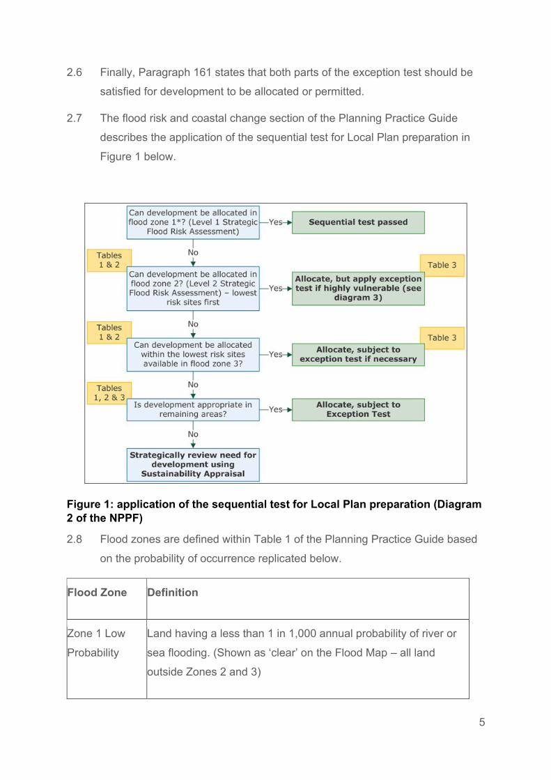
Places for Everyone Flood Risk Sequential Test and Exception Test
Evidence Paper
July 2021

i
Contents
1. Introduction ....................................................................................................... 1
2. Background ...................................................................................................... 3
3. Overview of flood risk ....................................................................................... 9
4. PfE 2021 Scale and Distribution of Growth .................................................... 11
5. Housing Land Supply ..................................................................................... 12
6. PfE Site Selection ........................................................................................... 14
7. Integrated Assessment ................................................................................... 15
8. Greater Manchester Level 1 Strategic Flood Risk Assessment ...................... 21
9. Greater Manchester Level 2 Strategic Flood Risk Assessment ...................... 22
10. Applying the sequential test ............................................................................ 23
11. Applying the Exception Test ........................................................................... 27
12. Conclusion ...................................................................................................... 31
Appendix A – Exception Test Site Assessment Summaries (GM Level 2 SFRA, Oct
2020) .......................................................................................................................... 1
List of Figures
Figure 1: application of the sequential test for Local Plan preparation (Diagram 2 of
the NPPF) .................................................................................................................. 5
Figure 2: Flood risk vulnerability classification ........................................................... 9
List of Tables
Table 1: Flood Zones ................................................................................................. 6
Table 2: tally of strategic recommendations for PfE
allocations………………………Error! Bookmark not defined.
Table 3: Summary of IA recommendations for PfE site allocations .......................... 29

1
1. Introduction
1.1 This purpose of this paper is to explain how the flood risk sequential test and
exception tests, as required by the National Planning Policy Framework, have
been applied in the preparation of the Places for Everyone Plan 2021.
GMSF to Places for Everyone (PfE)
1.2 In November 2014, the AGMA Executive Board recommended to the 10
Greater Manchester local authorities that they agree to prepare a joint
Development Plan Document (“Joint DPD”), called the Greater Manchester
Spatial Framework (“GMSF”) and that AGMA be appointed by the 10
authorities to prepare the GMSF on their behalf.
1.3 The first draft of the GMSF DPD was published for consultation on 31st
October 2016, ending on 16th January 2017. Following substantial re-
drafting, a further consultation on the Revised Draft GMSF took place
between January and March 2019.
1.4 On the 30 October 2020 the AGMA Executive Board unanimously agreed to
recommend GMSF 2020 to the 10 Greater Manchester Councils for approval
for consultation at their Executives/Cabinets, and approval for submission to
the Secretary of State following the period for representations at their Council
meetings.
1.5 At its Council meeting on 3 December Stockport Council resolved not to
submit the GMSF 2020 following the consultation period and at its Cabinet
meeting on 4 December, it resolved not to publish the GMSF 2020 for
consultation.
1.6 As a joint DPD of the 10 Greater Manchester authorities, the GMSF 2020
required the approval of all 10 local authorities to proceed. The decisions of
Stockport Council/Cabinet therefore signalled the end of the GMSF as a joint
plan of the 10.

2
1.7 Notwithstanding the decision of Stockport Council, the nine remaining districts
considered that the rationale for the preparation of a Joint DPD remained.
Consequently, at its meeting on the 11th December 2020, Members of the
AGMA Executive Committee agreed in principle to producing a joint DPD of
the nine remaining Greater Manchester (GM) districts. Subsequent to this
meeting, each district formally approved the establishment of a Joint
Committee for the preparation of a joint Development Plan Document of the
nine districts.
1.8 Section 28 of the Planning and Compulsory Purchase Act 2004 and
Regulation 32 of the Town and Country Planning (Local Planning) (England)
Regulations 2012 enable a joint plan to continue to progress in the event of
one of the local authorities withdrawing, provided that the plan has
‘substantially the same effect’ on the remaining authorities as the original joint
plan. The joint plan of the nine GM districts has been prepared on this basis.
1.9 In view of this, it follows that PfE should be considered as, in effect, the same
Plan as the GMSF, albeit without one of the districts (Stockport). Therefore
“the plan” and its proposals are in effect one and the same. Its content has
changed over time through the iterative process of plan making, but its
purpose has not. Consequently, the Plan is proceeding directly to Publication
stage under Regulation 19 of the Town and Country Planning (Local
Planning) England Regulations 2012.
1.10 Four consultations took place in relation to the GMSF. The first, in November
2014 was on the scope of the plan and the initial evidence base, the second
in November 2015, was on the vision, strategy and strategic growth options,
and the third, on a Draft Plan in October 2016.
1.11 The fourth and most recent consultation on The Greater Manchester Plan for
Homes, Jobs and the Environment: the Greater Manchester Spatial
Framework Revised Draft 2019 (GMSF 2019) took place in 2019. It received
over 17,000 responses. The responses received informed the production of
GMSF 2020. The withdrawal of Stockport Council in December 2020
prevented GMSF 2020 proceeding to Regulation 19 Publication stage and
instead work was undertaken to prepare PfE 2021.

3
1.12 Where a local planning authority withdraws from a joint plan and that plan
continues to have substantially the same effect as the original joint plan on the
remaining authorities, s28(7) of the Planning and Compulsory Purchase Act
2004 provides that any step taken in relation to the plan must be treated as a
step taken by the remaining authorities for the purposes of the joint plan. On
this basis, it is proposed to proceed directly to Publication stage under
Regulation 19 of the Town and Country Planning (Local Planning) England
Regulations 2012.
1.13 A comprehensive evidence base was assembled to support the policies and
proposals in the GMSF 2020. Given the basis on which the Plan has been
prepared, this evidence base remains the fundamental basis for the PfE
2021and has remained available on the GMCA’s website since October 2020.
That said, this evidence base has been reviewed and updated in the light of
the change from GMSF 2020 to the PfE2021 and, where appropriate,
addendum reports have been produced and should be read in conjunction
with evidence base made available in October 2020. The evidence
documents which have informed the plan are available via the GMCA’s
website.
2. Background
2.1 The requirement for applying the sequential and exception tests are set out in
Paragraphs 155 to 161 of the National Planning Policy Framework (NPPF)
and further guidance on the tests is provided in the Planning Practice Guide.
2.2 The NPPF requires local planning authorities to develop policies to manage
flood risk from all sources supported by an SFRA and local plans should apply
a sequential, risk-based approach to the location of new development to avoid
where possible flood risk to people and property and manage any residual
risk, taking account of the impacts of climate change, by:
• Applying the sequential test and then, if necessary, the exception test;

4
• Safeguarding land from development that is required, or likely to be
required, for current or future flood management;
• Using opportunities offered by new development to reduce the causes
and impacts of flooding; and
• Where climate change is expected to increase flood risk so that some
existing development may not be sustainable in the long-term, seeking
opportunities to facilitate the relocation of development, including
housing, to more sustainable locations.
2.3 Paragraph 158 of the NPPF states that the aim of the sequential test is to
steer new development to areas with the lowest probability of flooding.
Development should not be allocated if there are reasonably available sites
appropriate for the proposed development in areas with a lower of flooding.
The SFRA will provide the basis to apply this test.
2.4 Paragraph 159 of the NPPF states that If it is not possible for development to
be located in zones with a lower risk of flooding (taking into account wider
sustainable development objectives), the exception test may have to be
applied. The need for the exception test will depend on the potential
vulnerability of the site and of the development proposed, in line with the
Flood Risk Vulnerability Classification set out in national planning guidance.
2.5 Paragraph 160 of the NPPF states that the application of the exception test
should be informed by a strategic or site-specific flood risk assessment,
depending on whether it is being applied during plan production or at the
application stage. For the exception test to be passed it should be
demonstrated that:
(a) the development would provide wider sustainability benefits to the
community that outweigh the flood risk; and
(b) the development will be safe for its lifetime taking account of the
vulnerability of its users, without increasing flood risk elsewhere, and,
where possible, will reduce flood risk overall.
5
2.6 Finally, Paragraph 161 states that both parts of the exception test should be
satisfied for development to be allocated or permitted.
2.7 The flood risk and coastal change section of the Planning Practice Guide
describes the application of the sequential test for Local Plan preparation in
Figure 1 below.
Figure 1: application of the sequential test for Local Plan preparation (Diagram
2 of the NPPF)
2.8 Flood zones are defined within Table 1 of the Planning Practice Guide based
on the probability of occurrence replicated below.
Flood Zone Definition
Zone 1 Low
Probability
Land having a less than 1 in 1,000 annual probability of river or
sea flooding. (Shown as ‘clear’ on the Flood Map – all land
outside Zones 2 and 3)

6
Flood Zone Definition
Zone 2
Medium
Probability
Land having between a 1 in 100 and 1 in 1,000 annual
probability of river flooding; or land having between a 1 in 200
and 1 in 1,000 annual probability of sea flooding. (Land shown
in light blue on the Flood Map)
Zone 3a High
Probability
Land having a 1 in 100 or greater annual probability of river
flooding; or Land having a 1 in 200 or greater annual probability
of sea flooding.(Land shown in dark blue on the Flood Map)
Zone 3b The
Functional
Floodplain
This zone comprises land where water has to flow or be stored
in times of flood. Local planning authorities should identify in
their Strategic Flood Risk Assessments areas of functional
floodplain and its boundaries accordingly, in agreement with the
Environment Agency. (Not separately distinguished from
Table 1: Flood Zones
2.9 Table 2 of the planning practice guide classifies the type of development
according to their vulnerability to flood risk which is outlined in the list below.
Essential Infrastructure:
• Essential transport infrastructure (including mass evacuation routes)
which has to cross the area at risk.
• Essential utility infrastructure which has to be located in a flood risk
area for operational reasons, including electricity generating power
stations and grid and primary substations; and water treatment works
that need to remain operational in times of flood.
• Wind turbines.
Highly vulnerable:

7
• Police and ambulance stations; fire stations and command centres;
telecommunications installations required to be operational during
flooding.
• Emergency dispersal points.
• Basement dwellings.
• Caravans, mobile homes and park homes intended for permanent
residential use.
• Installations requiring hazardous substances consent. (Where there is
a demonstrable need to locate such installations for bulk storage of
materials with port or other similar facilities, or such installations with
energy infrastructure or carbon capture and storage installations, that
require coastal or water-side locations, or need to be located in other
high flood risk areas, in these instances the facilities should be
classified as ‘Essential Infrastructure’).
More vulnerable:
• Hospitals
• Residential institutions such as residential care homes, children’s
homes, social services homes, prisons and hostels.
• Buildings used for dwelling houses, student halls of residence, drinking
establishments, nightclubs and hotels.
• Non–residential uses for health services, nurseries and educational
establishments.
• Landfill* and sites used for waste management facilities for hazardous
waste.
• Sites used for holiday or short-let caravans and camping, subject to a
specific warning and evacuation plan.
Less vulnerable:
• Police, ambulance and fire stations which are not required to be
operational during flooding.
• Buildings used for shops; financial, professional and other services;
restaurants, cafes and hot food takeaways; offices; general industry,

8
storage and distribution; non-residential institutions not included in the
‘more vulnerable’ class; and assembly and leisure.
• Land and buildings used for agriculture and forestry.
• Waste treatment (except landfill* and hazardous waste facilities).
• Minerals working and processing (except for sand and gravel working).
• Water treatment works which do not need to remain operational during
times of flood.
• Sewage treatment works, if adequate measures to control pollution and
manage sewage during flooding events are in place.
Water compatible development:
• Water-compatible development
• Flood control infrastructure.
• Water transmission infrastructure and pumping stations.
• Sewage transmission infrastructure and pumping stations.
• Sand and gravel working.
• Docks, marinas and wharves.
• Navigation facilities.
• Ministry of Defence defence installations.
• Ship building, repairing and dismantling, dockside fish processing and
refrigeration and compatible activities requiring a waterside location.
• Water-based recreation (excluding sleeping accommodation).
• Lifeguard and coastguard stations.
• Amenity open space, nature conservation and biodiversity, outdoor
sports and recreation and essential facilities such as changing rooms.
• Essential ancillary sleeping or residential accommodation for staff
required by uses in this category, subject to a specific warning and
evacuation plan.
2.10 If a site cannot be accommodated in Flood Zone 1 then the exception test will
be required for highly vulnerable sites in Flood Zone 2 or more vulnerable,
highly vulnerable and essential infrastructure in Flood Zone 3. Table 2 (Figure
2 shown below) in the Planning Practice Guide explains when the exception
test should be carried out based on the vulnerability of the development.

9
Figure 2: Flood risk vulnerability classification
3. Overview of flood risk
3.1 The PfE area covers the vast majority of Greater Manchester, excluding the
borough of Stockport. Greater Manchester consists of a complex hydrological
network that interlinks the 10 Greater Manchester authority districts. The Irwell
and Mersey catchments dominate the sub-region, accounting for 78% of the
total catchment area. The upper regions of the catchments tend to be steeper
and are more susceptible to flooding from high intensity rainfall events. The
lower areas of the catchments are more susceptible to flooding from
widespread and persistent rainfall events. All catchments within the sub-

10
region, apart from the River Douglas, drain into the Manchester Ship Canal.
The Irwell catchment drains areas to the north of Manchester and is home to
over 2 million people. The Mersey Catchment drains from the eastern
boundary of the Pennines with a population of 1.2 million. The Douglas
catchment flows from Winter Hill, high on the West Pennine moors, through
rural landscapes and urban areas until it meets the Ribble Estuary with a
population of 800,000. The Glaze catchment in the south west covers the
remaining areas of Greater Manchester. All the watercourses in the
catchments are heavily modified in parts with many culverted or channelized
by development.
3.2 There are over 50,000 properties in Greater Manchester that have between a
1% and 0.1% chance of flooding from main rivers in any year. 30% of these
properties are located in Salford, 20% in Manchester and 15% in Wigan. The
remaining 35% of properties at risk of flooding are distributed fairly evenly
across the other districts of Greater Manchester.
3.3 The Irwell catchment is affected from rainfall in different ways. The upper
reaches in Bacup and Rawtenstall, Lancashire and Littleborough and
Rochdale are affected by flash flooding from rainfall water draining into the
river very quickly. Further downstream in Bury, Radcliffe, and Middleton
rainfall water takes longer to drain into the river, approximately 4-5 hours,
which means that this part of the catchment is affected by flooding from
widespread heavy rain and/or prolonged periods of wet weather. The lower
reaches of the Irwell in Manchester and Salford are most affected from
widespread/prolonged wet weather throughout the catchment.
3.4 The Mersey catchment is similar to the Irwell catchment because it too has
predominantly rural uplands and an urbanised lower catchment. Future
changes in land management across all catchments, especially in areas
upstream of communities at risk, could reduce water runoff and peak flows as
well as improving water quality and habitats.
3.5 Reservoirs and canals in Greater Manchester have important drainage and
flood alleviation functions, including the Manchester Ship Canal and the
reservoirs in the Tame, Goyt and Etherow sub-catchments.

11
3.6 Areas of Rochdale, Bolton and Oldham are affected in part due to surface
water run-off surcharging the drainage system. Areas in Salford and
Manchester are affected from the backing up of the drainage system during
high riverflows.
3.7 Groundwater flooding is currently not perceived to be a major issue.
4. PfE 2021 Scale and Distribution
of Growth
4.1 The overall spatial strategy of the PfE seeks to take advantage of the
opportunities for delivering high levels of economic growth, whilst addressing
the challenges for securing genuinely inclusive growth and prosperity in the
joint plan area. As such, the spatial strategy comprises of;
• Core Growth Area: central Manchester, south-east Salford, and north
Trafford:
Making the most of the key assets at the core of the conurbation is
central to the approach, as this will be essential to maximising
competitiveness and driving economic growth across the city region.
• Inner Area Regeneration: surrounding inner parts of Manchester,
Salford and Trafford:
Securing major investment in the surrounding inner areas will be
important to addressing the extensive deprivation in those
neighbourhoods, as well as supporting the successful functioning of the
core areas.
• Boost Northern Competitiveness: Bolton, Bury, Oldham, Rochdale,
Tameside, Wigan, and west Salford:

12
The PfE seeks to boost significantly the competitiveness of the
northern parts of Greater Manchester to reduce the disparities between
the northern and southern parts of Greater Manchester.
• Sustain Southern Competitiveness: most of Trafford and south
Manchester:
The PfE seeks to ensure that the southern areas of the joint plan area
continue to make a considerable contribution to growth by making the
most of its key assets.
• Rapid transit routes, town centres and strategic green infrastructure:
These elements are an important part of the spatial strategy and
extend through all of these areas.
4.2 In terms of the scale of development in the plan area:
• PfE Policy JP-H 1 sets out that a minimum of 164,880 net additional
dwellings will be delivered in the plan area over the period 2021-37, or
an annual average of around 10,305.
• PfE Policy JP-P 3 sets out that at least 1,900,000 sq m of new,
accessible, office floorspace will be provided in the plan area over the
period 2021-2037.
• PfE Policy JP-P 4 sets out that at least 3,330,000 sq m of new,
accessible, industrial and warehousing floorspace will be provided in
The plan area over the period 2021-2037.
5. Housing Land Supply
5.1 The PfE housing land supply forms a key component of the evidence base to
support the delivery of housing to meet the housing requirement set through
the PfE and assesses the supply of housing land against PfE housing
requirements. Sites which form part of the housing land supply were identified
by each district as part of individual Strategic Housing Land Availability
Assessments (SHLAAs).

13
5.2 In accordance with the National Planning Practice Guidance SHLAAs should:
• Identify sites and broad locations with potential for development;
• Assess their development potential; and
• Assess their suitability for development and the likelihood of
development coming forward (the availability and achievability).
5.3 Utilising previously developed land as a priority is a key objective within the
PfE, Integrated Assessment Framework and site selection methodology.
5.4 In addition, in order to maximise the housing land supply and minimise the
need for Green Belt release each district has, as a minimum, undertaken a
search for potential housing sites for each of the following:
• Extant planning permissions;
• Allocations;
• Lapsed planning permissions
• Developer proposals;
• Main town centres;
• Sites in close proximity to public transport nodes, such as train stations
and Metrolink stops;
• Existing employment allocations;
• Unimplemented employment permissions;
• Poorly performing employment areas, for example as identified in an
employment land review;
• Mills identified in the Greater Manchester mills survey;
• Safeguarded land;
• Protected open land;
• Other greenfield land around the edge of the urban area, informed by
the latest open space assessment where available;
• Council-owned land;
• Sites already assessed through the SHLAA that have not been
included as deliverable due to policy non-compliance but would
nevertheless be preferable to Green Belt development.

14
5.5 Due to the shortfall in the housing land supply to meet the housing
requirement, land which is currently protected open land / safeguarded land or
Green Belt had to be considered in strategic locations in line with the PfE
spatial strategy.
6. PfE Site Selection
6.1 The Site Selection Topic Paper sets out the detailed methodology which was
utilised as part of the overall site selection for the PfE (including the call for
sites process).
6.2 The purpose of the PfE site selection methodology is to identify the most
sustainable locations for residential and employment development that can
achieve the PfE Vision, Objectives and Spatial Strategy and meet the housing
and employment land supply shortfall across the plan area.
6.3 In summary, this involved the following stages:
• Stage 1: consider opportunities on Protected Open Land/
Safeguarded Land.
• Stage 2: Identify Areas of Search in line with the Site Selection
criteria.
• Stage 3: Planning constraints assessment of the Call for Sites within
Areas of Search.
• Identify Areas of Search with the potential for allocation.
6.4 The methodology includes seven site selection criteria which have been
informed by the PfE Spatial Strategy, plan objectives and guidance in the
NPPF to identify the most sustainable sites in the Green Belt. These were:
• Criterion 1: Land which has been previously developed and/or land
which is well served by public transport
• Criterion 2: Land that is able to take advantage of the key assets and
opportunities that genuinely distinguish Greater Manchester from its
competitors

15
• Criterion 3: Land that can maximise existing economic opportunities
which have significant capacity to deliver transformational change and
/ or boost the competitiveness and connectivity and genuinely deliver
inclusive growth
• Criterion 4: Land within 800 metres of a main town centre boundary or
800m from the other town centres’ centroids
• Criterion 5: Land which would have a direct significant impact on
delivering urban regeneration
• Criterion 6: Land where transport investment (by the developer) and
the creation of significant new demand (through appropriate
development densities), would support the delivery of long-term viable
sustainable travel options and delivers significant wider community
benefits.
• Criterion 7: Land that would deliver significant local benefits by
addressing a major local problem/issue
7. Integrated Assessment
7.1 As part of the preparation of the PfE, an Integrated Assessment (IA) has been
undertaken for each draft of the GMSF that preceded the PfE and an updated
IA to support the publication PfE plan. The purpose of the IA is to promote
sustainable development, health and equality issues through better integration
of social, environmental and economic considerations into the preparation of
the PfE. The IA helps to guide the development of the PfE by testing the
policies at each stage, against an agreed list of objectives. The Integrated
Assessment incorporates the planning regulation requirements of the
Sustainability Appraisal, Strategic Environmental Assessment and Health
Impact Assessment to assess the plan’s impact on sustainability.
7.2 At each stage the IA suggests ways to strengthen and enhance the policy to
better meet the objectives, and ultimately strengthen the PfE.

16
7.3 The Sustainability Appraisal also has a role in providing evidence to
determine if sites can pass part (a) of the exception test - that development
would provide wider sustainability benefits to the community that outweigh the
flood risk. The role of the sustainability appraisal is set out in Paragraphs 024
and 037 of the Planning Practice Guidance.
7.4 The IA objectives and assessment criteria are outlined below.
• Objective 1: Provide a sustainable supply of housing land including for
an appropriate mix of sizes, types, tenures in locations to meet housing
need, and to support economic growth. The assessment criteria for this
objective are:
o Ensure an appropriate quantity of housing land to meet the
objectively assessed need for market and affordable housing?
o Ensure an appropriate mix of types, tenures and sizes of
properties in relation to the respective levels of local demand?
o Ensure housing land is well-connected with employment land,
centres and green space or co-located where appropriate?
o Support improvements in the energy efficiency and resilience of
the housing stock?
• Objective 2: Provide a sustainable supply of employment land to
ensure sustainable economic growth and job creation. The assessment
criteria for this objective are:
o Meet current and future demand for employment land across the
plan area?
o Support education and training to provide a suitable labour force
for future growth?
o Provide sufficient employment land in locations that are well-
connected and well-served by infrastructure?
• Objective 3: Ensure that there is sufficient coverage and capacity of
transport and utilities to support growth and development. The
assessment criteria for this objective are:

17
o Ensure that the transport network can support and enable the
anticipated scale and spatial distribution of development?
o Improve transport connectivity?
o Ensure that utilities / digital infrastructure can support and
enable the anticipated scale and spatial distribution of
development?
• Objective 4: Reduce levels of deprivation and disparity. The
assessment criteria for this objective are:
o Reduce the proportion of people living in deprivation?
o Support reductions in poverty (including child and fuel poverty),
deprivation and disparity across the domains of the Indices of
Multiple Deprivation?
• Objective 5: Promote equality of opportunity and the elimination of
discrimination. The assessment criteria for this objective are:
o Foster good relations between different people?
o Ensure equality of opportunity and equal access to facilities /
infrastructure for all?
o Ensure no discrimination based on ‘protected characteristics’, as
defined in the Equality Act 2010?
o Ensure that the needs of different areas, (namely urban,
suburban, urban fringe and rural) are equally addressed?
• Objective 6: Support improved health and wellbeing of the population
and reduce health inequalities. The assessment criteria for this
objective are:
o Support healthier lifestyles and improvements in determinants of
health?
o Reduce health inequalities and with the rest of England?
o Promote access to green space?

18
• Objective 7: Ensure access to and provision of appropriate social
infrastructure. The assessment criteria for this objective are:
o Ensure people are adequately served by key healthcare
facilities, regardless of socio-economic status?
o Ensure sufficient access to educational facilities for all children?
o Promote access to, and provision of, appropriate community
social infrastructure including playgrounds and sports facilities?
• Objective 8: Support improved educational attainment and skill levels
for all. The assessment criteria for this objective are:
o Improve education levels of children in the area, regardless of
their background?
o Improve educational and skill levels of the population of working
age?
• Objective 9: Promote sustainable modes of transport. The assessment
criteria for this objective are:
o Reduce the need to travel and promote efficient patterns of
movement?
o Promote a safe and sustainable public transport network that
reduces reliance on private motor vehicles?
o Support the use of sustainable and active modes of transport?
• Objective 10: Improve air quality. The assessment criterion for this
objective is:
o Improve air quality within the plan area, particularly in the 9 Air
Quality Management Areas (AQMAs)?
• Objective 11: Conserve and enhance biodiversity, green infrastructure
and geodiversity assets. The assessment criterion for this objective is:
o Provide opportunities to enhance new and existing wildlife and
geological sites?

19
o Avoid damage to, or destruction of, designated wildlife sites,
habitats and species and protected and unique geological
features?
o Support and enhance existing multifunctional green
infrastructure and / or contribute towards the creation of new
multifunctional green infrastructure?
o Ensure access to green infrastructure providing opportunities for
recreation, amenity and tranquillity?
• Objective 12: Ensure communities, developments and infrastructure
are resilient to the effects of expected climate change. The assessment
criterion for this objective is:
o Ensure that communities, existing and new developments and
infrastructure systems are resilient to the predicted effects of
climate change?
• Objective 13: Reduce the risk of flooding to people and property. The
assessment criteria for this objective are:
o Restrict the development of property in areas of flood risk?
o Ensure adequate measures are in place to manage existing
flood risk?
o Ensure development is appropriately future proof to
accommodate future levels of flood risk including from climate
change?
• Objective 14: Protect and improve the quality and availability of water
resources. The assessment criteria for this objective are:
o Encourage compliance with the Water Framework Directive?
o Promote management practices that will protect water features
from pollution?
o Avoid consuming greater volumes of water resources than are
available to maintain a healthy environment?

20
• Objective 15: Increase energy efficiency, encourage low-carbon
generation and reduce greenhouse gas emissions. The assessment
criteria for this objective are:
o Encourage reduction in energy use and increased energy
efficiency?
o Encourage the development of low carbon and renewable
energy facilities, including as part of conventional
developments?
o Promote a proactive reduction in direct and indirect greenhouse
gas emissions emitted?
• Objective 16: Conserve and/or enhance landscape, townscape,
heritage assets and their setting and the character of the plan area.
The assessment criteria for this objective are:
o Improve landscape quality and the character of open spaces
and the public realm?
o Conserve and enhance the historic environment, heritage assets
and their setting?
o Respect, maintain and strengthen local character and
distinctiveness?
• Objective 17: Ensure that land resources are allocated and used in an
efficient and sustainable manner to meet the housing and employment
needs of the PfE, whilst reducing land contamination. The assessment
criteria for this objective are:
o Support the development of previously developed land and
other sustainable locations?
o Protect the best and most versatile agricultural land / soil
resources from inappropriate development?
o Encourage the redevelopment of derelict land, properties,
buildings and infrastructure, returning them to appropriate uses?
o Support reductions in land contamination through the
remediation and reuse of previously developed land?

21
• Objective 18: Promote sustainable consumption of resources and
support the implementation of the waste hierarchy. The assessment
criteria for this objective are:
o Support the sustainable use of physical resources?
o Promote movement up the waste hierarchy?
o Promote reduced waste generation rates?
8. Greater Manchester Level 1
Strategic Flood Risk
Assessment
8.1 The Greater Manchester Level 1 Strategic Flood Risk Assessment (GM Level
1 SFRA) was completed in March 2019 as part of the evidence base to inform
the preparation of the GMSF and remains an up-to-date evidence base to
inform the PfE.
8.2 It updates and brings together the evidence base on flood risk in Greater
Manchester to:
• Apply the sequential test to the existing land supply sites and the PfE
allocations.
• Identify the existing land supply sites and PfE allocations that need to
pass the exception test.
• Identify sites that are likely to be at a greater risk of flooding from
climate change.
• Update the functional floodplain (Flood Zone 3b) across Greater
Manchester; and

22
• Identity ‘opportunity areas for further critical drainage management’ as
a step towards updating the existing locally defined critical drainage
areas in Greater Manchester.
9. Greater Manchester Level 2
Strategic Flood Risk Assessment
9.1 The GM Level 1 SFRA recommended that more detailed strategic flood risk
assessment work was required to support the GMSF. Consequently, this was
undertaken in the Greater Manchester Level 2 Strategic Flood Risk
Assessment (GM Level 2 SFRA), completed in October 2020. It remains an
up-to-date evidence base for the PfE. The more detailed work comprised of:
• Exception test site reports - an assessment of whether GM housing
land supply sites and PfE allocations would pass the part (b) of the
exception test, which had been flagged from the GM Level 1 SFRA.
• New flood risk modelling - ‘broadscale’ flood modelling was completed
on some PfE allocations to fill modelling gaps, which enabled flood risk
to be more accurately assessed on the site.
• Flood risk reviews – considers the new modelling on some PfE
allocations to provides a summary of the flood risks for the sites.
• Opportunity areas for flood storage - identifies potential areas across
GM that could be considered, pending more detailed investigation, for
further flood storage, including natural flood management techniques.
9.2 To support the application of Part B of the Exception Test, the Level 2 SFRA
reviewed the 57 sites (52 land supply and 5 allocations) that were identified

23
from the Level 1 SFRA as requiring further appraisal. In addition, 6 strategic
allocations were also scoped for further broadscale fluvial modelling to cover
existing gaps in the baseline information.
10. Applying the sequential test
10.1 To apply the sequential test, the key question is whether the PfE housing land
requirement of 164,880 net additional dwellings can be accommodated in
areas of lower flood risk in Flood Zone 1 first, then Flood Zone 2 before
considering higher risk areas in Flood Zone 3. To answer this question, the
housing land supply, and PfE site selection process and the site screening
assessment undertaken for the GM Level 1 SFRA need to be considered.
Housing land supply
10.2 As outlined previously, the nine joint plan districts have identified suitable sites
for housing, the majority of which area on previously-developed land, in their
brownfield registers, strategic housing land availability assessments and local
plans. This existing supply of potential housing sites is insufficient to meet the
overall identified housing requirement. Consequently, additional sites are
required across the plan area. The only realistic option for doing so is to
remove some land from the Green Belt in strategic locations in line with the
PfE spatial strategy.
PfE site selection
10.3 Using the site selection methodology as set out in the PfE Site Selection
Topic Paper, sites were selected for allocation in Green Belt (and some
safeguarded land) that best met the spatial strategy to meet shortfall in
housing supply to the overall requirement. The selection process included
assessing sites that were submitted to the PfE call for sites exercise.

24
GM Level 1 SFRA site screening assessment
10.4 The GM Level 1 SFRA completed a flood risk screening assessment of the
GMSF/PfE allocations, sites within the housing and employment land supply
and sites submitted to the GMSF/PfE call for sites exercise.
10.5 All sites were screened to against the Environment Agency's (EA) Flood Map
for Planning (Flood Zones 1, 2 and 3), the functional floodplain (Flood Zone
3b), fluvial climate change (based on the EA's February 2016 allowances) and
the surface water flood zones of the EA's Risk of Flooding from Surface Water
(RoFSW) dataset.
10.6 Using the flood risk vulnerability classification, as set out in Table 3 of the
Planning Practice Guidance, to determine what type of development is
appropriate in the flood zones, each site was given a recommendation based
on the extent and severity of flood risk and the vulnerability of the proposed
site use. The recommendations are set out below:
• Strategic Recommendation A - consider withdrawal of site if
development cannot take place outside of Flood Zone 3b;
Strategic Recommendation A applies to any site where 10% or greater
of the site area is within Flood Zone 3b
• Strategic Recommendation B - Exception Test required if site passes
Sequential Test;
Strategic Recommendation B applies where 10% or greater of any
more vulnerable site is within Flood Zone 3a, unless already included
in Strategic Recommendation A. Less vulnerable uses of land do not
require the Exception Test.
• Strategic Recommendation C - consider site layout and design around
the identified flood risk if site passes Sequential Test, as part of a
detailed FRA or drainage strategy.
Strategic Recommendation C applies to sites where the following
criteria is true:
o <10% of the area of any site type is within Flood Zone 3b.

25
o <10% of any more vulnerable site is within Flood Zone 3a.
o 10% or greater of any site type is within the medium risk surface
water flood zone
• Strategic Recommendation D - site-specific FRA required;
Strategic Recommendation D applies to sites where the following
criteria is true:
o Any site within Flood Zone 2 that does not have any part of its
footprint within Flood Zone 3a or 3b, with the exception of a
highly vulnerable development which would be subject to, and
have to pass, the Exception Test.
o Less vulnerable and water compatible sites within Flood Zone
3a. No part of the site can be within Flood Zone 3b.
o Any site 100% within Flood Zone 1 where surface water flood
risk is apparent but not considered significant.
o Any site 100% within Flood Zone 1 that is greater than or equal
to 1 hectare in area.
• Strategic Recommendation E - site permitted on flood risk grounds due
to little perceived risk, subject to consultation with the LPA / LLFA.
Strategic Recommendation E applies to any site with its area 100%
within Flood Zone 1, not within any surface water flood zone and less
than 1 hectare in size.
10.7 The result of the site screening assessment for the nine joint plan districts are
presented in Appendix B of the GM Level 1 SFRA. Table 2, below, summaries
the outcome of site screening assessment for the PfE allocations.
A B C D E
Bolton 0 0 1 2 0
Bury 0 0 3 3 0
Manchester 0 0 1 2 0
Oldham 0 2 5 10 0
Rochdale 1 1 5 6 0

26
Salford 1 0 0 3 0
Tameside 0 0 1 3 0
Trafford 0 0 2 0 0
Wigan 0 0 4 1 0
PfE Total 2 3 22 30 0
Table 2: tally of strategic recommendations for PfE allocations
10.8 The vast majority of PfE allocations received either recommendation C or D,
as such, no further assessment of these sites is required through the SFRA.
Two allocations received a Recommendation A: Roch Valley, Rochdale and
East of Boothstown, Salford. Three allocations received a Recommendation
B: Chew Brook Vale (Robert Fletchers) and Broadbent Moss, both in Oldham
and Crimble Mill, Rochdale. These five allocations were recommended for
further assessment to determine their suitability for development in the GM
Level 2 SFRA. 50 sites in the housing land supply were also recommended
for further assessment.
Sequential Test conclusions
10.9 Following the screening assessment in the GM Level 1 SFRA, the vast
majority of the housing land supply and PfE allocations can be
accommodated in Flood Zone 1 and Flood Zone 2. Out of the 3,862 sites in
the housing land supply, 242 are in Flood Zone 3 (6.2%) and from these sites,
only 47 are covered by 10% or more of the site area by Flood Zone 3 (10%
being the threshold at which the design and layout of development could
avoid Flood Zone 3) which equals 1.2 % of the sites in the GM housing land
supply. In terms of the PfE allocations, only five allocations are partially in
Flood Zone 3 as outlined in the previous paragraph.
10.10 The baseline housing land supply sites and PfE allocations that are in Flood
Zones 2 and 3 are required because they meet the PfE site selection criteria
to deliver the spatial strategy of the plan. There are no reasonably available
other sites in areas of lower flood risk that could be considered as alternatives
as other sites have been screened out of the site selection process as not
meeting the criteria to deliver the spatial strategy.

27
10.11 Therefore, as there are insufficient sites within the housing land supply to
meet the plan’s housing land requirement and additional sites in Green Belt
are required, then all the sites within the housing land supply satisfy the
Sequential Test, because they are all needed and meet the site selection
criteria.
10.12 Following on from the sequential test and based on the GM Level 1 SFRA
recommendations, 50 housing land supply sites and five PfE allocations are
required to be assessed through the exception test to determine their
suitability for development.
11. Applying the Exception Test
11.1 As noted earlier, where residential developments (or more vulnerable uses)
are proposed in Flood Zone 3, Table 3 of the National Planning Practice
Guidance (Flood Risk and Coastal Change1) identifies that the Exception Test
needs to be applied. To pass this test it should be demonstrated that:
(a) the development would provide wider sustainability benefits to the
community that outweigh the flood risk; and
(b) the development will be safe for its lifetime taking account of the
vulnerability of its users, without increasing flood risk elsewhere, and,
where possible, will reduce flood risk overall.
11.2 A total of 55 sites (50 land supply and 5 allocations) were identified from the
Level 1 SFRA as requiring further appraisal in a Level 2 SFRA (listed in
Appendix 1). The allocations were:
• JPA14 – Broadbent Moss
1
https://assets.publishing.service.gov.uk/government/uploads/system/uploads/attachment_data/file/575184/Table_3_-_Flood_risk_vulnerability_and_flood_zone__compatibility_.pdf

28
• JPA15 – Chew Brook Vale (Robert Fletchers)
• JPA21 – Crimble Mill
• JPA24 – Roch Valley
• JPA27 – Land East of Boothstown
11.3 Broadbent Moss was subsequently screened out of requiring the Exception
Test due to the vulnerability of use being proposed (less vulnerable).
11.4 In addition, 6 strategic allocations were also scoped in for further broadscale
fluvial modelling to cover existing gaps in the baseline information. These
were:
• JPA 1.2 – Northern Gateway (Heywood Pilsworth)
• JPA7 – Elton Reservoir
• JPA13 – Bottom Field Farm (Woodhouses Cluster)
• JPA27 – Land East of Boothstown
• JPA32 – South of Hyde
• JPA35 – North of Mossley Common
Part A
11.5 The process to identify the housing supply and land allocations for the PfE
has been undertaken against strict sustainability criteria that meet with wider
plan objectives. Therefore, evidence on which it can be demonstrated that
Part A of the Exception Test has been satisfied is based on:
• Housing Land Supply and associated PfE Housing Topic Paper
• Site Selection Process and associated PfE Topic paper
• Integrated Assessment of the PfE
11.6 The outcome of the Integrated Assessment process for the 4 allocations
requiring the detailed Exception Test appraisal is summarised below:

29
Table 3: Summary of IA recommendations for PfE site allocations
Allocation IA Summary
JPA15 –
(Chew
Brook Vale)
Robert
Fletchers
• Scored positive effects against the majority of objectives.
• IA 2020 noted no negative or very negative effects. Where
negative effects were given these were in combination with
positive effects.
• Scoring for objectives 1 and 11 improved following IA
mitigation.
• Where objectives were scored as ‘neutral’ it was noted that
wider thematic policies would address any mitigation
requirements and no further mitigation was recommended in
the IA 2020 when the plan was read as a whole.
• The site is part greenfield and previously developed so scored
both positive and negative for objective 11. However, the IA
recommendations were considered to be addressed in
Chapter 4 of the PfE and no further mitigation was
recommended in the IA 2020 when the plan was read as a
whole.
JPA21 –
Crimble Mill
• Scored positive effects against the majority of objectives
• IA 2020 noted no negative or very negative effects. Where
negative effects were given these were in combination with
positive effects.
• Additional was included in the GMSF 2020 to include
reference to creation of GI corridor along river corridor to
deliver greater ecological benefits.
• Uncertain negative impacts and neutral scores were
considered to be addressed by wider thematic policies and no
further mitigation was recommended in the IA 2020 when the
plan was read as a whole.
• Scoring for objectives 10, 11, 13, 15 improved following IA
mitigation.

30
Allocation IA Summary
JPA24 –
Roch Valley
• Scored positive effects against the majority of objectives
• Negative effects were noted for objective 17 as the site is
greenfield. However, the IA recommendations were
considered to be addressed in Chapter 4 of the PfE and no
further mitigation was recommended in the IA 2020 when the
plan was read as a whole.
• Neutral scores were considered to be addressed by wider
thematic policies and no further mitigation was recommended
in the IA 2020 when the plan was read as a whole.
• Scoring for objectives 6, 10, 11, 12, 13, 14 and 17 improved
following IA mitigation.
JPA27 –
Land East
of
Boothstown
• Scored positive effects against the majority of objectives
• Negative effects were noted for objective 17 as the site is
greenfield. However, the IA recommendations were
considered to be addressed in Chapter 4 of the PfE and no
further mitigation was recommended in the IA 2020 when the
plan was read as a whole.
• Scoring for objective 11 improved following additional text
provided within the reasoned justification.
• Uncertain negative impacts and neutral scores were
considered to be addressed by wider thematic policies and no
further mitigation was recommended in the IA 2020 when the
plan was read as a whole.
Part B
11.7 For the 55 detailed site assessments, the recommendations for each site and
the likelihood of passing the Exception Test at flood risk assessment stage
are detailed within accompanying site screening assessments of the Level 2
Report. An overview of this is provided within Appendix A which summarises,
for each site:
• The key risks,

31
• The main barriers to development and/or passing the Exception Test,
• Overall recommendation on whether development should proceed and
whether it can pass the second part of the Exception Test, and
• Further work required and recommended next steps following EA,
LLFA and LPA consultation.
11.8 In consultation with each Local Planning Authority the following decisions
were made:
• Remove from baseline land supply (12 sites)
• Exception Test not applicable (10 sites)
• Likely to pass the Exception Test (22 sites)
• Unlikely to pass the Exception Test - site to remain in longer term land
supply (+10years) to allow for further evidence to be updated and the
site revisited (11 sites)
11.9 For those sites remaining within the baseline land supply/allocations, detailed
recommendations for the mitigation of flood risk will need to be addressed as
part of the specific development proposals for each site and supported by a
site-specific Flood Risk Assessment (FRA).
11.20 In addition to the findings that the Exception Test was not applicable to
allocation JPA14 (Broadbent Moss), the remaining 4 allocations were
considered ‘likely’ to pass the Exception Test if the recommendations from the
SFRA Level 2 were implemented. This was also the case for the 6 allocations
which had new broadscale flood modelling produced.
12. Conclusion
12.1 The site selection process for the PfE included the consideration of flood risk
to identify appropriate sites for development. As a result, the vast majority of
sites are located outside of areas with the highest risk of flooding in Flood
Zone 3.

32
12.2 In order to meet the PfE’s strategic objectives spatial strategy, which
incorporates the principles of sustainable development, a number of sites are
required in Flood Zones 2 and 3 which have been selected through the PfE
site selection process.
12.3 As such the GM Level 1 SFRA recommended that sites in higher areas of risk
flooding should be subject to further assessment to determine their suitability
through the application of the Exception Test. This resulted in 50 sites in the
housing land supply and five PfE allocations being tested in further detail in
the GM Level 2 SFRA plus a further six PfE allocations to address gaps in
flood risk information.
12.4 Through the PfE site selection process, the site screening assessment in the
GM Level 1 SFRA and the more detailed assessment on sites in the GM
Level 2 SFRA, it is considered that the sequential and exception tests as
outlined in the NPPF have been applied as necessary and met.

1
Appendix A – Exception Test Site Assessment
Summaries (GM Level 2 SFRA, Oct 2020)
Proposed site Level 2 recommendation on
passing the Exception Test
Main barriers to
passing Test
Recommended next steps
Bolton
1040-BOL -
Urban Village 5
St Helena S
N/A - site has been removed from
baseline land supply
Onsite Main River
(River Croal);
significant fluvial
and surface water
risk; no room for
onsite
compensatory
storage
Due to current level of risk and limitations to developable
areas, site has been withdrawn from the existing land
supply. However, as this site is in a key regeneration area
with high demand, development on this site could still be
possible if an FRA was submitted demonstrating sufficient
evidence to show any use and built form, including
access, is able to mitigate the flood risk and pass the ET
1148-BOL-
Gilnow Mill,
N/A - no need to apply ET for a
change in land use
N/A As development is currently restricted to a conversion, the
ET is not required to be applied here

2
Proposed site Level 2 recommendation on
passing the Exception Test
Main barriers to
passing Test
Recommended next steps
Spa Road, BL1
4LF
1189-BOL -
EAGLEY
BROOK WAY,
BOLTON
ET Not applicable:
• The site is allocated for housing
in the Bolton Allocations Plan
(2014)
• The site is covered by an
implemented planning permission
because the site is part of a wider
scheme that has been built (the
site is the residual that has not
been built out).
The rest of Waterside Gardens
was built out some years ago now.
But the residual apartment blocks
never commenced. The current
base clearly illustrates the gap
between the completed blocks and
Uncertainty with
Flood Map for
Planning and
modelling
The Level 2 assessment of flood risk and the modelling
and mitigation recommendations are very useful for a site-
specific flood risk assessment on any future planning
applications on the site. EA to update Flood Map for
Planning with latest Croal 2016 modelling

3
Proposed site Level 2 recommendation on
passing the Exception Test
Main barriers to
passing Test
Recommended next steps
the single apartment block to the
south. There have been no further
approaches I am aware of to
develop the site nor to bring
forward the residual so
assessment of current flood risk
have never arisen
1237-BOL -
RIVERSIDE,
FOLD ROAD,
STONECLOUG
H RADCLIFFE,
BOLTON,
Not applicable - planning
permission previously granted
N/A None
744-BOL -
Gilnow
Gardens,
Bolton, BL3
5NT
It is unlikely this site can pass the
Exception Test, unless the flood
risk can be safely mitigated and
safe access and egress routes
achieved
Fluvial risk from
culverted
watercourse,
currently difficult
to achieve safe
Due to current level of risk and safe access/egress being
unachieveable, site has been withdrawn from the existing
land supply. The principle of housing still remains should
a developer bring forward a housing scheme which can
be shown to meet the requirements and pass the
Exception Test

4
Proposed site Level 2 recommendation on
passing the Exception Test
Main barriers to
passing Test
Recommended next steps
access and
egress routes
HLA-122 -
REGENT
HOUSE, 617
CHORLEY NEW
ROAD,
LOSTOCK,
BOLTON,
Given the relatively shallow
modelled flood depths, it should
be possible for this site to pass the
ET if stilted development can be
implemented and clear
access/egress routes can be
achieved
100% in FZ3a
however
modelled flood
depths are
shallow
Revisit assessment when the updated Bessy Brook model
is made available. An FRA will be required to show safe
access/egress can be achived along with an detailed
emergency plan specifying evacuation procedures. Stilted
development with raised access routes will need to be
considered at this site
Bury
HL/2441/00 -
Bealey
Industrial
Estate, Hallam
Street, Off
Dumers Lane,
Radcliffe
Based on current, available
information, this site should pass
the ET. This decision should be
reassessed however following
more detailed modelling of
Hutchinson's Goit and with the
quantified risk from nearby
Bealey’s Goit and culvert
Unmodelled
watercourse of
Bealey's Goit and
residual risk from
culvert on the
watercourse,
more detailed
modelling of
Hutchinson's Goit
Further modelling needs to be carried out Hutchinson's
Goit and the risk quantified from Bealey Goit and the
culvert. This work should be undertaken the FRA stage
and so should be considered an update to this Level 2
SFRA with any modelling subject to consultation with the
both the LLFA and EA

5
Proposed site Level 2 recommendation on
passing the Exception Test
Main barriers to
passing Test
Recommended next steps
HL/2519/00 -
Mondi Paper
Mill, Holcombe
Mill, Peel
Bridge,
Ramsbottom,
BL0 0BS
It is unlikely the ET could be
passed due to significant risk from
both fluvial and surface water
sources.
Significant fluvial
and surface water
risk; lack of safe
access/egress
routes
If this site was carried forward, an FRA would be required
to demonstrate how the flood risk would be managed. Any
design would likely be costly at this site, i.e. stilted
development. Council minded to remove from baseline
until further evidence provided.
HL/2648/00 -
Land adjacent
to SE of 11
Morris Street,
Radcliffe,
Manchester,
M26 2HF
Based on current, available
information, it is unlikely this site
would pass the ET.
Significant fluvial
and surface water
risk to site and
wider area; lack
of safe
access/egress
routes
This Level 2 SFRA should be revisited and updated when
the site boundary has been amended, once the updated
Irwell model is approved and to include residual risk when
new modelling is available that takes into account the
flood defences near Morris St, currently under
construction. Despite this, it remains unlikely that this site
will be suitable for development due to access/egress
issues from the wider area during a flood
Manchester
113669/FO/2016
- Land to the
side of 27
Based on current information, it is
likely this site will pass the ET;
No major barriers
have been
Further consultation with the EA to confirm level data that
was supplied. Current site boundary overlaps with FZ3
and an existing access road though the proposed building

6
Proposed site Level 2 recommendation on
passing the Exception Test
Main barriers to
passing Test
Recommended next steps
Willaston
Close, Chorlton
confirmation on site boundary
required
identified at this
stage
footprint does not, site boundary could be redrawn to
avoid this. Due to change in use at the site, an FRA will
be required to demonstrate that flood risk will be mitigated
from any new developments
Brad_Cap_141
- Lower
Medlock
This site is likely to pass the ET if
development can avoid the areas
within FZ3 as well as accounting
for climate change
Existing and long
term risk from
onsite Main River
(River Medlock)
Manchester City Council to amend site boundary to only
include developable areas, i.e. outside FZ3 as well as
accounting for climate change, an FRA will still be
required. If development were to be undertaken in these
areas then it would likely require stilted development and
the ET would be need to be revisited
CC_Cap_007 -
Mayfield
Development
Area
This site is likely to pass the ET if
development can avoid the areas
within FZ3 as well as accounting
for climate change
Existing and long
term risk from
onsite Main River
(River Medlock)
Recommend amending site boundary to remove areas
within FZ3, also accounting for climate change. This Level
2 SFRA should be revisited following site specific data
from the Mayfield flood model is made available.
CC_Cap_904 -
Blackfriars
St/Deansgate
Site boundary has been amended
to avoid FZ3 and FZ2 so ET not
required
Onsite Main River
(River Irwell)
Assumed that no development will take place over the
River Irwell. An FRA will be required, this will potentially
need to assess residual risk from culvert blockage at the
north of the site as well as resolve any discrepancies

7
Proposed site Level 2 recommendation on
passing the Exception Test
Main barriers to
passing Test
Recommended next steps
betweent the modelled data and latest Flood Map for
Planning
High_Cap_700 -
Blackley New
Road, River Irk
site
This site is likely to pass the ET if
the developable area avoids FZ3
including accounting for climate
change
Available Irk
model is 1D-only
therefore depths,
hazards, etc
cannot be
quantified
Manchester City Council to amend site boundary to only
include developable areas, i.e. outside FZ3 as well as
accounting for climate change, an FRA will be required. A
2D model of the River Irk should be developed to more
robustly quantify risk, this work should be undertaken as
part of an update to this Level 2 SFRA. If the EA are
satisifided that the current 1D modelled results are
represantative of the risk then development of a 2D model
is not required.
Hulm_Cap_002
- Gamecock,
Boundary Lane
This site is likely to pass the ET No major barriers
have been
identified at this
stage
An FRA should not be required as the site is located with
FZ1, is low risk of surface water flooding and is <1
hectare in size
Old_Cap_001 -
396 Wilmslow
Road
N/A -site has been withdrawn from
the existing land supply
Significant
existing and long
term fluvial risk,
N/A - site has been removed from the existing land supply
by Manchester City Council

8
Proposed site Level 2 recommendation on
passing the Exception Test
Main barriers to
passing Test
Recommended next steps
majority of site
within FZ3a
Oldham
GM Allocation
15a –
Broadbent
Moss
ET is not applicable as the
proposed use is classified as less
vulnerable
Existing Flood
Map for Planning
not likely to be
accurate,
awaiting updated
Beal model
outputs
This Level 2 SFRA should be revisited when the updated
Beal model is made available. Due to surface water risk to
the site, it must be shown that this can be controlled for
the lifetime of the development before any development
can proceed. It is possible that a drainage strategy would
also be required for any development at this site due to
level of risk. This work should be undertaken as part of an
FRA.
GM Allocation
18 – Robert
Fletchers
It is likely this site can pass the
ET. However, additional work
required at the Level 2 SFRA
stage to quantify: risk from
unnamed and unmodelled
watercourse, residual risk from
long culverted sections, risk from
Unquantified risk
from unnamed
watercourse,
significant
surface water
flow routes
The GMCA has commissioned additional work to assess
the reservoir drawdown risk, modelling of the unmodelled
watercourse, and residual risk from culverts through
blockage scenario modelling
Any future FRA will need to demonstrate that the risk from
surface water can be managed for the lifetime of the
development through an appropriate drainage strategy

9
Proposed site Level 2 recommendation on
passing the Exception Test
Main barriers to
passing Test
Recommended next steps
Dovestone reservoir during an
emergency drawdown scenario
HLA2091(1) –
Knoll Close,
Oldham
Given this is a small extension to
an existing dwelling, it is unlikely
that planning permission would be
refused on flood risk grounds.
EA currently (at
the time of
writing)
remodelling River
Tame therefore
dependant on
outputs from this.
Also dependent
on subsequent
update to the
Flood Map for
Planning
The Flood Map for Planning is due to be updated with
latest modelled outputs from the new Tame model. The
EA states that 'if a development is applied for before this
update, it is unlikely that planning permission would be
refused due to the size of the site. It would also be
expected that FFL would match existing and flood
resilience measures would be implemented. If a
development is applied after the Flood Map update, then
the site should be within FZ1 and so would not require an
ET'. It is also possible that Oldham will be removing this
site from the existing land supply
SHA1723 –
Wellington
Road, Oldham
This site is likely to pass the ET
when the Flood Map for Planning
is updated with latest outputs from
the Tame 2018 model
Aawaiting
updates to the
Flood Map for
Planning
An FRA will need to provide sufficient evidence to
demonstrate that the surface water risk to the site can be
managed for the lifetime of the development without
increasing flood hazards elsewhere. This Level 2 SFRA

10
Proposed site Level 2 recommendation on
passing the Exception Test
Main barriers to
passing Test
Recommended next steps
should be revisited when the Flood Map for Planning is
updated as this is likely to place the site wholly within FZ1
Rochdale
GM Allocation
25 – Crimble
Mill
It is likely that this site will pass the
ET if the Level 2 SFRA
recommendations are followed
Unmodelled
watercourses;
Roch model is 1D
only therefore no
depth / hazard
information
Early discussions have taken place with the Environment
Agency with regards to flood risk issues on this site.
• Detailed 2D modelling of the River Roch would be
required to determine layout designs, floor levels,
emergency access and egress routes. This should
account for climate change using the EA’s latest
allowances.
• The EA have indicated that due to the small size of the
catchments of Millers Brook and the unnamed
watercourse to the east of the site that they do not need
to be modelled at the strategic planning level. However,
this should be carried out at the FRA stage.
• 11 hectares of land is developable (in Flood Zone 1 and
outside climate change risk area) based on existing fluvial
risk information (i.e. outlines only). New development
should be directed to these 11 hectares in the first

11
Proposed site Level 2 recommendation on
passing the Exception Test
Main barriers to
passing Test
Recommended next steps
instance.
• The open space created by the demolition of the factory
buildings should be used for flood storage.
• Redevelopment of Crimble Mill should investigate
suitable property flood resilience techniques whilst not
increasing the development footprint from its current area.
• Integration of safe access and egress routes and a full
emergency plan will need to be included in the
redevelopment of Crimble Mill.
• A full drainage strategy should be formulated for the
area of new development south of the Roch to inform the
FRA, to account for surface water flow routes and how to
mitigate within a proposed layout.
GM Allocation
28 – Roch
Valley
It is likely that this site will pass the
ET if the recommendations within
this Level 2 SFRA are followed,
however this decision should be
deferred to the outline planning
application stage with an FRA
Flood risk not
quantified from
unmodelled
unnamed
watercourse at
north east corner
An updated FRA will need to fully consider the
implications of the access road encroaching on the
proposed FSA. The access road should either be moved
further north, or the developer should find alternative
compensatory storage onsite. Risk from the unnamed
watercourse, along with residual risk from the culvert,

12
Proposed site Level 2 recommendation on
passing the Exception Test
Main barriers to
passing Test
Recommended next steps
of the site
(including
residual risk from
culverts)
should be quantified.
• Options for culvert removal should be investigated.
Development should seek to remove redundant
structures/culverted sections to reduce flood risk and help
improve WFD status.
• The FRA should include emergency planning
procedures with particular consideration to safety around
the proposed FSA, the existing culvert, and the provision
for safe access and egress routes in times of flood.
SH0594 –
Ealees Area of
Opportunity
Based on current information, it is
unlikely that this site could pass
the ET
Significant
existing and long
term fluvial and
surface water risk
Rochdale to add the site into the longer term supply due
to the potential positive impacts of the Littleborough FAS.
Despite this, the site is not likely to pass the ET. However
development could be feasible via stilted development,
raised FFLs with offsite compensatory storage or less
vulnerable ground floor developments. In order to pass
the ET, further investigation and detailed modelling of
these options would be required as well as ensuring safe
access/egress routes. This work would be undertaken as

13
Proposed site Level 2 recommendation on
passing the Exception Test
Main barriers to
passing Test
Recommended next steps
part of an update to this Level 2 SFRA as well as
consideration of the Littleborough FAS modelling.
SH0610 – New
Ladyhouse Mill
Based on current information, it is
unlikely that this site could pass
the ET
Confirmation of
fluvial risk
required
To confirm the fluvial risk to the site, this Level 2 SFRA
should be revisited when the updated Beal model is made
available.
Due to the significant surface water risk to the site, it must
be shown that this can be managed for the lifetime of the
development before any development can proceed. A
detailed drainage strategy may also be required due to
the level of surface water risk. It will additionally need to
be shown that safe access/egress routes to the site are
achievable
SH0665 –
Healey Hall
Mills
N/A - This site has been removed
from the baseline supply
N/A N/A
SH0807 -
Dyehouse Lane
This site is likely to pass the ET if
development avoids areas within
FZ3a including accounting for
climate change
Unmodelled
Ordinary
Watercourse
(Ash Brook);
This Level 2 SFRA should be revisited following updated
modelling on Ash Brook to quantify flood risk, current
flood mapping is based off broadscale. A detailed
drainage strategy will be required to show that the

14
Proposed site Level 2 recommendation on
passing the Exception Test
Main barriers to
passing Test
Recommended next steps
onsite Main River
(River Roch)
significant surface water risk can be managed for the
lifetime of the development
SH0893 -
Oakenrod
School
This site is likely to pass the ET if
development avoids land within
FZ3a including accounting for
climate change
Significant fluvial
risk
The overall site capacity may be reduced at a later date
by Rochdale to include only developable areas. A
drainage strategy may be required to mitigate the surface
water risk to the site. An FRA should assess options to
include an amenity greenspace alongside the River Roch
in development plans. This would have to be designed
with design flood levels in-mind
SH1020 -
Charles Street
N/A - Site removed from 2020
baseline land supply
Existing fluvial
risk and long term
risk from climate
change
Any future development here would likely need to include
significant investigation into mitigation options, i.e. stilted
development. Ongoing discussions between Council, site
owner and EA regarding the removal of nearby structures
across the watercourse and how this will help with
mitigating flood risk in this area
SH1759 - Mellor
Street
N/A - Site removed from 2020
baseline land supply
Significant
existing fluvial
risk; long term
Any future development in this site would likely require
stilted construction due to high fluvial depths from climate
change

15
Proposed site Level 2 recommendation on
passing the Exception Test
Main barriers to
passing Test
Recommended next steps
risk from climate
change
SH1775 -
Greenbooth
It is likely this site will pass the ET
if the recommendations from this
Level 2 SFRA are followed
Uncertainty with
Flood Map for
Planning;
unmodelled
Ordinary
Watercourse
(Woodhouse
Lane Brook);
onsite Main River
(Naden Brook);
onsite culverts;
residual risk
The Level 2 SFRA should be revisited after the Flood Map
for Planning is updated with the latest modelling of Naden
Brook, current mapping is based off older broadscale
modelled outputs. Modelling of the currently unmodelled
Woodhouse Brook should also be undertaken and the
results used to update this Level 2. An FRA will also be
required to quantify residual risk from culvert blockage of
the structures on this watercourse. Options for the
removal of these structures and the associated benefits of
mitigating flood risk should also be investigated. An FRA
may also be required to investigate any residual risk from
Doctor Dam, i.e. dam breach or overtopping, emergency
drawdown scenarios
SH1778 -
Warwick Mill
N/A - ET not required for a change
in use
N/A An FRA will be required due to the change in use, this
should also assess the current drainage system in place
to ensure it is suitable for any future development. The

16
Proposed site Level 2 recommendation on
passing the Exception Test
Main barriers to
passing Test
Recommended next steps
existing Mill is a listed Grade 2 building which has had
planning permission granted previously
SH1962 - Booth
Hollings
For any new development at this
site, it is unlikely to pass the ET.
Conversion or redevelopment of
the site would not require the ET
to be applied and so may be
achievable
Onsite
unmodelled
ordinary
watercourse
(Longden End
Brook) – 2D
model required;
significant
surface water
risk; development
would likely be
over a culvert
Due to the significant surface water risk and lack of
detailed modelling of Longden End Brook, it is unlikely
that any new development can take place at this site. Any
further modelling of the Brook should be undertaken as
part of an update to this Level 2 SFRA. The existing Mill
on this site is a Listed building and as this site is also
within the Green Belt, any redevelopment or conversion
would likely be limited to the existing building footprint.
Any FRA should also investigate potential options for the
removal of the culvert. Due to the signifiant surface water
risk to the site, a full drainage strategy will also be
required and an assessment of the existing drainage
network
SH2066 -
London House
N/A - ET not required for a change
in use
N/A A previous planning proposal was focused on a
conversion from an office to residential use, presumed
that any future proposal would also be a conversion. An
FRA would also be required to ensure the development is

17
Proposed site Level 2 recommendation on
passing the Exception Test
Main barriers to
passing Test
Recommended next steps
safe for its lifetime as well to assess the current drainage
network in place is suitable
SH2330 - Hilton
Fold Lane
N/A - there is no change in
vulnerability for this site
Significant fluvial
risk; 2D model of
River Irk required;
significant onsite
culverts; residual
risk
An FRA should focus on detailed 2D modelling of the
River Irk and its triburary. Options for the removal of
culverts on the watercourse should also be investigated in
order to reduce flood risk. Rochdale council has
significantly reduced the capacity of the site (55 to 20
units) meaning that dveelopment could now occur on the
parts of the site that were identified as being at low risk of
flooding. This site is linked to a wider proposal around
British Vita and a new link road, the information from this
Level 2 SFRA will be reviewed in the next update of the
baseline land supply
Salford
GM Allocation
31 – East of
Boothstown
Based on a further review of flood
risk, this site is likely to pass the
ET
Fluvial risk from
Shaw Brook;
surface water risk
in the southern
parts of the site
Based on the Level 2 SFRA, a further, more detailed flood
risk review has been carried out which illustrates an
indicative SuDS plan to mitigate fluvial risk, including
zoning of development around several onsite and offsite
attenuation basins, linked by a network of open and piped

18
Proposed site Level 2 recommendation on
passing the Exception Test
Main barriers to
passing Test
Recommended next steps
swales. There is also an option to install a further culvert
under the Bridgewater Canal to direct floodwater to a
purpose-built offsite wetland, if required. The capacities
and volumes of these indicative basins and swales are
based on the flood extents and depths produced from the
JFlow modelling. It is strongly advised that, the site-
specific FRA for the site includes detailed 2D hydraulic
modelling of Shaw Brook, based on detailed channel
survey.
• The more detailed flood risk review also indicates that
fluvial flows to the RHS site that lies adjacent to the east
can be attenuated through the network of swales and
attenuation and basins and the opening up the culvert at
the southern end of the site.
• Shaw Brook currently flows through multiple culverts
located onsite. Any development should seek to
investigate options looking into culvert removal, where
feasible.

19
Proposed site Level 2 recommendation on
passing the Exception Test
Main barriers to
passing Test
Recommended next steps
S/BEL/002 -
Land adjacent
to 1 Chaddock
Lane, Worsley
N/A - site has been removed from
the existing land supply
Significant
surface water
risk; 1D model
only of Stirrup
Brook
As this development is for one dwelling only, the site has
been removed from the existing land supply. If this site
were to be developed, further surface water modelling
would have to be carried out and be able to demonstrate
that it can remain safe for the lifetime of the development
without increasing risk elsewhere. Further detailed 2D
modelling of Stirrup Brook would also be required to fully
quantify the fluvial risk to the site. This work, if
undertaken, should be part of an update to this Level 2
SFRA
S/BRO/004 -
Former Royal
Archer Public
House, Lower
Broughton
N/A - site has been removed from
the existing land supply
Significant
residual existing
risk and long term
fluvial risk from
River Irwell; EA
cannot commit to
maintaining
defences long
term
Site has been removed from existing land supply by
Salford Council though this does not mean that
development is not permissible in the future. Further
review of flood risk may be undertaken for the Salford
Local Plan: Core Strategy. If development were to be
carried forward here, it is recommended that it not be for
residential use given the residual risk and longer term-risk
from climate change. An FRA would need to include
options modelling to assess the potential for safe

20
Proposed site Level 2 recommendation on
passing the Exception Test
Main barriers to
passing Test
Recommended next steps
development. Additionally, were development to proceed,
detailed emergency plans would need to be developed
and be in place for all site users and updated when new
information is made available. Residual risk breach
modelling and overtopping of the Irwell's defences should
also be modelled for an FRA, this may require condition
inspections of the defences
S/BRO/053 -
Cambridge
Riverside
N/A - site has been removed from
the existing land supply
Significant
residual existing
risk and long term
fluvial risk from
River Irwell; EA
cannot commit to
maintaining
defences long
term
Site has been removed from existing land supply by
Salford Council though this does not mean that
development is not permissible in the future. Further
review of flood risk may be undertaken for the Salford
Local Plan: Core Strategy. An FRA would need to include
options modelling to assess the potential for safe
development. Additionally, were development to proceed,
detailed emergency plans would need to be developed
and be in place for all site users and updated when new
information is made available. Residual risk breach
modelling and overtopping of the Irwell's defences should

21
Proposed site Level 2 recommendation on
passing the Exception Test
Main barriers to
passing Test
Recommended next steps
also be modelled for an FRA, this may require condition
inspections of the defences
S/BRO/062 -
238 Lower
Broughton
Road, Salford
N/A - site has been removed from
the existing land supply
Significant
residual existing
risk and long term
fluvial risk from
River Irwell; EA
cannot commit to
maintaining
defences long
term; surface
water risk
prevents access
routes to site
Site has been removed from existing land supply by
Salford Council though this does not mean that
development is not permissible in the future. As this site is
for one dwelling only, it may be that the cost and scale to
mitigate flood risk is unviable. An FRA would need to
include options modelling to assess the potential for safe
development. Additionally, were development to proceed,
detailed emergency plans would need to be developed
and be in place for all site users and updated when new
information is made available. Residual risk breach
modelling and overtopping of the Irwell's defences should
also be modelled for an FRA, this may require condition
inspections of the defences
S/BRO/067 -
Former Harry
Hall Gardens,
Based on current information, it is
unlikely this site can pass the ET
Significant
residual existing
risk and long term
fluvial risk from
It has been noted that this site may be removed from the
land supply following further EA consultation. If this were
to occur, this does not mean however that development is
not permissible in the future. Further review of flood risk

22
Proposed site Level 2 recommendation on
passing the Exception Test
Main barriers to
passing Test
Recommended next steps
land off Heath
Avenue
River Irwell; EA
cannot commit to
maintaining
defences long
term
may be undertaken for the Salford Local Plan: Core
Strategy. Salford Council has noted that as the modelled
flood depths on the site are limited, it may be possible to
develop this site for a small number of dwellings following
careful design. Based on current information, the most
likely solution for achieving sustainable development is to
place any development on stilts which would require
additional detailed options modelling. Were development
to proceed, detailed emergency plans would need to be
developed and be in place for all site users and updated
when new information is made available. Residual risk
breach modelling and overtopping of the Irwell's defences
should also be modelled for an FRA, this may require
condition inspections of the defences
S/CAD/060 -
Irlam Locks
Tower Site, off
Cadishead
Way, Irlam
Based on current information it is
unlikely this site could pass the ET
Uncertainty on
fluvial risk to the
site, requires
updated MSC
model results
This Level 2 SFRA should be revisited when the updated
MSC modelling is made available. Salford Council have
agreed to leave this site in the land supply but for the
longer term (10+ years). An FRA would also need to
include emergency planning procedures with a

23
Proposed site Level 2 recommendation on
passing the Exception Test
Main barriers to
passing Test
Recommended next steps
consideration on maintaining safe access and egress to
the site in times of flood. Any emergency plan must be
consulted on with Peel Ports
S/KER/018 -
Land at Kersal
Way
Unlikely to pass ET unless
developable area reduced and/or
comensatory storage can be found
Significant
residual existing
risk and long term
fluvial risk from
River Irwell; EA
cannot commit to
maintaining
defences long
term
Salford Council have agreed to leave this site in the land
supply but for the longer term (10+ years). The anticipated
density on this site based on figures in the HELAA is
approximately 13 dwellings per hectare – about 50%
down on what otherwise might be expected in order to
leave space to design compensatory flood storage into
the site. Based on existing information this site should not
be developed for residential use, however an FRA would
need to include options modelling to assess the potential
for safe development. Residual risk breach modelling and
overtopping of the Irwell's defences should also be
modelled for an FRA, this may require condition
inspections of the defences
S/ORD/087 -
Land bounded
by Ordsall
Based on current information it is
unlikely this site could pass the ET
Uncertainty on
fluvial risk to the
site, requires
This Level 2 SFRA should be revisited when the updated
MSC modelling is made available but based on current
information, if development densities were reduced by

24
Proposed site Level 2 recommendation on
passing the Exception Test
Main barriers to
passing Test
Recommended next steps
Lane, Dyer
Street and
Worrall Street
updated MSC
model results
directing development to FZ1 and FZ2 then the site is
likely to pass the ET. Salford Council have agreed to
leave this site in the land supply but for the longer term
(10+ years) pending more detailed modelling. If the
existing development on the site is demolished for new
development then a drainage strategy will be required to
ascertain flow routes on the site and whether these can
be attenuated on site
Tameside
H-DUKSTB-002
- Sandy Lane,
Dukinfield
It is likely this site can pass the ET
if surface water risk can be shown
to be managed
Significant
surface water
risk; Ensuring
safe
access/egress
routes during
surface water
flood events;
broadscale
This site is currently subject to a pending planning
application for residential development. The Flood Map
for Planning should be updated with the latest modelling
of the River Medlock, this work should be carried out at
the FRA stage and should inform an updated planning
application. Any residual risk from the culverts, i.e.
blockage or failure, should be modelled and quantified
with options for culvert removal also to be explored. Due
to the significant surface water risk to the site, a full
drainage strategy will be required as part of an FRA to

25
Proposed site Level 2 recommendation on
passing the Exception Test
Main barriers to
passing Test
Recommended next steps
mapped fluvial
risk
ensure that the risk can be managed for the lifetime of the
development and not increase hazards elsewhere
H-HYDGOD-022
- Brook Street,
Hyde
A detailed FRA has already been
carried out at this site concluding
that the flood risk is manageable
so it should pass the ET
Onsite ordinary
watercourse
(Godley Brook);
significant
surface water risk
A site-specific FRA concludes that development should
not be precluded on flood risk grounds as actual flood risk
is manageable via mitigation strategies. Tameside
Council have recently approved a pending residential
application for this site. However, Level 2
recommendation is that all areas within FZ3 would ideally
be left free of development and be included as a blue-
green corridor. However, the FRA has suggested plans
for raised FFLs and use of compensatory storage
H-HYDNEW-003
- Clarendon
Road, Hyde,
SK14 2LJ
N/A plans for current development
to be converted
N/A Tameside Council notes that the yield listed in the original
baseline supply has been reduced to take into account
the FZ constraints at the site. Due to the uncertainty with
the Flood Mapping, it is recommended that Godley Brook
be remodelled and the unmodelled ordinary watercourse
be 2D modelled to quantify the flood risk to the site. This
work should be undertaken as part of an update to this
Level 2 SFRA with the SFRA being revisited when this
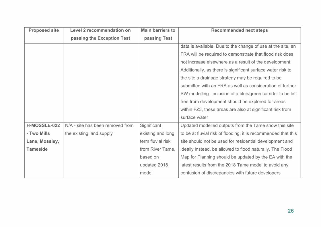
26
Proposed site Level 2 recommendation on
passing the Exception Test
Main barriers to
passing Test
Recommended next steps
data is available. Due to the change of use at the site, an
FRA will be required to demonstrate that flood risk does
not increase elsewhere as a result of the development.
Additionally, as there is significant surface water risk to
the site a drainage strategy may be required to be
submitted with an FRA as well as consideration of further
SW modelling. Inclusion of a blue/green corridor to be left
free from development should be explored for areas
within FZ3, these areas are also at significant risk from
surface water
H-MOSSLE-022
- Two Mills
Lane, Mossley,
Tameside
N/A - site has been removed from
the existing land supply
Significant
existing and long
term fluvial risk
from River Tame,
based on
updated 2018
model
Updated modelled outputs from the Tame show this site
to be at fluvial risk of flooding, it is recommended that this
site should not be used for residential development and
ideally instead, be allowed to flood naturally. The Flood
Map for Planning should be updated by the EA with the
latest results from the 2018 Tame model to avoid any
confusion of discrepancies with future developers

27
Proposed site Level 2 recommendation on
passing the Exception Test
Main barriers to
passing Test
Recommended next steps
H-MOSSLE-
131- Queen
Street,
Mossley,
Tameside
It is likely this site will pass the ET,
based on updated Tame 2018
model
Fluvial risk; long
term from climate
change
The site has no history of previous planning applications.
The Flood Map for Planning should be updated by the EA
with the latest results from the 2018 Tame model to avoid
any confusion of discrepancies with future developers.
Tameside Council has noted that the current FZ3a extent
in the site appears to be due to the footprints of former
buildings, the yield identified in the baseline supply has
been reduced to account for the FZ constraint. This area,
including accounting for climate change, is recommended
to be left as open greenspace. An FRA should inform the
site design including the greenspace as well as
investigating opportunities for SuDS. A drainage strategy
will also be required to be submitted to ensure that
drainage can be managed and the development will be
safe for its lifetime
H-MOSSLE-132
- Audley Street,
Mossley, OL5
9WH
It is likely this site will pass the ET,
based on updated Tame 2018
model
Uncertainty in
achieving safe
access and
egress; fluvial
Any development in this site should avoid areas within
FZ3a, including accounting for climate change from the
udpated Tame model. Tameside Council notes that the
FZ3a extent appears to be dictated to a large extent by

28
Proposed site Level 2 recommendation on
passing the Exception Test
Main barriers to
passing Test
Recommended next steps
climate change
risk
the footprints of former buildings. The Flood Map for
Planning should be updated by the EA to include the
latest Tame model outputs. An FRA is required due to the
change in use at the site and should focus on achieving
safe access/egress to the site as the current proposed
alternative access is unlikely to be practical or feasible
due to third party landownership and presence of the
existing Tame Valley Trail. It is recommended that the
area at risk of flooding in the south of the site should be
converted to open greenspace
H-WATERL-050
- Park Bridge,
Ashton-under-
Lyne, OL6 8AW
N/A - Site has already had
planning permission granted
2D model
required for
onsite culverted
Main River (River
Medlock);
residual risk;
significant
surface water risk
This site has outine consent for residential development,
approved 4/2/19. This Level 2 SFRA should be revisited
and updated with the outcomes of site-specific FRA and
drainage strategy used in the planning application.
Further detailed 2D modelling of the River Medlock
including an assessment of the residual risk should be
carried out by an FRA. The Flood Map for Planning would
then need to be updated with this Medlock modelling.
Where possible, options for culvert removal should also

29
Proposed site Level 2 recommendation on
passing the Exception Test
Main barriers to
passing Test
Recommended next steps
be explored. Risk from surface water needs to be shown it
can be managed safely for the lifetime of a development
through the FRA and accompnying drainage strategy
Trafford
1610- Lock
Lane, Trafford
Based on existing information this
site should pass the ET
Unclear risk from
MSC; awaiting
latest model
results
This Level 2 SFRA should be revisited once the the latest
MSC model is made available (late-2020). Based on the
existing information, the site would be likely to pass the
ET if development is able to avoid areas within FZ3a. An
FRA should include a drainage strategy to incorporate the
surface water risk into site design layout. The FRA should
also include emergency planning procedures with
particular consideration to achieving safe access and
egress to the site during times of flooding. A fully detailed
emergency plan must be included and consulted on with
Peel Ports
Wigan
SHLAA0023 -
Leyland Mill
Unlikely to pass ET unless
developable area reduced - direct
Fluvial risk from
River Douglas
with significant
FRA to examine reduction is developable area and
refocusing to eastern area in FZ1

30
Proposed site Level 2 recommendation on
passing the Exception Test
Main barriers to
passing Test
Recommended next steps
development to east of Leyland
Mill Lane
depths; residual
risk from adjacent
culvert
SHLAA0240 -
Barn Lane,
Golborne
Likely to pass ET assuming risk
area along Millingford Brook can
be included in a blue/green
corridor
Millingford Brook
flows directly
through the site
FRA to carry out 2D modelling of Millingford Brook;
surface water risk to also be mitigated within blue/green
corridor
SHLAA0325 -
Former Gas
Depot, York
Road, Ashton
This site is unlikely to pass the ET Significant fluvial
risk from onsite
culverted Main
River (Millingford
Brook); residual
risk; long term
risk from climate
change
There is currently a pending planning application on this
site for residential development, this has been objected to
by the EA on issues of flood risk. This Level 2 SFRA
should be revisited and updated with the outcomes of the
FRA used in the planning application. Based on available
information, it is recommended that this site should not be
developed and be left as open greenspace with options
for culvert removal to be investigated
SHLAA0405 -
Land adjacent
to Premier Inn,
This site is unlikely to pass the ET
unless development can be
directed to areas within FZ1,
reducing developable area
Significant
residual existing
risk and long term
It is possible that Wigan Council will amend the site
boundary to reflect the developable area that avoids flood
risk. The council notes that this area could be left for car
parking. An FRA should include a drainage strategy to

31
Proposed site Level 2 recommendation on
passing the Exception Test
Main barriers to
passing Test
Recommended next steps
Harrogate
Street
fluvial risk from
River Douglas
ensure that for any proposed new development, that
drainage can successfully be managed for the its lifetime.
An FRA should also include a detailed emergency plan
detailing safe access/egress routes and evacuation
procedures during flood events