placer county tahoe basin area plan
TRANSCRIPT

Placer County Tahoe Basin Area Plan
Implementing Regulations
January 2017
Disclaimer The statements and conclusions of this report are those of the GRANTEE and/or Subcontractor and not necessarily those of the Strategic Growth Council or the Department of Conservation, or its employees. The Strategic Growth Council and the Department make no warranties, express or implied, and assume no liability for the information contained in the succeeding text.

Placer County Tahoe Basin Area Plan
Implementing Regulations
January 2017
Prepared by: Placer County Planning Services Division
Tahoe Regional Planning Agency
Dyett & Bhatia Urban and Regional Planning
Stockham Consulting
Adopted by the Placer County Board of Supervisors:
December 6, 2016 Adopted by TRPA Governing Board:
January 25, 2017 Amended by the Placer County Board of Supervisors:
December 15, 2020 Amended by TRPA Governing Board:
February 24, 2021


This page intentionally left blank.

Table of Contents
1.01 Purpose .................................................................................................................................................... 1
1.02 Authority ................................................................................................................................................. 1
1.03 Applicability ........................................................................................................................................... 1
1.04 Administration ..................................................................................................................................... 3
1.05 Planning ................................................................................................................................................... 5
1.06 Definitions of Terms and Uses ....................................................................................................... 7
2.01 Zones and Districts ............................................................................................................................. 9
2.02 Zoning Map .......................................................................................................................................... 13
2.03 Residential Districts ........................................................................................................................ 19
2.04 Mixed-Use Districts ....................................................................................................................... 103
2.05 Community Service Districts .................................................................................................... 192
2.06 Conservation Districts ................................................................................................................. 212
2.07 Recreation Districts ...................................................................................................................... 230
2.08 Tourist Planned Development ................................................................................................. 256
2.09 Overlay Districts ............................................................................................................................ 259
2.10 Gateway Areas ................................................................................................................................ 262
3.01 Permissible Uses ............................................................................................................................ 263
3.02 Temporary Uses, Structures, and Activities ....................................................................... 263
3.03 Land Coverage ................................................................................................................................ 263
3.04 Density ............................................................................................................................................... 263
3.05 Basic Services .................................................................................................................................. 264
3.06 Streetscape and Roadway Design Standards ..................................................................... 264
3.07 Parking and Access ....................................................................................................................... 273
3.08 Natural Hazards. ............................................................................................................................ 291
3.09 Design Standards and Guidelines ........................................................................................... 291
3.10 Height ................................................................................................................................................. 306
3.11 Signs .................................................................................................................................................... 306
3.12 Subdivision ....................................................................................................................................... 313
3.13 Allocation of Development ........................................................................................................ 314
3.14 Transfer of Development ........................................................................................................... 314
3.15 Bonus Unit Incentives .................................................................................................................. 316
3.16 Individual Parcel Evaluation System ..................................................................................... 316
3.17 Water Quality .................................................................................................................................. 316
3.18 Vegetation and Forest Health ................................................................................................... 316
3.19 Wildlife Resources ........................................................................................................................ 316
3.20 Fish Resources ................................................................................................................................ 316
3.21 Livestock Grazing .......................................................................................................................... 316
3.22 Air Quality/Transportation ....................................................................................................... 316
3.23 Scenic Quality .................................................................................................................................. 316
3.24 Historic Resource Protection .................................................................................................... 316
3.25 Noise ................................................................................................................................................... 317
3.26 Shorezone ......................................................................................................................................... 317
List of Figures Tahoe Basin Area Plan Zoning .................................................................................................................. 14
Greater Tahoe City Sub Area ..................................................................................................................... 15
North Tahoe East Sub Area ........................................................................................................................ 16
North Tahoe West Sub Area ...................................................................................................................... 17
West Shore Sub Area .................................................................................................................................... 18
Greater Tahoe City: Mixed Use Districts ........................................................................................... 107
North Tahoe East: Mixed Use Districts .............................................................................................. 134
North Tahoe West: Mixed Use Districts ............................................................................................. 158
West Shore: Mixed Use Districts ........................................................................................................... 178
Tahoe City Town Center Pedestrian and Shared Use Path Improvements ........................ 269
Kings Beach Town Center Pedestrian and Shared Use Path Improvements ..................... 270

1
Chapter 1 Introduction and General Provisions Purpose
A. The Tahoe Regional Planning Agency (TRPA) and Placer County have found that there is a mutually beneficial need to provide Placer County, and other local jurisdictions, the option to prepare and implement Area Plans, provided such Area Plans conform with and further the Goals and Policies of the TRPA Regional Plan.
B. These Area Plan Regulations implement development standards and guidelines in accordance with goals, policies and programs of the Regional Plan and the Area Plan.
C. The Placer County Tahoe Basin Area Plan (Area Plan), in association with a Memorandum of Understanding (MOU) approved by the County and TRPA, enables TRPA to delegate limited development permitting authority to the County subject to appeal provisions to TRPA.
D. The delegation of approval of certain development activities set forth in the Area Plan and MOU has been found to not have a substantial effect on the natural resources in the Tahoe Region. Permitting authority as allowed and set forth in an MOU enables TRPA to focus its resources on projects of regional concern, while still maintaining an active and effective oversight role in the implementation of Area Plans.
Authority
Pursuant to the TRPA Regional Plan and Code of Ordinances, Chapter 13, Area Plans, the County adopts the regulations in this document to implement the Area Plan in the portions of Placer County located within the Lake Tahoe Regional Planning area.
Applicability
The provisions of this document apply to all land uses, development, and projects occurring within the Placer County Tahoe Basin Area Plan area. The boundaries of the Area Plan include all land within Placer County under the jurisdiction of TRPA.
A. All development within the Tahoe Region is required by federal and State law to comply with the Tahoe Regional Planning Compact (Public Law 96-551), Regional Plan, Code of Ordinances, and other provisions of TRPA.
B. No Area Plan may limit TRPA’s responsibility to enforce the Tahoe Regional Planning Compact, Regional Plan, TRPA Code of Ordinances, or other plan or regulation adopted by TRPA.
C. All regulations of the TRPA Code of Ordinances shall remain in effect unless superseded by the provisions of this Area Plan. This document supersedes Chapter 36, Design Standards, of the TRPA Code of Ordinances in the Mixed Use Subdistricts. This document supersedes Chapter 34, Driveway and Parking Standards and Chapter 38, Signs, of the TRPA Code of Ordinances in the entire Plan area.
D. In order to retain long-standing development standards for areas that were within Community Plans prior to adoption of the Area Plan and are not included in the Town

Placer County
2
Center Overlay District, provisions of the TRPA Code of Ordinances that apply to Community Plans and Community Plan Areas shall continue to apply.
Exceptions to this standard are as follows:
Chapter 11, Plan Area Statements and Plan Area Maps and Chapter 12, Community Plans, of the TRPA Code of Ordinances do not apply to adopted Area Plans; and
When standards for Town Centers address the same topic as a TRPA standard for Community Plans, the standards for Town Centers shall apply within the Town Center Overlay District.
Zoning subdistricts where TRPA Code of Ordinances Community Plan standards apply are as follows:
The former Tahoe City Community Plan includes all subdistricts within the Tahoe City Town Center plus the Fairway Service Subdistrict.
The former Kings Beach Community Plan includes all subdistricts within the Kings Beach Town Center.
The former North Stateline Community Plan includes the MU-TOR (Mixed-Use – Tourist) Subdistrict within the North Stateline Town Center.
The former Tahoe Vista Community Plan includes the MU-CCW (Mixed Use – Community Center West), MU-CCE (Mixed-Use – Community Center East), MU-GW (Mixed Use – Gateway West), and MU-GE (Mixed Use – Gateway East) Subdistricts.
The former Carnelian Bay Community Plan includes the MU-NC (Mixed-Use – Neighborhood Commercial) Subdistrict.
The former Kings Beach Industrial Community Plan includes the Kings Beach Industrial Subdistrict.
E. The Placer County Code applies to the area within a conforming Area Plan to the extent that a provision is not in conflict with the TRPA Code of Ordinances or this document.
F. In case of conflicts between the provisions of this Area Plan and other TRPA Code of Ordinances provisions, the most restrictive provision applies. In all other cases, the Area Plan provisions apply.
G. Upon adoption, the provisions of the Area Plan will supersede the six Community Plans and 51 Plan Area Statements that were previously adopted by Placer County and TRPA for the area. It will also replace two previously adopted Placer County General Plans.
H. Upon adoption, the provisions of the Area Plan will supersede the Placer County Standards and Guidelines for Signage, Parking, and Design that were previously adopted as substitute standards for certain areas by Placer County and TRPA.
Implementing Regulations
3
Administration
A. General. The General Provisions of the TRPA Code of Ordinances apply within this Area Plan, including Chapter 1, Introduction; Chapter 2, Applicability of the Code of Ordinances; Chapter 3, Environmental Documentation; Chapter 4, Required Findings; Chapter 5, Compliance; Chapter 6, Tracking, Accounting, and Banking; and Chapter 13, Area Plans.
B. Area Plan Memorandum of Understanding. After TRPA finds that the Placer County Tahoe Basin Area Plan is in conformance with the Regional Plan, TRPA and Placer County shall enter into a Memorandum of Understanding (MOU) that clearly specifies the extent to which the activities within the Area Plan are delegated or exempt from TRPA review and approval, and describes all procedures and responsibilities to ensure effective implementation of the Area Plan. The MOU shall be developed pursuant to Section 13.7, Procedures for Adoption of Memorandum of Understanding, of the TRPA Code of Ordinances.
C. Project Review Procedures. For TRPA project review responsibilities that are delegated to the County through an MOU, the County shall follow all procedures and timelines established in the TRPA Code of Ordinances, the Placer County Zoning Ordinance, and the Area Plan MOU. For project review responsibilities not delegated to the County through an MOU, TRPA and Placer County shall follow their separate review procedures and timelines.
D. Monitoring, Certification, and Enforcement of the Area Plan. The Area Plan MOU shall specify monitoring, certification, and enforcement provisions for the Placer County Tahoe Basin Area Plan pursuant to Section 13.8, Monitoring, Certification, and Enforcement of Area Plan, of the TRPA Code of Ordinances.
E. Design Review Required for Commercial and Multi-Family Residential Development, and All Development in Designated Scenic Areas. No sign installation or construction, renovation, remodeling, reconstruction, demolition, or other alteration of a building, structure, or site shall occur before obtaining design review approval as set forth in Placer County Code Section 17.52.070(D), Procedure for Design Review Approval, of the Placer County Zoning Ordinance.
F. Authority to Condition Development Permits.
Whenever these regulations or TRPA Code of Ordinances authorizes an advisory or decision-making official or entity to condition applications for development permits, the official or entity, after review of the application and other pertinent documents and any evidence made part of the record of the public hearing, may, in addition to those standards and special conditions required for particular types of development permits, impose additional conditions reasonably necessary to assure the following:
Conformity with the Goals and Policies embodied in the TRPA Regional Plan and Code of Ordinances;
Conformity with standards which are generally or specially applicable to particular uses, including specific conditions relative to operation of the use;
Placer County
4
Compatibility between the proposed development and adjacent development and neighborhoods;
Preservation of the character and integrity of adjacent development and neighborhoods; and
Protection of the health, safety, and general welfare of the citizens of the County.
Where additional conditions are imposed, the official or entity imposing the conditions shall make findings which embody the basic purpose of the conditions placed on the application. The conditions imposed by an advisory or decision-making official or entity may be modified subsequently by the final decision-making body or by the appellate body upon appeal of those conditions.
G. Activities Requiring TRPA Approval. Projects that meet one of the following criteria require review and approval by TRPA and may not be delegated by the MOU:
All development within the Conservation and Backcountry Districts, as shown on Map 1, Conceptual Regional Land Use Map, of the TRPA Regional Plan.
All development within the Shorezone of Lake Tahoe.
All development within a Town Center meeting the following criteria:
Residential projects with 50,000 or more square feet of new building floor area.
Non-residential projects with 40,000 or more square feet of new building floor area.
All development not in a Town Center meeting the following criteria:
Residential projects with 25,000 or more square feet of new building floor area.
Non-residential projects with 12,500 or more square feet of new building floor area.
Any projects with non-contiguous project sites (also see Section 2.09.A.3 of this document).
H. Appeals. An “aggrieved person” as defined in Article VI(j)(3) of the Tahoe Regional Planning Compact, by a final determination on a development permit by the County made pursuant to TRPA’s delegated authority, may appeal to TRPA pursuant to Section 13.9, Appeals, of the TRPA Code of Ordinances.
I. Exhaustion Required. Appellants shall exhaust all administrative remedies provided by the Placer County prior to appealing a decision to TRPA (see Placer County Code Sections 16.04.090 and 17.60.110).
J. Expiration of Approvals. All entitlement approvals shall expire if they do not meet the provisions of Section 2.2.4, Expiration of TRPA Approvals, of the TRPA Code of Ordinances and Section 17.58.160, Permit Time Limits, Exercising of Permits, and Extensions, of the Placer County Zoning Ordinance (see Placer County Code Section 16.12.120 and 16.24.070).

Implementing Regulations
5
K. Amendment to the Area Plan.
Applications for an amendment to the Area Plan or its implementing Regulations, including Zoning Map amendments, shall be processed according to the procedures of 17.60.090, Chapter or Plan Amendments and Rezoning, of the Placer County Zoning Ordinance.
As part of the application review process, the County shall forward the proposed amendment to TRPA for review in accordance with Section 13.8.1, Notification to TRPA of Proposed Activities Requiring Public Notification in Area Plans, of the TRPA Code of Ordinances, and as further specified in the Area Plan MOU.
If an amendment is approved by the County, the approved Area Plan amendment shall be reviewed by the TRPA Advisory Planning Commission and Governing Board for conformity with the requirements of the Regional Plan in accordance with Section 13.6.6, Conformity Review for Amendments to Area Plans, of the TRPA Code of Ordinances.
L. Conformity Review for Amendments Made by TRPA to the Regional Plan that Affect an Area Plan. If TRPA approves an amendment to the Regional Plan that would also require amendment of the Placer County Tahoe Basin Area Plan to maintain conformity, Placer County shall amend the Area Plan within one year to demonstrate conformity with the TRPA amendment in accordance with Section 13.6.7, Conformity Review for Amendments Made by TRPA to the Regional Plan that Affect an Area Plan, of the TRPA Code of Ordinances.
Planning
A. TRPA Regional Plan Maps. TRPA and the County shall continue to coordinate Geographic Information Systems (GIS) data to ensure that both agencies have access to the official TRPA maps listed in Chapter 10, TRPA Regional Plan Maps, of the TRPA Code of Ordinances, as well as other information necessary to implement conforming Area Plans.
B. Plan Area Statements and Community Plans. The provisions of Chapter 11, Plan Area Statements and Plan Area Maps, and Chapter 12, Community Plans, of the TRPA Code of Ordinances shall not be applicable once the Placer County Tahoe Basin Area Plan is adopted.
C. Area Plans. The County, in coordination with TRPA, shall process all modifications to the Placer County Tahoe Basin Area Plan, in accordance with Chapter 13, Area Plans, of the TRPA Code of Ordinances.
D. Specific and Master Plans. TRPA, in coordination with the County, shall process all requests for specific and master plans in accordance with Chapter 14, Specific and Master Plans, of the TRPA Code of Ordinances.
E. Environmental Improvement Program. TRPA is responsible for coordinating the Environmental Improvement Program as discussed in Chapter 15, Environmental Improvement Program, of the TRPA Code of Ordinances. The County is responsible for developing and implementing Environmental Improvement Projects to assist in the attainment and maintenance of the Environmental Threshold Carrying Capacities.
Placer County
6
F. Regional Plan and Environmental Threshold Review. TRPA is responsible for conducting regional plan and environmental threshold review in accordance with Chapter 16, Regional Plan and Environmental Threshold Review, of the TRPA Code of Ordinances.
G. Types of Permits Required. When the tables in Chapter 2 of these Regulations show a particular land use as being allowable within a subdistrict, the use is identified as being subject to one of the land use permit requirements listed below. The permit requirements reflect Placer County procedures and assume that permitting has been delegated to Placer County through an Area Plan MOU. For projects not subject to delegated permitting, Allowed (“A” uses) and Administrative Review Permits (“C” uses) shall be processed as TRPA Allowed (A) uses in accordance with Section 21.2.1, Allowed Uses, of the TRPA Code of Ordinances; and Minor Use Permits (“MUP” uses) and Conditional Use Permits (“CUP” uses) shall be processed as TRPA Special (S) uses in accordance with Section 21.2.2, Special Uses, of the TRPA Code of Ordinances. Land uses that are not listed on the tables in Chapter 2, or are not shown in a particular subdistrict, are not allowed.
Allowed (A). These uses are allowable subject to Zoning Clearance (“A” uses on the tables). Zoning Clearance is a routine land use approval that involves Placer County Planning Services Division staff checking a proposed development to ensure that all applicable zoning requirements will be satisfied (e.g., setbacks, height limits, parking requirements). Zoning Clearance is required by these Regulations for land uses that are consistent with the basic purposes of the particular district or subdistrict (e.g., houses in residential zones), and are unlikely to create any problems that will not be adequately handled by the applicable requirements.
Administrative Review Permit (C). These uses are allowable subject to approval of an Administrative Review Permit (see Placer County Code Section 17.58.100). Administrative Review Permit approval is required for certain land uses that are generally consistent with the purposes of the subdistrict, but could create minor problems for adjoining properties if they are not designed with sensitivity to surrounding land uses. The purpose of an Administrative Review Permit is to allow Placer County Planning Services Division staff and the Placer County Zoning Administrator to to determine if a use is in substantial conformance with approved development and design standards and guidelines.
Minor Use Permit (MUP). These uses are allowable subject to approval of a Minor Use Permit (“MUP”) (Placer County Code Section 17.58.120). Minor Use Permit approval is required for certain land uses that are generally consistent with the purposes of the subdistrict, but could create problems for adjoining properties, the surrounding area, and their populations if such uses are not designed to be compatible with surrounding land uses. The purpose of a Minor Use Permit is to allow Placer County Planning Services Division staff and the Placer County Zoning Administrator to evaluate a proposed use to determine if problems may occur, to provide the public with an opportunity to review the proposed project and express their concerns in a public hearing, to work with the project applicant to adjust the project through conditions of approval to solve any potential problems that are

Implementing Regulations
7
identified, or to disapprove a project if identified problems cannot be acceptably corrected.
Conditional Use Permit (CUP). These uses are allowable subject to approval of a Conditional Use Permit (“CUP”) (Placer County Code Section 17.58.130). Conditional Use Permit approval is required for certain land uses that may be appropriate in a subdistrict, depending on the design of the individual project and the characteristics of the proposed site and surroundings. Such uses can either raise major land use policy issues or could create serious problems for adjoining properties, the surrounding area, and their populations if they are not appropriately located and designed. The purpose of a Conditional Use Permit is to allow Placer County Planning Services Division staff and the Placer County Planning Commission to evaluate a proposed use to determine if problems may occur, to provide the public with an opportunity to review the proposed project and express their concerns in a public hearing, to work with the project applicant to adjust the project through conditions of approval to solve any potential problems that are identified, or to disapprove a project if identified problems cannot be acceptably corrected.
Definitions of Terms and Uses
A. Terms. The terms used in this document are defined in the TRPA Code of Ordinances, Chapter 90, Definitions.
B. Uses. Land Uses in this document are defined in Chapter 21, Permissible Uses, of the TRPA Code of Ordinances.
C. Shorezone Uses. Shorezone Uses in this document are defined in Chapter 81, Permissible Uses and Structures in the Shorezone and Lakezone, of the TRPA Code of Ordinances.

Placer County
8
This page intentionally left blank.

Implementing Regulations
9
Chapter 2 District Standards Zones and Districts
A. The Placer County Tahoe Basin Area Plan shall be classified into zoning subdistricts and zoning overlay districts. All property in the Area Plan is included in a zoning subdistrict. Some property is also included in one or more zoning overlay districts.
B. These Chapter 2 District Standards outline the allowed land uses and the development standards and guidelines for each zoning subdistrict and zoning overlay district. Chapter 2 standards and guidelines supplement the generally applicable development standards and guidelines that are outlined in Chapter 3: Area-Wide Standards and Guidelines.
C. Table 2.01.A-1 lists the zoning subdistricts and overlay districts. Subdistricts are organized as Residential Districts (Section 2.03), Mixed-Use Districts (Section 2.04), Community Service Districts (Section 2.05), Conservation Districts (Section 2.06), Recreation Districts (Section 2.07) and Tourist Planned Development Districts (Section 2.08). Zoning overlay districts are outlined in Section 2.09.
D. The Mixed-Use Subdistricts are classified within one of four subareas - Greater Tahoe City, North Tahoe East, North Tahoe West, and West Shore.
E. The location of each subdistrict and overlay district is depicted on the Area Plan zoning maps in Section 2.02.
TABLE 2.01.A-1: PLACER COUNTY TAHOE BASIN AREA PLAN SUBDISTRICTS AND OVERLAY DISTRICTS
Subdistrict Regional Plan
Land Use Designation Previous Plan Area Statement (PAS) Residential Subdistricts (Section 2.03)
Alpine Peaks Residential 167 Alpine Peaks
Brockway Residential 031 Brockway
Carnelian Bay Subdivision Residential 016B Carnelian Bay Subdivision
Carnelian Woods Residential 016A Carnelian Woods
Cedar Flat Residential 014 Cedar Flat
Chambers Landing Residential 156 Chambers Landing
Dollar Point Residential 010 Dollar Point
Fairway Tract Residential 002 Fairway Tract
Fairway Tract Northeast Residential 002 Fairway Tract Special Area #1
Fairway Tract South Residential 002 Fairway Tract Special Area #2
Flick Point/Agate Bay Residential 018 Flick Point/Agate Bay
Highlands Residential 011 Highlands
Homewood/Residential Residential 160 Homewood/Residential
Kings Beach Residential Residential 028 Kings Beach Residential
Kingswood East Residential 025 Kingswood East

Placer County
10
TABLE 2.01.A-1: PLACER COUNTY TAHOE BASIN AREA PLAN SUBDISTRICTS AND OVERLAY DISTRICTS
Subdistrict Regional Plan
Land Use Designation Previous Plan Area Statement (PAS) Kingswood West Residential 020 Kingswood West
Lake Forest Residential 008 Lake Forest
Lake Forest Glen Residential 007 Lake Forest Glen
Mark Twain Tract Residential 172 Mark Twain Tract
McKinney Tract Residential 158 McKinney Tract
Rocky Ridge Residential 005 Rocky Ridge
Sunnyside/Skyland Residential 164 Sunnyside/Skyland
Tahoe Estates Residential 021 Tahoe Estates
Tahoe Park/Pineland Residential 170 Tahoe Park/Pineland
Tahoe Pines Residential 161 Tahoe Pines
Tahoe Vista Residential Tourist 022 Tahoe Vista CP Special Area #6
Tahoe Vista Subdivision Residential 023 Tahoe Vista Subdivision
Tahoma Residential Residential 154 Tahoma Residential
Talmont Residential 168 Talmont
Tavern Heights Residential 171 Tavern Heights
Timberland Residential 165 Timberland
Woodvista Residential 027 Woodvista
Mixed-Use Subdistricts (Section 2.04) Greater Tahoe City Mixed Use Subdistricts
MU-TC Mixed-Use Town Center
Mixed-Use, Town Center 001A Tahoe City CP Special Area #1
Mixed-Use, Town Center 001A Tahoe City CP Special Area #2
Mixed-Use, Town Center 001A Tahoe City CP Special Area #3
Mixed-Use, Town Center 001A Tahoe City CP Special Area #5
Mixed-Use, Town Center 002 Fairway Tract Special Area #2
MU-N Mixed-Use Neighborhood Mixed-Use, Town Center 001A Tahoe City CP Special Area #5
MU-S Mixed-Use Service Mixed-Use, Town Center 001A Tahoe City CP Special Area #2
MU-NT Mixed-Use Neighborhood Tourist
Mixed-Use, Town Center 001A Tahoe City CP Special Area #4
MU-REC Mixed-Use Recreation
Mixed-Use, Town Center 001A Tahoe City CP Special Area #4
Mixed-Use, Town Center 001A Tahoe City CP Special Area #3
MUN-DH Mixed-Use Neighborhood Dollar Hill
Mixed-Use 009B Dollar Hill

Implementing Regulations
11
TABLE 2.01.A-1: PLACER COUNTY TAHOE BASIN AREA PLAN SUBDISTRICTS AND OVERLAY DISTRICTS
Subdistrict Regional Plan
Land Use Designation Previous Plan Area Statement (PAS)
MUN-LFG Mixed-Use Neighborhood Lake Forest Glen
Mixed-Use 007 Lake Forest Glen Special Area #1
North Tahoe East Mixed Use Subdistricts
MU-MTC Mixed-Use Mountainside Town Center
Mixed-Use, Town Center 029 Kings Beach CP Special Area #1
Mixed-Use, Town Center 029 Kings Beach CP Special Area #2 (East Entry)
Mixed-Use, Town Center 029 Kings Beach CP Special Area #2 (West Entry)
MU-LTC Mixed-Use Lakeside Town Center
Mixed-Use, Town Center
029 Kings Beach CP Special Area #2 (West Entry)
029 Kings Beach CP Special Area #3
MU-R Mixed-Use Residential Mixed-Use, Town Center 029 Kings Beach CP Special Area #4
MU-TOR Mixed-Use Tourist Tourist, Town Center 032 California North Stateline CP
MU-WREC
Mixed-Use Waterfront Recreation
Mixed-Use, Town Center
029 Kings Beach CP Special Area #2 (West Entry)
029 Kings Beach CP Special Area #3
029 Kings Beach CP Special Area #4
North Tahoe West Mixed Use Subdistricts
MU-GW Mixed-Use Gateway West Tourist 022 Tahoe Vista CP Special Area #1
MU-CCW Mixed-Use Community Center West
Tourist 022 Tahoe Vista CP Special Area #2
MU-CCE Mixed-Use Community Center East
Tourist 022 Tahoe Vista CP Special Area #3
MU-GE Mixed-Use Gateway East Tourist 022 Tahoe Vista CP Special Area #4
MU-NC Mixed-Use Neighborhood Commercial
Mixed-Use 017- Carnelian Bay CP
West Shore Mixed Use Subdistricts Tahoma Village Center Mixed-Use 155 Tahoma Commercial
Homewood Village Center Tourist 159 Homewood/Commercial
Sunnyside Village Center Mixed-Use 169 Sunnyside
Placer County
12
TABLE 2.01.A-1: PLACER COUNTY TAHOE BASIN AREA PLAN SUBDISTRICTS AND OVERLAY DISTRICTS
Subdistrict Regional Plan
Land Use Designation Previous Plan Area Statement (PAS) Community Service Subdistricts (Section 2.05)
Fairway Service Mixed-Use 001A Tahoe City Community Plan Special Area #2
Kings Beach Industrial Mixed-Use 026 Kings Beach Industrial CP
Lake Forest Commercial Mixed-Use 009A Lake Forest Commercial Special Area #1
009A Lake Forest Commercial Special Area #2
Tahoe City Industrial Mixed-Use 001B Tahoe City Industrial
Tahoe Vista Industrial Mixed-Use 022 Tahoe Vista CP Special Area #5
Conservation Subdistricts (Section 2.06)
Blackwood Conservation,
Recreation, Backcountry, Wilderness
162 Blackwood
Burton Creek Conservation 004 Burton Creek
Lower Ward Valley Conservation 163 Lower Ward Valley
Martis Peak Conservation 019 Martis Peak
McKinney Lake Conservation, Recreation 152 McKinney Lake
Watson Creek Conservation 013 Watson Creek
Recreation Subdistricts (Section 2.07)
64 Acre Tract Recreation 174 64 Acre Tract
Fish Hatchery Recreation 006 Fish Hatchery
Homewood Master Plan Conservation, Recreation 157 Homewood/Tahoe Ski Bowl
Lower Truckee Conservation, Recreation 003 Lower Truckee
North Star Recreation 015 North Star
North Tahoe High School Recreation 012 North Tahoe High School
North Tahoe Recreation Area Conservation, Recreation 024A North Tahoe Recreation Area
Snow Creek Conservation 024B Snow Creek
Tahoe City Golf Course Recreation 001A Tahoe City Community Plan Special Area #5
Recreation 002 Fairway Tract Special Area #2
Upper Ward Valley (also partially within the West Shore Subarea)
Conservation, Recreation 166 Upper Ward Valley
Tourist Planned Development Subdistricts (Section 2.08)
Granlibakken (also partially within the Greater Tahoe City Subarea)
Tourist 173 Granlibakken
Overlay Districts (Section 2.09)
Implementing Regulations
13
TABLE 2.01.A-1: PLACER COUNTY TAHOE BASIN AREA PLAN SUBDISTRICTS AND OVERLAY DISTRICTS
Subdistrict Regional Plan
Land Use Designation Previous Plan Area Statement (PAS) Town Center Overlay Multiple, Town Center Multiple
TCWE-SPA
Tahoe City Western Entry Special Planning Area
Mixed-Use, Town Center 001A Tahoe City CP Special Areas #1, #2 & #3
TCGC-SPA Tahoe City Golf Course Special Planning Area
Mixed-Use, Town Center
002 Fairway Tract Special Area #2
TRC-SPA Truckee River Corridor Special Planning Area
Recreation 003 Lower Truckee
KBE-SPA Kings Beach Entry Special Planning Area
Mixed-Use 029 Kings Beach Community Plan Special Area #2 (East Entry)
NS-SPA North Stateline Special Planning Area
Tourist, Town Center 032 California North Stateline Community Plan
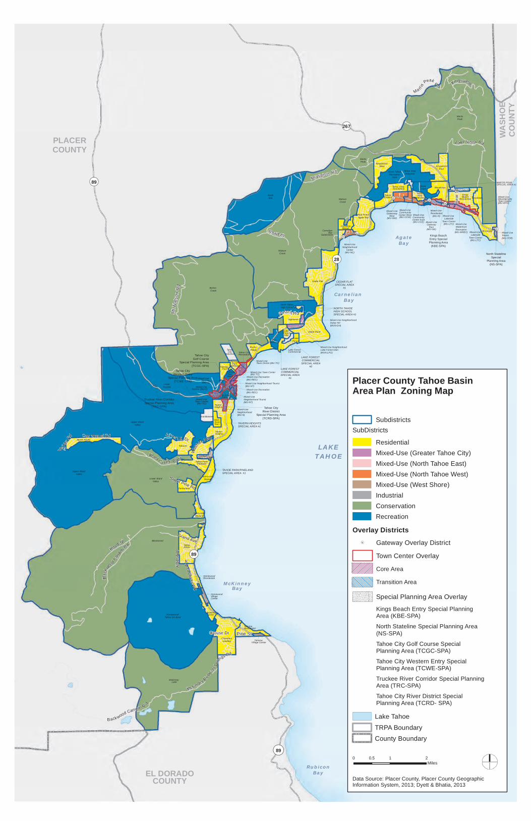
Zoning Map
A. The boundaries of the zoning subdistricts and overlay districts established by these Area Plan Regulations are shown on the Area Plan Zoning Map. Separate maps depicting The Greater Tahoe City, North Tahoe East, North Tahoe West and West Shore Subareas are also provided.
B. The boundaries of the zoning subdistricts and overlay districts generally follow the parcel lines in effect upon adoption of this Area Plan. In cases where a subdistrict or overlay zoning district does not follow a parcel boundary, the applicable subdistrict or overlay district applies to the portion of the parcel included in the subdistrict or overlay district. The zoning boundaries do not change if parcel boundaries are modified.
!(G
!(G!(G!(G
!(G!(G
Mixed-Use Town Center (MU-TC)
PLACERCOUNTY
EL DORADOCOUNTY
AgateBay
WASH
OECO
UNTY
Carnelian Bay
McKinneyBay
LAKETAHOE
RubiconBay
¬«89
¬«28
¬«267
¬«89
¬«89
Mt W
atso
n R
d
Road 38Grand Ave
Courchevel Rd
Road 49
Alde
r Ave
Grouse Dr
Sugar Pine Rd
Verb
ier R
d
Mt Watson Rd
B ack wood Canyon R d
Blac
kwoo
d Cany
onRd
Pine St
Ward C r eek B lvd
Silver Tip Dr
Bea
rSt
Polaris Rd
Lake Vist a Rd
Sacr
amen
toAv
e
Mckinney Ru bico
n Sprin
gs Rd
Was
hoe Way
Kingsview
Ma rt is P
eakRd
Blackwood
MartisPeak
Burton Creek
Upper Ward Valley
WatsonCreek
Mckinney Lake
LowerTruckee
NorthStar
Homewood/Tahoe Ski Bowl
Lower WardValley
Cedar Flat
Dollar Point
TahoePines
Brockway
Tavern Heights
Talmont
TahomaResidential
ChambersLanding
North TahoeRecreation
Area
KingswoodEast
Tahoe Park/Pineland
Alpine Peaks
Kingswood West
Sunnyside/Skyland
Timberland
Mckinney Tract
SunnysideVillage Center
CarnelianWoods
Mixed-UseNeighborhood
Center(MU-NC)
Homewood VillageCenter
Tahoma Village Center
Mixed-UseTourist(MU-TOR)
Carnelian Bay Subdivision
Flick Point/Agate Bay
KingsBeachResidential
Kings Beach Industrial TahoeEstates
Homewood Residential
Upper Ward Valley
Mark TwainTract
Granlibakken
TahoeCityIndustrial
Rocky Ridge
Highlands
North TahoeHigh School
Fish Hatchery
Mixed-Use NeighborhoodDollar Hill(MUN-DH)
Lake Forest
Lake ForestGlen
Lake Forest Commercial
Fairway Tract NortheastFairway Tract
Woodvista
Mixed-UseWaterfrontRecreation
(MU-WREC) Mixed-Use Lakeside
Town Center(MU-LTC)
SnowCreek
Fairway TractSouth
Mixed-UseGatweway
West(MU-GW)
Mixed-UseCommunityCenter West(MU-CCW)
Mixed-UseCommunityCenter East(MU-CCE) Mixed-Use
GatewayEast
(MU-GE)
TahoeVistaSubdivision Mixed-UseMountainsideTown Center(MU-MTC)
Mixed-Use Lakeside
Town Center(MU-LTC)
Mixed-Use Residential
(MU-R)
MartisPeak
Tahoe VistaIndustrial
Tahoe VistaResidential
WatsonCreek
Mixed-Use NeighborhoodLake Forest Glen(MUN-LFG)
Mixed-Use Service (MU-S)
Mixed-Use Town Center(MU-TC)
Mixed-Use Neighborhood (MU-N)
Tahoe City Recreation
Mixed-Use Neighborhood Tourist(MU-NT)
Mixed-Use Recreation (MU-REC)
64 Acre Tract
Tavern Heights
Mixed-Use Service (MU-S)
Mixed-Use Neighborhood Tourist(MU-NT)
Mixed-Use Recreation (MU-REC)
Mixed-Use Town Center(MU-TC)
Sunnyside/Skyland
Brockway
Truckee River CorridorSpecial Planning Area
(TRC-SPA)
Tahoe CityWestern Entry
Special Planning Area(TCWE-SPA)
Tahoe CityGolf Course
Special Planning Area(TCGC-SPA)
North StatelineSpecial
Planning Area(NS-SPA)
Kings BeachEntry SpecialPlanning Area
(KBE-SPA)
MARTIS PEAKSPECIAL AREA #1
CEDAR FLATSPECIAL AREA
#1
LAKE FOREST COMMERCIALSPECIAL AREA
#2
NORTH TAHOE HIGH SCHOOLSPECIAL AREA #1
LAKE FORESTCOMMERCIALSPECIAL AREA
#1
TAVERN HEIGHTS SPECIAL AREA #1
TAHOE PARK/PINELANDSPECIAL AREA #1
Tahoe CityRiver District
Special Planning Area(TCRD-SPA)
0 1 20.5Miles
Placer County Tahoe Basin Area Plan Zoning Map
Data Source: Placer County, Placer County GeographicInformation System, 2013; Dyett & Bhatia, 2013
Lake TahoeTRPA BoundaryCounty Boundary
SubdistrictsSubDistricts
ResidentialMixed-Use (Greater Tahoe City)Mixed-Use (North Tahoe East)Mixed-Use (North Tahoe West)Mixed-Use (West Shore)IndustrialConservationRecreation
Overlay Districts!(G Gateway Overlay District
Town Center Overlay
Core Area
Transition Area
Special Planning Area Overlay
Kings Beach Entry Special PlanningArea (KBE-SPA)
North Stateline Special Planning Area(NS-SPA)
Tahoe City Golf Course SpecialPlanning Area (TCGC-SPA)
Tahoe City Western Entry SpecialPlanning Area (TCWE-SPA)
Truckee River Corridor Special PlanningArea (TRC-SPA)
Tahoe City River District SpecialPlanning Area (TCRD- SPA)

LAKETAHOE
¬«28
¬«89
¬«89
MT
WAT
SON
RD
CHIN
QUAPIN
LAKE FOREST RD
ROCK
YRI
DG
E
W RIVER RD
GR
ANLI
BAKK
EN
RDTruckee River CorridorSpecial Planning Area
(TRC-SPA)
Mixed-Use NeighborhoodDollar Hill(MUN-DH)
Lake ForestCommercial
Special Area #1
Mixed-Use Neighborhood(MU-N)
Mixed-Use Recreation(MU-REC)
Mixed-Use Town Center
(MU-TC)
Tahoe CityWestern Entry
Special Planning Area(TCWE-SPA)
Tahoe CityGolf Course
Special Planning Area(TCGC-SPA)
Mixed-Use Recreation(MU-REC)
Mixed-UseNeighborhood Tourist (MU-NT)
NORTH TAHOEHIGH SCHOOL
SPECIAL AREA # 1
Lake ForestCommercial
Special Area #2
Tavern HeightsSpecial Area #1
N LAKE BLVD
POLARIS RD
FAIR
WAY
DR
EDGEWATER DR
OBSERVATION DR
MAMMOTH DRLASSEN DR
EDGEWOOD DR
GROVE ST
PANORAMA DR
WATSON DR
VILLAS RD
MT WATSON RD
Burton Creek
Lower Truckee
Upper Ward Valley
Dollar Point
Watson Creek
Highlands
North Tahoe High School
Rocky Ridge
Lake Forest
Fish Hatchery
Tavern Heights
Fairway Tract
64 Acre Tract
Granlibakken
Tahoe City
Industrial
Lake Forest Glen
Mixed-Use Town Center(MU-TC)
Fairway Tract NortheastTahoe City
Golf Course
Lake Forest Commercial
Mark Twain Tract
Mixed-Use Neighborhood(MU-N)
Mixed-Use Neighborhood Lake Forest Glen
(MUN-LFG)Mixed-Use Recreation (MU-REC)Fairway
Tract South
Mixed-UseService (MU-S)
Mixed-UseNeighborhood Tourist (MU-NT)
Fairway Industrial
Tahoe CityRiver District
Special Planning Area(TCRD-SPA)
Lake ForestSpecial Area #1
0 0.5 10.25Miles
GREATER TAHOE CITY PLAN AREASubdistricts
Residential
Commercial and Industrial
Conservation
Recreation
Tourist Planned Development
Mixed-Use (Greater Tahoe City)
Mixed-Use Recreation (MU-REC)
Mixed-Use Neighborhood Tourist (MU-NT)
Mixed-Use Town Center (MU-TC)
Mixed-Use Service (MU-S)
Mixed-Use Neighborhood (MU-N)
Mixed-Use Neighborhood Dollar Hill (MUN-DH)
Mixed-Use Neighborhood Lake Forest Glen (MUN-LFG)
Overlay DistrictsTown Center Overlay
Core Area
Transition Area
Tahoe City Golf Course Special Planning Area (TCGC-SPA)
Tahoe City River District Special Planning Area (TCRD-SPA)
Tahoe City Western Entry Special Planning Area (TCWE-SPA)
!(G
!(G!(G
Brockway
Mixed-Use Tourist
(MU-TOR)
Kings BeachEntry SpecialPlanning Area
(KBE-SPA)
Mixed-Use Waterfront Recreation (MU-WREC) Mixed-Use
Lakeside Town Center
(MU-LTC)
North StatelineSpecial
Planning Area(NS-SPA)
Mixed-Use Mountainside Town Center
(MU-MTC)
LAKETAHOEAgate
Bay
¬«28
¬«267
CALIF
ORNIA
NEVA
DA
N LAKE BLVD FOX
ST
BEAVER
ST
CO
ON
ST
DEE
R S
T
BEA
R S
T
SPECKLED AVE
PAR
K LN
GOLDEN AVERAINBOW AVE
CUTTHROAT AVE
TROUT AVE
DOLLY VARDEN AVE
BROOK AVE
LOCH LEVON AVE
BEND
AVE
SALMON AVE
WO
LF S
T
CH
IPM
UN
K S
T
LAKE VISTA DR
YACHT ST
BROCKWAY VISTA AVE
SEC
LIN
E S
T
LAKE ST
WINDSOR DR
NORTHSHORE BLVD
COMMON WE
ALT
HD
R
CANTEBU RY DR
BRO
CK
WAY
SPRI NGS RD
HAR
BO
RAV
E
Martis Peak
Brockway
Kingswood East
Kings Beach
Residential
Woodvista
Kings Beach IndustrialMixed-Use Mountainside Town Center
(MU-MTC)
Mixed-Use Residential
(MU-R) Mixed-Use Waterfront Recreation (MU-WREC)
MARTIS PEAK SPECIAL AREA
#1
NORTH TAHOE EAST SUB AREA
0 0.45 0.90.225Miles
Special Areas
!(G Gateway
SubdistrictsResidential
Commercial and Industrial
Conservation
Mixed-Use (North Tahoe East)
Mixed-Use Lakeside Town Center (MU-LTC)
Mixed-Use Mountainside Town Center (MU-MTC)
Mixed-Use Residential (MU-R)
Mixed-Use Tourist (MU-TOR)
Mixed-Use Waterfront Recreation (MU-WREC)
Overlay DistrictTown Center Overlay
Core Area
Transition Area
Special Planning Area Overlay
! ! ! ! ! ! ! ! ! ! ! ! ! ! ! ! ! ! ! ! ! ! ! ! ! ! ! ! ! ! ! ! ! ! ! ! ! ! ! ! ! ! ! ! ! ! ! ! ! ! ! ! ! ! ! !! ! ! ! ! ! ! ! ! ! ! ! ! ! ! ! ! ! ! ! ! ! ! ! ! ! ! ! ! ! ! ! ! ! ! ! ! ! ! ! ! ! ! ! ! ! ! ! ! ! ! ! ! ! ! ! ! ! ! ! ! ! ! ! ! ! ! ! ! ! ! ! ! ! ! ! ! ! ! ! ! ! ! ! ! ! ! ! ! ! ! ! ! ! ! ! ! ! ! ! ! ! ! ! ! ! ! ! ! ! ! ! ! ! ! ! ! ! ! ! ! ! ! ! ! ! ! ! ! ! ! ! ! ! ! ! ! ! ! ! ! ! ! ! ! ! ! ! ! ! ! ! ! ! ! ! ! ! ! ! ! ! ! ! ! ! ! ! ! ! ! ! ! ! ! ! ! ! ! ! ! ! ! ! ! !
!!
!!
!!
!!
!!
!!
!!
!!
!!
!!
!!
!!
!!
!!
!!
!!
!!
!!
!!
!!
!!
!!
!!
!!
!!
!!
!!
!!
!!
!!
!!
!!
!!
!!
!!
!!
!!
!!
!!
!!
!!
!!
!!
!!
!!
!!
!!
!!
!!
!!
!!
!!
!!
!!
!!
!!
!!
!!
!!
!!
!!
!!
!!
!!
!!
!!
!!
!!
!!
!!
!!
!!
!!
!!
!!
!!
!!
!!
!!
!!
!!
!!
!!
!!
!!
!!
!!
!!
!!
!!
!!
!!
!!
!!
!!
!!
!!
!!
!!
!!
!!
!!
!!
!!
!!
!!
!!
!!
!!
!!
!!
!!
!!
!!
!!
!!
!!
!!
!!
!!
!!
!!
!!
!!
!!
!!
!!
!!
!!
!!
!!
!!
!!
!!
!!
!!
!!
!!
!
!(G!(G
!(G!(G
LAKETAHOE
AgateBay
CarnelianBay
¬«28
¬«267
N L
AKE
BLV
D
REGENCY WAY
NORTH AVE
NILE R
D
DO
DO
WAH
RD
SAHARA DR
AGATE RD
OLD COUNTY RD
SUNSET RD
NIG
HTIN
GALE R
D
DONNER RD
GRANITE RD
ESTA
TES
DR
JESTER CT
BRA
SSIE
AVE
SUD
AN R
D
MU
LETA
IL D
R
NO
RTH
RID
GE D
R
SUM
MIT
RD
OPH
IR S
T
TERRACE DR
FAW
N L
N
HAZEL AV
E
LACR
OSS
E DR
ON
YX ST
OLIVE ST
TIGER AVE
AGATAM AVE
LAU
RE
L D
R
WH
ITE
HA
LL
LARDIN CARNELIAN CIR
MT WATSON RD
K I NG
SW
AY
NATIO
NAL
AVE
BEA
CH
ST
Watson Creek
NorthStar
Cedar Flat
Martis Peak
North Tahoe Recreation
Area
Flick Point/Agate Bay
Tahoe Estates
Woodvista
Kingwood West
Snow Creek
Kingswood East
Carnelian Woods
Tahoe Vista
Subdivision
Mixed-Use Gateway
East (MU-GE)
CarnelianBay
Subdivision
Tahoe Vista Industrial
Mixed-Use Neighborhood Center (MU-NC)
Mixed-Use CommunityCenter West(MU-CCW)
Mixed-Use Community Center East(MU-CCE)
Tahoe VistaResidential
Mixed-Use Gateway
West(MU-GW)
Cedar FlatSpecial Area#1
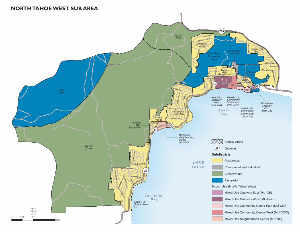
Special Areas
!(G Gateway
SubdistrictsResidential
Commercial and Industrial
Conservation
Recreation
Mixed-Use (North Tahoe West)
Mixed-Use Gateway East (MU-GE)
Mixed-Use Gateway West (MU-GW)
Mixed-Use Community Center East (MU-CCE)
Mixed-Use Community Center West (MU-CCW)
Mixed-Use Neighborhood Center (MU-NC)0 0.5 10.25
Miles
NORTH TAHOE WEST SUB AREA

!!!!
!!
!!
!!
!!
!!!!!!!!!!!!!
!!
!!
!!
!
!!!!!!!!!!!!!!!!!!!!!!!!!!!!!!!!!!!!!!!!!!
!!
!!
!!
!!
!!!!
!!!!!!!!!!
!!
!!!!!!!!!!!!!!!!!!!!!!!!!!!!!!!!!!!!!!!!!!!!!!!!!!!!!!!!!!!!!!!!!!!!!!!!!!!!!!!!!!
!!
!!
!!
!!
!!
!!
!!
!!
!!
!!
!!
!!
!!
!!
!!
!!
!!
!!
!!
!!
!!
!!
!!
!!
!!
!!
!!
!!
!!
!!
!!
!!
!!
!!
!!
!!
!!
!!
!!
!!
!!
!!
!!
!!
!!
!!
!!
!!
!!
!!
!!
!!
!!
!!
!!
!!
!!
!!
!!
!!
!!
!!
!!
!!
!!
!!
!!
!!
!!
!!
!!
!!
!!
!!
!!
!!
!!
!!
!!
!!
!!
!!
!!
!!
!!
!!
!!
!!
!!
!!
!!
!!
!!
!!
!!
!!
!!
!!
!!
!!
!!
!!
!!
!!
!!
!!
!!
!!!!!!!!!!!!!!!!!!!!!!!!!!!!!!!!!!!!!!!!!!!!!!!!!!!!!!!!!!!!!!!!!!!!!!!!!!!!!!!!!!!!!!!!!!!!!!!!!!!!!!!!!!!!
!!
!!
!!
!!!!!!!!
!!
!!
!!
!!
!!
!!
!!
!!!!!
LAKETAHOE
McKinneyBay
PLACER COEL DORADO CO
¬«89
¬«89
¬«28
WARD CREEK BLVD
GRAND AVE
COURCHEVEL RD SEQUOIA AVE
ALDER
AVE
PINE AVEGSTA
AD RD
INTE
RLAK
EN R
D
MCKINNEY DR
PARK AVE
WARD AVE
HO
LLY
RD
PINELAND DR
GROUSE DR
ROBIN R
D
FLICKER AVE
SUGAR PINE RD
TIMBERLAND LN
SACRAMENTO
AVE
CL
UB
DR
B
IGPI
NE
DR
SILVER TIP DR
RUBICON
CHERRY
FERN
OAK
TROUT
CAS
CADE DR
MCKINNE Y RUBICON SPRING
SRD
BARKER PASS RD
Sunnyside/Skyland
Blackwood
Upper Ward Valley
McKinney Lake
Lower WardValley
Homewood/Tahoe Ski Bowl
Talmont
Alpine Peaks
Tahoe Pines
Chambers Landing
TavernHeights
Tahoe Park/Pineland
Sunnyside/Skyland
Timberland
Tahoma Residential
McKinney Tract
HomewoodResidential
Mark Twain Tract
Sunnyside Village Center
Granlibakken
Homewood Village Center
Tahoma Village Center
Upper Ward Valley
TAHOE PARK/PINELANDSPECIAL AREA # 1
0 1 20.5Miles
Special Areas
SubdistrictsResidential
Tourist Planned Development
Recreation
Conservation
Mixed-Use (West Shore)
Sunnyside Village Center
Homewood Village Center
Tahoma Village Center
WEST SHORE SUB AREA

Implementing Regulations
19
Residential Districts
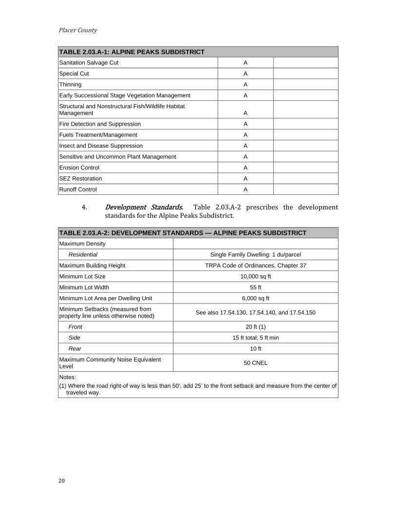
A. Alpine Peaks Subdistrict. The Alpine Peaks Subdistrict is located within the West Shore Subarea. The area should remain residential, maintaining the existing character of the neighborhood.
Special Designation. None.
Special Policies. Lots in this subdivision, whether sensitive or not, shall be eligible for
retirement pursuant to the Transfer Development Rights (TDR) provisions that would allow development rights to be transferred out of this Subdistrict.
There are problems with fire protection service and Tahoe City Public Utility District (TCPUD) service to this area due to its remote location. Buyout programs and other economic alternatives should be offered to the property owners in this area to encourage transfer out of existing developments.
Permissible Uses. The following primary uses may be permitted within all or a portion of the Subdistrict. The list indicates if the use is Allowed (A), subject to an Administrative Review Permit (C), or must be considered under the provisions for a Conditional Use Permit (CUP) or Minor Use Permit (MUP). Existing uses not listed shall be considered nonconforming uses within this Subdistrict. The establishment of new uses not listed shall be prohibited.
TABLE 2.03.A-1: ALPINE PEAKS SUBDISTRICT Allowable Land Uses Land Use Permit Add’l Regs.
Residential Single Family Dwelling A
Public Service Local Public Health and Safety Facilities MUP
Transit Stations and Terminals CUP
Pipelines and Power Transmission CUP
Transmission and Receiving Facilities MUP Placer County Code, Section 17.56.060.F
Transportation Routes CUP
Public Utility Centers MUP
Day Care Centers/Pre-Schools MUP
Threshold-Related Research Facilities MUP
Recreation Participant Sports Facilities MUP
Day Use Areas A
Riding and Hiking Trails A
Resource Management Reforestation A
Placer County
20
TABLE 2.03.A-1: ALPINE PEAKS SUBDISTRICT Sanitation Salvage Cut A
Special Cut A
Thinning A
Early Successional Stage Vegetation Management A
Structural and Nonstructural Fish/Wildlife Habitat Management A
Fire Detection and Suppression A
Fuels Treatment/Management A
Insect and Disease Suppression A
Sensitive and Uncommon Plant Management A
Erosion Control A
SEZ Restoration A
Runoff Control A
Development Standards. Table 2.03.A-2 prescribes the development standards for the Alpine Peaks Subdistrict.
TABLE 2.03.A-2: DEVELOPMENT STANDARDS — ALPINE PEAKS SUBDISTRICT Maximum Density
Residential Single Family Dwelling: 1 du/parcel
Maximum Building Height TRPA Code of Ordinances, Chapter 37
Minimum Lot Size 10,000 sq ft
Minimum Lot Width 55 ft
Minimum Lot Area per Dwelling Unit 6,000 sq ft
Minimum Setbacks (measured from property line unless otherwise noted) See also 17.54.130, 17.54.140, and 17.54.150
Front 20 ft (1)
Side 15 ft total; 5 ft min
Rear 10 ft
Maximum Community Noise Equivalent Level 50 CNEL
Notes: (1) Where the road right-of way is less than 50’, add 25’ to the front setback and measure from the center of
traveled way.
Implementing Regulations
21
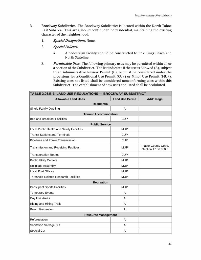
B. Brockway Subdistrict. The Brockway Subdistrict is located within the North Tahoe East Subarea. This area should continue to be residential, maintaining the existing character of the neighborhood.
Special Designations. None.
Special Policies. A pedestrian facility should be constructed to link Kings Beach and
North Stateline.
Permissible Uses. The following primary uses may be permitted within all or a portion of the Subdistrict. The list indicates if the use is Allowed (A), subject to an Administrative Review Permit (C), or must be considered under the provisions for a Conditional Use Permit (CUP) or Minor Use Permit (MUP). Existing uses not listed shall be considered nonconforming uses within this Subdistrict. The establishment of new uses not listed shall be prohibited.
TABLE 2.03.B-1: LAND USE REGULATIONS — BROCKWAY SUBDISTRICT Allowable Land Uses Land Use Permit Add’l Regs.
Residential Single Family Dwelling A
Tourist Accommodation Bed and Breakfast Facilities CUP
Public Service Local Public Health and Safety Facilities MUP
Transit Stations and Terminals CUP
Pipelines and Power Transmission CUP
Transmission and Receiving Facilities MUP Placer County Code, Section 17.56.060.F
Transportation Routes CUP
Public Utility Centers MUP
Religious Assembly MUP
Local Post Offices MUP
Threshold-Related Research Facilities MUP
Recreation Participant Sports Facilities MUP
Temporary Events A
Day Use Areas A
Riding and Hiking Trails A
Beach Recreation A
Resource Management Reforestation A
Sanitation Salvage Cut A
Special Cut A

Placer County
22
TABLE 2.03.B-1: LAND USE REGULATIONS — BROCKWAY SUBDISTRICT Thinning A
Early Successional Stage Vegetation Management A
Structural and Nonstructural Fish/Wildlife Habitat Management A
Fire Detection and Suppression A
Fuels Treatment/Management A
Insect and Disease Suppression A
Sensitive and Uncommon Plant Management A
Erosion Control A
SEZ Restoration A
Runoff Control A
Development Standards. Table 2.03.B-2 prescribes the development standards for the Brockway Subdistrict.
TABLE 2.03.B-2: DEVELOPMENT STANDARDS — BROCKWAY SUBDISTRICT Maximum Density
Residential Single Family Dwelling: 1 du/parcel
Bed and Breakfast Facilities Bed and Breakfast Facilities: 10 units per acre
Maximum Building Height TRPA Code of Ordinances, Chapter 37
Minimum Lot Size 10,000 sq ft
Minimum Lot Width 55 ft
Minimum Lot Area per Dwelling Unit 6,000 sq ft
Minimum Setbacks (measured from property line unless otherwise noted) See also 17.54.130, 17.54.140, and 17.54.150
Front 20 ft (1)
Side 15 ft total; 5 ft min
Rear 10 ft
Maximum Community Noise Equivalent Level 55 CNEL
Notes: (1) Where the road right-of way is less than 50’, add 25’ to the front setback and measure from the center of
traveled way.
Shorezone. Within the specified shorezone tolerance district, the following primary uses may be permitted by TRPA in the backshore, nearshore, and foreshore. Accessory structures shall be regulated pursuant to the regulations applicable to the primary use upon which they are dependent in accordance with the TRPA Code of Ordinances. The following structures may be permitted by TRPA in the shorezone as an Allowed (A) or Special (S) use only if they are accessory to an existing, allowed use located on the same or adjoining littoral parcel.

Implementing Regulations
23
TABLE 2.03.B-3: SHOREZONE — BROCKWAY SUBDISTRICT
Tolerance Districts 3 6 7 8 Primary Uses
Beach Recreation A A A
Safety and Navigational Devices A A A A
Salvage Operations A S S S
Accessory Structures Buoys A A A A
Piers A A A A
Fences S S S S
Boat Ramps S S S S
Breakwaters or Jetties S S S S
Shoreline Protective Structures S S S S
Floating Docks and Platforms A A A A
Water Intake Lines S S S S
Placer County
24
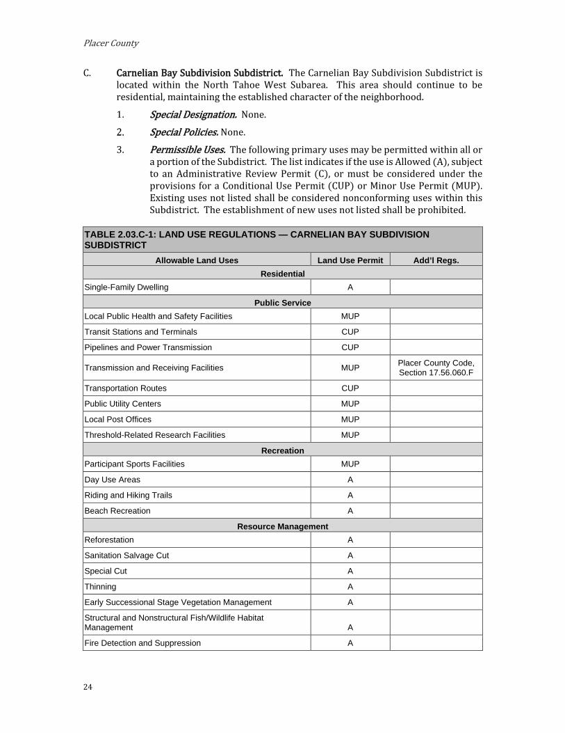
C. Carnelian Bay Subdivision Subdistrict. The Carnelian Bay Subdivision Subdistrict is located within the North Tahoe West Subarea. This area should continue to be residential, maintaining the established character of the neighborhood.
Special Designation. None.
Special Policies. None. 3. Permissible Uses. The following primary uses may be permitted within all or
a portion of the Subdistrict. The list indicates if the use is Allowed (A), subject to an Administrative Review Permit (C), or must be considered under the provisions for a Conditional Use Permit (CUP) or Minor Use Permit (MUP). Existing uses not listed shall be considered nonconforming uses within this Subdistrict. The establishment of new uses not listed shall be prohibited.
TABLE 2.03.C-1: LAND USE REGULATIONS — CARNELIAN BAY SUBDIVISION SUBDISTRICT
Allowable Land Uses Land Use Permit Add’l Regs. Residential
Single-Family Dwelling A
Public Service Local Public Health and Safety Facilities MUP
Transit Stations and Terminals CUP
Pipelines and Power Transmission CUP
Transmission and Receiving Facilities MUP Placer County Code, Section 17.56.060.F
Transportation Routes CUP
Public Utility Centers MUP
Local Post Offices MUP
Threshold-Related Research Facilities MUP
Recreation Participant Sports Facilities MUP
Day Use Areas A
Riding and Hiking Trails A
Beach Recreation A
Resource Management Reforestation A
Sanitation Salvage Cut A
Special Cut A
Thinning A
Early Successional Stage Vegetation Management A
Structural and Nonstructural Fish/Wildlife Habitat Management A
Fire Detection and Suppression A

Implementing Regulations
25
TABLE 2.03.C-1: LAND USE REGULATIONS — CARNELIAN BAY SUBDIVISION SUBDISTRICT Fuels Treatment/Management A
Insect and Disease Suppression A
Sensitive and Uncommon Plant Management A
Erosion Control A
SEZ Restoration A
Runoff Control A
4. Development Standards. Table 2.03.C-2 prescribes the development standards for the Carnelian Bay Subdivision Subdistrict.
TABLE 2.03.C-2: DEVELOPMENT STANDARDS — CARNELIAN BAY SUBDIVISION SUBDISTRICT Maximum Density
Residential Single Family Dwelling: 1 du/parcel
Additional Developed Outdoor Recreation Overnight Uses: 280 PAOT
Maximum Building Height TRPA Code of Ordinances, Chapter 37
Minimum Lot Size 10,000 sq ft
Minimum Lot Width 55 ft
Minimum Lot Area per Dwelling Unit 6,000 sq ft
Minimum Setbacks (measured from property line unless otherwise noted) See also 17.54.130, 17.54.140, and 17.54.150
Front 20 ft (1)
Side 15 ft total; 5 ft min
Rear 10 ft
Maximum Community Noise Equivalent Level 55 CNEL
Notes: (1) Where the road right-of way is less than 50’, add 25’ to the front setback and measure from the center of
traveled way.
5. Shorezone. Within the specified shorezone tolerance districts, the following primary uses may be permitted by TRPA in the backshore, nearshore, and foreshore. Accessory structures shall be regulated pursuant to the regulation applicable to the primary uses upon which they are dependent in accordance with the TRPA Code of Ordinances. The following structures may be permitted by TRPA in the shorezone as an Allowed (A) or Special (S) use only if they are accessory to an existing, allowed use located on the same or adjoining littoral parcel.

Placer County
26
TABLE 2.03.C-3: SHOREZONE — CARNELIAN BAY SUBDIVISION SUBDISTRICT
Tolerance Districts 4 6 Primary Uses
Beach Recreation A A
Safety and Navigational Devices A A
Salvage Operations A A
Accessory Structures Buoys A A
Piers A A
Fences S S
Boat Ramps S S
Breakwaters or Jetties S S
Floating Docks and Platforms A A
Shoreline Protective Structures S S
Water Intake Lines S S
Implementing Regulations
27
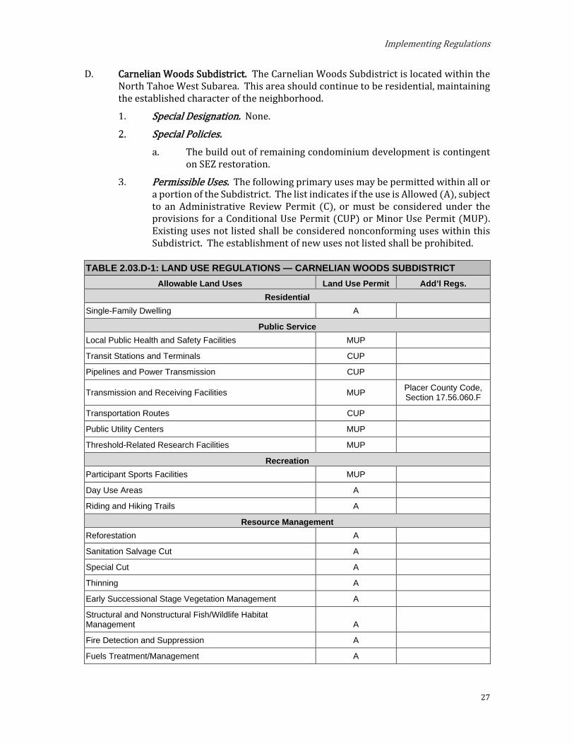
D. Carnelian Woods Subdistrict. The Carnelian Woods Subdistrict is located within the North Tahoe West Subarea. This area should continue to be residential, maintaining the established character of the neighborhood.
Special Designation. None.
Special Policies. The build out of remaining condominium development is contingent
on SEZ restoration.
Permissible Uses. The following primary uses may be permitted within all or a portion of the Subdistrict. The list indicates if the use is Allowed (A), subject to an Administrative Review Permit (C), or must be considered under the provisions for a Conditional Use Permit (CUP) or Minor Use Permit (MUP). Existing uses not listed shall be considered nonconforming uses within this Subdistrict. The establishment of new uses not listed shall be prohibited.
TABLE 2.03.D-1: LAND USE REGULATIONS — CARNELIAN WOODS SUBDISTRICT Allowable Land Uses Land Use Permit Add’l Regs.
Residential Single-Family Dwelling A
Public Service Local Public Health and Safety Facilities MUP
Transit Stations and Terminals CUP
Pipelines and Power Transmission CUP
Transmission and Receiving Facilities MUP Placer County Code, Section 17.56.060.F
Transportation Routes CUP
Public Utility Centers MUP
Threshold-Related Research Facilities MUP
Recreation Participant Sports Facilities MUP
Day Use Areas A
Riding and Hiking Trails A
Resource Management Reforestation A
Sanitation Salvage Cut A
Special Cut A
Thinning A
Early Successional Stage Vegetation Management A
Structural and Nonstructural Fish/Wildlife Habitat Management A
Fire Detection and Suppression A
Fuels Treatment/Management A

Placer County
28
TABLE 2.03.D-1: LAND USE REGULATIONS — CARNELIAN WOODS SUBDISTRICT Insect and Disease Suppression A
Sensitive and Uncommon Plant Management A
Erosion Control A
SEZ Restoration A
Runoff Control A
Development Standards. Table 2.03.D-2 prescribes the development standards for the Carnelian Woods Subdistrict.
TABLE 2.03.D-2: DEVELOPMENT STANDARDS — CARNELIAN WOODS SUBDISTRICT Maximum Density
Residential Single Family Dwelling: 1 du/parcel
Maximum Building Height TRPA Code of Ordinances, Chapter 37
Minimum Lot Size 10,000 sq ft
Minimum Lot Width 55 ft
Minimum Lot Area per Dwelling Unit 6,000 sq ft
Minimum Setbacks (measured from property line unless otherwise noted) See also 17.54.130, 17.54.140, and 17.54.150
Front 20 ft (1)
Side 15 ft total; 5 ft min
Rear 10 ft
Maximum Community Noise Equivalent Level 55 CNEL
Notes: (1) Where the road right-of way is less than 50’, add 25’ to the front setback and measure from the center of
traveled way.

Implementing Regulations
29
E. Cedar Flat Subdistrict. The Cedar Flat Subdistrict is located within the North Tahoe West Subarea. This area should continue as a residential area of the same type and character now existing.
Special Designation. None.
Special Policies. A specific plan shall be developed by Placer County for the County
littoral strip of land known as Lake Forest #2 prior to any further shorezone development. The plan should balance private pier and buoy uses with public recreation and fishery management.
The provisions of this Subdistrict shall apply to Special Area #1 if TRPA finds that the threshold findings set forth in TRPA Ordinance 95-4 have been completed. If the findings have not yet been satisfied then the provisions of the Watson Creek Subdistrict shall apply.
Permissible Uses. The following primary uses may be permitted within all or a portion of the Subdistrict. The list indicates if the use is Allowed (A), subject to an Administrative Review Permit (C), or must be considered under the provisions for a Conditional Use Permit (CUP) or Minor Use Permit (MUP). Existing uses not listed shall be considered nonconforming uses within this Subdistrict. The establishment of new uses not listed shall be prohibited.
TABLE 2.03.E-1: LAND USE REGULATIONS — CEDAR FLAT SUBDISTRICT Allowable Land Uses Land Use Permit Add’l Regs.
Residential Single Family Dwelling A
Public Service Local Public Health and Safety Facilities MUP
Transit Stations and Terminals CUP
Pipelines and Power Transmission CUP
Transmission and Receiving Facilities MUP Placer County Code, Section 17.56.060.F
Transportation Routes CUP
Public Utility Centers MUP
Religious Assembly MUP
Local Post Offices MUP
Day Care Centers/Pre-Schools MUP
Threshold-Related Research Facilities MUP
Recreation Participant Sports Facilities MUP
Day Use Areas A
Riding and Hiking Trails A
Beach Recreation A

Placer County
30
TABLE 2.03.E-1: LAND USE REGULATIONS — CEDAR FLAT SUBDISTRICT Resource Management
Reforestation A
Sanitation Salvage Cut A
Special Cut A
Selection Cut MUP
Thinning A
Early Successional Stage Vegetation Management A
Structural and Nonstructural Fish/Wildlife Habitat Management A
Fire Detection and Suppression A
Fuels Treatment/Management A
Insect and Disease Suppression A
Sensitive and Uncommon Plant Management A
Erosion Control A
SEZ Restoration A
Runoff Control A
Development Standards. Table 2.03.E-2 prescribes the development standards for the Cedar Flat Subdistrict.
TABLE 2.03.E-2: DEVELOPMENT STANDARDS — CEDAR FLAT SUBDISTRICT Maximum Density
Residential Single Family Dwelling: 1 du/parcel
Maximum Building Height TRPA Code of Ordinances, Chapter 37
Minimum Lot Size 10,000 sq ft
Minimum Lot Width 55 ft
Minimum Lot Area per Dwelling Unit 6,000 sq ft
Minimum Setbacks (measured from property line unless otherwise noted) See also 17.54.130, 17.54.140, and 17.54.150
Front 20 ft (1)
Side 15 ft total; 5 ft min
Rear 10 ft
Maximum Community Noise Equivalent Level 55 CNEL
Notes: (1) Where the road right-of way is less than 50’, add 25’ to the front setback and measure from the center of
traveled way.
Shorezone. Within the specified shorezone tolerance district, the following primary uses may be permitted by TRPA in the backshore, nearshore, and foreshore. Accessory structures shall be regulated pursuant to the regulations applicable to the primary use upon which they are dependent in

Implementing Regulations
31
accordance with the TRPA Code of Ordinances. The following structures may be permitted by TRPA in the shorezone as an Allowed (A) or Special (S) use only if they are accessory to an existing, allowed use located on the same or adjoining littoral parcel.
TABLE 2.03.E-3: SHOREZONE — CEDAR FLAT SUBDISTRICT
Tolerance Districts 2 4 Primary Uses
Beach Recreation A
Safety and Navigational Devices A A
Salvage Operations A A
Accessory Structures Buoys A A
Piers A A
Fences S S
Boat Ramps S S
Breakwaters or Jetties S S
Floating Docks and Platforms A A
Shoreline Protective Structures S S
Water Intake Lines S S

Placer County
32
F. Chambers Landing Subdistrict. The Chambers Landing Subdistrict is located within the West Shore Subarea. This area should continue to be residential, maintaining the existing character of the neighborhood.
Special Designation. None.
Special Policies. Additional commercial development shall be limited to parcels
containing commercial uses on the effective date of the Plan.
Permissible Uses. The following primary uses may be permitted within all or a portion of the Subdistrict. The list indicates if the use is Allowed (A), subject to an Administrative Review Permit (C), or must be considered under the provisions for a Conditional Use Permit (CUP) or Minor Use Permit (MUP). Existing uses not listed shall be considered nonconforming uses within this Subdistrict. The establishment of new uses not listed shall be prohibited.
TABLE 2.03.F-1: LAND USE REGULATIONS — CHAMBERS LANDING SUBDISTRICT Allowable Land Uses Land Use Permit Add’l Regs.
Residential Single Family Dwelling A
Commercial Eating and Drinking Places MUP See Special Policy 2.a.
Public Service Local Public Health and Safety Facilities MUP
Transit Stations and Terminals CUP
Pipelines and Power Transmission CUP
Transmission and Receiving Facilities MUP Placer County Code, Section 17.56.060.F
Transportation Routes CUP
Public Utility Centers MUP
Religious Assembly MUP
Local Post Offices MUP
Threshold-Related Research Facilities MUP
Recreation Participant Sports Facilities MUP
Day Use Areas A
Riding and Hiking Trails A
Beach Recreation A
Resource Management Reforestation A
Sanitation Salvage Cut A
Special Cut A
Thinning A

Implementing Regulations
33
TABLE 2.03.F-1: LAND USE REGULATIONS — CHAMBERS LANDING SUBDISTRICT Early Successional Stage Vegetation Management A
Structural and Nonstructural Fish/Wildlife Habitat Management A
Fire Detection and Suppression A
Fuels Treatment/Management A
Insect and Disease Suppression A
Sensitive and Uncommon Plant Management A
Erosion Control A
SEZ Restoration A
Runoff Control A
Development Standards. Table 2.03.F-2 prescribes the development standards for the Chambers Landing Subdistrict.
TABLE 2.03.F-2: DEVELOPMENT STANDARDS — CHAMBERS LANDING SUBDISTRICT Maximum Density
Residential Single Family Dwelling: 1 du/parcel
Maximum Building Height TRPA Code of Ordinances, Chapter 37
Minimum Lot Size 10,000 sq ft
Minimum Lot Width 55 ft
Minimum Lot Area per Dwelling Unit 6,000 sq ft
Minimum Setbacks (measured from property line unless otherwise noted) See also 17.54.130, 17.54.140, and 17.54.150
Front 20 ft (1)
Side 15 ft total; 5 ft min
Rear 10 ft
Maximum Community Noise Equivalent Level 55 CNEL
Notes: (1) Where the road right-of way is less than 50’, add 25’ to the front setback and measure from the center of
traveled way.
Shorezone. Within the specified shorezone tolerance district, the following primary uses may be permitted by TRPA in the backshore, nearshore, and foreshore. Accessory structures shall be regulated pursuant to the regulations applicable to the primary use upon which they are dependent in accordance with the TRPA Code of Ordinances. The following structures may be permitted by TRPA in the shorezone as an Allowed (A) or Special (S) use only if they are accessory to an existing, allowed use located on the same or adjoining littoral parcel.

Placer County
34
TABLE 2.03.F-3: SHOREZONE — CHAMBERS LANDING SUBDISTRICT
Tolerance Districts 6 7 Primary Uses
Beach Recreation A A
Safety and Navigational Devices A A
Salvage Operations A A
Accessory Structures Buoys A A
Piers A A
Fences S S
Boat Ramps S S
Breakwaters or Jetties S S
Floating Docks and Platforms A A
Shoreline Protective Structures S S
Water Intake Lines S S

Implementing Regulations
35
G. Dollar Point Subdistrict. The Dollar Point Subdistrict is located within the Greater Tahoe City Subarea. This area should continue as a residential area of the same type and character.
Special Designation. None. Special Policies. None.
Permissible Uses. The following primary uses may be permitted within all or a portion of the Subdistrict. The list indicates if the use is Allowed (A), subject to an Administrative Review Permit (C), or must be considered under the provisions for a Conditional Use Permit (CUP) or Minor Use Permit (MUP). Existing uses not listed shall be considered nonconforming uses within this Subdistrict. The establishment of new uses not listed shall be prohibited.
TABLE 2.03.G-1: LAND USE REGULATIONS — DOLLAR POINT SUBDISTRICT Allowable Land Uses Land Use Permit Add’l Regs.
Residential Single-Family Dwelling A
Public Service Local Public Health and Safety Facilities MUP
Transit Stations and Terminals CUP
Pipelines and Power Transmission CUP
Transmission and Receiving Facilities MUP Placer County Code, Section 17.56.060.F
Transportation Routes CUP
Public Utility Centers MUP
Religious Assembly MUP
Local Post Offices MUP
Day Care Centers/Pre-Schools MUP
Threshold-Related Research Facilities MUP
Recreation Participant Sports Facilities MUP
Day Use Areas A
Riding and Hiking Trails A
Beach Recreation A
Resource Management Reforestation A
Sanitation Salvage Cut A
Special Cut A
Thinning A
Early Successional Stage Vegetation Management A
Structural and Nonstructural Fish/Wildlife Habitat Management A

Placer County
36
TABLE 2.03.G-1: LAND USE REGULATIONS — DOLLAR POINT SUBDISTRICT Fire Detection and Suppression A
Fuels Treatment/Management A
Insect and Disease Suppression A
Sensitive and Uncommon Plant Management A
Erosion Control A
SEZ Restoration A
Runoff Control A
Development Standards. Table 2.03.G-2 prescribes the development standards for the Dollar Point Subdistrict.
TABLE 2.03.G-2: DEVELOPMENT STANDARDS — DOLLAR POINT SUBDISTRICT Maximum Density
Residential Single Family Dwelling: 1 du/parcel
Maximum Building Height TRPA Code of Ordinances, Chapter 37
Minimum Lot Size 10,000 sq ft
Minimum Lot Width 55 ft
Minimum Lot Area per Dwelling Unit 6,000 sq ft
Minimum Setbacks (measured from property line unless otherwise noted) See also 17.54.130, 17.54.140, and 17.54.150
Front 20 ft (1)
Side 15 ft total; 5 ft min
Rear 10 ft
Maximum Community Noise Equivalent Level 50 CNEL
Highway 28 Corridor 55 CNEL
Notes: (1) Where the road right-of way is less than 50’, add 25’ to the front setback and measure from the center of
traveled way.

Implementing Regulations
37
Shorezone. Within the specified shorezone tolerance district, the following primary uses may be permitted by TRPA in the backshore, nearshore, and foreshore. Accessory structures shall be regulated pursuant to the regulations applicable to the primary use upon which they are dependent in accordance with the TRPA Code of Ordinances. The following structures may be permitted by TRPA in the shorezone as an Allowed (A) or Special (S) use only if they are accessory to an existing, allowed use located on the same or adjoining littoral parcel.
TABLE 2.03.G-3: SHOREZONE — DOLLAR POINT SUBDISTRICT
Tolerance Districts 2 4 Primary Uses
Beach Recreation A
Safety and Navigational Devices A A
Salvage Operations A A
Accessory Structure Buoys A A
Piers A A
Fences S S
Boat Ramps S S
Breakwaters or Jetties S S
Shoreline Protective Structures S S
Floating Docks and Platforms A A
Water Intake Lines S S
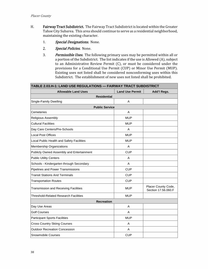
Placer County
38
H. Fairway Tract Subdistrict. The Fairway Tract Subdistrict is located within the Greater Tahoe City Subarea. This area should continue to serve as a residential neighborhood, maintaining the existing character.
Special Designations. None. Special Policies. None.
Permissible Uses. The following primary uses may be permitted within all or a portion of the Subdistrict. The list indicates if the use is Allowed (A), subject to an Administrative Review Permit (C), or must be considered under the provisions for a Conditional Use Permit (CUP) or Minor Use Permit (MUP). Existing uses not listed shall be considered nonconforming uses within this Subdistrict. The establishment of new uses not listed shall be prohibited.
TABLE 2.03.H-1: LAND USE REGULATIONS — FAIRWAY TRACT SUBDISTRICT Allowable Land Uses Land Use Permit Add’l Regs.
Residential Single-Family Dwelling A
Public Service Cemeteries A
Religious Assembly MUP
Cultural Facilities MUP
Day Care Centers/Pre-Schools A
Local Post Offices MUP
Local Public Health and Safety Facilities MUP
Membership Organizations A
Publicly Owned Assembly and Entertainment CUP
Public Utility Centers A
Schools - Kindergarten through Secondary A
Pipelines and Power Transmissions CUP
Transit Stations And Terminals CUP
Transportation Routes CUP
Transmission and Receiving Facilities MUP Placer County Code, Section 17.56.060.F
Threshold-Related Research Facilities MUP
Recreation Day Use Areas A
Golf Courses A
Participant Sports Facilities MUP
Cross Country Skiing Courses A
Outdoor Recreation Concession A
Snowmobile Courses CUP

Implementing Regulations
39
TABLE 2.03.H-1: LAND USE REGULATIONS — FAIRWAY TRACT SUBDISTRICT Resource Management
Reforestation A
Sanitation Salvage Cut A
Special Cut A
Selection Cut MUP
Thinning A
Early Successional Stage Vegetation Management A
Structural and Nonstructural Fish/Wildlife Habitat Management A
Fire Detection and Suppression A
Fuels Treatment/Management A
Insect and Disease Suppression A
Sensitive and Uncommon Plant Management A
Erosion Control A
SEZ Restoration A
Runoff Control A

Placer County
40
Development Standards. Table 2.03.H-2 prescribes the development standards for the Fairway Tract Subdistrict.
TABLE 2.03.H-2: DEVELOPMENT STANDARDS — FAIRWAY TRACT SUBDISTRICT Maximum Density
Residential Single Family Dwelling: 1 du/parcel
Maximum Building Height TRPA Code of Ordinances, Chapter 37
Minimum Lot Size 10,000 sq ft
Minimum Lot Width 55 ft
Minimum Lot Area per Dwelling Unit 6,000 sq ft
Minimum Setbacks (measured from property line unless otherwise noted) See also 17.54.130, 17.54.140, and 17.54.150
Front 20 ft (1)
Side 15 ft total; 5 ft min
Rear 10 ft
Maximum Community Noise Equivalent Level 55 CNEL
Notes: (1) Where the road right-of way is less than 50’, add 25’ to the front setback and measure from the center of
traveled way.
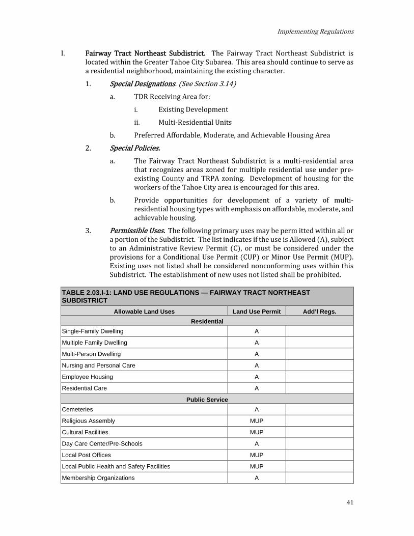
Implementing Regulations
41
I. Fairway Tract Northeast Subdistrict. The Fairway Tract Northeast Subdistrict is located within the Greater Tahoe City Subarea. This area should continue to serve as a residential neighborhood, maintaining the existing character.
Special Designations. (See Section 3.14)
TDR Receiving Area for:
i. Existing Development
ii. Multi-Residential Units
Preferred Affordable, Moderate, and Achievable Housing Area
Special Policies. The Fairway Tract Northeast Subdistrict is a multi-residential area
that recognizes areas zoned for multiple residential use under pre-existing County and TRPA zoning. Development of housing for the workers of the Tahoe City area is encouraged for this area.
Provide opportunities for development of a variety of multi-residential housing types with emphasis on affordable, moderate, and achievable housing.
Permissible Uses. The following primary uses may be perm itted within all or a portion of the Subdistrict. The list indicates if the use is Allowed (A), subject to an Administrative Review Permit (C), or must be considered under the provisions for a Conditional Use Permit (CUP) or Minor Use Permit (MUP). Existing uses not listed shall be considered nonconforming uses within this Subdistrict. The establishment of new uses not listed shall be prohibited.
TABLE 2.03.I-1: LAND USE REGULATIONS — FAIRWAY TRACT NORTHEAST SUBDISTRICT
Allowable Land Uses Land Use Permit Add’l Regs. Residential
Single-Family Dwelling A
Multiple Family Dwelling A
Multi-Person Dwelling A
Nursing and Personal Care A
Employee Housing A
Residential Care A
Public Service Cemeteries A
Religious Assembly MUP
Cultural Facilities MUP
Day Care Center/Pre-Schools A
Local Post Offices MUP
Local Public Health and Safety Facilities MUP
Membership Organizations A

Placer County
42
TABLE 2.03.I-1: LAND USE REGULATIONS — FAIRWAY TRACT NORTHEAST SUBDISTRICT Publicly Owned Assembly and Entertainment CUP
Public Utility Centers A
Schools – Kindergarten through Secondary A
Pipelines and Power Transmissions CUP
Transit Stations and Terminals CUP
Transportation Routes CUP
Transmission and Receiving Facilities MUP Placer County Code, Section 17.56.060.F
Threshold-Related Research Facilities MUP
Recreation Day Use Areas A
Golf Courses A
Participant Sports Facilities MUP
Cross Country Skiing Courses A
Outdoor Recreation Concession A
Snowmobile Courses CUP
Resource Management Reforestation A
Sanitation Salvage Cut A
Special Cut A
Selection Cut MUP
Thinning A
Early Successional Stage Vegetation Management A
Structural and Nonstructural Fish/Wildlife Habitat Management A
Fire Detection and Suppression A
Fuels Treatment/Management A
Insect and Disease Suppression A
Sensitive and Uncommon Plant Management A
Erosion Control A
SEZ Restoration A
Runoff Control A

Implementing Regulations
43
Development Standards. Table 2.03.I-2 prescribes the development standards for the Fairway Tract Northeast Subdistrict.
TABLE 2.03.I-2: DEVELOPMENT STANDARDS — FAIRWAY TRACT NORTHEAST SUBDISTRICT Maximum Density
Residential
Single Family Dwelling: 1 du/parcel Multiple Family Dwelling: 8 units per acre
Multi-Person Dwelling: 25 persons per acre Nursing and Personal Care: 25 persons per acre
Residential Care: 25 persons per acre Employee Housing: 15 units per acre
Maximum Building Height TRPA Code of Ordinances, Chapter 37
Minimum Lot Size 10,000 sq ft
Minimum Lot Width 55 ft
Minimum lot area per dwelling unit 6,000 sq ft
Minimum Setbacks (measured from property line unless otherwise noted) See also 17.54.130, 17.54.140, and 17.54.150
Front 20 ft (1)
Side 15 ft total; 5 ft min
Rear 10 ft
Maximum Community Noise Equivalent Level 55 CNEL
Notes: (1) Where the road right-of way is less than 50’, add 25’ to the front setback and measure from the center of
traveled way.

Placer County
44
J. Fairway Tract South Subdistrict. The Fairway Tract South Subdistrict is located within the Greater Tahoe City Subarea. This area should continue to serve as a recreation and public service area in a residential neighborhood, maintaining the existing character.
Special Designations. (See Section 3.14) TDR Receiving Area for:
i. Existing Development
ii. Multi-Residential Units
Preferred Affordable, Moderate, and Achievable Housing Area
Special Policies. The Fairway Tract South Subdistrict is a recreation/public service
area, which is in the influence area of the former Tahoe City Community Plan. All projects shall be subject to the policies and standards of this Sub-district.
Provide opportunities for development of a variety of multi-residential housing types with emphasis on affordable, moderate, and achievable housing.
Permissible Uses. The following primary uses may be permitted within all or a portion of the Subdistrict. The list indicates if the use is Allowed (A), subject to an Administrative Review Permit (C), or must be considered under the provisions for a Conditional Use Permit (CUP) or Minor Use Permit (MUP). Existing uses not listed shall be considered nonconforming uses within this Subdistrict. The establishment of new uses not listed shall be prohibited.
TABLE 2.03.J-1: LAND USE REGULATIONS — FAIRWAY TRACT SOUTH SUBDISTRICT Allowable Land Uses Land Use Permit Add’l Regs.
Residential Single-Family Dwelling A
Multiple Family Dwelling MUP
Multi-Person Dwelling MUP
Employee Housing MUP
Tourist Accommodation Bed and Breakfast Facilities CUP
Hotel, Motel and Other Transient Dwelling Units CUP
Commercial Eating and Drinking Places A
Nursery MUP
Amusements and Recreation Services A
Privately Owned Assembly and Entertainment MUP
Public Service Cemeteries A
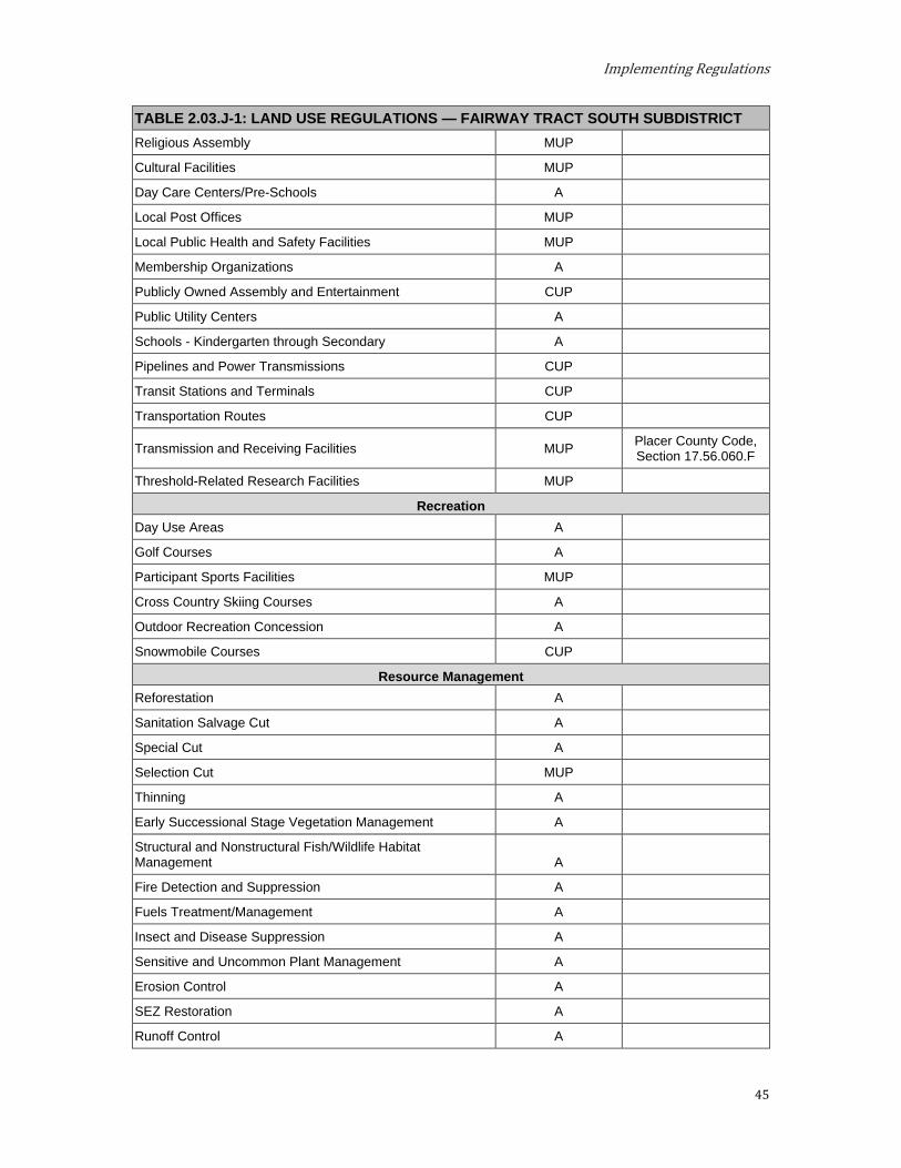
Implementing Regulations
45
TABLE 2.03.J-1: LAND USE REGULATIONS — FAIRWAY TRACT SOUTH SUBDISTRICT Religious Assembly MUP
Cultural Facilities MUP
Day Care Centers/Pre-Schools A
Local Post Offices MUP
Local Public Health and Safety Facilities MUP
Membership Organizations A
Publicly Owned Assembly and Entertainment CUP
Public Utility Centers A
Schools - Kindergarten through Secondary A
Pipelines and Power Transmissions CUP
Transit Stations and Terminals CUP
Transportation Routes CUP
Transmission and Receiving Facilities MUP Placer County Code, Section 17.56.060.F
Threshold-Related Research Facilities MUP
Recreation Day Use Areas A
Golf Courses A
Participant Sports Facilities MUP
Cross Country Skiing Courses A
Outdoor Recreation Concession A
Snowmobile Courses CUP
Resource Management Reforestation A
Sanitation Salvage Cut A
Special Cut A
Selection Cut MUP
Thinning A
Early Successional Stage Vegetation Management A
Structural and Nonstructural Fish/Wildlife Habitat Management A
Fire Detection and Suppression A
Fuels Treatment/Management A
Insect and Disease Suppression A
Sensitive and Uncommon Plant Management A
Erosion Control A
SEZ Restoration A
Runoff Control A
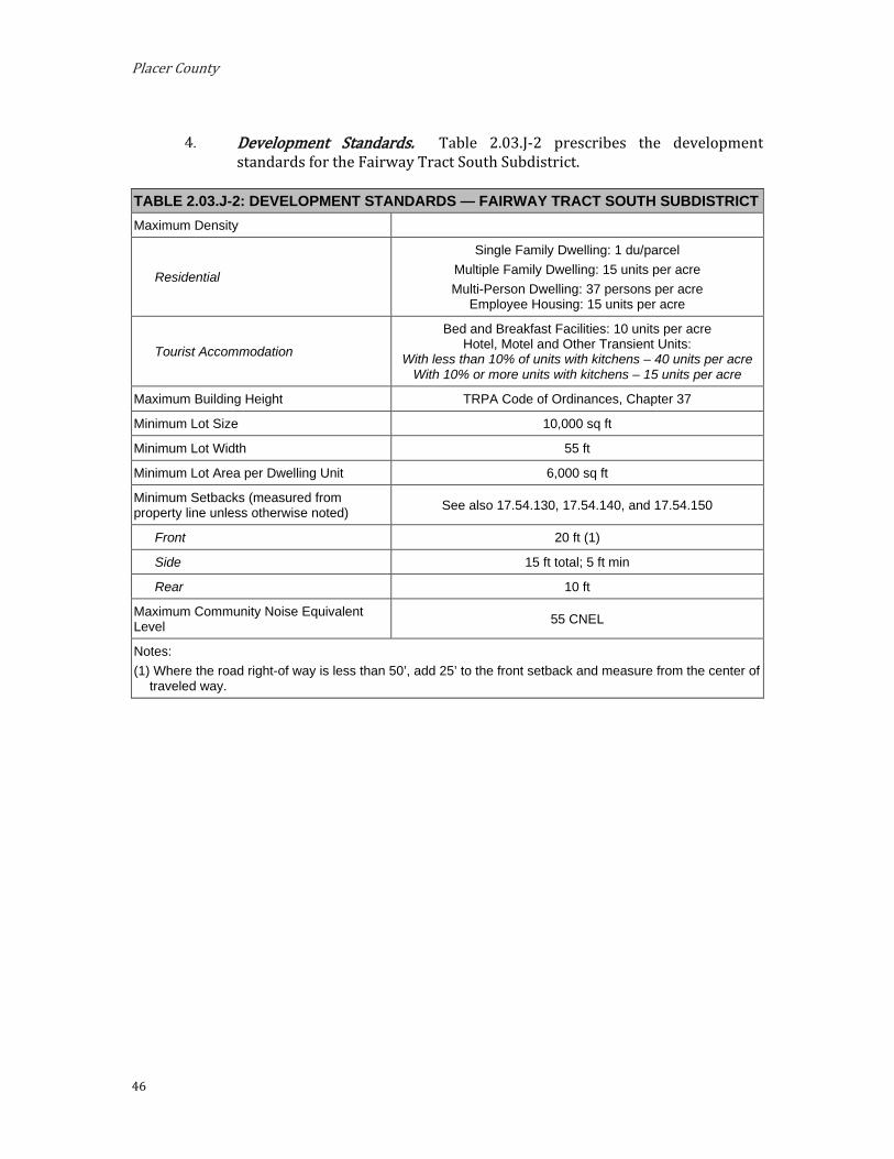
Placer County
46
Development Standards. Table 2.03.J-2 prescribes the development
standards for the Fairway Tract South Subdistrict.
TABLE 2.03.J-2: DEVELOPMENT STANDARDS — FAIRWAY TRACT SOUTH SUBDISTRICT Maximum Density
Residential
Single Family Dwelling: 1 du/parcel Multiple Family Dwelling: 15 units per acre Multi-Person Dwelling: 37 persons per acre
Employee Housing: 15 units per acre
Tourist Accommodation
Bed and Breakfast Facilities: 10 units per acre Hotel, Motel and Other Transient Units:
With less than 10% of units with kitchens – 40 units per acre With 10% or more units with kitchens – 15 units per acre
Maximum Building Height TRPA Code of Ordinances, Chapter 37
Minimum Lot Size 10,000 sq ft
Minimum Lot Width 55 ft
Minimum Lot Area per Dwelling Unit 6,000 sq ft
Minimum Setbacks (measured from property line unless otherwise noted) See also 17.54.130, 17.54.140, and 17.54.150
Front 20 ft (1)
Side 15 ft total; 5 ft min
Rear 10 ft
Maximum Community Noise Equivalent Level 55 CNEL
Notes: (1) Where the road right-of way is less than 50’, add 25’ to the front setback and measure from the center of
traveled way.
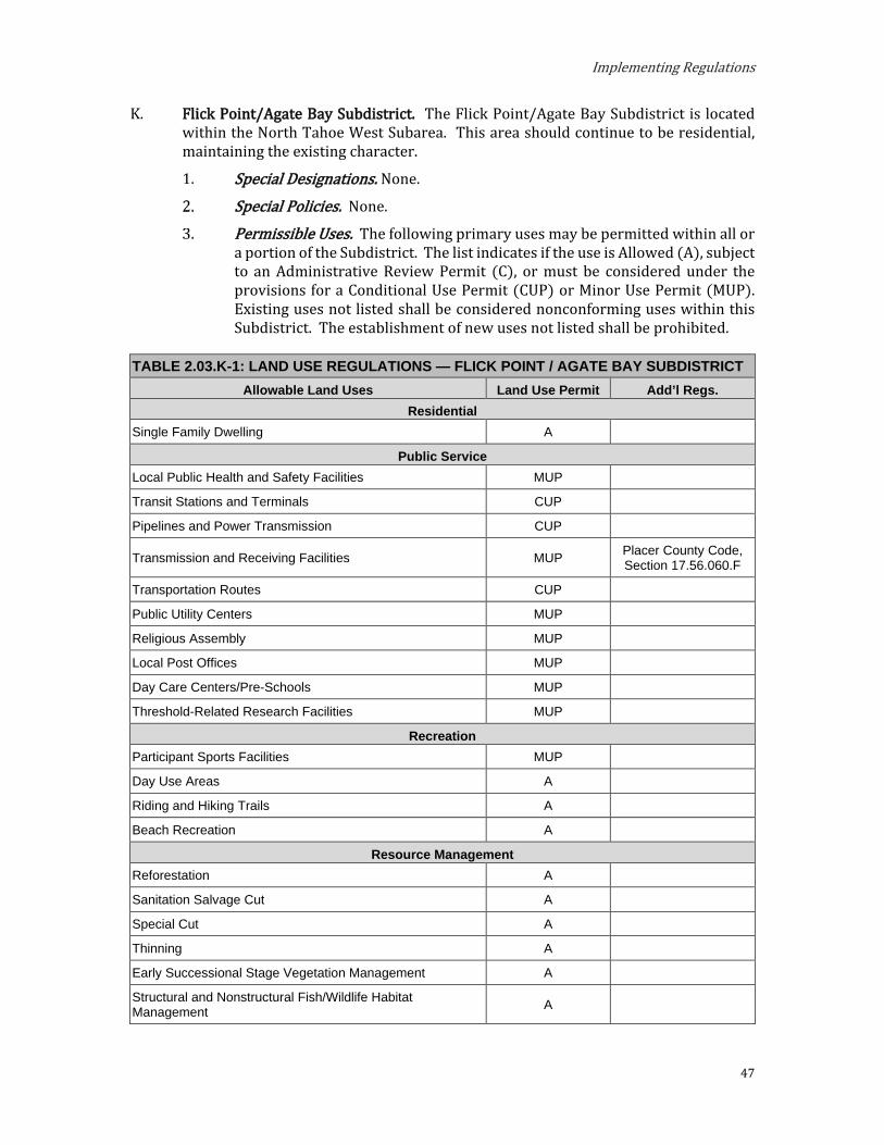
Implementing Regulations
47
K. Flick Point/Agate Bay Subdistrict. The Flick Point/Agate Bay Subdistrict is located within the North Tahoe West Subarea. This area should continue to be residential, maintaining the existing character.
Special Designations. None. Special Policies. None.
Permissible Uses. The following primary uses may be permitted within all or a portion of the Subdistrict. The list indicates if the use is Allowed (A), subject to an Administrative Review Permit (C), or must be considered under the provisions for a Conditional Use Permit (CUP) or Minor Use Permit (MUP). Existing uses not listed shall be considered nonconforming uses within this Subdistrict. The establishment of new uses not listed shall be prohibited.
TABLE 2.03.K-1: LAND USE REGULATIONS — FLICK POINT / AGATE BAY SUBDISTRICT Allowable Land Uses Land Use Permit Add’l Regs.
Residential Single Family Dwelling A
Public Service Local Public Health and Safety Facilities MUP
Transit Stations and Terminals CUP
Pipelines and Power Transmission CUP
Transmission and Receiving Facilities MUP Placer County Code, Section 17.56.060.F
Transportation Routes CUP
Public Utility Centers MUP
Religious Assembly MUP
Local Post Offices MUP
Day Care Centers/Pre-Schools MUP
Threshold-Related Research Facilities MUP
Recreation Participant Sports Facilities MUP
Day Use Areas A
Riding and Hiking Trails A
Beach Recreation A
Resource Management Reforestation A
Sanitation Salvage Cut A
Special Cut A
Thinning A
Early Successional Stage Vegetation Management A
Structural and Nonstructural Fish/Wildlife Habitat Management A
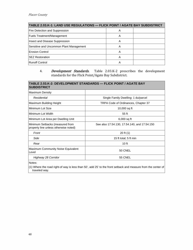
Placer County
48
TABLE 2.03.K-1: LAND USE REGULATIONS — FLICK POINT / AGATE BAY SUBDISTRICT Fire Detection and Suppression A
Fuels Treatment/Management A
Insect and Disease Suppression A
Sensitive and Uncommon Plant Management A
Erosion Control A
SEZ Restoration A
Runoff Control A
Development Standards. Table 2.03.K-2 prescribes the development standards for the Flick Point/Agate Bay Subdistrict.
TABLE 2.03.K-2: DEVELOPMENT STANDARDS — FLICK POINT / AGATE BAY SUBDISTRICT Maximum Density
Residential Single Family Dwelling: 1 du/parcel
Maximum Building Height TRPA Code of Ordinances, Chapter 37
Minimum Lot Size 10,000 sq ft
Minimum Lot Width 55 ft
Minimum Lot Area per Dwelling Unit 6,000 sq ft
Minimum Setbacks (measured from property line unless otherwise noted)
See also 17.54.130, 17.54.140, and 17.54.150
Front 20 ft (1)
Side 15 ft total; 5 ft min
Rear 10 ft
Maximum Community Noise Equivalent Level 50 CNEL
Highway 28 Corridor 55 CNEL
Notes: (1) Where the road right-of way is less than 50’, add 25’ to the front setback and measure from the center of
traveled way.

Implementing Regulations
49
Shorezone. Within the specified shorezone tolerance district, the following primary uses may be permitted by TRPA in the backshore, nearshore, and foreshore. Accessory structures shall be regulated pursuant to the regulations applicable to the primary use upon which they are dependent in accordance with the TRPA Code of Ordinances. The following structures may be permitted by TRPA in the shorezone as an Allowed (A) or Special (S) use only if they are accessory to an existing, allowed use located on the same or adjoining littoral parcel.
TABLE 2.03.K-3: SHOREZONE — FLICK POINT / AGATE BAY SUBDISTRICT
Tolerance Districts 2 6 Primary Uses
Beach Recreation A
Safety and Navigational Devices A A
Salvage Operations A A
Accessory Structures Buoys A A
Piers A A
Fences S S
Boat Ramps S S
Breakwaters or Jetties S S
Floating Docks and Platforms A A
Shoreline Protective Structures S S
Water Intake Lines S S

Placer County
50
L. Highlands Subdistrict. The Highlands Subdistrict is located within the Greater Tahoe City Subarea. This area should continue as residential, maintaining the existing character and single-family dwelling density.
Special Designations. None.
Special Policies. The following special policies apply to the Highlands Sub-district:
Existing multiple family dwellings shall be conforming; however, there shall not be any additional multiple family dwellings in the Subdistrict.
Permissible Uses. The following primary uses may be permitted within all or a portion of the Subdistrict. The list indicates if the use is Allowed (A), subject to an Administrative Review Permit (C), or must be considered under the provisions for a Conditional Use Permit (CUP) or Minor Use Permit (MUP). Existing uses not listed shall be considered nonconforming uses within this Subdistrict. The establishment of new uses not listed shall be prohibited.
TABLE 2.03.L-1: LAND USE REGULATIONS — HIGHLANDS SUBDISTRICT Allowable Land Uses Land Use Permit Add’l Regs.
Residential Single-Family Dwelling A
Multiple Family Dwelling MUP See Special Policy 2.a.
Public Service Local Public Health and Safety Facilities MUP
Transit Stations and Terminals CUP
Pipelines and Power Transmissions CUP
Transmission and Receiving Facilities MUP Placer County Code, Section 17.56.060.F
Transportation Routes CUP
Public Utility Centers MUP
Religious Assembly MUP
Local Post Offices MUP
Day Care Centers/Pre-Schools MUP
Threshold-Related Research Facilities MUP
Recreation Participant Sports Facilities MUP
Day Use Areas A
Riding and Hiking Trails A
Sports Assembly MUP
Cross Country Ski Courses A
Snowmobile Courses CUP
Outdoor Recreation Concession A

Implementing Regulations
51
TABLE 2.03.L-1: LAND USE REGULATIONS — HIGHLANDS SUBDISTRICT Resource Management
Reforestation A
Sanitation Salvage Cut A
Special Cut A
Thinning A
Early Successional Stage Vegetation Management A
Structural and Nonstructural Fish/Wildlife Habitat Management A
Fire Detection and Suppression A
Fuels Treatment/Management A
Insect and Disease Suppression A
Sensitive and Uncommon Plant Management A
Erosion Control A
SEZ Restoration A
Runoff Control A
Development Standards. Table 2.03.L-2 prescribes the development standards for the Highlands Subdistrict.
TABLE 2.03.L-2: DEVELOPMENT STANDARDS — HIGHLANDS SUBDISTRICT Maximum Density
Residential Single Family Dwelling: 1 du/parcel Multiple Family Dwelling: 15 du per acre
Maximum Building Height TRPA Code of Ordinances, Chapter 37
Minimum Lot Size 10,000 sq ft
Minimum Lot Width 55 ft
Minimum Lot Area per Dwelling Unit 6,000 sq ft
Minimum Setbacks (measured from property line unless otherwise noted) See also 17.54.130, 17.54.140, and 17.54.150
Front 20 ft (1) Side 15 ft total; 5 ft min Rear 10 ft
Maximum Community Noise Equivalent Level 50 CNEL
Notes: (1) Where the road right-of way is less than 50’, add 25’ to the front setback and measure from the center of
traveled way.
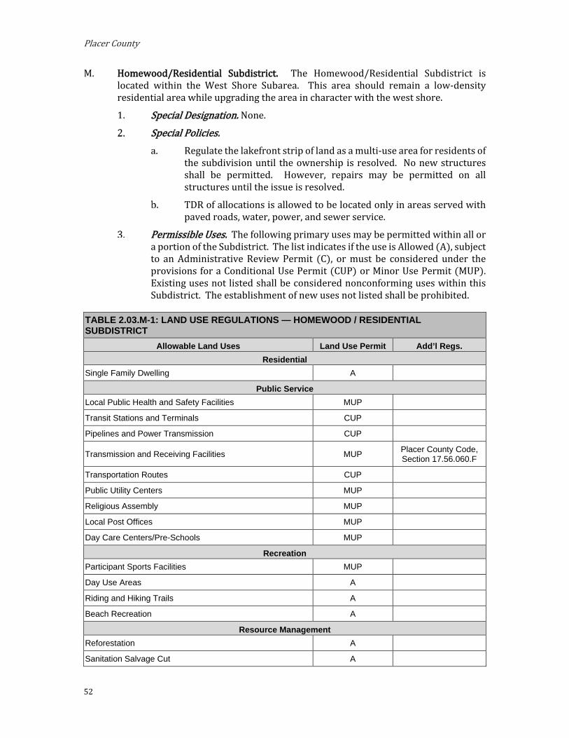
Placer County
52
M. Homewood/Residential Subdistrict. The Homewood/Residential Subdistrict is located within the West Shore Subarea. This area should remain a low-density residential area while upgrading the area in character with the west shore.
Special Designation. None. Special Policies.
Regulate the lakefront strip of land as a multi-use area for residents of the subdivision until the ownership is resolved. No new structures shall be permitted. However, repairs may be permitted on all structures until the issue is resolved.
TDR of allocations is allowed to be located only in areas served with paved roads, water, power, and sewer service.
Permissible Uses. The following primary uses may be permitted within all or a portion of the Subdistrict. The list indicates if the use is Allowed (A), subject to an Administrative Review Permit (C), or must be considered under the provisions for a Conditional Use Permit (CUP) or Minor Use Permit (MUP). Existing uses not listed shall be considered nonconforming uses within this Subdistrict. The establishment of new uses not listed shall be prohibited.
TABLE 2.03.M-1: LAND USE REGULATIONS — HOMEWOOD / RESIDENTIAL SUBDISTRICT
Allowable Land Uses Land Use Permit Add’l Regs. Residential
Single Family Dwelling A
Public Service Local Public Health and Safety Facilities MUP
Transit Stations and Terminals CUP
Pipelines and Power Transmission CUP
Transmission and Receiving Facilities MUP Placer County Code, Section 17.56.060.F
Transportation Routes CUP
Public Utility Centers MUP
Religious Assembly MUP
Local Post Offices MUP
Day Care Centers/Pre-Schools MUP
Recreation Participant Sports Facilities MUP
Day Use Areas A
Riding and Hiking Trails A
Beach Recreation A
Resource Management Reforestation A
Sanitation Salvage Cut A
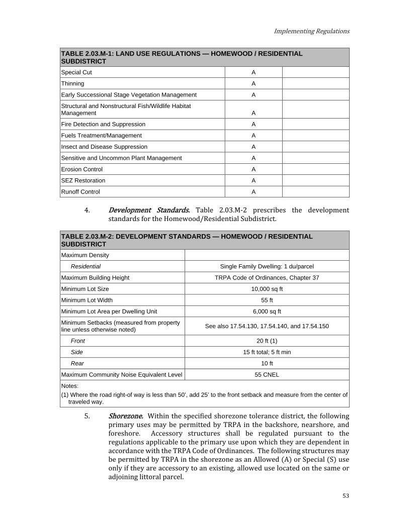
Implementing Regulations
53
TABLE 2.03.M-1: LAND USE REGULATIONS — HOMEWOOD / RESIDENTIAL SUBDISTRICT Special Cut A
Thinning A
Early Successional Stage Vegetation Management A
Structural and Nonstructural Fish/Wildlife Habitat Management A
Fire Detection and Suppression A
Fuels Treatment/Management A
Insect and Disease Suppression A
Sensitive and Uncommon Plant Management A
Erosion Control A
SEZ Restoration A
Runoff Control A
Development Standards. Table 2.03.M-2 prescribes the development standards for the Homewood/Residential Subdistrict.
TABLE 2.03.M-2: DEVELOPMENT STANDARDS — HOMEWOOD / RESIDENTIAL SUBDISTRICT Maximum Density
Residential Single Family Dwelling: 1 du/parcel
Maximum Building Height TRPA Code of Ordinances, Chapter 37
Minimum Lot Size 10,000 sq ft
Minimum Lot Width 55 ft
Minimum Lot Area per Dwelling Unit 6,000 sq ft
Minimum Setbacks (measured from property line unless otherwise noted) See also 17.54.130, 17.54.140, and 17.54.150
Front 20 ft (1)
Side 15 ft total; 5 ft min
Rear 10 ft
Maximum Community Noise Equivalent Level 55 CNEL
Notes: (1) Where the road right-of way is less than 50’, add 25’ to the front setback and measure from the center of
traveled way.
Shorezone. Within the specified shorezone tolerance district, the following primary uses may be permitted by TRPA in the backshore, nearshore, and foreshore. Accessory structures shall be regulated pursuant to the regulations applicable to the primary use upon which they are dependent in accordance with the TRPA Code of Ordinances. The following structures may be permitted by TRPA in the shorezone as an Allowed (A) or Special (S) use only if they are accessory to an existing, allowed use located on the same or adjoining littoral parcel.
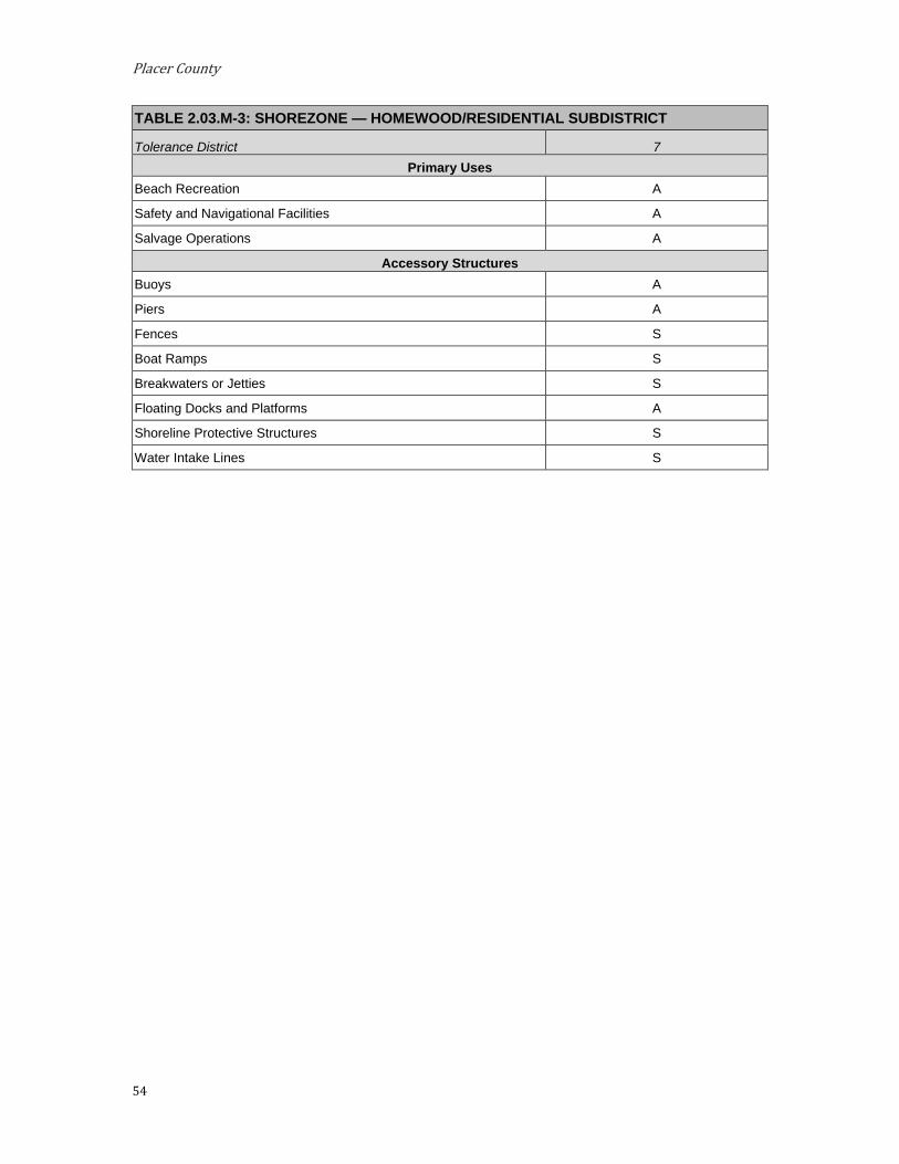
Placer County
54
TABLE 2.03.M-3: SHOREZONE — HOMEWOOD/RESIDENTIAL SUBDISTRICT
Tolerance District 7 Primary Uses
Beach Recreation A
Safety and Navigational Facilities A
Salvage Operations A
Accessory Structures Buoys A
Piers A
Fences S
Boat Ramps S
Breakwaters or Jetties S
Floating Docks and Platforms A
Shoreline Protective Structures S
Water Intake Lines S

Implementing Regulations
55
N. Kings Beach Residential Subdistrict. The Kings Beach Residential Subdistrict is located within the North Tahoe East Subarea. This area should continue to be a mixed residential area with substantial improvements to upgrade the character of the area.
Special Designations. (See Section 3.14) TDR Receiving Area for:
i. Existing Development
ii. Multi-Residential Units
Preferred Affordable, Moderate, and Achievable Housing Area
Special Policies. Low income housing that is displaced as a result of redevelopment
should be mitigated.
Single-family residential sites should be 50 feet or more in width.
Redirection should be encouraged in terms of planned unit developments that make the most efficient use of site design. Redevelopment projects should allow resubdivision of property equivalent to the number of units created by the old subdivision map, with reversions to acreage of the old subdivision lots. Substandard housing and mobile home and trailer park developments should be encouraged to convert to better quality, more permanent housing stock. Emphasis should be given to affordable, moderate, and achievable housing developments.
Provide opportunities for development of a variety of multi-residential housing types with emphasis on affordable, moderate, and achievable housing.
Permissible Uses. The following primary uses may be permitted within all or a portion of the Subdistrict. The list indicates if the use is Allowed (A), subject to an Administrative Review Permit (C), or must be considered under the provisions for a Conditional Use Permit (CUP) or Minor Use Permit (MUP). Existing uses not listed shall be considered nonconforming uses within this Subdistrict. The establishment of new uses not listed shall be prohibited.
TABLE 2.03.N-1: LAND USE REGULATIONS — KINGS BEACH RESIDENTIAL SUBDISTRICT
Allowable Land Uses Land Use Permit Add’l Regs. Residential
Single-Family Dwelling A
Multiple Family Dwelling A
Multi-Person Dwelling A
Employee Housing A
Mobile Home Dwelling MUP
Tourist Accommodation Hotels, Motels and Other Transient Dwelling Units CUP
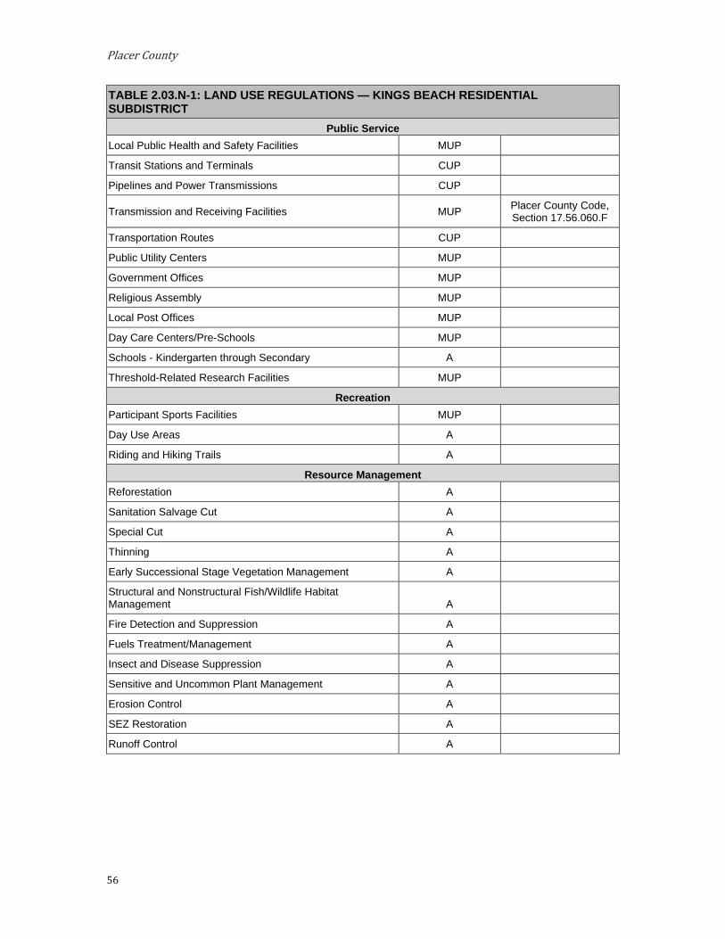
Placer County
56
TABLE 2.03.N-1: LAND USE REGULATIONS — KINGS BEACH RESIDENTIAL SUBDISTRICT
Public Service Local Public Health and Safety Facilities MUP
Transit Stations and Terminals CUP
Pipelines and Power Transmissions CUP
Transmission and Receiving Facilities MUP Placer County Code, Section 17.56.060.F
Transportation Routes CUP
Public Utility Centers MUP
Government Offices MUP
Religious Assembly MUP
Local Post Offices MUP
Day Care Centers/Pre-Schools MUP
Schools - Kindergarten through Secondary A
Threshold-Related Research Facilities MUP
Recreation Participant Sports Facilities MUP
Day Use Areas A
Riding and Hiking Trails A
Resource Management Reforestation A
Sanitation Salvage Cut A
Special Cut A
Thinning A
Early Successional Stage Vegetation Management A
Structural and Nonstructural Fish/Wildlife Habitat Management A
Fire Detection and Suppression A
Fuels Treatment/Management A
Insect and Disease Suppression A
Sensitive and Uncommon Plant Management A
Erosion Control A
SEZ Restoration A
Runoff Control A
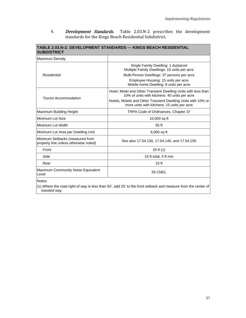
Implementing Regulations
57
Development Standards. Table 2.03.N-2 prescribes the development standards for the Kings Beach Residential Subdistrict.
TABLE 2.03.N-2: DEVELOPMENT STANDARDS — KINGS BEACH RESIDENTIAL SUBDISTRICT Maximum Density
Residential
Single Family Dwelling: 1 du/parcel Multiple Family Dwellings: 15 units per acre Multi-Person Dwellings: 37 persons per acre
Employee Housing: 15 units per acre Mobile home Dwelling: 8 units per acre
Tourist Accommodation
Hotel, Motel and Other Transient Dwelling Units with less than 10% of units with kitchens: 40 units per acre
Hotels, Motels and Other Transient Dwelling Units with 10% or more units with kitchens: 15 units per acre
Maximum Building Height TRPA Code of Ordinances, Chapter 37
Minimum Lot Size 10,000 sq ft
Minimum Lot Width 55 ft
Minimum Lot Area per Dwelling Unit 6,000 sq ft
Minimum Setbacks (measured from property line unless otherwise noted) See also 17.54.130, 17.54.140, and 17.54.150
Front 20 ft (1)
Side 15 ft total; 5 ft min
Rear 10 ft
Maximum Community Noise Equivalent Level 55 CNEL
Notes: (1) Where the road right-of way is less than 50’, add 25’ to the front setback and measure from the center of
traveled way.
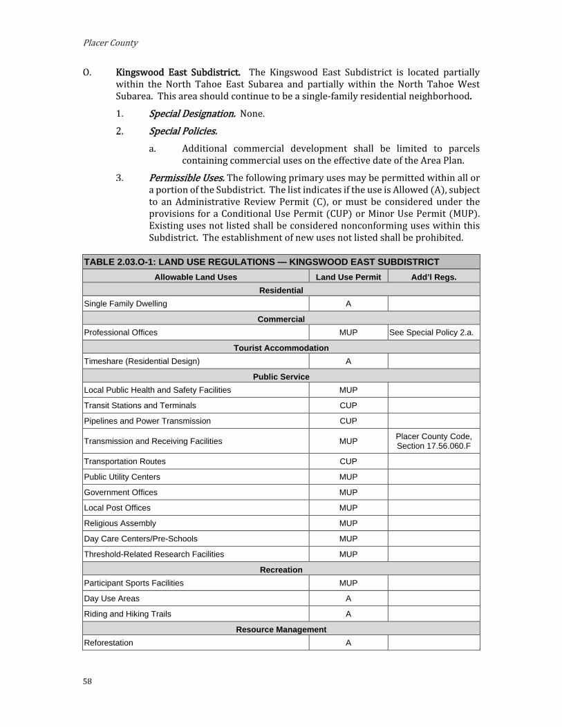
Placer County
58
O. Kingswood East Subdistrict. The Kingswood East Subdistrict is located partially within the North Tahoe East Subarea and partially within the North Tahoe West Subarea. This area should continue to be a single-family residential neighborhood.
Special Designation. None.
Special Policies. Additional commercial development shall be limited to parcels
containing commercial uses on the effective date of the Area Plan.
Permissible Uses. The following primary uses may be permitted within all or a portion of the Subdistrict. The list indicates if the use is Allowed (A), subject to an Administrative Review Permit (C), or must be considered under the provisions for a Conditional Use Permit (CUP) or Minor Use Permit (MUP). Existing uses not listed shall be considered nonconforming uses within this Subdistrict. The establishment of new uses not listed shall be prohibited.
TABLE 2.03.O-1: LAND USE REGULATIONS — KINGSWOOD EAST SUBDISTRICT Allowable Land Uses Land Use Permit Add’l Regs.
Residential Single Family Dwelling A
Commercial Professional Offices MUP See Special Policy 2.a.
Tourist Accommodation Timeshare (Residential Design) A
Public Service Local Public Health and Safety Facilities MUP
Transit Stations and Terminals CUP
Pipelines and Power Transmission CUP
Transmission and Receiving Facilities MUP Placer County Code, Section 17.56.060.F
Transportation Routes CUP
Public Utility Centers MUP
Government Offices MUP
Local Post Offices MUP
Religious Assembly MUP
Day Care Centers/Pre-Schools MUP
Threshold-Related Research Facilities MUP
Recreation Participant Sports Facilities MUP
Day Use Areas A
Riding and Hiking Trails A
Resource Management Reforestation A
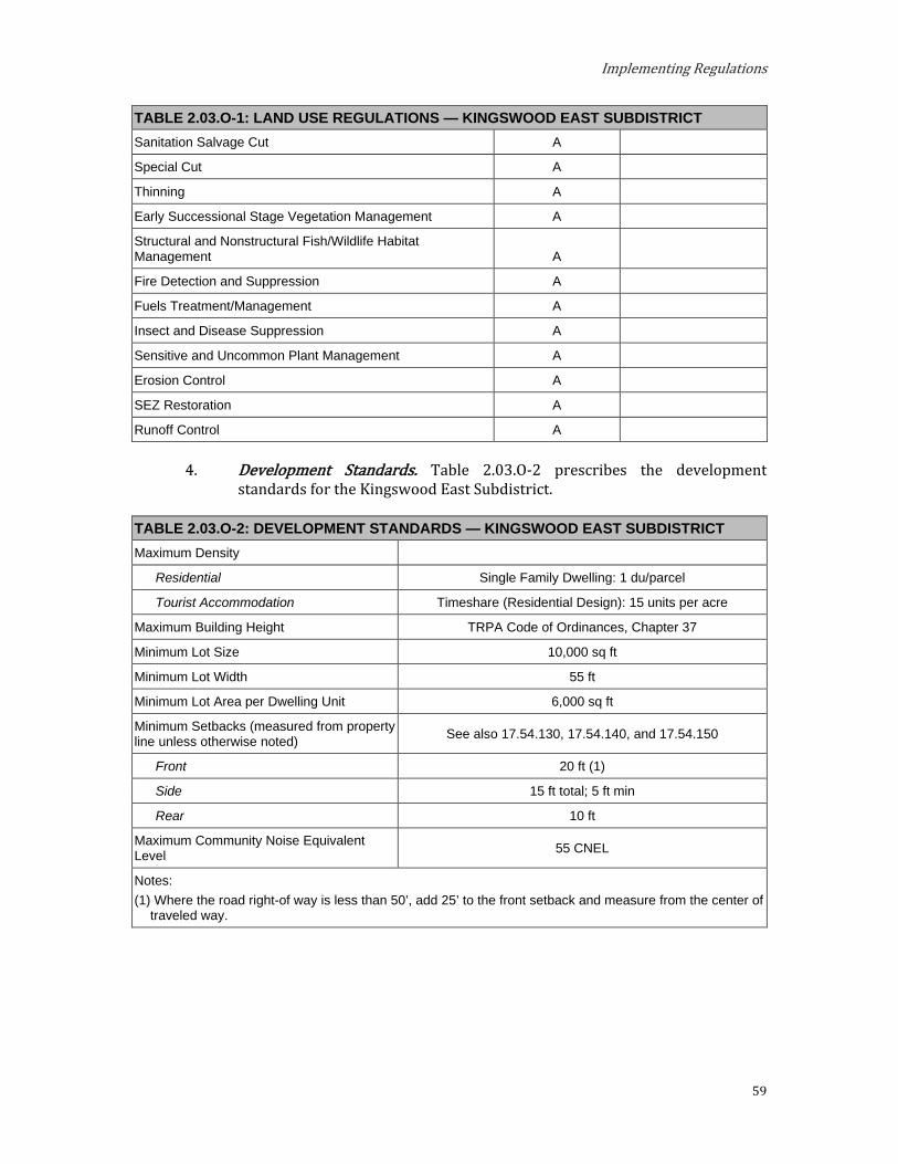
Implementing Regulations
59
TABLE 2.03.O-1: LAND USE REGULATIONS — KINGSWOOD EAST SUBDISTRICT Sanitation Salvage Cut A
Special Cut A
Thinning A
Early Successional Stage Vegetation Management A
Structural and Nonstructural Fish/Wildlife Habitat Management A
Fire Detection and Suppression A
Fuels Treatment/Management A
Insect and Disease Suppression A
Sensitive and Uncommon Plant Management A
Erosion Control A
SEZ Restoration A
Runoff Control A
Development Standards. Table 2.03.O-2 prescribes the development standards for the Kingswood East Subdistrict.
TABLE 2.03.O-2: DEVELOPMENT STANDARDS — KINGSWOOD EAST SUBDISTRICT Maximum Density
Residential Single Family Dwelling: 1 du/parcel
Tourist Accommodation Timeshare (Residential Design): 15 units per acre
Maximum Building Height TRPA Code of Ordinances, Chapter 37
Minimum Lot Size 10,000 sq ft
Minimum Lot Width 55 ft
Minimum Lot Area per Dwelling Unit 6,000 sq ft
Minimum Setbacks (measured from property line unless otherwise noted) See also 17.54.130, 17.54.140, and 17.54.150
Front 20 ft (1)
Side 15 ft total; 5 ft min
Rear 10 ft
Maximum Community Noise Equivalent Level 55 CNEL
Notes: (1) Where the road right-of way is less than 50’, add 25’ to the front setback and measure from the center of
traveled way.

Placer County
60
P. Kingswood West Subdistrict. The Kingswood West Subdistrict is located within the North Tahoe West Subarea. This area should continue to be residential, maintaining the existing character of the neighborhood.
Special Designation. None.
Special Policies. The County will investigate the possibility of providing a second
access to this area.
Permissible Uses. The following primary uses may be permitted within all or a portion of the Subdistrict. The list indicates if the use is Allowed (A), subject to an Administrative Review Permit (C), or must be considered under the provisions for a Conditional Use Permit (CUP) or Minor Use Permit (MUP). Existing uses not listed shall be considered nonconforming uses within this Subdistrict. The establishment of new uses not listed shall be prohibited.
TABLE 2.03.P-1: LAND USE REGULATIONS — KINGSWOOD WEST SUBDISTRICT Allowable Land Uses Land Use Permit Add’l Regs.
Residential Single-Family Dwelling A
Public Service Local Public Health and Safety Facilities MUP
Transit Stations and Terminals CUP
Pipelines and Power Transmission CUP
Transmission and Receiving Facilities MUP Placer County Code, Section 17.56.060.F
Transportation Routes CUP
Public Utility Centers MUP
Local Post Offices MUP
Threshold-Related Research Facilities MUP
Recreation Participant Sports Facilities MUP
Day Use Areas A
Riding and Hiking Trails A
Resource Management Reforestation A
Sanitation Salvage Cut A
Special Cut A
Thinning A
Early Successional Stage Vegetation Management A
Structural and Nonstructural Fish/Wildlife Habitat Management A
Fire Detection and Suppression A
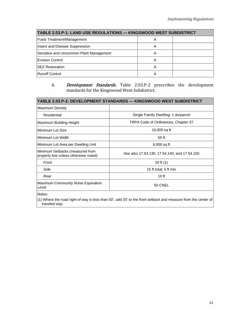
Implementing Regulations
61
TABLE 2.03.P-1: LAND USE REGULATIONS — KINGSWOOD WEST SUBDISTRICT Fuels Treatment/Management A
Insect and Disease Suppression A
Sensitive and Uncommon Plant Management A
Erosion Control A
SEZ Restoration A
Runoff Control A
Development Standards. Table 2.03.P-2 prescribes the development standards for the Kingswood West Subdistrict.
TABLE 2.03.P-2: DEVELOPMENT STANDARDS — KINGSWOOD WEST SUBDISTRICT Maximum Density
Residential Single Family Dwelling: 1 du/parcel
Maximum Building Height TRPA Code of Ordinances, Chapter 37
Minimum Lot Size 10,000 sq ft
Minimum Lot Width 55 ft
Minimum Lot Area per Dwelling Unit 6,000 sq ft
Minimum Setbacks (measured from property line unless otherwise noted) See also 17.54.130, 17.54.140, and 17.54.150
Front 20 ft (1)
Side 15 ft total; 5 ft min
Rear 10 ft
Maximum Community Noise Equivalent Level 50 CNEL
Notes: (1) Where the road right-of way is less than 50’, add 25’ to the front setback and measure from the center of
traveled way.
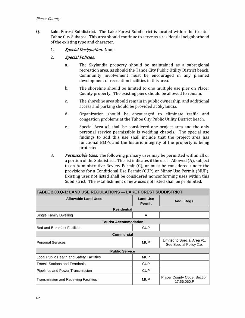
Placer County
62
Q. Lake Forest Subdistrict. The Lake Forest Subdistrict is located within the Greater Tahoe City Subarea. This area should continue to serve as a residential neighborhood of the existing type and character.
Special Designation. None.
Special Policies. The Skylandia property should be maintained as a subregional
recreation area, as should the Tahoe City Public Utility District beach. Community involvement must be encouraged in any planned development of recreation facilities in this area.
The shoreline should be limited to one multiple use pier on Placer County property. The existing piers should be allowed to remain.
The shoreline area should remain in public ownership, and additional access and parking should be provided at Skylandia.
Organization should be encouraged to eliminate traffic and congestion problems at the Tahoe City Public Utility District beach.
Special Area #1 shall be considered one project area and the only personal service permissible is wedding chapels. The special use findings to add this use shall include that the project area has functional BMPs and the historic integrity of the property is being protected.
Permissible Uses. The following primary uses may be permitted within all or a portion of the Subdistrict. The list indicates if the use is Allowed (A), subject to an Administrative Review Permit (C), or must be considered under the provisions for a Conditional Use Permit (CUP) or Minor Use Permit (MUP). Existing uses not listed shall be considered nonconforming uses within this Subdistrict. The establishment of new uses not listed shall be prohibited.
TABLE 2.03.Q-1: LAND USE REGULATIONS — LAKE FOREST SUBDISTRICT Allowable Land Uses Land Use
Permit Add’l Regs.
Residential Single Family Dwelling A
Tourist Accommodation Bed and Breakfast Facilities CUP
Commercial
Personal Services MUP Limited to Special Area #1. See Special Policy 2.e.
Public Service Local Public Health and Safety Facilities MUP
Transit Stations and Terminals CUP
Pipelines and Power Transmission CUP
Transmission and Receiving Facilities MUP Placer County Code, Section 17.56.060.F

Implementing Regulations
63
TABLE 2.03.Q-1: LAND USE REGULATIONS — LAKE FOREST SUBDISTRICT Transportation Routes CUP
Public Utility Centers MUP
Local Post Offices MUP
Religious Assembly MUP
Threshold-Related Research Facilities MUP
Recreation Participant Sports Facilities MUP
Day Use Areas A
Riding and Hiking Trails A
Beach Recreation A
Resource Management Reforestation A
Sanitation Salvage Cut A
Special Cut A
Thinning A
Early Successional Stage Vegetation Management A
Structural and Nonstructural Fish/Wildlife Habitat Management A
Fire Detection and Suppression A
Fuels Treatment/Management A
Insect and Disease Suppression A
Sensitive and Uncommon Plant Management A
Erosion Control A
SEZ Restoration A
Runoff Control A
Development Standards. Table 2.03.Q-2 prescribes the development standards for the Lake Forest Subdistrict.
TABLE 2.03.Q-2: DEVELOPMENT STANDARDS — LAKE FOREST SUBDISTRICT Maximum Density
Residential Single Family Dwelling: 1 du/parcel
Tourist Accommodation Bed and Breakfast Facilities: 10 units per acre
Maximum Building Height TRPA Code of Ordinances, Chapter 37
Minimum Lot Size 10,000 sq ft
Minimum Lot Width 55 ft
Minimum Lot Area per Dwelling Unit 6,000 sq ft
Minimum Setbacks (measured from property line unless otherwise noted) See also 17.54.130, 17.54.140, and 17.54.150
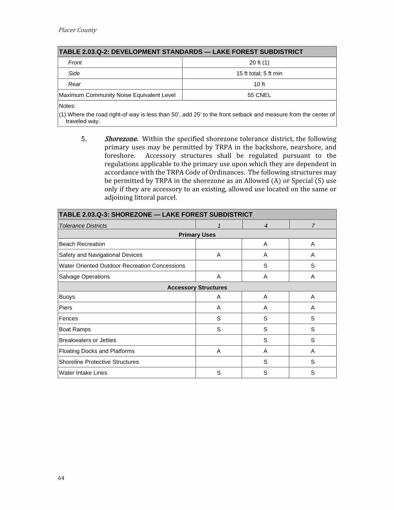
Placer County
64
TABLE 2.03.Q-2: DEVELOPMENT STANDARDS — LAKE FOREST SUBDISTRICT Front 20 ft (1)
Side 15 ft total; 5 ft min
Rear 10 ft
Maximum Community Noise Equivalent Level 55 CNEL
Notes: (1) Where the road right-of way is less than 50’, add 25’ to the front setback and measure from the center of
traveled way.
Shorezone. Within the specified shorezone tolerance district, the following primary uses may be permitted by TRPA in the backshore, nearshore, and foreshore. Accessory structures shall be regulated pursuant to the regulations applicable to the primary use upon which they are dependent in accordance with the TRPA Code of Ordinances. The following structures may be permitted by TRPA in the shorezone as an Allowed (A) or Special (S) use only if they are accessory to an existing, allowed use located on the same or adjoining littoral parcel.
TABLE 2.03.Q-3: SHOREZONE — LAKE FOREST SUBDISTRICT Tolerance Districts 1 4 7
Primary Uses Beach Recreation A A
Safety and Navigational Devices A A A
Water Oriented Outdoor Recreation Concessions S S
Salvage Operations A A A
Accessory Structures Buoys A A A
Piers A A A
Fences S S S
Boat Ramps S S S
Breakwaters or Jetties S S
Floating Docks and Platforms A A A
Shoreline Protective Structures S S
Water Intake Lines S S S
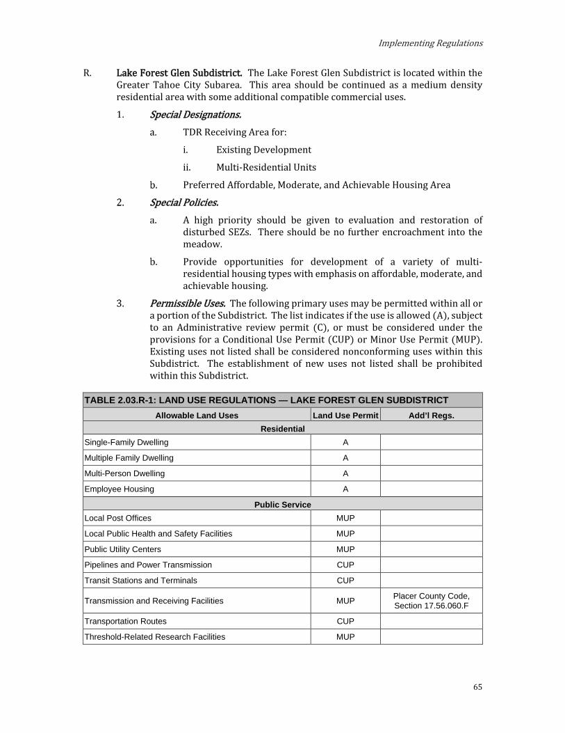
Implementing Regulations
65
R. Lake Forest Glen Subdistrict. The Lake Forest Glen Subdistrict is located within the Greater Tahoe City Subarea. This area should be continued as a medium density residential area with some additional compatible commercial uses.
Special Designations. TDR Receiving Area for:
i. Existing Development
ii. Multi-Residential Units
Preferred Affordable, Moderate, and Achievable Housing Area
Special Policies. A high priority should be given to evaluation and restoration of
disturbed SEZs. There should be no further encroachment into the meadow.
Provide opportunities for development of a variety of multi-residential housing types with emphasis on affordable, moderate, and achievable housing.
Permissible Uses. The following primary uses may be permitted within all or a portion of the Subdistrict. The list indicates if the use is allowed (A), subject to an Administrative review permit (C), or must be considered under the provisions for a Conditional Use Permit (CUP) or Minor Use Permit (MUP). Existing uses not listed shall be considered nonconforming uses within this Subdistrict. The establishment of new uses not listed shall be prohibited within this Subdistrict.
TABLE 2.03.R-1: LAND USE REGULATIONS — LAKE FOREST GLEN SUBDISTRICT Allowable Land Uses Land Use Permit Add’l Regs.
Residential Single-Family Dwelling A
Multiple Family Dwelling A
Multi-Person Dwelling A
Employee Housing A
Public Service Local Post Offices MUP
Local Public Health and Safety Facilities MUP
Public Utility Centers MUP
Pipelines and Power Transmission CUP
Transit Stations and Terminals CUP
Transmission and Receiving Facilities MUP Placer County Code, Section 17.56.060.F
Transportation Routes CUP
Threshold-Related Research Facilities MUP

Placer County
66
TABLE 2.03.R-1: LAND USE REGULATIONS — LAKE FOREST GLEN SUBDISTRICT Recreation
Day Use Areas A
Participant Sports Facilities MUP
Riding and Hiking Trails A
Resource Management Reforestation A
Sanitation Salvage Cut A
Special Cut A
Thinning A
Early Successional Stage Vegetation Management A
Structural and Nonstructural Fish/Wildlife Habitat Management A
Fire Detection And Suppression A
Fuels Treatment/Management A
Insect and Disease Suppression A
Sensitive and Uncommon Plant Management A
Erosion Control A
SEZ Restoration A
Runoff Control A
Development Standards. Table 2.03.R-2 prescribes the development standards for the Lake Forest Glen Subdistrict.
TABLE 2.03.R-2: DEVELOPMENT STANDARDS — LAKE FOREST GLEN SUBDISTRICT Maximum Density
Residential
Single Family Dwelling: 1 du/parcel Multiple Family Dwelling: 15 units per acre Multi-Person Dwelling: 37 persons per acre
Employee Housing: 15 units per acre
Maximum Building Height TRPA Code of Ordinances, Chapter 37
Minimum Lot Size 10,000 sq ft
Minimum Lot Width 55 ft
Minimum Lot Area per Dwelling Unit 6,000 sq ft
Minimum Setbacks (measured from property line unless otherwise noted) See also 17.54.130, 17.54.140, and 17.54.150
Front 20 ft (1)
Side 15 ft total; 5 ft min
Rear 10 ft
Maximum Community Noise Equivalent Level 55 CNEL

Implementing Regulations
67
TABLE 2.03.R-2: DEVELOPMENT STANDARDS — LAKE FOREST GLEN SUBDISTRICT Notes: (1) Where the road right-of way is less than 50’, add 25’ to the front setback and measure from the center of
traveled way.

Placer County
68
S. Mark Twain Tract Subdistrict. The Mark Twain Tract Subdistrict is located partially within the Greater Tahoe City Subdistrict and partially within the West Shore Subarea. This area should continue to be residential, at the density of one residence per legal lot or parcel of record. However, transfer of developments out of this area is encouraged.
Special Designations. None.
Special Policies. None.
Permissible Uses. The following primary uses may be permitted within all or a portion of the Subdistrict. The list indicates if the use is Allowed (A), subject to an Administrative Review Permit (C), or must be considered under the provisions for a Conditional Use Permit (CUP) or Minor Use Permit (MUP). Existing uses not listed shall be considered nonconforming uses within this Subdistrict. The establishment of new uses not listed shall be prohibited.
TABLE 2.03.S-1: LAND USE REGULATIONS — MARK TWAIN TRACT SUBDISTRICT Allowable Land Uses Land Use Permit Add’l Regs.
Residential Single-Family Dwelling A
Public Service Local Public Health and Safety Facilities MUP
Transit Stations and Terminals CUP
Pipelines and Power Transmission CUP
Transmission and Receiving Facilities MUP Placer County Code, Section 17.56.060.F
Transportation Routes CUP
Public Utility Centers MUP
Threshold-Related Research Facilities MUP
Recreation Participant Sports Facilities MUP
Day Use Areas A
Riding and Hiking Trails A
Resource Management Reforestation A
Sanitation Salvage Cut A
Special Cut A
Thinning A
Early Successional Stage Vegetation Management A
Structural and Nonstructural Fish/Wildlife Habitat Management A
Fire Detection and Suppression A
Fuels Treatment/Management A
Insect and Disease Suppression A
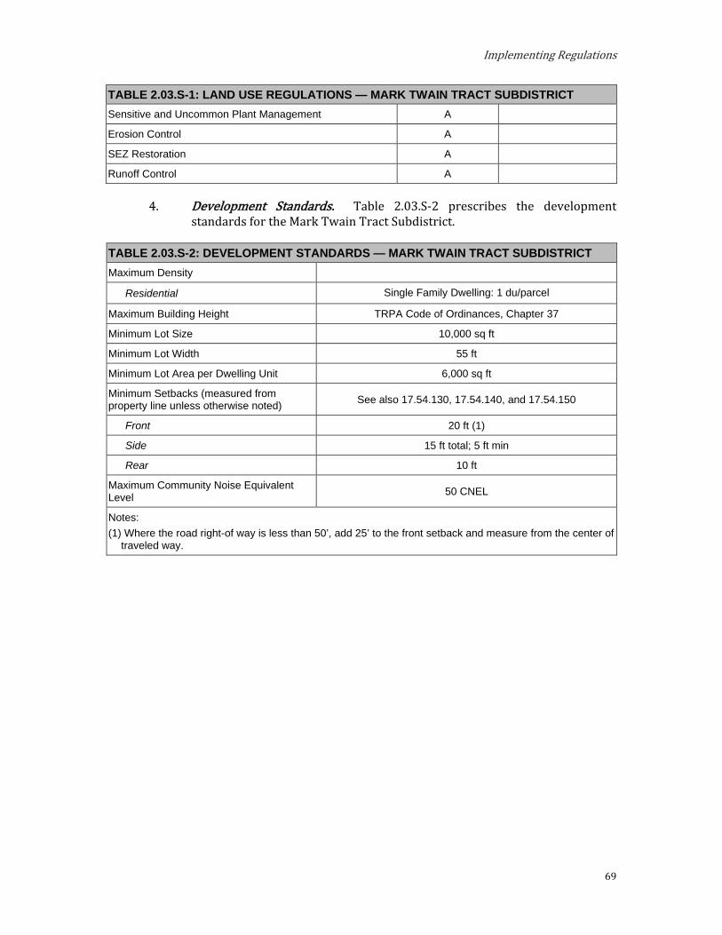
Implementing Regulations
69
TABLE 2.03.S-1: LAND USE REGULATIONS — MARK TWAIN TRACT SUBDISTRICT Sensitive and Uncommon Plant Management A
Erosion Control A
SEZ Restoration A
Runoff Control A
Development Standards. Table 2.03.S-2 prescribes the development standards for the Mark Twain Tract Subdistrict.
TABLE 2.03.S-2: DEVELOPMENT STANDARDS — MARK TWAIN TRACT SUBDISTRICT Maximum Density
Residential Single Family Dwelling: 1 du/parcel
Maximum Building Height TRPA Code of Ordinances, Chapter 37
Minimum Lot Size 10,000 sq ft
Minimum Lot Width 55 ft
Minimum Lot Area per Dwelling Unit 6,000 sq ft
Minimum Setbacks (measured from property line unless otherwise noted) See also 17.54.130, 17.54.140, and 17.54.150
Front 20 ft (1)
Side 15 ft total; 5 ft min
Rear 10 ft
Maximum Community Noise Equivalent Level 50 CNEL
Notes: (1) Where the road right-of way is less than 50’, add 25’ to the front setback and measure from the center of
traveled way.

Placer County
70
T. McKinney Tract Subdistrict. The McKinney Tract Subdistrict is located within the West Shore Subarea. This area should remain residential with a density of one single family dwelling per parcel.
Special Designations. None. Special Policies. Permissible Uses. The following primary uses may be permitted within all or
a portion of the Subdistrict. The list indicates if the use is Allowed (A), subject to an Administrative review permit (C), or must be considered under the provisions for a Conditional Use Permit (CUP) or Minor Use Permit (MUP). Existing uses not listed shall be considered nonconforming uses within this Subdistrict. The establishment of new uses not listed shall be prohibited within this Subdistrict.
TABLE 2.03.T-1: LAND USE REGULATIONS — MCKINNEY TRACT SUBDISTRICT Allowable Land Uses Land Use Permit Add’l Regs.
Residential Single Family Dwelling A
Public Service Local Public Health and Safety Facilities MUP
Transit Stations and Terminals CUP
Pipelines and Power Transmission CUP
Transmission and Receiving Facilities MUP Placer County Code, Section 17.56.060.F
Transportation Routes CUP
Public Utility Centers MUP
Local Post Offices MUP
Day Care Centers/Pre-Schools MUP
Threshold-Related Research Facilities MUP
Recreation Participant Sports Facilities MUP
Day Use Areas A
Riding and Hiking Trails A
Beach Recreation A
Resource Management Reforestation A
Sanitation Salvage Cut A
Special Cut A
Thinning A
Early Successional Stage Vegetation Management A
Structural and Nonstructural Fish/Wildlife Habitat Management A
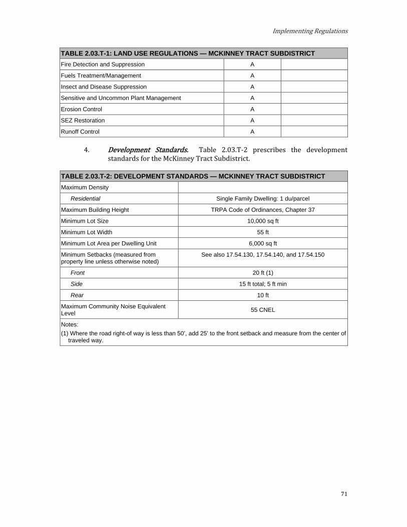
Implementing Regulations
71
TABLE 2.03.T-1: LAND USE REGULATIONS — MCKINNEY TRACT SUBDISTRICT Fire Detection and Suppression A
Fuels Treatment/Management A
Insect and Disease Suppression A
Sensitive and Uncommon Plant Management A
Erosion Control A
SEZ Restoration A
Runoff Control A
Development Standards. Table 2.03.T-2 prescribes the development standards for the McKinney Tract Subdistrict.
TABLE 2.03.T-2: DEVELOPMENT STANDARDS — MCKINNEY TRACT SUBDISTRICT Maximum Density
Residential Single Family Dwelling: 1 du/parcel
Maximum Building Height TRPA Code of Ordinances, Chapter 37
Minimum Lot Size 10,000 sq ft
Minimum Lot Width 55 ft
Minimum Lot Area per Dwelling Unit 6,000 sq ft
Minimum Setbacks (measured from property line unless otherwise noted)
See also 17.54.130, 17.54.140, and 17.54.150
Front 20 ft (1)
Side 15 ft total; 5 ft min
Rear 10 ft
Maximum Community Noise Equivalent Level 55 CNEL
Notes: (1) Where the road right-of way is less than 50’, add 25’ to the front setback and measure from the center of
traveled way.

Placer County
72
Shorezone. Within the specified shorezone tolerance district, the following primary uses may be permitted by TRPA in the backshore, nearshore, and foreshore. Accessory structures shall be regulated pursuant to the regulations applicable to the primary use upon which they are dependent in accordance with the TRPA Code of Ordinances. The following structures may be permitted by TRPA in the shorezone as an Allowed (A) or Special (S) use only if they are accessory to an existing, allowed use located on the same or adjoining littoral parcel.
TABLE 2.03.T-3: SHOREZONE — MCKINNEY TRACT SUBDISTRICT
Tolerance District 7 Primary Uses
Beach Recreation A
Safety and Navigational Devices A
Salvage Operations A
Accessory Structures Buoys A
Piers A
Fences S
Boat Ramps S
Breakwaters or Jetties S
Floating Docks and Platforms A
Shoreline Protective Structures S
Water Intake Lines S

Implementing Regulations
73
U. Rocky Ridge Subdistrict. The Rocky Ridge Subdistrict is located within the Greater Tahoe City Subarea. This area should continue to be a residential area of the same type and character that now exists.
Special Designation. None. Special Policies.
The wall barrier on Burton Creek should be removed or otherwise renovated to facilitate upstream migration of fish.
The existing motel shall be conforming; however, there shall be no additional tourist accommodation units in this Subdistrict.
TRPA recognizes the existing research facility at its current level of use on the Historic Fish Hatchery Property as a Threshold-Related Research Facility in Subdistrict. There shall be no expansion of the existing use unless, at the time of project approval it is determined that the project can be sufficiently mitigated, and there is implementation of the following environmental improvement projects:
i. Participate in planning, designing, and funding a fair share of the Burton Creek Linked Project-Stream Habitat Restoration (EIP Project 01.02.02.0031); AND
ii. Such additional mitigation as TRPA may determine necessary.
Permissible Uses. The following primary uses may be permitted within all or a portion of the Subdistrict. The list indicates if the use is Allowed (A), subject to an Administrative Review Permit (C), or must be considered under the provisions for a Conditional Use Permit (CUP) or Minor Use Permit (MUP). Existing uses not listed shall be considered nonconforming uses within this Subdistrict. The establishment of new uses not listed shall be prohibited.
TABLE 2.03.U-1: LAND USE REGULATIONS — ROCKY RIDGE SUBDISTRICT
Allowable Land Uses Land Use Permit Add’l Regs. Residential
Single-Family Dwelling A
Tourist Accommodation Hotel, Motel and Other Transient Dwelling Units CUP See Special Policy 2.b.
Bed and Breakfast Facilities CUP See Special Policy 2.b.
Commercial Professional Offices MUP
Public Service Local Post Offices MUP
Local Public Health and Safety Facilities MUP
Public Utility Centers MUP
Pipelines and Power Transmission CUP
Transit Stations and Terminals CUP

Placer County
74
TABLE 2.03.U-1: LAND USE REGULATIONS — ROCKY RIDGE SUBDISTRICT Transportation Routes CUP
Transmission and Receiving Facilities MUP Placer County Code, Section 17.56.060.F
Threshold-Related Research Facilities MUP
Recreation Day Use Areas A
Beach Recreation A
Participant Sports MUP
Riding and Hiking Trails A
Resource Management Reforestation A
Sanitation Salvage Cut A
Special Cut A
Thinning A
Early Successional Stage Vegetation Management A
Structural and Nonstructural Fish/Wildlife Habitat Management A
Fire Detection and Suppression A
Fuels Treatment/Management A
Insect and Disease Suppression A
Sensitive and Uncommon Plant Management A
Erosion Control A
SEZ Restoration A
Runoff Control A
Development Standards. Table 2.03.U-2 prescribes the development standards for the Rocky Ridge Subdistrict.
TABLE 2.03.U-2: DEVELOPMENT STANDARDS — ROCKY RIDGE SUBDISTRICT Maximum Density
Residential Single Family Dwelling: 1 du/parcel
Tourist Accommodation
Bed and Breakfast Facilities: 8 units per acre Hotel, Motel and Other Transient Dwelling Units:
With less than 10% of units with kitchens – 20 units per acre With 10% or more units with kitchens – 8 units per acre
Maximum Building Height TRPA Code of Ordinances, Chapter 37
Minimum Lot Size 10,000 sq ft
Minimum Lot Width 55 ft
Minimum Lot Area per Dwelling Unit 6,000 sq ft
Minimum Setbacks (measured from property line unless otherwise noted) See also 17.54.130, 17.54.140, and 17.54.150

Implementing Regulations
75
TABLE 2.03.U-2: DEVELOPMENT STANDARDS — ROCKY RIDGE SUBDISTRICT Front 20 ft (1)
Side 15 ft total; 5 ft min
Rear 10 ft
Maximum Community Noise Equivalent Level 55 CNEL
Notes: (1) Where the road right-of way is less than 50’, add 25’ to the front setback and measure from the center of
traveled way.
Shorezone. Within the specified shorezone tolerance district, the following primary uses may be permitted by TRPA in the backshore, nearshore, and foreshore. Accessory structures shall be regulated pursuant to the regulations applicable to the primary use upon which they are dependent in accordance with the TRPA Code of Ordinances. The following structures may be permitted by TRPA in the shorezone as an Allowed (A) or Special (S) use only if they are accessory to an existing, allowed use located on the same or adjoining littoral parcel.
TABLE 2.03.U-3: SHOREZONE — ROCKY RIDGE SUBDISTRICT Tolerance Districts 4 7
Primary Uses Beach Recreation A A
Safety and Navigational Facilities A A
Salvage Operations A A
Accessory Structures Buoys A A
Piers A A
Fences S S
Boat Ramps S S
Breakwaters or Jetties S S
Floating Docks and Platforms A A
Shoreline Protective Structures S S
Water Intake Lines S S
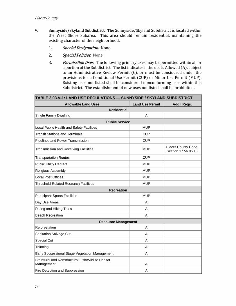
Placer County
76
V. Sunnyside/Skyland Subdistrict. The Sunnyside/Skyland Subdistrict is located within the West Shore Subarea. This area should remain residential, maintaining the existing character of the neighborhood.
Special Designation. None.
Special Policies. None.
Permissible Uses. The following primary uses may be permitted within all or a portion of the Subdistrict. The list indicates if the use is Allowed (A), subject to an Administrative Review Permit (C), or must be considered under the provisions for a Conditional Use Permit (CUP) or Minor Use Permit (MUP). Existing uses not listed shall be considered nonconforming uses within this Subdistrict. The establishment of new uses not listed shall be prohibited.
TABLE 2.03.V-1: LAND USE REGULATIONS — SUNNYSIDE / SKYLAND SUBDISTRICT Allowable Land Uses Land Use Permit Add’l Regs.
Residential Single Family Dwelling A
Public Service Local Public Health and Safety Facilities MUP
Transit Stations and Terminals CUP
Pipelines and Power Transmission CUP
Transmission and Receiving Facilities MUP Placer County Code, Section 17.56.060.F
Transportation Routes CUP
Public Utility Centers MUP
Religious Assembly MUP
Local Post Offices MUP
Threshold-Related Research Facilities MUP
Recreation Participant Sports Facilities MUP
Day Use Areas A
Riding and Hiking Trails A
Beach Recreation A
Resource Management Reforestation A
Sanitation Salvage Cut A
Special Cut A
Thinning A
Early Successional Stage Vegetation Management A
Structural and Nonstructural Fish/Wildlife Habitat Management A
Fire Detection and Suppression A

Implementing Regulations
77
TABLE 2.03.V-1: LAND USE REGULATIONS — SUNNYSIDE / SKYLAND SUBDISTRICT Fuels Treatment/Management A
Insect and Disease Suppression A
Sensitive and Uncommon Plant Management A
Erosion Control A
SEZ Restoration A
Runoff Control A
Development Standards. Table 2.03.V-2 prescribes the development standards for the Sunnyside/Skyland Subdistrict.
TABLE 2.03.V-2: DEVELOPMENT STANDARDS — SUNNYSIDE / SKYLAND SUBDISTRICT Maximum Density
Residential Single Family Dwelling: 1 du/parcel
Maximum Building Height TRPA Code of Ordinances, Chapter 37
Minimum Lot Size 10,000 sq ft
Minimum Lot Width 55 ft
Minimum Lot Area per Dwelling Unit 6,000 sq ft
Minimum Setbacks (measured from property line unless otherwise noted) See also 17.54.130, 17.54.140, and 17.54.150
Front 20 ft (1)
Side 15 ft total; 5 ft min
Rear 10 ft
Maximum Community Noise Equivalent Level 55 CNEL
Notes: (1) Where the road right-of way is less than 50’, add 25’ to the front setback and measure from the center of
traveled way.

Placer County
78
Shorezone. Within the specified shorezone tolerance district, the following primary uses may be permitted by TRPA in the backshore, nearshore, and foreshore. Accessory structures shall be regulated pursuant to the regulations applicable to the primary use upon which they are dependent in accordance with the TRPA Code of Ordinances. The following structures may be permitted by TRPA in the shorezone as an Allowed (A) or Special (S) use only if they are accessory to an existing, allowed use located on the same or adjoining littoral parcel.
TABLE 2.03.V-3: SHOREZONE — SUNNYSIDE / SKYLAND SUBDISTRICT
Tolerance Districts 4 6 7 Primary Uses
Beach Recreation A A A
Safety and Navigational Devices A A A
Salvage Operations A A A
Accessory Structures Buoys A A A
Piers A A A
Fences S S S
Boat Ramps S S S
Breakwaters or Jetties S S S
Floating Docks and Platforms A A A
Shoreline Protective Structures S S S
Water Intake Lines S S S
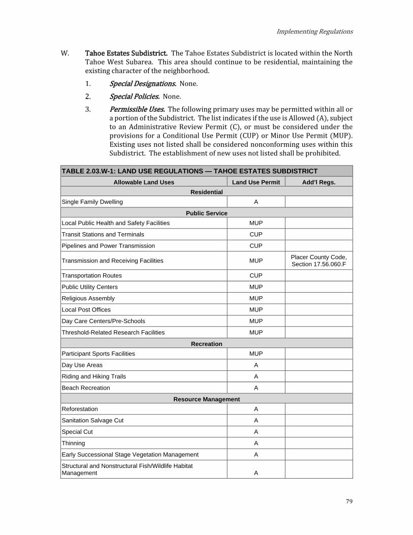
Implementing Regulations
79
W. Tahoe Estates Subdistrict. The Tahoe Estates Subdistrict is located within the North Tahoe West Subarea. This area should continue to be residential, maintaining the existing character of the neighborhood.
Special Designations. None.
Special Policies. None.
Permissible Uses. The following primary uses may be permitted within all or a portion of the Subdistrict. The list indicates if the use is Allowed (A), subject to an Administrative Review Permit (C), or must be considered under the provisions for a Conditional Use Permit (CUP) or Minor Use Permit (MUP). Existing uses not listed shall be considered nonconforming uses within this Subdistrict. The establishment of new uses not listed shall be prohibited.
TABLE 2.03.W-1: LAND USE REGULATIONS — TAHOE ESTATES SUBDISTRICT Allowable Land Uses Land Use Permit Add’l Regs.
Residential Single Family Dwelling A
Public Service Local Public Health and Safety Facilities MUP
Transit Stations and Terminals CUP
Pipelines and Power Transmission CUP
Transmission and Receiving Facilities MUP Placer County Code, Section 17.56.060.F
Transportation Routes CUP
Public Utility Centers MUP
Religious Assembly MUP
Local Post Offices MUP
Day Care Centers/Pre-Schools MUP
Threshold-Related Research Facilities MUP
Recreation Participant Sports Facilities MUP
Day Use Areas A
Riding and Hiking Trails A
Beach Recreation A
Resource Management Reforestation A
Sanitation Salvage Cut A
Special Cut A
Thinning A
Early Successional Stage Vegetation Management A
Structural and Nonstructural Fish/Wildlife Habitat Management A
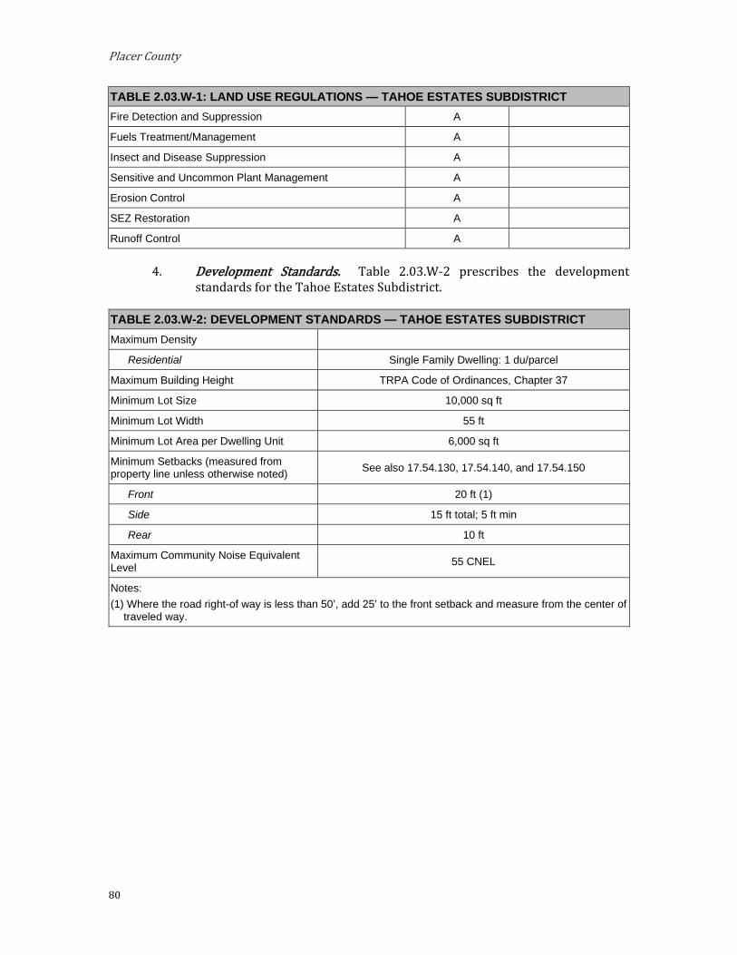
Placer County
80
TABLE 2.03.W-1: LAND USE REGULATIONS — TAHOE ESTATES SUBDISTRICT Fire Detection and Suppression A
Fuels Treatment/Management A
Insect and Disease Suppression A
Sensitive and Uncommon Plant Management A
Erosion Control A
SEZ Restoration A
Runoff Control A
Development Standards. Table 2.03.W-2 prescribes the development standards for the Tahoe Estates Subdistrict.
TABLE 2.03.W-2: DEVELOPMENT STANDARDS — TAHOE ESTATES SUBDISTRICT Maximum Density
Residential Single Family Dwelling: 1 du/parcel
Maximum Building Height TRPA Code of Ordinances, Chapter 37
Minimum Lot Size 10,000 sq ft
Minimum Lot Width 55 ft
Minimum Lot Area per Dwelling Unit 6,000 sq ft
Minimum Setbacks (measured from property line unless otherwise noted) See also 17.54.130, 17.54.140, and 17.54.150
Front 20 ft (1)
Side 15 ft total; 5 ft min
Rear 10 ft
Maximum Community Noise Equivalent Level 55 CNEL
Notes: (1) Where the road right-of way is less than 50’, add 25’ to the front setback and measure from the center of
traveled way.

Implementing Regulations
81
Shorezone. Within the specified shorezone tolerance district, the following primary uses may be permitted by TRPA in the backshore, nearshore, and foreshore. Accessory structures shall be regulated pursuant to the regulations applicable to the primary use upon which they are dependent in accordance with the TRPA Code of Ordinances. The following structures may be permitted by TRPA in the shorezone as an allowed (A) or special (S) use only if they are accessory to an existing, allowed use located on the same or adjoining littoral parcel.
TABLE 2.03.W-3: SHOREZONE — TAHOE ESTATES SUBDISTRICT
Tolerance District 2 Primary Uses
Safety and Navigational Devices A
Salvage Operations A
Accessory Structures Buoys A
Piers A
Fences S
Boat Ramps S
Breakwaters or Jetties S
Floating Docks and Platforms A
Shoreline Protective Structures S
Water Intake Lines S

Placer County
82
X. Tahoe Park/Pineland Subdistrict. The Tahoe Park/Pineland Subdistrict is located within the West Shore Subarea. This area should remain residential, maintaining the existing character of the neighborhood.
Special Designation. None. Special Policies.
Additional fire defensible space and other fire protection facilities are encouraged in this area.
Additional commercial uses permissible in this Subdistrict shall be limited to parcels containing such uses. No additional commercial floor area shall be approved in this Subdistrict.
Permissible Uses. The following primary uses may be permitted within all or a portion of the Subdistrict. The list indicates if the use is Allowed (A), subject to an Administrative Review Permit (C), or must be considered under the provisions for a Conditional Use Permit (CUP) or Minor Use Permit (MUP). Existing uses not listed shall be considered nonconforming uses within this Subdistrict. The establishment of new uses not listed shall be prohibited.
TABLE 2.03.X-1: LAND USE REGULATIONS — TAHOE PARK / PINELAND SUBDISTRICT Allowable Land Uses Land Use Permit Add’l Regs.
Residential Single Family Dwelling A
Commercial Eating and Drinking Places MUP See Special Policy 2.b.
Public Service Local Public Health and Safety Facilities MUP
Transit Stations and Terminals CUP
Pipelines and Power Transmission CUP
Transmission and Receiving Facilities MUP Placer County Code, Section
17.56.060.F
Transportation Routes CUP
Public Utility Centers MUP
Religious Assembly MUP
Local Post Offices MUP
Day Care Centers/Pre-Schools MUP
Schools – Kindergarten through Secondary MUP Limited to Special Area #1
Threshold-Related Research Facilities MUP
Recreation Participant Sports Facilities MUP
Day Use Areas A
Riding and Hiking Trails A

Implementing Regulations
83
TABLE 2.03.X-1: LAND USE REGULATIONS — TAHOE PARK / PINELAND SUBDISTRICT Resource Management
Reforestation A
Sanitation Salvage Cut A
Special Cut A
Thinning A
Early Successional Stage Vegetation Management A
Structural and Nonstructural Fish/Wildlife Habitat Management A
Fire Detection and Suppression A
Fuels Treatment/Management A
Insect and Disease Suppression A
Sensitive and Uncommon Plant Management A
Erosion Control A
SEZ Restoration A
Runoff Control A
Development Standards. Table 2.03.X-2 prescribes the development standards for the Tahoe Park/Pineland Subdistrict.
TABLE 2.03.X-2: DEVELOPMENT STANDARDS — TAHOE PARK / PINELAND SUBDISTRICT Maximum Density
Residential Single Family Dwelling: 1 du/parcel
Maximum Building Height TRPA Code of Ordinances, Chapter 37
Minimum Lot Size 10,000 sq ft
Minimum Lot Width 55 ft
Minimum Lot Area per Dwelling Unit 6,000 sq ft
Minimum Setbacks (measured from property line unless otherwise noted) See also 17.54.130, 17.54.140, and 17.54.150
Front 20 ft (1)
Side 15 ft total; 5 ft min
Rear 10 ft
Maximum Community Noise Equivalent Level 50 CNEL
Highway 89 Corridor 55 CNEL Notes: (1) Where the road right-of way is less than 50’, add 25’ to the front setback and measure from the center of
traveled way.

Placer County
84
Y. Tahoe Pines Subdistrict. The Tahoe Pines Subdistrict is located within the West Shore Subarea. This area should remain residential, maintaining the existing character of the neighborhood.
Special Designation. None.
Special Policies. Efforts to restore Blackwood Creek should continue.
Public access to the shoreline should be maintained or expanded on public lands, particularly on the County lands at Tahoe Pines.
Commercial use of the old Tahoe Pines post office building as it exists upon the adoption of this Area Plan is considered an allowable use.
Permissible Uses. The following primary uses may be permitted within all or a portion of the Subdistrict. The list indicates if the use is Allowed (A), subject to an Administrative Review Permit (C), or must be considered under the provisions for a Conditional Use Permit (CUP) or Minor Use Permit (MUP). Existing uses not listed shall be considered nonconforming uses within this Subdistrict. The establishment of new uses not listed shall be prohibited.
TABLE 2.03.Y-1: LAND USE REGULATIONS — TAHOE PINES SUBDISTRICT Allowable Land Uses Land Use Permit Add’l Regs.
Residential Single Family Dwelling A
Commercial Old Tahoe Pines Post Office (Commercial use of the old Tahoe Pines post office building as it exists upon the adoption of this Subdistrict is considered an allowed use.)
A See Special Policy 2.c.
Public Service Local Public Health and Safety Facilities MUP
Transit Stations and Terminals CUP
Pipelines and Power Transmission CUP
Transmission and Receiving Facilities MUP Placer County Code, Section 17.56.060.F
Transportation Routes CUP
Public Utility Centers MUP
Religious Assembly MUP
Local Post Offices MUP
Day Care Centers/Pre-Schools MUP
Threshold-Related Research Facilities MUP
Recreation Participant Sports Facilities MUP
Day Use Areas A
Riding and Hiking Trails A

Implementing Regulations
85
TABLE 2.03.Y-1: LAND USE REGULATIONS — TAHOE PINES SUBDISTRICT Beach Recreation A
Resource Management Reforestation A
Sanitation Salvage Cut A
Special Cut A
Thinning A
Early Successional Stage Vegetation Management A
Structural and Nonstructural Fish/Wildlife Habitat Management A
Fire Detection and Suppression A
Fuels Treatment/Management A
Insect and Disease Suppression A
Sensitive and Uncommon Plant Management A
Erosion Control A
SEZ Restoration A
Runoff Control A
Development Standards. Table 2.03.Y-2 prescribes the development standards for the Tahoe Pines Subdistrict.
TABLE 2.03.Y-2: DEVELOPMENT STANDARDS — TAHOE PINES SUBDISTRICT Maximum Density
Residential Single Family Dwelling: 1 du/parcel
Maximum Building Height TRPA Code of Ordinances, Chapter 37
Minimum Lot Size 10,000 sq ft
Minimum Lot Width 55 ft
Minimum Lot Area per Dwelling Unit 6,000 sq ft
Minimum Setbacks (measured from property line unless otherwise noted) See also 17.54.130, 17.54.140, and 17.54.150
Front 20 ft (1)
Side 15 ft total; 5 ft min
Rear 10 ft
Maximum Community Noise Equivalent Level 55 CNEL Notes: (1) Where the road right-of way is less than 50’, add 25’ to the front setback and measure from the center of
traveled way.
Shorezone. Within the specified shorezone tolerance district, the following primary uses may be permitted by TRPA in the backshore, nearshore, and foreshore. Accessory structures shall be regulated pursuant to the regulations applicable to the primary use upon which they are dependent in accordance with the TRPA Code of Ordinances. The following structures may
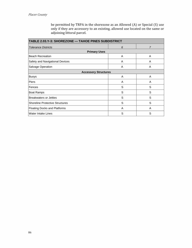
Placer County
86
be permitted by TRPA in the shorezone as an Allowed (A) or Special (S) use only if they are accessory to an existing, allowed use located on the same or adjoining littoral parcel.
TABLE 2.03.Y-3: SHOREZONE — TAHOE PINES SUBDISTRICT
Tolerance Districts 6 7 Primary Uses
Beach Recreation A A
Safety and Navigational Devices A A
Salvage Operation A A
Accessory Structures Buoys A A
Piers A A
Fences S S
Boat Ramps S S
Breakwaters or Jetties S S
Shoreline Protective Structures S S
Floating Docks and Platforms A A
Water Intake Lines S S

Implementing Regulations
87
Z. Tahoe Vista Residential Subdistrict. The Tahoe Vista Residential Subdistrict is located within the North Tahoe West Subarea. This area should continue to be residential, maintaining the existing character of the neighborhood.
Special Designation. TDR Receiving Area for:
i. Existing Development
ii. Multi-Residential Units
Preferred Affordable, Moderate, and Achievable Housing Area
Special Policies. Provide opportunities for development of a variety of multi-
residential housing types with emphasis on affordable, moderate, and achievable housing.
Permissible Uses. The following primary uses may be permitted within all or a portion of the Subdistrict. The list indicates if the use is Allowed (A), subject to an Administrative Review Permit (C), or must be considered under the provisions for a Conditional Use Permit (CUP) or Minor Use Permit (MUP). Existing uses not listed shall be considered nonconforming uses within this Subdistrict. The establishment of new uses not listed shall be prohibited.
TABLE 2.03.Z-1: LAND USE REGULATIONS — TAHOE VISTA RESIDENTIAL SUBDISTRICT Allowable Land Uses Land Use Permit Add’l Regs.
Residential Employee Housing A
Mobile Home Dwelling MUP
Multiple Family Dwelling A
Multi-Person Dwelling A
Residential Care A
Single-Family Dwelling A
Public Service Religious Assembly MUP
Day Care Centers – Pre-Schools A
Local Public Health and Safety Facilities MUP
Schools – Kindergarten through Secondary MUP
Pipelines and Power Transmission CUP
Transit Stations and Terminals CUP
Transportation Routes CUP
Transmission and Receiving Facilities MUP Placer County Code, Section 17.56.060.F
Threshold-Related Research Facilities MUP
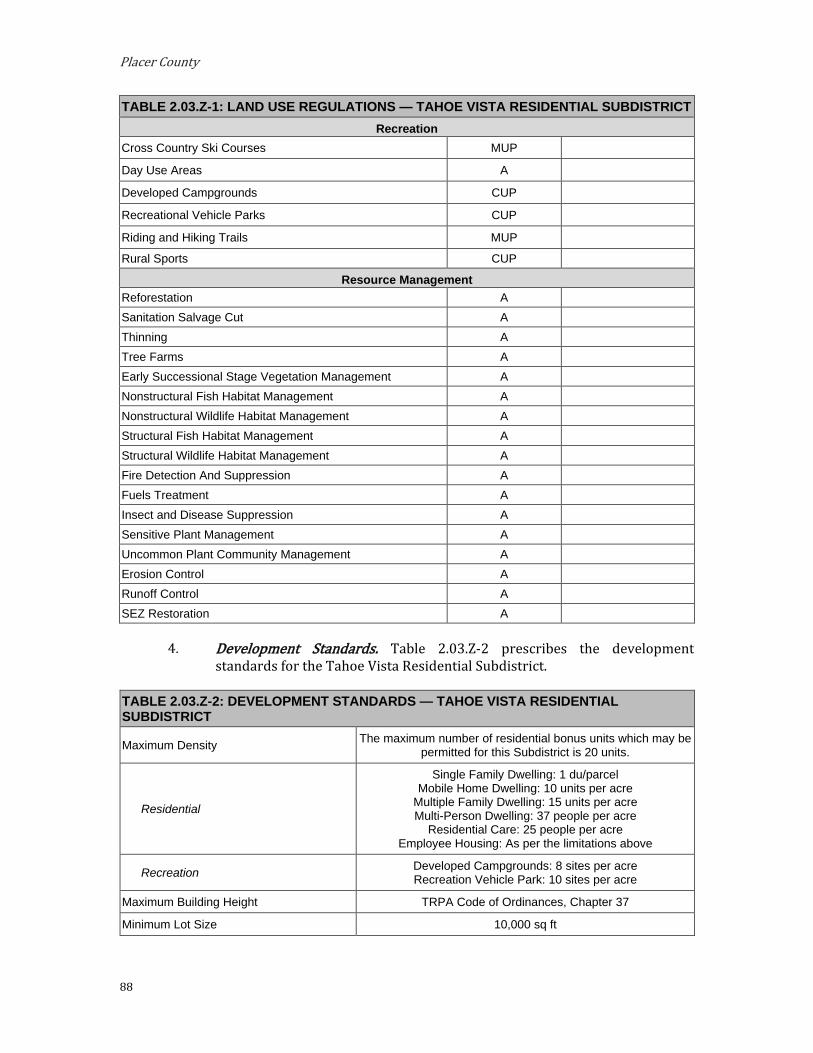
Placer County
88
TABLE 2.03.Z-1: LAND USE REGULATIONS — TAHOE VISTA RESIDENTIAL SUBDISTRICT Recreation
Cross Country Ski Courses MUP
Day Use Areas A
Developed Campgrounds CUP
Recreational Vehicle Parks CUP
Riding and Hiking Trails MUP
Rural Sports CUP
Resource Management Reforestation A Sanitation Salvage Cut A Thinning A Tree Farms A Early Successional Stage Vegetation Management A Nonstructural Fish Habitat Management A Nonstructural Wildlife Habitat Management A Structural Fish Habitat Management A Structural Wildlife Habitat Management A Fire Detection And Suppression A Fuels Treatment A Insect and Disease Suppression A Sensitive Plant Management A Uncommon Plant Community Management A Erosion Control A Runoff Control A SEZ Restoration A
Development Standards. Table 2.03.Z-2 prescribes the development standards for the Tahoe Vista Residential Subdistrict.
TABLE 2.03.Z-2: DEVELOPMENT STANDARDS — TAHOE VISTA RESIDENTIAL SUBDISTRICT
Maximum Density The maximum number of residential bonus units which may be permitted for this Subdistrict is 20 units.
Residential
Single Family Dwelling: 1 du/parcel Mobile Home Dwelling: 10 units per acre
Multiple Family Dwelling: 15 units per acre Multi-Person Dwelling: 37 people per acre
Residential Care: 25 people per acre Employee Housing: As per the limitations above
Recreation Developed Campgrounds: 8 sites per acre Recreation Vehicle Park: 10 sites per acre
Maximum Building Height TRPA Code of Ordinances, Chapter 37
Minimum Lot Size 10,000 sq ft

Implementing Regulations
89
TABLE 2.03.Z-2: DEVELOPMENT STANDARDS — TAHOE VISTA RESIDENTIAL SUBDISTRICT Minimum Lot Width 55 ft
Minimum Lot Area per Dwelling Unit 6,000 sq ft
Minimum Setbacks (measured from property line unless otherwise noted) See also 17.54.130, 17.54.140, and 17.54.150
Front 20 ft (1)
Side 15 ft total; 5 ft min
Rear 10 ft
Maximum Community Noise Equivalent Level 55 CNEL
Notes: (1) Where the road right-of way is less than 50’, add 25’ to the front setback and measure from the center of
traveled way.
AA. Tahoe Vista Subdivision Subdistrict. The Tahoe Vista Subdivision Subdistrict is located within the North Tahoe West Subarea. This area should continue to be low density residential, maintaining the existing character of the neighborhood.
Special Designation. None.
Special Policies. Nonresidential uses should be limited to parcels fronting Highway 28
and National Avenue.
Permissible Uses. The following primary uses may be permitted within all or a portion of the Subdistrict. The list indicates if the use is Allowed (A), subject to an Administrative Review Permit (C), or must be considered under the provisions for a Conditional Use Permit (CUP) or Minor Use Permit (MUP). Existing uses not listed shall be considered nonconforming uses within this Subdistrict. The establishment of new uses not listed shall be prohibited.
TABLE 2.03.AA-1: LAND USE REGULATIONS — TAHOE VISTA SUBDIVISION SUBDISTRICT
Allowable Land Uses Land Use Permit Add’l Regs. Residential
Single Family Dwelling A
Public Service Local Public Health and Safety Facilities MUP See Special Policy 2.a.
Transit Stations and Terminals CUP See Special Policy 2.a.
Pipelines and Power Transmission CUP
Transmission and Receiving Facilities MUP Placer County Code, Section 17.56.060.F
Transportation Routes CUP
Public Utility Centers MUP See Special Policy 2.a.
Religious Assembly MUP See Special Policy 2.a.
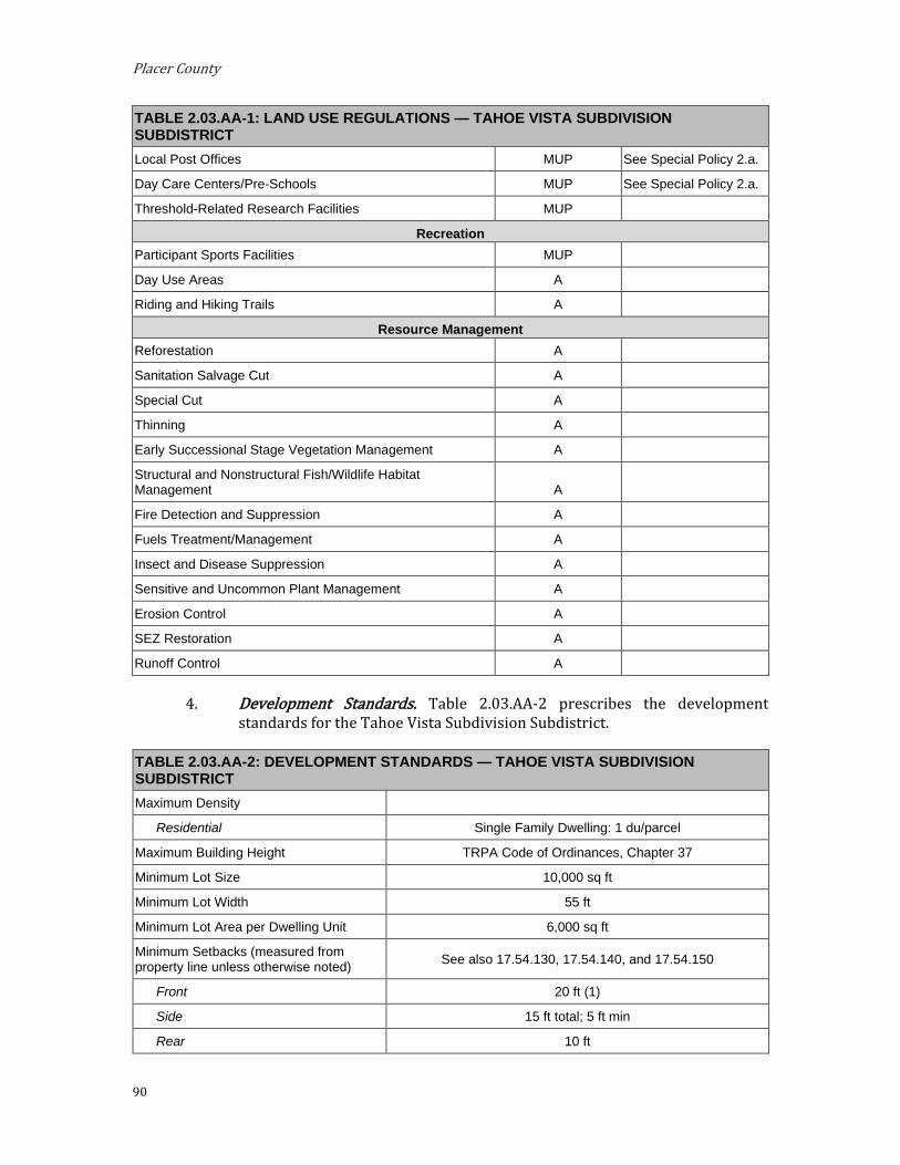
Placer County
90
TABLE 2.03.AA-1: LAND USE REGULATIONS — TAHOE VISTA SUBDIVISION SUBDISTRICT Local Post Offices MUP See Special Policy 2.a.
Day Care Centers/Pre-Schools MUP See Special Policy 2.a.
Threshold-Related Research Facilities MUP
Recreation Participant Sports Facilities MUP
Day Use Areas A
Riding and Hiking Trails A
Resource Management Reforestation A
Sanitation Salvage Cut A
Special Cut A
Thinning A
Early Successional Stage Vegetation Management A
Structural and Nonstructural Fish/Wildlife Habitat Management A
Fire Detection and Suppression A
Fuels Treatment/Management A
Insect and Disease Suppression A
Sensitive and Uncommon Plant Management A
Erosion Control A
SEZ Restoration A
Runoff Control A
Development Standards. Table 2.03.AA-2 prescribes the development standards for the Tahoe Vista Subdivision Subdistrict.
TABLE 2.03.AA-2: DEVELOPMENT STANDARDS — TAHOE VISTA SUBDIVISION SUBDISTRICT Maximum Density
Residential Single Family Dwelling: 1 du/parcel
Maximum Building Height TRPA Code of Ordinances, Chapter 37
Minimum Lot Size 10,000 sq ft
Minimum Lot Width 55 ft
Minimum Lot Area per Dwelling Unit 6,000 sq ft
Minimum Setbacks (measured from property line unless otherwise noted) See also 17.54.130, 17.54.140, and 17.54.150
Front 20 ft (1)
Side 15 ft total; 5 ft min
Rear 10 ft

Implementing Regulations
91
TABLE 2.03.AA-2: DEVELOPMENT STANDARDS — TAHOE VISTA SUBDIVISION SUBDISTRICT Maximum Community Noise Equivalent Level 55 CNEL
Notes: (1) Where the road right-of way is less than 50’, add 25’ to the front setback and measure from the center of
traveled way.
BB. Tahoma Residential Subdistrict. The Tahoma Residential Subdistrict is located within the West Shore Subarea. This area should continue to be residential, maintaining the existing character of the neighborhood.
Special Designations. (See Section 3.14) TDR Receiving Area for Existing Development; Multi-Residential
Units.
Preferred Affordable, Moderate, and Achievable Housing Area
Special Policies. Placer County, El Dorado County, and the Tahoe City Advisory Council
should continue to coordinate efforts with TRPA and State agencies to solve water quality problems in this area.
Water treatment facilities such as settling ponds should be located in this area.
Provide opportunities for development of a variety of multi-residential housing types with an emphasis on affordable, moderate, and achievable housing.
Permissible Uses. The following primary uses may be permitted within all or a portion of the Subdistrict. The list indicates if the use is Allowed (A), subject to an Administrative Review Permit (C), or must be considered under the provisions for a Conditional Use Permit (CUP) or Minor Use Permit (MUP). Existing uses not listed shall be considered nonconforming uses within this Subdistrict. The establishment of new uses not listed shall be prohibited.
TABLE 2.03.BB-1: LAND USE REGULATIONS — TAHOMA RESIDENTIAL SUBDISTRICT Allowable Land Uses Land Use Permit Add’l Regs.
Residential Single-Family Dwelling A
Multiple Family Dwelling A
Multi-Person Dwellings MUP
Employee Housing A
Tourist Accommodation Bed and Breakfast Facilities CUP
Public Service Local Public Health and Safety Facilities MUP
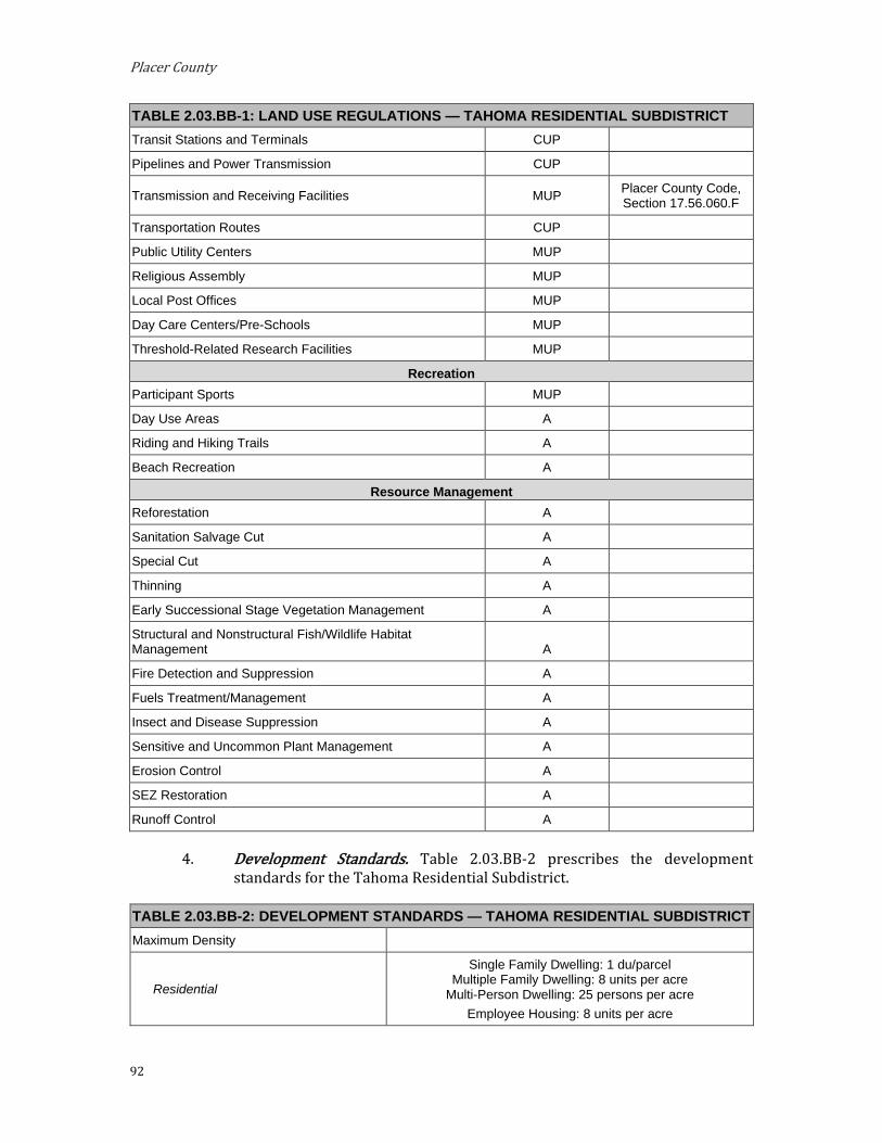
Placer County
92
TABLE 2.03.BB-1: LAND USE REGULATIONS — TAHOMA RESIDENTIAL SUBDISTRICT Transit Stations and Terminals CUP
Pipelines and Power Transmission CUP
Transmission and Receiving Facilities MUP Placer County Code, Section 17.56.060.F
Transportation Routes CUP
Public Utility Centers MUP
Religious Assembly MUP
Local Post Offices MUP
Day Care Centers/Pre-Schools MUP
Threshold-Related Research Facilities MUP
Recreation Participant Sports MUP
Day Use Areas A
Riding and Hiking Trails A
Beach Recreation A
Resource Management Reforestation A
Sanitation Salvage Cut A
Special Cut A
Thinning A
Early Successional Stage Vegetation Management A
Structural and Nonstructural Fish/Wildlife Habitat Management A
Fire Detection and Suppression A
Fuels Treatment/Management A
Insect and Disease Suppression A
Sensitive and Uncommon Plant Management A
Erosion Control A
SEZ Restoration A
Runoff Control A
Development Standards. Table 2.03.BB-2 prescribes the development standards for the Tahoma Residential Subdistrict.
TABLE 2.03.BB-2: DEVELOPMENT STANDARDS — TAHOMA RESIDENTIAL SUBDISTRICT Maximum Density
Residential
Single Family Dwelling: 1 du/parcel Multiple Family Dwelling: 8 units per acre
Multi-Person Dwelling: 25 persons per acre Employee Housing: 8 units per acre

Implementing Regulations
93
TABLE 2.03.BB-2: DEVELOPMENT STANDARDS — TAHOMA RESIDENTIAL SUBDISTRICT Tourist Accommodation Bed and Breakfast Facilities: 8 units per acre
Maximum Building Height TRPA Code of Ordinances, Chapter 37
Minimum Lot Size 10,000 sq ft
Minimum Lot Width 55 ft
Minimum Lot Area per Dwelling Unit 6,000 sq ft
Minimum Setbacks (measured from property line unless otherwise noted) See also 17.54.130, 17.54.140, and 17.54.150
Front 20 ft (1)
Side 15 ft total; 5 ft min
Rear 10 ft
Maximum Community Noise Equivalent Level 55 CNEL
Notes: (1) Where the road right-of way is less than 50’, add 25’ to the front setback and measure from the center of
traveled way.
Shorezone. Within the specified shorezone tolerance district, the following primary uses may be permitted by TRPA in the backshore, nearshore, and foreshore. Accessory structures shall be regulated pursuant to the regulations applicable to the primary use upon which they are dependent in accordance with the TRPA Code of Ordinances. The following structures may be permitted by TRPA in the shorezone as an Allowed (A) or Special (S) use only if they are accessory to an existing, allowed use located on the same or adjoining littoral parcel.
TABLE 2.03.BB-3: SHOREZONE — TAHOMA RESIDENTIAL SUBDISTRICT
Tolerance Districts 6 7 Primary Uses
Beach Recreation A A
Safety and Navigational Devices A A
Salvage Operations A A
Accessory Structures Buoys A A
Piers A A
Fences S S
Boat Ramps S S
Breakwaters or Jetties S S
Floating Docks and Platforms A A
Shoreline Protective Structures S S
Water Intake Lines S S

Placer County
94
CC. Talmont Subdistrict. The Talmont Subdistrict is located within the West Shore Sub-area. This area should remain residential, maintaining the existing character of the neighborhood.
Special Designation. None.
Special Policies. None.
Permissible Uses. The following primary uses may be permitted within all or a portion of the Subdistrict. The list indicates if the use is Allowed (A), subject to an Administrative Review Permit (C), or must be considered under the provisions for a Conditional Use Permit (CUP) or Minor Use Permit (MUP). Existing uses not listed shall be considered nonconforming uses within this Subdistrict. The establishment of new uses not listed shall be prohibited.
TABLE 2.03.CC-1: LAND USE REGULATIONS — TALMONT SUBDISTRICT Allowable Land Uses Land Use Permit Add’l Regs.
Residential Single-Family Dwelling A
Public Service Local Public Health and Safety Facilities MUP
Transit Stations and Terminals CUP
Pipelines and Power Transmissions CUP
Transmission and Receiving Facilities MUP Placer County Code, Section 17.56.060.F
Transportation Routes CUP
Public Utility Centers MUP
Day Care Centers/Pre-Schools MUP
Threshold-Related Research Facilities MUP
Recreation Participant Sports Facilities MUP
Day Use Areas A
Riding and Hiking Trails A
Resource Management Reforestation A
Sanitation Salvage Cut A
Special Cut A
Thinning A
Early Successional Stage Vegetation Management A
Structural and Nonstructural Fish/Wildlife Habitat Management A
Fire Detection and Suppression A
Fuels Treatment/Management A
Insect and Disease Suppression A
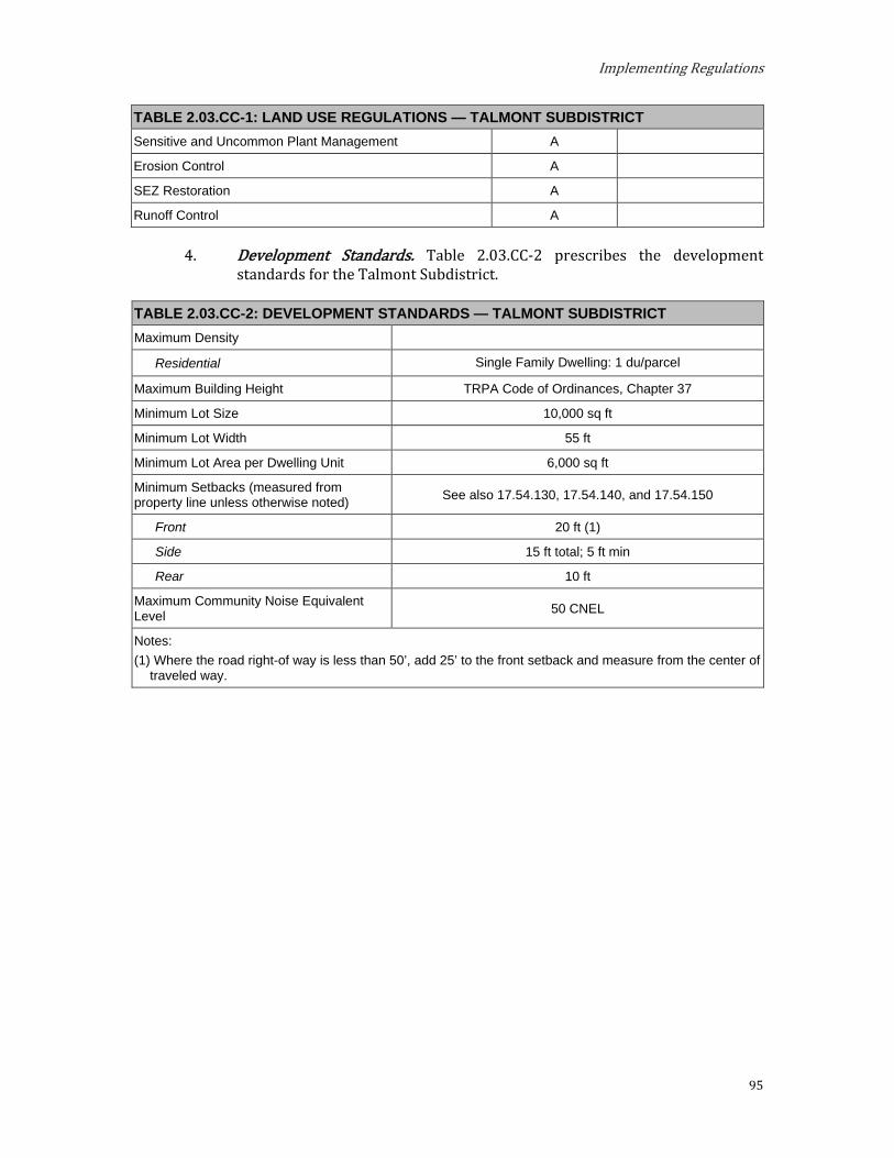
Implementing Regulations
95
TABLE 2.03.CC-1: LAND USE REGULATIONS — TALMONT SUBDISTRICT Sensitive and Uncommon Plant Management A
Erosion Control A
SEZ Restoration A
Runoff Control A
Development Standards. Table 2.03.CC-2 prescribes the development standards for the Talmont Subdistrict.
TABLE 2.03.CC-2: DEVELOPMENT STANDARDS — TALMONT SUBDISTRICT Maximum Density
Residential Single Family Dwelling: 1 du/parcel
Maximum Building Height TRPA Code of Ordinances, Chapter 37
Minimum Lot Size 10,000 sq ft
Minimum Lot Width 55 ft
Minimum Lot Area per Dwelling Unit 6,000 sq ft
Minimum Setbacks (measured from property line unless otherwise noted) See also 17.54.130, 17.54.140, and 17.54.150
Front 20 ft (1)
Side 15 ft total; 5 ft min
Rear 10 ft
Maximum Community Noise Equivalent Level 50 CNEL
Notes: (1) Where the road right-of way is less than 50’, add 25’ to the front setback and measure from the center of
traveled way.

Placer County
96
DD. Tavern Heights Subdistrict. The Tavern Heights Subdistrict is located partially within the Greater Tahoe City Subarea and partially within the West Shore Subarea. This area should continue to be residential, maintaining the existing character of the neighborhood.
Special Designations. (See Section 3.14) TDR Receiving Area for Existing Development; Multi-Residential
Units (Special Area #1 Only)
Preferred Affordable, Moderate, and Achievable Housing Area
Special Policies. a. The two religious facilities, as they exist upon the adoption of this
Area Plan, are considered allowed uses.
b. Special Area #1 is designated for multi-residential use and Government Office Use.
c. Special Area #1 provide opportunities for development of a variety of multi-residential housing types with emphasis on affordable, moderate, achievable, and employee housing.
Permissible Uses. The following primary uses may be permitted within all or a portion of the Subdistrict. The list indicates if the use is Allowed (A), subject to an Administrative Review Permit (C), or must be considered under the provisions for a Conditional Use Permit (CUP) or Minor Use Permit (MUP). Existing uses not listed shall be considered nonconforming uses within this Subdistrict. The establishment of new uses not listed shall be prohibited.
TABLE 2.03.DD-1: LAND USE REGULATIONS — TAVERN HEIGHTS SUBDISTRICT Allowable Land Uses Land Use Permit Add’l Regs.
Residential Single-Family Dwelling A
Multiple Family Dwellings MUP Limited to Special Area
#1
Multi-Person Dwellings MUP Limited to Special Area
#1
Employee Housing MUP Limited to Special Area
#1
Tourist Accommodation Bed and Breakfast Facilities CUP
Public Service Government Offices MUP
Local Public Health and Safety Facilities MUP
Transit Stations and Terminals CUP Pipelines and Power Transmission CUP
Transmission and Receiving Facilities MUP Placer County Code, Section 17.56.060.F
Transportation Routes CUP

Implementing Regulations
97
TABLE 2.03.DD-1: LAND USE REGULATIONS — TAVERN HEIGHTS SUBDISTRICT Public Utility Centers MUP Day Care Centers/Pre-Schools MUP Threshold-Related Research Facilities MUP
Recreation Participant Sports Facilities MUP Day Use Areas A Riding and Hiking Trails A Beach Recreation A
Resource Management Reforestation A Sanitation Salvage Cut A Thinning A Early Successional Stage Vegetation Management A Structural and Nonstructural Fish/Wildlife Habitat Management A
Fire Detection and Suppression A Fuels Treatment/Management A Insect and Disease Suppression A Sensitive Plant Management A Uncommon Plant Management A Erosion Control A SEZ Restoration A Runoff Control A
Development Standards. Table 2.03.DD-2 prescribes the development standards for the Tavern Heights Subdistrict.
TABLE 2.03.DD-2: DEVELOPMENT STANDARDS — TAVERN HEIGHTS SUBDISTRICT Maximum Density
Residential
Single Family Dwelling: 1 du/parcel Multiple Family Dwelling: 8 units per acre
Multi-Person Dwelling: 25 persons per acre Employee Housing: 8 units per acre
Tourist Accommodation Bed and Breakfast Facilities: 8 units per acre
Maximum Building Height TRPA Code of Ordinances, Chapter 37
Minimum Lot Size 10,000 sq ft
Minimum Lot Width 55 ft
Minimum Lot Area per Dwelling Unit 6,000 sq ft
Minimum Setbacks (measured from property line unless otherwise noted) See also 17.54.130, 17.54.140, and 17.54.150
Front 20 ft (1)
Side 15 ft total; 5 ft min
Rear 10 ft
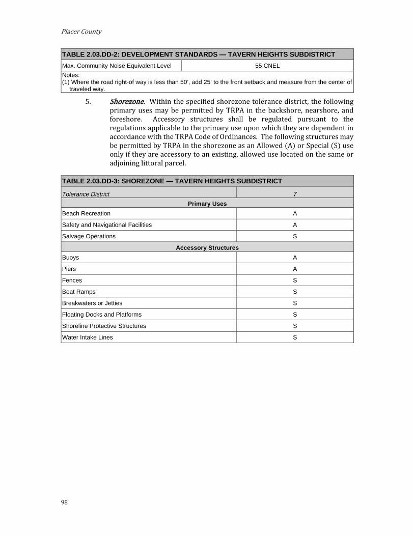
Placer County
98
TABLE 2.03.DD-2: DEVELOPMENT STANDARDS — TAVERN HEIGHTS SUBDISTRICT Max. Community Noise Equivalent Level 55 CNEL Notes: (1) Where the road right-of way is less than 50’, add 25’ to the front setback and measure from the center of
traveled way.
Shorezone. Within the specified shorezone tolerance district, the following primary uses may be permitted by TRPA in the backshore, nearshore, and foreshore. Accessory structures shall be regulated pursuant to the regulations applicable to the primary use upon which they are dependent in accordance with the TRPA Code of Ordinances. The following structures may be permitted by TRPA in the shorezone as an Allowed (A) or Special (S) use only if they are accessory to an existing, allowed use located on the same or adjoining littoral parcel.
TABLE 2.03.DD-3: SHOREZONE — TAVERN HEIGHTS SUBDISTRICT
Tolerance District 7 Primary Uses
Beach Recreation A
Safety and Navigational Facilities A
Salvage Operations S
Accessory Structures Buoys A
Piers A
Fences S
Boat Ramps S
Breakwaters or Jetties S
Floating Docks and Platforms S
Shoreline Protective Structures S
Water Intake Lines S

Implementing Regulations
99
EE. Timberland Subdistrict. The Timberland Subdistrict is located within the West Shore Subarea. This area should remain residential, maintaining the existing character of the neighborhood.
Special Designation. None.
Special Policies. None.
Permissible Uses. The following primary uses may be permitted within all or a portion of the Subdistrict. The list indicates if the use is Allowed (A), subject to an Administrative Review Permit (C), or must be considered under the provisions for a Conditional Use Permit (CUP) or Minor Use Permit (MUP). Existing uses not listed shall be considered nonconforming uses within this Subdistrict. The establishment of new uses not listed shall be prohibited.
TABLE 2.03.EE-1: LAND USE REGULATIONS — TIMBERLAND SUBDISTRICT Allowable Land Uses Land Use Permit Add’l Regs.
Residential Single Family Dwelling A
Public Service Local Public Health and Safety Facilities MUP
Transit Stations and Terminals CUP
Pipelines and Power Transmission CUP
Transmission and Receiving Facilities MUP Placer County Code, Section 17.56.060.F
Transportation Routes CUP
Public Utility Centers MUP
Local Post Offices MUP
Schools – Kindergarten through Secondary A
Day Care Centers/Pre-Schools MUP
Threshold-Related Research Facilities MUP
Recreation Participant Sports Facilities MUP
Day Use Areas A
Riding and Hiking Trails A
Resource Management Reforestation A
Sanitation Salvage Cut A
Special Cut A
Thinning A
Early Successional Stage Vegetation Management A
Structural and Nonstructural Fish/Wildlife Habitat Management A
Fire Detection and Suppression A
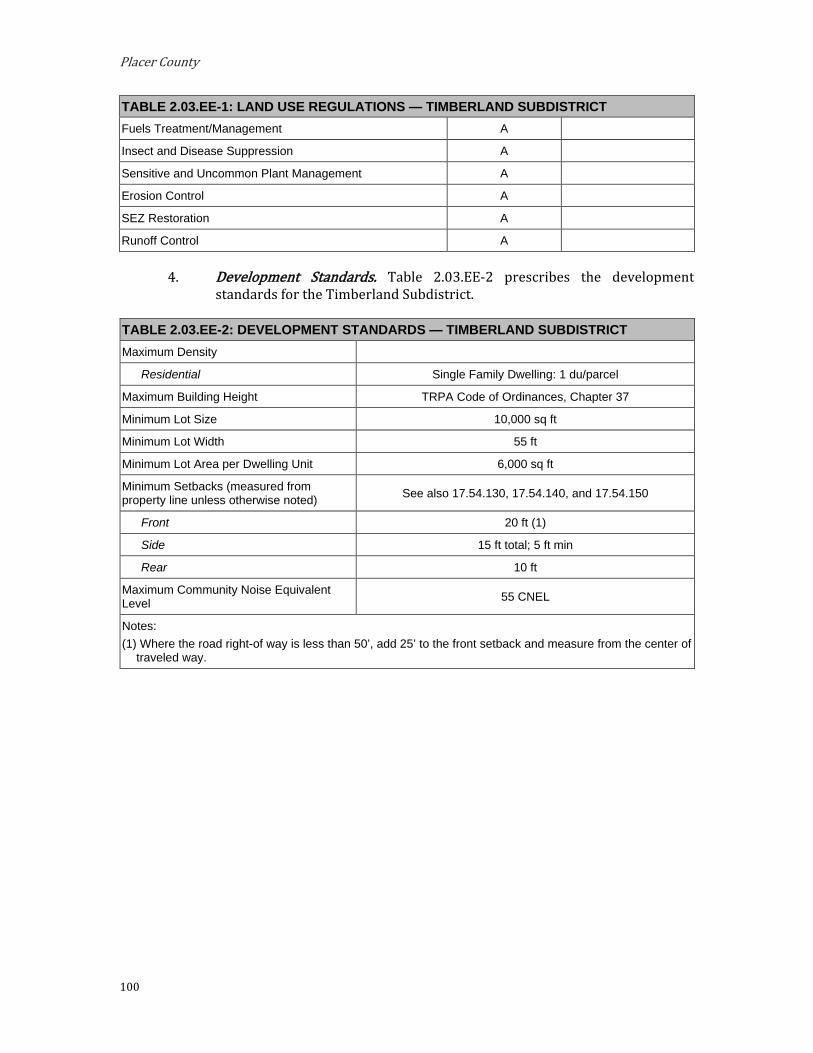
Placer County
100
TABLE 2.03.EE-1: LAND USE REGULATIONS — TIMBERLAND SUBDISTRICT Fuels Treatment/Management A
Insect and Disease Suppression A
Sensitive and Uncommon Plant Management A
Erosion Control A
SEZ Restoration A
Runoff Control A
Development Standards. Table 2.03.EE-2 prescribes the development standards for the Timberland Subdistrict.
TABLE 2.03.EE-2: DEVELOPMENT STANDARDS — TIMBERLAND SUBDISTRICT Maximum Density
Residential Single Family Dwelling: 1 du/parcel
Maximum Building Height TRPA Code of Ordinances, Chapter 37
Minimum Lot Size 10,000 sq ft
Minimum Lot Width 55 ft
Minimum Lot Area per Dwelling Unit 6,000 sq ft
Minimum Setbacks (measured from property line unless otherwise noted) See also 17.54.130, 17.54.140, and 17.54.150
Front 20 ft (1)
Side 15 ft total; 5 ft min
Rear 10 ft
Maximum Community Noise Equivalent Level 55 CNEL
Notes: (1) Where the road right-of way is less than 50’, add 25’ to the front setback and measure from the center of
traveled way.
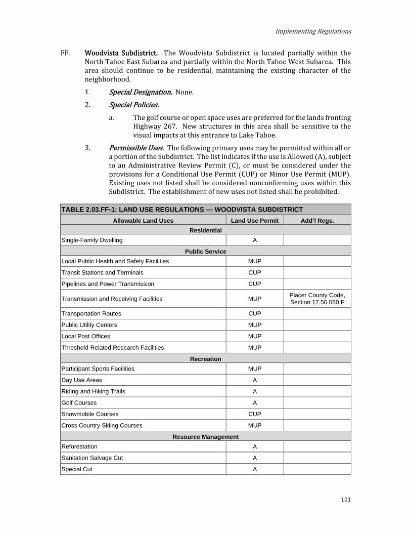
Implementing Regulations
101
FF. Woodvista Subdistrict. The Woodvista Subdistrict is located partially within the North Tahoe East Subarea and partially within the North Tahoe West Subarea. This area should continue to be residential, maintaining the existing character of the neighborhood.
Special Designation. None.
Special Policies. The golf course or open space uses are preferred for the lands fronting
Highway 267. New structures in this area shall be sensitive to the visual impacts at this entrance to Lake Tahoe.
Permissible Uses. The following primary uses may be permitted within all or a portion of the Subdistrict. The list indicates if the use is Allowed (A), subject to an Administrative Review Permit (C), or must be considered under the provisions for a Conditional Use Permit (CUP) or Minor Use Permit (MUP). Existing uses not listed shall be considered nonconforming uses within this Subdistrict. The establishment of new uses not listed shall be prohibited.
TABLE 2.03.FF-1: LAND USE REGULATIONS — WOODVISTA SUBDISTRICT Allowable Land Uses Land Use Permit Add’l Regs.
Residential Single-Family Dwelling A
Public Service Local Public Health and Safety Facilities MUP
Transit Stations and Terminals CUP
Pipelines and Power Transmission CUP
Transmission and Receiving Facilities MUP Placer County Code, Section 17.56.060.F
Transportation Routes CUP
Public Utility Centers MUP
Local Post Offices MUP
Threshold-Related Research Facilities MUP
Recreation Participant Sports Facilities MUP
Day Use Areas A
Riding and Hiking Trails A
Golf Courses A
Snowmobile Courses CUP
Cross Country Skiing Courses MUP
Resource Management Reforestation A
Sanitation Salvage Cut A
Special Cut A

Placer County
102
TABLE 2.03.FF-1: LAND USE REGULATIONS — WOODVISTA SUBDISTRICT Thinning A
Early Successional Stage Vegetation Management A
Structural and Nonstructural Fish/Wildlife Habitat Management A
Fire Detection and Suppression A
Fuels Treatment/Management A
Insect and Disease Suppression A
Sensitive and Uncommon Plant Management A
Erosion Control A
SEZ Restoration A
Runoff Control A
Development Standards. Table 2.03.FF-2 prescribes the development standards for the Woodvista Subdistrict.
TABLE 2.03.FF-2: DEVELOPMENT STANDARDS — WOODVISTA SUBDISTRICT Maximum Density
Residential Single Family Dwelling: 1 du/parcel
Maximum Building Height TRPA Code of Ordinances, Chapter 37
Minimum Lot Size 10,000 sq ft
Minimum Lot Width 55 ft
Minimum Lot Area per Dwelling Unit 6,000 sq ft
Minimum Setbacks (measured from property line unless otherwise noted)
See also 17.54.130, 17.54.140, and 17.54.150
Front 20 ft (1)
Side 15 ft total; 5 ft min
Rear 10 ft
Maximum Community Noise Equivalent Level 50 CNEL
Highway 267 Corridor 55 CNEL
Notes: (1) Where the road right-of way is less than 50’, add 25’ to the front setback and measure from the center of
traveled way.
Implementing Regulations
103
Mixed-Use Districts
The Mixed-Use Subdistricts are classified within four Subareas - Greater Tahoe City, North Tahoe East, North Tahoe West, and West Shore. There are separate standards and guidelines applicable to each Subarea, which supplement the general guidelines provided within Chapter 3: Area-Wide Standards and Guidelines.
A. Greater Tahoe City Mixed-Use Subdistricts.
1. Purpose. The purposes of the Greater Tahoe City Mixed-Use Subdistricts are to:
Provide for the orderly, well-planned, and balanced growth of the Greater Tahoe City area and support the area’s role as an important hub of the Lake Tahoe Region and a vibrant commercial, cultural, recreational, and tourist center.
Promote Tahoe City as a pedestrian-oriented, mixed-use activity center and gateway to North Lake Tahoe.
Encourage a mix of uses that promotes environmental improvement, economic vitality, and a pleasant quality of life and improve access to a greater range of facilities and services for residents.
Establish design standards that improve the pedestrian-orientation and visual quality of development and create a unified, distinctive, and attractive character along mixed-use streets.
Foster environmental Threshold attainment.
Planning Statements. Planning statements for each Mixed-Use Subdistrict are as follows:
Mixed-Use Town Center (MU-TC). This subdistrict is the heart of the Greater Tahoe City area. It is intended to maintain and enhance the pedestrian- and transit-oriented environment of retail, restaurants, services, and tourist accommodation with easy access to the lake and recreational activities. This subdistrict allows for vertical mixed-use projects with a focus on ground-level active storefronts.
i. Special Designations. (See Section 3.14)
(1) Town Center
ii. Special Policies.
(1) Development is preferred in and directed toward Town Centers.
(2) This subdistrict is appropriate for a variety of land uses with pedestrian and transit facilities.
(3) Redevelopment projects located between a State Highway and Lake Tahoe shall be designed to maintain and enhance views to Lake Tahoe in accordance with the Chapter 66, Scenic Resources, of
Placer County
104
the TRPA Code of Ordinances and Section 2.09.A of these Area Plan Regulations.
(4) Focus within this subdistrict should be on implementation of mobility, multi-modal, and complete street strategies included in the Lake Tahoe Region Active Transportation Plan and the Tahoe City Mobility Plan, including improved parking and circulation along State Route 28 near Grove Street, construction of the multi-use trail gap between Commons Beach and the Wye, and pedestrian crossing improvements along State Route 28 to Lake Tahoe, Commons Beach, and the Truckee River.
(5) Provide opportunities for development of a variety of multi-residential housing types with emphasis on affordable, moderate, and achievable housing.
b. Mixed-Use Neighborhood (MU-N). This subdistrict is intended to allow one or more of a variety of residential and nonresidential uses to encourage a greater mix and intensity of uses at a scale and form that is appropriate to its neighborhood context and adjacent residential areas. Allowable uses include a medium-scale mix of residential development and neighborhood-oriented commercial and service uses.
i. Special Designations. (See Section 3.14)
(1) Town Center
ii. Special Policies.
(1) Development is preferred in and directed toward Town Centers.
(2) This subdistrict is appropriate for a variety of land uses with pedestrian and transit facilities.
(3) The scale and form of development should be sensitive to adjacent residential areas.
(4) Provide opportunities for development of a variety of multi-residential housing types with emphasis on affordable, moderate, and achievable housing.
c. Mixed-Use Service (MU-S). This subdistrict is intended to provide for a mix of local and regional serving service, light industrial, and public service uses designed, developed, and screened to enhance the scenic corridor along Highway 89 and support attainment of environmental goals.
i. Special Designations. (See Section 3.14)
(1) Town Center
ii. Special Policies.

Implementing Regulations
105
(1) Development is preferred in and directed toward Town Centers.
(2) This subdistrict should be maintained as a public service area for Tahoe City.
d. Mixed-Use Neighborhood Tourist (MU-NT). This subdistrict is intended for residential housing, tourist accommodation, mixed-use tourist oriented planned developments, and recreational uses. This subdistrict also allows for community and retail uses that may be appropriate in a residential neighborhood or a small-scale resort setting.
i. Special Designations. (See Section 3.14)
(1) Town Center
ii. Special Policies.
(1) Development is preferred in and directed toward Town Centers.
(2) This subdistrict should be maintained as a residential and tourist area.
(3) Provide opportunities for development of a variety of multi-residential housing types with emphasis on affordable, moderate, and achievable housing.
e. Mixed-Use Recreation (MU-REC). This subdistrict is intended to provide areas for passive and commercial recreation uses and related services to improve public access and enjoyment of the Truckee River and Lake Tahoe. Recreational and a mix of supportive retail and service uses are allowed with environmental enhancement improvements.
i. Special Designations. (See Section 3.14)
(1) Town Center
ii. Special Policies.
(1) This subdistrict should be maintained as a recreation area with limited retail and service uses.
(2) Recreation and environmental enhancement projects should continue to be completed in coordination with the California Department of State Parks, the California Tahoe Conservancy and the Tahoe City Public Utility District.
f. Mixed Use Neighborhood Dollar Hill (MUN-DH). This area should continue to be a neighborhood oriented multi-family residential and commercial area.
i. Special Designation. (See Section 3.14)
(1) TDR Receiving Area for: Existing Development; Multi-Residential Units

Placer County
106
(2) Preferred Affordable, Moderate, and Achievable Housing Area
ii. Special Policies
(1) The uses permitted along Highway 28 should be compatible with the visual sensitivity of the area.
(2) Affordable, moderate, and achievable housing and/or community recreation facilities should be considered and encouraged as an alternative to commercial use for this area
(3) Strip commercial development in this area is discouraged.
(4) In order to approve a mixed-use project involving affordable, moderate, and achievable-income housing, the housing component shall be constructed prior to, or in conjunction with, the project as a whole.
(5) Provide opportunities for development of a variety of multi-residential housing types with emphasis on affordable, moderate, achievable, employee, and workforce housing.
g. Mixed-Use Neighborhood Lake Forest Glen (MUN-LFG). This area should continue to be a medium density residential area with some additional compatible commercial uses.
i. Special Designation.
(1) TDR Receiving Area for: Existing Development; Multi-Residential Units
(2) Preferred Affordable, Moderate, and Achievable-Income Housing Area
ii. Special Policies
(1) Commercial development should be limited to the properties fronting Highway 28 north of upper Lake Forest Road, discouraging strip development.
(2) Provide opportunities for development of a variety of multi-residential housing types with emphasis on affordable, moderate, and achievable housing.
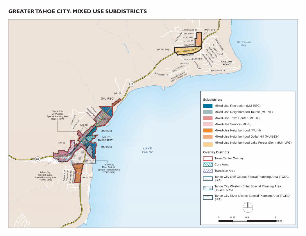
(MU-REC)
(MU-TC)
POLARIS RD
FAIR
WAY
DR
EDGEWATER DR
OBSERVATION DR
MAMMOTH DR
FABIAN WAY
BUNK
ER D
R
GROVE ST
EDGEWOOD DR
TAHOMA AVE
OLD M
ILL R
D
MARLETTE DRPANORAMA DR
JACKPINE ST
WATSON DR
MARTIN DR
PIONEER WAY
CEDARWOOD DR
GO
LDFI
ELD
DR
VIR
GIN
IA D
R
LAKE TERRACE AVE
RAW
HID
E D
R
OLYMPIC DR
SIERRA VIEW AVESI
LVER
AD
O D
R
ROSE AVE
LAKETAHOE
RO
UNDRIDG
E R D
MEADOWBROOK DR
HILL CREST AVE
LAKE FOR EST RD
LASSEN
D R
CarnelianBay
TAHOE CITY
DOLLAR POINT
¬«28
¬«89
(MUN-DH)
(MUN-LFG)
(MU-N)
(MU-TC)
(MU-TC)
(MU-N)
(MU-S)
(MU-TC)
(MU-NT)
(MU-NT)
(MU-REC)
(MU-REC)
Tahoe CityWestern Entry
Special Planning Area(TCWE-SPA)
Tahoe CityGolf Course
Special Planning Area(TCGC-SPA)
Tahoe CityRiver District
Special Planning Area(TCRD-SPA)
Burton Creek
Truckee R iver
GREATER TAHOE CITY: MIXED USE SUBDISTRICTS
SubdistrictsMixed-Use Recreation (MU-REC)
Mixed-Use Neighborhood Tourist (MU-NT)
Mixed-Use Town Center (MU-TC)
Mixed-Use Service (MU-S)
Mixed-Use Neighborhood (MU-N)
Mixed-Use Neighborhood Dollar Hill (MUN-DH)
Mixed-Use Neighborhood Lake Forest Glen (MUN-LFG)
Overlay DistrictsTown Center Overlay
Core Area
Transition Area
Tahoe City Golf Course Special Planning Area (TCGC-SPA)
Tahoe City Western Entry Special Planning Area(TCWE-SPA)
Tahoe City River District Special Planning Area (TCRD-SPA)
0 0.5 10.25Miles

Placer County
108
3. Permissible Uses. The following primary uses may be permitted within all or a portion of the Mixed Use Subdistricts. The list indicates if the use is Allowed (A), subject to an Administrative Review Permit (C), or must be considered under the provisions for a Conditional Use Permit (CUP) or Minor Use Permit (MUP). Existing uses not listed shall be considered nonconforming uses within these Subdistricts. The establishment of new uses not listed shall be prohibited. Numbers in parentheses (#) refer to specific limitations listed at the end of the table.
TABLE 2.04.A-1: LAND USE REGULATIONS — GREATER TAHOE CITY MIXED-USE SUBDISTRICTS
Town Center Subdistricts Village Center Subdistricts
Use MU-TC MU-N MU-S MU-NT MU-REC MUN-DH
MUN-LFG Add’l Regs
Residential Single Family Dwelling A(1) A A MUP A
Multiple Family Dwellings A(1) A MUP A MUP MUP A
Multi-Person Dwellings A(1) A MUP A MUP MUP A
Employee Housing MUP MUP MUP MUP MUP MUP A
Residential Care MUP MUP MUP
Nursing And Personal Care MUP MUP MUP
Tourist Accommodation Bed And Breakfast Facilities C A C
Hotels, Motels And Other Transient Dwelling Units
CUP CUP CUP
Timeshare (Hotel/Motel Design) CUP CUP CUP
Timeshare (Residential Design) CUP CUP CUP
Commercial Auto, Mobile Home and Vehicle Dealers CUP
Building Materials and Hardware MUP MUP
Eating and Drinking Places C C CUP CUP A
Food and Beverage Retail Sales A A CUP CUP(7) A
Furniture, Home Furnishings and Equipment
A MUP

Implementing Regulations
109
TABLE 2.04.A-1: LAND USE REGULATIONS — GREATER TAHOE CITY MIXED-USE SUBDISTRICTS
Town Center Subdistricts Village Center Subdistricts
Use MU-TC MU-N MU-S MU-NT MU-REC MUN-DH
MUN-LFG Add’l Regs
General Merchandise Stores A A MUP MUP A
Mail Order and Vending A
Nursery MUP MUP A A
Outdoor Retail Sales MUP MUP(2) MUP
Service Stations CUP (9) CUP
Amusements and Recreation Services CUP CUP CUP
Privately Owned Assembly and Entertainment
CUP CUP CUP CUP CUP
Animal Husbandry (Services) MUP(2)
Auto Repair and Service A
Broadcasting Studios A A A
Business Support Services A
Contract Construction Services A A
Financial Services A A A A
Health Care Services A A A(2) A A
Laundries and Dry Cleaning Plants CUP
Personal Services A A A A A
Professional Offices A A A A A
Repair Services MUP A
Schools - Business and Vocational A
Secondary Storage MUP MUP C MUP
Food and Kindred Products MUP
Industrial Services A
Printing and Publishing A
Small Scale Manufacturing MUP A MUP
Storage Yards CUP

Placer County
110
TABLE 2.04.A-1: LAND USE REGULATIONS — GREATER TAHOE CITY MIXED-USE SUBDISTRICTS
Town Center Subdistricts Village Center Subdistricts
Use MU-TC MU-N MU-S MU-NT MU-REC MUN-DH
MUN-LFG Add’l Regs
Vehicle and Freight Terminals A
Vehicle Storage and Parking MUP MUP MUP
Warehousing MUP(2)
Wholesale and Distribution CUP(2)
Public Service
Cemeteries MUP
Religious Assembly MUP A MUP A MUP
Collection Stations MUP A
Cultural Facilities A A A A MUP A
Day Care Centers/Pre-Schools A MUP MUP
Government Offices A A A A A(3)
Local Assembly and Entertainment CUP A CUP CUP A
Local Post Offices A A A A MUP
Local Public Health and Safety Facilities A A A A MUP A MUP
Membership Organizations A A MUP
Publicly Owned Assembly and Entertainment
MUP A MUP MUP MUP
Public Utility Centers MUP A MUP MUP
Regional Public Health and Safety Facilities A A A A CUP
Schools - Kindergarten Through Secondary MUP MUP
Social Service Organizations MUP MUP
Pipelines and Power Transmission CUP(5) CUP(5) CUP(5) CUP(5) CUP(5) CUP CUP
Transit Stations and Terminals CUP(6) CUP(6) A CUP(6) CUP CUP
Transportation Routes CUP CUP CUP CUP CUP CUP CUP
Transmission and Receiving Facilities (8) MUP MUP MUP MUP MUP MUP MUP

Implementing Regulations
111
TABLE 2.04.A-1: LAND USE REGULATIONS — GREATER TAHOE CITY MIXED-USE SUBDISTRICTS
Town Center Subdistricts Village Center Subdistricts
Use MU-TC MU-N MU-S MU-NT MU-REC MUN-DH
MUN-LFG Add’l Regs
Airfields, Landing Strips and Heliports (New Non-Emergency Sites Prohibited)
CUP
Threshold-Related Research Facilities MUP MUP MUP MUP MUP MUP MUP
Recreation
Day Use Areas A A A A A A A
Recreation Center MUP A MUP A
Participant Sports (Facilities) MUP A MUP CUP A MUP
Sport Assembly MUP A MUP CUP
Beach Recreation A A A
Boat Launching Facilities A CUP CUP
Cross Country Skiing Courses MUP MUP MUP MUP A MUP
Developed Campgrounds CUP
Outdoor Recreation Concessions MUP MUP MUP MUP MUP
Marinas CUP(4) CUP(4) CUP(4)
Recreational Vehicle Park CUP
Riding And Hiking Trails A A A A A MUP A
Rural Sports MUP A A A MUP
Snowmobile Courses CUP
Undeveloped Campgrounds
Resource Management
Reforestation A A A A A A A
Sanitation Salvage Cut A A A A A A A
Special Cut A A A A A A
Thinning A A A A A A A
Tree Farms A A A A A A
Early Successional Stage Vegetation Management
A A A A A A A
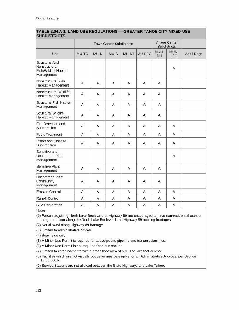
Placer County
112
TABLE 2.04.A-1: LAND USE REGULATIONS — GREATER TAHOE CITY MIXED-USE SUBDISTRICTS
Town Center Subdistricts Village Center Subdistricts
Use MU-TC MU-N MU-S MU-NT MU-REC MUN-DH
MUN-LFG Add’l Regs
Structural And Nonstructural Fish/Wildlife Habitat Management
A
Nonstructural Fish Habitat Management A A A A A A
Nonstructural Wildlife Habitat Management A A A A A A
Structural Fish Habitat Management A A A A A A
Structural Wildlife Habitat Management A A A A A A
Fire Detection and Suppression A A A A A A A
Fuels Treatment A A A A A A A
Insect and Disease Suppression A A A A A A A
Sensitive and Uncommon Plant Management
A
Sensitive Plant Management A A A A A A
Uncommon Plant Community Management
A A A A A A
Erosion Control A A A A A A A
Runoff Control A A A A A A A
SEZ Restoration A A A A A A A Notes: (1) Parcels adjoining North Lake Boulevard or Highway 89 are encouraged to have non-residential uses on
the ground floor along the North Lake Boulevard and Highway 89 building frontages. (2) Not allowed along Highway 89 frontage. (3) Limited to administrative offices. (4) Beachside only. (5) A Minor Use Permit is required for aboveground pipeline and transmission lines. (6) A Minor Use Permit is not required for a bus shelter. (7) Limited to establishments with a gross floor area of 5,000 square feet or less. (8) Facilities which are not visually obtrusive may be eligible for an Administrative Approval per Section
17.56.060.F. (9) Service Stations are not allowed between the State Highways and Lake Tahoe.

Implementing Regulations
113
4. Development Standards. Tables 2.04.A-2, 2.04.A-3, 2.04.A-4, and 2.04.A-5 prescribe the development standards for the Greater Tahoe City Mixed-Use sub-districts.
TABLE 2.04.A-2: DENSITY, BUILDING HEIGHT, RECREATION AND NOISE STANDARDS —GREATER TAHOE CITY MIXED-USE SUBDISTRICTS
Town Center Subdistricts Village Center Subdistricts
MU-TC MU-N MU-S MU-NT MU-REC MUN-DH MUN-LFG Density within Town Centers is governed by Chapter 13, Area Plans, of the
TRPA Code of Ordinances. Chapter 31, Density, of the TRPA Code of Ordinances does not apply within Town Centers.
Residential
Single Family Dwelling (du/parcel)
1 1 - 1 1 1 1
Multiple Family Dwelling (du/acre)
25 25 25 25 25 15 15
Multi-Person Dwelling (people per acre)
62 62 62 62 62 37 37
Nursing and Personal Care (people per acre)
25 25 - 25 - 25 -
Residential Care (people per acre) 25 25 - 25 - 25 -
Employee Housing 25 25 25 25 15 15 15
Tourist Accommodation
Bed and Breakfast Facilities (units per acre)
40 40 - 40 - - -
Hotel, Motel and Other Transient Dwelling Units (units per acre)
40 40 - 40 - - -
Timeshare 40 15 - 40 - - -
Recreation
Developed Campgrounds (sites per acre)
8 - - 8 8 - -
Group Facilities (persons per acre)
25 25 - 25 25 - -

Placer County
114
TABLE 2.04.A-2: DENSITY, BUILDING HEIGHT, RECREATION AND NOISE STANDARDS —GREATER TAHOE CITY MIXED-USE SUBDISTRICTS
Town Center Subdistricts Village Center Subdistricts
MU-TC MU-N MU-S MU-NT MU-REC MUN-DH MUN-LFG Recreational Vehicle Park (sites per acre)
10 - - 10 10 - -
Building Height See Section 2.09.A TRPA Code of Ordinances Chapter 37
Additional Developed Outdoor Recreation
600 Summer Day Use PAOTs in the Tahoe City Town Center. Additional PAOTs may be granted by TRPA in Town
Centers -
Maximum Community Noise Equivalent Level (CNEL)
65 65 65 55 55 60 55
Also see TRPA Code Chapter 68, Noise Limitations.

Implementing Regulations
115
TABLE 2.04.A-3: BUILDING PLACEMENT STANDARDS AND GUIDELINES — GREATER TAHOE CITY MIXED-USE SUBDISTRICTS
Town Center Subdistricts Village Center Subdistricts
MU-TC MU-N MU-S MU-NT MU-REC MUN-DH MUN-LFG #
Minimum Setbacks (measured from property line unless otherwise noted)
Street Frontage, Hwy 28 and 89
0 ft min, 10 ft
max (a)
0 ft min, 20 ft
max (a) 20 ft (a) 10 ft min
(a) 10 ft (a) 0 ft min,
20 ft max (a)
0 ft min, 20 ft max (a)
Street Frontage, Other Streets
10 ft min, 25 ft max (measured
from back of curb or outer edge of road drainage facilities if no
curb) (a)
20 ft, must be landscaped and property edges shall be clearly
marked by a change in material, change in grade or
mounding between six and 18 inches in height, fences or walls less than three feet in height, or stones or posts
located at a minimum two feet on center.
10 ft min, 25 ft max (measured from back of curb or outer edge
of road drainage facilities if no curb) (a)
Interior Side 0 ft; 10 ft adjacent
to residential subdistrict (b)
20 ft (b) 10 ft (b) 10 ft (b) 0 ft; 10 ft adjacent to residential subdistrict
(b)
Rear 0 ft; 10 ft adjacent
to residential subdistrict (b)
20 ft (b) 10 ft (b) 10 ft (b) 0 ft; 10 ft adjacent to residential subdistrict
(b)
Truckee River and Lake Tahoe Per the TRPA Code of Ordinances
Minimum Building Frontage at Build-to Line
40% (c) n/a n/a n/a n/a n/a n/a
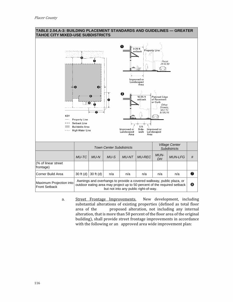
Placer County
116
TABLE 2.04.A-3: BUILDING PLACEMENT STANDARDS AND GUIDELINES — GREATER TAHOE CITY MIXED-USE SUBDISTRICTS
Town Center Subdistricts Village Center Subdistricts
MU-TC MU-N MU-S MU-NT MU-REC MUN-DH MUN-LFG #
(% of linear street frontage)
Corner Build Area 30 ft (d) 30 ft (d) n/a n/a n/a n/a n/a
Maximum Projection into Front Setback
Awnings and overhangs to provide a covered walkway, public plaza, or outdoor eating area may project up to 50 percent of the required setback
but not into any public right-of-way.
a. Street Frontage Improvements. New development, including substantial alterations of existing properties (defined as total floor area of the proposed alteration, not including any internal alteration, that is more than 50 percent of the floor area of the original building), shall provide street frontage improvements in accordance with the following or an approved area wide improvement plan:

Implementing Regulations
117
i. All Street Frontages.
(1) Building Frontage. The area between the building frontage and back of sidewalk, pedestrian way, bicycle path, or edge of pavement where there is no sidewalk, shall be improved so that it functions as part of the wider sidewalk, improved as outdoor eating or seating areas (subject to Placer County Code Section 17.56.160, Outdoor Retail Sales), or landscaped.
(2) Curb. Six-inch vertical concrete curb at sidewalks or rolled curbs with gutter or valley gutter where sidewalks are not planned.
(3) Bicycle and Pedestrian Improvements. Bicycle and pedestrian improvements pursuant to the Lake Tahoe Region Bike and Pedestrian Plan or other improvement plan for the area.
ii. Additional Improvements Applicable Along Highway 28 and 89 Frontage.
(1) Street Trees. Street trees shall be planted at least 40 or 50 feet on center depending on species selected or pockets of shrubs planted 25 feet on center or a combination of both trees and shrubs.
(2) Pedestrian Street Lights. Twelve-foot-high pedestrian lights at 50 feet on center or low-level lights 25 feet on center.
iii. Additional Improvements Applicable Along Other Streets in MU-TC and MU-N Subdistricts.
(1) Five-foot-wide sidewalk or pedestrian way with landscaping or street trees.
iv. Additional Improvements for Mixed Use Subdistricts within Tahoe City Town Center.
(1) Minimum six foot wide sidewalk or pedestrian way for all projects along Highway 28 and 89.
b. Required Interior Yards. In order to provide light and air for residential units, the following minimum setbacks apply to any building wall facing an interior side or rear yard. When the site is adjacent to a residential subdistrict, the project must comply with whichever standard results in the greater setback.
i. Standards for Interior Yards adjacent to Residential Sub-districts.
(1) Structures shall not interrupt a line of a 1:1 slope extending upward from 25 feet above existing grade of the setback line adjacent to the residential district.

Placer County
118
ii. Standards for all Interior Yards. The required setbacks apply to that portion of the building wall containing residential windows and extending three feet on either side of any window.
(1) For any wall containing a living room, family room, or kitchen windows, a setback of at least 15 feet shall be provided.
(2) For any wall containing sleeping room windows, a setback of at least 10 feet shall be provided.
(3) For all other walls containing windows, a setback of at least five feet shall be provided.
FIGURE 2.04(A)(3): REQUIRED SIDE AND REAR YARDS FOR RESIDENTIAL USES
c. Build-to Line for Nonresidential Uses. Buildings with nonresidential uses on the ground floor fronting Highways 89 and 28 shall be constructed at the required setback for the identified percent of linear street frontage. This requirement may be modified or waived with project approval upon finding that:
i. Entry courtyards, plazas, entries, or outdoor eating and display areas are located between the build-to line and building, provided that the buildings are built to the edge of the courtyard, plaza, or dining area;

Implementing Regulations
119
ii. The building incorporates an alternative entrance design that creates a welcoming entry feature facing the street; or
iii. The building placement is necessary to allow significant views of the lake.
d. Corner Build Area. Where feasible and compatible with environmental constraints, buildings in the MU-TC Subdistrict with nonresidential uses on the ground floor should be located in accordance with the required setbacks within 30 feet of any street corner. Public plazas may be at the street corner provided buildings are built to the edge of the public plaza.
TABLE 2.04.A-4: BUILDING FORM GUIDELINES — GREATER TAHOE CITY MIXED-USE SUBDISTRICTS
Town Center Subdistricts Village Center Subdistricts
MU-TC MU-N MU-S MU-NT MU-REC
MUN-DH
MUN-LFG #
Maximum Length of Blank Wall 25 ft (e) 40 ft (e) 75 ft (e) 25 ft (e) 40 ft (e) 40 ft (e) 40 ft (e) Required Transparency (% of building wall area) 75% (f) 50% (f) n/a 75% (f) 40% (f) n/a n/a
Building Modulation Any building over 50 feet wide should be broken down to read as a series of buildings no wider than 50 feet each.
e. Limitations on Blank Walls. Except for side walls built on property lines, no wall should run in a continuous horizontal plane for more than the length specified in Table 2.04.A-4 without windows or door or architectural details of minimum two foot recess or projection.
f. Building Transparency; Required Openings for Non-Residential Uses. Exterior walls facing and within 20 feet of a front or street side property line should include windows, doors, or other openings for at least the percentage stated in Table 2.04.A-4 of the building wall area located between 2.5 and seven feet above ground level. Openings fulfilling this requirement shall have transparent glazing and provide views into work areas, display areas, sales areas, lobbies, or similar active spaces, or into window displays that are at least three feet deep.
i. Exceptions for Parking Garages. Multi-level garages are not required to meet the building transparency requirement of this subsection. Instead, they must be either located behind
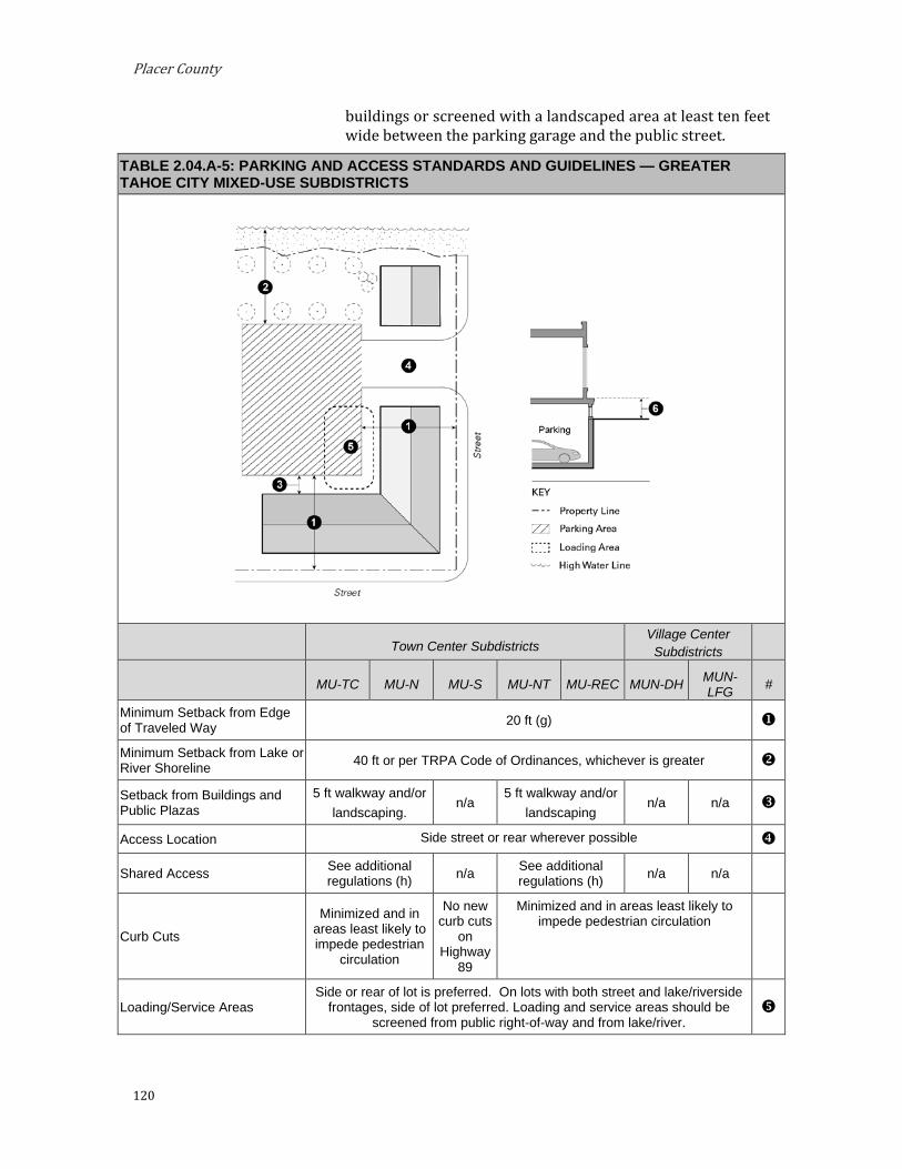
Placer County
120
buildings or screened with a landscaped area at least ten feet wide between the parking garage and the public street.
TABLE 2.04.A-5: PARKING AND ACCESS STANDARDS AND GUIDELINES — GREATER TAHOE CITY MIXED-USE SUBDISTRICTS
Town Center Subdistricts Village Center Subdistricts
MU-TC MU-N MU-S MU-NT MU-REC MUN-DH MUN-LFG #
Minimum Setback from Edge of Traveled Way 20 ft (g)
Minimum Setback from Lake or River Shoreline 40 ft or per TRPA Code of Ordinances, whichever is greater
Setback from Buildings and Public Plazas
5 ft walkway and/or landscaping.
n/a 5 ft walkway and/or
landscaping n/a n/a
Access Location Side street or rear wherever possible
Shared Access See additional regulations (h) n/a See additional
regulations (h) n/a n/a
Curb Cuts
Minimized and in areas least likely to impede pedestrian
circulation
No new curb cuts
on Highway
89
Minimized and in areas least likely to impede pedestrian circulation
Loading/Service Areas Side or rear of lot is preferred. On lots with both street and lake/riverside
frontages, side of lot preferred. Loading and service areas should be screened from public right-of-way and from lake/river.
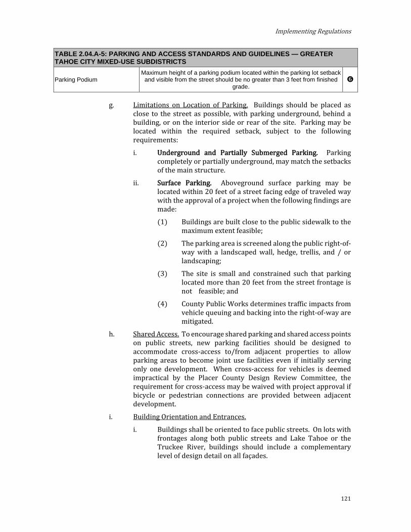
Implementing Regulations
121
TABLE 2.04.A-5: PARKING AND ACCESS STANDARDS AND GUIDELINES — GREATER TAHOE CITY MIXED-USE SUBDISTRICTS
Parking Podium Maximum height of a parking podium located within the parking lot setback
and visible from the street should be no greater than 3 feet from finished grade.
Limitations on Location of Parking. Buildings should be placed as close to the street as possible, with parking underground, behind a building, or on the interior side or rear of the site. Parking may be located within the required setback, subject to the following requirements:
i. Underground and Partially Submerged Parking. Parking completely or partially underground, may match the setbacks of the main structure.
ii. Surface Parking. Aboveground surface parking may be located within 20 feet of a street facing edge of traveled way with the approval of a project when the following findings are made:
(1) Buildings are built close to the public sidewalk to the maximum extent feasible;
(2) The parking area is screened along the public right-of-way with a landscaped wall, hedge, trellis, and / or landscaping;
(3) The site is small and constrained such that parking located more than 20 feet from the street frontage is not feasible; and
(4) County Public Works determines traffic impacts from vehicle queuing and backing into the right-of-way are mitigated.
h. Shared Access. To encourage shared parking and shared access points on public streets, new parking facilities should be designed to accommodate cross-access to/from adjacent properties to allow parking areas to become joint use facilities even if initially serving only one development. When cross-access for vehicles is deemed impractical by the Placer County Design Review Committee, the requirement for cross-access may be waived with project approval if bicycle or pedestrian connections are provided between adjacent development.
i. Building Orientation and Entrances.
i. Buildings shall be oriented to face public streets. On lots with frontages along both public streets and Lake Tahoe or the Truckee River, buildings should include a complementary level of design detail on all façades.

Placer County
122
ii. Building frontages should be generally parallel to streets, and the primary building entrances should be located on a public street.
iii. Building entrances should be emphasized with special architectural and landscape treatments.
iv. Entrances located at corners shall generally be located at a 45-degree angle to the corner and should have a distinct architectural treatment to animate the intersection and facilitate pedestrian flow around the corner. Different treatments may include angled or rounded corners, arches, and other architectural elements. All building and dwelling units located in the interior of a site should have entrances from the sidewalk that are designed as an extension of the public sidewalk and connect to a public sidewalk.
v. Entrances to residential units should be physically separated from the entrance to the permitted commercial uses and clearly marked with a physical feature incorporated into the building or an appropriately scaled element applied to the façade.
FIGURE 2.04(A)(4): BUILDING ORIENTATION AND ENTRANCES
j. Building Design and Articulation. Buildings shall provide adequate architectural articulation and detail to avoid a bulky and “box-like” appearance. Building design shall reflect “Old Tahoe” or “Historic Alpine” architectural features, which promote the rustic, alpine character of the area and include the following:
i. Exterior Building Materials and Colors.
(1) A unified palette of quality materials shall be used on all sides of buildings.
(2) Natural colors of a mountain setting shall be used to help delineate windows and other architectural features to increase architectural interest.
ii. Building Details. Buildings shall provide adequate architectural articulation and detail to avoid a bulky and “box-like” appearance and designs shall consider the effects of snow and ice on building access.

Implementing Regulations
123
(1) Building façades shall include building projections or recesses, doorway and window trim, shutters, awnings, window boxes, natural stone or wood materials, and other details that provide architectural articulation and design interest.
(2) Clip-gambrel roofs, shed roofs, cornices, balconies, covered walkways, and other architectural elements should be used, as appropriate, to terminate rooflines and accentuate setbacks between stories.
(3) All applied surface ornamentation or decorative detailing shall be consistent with the architectural style of the building.
(4) Each side of the building that is visible from a public right-of-way, shoreline, or publicly accessible open space shall be designed with a complementary level of detailing. Particular attention shall be given to the detailing within the pedestrian’s range of touch and view, such as the use of special store-front detailing and façade ornamentation to reinforce the pedestrian character of the street.
(5) Building designs shall account for the frequent presence of snow and ice consistent with Section 3.09.D, Design for Snow. Appropriate design strategies may include:
(a) Location of entrances under the gable ends of pitched roofs;
(b) Limiting the location of entrances, stairs, or walkways under the drip line of roof eaves;
(c) Covering of stairs and walkways;
(d) Use of snow cleats on roofs to prevent rapid shedding of snow and ice;
(e) Limiting the extension of open or uncovered balconies into the roof area;
(f) Use of heating elements to reduce snow shedding off of roofs; and
(g) Consideration of composition roofs over metal roofing materials.
k. Pedestrian Connections. A minimum five-foot-wide, unobstructed pedestrian access should be provided from on-site vehicle and bicycle parking area to the main entrance of buildings, to adjacent public amenities such as the beach, shoreline, or viewpoints, and to public trails or transit stops located along the street frontage.

Placer County
124
l. Fencing and Wall Materials. Fences along street-facing property edges on Highways 28 and 89 should be limited and shall be landscaped screens, wood, or stone with articulation or surface features of minimum two-inch depth at minimum every 50 feet.
m. Residential Open Space, Town Center Subdistricts. For residential and mixed-use projects with residential uses, 75 square feet of private or common open space area should be provided per dwelling unit. Private areas typically consist of balconies, decks, patios, fenced yards, and other similar areas adjacent to private units. Common areas typically consist of landscaped areas, walks, patios, barbeque areas, or other such improvements as are appropriate to enhance the outdoor environment of the development. Landscaped courtyard entries that are oriented towards a public street are considered common areas.
i. Minimum Dimensions.
(1) Private Open Space. Private open space should have no horizontal dimension less than six feet.
(2) Common Open Space. Common open space should have no horizontal dimension less than 20 feet.
ii. Usability. A surface should be provided that allows convenient use for outdoor living and/or recreation. Such surface may be any practical combination of lawn, garden, flagstone, wood planking, concrete, or other serviceable, dust-free surfacing. Seating areas and plazas should be located in areas with good solar exposure.
iii. Accessibility.
(1) Private Open Space. The space should be accessible to the living unit by a doorway to a habitable room or hallway.
(2) Common Open Space. The space should be accessible to the living units on the lot. It should be served by any stairway or other accessway qualifying as an egress facility from a habitable room.
5. Design Guidelines. a. Street Frontage Design. Design front setbacks that maintain the
mountain character of scenic highways 89 and 28. Incorporate varied landscaping with a combination of trees, shrubs, and groundcover, as well as changes in elevation or landscaped edges. Avoid heavily manicured or uniform landscape palettes.

Implementing Regulations
125
b. Building Form and Design.
i. Building Articulation and Visual Interest at the Ground Level. Vary building planes along the street frontage. Incorporate ground-level building details to create a pedestrian-oriented environment with a rural transitional character. Illustrations demonstrate preferred architectural detailing and articulation regardless of building height, size, and massing.
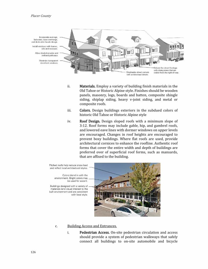
Placer County
126
ii. Materials. Employ a variety of building finish materials in the Old Tahoe or Historic Alpine style. Finishes should be wooden panels, masonry, logs, boards and batten, composite shingle siding, shiplap siding, heavy v-joint siding, and metal or composite roofs.
iii. Colors. Design buildings exteriors in the subdued colors of historic Old Tahoe or Historic Alpine style
iv. Roof Design. Design sloped roofs with a minimum slope of 3:12. Roof forms may include gable, hip, and gambrel roofs, and lowered eave lines with dormer windows on upper levels are encouraged. Changes in roof heights are encouraged to prevent boxy buildings. Where flat roofs are used, provide architectural cornices to enhance the roofline. Authentic roof forms that cover the entire width and depth of buildings are preferred over of superficial roof forms, such as mansards, that are affixed to the building.
c. Building Access and Entrances.
i. Pedestrian Access. On-site pedestrian circulation and access should provide a system of pedestrian walkways that safely connect all buildings to on-site automobile and bicycle
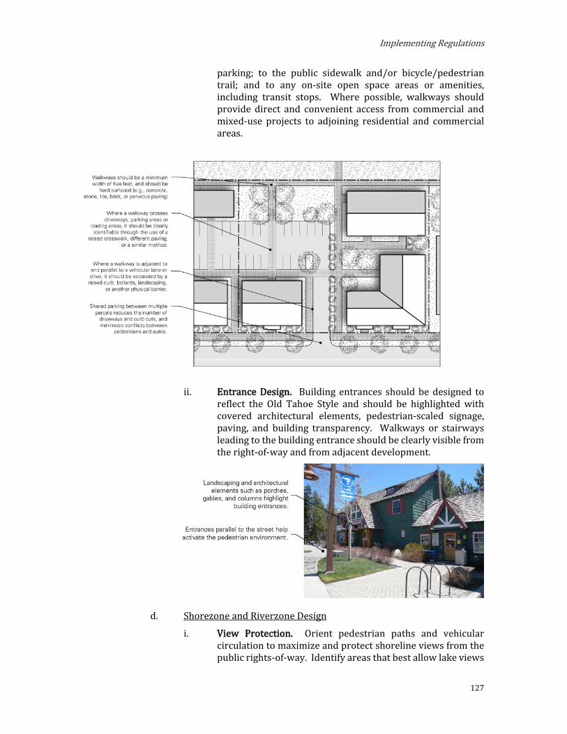
Implementing Regulations
127
parking; to the public sidewalk and/or bicycle/pedestrian trail; and to any on-site open space areas or amenities, including transit stops. Where possible, walkways should provide direct and convenient access from commercial and mixed-use projects to adjoining residential and commercial areas.
ii. Entrance Design. Building entrances should be designed to reflect the Old Tahoe Style and should be highlighted with covered architectural elements, pedestrian-scaled signage, paving, and building transparency. Walkways or stairways leading to the building entrance should be clearly visible from the right-of-way and from adjacent development.
d. Shorezone and Riverzone Design
i. View Protection. Orient pedestrian paths and vehicular circulation to maximize and protect shoreline views from the public rights-of-way. Identify areas that best allow lake views

Placer County
128
and design buildings and landscaping to maximize visual access. Where buildings, structures, or parking or loading areas can be seen within a scenic corridor, minimize the impact with vegetation, landforms, or colors and materials that blend with the surroundings.
ii. Access. Provide clearly demarcated public access to the shore and river from public rights-of way. Incorporate landscaped edges, furniture, changes in elevation, and paving, while ensuring that all landscape design is sensitive to the natural habitat.
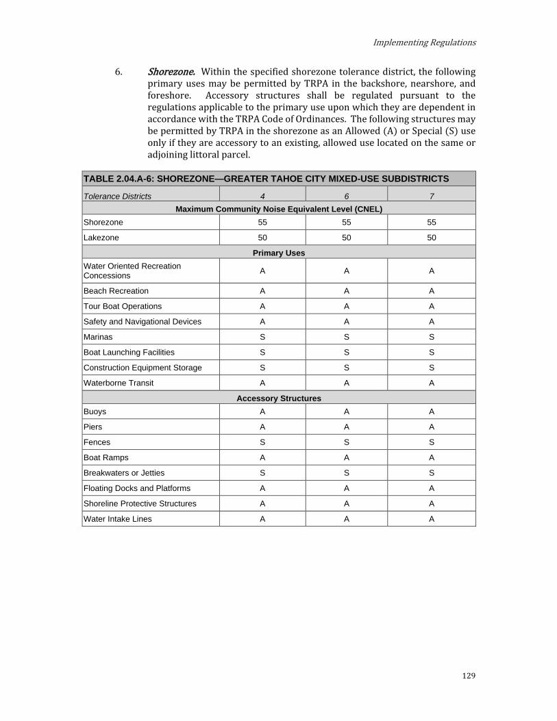
Implementing Regulations
129
6. Shorezone. Within the specified shorezone tolerance district, the following primary uses may be permitted by TRPA in the backshore, nearshore, and foreshore. Accessory structures shall be regulated pursuant to the regulations applicable to the primary use upon which they are dependent in accordance with the TRPA Code of Ordinances. The following structures may be permitted by TRPA in the shorezone as an Allowed (A) or Special (S) use only if they are accessory to an existing, allowed use located on the same or adjoining littoral parcel.
TABLE 2.04.A-6: SHOREZONE—GREATER TAHOE CITY MIXED-USE SUBDISTRICTS
Tolerance Districts 4 6 7 Maximum Community Noise Equivalent Level (CNEL)
Shorezone 55 55 55
Lakezone 50 50 50
Primary Uses Water Oriented Recreation Concessions A A A
Beach Recreation A A A
Tour Boat Operations A A A
Safety and Navigational Devices A A A
Marinas S S S
Boat Launching Facilities S S S
Construction Equipment Storage S S S
Waterborne Transit A A A
Accessory Structures Buoys A A A
Piers A A A
Fences S S S
Boat Ramps A A A
Breakwaters or Jetties S S S
Floating Docks and Platforms A A A
Shoreline Protective Structures A A A
Water Intake Lines A A A

Placer County
130
B. North Tahoe East Mixed-Use Subdistricts.
Purpose. The purposes of the North Tahoe East Mixed-Use Subdistricts are to:
a. Provide for the orderly, well-planned, and balanced growth of the King’s Beach and North Stateline area and support the area’s role as a gateway to North Lake Tahoe and a vibrant commercial, cultural, recreational, and tourist center.
b. Promote the King’s Beach and North Stateline area as active, pedestrian- and transit-oriented, mixed-use areas attractive to residents and visitors alike.
c. Encourage a mix of uses that promotes environmental improvement, year-round economic vitality, and a pleasant quality of life, and improve access to a greater range of recreational opportunities, facilities and services for residents and visitors.
d. Establish design standards that improve the pedestrian-orientation, interconnectivity, and visual quality of development and create a unified, distinctive, and attractive character.
e. Foster environmental Threshold attainment.
2. Planning Statements. Planning statements for each Mixed-Use Subdistrict are as follows:
a. Mixed-Use Mountainside Town Center (MU-MTC). This subdistrict is the center of the King’s Beach area located mountainside of North Lake Boulevard. This subdistrict is intended to allow one or more of a variety of residential and non-residential uses with a focus on ground-level active storefronts along North Lake Boulevard. This subdistrict encourages a greater mix and intensity of uses at a scale and form that is appropriate to its town center context and adjacent residential areas.
i. Special Designations. (See Section 3.14)
(1) Town Center
ii. Special Policies.
(1) Development is preferred in and directed toward Town Centers.
(2) This subdistrict is appropriate for a variety of land uses with pedestrian and transit facilities.
(3) Provide opportunities for development of a variety of multi-residential housing types with emphasis on affordable, moderate, and achievable housing.
b. Mixed-Use Lakeside Town Center (MU-LTC). This subdistrict is the center of the King’s Beach area located lakeside of North Lake Boulevard. It is intended to maintain and enhance the pedestrian- and transit-oriented environment of retail, restaurants, tourist

Implementing Regulations
131
accommodation, and mixed-use development and enhanced access to the lake and recreational activities. This subdistrict allows for vertical mixed-use projects with a focus on ground-level active storefronts along North Lake Boulevard.
i. Special Designations. (See Section 3.14)
(1) Town Center
ii. Special Policies.
(1) Development is preferred in and directed toward Town Centers.
(2) This subdistrict is appropriate for a variety of land uses with pedestrian and transit facilities.
(3) Redevelopment projects shall be designed to maintain and enhance views to Lake Tahoe in accordance with Chapter 66, Scenic Resources, of the TRPA Code of Ordinances and the building height findings in Section 2.09.A of these Area Plan Regulations.
(4) Provide opportunities for development of a variety of multi-residential housing types with emphasis on affordable, moderate, and achievable housing.
c. Mixed-Use Residential (MU-R). This subdistrict is intended to allow a variety of residential and nonresidential uses and provides a transition from surrounding, lower-density subdistricts to the Town Center. A mix of residential, tourist accommodation, retail, and recreational uses are allowed; however, nonresidential uses are limited west of Beach Street.
i. Special Designations. (See Section 3.14)
(1) Town Center
ii. Special Policies.
(1) Development is preferred in and directed toward Town Centers.
(2) This subdistrict should be maintained as a residential and tourist area.
(3) Provide opportunities for development of a variety of multi-residential housing types with emphasis on affordable, moderate, and achievable housing.
d. Mixed-Use Tourist (MU-TOR). This subdistrict is intended as a destination resort area with multiple uses and activities that complement each other located in a pedestrian-oriented setting. Visitors generally park once and walk between attractions. This subdistrict allows a wide range of entertainment, tourist, recreational, retail, residential, and supporting uses.
i. Special Designations. (See Section 3.14)

Placer County
132
(1) Town Center
ii. Special Policies.
(1) Development is preferred in and directed toward Town Centers.
(2) This subdistrict is appropriate for a variety of land uses with pedestrian and transit facilities.
e. Mixed-Use Waterfront Recreation (MU-WREC). This subdistrict is intended to provide areas for passive and commercial recreation uses and related services to improve public access and enjoyment of the Lake Tahoe waterfront. Recreational and a mix of supportive retail and service uses are allowed along with environmental enhancement improvements.
i. Special Designations. (See Section 3.14)
(1) Town Center
ii. Special Policies.
(1) This subdistrict should be maintained as a recreation area with limited retail and service uses.
(2) Recreation and environmental enhancement projects should continue to be completed in coordination with the California Department of State Parks, the California Tahoe Conservancy and the North Tahoe Public Utility District.
(3) The County, the California Department of State Parks, and the North Tahoe Public Utility District shall explore better integration, utilization, and shared use of the Kings Beach State Recreation Area parking lot areas to better serve the community during the off-season and evening hours, to better serve the North Lake Tahoe Event Center, and to showcase it as an integral community facility.

(MU-LTC)(MU-WREC)
N LAKE BLVD
FOX
ST
BEAV
ER S
T
CO
ON
ST
PAR
K LN
GOLDEN AVE
BEAR
ST
RAINBOW AVE
TROUT AVE
DEE
R S
T
DOLLY VARDEN AVE
STEELHEAD AVE
BROOK AVE
LOCH LEVON AVE
BEN
D A
VE
BRASSIE AVE
SALMON AVE
PIER AVE
LAKE VISTA DR
HAR
BOR
AVE
BROCKWAY VISTA AVE
YACHT ST
SPEEDBOAT AVE
BEAC
H S
T
SEC
LIN
E ST
LAKE ST
COVE AVE
CH
IPM
UN
K ST
WO
LF S
T
CH
IPM
UN
K ST
¬«28
¬«267
(MU-TOR)
(MU-TOR)
North StatelineSpecial
Planning Area(NS-SPA)
NORTHSTATELINE
KINGS BEACH (MU-MTC)
(MU-MTC)
(MU-MTC)
(MU-MTC)
(MU-R)
(MU-LTC)
(MU-WREC)
LAKETAHOE
CALIF
ORNI
ANE
VADA
Kings BeachEntry SpecialPlanning Area
(KBE-SPA)
Griff
Cree
kGr
iffC r
eek
NORTH TAHOE EAST: MIXED USE DISTRICTS
0 0.25 0.50.125Miles
!(G Gateway
SubdistrictsMixed-Use Lakeside Town Center (MU-LTC)
Mixed-Use Mountainside Town Center (MU-MTC)
Mixed-Use Waterfront Recreation (MU-WREC)
Mixed-Use Tourist
Mixed-Use Residential (MU-R)
Overlay DistrictTown Center Overlay
Core Area
Transition Area
Special Planning Area Overlay
Kings Beach Entry Special Planning Area (KBE-SPA)
North Stateline Special Planning Area (NS-SPA)
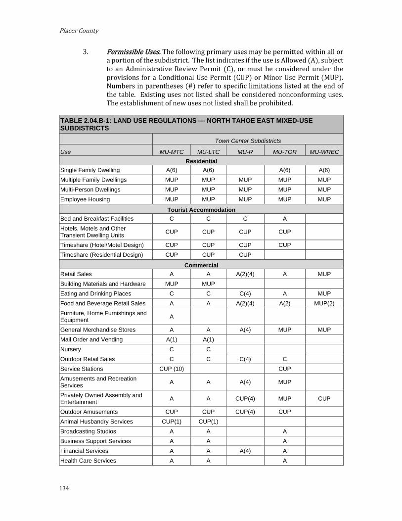
Placer County
134
3. Permissible Uses. The following primary uses may be permitted within all or a portion of the subdistrict. The list indicates if the use is Allowed (A), subject to an Administrative Review Permit (C), or must be considered under the provisions for a Conditional Use Permit (CUP) or Minor Use Permit (MUP). Numbers in parentheses (#) refer to specific limitations listed at the end of the table. Existing uses not listed shall be considered nonconforming uses. The establishment of new uses not listed shall be prohibited.
TABLE 2.04.B-1: LAND USE REGULATIONS — NORTH TAHOE EAST MIXED-USE SUBDISTRICTS
Town Center Subdistricts
Use MU-MTC MU-LTC MU-R MU-TOR MU-WREC Residential
Single Family Dwelling A(6) A(6) A(6) A(6) Multiple Family Dwellings MUP MUP MUP MUP MUP Multi-Person Dwellings MUP MUP MUP MUP MUP Employee Housing MUP MUP MUP MUP MUP
Tourist Accommodation Bed and Breakfast Facilities C C C A Hotels, Motels and Other Transient Dwelling Units CUP CUP CUP CUP
Timeshare (Hotel/Motel Design) CUP CUP CUP CUP Timeshare (Residential Design) CUP CUP CUP
Commercial Retail Sales A A A(2)(4) A MUP Building Materials and Hardware MUP MUP Eating and Drinking Places C C C(4) A MUP Food and Beverage Retail Sales A A A(2)(4) A(2) MUP(2) Furniture, Home Furnishings and Equipment A
General Merchandise Stores A A A(4) MUP MUP Mail Order and Vending A(1) A(1) Nursery C C Outdoor Retail Sales C C C(4) C Service Stations CUP (10) CUP Amusements and Recreation Services A A A(4) MUP
Privately Owned Assembly and Entertainment A A CUP(4) MUP CUP
Outdoor Amusements CUP CUP CUP(4) CUP Animal Husbandry Services CUP(1) CUP(1) Broadcasting Studios A A A Business Support Services A A A Financial Services A A A(4) A Health Care Services A A A

Implementing Regulations
135
TABLE 2.04.B-1: LAND USE REGULATIONS — NORTH TAHOE EAST MIXED-USE SUBDISTRICTS
Town Center Subdistricts
Use MU-MTC MU-LTC MU-R MU-TOR MU-WREC Personal Services A A A(4) A Professional Offices (/Services) A A A(2)(4) A Repair Services MUP(5) MUP Schools - Business and Vocational A(1) A(1) MUP Printing and Publishing A A Small Scale Manufacturing MUP(1) Vehicle Storage and Parking MUP MUP MUP MUP MUP
Public Service Religious Assembly MUP(2) MUP(2) Collection Stations A A Cultural Facilities A A A(4) MUP MUP Day Care Centers/Pre-Schools A(1) A(1) A Government Offices A A A(2)(4) A(1) Hospitals CUP CUP Local Assembly and Entertainment A A MUP(4) A(2) MUP
Local Post Offices A A A(4) A Local Public Health and Safety Facilities MUP MUP MUP(4) MUP MUP
Membership Organizations A(1) A(1) MUP(1)(4) A(1)(2) Publicly Owned Assembly And Entertainment A A MUP(4) A(2) MUP
Regional Public Health and Safety Facilities CUP CUP CUP(4) CUP CUP
Schools – College CUP CUP Pipelines and Power Transmission CUP(7) CUP(7) CUP(7)(4) CUP(7) CUP(7) Transit Stations and Terminals CUP(8) CUP(8) CUP(8)(4) CUP(8) CUP(8) Transportation Routes CUP CUP CUP(4) CUP CUP Transmission and Receiving Facilities (9) MUP MUP MUP MUP MUP
Threshold-Related Research Facilities MUP MUP MUP MUP MUP
Recreation Day Use Areas A A A(4) A A
Recreation Center A A MUP(4) A(2)
Participant Sports (Facilities) MUP MUP MUP(4) MUP MUP
Sport Assembly CUP CUP CUP(4) CUP CUP
Beach Recreation A A(4) A
Boat Launching Facilities A A(4) A
Developed Campgrounds
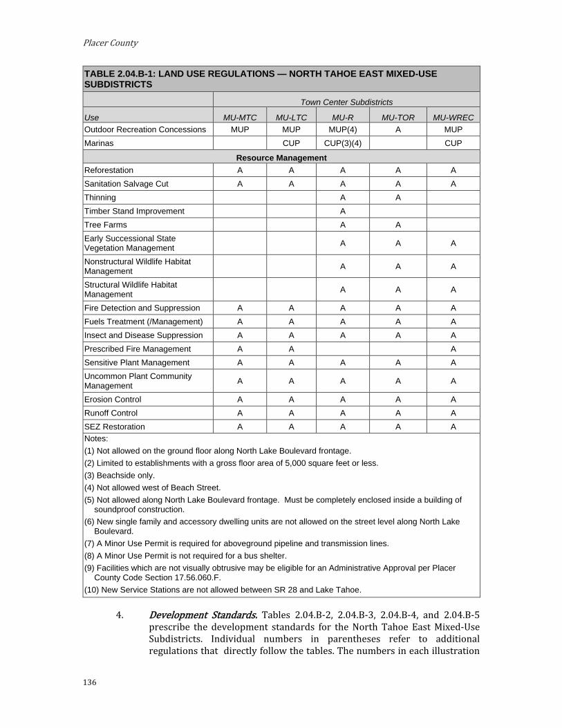
Placer County
136
TABLE 2.04.B-1: LAND USE REGULATIONS — NORTH TAHOE EAST MIXED-USE SUBDISTRICTS
Town Center Subdistricts
Use MU-MTC MU-LTC MU-R MU-TOR MU-WREC Outdoor Recreation Concessions MUP MUP MUP(4) A MUP Marinas CUP CUP(3)(4) CUP
Resource Management Reforestation A A A A A Sanitation Salvage Cut A A A A A Thinning A A Timber Stand Improvement A Tree Farms A A Early Successional State Vegetation Management A A A
Nonstructural Wildlife Habitat Management A A A
Structural Wildlife Habitat Management A A A
Fire Detection and Suppression A A A A A Fuels Treatment (/Management) A A A A A Insect and Disease Suppression A A A A A Prescribed Fire Management A A A Sensitive Plant Management A A A A A Uncommon Plant Community Management A A A A A
Erosion Control A A A A A Runoff Control A A A A A SEZ Restoration A A A A A Notes: (1) Not allowed on the ground floor along North Lake Boulevard frontage. (2) Limited to establishments with a gross floor area of 5,000 square feet or less. (3) Beachside only. (4) Not allowed west of Beach Street. (5) Not allowed along North Lake Boulevard frontage. Must be completely enclosed inside a building of
soundproof construction. (6) New single family and accessory dwelling units are not allowed on the street level along North Lake
Boulevard. (7) A Minor Use Permit is required for aboveground pipeline and transmission lines. (8) A Minor Use Permit is not required for a bus shelter. (9) Facilities which are not visually obtrusive may be eligible for an Administrative Approval per Placer
County Code Section 17.56.060.F. (10) New Service Stations are not allowed between SR 28 and Lake Tahoe.
4. Development Standards. Tables 2.04.B-2, 2.04.B-3, 2.04.B-4, and 2.04.B-5 prescribe the development standards for the North Tahoe East Mixed-Use Subdistricts. Individual numbers in parentheses refer to additional regulations that directly follow the tables. The numbers in each illustration

Implementing Regulations
137
below refer to corresponding regulations in the “#” column in the associated table.
TABLE 2.04.B-2: DENSITY, BUILDING HEIGHT, RECREATION AND NOISE STANDARDS — NORTH TAHOE EAST MIXED-USE SUBDISTRICTS
Town Center Subdistricts
MU-MTC MU-LTC MU-R MU-TOR MU-WREC Density within Town Centers is governed by Chapter 13, Area Plans, of the TRPA Code of
Ordinances. Chapter 31, Density, of the TRPA Code of Ordinances does not apply within Town Centers.
Residential
Single Family Dwelling (unit/parcel) Permitted if existing, no new
Multiple Family Dwelling (units/acre) 25 25 25 15 25
Multi-Person Dwelling (people per acre) 62 62 62 37 62
Residential Care (people per acre) 25 25 - - -
Employee Housing (units/acre)
251 25 25 15 25
Tourist Accommodation
Bed and Breakfast Facilities (units/acre) 40 40 40 40 -
Hotel, Motel and Other Transient Dwelling Units 40 40 40 40 -
Timeshare (units/acre) 40 40 40 40 -
Building Height See Section 2.09.A
Additional Developed Outdoor Recreation
750 Summer Day Use PAOTs in the Kings Beach Town Center. Additional PAOTs may be granted by TRPA in Town Centers
Maximum Community Noise Equivalent Level (CNEL) 60 60 55 60 55
Highway 28 Corridor 55 55 55
60; where applicable, a
max 55 CNEL override is permissible
55
Hourly Leq, dB
For stationary or industrial noise sources or projects affected by stationary or industrial noise sources (as measured at the property line of a noise
sensitive receiving use): Daytime (7a.m.-7p.m.): 55
Nighttime (7p.m.-7a.m.): 45
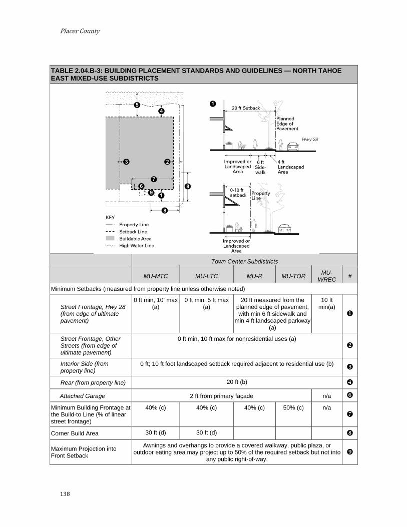
Placer County
138
TABLE 2.04.B-3: BUILDING PLACEMENT STANDARDS AND GUIDELINES — NORTH TAHOE EAST MIXED-USE SUBDISTRICTS
Town Center Subdistricts
MU-MTC MU-LTC MU-R MU-TOR MU-WREC #
Minimum Setbacks (measured from property line unless otherwise noted)
Street Frontage, Hwy 28 (from edge of ultimate pavement)
0 ft min, 10’ max (a)
0 ft min, 5 ft max (a)
20 ft measured from the planned edge of pavement, with min 6 ft sidewalk and
min 4 ft landscaped parkway (a)
10 ft min(a)
Street Frontage, Other Streets (from edge of ultimate pavement)
0 ft min, 10 ft max for nonresidential uses (a)
Interior Side (from property line)
0 ft; 10 ft foot landscaped setback required adjacent to residential use (b)
Rear (from property line) 20 ft (b) Attached Garage 2 ft from primary façade n/a
Minimum Building Frontage at the Build-to Line (% of linear street frontage)
40% (c) 40% (c) 40% (c) 50% (c) n/a
Corner Build Area 30 ft (d) 30 ft (d)
Maximum Projection into Front Setback
Awnings and overhangs to provide a covered walkway, public plaza, or outdoor eating area may project up to 50% of the required setback but not into
any public right-of-way.

Implementing Regulations
139
a. Street Frontage Improvements. New development, including substantial alterations of existing properties (total floor area of the proposed alternation, not including any internal alteration, is more than 50 percent of the floor area of the original building), shall provide frontage improvements in accordance with the following or an approved area-wide improvement plan:
i. Building Frontage. The area between the building frontage and back of sidewalk or edge of pavement where there is no sidewalk, shall be improved so that it functions as part of the wider sidewalk, improved as outdoor eating or seating areas (subject to Placer County Code Section 17.56.160, Outdoor Retail Sales), or landscaped.
ii. Street Trees. If located in sidewalk tree wells, trees shall be planted at minimum 20 feet on center along the Highway 28 street frontage. Otherwise, street trees shall be planted at least 40 or 50 feet on center depending on species selected.
iii. Curb. Six-inch vertical concrete curb and gutter at sidewalks or rolled curbs with gutter or valley gutter where sidewalks are not planned.
iv. Pedestrian Street Lights. Twelve-foot-high pedestrian lights at 50 feet on center or low-level lights 25 feet on center.
v. Additional Improvements in Town Centers. Minimum six-foot-wide sidewalk or pedestrian way with landscaping or street trees for all projects along Highway 28 and Highway 267.
b. Required Interior Yards. In order to provide light and air for residential units, the following minimum setbacks apply to any building wall facing an interior side or rear yard. When the site is adjacent to a residential subdistrict, the project must comply with whichever standard results in the greater setback.
i. Standards for Interior Yards adjacent to Residential Subdistricts.
(1) Structures shall not interrupt a line of a 1:1 slope extending upward from 25 feet above existing grade of the setback line adjacent to the residential district.
ii. Standards for all Interior Yards. The required setbacks apply to that portion of the building wall containing residential windows and extending three feet on either side of any window.
(1) For any wall containing living room, family room, or kitchen windows, a setback of at least 15 feet shall be provided.
(2) For any wall containing bedroom windows, a setback of at least 10 feet shall be provided.

Placer County
140
(3) For all other walls containing windows, a setback of at least five feet shall be provided.
FIGURE 2.04(B)(3): REQUIRED SIDE AND REAR YARDS FOR RESIDENTIAL USES
c. Build-to Line for Nonresidential Uses. Buildings with nonresidential uses on the ground floor shall be constructed at the required setback for the identified percent of linear street frontage. This requirement may be modified or waived with project approval upon finding that:
i. Entry courtyards, plazas, entries, or outdoor eating and display areas are located between the build-to line and building, provided that the buildings are built to the edge of the courtyard, plaza, or dining area;
ii. The building incorporates an alternative entrance design that creates a welcoming entry feature facing the street; or
iii. The building placement is necessary to allow significant views of the lake.
d. Corner Build Area. Where feasible and compatible with environmental constrains, buildings with nonresidential uses on the ground floor in the MU-MTC Subdistrict should be located in accordance with the required setbacks within 30 feet of any street corner. Public plazas may be at the street corner provided buildings are built to the edge of the public plaza.

Implementing Regulations
141
TABLE 2.04.B-4: BUILDING FORM GUIDELINES — NORTH TAHOE EAST MIXED-USE SUBDISTRICTS
Town Center Subdistricts
MU-MTC MU-LTC MU-R MU-TOR MU-WREC #
Maximum Length of Blank Wall
Except for side walls built on property lines, no wall should run in a continuous horizontal plane for more than 25 feet without windows or doors or architectural details of minimum 2 foot recess or projection
Required Transparency (% of building wall area)
50%(e) 50%(e) 40%(e) 75%(e) 40%(e)
Building Modulation Nonresidential buildings over 75 feet wide should be broken down to read as a series of buildings no wider than 75 feet each
Maximum Building Length 250 ft 200 ft 200 ft 350 ft 200 ft
e. Building Transparency; Required Openings for Retail and Service Uses. Exterior walls facing and within 20 feet of a front or street side property line should include windows, doors, or other openings for the required percentage stated in Table 2.04.B-3.3 of the building wall area located between 2.5 and seven feet above ground level. Openings fulfilling this requirement shall have transparent glazing and provide views into work areas, display are-as, sales areas, lobbies, or similar active spaces, or into window displays that are at least three feet deep.
i. Exceptions for Parking Garages. Multi-level garages are not required to meet the building transparency requirement of this subsection. Instead, they must either be located behind buildings or screened with a landscaped area at least 10 feet wide between the parking garage and public street.

Placer County
142
TABLE 2.04B-5: PARKING AND ACCESS STANDARDS AND GUIDELINES — NORTH TAHOE EAST MIXED-USE SUBDISTRICTS
Town Center Subdistricts
MU-MTC MU-LTC MU-G MU-TOR MU-REC # Minimum Setback From Edge of Traveled Way 20 ft (f)
Minimum Setback From Lake Tahoe
40 ft, or per TRPA Code of Ordinances, whichever is greater
Setbacks from Buildings and Public Plazas
5 ft walkway and/or landscaping
Access Location Side street or rear wherever possible
Shared Access See additional regulations (g) n/a (g) Curb Cuts Minimized and in areas least likely to impede pedestrian circulation Loading/Service Areas Side or rear of lot is preferred. Loading and services areas should be
screened from public ROW and from lake.
Parking Podium Maximum height of a parking podium visible from the street should be no greater than 3 feet from finished grade.
f. Limitations on Location of Parking. Buildings should be placed as
close to the street as possible, with parking behind a building or on the interior side or rear of the site. Parking may be located within the required setback, subject to the following requirements.
i. Underground and Partially Submerged Parking. Parking completely or partially underground (with maximum three
Implementing Regulations
143
feet above ground), may match the setbacks of the main structure.
ii. Surface Parking. Aboveground surface parking may be located within 20 feet of a street, but no less than 20 feet from the edge of the traveled way with the approval of a project when the following findings are made:
(1) Buildings are built close to the public sidewalk to the maximum extent feasible;
(2) The parking area is screened along the public right-of-way with a wall, hedge, trellis, and/or landscaping; and,
(3) The site is small and constrained such that parking located more than 20 feet from the street frontage is not feasible.
(4) County Public Works determines traffic impacts from vehicle queuing and backing into the right-of-way are mitigated.
g. Shared Access. To encourage shared parking and shared access points on public streets, new parking facilities for Retail Trade or Service Uses should be designed to accommodate cross-access to / from adjacent properties to allow parking areas to become joint use facilities even if initially serving only one development. When cross-access for vehicles is deemed impractical by the Design Review Committee, the requirement for cross-access may be waived with project approval if bicycle or pedestrian connections are provided between adjacent developments.
h. Building Orientation and Entrances.
i. Buildings shall be oriented to face public streets.
ii. Building frontages should be generally parallel to streets, and the primary building entrances should be located on a public street.
iii. Building entrances should be emphasized with special architectural and landscape treatments.
iv. Entrances located at corners shall generally be located at a 45-degree angle to the corner and should have a distinct architectural treatment to animate the intersection and facilitate pedestrian flow around the corner. Different treatments may include angled or rounded corners, arches, and other architectural elements. All building and dwelling units located in the interior of a site should have entrances from the sidewalk that are designed as an extension of the public sidewalk and connect to a public sidewalk.
v. Entrances to residential units should be physically separated from the entrance to the permitted commercial uses and

Placer County
144
clearly marked with a physical feature incorporated into the building or an appropriately scaled element applied to the façade.
FIGURE 2.04(B)(4.1): BUILDING ORIENTATION AND ENTRANCES
i. Building Design and Articulation. Buildings shall provide adequate architectural articulation and detail to avoid a bulky and “box-like” appearance. Building design shall reflect “Old Tahoe” and “Historic Alpine” theme and architectural features, which promote the community’s rustic setting and beach character and include the following:
i. Exterior Building Materials and Colors. Buildings shall be designed in accordance with Section 36.6.1 of the TRPA Code of Ordinances and the following supplemental standards.
(1) A unified palette of non-reflective, natural materials such as stone and wood shall be used on all sides of buildings.
(2) Natural colors of a mountain setting shall be used to help delineate windows and other architectural features to increase architectural interest.
ii. Building Details. Buildings shall provide adequate architectural articulation and detail to avoid a bulky and “box-like” appearance and designs shall consider the effects of snow and ice on building access.
(1) Building façades shall include building projections or recesses, doorway and window details, shutters, awnings, window boxes, natural stone or wood materials, and other details that provide architectural articulation and design interest.
(2) Clip-gambrel roofs, shed roofs, upper-floor balconies, covered walkways, and other architectural elements should be used, as appropriate, to terminate rooflines and accentuate setbacks between stories.

Implementing Regulations
145
(3) All applied surface ornamentation or decorative detailing shall be consistent with the architectural style of the building.
(4) Each side of the building that is visible from a public right-of-way, shoreline, or publicly accessible open space shall be designed with a complementary level of detailing. Particular attention shall be given to the detailing within the pedestrian’s range of touch and view, such as the use of special storefront detailing and façade ornamentation to reinforce the pedestrian character of the street.
(5) Building designs shall account for the frequent presence of snow and ice consistent with Section 3.09.D, Design for Snow. Appropriate design strategies may include:
(1) Location of entrances under the gable ends of pitched roofs;
(2) Limiting the location of entrances, stairs, or walkways under the drip line of roof eaves;
(3) Covering of stairs and walkways;
(4) Use of snow cleats on roofs to prevent rapid shedding of snow and ice;
(5) Limiting the extension of open or uncovered balconies into the roof area;
(6) Use of heating elements to reduce snow shedding off of roofs; or
(7) Consideration of composition roofs over metal roofing materials.
j. Pedestrian Connections. A minimum five foot wide unobstructed pedestrian access should be provided from on-site vehicle and bicycle parking area to the main entrance of buildings, to adjacent public amenities such as the beach, shoreline, or viewpoints, and to public trails or transit stops located along the street frontage.
k. Residential Open Space. For residential and mixed-use projects with residential uses, 75 square feet of private or common open space area should be provided per dwelling unit. Private areas typically consist of balconies, decks, patios, fenced yards, and other similar areas adjacent to private units. Common areas typically consist of landscaped areas, walks, patios, barbeque areas, or other such improvements as are appropriate to enhance the outdoor environment of the development. Landscaped courtyard entries that are oriented towards a public street are considered common areas.
Placer County
146
i. Minimum Dimensions.
(1) Private Open Space: Private open space should have no horizontal dimension less than six feet.
(2) Common Open Space: Common open space should have no horizontal dimension less than 20 feet.
ii. Usability. A surface should be provided that allows convenient use for outdoor living and/or recreation. Such surface may be any practical combination of lawn, garden, flagstone, wood planking, concrete, or other serviceable, dust-free surfacing. Seating areas and plazas should be located in areas with good solar exposure.
iii. Accessibility.
(1) Private Open Space: The space should be accessible to the living unit by a doorway to a habitable room or hallway.
(2) Common Open Space: The space should be accessible to the living units on the lot. It should be served by any stairway or other accessway qualifying as an egress facility from a habitable room.
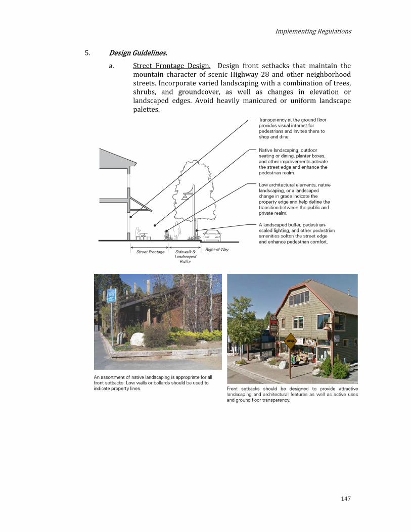
Implementing Regulations
147
5. Design Guidelines. a. Street Frontage Design. Design front setbacks that maintain the
mountain character of scenic Highway 28 and other neighborhood streets. Incorporate varied landscaping with a combination of trees, shrubs, and groundcover, as well as changes in elevation or landscaped edges. Avoid heavily manicured or uniform landscape palettes.
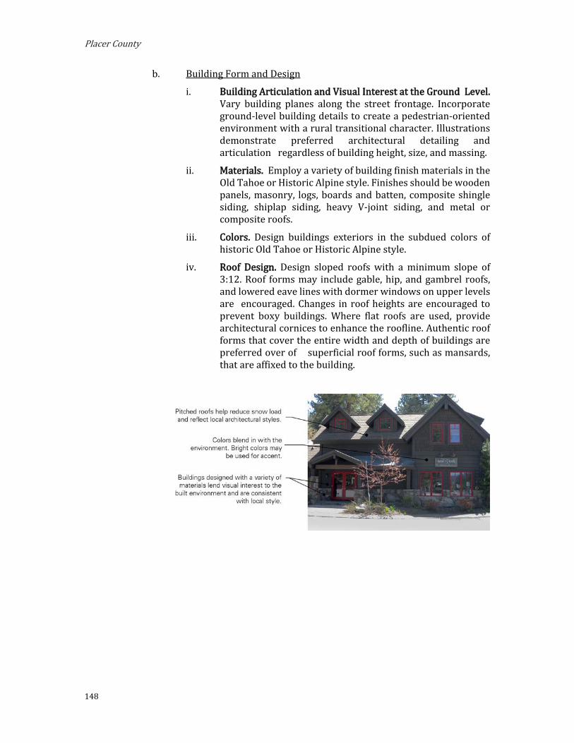
Placer County
148
b. Building Form and Design
i. Building Articulation and Visual Interest at the Ground Level. Vary building planes along the street frontage. Incorporate ground-level building details to create a pedestrian-oriented environment with a rural transitional character. Illustrations demonstrate preferred architectural detailing and articulation regardless of building height, size, and massing.
ii. Materials. Employ a variety of building finish materials in the Old Tahoe or Historic Alpine style. Finishes should be wooden panels, masonry, logs, boards and batten, composite shingle siding, shiplap siding, heavy V-joint siding, and metal or composite roofs.
iii. Colors. Design buildings exteriors in the subdued colors of historic Old Tahoe or Historic Alpine style.
iv. Roof Design. Design sloped roofs with a minimum slope of 3:12. Roof forms may include gable, hip, and gambrel roofs, and lowered eave lines with dormer windows on upper levels are encouraged. Changes in roof heights are encouraged to prevent boxy buildings. Where flat roofs are used, provide architectural cornices to enhance the roofline. Authentic roof forms that cover the entire width and depth of buildings are preferred over of superficial roof forms, such as mansards, that are affixed to the building.

Implementing Regulations
149
c. Building Entrances
i. Entrance Design. Building entrances should be designed to reflect the Old Tahoe Style and should be highlighted with covered architectural elements, pedestrian-scaled signage, paving, and building transparency. Walkways or stairways leading to the building entrance should be clearly visible from the right-of-way and from adjacent development.
d. Shorezone Design
i. View Protection. Orient pedestrian paths and vehicular circulation to maximize and protect shoreline views from the public rights-of-way. Identify areas that best allow lake views and design buildings and landscaping to maximize visual access. Where buildings, structures, or parking or loading areas can be seen within a scenic corridor, minimize the impact with vegetation, landforms, or colors and materials that blend with the surroundings.

Placer County
150
ii. Access. Provide clearly demarcated public access to the shorezone from public rights-of way. Incorporate landscaped edges, furniture, changes in elevation, and paving, while ensuring that all landscape design is sensitive to the natural habitat. When located adjacent to a parking area, design the access path to be visually distinct from the parking area.
6. Shorezone. Within the specified shorezone tolerance district, the following primary uses may be permitted by TRPA in the backshore, nearshore, and foreshore. Accessory structures shall be regulated pursuant to the regulations applicable to the primary use upon which they are dependent in accordance with the TRPA Code of Ordinances. The following structures may be permitted by TRPA in the shorezone as an Allowed (A) or Special (S) use only if they are accessory to an existing, allowed use located on the same or adjoining littoral parcel.
TABLE 2.04.B-6: SHOREZONE — NORTH TAHOE EAST MIXED-USE SUBDISTRICTS
Tolerance Districts 6 7 Maximum Community Noise Equivalent Level (CNEL)
Shorezone 55 55
Lakezone 50 50
Primary Uses Water- Oriented Outdoor Recreation Concessions S S
Beach Recreation A A
Waterborne Borne Transit A A
Tour Boat Operations S S
Safety and Navigation Facilities A A
Marinas S S
Boat Launching Facilities S S
Salvage Operations S S
Accessory Structures Buoys A A
Piers A A
Fences S S
Boat Ramps A A
Breakwaters or Jetties S S
Shoreline Protective Structures S S
Water Intake Lines A A
Floating Platforms and Docs A A

Implementing Regulations
151
C. North Tahoe West Mixed-Use Subdistricts.
1. Purpose. The purposes of the North Tahoe West Plan Area Mixed-Use Sub-districts are to:
a. Provide for the orderly, well-planned, and balanced growth of the Tahoe Vista and Carnelian Bay areas and support their role as important commercial, service, tourist, and community gathering places for local residents and visitors with easy access to recreational opportunities.
b. Promote Tahoe Vista and Carnelian Bay areas as pedestrian- and transit-oriented, mixed-use community centers.
c. Encourage a mix of uses that promotes convenience, economic vitality, and a pleasant quality of life and improve access to a greater range of facilities and services for surrounding residential neighborhoods.
d. Establish design standards that improve the pedestrian-orientation and visual quality of development and create a unified, distinctive, and attractive character.
2. Planning Statements. Planning statements for each Mixed-Use Subdistrict are as follows:
a. Mixed-Use Community Center (MU-CC). The Mixed-Use Community Center is made up of Mixed-Use Community Center East (MU-CCE) and Mixed-Use Community Center West (MU-CCW). Together, these subdistricts are the heart of the Tahoe Vista area. MU-CC is intended to maintain and enhance the pedestrian- and transit-oriented environment of retail, restaurants, services, and tourist accommodation with easy access to the lake and recreational activities.
i. Special Designations. (See Section 3.14) (1) TDR Receiving Area for: Existing Development; Multi-
Residential Units
(2) Preferred Affordable, Moderate, and Achievable Housing Area
ii. Special Policies.
(1) A mix of tourist and residential serving commercial is encouraged in the MU-CCW area.
(2) Public outdoor recreation and tourist uses are encouraged in the MU-CCE area and this area is targeted for increased public access to Lake Tahoe.
(3) All projects, as a condition of approval, shall implement frontage improvements consistent with Area Plan requirements.

Placer County
152
(4) All projects shall be subject to the design guidelines consistent with Area Plan requirements.
(5) For the Placer County project review process for design review and signage, retain the existence and participation of the North Tahoe Design Review Committee. The County should consider the recommendations of the Committee prior to taking action on any project subject to Committee review.
(6) Projects which provide substantial rehabilitation by remodeling, upgrading, or other aesthetic improvements shall be eligible for incentives.
(7) The focus of redevelopment should be on the beach area.
(8) TRPA and Placer County staff should provide quick and responsive project review through a coordinated review process.
(9) Outdoor advertising shall be subject to Area Plan standards and guidelines.
(10) Nonconforming signs shall be subject to an amortization plan and incentive program to provide for the eventual elimination or replacement of such signs.
(11) All projects within the TRPA scenic corridor shall be responsible for removing, relocating, or screening overhead utilities as a condition of project approval. The decision making body may waive this requirement if the project is part of an underground program or the undergrounding has been determined by TRPA not to be necessary to meet TRPA scenic targets.
(12) Projects with existing coverage in excess of 75 percent of their project area shall be required to provide an increase in landscaping equal to 5% of the project area. The landscaping requirement shall be met within the project area or, if not feasible, off site in a related area. This condition may be waived by the Design Review Committee if the project is part of an assessment district which is providing the required increase in landscaping or the landscaping requirement has been met by a previous approval.
(13) The Design Review Committee shall consider the recommendations contained within the Scenic Quality Improvement Program (SQIP) when reviewing projects and where appropriate, incorporate
Implementing Regulations
153
conditions of approval to implement the recommendations.
(14) Projects located between the designated scenic corridors and Lake Tahoe shall not cause a reduction of the views of Lake Tahoe from the corridors. TRPA may consider as an alternative, off-site improvements if it is determined there is a net increase in the lake views within the scenic unit.
(15) Projects in Tolerance District One (1) shall not increase disturbance or land coverage and shall be limited to maintenance dredging.
(16) Provide opportunities for development of a variety of multi-residential housing types with emphasis on affordable, moderate, and achievable housing.
b. Mixed-Use Gateway (MU-G). The Mixed-Use Gateway is made up of Mixed-Use Gateway East (MU-GE) and Mixed-Use Gateway West (MU-GW). Together, these subdistricts intended to create an attractive mixed-use commercial corridor that provides a welcoming gateway to Tahoe Vista. The physical form varies to reflect the commercial mixed-use character of the gateway corridor and to transition from surrounding, lower-density districts to the community center.
i. Special Designations. (See Section 3.14) (1) TDR Receiving Area for: Existing Development; Multi-
Residential Units
(2) Preferred Affordable, Moderate, and Achievable Housing Area
ii. Special Policies.
(1) Tourist oriented uses are encouraged in the MU-GW area and priority should be given to locating tourist accommodation uses and beach access in this area.
(2) All projects, as a condition of approval, shall implement frontage improvements consistent with Area Plan requirements.
(3) All projects shall be subject to the design guidelines consistent with Area Plan requirements.
(4) For the Placer County project review process for design review and signage, retain the existence and participation of the North Tahoe Design Review Committee. The County should consider the recommendations of the Committee prior to taking action on any project subject to Committee review.
Placer County
154
(5) Projects which provide substantial rehabilitation by remodeling, upgrading, or other aesthetic improvements shall be eligible for incentives.
(6) The focus of redevelopment should be on the beach area.
(7) TRPA and Placer County staff should provide quick and responsive project review through a coordinated review process.
(8) Outdoor advertising shall be subject to Area Plan standards and guidelines.
(9) Nonconforming signs shall be subject to an amortization plan and incentive program to provide for the eventual elimination or replacement of such signs.
(10) All projects within the TRPA scenic corridor shall be responsible for removing, relocating, or screening overhead utilities as a condition of project approval. The decision making body may waive this requirement if the project is part of an underground program or the undergrounding has been determined by TRPA not to be necessary to meet TRPA scenic targets.
(11) Projects with existing coverage in excess of 75 percent of their project area shall be required to provide an increase in landscaping equal to 5% of the project area. The landscaping requirement shall be met within the project area or, if not feasible, off site in a related area. This condition may be waived by the Design Review Committee if the project is part of an assessment district which is providing the required increase in landscaping or the landscaping requirement has been met by a previous approval.
(12) The Design Review Committee shall consider the recommendations contained within the Scenic Quality Improvement Program (SQIP) when reviewing projects and where appropriate, incorporate conditions of approval to implement the recommendations.
(13) Projects located between the designated scenic corridors and Lake Tahoe shall not cause a reduction of the views of Lake Tahoe from the corridors. TRPA may consider as an alternative, off-site improvements if it is determined there is a net increase in the lake views within the scenic unit.
Implementing Regulations
155
(14) Projects in Tolerance District One (1) shall not increase disturbance or land coverage and shall be limited to maintenance dredging.
(15) Provide opportunities for development of a variety of multi-residential housing types with emphasis on affordable, moderate, and achievable housing.
c. Mixed-Use Neighborhood Center (MU-NC). MU-NC is intended to provide a central gathering place where residents and visitors can enjoy a range of commercial, retail, service, tourist accommodation, and residential uses in a compact development pattern, creating an aesthetically-pleasing environment for pedestrians, cyclists, and automobile drivers.
i. Special Designations. (See Section 3.14) (1) TDR Receiving Area for: Existing Development; Multi-
Residential Units
(2) Preferred Affordable, Moderate, and Achievable-Income Housing Area
ii. Special Policies. (1) All projects, as a condition of approval shall
implement or commit to a five year schedule to implement sidewalk improvements. This condition may be waived if the project is in an assessment district already committed to such improvements.
(2) All projects shall be subject to the Area Plan design standards and guidelines. Standards may be adjusted to preserve natural features. Setback standards on State Route 28 may only be reduced upon making the required findings of the TRPA Code for scenic corridors.
(3) For the Placer County project review process for design review and signage, retain the existence and participation of the North Tahoe Design Review Committee. The County and TRPA should consider the recommendations of the Committee prior to taking action on any project subject to Committee review.
(4) Projects which provide substantial rehabilitation by remodeling, upgrading, or other aesthetic improvements shall be eligible for incentives.
(5) TRPA and Placer County staff should provide quick and responsive project review through a coordinated review process.
(6) Outdoor advertising shall be subject to Area Plan standards and guidelines.
Placer County
156
(7) Nonconforming signs shall be subject to an amortization plan and incentive program to provide for the eventual elimination or replacement of such signs.
(8) All projects within the TRPA scenic corridor shall be responsible for removing, relocating, or screening overhead utilities as a condition of project approval. TRPA may waive this requirement if the project is part of an underground program or the undergrounding has been determined by TRPA not to be necessary to meet TRPA scenic targets.
(9) Projects with existing coverage in excess of 75% of their project area, shall be required to provide an increase in landscaping equal to 5% of the project area. The landscaping requirement shall be met within the project area or, if not feasible, off site in a related area. This condition may be waived by the Design Review Committee if the project is part of an assessment district which is providing the required increase in landscaping or the landscaping requirement has been met by a previous approval.
(10) The Design Review Committee shall consider the recommendations contained within the Scenic Quality Improvement Program (SQIP) when reviewing projects and where appropriate, incorporate conditions of approval to implement the recommendations.
(11) Projects located between the designated scenic corridors and Lake Tahoe shall not cause a reduction of the views of Lake Tahoe from the corridors. TRPA may consider off-site improvements as an alternative if it is determined there is a net increase in the lake views within the scenic unit.
(12) Provide opportunities for development of a variety of multi-residential housing types with emphasis on affordable, moderate, and achievable housing.
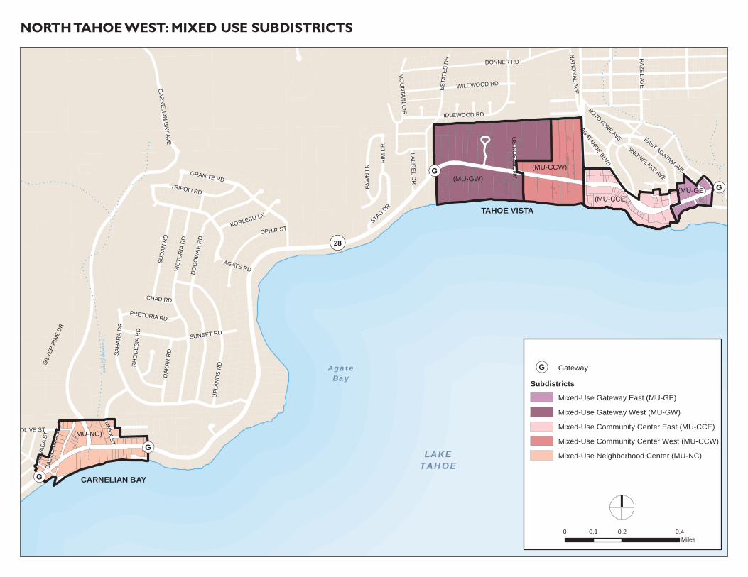
!!
!
!
!
! ! !
!!
!
!
!!
!
!!
!!
!!
! !! !
!!
!! ! !
!! !
!! !
!
!
!! !
!! !
! !!
!
!
!!
!!
!!
!! ! ! !
!!
! ! ! ! ! ! ! ! ! ! ! ! ! ! ! ! ! ! ! ! ! ! !!
!!
!! ! !
!! ! ! ! ! ! !
!!
!! ! !
!! ! ! ! ! ! ! ! ! !
!!
! ! !!
!!
!!
!!
!!
!!
! ! ! ! ! ! ! !!
!
!
!
!
!
!
!
!!
!!
!!
!
!
!
!
!
!
!
!
!
!!
!
!
!
!
!
!
!
!
!
!
!
!
!
!
!
!
!
!
!
!
!
!
!!
!
!
!!
!!
!!
!!
!! !
! ! !!
!
!
!
!
!
!
!!
!!
!!
!
!
!
!
!
!
!!
!!
!! !
! ! ! ! ! ! ! ! ! ! ! ! ! !!
!!
!
!
!
!
!
!
!
!
!!
!!
!
!
!
!
!
!
!
!
!
!
!
!!
!
!
!
!
!!
!!
!!
!!
!!
! ! ! ! ! !!
!!
!!
! ! ! !!
!!
!
!
!
!
!
!
!
!
!
!
!
!
!
!
!
!
!!
! ! ! ! ! !! ! ! ! ! !
! !!
!!
!!
!
!
!
!
!
!
!
!
!
!
!
!
!
!
!
!! !
!!
!!
!!
!!
!!
!
!
!
!
!
!
!
!
!!
!!
!
!!
!!
!!
!!
!
!
!
!
!!
!
!
!!
!!
!!
!!
!!
!!
!!
!!
!!
!!
!!
!!
!!
!!
!!
!!
!!
!!
!!
!!
!!
!!
!!
!!
!!
!!
!!
!!
!!
!!
!!
!
!
!
!
!
!
!
!
!
!
!
!
!
!
!
!
!
!
!
!
!!
!
!
!
!
!
!
!
!!
!
!!
!!
!!
!!
!!
!!
!
!
!!
!!
!
!
!
!
!
!
!
!
!
!
!
!
!
!
!
!
!
!
!
!
!
!
!!
!!
!!
!!
!!
!
!
!
!
!
!
!
!
!
!
!
!
!
!
!
!
!
!
!
!
!
!
!!
!!
!!
!!
!!
!!
!
!!
!!
!!
!!
!!
!!
!!
!!
!!
!!
!!
!!
!!
!!
!!
!!
!!
!!
!
!
!
!!
!!
!!
!!
!!
!!
!!
!!
!!
!!
!
!
!
!
!
!
!
!
!
!
!
!
!
!!
!!
!!
!
!
!
!!
!!
!!
!!
!
!!
!!
!!
!!
!!
!!
!!
!
!
!
!
!!
!!
!
!!
!
!
!
!
!
!
!
!
!
!
!
!
!!
!
!
!!
!
!!
!!
!!
!
!
!
!
!
!
!
!
!
!
!
!
!
!
!
!
!
!
!
!
!
!
!
!
!
!
! !
!
!
!!
!! !
!! !
! ! ! !!
!
!!
!
!
!
!
!
!
!
!
!
!
!
!
!
!!
!
!
!
!
!!
!!
!!
!!
!!
!
!
!
!
!!
!
!
!
!
!
!!
!!
!!
!
!
!
!
!
!
!!
!
!
!
!
!!
!!
!!
!!
!!
!!
!!
!
!
!
!
!
!
!
!
!
!
!
!
!
!!
!!
!!
!!
!!
!!
!
!
!
!
!
!
!!
!!
!!
!!
!!
!!
!!
!!
!!
!!
!
!
!!
!!
!!
!!
!!
!!
!!
!!
!!
!!
!!
!!
!!
!!
!!
!!
!!
!!
!!
!!
!!
!!
!!
!!
!!
!!
!!
!!
!!
!!
!
!
!
!
!
!
!
!
!
!
!
!
!
!
!
!
!
!
!
!
!
!
!
!!
!!
!!
!!
!
!
!
!
!!
!!
!
!
!
!
!
!
!
!
!
!
!
!
!
!
!
!
!
!
!
!
!
!
!!
!!
!!
!
!
!
!
!
!
!
!
!
!
!
!!
!!
!!
!
!
!!
!!
!!
!!
!!
!!
!!
!!
!
!
!
!
!
!!
!!
!!
!!
!!
!
!!
!!
!
!(G!(G
!(G
!(G
VIC
TOR
IA R
DD
OD
OW
AH R
D
SAH
ARA
DR
AGATE RD
RIM
DR
SUNSET RD
UPL
AND
S R
D
GRANITE RD
ESTA
TES
DR
NATIO
NAL AVE
SUD
AN R
D
OPHIR ST
TRIPOLI RD
IDLEWOOD RD
SILV
ER P
INE
DR
STAG DR
HAZEL AVE
FAW
N L
N
CAR
NELIAN
BAY AVE
WILDWOOD RD
ON
YX ST
OLIVE ST
DAK
AR R
D
EAST AGATAM AVE
KORLEBU LN
NEV
ADA
ST
PRETORIA RD
LAUR
EL DR
RH
OD
ESIA
RD
SNOWFLAKE AVE
AGATAHOE BLVD
MO
UN
TAIN C
IR
CHAD RD
SOTOYONE AVE
AND
ERSO
N R
D
CAL
IFO
RN
IA S
TDONNER RD
Carnelian Canyon
NORTH TAHOE WEST: MIXED USE SUBDISTRICTS
TAHOE VISTA
CARNELIAN BAY
LAKETAHOE
AgateBay
¬«28
(MU-GW)
(MU-NC)
(MU-CCW)
(MU-CCE)(MU-GE)
!(G Gateway
SubdistrictsMixed-Use Gateway East (MU-GE)
Mixed-Use Gateway West (MU-GW)
Mixed-Use Community Center East (MU-CCE)
Mixed-Use Community Center West (MU-CCW)
Mixed-Use Neighborhood Center (MU-NC)
0 0.2 0.40.1Miles
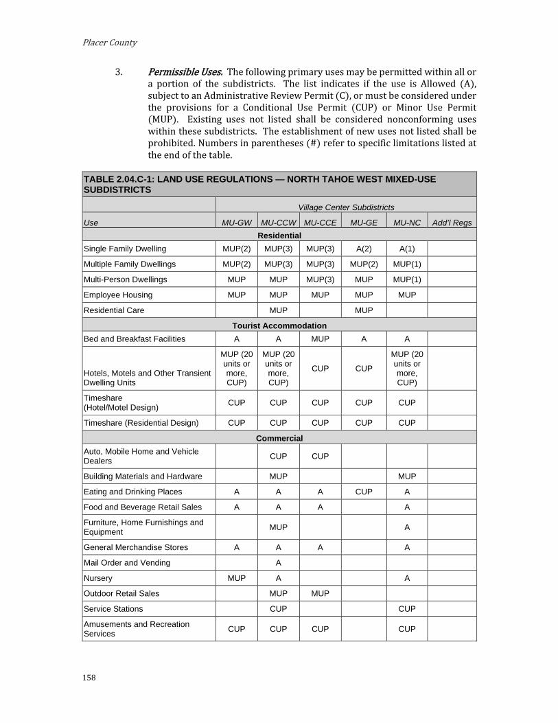
Placer County
158
3. Permissible Uses. The following primary uses may be permitted within all or a portion of the subdistricts. The list indicates if the use is Allowed (A), subject to an Administrative Review Permit (C), or must be considered under the provisions for a Conditional Use Permit (CUP) or Minor Use Permit (MUP). Existing uses not listed shall be considered nonconforming uses within these subdistricts. The establishment of new uses not listed shall be prohibited. Numbers in parentheses (#) refer to specific limitations listed at the end of the table.
TABLE 2.04.C-1: LAND USE REGULATIONS — NORTH TAHOE WEST MIXED-USE SUBDISTRICTS
Village Center Subdistricts
Use MU-GW MU-CCW MU-CCE MU-GE MU-NC Add’l Regs Residential
Single Family Dwelling MUP(2) MUP(3) MUP(3) A(2) A(1)
Multiple Family Dwellings MUP(2) MUP(3) MUP(3) MUP(2) MUP(1)
Multi-Person Dwellings MUP MUP MUP(3) MUP MUP(1)
Employee Housing MUP MUP MUP MUP MUP
Residential Care MUP MUP
Tourist Accommodation Bed and Breakfast Facilities A A MUP A A
Hotels, Motels and Other Transient Dwelling Units
MUP (20 units or more, CUP)
MUP (20 units or more, CUP)
CUP CUP
MUP (20 units or more, CUP)
Timeshare (Hotel/Motel Design) CUP CUP CUP CUP CUP
Timeshare (Residential Design) CUP CUP CUP CUP CUP
Commercial Auto, Mobile Home and Vehicle Dealers CUP CUP
Building Materials and Hardware MUP MUP
Eating and Drinking Places A A A CUP A
Food and Beverage Retail Sales A A A A
Furniture, Home Furnishings and Equipment MUP A
General Merchandise Stores A A A A
Mail Order and Vending A
Nursery MUP A A
Outdoor Retail Sales MUP MUP
Service Stations CUP CUP
Amusements and Recreation Services CUP CUP CUP CUP

Implementing Regulations
159
TABLE 2.04.C-1: LAND USE REGULATIONS — NORTH TAHOE WEST MIXED-USE SUBDISTRICTS
Village Center Subdistricts
Use MU-GW MU-CCW MU-CCE MU-GE MU-NC Add’l Regs Privately Owned Assembly and Entertainment CUP CUP
Outdoor Amusements CUP CUP CUP
Animal Husbandry (Services) MUP
Broadcasting Studios MUP A MUP A
Business Support Services MUP MUP
Contract Construction Services MUP MUP
Financial Services A A
Health Care Services MUP A
Personal Services A MUP A
Professional Offices A MUP A
Repair Services MUP MUP
Schools - Business and Vocational CUP CUP
Secondary Storage MUP MUP MUP MUP MUP
Small Scale Manufacturing MUP MUP MUP
Vehicle Storage and Parking MUP MUP MUP MUP MUP
Public Service Religious Assembly A MUP
Collection Stations A A
Cultural Facilities MUP A MUP MUP A
Day Care Centers/Pre-Schools A A A A A
Government Offices MUP MUP
Hospitals CUP
Local Assembly and Entertainment MUP A MUP
Local Post Offices A A A
Local Public Health and Safety Facilities MUP A MUP MUP A
Membership Organizations MUP
Publicly Owned Assembly and Entertainment MUP MUP
Public Utility Centers MUP
Schools - Kindergarten through Secondary MUP
Social Service Organizations A MUP
Pipelines and Power Transmission CUP CUP CUP CUP CUP
Transit Stations and Terminals CUP CUP CUP CUP CUP

Placer County
160
TABLE 2.04.C-1: LAND USE REGULATIONS — NORTH TAHOE WEST MIXED-USE SUBDISTRICTS
Village Center Subdistricts
Use MU-GW MU-CCW MU-CCE MU-GE MU-NC Add’l Regs Transmission and Receiving Facilities (4) MUP MUP MUP MUP MUP
Transportation Routes CUP CUP CUP CUP CUP
Threshold-Related Research Facilities MUP MUP MUP MUP MUP
Recreation Day Use Areas A A A A A
Participant Sports (Facilities) MUP MUP A
Beach Recreation A A A MUP A
Boat Launching Facilities CUP CUP A A
Cross Country Skiing Courses A A
Developed Campgrounds CUP
Group Facilities MUP
Marinas CUP A CUP
Outdoor Recreation Concessions A A A MUP A
Recreation Center MUP MUP
Recreational Vehicle Park CUP
Riding and Hiking Trails A MUP
Rural Sports CUP CUP
Snowmobile Courses CUP CUP
Undeveloped Campgrounds
Visitor Information Center MUP MUP MUP MUP
Resource Management Reforestation A A A A A
Sanitation Salvage Cut A A A A A
Thinning A A A A A
Tree Farms A A A A A
Early Successional State Vegetation Management A A A A A
Nonstructural Fish Habitat Management A A A A A
Nonstructural Wildlife Habitat Management A A A A A
Structural Fish Habitat Management A A A A A
Structural Wildlife Habitat Management A A A A A

Implementing Regulations
161
TABLE 2.04.C-1: LAND USE REGULATIONS — NORTH TAHOE WEST MIXED-USE SUBDISTRICTS
Village Center Subdistricts
Use MU-GW MU-CCW MU-CCE MU-GE MU-NC Add’l Regs Fire Detection and Suppression A A A A A
Fuels Treatment (/Management) A A A A A
Insect and Disease Suppression A A A A
Sensitive Plant Management A A A A A
Uncommon Plant Community Mgmt. A A A A A
Erosion Control A A A A A
Runoff Control A A A A A
SEZ Restoration A A A A A
Notes: (1) Residential uses are discouraged on the ground floor along Highway 28 and Carnelian Woods Ave. (2) Residential uses are discouraged on the ground floor along Highway 28. (3) Residential uses are discouraged on the ground floor along Highway 28 west of Pino Grande Ave. (4) Facilities that are not visually obtrusive may be eligible for an Administrative Approval per Placer County
Code Section 17.56.060.F.
4. Development Stndards. Tables 2.04.C-2, 2.04.C-3, and 2.04.C-4 prescribe the development standards for the North Tahoe West Mixed-Use subdistricts.
TABLE 2.04.C-2: DENSITY, BUILDING HEIGHT, RECREATION AND NOISE STANDARDS — NORTH TAHOE WEST MIXED-USE SUBDISTRICTS
Village Center Subdistricts
MU-GW MU-CCW MU-CCE MU-GE MU-NC Maximum Density (Units/acre unless otherwise indicated)
Single Family Dwelling (du/parcel) 1 1 1 1 1
Multiple Family Dwelling 15 15 15 15 15
Multi-Person Dwelling (people per acre) 37 37 37 37 37
Residential Care (people per acre) 25 25
Employee Housing (units per acre) As per the limitations
above
As per the limitations
above
As per the limitations
above
As per the limitations
above 15
Tourist Accommodation
Bed and Breakfast Facilities 10 10 10 10 10
Hotel, Motel and Other Transient Dwelling Units with less than 10% of units with kitchens
40 40 40 40 40
Hotel, Motel and Other Transient Dwelling Units with 10% or more units with kitchens
15 15 15 15 15

Placer County
162
TABLE 2.04.C-2: DENSITY, BUILDING HEIGHT, RECREATION AND NOISE STANDARDS — NORTH TAHOE WEST MIXED-USE SUBDISTRICTS
Village Center Subdistricts
MU-GW MU-CCW MU-CCE MU-GE MU-NC
Timeshare (units per acre) As set forth
above
As set forth
above
As set forth
above
As set forth
above 15
Recreation
Developed Campgrounds (sites per acre) 8
Group Facilities (persons per acre) 25
Recreational Vehicle Park (sites per acre) 10
Building Height TRPA Code of Ordinances Chapter 37
Additional Developed Outdoor Recreation - - - - Summer Day
Uses: 40 PAOT
Maximum Community Noise Equivalent Level (CNEL)
55 60 55 55 60
Where applicable, a maximum 55 CNEL override is permissible for the Highway 28 Corridor
Hourly Leq, dB Daytime (7a.m.-7p.m.): 55; Nighttime (7p.m.-7a.m.): 45 Levels should be lowered by five dB for simple tone noises
Maximum Level, dB Daytime (7a.m.-7p.m.): 75; Nighttime (7p.m.-7a.m.): 65
In the MU-NC Subdistrict, each of the noise levels specified above should be lowered by five dB for simple tone noises, noises consisting primarily of speech or music, or for recurring impulsive noises.

Implementing Regulations
163
TABLE 2.04.C-3: BUILDING PLACEMENT STANDARDS AND GUIDELINES — NORTH TAHOE WEST MIXED-USE SUBDISTRICTS
Village Center Subdistrict
MU-G MU-CC MU-NC # Minimum Setbacks
Street Frontage, Hwy 28 (from edge of pavement)
15 ft min, 20 ft max. First 4 ft should be a landscaped parkway followed by a minimum 6 ft sidewalk. This guideline may be waived by the Design Review Committee were topographical features preclude sidewalk construction and
alternative pedestrian access exists (a)
Street Frontage, Other Streets (from edge of pavement)
10 ft min, 20 ft max. First 2 ft should be a landscaped snow easement followed by a 4 ft sidewalk (a)
Interior Side (from property line) 0 ft; 10 ft landscaped setback required adjacent to residential use
Rear (from property line) 20 ft 10 ft
Lake Tahoe Per TRPA Code of Ordinances
Attached garage 2 ft from primary façade
Minimum Building Frontage at the Build-to Line (% of linear street frontage)
40% (b) 30% (b) 30% (b)
Corner Build Area 30 ft (c) 30 ft (c) 30 ft (c)
Maximum Projection into Front Setback
Awnings and overhangs to provide a covered walkway, public plaza, or outdoor eating area may project up to 50% of the required setback, but not
into any public right-of-way.
Placer County
164
a. Street Frontage Improvements. New development, including substantial alterations of existing properties (total floor area of the proposed alteration, not including any internal alteration, is more than 50 percent of the floor area of the original building), shall provide street frontage improvements in accordance with the following or an approved area wide improvement plan:
i. Building Frontage. The area between the building frontage and back of sidewalk or edge of pavement where there is no sidewalk, shall be improved so that it functions as part of the wider sidewalk, improved as outdoor eating or seating areas (subject to Placer County Code, Section 17.56.160, Outdoor Retail Sales), or landscaped.
ii. Street Trees. If located in sidewalk tree wells, trees shall be planted at minimum 20 feet on center along the Highway 28 street frontage. Otherwise, street trees shall be planted at least 40 or 50 feet on center depending on species selected.
iii. Curb. Six inch vertical concrete curb at sidewalks or rolled curbs with gutter or valley gutter where sidewalks are not planned.
iv. Pedestrian Street Lights. Twelve foot high pedestrian lights at 50 feet on center or low-level lights 25 feet on center along Highway 28.
b. Build-to Line for Nonresidential Uses. Buildings with non-residential uses on the ground floor shall be constructed at the required setback for the identified percent of linear street frontage. This requirement may be modified or waived with project approval upon finding that:
i. Entry courtyards, plazas, entries, or outdoor eating and display areas are located between the build-to line and building, provided that the buildings are built to the edge of the courtyard, plaza, or dining area;
ii. The building incorporates an alternative entrance design that creates a welcoming entry feature facing the street; or
iii. The building placement is necessary to allow significant views of the lake.
c. Corner Build Area. Where feasible and compatible with environmental constraints, buildings with nonresidential uses on the ground floor should be located in accordance with the required setbacks within 30 feet of any street corner. Public plazas may be at the street corner provided buildings are built to the edge of the public plaza.
d. Building Transparency; Required Openings for Retail and Service Uses. Exterior walls facing and within 20 feet of a front or street side property line should include windows, doors, or other openings for 50 percent of the building wall area located between 2.5 and seven feet above ground level. Openings fulfilling this requirement shall have

Implementing Regulations
165
transparent glazing and provide views into work areas, display areas, sales areas, lobbies, or similar active spaces, or into window displays that are at least three feet deep.
i. Exceptions for Parking Garages. Multi-level garages are not required to meet the building transparency requirement of this subsection. Instead, they must be either located behind buildings or screened with a landscaped area at least 10 feet wide between the parking garage and public street.
TABLE 2.04.C-4: PARKING AND ACCESS STANDARDS AND GUIDELINES — NORTH TAHOE WEST MIXED-USE SUBDISTRICTS
Village Center Subdistrict
MU-G MU-CC MU-NC # Minimum Setback from Edge of Traveled Way
20 ft(e)
Minimum Setback from Lake Tahoe 40 ft or per TRPA Code of Ordinances, whichever is greater
Setback from Buildings and Public Plazas
5 ft walkway and/or landscaping
Access Location Side street or rear wherever possible
Shared Access See additional regulations (f)
Curb Cuts Minimized and in areas least likely to impede pedestrian circulation
Placer County
166
TABLE 2.04.C-4: PARKING AND ACCESS STANDARDS AND GUIDELINES — NORTH TAHOE WEST MIXED-USE SUBDISTRICTS Loading/Service Areas Side or rear of lot is preferred; Loading and service areas
should be screened from the public right-of-way
Parking Podium Maximum height of a parking podium located within the parking lot setback and visible from the street should be no
greater than 3 feet from finished grade.
e. Limitations on Location of Parking. Buildings should be placed as close to the street as possible, with parking behind a building, or on the interior side or rear of the site. Parking may be located within the required setback, subject to the following requirements.
i. Underground and Partially Submerged Parking. Parking completely or partially underground (with maximum three feet above ground), may match the setbacks of the main structure.
ii. Surface Parking. Aboveground surface parking may be located within 20 feet of a street facing edge of traveled way with the approval of a project when the following findings are made:
(1) Buildings are built close to the public sidewalk to the maximum extent feasible;
(2) The parking area is screened along the public right-of-way with a wall, hedge, trellis, and/or landscaping;
(3) The site is small and constrained such that parking located more than 20 feet from the street frontage is not feasible; and
(4) County Public Works determines traffic impacts from vehicle queuing and backing into the right-of-way are mitigated.
f. Shared Access. To encourage shared parking and shared access points on public streets, new parking facilities for Retail Trade or Service Uses should be designed to accommodate cross-access to / from adjacent properties to allow parking areas to become joint use facilities even if initially serving only one development. When cross-access for vehicles is deemed impractical by the Design Review Committee, the requirement for cross-access may be waived with project approval if bicycle or pedestrian connections are provided between adjacent development.
Building Orientation and Entrances.
i. Buildings should be oriented to face public streets.
ii. Building frontages shall be generally parallel to streets, and the primary building entrances should be located on a public street.

Implementing Regulations
167
iii. Building entrances should be emphasized with special architectural and landscape treatments.
iv. Entrances located at corners shall generally be located at a 45 degree angle to the corner and should have a distinct architectural treatment to animate the intersection and facilitate pedestrian flow around the corner. Different treatments may include angled or rounded corners, arches, and other architectural elements. All building and dwelling units located in the interior of a site should have entrances from the sidewalk that are designed as an extension of the public sidewalk and connect to a public sidewalk.
v. Entrances to residential units should be physically separated from the entrance to the permitted commercial uses and clearly marked with a physical feature incorporated into the building or an appropriately scaled element applied to the façade.
FIGURE 2.04(C)(4.A): BUILDING ORIENTATION AND ENTRANCES
h. Building Design and Articulation. Buildings shall provide adequate architectural articulation and detail to avoid a bulky and “box-like” appearance. Building design shall reflect “Old Tahoe” or “Historic Alpine” architectural features, which promote the rustic, alpine character of the area and include the following:
i. Exterior Building Materials and Colors.
(1) A unified palette of non-reflective, natural materials such as stone and wood shall be used on all sides of buildings.
(2) Rustic exterior colors shall be used to blend the building into the forest canopy.
ii. Building Details. Buildings shall provide adequate architectural articulation and detail to avoid a bulky and “box-like” appearance and designs shall consider the effects of snow and ice on building access.
(1) Building façades shall include building projections or recesses, doorway and window details, shutters, awnings, window boxes, natural stone or wood

Placer County
168
materials, and other details that provide architectural articulation and design interest.
(2) Clip-gambrel roofs, shed roofs, upper-floor balconies, covered walkways, and other architectural elements should be used, as appropriate, to terminate rooflines and accentuate setbacks between stories.
(3) All applied surface ornamentation or decorative detailing shall be consistent with the architectural style of the building.
(4) Each side of the building that is visible from a public right-of-way, shoreline, or publicly accessible open space shall be designed with a complementary level of detailing. Particular attention shall be given to the detailing within the pedestrian’s range of touch and view, such as the use of special store-front detailing and façade ornamentation to reinforce the pedestrian character of the street.
(5) Building designs shall account for the frequent presence of snow and ice consistent with Section 3.09.D, Design for Snow. Appropriate design strategies may include:
(a) Location of entrances under the gable ends of pitched roofs;
(b) Limiting the location of entrances, stairs, or walkways under the drip line of roof eaves;
(c) Covering of stairs and walkways;
(d) Use of snow cleats on roofs to prevent rapid shedding of snow and ice;
(e) Limiting the extension of open or uncovered balconies into the roof area;
(f) Use of heating elements to reduce snow shedding off of roofs; or
(g) Consideration of composition roofs over metal roofing materials.
i. Pedestrian Connections. A minimum five-foot-wide unobstructed pedestrian access should be provided from on-site vehicle and bicycle parking area to the main entrance of buildings, to adjacent public amenities such as the beach, shoreline, or viewpoints, and to public trails or transit stops located along the street frontage.
j. Residential Open Space. For residential and mixed-use projects with residential uses, 75 square feet of private or common open space area should be provided per dwelling unit. Private areas typically consist of balconies, decks, patios, fenced yards, and other similar areas

Implementing Regulations
169
adjacent to private units. Common areas typically consist of landscaped areas, walks, patios, barbeque areas, or other such improvements as are appropriate to enhance the outdoor environment of the development. Landscaped courtyard entries that are oriented towards a public street are considered common areas.
i. Minimum Dimensions.
(1) Private Open Space. Private open space should have no horizontal dimension less than six feet.
(2) Common Open Space. Common open space should have no horizontal dimension of less than 20 feet.
ii. Usability. A surface should be provided that allows convenient use for outdoor living and/or recreation. Such surface may be any practical combination of lawn, garden, flagstone, wood planking, concrete, or other serviceable, dust-free surfacing. Seating areas and plazas should be located in areas with good solar exposure.
iii. Accessibility.
(1) Private Open Space: The space should be accessible to only one living unit by a doorway to a habitable room or hallway.
(2) Common Open Space: The space should be accessible to the living units on the lot. It should be served by any stairway or other accessway qualifying as an egress facility from a habitable room.

Placer County
170
5. Design Guidelines. a. Street Frontage Design. Design front setbacks that maintain the
mountain character of scenic Highway 89 and other neighborhood streets. Incorporate varied landscaping with a combination of trees, shrubs, and groundcover, as well as changes in elevation or landscaped edges. Avoid heavily manicured or uniform landscape palettes.

Implementing Regulations
171
b. Building Form and Design.
i. Building Articulation and Visual Interest at the Ground Level. Vary building planes along the street frontage. Incorporate ground-level building details to create a pedestrian-oriented environment with a rural transitional character. Illustrations demonstrate preferred architectural detailing and articulation regardless of building height, size, and massing.
ii. Materials. Employ a variety of building finish materials in the Old Tahoe or Historic Alpine style. Finishes should be wooden panels, masonry, logs, boards and batten, composite shingle siding, shiplap siding, heavy v-joint siding, and metal or composite roofs.
iii. Colors. Design buildings exteriors in the subdued colors of historic Old Tahoe or Historic Alpine style. These include earthy and natural colors that blend well with the alpine forest (reddish-brown, brown, tan, ochre, umber, sand, and dark green). Limit the use of bright-colored building materials and finishes, especially along scenic corridors.
iv. Roof Design. Design sloped roofs with a minimum slope of 3:12. Roof forms may include gable, hip, and gambrel roofs, and lowered eave lines with dormer windows on upper levels are encouraged. Changes in roof heights are encouraged to prevent boxy buildings. Where flat roofs are used, provide architectural cornices to enhance the roofline. Authentic roof forms that cover the entire width and depth of buildings are preferred over of superficial roof forms, such as mansards, that are affixed to the building.
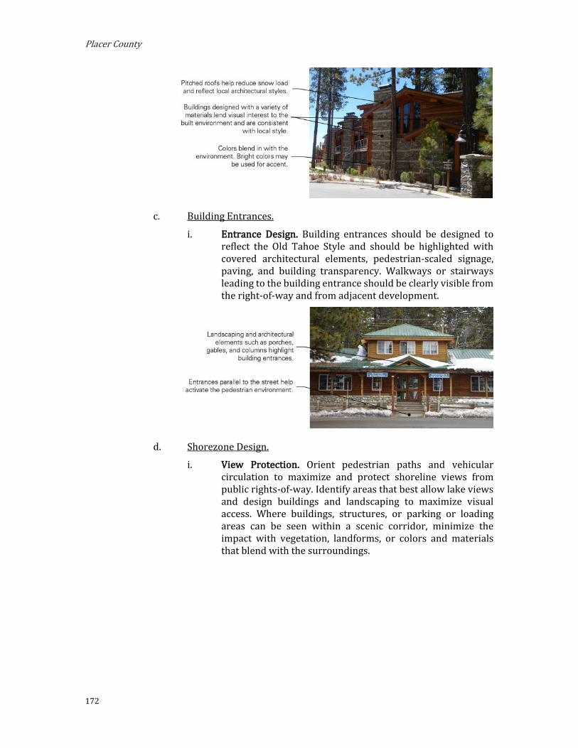
Placer County
172
c. Building Entrances.
i. Entrance Design. Building entrances should be designed to reflect the Old Tahoe Style and should be highlighted with covered architectural elements, pedestrian-scaled signage, paving, and building transparency. Walkways or stairways leading to the building entrance should be clearly visible from the right-of-way and from adjacent development.
d. Shorezone Design.
i. View Protection. Orient pedestrian paths and vehicular circulation to maximize and protect shoreline views from public rights-of-way. Identify areas that best allow lake views and design buildings and landscaping to maximize visual access. Where buildings, structures, or parking or loading areas can be seen within a scenic corridor, minimize the impact with vegetation, landforms, or colors and materials that blend with the surroundings.

Implementing Regulations
173
ii. Access. Provide clearly demarcated public access to the shorezone from public rights-of way. Incorporate landscaped edges, furniture, changes in elevation, and paving, while ensuring that all landscape design is sensitive to the natural habitat. When located adjacent to a parking area, design the access path to be visually distinct from the parking area.

Placer County
174
6. Shorezone. Within the specified shorezone tolerance district, the following primary uses may be permitted by TRPA in the backshore, nearshore, and foreshore. Accessory structures shall be regulated pursuant to the regulations applicable to the primary use upon which they are dependent in accordance with the TRPA Code of Ordinances. The following structures may be permitted by TRPA in the shorezone as an Allowed (A) or Special (S) use only if they are accessory to an existing, allowed use located on the same or adjoining littoral parcel.
TABLE 2.04.B-6: SHOREZONE — NORTH TAHOE EAST MIXED-USE SUBDISTRICTS
Tolerance Districts 6 7 Maximum Community Noise Equivalent Level (CNEL)
Shorezone 55 55
Lakezone 50 50
Primary Uses Water-Oriented Outdoor Recreation Concessions S S
Beach Recreation A A
Waterborne Transit A A
Tour Boat Operations S S
Safety and Navigation Facilities A A
Marinas S S
Boat Launching Facilities S S
Salvage Operations S S
Accessory Structures Buoys A A
Piers A A
Fences S S
Boat Ramps A A
Breakwaters or Jetties S S
Shoreline Protective Structures S S
Water Intake Lines A A
Floating Platforms and Docs A A
Implementing Regulations
175
D. West Shore Mixed-Use Subdistricts.
1. Purpose. The purposes of the West Shore Mixed-Use Subdistricts are to:
a. Encourage a mix of uses that promotes convenience, economic sustainability, community gathering, and a pleasant quality of life.
b. Promote pedestrian- and transit-oriented, mixed-use community centers at appropriate locations.
c. Establish design standards that improve the visual quality of development and create a unified and attractive character.
d. Provide central community gathering places where residents and visitors can enjoy a range of small-scale commercial, retail, service, and tourist accommodation uses in a forested, alpine atmosphere and serene, walkable environment with a small town feel. The purpose of the district is to also encourage a mix of uses that promotes convenience, economic vitality, and a pleasant quality of life with improved access to recreational activities.
2. Planning Statements. Planning statements for each Mixed-Use Subdistrict are as follows: a. Tahoma Village Center Subdistrict. This area should continue as a
neighborhood tourist commercial area; however, there is a need for rehabilitation while maintaining the scale and character of the west shore.
i. Special Designations (See Section 3.14)
(1) TDR Receiving Area for Existing Development; Multi-Residential Units.
(2) Preferred Affordable, Moderate, and Achievable Housing Area.
ii. Special Policies:
(1) This is the closest commercial area to Sugar Pine State Park, Bliss State Park and Meeks Bay and, as such, further upgrades as a local commercial center should be encouraged to meet tourist and camper needs. The possible growth and expansion of these two recreational facilities should be coordinated.
(2) Provide opportunities for development of a variety of multi-residential housing types with emphasis on affordable, moderate, and achievable housing.
b. Homewood Village Center Subdistrict. This area should continue to be a tourist commercial area. However, there is a need for rehabilitation while maintaining the scale and character of the west shore.
i. Special Designations (See Section 3.14)
Placer County
176
(1) TDR Receiving Area for Existing Development; Multi-Residential Units
(2) Preferred Affordable, Moderate, and Achievable Housing Area
ii. Special Policies:
(1) Planning for development of this area should include consideration of the adjoining ski areas, as well as marina master planning.
(2) The marina should be upgraded to accommodate boating needs.
(3) Tourism and recreation compatible with the historic nature development should be encouraged in this area.
(4) Outdoor seasonal events shall be regulated in a manner to reduce conflicts with neighboring residential uses and to minimize environmental impacts.
(5) Provide opportunities for development of a variety of multi-residential housing types with emphasis on affordable, moderate, and achievable housing.
c. Sunnyside Village Center Subdistrict. The current and future uses should be directed towards the needs of tourists. The area to the west of Highway 89 should be rehabilitated to improve the scenic quality of the area while maintaining the west shore scale and character.
i. Special Designations (See Section 3.14)
(1) TDR Receiving Area for Existing Development; Multi-Residential Units.
(2) Preferred Affordable, Moderate, and Achievable Housing Area.
ii. Special Policies:
(1) Upgrading of existing facilities should be consistent with the historical character of the area
(2) Provide opportunities for development of a variety of multi-residential housing types with emphasis on affordable, moderate, and achievable housing.

W LA
KE B
LVD
GRAND AVE
PINE AVE
WARD CREEK BLVD
INTE
RLA
KEN
RD
MAD
RO
NE
AVE
MCKINNEY DR
PARK AVE
DOE
AVE
PINELAND DR
GR
OU
SE D
R
CLUB
DR
ROBIN R
D
FLICKER AVE
SKYLINE D
R
CH
UC
KER
RD
SUGAR PINE RD
FOUNTAIN AVE
RUBICON AVE
LAGOON RD
CEDAR CREST AVE
SIERRA VISTA AVE
TAMARACK LN
TIMBERLAND LN
LEOTA WAY
TALLAC AVE
ELIZABETH DR
FERN ST
SUN
NYS
IDE
LN
HILL ST
OAK ST
TAHOMA
HOMEWOOD
SUNNYSIDE
LAKETAHOE
McKinneyBay
PLACER COUNTYEL DORADO COUNTY
WAS
HOE
WAY
PINE R
IDG
ERD
SACR
AMEN
TOAV
E
SACR
AMEN
TOAV
E
PINE ST
¬«89
Ward Creek
Madden Creek
Homewood Canyo
n
Blackwood Cree k
McKi
nney
Creek
WEST SHORE: MIXED USE SUBDISTRICTS
SubdistrictsSunnyside Village Center
Homewood Village Center
Tahoma Village Center
0 0.5 10.25Miles

Placer County
178
3. Permissible Uses. The following primary uses may be permitted within all or a portion of the subdistricts. The list indicates if the use is Allowed (A), subject to an Administrative Review Permit (C), or must be considered under the provisions for a Conditional Use Permit (CUP) or Minor Use Permit (MUP). Existing uses not listed shall be considered nonconforming uses within these subdistricts. The establishment of new uses not listed shall be prohibited.
TABLE 2.04.D-1: LAND USE REGULATIONS — WEST SHORE MIXED-USE SUBDISTRICTS
Use Tahoma Village Center
Homewood Village Center
Sunnyside Village Center Add’l Regs
Residential Single Family Dwelling A A A
Multiple Family Dwellings MUP MUP MUP
Multi-Person Dwellings MUP MUP MUP
Employee Housing MUP MUP MUP
Residential Care MUP
Nursing and Personal Care MUP
Tourist Accommodation Bed and Breakfast Facilities A A A Hotels, Motels and Other Transient Dwelling Units CUP CUP CUP Timeshare (Hotel/Motel Design) CUP CUP CUP Timeshare (Residential Design) CUP CUP
Commercial Auto, Mobile Home and Vehicle Dealers CUP CUP CUP
Building Materials and Hardware MUP MUP MUP
Eating and Drinking Places A A A
Food and Beverage Retail Sales A A A
Furniture, Home Furnishings and Equipment MUP MUP MUP
General Merchandise Stores A A A
Mail Order and Vending A A A
Nursery A A A
Outdoor Retail Sales A MUP MUP
Service Stations A A A
Amusements and Recreation Services CUP CUP CUP
Outdoor Amusements CUP CUP
Animal Husbandry MUP MUP
Auto Repair and Service MUP MUP
Broadcasting Studios A A A
Business Support Services A A A
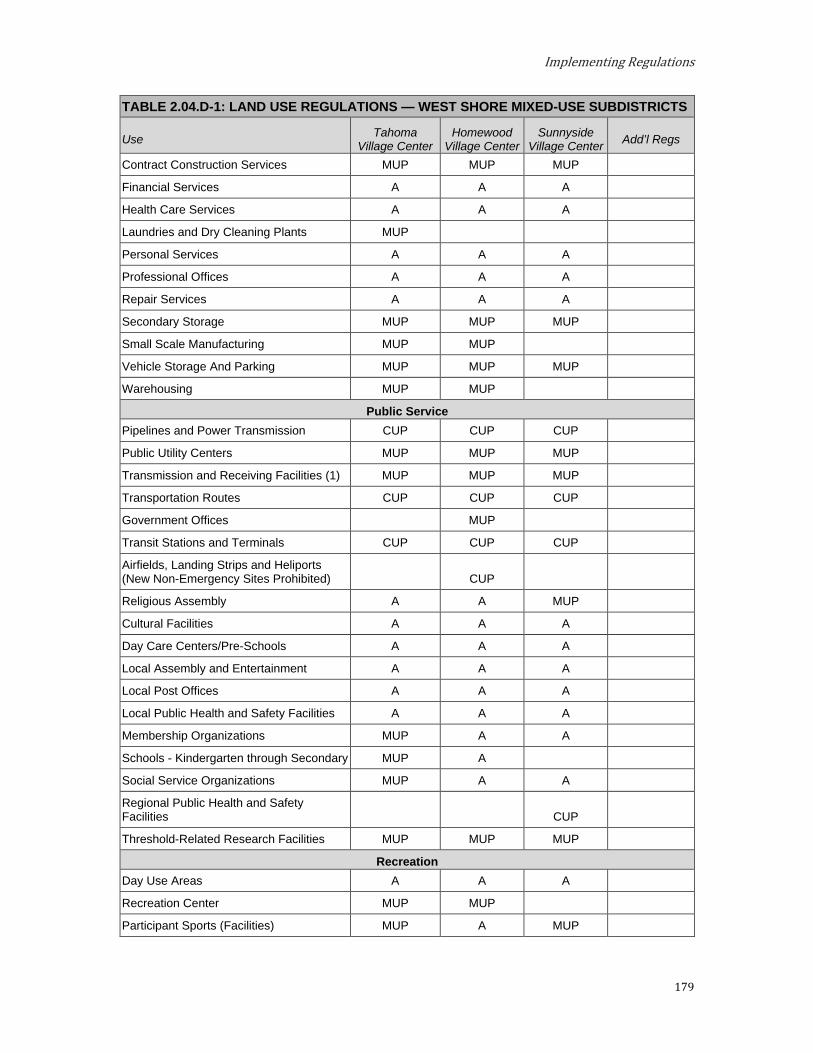
Implementing Regulations
179
TABLE 2.04.D-1: LAND USE REGULATIONS — WEST SHORE MIXED-USE SUBDISTRICTS
Use Tahoma Village Center
Homewood Village Center
Sunnyside Village Center Add’l Regs
Contract Construction Services MUP MUP MUP
Financial Services A A A
Health Care Services A A A
Laundries and Dry Cleaning Plants MUP
Personal Services A A A
Professional Offices A A A
Repair Services A A A
Secondary Storage MUP MUP MUP
Small Scale Manufacturing MUP MUP
Vehicle Storage And Parking MUP MUP MUP
Warehousing MUP MUP
Public Service Pipelines and Power Transmission CUP CUP CUP
Public Utility Centers MUP MUP MUP
Transmission and Receiving Facilities (1) MUP MUP MUP
Transportation Routes CUP CUP CUP
Government Offices MUP
Transit Stations and Terminals CUP CUP CUP
Airfields, Landing Strips and Heliports (New Non-Emergency Sites Prohibited) CUP
Religious Assembly A A MUP
Cultural Facilities A A A
Day Care Centers/Pre-Schools A A A
Local Assembly and Entertainment A A A
Local Post Offices A A A
Local Public Health and Safety Facilities A A A
Membership Organizations MUP A A
Schools - Kindergarten through Secondary MUP A
Social Service Organizations MUP A A
Regional Public Health and Safety Facilities CUP
Threshold-Related Research Facilities MUP MUP MUP
Recreation Day Use Areas A A A
Recreation Center MUP MUP
Participant Sports (Facilities) MUP A MUP

Placer County
180
TABLE 2.04.D-1: LAND USE REGULATIONS — WEST SHORE MIXED-USE SUBDISTRICTS
Use Tahoma Village Center
Homewood Village Center
Sunnyside Village Center Add’l Regs
Group Facilities MUP MUP
Beach Recreation A A
Boat Launching Facilities CUP CUP
Cross Country Skiing Courses MUP MUP
Developed Campgrounds A
Marinas A A
Outdoor Recreation Concessions MUP A A
Recreational Vehicle Park CUP
Riding and Hiking Trails MUP MUP
Rural Sports CUP
Skiing Facilities CUP
Snowmobile Courses CUP
Visitor Information Center MUP MUP MUP
Resource Management Reforestation A A A
Sanitation Salvage Cut A A A
Thinning A A A
Timber Stand Improvement A A A
Tree Farms A A A
Early Successional State Vegetation Management A A A
Nonstructural Fish Habitat Management A A A
Nonstructural Wildlife Habitat Management A A A
Structural Fish Habitat Management A A A
Structural Wildlife Habitat Management A A A
Fire Detection and Suppression A A A
Fuels Treatment (/Management) A A A
Insect and Disease Suppression A A A
Sensitive Plant Management A A A
Uncommon Plant Community Management A A A
Erosion Control A A A
Runoff Control A A A
SEZ Restoration A A A
Reforestation A A A
Sanitation Salvage Cut A A A

Implementing Regulations
181
TABLE 2.04.D-1: LAND USE REGULATIONS — WEST SHORE MIXED-USE SUBDISTRICTS
Use Tahoma Village Center
Homewood Village Center
Sunnyside Village Center Add’l Regs
Note: (1) Facilities which are not visually obtrusive may be eligible for an Administrative Approval per Placer County Code Section 17.56.060.F.
4. Development Standards. Tables 2.04.D-2, 2.04.D-3, 2.04.D-4, and 2.04.D-5 prescribe the development standards for the West Shore Mixed-Use District subdistricts.
TABLE 2.04.D-2: DENSITY, BUILDING HEIGHT AND NOISE STANDARDS — WEST SHORE MIXED-USE SUBDISTRICTS
Subdistrict Tahoma Village Center
Homewood Village Center
Sunnyside Village Center
Maximum Density (Units/acre unless otherwise indicated) Residential
Single Family Dwelling (du/parcel) 1 1 1
Multiple Family Dwelling (units per acre) 8 8 8
Multi-Person Dwellings (people per acre) 25 25 25
Residential Care (people per acre) 25
Employee Housing (units per acre) As per the limitations above 8 15, multiple family
only
Tourist Accommodation
Bed and Breakfast Facilities (units per acre) 10 10 10
Hotel, Motel and Other Transient Dwelling Units with less than 10% of units with kitchens (units per acre)
20 20 20
Hotel, Motel and Other Transient Dwelling Units with 10% or more units with kitchens (units per acre)
15 15 15
Timeshare (units per acre) As set forth above As set forth above As set forth above
Recreation
Developed Campgrounds (sites per acre) 8
Recreation Vehicle Parks (sites per acre) 10
Building Height TRPA Code of Ordinances Chapter 37
Maximum Community Noise Equivalent Level (CNEL) 55 60 60

Placer County
182
TABLE 2.04.D-3: BUILDING PLACEMENT STANDARDS AND GUIDELINES — WEST SHORE MIXED-USE SUBDISTRICTS
Subdistrict Tahoma Village Center
Homewood Village Center
Sunnyside Village Center #
Minimum Setbacks (measured from property line unless otherwise noted)
Street Frontage
20 ft from property line or 45 ft from the centerline of abutting a traveled way, whichever is greater. An additional setback may be required to allow existing or planned bicycle or pedestrian improvements per the Lake Tahoe Region Bike and Pedestrian Plan. (a)
Side Total of 15 ft, 5 ft minimum on each side Rear 10 ft Lake Tahoe Per TRPA Code of Ordinances Attached Garage (measured from primary façade) 2 ft
Minimum Building Frontage at the Street Frontage Setback Line (% of linear street frontage)
40%, buildings shall be constructed at the required setback for 40 percent of linear street frontage. (c)
Corner Build Area 30 ft (b)
Maximum Projection into Front Setback
Awnings and overhangs to provide a covered walkway, public plaza, or outdoor eating area may project up to 50% of the required setback, but not into any public right-of-way.
a. Street Frontage Improvements. New development, including
substantial alterations of existing properties, shall provide street frontage improvements in accordance with the following or an improved area wide improvement plan:
i. Property Edge. Street-facing property boundaries or the property edges abutting public trails or roads shall be clearly marked by a change in material (permeable hardscape or

Implementing Regulations
183
landscaping versus asphalt along vehicle travel lanes), change in grade or mounding between six and 18 inches in height, fences or walls less than three feet in height, or stones or posts located at a minimum two feet on center.
ii. Building Frontage. The area between any bicycle / pedestrian improvements or paths and the building frontage shall be improved with pedestrian connections, outdoor dining / seating areas (subject to Placer County Code, Section 17.56.160, Outdoor Retail Sales), or landscaping.
iii. Fences and Walls. Fences along street-facing property edges should be wood or stone with articulation or surface features of a minimum six-inch depth at a minimum of every 10 feet.
iv. Street Trees. If located in sidewalk tree wells, trees shall be planted at a minimum 20 feet on center along the Highway 89 street frontage. Otherwise, street trees shall be planted at least 40 or 50 feet on center depending on the species selected.
v. Bicycle and Pedestrian Improvements. Bicycle or pedestrian improvements pursuant to the Lake Tahoe Region Bike and Pedestrian Plan and any existing pedestrian pathways or bikeways shall be continued from adjacent lots.
vi. Access. Driveways and pedestrian pathway entrances should be framed on either side by landscaped areas of minimum six-foot length by four-foot depth.
b. Corner Build Area. Where feasible and compatible with environmental constraints, buildings with nonresidential uses on the ground floor should be located in accordance with the required setbacks within 30 feet of any street corner. Public plazas may be at the street corner provided buildings are built to the edge of the public plaza.
c. Build-to Line for Nonresidential Uses. Buildings with nonresidential uses on the ground floor shall be constructed at the required setback for the identified percent of linear street frontage. This requirement may be modified or waived with project approval upon finding that:
i. Entry courtyards, plazas, entries, or outdoor eating and display areas are located between the build-to line and building, provided that the buildings are built to the edge of the courtyard, plaza, or dining area;
ii. The building incorporates an alternative entrance design that creates a welcoming entry feature facing the street; or
iii. The building placement is necessary to allow significant views of the lake from scenic highway corridors and public recreation areas.

Placer County
184
TABLE 2.04.D-4: BUILDING FORM GUIDELINES — WEST SHORE MIXED-USE SUBDISTRICTS
Subdistrict Tahoma Village Center Homewood Village Center Sunnyside Village Center #
Maximum Length of Blank Wall No wall may run in a continuous horizontal plane for more than 40 feet without
windows, doors, or architectural details of minimum six inch recess or projection
Required Transparency (% of building wall area) 40% (d)
d. Building Transparency; Required Openings for Retail and Service Uses. Exterior walls facing and within 40 feet of a front or street side property line should include windows, doors, or other openings for at least 40 percent of the building wall area located between 2.5 and seven feet above ground level. Openings fulfilling this requirement shall have transparent glazing and provide views into work areas, display areas, sales areas, lobbies, or similar active spaces, or into window displays that are at least three feet deep.

Implementing Regulations
185
TABLE 2.04.D-5: PARKING AND ACCESS STANDARDS — WEST SHORE MIXED-USE SUBDISTRICTS
Subdistrict Tahoma Village Center
Homewood Village Center
Sunnyside Village Center #
Minimum Setback From Edge of Traveled Way 20 ft (e)
Minimum Setback from Lake Tahoe (measured from mean high water line) 40 ft or per TRPA Code of Ordinances, whichever is greater
Setback from Buildings 5 ft walkway and/or landscaping
Access Location Side street or rear wherever possible
Curb Cuts Minimized and in areas least likely to impede pedestrian circulation
Loading/Service Areas/Boat Storage or Parking Areas
Side or rear of lot is preferred; Loading and service areas should be screened from public ROW
e. Limitations on Location of Parking. Buildings should be placed as close to the street as possible, with parking behind a building, or on the interior side or rear of the site. Above ground surface parking may be located within 20 feet of a street facing property line with project approval when the County makes the following findings:
i. Buildings are built close to the public sidewalk to the maximum extent feasible;
ii. The parking area is screened along the public right-of-way with a wall, hedge, trellis, and/or landscaping; and
iii. The site is small and constrained such parking located more than 20 feet from the street frontage is not feasible; and
Placer County
186
iv. County Public Works determines traffic impacts from vehicle queuing and backing into the right-of-way are mitigated.
f. Building Orientation.
i. Buildings shall be oriented to face public streets.
g. Building Entrances.
i. Primary building entrances should be located on a public street.
ii. Building entrances should be covered and highlighted from the building mass with a roofed projection that has a minimum depth of three feet and a minimum area of 10 square feet.
h. Exterior Building Materials and Colors.
i. A unified palette of non-reflective, natural materials such as stone and wood shall be used on all sides of buildings.
ii. Natural colors of a mountain setting shall be used to help delineate windows and other architectural features to increase architectural interest.
i. Building Details. Buildings shall provide adequate architectural articulation and detail to avoid a bulky and “box-like” appearance and designs shall consider the effects of snow and ice on building access. i. Building façades shall include building projections or
recesses, doorway and window details, shutters, awnings, window boxes, natural stone or wood materials, and other details that provide architectural articulation and design interest.
ii. Clip-gambrel roofs, shed roofs, upper-floor balconies, covered walkways, and other architectural elements should be used, as appropriate, to terminate rooflines and accentuate setbacks between stories.
iii. All applied surface ornamentation or decorative detailing shall be consistent with the architectural style of the building.
iv. Buildings shall include a complementary level of design detail on all façades.
v. Building designs shall account for the frequent presence of snow and ice consistent with Section 3.09.D, Design for Snow. Appropriate design strategies may include:
(1) Location of entrances under the gable ends of pitched roofs;
(2) Limiting the location of entrances, stairs, or walkways under the drip line of roof eaves;
(3) Covering of stairs and walkways;
Implementing Regulations
187
(4) Use of snow cleats on roofs to prevent rapid shedding of snow and ice;
(5) Limiting the extension of open or uncovered balconies into the roof area;
(6) Use of heating elements to reduce snow shedding off of roofs and
(7) Consideration of composition roofs over metal roofing materials.
j. Pedestrian Connections. A minimum five-foot wide unobstructed pedestrian access should be provided from on-site vehicle and bicycle parking areas to the main entrance of buildings, to adjacent public amenities such as the beach, shoreline, or viewpoints, and to public trails or transit stops located along street frontage.
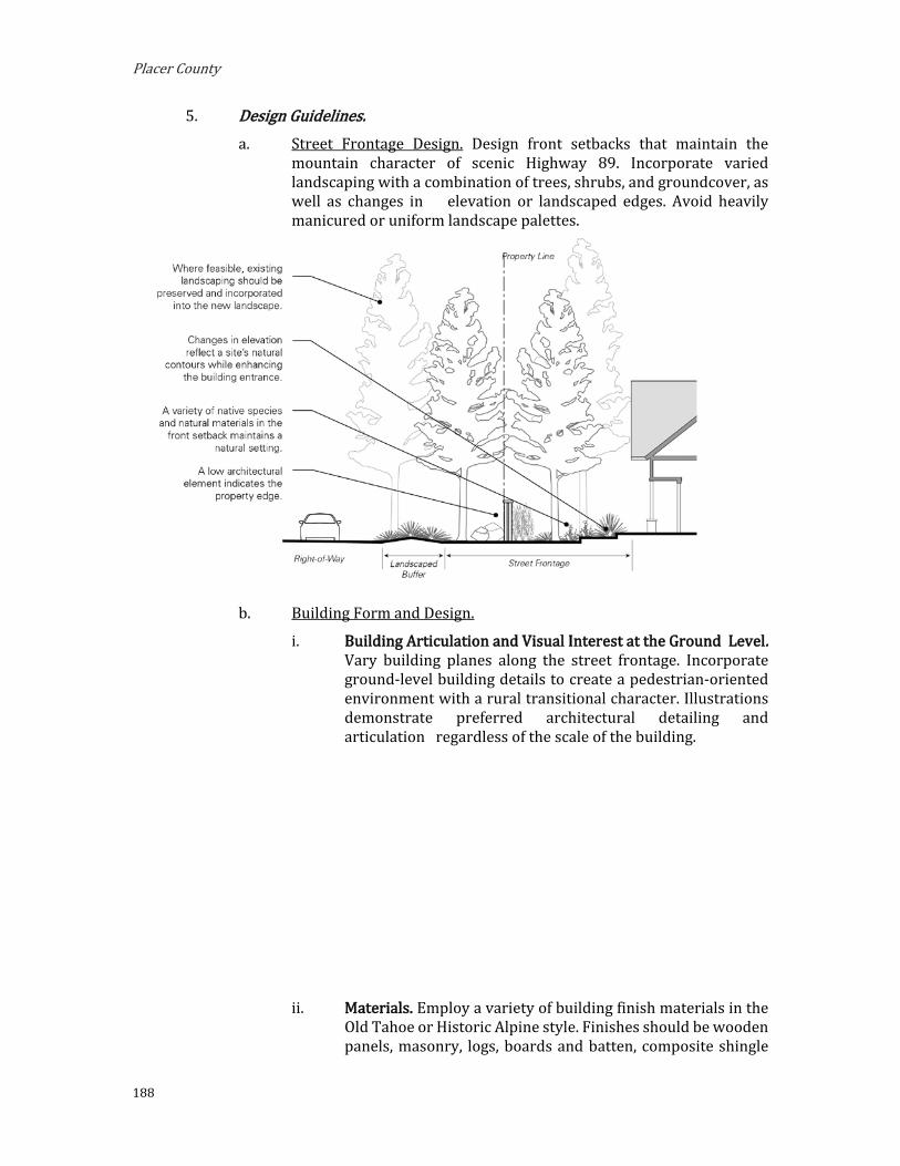
Placer County
188
5. Design Guidelines. a. Street Frontage Design. Design front setbacks that maintain the
mountain character of scenic Highway 89. Incorporate varied landscaping with a combination of trees, shrubs, and groundcover, as well as changes in elevation or landscaped edges. Avoid heavily manicured or uniform landscape palettes.
b. Building Form and Design.
i. Building Articulation and Visual Interest at the Ground Level. Vary building planes along the street frontage. Incorporate ground-level building details to create a pedestrian-oriented environment with a rural transitional character. Illustrations demonstrate preferred architectural detailing and articulation regardless of the scale of the building.
ii. Materials. Employ a variety of building finish materials in the Old Tahoe or Historic Alpine style. Finishes should be wooden panels, masonry, logs, boards and batten, composite shingle

Implementing Regulations
189
siding, shiplap siding, heavy v-joint siding, and metal or composite roofs.
iii. Colors. Design buildings exteriors in the subdued colors of historic Old Tahoe or Historic Alpine style. These include earthy and natural colors that blend well with the alpine forest (reddish-brown, brown, tan, ochre, umber, sand, and dark green). Limit the use of bright-colored building materials and finishes, especially along scenic corridors.
iv. Roof Design. Design sloped roofs with a minimum slope of 3:12. Roof forms may include gable, hip, and gambrel roofs, and lowered eave lines with dormer windows on upper levels are encouraged. Changes in roof heights are encouraged to prevent boxy buildings. Where flat roofs are used, provide architectural cornices to enhance the roofline. Authentic roof forms that cover the entire width and depth of buildings are preferred over of superficial roof forms, such as mansards, that are affixed to the building.
c. Shorezone Design.
i. View Protection. Orient pedestrian paths and vehicular circulation to maximize and protect shoreline views from public rights-of-way. Identify areas that best allow lake views and design buildings and landscaping to maximize visual access. Where buildings, structures, or parking or loading areas can be seen within a scenic corridor, minimize the impact with vegetation, landforms, or colors and materials that blend with the surroundings.
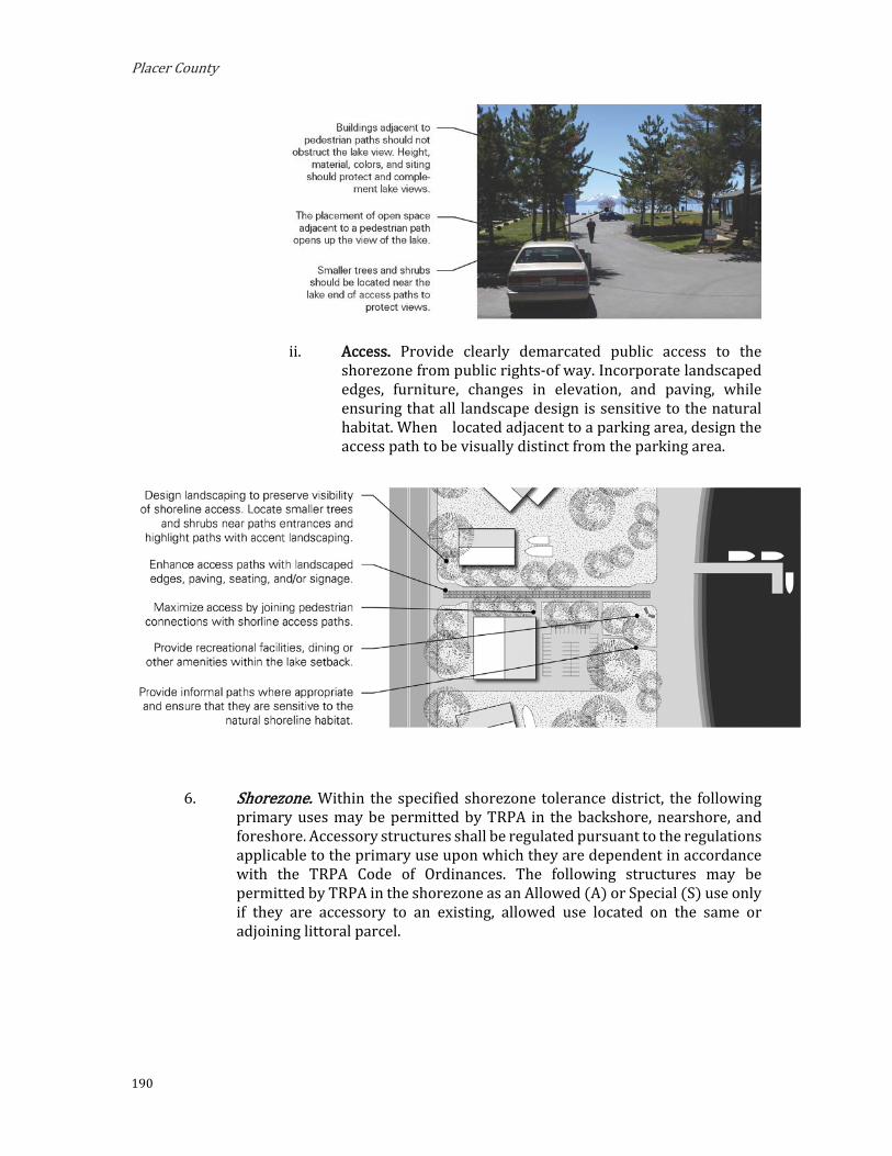
Placer County
190
ii. Access. Provide clearly demarcated public access to the shorezone from public rights-of way. Incorporate landscaped edges, furniture, changes in elevation, and paving, while ensuring that all landscape design is sensitive to the natural habitat. When located adjacent to a parking area, design the access path to be visually distinct from the parking area.
6. Shorezone. Within the specified shorezone tolerance district, the following primary uses may be permitted by TRPA in the backshore, nearshore, and foreshore. Accessory structures shall be regulated pursuant to the regulations applicable to the primary use upon which they are dependent in accordance with the TRPA Code of Ordinances. The following structures may be permitted by TRPA in the shorezone as an Allowed (A) or Special (S) use only if they are accessory to an existing, allowed use located on the same or adjoining littoral parcel.

Implementing Regulations
191
TABLE 2.04.D-6: SHOREZONE — WEST SHORE MIXED-USE SUBDISTRICTS
Tolerance District 7 Primary Uses
Water Oriented Recreation Concessions A
Beach Recreation A
Water Borne Transit A
Boat Launching Facilities S
Tour Boat Operations A
Safety and Navigation Devices A
Marinas S
Sea Plane Operations S (only in Homewood Village Center)
Salvage Operations S
Accessory Structures Buoys A
Piers A
Fences S
Boat Ramps A
Breakwaters or Jetties S
Floating Docks and Platforms A
Shoreline Protective Structures S
Water Intake Lines A

Placer County
192
Community Service Districts
A. Fairway Service Subdistrict. The Fairway Service Subdistrict is located within the Greater Tahoe City Subarea. This area should continue to serve the recreation and public service needs of the northwest portion of the Tahoe Region and may also be appropriate for residential uses.
1. Special Designations. (See Section 3.14)
a. TDR Receiving Area for:
i. Existing development
ii. Multi-residential units
2. Special Policies. a. Provide opportunities for development of a variety of multi-
residential housing types with emphasis on affordable, moderate, and achievable housing.
3. Permissible Uses. The following primary uses may be permitted within all or a portion of the Subdistrict. The list indicates if the use is Allowed (A), subject to an Administrative Review Permit (C), or must be considered under the provisions for a Conditional Use Permit (CUP) or Minor Use Permit (MUP). Existing uses not listed shall be considered nonconforming uses within this Subdistrict. The establishment of new uses not listed shall be prohibited.
TABLE 2.05.A-1: LAND USE REGULATIONS — FAIRWAY SERVICE SUBDISTRICT Allowable Land Uses Land Use Permit Add’l Regs.
Residential Single Family Dwelling A
Multiple Family Dwelling MUP
Multi-Person Dwellings MUP
Employee Housing MUP
Commercial Nursery MUP Business Support Services A Professional Offices A
Public Service Cultural Facilities A
Government Offices MUP
Local Public Health and Safety Facilities A
Public Utility Centers A
Regional Public Health and Safety Facilities MUP
Threshold-Related Facilities MUP
Pipelines and Power Transmission MUP
Transit Stations and Terminals A

Implementing Regulations
193
TABLE 2.05.A-1: LAND USE REGULATIONS — FAIRWAY SERVICE SUBDISTRICT Transportation Routes A
Transmission and Receiving Facilities MUP Placer County Code Section 17.56.060F
Threshold-Related Research Facilities MUP
Recreation Day Use Areas A
Cross County Skiing Courses MUP
Golf Courses MUP
Outdoor Recreation Concessions MUP
Riding and Hiking Trails MUP
Snowmobile Courses A
Visitor Information Centers MUP
Resource Management Reforestation A
Sanitation Salvage Cut A
Special Cut A
Thinning A
Tree Farms A
Early Successional Stage Vegetation Management A
Nonstructural Fish Habitat Management A
Nonstructural Wildlife Habitat Management A
Structural Fish Habitat Management A
Structural Wildlife Habitat Management A
Fire Detection and Suppression A
Fuels Treatment A
Insect and Disease Suppression A
Sensitive Plant Management A
Uncommon Plant Community Management A
Erosion Control A
SEZ Restoration A
Runoff Control A

Placer County
194
4. Development Standards. Table 2.05.A-2 prescribes the development standards for the Fairway Industrial Subdistrict.
TABLE 2.05.A-2: DEVELOPMENT STANDARDS — FAIRWAY SERVICE SUBDISTRICT Maximum Density
Residential
Single Family Dwelling: 1 du/parcel Multiple Family Dwelling: 15 units per acre Multi-Person Dwelling: 37 people per acre
Employee Housing: As per the limitations set forth in this table
Commercial Corner Lots: 6,000 sq ft Interior Lots: 5,000 sq ft
Building Height TRPA Code of Ordinances Chapter 37
Minimum Lot Size 10,000 sq ft
Minimum Lot Width 60 ft
Minimum Setbacks (measured from property line unless otherwise noted)
See also 17.54.130, 17.54.140, and 17.54.150
Front 10 ft
Side 5 ft
Rear 5 ft
Maximum Community Noise Equivalent Level 65 CNEL
Implementing Regulations
195
B. Kings Beach Industrial Subdistrict. The Kings Beach Industrial Subdistrict is located within the North Tahoe East Subarea. This area should be redeveloped to provide a location for the service / industrial needs of the area.
1. Special Designation. (See Section 3.14) a. TDR Receiving Area for:
i. Existing Development
ii. Multi-Residential Units
b. Preferred Affordable, Moderate, and Achievable Housing Area
2. Special Policies. a. Speckled Avenue, currently a designated “Truck Route,” should retain
that classification for local commercial uses only. Highway 267 should continue to be the primary north-south connection to Highway 28.
b. Commercial properties in the Subdistrict should be visually upgraded. Many of the commercial properties in the Subdistrict are in need of scenic restoration. This should be accomplished through remodeling, renovation, screening, landscaping and, in some cases, through complete removal of the use or activity. Given the interrelationship of residential uses in this area, it is particularly important that commercial properties be retrofitted as much as possible to be aesthetically compatible with adjacent land uses and from roadways.
This policy will be implemented through the Design Review process, the Conditional Use Permit process, and through the code enforcement process.
c. Provide opportunities for development of a variety of multi-residential housing types with emphasis on affordable, moderate, and achievable housing.
3. Permissible Uses. The following primary uses may be permitted within all or a portion of the Subdistrict. The list indicates if the use is Allowed (A), subject to an Administrative Review Permit (C), or must be considered under the provisions for a Conditional Use Permit (CUP) or Minor Use Permit (MUP). Existing uses not listed shall be considered nonconforming uses within this Subdistrict. The establishment of new uses not listed shall be prohibited.
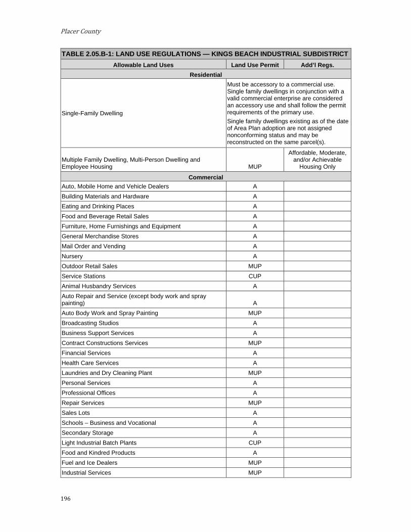
Placer County
196
TABLE 2.05.B-1: LAND USE REGULATIONS — KINGS BEACH INDUSTRIAL SUBDISTRICT Allowable Land Uses Land Use Permit Add’l Regs.
Residential
Single-Family Dwelling
Must be accessory to a commercial use. Single family dwellings in conjunction with a valid commercial enterprise are considered an accessory use and shall follow the permit requirements of the primary use. Single family dwellings existing as of the date of Area Plan adoption are not assigned nonconforming status and may be reconstructed on the same parcel(s).
Multiple Family Dwelling, Multi-Person Dwelling and Employee Housing MUP
Affordable, Moderate, and/or Achievable
Housing Only
Commercial Auto, Mobile Home and Vehicle Dealers A Building Materials and Hardware A Eating and Drinking Places A Food and Beverage Retail Sales A Furniture, Home Furnishings and Equipment A General Merchandise Stores A Mail Order and Vending A Nursery A Outdoor Retail Sales MUP Service Stations CUP Animal Husbandry Services A Auto Repair and Service (except body work and spray painting) A
Auto Body Work and Spray Painting MUP Broadcasting Studios A Business Support Services A Contract Constructions Services MUP Financial Services A Health Care Services A Laundries and Dry Cleaning Plant MUP Personal Services A Professional Offices A Repair Services MUP Sales Lots A Schools – Business and Vocational A Secondary Storage A Light Industrial Batch Plants CUP Food and Kindred Products A Fuel and Ice Dealers MUP Industrial Services MUP
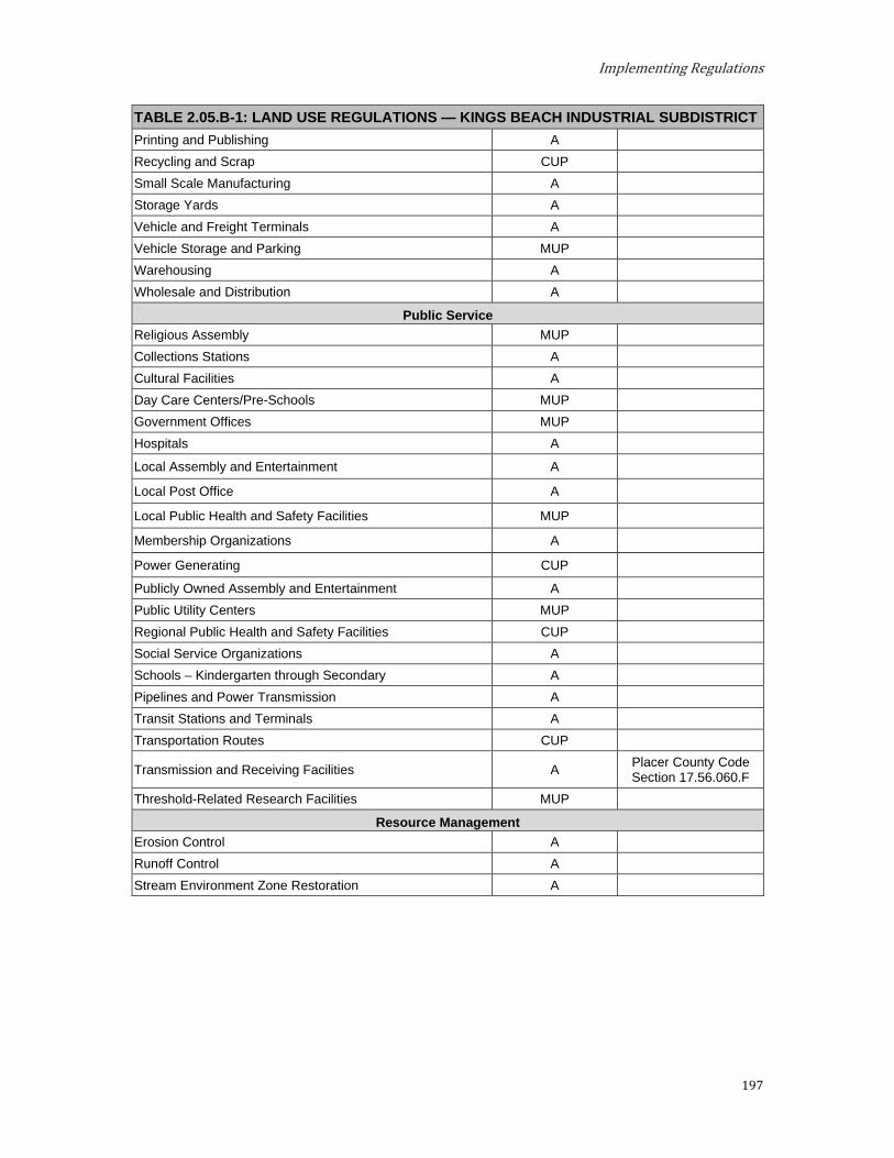
Implementing Regulations
197
TABLE 2.05.B-1: LAND USE REGULATIONS — KINGS BEACH INDUSTRIAL SUBDISTRICT Printing and Publishing A Recycling and Scrap CUP Small Scale Manufacturing A Storage Yards A Vehicle and Freight Terminals A Vehicle Storage and Parking MUP Warehousing A Wholesale and Distribution A
Public Service Religious Assembly MUP Collections Stations A Cultural Facilities A Day Care Centers/Pre-Schools MUP Government Offices MUP Hospitals A
Local Assembly and Entertainment A
Local Post Office A
Local Public Health and Safety Facilities MUP
Membership Organizations A
Power Generating CUP
Publicly Owned Assembly and Entertainment A Public Utility Centers MUP Regional Public Health and Safety Facilities CUP Social Service Organizations A Schools – Kindergarten through Secondary A Pipelines and Power Transmission A Transit Stations and Terminals A Transportation Routes CUP
Transmission and Receiving Facilities A Placer County Code Section 17.56.060.F
Threshold-Related Research Facilities MUP
Resource Management Erosion Control A Runoff Control A Stream Environment Zone Restoration A

Placer County
198
4. Development Standards. Table 2.05.B-2 prescribes the development standards for the Kings Beach Industrial Subdistrict.
TABLE 2.05.B-2: DEVELOPMENT STANDARDS — KINGS BEACH INDUSTRIAL SUBDISTRICT
Maximum Density Employee Housing: 15 units per acre
Multiple Family Dwellings: 15 units per acre Multiple Person Dwellings: 37 persons per acre
Building Height TRPA Code of Ordinances Chapter 37
Minimum Lot Size
Commercial Corner Lots: 6,000 sq ft Interior Lots: 5,000 sq ft
Residential 10,000 sq ft
Minimum Lot Width 60 ft
Minimum Setbacks (measured from property line unless otherwise noted) See also 17.54.130, 17.54.140, and 17.54.150
Front 10 ft
Side 5 ft
Rear 5 ft
Maximum Community Noise Equivalent Level 65 CNEL
Hourly Leq, dB
Daytime (7a.m.-7p.m.): 55 Nighttime (7p.m.-7a.m.): 45
Levels specified above should be lowered by five dB for simple tone noises
Maximum Level, dB
Daytime (7a.m.-7p.m.): 75 Nighttime (7p.m.-7a.m.): 65
Levels specified above should be lowered by five dB for simple tone noises
C. Lake Forest Commercial Subdistrict. The Lake Forest Commercial Subdistrict is located within the Greater Tahoe City Subarea. The theme for the Lake Forest Commercial Subdistrict is generally of the "Local-serving Retail, Services, and Storage" nature.
1. Special Designation. (See Section 3.14) a. TDR Receiving Area for:
i. Existing Development
ii. Multi-Residential Units
b. Preferred Affordable, Moderate, and Achievable Housing Area
2. Special Policies. a. Two special areas have been created to more closely define
development themes and permitted uses. Special Area 1, on the western side of the Subdistrict, is oriented toward "light" commercial and office uses. Special Area 2, on the eastern side of the Subdistrict,
Implementing Regulations
199
is more oriented toward "heavy" commercial uses. These designations are based on existing development patterns as well as historic County zoning designations.
b. Given the limited opportunities in the Lake Tahoe basin for siting the types of necessary services located in Special Area 2, this Area Plan does not encourage relocation of such uses. Rather, the goal for this area is to encourage remodeling and rehabilitation of facilities to make properties and uses more congruous. Uses, which by their nature tend to be obtrusive, should be screened and buffered to the extent practical, to minimize such obtrusiveness. Because of the unusual mix of uses in this area, special policies with respect to noise are important also. Commercial businesses should conduct their operation in such a way as to not create adverse noise impacts on neighboring properties, for example, through observance of appropriate working hours.
c. Ensure that the design elements of new, remodeled and rehabilitated development are compatible with the scenic, recreation and community values of Lake Forest and the region, through use of the design and sign regulations for the area.
d. The allocation policy shall assign priority to projects which emphasize remodeling and rehabilitation of substandard development.
e. Strip commercial development in this area should be discouraged.
f. The Lake Forest Commercial Subdistrict should continue to emphasize service oriented commercial uses which are compatible with the surrounding residential and recreational uses.
g. Given existing conditions and the limited amount of new development contemplated, no significant improvements to Lake Forest Road, other than ordinary maintenance and repair, are anticipated.
h. Safe and efficient use of Lake Forest Road should be accomplished through management strategies (rather than sizeable capital investments), such as enforcement of appropriate speed levels, and possibly a "stop" sign at an appropriate location.
i. Consideration should be given to a community parking lot at a centralized location, to reduce the use of the public right-of-way for parking.
j. Provide opportunities for development of a variety of multi-residential housing types with emphasis on affordable, moderate, and achievable housing.
3. Permissible Uses. The following primary uses may be permitted within all or a portion of the Subdistrict. The list indicates if the use is Allowed (A), subject to an Administrative Review Permit (C), or must be considered under the provisions for a Conditional Use Permit (CUP) or Minor Use Permit (MUP). Existing uses not listed shall be considered nonconforming uses within this Subdistrict. The establishment of new uses not listed shall be prohibited.

Placer County
200
TABLE 2.05.C-1: LAND USE REGULATIONS — LAKE FOREST COMMERCIAL SUBDISTRICT
Use Special Area #1 Special Area #2 Notes Residential
Employee Housing MUP MUP Multiple Family Dwelling MUP MUP Multi-Person Dwellings MUP MUP Single-Family Dwelling MUP MUP
Tourist Accommodation Bed and Breakfast Facilities A Hotels, Motels and Other Transient Dwelling Units CUP
Tire Sharing (Hotel/Motel Design) CUP
Commercial Auto, Mobile Home and Vehicle Dealers CUP CUP Building Materials and Hardware MUP A Eating and Drinking Places A A Food and Beverage Retail Sales A A Furniture, Home Furnishings and Equipment A A General Merchandise Stores A A Mail Order and Vending A A Nursery MUP A Indoor Retail Sales A A Outdoor Retail Sales MUP MUP Service Stations CUP CUP Amusements and Recreation Services A A Privately Owned Assembly and Entertainment CUP CUP Outdoor Amusements CUP CUP Animal Husbandry Services A Auto Repair and Service A Broadcasting Studios A A Business Support Services A A Contract Construction Services A A Financial Services A A Health Care Services MUP A Laundries and Dry Cleaning Plant A A Personal Services A A Professional Offices A A Repair Services A A Schools – Business and Vocational A A Secondary Storage A Food and Kindred Products A A Fuel and Ice Dealers CUP
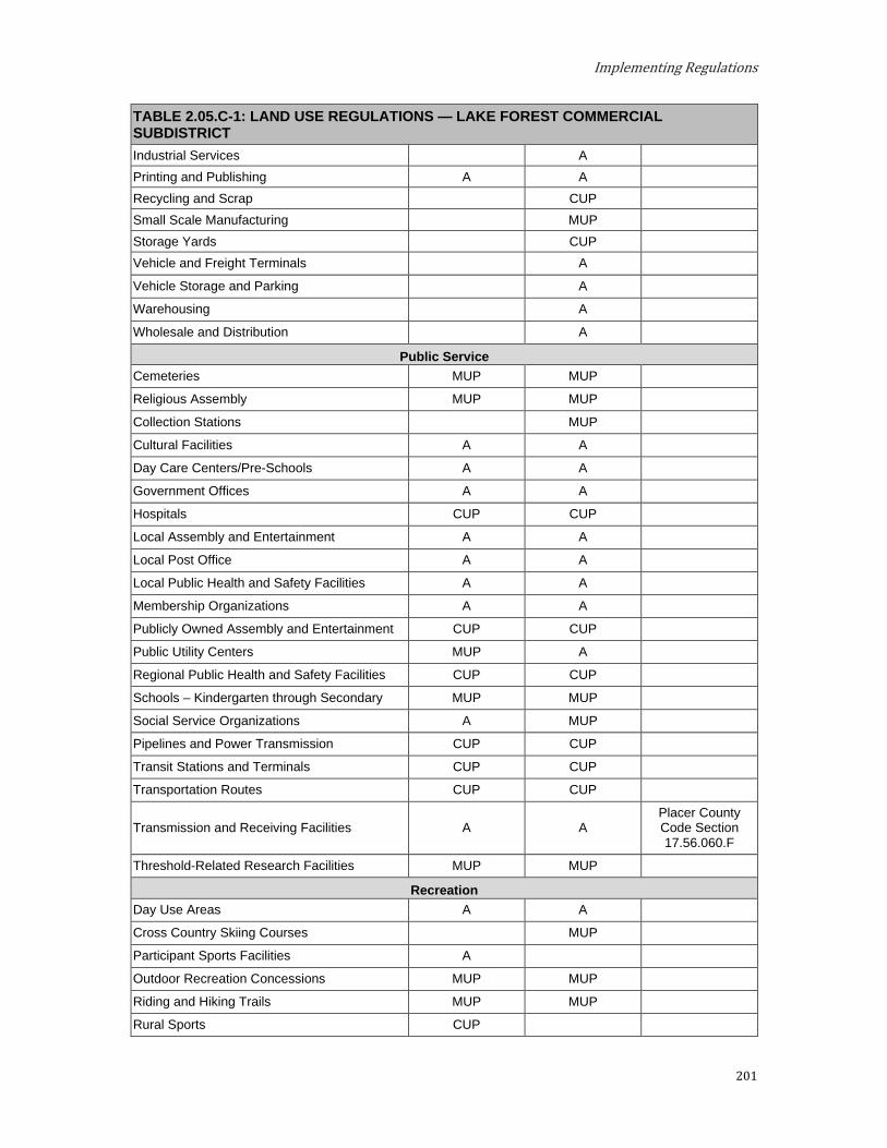
Implementing Regulations
201
TABLE 2.05.C-1: LAND USE REGULATIONS — LAKE FOREST COMMERCIAL SUBDISTRICT Industrial Services A Printing and Publishing A A Recycling and Scrap CUP Small Scale Manufacturing MUP Storage Yards CUP Vehicle and Freight Terminals A
Vehicle Storage and Parking A
Warehousing A
Wholesale and Distribution A
Public Service Cemeteries MUP MUP
Religious Assembly MUP MUP
Collection Stations MUP
Cultural Facilities A A
Day Care Centers/Pre-Schools A A
Government Offices A A
Hospitals CUP CUP
Local Assembly and Entertainment A A
Local Post Office A A
Local Public Health and Safety Facilities A A
Membership Organizations A A
Publicly Owned Assembly and Entertainment CUP CUP
Public Utility Centers MUP A
Regional Public Health and Safety Facilities CUP CUP
Schools – Kindergarten through Secondary MUP MUP
Social Service Organizations A MUP
Pipelines and Power Transmission CUP CUP
Transit Stations and Terminals CUP CUP
Transportation Routes CUP CUP
Transmission and Receiving Facilities A A Placer County Code Section 17.56.060.F
Threshold-Related Research Facilities MUP MUP
Recreation Day Use Areas A A
Cross Country Skiing Courses MUP
Participant Sports Facilities A
Outdoor Recreation Concessions MUP MUP
Riding and Hiking Trails MUP MUP
Rural Sports CUP

Placer County
202
TABLE 2.05.C-1: LAND USE REGULATIONS — LAKE FOREST COMMERCIAL SUBDISTRICT Snow Mobile Courses A
Visitor Information Center MUP MUP
Resource Management Reforestation A A Sanitation Salvage Cut A A Thinning A A Early Successional Stage Vegetation Management A A
Nonstructural Fish Habitat Management A A Nonstructural Wildlife Habitat Management A A Structural Fish Habitat Management A A Structural Wildlife Habitat Management A A Fire Detection and Suppression A A Fuels Treatment A A Insect and Disease Suppression A A Sensitive Plant Management A A Uncommon Plant Community Management A A Erosion Control A A SEZ Restoration A A Runoff Control A A

Implementing Regulations
203
4. Development Standards. Table 2.05.C-2 prescribes the Development Standards for the Lake Forest Commercial Subdistrict.
TABLE 2.05.C-2: DEVELOPMENT STANDARDS — LAKE FOREST COMMERCIAL SUBDISTRICT Maximum Density
Residential
Single Family Dwelling: 1 du/parcel Multiple Family Dwelling: 15 units per acre
Multi-Person Dwellings: 37 persons per acre Employee Housing: As per the density limitations above
Tourist Accommodation
Bed and Breakfast Facilities: 10 units per acre Hotel, Motel and Other Transient Units:
With less than 10% of units with kitchens – 40 units per acre With 10% or more units with kitchens – 15 units per acre
Timeshare (Hotel/Motel Design): 40 units per acre
Building Height TRPA Code of Ordinances Chapter 37
Minimum Lot Width 60 ft
Minimum Setbacks (measured from property line unless otherwise noted) See also 17.54.130, 17.54.140, and 17.54.150
Front 10 ft
Side 5 ft
Rear 5 ft
Maximum Community Noise Equivalent Level
Special Area #1 60 CNEL
Special Area #2 65 CNEL

Placer County
204
D. Tahoe City Industrial Subdistrict. The Tahoe City Industrial Subdistrict is located within the Greater Tahoe City Subarea. This area should become the light industrial area for Tahoe City and the receiving area for the relocation of existing incompatible uses located in the Tahoe City area.
Special Designations. (See Section 3.14) a. TDR Receiving Area for:
i. Existing Development
ii. Multi-Residential Units
b. Preferred Affordable, Moderate, and Achievable Housing Area
2. Special Policies. a. Uses on the main highways should be primarily tourist-service in
nature. This area is a preferred area for the location of uses not found to be compatible elsewhere in the Tahoe City area.
b. Provide opportunities for development of a variety of multi-residential housing types with emphasis on affordable, moderate, and achievable housing.
3. Permissible Uses. The following primary uses may be permitted within all or a portion of the Subdistrict. The list indicates if the use is Allowed (A), subject to an Administrative Review Permit (C), or must be considered under the provisions for a Conditional Use Permit (CUP) or Minor Use Permit (MUP). Existing uses not listed shall be considered nonconforming uses within this Subdistrict. The establishment of new uses not listed shall be prohibited.
TABLE 2.05.D-1: LAND USE REGULATIONS — TAHOE CITY INDUSTRIAL SUBDISTRICT Allowable Land Uses Land Use Permit Add’l Regs.
Residential Employee Housing MUP
Mobile Home Dwelling MUP
Multiple Family Dwelling MUP
Multi-Person Dwellings MUP
Commercial Building Materials and Hardware MUP
Nursery MUP
Outdoor Retail Sales MUP
Auto Repair and Service MUP
Fuel and Ice Dealers MUP
Industrial Services MUP
Recycling and Scrap MUP
Small Scale Manufacturing MUP
Storage Yards A
Vehicle and Freight Terminals MUP
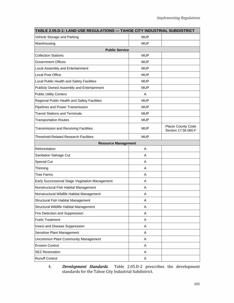
Implementing Regulations
205
TABLE 2.05.D-1: LAND USE REGULATIONS — TAHOE CITY INDUSTRIAL SUBDISTRICT Vehicle Storage and Parking MUP
Warehousing MUP
Public Service Collection Stations MUP
Government Offices MUP
Local Assembly and Entertainment MUP
Local Post Office MUP
Local Public Health and Safety Facilities MUP
Publicly Owned Assembly and Entertainment MUP
Public Utility Centers A
Regional Public Health and Safety Facilities MUP
Pipelines and Power Transmission MUP
Transit Stations and Terminals MUP
Transportation Routes MUP
Transmission and Receiving Facilities MUP Placer County Code Section 17.56.060.F
Threshold-Related Research Facilities MUP
Resource Management Reforestation A
Sanitation Salvage Cut A
Special Cut A
Thinning A
Tree Farms A
Early Successional Stage Vegetation Management A
Nonstructural Fish Habitat Management A
Nonstructural Wildlife Habitat Management A
Structural Fish Habitat Management A
Structural Wildlife Habitat Management A
Fire Detection and Suppression A
Fuels Treatment A
Insect and Disease Suppression A
Sensitive Plant Management A
Uncommon Plant Community Management A
Erosion Control A
SEZ Restoration A
Runoff Control A
4. Development Standards. Table 2.05.D-2 prescribes the development standards for the Tahoe City Industrial Subdistrict.

Placer County
206
TABLE 2.05.D-2: DEVELOPMENT STANDARDS — TAHOE CITY INDUSTRIAL SUBDISTRICT Maximum Density
Residential
Multiple Family Dwellings: 15 units per acre Multi-Person Dwelling: 37 people per acre
Mobile Home Dwelling: 8 units per acre Employee Housing: As per the limitations above
Building Height TRPA Code of Ordinances Chapter 37
Minimum Lot Size
Commercial Corner Lots: 6,000 sq ft Interior Lots: 5,000 sq ft
Minimum Lot Width 60 ft
Minimum Setbacks (measured from property line unless otherwise noted) See also 17.54.130, 17.54.140, and 17.54.150
Front 10 ft
Side 5 ft
Rear 5 ft
Maximum Community Noise Equivalent Level 65 CNEL

Implementing Regulations
207
E. Tahoe Vista Industrial Subdistrict. The Tahoe Vista Industrial Subdistrict is located within the North Tahoe West Subarea. This Subdistrict should continue to provide a location for the service/industrial needs of the area.
1. Special Designation. (See Section 3.14) a. Preferred Industrial Area
2. Special Policies. a. Public services and industrial uses are encouraged by the permissible
use list. Wholesale/storage, light industrial and other similar uses should be limited to the National Avenue area. Heavy equipment traffic should be mitigated as to be compatible with nearby properties, including residential uses.
Permissible Uses. The following primary uses may be permitted within all or a portion of the Subdistrict. The list indicates if the use is Allowed (A), subject to an Administrative Review Permit (C), or must be considered under the provisions for a Conditional Use Permit (CUP) or Minor Use Permit (MUP). Existing uses not listed shall be considered nonconforming uses within this Subdistrict. The establishment of new uses not listed shall be prohibited.
TABLE 2.05.E-1: LAND USE REGULATIONS — TAHOE VISTA INDUSTRIAL SUBDISTRICT Allowable Land Uses Land Use Permit Add’l Regs.
Commercial Auto, Mobile Home and Vehicle Dealers A
Building Materials and Hardware A
General Merchandise Stores Mail Order, and Vending A
Nursery A
Outdoor Retail Sales A
Eating and Drinking Places MUP
Food and Beverage Retail Sales MUP
Furniture, Home Furnishings and Equipment A
Service Stations CUP
Amusements and Recreation Services CUP
Privately Owned Assembly and Entertainment CUP
Animal Husbandry Services A
Auto Repair and Service A
Broadcasting Studios A
Business Support Services A
Contract Construction Services A
Financial Services A
Health Care Services A
Laundries and Dry Cleaning Plant A
Personal Services A

Placer County
208
TABLE 2.05.E-1: LAND USE REGULATIONS — TAHOE VISTA INDUSTRIAL SUBDISTRICT Professional Offices A
Repair Services A
Sales Lots A
Schools – Business and Vocational A
Secondary Storage A
Batch Plants CUP
Food and Kindred Products A
Fuel and Ice Dealers CUP
Industrial Services MUP
Printing and Publishing A
Recycling and Scrap A
Small Scale Manufacturing A
Storage Yards A
Vehicle and Freight Terminals A
Vehicle Storage and Parking A
Warehousing A
Wholesale and Distribution A
Public Service Religious Assembly MUP
Collections Stations A
Cultural Facilities A
Day Care Centers/Pre-Schools A
Government Offices A
Local Assembly and Entertainment MUP
Local Post Office A
Local Public Health and Safety Facilities A
Publicly Owned Assembly and Entertainment A
Public Utility Centers A
Regional Public Health and Safety Facilities CUP
Schools – Kindergarten through Secondary MUP
Social Service Organizations A
Pipelines and Power Transmission A
Transit Stations and Terminals A
Transportation Routes CUP
Transmission and Receiving Facilities A Placer County Code Section 17.56.060.F
Threshold-Related Research Facilities MUP

Implementing Regulations
209
TABLE 2.05.E-1: LAND USE REGULATIONS — TAHOE VISTA INDUSTRIAL SUBDISTRICT Recreation
Cross Country Ski Courses A
Day Use Areas A
Outdoor Recreation Concessions MUP
Participants Sports Facilities A
Recreation Centers A
Riding and Hiking Trails A
Rural Sports A
Snowmobile Courses A
Resource Management Reforestation A
Sanitation Salvage Cut A
Thinning A
Tree Farms A
Early Successional State Vegetation Management A
Nonstructural Fish Habitat Management A
Nonstructural Wildlife Habitat Management A
Structural Fish Habitat Management A
Structural Wildlife Habitat Management A
Fire Detection and Suppression A
Fuels Treatment A
Insect and Disease Suppression A
Sensitive Plant Management A
Uncommon Plant Community Management A
Erosion Control A
Runoff Control A
SEZ Restoration A

Placer County
210
4. Development Standards. Table 2.05.E-2 prescribes the development standards for the Tahoe Vista Industrial Subdistrict.
TABLE 2.05.E-2: DEVELOPMENT STANDARDS — TAHOE VISTA INDUSTRIAL SUBDISTRICT Minimum Lot Size
Commercial Corner Lots: 6,000 sq ft Interior Lots: 5,000 sq ft
Building Height TRPA Code of Ordinances Chapter 37
Minimum Lot Width 60 ft
Minimum Setbacks (measured from property line unless otherwise noted) See also 17.54.130, 17.54.140, and 17.54.150
Front 10 ft
Side 5 ft
Rear 5 ft
Maximum Community Noise Equivalent Level
65 CNEL, where applicable, a maximum 55 CNEL override for the Highway 28 corridor is permissible.
5. Shorezone. Within the specified shorezone tolerance district, the following primary uses may be permitted by TRPA in the backshore, nearshore, and foreshore. Accessory structures shall be regulated pursuant to the regulations applicable to the primary use upon which they are dependent in accordance with the TRPA Code of Ordinances. The following structures may be permitted by TRPA in the shorezone as an Allowed (A) or Special (S) use only if they are accessory to an existing, allowed use located on the same of adjoining littoral parcel.
TABLE 2.05.E-3: SHOREZONE — TAHOE VISTA INDUSTRIAL SUBDISTRICT
Tolerance Districts 1 6 7 Maximum Community Noise Equivalent Level (CNEL)
Shorezone 55 55 55
Lakezone 50 50 50
Primary Uses Water Oriented Outdoor Recreation Concessions S A A
Beach Recreation A A A
Salvage Operators S S
Tour Boat Operations S S
Safety and Navigation Facilities A A A
Marinas S S
Boat Launching Facilities S S
Construction Equipment Storage S S
Waterborne Transit A A
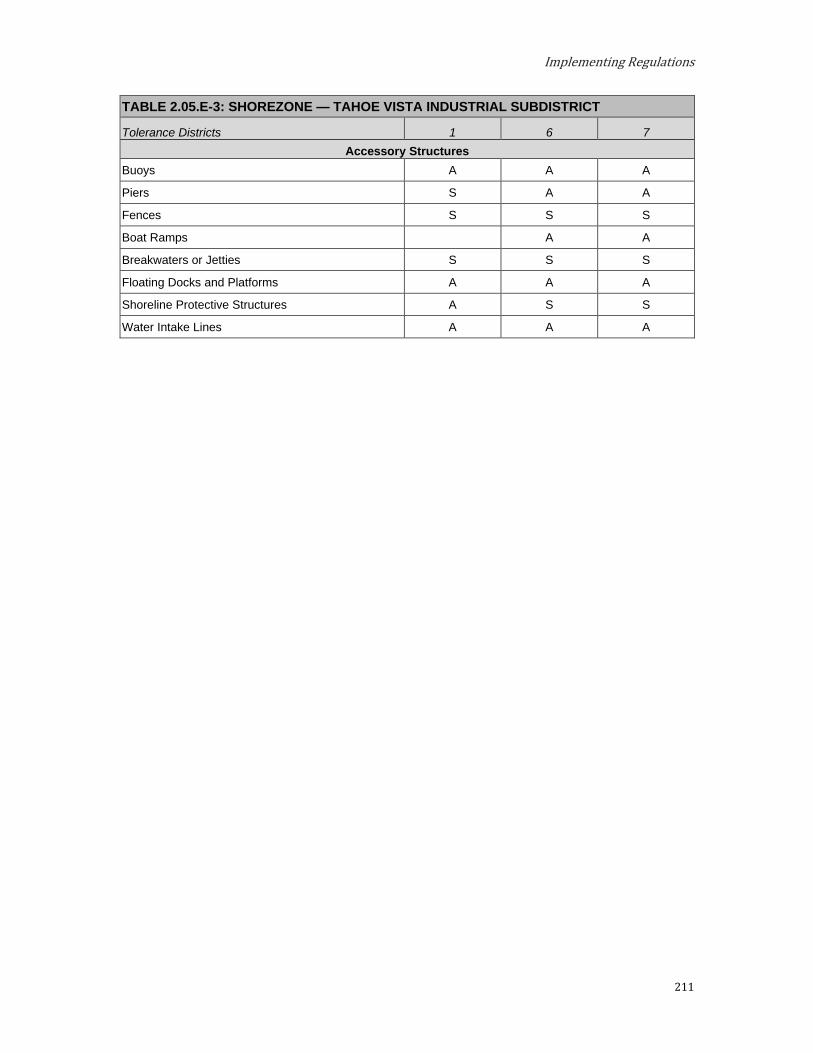
Implementing Regulations
211
TABLE 2.05.E-3: SHOREZONE — TAHOE VISTA INDUSTRIAL SUBDISTRICT
Tolerance Districts 1 6 7 Accessory Structures
Buoys A A A
Piers S A A
Fences S S S
Boat Ramps A A
Breakwaters or Jetties S S S
Floating Docks and Platforms A A A
Shoreline Protective Structures A S S
Water Intake Lines A A A

Placer County
212
Conservation Districts
A. Blackwood Subdistrict. The Blackwood Subdistrict is located within the West Shore Subarea. This area should be managed, as appropriate, to improve the quality of the watershed, including management of Blackwood Creek as a resident and migratory fishery.
Special Designation. None. Special Policies.
Management activities that restore disturbed areas and improve the vegetative cover should be emphasized.
Prioritize Blackwood Creek for continued restoration efforts.
Off-road vehicle use should be restricted to designated roads.
Opportunities should be provided for snowmobile use and staging area when such uses do not include the location of concession base facilities in this Subdistrict.
Snowmobile use should be prohibited in important wildlife habitat as identified in the Tahoe National Forest Land and Resource Management Plan, including any future amendments.
Permissible Uses. The following primary uses may be permitted within all or a portion of the Subdistrict. The list indicates if the use is Allowed (A), subject to an Administrative Review Permit (C), or must be considered under the provisions for a Conditional Use Permit (CUP) or Minor Use Permit (MUP). Existing uses not listed shall be considered nonconforming uses within this Subdistrict. The establishment of new uses not listed shall be prohibited.
TABLE 2.06.A-1: LAND USE REGULATIONS — BLACKWOOD SUBDISTRICT Allowable Land Uses Land Use Permit Add’l Regs.
Residential Single Family Dwelling MUP
Public Service Local Public Health and Safety Facilities MUP
Pipelines and Power Transmission CUP
Public Utility Centers MUP
Transit Stations and Terminals CUP
Transmission and Receiving Facilities CUP Placer County Code Section 17.56.060.F
Transportation Routes CUP
Threshold-Related Research Facilities MUP
Recreation Cross Country Skiing Courses MUP
Day Use Areas MUP
Developed Campgrounds CUP

Implementing Regulations
213
TABLE 2.06.A-1: LAND USE REGULATIONS — BLACKWOOD SUBDISTRICT Riding and Hiking Trails A
Undeveloped Campgrounds MUP
Off-Road Vehicle Courses CUP
Snowmobile Courses CUP
Marinas CUP
Beach Recreation A
Boat Launching Facilities CUP
Resource Management Reforestation A
Regeneration Harvest A
Sanitation Salvage Cut A
Selection Cut A
Special Cut A
Thinning A
Timber Stand Improvement A
Tree Farms MUP
Early Successional Stage Vegetation Management A
Nonstructural Fish Habitat Management A
Nonstructural Wildlife Habitat Management A
Structural Fish Habitat Management A
Structural Wildlife Habitat Management A
Farm/Ranch Accessory Structures MUP
Grazing MUP
Range Pasture Management A
Range Improvement MUP
Fire Detection and Suppression A
Fuels Treatment A
Insect and Disease Suppression A
Prescribed Fire Management A
Sensitive Plant Management A
Uncommon Plant Community Management A
Erosion Control A
Runoff Control A
SEZ Restoration A
Development Standards. Table 2.06.A-2 prescribes the development standards for the Blackwood Subdistrict.

Placer County
214
TABLE 2.06.A-2: DEVELOPMENT STANDARDS — BLACKWOOD SUBDISTRICT Maximum Density
Residential Single Family Dwelling: 1 du/parcel Recreation Developed Campgrounds: 8 sites per acre
Building Height TRPA Code of Ordinances Chapter 37 Minimum Setbacks (measured from property line unless otherwise noted)
See also 17.54.130, 17.54.140, and 17.54.150
Front 50 ft Side 30 ft Rear 30 ft
Maximum Community Noise Equivalent Level 50 CNEL
Shorezone. Within the specified shorezone tolerance district, the following primary uses may be permitted by TRPA in the backshore, nearshore, and foreshore. Accessory structures shall be regulated pursuant to the regulations applicable to the primary use upon which they are dependent in accordance with the TRPA Code of Ordinances. The following structures may be permitted by TRPA in the shorezone as an Allowed (A) or Special (S) use only if they are accessory to an existing, allowed use located on the same or adjoining littoral parcel.
TABLE 2.06.A-3: SHOREZONE — BLACKWOOD SUBDISTRICT
Tolerance District 6 Primary Uses
Beach Recreation A Boat Launching Facilities S Marinas S Safety and Navigation Facilities A Salvage Operations A Tour Boat Operations S Water Borne Transit S Water Oriented Outdoor Recreation Concessions A
Accessory Structures Boat Ramps A Breakwaters or Jetties S Buoys A Fences S Floating Docks and Platforms A
Piers S
Shoreline Protective Structures S
Water Intake Lines S
B. Burton Creek Subdistrict. The Burton Creek Subdistrict is located within the Greater Tahoe City Subarea. This planning area should continue to provide a full range of low
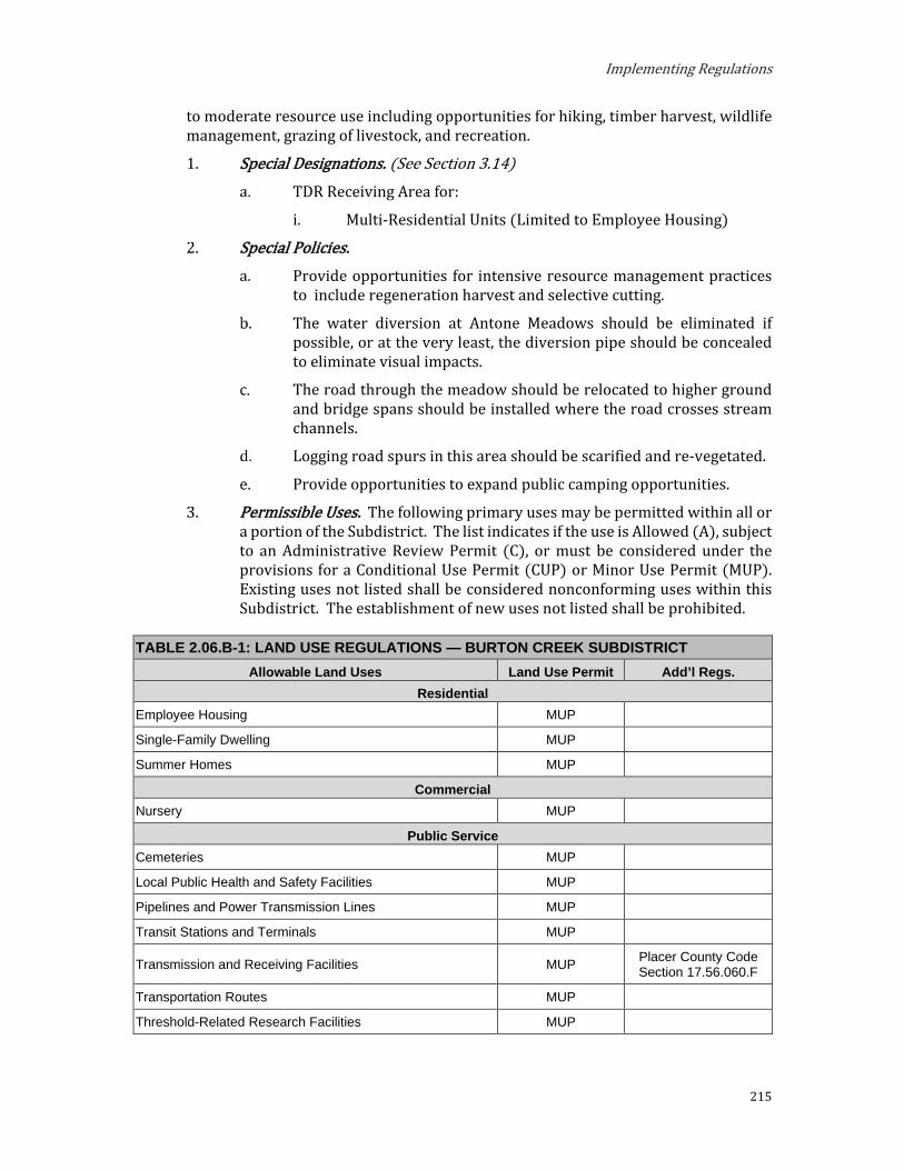
Implementing Regulations
215
to moderate resource use including opportunities for hiking, timber harvest, wildlife management, grazing of livestock, and recreation.
Special Designations. (See Section 3.14) TDR Receiving Area for:
i. Multi-Residential Units (Limited to Employee Housing)
Special Policies. Provide opportunities for intensive resource management practices
to include regeneration harvest and selective cutting.
The water diversion at Antone Meadows should be eliminated if possible, or at the very least, the diversion pipe should be concealed to eliminate visual impacts.
The road through the meadow should be relocated to higher ground and bridge spans should be installed where the road crosses stream channels.
Logging road spurs in this area should be scarified and re-vegetated.
Provide opportunities to expand public camping opportunities.
Permissible Uses. The following primary uses may be permitted within all or a portion of the Subdistrict. The list indicates if the use is Allowed (A), subject to an Administrative Review Permit (C), or must be considered under the provisions for a Conditional Use Permit (CUP) or Minor Use Permit (MUP). Existing uses not listed shall be considered nonconforming uses within this Subdistrict. The establishment of new uses not listed shall be prohibited.
TABLE 2.06.B-1: LAND USE REGULATIONS — BURTON CREEK SUBDISTRICT Allowable Land Uses Land Use Permit Add’l Regs.
Residential Employee Housing MUP
Single-Family Dwelling MUP
Summer Homes MUP
Commercial Nursery MUP
Public Service Cemeteries MUP
Local Public Health and Safety Facilities MUP
Pipelines and Power Transmission Lines MUP
Transit Stations and Terminals MUP
Transmission and Receiving Facilities MUP Placer County Code Section 17.56.060.F
Transportation Routes MUP
Threshold-Related Research Facilities MUP
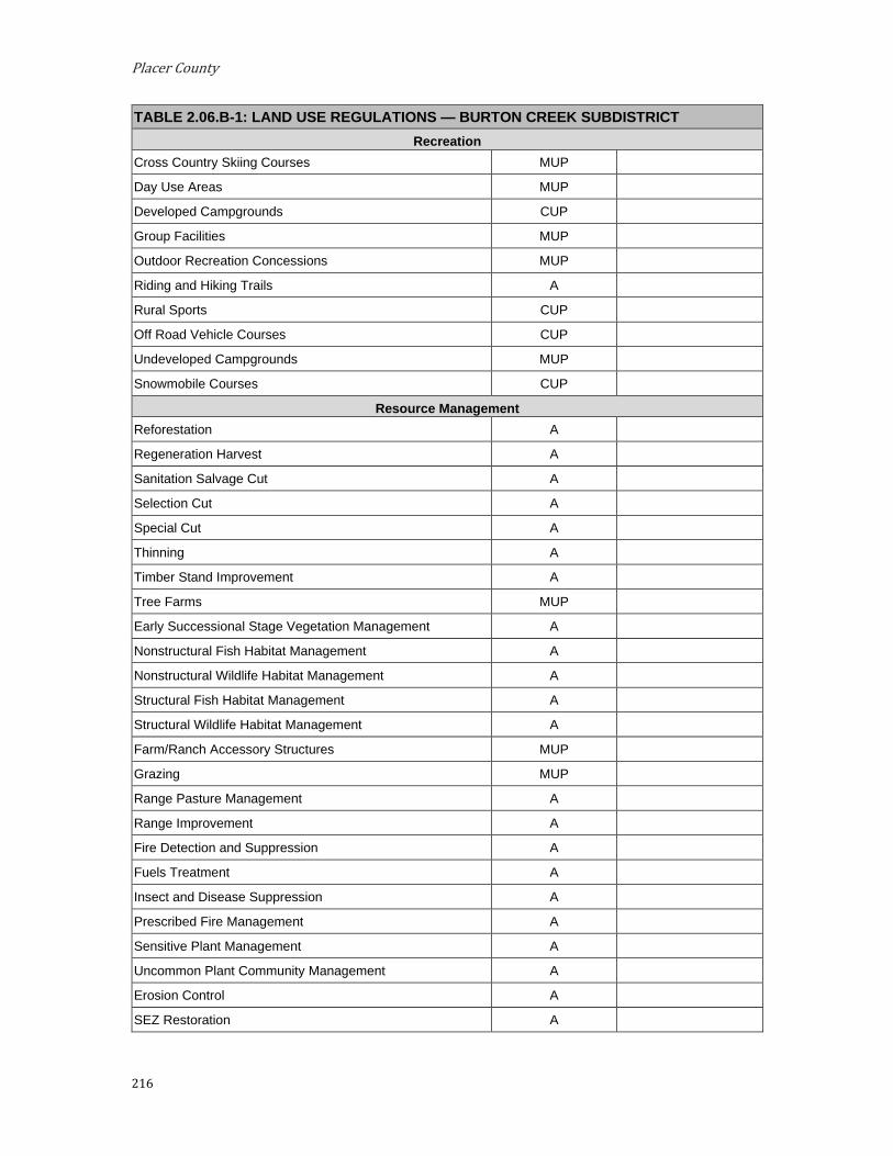
Placer County
216
TABLE 2.06.B-1: LAND USE REGULATIONS — BURTON CREEK SUBDISTRICT Recreation
Cross Country Skiing Courses MUP
Day Use Areas MUP
Developed Campgrounds CUP
Group Facilities MUP
Outdoor Recreation Concessions MUP
Riding and Hiking Trails A
Rural Sports CUP
Off Road Vehicle Courses CUP
Undeveloped Campgrounds MUP
Snowmobile Courses CUP
Resource Management Reforestation A
Regeneration Harvest A
Sanitation Salvage Cut A
Selection Cut A
Special Cut A
Thinning A
Timber Stand Improvement A
Tree Farms MUP
Early Successional Stage Vegetation Management A
Nonstructural Fish Habitat Management A
Nonstructural Wildlife Habitat Management A
Structural Fish Habitat Management A
Structural Wildlife Habitat Management A
Farm/Ranch Accessory Structures MUP
Grazing MUP
Range Pasture Management A
Range Improvement A
Fire Detection and Suppression A
Fuels Treatment A
Insect and Disease Suppression A
Prescribed Fire Management A
Sensitive Plant Management A
Uncommon Plant Community Management A
Erosion Control A
SEZ Restoration A
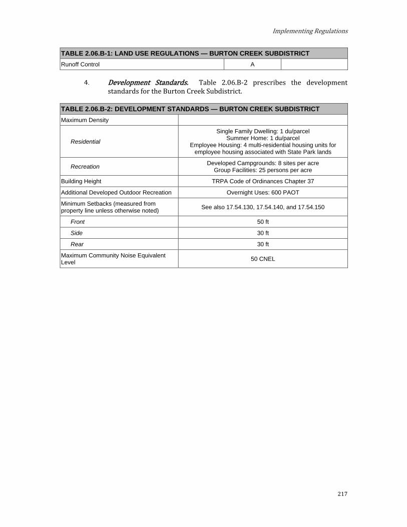
Implementing Regulations
217
TABLE 2.06.B-1: LAND USE REGULATIONS — BURTON CREEK SUBDISTRICT Runoff Control A
Development Standards. Table 2.06.B-2 prescribes the development standards for the Burton Creek Subdistrict.
TABLE 2.06.B-2: DEVELOPMENT STANDARDS — BURTON CREEK SUBDISTRICT Maximum Density
Residential
Single Family Dwelling: 1 du/parcel Summer Home: 1 du/parcel
Employee Housing: 4 multi-residential housing units for employee housing associated with State Park lands
Recreation Developed Campgrounds: 8 sites per acre Group Facilities: 25 persons per acre
Building Height TRPA Code of Ordinances Chapter 37
Additional Developed Outdoor Recreation Overnight Uses: 600 PAOT
Minimum Setbacks (measured from property line unless otherwise noted) See also 17.54.130, 17.54.140, and 17.54.150
Front 50 ft
Side 30 ft
Rear 30 ft
Maximum Community Noise Equivalent Level 50 CNEL

Placer County
218
C. Lower Ward Valley Subdistrict. The Lower Ward Valley Subdistrict is located within the West Shore Subarea. This Subdistrict is located in close proximity to urban areas and should provide opportunities for a variety of recreational activities and low to moderate resource management. Intensity of uses should be constrained by the environmental capability of the area.
Special Designation. None. Special Policies.
This area should provide additional recreation facilities for day use on State Park land and overnight camping at Kaspian Campground.
Viewing opportunities (vista point and trailhead) at Eagle Rock should be maintained.
The quality of background views as viewed from Shoreline Unit 13 should be maintained.
Permissible Uses. The following primary uses may be permitted within all or a portion of the Subdistrict. The list indicates if the use is Allowed (A), subject to an Administrative Review Permit (C), or must be considered under the provisions for a Conditional Use Permit (CUP) or Minor Use Permit (MUP). Existing uses not listed shall be considered nonconforming uses within this Subdistrict. The establishment of new uses not listed shall be prohibited.
TABLE 2.06.C-1: LAND USE REGULATIONS — LOWER WARD VALLEY SUBDISTRICT Allowable Land Uses Land Use Permit Add’l Regs.
Residential Single Family Dwelling MUP
Public Service Transportation Routes CUP
Pipelines and Power Transmission CUP
Transmission and Receiving Facilities CUP Placer County Code Section 17.56.060.F
Local Public Health and Safety Facilities MUP
Threshold-Related Research Facilities MUP
Recreation Cross Country Skiing Courses MUP
Day Use Areas MUP
Developed Campgrounds CUP
Outdoor Recreation Concessions MUP
Riding and Hiking Trails A
Rural Sports CUP
Undeveloped Campgrounds MUP
Visitor Information Center MUP
Resource Management Reforestation A

Implementing Regulations
219
TABLE 2.06.C-1: LAND USE REGULATIONS — LOWER WARD VALLEY SUBDISTRICT Regeneration Harvest A
Sanitation Salvage Cut A
Selection Cut A
Special Cut A
Thinning A
Timber Stand Improvement A
Tree Farms MUP
Early Successional Stage Vegetation Management A
Nonstructural Fish Habitat Management A
Nonstructural Wildlife Habitat Management A
Structural Fish Habitat Management A
Structural Wildlife Habitat Management A
Farm/Ranch Accessory Structures MUP
Grazing MUP
Range Pasture Management A
Range Improvement MUP
Fire Detection and Suppression A
Fuels Treatment A
Insect and Disease Suppression A
Prescribed Fire Management A
Sensitive Plant Management A
Uncommon Plant Community Management A
Erosion Control A
Runoff Control A
SEZ Restoration A

Placer County
220
Development Standards. Table 2.06.C-2 prescribes the development standards for the Lower Ward Valley Subdistrict.
TABLE 2.06.C-2: DEVELOPMENT STANDARDS — LOWER WARD VALLEY SUBDISTRICT Maximum Density
Residential Single Family Dwelling: 1 du/parcel
Recreation Developed Campgrounds: 8 sites per acre
Building Height TRPA Code of Ordinances Chapter 37
Minimum Setbacks (measured from property line unless otherwise noted) See also 17.54.130, 17.54.140, and 17.54.150
Front 50 ft
Side 30 ft
Rear 30 ft
Maximum Community Noise Equivalent Level 50 CNEL
Highway 89 Corridor 55 NEL
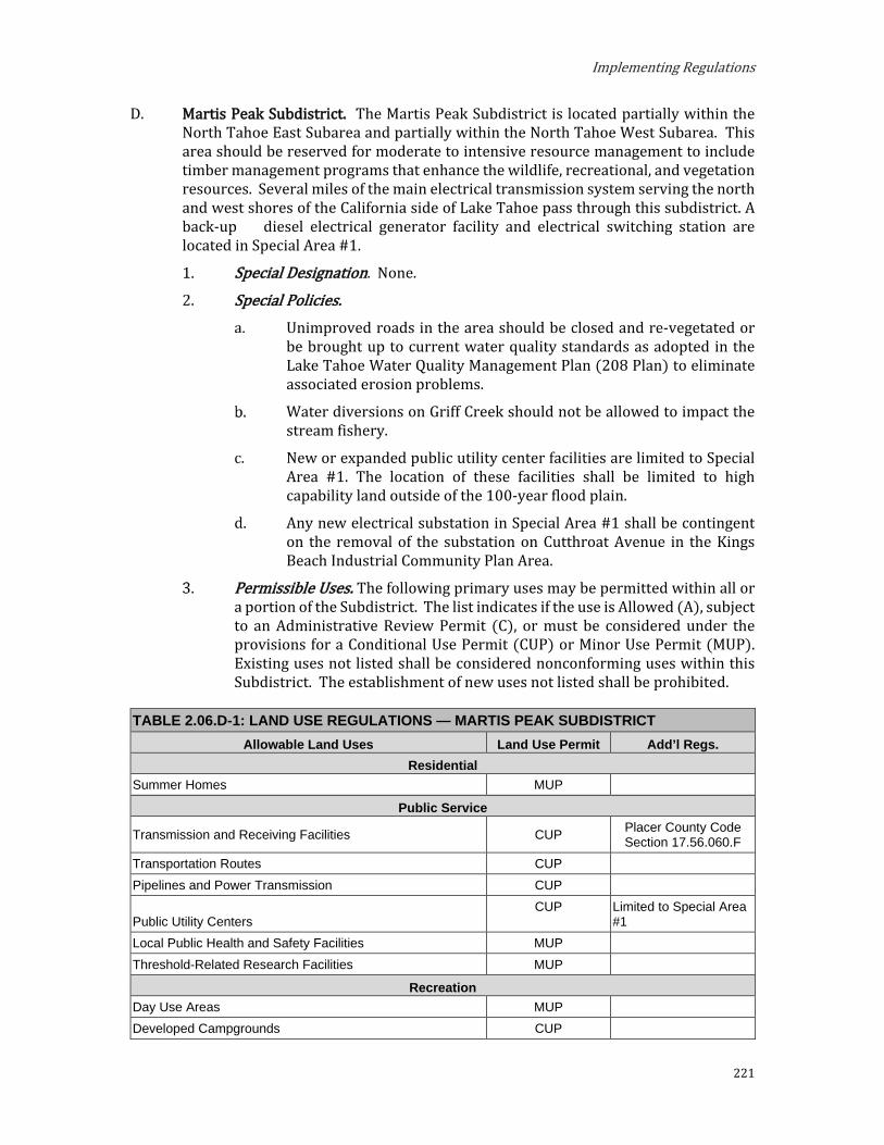
Implementing Regulations
221
D. Martis Peak Subdistrict. The Martis Peak Subdistrict is located partially within the North Tahoe East Subarea and partially within the North Tahoe West Subarea. This area should be reserved for moderate to intensive resource management to include timber management programs that enhance the wildlife, recreational, and vegetation resources. Several miles of the main electrical transmission system serving the north and west shores of the California side of Lake Tahoe pass through this subdistrict. A back-up diesel electrical generator facility and electrical switching station are located in Special Area #1.
Special Designation. None. Special Policies.
Unimproved roads in the area should be closed and re-vegetated or be brought up to current water quality standards as adopted in the Lake Tahoe Water Quality Management Plan (208 Plan) to eliminate associated erosion problems.
Water diversions on Griff Creek should not be allowed to impact the stream fishery.
New or expanded public utility center facilities are limited to Special Area #1. The location of these facilities shall be limited to high capability land outside of the 100-year flood plain.
Any new electrical substation in Special Area #1 shall be contingent on the removal of the substation on Cutthroat Avenue in the Kings Beach Industrial Community Plan Area.
Permissible Uses. The following primary uses may be permitted within all or a portion of the Subdistrict. The list indicates if the use is Allowed (A), subject to an Administrative Review Permit (C), or must be considered under the provisions for a Conditional Use Permit (CUP) or Minor Use Permit (MUP). Existing uses not listed shall be considered nonconforming uses within this Subdistrict. The establishment of new uses not listed shall be prohibited.
TABLE 2.06.D-1: LAND USE REGULATIONS — MARTIS PEAK SUBDISTRICT Allowable Land Uses Land Use Permit Add’l Regs.
Residential Summer Homes MUP
Public Service
Transmission and Receiving Facilities CUP Placer County Code Section 17.56.060.F
Transportation Routes CUP Pipelines and Power Transmission CUP
Public Utility Centers CUP Limited to Special Area
#1 Local Public Health and Safety Facilities MUP Threshold-Related Research Facilities MUP
Recreation Day Use Areas MUP Developed Campgrounds CUP

Placer County
222
TABLE 2.06.D-1: LAND USE REGULATIONS — MARTIS PEAK SUBDISTRICT Riding and Hiking Trails A Rural Sports CUP Off-Road Vehicle Course CUP Outdoor Recreation Concessions MUP Snowmobile Courses CUP Group Facilities MUP Undeveloped Campgrounds MUP
Resource Management Reforestation A Regeneration Harvest A Sanitation Salvage Cut A Selection Cut A Special Cut MUP Thinning A Timber Stand Improvement A Tree Farms MUP Early Successional Stage Vegetation Management A Nonstructural Fish Habitat Management A Nonstructural Wildlife Habitat Management A Structural Fish Habitat Management A Structural Wildlife Habitat Management A Farm/Ranch Accessory Structures A Fire Detection and Suppression A Fuels Treatment A Insect and Disease Suppression A Prescribed Fire Management A Sensitive Plant Management A Uncommon Plant Community Management A Erosion Control A Runoff Control A SEZ Restoration A

Implementing Regulations
223
Development Standards. Table 2.06.D-2 prescribes the development standards for the Martis Peak Subdistrict.
TABLE 2.06.D-2: DEVELOPMENT STANDARDS — MARTIS PEAK SUBDISTRICT Maximum Density
Residential Summer Homes: 1 du/parcel
Recreation Developed Campgrounds: 8 sites per acre Group Facilities: 25 persons per acre
Building Height TRPA Code of Ordinances Chapter 37
Additional Developed Outdoor Recreation Overnight Uses: 124 PAOT
Minimum Setbacks (measured from property line unless otherwise noted) See also 17.54.130, 17.54.140, and 17.54.150
Front 50 ft
Side 30 ft
Rear 30 ft
Maximum Community Noise Equivalent Level 50 CNEL
Route 267 Corridor 55 CNEL
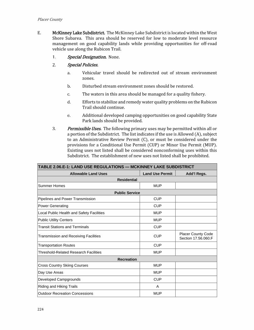
Placer County
224
E. McKinney Lake Subdistrict. The McKinney Lake Subdistrict is located within the West Shore Subarea. This area should be reserved for low to moderate level resource management on good capability lands while providing opportunities for off-road vehicle use along the Rubicon Trail.
Special Designation. None. Special Policies.
Vehicular travel should be redirected out of stream environment zones.
Disturbed stream environment zones should be restored.
The waters in this area should be managed for a quality fishery.
Efforts to stabilize and remedy water quality problems on the Rubicon Trail should continue.
Additional developed camping opportunities on good capability State Park lands should be provided.
Permissible Uses. The following primary uses may be permitted within all or a portion of the Subdistrict. The list indicates if the use is Allowed (A), subject to an Administrative Review Permit (C), or must be considered under the provisions for a Conditional Use Permit (CUP) or Minor Use Permit (MUP). Existing uses not listed shall be considered nonconforming uses within this Subdistrict. The establishment of new uses not listed shall be prohibited.
TABLE 2.06.E-1: LAND USE REGULATIONS — MCKINNEY LAKE SUBDISTRICT Allowable Land Uses Land Use Permit Add’l Regs.
Residential Summer Homes MUP
Public Service Pipelines and Power Transmission CUP
Power Generating CUP
Local Public Health and Safety Facilities MUP
Public Utility Centers MUP
Transit Stations and Terminals CUP
Transmission and Receiving Facilities CUP Placer County Code Section 17.56.060.F
Transportation Routes CUP
Threshold-Related Research Facilities MUP
Recreation Cross Country Skiing Courses MUP
Day Use Areas MUP
Developed Campgrounds CUP
Riding and Hiking Trails A
Outdoor Recreation Concessions MUP

Implementing Regulations
225
TABLE 2.06.E-1: LAND USE REGULATIONS — MCKINNEY LAKE SUBDISTRICT Rural Sports CUP
Group Facilities MUP
Undeveloped Campgrounds MUP
Off-Road Vehicle Course CUP
Snowmobile Courses CUP
Resource Management Reforestation A
Regeneration Harvest A
Sanitation Salvage Cut A
Selection Cut A
Special Cut A
Thinning A
Timber Stand Improvement A
Tree Farms MUP
Early Successional Stage Vegetation Management A
Nonstructural Fish Habitat Management A
Nonstructural Wildlife Habitat Management A
Structural Fish Habitat Management A
Structural Wildlife Habitat Management A
Farm/Ranch Accessory Structures MUP
Grazing MUP
Range Pasture Management A
Range Improvement MUP
Fire Detection and Suppression A
Fuels Treatment A
Insect and Disease Suppression A
Prescribed Fire Management A
Sensitive Plant Management A
Uncommon Plant Community Management A
Erosion Control A
Runoff Control A
SEZ Restoration A
Development Standards. Table 2.06.E-2 prescribes the development standards for the McKinney Lake Subdistrict.
TABLE 2.06.E-2: DEVELOPMENT STANDARDS — MCKINNEY LAKE SUBDISTRICT Maximum Density
Residential Summer Homes: 1 du/parcel

Placer County
226
TABLE 2.06.E-2: DEVELOPMENT STANDARDS — MCKINNEY LAKE SUBDISTRICT Recreation Developed Campgrounds: 8 sites per acre
Building Height TRPA Code of Ordinances Chapter 37
Minimum Setbacks (measured from property line unless otherwise noted) See also 17.54.130, 17.54.140, and 17.54.150
Front 50 ft
Side 30 ft
Rear 30 ft
Maximum Community Noise Equivalent Level 50 CNEL
Highway 89 Corridor 55 CNEL

Implementing Regulations
227
F. Watson Creek Subdistrict. The Watson Creek Subdistrict is located within the North Tahoe West Subarea. This Subdistrict should be managed with an emphasis on providing improved opportunities for dispersed recreation and timber harvest.
Special Designation. None. Special Policies.
The development or relocation of recreational facilities should be limited to good capability lands within close proximity to urban services.
Some bank stabilization and fish passage barrier removal work should be performed on Watson Creek.
Permissible Uses. The following primary uses may be permitted within all or a portion of the Subdistrict. The list indicates if the use is Allowed (A), subject to an Administrative Review Permit (C), or must be considered under the provisions for a Conditional Use Permit (CUP) or Minor Use Permit (MUP). Existing uses not listed shall be considered nonconforming uses within this Subdistrict. The establishment of new uses not listed shall be prohibited.
TABLE 2.06.F-1: LAND USE REGULATIONS — WATSON CREEK SUBDISTRICT Allowable Land Uses Land Use Permit Add’l Regs.
Residential Summer Homes MUP
Public Service
Transmission and Receiving Facilities CUP Placer County Code Section 17.56.060.F
Pipelines and Power Transmission CUP Local Public Health and Safety Facilities MUP Threshold-Related Research Facilities MUP
Recreation Day Use Areas MUP Developed Campgrounds CUP Off-Road Vehicle Course CUP Outdoor Recreation Concessions MUP Riding and Hiking Trails MUP Rural Sports CUP Group Facilities MUP Undeveloped Campgrounds MUP Snowmobile Courses CUP
Resource Management Reforestation A Regeneration Harvest A Sanitation Salvage Cut A Selection Cut A Special Cut A Thinning A

Placer County
228
TABLE 2.06.F-1: LAND USE REGULATIONS — WATSON CREEK SUBDISTRICT Timber Stand Improvement A Tree Farms MUP Early Successional Stage Vegetation Management A Nonstructural Fish Habitat Management A Nonstructural Wildlife Habitat Management A Structural Fish Habitat Management A Structural Wildlife Habitat Management A Farm/Ranch Accessory Structures MUP Grazing MUP Range Pasture Management A Range Improvement A Fire Detection and Suppression A Fuels Treatment A Insect and Disease Suppression A Prescribed Fire Management A Sensitive Plant Management A Uncommon Plant Community Management A Erosion Control A Runoff Control A SEZ Restoration A

Implementing Regulations
229
Development Standards. Table 2.06.F-2 prescribes the development standards for the Watson Creek Subdistrict.
TABLE 2.06.F-2: DEVELOPMENT STANDARDS — WATSON CREEK SUBDISTRICT Maximum Density
Residential Summer Homes: 1 du/parcel
Recreation Developed Campgrounds: 8 sites per acre Group Facilities: 25 persons per acre
Building Height TRPA Code of Ordinances Chapter 37
Additional Developed Outdoor Recreation Overnight Uses: 400 PAOT
Minimum Setbacks (measured from property line unless otherwise noted) See also 17.54.130, 17.54.140, and 17.54.150
Front 50 ft
Side 30 ft
Rear 30 ft
Maximum Community Noise Equivalent Level 50 CNEL

Placer County
230
Recreation Districts
A. 64 Acre Tract Subdistrict. The 64 Acre Tract Subdistrict is located within the Greater Tahoe City Subarea. This area should be redeveloped into a public recreation area consistent with the overall design plan for Tahoe City.
Special Designation. None. Special Policies.
Use all appropriate opportunities to increase opportunities for public access to the Truckee River and Lake Tahoe.
Increase the total mileage of bicycle trails available for public use in the Placer County General Plan area, complete linkages in the system, and complete alignments as established in the Tahoe City P.U.D. Master Plan.
Coordinate with the U.S. Forest Service for the management and continued improvement of the 64-acre Tract property pursuant to requirements set forth in the Regional Plan. Improvements should include recreation, transportation and public facilities that complement the transit center, trailheads and parking areas that currently exist.
Recreation plans shall consider the “Parks and Recreation Master Plan” of the Tahoe City Public Utility District along with the planning programs of the California State Parks Department, and U.S. Forest Service. Capital improvements in the Subdistrict should be responsive to the needs assessment that was included in the Tahoe City P.U.D. Master Plan.
Permissible Uses. The following primary uses may be permitted within all or a portion of the Subdistrict. The list indicates if the use is Allowed (A), subject to an Administrative Review Permit (C), or must be considered under the provisions for a Conditional Use Permit (CUP) or Minor Use Permit (MUP). Existing uses not listed shall be considered nonconforming uses within this Subdistrict. The establishment of new uses not listed shall be prohibited.
TABLE 2.07.A-1: LAND USE REGULATIONS — 64 ACRE TRACT SUBDISTRICT Allowable Land Uses Land Use Permit Add’l Regs.
Residential Employee Housing MUP
Public Service Cultural Facilities A
Pipelines and Power Transmissions CUP
Public Assembly and Entertainment Facilities CUP
Local Public Health and Safety Facilities MUP
Transmission and Receiving Facilities CUP Placer County Code Section 17.56.060.F
Transportation Routes CUP
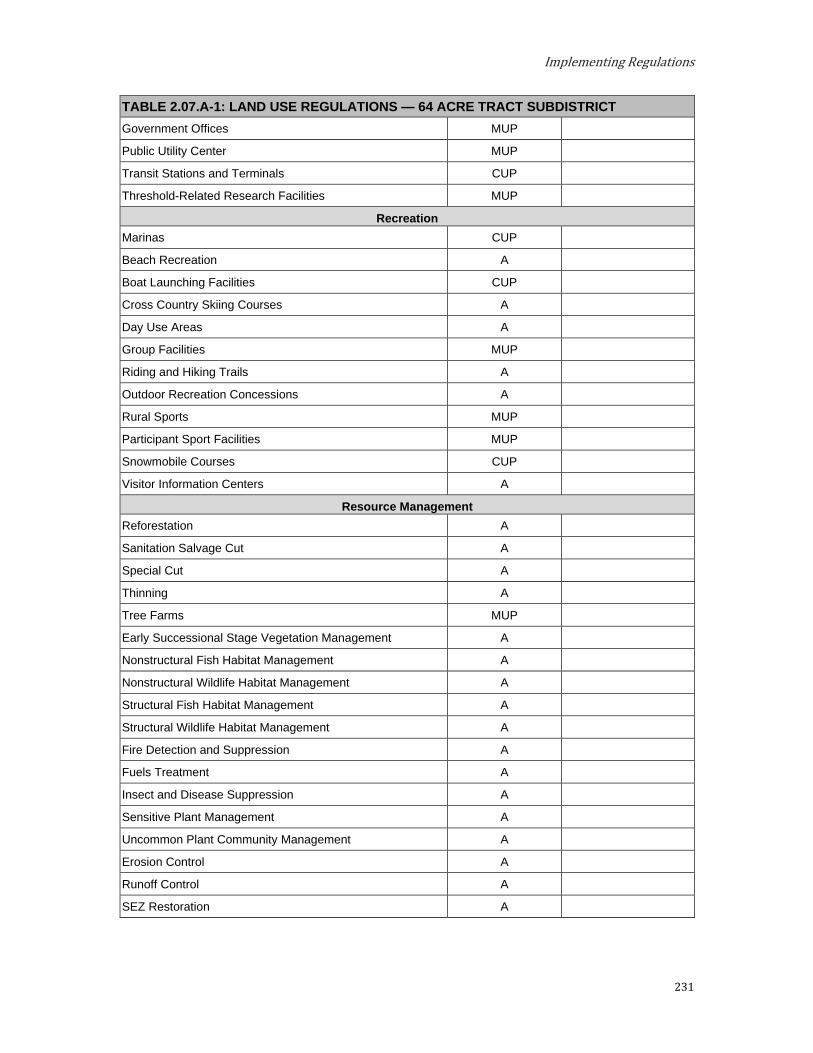
Implementing Regulations
231
TABLE 2.07.A-1: LAND USE REGULATIONS — 64 ACRE TRACT SUBDISTRICT Government Offices MUP
Public Utility Center MUP
Transit Stations and Terminals CUP
Threshold-Related Research Facilities MUP
Recreation Marinas CUP
Beach Recreation A
Boat Launching Facilities CUP
Cross Country Skiing Courses A
Day Use Areas A
Group Facilities MUP
Riding and Hiking Trails A
Outdoor Recreation Concessions A
Rural Sports MUP
Participant Sport Facilities MUP
Snowmobile Courses CUP
Visitor Information Centers A
Resource Management Reforestation A
Sanitation Salvage Cut A
Special Cut A
Thinning A
Tree Farms MUP
Early Successional Stage Vegetation Management A
Nonstructural Fish Habitat Management A
Nonstructural Wildlife Habitat Management A
Structural Fish Habitat Management A
Structural Wildlife Habitat Management A
Fire Detection and Suppression A
Fuels Treatment A
Insect and Disease Suppression A
Sensitive Plant Management A
Uncommon Plant Community Management A
Erosion Control A
Runoff Control A
SEZ Restoration A
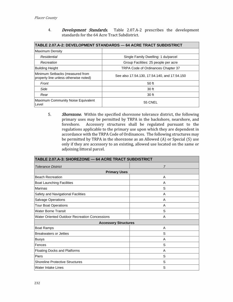
Placer County
232
Development Standards. Table 2.07.A-2 prescribes the development standards for the 64 Acre Tract Subdistrict.
TABLE 2.07.A-2: DEVELOPMENT STANDARDS — 64 ACRE TRACT SUBDISTRICT Maximum Density
Residential Single Family Dwelling: 1 du/parcel Recreation Group Facilities: 25 people per acre
Building Height TRPA Code of Ordinances Chapter 37 Minimum Setbacks (measured from property line unless otherwise noted) See also 17.54.130, 17.54.140, and 17.54.150
Front 50 ft Side 30 ft Rear 30 ft
Maximum Community Noise Equivalent Level 55 CNEL
Shorezone. Within the specified shorezone tolerance district, the following primary uses may be permitted by TRPA in the backshore, nearshore, and foreshore. Accessory structures shall be regulated pursuant to the regulations applicable to the primary use upon which they are dependent in accordance with the TRPA Code of Ordinances. The following structures may be permitted by TRPA in the shorezone as an Allowed (A) or Special (S) use only if they are accessory to an existing, allowed use located on the same or adjoining littoral parcel.
TABLE 2.07.A-3: SHOREZONE — 64 ACRE TRACT SUBDISTRICT
Tolerance District 7 Primary Uses
Beach Recreation A Boat Launching Facilities A Marinas S Safety and Navigational Facilities A Salvage Operations A Tour Boat Operations A Water Borne Transit S Water Oriented Outdoor Recreation Concessions A
Accessory Structures Boat Ramps A Breakwaters or Jetties S Buoys A Fences S Floating Docks and Platforms A Piers S Shoreline Protective Structures S Water Intake Lines S

Implementing Regulations
233
B. Fish Hatchery Subdistrict. The Fish Hatchery Subdistrict is located within the Greater Tahoe City Subarea. This area should continue to provide both dispersed and more intensive forms of recreation while preserving, to the extent possible, its natural character and value as a stream environment zone (SEZ). Intensive uses in sensitive areas should be relocated to other less-sensitive sites in the planning area, and inappropriate uses should be redirected outside the Subdistrict.
Special Designations. None. Special Policies.
The campsites should be eliminated in this area over the long term and relocated in a Subdistrict with higher capability land.
The undeveloped portions of the SEZ should be managed for scenic restoration and low intensity uses.
Wherever possible, disturbed sites in the SEZ should be restored. TRPA incentives for transfers of development and coverage encourage restoration in this subdistrict. This subdistrict is a high priority area for land coverage reduction.
TRPA recognizes the existing research facility at its current level of use on the Historic Fish Hatchery Property as a Threshold-Related Research Facility in this Area Plan area. There shall be no expansion of the existing use unless, at the time of project approval it is determined that the project can be sufficiently mitigated, and there is implementation of the following environmental improvement projects:
i. Participate in planning, designing, and funding a fair share of the Burton Creek Linked Project-Stream Habitat Restoration (EIP project #01.02.02.0031); AND
ii. Plan and design, and/or fund a functional equivalent restoration project consistent with all Special Policies in the Fish Hatchery and Rocky Ridge Subdistricts; OR
iii. Such additional mitigation as TRPA may determine is necessary.
Permissible Uses. The following primary uses may be permitted within all or a portion of the Subdistrict. The list indicates if the use is Allowed (A), subject to an Administrative Review Permit (C), or must be considered under the provisions for a Conditional Use Permit (CUP) or Minor Use Permit (MUP). Existing uses not listed shall be considered nonconforming uses within this Subdistrict. The establishment of new uses not listed shall be prohibited.
TABLE 2.07.B-1: LAND USE REGULATIONS — FISH HATCHERY SUBDISTRICT
Allowable Land Uses Land Use Permit Add’l Regs. Residential
Single-Family Dwelling A

Placer County
234
TABLE 2.07.B-1: LAND USE REGULATIONS — FISH HATCHERY SUBDISTRICT Public Service
Cultural Facilities MUP
Government Offices MUP
Local Public Health and Safety Facilities A
Pipelines and Power Transmission CUP
Public Utility Centers CUP
Regional Public Health and Safety Facilities MUP
Threshold-Related Research Facilities MUP
Transit Stations and Terminals CUP
Transmission and Receiving Facilities CUP Placer County Code Section 17.56.060.F
Transportation Routes CUP
Recreation Beach Recreation A
Boat Launching Facilities CUP
Day Use Areas A
Developed Campgrounds CUP
Participant Sports MUP
Riding and Hiking Trails MUP
Resource Management Reforestation A
Regeneration Harvest MUP
Sanitation Salvage Cut A
Selection Cut MUP
Special Cut MUP
Thinning A
Timber Stand Improvement MUP
Tree Farms MUP
Early Successional Stage Vegetation Management A
Nonstructural Fish Habitat Management A
Nonstructural Wildlife Habitat Management A
Structural Fish Habitat Management MUP
Structural Wildlife Habitat Management MUP
Farm/Ranch Accessory Structures MUP
Fire Detection and Suppression A
Fuels Treatment MUP
Insect and Disease Suppression A
Prescribed Fire Management A

Implementing Regulations
235
TABLE 2.07.B-1: LAND USE REGULATIONS — FISH HATCHERY SUBDISTRICT Sensitive Plant Management A
Uncommon Plant Community Management A
Erosion Control A
SEZ Restoration A
Runoff Control A
Development Standards. Table 2.07.B-2 prescribes the development standards for the Fish Hatchery Subdistrict.
TABLE 2.07.B-2: DEVELOPMENT STANDARDS — FISH HATCHERY SUBDISTRICT Maximum Density
Residential Single Family Dwelling: 1 du/parcel
Recreation Developed Campgrounds: 8 sites per acre
Building Height TRPA Code of Ordinances Chapter 37
Minimum Setbacks (measured from property line unless otherwise noted) See also 17.54.130, 17.54.140, and 17.54.150
Front 50 ft
Side 30 ft
Rear 30 ft
Maximum Community Noise Equivalent Level 55 CNEL
Shorezone. Within the specified shorezone tolerance district, the following
primary uses may be permitted by TRPA in the backshore, nearshore, and foreshore. Accessory structures shall be regulated pursuant to the regulations applicable to the primary use upon which they are dependent in accordance with the TRPA Code of Ordinances. The following structures may be permitted by TRPA in the shorezone as an Allowed (A) or Special (S) use only if they are accessory to an existing, allowed use located on the same or adjoining littoral parcel.
TABLE 2.07.B-3: SHOREZONE — FISH HATCHERY SUBDISTRICT
Tolerance District 1 Primary Uses
Beach Recreation A
Safety and Navigation Facilities A
Boat Launching Facilities S
Water Oriented Outdoor Recreation Concessions S
Accessory Structures Buoys A
Piers A

Placer County
236
TABLE 2.07.B-3: SHOREZONE — FISH HATCHERY SUBDISTRICT
Tolerance District 1 Fences S
Boat Ramps A
Floating Docks and Platforms A
Shoreline Protective Structures S
Water Intake Lines A
C. Homewood / Tahoe Ski Bowl Master Plan Subdistrict. The Homewood / Tahoe Ski Bowl Subdistrict is located within the West Shore Subarea. Development within the Homewood / Tahoe Ski Bowl Subdistrict is subject to the adopted Homewood Master Plan (December 14, 2011).

Implementing Regulations
237
D. Lower Truckee Subdistrict. The Lower Truckee Subdistrict is located within the Greater Tahoe City Subarea. This area should be managed for recreational uses that are compatible with the special scenic and resource values of the Subdistrict. Existing developed facilities that contribute to scenic degradation should be relocated to other suitable areas outside the Subdistrict.
Special Designations. None. Special Policies.
Encourage existing commercial uses in this area to relocate to more appropriate areas. Incentives through TDRs to any receivable subdistrict should be provided to encourage commercial uses to relocate. Commercial uses that are allowed to remain for safety reasons should be required to show that there is no safe feasible alternative site and should be required to do visual buffering or landscaping as conditions for any permits for additions, modifications, or alterations.
Provide suitable parking facilities for recreational users of the river.
Optimize recreation and travel use of the river corridor to that which maintains its attractiveness and environmental stability.
Provide opportunities for low to moderate resource management in the plateau area that is located above the Truckee River canyon area and is not visible from Highway 89.
Public recreation opportunities on Lake Tahoe and the Truckee River should be encouraged. Prior to any expansion, the total number of rafts operating at one time on the Truckee River should be established by a comprehensive environmental analysis. This analysis should include, but not be limited to, determination of overall recreation needs, attractiveness of the facilities, environmental constraints and impacts, parking and traffic constraints, and various water flow limitations. Parking for commercial rafting should be provided by the businesses and in locations that do not further congest the "wye" area.
Consistent with the Truckee River Corridor Special Planning Area provisions (Section 2.09.B.3), the County shall consider a plan that recognizes existing industrial and commercial uses. The County shall consider rezoning of such industrial and commercial sites, and establishing development standards that focus on environmental redevelopment and / or restoration of those sites.
Permissible Uses. The following primary uses may be permitted within all or a portion of the Subdistrict. The list indicates if the use is Allowed (A), subject to an Administrative Review Permit (C), or must be considered under the provisions for a Conditional Use Permit (CUP) or Minor Use Permit (MUP). Existing uses not listed shall be considered nonconforming uses within this Subdistrict. The establishment of new uses not listed shall be prohibited.
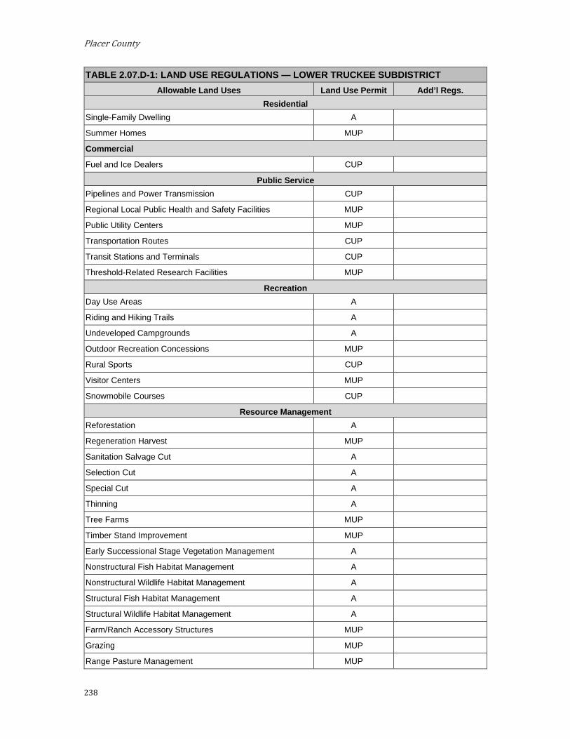
Placer County
238
TABLE 2.07.D-1: LAND USE REGULATIONS — LOWER TRUCKEE SUBDISTRICT Allowable Land Uses Land Use Permit Add’l Regs.
Residential Single-Family Dwelling A
Summer Homes MUP
Commercial
Fuel and Ice Dealers CUP
Public Service Pipelines and Power Transmission CUP
Regional Local Public Health and Safety Facilities MUP
Public Utility Centers MUP
Transportation Routes CUP
Transit Stations and Terminals CUP
Threshold-Related Research Facilities MUP
Recreation Day Use Areas A
Riding and Hiking Trails A
Undeveloped Campgrounds A
Outdoor Recreation Concessions MUP
Rural Sports CUP
Visitor Centers MUP
Snowmobile Courses CUP
Resource Management Reforestation A
Regeneration Harvest MUP
Sanitation Salvage Cut A
Selection Cut A
Special Cut A
Thinning A
Tree Farms MUP
Timber Stand Improvement MUP
Early Successional Stage Vegetation Management A
Nonstructural Fish Habitat Management A
Nonstructural Wildlife Habitat Management A
Structural Fish Habitat Management A
Structural Wildlife Habitat Management A
Farm/Ranch Accessory Structures MUP
Grazing MUP
Range Pasture Management MUP
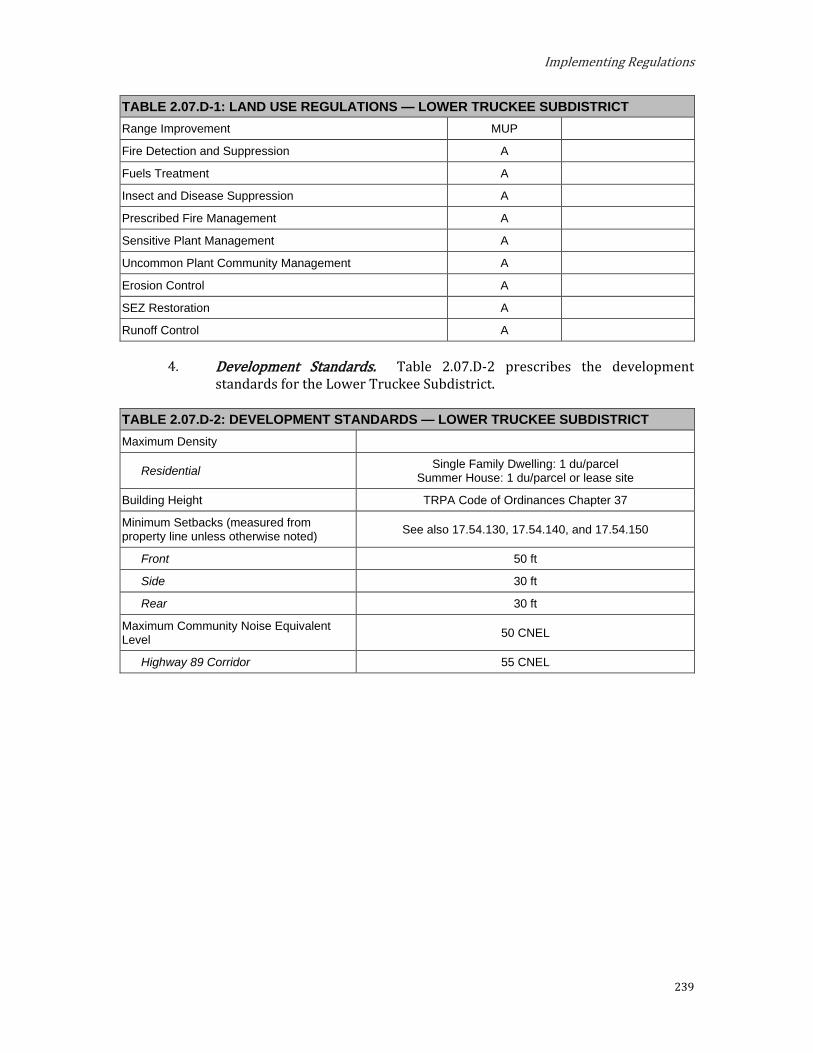
Implementing Regulations
239
TABLE 2.07.D-1: LAND USE REGULATIONS — LOWER TRUCKEE SUBDISTRICT Range Improvement MUP
Fire Detection and Suppression A
Fuels Treatment A
Insect and Disease Suppression A
Prescribed Fire Management A
Sensitive Plant Management A
Uncommon Plant Community Management A
Erosion Control A
SEZ Restoration A
Runoff Control A
Development Standards. Table 2.07.D-2 prescribes the development standards for the Lower Truckee Subdistrict.
TABLE 2.07.D-2: DEVELOPMENT STANDARDS — LOWER TRUCKEE SUBDISTRICT Maximum Density
Residential Single Family Dwelling: 1 du/parcel Summer House: 1 du/parcel or lease site
Building Height TRPA Code of Ordinances Chapter 37
Minimum Setbacks (measured from property line unless otherwise noted) See also 17.54.130, 17.54.140, and 17.54.150
Front 50 ft
Side 30 ft
Rear 30 ft
Maximum Community Noise Equivalent Level 50 CNEL
Highway 89 Corridor 55 CNEL

Placer County
240
E. North Star Subdistrict. The North Star Subdistrict is located within the North Tahoe West Subarea. This area is best suited for low intensive resource management, although some opportunity for ski trail expansion should be provided.
Special Designation. None. Special Policies.
Coordinate with the USFS and operators of the North Star ski facility to assess the feasibility of, and demand for, expanding the North Star operations into this planning area.
Ski expansion within the Basin should be limited to lifts and runs. Access should be from base facilities outside the Basin.
Other accessory uses to ski areas, such as warming huts and eating and drinking establishments, should be serviced from outside the Basin. Also, such facilities, if constructed, should be screened from views originating from within the Basin.
Base facilities for cross country ski and snowmobile courses should be located outside the Basin.
Permissible Uses. The following primary uses may be permitted within all or a portion of the Subdistrict. The list indicates if the use is Allowed (A), subject to an Administrative Review Permit (C), or must be considered under the provisions for a Conditional Use Permit (CUP) or Minor Use Permit (MUP). Existing uses not listed shall be considered nonconforming uses within this Subdistrict. The establishment of new uses not listed shall be prohibited.
TABLE 2.07.E-1: LAND USE REGULATIONS — NORTH STAR SUBDISTRICT Allowable Land Uses Land Use Permit Add’l Regs.
Public Service
Transmission and Receiving Facilities CUP Placer County Code Section 17.56.060.F
Pipelines and Power Transmission Lines CUP
Threshold-Related Research Facilities MUP
Recreation Cross Country Skiing Courses MUP
Riding and Hiking Trails A
Downhill Skiing Facilities CUP
Snowmobile Courses CUP
Resource Management Reforestation A
Regeneration Harvest A
Sanitation Salvage Cut A
Selection Cut A
Special Cut A
Thinning A

Implementing Regulations
241
TABLE 2.07.E-1: LAND USE REGULATIONS — NORTH STAR SUBDISTRICT Timber Stand Improvement A
Tree Farms MUP
Early Successional Stage Vegetation Management A
Nonstructural Fish Habitat Management A
Nonstructural Wildlife Habitat Management A
Structural Fish Habitat Management A
Structural Wildlife Habitat Management A
Farm/Ranch Accessory Structures MUP
Fire Detection and Suppression A
Fuels Treatment A
Insect and Disease Suppression A
Prescribed Fire Management A
Sensitive Plant Management A
Uncommon Plant Community Management A
Erosion Control A
Runoff Control A
SEZ Restoration A
Development Standards. Table 2.07.E-2 prescribes the development standards for the North Star Subdistrict.
TABLE 2.07.E-2: DEVELOPMENT STANDARDS — NORTH STAR SUBDISTRICT Maximum Density N/A
Building Height TRPA Code of Ordinances Chapter 37
Additional Recreation Development Winter Day Use: 1,000 PAOT
Minimum Setbacks (measured from property line unless otherwise noted) See also 17.54.130, 17.54.140, and 17.54.150
Front 50 ft
Side 30 ft
Rear 30 ft
Maximum Community Noise Equivalent Level 55 CNEL
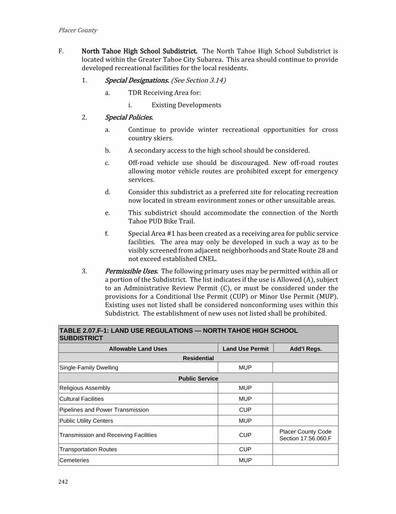
Placer County
242
F. North Tahoe High School Subdistrict. The North Tahoe High School Subdistrict is located within the Greater Tahoe City Subarea. This area should continue to provide developed recreational facilities for the local residents.
Special Designations. (See Section 3.14) TDR Receiving Area for:
i. Existing Developments
Special Policies. Continue to provide winter recreational opportunities for cross
country skiers.
A secondary access to the high school should be considered.
Off-road vehicle use should be discouraged. New off-road routes allowing motor vehicle routes are prohibited except for emergency services.
Consider this subdistrict as a preferred site for relocating recreation now located in stream environment zones or other unsuitable areas.
This subdistrict should accommodate the connection of the North Tahoe PUD Bike Trail.
Special Area #1 has been created as a receiving area for public service facilities. The area may only be developed in such a way as to be visibly screened from adjacent neighborhoods and State Route 28 and not exceed established CNEL.
Permissible Uses. The following primary uses may be permitted within all or a portion of the Subdistrict. The list indicates if the use is Allowed (A), subject to an Administrative Review Permit (C), or must be considered under the provisions for a Conditional Use Permit (CUP) or Minor Use Permit (MUP). Existing uses not listed shall be considered nonconforming uses within this Subdistrict. The establishment of new uses not listed shall be prohibited.
TABLE 2.07.F-1: LAND USE REGULATIONS — NORTH TAHOE HIGH SCHOOL SUBDISTRICT
Allowable Land Uses Land Use Permit Add’l Regs. Residential
Single-Family Dwelling MUP
Public Service Religious Assembly MUP
Cultural Facilities MUP
Pipelines and Power Transmission CUP
Public Utility Centers MUP
Transmission and Receiving Facilities CUP Placer County Code Section 17.56.060.F
Transportation Routes CUP
Cemeteries MUP
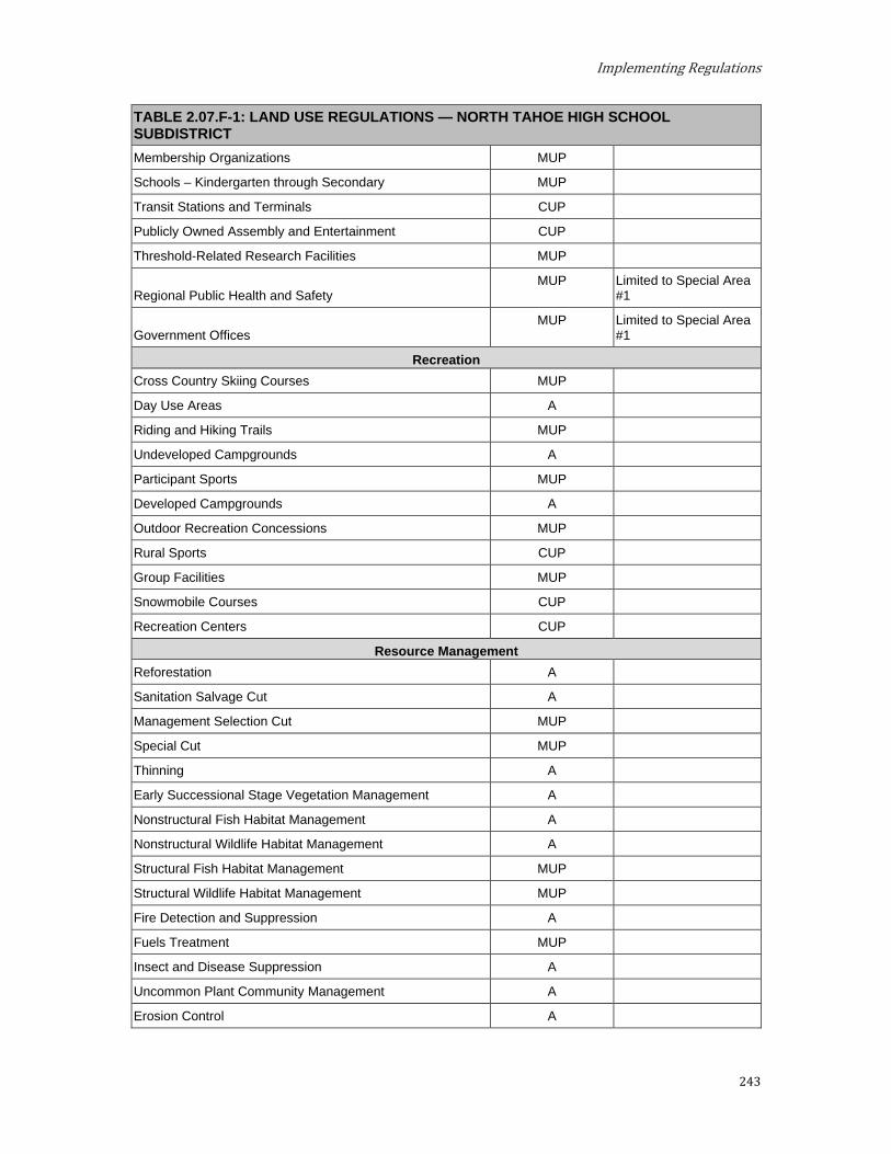
Implementing Regulations
243
TABLE 2.07.F-1: LAND USE REGULATIONS — NORTH TAHOE HIGH SCHOOL SUBDISTRICT Membership Organizations MUP
Schools – Kindergarten through Secondary MUP
Transit Stations and Terminals CUP
Publicly Owned Assembly and Entertainment CUP
Threshold-Related Research Facilities MUP
Regional Public Health and Safety MUP Limited to Special Area
#1
Government Offices MUP Limited to Special Area
#1
Recreation Cross Country Skiing Courses MUP
Day Use Areas A
Riding and Hiking Trails MUP
Undeveloped Campgrounds A
Participant Sports MUP
Developed Campgrounds A
Outdoor Recreation Concessions MUP
Rural Sports CUP
Group Facilities MUP
Snowmobile Courses CUP
Recreation Centers CUP
Resource Management Reforestation A
Sanitation Salvage Cut A
Management Selection Cut MUP
Special Cut MUP
Thinning A
Early Successional Stage Vegetation Management A
Nonstructural Fish Habitat Management A
Nonstructural Wildlife Habitat Management A
Structural Fish Habitat Management MUP
Structural Wildlife Habitat Management MUP
Fire Detection and Suppression A
Fuels Treatment MUP
Insect and Disease Suppression A
Uncommon Plant Community Management A
Erosion Control A
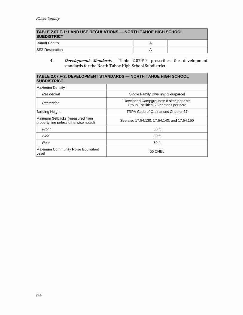
Placer County
244
TABLE 2.07.F-1: LAND USE REGULATIONS — NORTH TAHOE HIGH SCHOOL SUBDISTRICT Runoff Control A
SEZ Restoration A
Development Standards. Table 2.07.F-2 prescribes the development standards for the North Tahoe High School Subdistrict.
TABLE 2.07.F-2: DEVELOPMENT STANDARDS — NORTH TAHOE HIGH SCHOOL SUBDISTRICT Maximum Density
Residential Single Family Dwelling: 1 du/parcel
Recreation Developed Campgrounds: 8 sites per acre Group Facilities: 25 persons per acre
Building Height TRPA Code of Ordinances Chapter 37
Minimum Setbacks (measured from property line unless otherwise noted) See also 17.54.130, 17.54.140, and 17.54.150
Front 50 ft
Side 30 ft
Rear 30 ft
Maximum Community Noise Equivalent Level 55 CNEL
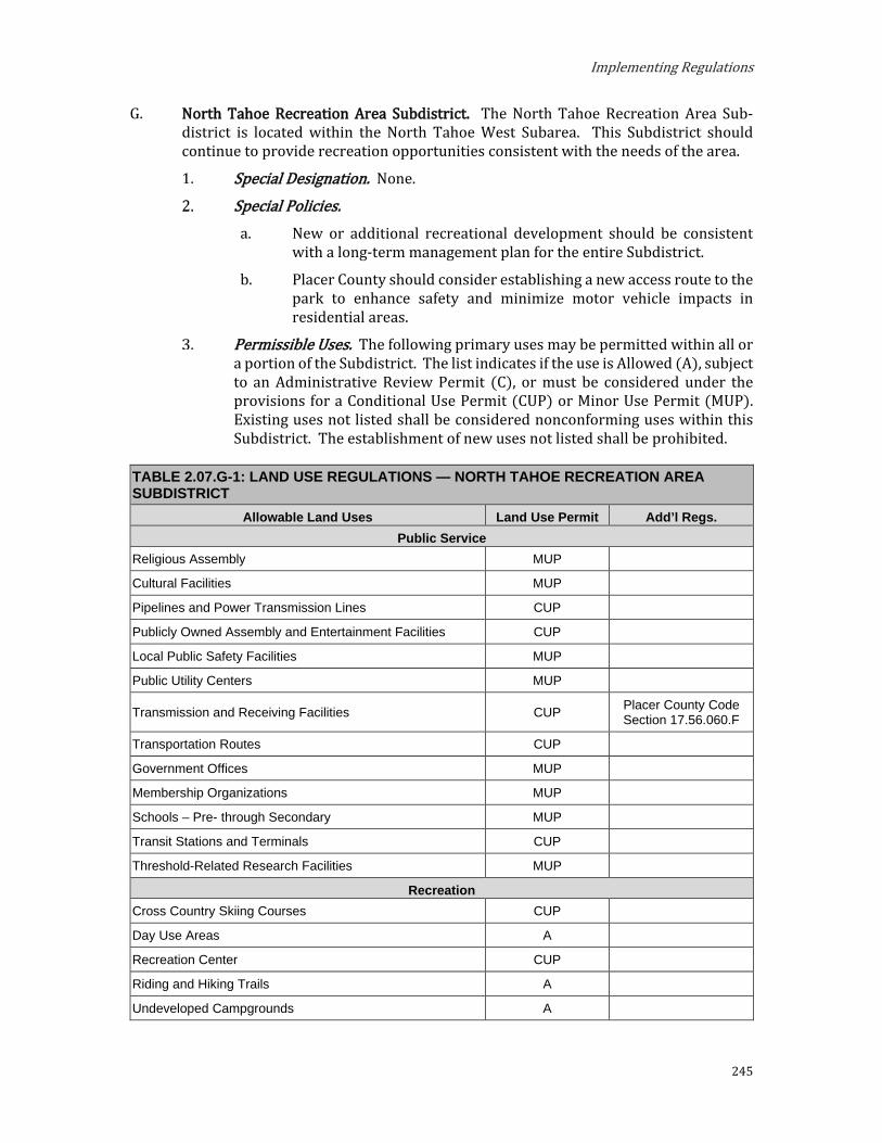
Implementing Regulations
245
G. North Tahoe Recreation Area Subdistrict. The North Tahoe Recreation Area Sub- district is located within the North Tahoe West Subarea. This Subdistrict should continue to provide recreation opportunities consistent with the needs of the area.
Special Designation. None.
Special Policies. a. New or additional recreational development should be consistent
with a long-term management plan for the entire Subdistrict.
b. Placer County should consider establishing a new access route to the park to enhance safety and minimize motor vehicle impacts in residential areas.
Permissible Uses. The following primary uses may be permitted within all or a portion of the Subdistrict. The list indicates if the use is Allowed (A), subject to an Administrative Review Permit (C), or must be considered under the provisions for a Conditional Use Permit (CUP) or Minor Use Permit (MUP). Existing uses not listed shall be considered nonconforming uses within this Subdistrict. The establishment of new uses not listed shall be prohibited.
TABLE 2.07.G-1: LAND USE REGULATIONS — NORTH TAHOE RECREATION AREA SUBDISTRICT
Allowable Land Uses Land Use Permit Add’l Regs. Public Service
Religious Assembly MUP
Cultural Facilities MUP
Pipelines and Power Transmission Lines CUP
Publicly Owned Assembly and Entertainment Facilities CUP
Local Public Safety Facilities MUP
Public Utility Centers MUP
Transmission and Receiving Facilities CUP Placer County Code Section 17.56.060.F
Transportation Routes CUP
Government Offices MUP
Membership Organizations MUP
Schools – Pre- through Secondary MUP
Transit Stations and Terminals CUP
Threshold-Related Research Facilities MUP
Recreation Cross Country Skiing Courses CUP
Day Use Areas A
Recreation Center CUP
Riding and Hiking Trails A
Undeveloped Campgrounds A
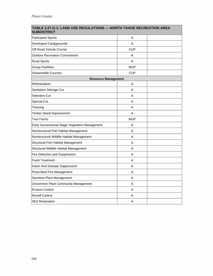
Placer County
246
TABLE 2.07.G-1: LAND USE REGULATIONS — NORTH TAHOE RECREATION AREA SUBDISTRICT Participant Sports A
Developed Campgrounds A
Off-Road Vehicle Course CUP
Outdoor Recreation Concessions A
Rural Sports A
Group Facilities MUP
Snowmobile Courses CUP
Resource Management Reforestation A
Sanitation Salvage Cut A
Selection Cut A
Special Cut A
Thinning A
Timber Stand Improvement A
Tree Farms MUP
Early Successional Stage Vegetation Management A
Nonstructural Fish Habitat Management A
Nonstructural Wildlife Habitat Management A
Structural Fish Habitat Management A
Structural Wildlife Habitat Management A
Fire Detection and Suppression A
Fuels Treatment A
Insect And Disease Suppression A
Prescribed Fire Management A
Sensitive Plant Management A
Uncommon Plant Community Management A
Erosion Control A
Runoff Control A
SEZ Restoration A

Implementing Regulations
247
Development Standards. Table 2.07.G-2 prescribes the development standards for the North Tahoe Recreation Area Subdistrict.
TABLE 2.07.G-2: DEVELOPMENT STANDARDS — NORTH TAHOE RECREATION AREA SUBDISTRICT Maximum Density
Recreation Developed Campgrounds: 8 sites per acre Group Facilities: 25 persons per acre
Building Height TRPA Code of Ordinances Chapter 37
Additional Developed Outdoor Recreation Overnight Uses: 200 persons at one time
Minimum Setbacks (measured from property line unless otherwise noted) See also 17.54.130, 17.54.140, and 17.54.150
Front 50 ft
Side 30 ft
Rear 30 ft
Maximum Community Noise Equivalent Level 55 CNEL

Placer County
248
H. Snow Creek Subdistrict. The Snow Creek Subdistrict is located within the North Tahoe West Subarea. The planning of this Subdistrict should focus on providing outdoor recreation opportunities.
Special Designation. None. Special Policies.
Owners of legal lots and parcels of record are encouraged to utilize TRPA development transfer incentives to transfer their development rights out of this subdistrict.
Permissible Uses. The following primary uses may be permitted within all or a portion of the Subdistrict. The list indicates if the use is Allowed (A), subject to an Administrative Review Permit (C), or must be considered under the provisions for a Conditional Use Permit (CUP) or Minor Use Permit (MUP). Existing uses not listed shall be considered nonconforming uses within this Subdistrict. The establishment of new uses not listed shall be prohibited.
TABLE 2.07.H-1: LAND USE REGULATIONS — SNOW CREEK SUBDISTRICT Allowable Land Uses Land Use Permit Add’l Regs.
Residential Single-Family Dwelling CUP
Public Service Pipelines and Power Transmissions CUP
Transmission and Receiving Facilities CUP Placer County Code Section 17.56.060.F
Local Public Health and Safety Facilities MUP
Public Utility Centers MUP
Transportation Routes CUP
Government Offices MUP
Transit Stations and Terminals CUP
Threshold-Related Research Facilities MUP
Recreation Cross Country Skiing Courses MUP
Day Use Areas A
Riding and Hiking Trails A
Undeveloped Campgrounds MUP
Participant Sports A
Developed Campgrounds CUP
Outdoor Recreation Concessions A
Recreational Vehicle Park CUP
Rural Sports CUP
Group Facilities MUP
Snowmobile Courses CUP

Implementing Regulations
249
TABLE 2.07.H-1: LAND USE REGULATIONS — SNOW CREEK SUBDISTRICT Beach Recreation A
Resource Management Reforestation A
Regeneration Harvest MUP
Sanitation Salvage Cut A
Selection Cut MUP
Special Cut MUP
Thinning A
Timber Stand Improvement MUP
Tree Farms MUP
Early Successional Stage Vegetation Management A
Nonstructural Fish Habitat Management A
Nonstructural Wildlife Habitat Management A
Structural Fish Habitat Management MUP
Structural Wildlife Habitat Management MUP
Farm/Ranch Accessory Structures MUP
Grazing MUP
Range Pasture Management MUP
Range Improvement MUP
Fire Detection and Suppression A
Fuels Treatment MUP
Insect and Disease Suppression A
Prescribed Fire Management A
Sensitive Plant Management A
Uncommon Plant Community Management A
Erosion Control A
Runoff Control A
SEZ Restoration A
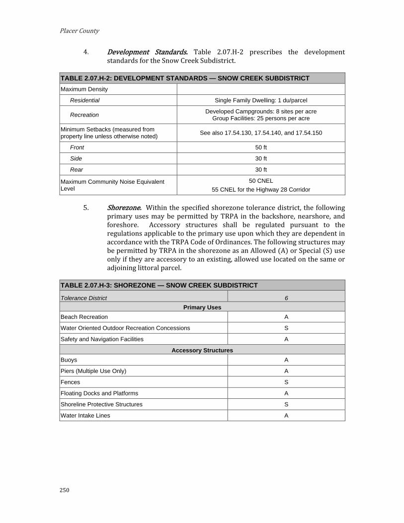
Placer County
250
Development Standards. Table 2.07.H-2 prescribes the development standards for the Snow Creek Subdistrict.
TABLE 2.07.H-2: DEVELOPMENT STANDARDS — SNOW CREEK SUBDISTRICT Maximum Density
Residential Single Family Dwelling: 1 du/parcel
Recreation Developed Campgrounds: 8 sites per acre Group Facilities: 25 persons per acre
Minimum Setbacks (measured from property line unless otherwise noted) See also 17.54.130, 17.54.140, and 17.54.150
Front 50 ft
Side 30 ft
Rear 30 ft
Maximum Community Noise Equivalent Level
50 CNEL 55 CNEL for the Highway 28 Corridor
Shorezone. Within the specified shorezone tolerance district, the following primary uses may be permitted by TRPA in the backshore, nearshore, and foreshore. Accessory structures shall be regulated pursuant to the regulations applicable to the primary use upon which they are dependent in accordance with the TRPA Code of Ordinances. The following structures may be permitted by TRPA in the shorezone as an Allowed (A) or Special (S) use only if they are accessory to an existing, allowed use located on the same or adjoining littoral parcel.
TABLE 2.07.H-3: SHOREZONE — SNOW CREEK SUBDISTRICT
Tolerance District 6 Primary Uses
Beach Recreation A
Water Oriented Outdoor Recreation Concessions S
Safety and Navigation Facilities A
Accessory Structures Buoys A
Piers (Multiple Use Only) A
Fences S
Floating Docks and Platforms A
Shoreline Protective Structures S
Water Intake Lines A

Implementing Regulations
251
I. Tahoe City Golf Course Subdistrict. The Tahoe City Golf Course Subdistrict is located within the Greater Tahoe City Subarea. This Subdistrict should continue to serve as a recreation/public service area, maintaining the existing character.
Special Designation. None. Special Policies. The following special policies apply to the Tahoe City Golf
Course Subdistrict. The Tahoe City Golf Course Subdistrict should continue as a
recreational and restoration and public service area.
Permissible Uses. The following primary uses may be permitted within all or a portion of the Subdistrict. The list indicates if the use is Allowed (A), subject to an Administrative Review Permit (C), or must be considered under the provisions for a Conditional Use Permit (CUP) or Minor Use Permit (MUP). Existing uses not listed shall be considered nonconforming uses within this Subdistrict. The establishment of new uses not listed shall be considered nonconforming uses.
TABLE 2.07.I-1: LAND USE REGULATIONS — TAHOE CITY GOLF COURSE SUBDISTRICT Allowable Land Uses Land Use Permit Add’l Regs.
Commercial Amusements and Recreation Services CUP
Public Service Local Public Health and Safety Facilities CUP
Public Utility Centers CUP
Pipelines and Power Transmission Facilities CUP
Transit Stations and Terminals CUP
Transportation Routes CUP
Transmission and Receiving Facilities CUP Placer County Code, Section 17.56.060.F
Threshold-Related Research Facilities MUP
Recreation Day Use Areas A
Golf Courses A
Participant Sport Facilities MUP
Cross Country Skiing Courses A
Outdoor Recreation Concessions A
Riding and Hiking Trails A
Snow Mobile Courses CUP
Resource Management Reforestation A
Sanitation Salvage Cut A
Special Cut A

Placer County
252
TABLE 2.07.I-1: LAND USE REGULATIONS — TAHOE CITY GOLF COURSE SUBDISTRICT Selection Cut MUP
Thinning A
Early Successional Stage Vegetation Management A
Nonstructural Fish Habitat Management A
Nonstructural Wildlife Habitat Management A
Structural Fish Habitat Management A
Structural Wildlife Habitat Management A
Fire Detection and Suppression A
Fuels Treatment/Management A
Insect and Disease Suppression A
Sensitive Plant Management A
Uncommon Plant Community Management A
Erosion Control A
SEZ Restoration A
Runoff Control A
Development Standards. Table 2.07I-2 prescribes the development standards for the Tahoe City Golf Course Subdistrict.
TABLE 2.07.I-2: DEVELOPMENT STANDARDS—TAHOE CITY GOLF COURSE SUBDISTRICT Minimum Setbacks (measured from property line unless otherwise noted) See also 17.54.130, 17.54.140, and 17.54.150
Front 50 ft
Side 30 ft
Rear 30 ft
Maximum Community Noise Equivalent Level 55 CNEL

Implementing Regulations
253
J. Upper Ward Valley Subdistrict. The Upper Ward Valley Subdistrict is located partially within the Greater Tahoe City Subarea and partially within the West Shore Subarea. This subdistrict should be managed for a variety of dispersed and developed recreational opportunities consistent with the need to protect natural environmental qualities and to limit increased vehicle miles of travel. The boundaries of this Subdistrict do not coincide with the scale of any future ski area development. Instead, the Subdistrict boundary serves as a planning guide for expansion of a ski area site within the larger Area Plan.
Special Designation. None. Special Policies.
Expansion of downhill ski opportunities may include such facilities as warming huts, first aid, food service, and minor lift maintenance facilities, but should prohibit such base facilities as lodges, and parking lots. In-basin access to skiers via Ward Valley Road shall be limited according to the Ski Area Master Plan, which may recommend access to the ski area for local residents of the Alpine Peaks Subdistrict and to individuals arriving via approved mass transportation.
Paige Meadows camping opportunities and winter trailhead should be expanded.
Paige Meadows should remain closed to snowmobile use.
A high priority should be given to the maintenance of Ward Creek as a fishery.
Permissible Uses. The following primary uses may be permitted within all or a portion of the Subdistrict. The list indicates if the use is Allowed (A), subject to an Administrative Review Permit (C), or must be considered under the provisions for a Conditional Use Permit (CUP) or Minor Use Permit (MUP). Existing uses not listed shall be considered nonconforming uses within this Subdistrict. The establishment of new uses not listed shall be prohibited.
TABLE 2.07.J-1: LAND USE REGULATIONS — UPPER WARD VALLEY SUBDISTRICT Allowable Land Uses Land Use Permit Add’l Regs.
Residential Single-Family Dwelling A
Public Service Local Public Health and Safety Facilities MUP
Public Utility Centers MUP
Transportation Routes CUP
Transit Stations and Terminals CUP
Pipelines and Power Transmissions CUP
Threshold-Related Research Facilities MUP
Recreation Cross Country Skiing Courses MUP
Day Use Areas A

Placer County
254
TABLE 2.07.J-1: LAND USE REGULATIONS — UPPER WARD VALLEY SUBDISTRICT Riding and Hiking Trails A
Undeveloped Campgrounds A
Developed Campgrounds CUP
Outdoor Recreation Concessions MUP
Downhill Skiing Facilities CUP
Snowmobile Courses CUP
Resource Management Reforestation A
Regeneration Harvest A
Sanitation Salvage Cut A
Selection Cut A
Special Cut A
Thinning A
Timber Stand Improvement A
Tree Farms MUP
Early Successional Stage Vegetation Management A
Nonstructural Fish Habitat Management A
Nonstructural Wildlife Habitat Management A
Structural Fish Habitat Management A
Structural Wildlife Habitat Management A
Farm/Ranch Accessory Structures MUP
Grazing MUP
Range Pasture Management MUP
Range Improvement MUP
Fire Detection and Suppression A
Fuels Treatment A
Insect and Disease Suppression A
Prescribed Fire Management A
Sensitive Plant Management A
Uncommon Plant Community Management A
Erosion Control A
Runoff Control A
SEZ Restoration A
Development Standards. Table 2.07.J-2 prescribes the development standards for the Upper Ward Valley Subdistrict.
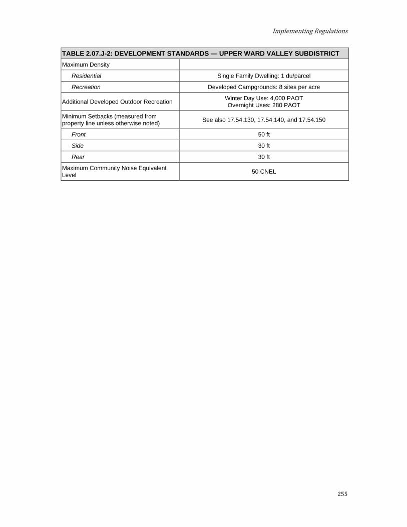
Implementing Regulations
255
TABLE 2.07.J-2: DEVELOPMENT STANDARDS — UPPER WARD VALLEY SUBDISTRICT Maximum Density
Residential Single Family Dwelling: 1 du/parcel
Recreation Developed Campgrounds: 8 sites per acre
Additional Developed Outdoor Recreation Winter Day Use: 4,000 PAOT Overnight Uses: 280 PAOT
Minimum Setbacks (measured from property line unless otherwise noted) See also 17.54.130, 17.54.140, and 17.54.150
Front 50 ft
Side 30 ft
Rear 30 ft
Maximum Community Noise Equivalent Level 50 CNEL

Placer County
256
Tourist Planned Development
A. Granlibakken Subdistrict. The Granlibakken Subdistrict is located partially within the Greater Tahoe City Subarea and partially within the West Shore Subarea. This area should continue as a multi-use tourist-oriented planned unit development.
Special Designations. (See Section 3.14) TDR Receiving Area for:
i. Existing Development
ii. Multi-Residential Units
Preferred Affordable, Moderate, and Achievable Housing Area
Special Policies. a. Development of this area per the CTRPA approved litigation
settlement shall be allowed.
b. Consolidation of undeveloped lots should be encouraged.
c. Provide opportunities for development of a variety of multi-residential housing types with emphasis on affordable, moderate, and achievable housing.
Permissible Uses. The following primary uses may be permitted within all or a portion of the Subdistrict. The list indicates if the use is Allowed (A), subject to an Administrative Review Permit (C), or must be considered under the provisions for a Conditional Use Permit (CUP) or Minor Use Permit (MUP). Existing uses not listed shall be considered nonconforming uses within this Subdistrict. The establishment of new uses not listed shall be prohibited.
TABLE 2.08.A-1: LAND USE REGULATIONS — GRANLIBAKKEN SUBDISTRICT Allowable Land Uses Land Use Permit Add’l Regs.
Residential Employee Housing MUP
Multiple Family Dwelling A
Multi-Person Dwelling A
Single-Family Dwelling MUP
Tourist Accommodation Hotel, Motel and Other Transient Dwelling Units A
Timeshare (Hotel/Motel Design) CUP
Timeshare (Residential Design) CUP
Commercial Eating and Drinking Places CUP
Amusements and Recreation Services CUP
Privately Owned Assembly and Entertainment CUP
Secondary Storage CUP

Implementing Regulations
257
TABLE 2.08.A-1: LAND USE REGULATIONS — GRANLIBAKKEN SUBDISTRICT Public Service
Religious Assembly MUP
Cultural Facilities MUP
Day Care Centers MUP
Local Assembly and Entertainment MUP
Local Post Office A
Local Public Health and Safety Facilities MUP
Pipelines and Power Transmission CUP
Transmission and Receiving Facilities CUP Placer County Code Section 17.56.060.F
Transit Stations and Terminals CUP
Transportation Routes CUP
Threshold-Related Research Facilities MUP
Recreation Day Use Areas A
Participant Sports Facilities A
Sport Assembly MUP
Cross Country Skiing Courses MUP
Group Facilities MUP
Outdoor Recreation Concessions A
Riding and Hiking Trails MUP
Rural Sports MUP
Snowmobile Courses CUP
Resource Management Reforestation A
Sanitation Salvage Cut A
Thinning A
Early Successional Stage Vegetation Management A
Nonstructural Fish Habitat Management A
Nonstructural Wildlife Habitat Management A
Structural Fish Habitat Management A
Structural Wildlife Habitat Management A
Fire Detection and Suppression A
Fuels Treatment A
Insect and Disease Suppression A
Sensitive Plant Management A
Uncommon Plant Community Management A
Erosion Control A

Placer County
258
TABLE 2.08.A-1: LAND USE REGULATIONS — GRANLIBAKKEN SUBDISTRICT Runoff Control A
SEZ Restoration A
Development Standards. Table 2.08.A-2 prescribes the development standards for the Granlibakken Subdistrict.
TABLE 2.08.A-2: DEVELOPMENT STANDARDS — GRANLIBAKKEN SUBDISTRICT Maximum Density
Residential
Single Family Dwelling: 1 du/parcel Multiple Family Dwelling: 15 units per acre Multi-Person Dwelling: 37 persons per acre
Employee Housing: As per the limitations above
Tourist Accommodation
Hotel, Motel and Other Transient Units: With less than 10% of units with kitchens – 40 units per acre
With 10% or more units with kitchens – 15 units per acre Timeshare: As per the limitations set forth in this table
Recreation Group Facilities: 25 people per acre
Building Height TRPA Code of Ordinances Chapter 37
Minimum Setbacks (measured from property line unless otherwise noted) See also 17.54.130, 17.54.140, and 17.54.150
Front 50 ft
Side 30 ft
Rear 30 ft
Maximum Community Noise Equivalent Level 55 CNEL

Implementing Regulations
259
Overlay Districts
A. Town Center Overlay District. The purpose of Town Center Overlay District is to promote environmental redevelopment and provide capacity for transfers of development in accordance with the Regional Plan.
Except as provided in the supplemental limitations in this Section 2.09, all property within the Tahoe City, Kings Beach, and North Stateline Town Center Overlay Districts shall be eligible for all programs in the Regional Plan and Code for Town Centers, including but not limited to: eligibility as receiving areas for transfers of development rights and existing development in accordance with Chapter 51, Banking, Conversion, and Transfers of Development, of the TRPA Code of Ordinances; land coverage provisions for Centers in accordance with Chapter 30, Land Coverage, of the TRPA Code of Ordinances; and development standards for Town Centers in accordance with Chapter 13, Area Plans, of the TRPA Code of Ordinances.
Core Areas. Building Height. Maximum building height within Town Center Core
areas is four stories and 56 feet, subject to the findings listed below.
i. Three- or four-story buildings in Town Centers shall meet findings listed in Section 37.7.16 of the TRPA Code of Ordinances; and
ii. Four-story buildings in Town Centers located between Lake Tahoe and State Highways 28 or 89 shall maintain 35 percent of the site as open view corridors to Lake Tahoe, or if existing development does not comply, increase the width of open view corridors by 10 percent or more.
Transition Areas. Building Height. Maximum building height within Town Center
Transition areas is three stories and 46 feet, subject to the findings listed below.
i. Three- or four-story buildings in Town Centers shall meet findings listed in Section 37.7.16 of the TRPA Code of Ordinances.
b. Sidewalks. Prior to or concurrent with development of projects utilizing Town Center standards, planned sidewalks or multi-use trails shall be installed along the project’s Highway 89, Highway 28 and Highway 267 street frontages, as applicable, and extending off-site to the existing Town Center sidewalk/trail network. Any projects proposed without sidewalk or multi-use trail connections to Town Center Core areas shall be ineligible for Town Center Overlay District standards.
Non-Contiguous Project Area. Projects within the Town Center Overlay District may utilize a non-contiguous project area with TRPA approval. To utilize a non-contiguous project area, all project components shall be located on developed mixed-use land within the Town Center Overlay District and all

Placer County
260
applicable development standards shall apply. Projects using a non-contiguous project area shall not increase the density of land coverage in any portions of the project area that are between SR28 or SR 89 and Lake Tahoe, beyond the limits that would apply to those portions of the project area without the use of a non-contiguous project area. All non-contiguous project areas shall comply with the setbacks within Town Centers.
B. Special Planning Area Overlay Districts
Tahoe City Western Entry Special Planning Area (TCWE-SPA). The purpose of the Tahoe City Western Entry Special Planning Area Overlay District is to promote SEZ restoration along the Truckee River in conjunction with any development utilizing Town Center redevelopment incentives. Property owners shall address the requirements listed below to be eligible for Town Center Overlay District standards. a. Restoration. Projects with Truckee River frontage shall remove
coverage and restore SEZs along the river frontage extending no less than 30 feet from the high water mark. Existing buildings in this area shall be removed or mitigated with additional restoration in other areas. Verified coverage may be relocated to other areas.
b. Public Access. Projects with Truckee River frontage shall provide public access and amenities along the river frontage, concurrent with development, extending no less than 30 feet from the high water mark. Riverfront amenities shall include, but not be limited to, a multi-use public trail extension or relocation connecting with the existing Truckee River Multi-Use Trail. Public trail facilities shall qualify as air quality mitigation in accordance with Section 65.2.4.C, Required Offsets, of the TRPA Code of Ordinances.
Tahoe City River District Special Planning Area (TCGC-SPA). The purpose of the Tahoe City River District Special Planning Area Overlay District is to implement project design requirements that support the conversion of the old SR 89/Fanny Bridge roadway segment from a State Highway to a recreation-oriented County roadway. The design of all projects shall demonstrate compatibility with the long term operational plans for the roadway segment and shall support the evolution of the area into an active, popular location with safety enhancements that encourage primary access by bicycling, walking and transit.
Tahoe City Golf Course Special Planning Area (TCGC-SPA). The purpose of the Tahoe City Golf Course Special Planning Area Overlay District is to promote redevelopment in the Tahoe City Town Center, shared use projects, and accelerated SEZ restoration. Property owners shall address the requirements listed below to be part of a Town Center project site or be eligible for Town Center Overlay District standards.
Restoration. All or part of the special planning area may be included in a Town Center Project Area only if an equal or greater area of disturbed SEZ land is restored prior to or concurrent with development. Fifty percent of the qualifying restoration areas must

Implementing Regulations
261
be within 0.5 mile of the project. The other 50 percent may be located elsewhere in the same hydrologically related area (HRA), as defined by TRPA.
Sidewalks. Continuous public sidewalks or paved multi-use trails between redevelopment sites and existing sidewalks in the Town Center shall be provided.
Truckee River Corridor Special Planning Area (TRC-SPA). The purpose of the Truckee River Corridor Special Planning Area Overlay District is to improve the planning framework for two pockets of industrial and commercial use sites along Highway 89 between Tahoe City and Alpine Meadows. Following adoption of the Area Plan, the County shall develop an updated plan for these sites that recognizes existing industrial and commercial uses and establishes zoning designations and development standards that focus on environmental redevelopment, restoration, and consistency with the Regional Plan Goals and Policies. The plan shall be processed as an Area Plan amendment.
Kings Beach Entry Special Planning Area (KBE-SPA). The purpose of the Kings Beach Entry Special Planning Area Overlay District is to promote integrated development addressing land use, design, circulation, recreation, public services, and natural resources. Coordinated preparation of a Special Plan Area is encouraged and if developed shall be processed as an Area Plan Amendment. At a minimum, property owners shall address the requirements listed below to be eligible for Town Center Overlay District standards.
Sidewalks. Concurrent with or prior to development, continuous sidewalks or paved multi-use trails will be provided between redevelopment sites and existing sidewalks in Kings Beach.
Restoration. Projects shall relocate all development on the site from the 100 year floodplain that includes Griff Creek and shall restore the stream environment. To the extent feasible, projects shall extend coverage removal and restoration activities to other SEZ lands.
Scenic Enhancements. Projects on developed sites shall enhance scenic conditions with relocated or remodeled buildings, landscaping, streetscape improvements, and other site improvements.
North Stateline Special Planning Area (NS-SPA). The purpose of the North Stateline Special Planning Area Overlay District is to maintain the validity of existing plans and development approvals, while encouraging the development of an integrated Town Center plan in coordination with property owners. Coordinated preparation of a Special Plan is encouraged and if developed shall be processed as an Area Plan amendment. At a minimum, property owners shall address the requirements listed below to be eligible for Town Center Overlay District standards. Prior to approval of a Special Plan, provisions in the Regional Plan and this Area Plan that apply to Town Centers shall not be used.
Town Center Plan. A Special Plan shall be prepared and processed as an Area Plan amendment meeting the requirements for Town Centers in Chapter 13, Area Plans, of the TRPA Code of Ordinances

Placer County
262
Gateway Areas
Gateway areas shown on the official zoning map shall be consistent with the Design Guidelines for Gateways (see Subsection 3.09.F).
Implementing Regulations
263
Chapter 3 Area-Wide Standards and Guidelines The standards and guidelines outlined in this Chapter apply to the entire Plan area. The district standards in Chapter 2 supplement these standards for each subdistrict or overlay district.
Permissible Uses
Permissible Uses are defined in Chapter 21 of the TRPA Code of Ordinances. Permissible uses for each zoning subdistrict are outlined in Chapter 2 of these Area Plan Regulations. Additional provisions for accessory dwelling units are outlined below.
Additional Accessory Dwelling UnitsAllowed. In addition to accessory dwelling units (ADU) and junior accessory dwelling units (JADU), or what are referred to as secondary residences by TRPA, permitted as an accessory use by Section 21.3.2.A.1 of the TRPA Code of Ordinances, ADUs and JADUs are also permitted on parcels less than one acre as accessory to a single family dwelling or multi-family dwelling primary use it serves under Section 21.3.2.A.2 of the TRPA Code of Ordinances, as this document, Placer County’s Housing Element, and Placer County’s Zoning Ordinance Section 17.56.200 serve as a TRPA-Certified Local Government Housing Program if the parcel is restricted to prohibit the secondary residence to be converted to a tourist use or utilized as a vacation rental. ADUs and JADUs shall not be considered in calculating single-family or multi-family density, however, shall be considered a Residential Unit subject to the residential allocation and transfer provisions of the TRPA Code of Ordinances. Consistent with the TRPA four-year Area Plan recertification process, the secondary residential unit program shall be evaluated for efficacy and necessary adjustments.
Note: Pursuant to State of California regulations that prevent local jurisdictions from imposing further restrictions on ADUs and JADUs, applicants for all ADU/JADU permits must obtain authorization from both Placer County (in accordance with Placer County Code Section 17.56.200 and California Government Code Sections 65852.2 and 65852.22) and TRPA (in accordance with the Regional Plan, including requirements that the ADU be deed-restricted to affordable, moderate, or achievable housing). Delegated ADU permitting authority may be reassumed by Placer County when/if the State of California and/or TRPA regulations are changed.
Temporary Uses, Structures, and Activities.
Temporary uses, structures, and activities are outlined in Chapter 22 of the TRPA Code of Ordinances (also see Placer County Zoning Ordinance Section 17.56).
Land Coverage
Land coverage limitations are outlined in Chapter 30 of the TRPA Code of Ordinances.
Density
Density within the Town Center Overlay District is outlined in Chapter 13, Area Plans, of the TRPA Code of Ordinances. Additional density standards for each zoning subdistrict are outlined in Chapter 2 of these Area Plan Regulations.

Placer County
264
Density outside Town Centers is outlined in Chapter 31, Density, of the TRPA Code of Ordinances. Additional density standards for each zoning subdistrict are outlined in Chapter 2 of these Area Plan Regulations.
Basic Services
Requirements for basic services are outlined in Chapter 32 of the TRPA Code of Ordinances.
Streetscape and Roadway Design Standards
The Tahoe Basin roadway network primarily consists of State Highways and County roadways. Other roadways in the basin are operated by the U.S. Forest Service, California State Parks, and California Tahoe Conservancy. There are also private roadways which are owned and maintained by private parties.
State Highways within the Plan Area include State Route 28, State Route 267, and State Route 89. State Routes 267 and 89 are the major highways providing access in and out of North Lake Tahoe and State Routes 28 and 89 provide circulation around the western and northern portions of Lake Tahoe within Placer County. Caltrans facilities are designed, operated and maintained by Caltrans in accordance with their current transportation corridor concept reports. However, Caltrans encourages complete street design and is a partner with Placer County where sidewalks are required along a highway.
The majority of roadways in the Plan area are collector and local roadways. Collector roadways collect traffic from local streets towards highways, while local roadways provide direct access to adjacent land uses and collector roadways.
Placer County Department of Public Works and Facilities maintains a Countywide Highway Deficiency Manual to plan for ultimate right-of-way and pavement widths, as well as sidewalk and bicycle lane improvements, for specific County maintained roadways. Table 3.06.A of this section provides planned design characteristics for specific streetscape and roadways to guide future development improvements. Typical street cross sections are provided in this section for public and private development projects in the Plan Area. In addition, the figures below should be referred to for specific pedestrian streetscape improvements planned within the Kings Beach and Tahoe City Town Centers.

Implementing Regulations
265
TABLE 3.06.A: FUTURE STREETSCAPE AND ROADWAY DESIGN CHARACTERISTICS 1
Road Name Segment ROW Width
Paved Width CGS 2
Traffic Index (TI)
Bear Street Highway 28 - Rainbow Avenue 50 32 YES 6.5 Bear Street Rainbow Avenue - Speckled Avenue 50 22 YES 6.5 Beaver Street Highway 28 - Town Center Limit 50 22 YES (W) 6.5 Beaver Street Town Center Limit - End 40 22 NO 6.5 Brockway Vista Avenue Secline Street - Deer Street 40 32 YES 6 Brockway Vista Avenue Coon Street - Chipmunk Street 40 22 NO 6 Brook Avenue Bear Street - Coon Street 40 22 YES 7 Brook Avenue Coon Street - Fox Street 40 22 YES(S) 7 Brook Avenue Fox Street - End 40 22 NO 7 Carnelian Bay Avenue Highway 28 - Highway 267 60 32 NO 7 Cedarwood Drive Village Road - End 60 32 NO 6 Chamonix Road Courchevel Road - End 60 32 NO 6 Chipmunk Street Brockway Vista Avenue - Highway 28 50 32 NO 7.5 Chipmunk Street Highway 28 - Minnow Avenue 50 32 YES 7.5 Chipmunk Street Minnow Avenue - Salmon Avenue 50 22 YES(W) 7.5 Chipmunk Street Steelhead Avenue - Speckled Avenue 50 22 YES 7.5 Coon Street Brockway Vista - Trout Avenue 50 32 YES 6.5 Coon Street Trout Avenue - Speckled Avenue 50 22 YES 6.5 Courchevel Road Ward Creek Boulevard - End 60 32 NO 6 Cutthroat Avenue Wolf Street - Fox Street 40 22 YES(N) 6.5 Cutthroat Avenue Fox Street - Beaver Street 40 22 NO 6.5 Deer Street Highway 28 - Rainbow Avenue 50 32 YES(E) 6 Deer Street Rainbow Avenue - Steelhead Avenue 50 22 YES(W) 6 Deer Street Steelhead Avenue – Speckled Avenue 50 22 NO 6 Dolly Varden Avenue Highway 267 - Fox Street 40 22 YES(S) 6 Dolly Varden Avenue Fox Street - Chipmunk Street 40 22 NO 6 Fabian Way Highway 28 - Old Mill Road 60 32 NO 6.5 Fairway Drive Highway 89 - Grove Street 60 32 YES(E) 6.5 Fox Street Highway 28 - Brook Avenue 50 32 YES 6.5 Fox Street Brook Avenue - Trout Avenue 50 22 YES(W) 6.5 Fox Street Trout Avenue – Steelhead Avenue 50 22 YES(E) 6.5 Fox Street Steelhead Avenue – Speckled Avenue 50 22 NO 6.5 Golden Avenue Secline Street - Fox Street 40 22 YES(S) 6 Golden Avenue Fox Street - End 40 22 NO 6 Grand Avenue Highway 89 - Alpine Avenue 60 32 NO 6 Granlibakken Road Highway 89 - Town Center Limit 60 32 YES 6.5 Granlibakken Road Town Center Limit - End 60 32 NO 6.5 Grove Street Highway 28 - Fairway Drive 60 32 YES(S) 6.5 Gstaad Road Courchevel Road - End 60 32 NO 6

Placer County
266
TABLE 3.06.A: FUTURE STREETSCAPE AND ROADWAY DESIGN CHARACTERISTICS 1
Road Name Segment ROW Width
Paved Width CGS 2
Traffic Index (TI)
Heather Lane Polaris Road - Cedarwood Drive 60 32 NO 6 Highlands Drive Country Club Drive - End 60 32 NO 6 Innsbruck Road Courchevel Road - End 60 32 NO 6 Kitzbuehl Road Courchevel Road - End 60 32 NO 6 Lake Forest Road Highway 28 - Highway 28 60 32 NO 6.5 Loch Levon Avenue Deer Street - Fox Street 40 22 YES(S) 6 Loch Levon Avenue Fox Street - End 40 22 NO 6 McKinney Drive Highway 89 - Highway 89 60 32 NO 5.5 McKinney Rubicon Highway 89 - End 60 32 NO 6.5 Merdan Road Gstaad Road - End 60 32 NO 6 Minnow Avenue Fox Street - Chipmunk Street 40 22 YES(S) 6 N. National Avenue Highway 267 - End 60 32 NO 7 National Avenue Highway 28 - End 60 32 NO 7 Old County Road Highway 28 - Forest Road 60 32 NO 6 Old Mill Road Highway 28 - Polaris Road 60 32 NO 6.5 Pineland Drive Highway 89 - Twin Peaks Road 60 32 NO 6 Polaris Road End - End 60 32 NO 6 Rainbow Avenue Secline Street - Bear Street 40 32 YES(S) 6.5 Rainbow Avenue Bear Street - Fox Street 40 22 YES(S) 6 Rainbow Avenue Fox Street - End 40 22 NO 6 Regency Way N. National Avenue - End 60 32 NO 6 Salmon Avenue Coon Street - Fox Street 40 32 YES 6.5 Salmon Avenue Fox Street - Chipmunk Street 40 22 YES(S) 6 Secline Street Brockway Vista Avenue - Highway 28 50 32 YES(W) 6.5 Secline Street Highway 28 - Rainbow Avenue 50 32 YES(W) 6.5 Secline Street Rainbow Avenue - Steelhead Avenue 50 22 YES 6.5 Speckled Avenue Highway 267 - Fox Street 50 40 YES 7 Speckled Avenue Fox Street - Chipmunk Street 40 22 NO 6.5 Steelhead Avenue Secline Street - Deer Street 40 32 YES(N) 6.5 Steelhead Avenue Deer Street - Fox Street 40 22 YES(N) 6 Steelhead Avenue Fox Street - End 40 22 NO 6 Tahoe Street Grove Street - Jackpine Street 40 32 YES(S) 6 Trout Avenue Deer Street - Bear Street 40 32 YES 6.5 Trout Avenue Bear Street - Fox Street 40 22 YES(S) 6 Trout Avenue Fox Street - End 40 22 NO 6 Twin Peaks Road Pineland Drive - Ward Creek Boulevard 60 32 NO 6 Ward Creek Boulevard Twin Peaks Road - Courchevel Road 60 32 NO 6 Wolf Street Dolly Varden Avenue - Speckled Avenue 50 22 YES 6.5 Zermatt Road End - End 60 32 NO 6 Notes:
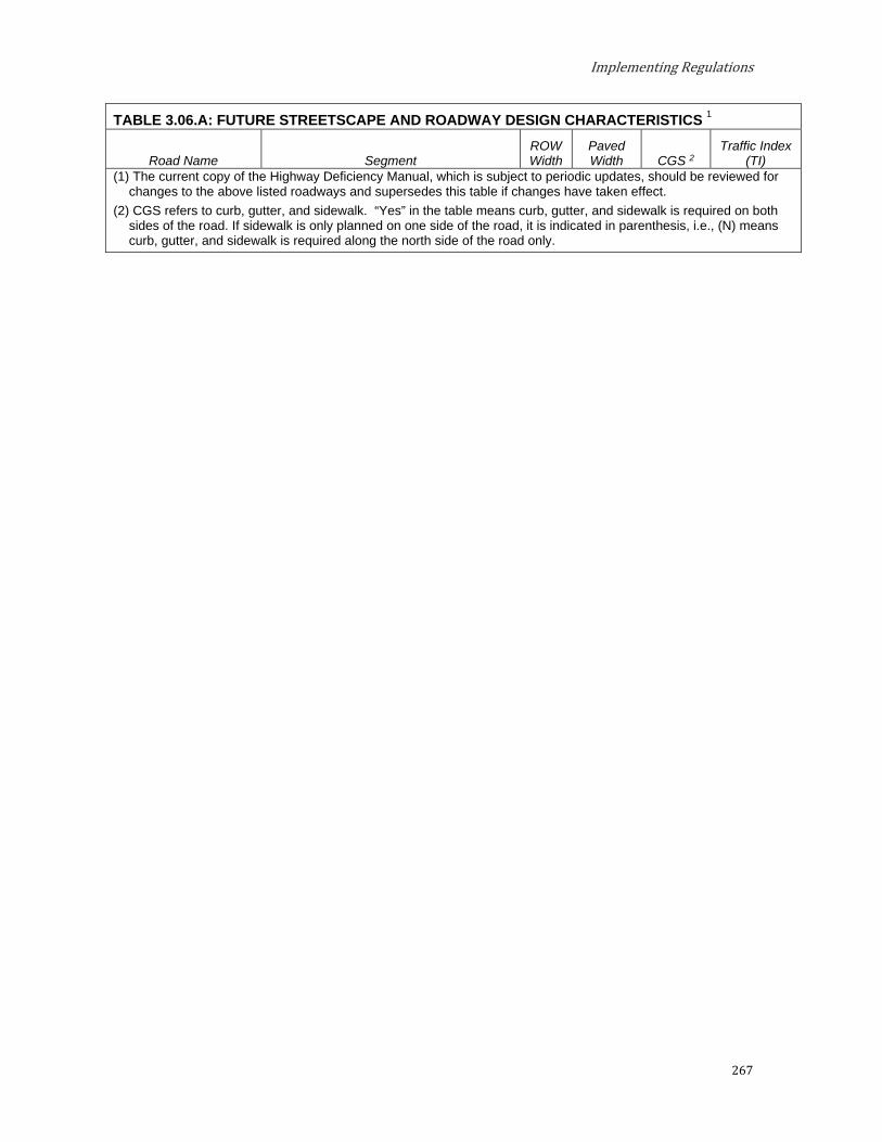
Implementing Regulations
267
TABLE 3.06.A: FUTURE STREETSCAPE AND ROADWAY DESIGN CHARACTERISTICS 1
Road Name Segment ROW Width
Paved Width CGS 2
Traffic Index (TI)
(1) The current copy of the Highway Deficiency Manual, which is subject to periodic updates, should be reviewed for changes to the above listed roadways and supersedes this table if changes have taken effect.
(2) CGS refers to curb, gutter, and sidewalk. “Yes” in the table means curb, gutter, and sidewalk is required on both sides of the road. If sidewalk is only planned on one side of the road, it is indicated in parenthesis, i.e., (N) means curb, gutter, and sidewalk is required along the north side of the road only.
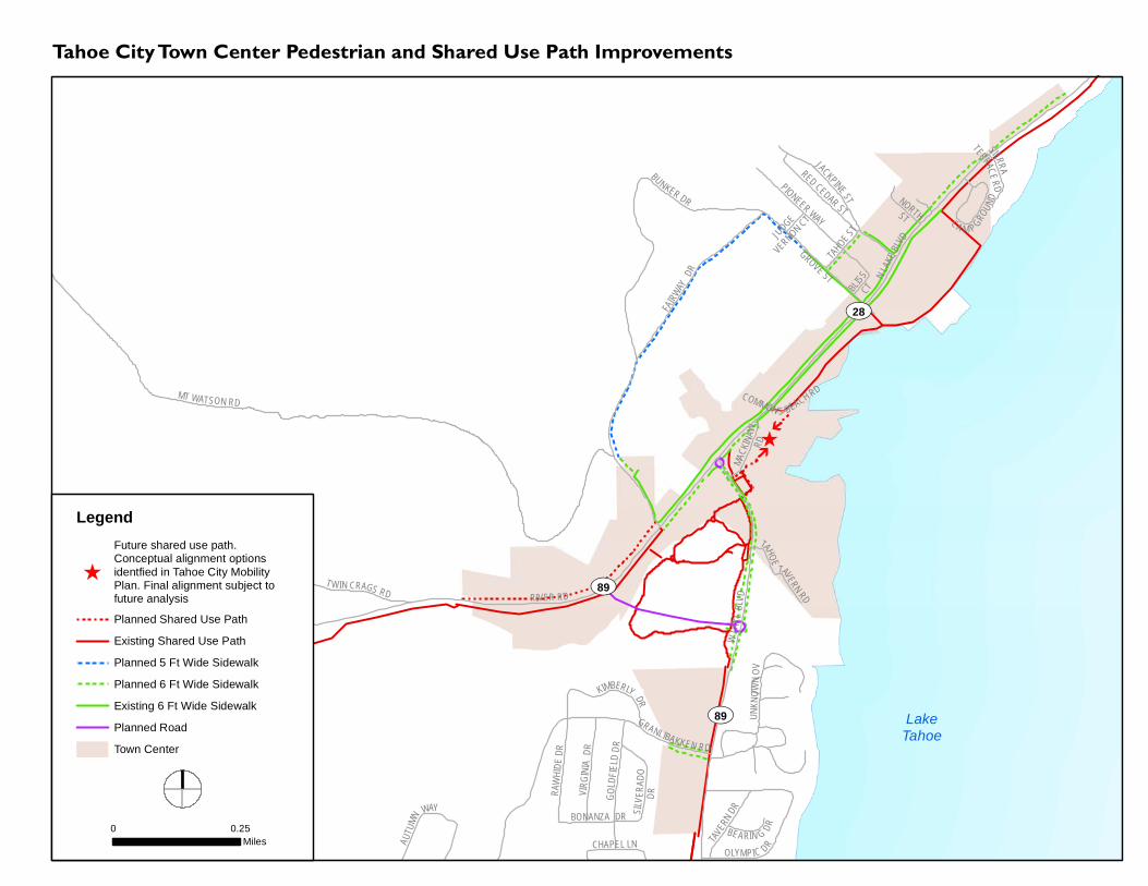
!
!
!
!
!
!
!
!
!
!
!
!
!
!
!
!
!
!
!
!
!
!
!
!
!
!
!
!
!!
!
!
!
!
!
!
!
!
!
!
!
!
!!
!
!
!
!
!
!
!
!
!
!
!
!
!
!
!
!
!
!
!
!
!
!
!
)
UV89
aa
UV28
UV89
TAHOE ST
UNKN
OWN O
V
GRANLIBAKKEN RD
JACKPINEST
GROVE ST N LAKE BLV
D
BLISS
CT
JUDGEVERNON CT
BONANZA DR
COMMON S BEACH RDMT WATSON RD
TAHOE
TAVERN RD
PIONEER WAY
TAVER
N DR
BEARIN G DR
RIVER RD
RAWH
IDE DR
VIRGIN
IA DR
TWIN CRAGS RD
WLA
KEBLV
D
OLYMPIC DR
GOLD
FIELD
DR
CHAPEL LN
NORTHST
SIERRA
TERRACERD
MACK
INAW
RD
FAIRW
AYDR
SILV E
R ADO
DR
AUTU
MN
WAY
RED CEDAR STCA M P GRO
UND
KIMBERLY DRBUNKER DR
Tahoe City Town Center Pedestrian and Shared Use Path Improvements
0 0.25Miles
Legend
)
Future shared use path.Conceptual alignment optionsidentfied in Tahoe City MobilityPlan. Final alignment subject tofuture analysis
Planned Shared Use Path
Existing Shared Use Path! ! Planned 5 Ft Wide Sidewalk! ! Planned 6 Ft Wide Sidewalk
Existing 6 Ft Wide Sidewalk
Planned Road
Town Center
LakeTahoe

!
!
!
!
!
!
!
!
!!
!
! !
! !
! ! !
! ! !
! ! !
! ! !
! ! !! ! !
! ! ! ! ! !
! ! ! ! ! ! ! ! !! ! !
!!
!
!!
!!
!!
!!
!!
! ! !
!!
!
! !
!
! !
!
!!
!
! ! !
! ! !
! ! !
! ! !
! ! !
! ! !
! ! !
! ! !
! ! !
!!
!!
!!
!!
!!
!!
!
!!
!
! ! !
! ! !
!!
! !
! ! !
! !
!!
!
!
!
!!
! !
! ! !
! ! ! !
!
!!
!
! !
! !
!!
!!
! !
!!
!!
!!
!
!
!!
!
!
!
!!
!!
!
!!
!!
!!
!!
!!!
!!
!!
!!
!
___ª
f
f
PELICAN DR
Loop TrailGRIFF LN
CHURCH
BEACH CT
DEER
ST
FOX S
T
BEAR
ST
SALMON CT
WOLF
ST
COON
ST
ISLET AVE CAL NEVA DR
BASS AVE
BEAC
H ST
COVE AVE
TIGER AVE
WAVE A VE
CHIPM UNK ST
LOCH LEVON AVE
LAKE VISTA DR
STEELHEAD AVE
BROOK AVE
NORTH AVE
TROUT AVE
RAINBOW AVE
GOLDEN AVE
DOLLY VARDEN AVE
CUTTHROAT AVESPECKLED AVE
SALMON AVE
MINNOW AVE
PARK LN
BROCKWAY SPRINGS
DR
NORT
HSHO
REBL
VDBEND AVE
N LAKEBLVD
BROCKWAY VISTA AVE
BEAVER ST
BROCKWAY VISTAAVE
SECL
INE ST
WASH
OECO
UNTY
CHIPM
UNK ST
UV28
UV267
Kings Beach Town Center Pedestrian and Shared Use Path Improvements
0 0.25Miles
LegendPlanned Shared Use PathExisting Shared Use Path
! ! Planned 5 Ft Wide SidewalkExisting 5 Ft Wide Sidewalk
! ! Planned 6 Ft Wide SidewalkExisting 6 Ft Wide Sidewalk
_ Future Path Connection
ª Planned Pedestrian Crossing
Town CenterIndustrial Area
LakeTahoe

Placer County
270
The standards presented in this section supplement the standards presented in previous sections of the Area Plan. If there is a conflict with the earlier sections, the standards of this section shall apply.
Projects subject to the requirements of this section shall be conditioned to meet the following standards where applicable.
A. Projects fronting public right-of-ways within the Plan area shall be required to construct frontage improvements as follows:
(1) Required ultimate pavement half-section as shown in Table 3.06.A and / or in accordance with the County’s Land Development Manual standards and Highway Deficiency Manual, or as otherwise determined by Placer County.
(2) Five foot wide or six foot wide concrete sidewalks, as determined by land use. Non-residential uses such as commercial, industrial, recreational, multi-family residential, and uses other than single family residential shall provide six foot wide sidewalks and single-family residential subdivision projects shall provide five foot wide sidewalks, or as otherwise determined by Placer County. Where space allows, detached sidewalks or multi-use paths shall be provided in-lieu of sidewalks attached to the back of curb in order to separate users from the vehicular travel way.
(3) Landscaping that also provides stormwater best management practices (such as bioswales) in setback areas.
(4) Rolled concrete curb and gutter, or as required by Placer County based on project location. Vertical curb may be specified for straight segments along industrial area roadways. Not all roads will have curb and gutter but may have a different type of road side drainage conveyance such as a stabilized roadside ditch or other County approved drainage feature, as determined by Placer County.
(5) To the extent possible, both sidewalk and water quality features (such as a rock-lined ditch where existing or planned as part of a County water quality improvement project) shall be provided along the project frontage where sufficient right-of-way is available.
B. The following figures and text display the design standards which are to be applied within the Placer County Tahoe Basin Area Plan. Specific standards may be established by the Placer County Community Development Resource Agency - Engineering and Surveying Division, Department of Public Works and Facilities, or approved areawide improvement plans.
(1) 22-Foot Paved Roads Typical Cross Section (No parking): Two 11' wide travel lanes, concrete rolled curb and gutter, 5’ or 6’ wide sidewalks on one or both sides, lighting and landscaping.
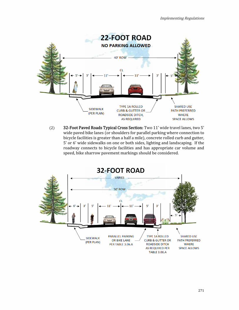
Implementing Regulations
271
(2) 32-Foot Paved Roads Typical Cross Section: Two 11’ wide travel lanes, two 5’
wide paved bike lanes (or shoulders for parallel parking where connection to bicycle facilities is greater than a half a mile), concrete rolled curb and gutter, 5’ or 6' wide sidewalks on one or both sides, lighting and landscaping. If the roadway connects to bicycle facilities and has appropriate car volume and speed, bike sharrow pavement markings should be considered.

Placer County
272
(3) 40-Foot Paved Roads Typical Cross Section: Two 10’ wide travel lanes, two 5’ wide paved bike lanes, two 5’ wide paved shoulders for parallel parking, concrete rolled curb and gutter, and 5’ or 6’ wide sidewalks on one or both sides. 1
____________________________ 2 Future conditions could include cycle track or Class IV bicycle facility with pavement striping and roadway alterations.

Implementing Regulations
273
Parking and Access
This section supersedes Chapter 34, Driveway and Parking Standards, of the TRPA Code of Ordinances.
Off-street parking is required for all projects. Each site is expected to accommodate its customer and employee parking needs on site. In some cases, exceptions may be made and parking credit given for projects that participate in and contribute towards community parking facilities. Parking should be safe and accessible, with a simple layout that is readily understood by the driver. On-site parking should be designed and located so that it does not dominate the development. Parking in excess of that required to adequately serve a project is discouraged in order to avoid unnecessary auto use, extraneous impervious cover, and visual impact.
A. Parking. To ensure adequate parking facilities for uses in the region, Placer County and TRPA shall use the following standards and procedures to determine parking requirements:
Parking Facility Defined. A parking facility is a clearly identifiable location for vehicular parking. A parking facility may be a parking area, parking lot, or parking structure.
Compliance Program. The provisions set forth in subsections 3 through 10, inclusive, shall apply to projects which involve new or expansion of existing development that creates a demand for parking, including recreation and public service projects. Projects not involving new or expansion of existing development may have the provisions in 3, 4, 5, 6, and 7 required as conditions of approval, if Placer County and TRPA find that the resultant situation would otherwise cause or continue to cause significant adverse impacts on traffic, transportation, air quality, or water quality.
Parking Demand. Placer County shall adopt and maintain a parking demand table (Table 3.07.A-1: Parking Spaces Required) for the purpose of estimating the minimum and maximum parking demand of uses in the Area Plan. In lieu of the parking demand table, an applicant may submit for TRPA and County approval a technically adequate parking analysis. When parking demand for a use is calculated to a fraction, the fraction shall be rounded up to the nearest whole number if 0.5 or greater, and rounded down if 0.49 or less.
TABLE 3.07.A-1: PARKING SPACES REQUIRED
Use Required Number of Parking Spaces Light Industrial/Wholesale/Storage
Batch Plant Determined by Use Permit
Food and Kindred Products 1.1 per 1,000 sq.ft.

Placer County
274
TABLE 3.07.A-1: PARKING SPACES REQUIRED
Use Required Number of Parking Spaces Fuel and Ice Dealers 3.33 per 1,000 sq.ft. retail/office area
Industrial Services 1.1 per 1,000 sq.ft.
Printing and Publishing 1.1 per 1,000 sq.ft.
Recycling and Scrap Determined by Use Permit
Small-Scale Manufacturing 1.1 per 1,000 sq.ft.
Storage Yards 1 per peak employee
Vehicle and Freight Terminals 1 per peak employee
Vehicle Storage and Parking 2 per 1,000 sq.ft. non-storage area and 1 per 1,000 sq.ft. of storage area
Warehousing .8 per 1,000 sq.ft.
Wholesale Distribution .8 per 1,000 sq.ft.
Recreation, Education, and Public Assembly Uses Beach Recreation Determined by Use Permit
Boat Launch Facilities 1 per peak employee and .75 car/trailer spot per anticipated daily launch user
Cross Country Skiing Courses 1 per every 3 day users
Day Use Areas 1 per every 3 day users
Developed Campgrounds 1 per peak employee and 1.1 per campsite
Downhill Ski Facilities 1 space per every 3 day users and .5 per peak employee
Golf Course 9.8 per hole
Group Facilities Determined by Use Permit
Marinas 1 per peak employee and .33 per mooring or slip
Off-Road Vehicle Course Determined by Use Permit
Outdoor Recreation Concession Determined by Use Permit
Participant Sports (facilities) 1 per peak employee and 2 per 1,000 sq.ft.
Recreation Center 3.2 per 1,000 sq.ft.
Recreational Vehicle Park 1 per peak employee and 1.1 per campsite
Riding and Hiking Trails Determined by Use Permit
Rural Sports 1 space per every 3 day users
Snowmobile Courses 1 space per every 3 day users and .5 per peak employee
Sport Assembly .33 per seat
Undeveloped Campgrounds None
Visitor Information Center 6 per 1,000 sq.ft.
Residential Uses Employee Housing .6 per bed and 1 per live-in employee
Mobile Home Dwelling 2.17 per unit
Multi-Family Dwelling 1 per bedroom for first two bedrooms and .5 per additional bedroom
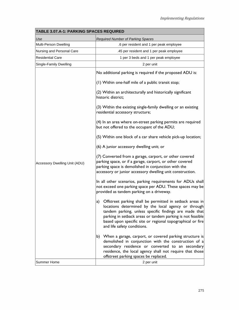
Implementing Regulations
275
TABLE 3.07.A-1: PARKING SPACES REQUIRED
Use Required Number of Parking Spaces Multi-Person Dwelling .6 per resident and 1 per peak employee
Nursing and Personal Care .45 per resident and 1 per peak employee
Residential Care 1 per 3 beds and 1 per peak employee
Single-Family Dwelling 2 per unit
Accessory Dwelling Unit (ADU)
No additional parking is required if the proposed ADU is:
(1) Within one-half mile of a public transit stop;
(2) Within an architecturally and historically significant historic district;
(3) Within the existing single-family dwelling or an existing residential accessory structure;
(4) In an area where on-street parking permits are required but not offered to the occupant of the ADU;
(5) Within one block of a car share vehicle pick-up location;
(6) A junior accessory dwelling unit; or
(7) Converted from a garage, carport, or other covered parking space, or if a garage, carport, or other covered parking space is demolished in conjunction with the accessory or junior accessory dwelling unit construction.
In all other scenarios, parking requirements for ADUs shall not exceed one parking space per ADU. These spaces may be provided as tandem parking on a driveway.
a) Offstreet parking shall be permitted in setback areas in locations determined by the local agency or through tandem parking, unless specific findings are made that parking in setback areas or tandem parking is not feasible based upon specific site or regional topographical or fire and life safety conditions.
b) When a garage, carport, or covered parking structure is demolished in conjunction with the construction of a secondary residence or converted to an secondary residence, the local agency shall not require that those offstreet parking spaces be replaced.
Summer Home 2 per unit

Placer County
276
TABLE 3.07.A-1: PARKING SPACES REQUIRED
Use Required Number of Parking Spaces Retail and Entertainment
Amusement and Recreation Services Determined by Use Permit
Auto, Mobile Home, and Vehicle Dealers 1 per peak employee and 2 per 1,000 sq.ft. of sales area
Building Materials and Hardware 3 per 1,000 sq.ft., including outdoor sales area
Eating and Drinking Places 10 per 1,000 sq.ft. or .25 per customer or seat (whichever is higher)
Food and Beverage Retail Sales 5 per 1,000 sq.ft.
Furniture, Home Furnishings and Equipment
2 per 1,000 sq.ft. of non-storage area and 1 per 1,000 sq.ft. of storage area
General Merchandise Stores 3.33 per 1,000 sq.ft.
Mail Order and Vending 2 per 1,000 sq.ft. of non-storage area and 1 per 1,000 sq.ft. of storage area
Nursery 1 per 1,000 sq.ft. of non-storage area and 1 per 1,000 sq.ft. of storage area
Outdoor Amusements 1 per every 3 day users
Outdoor Retail Sales 1 per peak employee and 2 per 1,000 sq.ft. of storage area
Privately Owned Assembly and Entertainment 6.66 per 1,000 sq.ft. or 1 space per 3 seats, whichever is greater
Service Stations 3.33 per 1,000 sq.ft. retail/office area and 4 per service bay
Public Services Airfields, Landing Strips, and Heliports Determined by Use Permit
Cemeteries 1 per peak employee
Collection Stations 2 per 1,000 sq.ft. of non-storage area and 1 per 1,000 sq.ft. of storage area
Cultural Facilities 4.2 per 1,000 sq.ft.
Day Care Centers/Pre-Schools 1 per peak employee and .3 per child capacity
Government Offices 4 per 1,000 sq.ft.
Hospitals 7.35 per bed
Local Assembly and Entertainment 6.66 per 1,000 sq.ft. or 1 space per 3 seats, (whichever is higher)
Local Post Offices 6 per 1,000 sq.ft.
Local Public Health and Safety Facilities 1 per peak employee and 1 per 1,000 sq.ft.
Membership Organizations 3.33 per 1,000 sq.ft.
Power Generating Determined by Use Permit
Public Utility Centers 1 per peak employee
Publicly Owned Assembly and Entertainment 6.66 per 1,000 sq.ft. or 1 space per 3 seats, whichever is greater
Regional Public Health and Safety Facilities 1 per peak employee and 1 per 1,000 sq.ft.

Implementing Regulations
277
TABLE 3.07.A-1: PARKING SPACES REQUIRED
Use Required Number of Parking Spaces Religious Assembly .25 per permitted capacity
Schools – College .4 total student population (students, faculty, staff)
Schools – Kindergarten thru Secondary .25 per students (K – Grade 8) and .3 per student (Grate 9 – 12)
Social Service Organizations 3 per 1,000 sq.ft.
Threshold-Related Research Facilities 3.33 per 1,000 sq.ft.
Service Uses Animal Husbandry 4 per 1,000 sq.ft. of outdoor kennel
Auto Repair and Service 3.33 per 1,000 sq.ft. of retail/office area and 4 per service bay
Broadcasting Studios 3.33 per 1,000 sq.ft.
Business Support Services 3.33 per 1,000 sq.ft.
Contract Construction Services 3.33 per 1,000 sq.ft.
Financial Services 4 per 1,000 sq.ft.
Health Care Services 5 per 1,000 sq.ft.
Laundries and Dry Cleaning Services 2 per 1,000 sq.ft. of non-storage area and 1 per 1,000 sq.ft. of storage area
Personal Services 4 per 1,000 sq.ft.
Professional Offices 3.5 per 1,000 sq.ft.
Repair Services 2 per 1,000 sq.ft. of non-storage area and 1 per 1,000 sq.ft. of storage area
Sales Lots 1 per peak employee and 2 per 1,000 sq.ft. of sales area
Schools – Business and Vocational 13.33 per 1,000 sq.ft. and 1 per peak employee
Secondary Storage 1 per 1,000 sq.ft. storage area
Tourist Accommodation Bed and Breakfast Facility 1 per bedroom and 1 per peak employee
Hotel, Motel and Other Transient Dwelling Units
1 per hotel or motel unit/room, .25 spaces per additional bedroom above the initial unit/room; 4 per 1,000 sq.ft. of meeting/conference
area; and 1 per 1,000 sq.ft. of commercial/retail area over 1,000 sq.ft.
Timeshare (hotel/motel design) 1.25 per unit for first bedroom and .25 per add’l bedroom in unit
Timeshare (residential design) 1.25 per unit for first bedroom and .25 per add’l bedroom in unit
Linear Public Facilities Pipelines and Power Transmission None
Transit Stations and Terminals Determined by Use Permit
Transmission and Receiving Facilities None
Transportation Routes None

Placer County
278
Parking Analysis. A parking analysis shall include:
A parking demand estimate;
Proposed alternatives to the parking standards;
A scaled site plan showing proposed parking spaces with the required stall dimensions and parking lot drive aisle widths;
Methods of ensuring compliance with the alternative standards; and
Any additional information that may be required.
General Standards. Adequate on-site parking to meet the parking demand of a use shall be provided within the project area.
Single-Family Houses, Including Accessory Dwelling Units. Parking spaces within a driveway, a garage, or carport shall be considered in determining the adequacy of parking facilities for single-family houses, including accessory dwelling units. Stacked parking may occur.
Other Residential Uses. Only designated parking spaces and one parking space per unit within a garage shall be considered in determining the adequacy of parking facilities for residential uses other than a single-family residence. Stacked parking may occur for no more than two vehicles.
A minimum driveway length of 20 feet shall be provided from the face of the garage to back of sidewalk, or back of curb where there is no sidewalk or edge of travel way where there is no sidewalk or curb, to be considered as a parking space.
Multiple Uses. If two or more uses share a project area, the parking demand of each use shall be calculated separately. The parking demand of the project area shall be the total of the parking demand of the uses, unless exempted otherwise pursuant to the provisions of this section.
Fleet Vehicles. Tourist accommodation, commercial, public service, and recreation uses shall provide one parking space for each business or fleet vehicle.
Shared Parking. Shared parking is the use of a parking facility, or portion of a parking facility, by two or more uses. Placer County and TRPA may approve shared parking facilities, provided the applicants execute and record reciprocal agreements for shared parking and they make the following findings:
i. The uses have different peak period; and
ii. The parking facility will meet the peak shared demand.
Town Center Parking. Until a fee in-lieu of constructing all required parking spaces or other parking management program is in effect, the Placer County Design Review Committee may approve a 20-percent
Implementing Regulations
279
reduction in the amount of required parking for mixed-use, retail, transient lodging, and restaurant projects/uses within a Town Center.
Parking Reduction for Transit. Outside Town Centers, parking requirements for uses other than single-family dwellings may be reduced up to 20 percent if a traffic analysis indicates transit service exists within 300 feet of the property and such a substitute measure would be a viable substitute for parking.
Service Parking. All uses shall address how service deliveries will be accommodated. Such parking shall not conflict with snow removal operations, shall not conflict with traffic flows, and should have unrestricted access.
Parking Maximum. Ten percent over parking minimum is the maximum number of parking allowed on a site. The maximum value assures that excessive parking leading to excess auto use is not provided.
Parking for Outdoor Dining. For restaurants, areas used for snow storage in winter may be striped and counted towards parking required for summertime unenclosed patio dining areas (outdoor seating).
Bicycle Parking. In order to encourage non-auto travel, short-term bicycle parking spaces shall be provided for all Commercial, Tourist Accommodation, Industrial, Multi-family Residential, Recreation, and Public Service land uses.
i. Parking Spaces Required. The number of short-term bicycle parking spaces should be at least 10 percent of the number of required automobile parking spaces, with a minimum of two spaces per property.
ii. Location. Bicycle parking should be visible from the street or from the main building entrance, or a sign must be posted at the main driveway or entrance indicating the location of bicycle parking. Bicycle parking shall be located outside of the public right-of-way, except as allowed with an encroachment permit and provided an unobstructed sidewalk clearance of six feet is maintained for pedestrians at all times.
iii. Anchoring and Security. For each bicycle parking space required, a stationary, securely anchored object shall be provided to which a bicycle frame and one wheel can be secured with a lock. Any required short-term bicycle parking provided shall be provided free of charge.
iv. Bicycle Parking Stations. Property owners may cooperate to install a bicycle parking station, defined as a structure designed for use as a bicycle parking facility. Such a facility, when within 1,320 feet of the uses served, may furnish required long-term bicycle parking in lieu of site-by-site compliance.

Placer County
280
Off-site Parking. Off-site parking shall not be considered in determining the adequacy of parking facilities except as follows:
Temporary Uses. Off-site parking requirements will be determined through the application approval process by the Design Review Committee. If required, parking may be permitted for a temporary use on the basis of an approved parking analysis approved by the Design Review Committee and TRPA.
Deed Restrictions. Based upon an approval of a parking analysis, Placer County and TRPA may approve off-site parking provided an appropriate deed restriction is recorded, which documents the relationship of the two parcels and identified the term of the agreement to allow for the off-site parking.
Assessment Districts. Placer County and TRPA may approve off-site parking, which is provided pursuant to an assessment district for which a parking analysis is prepared.
Locations. Locations for off-site parking facilities may be approved by Placer County or TRPA if the agencies find that the off-site parking will not violate other applicable standards. Parking credited for meeting parking standards shall be located within 400 feet of the facility it serves or shall be directly served by a shuttle during the hours of operation.
On-Street Parking. Except when included in an assessment district, on-street parking shall not be considered in determining the adequacy of parking facilities. On-street parking along State or federal highways shall be reduced or eliminated to the extent feasible. Where on-street parking cannot be removed, TRPA may request state and local agencies to implement on-street parking restrictions in designated areas for specific times.
Assessment District Standards. Exceptions to the parking standards in this section may be approved pursuant to an assessment district's approved parking plan. It is assumed that any parking provisions pursuant to an approved parking analysis, in an assessment district, are superior to the application of the parking demand table.
Parking Facility Design Standards. Parking facilities shall be designed to provide the required parking spaces within a minimum amount of area. Parking facilities shall minimize coverage and minimize impacts on water quality and meet the following standards:
All off-street parking shall be located on the same property as the major land use it is intended to serve, unless located within a community parking district or a shared parking arrangement has been established, which is preferred.
All maneuvering shall be accomplished on-site to provide ability to enter any public or private road in a forward direction. With the exception of single-family residences, backing out onto a street is not allowed.
Implementing Regulations
281
Parking and loading areas are to be paved, graded, and drained according to the Placer County Land Development Manual and the current County General Specifications.
Striping of parking spaces, identification of compact spaces, handicapped parking, and loading areas is required.
The size of a standard parking space is nine feet in width and 20 feet in length. Length can be reduced by up to two feet where the space abuts a curb.
Up to 20 percent of the parking requirement may be developed as compact car spaces, eight feet by 16 feet in size.
Parking layout design should provide 24-foot minimum aisle widths (for 90-degree parking layouts) and turning radii that complies with County standards.
Parallel parking design on State highways and County roads at or near pedestrian crosswalks and driveway encroachments should be analyzed to provide appropriate sight distance to facilitate safe multi-modal use of the roadway.
A minimum setback of 30 feet shall be provided between the edge of travel lane of the adjacent street and the first parking space or cross aisle in the parking lot where the total two-way traffic volume on the adjacent street exceeds 5,000 vehicles per day except as defined within Town Centers below. This limits the 30 foot setback requirement to those locations where there is a reasonable possibility of an inbound traffic queue formed by a parking maneuver in the first space that could noticeably impede traffic or cycling on the adjacent roadway. At all other commercial or public lots, the minimum driveway length shall be 20 feet from the edge of travel lane to the first parking space.
Within Town Centers, a minimum setback of 20 feet shall be provided between the edge of travel lane of the adjacent highway or street except a minimum setback of 10 feet shall apply for the “exit only” condition on a State highway or County road. If parcel configuration allows, access and parking circulation should be designed for ingress from a County road and egress onto the State highway.
Exceptions. The following are specific exceptions to the above standards:
Placer County and TRPA may permit deviations to the parking standards on the basis of an approved parking analysis prepared pursuant to Section A.4 above.
For single-family residences, Placer County and TRPA may count each space within a garage or carport as a parking space if a reduced setback is allowed.
Placer County and TRPA may permit deviation from the parking standard if they find that:
Placer County
282
i. There is an existing residential use, other than single-family houses, or an existing tourist accommodation, commercial, public service, or recreation use;
ii. There are existing parking facilities;
iii. The proposed use does not increase, or reduces, parking demand; and
iv. It is not feasible to increase the parking capacity in the project area to the level otherwise required.
For projects proposed on parcels within Town Centers and fronting the State highway, parking requirements that apply within Section 3.08 Parking and Access can be voluntarily waived for a period of ten years from the date of approval of the Area Plan. Waivers may be granted beyond ten years from the date of approval of the Area Plan on a case by case basis, as approved by the County Department of Public Works and Facilities. Waivers may not be granted for residential or tourist accommodation uses; and the County reserves the right to also consider excluding sit down restaurants from the waiver on a case by case basis. Waivers may only apply to projects that include all of the following:
i. The entire project site is 25,000 square feet or less. Separate projects by applicant, but with adjoining parcels, will be treated as one and the same project for the purposes of the waiver.
ii. The project does not include residential or tourist accommodation units. The County reserves the right to also consider excluding sit down restaurants from the waiver on a case by case basis.
ii. Properties with onsite parking will agree to parking by non-business patrons during peak periods in the Town Centers.
iii. The project annexes into an existing or forms a new Zone of Benefit under the County’s Community Service Area (CSA) Zone of Benefit to contribute to transit service enhancements. thru payment of An annual transit in-lieu fee will be assessed with associated property tax statements and payment will be due subject to property tax bill requirements. The amount of the transit in-lieu fee will assessment, to be determined by the County Public Works and Facilities Department, and will be consistent with the goals and objectives within the Placer County TART Systems Plan.
After the 10 year waiver period (or as extended), a parking in-lieu fee program may be considered which will take the place of the transit in-lieu assessment. At such time, properties being assessed a transit in-lieu fee will be given the option to continue with the transit assessment or pay a

Implementing Regulations
283
parking in-lieu on-time fee, based on an approved parking in-lieu program.
Parking for Disabled Persons. The County requires that access be provided in accordance with the Uniform Building Code and State Title 24 Regulations for person with disabilities. No recommendation contained in this section will replace or supersede any federal, State, or local requirements for the provision of accessible parking for the disabled.
Standards. The following standards apply to parking intended for disabled persons:
i. Handicapped spaces must be safe and usable and the maximum slope of such spaces may need to be less than that permitted by code.
ii. Parking spaces shall be 14 feet wide and 20 feet in length, and clearly marked, both on the pavement and with a sign displaying the International Symbol of Accessibility.
iii. The number of parking spaces provided shall be as per Placer County requirements.
Guidelines.
i. Parking spaces should be located as near as possible to the building entrance, preferably no more than 100 feet away.
ii. The parking spaces should be located so that wheelchair users do not have to move out from behind parked cars.
iii. Curbs should be flush between the parking spaces for the disabled and the building entrance.
iv. Parking lots with 10 or more spaces should provide parking for the disabled. One space should be provided for the first 20 spaces or fraction thereof. One additional space should be provided for each additional 20 spaces or fraction thereof.
v. Access to and from the vehicle should be on level ground. Location of disabled parking should be as near to the main pedestrian corridor or building entrance as possible.
B. Parking Facility Design Guidelines.
1. Parking Facility Design. Integrate pedestrian access within parking lot design. Design parking areas to have clearly defined boundaries and striping that indicates the locations of all spaces.
a. Parking areas should be easily accessed from the street. Location of the parking to the rear or side of the building is preferred, with the front setback used to create a landscape buffer between the building and the street. Combined parking areas for adjoining businesses are encouraged.
b. Pedestrian access from the parking areas to the buildings should be integrated into the parking lot design.

Placer County
284
c. New on-street parking along public roads should be considered in commercial districts only when approved by CALTRANS and / or the Department of Public Works, and limited to parallel parking only. Parallel parking spaces shall measure nine feet wide by 22 feet in length.
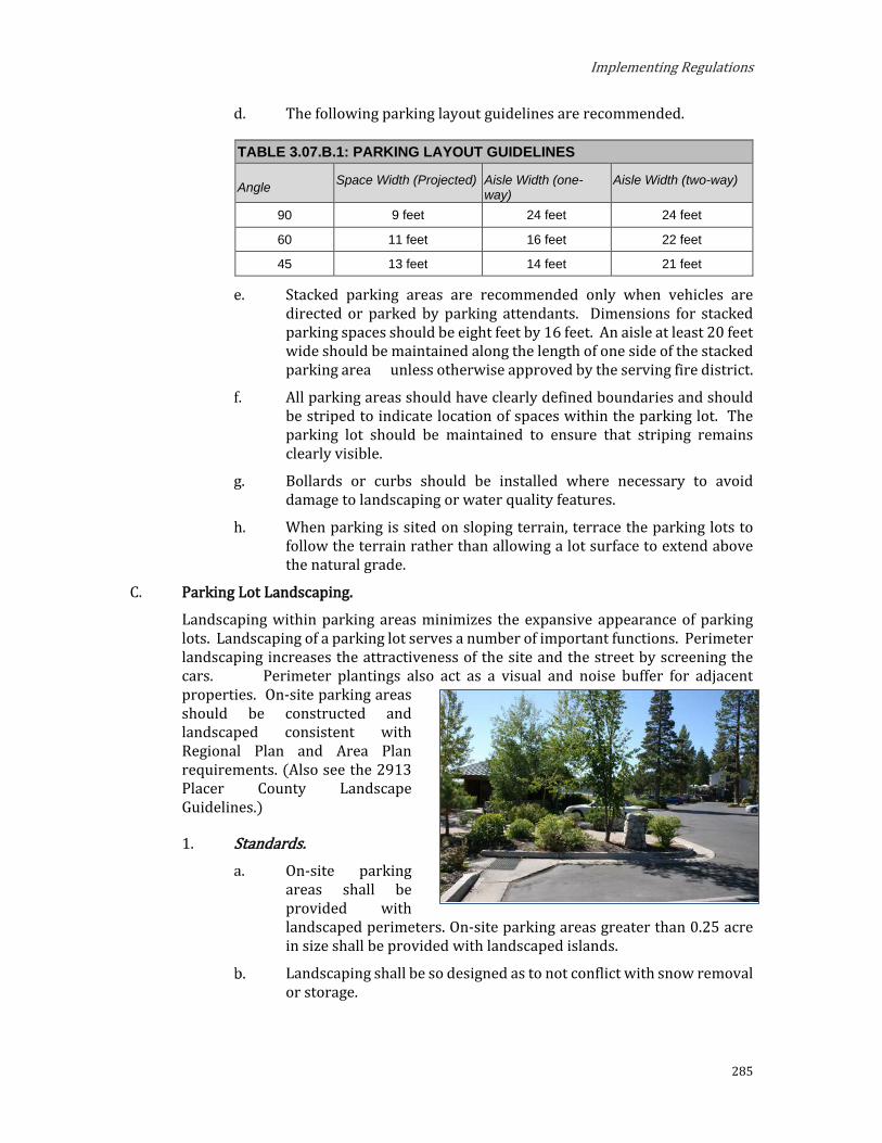
Implementing Regulations
285
d. The following parking layout guidelines are recommended.
TABLE 3.07.B.1: PARKING LAYOUT GUIDELINES
Angle Space Width (Projected) Aisle Width (one-way)
Aisle Width (two-way)
90 9 feet 24 feet 24 feet
60 11 feet 16 feet 22 feet
45 13 feet 14 feet 21 feet
e. Stacked parking areas are recommended only when vehicles are directed or parked by parking attendants. Dimensions for stacked parking spaces should be eight feet by 16 feet. An aisle at least 20 feet wide should be maintained along the length of one side of the stacked parking area unless otherwise approved by the serving fire district.
f. All parking areas should have clearly defined boundaries and should be striped to indicate location of spaces within the parking lot. The parking lot should be maintained to ensure that striping remains clearly visible.
g. Bollards or curbs should be installed where necessary to avoid damage to landscaping or water quality features.
h. When parking is sited on sloping terrain, terrace the parking lots to follow the terrain rather than allowing a lot surface to extend above the natural grade.
C. Parking Lot Landscaping.
Landscaping within parking areas minimizes the expansive appearance of parking lots. Landscaping of a parking lot serves a number of important functions. Perimeter landscaping increases the attractiveness of the site and the street by screening the cars. Perimeter plantings also act as a visual and noise buffer for adjacent properties. On-site parking areas should be constructed and landscaped consistent with Regional Plan and Area Plan requirements. (Also see the 2913 Placer County Landscape Guidelines.)
1. Standards. On-site parking
areas shall be provided with landscaped perimeters. On-site parking areas greater than 0.25 acre in size shall be provided with landscaped islands.
Landscaping shall be so designed as to not conflict with snow removal or storage.

Placer County
286

Implementing Regulations
287
2. Guidelines. All portions of a parking lot that are not used for parking or
maneuvering should be landscaped.
A landscaped separation should be provided between the parking areas and the building.
Perimeter landscape screening along the front of a lot, including mounding 34 inches in height is suggested. At that height, it will screen parked cars, but still permit visibility for safe site distance.
Screening along the sides and rear of the lot should be a minimum 6 feet in height and 10 feet wide. Landscaping is preferred over fencing for screening purposes.
Where appropriate, consider installing a joint landscaped perimeter parking screen with adjoining properties. A joint project offers the opportunity to share the cost of the improvements while creating a more substantial screen should be required around the entire perimeter of the parking area, with 10-foot minimum width landscape strips along non-frontage sides and 20-foot minimum width landscape strips along frontage roads. Trees should be planted at intervals of no greater than 40 feet on center around the perimeter of the parking area. Hedges are appropriate in urban areas. Step down landscaping near entrances in order to maintain safe sight distances.
Landscaping of parking areas in rural and rural transition areas should primarily consist of native vegetation in its natural forms (i.e., not formal hedges or hedge rows). Use low walls or changes in grade to assist in screening. Step down landscaping near entrances in order to maintain safe sight distances.
f. Landscaped Islands. Provide landscaped islands within parking areas as a means to break up the visual dominance of parked vehicles. Landscaped islands allow for the retention of significant existing vegetation while providing opportunities to add additional landscaping. Existing vegetation, especially large trees, will benefit from previous planting beds above root systems. Vegetation in landscaped islands must be adequately protected from vehicle damage by such methods as curbing, tree wells, changes in grade, boulders and other parking barriers.
Landscaped islands should also be provided within the interior of parking areas to break up expanses of pavement and screen parked vehicles. Parking areas should be divided into bays not exceeding 75 feet in length with landscaped buffer strips between bays. Tree planting on the interior of the parking area should be provided at an average ratio of at least one tree per four spaces. Islands should be a minimum five feet in width measured inside of curbs. An eight-foot-wide planter area is more ideal to ensure the long-term survival of the tree.

Placer County
288
Use the existing vegetation pattern as a design determinant in laying out the parking area. In rural transition and rural areas, the design goal should be to fit the parking layout into the landscape rather than create a very formal and repetitive layout using one island every eight spaces.
A landscaped buffer area with a minimum depth of 10 feet for lots within Town Centers and 15 feet for lots outside of Town Centers (as measured from back of curb) should be provided between any surface parking area and any property line adjacent to a public street. In order to allow drivers safe visibility at intersections of driveways and streets, no obstruction in excess of two feet high be placed within a triangular area formed by the street and driveway at property line and a line connecting them at points 25 feet from their intersection. Trees pruned high enough to permit driver visibility may be permitted.
Parking areas should not visually dominate a project. Plant materials, earth berms, and low walls and fences should be used to reduce the visual prominence of parking areas while still providing adequate visibility for customers and security.
D. Access. The places where a driver enters or leaves a site affect both the project and the community as a whole. Care must be taken in locating access to a site in order to avoid creating traffic obstructions or hazards where drivers are entering or leaving a site. In addition, poor placement or an insufficient number of access points to a site can lead to their blockage and impede smooth traffic flow through a site.
Applicability. The provisions of this subsection apply to projects that create a need for a driveway. Projects that do not create a need for a driveway, but are to be served by an existing driveway, may have the provisions required as conditions of approval if the review authority finds that the resultant situation would otherwise cause or continue to cause significant adverse impacts on traffic, transportation, air quality, or water quality.
Standards Applicable to Driveways. To ensure organized and well-designed ingress and egress of vehicles from driveways, Placer County and TRPA shall review the design of driveways according to the following standards and procedures:
Driveway Defined. A driveway is a clearly identifiable path of vehicular access from the parking facility of a parcel to the public right-of-way or other access road. A driveway may be either one-way or two-way.
Compliance Program. The provisions set forth in subsections “c” through “g,” inclusive, shall apply to projects that create a need for a driveway. Projects that do not create a need for a driveway, but are to be served by an existing driveway, may have the provisions required as conditions of approval if Placer County and TRPA find that the resultant situation would otherwise cause or continue to cause significant adverse impacts on traffic, transportation, air quality, or water quality.
Implementing Regulations
289
General Standards. Driveways shall comply with the following standards:
i. New Driveways. New driveways shall be designed and located so as to cause the least adverse impacts on traffic, transportation, air quality, water quality, and safety.
ii. Shared Driveways. In the application of subsections “d” through “f,” inclusive, Placer County and TRPA shall encourage shared driveways if they find that the effect is equal or superior to the effect of separate driveways. Shared driveways a minimum width of 20 feet between two properties shall be provided where feasible.
iii. Caltrans Standards. On State and federal highways, the ingress/egress standards of the California shall apply, as appropriate, in addition to the standards in subsections “d” through “f,” inclusive. Where the State standards conflict with Subsections “d” through “f,” inclusive, the State standards shall control.
iv. Slope of Driveways. Driveways may exceed 10-percent slope for single-family houses, including secondary residences, and five-percent slope for all other uses, if Placer County and TRPA find that a steeper driveway would minimize the amount of grading and site disturbance that would result from construction of a driveway of lesser slope. In no case shall a driveway exceed 15 percent for a residential use, or eight percent for all other uses.
v. Best Management Practices. Driveways shall be managed in accordance with Chapter 60 of the TRPA Code of Ordinances.
Numbers of Driveways. Additional or transferred development which does not require a traffic analysis pursuant to Section 65.2 of the TRPA Code of Ordinances, shall be served by a single driveway with no more than two points of ingress/egress from the public right-of-way or other access road. Additional or transferred development which requires a traffic analysis pursuant to Section 65.2, shall conform to the ingress / egress provisions necessary to mitigate all traffic and air quality impacts under Section 65.2.
i. One driveway connection is allowed for single-family uses, including accessory dwelling units. No circular or secondary driveway connections are allowed.
Width of Driveways. Driveway widths shall conform to the following standards:
i. Single-Family Houses, Including Accessory Dwelling Units: Driveways serving single-family houses, including ADUs, shall have a minimum width of 10 feet and a maximum of 20 feet. Where the single-family house includes a garage, the driveway shall be at least as wide as the garage door opening
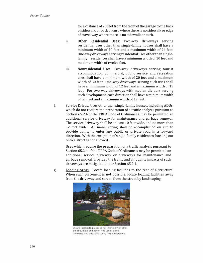
Placer County
290
for a distance of 20 feet from the front of the garage to the back of sidewalk, or back of curb where there is no sidewalk or edge of travel way where there is no sidewalk or curb.
ii. Other Residential Uses: Two-way driveways serving residential uses other than single-family houses shall have a minimum width of 20 feet and a maximum width of 24 feet. One-way driveways serving residential uses other than single-family residences shall have a minimum width of 10 feet and maximum width of twelve feet.
iii. Nonresidential Uses: Two-way driveways serving tourist accommodation, commercial, public service, and recreation uses shall have a minimum width of 20 feet and a maximum width of 30 feet. One-way driveways serving such uses shall have a minimum width of 12 feet and a maximum width of 15 feet. For two-way driveways with median dividers serving such development, each direction shall have a minimum width of ten feet and a maximum width of 17 feet.
Service Drives. Uses other than single-family houses, including ADUs, which do not require the preparation of a traffic analysis pursuant to Section 65.2.4 of the TRPA Code of Ordinances, may be permitted an additional service driveway for maintenance and garbage removal. The service driveway shall be at least 10 feet wide, and no more than 12 feet wide. All maneuvering shall be accomplished on site to provide ability to enter any public or private road in a forward direction. With the exception of single-family residences, backing out onto a street is not allowed.
Uses which require the preparation of a traffic analysis pursuant to Section 65.2.4 of the TRPA Code of Ordinances may be permitted an additional service driveway or driveways for maintenance and garbage removal, provided the traffic and air quality impacts of such driveways are mitigated under Section 65.2.4.
Loading Areas. Locate loading facilities to the rear of a structure. When such placement is not possible, locate loading facilities away from the driveway and screen from the street by landscaping.

Implementing Regulations
291
Natural Hazards.
Natural Hazards are regulated by Chapter 35, Natural Hazard Standards, of the TRPA Code of Ordinances.
Design Standards and Guidelines
This Section supersedes Chapter 36, Design Standards, of the TRPA Code of Ordinances for Mixed Use Subdistricts. Additional design standards and guidelines for each Mixed Use Subdistrict are outlined in Section 2.04, Mixed Use Districts, of this document.
For all other subdistricts, this Section supplements Chapter 36, Design Standards, of the TRPA Code of Ordinances.
A. Building Design.
Building design shall be in accordance with Section 36.6.1 of the TRPA Code of Ordinances.
To ensure compatibility with adjacent uses and viewshed protection, buildings must not project above the forest canopy, ridgelines, or otherwise detract from the viewshed and the review authority must make findings 1, 3, 5, and 9 of Section 37.7 of the TRPA Code of Ordinances in approving any project consisting of three or more stories.
Additional building design standards for Mixed Use Subdistricts are outlined in Chapter 2.
B. Site Design. Site design involves the arrangement of indoor and outdoor spaces to accommodate the activities required for a proposed use. Customer service, vehicle movement patterns, loading needs, and expansion potential should all be considered in laying out the site design. Because a site functions as an integral part of the community, the site design should also relate the spaces and activities to each other, to the site, and to the structures and activities on adjacent sites. The design should take into account such factors as safety, privacy, community idenity, and character preservation of the natural environment and pedestrian open space.
Standards Site design shall be in accordance with Sections 36.5.1, 36.5.2 and
36.5.5 of the TRPA Code of Ordinances.
Buildings shall be sited in a manner consistent with adjacent properties, with consideration given to sun and shade, changing climatic conditions, noise, safety, and privacy.
Each step of a phased project shall provide a design that is as complete as possible in the functional, visual, drainage and traffic aspects.
Site planning shall include a drainage, infiltration, and grading plan that meets water quality standards.
Site planning shall meet the requirements set forth in the Regional Transportation Plan.

Placer County
292
In the Mixed-Use areas special emphasis shall be placed on the provision for pedestrian open space and landscaping.
Setback standards shall follow requirements set forth below.
i. Structures: Setback requirements for each zoning subdistrict are outlined in Chapter 2 of these Area Plan Regulations.
ii. Scenic Corridors: In addition to the Chapter 2 setback standards, on parcels abutting roadways rated in TRPA’s Scenic Resources Inventory, buildings and structures shall be setback 20 feet from the highway right-of-way line in accordance Section 36.5.4 of the TRPA Code of Ordinances, except within the Mixed Use Subdistricts.
iii. Buildings, structures, and other land coverage/disturbance shall be setback from SEZs in accordance with Section 53.9.3 (SEZ Setbacks) of the TRPA Code of Ordinances.
Guidelines. Site Plans. Design site plans that preserve and enhance natural site
features and views, while promoting safety and privacy. Where possible, locate buildings on the portion of the site where existing vegetation or landforms present the greatest natural screening opportunities.

Implementing Regulations
293
Building on Sloped Sites. Design buildings on sloped sites to conform to the natural topography of the site. In areas where slopes exceed five percent, stepped foundations are recommended.
Connectivity. Where sites abut public open spaces, including sidewalks, multi-use paths, greenbelts, waterfront recreation areas, or conservation areas, provide clear and direct access to the public use or path. Ensure that site plans are integrated with planned bicycle and pedestrian improvements and provide safe and comfortable pedestrian connections to places of employment, schools, and other destinations.
C. Landscaping. Landscaping is a major factor in the image of an area. However, the landscaping of a project should attempt to do more than make a place look attractive. Plants can perform a number of functions to enhance the land use and increase user comfort. Plants can be used to create spaces, separate uses, give privacy, screen heat and glare, deflect wind, muffle noise, articulate circulation, emphasize entrances and exits, inhibit soil erosion, purify air, and soften the lines of architecture and paving. Careful thought should be given to the needs of site when designing the landscaping.
Placer County
294
Standards. All site development shall include landscaping. The use of planter
boxes or trellises is encouraged where larger landscaping areas are not available.
Existing trees and natural features should be preserved and incorporated into the landscape plan. Trees to be saved shall be protected during construction.
Site development shall include incorporation of bicycle parking and facilities.
Landscaping shall be designed to preserve adequate sight distance for motorists and pedestrians.
Incorporation of water conservation measures in landscaping specifications is encouraged. Such measures include the use of drought tolerant plants, drip irrigation, mulch layer (three inches thick) over landscape beds to slow evaporation, and soil amendment with compost and clay to increase water retention.
Areas designated open space, as per County standards, shall either remain in natural vegetation if possible or be landscaped.
For all projects other than single-family residential development and erosion control projects, the following plant sizes and spacing shall be required for woody material at the time of planting:
i. Trees should be minimum of six feet high and 1.5 inches in diameter at breast height (DBH);
ii. Upright shrubs shall be a minimum three gallon pot size with a minimum 18 inches in height and spread; spreading shrubs shall be a minimum three gallon pot size with a 24-inch spread; and
iii. Ground cover shall be a minimum four-inch pot size with a maximum 24-inch on-center spacing.
Plant species on the TRPA Recommended Native and Adapted Plant List shall be used for lawns and landscaping. Plant species not found on the TRPA recommended list may be used as accent plantings. Accent planting areas are restricted to borders, entryways, flower beds, and other similar locations.
Landscaping shall be consistent with regional Fire Defensible Space Requirements.
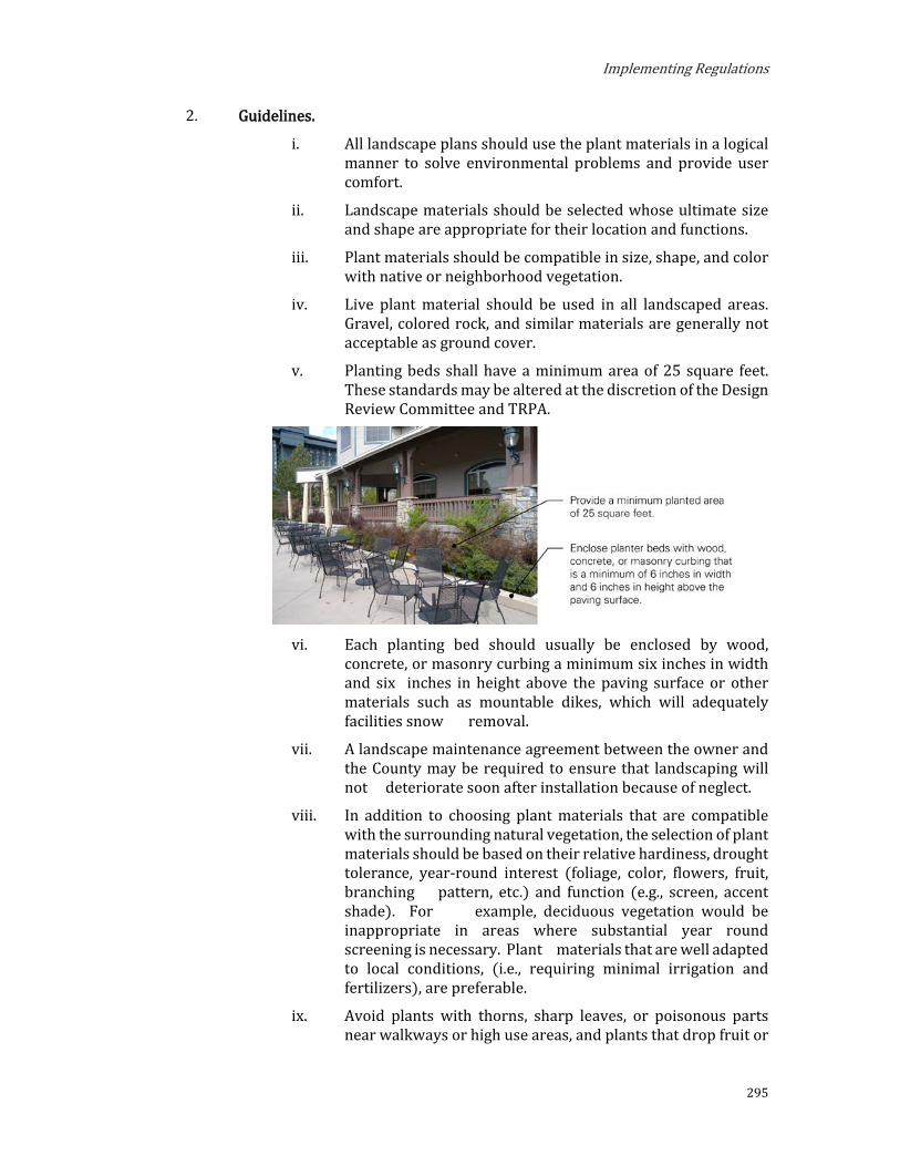
Implementing Regulations
295
Guidelines. i. All landscape plans should use the plant materials in a logical
manner to solve environmental problems and provide user comfort.
ii. Landscape materials should be selected whose ultimate size and shape are appropriate for their location and functions.
iii. Plant materials should be compatible in size, shape, and color with native or neighborhood vegetation.
iv. Live plant material should be used in all landscaped areas. Gravel, colored rock, and similar materials are generally not acceptable as ground cover.
v. Planting beds shall have a minimum area of 25 square feet. These standards may be altered at the discretion of the Design Review Committee and TRPA.
vi. Each planting bed should usually be enclosed by wood,
concrete, or masonry curbing a minimum six inches in width and six inches in height above the paving surface or other materials such as mountable dikes, which will adequately facilities snow removal.
vii. A landscape maintenance agreement between the owner and the County may be required to ensure that landscaping will not deteriorate soon after installation because of neglect.
viii. In addition to choosing plant materials that are compatible with the surrounding natural vegetation, the selection of plant materials should be based on their relative hardiness, drought tolerance, year-round interest (foliage, color, flowers, fruit, branching pattern, etc.) and function (e.g., screen, accent shade). For example, deciduous vegetation would be inappropriate in areas where substantial year round screening is necessary. Plant materials that are well adapted to local conditions, (i.e., requiring minimal irrigation and fertilizers), are preferable.
ix. Avoid plants with thorns, sharp leaves, or poisonous parts near walkways or high use areas, and plants that drop fruit or

Placer County
296
branches in locations where they could cause maintenance problems or safety hazards.
x. Preserve and incorporate into the landscape plan all existing trees and natural features, where possible. Introduce plant materials that are compatible in size, shape, and color with native or neighborhood vegetation.
xi. Design planter beds and trellises to be compatible with the primary building’s character.
xii. Use landscape materials and landforms to enhance energy conservation.
D. Lighting. Outside lighting increases the operational efficiency of a site, provides a measure of site security, and can enhance the aesthetics of the site and the architectural qualities of its structure. In determining the lighting for a project, the source, intensity, and type of illumination should be appropriate for the lighting needs.
General Lighting Standards. Exterior lights shall not blink,
flash, or change intensity except for temporary public safety signs. String lights, building or roofline tube lighting, reflective, or luminescent wall surfaces are prohibited.
Exterior lighting shall not be attached to trees except for the winter holiday season.
Parking lot, walkway, and building lights shall be directed downward.

Implementing Regulations
297
Fixture mounting height shall be appropriate to the purpose. The height shall not exceed the limitations set forth in Chapter 37 of the TRPA Code of Ordinances.
Outdoor lighting shall be used for purposes of illumination only, and shall not be designed for, or used as, an advertising display. Illumination for aesthetic or dramatic purposes of any building or surrounding landscape utilizing exterior light fixtures projected above the horizontal is prohibited.
The commercial operation of searchlights for advertising or any other purpose is prohibited.
Seasonal and Special Event Lighting. Seasonal lighting displays and lighting for special events may be permitted on a temporary basis pursuant to Chapter 22 of the TRPA Code of Ordinances.
2. Prohibited Lighting. The following types of exterior lighting are prohibited:
Drop-down lenses.
Mercury vapor lights.
Searchlights, laser lights, or any other lighting that flashes, blinks, alternates, moves, or changes intensity.
String lights, neon light, building or roof outline tube lighting, reflective or luminescent wall surfaces, except with approved seasonal or special event lighting.
Lighting attached to trees except for the winter holiday season.
Illumination for aesthetic or dramatic purposes of any building or surrounding landscape utilizing exterior light fixtures projected above the horizontal.
3. Fixture Types. All lighting fixtures shall be fully shielded and directed downward so as not to produce obtrusive glare onto the public right-of-way or adjoining properties. All luminaries shall meet the most recently adopted criteria of the Illuminating Engineering Society of North America (IESNA) for “Full Cut Off” luminaries.
Glare. No use shall be operated such that significant, direct glare, incidental to the operation of the use is visible beyond the boundaries of the lot where

Placer County
298
the use is located. Light or glare from mechanical or chemical processes, high-temperatures processes, such as combustion or welding, or from reflective materials on buildings or used or stored on a site, shall be shielded or modified to prevent emission of adverse light or glare onto other properties.
5. Light Trespass. Lights shall be placed to deflect light away from adjacent lots and public streets, and to prevent adverse interference with the normal operation or enjoyment of surrounding properties.
Direct or sky-reflected glare from floodlights shall not be directed into any other lot or street.
No light, or combination of lights, or activity shall cast light exceeding one foot-candle onto a public street, with the illumination level measured at the centerline of the street.
No light, combination of lights, or activity shall cast light exceeding 0.5 foot-candle onto a residentially zoned lot, or any lot containing residential uses.
6. Lighting Design. Design exterior lighting as part of the architectural and site design of a project. Choose styles that are compatible with the building’s architecture and landscaping. Highlight special recognizable architectural features or to use the play of light and shadow to articulate the façade, and avoid harsh overall lighting. Ensure that area lighting is shielded so that direct rays do not pass property lines.
E. Design for Snow.
1. Roofs. Roofs should be designed to cope with erratic loading resulting from varying snow accumulations and meet California Building Code (CBC) provisions for snow shed from roofs.
a. Flat roofs shall be able to drain the melting snow with drains that will not become blocked with ice.
b. Steeply pitched roofs shall be of a pitch and material that will shed snow.
2. Building Entrances. Building entrances shall be designed so that snow does not shed freely into entrances.

Implementing Regulations
299
3. Parking and Driveway Areas. Parking and driveway areas shall be sloped a minimum two percent to prevent ponding and icing.
4. Snow Storage Easements. Properties adjacent to a County-maintained roadway shall dedicate snow storage easements to Placer County.
5. Snow Storage. Multi-family residential projects and all nonresidential projects shall provide, onsite within the project area, snow storage areas of a size adequate to store snow removed from parking, driveway and pedestrian access areas or have arrangements by means of recorded easements or equivalent arrangements to remove and store accumulated snow offsite.
a. Application Content Requirements. Snow storage areas shall be identified on the required site plan.
b. Minimum Storage Area. Required for each unenclosed parking area, including circulation.
i. Residential Districts. An area equal to a minimum of 75 percent of all uncovered required parking and driveway areas shall be provided onsite for the storage of snow.
ii. Mixed Use and Tourist Planned Development Districts. An area equal to a minimum of 60 percent of all uncovered required parking and driveway areas shall be provided for the storage of snow.
iii. Community Service Districts. An area equal to a minimum of 40 percent of all uncovered required parking and driveway areas shall be provided for the storage of snow.
iv. Conservation and Recreation Districts. As determined by Placer County based on the parking area use and location.
c. Reduction of Required Snow Storage Area. Placer County may reduce or waive the required snow storage area(s) if the following conditions are met:
i. A maintenance district or other arrangement is formed for snow removal and the affected property participates in such arrangement;
ii. The property owner commits to permanently haul on-site snow from the property to an approved off-site snow storage area. The commitment to haul on-site snow shall be in the form of a recorded document mutually agreed to between the property owner and the County; and
iii. A snow storage management plan is submitted and approved by the County that includes the following:
(1) The site shall designate temporary or interim snow storage areas that do not interfere with more than one-third of the project required minimum parking.

Placer County
300
(2) Interim snow storage shall be removed within 10 calendar days following a storm cycle.
(3) Interim snow storage shall not be in a location that will damage trees, landscape, or other facilities.
(4) Interim snow storage shall not block any required access, sidewalk, trail, or public path.
(5) Snow shall be hauled to an approved and permitted location.
(6) Snow hauling shall generally be completed during non-business hours.
(7) The snow management plan shall designate the removal methods.
(8) Drainage facilities shall not be blocked.
(9) Snow storage shall be located so that snow moving equipment is not required to enter the public streets to move snow to the storage area unless an encroachment permit is obtained.
(10) Snow storage shall be located in areas that are substantially free and clear of obstructions (e.g. propane tanks, trees, large boulders, trash enclosures, utility pedestals).
d. Location. Snow storage areas should be located in accordance with the following:
i. Near the sides or rear of parking areas and driveways, away from the primary street frontage;
ii. To maximize solar exposure to the greatest extent feasible;
iii. To allow snow moving equipment to move snow to the storage area without entering a public street;
iv. Shall preserve sight lines for vehicles entering or exiting driveways;
v. In areas that are readily accessible and substantially free and clear of obstructions (e.g. propane tanks, trees, large boulders, trash enclosures, utility pedestals);
vi. Shall not block any required access, sidewalk, trail, or public path;
vii. May be located within parking areas but such areas may not be counted towards meeting parking requirements for the use;
viii. May be located within required landscaping areas but the areas shall be planted with landscaping tolerant of snow storage or be native vegetation; and

Implementing Regulations
301
ix. Snow shall not be plowed into or stored in an SEZ.
e. Minimum Dimensions. The minimum dimension of a snow storage area should be 10 feet in any direction.
f. Drainage. Drainage from snow storage areas should be directed towards on-site drainage retention/treatment facilities. Snow storage areas for nonresidential projects are required to install oil/water separators.
6. Design for Snow Guidelines. The following guidelines apply to projects to ensure appropriate accommodations for snow.
a. Parking and Driveways. Design parking areas and driveways for snow removal operations. Ensure that parking areas and driveways catch afternoon sun in order to speed snow melting and prevent ice build-up. Limit driveway grade to a maximum of five percent to allow easy use during icy or snowy conditions.
b. Roof Design. Design roofs that will cope with erratic loading of varying snow accumulations. Ensure that the drains of flat roofs do not become blocked with ice and that pitched roofs incorporate design measures that promote safe snow shed. Ensure that eave lines are high enough that snow will not accumulate at the eave edge.
F. Utility and Service Areas
All projects proposing a new structure or reconstruction or expansion of an existing structure shall locate and screen utility and service areas in accordance with this subsection.
Standards. Mechanical and electrical equipment shall be screened from view.
These features should be located at the rear or side of the building, or integrated into the architectural design by using similar materials and colors wherever possible. The location of these elements, including pad-mounted transformers should not be highly visible from scenic corridors or recreation areas, and should be coordinated with the utility company early in the site design process.
i. Equipment to be screened includes, but is not limited to, all roof-mounted equipment, satellite dishes, air conditioners, heaters, utility meters, cable equipment, utility boxes, backflow preventions, irrigation control valves, electrical transformers, pull boxes, and all ducting for air conditioning, heating, and blower systems.
All utilities extending from street to building should be placed underground. Overhead utilities should be avoided whenever possible.
Outdoor storage and work areas should be adequately screened by a solid fence, wall, or hedge, six feet in height so as not to be visible from any public street, the shoreline, or publicly accessible open space area. The area being screened should not be visible through the screen.
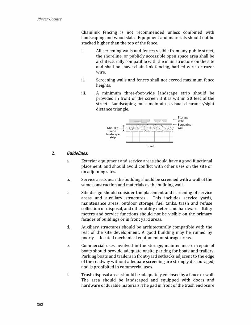
Placer County
302
Chainlink fencing is not recommended unless combined with landscaping and wood slats. Equipment and materials should not be stacked higher than the top of the fence.
i. All screening walls and fences visible from any public street, the shoreline, or publicly accessible open space area shall be architecturally compatible with the main structure on the site and shall not have chain-link fencing, barbed wire, or razor wire.
ii. Screening walls and fences shall not exceed maximum fence heights.
iii. A minimum three-foot-wide landscape strip should be provided in front of the screen if it is within 20 feet of the street. Landscaping must maintain a visual clearance/sight distance triangle.
Guidelines.
a. Exterior equipment and service areas should have a good functional placement, and should avoid conflict with other uses on the site or on adjoining sites.
b. Service areas near the building should be screened with a wall of the same construction and materials as the building wall.
c. Site design should consider the placement and screening of service areas and auxiliary structures. This includes service yards, maintenance areas, outdoor storage, fuel tanks, trash and refuse collection or disposal, and other utility meters and hardware. Utility meters and service functions should not be visible on the primary facades of buildings or in front yard areas.
d. Auxiliary structures should be architecturally compatible with the rest of the site development. A good building may be ruined by poorly located mechanical equipment or storage areas.
e. Commercial uses involved in the storage, maintenance or repair of boats should provide adequate onsite parking for boats and trailers. Parking boats and trailers in front-yard setbacks adjacent to the edge of the roadway without adequate screening are strongly discouraged, and is prohibited in commercial uses.
f. Trash disposal areas should be adequately enclosed by a fence or wall. The area should be landscaped and equipped with doors and hardware of durable materials. The pad in front of the trash enclosure

Implementing Regulations
303
should be reinforced to carry the weight of garbage trucks as they lift the full containers.
i. Location. The solid waste and recycling storage area should not be visible from a right-of-way and should not be located within any required front yard or street side yard.
ii. Screening. Solid waste and recycling storage areas located outside or on the exterior of any building shall be screened with at least a six foot high solid enclosure.
iii. Landscaping. Where feasible, the perimeter of the recycling and trash enclosure shall be planted on three sides with drought resistant landscaping, including a combination of shrubs and / or climbing evergreen vines.
g. Service areas should be located at the rear of the site wherever possible, and shall be screened by the main structures. Service areas near the building shall be screened with a wall of the same construction and materials as the building wall. Consider snow accumulation in planning access to service areas and trash receptacles.
i. Urban. Urban areas have the widest range of appropriate solutions. Use walls or fences of similar colors and material as the main building or structure. Avoid long, straight runs of walls or fences with no articulation. Buffer walls and fences with landscape plantings. If chainlink fence must be used, use only that which is coated in a dark color.
ii. Rural Transition. Screening service areas in rural transition areas may be accomplished by using structural or vegetative screens, or a combination of both. The range of appropriate materials is narrower than in urban areas.
iii. Rural. Use landform and vegetation to screen service areas whenever possible. Use structural solutions only when no other solutions exist. Structural solutions are appropriate when buffering the service area from neighboring residents or recreational uses. Walls and fences of natural materials are appropriate in rural areas.

Placer County
304
G. Gateway Design Guidelines.
Gateways should mark a sense of arrival; help orient visitors, and reinforce the community character through architecture and design, streetscape, landscaping, and signage.
The intent of the Gateway areas is to create the primary entryway into commercial areas. The designation recognizes the significance of the automobile while simultaneously minimizing its dominance in commercially developed areas and avoiding unsightly highway strip commercial development. The designation calls for an attractive transition between the higher density zones within the mixed-use districts and the adjacent residential zones.
It is the purpose of the Gateway areas is to provide public, retail, and commercial uses appropriate along major vehicular corridors while encouraging appropriate and unified development among the properties.
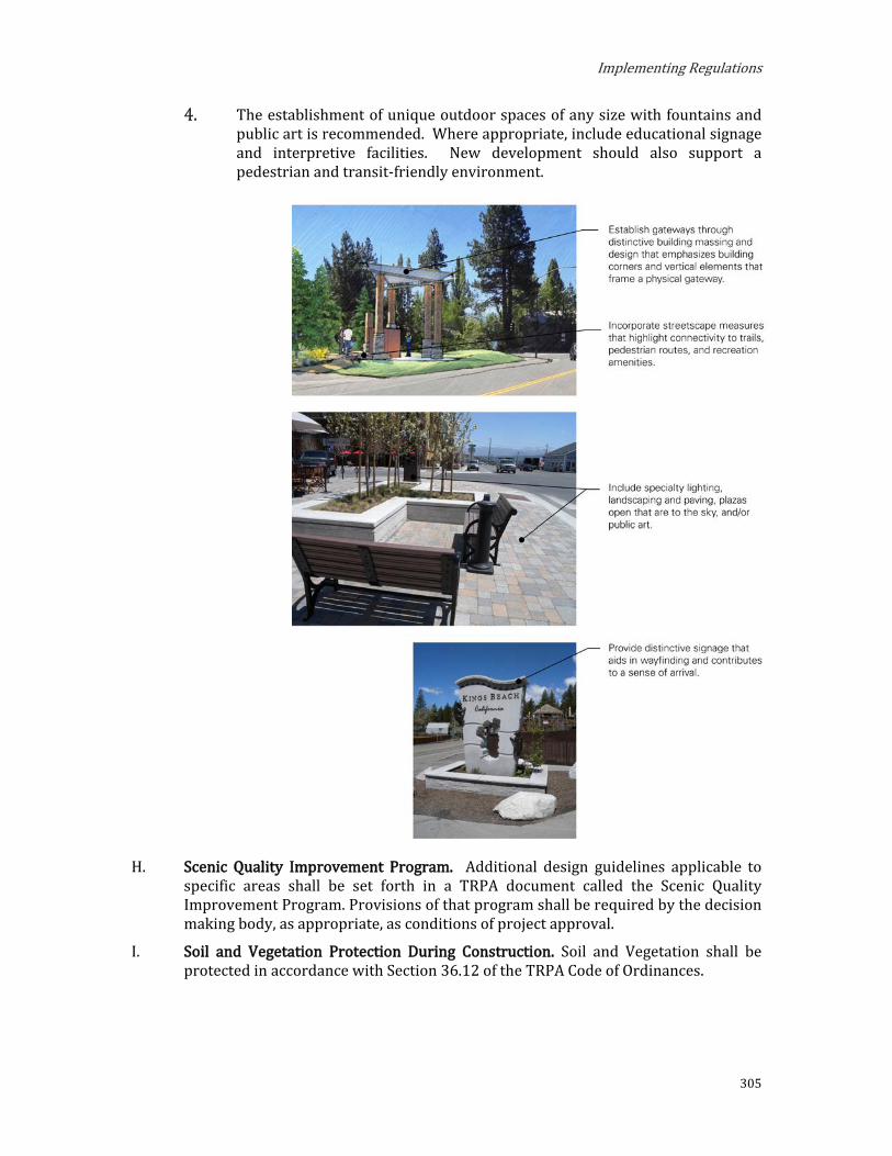
Implementing Regulations
305
The establishment of unique outdoor spaces of any size with fountains and public art is recommended. Where appropriate, include educational signage and interpretive facilities. New development should also support a pedestrian and transit-friendly environment.
H. Scenic Quality Improvement Program. Additional design guidelines applicable to specific areas shall be set forth in a TRPA document called the Scenic Quality Improvement Program. Provisions of that program shall be required by the decision making body, as appropriate, as conditions of project approval.
I. Soil and Vegetation Protection During Construction. Soil and Vegetation shall be protected in accordance with Section 36.12 of the TRPA Code of Ordinances.

Placer County
306
Height
The maximum height of buildings and other structures is outlined in Chapter 37, Height, of the TRPA Code of Ordinances. Additional height standards for each zoning subdistrict are outlined in Chapter 2 of these Area Plan Regulations.
Chapter 13, Area Plans, of the TRPA Code of Ordinances permits building heights greater than is otherwise allowed by Chapter 37 within the Town Center Overlay Districts. Additional height allowances and requirements for the Town Centers are outlined in Subsection 2.09.A, Town Center Overlay District, of this document.
Signs
This Section supersedes Chapter 38, Signs, of the TRPA Code of Ordinances.
A sign’s basic function is to communicate a message to the viewer. A sign should be unobtrusive, convey its message clearly, be vandal-proof and weather-resistant, and, if lighted, not be unnecessarily bright. The intent of this regulation is to achieve a good relationship between the sign, the building, and the neighborhood. The Sign regulations permit each business a certain amount of signage based upon the zoning, lot size, lot frontage depth, total building size, and building frontage length.
A. Purpose. The purpose of this Section is to establish regulations for the design, construction, location, and maintenance of signs that balance the need of residents, businesses, visitors, and institutions for adequate identification, communication, and advertising with the objectives of protecting public health, safety, and general welfare and promoting a well-maintained and visually attractive community, consistent with State and federal law.
B. Applicability. The provisions set forth in this Section shall apply in all areas of the Area Plan, unless expressly stated otherwise. No sign shall be erected or maintained anywhere in the Area Plan area except in conformity with this Section.
C. Sign Standards. The following regulations shall apply to all properties within the Area Plan
area subject to these standards. All signs shall comply with the applicable standards set forth in these regulations.
A Sign permit is required for all signage under the jurisdiction of the Placer County Planning Services Division and TRPA Code. A Design Site Agreement approved by Placer County which includes a sign submittal may serve as a Sign Permit.
A sign initially approved and for which a permit is allowed shall not thereafter be modified, altered or replaced, nor shall any design element of any building or lot upon which such sign is maintained be modified, altered or replaced if any such design element constituted a basis for approval of such sign, without an amended or new permit therefor first being obtained.

Implementing Regulations
307
Definitions. Sign. Anything whatsoever placed, erected, constructed, posted,
printed, or otherwise effaces or makes visible for outdoor advertising purposes in any manner whatsoever, on the ground or on any tree, wall, post, fence, building, or structure.
Freestanding Sign. A sign not attached to a building.
Building Sign. A sign which is attached flat against a building and does not project outward or extend above the principal roof line.
Projecting Sign. A sign attached to a building that projects outward and does not extend above the principal roof line.
Sign Permit. A permit issued through the Planning Services Division authorizing the use of a freestanding, building, projecting, or window sign.
Existing Sign. A sign that is legally existing or approved on the effective date of this Area Plan.
Non-Conforming Sign. A sign that is existing as of the effective date of this Area Plan which does not comply with the applicable standards set forth within.
Conforming Sign. A sign that is existing as of the effective date of this Area Plan which complies with the standards set forth within.
Freestanding Signs. Each building or cluster of buildings (e.g., shopping centers) in a commercial district shall be permitted one freestanding sign.
The total area of an outdoor freestanding sign shall not exceed one square foot of sign area for each two feet of street frontage occupied by the business or enterprise. The maximum permissible aggregate sign area is 50 square feet for all freestanding, directional, projecting, and building signs, with the exception of multiple-tenants projects and multiple-frontage buildings as described in Subsection 3.11.C.4.b, below. Freestanding signs are permitted a maximum height of 14 feet, or no higher than the principal roofline of the structure on the property, whichever is less. Freestanding signs must be incorporated into a landscaped design theme or planter area unless there is insufficient space.
Setbacks. The setback for a freestanding sign in mixed-use and tourist districts shall be a minimum of 10 feet from all property lines. The Design Review Committee or TRPA may decrease the setback to a minimum of five feet if it is determined that the public will be better served with a sign located closer than 10 feet to the property line, due to site specific conditions such as steep terrain, heavy vegetation, or existing structures on the site or adjoining properties. Signs legally existing as of the date of adoption of this Area Plan, non-conforming only in terms of setback requirements, need not be relocated or removed.

Placer County
308
Building Signs. One building sign may be maintained upon each building frontage of
a main building. Each such building sign may be allowed an area of one square foot of sign area for each linear foot of the width of such a building frontage or the following table. The maximum aggregate sign area for all signs, freestanding building signs, and projecting, shall not exceed 50 square feet, with the exception of multiple-tenant projects and multiple frontage buildings as described in Section 3.11.C.4.b.
TABLE 3.11.J-2: MAXIMUM BUILDING SIGN AREA
Floor Area (sq.ft.) Sign Area (sq ft) 0 – 1,000 10
1,001 – 2,000 20
2,001 – 5,000 30
5,001 – 10,000 40
10,000 or more 50
Multiple Tenant Buildings. Each primary use may be allowed one square foot of sign area for each one linear foot of building frontage up to a maximum of 30 square feet of sign area for building frontage. A maximum of four building signs may be permitted per primary use.
In instances where the primary use has not building frontage, but does not have a frontage without a public entrance on a street, building signage may be erected upon that alternative frontage. The sign area shall be calculated based upon that alternative frontage.
Projecting Signs. Projecting signs may be permitted according to the same specifications as building signs listed in Section 3.11.C.4.b above. Projecting signs may project up to 42 inches from the face of the building, must have at least eight feet of ground clearance, and cannot be higher than the building to which they are attached. Projecting signs may not extend beyond the applicant’s property.
Sign Area. a. The area of a sign shall include the entire area within any type of
perimeter or border which may enclose the outer limits of any writing, representation, emblem, figure, or character. The structure surrounding the sign should be kept to a minimum size.
b. The area of the second side of a two-sided sign, if identical to side one, shall not count as additional signage.
Sign Permit. A Sign Permit is required for all signage under the jurisdiction of the Placer County Planning Services Division and TRPA.
Signage Plans. Buildings, or clusters of buildings, shall provide a signage plan for the entire structure. This plan shall be prepared by the owner of the building(s) or their agent. The signage plan must be
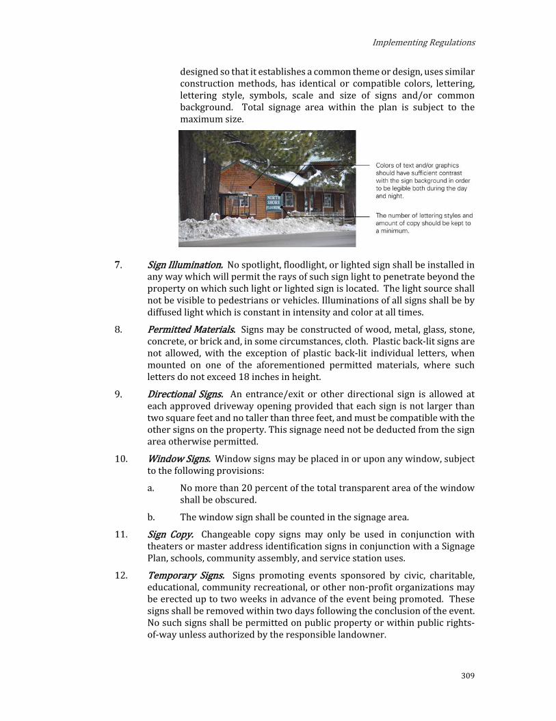
Implementing Regulations
309
designed so that it establishes a common theme or design, uses similar construction methods, has identical or compatible colors, lettering, lettering style, symbols, scale and size of signs and/or common background. Total signage area within the plan is subject to the maximum size.
Sign Illumination. No spotlight, floodlight, or lighted sign shall be installed in any way which will permit the rays of such sign light to penetrate beyond the property on which such light or lighted sign is located. The light source shall not be visible to pedestrians or vehicles. Illuminations of all signs shall be by diffused light which is constant in intensity and color at all times.
Permitted Materials. Signs may be constructed of wood, metal, glass, stone, concrete, or brick and, in some circumstances, cloth. Plastic back-lit signs are not allowed, with the exception of plastic back-lit individual letters, when mounted on one of the aforementioned permitted materials, where such letters do not exceed 18 inches in height.
Directional Signs. An entrance/exit or other directional sign is allowed at each approved driveway opening provided that each sign is not larger than two square feet and no taller than three feet, and must be compatible with the other signs on the property. This signage need not be deducted from the sign area otherwise permitted.
Window Signs. Window signs may be placed in or upon any window, subject to the following provisions:
a. No more than 20 percent of the total transparent area of the window shall be obscured.
b. The window sign shall be counted in the signage area.
Sign Copy. Changeable copy signs may only be used in conjunction with theaters or master address identification signs in conjunction with a Signage Plan, schools, community assembly, and service station uses.
Temporary Signs. Signs promoting events sponsored by civic, charitable, educational, community recreational, or other non-profit organizations may be erected up to two weeks in advance of the event being promoted. These signs shall be removed within two days following the conclusion of the event. No such signs shall be permitted on public property or within public rights-of-way unless authorized by the responsible landowner.

Placer County
310
Abandoned Signs. Signs advertising businesses that have vacated a location for a period of longer than one year shall be the responsibility of the property owners for removal, which shall be accomplished within 60 days thereafter.
Neighborhood Identification Signs. Not more than two permanent signs containing copy of not more than 50 square feet in aggregate sign area and not more than six feet in height shall be allowed to identify a neighborhood or other residential area comprising not less than three acres in size.
Institutional Signs. Two signs not exceeding 24 square feet in aggregate sign area shall be allowed for a religious assembly facility, school, community center or other public or institutional use. One of such signs may be maintained integral with a building and the other sign may be affixed to the ground provided that the top of the sign does not exceed a height of six feet from the finished grade of the lot and is set back at least five feet from any property line.
Real Estate Signs. One temporary sign not over eight square feet in area shall be allowed for any lot or two or more contiguous lots in single ownership (whether or not such lot or lots have been or are to be subdivided) containing appurtenant sign copy advertising the sale, rental, or lease of the property (the lot or lots and/or the improvements, if any, thereon) upon which such sign is located. Such signs shall be exempt from Sign Permit requirements.
Increases in Maximum Allowed Sign Area. Sign area for building and freestanding signs which are visible from highways with a posted speed limit of 45 miles per hour or greater may be increased up to 20 percent over the maximum allowable area for each sign as calculated based on the applicable provisions of these standards.
Off-Premise Signs. No sign shall be erected or maintained on a parcel or project area other than the parcel or project area on which the use or activity advertised by the sign is located, with the exception of: (1) signs advertising public facilities, such as governmental offices or public recreational facilities, and (2) use of "international symbols" which relay information in graphic form and which contain no copy advertising business names. Sign area shall be consistent with the maximum amounts allowed for freestanding signs.
Gasoline Price Signs: Signs for gasoline or other motor fuel price signs shall conform to the following standards:
Motor Vehicles: A use which includes selling motor vehicle fuel to the public may be allowed one (1) gasoline price sign on each street frontage providing direct vehicular entrance to the use. Such signs may be incorporated into free-standing signs, however, the gasoline price sign shall not exceed ten (10) feet in height and fifteen (15) square feet in area for each side. Gasoline price signs shall have no more than two (2) sides. Portable gasoline price signs are prohibited. Sign area utilized for gasoline prices that is kept at the minimum area required by law shall not be included in the total permitted sign area. Any price signing in excess of the minimum required by law shall be included in the total permitted area.

Implementing Regulations
311
Marina Gasoline Price Signs: A marina which sells motor fuel to the public may be allowed one (1) gasoline price sign. Such sign may be incorporated into a free-standing sign, however, the gasoline price sign shall not exceed eight (8) feet in height and nine (9) square feet in area for each side. Gasoline price signs shall have no more than two (2) sides. Portable gasoline price signs are not allowed. Sign area utilized / or gasoline prices that is kept at the minimum area required by law shall not be included in the total permitted sign area. Any price signing in excess of the minimum required by law shall be included in the total permitted area.
State of Repair. All signs and components thereof, including supports, braces, and anchors, shall be kept in a state of good repair.
Prohibited Signs. The following types of signs, materials, designs, messages, and locations are prohibited:
Signs Creating Traffic Hazards. No signs shall be erected at or near any public street or the intersection of any streets in such a manner as to create a traffic hazard by obstructing vision or any location where it would interfere with, obstruct the view of, or be confused with any authorized traffic sign.
Hazardous Signs. No sign shall be erected or maintained which, due to structural weakness, design defect, or other reasons, constitutes a threat to the health, safety, and welfare of any person or property.
Signs Resembling Traffic Signals or Signs. No sign shall be constructed, erected, or maintained which purports to be or resembles an official County, State or federal traffic sign or signal except those signs officially authorized and installed by Placer County, or the California Department of Transportation. This Section shall not apply to signage in parking lots.
A-frame Signs. Any portable sign or structure composed of 2 sign surfaces mounted or attached back to back in such a manner as to form a basically triangular vertical cross-section through the faces.
Flashing Signs. Any sign which contains an intermittent or flashing light source, or which includes the illusion of intermittent or flashing light by means of animation, or an externally mounted intermittent light source. Automatic changing signs, such as public service time, temperature and date signs, are not classified as flashing signs.
Electronic Message Signs. A permanent freestanding roof, wall, or other sign which changes copy electronically using switch and electric lamps.
Off-premise Signs and Billboards. Outdoor advertising signs which advertise goods, products, or services not sold on the premises on which said sign is located.
Roof Signs. Any sign erected partly or wholly on or over the roof of a building, including ground signs that rest on or overlap a roof.

Placer County
312
Animated Signs. A rotating or revolving sign, all or a portion of which moves in some manner.
Wind Signs. Any propeller, whirling, or similar device which is designed to flutter, rotate, or display other movement under the influence of the wind. This shall include flags, banners, and pennants.
Illuminated Signs. Standard "cabinet" illuminated signs.
Mobile or Portable Signs. A sign not permanently attached to the ground or building.
Video Signs. Animated visual messages which are projected on a screen.
Tree Sign. Any type of sign whatsoever attached to a tree.
Amortization of Non-Conforming Signs. This Section sets forth requirements for the amortization schedule for the removal or alteration of signs that do not conform to the provisions of these regulations.
Conformance or Removal of Non-Conforming Signs. Non-conforming signs shall be conformed as required under Section 38.12 of the TRPA Code of Ordinances.
Exceptions to Standards. Exceptions may be granted to the standards set forth in this Section for signs legally existing prior to the adoption of this Area Plan, provided the following findings can be made:
Because of special circumstances applicable to the property, including size shape, topography, location or surroundings, the strict application of the sign regulations deprive such property of privileges enjoyed by other property in the vicinity and other identical zoning classifications.
The exception is in harmony with the purpose and intent of the sign regulations.
There are exceptional or extraordinary circumstances or conditions applicable to the property involved, or to the intended use of the property that are not contemplated or provided for by these regulations.
The approval of the exception will not be materially detrimental to the public health, safety, and welfare.
Alternative signage concepts that comply with the provisions to which the exceptions requested have been evaluated, and undue hardship would result if the strict adherence to the provision is required.
A scenic quality analysis demonstrates that the exception, if approved, will be consistent with the threshold attainment findings listed in the Scenic Quality Management Program (SQIP).
The exception which is approved shall not increase the number, area, and height of the existing sign or signs for which the exception is requested.

Implementing Regulations
313
The exception is the minimum departure from the standards.
Permit Issuing Authority. Upon making the requisite findings by TRPA under the provisions of Section 38.2.3 of the TRPA Code of Ordinances, Placer County shall assume lead responsibility for permit issuance and enforcement of these sign regulations as set forth in the County's Enforcement Ordinance. TRPA shall retain responsibility for the amortization requirements required under Chapter 38.12 of the Code and for the review and enforcement of state and federal signage exempt from Placer County review authority.
D. Sign Design Guidelines. Signs shall be designed in accordance with the following guidelines:
1. Signs should be designed and located to be compatible with their surroundings in terms of size, shape, color, texture, and lighting.
2. Signs should be simple in design and easy to read, with the number of lettering styles and amount of copy kept to a minimum - preferably giving only the name of the business.
3. Reflective, fluorescent, and primary colors should be avoided. Reader boards are prohibited, with the exception of theaters, master identification signs in conjunction with a signage plan, schools, religious assembly facilities, community centers, or community recreation centers.
4. Architectural details of a building often suggest a location, size, or shape for a sign. Signage should complement the architectural details of the building. Signs that violate the architectural integrity of the building to which it is attached will not be allowed. Signs should also help to establish a visual continuity with adjacent storefronts and store signs relating directly to the store entrance.
5. Signs should be oriented toward pedestrians or vehicles in close proximity.
Subdivision
Subdivision limitations are outlined in Chapter 39, Subdivision, of the TRPA Code of Ordinances.

Placer County
314
Allocation of Development
The allowed allocation of development is outlined in Chapter 50, Allocation of Development, of the TRPA Code of Ordinances. Additional provisions for allocations are outlined in Subsections A, B and C below.
A. Allocations. For allocations that have been released to the County by TRPA, the County is responsible for assigning allocations to projects and maintaining records of allocations, which shall be transmitted to TRPA annually or as specified in an MOU.
Requests for allocations shall be made on applications provided by the County. Applications shall be processed in accordance with county procedures and criteria.
B. TRPA Certified Placer County Moderate-Income Housing Program. This program is intended to serve as a TRPA-Certified Local Government Moderate Income Housing Program as described in subsection 52.3.6 of the TRPA Code of Ordinances. Owners of parcels located within Placer County may apply to TRPA to receive a residential allocation from the Residential Allocation Incentive Pool, subject to the limitations in TRPA Code Section 50.5.1.D.
To qualify to receive a residential allocation through the Residential Incentive Program, property owners must, through deed-restriction limit the project area to the approved use and restrict the occupants’ household income to moderate-income housing limits. Moderate-income units using residential allocations received through this program shall be restricted for long-term occupancy for at least ten months in each calendar year.
C. Additional Outdoor Recreation Facilities. In addition to requirements of the TRPA Code of Ordinances, Section 50.9, Regulation of Additional Recreation Facilities, additional outdoor recreation facilities outside Town Center Overlay Districts shall be regulated by and shall not exceed the maximum number of People at One Time (PAOT) identified by this document for each sub-district. If PAOT allowances are not specified in the applicable subdistrict, then additional PAOT allocations are not allowed. There are no supplemental limitations for PAOT allocations within Town Center Overlay Districts.
Banking, Conversion, and Transfer of Development
Programs for Banking, Conversion, and Transfers of Development are outlined in Chapter 51, Banking, Conversion, and Transfer of Development, of the TRPA Code of Ordinances. Additional provisions related to Transfers of Development are outlined in Subsections A and B below.
A. Development Transfer Receiving Areas. The following subdistricts are eligible to receive transfers of development:
Transfer of Potential Residential Units of Use (Formerly ‘Development Rights’) to Town Centers. Properties within the Town Center Overlay District are eligible to receive Transfers of Potential Residential Units of Use to Centers, with bonus units, in accordance with Section 51.5.1.C.3 of the TRPA Code of Ordinances.

Implementing Regulations
315
Transfers of Existing Development to Town Centers. Properties within the Town Center Overlay District are eligible to receive Transfers of Existing Development to Centers, with bonus units, in accordance with Section 51.5.3.C of the TRPA Code of Ordinances.
Transfers of One or More Potential Residential Units of Use. Parcels eligible to receive one or more Potential Residential Units of Use in accordance with Subsection 51.5.1.C.1 of the TRPA Code of Ordinances are limited to property within the Town Center Overlay District or within a subdistrict designated as a receiving area for transfers of multi-residential units.
Transfers of One Potential Residential Unit of Use. Additional parcels eligible to receive one Potential Residential Unit of Use are identified in Subsection 51.5.1.C.2 of the TRPA Code of Ordinances.
Transfers of Existing Development. Parcels eligible to receive transfers of existing development in accordance with Section 51.5.3 of the TRPA Code of Ordinances are limited to property within the Town Center Overlay District or within a subdistrict designated as a receiving area for transfers of existing development.
B. Special Designations. In addition to the receiving area allowances listed above in Subsection A, Subdistricts may have one or more Special Designations that allow for reception of transfers of development. Special Designations include the following:
TDR (Transfer of Development Right) Receiving Area. The following designations determine which Subdistricts, or portions thereof, are receiving areas for transfer of the development specified in Chapter 51 of the TRPA Code of Ordinances: Banking, Conversion, and Transfer of Development Rights:
Existing Development. The existing development designation determines which areas are eligible for the transfer of existing uses that are permissible uses in the Subdistrict.
Multi-Residential Units. The multi-residential unit designation determines which areas are eligible for the transfer of a potential residential units of use.
Preferred Affordable, Moderate, and Achievable Housing Area. Subdistricts with the preferred affordable, moderate, and achievable housing area designation are preferred locations for affordable, moderate, and achievable housing and are eligible for subdivision of post-1987 residential projects pursuant to sub-paragraph 39.2.5.C, D, and F of the TRPA Code of Ordinances.
Preferred Industrial Area. Subdistricts with the preferred industrial area designation are eligible for the commercial allocation and transfer incentives pursuant to Chapters 50 and 51.
Town Center. Subdistricts within the Town Center Overlay District qualify as TDR Receiving Areas and Preferred Affordable, Moderage, and AchievableHousing Areas.

Placer County
316
Bonus Unit Incentives
Bonus Unit incentives are outlined in Chapter 52, Bonus Unit Incentive Program, of the TRPA Code of Ordinances.
Individual Parcel Evaluation System
The Individual Parcel Evaluation System (IPES) is outlined in Chapter 53, Individual Parcel Evaluation System, of the TRPA Code of Ordinances.
Water Quality
Water quality regulations are outlined in Chapter 60, Water Quality, of the TRPA Code of Ordinances.
Vegetation and Forest Health
Vegetation and forest health regulations are outlined in Chapter 61, Vegetation and Forest Health, of the TRPA Code of Ordinances.
Wildlife Resources
Wildlife resources regulations are outlined in Chapter 62, Wildlife Resources, of the TRPA Code of Ordinances.
Fish Resources
Fish resources regulations are outlined in Chapter 63, Fish Resources, of the TRPA Code of Ordinances.
Livestock Grazing
Livestock grazing regulations are outlined in Chapter 64, Livestock Grazing, of the TRPA Code of Ordinances.
Air Quality/Transportation
Air quality and transportation regulations are outlined in Chapter 65, Air Quality/Transportation, of the TRPA Code of Ordinances.
Scenic Quality
Scenic quality regulations are outlined in Chapter 66, Scenic Quality, of the TRPA Code of Ordinances. Additional scenic quality standards for certain zoning subdistrict are outlined in Chapter 2 of these Area Plan Regulations.
Historic Resource Protection
Historic resource protections are outlined in Chapter 67, Historic Resource Protection, of the TRPA Code of Ordinances.

Implementing Regulations
317
Noise
Noise limitations are outlined in Chapter 68 of the TRPA Code of Ordinances. Additional noise standards for certain zoning subdistricts are outlined in Chapter 2 of these Area Plan Regulations.
Shorezone
The Shorezone of Lake Tahoe is regulated by Chapters 80 through 86 of the TRPA Code of Ordinances. Additional Shorezone standards for certain zoning subdistricts are outlined in Chapter 2 of these Area Plan Regulations.