placemaking – urban design and heritage 8development/...64 official community plan | city of...
TRANSCRIPT
Official Community Plan | city of victoria64
SECTION 8: placeMaking – urban design and Heritage
GOALS
❯ 8 (A) Victoria is vibrant and attractive with high quality architecture and urban design that enhance its unique character and sense of place.
❯ 8 (B) Victoria’s cultural and natural heritage resources are protected and celebrated.
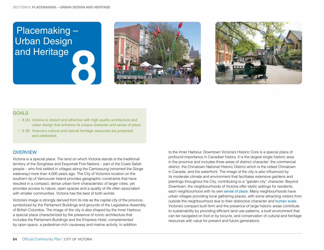
OVERVIEWVictoria is a special place. The land on which Victoria stands is the traditional territory of the Songhees and esquimalt First nations – part of the Coast Salish people – who first settled in villages along the Camossung (renamed the Gorge waterway) more than 4,000 years ago. The City of Victoria’s location on the southern tip of Vancouver Island provides geographic constraints that have resulted in a compact, dense urban form characteristic of larger cities, yet provides access to nature, open spaces and a quality of life often associated with smaller communities. Victoria has the best of both worlds.
Victoria’s image is strongly derived from its role as the capital city of the province, symbolized by the Parliament Buildings and grounds of the legislative assembly of British Columbia. The image of the city is also shaped by the Inner Harbour, a special place characterized by the presence of iconic architecture that includes the Parliament Buildings and the empress Hotel, complemented by open space, a pedestrian-rich causeway and marine activity. In addition
Placemaking – Urban Design and Heritage
8to the Inner Harbour, Downtown Victoria’s Historic Core is a special place of profound importance in Canadian history. It is the largest single historic area in the province and includes three areas of distinct character: the commercial district, the Chinatown national Historic District which is the oldest Chinatown in Canada, and the waterfront. The image of the city is also influenced by its moderate climate and environment that facilitates extensive gardens and plantings throughout the City, contributing to a “garden city” character. Beyond Downtown, the neighbourhoods of Victoria offer idyllic settings for residents, each neighbourhood with its own sense of place. Many neighbourhoods have urban villages providing local gathering places, with some attracting visitors from outside the neighbourhood due to their distinctive character and human scale. Victoria’s compact built form and the presence of large historic areas contribute to sustainability by providing efficient land use patterns, a built environment that can be navigated on foot or by bicycle, and conservation of cultural and heritage resources with value for present and future generations.
city of victoria | Official Community Plan 65
SECTION 8: placeMaking – urban design and Heritage
Victoria will continue to face the challenges of accommodating development that will create new memorable places that broaden Victoria’s image beyond its identity as a provincial capital with an iconic harbour, while contributing to the goals of sustainability, and retaining the character of Victoria’s existing special places.
To address these challenges, the plan seeks to concentrate new development throughout the Downtown Core area into new districts outside of Old Town, while continuing to support sensitive infill within the historic centre of the city. new districts will each have their own sense of place, as contemporary backdrops that will frame the old city. new development is also envisioned within and around urban Villages and Town Centres to intensify neighbourhood meeting places with human scale building forms and streetscape designs. Victoria’s special places are envisioned to be connected by streets and public spaces that are well-designed, beautified and animated by arts and culture, to entice people to walk, cycle, take transit and enjoy urban life. These will be the places that matter to Victorians with a diversity of form, character, uses and activities throughout the community.
Placemaking is the creation of place. It is the practice of building communities that have unique identity. This section applies the principles of placemaking to the urban design* of the city at various scales ranging from the city form as a whole down to specific sites and buildings, to the spaces between buildings and acknowledges the people who use them. The policies of this section are organized under the physical characteristics of the city, from broad to more specific categories including: city form; harbour and waterfront; corridors; areas and districts; centres, village and nodes; streetscapes and open space; buildings and sites; and natural features and landscaping. Successful placemaking will require legislated planning tools to help achieve the goals and objectives within this section, including the designation of Development Permit areas and Heritage Conservation areas that provide for urban design control in designated areas of the community. These are found in appendix a of this Plan.
*urban design includes heritage conservation.
BROAD OBJECTIVES:The placemaking policies of this plan collectively address 12 broad objectives:
8 (a) That urban design at every scale from sites to local areas is responsive to Victoria’s geographic context and existing pattern of development, achieves excellence, and creates memorable places.
8 (b) That the views from the public realm of existing landmarks are maintained, and that new landmarks are introduced to enhance the visual identity and appearance of Victoria and to improve wayfinding around the city.
8 (c) That new buildings and features contribute to the sense of place in development permit areas and heritage conservation areas through sensitive and innovative responses to existing form and character.
8 (d) That social vibrancy is fostered and strengthened through human scale design of buildings, streetscapes and public spaces.
8 (e) That each neighbourhood is connected and integrated to the urban Core, other neighbourhoods and to the region through urban design elements.
8 (f) That the built environment is beautified and softened through natural features in the public realm.
8 (g) That a sense of place is developed and enhanced through urban design features.
8 (h) That the public realm is animated through street life and festivals, celebrations and special events.
8 (i) That heritage values are considered in land management at every scale from sites to local areas.
8 (j) That heritage property is conserved as resources with value for present and future generations.
8 (k) That streetscape improvements include art in public places and reflect the culture and heritage of Victoria.
8 (l) That heritage and cultural values are identified, celebrated, and retained through community engagement.
Official Community Plan | city of victoria66
SECTION 8: placeMaking – urban design and Heritage
CITY FORM8.1 Continue to balance new development and heritage conservation
throughout the urban Place Designations in this plan.
8.2 acknowledge Victoria’s geographic context through building forms that are low at the shoreline and gradually rise to correspond with the rise in topography by:
8.2.1 Giving further emphasis to this principle throughout the urban Core as an urban amphitheatre centred on the harbour;
8.2.2 locating the city’s tallest buildings in the Core Business area as identified on Map 2, to symbolize downtown Victoria as the centre of the city and region and to emphasize the topographical high point of the downtown neighbourhood;
8.2.3 locating potential new landmarks at high geographic points, within Town Centres and urban Villages, at focal and inflection points in the street grid, and at commercial nodes throughout the city; and,
8.2.4 Protect views of distant vistas and cityscapes from public vantage points at the high geographic points of Summit Park, Gonzales Hill and Moss rock by maintaining low-rise building form on the immediate surrounding slopes.
8.3 Design tall buildings to complement the skyline through careful consideration of building termination.
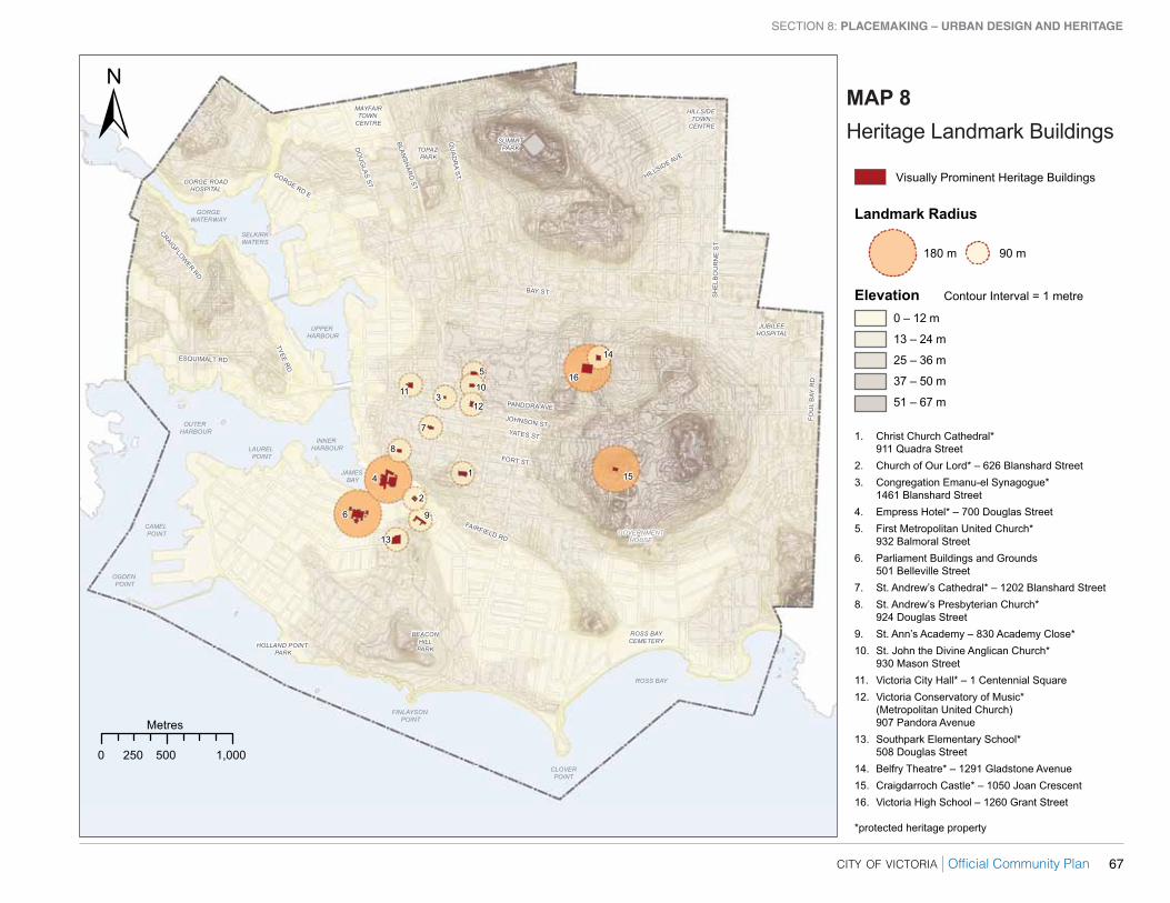
8.4 Maintain views of identified heritage landmark buildings from the public realm through careful consideration of new development within a 90 or 180 metre radius as defined on Map 8.
8.5 Continue to consider the heritage value and special character of areas, districts, streetscapes, cultural landscapes and individual properties in local area plans and related studies [See alSO SeCTIOn 6 – lanD
ManaGeMenT anD DeVelOPMenT].
8.6 Conserve and enhance the heritage value, character and special features of areas, districts, streetscapes, cultural landscapes and individual properties throughout the city [See alSO SeCTIOn 9 – ParKS
anD reCreaTIOn].
8.7 Maintain and promote unique character and sense of place in the urban Core, Town Centres, and urban Villages through the designation of Development Permit areas as identified in appendix a, and related guidelines, and give consideration to future designated areas in local area planning.
8.8 enhance the visual identity of corridors and urban Villages that span two or more neighbourhoods through unifying urban design features.
8.9 Continue to conserve and enhance the heritage value, character and special features of historic areas through the designation of Heritage Conservation areas identified in appendix a, and give consideration to future designations in local area planning.
8.10 Maintain, update and create design guidelines for Development Permit areas and Heritage Conservation areas that provide direction for design of commercial, industrial, multi-unit and intensive residential development including infill, and exterior alterations and new additions to heritage property.
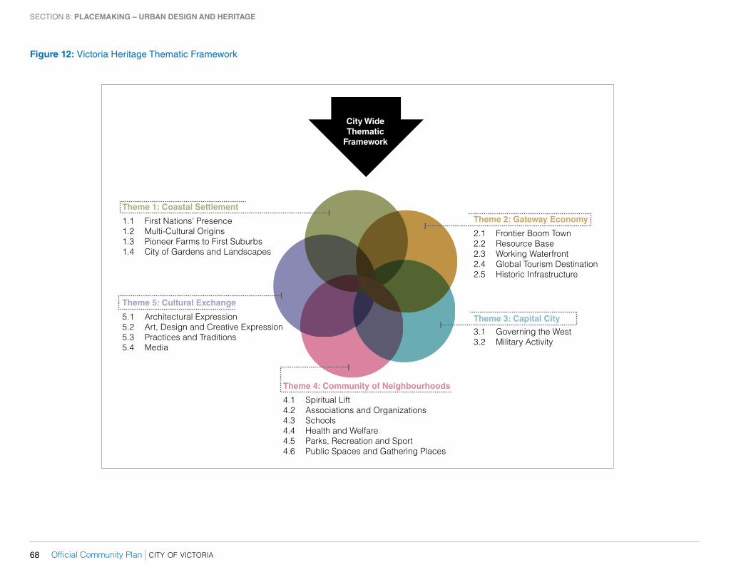
8.11 Determine the heritage value of areas, districts, streetscapes, cultural landscape and individual properties using the Victoria Heritage Thematic Framework as identified in Figure 12.
8.12 Seek opportunities to partner and collaborate with the Songhees and esquimalt First nations on placemaking initiatives that acknowledge and celebrate traditional territory and cultural values of First Peoples [See alSO SeCTIOn 16 – arTS anD CulTure].
HARBOUR AND WATERFRONT8.13 encourage urban design that enhances the Harbour as a marine
gateway [See alSO SeCTIOn 14 – eCOnOMY].
8.14 enable continuous public access along the waterfront through the implementation of the Victoria Harbour Pathway Plan with special consideration to urban design features for pedestrian enjoyment and comfort [See alSO SeCTIOn 7 – TranSPOrTaTIOn anD MOBIlITY].
8.15 Consider urban design improvements along and near the Core Songhees waterfront as part of local area planning [See alSO SeCTIOn 6 –
lanD ManaGeMenT anD DeVelOPMenT].
8.16 Continue to maintain views from public vantage points of the Inner Harbour, across the water to the Core Songhees area and along the waterfront from laurel Point to the urban Core, and from Belleville Street northwards to the Johnson Street Bridge as identified in guidelines for the Downtown Core area.
8.17 Maintain a lower-scale of buildings with a low profile along the waterfront adjacent to Store Street, Wharf Street, Government Street and Belleville Street, and in these locations support new development with form and character that contributes to and complements the skyline of the Core Historic area.
city of victoria | Official Community Plan 67
SECTION 8: placeMaking – urban design and Heritage
ESQUIMALT RD
GORGE RD E
SH
ELB
OU
RN
E S
T
CRAIGFLOWER RD
FAIRFIELD RD
JOHNSON ST
HILLSIDE AVE
QU
AD
RA S
T
FOU
L B
AY R
D
FORT ST
PANDORA AVE
TYEE RD
BAY ST
YATES ST
DO
UG
LAS ST
BLANSH
ARD
ST0 500 1,000250
Metres
15
16
14
13
6 9
2
14
8
7
12
10
5
311
ROSS BAY
FINLAYSON POINT
OGDEN POINT
CAMEL POINT
OUTER HARBOUR
LAUREL POINT
JAMES BAY
UPPER HARBOUR
INNER HARBOUR
SELKIRKWATERS
HILLSIDE TOWN
CENTRE
MAYFAIRTOWN
CENTRE
GORGEWATERWAY
HOLLAND POINT PARK
TOPAZ PARK
BEACONHILLPARK
GOVERNMENTHOUSE
CLOVERPOINT
ROSS BAYCEMETERY
GORGE ROADHOSPITAL
JUBILEEHOSPITAL
SUMMITPARK
180 m 90 m
MAP 8Heritage Landmark Buildings
Visually Prominent Heritage Buildings
Landmark Radius
Elevation Contour Interval = 1 metre
1. Christ Church Cathedral* 911 Quadra Street2. Church of Our Lord* – 626 Blanshard Street3. Congregation Emanu-el Synagogue* 1461 Blanshard Street4. Empress Hotel* – 700 Douglas Street5. First Metropolitan United Church* 932 Balmoral Street6. Parliament Buildings and Grounds 501 Belleville Street7. St. Andrew’s Cathedral* – 1202 Blanshard Street8. St. Andrew’s Presbyterian Church* 924 Douglas Street9. St. Ann’s Academy – 830 Academy Close*10. St. John the Divine Anglican Church* 930 Mason Street11. Victoria City Hall* – 1 Centennial Square12. Victoria Conservatory of Music* (Metropolitan United Church) 907 Pandora Avenue13. Southpark Elementary School* 508 Douglas Street14. Belfry Theatre* – 1291 Gladstone Avenue15. Craigdarroch Castle* – 1050 Joan Crescent16. Victoria High School – 1260 Grant Street
*protected heritage property
0 – 12 m
13 – 24 m
25 – 36 m
37 – 50 m
51 – 67 m
Official Community Plan | city of victoria68
SECTION 8: placeMaking – urban design and Heritage
Theme 4: Community of Neighbourhoods
4.1 Spiritual Lift4.2 Associations and Organizations4.3 Schools4.4 Health and Welfare4.5 Parks, Recreation and Sport4.6 Public Spaces and Gathering Places
Theme 5: Cultural Exchange
5.1 Architectural Expression5.2 Art, Design and Creative Expression5.3 Practices and Traditions5.4 Media
Theme 1: Coastal Settlement
1.1 First Nations’ Presence1.2 Multi-Cultural Origins1.3 Pioneer Farms to First Suburbs1.4 City of Gardens and Landscapes
Theme 2: Gateway Economy
2.1 Frontier Boom Town2.2 Resource Base2.3 Working Waterfront2.4 Global Tourism Destination2.5 Historic Infrastructure
Theme 3: Capital City
3.1 Governing the West3.2 Military Activity
City WideThematic
Framework
figure 12: Victoria Heritage Thematic Framework
city of victoria | Official Community Plan 69
SECTION 8: placeMaking – urban design and Heritage
CORRIDORS8.18 Provide a variety of linkages that connect public transit, greenway,
cycling and pedestrian networks to special places, and remove actual and perceived barriers to such destinations that may impede users or comfort and enjoyment.
8.19 enhance and expand the through-block pedestrian passageways throughout the Downtown Core area to break up long blocks with walkways that are:
8.19.1 Open to the sky;
8.19.2 located to allow unimpeded sight lines;
8.19.3 Fronted by active uses at grade for animation and surveillance;
8.19.4 Publicly accessible throughout the day and night, or business hours at minimum; and,
8.19.5 Include wayfinding features.
8.20 Identify and mark gateway locations along major access routes for a sense of arrival and departure into Victoria, the urban Core, Town Centres and urban Villages.
8.21 establish and enhance the visual identity of greenways through design features that distinguish them from other corridors and that improve wayfinding for cyclists and pedestrians.
8.22 enhance the appearance of major roads through design features that support and advance the Walkable urban Thoroughfare Guidelines in Figure 11 including, but not limited to:
8.22.1 Street furniture;
8.22.2 Pedestrian-scale lighting;
8.22.3 removal of visual clutter;
8.22.4 Street trees and planted boulevards; and,
8.22.5 raised, landscaped medians for pedestrian refuge.
8.23 explore the feasibility of establishing separated bike lanes within the cycling network to contribute to human scale street design by segmenting large expanses of hard surfacing [See alSO SeCTIOn 7 –
TranSPOrTaTIOn anD MOBIlITY].
8.24 enhance the pedestrian corridor along Government Street Mall through the extension of public realm improvements northward to Pembroke Street, and street or pathway connections to nearby public spaces.
AREAS AND DISTRICTS8.25 enhance local area distinctiveness through design of the public realm
with features that contribute to a sense of place, such as landscaping, street furniture, pedestrian-scale lighting, or art in public places.
8.26 enhance the place character of historic districts by celebrating heritage in urban design features such as landscaping, street furniture, lighting, art in public places, or banners.
8.27 Develop and regularly update statements of significance for historic areas and districts to inform local area plans and design guidelines for Development Permit areas and Heritage Conservation areas.
8.28 Maintain and enhance the heritage character of the urban Core through incentives that support:
8.28.1 Conversion of upper storeys of heritage-designated properties from non-residential uses to residential; and, [See alSO SeCTIOn 13 – HOuSInG anD HOMeleSSneSS],
8.28.2 rehabilitation of non-residential heritage-designated properties, such as offices and hotels [See alSO SeCTIOn 14 –
eCOnOMY].
8.29 Maintain and enhance the heritage character and special features of Traditional residential areas through incentives for heritage-designated houses [See alSO SeCTIOn 13 – HOuSInG anD HOMeleSSneSS anD SeCTIOn
14 – eCOnOMY].
CENTRES, VILLAGES AND NODES8.30 accommodate urban growth in large and Small urban Villages
through design that maintains human-scale in buildings, structures and public spaces, such as streetscape and squares.
8.31 animate the pedestrian realm in the urban Core, Town Centres, urban Villages and employment districts through urban design considerations, such as local gateways, sidewalk cafés, landscaping, street furniture and art in public places as generally consistent with the urban Place Designations in this plan.
8.32 require new development to build at-grade building frontages that are suitable for active uses on commercial streets, where viable, in the urban Core, Town Centres, urban Villages and General employment areas as shown on Map 2.
Official Community Plan | city of victoria70
SECTION 8: placeMaking – urban design and Heritage
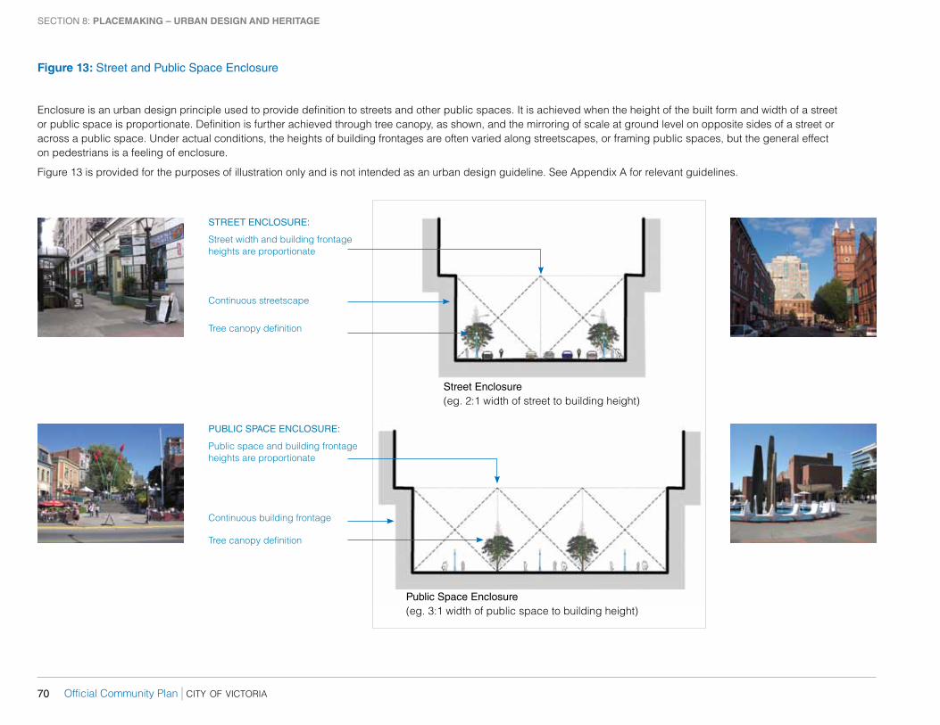
figure 13: Street and Public Space Enclosure
Public Space Enclosure(eg. 3:1 width of public space to building height)
STREET ENCLOSURE:
Street width and building frontage heights are proportionate
Continuous streetscape
Tree canopy definition
PUBLIC SPACE ENCLOSURE:
Public space and building frontage heights are proportionate
Continuous building frontage
Tree canopy definition
Street Enclosure(eg. 2:1 width of street to building height)
enclosure is an urban design principle used to provide definition to streets and other public spaces. It is achieved when the height of the built form and width of a street or public space is proportionate. Definition is further achieved through tree canopy, as shown, and the mirroring of scale at ground level on opposite sides of a street or across a public space. under actual conditions, the heights of building frontages are often varied along streetscapes, or framing public spaces, but the general effect on pedestrians is a feeling of enclosure.
Figure 13 is provided for the purposes of illustration only and is not intended as an urban design guideline. See appendix a for relevant guidelines.
city of victoria | Official Community Plan 71
SECTION 8: placeMaking – urban design and Heritage
STREETSCAPES AND OPEN SPACE8.33 enhance the design of the public realm to acknowledge the importance
of streets and other public spaces to the social life of the city.
8.34 Contribute to place character in the design of sidewalks, streets, and other public spaces, through public realm improvements consistent with the walkable urban thoroughfare guidelines in Figure 11.
8.35 Integrate urban design and heritage conservation in public realm improvements [See alSO SeCTIOn 16 – arTS anD CulTure].
8.36 Develop and maintain a Heritage Interpretation Plan with policies on permanent and temporary public realm improvements such as art in public places, murals, mosaics, installations, banners and plaques [See alSO SeCTIOn 16 – arTS anD CulTure].
8.37 Support a wide range of opportunities for permanent and temporary art in public and public-private spaces [See alSO SeCTIOn 16 – arTS
anD CulTure].
8.38 Continue to animate street life through festivals, celebrations and special events [See alSO SeCTIOn 16 – arTS anD CulTure].
8.39 Define streets as public space by respecting building height ratios proportionate to street width as shown in Figure 13, framing streets with a combination of building forms and tree canopies as appropriate and as may be further detailed in local area plans. allow for variations in building frontage to street width ratios across the City to acknowledge special conditions and local context.
8.40 enclose public space with buildings, formal tree planting or a combination of both for definition, as shown in Figure 13, so its importance in the urban form is apparent, while allowing openings to encourage entry into the space.
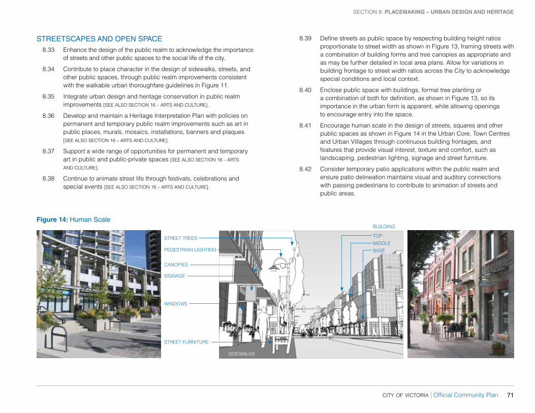
8.41 encourage human scale in the design of streets, squares and other public spaces as shown in Figure 14 in the urban Core, Town Centres and urban Villages through continuous building frontages, and features that provide visual interest, texture and comfort, such as landscaping, pedestrian lighting, signage and street furniture.
8.42 Consider temporary patio applications within the public realm and ensure patio delineation maintains visual and auditory connections with passing pedestrians to contribute to animation of streets and public areas.
figure 14: Human Scale
STreeT TreeS
PeDeSTrIan lIGHTInG
CanOPIeS
WInDOWS
TOP
STreeT FurnITure
SIDeWalKS
SIGnaGe
BaSe
MIDDle
BuIlDInG
Official Community Plan | city of victoria72
SECTION 8: placeMaking – urban design and Heritage
BUILDINGS AND SITES8.43 encourage high quality architecture, landscape and urban design to
enhance the visual identity and appearance of the City.
8.44 Support new infill and building additions that respond to context through sensitive and innovative design.
8.45 encourage human scale in all building designs, including low, mid-rise and tall buildings, through consideration of form, proportion, pattern, detailing and texture, particularly at street level.
8.46 Design tall buildings to achieve human scale qualities by mitigating the perception of building mass at upper levels, maximizing sunlight penetration to the public realm, and responding to adjacent development.
8.47 encourage buildings adjacent to sidewalks and public plazas to maximize shop windows and entrances at ground level to support active land uses and provide interest for pedestrians throughout the urban Core, Town Centres, and urban Villages [See alSO SeCTIOn 6 –
lanD ManaGeMenT anD DeVelOPMenT].
8.48 Integrate off-street vehicle parking in a way that does not dominate development or streetscapes [See alSO SeCTIOn 6 – lanD ManaGeMenT
anD DeVelOPMenT].
8.49 Continue to support new additions that conserve and enhance heritage property, as consistent with the national Standards and Guidelines for the Conservation of Historic Places in Canada.
8.50 encourage new development to avoid the demolition of heritage property, or one or more of its facades.
8.51 Continue to give consideration to tools available under legislation to protect or conserve heritage property including, but not limited to: heritage designation bylaws; listing on the heritage register; temporary protection; heritage alteration permits; heritage revitalization agreements; design guidelines; and, the protection of views of heritage landmark buildings from public vantage points as identified in Map 8, and to be determined in future local area plans.
8.52 Continue to enable and support heritage conservation through incentives and allowances including, but not limited to: property tax reductions; grants; bonus density provision; and, zoning variances.
8.53 require a heritage conservation plan, as appropriate, and heritage impact assessment, where relevant, for heritage alteration permits, heritage revitalization agreements, and rezonings for heritage properties.
8.54 Continue to work with senior government, community and business partners to identify, protect and conserve property of heritage value.
8.55 Continue to produce and update, as required, statements of significance for all property on the heritage register.
NATURAL FEATURES AND LANDSCAPING8.56 Improve public access to the waterfront and other natural features on
public lands through wayfinding measures.
8.57 acknowledge Victoria’s natural environment through landscaping that contributes to a sense of place through innovative and sensitive responses to sites including existing form and character.
8.58 acknowledge the place character of the urban Core, Town Centres and large urban Villages through natural features and indigenous plantings in the public realm, providing greenery to soften the urban environment, through:
8.58.1 Maintaining or increasing the planting of regularly spaced trees aligned with the development and implementation of an urban Forest Master Plan; [See alSO SeCTIOn 10 –
enVIrOnMenT];
8.58.2 Coordinating the urban design and green infrastructure benefits of public realm improvements on major roads, such as landscaping that contribute to rainwater management [See alSO SeCTIOn 11 – InFraSTruCTure]; and,
8.58.3 Working with partners to maintain and enhance a variety of plantings as part of street design standards and roadway design, and at important public buildings [See alSO SeCTIOn
6 – lanD ManaGeMenT anD DeVelOPMenT anD SeCTIOn 7 –
TranSPOrTaTIOn anD MOBIlITY].
8.59 Consider the incorporation of landscaping into street design standards to provide human scale elements and visually break up the extent of hard surface within right-of-ways [See alSO SeCTIOn 7 – TranSPOrTaTIOn
anD MOBIlITY].
city of victoria | Official Community Plan 73
SECTION 8: placeMaking – urban design and Heritage
8.60 Strengthen greenway identity through integration of natural features and landscaping, where feasible, to encourage use and enhance the experience of cyclists and pedestrians.
8.61 encourage private landscaped gardens in Development Permit and Heritage Conservation areas to contribute to Victoria’s identity as a city of gardens.
8.62 Develop and maintain a policy to identify and conserve heritage cultural landscapes on public and private lands, that [See alSO SeCTIOn
9 – ParKS anD reCreaTIOn]:
8.62.1 Seeks to determine the heritage value, character and special features of cultural landscapes; and,
8.62.2 Provides guidance for alterations, while conserving heritage value, character and special features.
8.63 Maintain horticultural plantings in select parks, including Beacon Hill Park, and road right-of-ways, as possible within City resources.
8.64 encourage active land uses adjacent to parks, where appropriate, for animation, surveillance and to encourage park use.
8.65 Design park perimeters at street interfaces to be visually and physically penetrable to pedestrians.