pilgrim petroleum corporation 15 september 2006 … · on the pilgrim petroleum corporation...
TRANSCRIPT

Resource Evaluation Report
On The Pilgrim Petroleum Corporation Interests
in Archer and Wichita Counties,
Bend Arch-Fort Worth Basin Province, Texas, USA
Prepared According To
National Instrument 51-101
Prepared on Behalf of
Pilgrim Petroleum Corporation
15 September 2006
Submitted By:
Independent Qualified Reserves Evaluators

Resource Evaluation Report
On The Pilgrim Petroleum Corporation Interests
in Archer and Wichita Counties,
Bend Arch-Fort Worth Basin Province, Texas, USA
Prepared According To
National Instrument 51-101
Prepared on Behalf of
Pilgrim Petroleum Corporation
15 September 2006
Letha C. Lencioni
Registered Petroleum Engineer
State of Colorado #29506
Independent Qualified Reserves Evaluators

TABLE OF CONTENTS
PAGE
1. INTRODUCTION................................................................................................. 1-1 1.1 AUTHORIZATION.................................................................................... 1-1 1.2 INTENDED PURPOSE AND USERS OF REPORT ................................ 1-1 1.3 OWNER CONTACT AND PROPERTY INSPECTION........................... 1-1 1.4 SCOPE OF WORK..................................................................................... 1-1 1.5 APPLICABLE STANDARDS ................................................................... 1-1 1.6 ASSUMPTIONS AND LIMITING CONDITIONS................................... 1-2 1.7 INDEPENDENCE/DISCLAIMER OF INTEREST................................... 1-2 2. REQUIRED DISCLOSURES REGARDING PROSPECTS ........................... 2-1 2.1 LOCATION AND BASIN NAME............................................................. 2-1 2.2 PILGRIM PETROLEUM CORPORATION’S GROSS AND NET INTERESTS IN THE PROPERTIES......................................................... 2-2 2.3 EXPIRY DATE OF INTEREST ................................................................ 2-4 2.4 DESCRIPTION OF TARGET ZONE ........................................................ 2-4 2.5 DISTANCE TO THE NEAREST COMMERCIAL PRODUCTION........ 2-4 2.6 PRODUCT TYPES REASONABLY EXPECTED ................................... 2-5 2.7 RANGE OF POOL OR FIELD SIZES....................................................... 2-5 2.8 DEPTH OF THE TARGET ZONE ............................................................ 2-6 2.9 ESTIMATED DRILLING AND TESTING COSTS ................................. 2-7 2.10 EXPECTED TIMING OF DRILLING AND COMPLETION .................. 2-7 2.11 EXPECTED PRICES.................................................................................. 2-7
9/19/2006 i Gustavson Associates

PAGE
2.12 EXPECTED MARKETING AND TRANSPORTATION ARRANGEMENTS.................................................................................... 2-8 2.13 IDENTITY AND RELEVANT EXPERIENCE OF THE OPERATOR.... 2-10 2.14 RISKS AND PROBABILITY OF SUCCESS............................................ 2-11 2.15 APPLICABLE INFORMATION SPECIFIED IN SECTION 5.10 OF 51-101 ......................................................................................................... 2-11 3. PROBABILISTIC RESOURCE ESTIMATE.................................................... 3-1 3.1 GENERAL.................................................................................................. 3-1 3.2 INPUT PARAMETERS ............................................................................. 3-1 3.3 PROBABILISTIC SIMULATION............................................................. 3-2 3.4 RESULTS ................................................................................................... 3-2 4. FORM 51-101F2.................................................................................................... 4-1 5. CONSENT LETTER ............................................................................................ 5-1 6. CERTIFICATE OF QUALIFICATIONS .......................................................... 6-1
9/19/2006 ii Gustavson Associates

LIST OF FIGURES
FIGURE PAGE 2-1 Index Map of the Bend Arch-Fort Worth Basin Geological Province ................... 2-1 2-2 Map of Pilgrim Petroleum Acreage in Wichita County, Texas .............................. 2-2 2-3 Map of Pilgrim Petroleum Acreage in Archer County, Texas ............................... 2-3 2-4 Mississippian Chappel Pinnacle Reef Assessment Unit......................................... 2-6 2-5 TEPPCO Pipeline Map ........................................................................................... 2-8 2-6 KinderMorgan – Terasen Pipeline Map.................................................................. 2-9 2-7 Pipeline Map of Part of Wichita and Archer Counties, Texas................................ 2-10 3-1 Distribution of Prospective Oil Resources.............................................................. 3-3 3-2 Distribution of Prospective Gas Resources ............................................................ 3-4
LIST OF TABLES
TABLE PAGE 2-1 List of Pilgrim Petroleum Corporation Leases and Approximate Acres ................ 2-3 3-1 Prospective Resources ............................................................................................ 3-3
9/19/2006 iii Gustavson Associates

1. INTRODUCTION
1.1 AUTHORIZATION
Gustavson Associates LLC (the Consultant) has been retained by Pilgrim Petroleum Corporation
(Pilgrim, the Client) to prepare a Report under Standards 51-101 regarding the Client’s acreage
located in Archer and Wichita counties, Texas, USA.
1.2 INTENDED PURPOSE AND USERS OF REPORT
The purpose of this Report is to support the Client’s filing with the Toronto Stock Exchange.
1.3 OWNER CONTACT AND PROPERTY INSPECTION
This Consultant has had frequent contact with the Client including contact up to the date of this
Report. This Consultant has not personally inspected the subject properties.
1.4 SCOPE OF WORK
This Report is intended to describe and quantify the potential oil and gas resources contained
within the Client’s acreage located in Archer and Wichita Counties, Texas, USA..
1.5 APPLICABLE STANDARDS This Report has been prepared in accordance with Canadian National Instrument 51-101. The
National Instrument requires disclosure of specific information concerning prospects, as will be
provided in Section 2 of this Report.
9/19/2006 1-1 Gustavson Associates

1.6 ASSUMPTIONS AND LIMITING CONDITIONS
This Report is limited to a characterization of the potential undiscovered oil and gas resources on
the Client’s properties located in Archer and Wichita Counties, Texas, and owned as of the
effective date of this report. This Report does not attempt to place a value thereon.
The lease maps included in the report are based on information supplied by the Client and other
sources. Some of the available lease descriptions were incomplete, but the Client informs the
Consultant that the acreage is as listed in the accompanying table, and that, in some instances,
the deep rights have been included by addendums to the leasehold assignments. The size of the
individual leases may not be to scale on the maps.
Gustavson Associates reserves the right to revise its opinions of reserves and resources, if new
information is deemed sufficiently credible to do so.
The accuracy of any estimate is a function of available time, data and of geological, engineering
and commercial interpretation and judgment. While the resource estimates presented herein are
believed to be reasonable, they should be viewed with the understanding that additional analysis
or new data may justify their revision and we reserve the right to make such revision.
1.7 INDEPENDENCE/DISCLAIMER OF INTEREST
Gustavson Associates LLC has acted independently in the preparation of this Report. The
company and its employees have no direct or indirect ownership in the property appraised or the
area of study described.
Our fee for this Report and the other services that may be provided are not dependent on the
amount of resources estimated.
9/19/2006 1-2 Gustavson Associates

2. REQUIRED DISCLOSURES REGARDING PROSPECTS
2.1 LOCATION AND BASIN NAME
The Pilgrim acreage that is described in more detail below is located on the northern plunge of
the Bend Arch within the Bend-Arch-Fort Worth Basin geological province of North Texas. The
Bend Arch is a prominent structural ridge that marks the western boundary of the Fort Worth
Basin. Figure 2-1 shows the location of the major geological features of this province and the
location of the Pilgrim acreage position.
Figure 2-1 Index map of the Bend Arch-Fort Worth Basin geological province (outlined in red) and primary structural elements of north-central Texas and the southwestern corner of Oklahoma. Theapproximate location of the Pilgrim properties is shown by a yellowstar. (modified after USGS Fact Sheet 2004-3022, March 2004).
9/19/2006 2-1 Gustavson Associates

2.2 PILGRIM PETROLEUM CORPORATION’S GROSS AND NET INTEREST IN THE
PROPERTIES
Pilgrim Petroleum Corporation owns leases covering approximately 11,700 gross acres in
Archer and Wichita counties, Texas. The acreage is scattered, with approximately 9300
acres, or 80% of the total lease position, associated with two comparatively large blocks in
Archer County. Working interests are 100%, and the Net Revenue Interests (NRI) are 76.4%.
As of July 2006, the leaseholds consisted of 10 individual leases, including 201 wells, some
of which are inactive. Pilgrim continues to acquire leases, and since that date, has added an
additional 6 leases and 321 wells, which have not been evaluated in this report. Pilgrim’s
leases in Wichita and Archer counties are shown in Figures 2-3 and 2-4. A list of the leases
as of July 2006 is included in Table 2-1.
Legend Pilgrim Leasehold City or Town
Prothro, C.N. (new)Patton (new)
Waggoner Est B (new)
Douglas Mineral Trust
Burnett EE (new)
Waggoner AN (new)
Lilly Hooks
Lochridge Morgan F.D.
S.M.A.Unit B (new)
Figure 2-2 Map of Pilgrim Petroleum Corporation acreage in Wichita County, Texas
9/19/2006 2-2 Gustavson Associates

Meldon White City National Bank
Climax
Cowan & Mackinney Cowan-Mackinney C
Legend Pilgrim Leasehold City or Town
Figure 2-3 Map of Pilgrim Petroleum Corporation acreage in Archer County, Texas
County Lease Gross Acres
Archer Climax 5000
Cowan Mackinney “C” 160
Cowan & Mackinney 280
City National Bank 4300
Meldon White L. 430
Wichita Lilly Hooks 190
Morgan F.D. 120
Morgan F. D. Tract 2 120
Lochridge 140
Douglas Mineral Trust 960
Table 2-1 List of Pilgrim Petroleum Corporation Leases and Approximate Acres
9/19/2006 2-3 Gustavson Associates

2.3 EXPIRY DATE OF INTEREST
Several of the leases are held by shallow oil production that appears to be sub-economic at
present. The Client reports that the remaining leases continue to be in force pending re-activation
of shut-in wells.
2.4 DESCRIPTION OF TARGET ZONE
The primary target zones are the Mississippian-age pinnacle reef (“Waulsortian” mud mound)
carbonate reservoirs of the Chappel Formation at depths in the range of 4000 to 6500 feet.
Geometrically, these pinnacle reefs may be envisioned as narrow, tall gumdrop-shaped bodies
that grew on the Mississippian marine shelf seafloor of North Texas and were laterally buried in
their own debris and subsequently by younger muddy sediments.
Individual pinnacle reef reservoirs are of relatively small areal extent (generally less than 640
acres, and more commonly less than 160 acres) based on historic drilling and field descriptions.
However, they may be numerous and widespread in their distribution within the Mississippian
Chappel Pinnacle Reef Fairway than spans all or portions of 27 counties in North Texas.
Although small in areal extent, the individual pinnacle reefs can be very thick, with heights of
150 to more than 300 feet above the surrounding thin, off-reef marine platform substratum. The
reefs are encased in off-reef skeletal debris aprons of tight carbonate and are overlain by the
Mississippian-age Barnett Shale that provides both the vertical seal for the reservoirs and is the
source rock for the hydrocarbons trapped in the reefal rocks.
2.5 DISTANCE TO THE NEAREST COMMERCIAL PRODUCTION
La Pan Field, the nearest Chappel pinnacle reef production to the subject acreage, is located
about 30 miles to the east in central Clay County. The La Pan Field was discovered in 1955 and
has yielded more than 4 BCFG and 902,000 barrels of oil (BO) from six wells drilled into a
pinnacle reef that covers about 160 acres. The field also produces from the overlying
Pennsylvanian Atoka sandstones.
9/19/2006 2-4 Gustavson Associates

Osage Field, located some 50 miles to the southeast of Pilgrim’s acreage in southwestern
Montague County, was discovered in 1953 and has yielded more than 10 BCFG from a pinnacle
reef that covers 600 acres.
Shackelford NE Field, located some 60 miles to the southwest of Pilgrim’s Archer County
leasehold, in Shackelford County, is mainly a gas field with some associated oil. The field was
discovered in 1973 and has produced in excess of 32 billion cubic feet of gas (BCFG) from a
cluster of individual reefs that make up the producing complex.
2.6 PRODUCT TYPES REASONABLY EXPECTED
Both oil and gas have been discovered and produced from Chappel pinnacle reef reservoirs in the
play area. Some combination of the two product types is expected in the area of Pilgrim’s
acreage position.
2.7 RANGE OF POOL OR FIELD SIZES
The precise range of field sizes is not known to this Consultant, but the available data does
provide useful information. The U.S. Geological Survey (USGS), in its 1995 and 2003
probabilistically-based Oil and Gas Resource Assessments of the Bend Arch-Fort Worth Basin
Province, included Chappel pinnacle reef fields with minimum accumulations of 0.5 MMB0 for
oil accumulations, and 3 BCF for gas accumulations. That seems to indicate some fields were
smaller than the minimums. As mentioned above, the largest field in the immediate area has
produced a cumulative 32 BCF gas. The USGS Assessments indicate that the median field size
for discovered Chappel pinnacle reef fields is one million barrels of oil (1 MMBO) for oil fields
and four to five billion cubic feet of gas (4-5 BCFG) for gas fields in the play. The USGS
reports that through 1990, fields in this play produced 83 MMBO, 246 BCFG, and 16 MMBNGL
(natural gas liquids or condensate). The typical field consists of 1-3 wells. These median field
sizes are anticipated to be representative for future discoveries. Figure 2-5 shows the outline of
the Mississippian Chappel Reef Assessment Unit.
9/19/2006 2-5 Gustavson Associates

Figure 2-4 Mississippian Chappel Pinnacle Reef Assessment Unit
Source: USGS – National Assessment of Oil and Gas Bend Arch-Fort Worth Basin Province
2.8 DEPTH OF THE TARGET ZONE
The top of the Mississippian-age pinnacle reef (“Waulsortian” mud mound) carbonate reservoirs
of the Chappel Formation is expected at depths ranging from 4000 to 6500 feet.
9/19/2006 2-6 Gustavson Associates
2.9 ESTIMATED DRILLING AND TESTING COSTS
Development of the resource will require careful mapping of existing geological data followed
by 3-D seismic surveys on Pilgrim’s two large land positions (4300 acres and 5000 acres). The
estimated cost per survey, including the required overlap to adequately image the target horizon,
is approximately $800,000.
Total drilling and completion costs are estimated at $550,000 per well. Of this, roughly
$375,000 is expected for drilling costs, with $175,000 for completion. Testing costs are
expected to be very limited, if any. Total number of wells drilled may vary between 2 and about
20.
2.10 EXPECTED TIMING OF DRILLING AND COMPLETION
It is projected that initial mapping of existing geological data will be completed by the end of the
fourth quarter, 2006, and that the first of two targeted 3-D seismic surveys will be acquired and
interpreted within two-months later. The second 3-D survey could be planned to be concurrent
with the first, or immediately afterward, depending on results of the initial geological mapping.
Drilling is expected to commence within one year of completion of seismic interpretation.
Commencement of drilling is dependent on rig availability and also upon the time required for
permitting locations and meeting all regulatory requirements. If the estimated maximum number
of wells is drilled, the total development schedule could encompass up to two years or more,
depending on the time required for ongoing re-evaluation of the prospect as new information is
provided by newly drilled wells.
2.11 EXPECTED PRICES
Current oil and condensate prices for the area are about $59.75 per barrel. Well-head gas prices
are estimated to be $4.65 per MCF as of the date of this report.
9/19/2006 2-7 Gustavson Associates

2.12 EXPECTED MARKETING AND TRANSPORTATION ARRANGEMENTS
The subject area has a long-established history of oil production, and gathering systems for oil
and casing-head gas are in place. The Client’s current oil production is marketed to TEPPCO,
and their crude oil pipeline system is shown below (Figure 2-4). Gas-well gas production is not
as widespread, but there is at least one major gas pipeline in the area as shown in Figure 2-5.
Additionally, a pipeline map from the Texas Railroad Commission shows a gas transmission line
running north and south through the area (Figure 2-6), but this Consultant has not identified the
operator or ascertained the available capacity of that line. Pipeline connections are not expected
to be a problem.
Figure 2-5 TEPPCO Pipeline Map (from TEPPCO website, http://www.teppco.com/news/logos_maps/Teppco_System_Map_2003.gif)
9/19/2006 2-8 Gustavson Associates
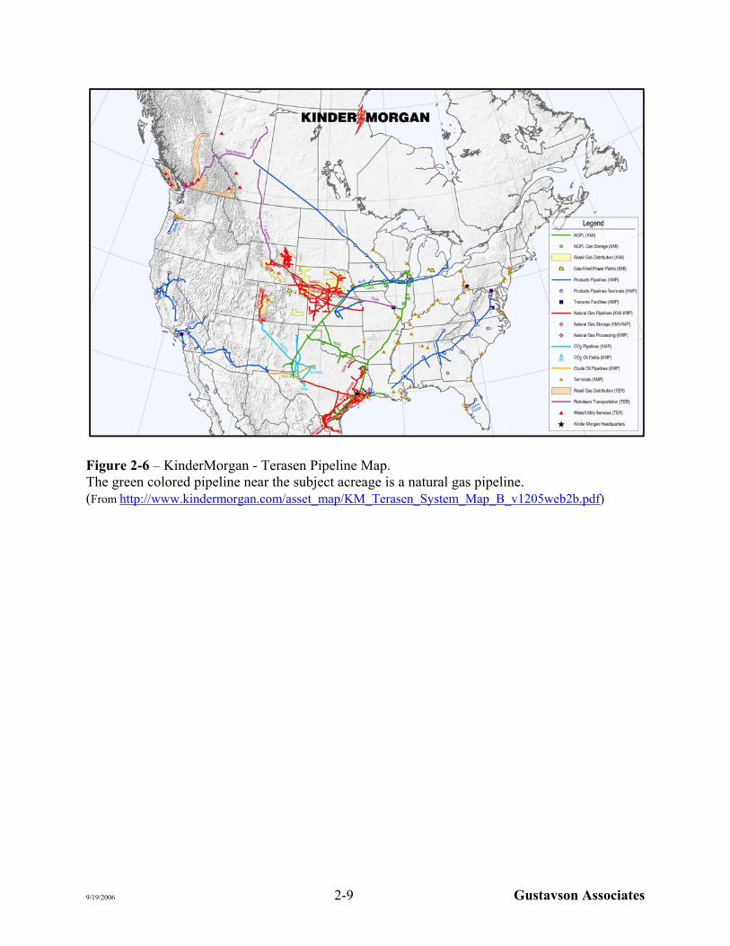
Figure 2-6 – KinderMorgan - Terasen Pipeline Map. The green colored pipeline near the subject acreage is a natural gas pipeline. (From http://www.kindermorgan.com/asset_map/KM_Terasen_System_Map_B_v1205web2b.pdf)
9/19/2006 2-9 Gustavson Associates

Figure 2-7 Pipeline map of part of Wichita and Archer counties, Texas (from the Railroad Commission of Texas website, http://gis2.rrc.state.tx.us )
2.13 IDENTITY AND RELEVANT EXPERIENCE OF THE OPERATOR
The operators for Pilgrim will most likely be American Petroleum Corporation and/or General
Energy Corporation, subsidiaries of Pilgrim Petroleum. They currently operate the existing
shallow production on the Pilgrim leases.
9/19/2006 2-10 Gustavson Associates
2.14 RISKS AND PROBABILITY OF SUCCESS
Modern 3D seismic surveys are critical to identifying the locations of Chappel pinnacle reefs of
small areal extent within the play fairway. This seismic technique, which sees the sediment
drape over the underlying pinnacles, has been used successfully for exploration of Chappel reefs.
The risks are mostly geological; the main geologic risk is in the potential for encountering
pinnacle reefs in a given area.
The probability of drilling success is high, once a pinnacle reef has been identified by 3-D
seismic.
2.15 APPLICABLE INFORMATION SPECIFIED IN SECTION 5.10 OF 51-101
This Report does not include an estimate of Fair Value of the Pinnacle Reef Project; therefore,
the information specified in Section 5.10 of National Instrument 51-101 is not required to be
included in this Report.
9/19/2006 2-11 Gustavson Associates

3. PROBABILISTIC RESOURCE ESTIMATE
3.1 GENERAL
A probabilistic reserve analysis is most applicable for projects such as evaluating the potential
resources of the subject area, where uncertainty exists in the geology and reservoir parameters.
The uncertainty in the reservoir data is quantified by probability distributions, and an iterative
approach yields an expected probability distribution for potential reserves. This approach allows
consideration of most likely resources for planning purposes, while gaining an understanding of
what volumes of resources may have higher certainty, and what potential upside may be for the
project.
A thorough statistical analysis of Chappel Lime Pinnacle Reefs in the entire Bend Arch-Fort
Worth Basin Province has previously been conducted by the USGS and published in the
Assessments described earlier in this report. The resource estimates herein incorporate the
median field sizes determined by the USGS. For a resource estimate such as this, the risk is
mainly geologic. Further probabilistic analysis for this project was carried out considering the
geologic risk of pinnacle reefs being present under the subject leaseholds, and the uncertainty of
identifying pinnacle reefs with seismic surveys.
3.2 INPUT PARAMETERS
This method involved estimating the probable density of undiscovered Chappel Lime Reef fields
based on their occurrence in other parts of the basin, their small areal extent, and the probable
existence of undiscovered fields due to the difficulty of locating them before the advent and
widespread use of 3-D seismic surveys. The geologic probability of occurrence of pinnacle reefs
was estimated to be 10 percent; in other words, 10 percent of the acreage could be found to
contain pinnacle reefs. Therefore, Pilgrim’s total of 9300 acres in the two large blocks should
contain 930 productive acres. As the typical size of a pinnacle reef field is 160 acres or less, 930
net productive acres would most likely contain 5.8 fields, and this was considered the best
estimate.
9/19/2006 3-1 Gustavson Associates

Based on the above input parameters, it was projected that 3-D seismic surveys would most
likely indicate 5.8 drilling targets for each of Pilgrim’s two large blocks of acreage. Further, a
drilling success of 2 out of 3, or 66.7 percent was estimated. In other words, it was projected that
2 out of 3 of the initial exploratory wells would encounter pinnacle reef fields of the median size
reported in the USGS Assessment. It is considered equally likely that each field will contain
either oil or gas. Any associated gas or condensate has not been considered in the resource
estimate.
3.3 PROBABILISTIC SIMULATION
Probabilistic reserve analysis was performed using the Monte Carlo simulation software called
“@ Risk”. This software allows for input of a variety of probability distributions for any
uncertain parameter. Then the program performs a large number of iterations, either a large
number specified by the user, or until a specified level of stability id achieved in the output. The
results include a probability distribution for the output, sampled probability for the inputs, and
sensitivity analysis showing which input parameters have the most effect on the uncertainty in
each output parameter.
After distributions for input parameters were defined, a series of simulations were run wherein
points from the distributions were randomly selected and used to calculate one iteration of
estimated potential resources. The iterations were repeated until stable statistics (mean and
standard deviation) result from the resulting output distribution, after 5,000 iterations.
3.4 RESULTS
The output distributions were then used to characterize the potential resources. Graphs of
cumulative probability versus resources were constructed. Results are presented in Table 3-1.
Figures 3-1 and 3-2 show the distribution of “Prospective Resources” for oil and gas,
respectively. Prospective Resources are those estimated to be potentially recoverable and likely
economic. Key points from the resource distribution include the 50 percent point (best estimate),
9/19/2006 3-2 Gustavson Associates
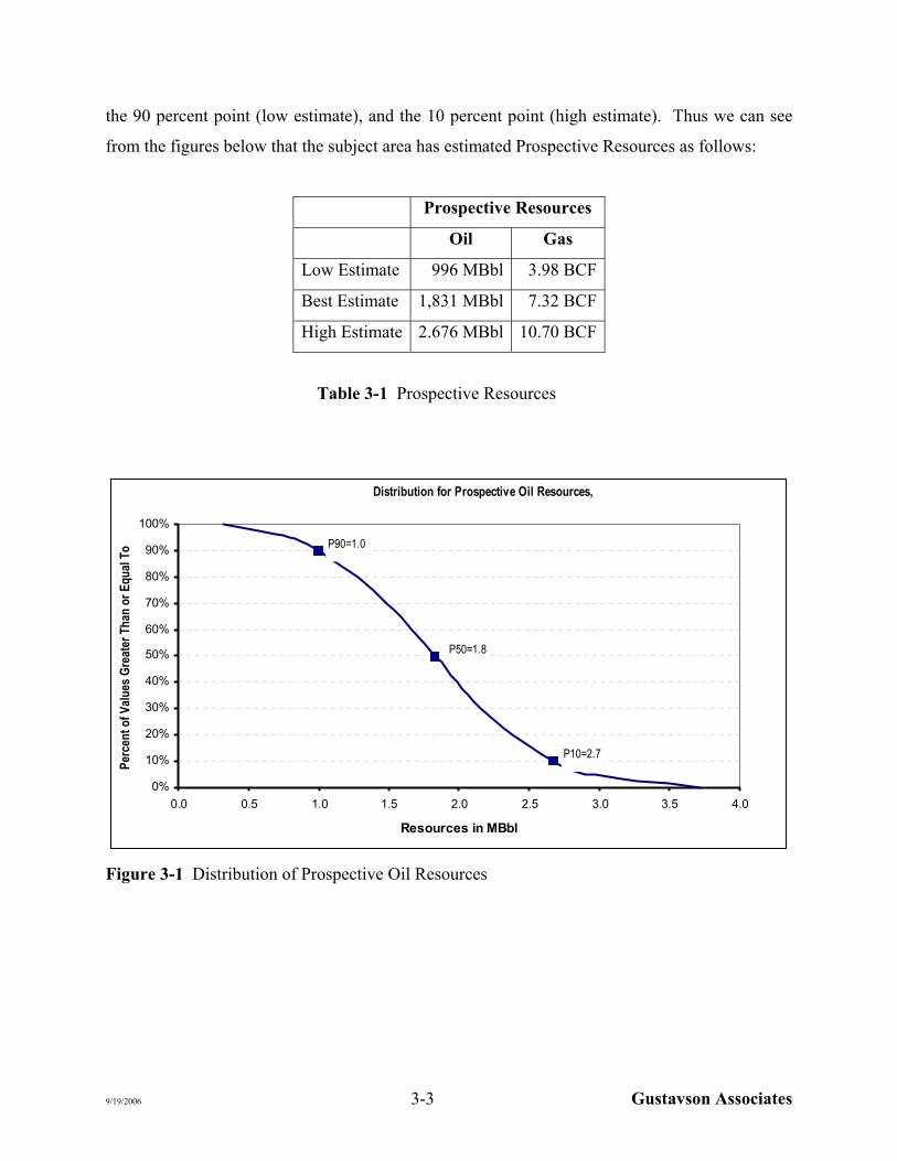
the 90 percent point (low estimate), and the 10 percent point (high estimate). Thus we can see
from the figures below that the subject area has estimated Prospective Resources as follows:
Prospective Resources
Oil Gas
Low Estimate 996 MBbl 3.98 BCF
Best Estimate 1,831 MBbl 7.32 BCF
High Estimate 2.676 MBbl 10.70 BCF
Table 3-1 Prospective Resources
Distribution for Prospective Oil Resources,
P90=1.0
P50=1.8
P10=2.7
0%
10%
20%
30%
40%
50%
60%
70%
80%
90%
100%
0.0 0.5 1.0 1.5 2.0 2.5 3.0 3.5 4.0
Resources in MBbl
Per
cen
t o
f V
alu
es G
reat
er T
han
or
Eq
ual
To
Figure 3-1 Distribution of Prospective Oil Resources
9/19/2006 3-3 Gustavson Associates

Distribution for Prospective Gas Resources
P90=4.0
P50=7.3
P10=10.7
0%
10%
20%
30%
40%
50%
60%
70%
80%
90%
100%
0.0 2.0 4.0 6.0 8.0 10.0 12.0 14.0 16.0
Resources in BCF
Per
cen
t o
f V
alu
es G
reat
er T
han
or
Eq
ual
To
Figure 3-2 Distribution of Prospective Gas Resources
Note that, in general, the high probability resource estimates at the left side of these distributions
represents downside risk, while the low probability estimates on the right side of the distributions
represent upside potential.
9/19/2006 3-4 Gustavson Associates

4. FORM 51-101F2
REPORT ON RESERVES DATA
BY
INDEPENDENT QUALIFIED RESERVES
EVALUATOR OR AUDITOR
This is the form referred to in item 2 of section 2.1 of National Instrument 51-101 Standards
of Disclosure for Oil and Gas Activities ("NI 51-101").
1. Terms to which a meaning is ascribed in NI 51-101 have the same meaning in this form. 2. The report on reserves data referred to in item 2 of section 2.1 of NI 51-101, to be
executed by one or more qualified reserves evaluators or auditors independent of the reporting issuer, shall in all material respects be as follows:
Report on Reserves Data To the Directors of Pilgrim Petroleum Corporation: 1. We have evaluated the Company’s reserves and resources data as at 15 September 2006.
The data consist of prospective oil and gas resources estimated as at 15 September 2006.
2. The reserves and resources data are the responsibility of the Company’s management.
Our responsibility is to express an opinion on the reserves and resources data based on our evaluation.
We carried out our evaluation in accordance with standards set out in the Canadian Oil and Gas Evaluation Handbook (the "COGE Handbook") prepared jointly by the Society of Petroleum Evaluation Engineers (Calgary Chapter) and the Canadian Institute of Mining, Metallurgy & Petroleum (Petroleum Society).
3. Those standards require that we plan and perform an evaluation to obtain reasonable
assurance as to whether the reserves and resources data are free of material misstatement. An evaluation also includes preparing estimates of reserves and resources data in accordance with principles and definitions presented in the COGE Handbook.
9/19/2006 4-1 Gustavson Associates

- 2 - 4. The following table sets forth the estimated resources of the Company evaluated by us as
at 15 September 2006, and identifies the respective portions thereof that we have evaluated and reported on to the Company's management:
Prospective Resources
Independent Qualified Reserves
Evaluator or Auditor
Description and Preparation Date
of Report
Location of Reserves
(Country or Foreign
Geographic Area) Audited Evaluated Reviewed Total
Letha C. Lencioni
Evaluation
Report 15 September
2006
Bend Arch-Fort Worth
Basin Province, Northern
Texas, USA
0
Low –3.98 BCF, 996 MBbl
Best – 7.32 BCF, 1,832 MBbl
High – 10.70 BCF, 2,676 MBbl
0
Low –3.98 BCF, 996 MBbl
Best – 7.32 BCF, 1,832 MBbl
High – 10.70 BCF, 2,676 MBbl
Totals
0
Low –3.98 BCF, 996 MBbl
Best – 7.32 BCF, 1,832 MBbl
High – 10.70 BCF, 2,676 MBbl
0
Low –3.98 BCF, 996 MBbl
Best – 7.32 BCF, 1,832 MBbl
High – 10.70 BCF, 2,676 MBbl
5. In our opinion, the reserves and resources data respectively evaluated by us have, in all material respects, been determined and are in accordance with the COGE Handbook. We express no opinion on the reserves and resources data that we reviewed but did not audit or evaluate; however, to our knowledge, all data were evaluated.
6. We have no responsibility to update our reports referred to in paragraph 4 for events and circumstances occurring after their respective preparation dates.
7. Because the reserves data are based on judgments regarding future events, actual results
will vary and the variations may be material.
Executed as to our report referred to above:
Letha C. Lencioni, Boulder, Colorado, USA, September 15, 2006
[signed]
9/19/2006 4-2 Gustavson Associates
5. CONSENT LETTER
Gustavson Associates LLC hereby consents to the use of all or any part of this Resource
Evaluation Report for the Client’s leaseholds in Archer and Wichita Counties, Texas, USA, as of
15 September 2006, in any document filed with any Canadian Securities Commission by Pilgrim
Petroleum Corporation, an Alberta Corporation.
Letha C. Lencioni Vice-President, Petroleum Sector
Gustavson Associates LLC
9/19/2006 5-1 Gustavson Associates

6. CERTIFICATE OF QUALIFICATION
I, Letha Chapman Lencioni, Professional Engineer of 5757 Central Avenue, Suite D, Boulder,
Colorado, 80301, USA, hereby certify:
1. I am an employee of Gustavson Associates, which prepared a detailed analysis of the oil
and gas properties of Pilgrim Petroleum Corporation. The effective date of this
evaluation is September 15, 2006.
2. I do not have, nor do I expect to receive, any direct or indirect interest in the securities of
Pilgrim Petroleum Corporation or its affiliated companies, nor any interest in the subject
properties.
3. I attended the University of Tulsa and I graduated with a Bachelor of Science Degree in
Petroleum Engineering in 1980; I am a Registered Professional Engineer in the State of
Colorado, and I have in excess of 24 years’ experience in the conduct of evaluation and
engineering studies relating to oil and gas fields.
4. A personal field inspection of the properties was not made; however, such an inspection
was not considered necessary in view of information available from public information
and records, the files of Pilgrim Petroleum Corporation, and the appropriate state
regulatory authorities.
Letha Chapman Lencioni
Chief Reservoir Engineer/ Vice-President, Petroleum Sector
Gustavson Associates, Inc. Colorado Registered Engineer #29506
9/19/2006 6-1 Gustavson Associates