pike pine streetscape and bicycle improvements project
TRANSCRIPT

Pike Pine Streetscape and Bicycle Improvements Project Seattle, Washington SEPA Checklist February 5, 2021
Pike Pine Streetscape and Bicycle Improvements Project SEPA Checklist, February 5, 2021 Page 2 of 29
STATE ENVIRONMENTAL POLICY ACT (SEPA) ENVIRONMENTAL CHECKLIST A. BACKGROUND
1. Name of proposed project, if applicable:
Pike Pine Streetscape and Bicycle Improvements Project (the Project)
2. Name of applicant: The Seattle Office of the Waterfront and Civic Projects (OWCP) and the Seattle Department of Transportation (SDOT)
3. Address and phone number of applicant and contact person: Therese Casper, Project Manager Seattle Office of the Waterfront and Civic Projects 800 Fifth Avenue, Suite 3100 P.O. Box 34996 Seattle, WA 98124 206-684-8764
4. Date checklist prepared: February 5, 2021
5. Agency requesting checklist: SDOT
6. Proposed timing or schedule (including phasing, if applicable): Pending timely receipt of approvals and permits, Project construction is anticipated to begin in June 2023 and be substantially complete by December 2024.
7. Do you have any plans for future additions, expansion, or further activity related to or connected with this proposal? If yes, explain. Neither OWCP nor SDOT has plans for future additions to or expansion of the Project. SDOT has plans for a future project that borders the Project in that SDOT’s future project, the Center City Connector Streetcar Project (CCCSP) located on First Avenue, will be partially constructed adjacent to or just slightly within the westernmost end of the Project’s footprint. CCCSP is under design. The Project will need to coordinate with CCCSP regarding the intersections of First Avenue with Pike and Pine Streets.

Pike Pine Streetscape and Bicycle Improvements Project SEPA Checklist, February 5, 2021
Page 3 of 29
8. List any environmental information you know about that has been prepared, or will be prepared, directly related to this proposal. Cultural Resources Inadvertent Discovery Plan, Pike Pine Streetscape and Bicycle
Improvements (to be prepared)
Pavement Evaluation Report, Pike Pine Streetscape and Bicycle Improvements (Draft) prepared for ZGF Architects by Aspect Consulting (April 8, 2020)
Pike Pine Streetscape and Bicycle Improvements Project Areaways Evaluation Report prepared by Chudgar Engineering Company (April 8, 2020)
Pike Pine Streetscape and Bicycle Improvements Traffic Analysis Technical Memorandum (Draft) prepared for ZGF by Concord Engineering (March 27, 2020)
“Preliminary (30%) Stormwater Technical Memorandum, Pike Pine Streetscape & Bicycle Improvements” prepared for SDOT by Toole Design (April 2, 2020)
9. Do you know whether applications are pending for governmental approvals of other
proposals directly affecting the property covered by your proposal? If yes, explain. A number of applications are pending for government approvals of other proposals in and around the Project footprint by public and private entities. These proposals are not anticipated to directly affect the Project footprint.
10. List any government approvals or permits that will be needed for your proposal, if known.
Seattle Parks and Recreation Revocable Use Permit Seattle Landmarks Adjacency Review Temporary Noise Variance or Major Public Project Construction Noise Variance Ecology NPDES Construction Stormwater General Permit Possible: Washington State Department of Transportation (WSDOT) permit for work
over I-5 and for work adjacent to the WSDOT-owned Jim Ellis Freeway and Plymouth Pillars Parks.
Possible: National Environmental Policy Act (NEPA) documentation, likely consisting of a completed categorical exclusion form, approved by WSDOT on behalf of the Federal Highways Administration
Possible: U.S. Department of Transportation Act Section 4(f) Evaluation Possible: Ecology Coastal Zone Management Act Consistency Determination
Certification Possible: Approval of or Memorandum of Agreement with the Washington State
Department of Archaeology and Historic Preservation (DAHP)

Pike Pine Streetscape and Bicycle Improvements Project SEPA Checklist, February 5, 2021 Page 4 of 29
11. Give brief, complete description of your proposal, including the proposed uses and the size of the project and site. There are several questions later in this checklist that ask you to describe certain aspects of your proposal. You do not need to repeat those answers on this page.
This Project combines the OWCP’s “Pike Pine Renaissance” pedestrian and streetscape improvement project with SDOT’s protected bicycle lane project on Pike and Pine Streets to create a single, seamless streetscape and bicycle improvements project on Pike and Pine Streets in downtown Seattle, Washington between First and Bellevue Avenues, including the portions of Pike and Pine Streets between about Ninth and Minor Avenues that cross I-5 (the I-5 bridges). See Figure 1, Project Footprint, attached. Major Project elements consist of 1. Extending to Melrose and Bellevue Avenues the one-way arterial couplet that currently
ends one-way to the east on Pike Street at Terry Avenue and currently starts one-way to the west on Pine Street at Eighth Avenue. The Project will remove the traffic lanes that do not conform with the new one-way travel directions of Pike and Pine Streets.
2. Adding and shifting protected bike lanes to create a bike lane couplet on Pike and Pine Streets between Melrose and Second Avenues, with the east-bound bike lane traveling along the north side of Pike Street and the west-bound bike lane traveling along the south side of Pine Street. Adding, on the Melrose to Bellevue Avenues block on Pike Street, bike facilities that are likely to consist of a two-way protected bike lane. As part of this work, the Project will a. Shift the existing eastbound protected bike lane on Pike Street between Ninth
Avenue and Bellevue Avenue from the south side of the street to the north side of the street, and shift the existing westbound bike lane on Pine Street between Melrose Avenue and Ninth Avenue from the north side of the street to the south side of the street, where it will be constructed as a protected bike lane.
b. Enhance with landscaped or curbed buffers the existing one-way protected bike lanes except for the protected bike lane on the 400 block of Pine Street.
c. Install new protected one-way bike lanes to complete gaps in the existing protected bike lane network. In particular, the Project will add an eastbound protected bike lane on Pike Street from Sixth Avenue to Ninth Avenue and make spot curb adjustments on Pike Street between Seventh and Ninth Avenues to accommodate the new protected bike lane. The Project will also add a westbound protected bike lane on Pine Street from Ninth Avenue to Eighth Avenue.
3. Widening and reconstructing sidewalks in some areas of the corridor, including a. Widening the sidewalk on Pine Street between Third and Fourth Avenues to improve
the space given to pedestrians and the protected bike lane; b. Upgrading SDOT-owned accessories on the WSDOT-owned I-5 bridges by widening
sidewalks and installing new railings with integrated lighting; c. Performing sidewalk reconstruction work generally at the west and east ends of the
project area, involving some areaway work on Pike and Pine Streets between First and Third Avenue to rebuild sidewalks on top of areaways; and
d. Installing ADA-compliant curb ramps.

Pike Pine Streetscape and Bicycle Improvements Project SEPA Checklist, February 5, 2021
Page 5 of 29
4. Creating a more consistent and continuous tree canopy along the project corridor by replacing trees that are in poor condition, moving tree locations in limited areas, and infilling trees where gaps exist.
Other Project elements include relocating and adding stormwater inlets and catch basins as well as pipes connecting the inlets and catch basins to existing drainage and sewer lines; likely lengthening of transit-only lanes thereby prioritizing transit and allowing it to experience shorter travel times; upgrading existing traffic signals by replacing span wires with mast arms and updating traffic signal heads; adding roadway luminaires and two-globe pedestrian lighting fixtures along with replacing, on parts of Pike Street, three-globe pedestrian lighting fixtures with two-globe fixtures to match the two-globe fixtures on Pine Street; performing pavement and sidewalk spot repairs; rechannelizing and restriping the roadway as needed; creating curbless shared streets on Pike and Pine Streets between First and Second Avenues; installing distinctive painted or paved crosswalk treatments; installing signs, bollards, bicycle racks, benches and other street furniture; and integrating public art into the Project.
The Project will be funded with local funds; no state or federal funding is anticipated.
12. Location of the proposal. Give sufficient information for a person to understand the precise location of your proposed project, including a street address, if any, and section, township, and range, if known. If a proposal would occur over a range of area, provide the range or boundaries of the site(s). Provide a legal description, site plan, vicinity map, and topographic map, if reasonably available. While you should submit any plans required by the agency, you are not required to duplicate maps or detailed plans submitted with any permit applications related to this checklist. The Project is located in downtown Seattle, Washington, on city of Seattle and WSDOT rights of way of Pike and Pine Streets. The Project extends on Pike and Pine Streets from the eastern side of the First Avenue right of way in the Pike-Market neighborhood to the east through the Central Business District neighborhood and to the Bellevue Avenue in the Broadway/Capitol Hill/First Hill neighborhood. See Figure 1, Project Footprint, attached. The Project is entirely within city right of way except where the Project crosses I-5, where the Project is within WSDOT right of way. The project is located within Township 25N, Range 4E and Sections 31 and 32.
B. ENVIRONMENTAL ELEMENTS 1. Earth
a. General description of the site: [Check the applicable boxes]
Flat Rolling Hilly Steep Slopes Mountainous Other: (identify)
Pike Pine Streetscape and Bicycle Improvements Project SEPA Checklist, February 5, 2021 Page 6 of 29
b. What is the steepest slope on the site (approximate percent slope)? The Project footprint ranges from rolling, at the west end of the Project from First until about Seventh Avenues, to sloping upward to the eastern end of the Project footprint from about Seventh to Bellevue Avenues. The steepest slope in the Project footprint is in the 13-21% category on Pine Street between Boren and Minor Avenues. Notably, the Project footprint crosses I-5 from about Ninth to Terry Avenues on Pike Street and from about east of Terry to west of Minor Avenues on Pine Street. I-5 is in a road cut that is at least 20 feet below the Pike and Pine Street bridges that cross it.
c. What general types of soils are found on the site (for example, clay, sand, gravel, peat, muck)? If you know the classification of agricultural soils, specify them and note any agricultural land of long-term commercial significance and whether the proposal results in removing any of these soils. The Project footprint is generally covered by impervious surfaces, consisting of sidewalks and pavement. The United States Department of Agriculture Natural Resources Conservation Service Web Soil Survey at https://websoilsurvey.sc.egov.usda.gov/App/WebSoilSurvey.aspx classifies the soil in the Project footprint as “Urban land,” which is classified as not prime farmland. Surface geology mapping describes the western half of the Project footprint as “Modified land” consisting of silt, sand, debris and slag and the eastern half of the Project footprint as “Till” consisting of till and hardpan. Soil will be excavated during Project construction. Depending on its suitability, the excavated soil will be reused on site or hauled off site for disposal.
d. Are there surface indications or history of unstable soils in the immediate vicinity?
If so, describe. There are no surface indications or known history of unstable soils in the immediate Project vicinity. However, while the steepest slope within the Project footprint is the portion of Pine Street between Boren and Minor Avenues that is in the 13-21% category, immediately adjacent to and beneath the portion of the Project footprint that is just east of I-5 and its vertical retaining walls are several areas where slopes are mapped as being greater than 40%.
e. Describe the purpose, type, total area, and approximate quantities and total affected area of any filling, excavation, and grading proposed. Indicate the source of fill. The Project will disturb about 164,000 square feet of ground by excavating, grading and filling. A total of approximately 13,000 cubic yards of pavement, underlying rock base course and soil will be excavated and filled during Project construction. Excavating and filling will extend up to approximately 15 feet below ground surface (bgs) for installation of several signal pole foundations; up to approximately 10 feet bgs in several locations for relocating and adding stormwater inlets, catch basins and connecting pipe and in places along the Project footprint for luminaire installation; and up to approximately 3 feet bgs in places along the Project footprint for pedestrian lighting, street tree replacement and installation, and sign post, bollard and street furniture installation. Excavating, grading and

Pike Pine Streetscape and Bicycle Improvements Project SEPA Checklist, February 5, 2021
Page 7 of 29
filling will occur throughout the Project footprint up to approximately 2 feet bgs for pavement and sidewalk repair, removal and replacement. Any fill used on site would be required to satisfy the applicable version of the City of Seattle Standard Specifications for Road, Bridge and Municipal Construction.
f. Could erosion occur as a result of clearing, construction, or use? If so, generally describe. Erosion could occur during Project construction as a result of grading, excavation and filling work.
g. About what percent of the site will be covered with impervious surfaces after project construction (for example, asphalt or buildings)? Close to 100% of the Project site is currently covered with impervious surfaces. After Project construction, about 95% to 100% of the Project site will be covered with impervious surfaces, with the balance of the Project site having tree wells, planted buffers, and possibly several small, landscaped areas.
h. Proposed measures to reduce or control erosion, or other impacts to the earth, if any: To control or reduce erosion, or other impacts to the earth, the contractor will be required to comply with the applicable version of the Seattle Standard Plans and Standard Specifications for Road, Bridge and Municipal Construction and the Seattle Stormwater Code. In particular, the Project contractor will be required to perform the following measures and implement the following best management practices (BMPs) at the Project construction site: Provide a Project-specific Spill Prevention Plan for City review and acceptance
before beginning any Project site construction activities; Provide a Project-specific Stormwater Pollution Prevention Plan (SWPPP) with
BMPs for City review and acceptance before beginning construction activities; Perform all paving and utility work in accordance with City requirements and
the requirements of the utilities involved; and
Use catch basin filters in catch basins located within and downgradient of the site if necessary to prevent sediments from entering the storm drainage system during construction.
2. Air
a. What types of emissions to the air would result from the proposal during construction, operation, and maintenance when the project is completed? If any, generally describe and give approximate quantities if known. The types of air emissions from Project construction would include:
Pike Pine Streetscape and Bicycle Improvements Project SEPA Checklist, February 5, 2021 Page 8 of 29
Minor fugitive dust generated during excavation, grading and filling and other
construction activities; Engine exhaust emissions from construction equipment and vehicles and from work
vehicles; and Increased motor vehicle emissions associated with increased traffic congestion during
construction.
Project operation and maintenance, after Project construction completion, would not result in new air emissions.
b. Are there any off-site sources of emissions or odor that may affect your proposal? If so, generally describe. There are no off-site sources of emissions or odor that would affect the Project.
c. Proposed measures to reduce or control emissions or other impacts to air, if any: To control or reduce emissions, or other impacts to the air, the contractor must comply with the applicable version of the Seattle Standard Specifications for Road, Bridge and Municipal Construction, which require the contractor to comply with all provisions of federal, state and local statutes, ordinances, and regulations. The specifications specifically require that contractors maintain air quality to comply with the national emission standards for hazardous air pollutants. Minimizing air quality impacts during construction may include such measures as spraying areas of exposed soil with water for dust control, periodically cleaning streets in the construction zone, and minimizing vehicle and equipment idling to limit exhaust emissions.
3. Water
a. Surface:
1) Is there any surface water body on or in the immediate vicinity of the site (including year-round and seasonal streams, saltwater, lakes, ponds, wetlands)? If yes, describe type and provide names. If appropriate, state what stream or river it flows into.
There is no surface water body on or in the immediate vicinity of the Project footprint.
2) Will the project require any work over, in, or adjacent to (within 200 feet) the described waters? If yes, please describe and attach available plans.
Not applicable.

Pike Pine Streetscape and Bicycle Improvements Project SEPA Checklist, February 5, 2021
Page 9 of 29
3) Estimate the amount of fill and dredge material that would be placed in or removed from surface water or wetlands and indicate the area of the site that would be affected. Indicate the source of fill material. No fill or dredge material will be placed in or removed from surface water or wetlands.
4) Will the proposal require surface water withdrawals or diversions? Give general description, purpose, and approximate quantities if known. No.
5) Does the proposal lie within a 100-year floodplain? If so, note location on the site plan. No.
6) Does the proposal involve any discharges of waste materials to surface waters? If so, describe the type of waste and anticipated volume of discharge. Project construction and operation will not involve discharges of waste materials to surface waters. Waste materials generated during Project construction will be collected and hauled off-site for proper recycling or disposal. Waste materials generated during Project operation, such as those generated during Project maintenance, will also be collected and hauled off-site for proper recycling or disposal.
b. Ground:
1) Will ground water be withdrawn from a well for drinking water or other purposes? If so, give a general description of the well, proposed uses and approximate quantities withdrawn from the well. Will water be discharged to groundwater? Give general description, purpose, and approximate quantities if known. No.
2) Describe waste material that will be discharged into the ground from septic tanks or other sources, if any (for example: Domestic sewage; industrial, containing the following chemicals . . . ; agricultural; etc.). Describe the general size of the system, the number of such systems, the number of houses to be served (if applicable), or the number of animals or humans the system(s) are expected to serve. No waste material will be discharged into the ground.

Pike Pine Streetscape and Bicycle Improvements Project SEPA Checklist, February 5, 2021 Page 10 of 29
c. Water runoff (including stormwater):
1) Describe the source of runoff (including storm water) and method of collection and disposal, if any (include quantities, if known). Where will this water flow? Will this water flow into other waters? If so, describe. Runoff, consisting of stormwater, will be generated on the Project footprint from rain storms and from runoff from upslope areas. Runoff from the Project footprint will drain to areas having combined and separated sewers. Runoff draining to combined sewers will generally flow to the King County West Point Treatment Plant where the water will be treated and discharged into Puget Sound. Runoff draining to separated sewers will drain to the stormwater drainage system and discharge into Lake Union. Project construction will not alter current runoff drainage paths: during Project construction and operation, runoff will flow into combined sewers or the stormwater drainage system, as it does now. Because the project is anticipated to disturb more than an acre of ground, the City expects to obtain an NPDES Construction Stormwater General Permit for Project construction from Ecology and expects the Project contractor to prepare a Project-specific Stormwater Pollution Prevention Plan (SWPPP). During Project construction, the Project contractor will implement BMPs from the SWPPP as well as treatment, sampling and notification requirements from the NPDES permit to ensure stormwater runoff from the Project footprint is appropriately clean before entering combined sewers or the stormwater drainage system.
2) Could waste materials enter ground or surface waters? If so, generally describe.
Waste materials, in the form of spilled deleterious or hazardous substances, could enter ground or surface waters. However, the Project contractor will prepare and then, during Project staging and construction, implement a Project-specific Spill Prevention Plan to prevent, to the extent possible, waste materials from entering ground and surface waters.
3) Does the proposal alter or otherwise affect drainage patterns in the vicinity of the site? If so, describe. The Project will install trees and planted buffers, which could increase the amount of rainfall on the Project footprint allowed to drain to groundwater instead of draining to the combined sewer or the stormwater drainage system. While the Project will install and relocate catch basins and their connecting pipes, the Project will not alter current drainage patterns on or in the vicinity of the Project footprint. During Project construction and operation, runoff will flow into the combined sewer or the stormwater drainage system as it does now.

Pike Pine Streetscape and Bicycle Improvements Project SEPA Checklist, February 5, 2021
Page 11 of 29
d. Proposed measures to reduce or control surface, ground, and runoff water, and drainage pattern impacts, if any: See Section B.1.h, as well as Sections B.3.a.6) and B.3.c.1), 2) and 3), for proposed measures.
4. Plants
a. Types of vegetation found on the site: [Check the applicable boxes]
Deciduous trees: Alder Maple Aspen Other: (identify) Evergreen trees: Fir Cedar Pine Other: (identify) Shrubs Grass Pasture Crop or grain Orchards, vineyards, or other permanent crops Wet soil plants: Cattail Buttercup Bulrush Skunk cabbage Other: (identify) Water plants: water lily eelgrass milfoil Other: (identify) Other types of vegetation: (identify)
b. What kind and amount of vegetation will be removed or altered?
A total of about 28 trees will be removed from the Project footprint during Project construction. These trees will generally consist of maple, cherry, oak, locust, and ash trees. The Project will replace these removed trees, at a ratio of two trees planted for each tree removed, with maple, cherry, and elm trees. This will result in the Project installing 28 more trees than the number demolished, with the overall number of trees being greater after Project construction than before. The Project is not proposing to remove any understory plantings.
c. List threatened or endangered species known to be on or near the site. There are no known threatened or endangered species on or near the site.
d. Proposed landscaping, use of native plants, or other measures to preserve or enhance vegetation on the site, if any:
See Section B.4.b. for information about the Project’s removal and installation of trees and removal of understory plantings. The Project will install ground level plantings, such as ground cover, low shrubs and grasses, in the landscaped bike lane buffers constructed as part of the Project. During Project construction, the contractor will be required to protect the street trees that are to remain and must prepare and implement a Tree, Vegetation, and Soil Protection Plan.

Pike Pine Streetscape and Bicycle Improvements Project SEPA Checklist, February 5, 2021 Page 12 of 29
e. List all noxious weeds and invasive species known to be on or near the site. There are no known noxious weeds or invasive species on or near the site.
5. Animals
a. Birds and animals which have been observed on or near the site or are known to be on or near the site: [Check the applicable boxes]
Birds: Hawk Heron Eagle Songbirds
Other: (identify) Crows, pigeons, doves, starlings, robins, gulls, and house sparrows are common urban species that could occur in the Project area. Mammals: Deer Bear Elk Beaver
Other:(identify) Rats, gray squirrels, and raccoons are common urban species that likely occur in the Project area. Fish: Bass Salmon Trout Herring
Shellfish Other: (identify)
b. List any threatened or endangered species known to be on or near the site. There are no known threatened or endangered species on or near the site.
c. Is the site part of a migration route? If so, explain. The site is part of the Pacific Flyway. Migratory birds may benefit from street trees, ground vegetation, and the nearby Elliott Bay.
d. Proposed measures to preserve or enhance wildlife, if any:
No impacts to wildlife are anticipated; accordingly, no measures to preserve or enhance wildlife are proposed.
e. List any invasive animal species known to be on or near the site.
No invasive animal species are known to occur on or near the site.
6. Energy and natural resources
a. What kinds of energy (electric, natural gas, oil, wood stove, solar) will be used to meet the completed project's energy needs? Describe whether it will be used for heating, manufacturing, etc. Electricity will be used to operate new, upgraded and existing traffic signals and new, replacement and existing luminaires and pedestrian lighting within the Project footprint.

Pike Pine Streetscape and Bicycle Improvements Project SEPA Checklist, February 5, 2021
Page 13 of 29
b. Would your project affect the potential use of solar energy by adjacent properties? If so, generally describe. No.
c. What kinds of energy conservation features are included in the plans of this proposal? List other proposed measures to reduce or control energy impacts, if any: The plans of this proposal include several energy conservation features. Specifically, the emphasis of the Project on creating pedestrian and bicycle facilities is expected to increase pedestrian and bicycle use of the streets and sidewalks in the Project area, reducing vehicle use in the area and therefore reducing vehicular fuel use. Additionally, once the trees added by the Project are mature, shade provided by them may reduce the need for adjacent buildings to use air conditioning leading to energy conservation. Measures to reduce energy impacts will also be taken during Project construction by encouraging workers to avoid leaving equipment and vehicles idling when not in use.
7. Environmental health
a. Are there any environmental health hazards, including exposure to toxic chemicals, risk of fire and explosion, spill, or hazardous waste, that could occur as a result of this proposal? If so, describe.
1) Describe any known or possible contamination at the site from present or past
uses.
Known or possible contamination in the Project footprint from present or past uses consists of possible contamination from two active State of Washington Department of Ecology Confirmed or Suspected Contaminated Sites List (CSCSL) sites with addresses on Pine Street near Eighth and Ninth Avenues. Based on their addresses or location descriptions, underground storage tanks (USTs) that are still in place or that have been closed in place could be encountered on Pine Street near Third, Melrose and Bellevue Avenues. These potential conditions will be evaluated closer to the development of the final Project design. If necessary, special provisions will be added to the Project contract to notify the contractor of the potential conditions and how to manage them.
2) Describe existing hazardous chemicals/conditions that might affect project
development and design. This includes underground hazardous liquid and gas transmission pipelines located within the project area and in the vicinity.
The only known existing hazardous chemicals or conditions that might affect Project development, design or construction are natural gas supply lines typical in commercial and residential neighborhoods. As is customary for all OWCP and SDOT projects, public and private utilities, including natural gas supply lines, will be identified and worked around during Project development, design and construction. No known underground hazardous liquid or gas transmission pipelines exist in the Project area or

Pike Pine Streetscape and Bicycle Improvements Project SEPA Checklist, February 5, 2021 Page 14 of 29
its vicinity. The USTs described in B.7.a.1), above, or any other USTs, will be appropriately managed during construction, as necessary.
3) Describe any toxic or hazardous chemicals that might be stored, used, or
produced during the project’s development or construction, or at any time during the operating life of the project.
Toxic or hazardous chemicals that might be used during Project construction include vehicle and equipment fuels, lubricants and additives such as gasoline, diesel fuel, motor oil, hydraulic oil, and antifreeze as well as pavement coatings and paint. These same chemicals might be used as part of maintenance during the Project’s operating life.
4) Describe special emergency services that might be required.
No special emergency services might be required.
5) Proposed measures to reduce or control environmental health hazards, if any: A Project-specific Health and Safety Plan and a Project-specific Spill Prevention Plan will be developed by the construction contractor before work commences. The Health and Safety Plan will provide information on any hazardous materials that may be associated with Project construction and will outline safety procedures for handling these substances. The Spill Prevention Plan will identify actions the construction contractor will take to minimize the potential for spills during construction. Project specifications regarding discoveries of contaminated materials, dangerous wastes and Federal Toxic Substances Control Act wastes will be followed if unanticipated contaminated materials are encountered during construction.
b. Noise
1) What types of noise exist in the area which may affect your project (for example: traffic, equipment, operation, other)? Noise that exists in the area consists of traffic noise and potential construction noise. This noise will not affect Project construction or operation.
2) What types and levels of noise would be created by or associated with the
project on a short-term or a long-term basis (for example: traffic, construction, operation, other)? Indicate what hours noise would come from the site. Noise from Project construction is anticipated to occur progressively through the Project footprint during the approximately 19-month Project construction period. Such noise, which would be caused by construction equipment and vehicles, would not exceed levels established in the Seattle Noise Control Code (see SMC Chapter 25.08). Because of various traffic, site and timing constraints, it is anticipated that construction work will need to occur during approximately 30 weekends over the course of the construction period and may also need to occur outside of standard
Pike Pine Streetscape and Bicycle Improvements Project SEPA Checklist, February 5, 2021
Page 15 of 29
work hours, which are 7 a.m. to 10 p.m. on weekdays and 9 a.m. to 10 p.m. on weekends and holidays. When there is a need to work outside these standard times, OWCP and SDOT or the Project contractor will obtain the appropriate noise permits or variances for such work. Noise from post-construction Project operation would occur from traffic traveling on streets within and near the Project footprint. Because the Project is not expected to increase vehicle trips or significantly change vehicle speeds in or near the Project footprint, traffic noise is anticipated to remain the same during Project operation as it is before Project construction.
3) Proposed measures to reduce or control noise impacts, if any: The following measures may be used to minimize noise impacts during Project construction: Installation and maintenance of effective mufflers on equipment; Location of equipment and vehicle staging areas as far from residential and hotel
properties as possible; and Minimization of idling of power equipment and vehicles when not in use.
8. Land and shoreline use
a. What is the current use of the site and adjacent properties? Will the proposal affect current land uses on nearby or adjacent properties? If so, describe. The current use of the site is for right of way developed with streets, bicycle lanes, sidewalks and driveways. The current use of adjacent properties is almost exclusively for low-, mid- and high- rise buildings used for retail, business, professional and residential purposes, including for the Washington State Convention Center. Adjacent properties are also used for several city-owned parks. While the Project will reallocate the use of the right of way among streets, bicycle lanes, sidewalks and driveways, the Project will not affect current land uses on nearby or adjacent properties.
b. Has the site been used as working farmlands or working forest lands? If so, describe. How much agricultural or forest land of long-term commercial significance will be converted to other uses as a result of the proposal, if any? If resource lands have not been designated, how many acres in farmland or forest land tax status will be converted to nonfarm or non-forest use?
No.
1) Will the proposal affect or be affected by surrounding working farm or
forest land normal business operations, such as oversize equipment access, the application of pesticides, tilling, and harvesting? If so, how?
No.

Pike Pine Streetscape and Bicycle Improvements Project SEPA Checklist, February 5, 2021 Page 16 of 29
c. Describe any structures on the site.
Structures on the Project site, which is right of way, generally consist of bus strain poles, luminaires, traffic signal poles, pedestrian luminaires, street signs, bus station shelters, parking pay stations and related signage, utility boxes, bridge railings, mail boxes, recycling and trash cans, newspaper vending machines, bicycle racks, fire hydrants, planters, benches, and underground utilities. Structures adjacent to the Project site are buildings and several parks. Structures crossing the Project footprint generally consist of two bridges over Pike Street between Seventh Avenue and Ninth Avenue/Convention Place that connect parts of the Washington State Convention Center. One bridge is enclosed, occupiable convention center space; the other is an open-air bridge for trucks and vehicles.
d. Will any structures be demolished? If so, what? There will be an evaluation of existing structures on the Project site, including stormwater catch basins, inlets and connecting pipes. Some structures, like catch basins, inlets and connecting pipe, will be removed, replaced or relocated. These changes will be coordinated with appropriate agencies and entities. The Project will not demolish the bridges described in Section B.8.c, above, that cross the Project footprint.
e. What is the current zoning classification of the site? The Project footprint has the following current zoning classifications:
• DMC-145, DMC 240/290-440 and DMC 340/290-440 - Downtown Mixed Commercial with height limits generally ranging from 145 to 440 feet depending on the building use, as defined in SMC Chapter 23.49, SMC Chapter 23.30 and SMC 23.49.008.
• DRC 85-170 and DRC 85-180 - Downtown Retail Core with height limits generally
ranging from 85 to 180 feet depending on the building use, as defined in SMC Chapter 23.49, SMC Chapter 23.30 and SMC 23.49.008.
• DOC2 500/300-550 - Downtown Office Core 2 with height limits generally ranging from 300 to 550 feet depending on the building use, as defined in SMC Chapter 23.49, SMC Chapter 23.30 and SMC 23.49.008.
• HR (M) - Residential, Multifamily, Highrise with an “M” mandatory housing affordability suffix, as defined in SMC Chapter 23.45 and SMC 23.34.006.
• NC3P-75 (M) and NC3P-95 (M) - Neighborhood Commercial 3, pedestrian-designated, with a 75 or 95 foot general height limit and an “M” mandatory housing affordability suffix, as defined in SMC Chapter 23.47A, SMC 23.34.086, SMC Chapter 23.30 and SMC 23.34.006. The portion of the footprint with this zoning is also located in the Pike/Pine Conservation Overlay District, as defined in SMC Chapter 23.73.

Pike Pine Streetscape and Bicycle Improvements Project SEPA Checklist, February 5, 2021
Page 17 of 29
f. What is the current comprehensive plan designation of the site?
The current comprehensive plan designation of the Project footprint is “Urban Centers,” which are the densest Seattle neighborhoods and act as both regional centers and local neighborhoods that offer a diverse mix of uses, housing, and employment opportunities.
g. If applicable, what is the current shoreline master program designation of the site? Not applicable.
h. Has any part of the site been classified as a critical area by the city or county? If so, specify. The city has classified a small portion of the eastern part of the Project footprint as a steep slope area (40% or steeper).
i. Approximately how many people would reside or work in the completed project? None.
j. Approximately how many people would the completed project displace? None.
k. Proposed measures to avoid or reduce displacement impacts, if any: Not applicable.
l. Proposed measures to ensure the proposal is compatible with existing and
projected land uses and plans, if any: The Project is consistent, and therefore compatible, with existing land uses in the Project footprint. Further, the Project adheres to Seattle Streets Illustrated, the right of way improvements manual that helps those involved with the design, permitting and construction of Seattle’s street right of way. The Project footprint is part of the Priority Investment Network (PIN) in the Seattle Pedestrian Master Plan (2017). The PIN includes streets that serve as key pedestrian routes to frequent transit stops, with the foremost priority of the Pedestrian Master Plan being to ensure that a safe and comfortable pedestrian environment is provided on streets within the PIN. Because the Project will improve the pedestrian experience on Pike and Pine Streets by improving sidewalks to have safer, wider walking surfaces, additional lighting, ADA-compliant curb ramps, improved crosswalks, and more trees, the Project is compatible with the Pedestrian Master Plan. The Pike Street portion of the Project’s bicycle facilities is a Citywide Network Cycle Track bicycle facility recommended in the current Seattle Bicycle Master Plan (2014). The
Pike Pine Streetscape and Bicycle Improvements Project SEPA Checklist, February 5, 2021 Page 18 of 29
Project’s bicycle facilities are protected bicycle lanes (cycle tracks) and therefore will be compatible with the current Bicycle Master Plan. The Project’s bicycle facilities will also connect or improve connections with the protected bicycle lane at Second Avenue, which is also a Citywide Network Cycle Track recommended in the current Bicycle Master Plan. The Project’s bicycle facilities on Pike and Pine Streets are consistent with the current Seattle Bicycle Master Plan’s 2019 to 2024 Implementation Plan because the facilities will provide the primary bicycle connection between downtown and neighborhoods to the east, including Capitol Hill, as is shown in the Implementation Plan’s Planned 2024 Bike Network. The Project directly achieves policies of the Transportation element of the City’s 2015-2035 Comprehensive Plan, adopted in November 2020 (see http://www.seattle.gov/opcd/ongoing-initiatives/comprehensive-plan). The Project’s conversion of roadway space from general purpose traffic to the protected bike lane on Pike Street from Sixth to Ninth Avenues and to the likely lengthening of transit-only lanes, both described in A.11., above, are causes for the increased delay and worsening of LOSs described in B.14.d., below. However, the Comprehensive Plan Transportation element recognizes that Seattle, a mature, fully built city that already has a core network of streets and lacks room for major new streets or for widening arterial streets, must use streets and sidewalks in the most efficient way possible by prioritizing street space so it can be used by the most people, at most times of the day, and in a variety of ways. See Comp. Plan p. 73. The Project increases the variety of ways Pike and Pine Streets can be used by improving pedestrian, bicycle and likely transit facilities, in keeping with a number of Comprehensive Plan Transportation element policies. See, for example, Comp. Plan Transportation policies T 1.2, T 2.2, T 3.1, T 3.10, and T 3.11. The Project likely contributes toward achieving policies of the Transportation element of the Comprehensive plan by converting general purpose traffic use to pedestrian, bicycle and likely transit facility use. The Comprehensive Plan has targets for vehicle mode shift from drive alone (single occupancy) vehicle trips to other modes such as bicycling and transit. The target for Seattle’s downtown area is to have, by 2035, at least 85% of work-based trips and 90% of non-work based trips made by travel modes other than driving alone. See Comp. Plan Transportation policy T 1.5.
m. Proposed measures to ensure that the proposal is compatible with nearby agricultural and forest lands of long-term commercial significance, if any: Not applicable.
9. Housing
a. Approximately how many units would be provided, if any? Indicate whether high, middle, or low-income housing. No housing units would be provided.

Pike Pine Streetscape and Bicycle Improvements Project SEPA Checklist, February 5, 2021
Page 19 of 29
b. Approximately how many units, if any, would be eliminated? Indicate whether high, middle, or low-income housing. No housing units would be eliminated.
c. Proposed measures to reduce or control housing impacts, if any: Not applicable.
10. Aesthetics
a. What is the tallest height of any proposed structure(s), not including antennas; what is the principal exterior building material(s) proposed? The project will primarily construct improvements at ground level with taller improvements consisting of replacing or installing street furniture, signs, trees, and pedestrian lighting fixtures. The tallest structures the Project will construct are roadway luminaires and traffic signal poles, which would extend up to roughly 30 feet above grade.
b. What views in the immediate vicinity would be altered or obstructed?
None.
c. Proposed measures to reduce or control aesthetic impacts, if any: No impacts are anticipated so no measures are proposed.
11. Light and glare
a. What type of light or glare will the proposal produce? What time of day would it mainly occur? The Project will install new I-5 bridge railings with integrated lighting; replace, on parts of Pike Street, existing three-globe pedestrian lighting fixtures with two-globe pedestrian lighting fixtures; install new two-globe pedestrian lighting fixtures; install new roadway luminaires; update existing traffic signal heads; remove some existing traffic signal poles; and upgrade existing traffic signals by replacing span wires with mast arms. The lighting will operate at night. The traffic signals will operate 24 hours per day.
b. Could light or glare from the finished project be a safety hazard or interfere with views? No. The lighting installed by the Project will operate at night, will be designed to improve safety and will not interfere with views. The traffic signals will also be designed to improve safety and will not be bright enough to be noticed except by the traffic it is controlling.

Pike Pine Streetscape and Bicycle Improvements Project SEPA Checklist, February 5, 2021 Page 20 of 29
c. What existing off-site sources of light or glare may affect your proposal? None.
d. Proposed measures to reduce or control light and glare impacts, if any: No impacts are anticipated so no measures are proposed.
12. Recreation
a. What designated and informal recreational opportunities are in the immediate vicinity? Recreational opportunities in the immediate vicinity of the Project footprint consist of Westlake Park, the Jim Ellis Freeway Park and Plymouth Pillars Park, three city-maintained parks located along Pike and Pine Streets. Westlake Park is owned by the city of Seattle; the other two parks are owned by WSDOT. Westlake Park is a triangular-shaped park with one side located on Fourth Avenue just at and south of Pine Street and one side located on Pine Street just at and east of Fourth Avenue. The Jim Ellis Freeway Park is a sprawling park located on lids over I-5, with the bulk of the park being between Seneca and Union Streets. A long narrow finger of the park extends north of Union Street and terminates at the intersection of Pike Street and Hubbell Place (Terry Avenue). Plymouth Pillars Park lies between Pike and Pine Streets east of and parallel to I-5 and west of Minor Avenue. The park includes a dog off-leash area between Boren Avenue and Pine Street. The park itself can be entered on Pike Street, Boren Avenue and Pine Street. The off-leash area can be accessed from Boren Avenue and Pike Street. About a block from the Project footprint’s southeast corner is The Northwest School, a private school located on the southern portion of the block bounded by E Pike Street, Crawford Place, E Union Street and Summit Avenue. The school appears to offer on-site indoor recreational opportunities to its students.
b. Would the proposed project displace any existing recreational uses? If so, describe. The Project will not displace any existing recreational uses. Construction work will generally occur within the right of way of Pike and Pine Streets. Portions of the entrances to Westlake Park, the Jim Ellis Freeway Park and Plymouth Pillars Park might be temporarily blocked by Project construction; however, it is anticipated that the remaining portions of the park entrances will allow full accessibility to the parks. The Project is far enough from The Northwest School that the Project is not anticipated to impact school operations.
Pike Pine Streetscape and Bicycle Improvements Project SEPA Checklist, February 5, 2021
Page 21 of 29
c. Proposed measures to reduce or control impacts on recreation, including recreation opportunities to be provided by the project or applicant, if any: Project construction will not affect the public’s ability to use Westlake Park, the Jim Ellis Freeway Park or Plymouth Pillars Park, though Project construction might temporarily block portions of the park entrances. Blocking such areas will be kept to a minimum and will not prevent access to the parks. In addition, SDOT will obtain any required permit from WSDOT as well as a Revocable Use Permit from Seattle Parks and Recreation for Project construction. During Project construction, OWCP and SDOT will adhere to the conditions of such permits, which may dictate when and to what degree portions of park entrances may be blocked. Project operation will promote the public’s use of the parks by increasing pedestrian and bicycle use of Pike and Pine Streets.
13. Historic and cultural preservation
a. Are there any buildings, structures, or sites located on or near the project site that are over 45 years old listed in or eligible for listing in national, state, or local preservation registers? If so, specifically describe. There are approximately 90 buildings and structures within the project’s Area of Potential Impact (API). The API consists of parcels that abut Pike and Pine Streets that have sidewalks that the Project will widen or repair. Of these approximately 90 buildings and structures, about 60 are known to be over 45 years old or are listed in or are eligible for listing in national, state, or local preservation registers. Specifically, 11 are listed in the National Register of Historic Places (NRHP), 17 are considered eligible for listing in the Washington Heritage Register (WHR) or NRHP, 13 are City of Seattle Historic Landmarks, 16 are considered not eligible for WHR or NRHP listing, and the rest are of undetermined status. These buildings and structures do not include the Pike Place Public Market Historic District, an NRHP-listed district immediately west of the API. See Figure 2 for a map of the buildings and structures within the API; see Figure 3 for a list of the buildings and structures in the API that identifies the registers the buildings and structures are listed in or are eligible for listing in. Areaways exist beneath parts of the sidewalks in the Project footprint. Areaways are historic features that have floors at approximately the basement level of adjacent buildings. Areaways were originally constructed as sidewalks when the adjacent streets were at the level of the areaway floor. As the street levels were raised, the areaway sidewalks were walled off from the streets and their volume was covered by sidewalks at the new street level, resulting in a covered underground sidewalk or areaway. The areaways within the API were evaluated in 2003 and found to be too heavily altered to be considered eligible for NRHP listing (WISAARD, 2020). The structural integrity of those areaways is in various stages of deterioration. See Pike Pine Streetscape and Bicycle Improvements Project Areaways Evaluation Report prepared by Chudgar Engineering Company (April 8, 2020). Because of the high costs of rebuilding or rehabilitating these areaways, the Project plans to impact at most about one areaway, which has a substandard sidewalk above the areaway.

Pike Pine Streetscape and Bicycle Improvements Project SEPA Checklist, February 5, 2021 Page 22 of 29
b. Are there any landmarks, features, or other evidence of Indian or historic use of
occupation? This may include human burials or old cemeteries. Are there any material evidence, artifacts, or areas of cultural importance on or near the site? Please list any professional studies conducted at the site to identify such resources. One archaeological site, 45KI737, is known to exist in the Project footprint. The site is about 35 to 40 feet below the current ground surface and is considered potentially eligible for listing in the NRHP. Discovered during the cultural resources survey for Sound Transit’s Link Light Rail Tunnel project (see NADB No. 1683093 in B.13.c., below) the site is associated with the settlement of the area during the late 19th and early 20th centuries. Infrastructure features at the site include what appear to be hillside street retaining structures or sluice walls with a segment of puncheon road between two of the retaining structures, plank sidewalks or boardwalks, and wooden storm and sewer drains. Two small diameter gas and water pipes were excavated from beside and below the puncheon road.
c. Describe the methods used to assess the potential impacts to cultural and historic resources on or near the project site. Examples include consultation with tribes and the Department of Archaeology and Historic Preservation, archaeological surveys, historic maps, GIS data, etc. HNTB specialists (an archaeologist and an architectural historian) assessed the potential impacts of the Project to cultural and historic resources on and near the Project footprint by accessing, on December 4 and December 12, 2020, the online database “Washington Information System for Architectural and Archaeological Records Data” (WISAARD) and conducting records searches to identify known cultural resources and known structures and buildings in or near the Project footprint. HNTB identified, and reviewed, five cultural resources studies conducted for areas including or within the project footprint. These studies are listed in Table 1, below. HNTB also reviewed Historic Property Inventory forms (HPIFs) while SDOT supplemented the WISAARD database results with City of Seattle historic landmarks information from GIS data layers. The results of the historic property and landmarks review are compiled in Figures 2 and 3. Finally, HNTB reviewed an SDOT study assessing the structural integrity of areaways in the project area. See Pike Pine Streetscape and Bicycle Improvements Project Areaways Evaluation Report prepared by Chudgar Engineering Company (April 8, 2020).

Pike Pine Streetscape and Bicycle Improvements Project SEPA Checklist, February 5, 2021
Page 23 of 29
Table 1. Previous Cultural Resources Studies Within the Project Footprint NADB No.
Survey Project Principal Investigator, Year, Affiliation Location Methods
1339767 Denny Way/Lake Union Combined Sewer Overflow Control Project, Seattle, King County, Cultural Resources Assessment Forsman, Leonard, 1997, Larson Anthropological/ Archaeological Services
T25N, R4E, Sections 29, 30, 31, and 32; T25N, R3E, Sections 24 and 25
Desktop Study
1339816 Central Link Light Rail Transit Project, Final Environmental Impact Statement Courtois, Shirley, 1999, Courtois & Associates
T25N, R4E, Section 32
Pedestrian survey and subsurface testing
1339836 Central Link Light Rail Transit Project, Final Environmental Impact Statement (Revision) Courtois, Shirley, 1999, Courtois & Associates
T25N, R4E, Section 32
Pedestrian survey and subsurface testing
1353456 Similkameen River Railroad Corridor Cultural Resources Survey Report Rooke, Lara, 2002, Cascadia Archaeology
T25N, R4E, Section 31
Pedestrian survey
1683093 Archaeological Investigations at Old Pine Street (45‐KI‐737), Seattle, King County, Washington Hoyt, Bryan, 2012, ESA Paragon
T25N, R4E, Section 32
Monitoring and Data Recovery
d. Proposed measures to avoid, minimize, or compensate for loss, changes to, and
disturbance of resources. Please include plans for the above and any permits that may be required. To avoid, minimize, or compensate for loss, changes to, and disturbance of resources, OWCP and SDOT will Obtain and implement any requirements of a Seattle Landmarks Adjacency Review by
the Seattle Department of Neighborhoods; Obtain and implement any requirements of any necessary approvals or Memorandum
of Agreement from DAHP for work next to NRHP or WHR eligible or listed properties or in any NRHP or WHR eligible or listed areaways;
Require the Project contractor to adhere to Section 1-07.5(5), Archaeological and Historic Preservation, of the applicable edition of the City of Seattle Standard Specifications for Road, Bridge, and Municipal Construction; and
Implement the Cultural Resources Inadvertent Discovery Plan prepared for the Project.

Pike Pine Streetscape and Bicycle Improvements Project SEPA Checklist, February 5, 2021 Page 24 of 29
14. Transportation
a. Identify public streets and highways serving the site or affected geographic area, and describe proposed access to the existing street system. Show on site plans, if any. In most of the Project footprint, Pike and Pine Streets are principal arterial streets. These streets can be accessed from any of the fourteen streets that cross them from First Avenue to the west to Bellevue Avenue to the east. Eleven of these cross streets are arterial streets; four of these arterial streets are principal arterial streets. I-5 serves the Project footprint via a high occupancy vehicle (HOV) express lane ramp at Pike Street and Ninth Avenue. The ramp serves southbound traffic exiting I-5 in the morning and northbound traffic entering I-5 in the afternoon. Several blocks to the north and south of the Project footprint are general purpose I-5 on and off ramps. See Figure 1, Project Footprint, attached. During construction, access to and from the Project area will be maintained. Intermittent lane closures are expected on Pike and Pine Streets and on some side streets approaching Pike and Pine Streets. Full closures of streets in the Project area are anticipated to be minimal. Detours will be provided for any full closures. Access to the I-5 HOV express lane ramp at Pike Street and Ninth Avenue is anticipated to be maintained at all times. During post-construction Project operation, access to and from the Project area will generally be the same as before Project construction started. Access to the Pike and Pine Street corridors will be modified by the extension of the one-way couplet from First to Bellevue Avenues: circulation in the area will be adjusted but access will be similar.
b. Is the site or affected geographic area currently served by public transit? If so, generally describe. If not, what is the approximate distance to the nearest transit stop?
A number of public transit modes and associated stops currently serve the Project footprint or the area near it. Sound Transit’s underground Westlake Link light rail station is located within the Project footprint on Pine Street with station entrances existing between Third and Sixth Avenues. Numerous Sound Transit Express, Community Transit, and King County Metro bus routes cross or travel along parts of Pike and Pine Streets. The Monorail’s Westlake Center Station is located on Fifth Avenue just north of Pine Street. The South Lake Union Streetcar’s Westlake Hub stop is approximately two blocks north of Pine Street on Westlake Avenue between Fifth and Sixth Avenues. Several Sound Transit Express bus routes travel along parts of Union Street, one block south of Pike Street. Although all of the above described public transit modes are currently operating, some of the routes are operating at reduced service, and some have been temporarily discontinued, due to the Covid-19 pandemic. In addition, some King Country Metro bus routes will change once the Northgate Link light rail station opens in late 2021.

Pike Pine Streetscape and Bicycle Improvements Project SEPA Checklist, February 5, 2021
Page 25 of 29
Project construction could temporarily relocate routes or stops of public transit modes in the Project during the intermittent lane closures and minimum full street closures described in B.14.a., above. Project construction will permanently remove the eastbound bus stop on Pine Street between Eighth and Ninth Avenues, with the stop’s function being served by an existing bus stop on Pike Street. Project construction might permanently alter other bus routes or stops.
c. How many additional parking spaces would the completed project or non-project proposal have? How many would the project or non-project proposal eliminate? The completed Project will both remove and add parking spaces. It is anticipated that approximately eight spaces will be removed from Pike Street between Sixth and Ninth Avenues and that approximately twenty spaces will be added on Pike Street, about two of which will be added between First and Second Avenues and about eighteen of which will be added between Terry and Bellevue Avenues. The Project is thus currently anticipated to add a total of approximately twelve parking spaces though this could change as Project design progresses.
d. Will the proposal require any new or improvements to existing roads, streets, pedestrian, bicycle or state transportation facilities, not including driveways? If so, generally describe (indicate whether public or private). The Project will construct the improvements to streets, and to bicycle and pedestrian facilities, described in A.11., above. In extending to Melrose and Bellevue Avenues the one-way arterial couplet on Pike and Pine Streets, the Project will change the following street segments from carrying two-way traffic to carrying one-way traffic: Pike Street: convert from two-way traffic to one-way eastbound traffic the section
of the street from Terry Avenue to Bellevue Avenue
Pine Street: convert from two-way traffic to one-way westbound traffic the section of the street from Melrose Avenue to Eighth Avenue
The Project is not anticipated to install traffic signals where none currently exist. The Project will remove traffic signals that are no longer needed because of the changes in traffic flow direction, will update traffic signal heads, and will upgrade other traffic signals with mast arm traffic signals. Traffic signal programming will be revised to maximize pedestrian, bicycle and transit safety and vehicle flow.
e. Will the project or proposal use (or occur in the immediate vicinity of) water, rail, or air transportation? If so, generally describe.
The Project will not use water, rail or air transportation during construction or during post-construction operation. The Project occurs in the vicinity of rail transportation as described in B.14.b., above.

Pike Pine Streetscape and Bicycle Improvements Project SEPA Checklist, February 5, 2021 Page 26 of 29
f. How many vehicular trips per day would be generated by the completed project or proposal? If known, indicate when peak volumes would occur and what percentage of the volume would be trucks (such as commercial and non-passenger vehicles). What data or transportation models were used to make these estimates?
The completed Project is not anticipated to generate any vehicular trips per day. However, as described in B.14.d., above, changes to vehicle travel routes will occur within the Project footprint. Peak volumes within the Project footprint occur in the morning and in the afternoon. The Pike Pine Streetscape and Bicycle Improvements Traffic Analysis Technical Memorandum (Draft), prepared for ZGF by Concord Engineering (March 27, 2020), compares the anticipated 2024 traffic conditions without the Project (the Baseline condition) to traffic conditions anticipated in 2024 after Project construction is completed (the Alternative conditions). The memorandum studies two alternatives, the Alternative 1 condition and the Alternative 2 condition. The two alternative conditions differ by the amount of reduction of King County transit service provided, with the amounts being independent of the traffic flow changes created by the Project. The Alternative 1 condition has a “medium” level of volume reduction on transit routes traveling north from downtown Seattle via the I-5 HOV on-ramp at Pike Street and Ninth Avenue. The Alternative 2 condition has a “high” level of volume reduction on such transit routes. Because the medium and high transit volume change scenarios apply only to the afternoon peak period, the Baseline condition is compared only to the Alternative 1 condition for the morning peak volumes but to both alternative conditions for the afternoon peak volumes. The Pike Pine Streetscape and Bicycle Improvements Traffic Analysis Technical Memorandum (Draft) analyzes Baseline and alternative conditions for intersections within the Project footprint as well as for intersections along Pike and Pine Streets to the east of the Project footprint. The intersections analyzed by the Pike Pine Streetscape and Bicycle Improvements Traffic Analysis Technical Memorandum (Draft) are shown in Figure 4, attached. During the morning peak period, operations at all but two intersections within the Project footprint (the intersections of Pike Street with Minor and Bellevue Avenues) would improve (experience less traffic delay) under the Alternative 1 condition compared to the Baseline condition. Under the Alternative 1 condition, the two-way to one-way conversion on Pike and Pine Streets and the associated traffic diversion will result in increased traffic east of Boren for the eastbound traffic on Pike Street and the westbound traffic on Pine Street. However, it is anticipated that all intersections will still operate within acceptable levels of service (LOSs) with the increased traffic. During the afternoon peak period, under the Alternative 1 condition, operations along Pine Street in the Project footprint (i.e., west of Bellevue Avenue) would improve over the Baseline condition. Intersection delay would be similar to, or less than, the Baseline condition at most intersections and westbound travel times would decrease. However, most intersections on Pine Street east of Bellevue Avenue would experience an increase in delay under the Alternative 1 condition due to the additional westbound traffic on Pine Street resulting from the two-way to one-way conversion of Pine Street from Melrose to First Avenues. In the eastbound direction, Pike Street is anticipated to experience higher

Pike Pine Streetscape and Bicycle Improvements Project SEPA Checklist, February 5, 2021
Page 27 of 29
travel times and an increase in intersection delay in the Project footprint (i.e., from First to Bellevue Avenues). This is due to a decrease in capacity along Pike Street near Eighth Avenue to accommodate the protected bike lane and some increased eastbound traffic on Pike Street due to the two-way to one-way conversion of Pike Street from First to Bellevue Avenues. Under the Alternative 1 condition, several intersections on Pike Street in the Project footprint would have a delay that is similar to, or slightly increased, from the Baseline condition, with LOS degradation being minor at most intersections. However, two intersections would have more marked degradation. The Pike Street and Sixth Avenue intersection LOS would degrade from E to F and the Pike Street and Boren Avenue intersection LOS would degrade from D to E. Under the Alternative 2 condition, the intersections between Fourth and Ninth Avenues on Pike Street would operate with slightly less delays than in the Alternative 1 condition due to the reduction in transit volumes. Figure 5 shows the LOS and delay values for the afternoon peak volumes for the intersections analyzed by the Pike Pine Streetscape and Bicycle Improvements Traffic Analysis Technical Memorandum (see Figure 4). The above described analysis was performed using Synchro 10 for the morning peak analysis and VISSIM 11 models for the afternoon peak analysis. The VISSIM calibration process followed FHWA Traffic Microsimulation Guidelines and WSDOT’s VISSIM Simulation Protocol. As is discussed in Section B.8.l., above, it is expected that the Project will likely indirectly convert single-occupancy vehicle use to other modes. Although the Pike Pine Streetscape and Bicycle Improvements Traffic Analysis Technical Memorandum (Draft) did not assume any reduction in single occupancy vehicles, with the expansion of the protected bike lane and the reduction in capacity for single occupancy vehicles, it could be expected that single occupancy vehicles would be reduced. Other projects in the downtown area that have added bike lanes have shown a reduction in general purpose traffic volumes. Along Second Avenue, the peak volumes reduced by about 10%. On Pike Street west of Sixth Avenue, where a bike lane has already been added, PM peak volumes reduced by about 12% after the bike lanes were added. SDOT could expect a similar traffic reduction on Pike Street east of Sixth Avenue. This would reduce the delay and worsening of LOS attributable to the Project. With the reduction in traffic volumes, it could be expected that the intersections of Pike Street and Sixth Avenue and Pike Street and Boren Avenue would operate like the Baseline condition.
g. Will the proposal interfere with, affect, or be affected by the movement of agricultural and forest products on roads or streets in the area? If so, generally describe. No.
h. Proposed measures to reduce or control transportation impacts, if any: The following measures may be used to reduce or control transportation impacts during

Pike Pine Streetscape and Bicycle Improvements Project SEPA Checklist, February 5, 2021 Page 28 of 29
Project construction: OWCP and SDOT will conduct public outreach before and during project construction
to notify residents, businesses, local agencies, transit agencies, and other stakeholders of expected traffic flow disruptions or changes.
The construction contractor will submit a traffic control plan, for approval by OWCP and SDOT, pursuant to the applicable version of the Seattle Standard Specifications for Road, Bridge and Municipal Construction. The contractor will implement the traffic control plan during Project construction.
All traffic control will be in accordance with the appropriate version of the City of Seattle Traffic Control Manual for In-Street Work.
The contractor, OWCP and SDOT will work to plan and implement construction-related detours to minimize disruptions, maintain adequate access and be marked by proper signage.
Any proposed effects to transit will be coordinated in advance with the appropriate agencies.
Alternative routes for pedestrians, bicyclists and those with disabilities will be identified and marked clearly.
OWCP and SDOT will inform adjacent property owners of work progress. The following measures may be used to reduce or control transportation impacts during Project operation: SDOT may reduce or control transportation impacts during Project operation by
altering traffic signal operations to improve safety and efficiency of travel for pedestrians, bicycles and vehicles.
When needed, temporary road closures will be minimized, and detour routes will have proper signage.
All traffic control will be in accordance with the appropriate version of the City of Seattle Traffic Control Manual for In-Street Work.
15. Public services
a. Would the project result in an increased need for public services (for example: fire protection, police protection, public transit, health care, schools, other)? If so, generally describe. The Project would not result in an increased need for public services.
b. Proposed measures to reduce or control direct impacts on public services, if any. No measures are proposed.
Pike Pine Streetscape and Bicycle Improvements Project SEPA Checklist, February 5, 2021
Page 29 of 29
16. Utilities
a. Utilities currently available at the site, if any: [Check the applicable boxes]
None Electricity Natural gas Water Refuse service Telephone Sanitary sewer Septic system Other (identify)
b. Describe the utilities that are proposed for the project, the utility providing the
service, and the general construction activities on the site or in the immediate vicinity which might be needed. The Project will relocate and add stormwater inlets and catch basins and will install pipes to connect the inlets and catch basins to existing Seattle Public Utilities (SPU) drainage and sewer lines. Public and private utilities will be identified and avoided where feasible during Project construction.
C. SIGNATURE The above answers are true and complete to the best of my knowledge. I understand that the lead agency is relying on them to make its decision. Signature: ......................................................................................................................................... Date Submitted: February 5, 2021 .................................................................................................... Attachments:
Figure 1 – Project Footprint Figure 2 – Buildings and Structures Map Figure 3 – Buildings and Structures List Figure 4 – Intersections Analyzed by Traffic Analysis (Study Area) Figure 5 – PM Peak LOS Values Analyzed by Traffic Analysis

Pike Pine Streetscape & Bicycle Improvements Project Figure 1 - Project Footprint
8TH AVE
BELL
EVUE
AVE
CRAW
FORD
PL
WESTERN AVE
TERRY AVE
MARION ST
HOWELL ST
SPRING STPIKE PL
UNIVERSIT
Y ST
TERRY AVE
PIKE ST
UNIVERSITY ST
E PINE ST
E PIKE ST
UNION ST
POST AL
MINORAVE
MELR
OSE
AVE
LENORA ST
UNIONST
9TH AVE
COLUMBIA ST
8 LOWERAVE
9THAVE
MINOR AVE
PINE ST
WEST
LAKE
AVE
6TH AVEMADISON ST
WESTLAKE AVE
YALEAVE
3RD AVE
SENECA ST
I5 NB
UNIVERSITY ST
9TH AVE
ALASKAN
WAY
4TH AVE5TH AVE
TERRY AVE
2ND AVE
BOREN AVE
9THAVE
8TH AVE
7THAVE
TERRY AVE
ALASKAN
E RDWYWAY
STEWART S
T
HUBB
ELL P
LSPRING ST
SPRING STSENECA ST
PIKE ST
PINE ST
UNION ST
PINE ST
PIKE ST
UNION ST
VIRGINIA ST
UNIVERSITY ST
I5 NB
COLLECTORPIKE ST
BLANCHARD ST
UNION ST
UNIVERSITY ST
STEWART
ST
OLIVE WAY
POST AL
7TH AVE
BELL
EVUE
AVE
SPRINGST ON RP
7TH AVE
1ST AVE
I5 EX
PRPIK
E AND
9TH
RP
CONV
ENTIO
N PL
I5 NB SENECAST OFF RP
OLIVE
WY
OFF R
P
I5 SB
UNIVE
RSITY
ST O
N RP
SR99 TUNNEL SB
SR99
TUNNEL NB
I5 EX
PRES
S
Legend
0 160 320 480 640Feet
Coor dinate S ys tem:State Plane, NA D83-91,Washington, North ZoneOrthophoto S our ce:Pictom etr y
©2016THE CITY OF S E ATTLEAl l rights res er ved.Produced by the S eattleDepartm ent of Trans por tationNo warr anties of any sor t,includ ing acc ur acy, fitness ormerc hantabi li ty, ac com panyth is product.
PLO T DATE : Date: 1/12/2021AUT HOR : <Your N ame><Map Locat ion>
Pine Street Footprint
Pike Street Footprint
StreetsInterstate/Freeway
State Route/Freeway
Principal Arterial
Minor Arterial
Collector Arterial
Not Designated

Nç
0 200 400
Feet Page 1 of 6
Identified Properties Figure 2 - Buildings and Structures MapPike Pine Streetscape & Bicycle Improvements Project

Pike Place MarketHistoric District
31
56
29
3059
51
27
2
48
5047
352
28
1
757
5
584
49
536 12
63
6465
54
55
77
88
Nç
0 200 400
Feet Page 2 of 6
Identified Properties Figure 2 - Buildings and Structures MapPike Pine Streetscape & Bicycle Improvements Project

Pike Place MarketHistoric District
31
56
13
62
21
29
21
3059
51
20
68
70
19
71
38
39
2
48
5047
352
1
757
5
584
49
536
12
63
6465
61
9
1615
60
17
18
67
37
36
66
35
75
77
88
92
93
Nç
0 200 400
Feet Page 3 of 6
Identified Properties Figure 2 - Buildings and Structures MapPike Pine Streetscape & Bicycle Improvements Project
1362
21
21
69
22
21
20
68
70
19
71
38
39
61
1615
60
17
18
67
37
36
66
42
4341
40
35
75
76
74
90
91
92
93
Nç
0 200 400
Feet Page 4 of 6
Identified Properties Figure 2 - Buildings and Structures MapPike Pine Streetscape & Bicycle Improvements Project

8
32
21
21
69
22
21
20
6870
26
25
2324
42
4341
40
44
76
74
72
83
84
85
86
87
89
90
91
Nç
0 200 400
Feet Page 5 of 6
Identified Properties Figure 2 - Buildings and Structures MapPike Pine Streetscape & Bicycle Improvements Project

34
14
33
118
32
10
26
25
2324
44
72
73
78
79
80
818283
84
85
86
87
89
Nç
0 200 400
Feet Page 6 of 6
Identified Properties Figure 2 - Buildings and Structures MapPike Pine Streetscape & Bicycle Improvements Project
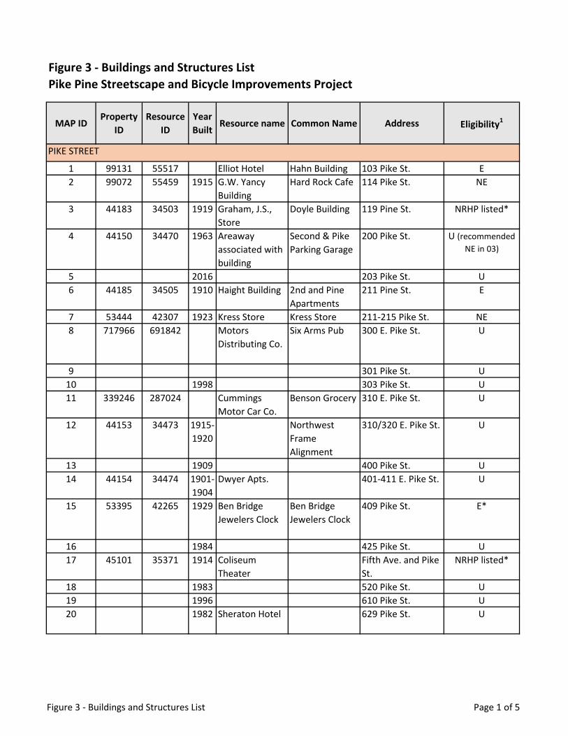
MAP IDProperty
IDResource
IDYear Built
Resource name Common Name Address Eligibility1
1 99131 55517 Elliot Hotel Hahn Building 103 Pike St. E2 99072 55459 1915 G.W. Yancy
BuildingHard Rock Cafe 114 Pike St. NE
3 44183 34503 1919 Graham, J.S., Store
Doyle Building 119 Pine St. NRHP listed*
4 44150 34470 1963 Areaway associated with building
Second & Pike Parking Garage
200 Pike St. U (recommended NE in 03)
5 2016 203 Pike St. U6 44185 34505 1910 Haight Building 2nd and Pine
Apartments211 Pine St. E
7 53444 42307 1923 Kress Store Kress Store 211-215 Pike St. NE8 717966 691842 Motors
Distributing Co.Six Arms Pub 300 E. Pike St. U
9 301 Pike St. U10 1998 303 Pike St. U11 339246 287024 Cummings
Motor Car Co.Benson Grocery 310 E. Pike St. U
12 44153 34473 1915-1920
Northwest Frame Alignment
310/320 E. Pike St. U
13 1909 400 Pike St. U14 44154 34474 1901-
1904Dwyer Apts. 401-411 E. Pike St. U
15 53395 42265 1929 Ben Bridge Jewelers Clock
Ben Bridge Jewelers Clock
409 Pike St. E*
16 1984 425 Pike St. U17 45101 35371 1914 Coliseum
TheaterFifth Ave. and Pike St.
NRHP listed*
18 1983 520 Pike St. U19 1996 610 Pike St. U20 1982 Sheraton Hotel 629 Pike St. U
Figure 3 - Buildings and Structures List Pike Pine Streetscape and Bicycle Improvements Project
PIKE STREET
Figure 3 - Buildings and Structures List Page 1 of 5

MAP IDProperty
IDResource
IDYear Built
Resource name Common Name Address Eligibility1
91 2001 One Convention Place (Condos)
701 Pike St. NE
21 44190 34509 1906 Waldorf Hotel Waldorf Towers 706 Pike St. E
22 53438 42304 1925 The Mountaineers Building
The Mountaineers Building
715 Pike St. NE
23 1991 1011 Pike St. U24 44167 34487 1904 Crest Hotel 1019-1025 Pike St. U
86 70581 1101 E. Pike St.25 675042 621535 Villa
ApartmentsVilla Apartments
1106 Pike St. E
26 47974 38169 Packard Seattle dealership
Starbuck’s 1120 Pike St. U
27 44181 34501 1910 Afton Hotel Atwood Apartments
104 Pine St. NE
28 44182 34502 1910 Colonnade Hotel
Gatewood Hotel
107 Pine St. NRHP listed*
29 44187 34506 1929 United Shopping Tower
Olympic Tower 217 Pine St. NRHP listed*
30 86534 46372 Metro Bus Tunnel Entrance
Third Ave. & Pine St.
NE
31 44188 34507 1929 Areaways Associated with Building
Bon Marche Department Store
300 Pine St. NRHP listed bldg* (areaways recommended
NE in 03)
32 48018 38211 2015 Melrose Building
Excelsior Apartments
301 E. Pine U
33 47972 38167 Pineview Apartments
Le Frock 311-321 E. Pine St. U
82 2014 320 E. Pine St. U81 1917 400 E. Pine St. U34 44193 34512 1915-
1920Coleman Automotive
Raffs Shoes 401 E. Pine St. NRHP listed
PINE STREET
Figure 3 - Buildings and Structures List Page 2 of 5

MAP IDProperty
IDResource
IDYear Built
Resource name Common Name Address Eligibility1
35 45104 35374 1916-1918
Frederick and Nelson Department Store
Nordstrom Building
Fifth Ave. & Pine St.
NE*
36 44189 34508 1910 O’Shea Building O’Shea Building 501 Pine St. E
37 44194 34513 1923-1924
Shafer Building 523 Pine St. NRHP listed*
38 665824 612938 1929-1954
I. Magnin Building
Old Navy-Forever 21
601 Pine St. NE
39 86592 46430 601 Pine St. NE74 1996 724 Pine St. U40 675803 622252 Tower 801 801 Pine St. U41 44195 34514 1928 Pine St.
PropertiesPande Cameron and Co.
815 Pine St. NE
42 44179 34499 1978 Yuen Lui Studio Building
Yuen Lui Studio 904 Pine St. U
43 44191 34510 1928 Paramount Theater
Paramount Theater
911 Pine St. NRHP listed*
44 720059 697361 Pine St. & Boren Ave. Bridge
E. Pine St. U
89 1912 1201 Pine St. E84 2020 1208 E. Pine St. U83 1967 1216 E. Pine St. U
45 341429 289199 Economy Market
1423 First Ave. E
46 344525 292291 Corner Market (Pike Place Market HD)
1501 First Ave. NRHP listed*
47 44887 35170 1922 Broderick Building
Broderick Building
1502 First Ave. NE
88 1991 1401 Second Ave. U48 99071 55458 1904 Eitel Building Eitel Building 1501 Second Ave. E*49 344664 292429 1964 Second & Pike
Parking GarageSecond & Pike Parking Garage
1508 Second Ave. E
FIRST AVENUE
SECOND AVENUE
Figure 3 - Buildings and Structures List Page 3 of 5

MAP IDProperty
IDResource
IDYear Built
Resource name Common Name Address Eligibility1
50 44971 35249 1910 Eitel Building - Areaways
Second & Pike Building
1511 Second Ave. U (recommended
NE in 03)51 44973 35251 1909 Areaways
associated with building
Forest Hotel 1521 Second Ave. U(recommended
NE in 03)52 44974 35252 1919 A.E. Doyle
Building - Areaways
Doyle Building 1527 Second Ave. U
53 44975 35253 1910 Haight Building Second and Pine Building
1530 Second Ave. E
54 44976 35254 1908 Standard Furniture Co. - Areaways
Nordstrom Rack 1601 Second Ave. NE
55 44977 35255 1906 Shoenfelds’ Standard Furniture Co. Building
Nordstrom Rack 1601 Second Ave. U
56 44978 35256 Surface Parking Lot
1608 Second Ave. NE
57 1924 1419 Third Ave. U58 344638 292404 Republic
BuildingMelbourne Tower
1511 Third Ave. E
59 45011 35286 1911 Sherman-Clay Block
McDonald’s 1530 Third Ave. NE
77 1959 Bon Marche Garage
1601 Third Ave. NE
60 45052 35326 1920 Liggett Building Fourth and Pike Building
1424 Fourth Ave. NRHP listed*
61 45053 35327 1910 Joshua Green Building
Joshua Green Building
1425 Fourth Ave. E*
62 344534 292300 1906 Northern Bank and Trust Building
Seaboard Building
1500 Fourth Ave. NRHP listed*
63 1985 1501 Fourth Ave. U64 45055 35328 1915 Zedick Jewelers
Street ClockCentury Square Clock
1529 Fourth Ave. E
65 45056 35329 1920 The Gap 1531 Fourth Ave. NE
66 1989 1420 Fifth Ave. U
THIRD AVENUE
FOURTH AVENUE
FIFTH AVENUE
Figure 3 - Buildings and Structures List Page 4 of 5

MAP IDProperty
IDResource
IDYear Built
Resource name Common Name Address Eligibility1
67 45166 35432 1921 Decatur Building
Pay and Save Corp.
1521 Sixth Ave. E
92 1999 Pacific Place Condos
also 600 Pine 1612 Sixth Ave. U
68 1996 1501 Seventh Ave. U69 2003 1519 Ninth St. U70 53381 42252 1914 Earlington
ApartmentsPayne Apartments
1521 Seventh Ave. E
71 45169 35435 1930 Roosevelt Hotel Hotel Theodore 1531 Seventh Ave. U
75 1976 1600 Seventh Ave. U
76 / 90 2014 820 Pine St. 1601 Ninth Ave. U
72 49107 39215 Boren/ Pike/ Pine Park
Plymouth Pillars Park
Boren Ave. U
79 42793 1910 First Covenant 1500 Bellevue Ave. U
78 87168 1926 McDermott Apt. 1514 Bellevue Ave. U
80 1925 1515 Bellevue Ave. U
73 1918 1520 Bellevue Ave. U
85 343114 1912 1501 Melrose Ave. U87 44034 Wintonia Hotel 1431 Minor Ave. E
1. Eligibility Symbols: NRHP listed = listed on the National Register of Historic Places (NRHP) * = City Landmark E = Eligible for listing on the NRHP NE = Not Eligible for listing on the NRHP U = Undetermined
SIXTH AVENUE
SEVENTH AVENUE
NINTH AVENUE
BOREN AVENUE
BELLEVUE AVENUE
MELROSE AND MINOR AVENUES
Figure 3 - Buildings and Structures List Page 5 of 5

Source: Exhibit 1.1, Pike Pine Streetscape and Bicycle Improvements Technical Memorandum (Draft) for ZGF prepared by Concord Engineering (March 27, 2020)
Figure 4 - Intersections Analyzed by Traffic Analysis (Study Area)

Delay LOS Delay LOS Delay LOS101 1st Ave & Pine St Signal Intersection 17 B 17 B 17 B101 1st Ave & Pine St Signal SBR 23 C 24 C 23 C101 1st Ave & Pine St Signal SBT 12 B 13 B 12 B101 1st Ave & Pine St Signal EBR 19 B 20 B 19 B101 1st Ave & Pine St Signal NBT 22 C 21 C 22 C101 1st Ave & Pine St Signal NBL 23 C 23 C 23 C101 1st Ave & Pine St Signal WBR 12 B 14 B 14 B101 1st Ave & Pine St Signal WBT 19 B 20 C 22 C101 1st Ave & Pine St Signal WBL 25 C 27 C 27 C102 2nd Ave & Pine St Signal Intersection 40 D 44 D 41 D102 2nd Ave & Pine St Signal SBR 23 C 23 C 23 C102 2nd Ave & Pine St Signal SBT 31 C 37 D 33 C102 2nd Ave & Pine St Signal WBT 81 F 77 E 79 E102 2nd Ave & Pine St Signal WBL 87 F 80 F 81 F103 3rd Ave & Pine St Signal Intersection 74 E 66 E 64 E103 3rd Ave & Pine St Signal SBR 26 C 25 C 25 C103 3rd Ave & Pine St Signal SBT 26 C 26 C 28 C103 3rd Ave & Pine St Signal NBT 26 C 26 C 25 C103 3rd Ave & Pine St Signal WBR 52 D 44 D 42 D103 3rd Ave & Pine St Signal WBT 77 E 69 E 66 E104 4th Ave & Pine St Signal Intersection 28 C 28 C 27 C104 4th Ave & Pine St Signal NBT 17 B 17 B 18 B104 4th Ave & Pine St Signal NBL 52 D 53 D 46 D104 4th Ave & Pine St Signal WBR 75 E 77 E 65 E104 4th Ave & Pine St Signal WBT 96 F 88 F 78 E105 5th Ave & Pine St Signal Intersection 37 D 28 C 23 C105 5th Ave & Pine St Signal SBT 33 C 21 C 17 B105 5th Ave & Pine St Signal WBT 55 E 49 D 44 D105 5th Ave & Pine St Signal WBL 31 C 24 C 25 C106 6th Ave & Pine St Signal Intersection 83 F 85 F 78 E106 6th Ave & Pine St Signal NBT 96 F 104 F 95 F106 6th Ave & Pine St Signal NBL >150 F >150 F >150 F106 6th Ave & Pine St Signal WBR 10 B 9 A 8 A106 6th Ave & Pine St Signal WBT 56 E 49 D 50 D107 7th Ave & Pine St Signal Intersection 135 F 127 F 127 F107 7th Ave & Pine St Signal SBR 53 D 49 D 45 D107 7th Ave & Pine St Signal SBT >150 F >150 F >150 F107 7th Ave & Pine St Signal NBL 108 F 73 E 69 E107 7th Ave & Pine St Signal WBT 50 D 57 E 51 D107 7th Ave & Pine St Signal WBL 74 E 106 F 88 F108 8th Ave & Pine St Signal Intersection 36 D 32 C 30 C108 8th Ave & Pine St Signal NBT 29 C 27 C 27 C108 8th Ave & Pine St Signal NBL 56 E 82 F 60 E108 8th Ave & Pine St Signal WBR 34 C 21 C 23 C
IntersectionIntx No
Baseline Alternative2Control Type
Alternative1Movement
Figure 5 - Traffic Analysis Study Area VISSIM Level of Service Values for PM Peak Volumes
Source: VISSIM PM Peak Scenarios Modeling Summary Table 2 - Delay and LOS from Pike Pine Streetscape and Bicycle Improvements Technical Memorandum (Draft) for ZGF prepared by Concord Engineering (March 27, 2020)
Page 1

Page 2
Delay LOS Delay LOS Delay LOSIntersection
Intx
NoBaseline Alternative2Control
TypeAlternative1Movement
108 8th Ave & Pine St Signal WBT 51 D 42 D 45 D108 8th Ave & Pine St Signal NBR 31 C N/A N/A N/A N/A109 9th Ave & Pine St Signal Intersection 34 C 53 D 48 D109 9th Ave & Pine St Signal SBR 38 D 59 E 37 D109 9th Ave & Pine St Signal SBT 19 B 28 C 21 C109 9th Ave & Pine St Signal EBR 18 B N/A N/A N/A N/A109 9th Ave & Pine St Signal WBT 54 D 58 E 62 E109 9th Ave & Pine St Signal WBL 38 D 40 D 40 D109 9th Ave & Pine St Signal EBT 19 B N/A N/A N/A N/A109 9th Ave & Pine St Signal SBL 15 B N/A N/A N/A N/A110 Boren Ave & Pine St Signal Intersection 55 D 59 E 57 E110 Boren Ave & Pine St Signal SBR 27 C 82 F 62 E110 Boren Ave & Pine St Signal SBT 19 B 57 E 65 E110 Boren Ave & Pine St Signal EBR 57 E N/A N/A N/A N/A110 Boren Ave & Pine St Signal NBT 76 E 21 C 16 B110 Boren Ave & Pine St Signal NBL >150 F >150 F >150 F110 Boren Ave & Pine St Signal WBR 39 D 60 E 74 E110 Boren Ave & Pine St Signal WBT 81 F 46 D 39 D110 Boren Ave & Pine St Signal WBL 86 F 79 E 57 E110 Boren Ave & Pine St Signal NBR 69 E N/A N/A N/A N/A110 Boren Ave & Pine St Signal EBT 58 E N/A N/A N/A N/A110 Boren Ave & Pine St Signal SBL 39 D N/A N/A N/A N/A110 Boren Ave & Pine St Signal EBL 38 D N/A N/A N/A N/A111 Minor Ave & Pine St TWSC Intersection 54 F 37 E 23 C111 Minor Ave & Pine St TWSC EBR 22 C N/A N/A N/A N/A111 Minor Ave & Pine St TWSC NBL 133 F 37 E 46 E111 Minor Ave & Pine St TWSC WBT 19 C 10 B 14 B111 Minor Ave & Pine St TWSC WBR 15 C 8 A 19 C111 Minor Ave & Pine St TWSC NBR 143 F N/A N/A N/A N/A111 Minor Ave & Pine St TWSC EBT 24 C N/A N/A N/A N/A112 Melrose Ave & Pine St Signal Intersection 43 D 44 D 45 D112 Melrose Ave & Pine St Signal WBR 51 D 28 C 28 C112 Melrose Ave & Pine St Signal WBL 70 E 85 F 39 D112 Melrose Ave & Pine St Signal SBL 28 C 55 E 50 D112 Melrose Ave & Pine St Signal SBT 31 C 59 E 49 D112 Melrose Ave & Pine St Signal NBR 14 B 11 B 10 A112 Melrose Ave & Pine St Signal NBT 14 B 30 C 26 C112 Melrose Ave & Pine St Signal EBT 44 D N/A N/A N/A N/A112 Melrose Ave & Pine St Signal EBR 37 D N/A N/A N/A N/A112 Melrose Ave & Pine St Signal EBL 49 D N/A N/A N/A N/A112 Melrose Ave & Pine St Signal NBL 29 C 36 D 42 D112 Melrose Ave & Pine St Signal SBR 51 D 68 E 68 E112 Melrose Ave & Pine St Signal WBT 65 E 27 C 29 C113 Bellevue Ave & Pine St Signal Intersection 39 D 56 E 58 E113 Bellevue Ave & Pine St Signal WBR 40 D 35 D 37 D113 Bellevue Ave & Pine St Signal WBL 36 D 35 D 39 D
Figure 5 - Traffic Analysis Study Area VISSIM Level of Service Values for PM Peak Volumes

Delay LOS Delay LOS Delay LOSIntersectionIntx
NoBaseline Alternative2Control
TypeAlternative1Movement
113 Bellevue Ave & Pine St Signal WBT 55 D 35 C 40 D113 Bellevue Ave & Pine St Signal SBL 60 E 121 F 122 F113 Bellevue Ave & Pine St Signal SBT 58 E 108 F 117 F113 Bellevue Ave & Pine St Signal SBR 62 E 110 F 116 F113 Bellevue Ave & Pine St Signal NBR 41 D 44 D 44 D113 Bellevue Ave & Pine St Signal NBT 46 D 46 D 46 D113 Bellevue Ave & Pine St Signal NBL 70 E 73 E 53 D113 Bellevue Ave & Pine St Signal EBT 15 B 38 D 36 D113 Bellevue Ave & Pine St Signal EBL 28 C 52 D 51 D113 Bellevue Ave & Pine St Signal EBR 15 B 32 C 27 C114 Crawford Pl & Pine St TWSC Intersection >150 F >150 F 129 F114 Crawford Pl & Pine St TWSC WBR 0 A 0 A 0 A114 Crawford Pl & Pine St TWSC WBL 0 A 0 A 0 A114 Crawford Pl & Pine St TWSC WBT 55 F 44 E 48 E114 Crawford Pl & Pine St TWSC SBL >150 F 54 F 45 E114 Crawford Pl & Pine St TWSC SBT 0 A 0 A 0 A114 Crawford Pl & Pine St TWSC SBR >150 F >150 F >150 F114 Crawford Pl & Pine St TWSC NBR >150 F >150 F >150 F114 Crawford Pl & Pine St TWSC NBT 0 A 0 A 0 A114 Crawford Pl & Pine St TWSC NBL >150 F >150 F >150 F114 Crawford Pl & Pine St TWSC EBT 2 A 1 A 1 A114 Crawford Pl & Pine St TWSC EBL 5 A 5 A 7 A114 Crawford Pl & Pine St TWSC EBR 0 A 0 A 0 A115 Summit Ave & Pine St TWSC Intersection 134 F >150 F >150 F115 Summit Ave & Pine St TWSC WBR 62 F 62 F 60 F115 Summit Ave & Pine St TWSC WBL 54 F 70 F 59 F115 Summit Ave & Pine St TWSC WBT 82 F 82 F 87 F115 Summit Ave & Pine St TWSC SBL >150 F >150 F >150 F115 Summit Ave & Pine St TWSC SBT >150 F >150 F >150 F115 Summit Ave & Pine St TWSC SBR >150 F >150 F >150 F115 Summit Ave & Pine St TWSC NBR >150 F >150 F 122 F115 Summit Ave & Pine St TWSC NBT >150 F >150 F >150 F115 Summit Ave & Pine St TWSC NBL >150 F >150 F >150 F115 Summit Ave & Pine St TWSC EBT 3 A 2 A 3 A115 Summit Ave & Pine St TWSC EBL 15 B 11 B 14 B115 Summit Ave & Pine St TWSC EBR 3 A 2 A 2 A116 Belmont Ave & Pine St TWSC Intersection 36 E 87 F 40 E116 Belmont Ave & Pine St TWSC WBR 70 F 76 F 66 F116 Belmont Ave & Pine St TWSC WBL 61 F 71 F 53 F116 Belmont Ave & Pine St TWSC WBT 72 F 87 F 88 F116 Belmont Ave & Pine St TWSC SBL 30 D 57 F 40 E116 Belmont Ave & Pine St TWSC SBT 34 D 54 F 33 D116 Belmont Ave & Pine St TWSC SBR 36 E 62 F 44 E116 Belmont Ave & Pine St TWSC NBR 15 C 19 C 20 C116 Belmont Ave & Pine St TWSC NBT 44 E 48 E 41 E116 Belmont Ave & Pine St TWSC NBL 56 F 67 F 71 F
Page 3
Figure 5 - Traffic Analysis Study Area VISSIM Level of Service Values for PM Peak Volumes

Delay LOS Delay LOS Delay LOSIntersectionIntx
NoBaseline Alternative2Control
TypeAlternative1Movement
116 Belmont Ave & Pine St TWSC EBT 5 A 4 A 5 A116 Belmont Ave & Pine St TWSC EBL 12 B 10 B 11 B116 Belmont Ave & Pine St TWSC EBR 7 A 6 A 7 A117 Boylston Ave & Pine St TWSC Intersection 39 E >150 F 51 F117 Boylston Ave & Pine St TWSC WBR 71 F 97 F 105 F117 Boylston Ave & Pine St TWSC WBL 80 F 106 F 87 F117 Boylston Ave & Pine St TWSC WBT 78 F 119 F 122 F117 Boylston Ave & Pine St TWSC SBL 43 E 43 E 49 E117 Boylston Ave & Pine St TWSC SBT 39 E 46 E 48 E117 Boylston Ave & Pine St TWSC SBR 47 E 77 F 74 F117 Boylston Ave & Pine St TWSC NBR 13 B 23 C 13 B117 Boylston Ave & Pine St TWSC NBT 20 C 36 E 23 C117 Boylston Ave & Pine St TWSC NBL 73 F >150 F 78 F117 Boylston Ave & Pine St TWSC EBT 6 A 5 A 5 A117 Boylston Ave & Pine St TWSC EBL 13 B 13 B 10 B117 Boylston Ave & Pine St TWSC EBR 8 A 7 A 8 A118 Harvard Ave & Pine St Signal Intersection 30 C 57 E 50 D118 Harvard Ave & Pine St Signal WBR 42 D 119 F 93 F118 Harvard Ave & Pine St Signal WBL 62 E 108 F 109 F118 Harvard Ave & Pine St Signal WBT 66 E 122 F 126 F118 Harvard Ave & Pine St Signal SBL 62 E 93 F 66 E118 Harvard Ave & Pine St Signal SBT 57 E 99 F 65 E118 Harvard Ave & Pine St Signal SBR 76 E 142 F 99 F118 Harvard Ave & Pine St Signal NBR 26 C 24 C 18 B118 Harvard Ave & Pine St Signal NBT 32 C 32 C 31 C118 Harvard Ave & Pine St Signal NBL 59 E 81 F 62 E118 Harvard Ave & Pine St Signal EBT 8 A 7 A 8 A118 Harvard Ave & Pine St Signal EBL 15 B 15 B 14 B118 Harvard Ave & Pine St Signal EBR 9 A 11 B 11 B119 Broadway & Pine St Signal Intersection 37 D 60 E 58 E119 Broadway & Pine St Signal WBR 80 F >150 F >150 F119 Broadway & Pine St Signal WBL 74 E >150 F >150 F119 Broadway & Pine St Signal WBT 102 F >150 F >150 F119 Broadway & Pine St Signal SBT 29 C 37 D 36 D119 Broadway & Pine St Signal SBR 41 D 121 F 94 F119 Broadway & Pine St Signal NBR 33 C 32 C 33 C119 Broadway & Pine St Signal NBT 31 C 30 C 32 C119 Broadway & Pine St Signal EBT 23 C 22 C 20 C119 Broadway & Pine St Signal EBL 34 C 41 D 35 C119 Broadway & Pine St Signal EBR 28 C 24 C 23 C201 1st Ave & Pike St Signal Intersection 27 C 31 C 26 C201 1st Ave & Pike St Signal SBR 25 C 25 C 25 C201 1st Ave & Pike St Signal SBT 25 C 25 C 25 C201 1st Ave & Pike St Signal NBT 12 B 14 B 12 B201 1st Ave & Pike St Signal NBBL 22 C 24 C 22 C201 1st Ave & Pike St Signal NBR 140 F >150 F 127 F
Page 4
Figure 5 - Traffic Analysis Study Area VISSIM Level of Service Values for PM Peak Volumes

Delay LOS Delay LOS Delay LOSIntersectionIntx
NoBaseline Alternative2Control
TypeAlternative1Movement
202 2nd Ave & Pike St Signal Intersection 44 D 51 D 43 D202 2nd Ave & Pike St Signal SBT 13 B 12 B 13 B202 2nd Ave & Pike St Signal EBR >150 F >150 F >150 F202 2nd Ave & Pike St Signal EBT >150 F >150 F >150 F202 2nd Ave & Pike St Signal SBL >150 F >150 F >150 F203 3rd Ave & Pike St Signal Intersection 105 F 115 F 115 F203 3rd Ave & Pike St Signal SBT 29 C 31 C 29 C203 3rd Ave & Pike St Signal NBT 22 C 22 C 21 C203 3rd Ave & Pike St Signal NBR 45 D 55 E 70 E203 3rd Ave & Pike St Signal EBT 105 F 115 F 115 F204 4th Ave & Pike St Signal Intersection 41 D 44 D 40 D204 4th Ave & Pike St Signal NBT 19 B 19 B 19 B204 4th Ave & Pike St Signal NBR >150 F >150 F 150 F204 4th Ave & Pike St Signal EBT 91 F 100 F 94 F205 5th Ave & Pike St Signal Intersection 52 D 49 D 38 D205 5th Ave & Pike St Signal SBT 11 B 9 A 8 A205 5th Ave & Pike St Signal EBR 33 C 35 C 32 C205 5th Ave & Pike St Signal EBT 67 E 73 E 67 E205 5th Ave & Pike St Signal SBL >150 F >150 F 96 F206 6th Ave & Pike St Signal Intersection 75 E 83 F 68 E206 6th Ave & Pike St Signal NBT 95 F 105 F 88 F206 6th Ave & Pike St Signal NBR 73 E 55 E 42 D206 6th Ave & Pike St Signal EBT 56 E 69 E 61 E206 6th Ave & Pike St Signal EBR 73 E 100 F 77 E207 7th Ave & Pike St Signal Intersection 69 E 68 E 64 E207 7th Ave & Pike St Signal SBT 139 F 130 F 135 F207 7th Ave & Pike St Signal EBR 32 C 28 C 25 C207 7th Ave & Pike St Signal NBT 24 C 21 C 22 C207 7th Ave & Pike St Signal NBR 36 D 41 D 36 D207 7th Ave & Pike St Signal EBT 36 D 31 C 30 C207 7th Ave & Pike St Signal SBL >150 F >150 F >150 F207 7th Ave & Pike St Signal EBL 55 D 48 D 44 D208 8th Ave & Pike St Signal Intersection 35 D 33 C 30 C208 8th Ave & Pike St Signal EBR 31 C 15 B 12 B208 8th Ave & Pike St Signal NBT 72 E 77 E 71 E208 8th Ave & Pike St Signal NBR 65 E 72 E 61 E208 8th Ave & Pike St Signal EBT 19 B 13 B 11 B208 8th Ave & Pike St Signal EBL 31 C 31 C 28 C209 9th Ave & Pike St Signal Intersection 22 C 19 B 16 B209 9th Ave & Pike St Signal EBT 27 C 42 D 18 B209 9th Ave & Pike St Signal SBL 29 C 29 C 26 C
Page 5
Figure 5 - Traffic Analysis Study Area VISSIM Level of Service Values for PM Peak Volumes

Delay LOS Delay LOS Delay LOSIntersectionIntx
NoBaseline Alternative2Control
TypeAlternative1Movement
210 Terry Ave & Pike St * Intersection 27 C 28 D 21 C210 Terry Ave & Pike St * EBR to Terry 30 C 11 B 7 A210 Terry Ave & Pike St * WBL to Terry 29 C N/A N/A N/A N/A210 Terry Ave & Pike St * Terry NBR 34 C 12 B 12 B210 Terry Ave & Pike St * EBT 25 C 19 C 12 B210 Terry Ave & Pike St * EBR to Hubbell 29 C 10 A 8 A210 Terry Ave & Pike St * WBL to Hubbell 29 C N/A N/A N/A N/A210 Terry Ave & Pike St * Hubbell NBR 34 C 88 F 77 F211 Boren Ave & Pike St Signal Intersection 38 D 57 E 51 D211 Boren Ave & Pike St Signal SBR 25 C N/A N/A N/A N/A211 Boren Ave & Pike St Signal SBT 16 B 41 D 38 D211 Boren Ave & Pike St Signal EBR 51 D 40 D 37 D211 Boren Ave & Pike St Signal NBT 48 D 71 E 61 E211 Boren Ave & Pike St Signal NBL 49 D N/A N/A N/A N/A211 Boren Ave & Pike St Signal WBR 52 D N/A N/A N/A N/A211 Boren Ave & Pike St Signal WBT 51 D N/A N/A N/A N/A211 Boren Ave & Pike St Signal WBL 53 D N/A N/A N/A N/A211 Boren Ave & Pike St Signal NBR 48 D 80 F 63 E211 Boren Ave & Pike St Signal EBT 39 D 45 D 40 D211 Boren Ave & Pike St Signal SBL 71 E 140 F 133 F211 Boren Ave & Pike St Signal EBL 93 F 54 D 47 D
212 Melrose Ave & Pike St Half-Signal Intersection 21 C 52 D 39 D
212 Melrose Ave & Pike St Signal EBT 15 B 38 D 32 C212 Melrose Ave & Pike St Signal EBR 9 A 26 C 16 B212 Melrose Ave & Pike St Signal WBL 22 C N/A N/A N/A N/A212 Melrose Ave & Pike St Signal WBT 21 C N/A N/A N/A N/A212 Melrose Ave & Pike St Signal WBR 43 D N/A N/A N/A N/A212 Melrose Ave & Pike St TWSC SBL 55 F >150 F 121 F212 Melrose Ave & Pike St TWSC SBT 59 F >150 F 97 F212 Melrose Ave & Pike St TWSC SBR 54 F N/A N/A N/A N/A212 Melrose Ave & Pike St TWSC NBL 26 D N/A N/A N/A N/A212 Melrose Ave & Pike St TWSC NBT 31 D 76 F 68 F212 Melrose Ave & Pike St TWSC NBR 16 C 51 F 51 F213 Bellevue Ave & Pike St Signal Intersection 23 C 37 D 35 C213 Bellevue Ave & Pike St Signal WBR 25 C 45 D 34 C213 Bellevue Ave & Pike St Signal WBL 17 B 41 D 41 D213 Bellevue Ave & Pike St Signal WBT 25 C N/A N/A N/A N/A213 Bellevue Ave & Pike St Signal SBL 40 D 47 D 42 D213 Bellevue Ave & Pike St Signal SBT 39 D 42 D 38 D213 Bellevue Ave & Pike St Signal SBR 45 D N/A N/A N/A N/A213 Bellevue Ave & Pike St Signal NBR 38 D 65 E 44 D213 Bellevue Ave & Pike St Signal NBT 29 C 56 E 41 D213 Bellevue Ave & Pike St Signal NBL 35 C N/A N/A N/A N/A213 Bellevue Ave & Pike St Signal EBT 3 A 11 B 10 B213 Bellevue Ave & Pike St Signal EBL 45 D 58 E 61 E
Page 6
Figure 5 - Traffic Analysis Study Area VISSIM Level of Service Values for PM Peak Volumes

Delay LOS Delay LOS Delay LOSIntersectionIntx
NoBaseline Alternative2Control
TypeAlternative1Movement
213 Bellevue Ave & Pike St Signal EBR 4 A 17 B 11 B214 Crawford Pl & Pike St TWSC Intersection 15 B 28 D 5 A214 Crawford Pl & Pike St TWSC WBR 0 A 1 A 0 A214 Crawford Pl & Pike St TWSC WBL 6 A 11 B 1 A214 Crawford Pl & Pike St TWSC WBT 9 A 8 A 2 A214 Crawford Pl & Pike St TWSC SBL 0 A 0 A 0 A214 Crawford Pl & Pike St TWSC SBT 0 A 0 A 0 A214 Crawford Pl & Pike St TWSC SBR 0 A 0 A 0 A214 Crawford Pl & Pike St TWSC NBR 0 A 0 A 0 A214 Crawford Pl & Pike St TWSC NBT 65 F 20 C 10 A214 Crawford Pl & Pike St TWSC NBL 36 E 28 D 18 C214 Crawford Pl & Pike St TWSC EBT 1 A 2 A 1 A214 Crawford Pl & Pike St TWSC EBL 13 B 4 A 2 A214 Crawford Pl & Pike St TWSC EBR 1 A 1 A 1 A215 Summit Ave & Pike St TWSC Intersection 11 B 24 C 10 B215 Summit Ave & Pike St TWSC WBR 6 A 5 A 7 A215 Summit Ave & Pike St TWSC WBL 9 A 7 A 7 A215 Summit Ave & Pike St TWSC WBT 4 A 2 A 2 A215 Summit Ave & Pike St TWSC SBL 16 C 16 C 17 C215 Summit Ave & Pike St TWSC SBT 18 C 18 C 20 C215 Summit Ave & Pike St TWSC SBR 13 B 9 A 10 B215 Summit Ave & Pike St TWSC NBR 13 B 14 B 11 B215 Summit Ave & Pike St TWSC NBT 20 C 22 C 25 C215 Summit Ave & Pike St TWSC NBL 24 C 24 C 12 B215 Summit Ave & Pike St TWSC EBT 4 A 5 A 4 A215 Summit Ave & Pike St TWSC EBL 10 A 9 A 9 A215 Summit Ave & Pike St TWSC EBR 3 A 3 A 4 A216 Belmont Ave & Pike St TWSC Intersection 11 B 24 C 10 B216 Belmont Ave & Pike St TWSC WBR 3 A 3 A 3 A216 Belmont Ave & Pike St TWSC WBL 8 A 7 A 6 A216 Belmont Ave & Pike St TWSC WBT 1 A 1 A 1 A216 Belmont Ave & Pike St TWSC SBL 19 C 17 C 19 C216 Belmont Ave & Pike St TWSC SBT 25 D 24 C 27 D216 Belmont Ave & Pike St TWSC SBR 14 B 10 A 9 A216 Belmont Ave & Pike St TWSC NBR 17 C 15 C 19 C216 Belmont Ave & Pike St TWSC NBT 25 D 23 C 26 D216 Belmont Ave & Pike St TWSC NBL 16 C 16 C 19 C216 Belmont Ave & Pike St TWSC EBT 3 A 3 A 2 A216 Belmont Ave & Pike St TWSC EBL 8 A 6 A 6 A216 Belmont Ave & Pike St TWSC EBR 7 A 6 A 5 A217 Boylston Ave & Pike St TWSC Intersection 13 B 30 D 12 B217 Boylston Ave & Pike St TWSC WBR 4 A 5 A 5 A217 Boylston Ave & Pike St TWSC WBL 14 B 11 B 13 B217 Boylston Ave & Pike St TWSC WBT 2 A 2 A 2 A217 Boylston Ave & Pike St TWSC SBL 26 D 30 D 25 D217 Boylston Ave & Pike St TWSC SBT 21 C 28 D 21 C
Page 7
Figure 5 - Traffic Analysis Study Area VISSIM Level of Service Values for PM Peak Volumes

Delay LOS Delay LOS Delay LOSIntersectionIntx
NoBaseline Alternative2Control
TypeAlternative1Movement
217 Boylston Ave & Pike St TWSC SBR 14 B 14 B 13 B217 Boylston Ave & Pike St TWSC NBR 18 C 18 C 15 B217 Boylston Ave & Pike St TWSC NBT 27 D 24 C 24 C217 Boylston Ave & Pike St TWSC NBL 18 C 18 C 15 C217 Boylston Ave & Pike St TWSC EBT 8 A 6 A 4 A217 Boylston Ave & Pike St TWSC EBL 9 A 8 A 8 A217 Boylston Ave & Pike St TWSC EBR 10 B 7 A 8 A218 Harvard Ave & Pike St Signal Intersection 23 C 23 C 19 B218 Harvard Ave & Pike St Signal WBR 13 B 12 B 11 B218 Harvard Ave & Pike St Signal WBL 32 C 32 C 26 C218 Harvard Ave & Pike St Signal WBT 10 B 8 A 8 A218 Harvard Ave & Pike St Signal SBL 32 C 33 C 27 C218 Harvard Ave & Pike St Signal SBT 18 B 27 C 15 B218 Harvard Ave & Pike St Signal SBR 15 B 4 A 4 A218 Harvard Ave & Pike St Signal NBR 43 D 44 D 32 C218 Harvard Ave & Pike St Signal NBT 38 D 38 D 31 C218 Harvard Ave & Pike St Signal NBL 48 D 43 D 41 D218 Harvard Ave & Pike St Signal EBT 23 C 22 C 17 B218 Harvard Ave & Pike St Signal EBL 26 C 26 C 22 C218 Harvard Ave & Pike St Signal EBR 23 C 21 C 20 C219 Broadway & Pike St Signal Intersection 39 D 38 D 37 D219 Broadway & Pike St Signal WBR 32 C 20 B 19 B219 Broadway & Pike St Signal WBL 46 D 47 D 39 D219 Broadway & Pike St Signal WBT 36 D 31 C 29 C219 Broadway & Pike St Signal SBL 51 D 51 D 51 D219 Broadway & Pike St Signal SBT 28 C 29 C 30 C219 Broadway & Pike St Signal SBR 26 C 24 C 24 C219 Broadway & Pike St Signal NBR 41 D 39 D 41 D219 Broadway & Pike St Signal NBT 44 D 43 D 45 D219 Broadway & Pike St Signal NBL 62 E 58 E 60 E219 Broadway & Pike St Signal EBT 35 D 35 C 33 C219 Broadway & Pike St Signal EBL 48 D 50 D 43 D219 Broadway & Pike St Signal EBR 34 C 34 C 32 C
*Signalized in Baseline and Two-Way Stop Controlled(TWSC) in Alternative 1 and Alternative 2.
Page 8
Figure 5 - Traffic Analysis Study Area VISSIM Level of Service Values for PM Peak Volumes