pictorial and verbal representation of route information paul lee & barbara tversky stanford...
Post on 21-Dec-2015
220 views
TRANSCRIPT

Pictorial and Verbal Representation of
Route Information
Paul Lee & Barbara TverskyStanford University
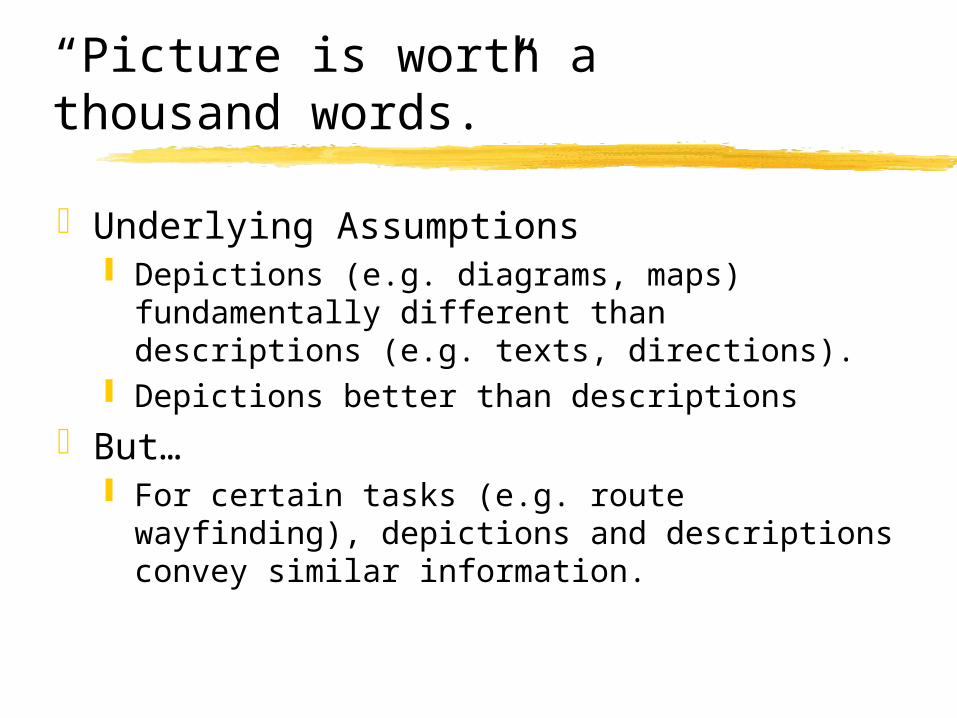
“Picture is worth a thousand words.”
Underlying Assumptions Depictions (e.g. diagrams, maps) fundamentally
different than descriptions (e.g. texts, directions). Depictions better than descriptions
But… For certain tasks (e.g. route wayfinding), depictions
and descriptions convey similar information.

Route Maps & Route Directions
Are the schematizations similar?Ask students outside dorm how to get to
Taco Bell
Constraintsby DepictiveMedium
CommonStructure
Constraintsby DescriptiveMedium
SketchMaps
RouteDirections

Sketch Map 1

Sketch Map 2

Directions 1
From Roble parking lotR onto Santa TheresaL onto Lagunita (the first stop sign)L onto MayfieldR onto BowdoinL onto Stanford AveR onto El Caminogo down a few miles. It’s on the right.

Go down street toward main campus (where most of the buildings are as opposed to where the fields are) make a right on the first real street (not an entrance to a dorm or anything else). Then make a left on the 2nd street you come to. There should be some buildings on your right (Flo Mo) and a parking lot on your left. the street will make a sharp right. Stay on it. That puts you on Mayfield Rd. The first intersection after the turn will be at Campus Dr. Turn left and stay until you get to El Camino. Turn right (south) and Taco Bell is a few miles down on the right.
Direction 2

Segmentation according to Denis
Start point: “you leave the building”Reorientation: “you turn left”Path/progression: “you follow Main St.”End point: “until you get to the restaurant”

Was all necessary information included?
Maps: YesDirections: No, incomplete explicitly
75% lacked start or end point 45% lacked path/progression information
Missing information recovered by 2 rules: Continuity Forward progression

Was extra information included?
Yes, in 90% of maps and directions Added information kept traveler on track:
cardinal directions arrows distances extra landmarks

Path Types: Text vs. Depiction
Straight Path Curved Pathfollow 5 20go 17 2
take, head,drive,continue,down
13 0
stay, keepgoing, willtake you, -->
0 5

Goodness Ratings
23 Subjects rated the goodness of the maps and directions 1-7 rating scale: 1=not usable; 7=excellent

Good Map 1 (rating = 5.73)

Good Map 2 (rating = 5.50)

Avg. Map 1 (rating = 3.73)

Avg. Map 2 (rating = 3.68)

Bad Map 1 (rating = 2.68)

Bad Map 2 (rating = 2.23)

Good Direction (5.59)
From Roble fields head out towards campus at Campus drive turn right follow Campus around until you hit palm drive turn left onto palm drive go on palm until you hit el camino turn rt. Onto el camino (it’s one of those things where you merge
right) head south on el camino pass several lights (~2.3) Taco Bell will be on your right, on the corner of some street & el
camino

Average Direction (3.73)
Go out St. Theresaturn Rt.Follow Campus Dr. way around to Galvezturn left on Galvezturn right on El CaminoGo till you see Taco Bell on your right

Bad Direction (2.68)
LomitaMayfield --> Row HousesLeft onto Campus Drive EastFollow to SERRArt. on SERRArt. onto EL CAMINO - 2 miles down EL
CAMINO

How was information schematized?
Start/end points: landmarks, paths Maps: icons, rough shapes, street names Directions: names, descriptions
Reorientations: amount unspecified Maps: roughly perpendicular lines, arrows Directions: “turn,” “take a,” “make a,” “go”
Path/progression Maps: straight or curved line Directions: “go” or “follow”

Intersections
Straight Paths
Depictive Toolkit
Curved Paths
Landmarks
Arrows

Descriptive Toolkit
Start at A facing BTurn R/L, turn R/L on (x)Go down (x), go down (x) until, go down
(x) for (y)Follow, follow until (x), follow (x) for (y)Continue pastZ will be on your L/R

Toolkit Map 1

Toolkit Map 2

Toolkit Map 3

Toolkit Map 4

Toolkit Map 5

Toolkit Direction 1
Start at Cowell, facing Campus Loop.Turn right on Campus loop and follow until
Serra St.Turn right on Serra St.Turn left on El Camino Real.Go down El Camino Real and Town &
Country will be on your right.

Toolkit Direction 2
Start at Cowell Health Center, facing Campus drive loop. Turn right at Campus Drive. Follow Campus Drive until the first stop sign. Turn right on Bowdoin. Follow Bowdoin until the second stop sign. Turn left on Stanford Avenue. Go down Stanford Avenue, past 2 lights and a stop sign, until you reach
the third light (El Camino real) Turn left on El Camino. Follow El Camino (northwest) past 2 stop lights for about one mile until
you reach Embarcadero. (there is a light there) Turn right immediately after the light at Embarcadero into the T & C
Plaza.

Results: Depictive Toolkit
Intersections Use of wrong X, L, T intersection - 93% of
participantsMost cases: X -> T and T -> L
Non-prototypical intersection - 43% Exit ramps - 57%
Paths Used only straight paths (i.e. no curved paths) - 14% Non-prototypical paths - 29%

Results: Depictive Toolkit
Landmarks Added by participants
Stop signs/lights - 43%Overpass - 43%Iconic landmarks - 21%
Arrows - 86%Additional Information
Cardinal direction - 14% Distance information - 7% Commentary - 50%

Results: Descriptive Toolkit
Turns Alternative wording (e.g. “make/take a”) - 21%of
participants “exit at ___” - 43% Specified turn angles - 50%
Progressions Alternative wording (e.g. take, head down, stay
on, pass, proceed, get on) - 14% Path description - 57%

Results: Descriptive Toolkit
Landmarks Stop signs/lights - 86% of participants Overpass - 7% Dead end - 21% Parking lot - 14%
Additional Information Time/distance information - 71% Commentary - 29%

Mega-descriptions/depictions
Denis: ideal skeletal descriptions derived from mega-descriptions
Experiment Task Subjects receive “mega-descriptions” or “mega-
depictions” of the route12 cross streets and 44 landmarks included
Subjects are asked to cross out phrases or landmarks to create an ideal description or depiction
Skeletal description/depiction created from retention of phrases and landmarks by 70% of subjects

Skeletal Depiction

Skeletal Description
DirectionsYou are standing on Santa Teresa St.
Take Santa Teresa down.
Turn right on Lomita.
Turn left on Mayfield.
Take Mayfield until the road stops at a stop sign and veer right, in front of Xanadu.
Follow the road to the right.
At a 4-way stop junction, turn left on Campus Dr. East.
You will come across a 4-way stop junction in front of a gas station.
Turn right on Serra.
Turn left on El Camino Real and continue for about 2-3 miles.
Once you pass Curtner St, start looking for Taco Bell on the right.
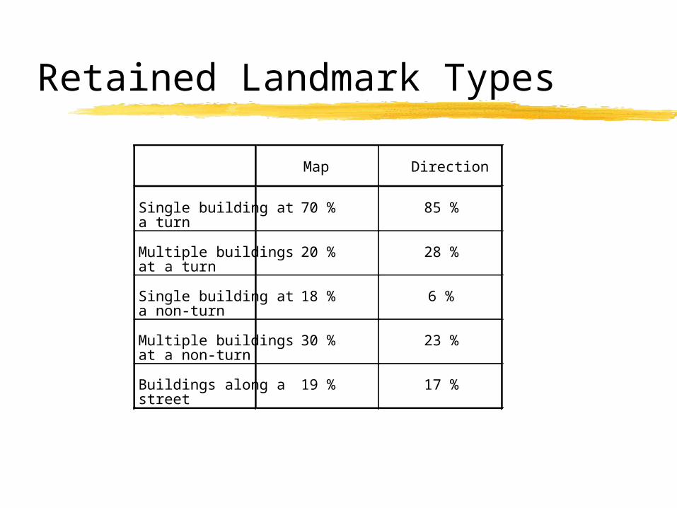
Retained Landmark Types
Map Direction
Single building ata turn
70 % 85 %
Multiple buildingsat a turn
20 % 28 %
Single building ata non-turn
18 % 6 %
Multiple buildingsat a non-turn
30 % 23 %
Buildings along astreet
19 % 17 %

Summary
Similar schematizations for route maps and route directions
Can determine “goodness” of maps and directions
Majority of route information can be expressed with a small finite set of depictions and descriptions