physical geography unit 2 – patterns in weather and climate
TRANSCRIPT

Physical Geography
Unit 2 – Patterns in Weather and Climate

WEATHER AND CLIMATE (p. 54)• Weather refers to the day to day or short-term conditions of the
atmosphere.– The daily atmospheric conditions in a given place over a short
period of time. These conditions are constantly changing (temperatures can be blistering hot or bone-chillingly cold, totally dry or heavy rain, days and nights can be calm and still or have violent winds, etc.).
– Weather includes such variables as temperature, precipitation, humidity, cloud cover, wind, and air pressure.
• Climate refers to the average weather conditions of a region. The recorded average is the result of many years of weather observations.– Time is a key factor. Climate often uses monthly or yearly (annual)
averages for such variables as temperature, moisture, and air movement.

• In some places weather conditions seldom change so there are no distinct seasons. This is often the case in tropical or polar regions.
• Other places weather may vary throughout the year creating distinct seasons. Regions that experience four seasons are referred to as temperate regions.
*Complete Questions 1-5, p. 55*

THE EARTH-SUN RELATIONSHIP (p. 55)• The sun provides light and heat for all
bodies of the solar system.– The sun is approximately 150,000,000
km away from earth.– It is 109 times Earth’s diameter.– At the sun’s core it is approx. 15
million degrees Celsius, and the surface is approx. 10 million degree Celsius.
– The earth and all bodies of the solar system is attracted to the sun by its gravitational attraction.
• The earth revolves around the sun in one year (one revolution), but spins on its axis every 24 hours (one rotation).

• The earth is tilted on it’s axis 23 ½ degrees which gives us the length of day and seasonal changes throughout the year.
• Because of the Earth’s tilt, there are only two times during the year when the sun shines equally on both the Northern and Southern Hemispheres:– Equinoxes: derived from a Latin word meaning “Equal Night”.
Equinoxes occur March 20th to the 23rd, September 20th to the 23rd.
• There are two times of the year that mark the furthest the sun reaches north and south of the equator and either the Northern or Southern Hemisphere receive the most sunlight:– Solstices: derived from a Latin word meaning “Sun Stands Still”.
• Solstices occur on the longest and shortest days of the year:– Longest day in the Northern Hemisphere June 21 (approx.)– Longest day in the Southern Hemisphere December 22 (approx.)

*Complete Questions 6-10, pp. 55-56*

SUNLIGHT AND CLOUDS(p. 56)• Only 49% of the sun’s radiation that reaches Earth is absorbed.

• Not all surfaces on Earth absorb the same amount of energy:– Water absorbs energy but also reflects energy.– Snow and ice mainly reflect solar energy.– Vegetation’s absorption and reflection rate is somewhere
between that of water and snow.• Clouds may reduce the amount of energy the earth receives, but it
also reduces the amount radiated back into space from the earth.– On clear days the amount of energy radiated from the sun to the
earth (daytime) and from the earth to the sun (nighttime) is at it’s greatest. Temperature ranges (differences between highest and lowest values) are greatest between day and night.
– On cloudy days the amount of energy absorbed from the sun is limited and the amount radiated back into space is also limited by clouds. Temperature ranges between day and night are not great.

• Clouds have the ability to reflect solar energy. This can either prevent solar energy from reaching the earth (day time) or keep solar energy from escaping (nighttime).

PATTERNS IN TEMPERATURE (p. 57)• The curvature of the earth affects temperature north and south of
the equator.– The equator receives the most solar radiation, more than the
polar or temperate regions. The sun’s rays are direct at the equator.
– The polar regions receive solar radiation at an angle (obliquely), meaning there is more surface area for the same amount of radiation to heat.

What pattern do you notice between latitude and temperature?
Complete #s 11 & 12 (p. 57) #14 (p. 59)

WIND: THE MOVEMENT OF AIR (p. 59)• The sun’s rays strike the Earth unevenly, therefore some areas of land
are heated more than others. A warm surface will warm the air above it.
• The general pattern in global air movement is as follows:– Warm air over the equator is heated (most direct sunlight).– Warm air expands, becomes less dense and more buoyant. Warm
air rises.– Cool air above this warm rising air is forced toward the polar
regions.– As this cool air becomes more dense near the poles, it begins to
sink back to earth.– It begins to warm as it reaches the surface and displaces cooler
air just above the surface at high latitudes, forcing it towards the equator.

• This flow of air from the equator to the poles and back to the equator again is called a convection cell. The key factor driving convection is density (warm air is less dense than cool air).
• This air movement helps circulate the sun’s energy around the earth and creates a more even distribution of heat. Without convection cells, there would be a wider temperature range across the globe.
• Warm moist air creates low pressure areas, while cool dry air creates high pressure areas.
• Air moves from high to low pressure.• This horizontal movement of air is
called wind.

1.Indicate which way the winds would blow in the daytime.Answer: from the sea to the land (a sea breeze). Lower temperature over the sea equates with high pressure.
2.Indicate which way the winds would blow in the nighttime.Answer: from the land to the sea (a land breeze). Lower temperature over the land equates with high pressure.

• Winds rising from the equator and moving toward the poles and back again are complicated by two factors:– The Earth’s Rotation (Coriolis Force: winds in the Northern hemisphere are
deflected to the right, while winds in Southern Hemisphere are deflected left).– The uneven distribution of land and water over the Earth’s Surface.
• This results in three convection cells for each hemisphere (Northern & Southern). Each of these convection cells produce regular, predictable wind patterns at certain locations in the world (prevailing winds).
• The prevailing winds are:– Northeast Trade Winds 0° to 23.5° N– Southeast Trade Winds 0° to 23.5° S– Westerly Winds 23.5° to 66.5° N– Westerly Winds 23.5° to 66.5° S– North Polar Easterlies 66.5° to 90° N– South Polar Easterlies 66.5° to 90° S.
*Complete #s 17-21 on p. 63-64)*

Wind and Precipitation Patterns (p. 64)• We have learned that air can vary in terms of its temperature,
density, and pressure. Another quality of air is its humidity.• Humidity is the amount of moisture contained in air. This moisture
comes from evaporated water on Earth’s surface.• It is important to remember that warm air (low pressure) can hold
more moisture than cold air (high pressure).• Depending on where moist air develops, it creates different
precipitation patterns. Three types of precipitation can occur:1. Orographic rainfall2. Frontal rainfall3. Convectional rainfall

Orographic (relief) rainfall • This type of rainfall occurs in coastal regions where mountains are present.• Warm, moisture laden air blows off the sea and is forced upward by changes in
topography (mountains/high relief).• Air cools at higher altitudes and cool air holds less moisture. • Condensation occurs with cloud formation and rain falls. • Most rain falls on the windward side of the mountain, while the leeward side is
often in a dry rain shadow. This is because the moisture has been lost by the time the air reaches the leeward side.

Frontal (cyclonic) rainfall • This type of rainfall occurs in areas where warm and cold air masses meet (often
temperate regions). The leading edge of an air mass is called a front.• A warm moisture laden air mass meets a cold air mass.• Warm air (low density) is forced up over the cooler air (high density). • Air cools at higher altitudes and cool air holds less moisture. • Condensation occurs with cloud formation and rain falls.

Convectional rainfall • This type of rainfall occurs in areas where temperatures are quite high (tropical
regions or summertime in inland temperate regions).• Sun heats the earth causing large amounts of water to evaporate. • Hot air rises forming convection currents (warm moisture-laden air cools at higher
altitude and this newly cooled air holds less moisture).• Condensation occurs with cloud formation and rain falls.• Cool air then sinks and is heated again near the surface.

OCEAN CURRENTS AND CLIMATE (p. 68)• Ocean currents are permanent or semi-permanent horizontal
movements of unusually cold or warm surface water of the oceans, to a depth of about 100m.
• The movement of winds over the ocean create drag on surface water, which is the primary cause of currents. As such ocean currents, like prevailing winds, follow regular, predictable patterns of flow.
• There are three main factors that influence how and where ocean currents flow:1. The Coriolis Force causes currents in the Northern Hemisphere
to be deflected to the right of their initial path, while currents in the Southern Hemisphere are deflected to the left.
2. The size and shape of the body of water (ocean currents often follow shape of the edges of continents they flow beside).
3. Differences in water temperature and salt content. These differences cause convection currents to develop similarly to those in the atmosphere.

• Warm currents originate near the equator and move warm water towards the poles (e.g.: Gulf Stream, Brazil, Kuroshio currents).
• Cold currents originate near the poles and move cold water towards the equator (e.g.: Labrador, Peru, Benguela currents).

Video Clip: “The Global Conveyor Belt”
(http://science.nasa.gov/media/medialibrary/2013/05/20/thermohaline_assembled.640x360.mp4)
*Complete #s 27-30 on pp. 68-69*

CONTINENTALITY AND CLIMATE (p. 69)• Water masses heat up and cool down more slowly than land.• Sunlight is absorbed through water to greater depths, unlike land, so
more solar energy is require to heat up water. Water that has been heated will retain this heat for a longer period as well.
• This characteristic of water affects temperature range (the difference between the highest and lowest average temperature).
• Regions near large bodies of water experience a maritime climate:– Summer temperatures never get too hot due to slow heating time of water, and
winters do not get too cold due to water’s heat retention. This equates with a low temperature range and a moderated climate.
• Regions inland and far from large bodies of water experience a continental climate:– Summer temperatures get quite hot due to land heating quickly, and winter
temperatures are quite cold since there is no body of water to hold on to additional heat. This equates with a high temperature range and extremes in climate.

Temperature range samples for Canadian Cities. What pattern do you see between distance from the sea and temperature range?

Monsoons (pp. 70-71)• From Arabic for 'seasonal wind‘, a
monsoon is a sudden wet season in the tropics caused by changing wind directions (think land and sea breezes caused by the effects of continentality).
India’s Winter Monsoon• Continental Asia cools quickly and high
atmospheric pressure results. • Wind blows southward towards the low
(warmer temperature) over Indian ocean.
• Very little rain (dry season) results because the wind is blowing over dry land and does not pick up much moisture.

India’s Summer monsoon• Continental Asia heats up quickly and
low atmospheric pressure results.• Wind blows northward towards the low
(warmer) temperature over India.• Tremendous rains result because the
wind is blowing over the warm Indian Ocean. The especially warm wind in this low latitude region will carry a great amount of moisture.
*Complete Temperature Range and Distance from the Coast” Activity*
ELEVATION AND CLIMATE (p. 71)• Elevation is defined as the height of a region
above sea level.• Air temperature decreases 2°C for every 300m
increase in elevation. • The higher up we go the colder it gets, hence
snow on mountain tops. Remember, the higher we go into the atmosphere the farther away from the heated surface of Earth.
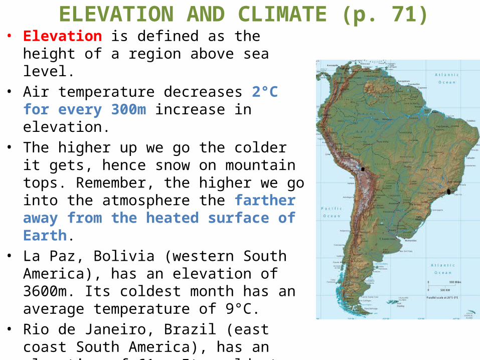
• La Paz, Bolivia (western South America), has an elevation of 3600m. Its coldest month has an average temperature of 9°C.
• Rio de Janeiro, Brazil (east coast South America), has an elevation of 61m. Its coldest month has an average temperature of 25°C.
• La Paz and Rio de Janeiro have a similar distance from ocean and similar latitude. However, La Paz is much colder because of higher elevation in the Andes mountains.

*Complete “Continentality Lab”*