eprints.keele.ac.ukeprints.keele.ac.uk/522/1/slann phd 2015.pdf · i abstract this thesis...
TRANSCRIPT

This work is protected by copyright and other intellectual property rights and duplication or sale of all or part is not permitted, except that material may be duplicated by you for research, private study, criticism/review or educational
purposes. Electronic or print copies are for your own personal, non-commercial use and shall not be passed to any other individual. No quotation may be published without proper acknowledgement. For any other use, or to
quote extensively from the work, permission must be obtained from the copyright holder/s.

The security of the European
Union’s critical outer space
infrastructures
Phillip A. Slann
This electronic version of the thesis has been edited solely to ensure compliance with
copyright legislation and excluded material is referenced in the text. The full, final,
examined and awarded version of the thesis is available for consultation in hard copy via
the University Library
Thesis submitted for the degree of Doctor of Philosophy in International
Relations
March 2015
Keele University

i
Abstract
This thesis investigates the European Union’s (EU) conceptualisation of outer space
security in the absence of clear borders or boundaries. In doing so, it analyses the means
the EU undertakes to secure the space segments of its critical outer space infrastructures
and the services they provide. The original contribution to knowledge offered by this thesis
is the framing of European outer space security as predicated upon anticipatory
mechanisms targeted towards critical outer space infrastructures. The objective of this
thesis is to contribute to astropolitical literature through an analysis of the EU’s efforts to
secure the space segments of its critical outer space infrastructures, alongside a
conceptualisation of outer space security based upon actor-specific threats, critical
infrastructures and anticipatory security measures. The EU’s Galileo and Copernicus
programmes are identified as future critical outer space infrastructures through their
services’ expected contributions to EU-level policy-multiplication and European states and
societies, making them examples of regional and global European space power projection.
Following the designation of the Galileo and Copernicus programmes as critical outer
space infrastructures, the thesis details the dangers and risks, both intentional and
environmental, which the EU has publicly acknowledged as being the most threatening.
Although the specific risk assessments for the Galileo and Copernicus projects are
confidential, the generic dangers and risks for satellites in Lower Earth Orbit and Middle
Earth Orbit referred to in EU policy documents are explored, including space debris, space
weather phenomena, orbital congestion and the possibility of the future weaponisation of
near-Earth space.

ii
At a macro-level, the EU’s determination to mitigate both intentional and environmental
risks through international diplomacy, improved satellite design and increased awareness
of near-Earth space are analysed as being reflective of preventive and preemptive forms of
anticipatory security. On a micro-level the EU’s efforts to protect its outer space
infrastructures from said risks are framed within the context of critical infrastructure
security.

iii
Table of contents
Abstract .................................................................................................................................. i
Table of contents .................................................................................................................. iii
Figures and images ............................................................................................................... vi
Abbreviations ...................................................................................................................... vii
Acknowledgements ............................................................................................................ xiv
1 Introduction ......................................................................................................................... 1
1.1 The issue at hand: (in)security in outer space ........................................................................... 3
1.2 Outer space and the astrophysical environment ........................................................................ 6
1.3 The foundations and context(s) of critical astropolitics .......................................................... 13
1.4 Defining outer space security .................................................................................................. 37
1.5 Scope, limitations and methods .............................................................................................. 43
1.6 Thesis structure ....................................................................................................................... 50
2 Europe and outer space ..................................................................................................... 53
2.1 Actors in European outer space activities ............................................................................... 54
2.2 Power projection and outer space ........................................................................................... 56
2.3 The origins of European collaboration in outer space ............................................................ 66
2.4 European launch capability and space power projection ........................................................ 68
2.5 The inevitable evolution: The militarisation of European activities in outer space ................ 70
2.6 The relationship between the terrestrial and outer space policies of the EU: European space
power in action .............................................................................................................................. 78
2.7 Conclusion: European collaboration and space power projection .......................................... 83
3 European critical outer space infrastructures .................................................................... 85
iv
3.1 Securing the vital: Critical infrastructures and the need for their protection .......................... 87
3.2 Critical Infrastructure Protection versus Critical Infrastructure Resilience ............................ 93
3.3 European Critical Infrastructures .......................................................................................... 106
3.4 CIP, CIR and European security in outer space .................................................................... 115
3.5 Galileo ................................................................................................................................... 121
3.6 Copernicus ............................................................................................................................ 129
3.7 Galileo and Copernicus: Future European critical infrastructures ........................................ 138
3.8 Conclusion ............................................................................................................................ 158
4 Intentional man-made threats to the security of critical outer space infrastructures ....... 161
4.1 The militarisation and weaponisation of outer space ............................................................ 162
4.2 Signal disruption ................................................................................................................... 189
4.3 Congestion as a threat to outer space activities ..................................................................... 192
4.4 The legal regime on outer space activities ............................................................................ 195
4.5 European efforts to promote sustainable outer space activities: the draft International Code of
Conduct for Outer Space Activities ............................................................................................ 199
4.6 Intentional threats to critical outer space infrastructures and European outer space security
.................................................................................................................................................... 211
5 Environmental hazards to the security of critical outer space infrastructures ................ 214
5.1 Natural environmental risks .................................................................................................. 215
5.2 Space debris .......................................................................................................................... 229
5.3 Resilience in European outer space activities ....................................................................... 256
5.4 The astro- and geopolitics of the European SSA and SST programmes ............................... 259
5.5 Extra-terrestrial environmental security and the security of critical infrastructures ............. 263

v
6 Conclusion ...................................................................................................................... 268
6.1 Europe, outer space and European critical outer space infrastructures ................................. 269
6.2 The security of European critical outer space infrastructures ............................................... 272
6.3 Opportunities for further research ......................................................................................... 277
References .......................................................................................................................... 281

vi
Figures and images
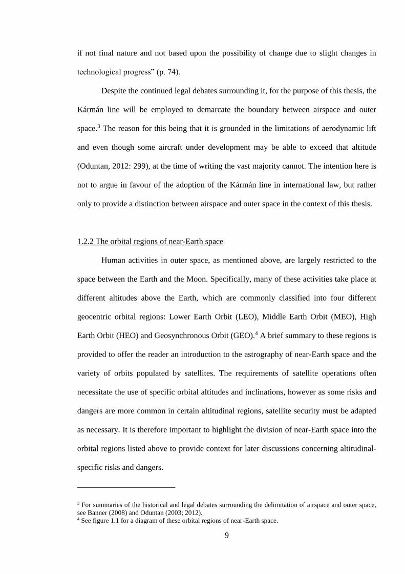
Figure 1.1: The orbital regions of near-Earth space ............................................................. 12
Figure 1.2 Illustration of a highly elliptical orbit ................................................................. 13
Figure 3.1 Critical Infrastructure Resilience ........................................................................ 98
Figure 3.2 The Copernicus space segment ......................................................................... 132
Figure 3.3 Remote sensing imaging variants ..................................................................... 135
Figure 4.1 The ALMV launched against Solwind P78-1 in September 1985 ................... 173

vii
Abbreviations
ABL - Airborne Laser
ABM - Anti-Ballistic Missile
ACE - Advanced Composition Explorer
AFWA - Air Force Weather Agency
ALBM - Air-Launched Ballistic Missile
ALMV - Air-Launched Miniature Vehicle
Ariane 5 ME - Ariane 5 Mid-life Evolution
ASAT - Anti-Satellite
ASI - Agenzia Spaziale Italiana
ATM - Air Traffic Management
BMD - Ballistic Missile Defence
CAM - Collision Avoidance Manoeuvre
CCSDS - Consultative Committee for Space Data Systems
CD - Conference on Disarmament
CERN - Organisation Européenne pour la Recherche Nucléaire
CFSP - Common Foreign and Security Policy
CIIP - Critical Information Infrastructure Protection
CIP - Critical Infrastructure Protection
CIR - Critical Infrastructure Resilience
CME - Coronal Mass Ejection
CNES - Centre National d’Études Spatiales
CNSA - Chinese National Space Administration
COIL - Chemical Oxygen-Iodine Laser
COSPAS-SARSAT - Cosmicheskaya Sistyema Poiska Avariynich Sudov- Search

viii
and Rescue Satellite-Aided Tracking
CSA - Canadian Space Agency
CSEISSWE - Committee on the Societal and Economic Impacts of Severe
Space Weather Events: A Workshop
DEW - Directed-Energy Weapons
DLR - Deutches Zentrum für Luft- und Raumfarht e. V.
DODI - Department of Defense Instruction
EC - European Commission
ECI - European Critical Infrastructure
EDA - European Defence Agency
EGNOS - European Geostationary Satellite Overlay Service
ELDO - European Launcher Development Organisation
EMP - Electromagnetic Pulse
EPCIP - European Programme for Critical Infrastructure Protection
ERNO - Entwicklungsring Nord
ERS - European Remote Sensing
ESA - European Space Agency
ESDP - European Spatial Development Perspective
ESP - European Space Policy
ESPI - European Space Policy Institute
ESRIN - European Space Research Institute
ESRO - European Space Research Organisation
EU - European Union
EUMETSAT - European Organisation for the Exploitation of
Meteorological Satellites
ix
Eurocontrol - European Organisation for the Safety of Air Navigation
FOC - Fully Operational Capability
FP7 - Seventh Framework Programme for Research
FY-1C - Fen-Yung 1C
G-MOSAIC - GMES services for Management of Operations, Situation
Awareness and Intelligence for regional Crises
GBAS - Ground-Based Augmentation System
GEO - Geosynchronous Orbit
GIOVE - Galileo In-Orbit Validation Element
GISC - GMES In-Situ Coordination
GLONASS - Globalnaya Navigatsionnaya Sputnikovaya Sistema
GMES - Global Monitoring for Environment and Security
GNSS - Global Navigation Satellite System
GOCE - Gravity field and Ocean Circulation Explorer
GOES - Geostationary Operational Environmental Satellite
GPS - Global Positioning System
GRAVES - Grand Résau Adapté à la Veille Spatiale
GSA - European Global Navigation Satellite System Authority
GSO - Geostationary Orbit
HEO - Higher Earth Orbit
IADC - Inter-Agency Space Debris Coordination Committee
ICBM - Inter-Continental Ballistic Missile
IncREO - Increasing Resilience through Earth Observation
INPE - Instituto Nacional de Pesquisas Espaciais
INW - Isotropic Nuclear Weapons

x
IOV - In-Orbit Validation
IRBM - Intermediate Range Ballistic Missile
ISS - International Space Station
IT - Information Technology
ITU - International Telecommunications Union
JAXA - Japan Aerospace Exploration Agency
JCF - Joint Forces Commander
JDAM - Joint Direct Attack Munition
JP3-14 - Joint Publication 3-14
KEW - Kinetic-Energy Weapons
L1 - Lagrange Point 1
LEO - Lower Earth Orbit
LF/HC - Low Frequency/High Consequence
LTS - Large Technical System
MDGPS - Maritime Differential Global Positioning System
MEO - Middle Earth Orbit
MFF - Multi-annual Financial Framework
MHV - Miniature Homing Vehicle
MIRACL - Mid-Infrared Advanced Chemical Laser
MSAS - Multi-transport Satellite-based Augmentation System
MUSIS - Multinational Space-based Imagery System
NASA - National Aeronautics and Space Administration
NATO - North Atlantic Treaty Organisation
NOAA - National Oceanic and Atmospheric Administration
NOTAM - Notice to Airmen

xi
NRO - National Reconnaissance Office
NSC - National Security Council
Ofcom - Office of Communications
ORFEO - Optical and Radar Federated Earth Observation
OST - Outer Space Treaty
PAROS - Prevention of an Arms Race in Outer Space
PCCIP - President’s Commission on Critical Infrastructure Protection
PEO - Polar Elliptical Orbit
POES - Polar Operational Environmental Satellite
PRC - People’s Republic of China
PRS - Public Regulated Service
PPWT - Treaty on Prevention of the Placement of Weapons in Outer
Space and the Threat or Use of Force against Outer Space
Objects
RAF - Royal Air Force
RFSA - Russian Federal Space Agency
SAR - Search And Rescue
SBAS - Satellite Based Augmentation System
SBL - Space-Based Laser
SBSS - Space-Based Surveillance System
SEP - Solar Energetic Particle
SESAR - Single European Sky ATM Research
SEU - Single Event Upset
SIGINT - Signals Intelligence
SMOS - Soil Moisture Ocean Salinity

xii
SOHO - Solar and Heliospheric Observatory
SoL - Safety of Life
SPOT - Satellite Pour l’Observation de la Terre
SSA - Space Situational Awareness
SSA-NEO - Near-Earth Object segment of the European Space
Situational Awareness Programme
SSA-PP - Space Situational Awareness Preparatory Programme
SSA-SST - Space Surveillance and Tracking segment of the European
Space Situational Awareness Programme
SSA-SWE - Space Weather Event segment of the European Space
Situational Awareness Programme
SSL - Solid State Laser
SST - Space Surveillance and Tracking
SSTL - Surrey Satellites Technology Limited
STM - Space Traffic Management
SWE - Space Weather Event
SWPC - Space Weather Prediction Centre
TCBM - Transparency and Confidence-Building Measure
TEN-T - Trans-European Transport Network
TIRA - Tracking and Imaging Radar
TROPOMI - TROPOspheric Monitoring Instrument
TV - Television
UKSA - United Kingdom Space Agency
UNCOPUOS - United Nations Committee on the Peaceful Uses of Outer
Space
xiii
UNIDIR - United Nations Institute for Disarmament Research
UNOOSA - United Nations Office for Outer Space Affairs
US - United States
USAAF - United States Air Force
USSSN - United States Space Surveillance Network
UV - Ultra-Violet
VHF - Very High Frequency
WAAS - Wide-Area Augmentation System

xiv
Acknowledgements
This Ph.D. project and thesis would not have been possible without the help and
support of a number of friends and family members to whom I am eternally grateful. In
particular I would like to thank my supervisors, Luis Lobo-Guerrero and Peter Adey, for
their invaluable support and tireless enthusiasm for my project regardless of the time of
day or their location across the globe, and my examiners John Vogler and Michael
Sheehan. Many thanks also to the members of the Emerging Securities Unit at Keele – and
in particular Barry Ryan, Chris Zebrowski, Corey Walker-Mortimer, Helen Parr and Rob
Emerton – and to Claudia Aradau, Marieke de Goede, Marijn Hoijtink, Stephanie Simon
and Ruth Fletcher, all of whom have offered invaluable advice on my project as it
progressed and developed. Andy Hodder and Rebecca Spiteri have patiently supported me
throughout the peaks and troughs of the project, providing encouragement and advice.
Finally, I would like to say thank you to my brothers and my parents for forgiving my
occasional outbursts of seemingly nonsensical thoughts, and especially to Laurence Slann
for reading over my translations and Angela Slann for reading and commenting on endless
drafts of my work without complaint.
1
1 Introduction
From the second half of 2012 and through to the end of 2014, the European Union
(EU) Space Expo travelled around Europe, stopping in a number of countries, including
Denmark, France, Finland, Belgium, Austria, Cyprus and the United Kingdom. At all of
these venues, an inflatable bubble was erected containing a series of displays and
holographic imagery, as well as a small stage for experts in European outer space activities
to offer brief introductory talks on their area of expertise. The objective of the exhibition
was to introduce visitors to the wide variety of applications that have been enhanced or
made possible through the use of outer space technologies. The displays and talks focused
upon three projects: Galileo, the European Geostationary Navigation Overlay Service
(EGNOS) and Copernicus, formally known as Global Monitoring for Environment and
Security (GMES). These three projects, only one of which – EGNOS – is fully operational
at the time of writing, represent some of the main EU investments in outer space. Galileo
and Copernicus in particular have been described as the ‘flagship’ European outer space
programmes (see Giannopapa and Oren, 2011; Nardon and Venet, 2011), with EGNOS
being included alongside the Galileo programme as part of the wider project to provide
improved Global Navigation Satellite Service (GNSS) signals to Europe. The exhibition
included a series of videos explaining how the services provided by EGNOS, Galileo and
Copernicus are already improving the lives of those living in Europe, as well as looking to
the future and portraying how lifestyles, transportation, safety and labour will be further
assisted and enhanced. Although the exhibition was aimed at raising awareness of outer

2
space technologies and their applications, there was an implied message that these
technologies are integral to European societies. However, there was a noticeable absence
of information on how these services are to be secured.
Modern societies are largely dependent upon outer space technologies and
applications. From relatively mundane activities such as digital television, to the
remarkable and yet necessary precision offered by the atomic clocks of Global Navigation
Satellite Systems (GNSSs). Although landline telephones and the internet might not be
dramatically affected, a hypothetical loss of all satellites would cripple many aspects of
21st century societies (Black, 2011), including air and sea travel and banking. Given the
navigation and remote sensing services that Galileo and Copernicus are expected to
provide, it can be presumed they will become important assets for Europe and the EU in
the future, both on a practical level of service-provision but also on a political level, as
evidence of European outer space industry and the EU’s position as an independent actor
in outer space affairs. As Pasco (2009) highlights succinctly, the problem is thus:
[i]f Europe wants to remain an independent actor in the space arena, it will
[…] have to find ways to protect its civilian dual-use space programs without
relying on military options that have never been attractive to its member states
and that have been deliberately precluded at the community level (p. 12).
The need for ensuring the security of the EU’s outer space assets, which are framed in this
thesis as being parts of critical outer space infrastructures, follows a wider trend of
portraying critical infrastructures as points of vulnerability for the security, safety and
wellbeing of terrestrial states, societies and populations (see Clemente, 2013; Cohen, 2010;

3
Council of the European Union, 2008a; Egan, 2007 and US Department of Homeland
Security, 2012).
This thesis focuses upon the space segments of European critical outer space
infrastructures and their security. In doing so it poses four main questions:
1. Are outer space infrastructures critical infrastructures for the EU, and if so,
why?
2. To what extent does the EU recognise this?
3. What risks and dangers does the EU perceive to be threatening to the space
segments of European critical outer space infrastructures?
4. How is the EU attempting to ensure the security of the space segments of its
critical outer space infrastructures against these risks and dangers, and how can
this be conceptualised?
1.1 The issue at hand: (in)security in outer space
Although satellites have become established as an integral part of modern ways of
life, they are vulnerable to a myriad of intentional and unintentional forms of interference.
As will be discussed in more detail later, the EU and the European Space Agency (ESA)
do not admit in public the risks or dangers from which they protect their outer space
infrastructures, however the European Commission (EC) (2011a) has offered a general
overview of the dangers it believes are posed to operations in outer space:
[outer space] infrastructure is at risk of damage or destruction by natural
phenomena, such as solar radiation and asteroids, and by other spacecraft and

4
their debris. It is also under threat from electromagnetic interference, be it
intentional or otherwise (p. 6).
This thesis divides forms of interference into two categories: intentional and unintentional,
which are themselves comprised of a number of risks and dangers. Intentional interference
to space segments generally comes in the use of anti-satellite (ASAT) weaponry or
electromagnetic signal jamming to permanently or temporarily disable satellites, though
interference with the operations of ground control infrastructures has the potential to be
equally effective. Unintentional forms of interference, meanwhile, include space debris,
solar flares, radiation and accidental signal interference from satellites sharing frequencies.
Intentional interference implies the use of force or technology by one party against
the outer space assets or ground control segments of another party. While there has not yet
been an instance of operational satellites being attacked by anti-satellite weaponry, the
technology was developed by both the USA and the Soviet Union during the Cold War
(Moltz, 2008; Vogler, 2000), although there was then a hiatus in testing until the Chinese
and US ASAT events in 2007 and 2008 respectively (Moltz, 2008). The threat posed by
the continued development of technologies capable of interfering with satellite operations
has been recognised by numerous actors dependent on satellite applications, including the
North Atlantic Treaty Organisation (NATO), which, in its 6th Strategic Concept, warned
that:
[a] number of significant technology-related trends – including the
development of laser weapons, electronic warfare and technologies that
impede access to space – appear poised to have major global effects that will

5
impact on NATO military planning and operations (North Atlantic Treaty
Organisation, 2010).
While ASAT technology itself has been proved successful through testing, there is the risk
of significant space debris generation, a factor which contributed during the Cold War to
the decision of US and Soviet leaders “to minimize risks by establishing norms of
unacceptable space behavior” (Moltz, 2008: 65). Alongside the suspension of ASAT
testing in the 1970s, such norms included the prohibition of nuclear testing in outer space,
which had proved dangerous to satellites and astronauts thousands of miles away from the
detonation. On 9th July 1962, as part of Project Fishbowl, the US detonated a 1.4 megaton
hydrogen bomb, named Starfish Prime, at an altitude of 248 miles, which led to a
significant increase in the number of electrons present within the Van Allen radiation belts
surrounding the Earth (Moltz, 2008: 119). Furthermore, the electromagnetic pulse (EMP)
discharge from the Starfish explosion eventually disabled six satellites: one British, one
Soviet and four American (Hoerlin, 1976: 25-26). Although the US did not immediately
cease its exo-atmospheric nuclear testing program, after the failure of the third attempted
Bluegill test on 25th July 1962 and months of tense negotiations between the US, the UK
and the Soviet Union, there was eventually an agreement between the three states to sign
the Partial Test-Ban Treaty (PTBT) in Moscow in July 1963. As well as banning the
testing of nuclear weapons in outer space, the treaty also prohibited testing in the Earth’s
atmosphere and under-water (Moltz, 2008: 139).1
While there are many forms of unintentional interference, two in particular – space
debris and the accidental overlapping of frequencies – have been the subject of
1 For a more detailed analysis of the negotiations and events which led up to the Partial Test-Ban Treaty, see
Moltz (2008: 118-142)

6
international efforts to counter them. Space debris has been a growing issue since the early
years of human space exploration. By the mid-1960s, the National Aeronautics and Space
Administration (NASA) had begun considering the problem, a process which was placed
on the international stage in the 1970s following a series of ASAT tests undertaken by the
Soviet Union which further increased the amount of debris in orbit (Moltz, 2008: 126).
Recently, international efforts have included mitigation guidelines proposed by the Inter-
Agency Debris Coordination Committee (IADC) in 2003 and approved by the United
Nations (UN) General Assembly in 2007, while the US in particular has been active in
ensuring that companies and agencies launching satellites comply with stringent
regulations.2 With regards to frequency overlapping, the International Telecommunications
Union (ITU) is responsible for overseeing the existing regime concerning frequencies by
allocating them to states, which are then charged with regulating distribution and
compliance with international norms and agreements.
1.2 Outer space and the astrophysical environment
While outer space is undisputedly a vast area, human activity is, with the exception
of a small number of scientific probes, limited to a solar system which is a comparatively
minuscule portion of the universe. Even then, the majority of this activity, including
manned spaceflight, has thus far only extended to the Moon, Earth’s celestial satellite.
Therefore, terms such as outer space security are intrinsically linked to the technological
capabilities of the human race; we, as humans, rarely consider future security issues and
applications of satellites and spacecraft travelling regularly beyond the Moon. Dolman
(2002), for example, admits that what he terms ‘Solar space’, in other words everything in
2 These regulations include the 1995 NASA Safety Standard, the 2007 Process for Limiting Orbital Debris
again published by NASA (National Aeronautics and Space Administration, 1995; 2009) and the 1997
Orbital Debris Mitigation Standard Practices published by the US government (United States Government,
1997).

7
our solar system beyond the gravity well of the Moon, is of less importance than the space
between the surface of the Earth and the Moon, as “exploration into this region using
current technologies will be quite limited” (p. 70). Dolman does however note that “the
exploration of solar space is the next major goal for manned missions and eventual
permanent human colonization” (p. 70), implying that the limits of policy formulation and
academic thinking will steadily expand alongside advancing technologies.
1.2.1 Delimiting the separation between the Earth’s atmosphere and outer space
When discussing human activities in outer space, a first question to consider is
where the Earth’s atmosphere ends and outer space begins. While technological and
financial restrictions mean that human activities do not regularly extend beyond 40,000km,
it is important to identify the lower limit for operations that can be described as taking
place in ‘outer space’. Although at first glance this question may well appear simple, there
is anything but a consensus amongst policy-makers, lawyers and academics over the
boundary between the atmosphere and outer space. The significance of this conceptual and
legal impasse over should not be underestimated; as Oduntan (2012) notes:
[t]he legal distinction between airspace and outer space and the two bodies of
law governing them is ultimately very necessary for the smooth conduct of air
and space activities. In spite of the acknowledged commercial, strategic,
political and environmental importance of air and space activities, the
province and exact scope of the applicable laws have not been determined (p.
282).

8
If nothing else, a distinct demarcation between airspace and outer space is required to
denote where national sovereignty can be claimed and where it cannot (Banner; 2008;
Harris and Harris, 2006; Oduntan, 2003; 2012). Additionally, it can be argued that any
international legal agreements on activities in outer space are inherently limited if the
domain to which they pertain is not clearly defined. Within the context of this thesis, the
demarcation of airspace/outer space is necessary to differentiate between activities that are
normalised in one domain yet remain issues of concern in the other. The testing of
weapons systems, discussed further in chapter 4, is a pertinent example; it is common
practice for states to test the capability of their weapons systems to destroy targets located
within the confines of the Earth’s atmosphere. In contrast, the testing of extra-terrestrial
weapons is a controversial practice, with recent ASAT testing by China and the US
resulting in vocalised objections from spacefaring states. Moreover, delimiting between
airspace and outer space clarifies the scope of this thesis, which focuses on the security of
the space segments of outer space infrastructures.
A popular demarcation between airspace and outer space is the Kármán line,
proposed by the Hungarian-American aerospace engineer Theodore von Kármán, which
establishes that outer space begins at an altitude of 100 km, where space operations first
become practical (Ministry of Defence, 2012: 1-2). Although the Kármán line has been
adopted by some international institutions, such as the Fédération Aéronautique
Internationale (FAI), there have been objections: for instance, Rendleman (2010) notes that
the US is reluctant to formally acknowledge it, as doing so may allow states to oppose the
over-flight of space objects after they re-enter the Earth's atmosphere (pp. 16-17). The
permanence of the Kármán line has also been called into question by Oduntan (2003), who
argues that “the desirable legal demarcation regime should ideally be of a near permanent
9
if not final nature and not based upon the possibility of change due to slight changes in
technological progress” (p. 74).
Despite the continued legal debates surrounding it, for the purpose of this thesis, the
Kármán line will be employed to demarcate the boundary between airspace and outer
space.3 The reason for this being that it is grounded in the limitations of aerodynamic lift
and even though some aircraft under development may be able to exceed that altitude
(Oduntan, 2012: 299), at the time of writing the vast majority cannot. The intention here is
not to argue in favour of the adoption of the Kármán line in international law, but rather
only to provide a distinction between airspace and outer space in the context of this thesis.
1.2.2 The orbital regions of near-Earth space
Human activities in outer space, as mentioned above, are largely restricted to the
space between the Earth and the Moon. Specifically, many of these activities take place at
different altitudes above the Earth, which are commonly classified into four different
geocentric orbital regions: Lower Earth Orbit (LEO), Middle Earth Orbit (MEO), High
Earth Orbit (HEO) and Geosynchronous Orbit (GEO).4 A brief summary to these regions is
provided to offer the reader an introduction to the astrography of near-Earth space and the
variety of orbits populated by satellites. The requirements of satellite operations often
necessitate the use of specific orbital altitudes and inclinations, however as some risks and
dangers are more common in certain altitudinal regions, satellite security must be adapted
as necessary. It is therefore important to highlight the division of near-Earth space into the
orbital regions listed above to provide context for later discussions concerning altitudinal-
specific risks and dangers.
3 For summaries of the historical and legal debates surrounding the delimitation of airspace and outer space,
see Banner (2008) and Oduntan (2003; 2012). 4 See figure 1.1 for a diagram of these orbital regions of near-Earth space.
10
Lower Earth Orbit extends from 150km to 2000km (Inter-Agency Space Debris
Coordination Committee, 2007: 6) and is one of the most densely populated areas of near-
Earth space. Because of its close proximity to the Earth, many imaging satellites use this
orbit, as do manned spacecraft such as the International Space Station (ISS) (Johnson-
Freese, 2009: 69). Indeed, the number of satellites and operations taking place in LEO has
led MacDonald (2007) to note that “space – and in particular the Lower Earth Orbit […] –
can no longer be considered remote. The journey through the Earth’s atmosphere is now
made on an almost weekly basis” (p. 594).
Above LEO, Middle Earth Orbit ranges from 800km to 35,000km and is home to
GNSSs such as the NAVSTAR Global Positioning System (GPS) (Dolman, 2002: 65-66)
and the European Galileo programme (European Space Agency, 2007). However, MEO is
a hostile environment as it includes both the Van Allen radiation belts, which necessitate
protection against the harsh conditions (Johnson-Freese, 2009: 69; Royal Academy of
Engineering, 2013: 12).
Extending beyond 35,000km is the region known as High Earth Orbit. This region
offers the best coverage of the Earth with the minimum number of satellites and includes
Geosynchronous Orbit (Dolman, 2002: 66). GEO has an altitude of approximately
35,800km (Johnson-Freese, 2009: 69), which allows for an orbital period – the time it
takes for a satellite to revolve around the earth – of exactly one day. Satellites in GEO with
an inclination of 0º are known as being in Geostationary Orbit (GSO), as they remain in a
fixed relative position above the equator. Satellites in GSO can ‘see’ 28 per cent of the
Earth’s surface, while their ‘stationary’ position offers continuous contact with antennae on
Earth. Consequently, GSO is populated largely by communications and weather satellites
(Dolman, 2002: 66), leading Collis (2009) to contend that it is “Space’s [sic] most valuable
position” (p. 47). Highly elliptical orbits are also classified as being located mainly in HEO
11
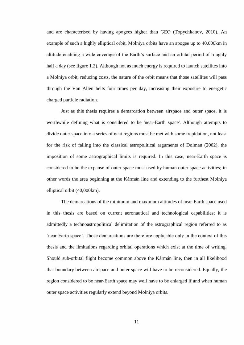
and are characterised by having apogees higher than GEO (Topychkanov, 2010). An
example of such a highly elliptical orbit, Molniya orbits have an apogee up to 40,000km in
altitude enabling a wide coverage of the Earth’s surface and an orbital period of roughly
half a day (see figure 1.2). Although not as much energy is required to launch satellites into
a Molniya orbit, reducing costs, the nature of the orbit means that those satellites will pass
through the Van Allen belts four times per day, increasing their exposure to energetic
charged particle radiation.
Just as this thesis requires a demarcation between airspace and outer space, it is
worthwhile defining what is considered to be 'near-Earth space'. Although attempts to
divide outer space into a series of neat regions must be met with some trepidation, not least
for the risk of falling into the classical astropolitical arguments of Dolman (2002), the
imposition of some astrographical limits is required. In this case, near-Earth space is
considered to be the expanse of outer space most used by human outer space activities; in
other words the area beginning at the Kármán line and extending to the furthest Molniya
elliptical orbit (40,000km).
The demarcations of the minimum and maximum altitudes of near-Earth space used
in this thesis are based on current aeronautical and technological capabilities; it is
admittedly a technoastropolitical delimitation of the astrographical region referred to as
‘near-Earth space’. Those demarcations are therefore applicable only in the context of this
thesis and the limitations regarding orbital operations which exist at the time of writing.
Should sub-orbital flight become common above the Kármán line, then in all likelihood
that boundary between airspace and outer space will have to be reconsidered. Equally, the
region considered to be near-Earth space may well have to be enlarged if and when human
outer space activities regularly extend beyond Molniya orbits.

12
Figure 1.1: The orbital regions of near-Earth space (to scale 1:300,000,000)

13
Figure 1.2 Illustration of a highly elliptical orbit
1.3 The foundations and context(s) of critical astropolitics
Rather than try to summarise the entirety of the astropolitical literature concerned
with outer space affairs, which would be an almost impossible task, there follows a brief
review of the arguments and theories of authors who take different approaches to the
subject. Human activity in outer space, albeit largely undertaken by satellites under the

14
command of humans on Earth, has produced outer space in a form which reflects the
current requirements and expectations of the domain. Sheehan (2007) contends that:
although we as humans live in a physical universe, much of the ‘world’ we
inhabit is intersubjectively constructed through our mutual understandings of
what constitutes reality. We act in terms of our beliefs, values, theories and
understandings of the ‘reality’ we perceive […] We perceive outer space in a
particular way, as a particular kind of realm, in which certain types of activity
are possible, even expected, while others are frowned upon or specifically
forbidden (p. 5).
This is illustrated perfectly, though perhaps unintentionally, by Caldicott and Eisendrath
(2007), who name the first chapter of their book ‘A brief history of outer space’, even
though it begins in 1958 with the launching of Sputnik 1. It is almost an insinuation that
outer space did not exist prior to human expansion into the domain and that, for all intent
and purpose, ‘history’ began with Sputnik. Whilst obviously inaccurate, there is
nevertheless some truth in so far that outer space, as we conceive it today, did not exist
prior to Sputnik. The launch of the first man-made satellite into a stable orbit transformed
outer space into a domain of possibilities for supporting terrestrial systems and societies.
Outer space has subsequently become a crucial support mechanism for terrestrial modes of
life through the activities taking place there, and consequently space policies, programmes
and laws are all directed towards maintaining this assistance.
There are two categories through which outer space is produced. The first is
imaginations of outer space; how policy-makers, lawyers and non-experts conceive and
understand outer space. These imaginations are internally reproductive, in that they reflect
15
the conceptions of outer space yet simultaneously influence those conceptions. The second
category is the use of outer space; how space programmes and the services provided by
satellite networks produce outer space based upon terrestrial needs. In addition, both
aforementioned categories are mutually constitutive; the imaginations of outer space shape
the visions upon which space programmes are developed, while the achievements and
realities of the space programmes serve to inspire and foster new imaginations.
A detailed account of how outer space has been imagined, and arguably
constructed, in the years since the launch of Sputnik is beyond the intentions of this
chapter.5 Rather, it will attempt to illustrate how outer space is conceptualised in the
current (astro-)political climate by reviewing existing literature and scholarship in the
fields of critical geopolitics and astropolitics.
1.3.1 Astrographical and astropolitical imaginations of outer space
At face value, astrography is very similar to geography, in that while the latter
applies to the earth (geo), the former relates to outer space (astro). However the
phenomena being studied are naturally quite different: whilst geography is split between
human and physical disciplines, the limits of astrography have yet to be specifically
determined, thus numerous areas of interest could potentially fall within its mandate. This
is not necessarily a drastic flaw though; in its current form, astrography offers the
opportunity and framework for a broad study of the spatial and exploitative characteristics
of outer space. However, MacDonald (2007) warns that “[w]e must be alert to the
‘declarative’ (‘this is how the Outer Earth is’) and ‘imperative’ (‘this is what we must do’)
modes of narration that astropolitics has borrowed from its terrestrial antecedent” (p. 609).
5 For a thorough account of how conceptualisations of the domain of outer space have developed since 1957,
see Sheehan (2007).
16
Additionally, the advantages and limitations of geography equally apply to astrography: to
paraphrase Ó Tuathail (1996: 2), ‘astrography is not something already possessed by outer
space but an active writing of outer space by an expanding, centralising imperial state. It is
not a noun, but a verb, an astro-graphing, outer space-writing by ambitious endocolonising
and exocolonising states who seek to seize space and organise it to fit their cultural visions
and material interests’.
An example of this is the astrocartographical practice of mapping/tracking
satellites’ orbits around the earth; they are supposedly revealing the hidden vertical
element of contemporary life but arguably serve only to obfuscate further. Astrographical
maps/tracks reveal the positions of some satellites or orbits, but only those which the
owners (state or otherwise) are willing to reveal, and even then, the user is allowed to
choose which satellites’ orbits they wish to see, enabling an orderly perspective. However,
orbital tracks are projected upon a map of the Earth, showing users where, compared to
their terrestrial position, satellites are passing overhead. This though leads to an
obfuscation of the astrographical ‘reality’ of outer space, where so-called ‘near-Earth’
space is crowded by satellites on their own orbital paths. Furthermore, the orbital tracks do
not display the vertical orbit of satellites, only their projected geographical paths, thus
ignoring a vital spatial element of satellites’ orbits, and there is little or no display of
deviation from predicted orbital paths. The mere existence of orbital tracking is arguably
problematic, as it emphasises the human exploitation of outer space, ignoring areas or
orbits which are not used by humans and their material assets.
The obfuscations created by orbital tracking are arguably founded upon perceived
geographical and astrographical permanence. Orbital tracking software project predictions
of ‘live’ events (orbiting satellites) upon a static cartographical representation of the Earth.
This juxtaposition of highly mobile (albeit unidirectional) satellites upon a static Earth

17
serves only to reinforce a number of geopolitical and cartographical fallacies. The specific
cartographical representation of the Earth differs depending upon which orbital tracking
software or website is used, however state boundaries are generally included as a means of
illustrating over which states a particular satellite is travelling at a moment in time.
However, providing states as the cartographical reference for satellites’ travels only
reinforces the perception of the state being the “fundamental unit of society” (P. Steinberg,
2012).
The division of near-Earth space into Lower Earth Orbit (LEO), Middle Earth Orbit
(MEO), Higher Earth Orbit (HEO), Geostationary Orbit (GSO), Geosynchronous Orbit
(GEO) and Polar Elliptical Orbit (PEO) arguably highlights yet another astrographical
limitation: while they represent astrophysical and gravitational conditions which enable
satellite operations around the Earth, the division of near-Earth space into such regions
emphasises the man-made presence in outer space. In other words, near-Earth space is
mapped based upon its technological exploitation by humankind, with the Earth as a
societal, as well as astrophysical, referent.
The emergence of astropolitics has occurred in a similar fashion to astrography,
with its proponents taking an approach associated with terrestrial politics – in this case
geopolitics – and applying it to the extra-terrestrial dimension. It therefore, like the case of
astrography discussed above, comes with the advantages and disadvantages of geopolitics.
However, before astropolitics can be discussed in any detail geopolitics, and critiques of it,
must first be reviewed.
1.3.2 From geopolitics to critical geopolitics
Geopolitics as a discipline has its origins in the late 19th Century, with years of
European imperial ambitions and campaigns culminating in a situation whereby European

18
world maps became “for the first time relatively occupied” (Ó Tuathail, 1996: 25; see
Sparke, 2007: 339). Geopolitics has been heavily associated with the Geopolitik of Nazi
Germany in the 1930s, to the extent that French accounts of geopolitics still struggle to
broach the subject and its history (Retaillé, 2001: 35), though there is perhaps a certain
irony that the French academic distaste for the study of geopolitics is itself borne of an
historical geopolitical rivalry. Despite the assertions of Raffestin (2001: 10), the ‘classical’
geopolitical approach developed from scholars in the late 19th and early to mid-20th
Centuries who were “fundamentally concerned with the role that inter alia location and
resources play in the exercise of power over territory” (Dodds, 2010a); these scholars
generally held a common understanding of permanence in geography, a perception which
Ó Tuathail (1996) terms the ‘geopolitical gaze’. However, geography – either human or
physical – is not permanent; it fluctuates thanks a multitude of factors, including societal
changes, migration, continental drift and erosion but to name a few. Ó Tuathail (1996)
argues that rather than emphasising its constituent elements, classical geopolitics (and geo-
power in general):
depends on a suppression of geography and politics. In its spatializations,
biologization, linnaeanization, strategization, and naturalization of the
historical, it works to degeographicalize and depoliticize the study of
international politics (p. 53).
Additionally, while geopolitics purports to address global issues, in reality “it has instead
offered a means of affixing and calibrating the meaning of the local within the global
whole” (Ó Tuathail, 2010: 256). Geopolitics and geoeconomics – the former’s supposed
post-Cold War replacement – are, as Sparke (2007) puts it, “better understood as

19
geostrategic discourses” (p. 340, original emphasis), a focus which pervades much of the
scholarship on critical geopolitics (Müller, 2010; Ó Tuathail, 2002). In particular, Ó
Tuathail and Dalby (1998a) argue that the geopolitics of the Cold War era was no more
than a “powerful and pervasive political ideology that lasted for forty years” (p. 1). In this
way, the political foundations of geopolitics belie its attempts to reveal the ‘truth’ behind
the relationships between geography and foreign policy formulation. It is, in the words of
Ó Tuathail (1998), no more than “a particular mode of representing global space” (p. 22).
Ó Tuathail (1994; 1996) takes a Derridean deconstructive approach to critical
geopolitics, attempting to deconstruct geopolitics by focusing upon the contexts in which
geopolitics and geopolitical writings emerge. He uses hyphens to divide words “so the
unseen conceptual marks that have so delimited our existing understandings of maps,
geography and geopolitics can be rendered visible” (1994: 526). Consequently, geopolitics
becomes geo-politics and geography becomes geo-graph-y,6 while the term geo-power
plays an important role in emphasising Foucauldian power/knowledge relationships. This
is exemplary of the wider critical geopolitical approach; with close attention being paid to
what is revealed and hidden by geopolitical discourses. In this light, geo-politics – “the
politics of writing global space” (1996: 18) – is not separate to geopolitics, it is a
problematic of the latter:
Geo-politics does not mark a fixed presence but an unstable and indeterminate
problematic; it is not an ‘is’ but a question. The hyphen ruptures the givenness
of geopolitics and opens up the seal of bonding of the ‘geo’ and the ‘politics’
to critical thought. In undoing the symbolic functioning of the sign, its
6 Ó Tuathail’s geo-graph-y pertains, in his words, to “an open-ended inscribing, delimiting, and engraving of
the earth/globe/world. To study geo-graph-y, then, is to study the projection of geo-graphs striving for
signification; it is to study the graphing/weaving/writing of a geo/world/system” (1994: 530).

20
semantic instability, ambiguity, and indeterminancy are released. The sign lies
open before us, a disrupted unity in question, a sign of a textual weave
involving geography and politics (1996: 67).
Ó Tuathail does not aim to provide a comprehensive theory; he contends that critical
geopolitics works to reveal the problematic(s) of geopolitics, rather than offer an
alternative (1994: 527). This is not to say that fieldwork and original research is
discouraged, far from it; he recommends that “critical geopolitics can deepen its critical
practice by grounding itself in regional research” (2010: 257). However the emphasis
remains on the revealing of hidden discourses within geopolitical scholarship. In this light,
he argues that geopolitics is yet another form of ‘geo-power’ that is:
a convenient fiction, an imperfect name for a set of practices within the civil
societies of the Great Powers that sought to explain the meaning of the new
global conditions of space, power, and technology. It names not a singularity
but a multiplicity, an ensemble of heterogeneous intellectual efforts to think
through the geographical dimensions and implications of the transformative
effects of changing technologies of transportation, communications, and
warfare on the accumulation of exercise of power in the new world order of
‘closed space’ (1996: 15).
The Eurocentric nature of geopolitics permeates Ó Tuathail’s work and contributes the
wider argument that the geopolitical culture assists and enables imperialism (Dalby, 2008;
Ó Tuathail, 1996). Indeed, he contends that “[g]eopolitics is state philosophy, a technology
of govern-mentality. It was conceived and nurtured in the imperial capitals of the Great
21
Powers, in their learned academics, in the map and war rooms of ambitious expansionist
states” (p. 1998: 23). It also leads to a state of affairs identified by Agnew (1994), whereby
the notion of the territorial state is immortalised in classical geopolitical literatures, as well
as many international relations studies, although Ó Tuathail’s (1998) arguments imply a
mutually dependent relationship whereby the state relies upon geopolitical imaginations for
justification of its existence and vice versa. The proliferation of the state as the common
form of political organisation owes much to European colonialism and imperialism, to the
extent that Agnew contends that “the territorial state as a primary mode of political
organization is no older than the 18th century” (p. 65). Importantly, Agnew is not
suggesting that territory itself is a problem, rather that the ways in which it is conceived are
problematic (Agnew, 2010: 779; Elden, 2010: 757). The relevance of this scholarly
incongruity to geopolitics is the context in which many classical geopoliticians were
writing; their Eurocentric perspective meant that their concerns were with the continued
existence of the state as a model of political organisation, rather than analysing its
historical emergence (Ó Tuathail, 1996).
Although critical geopolitics emerged at the end of the Cold War and its proponents
were primarily concerned with interrogating and critiquing the spatial and political
foundations upon which states’ foreign policies were formed, its relevance has by no
means diminished (Dalby, 2008; 2010; Ó Tuathail, 2010). Empires and imperialism are
returning to – if they had ever truly left – geopolitical scholarship (see Parker, 2010), while
“much blood and treasure is still involved in military conflict, and many wars are justified
in language structured in explicitly geographical terms” (Dalby, 2008: 415). Sparke (2007)
notes that the fetishisation of space and place remains an integral aspect of contemporary
US foreign policy-formulation; he argues that the use of terms such as ‘axis of evil’, ‘failed
states’ and ‘rogue regimes’ creates a “geopolitical script of fear” (p. 340). This geopolitical

22
language also creates a geographical and moral divide between ‘good’ and ‘evil’, as seen
in the justifications for instigating conflict with Iraq in 2003 (Sparke, 2007). Geopolitics,
then, is far from obsolete, and consequently critical geopolitics, in its desire to interrogate
the foundations and assumptions of geopolitics, remains equally pertinent. This scholarly
relationship extends beyond the atmospheric confines of the Earth: as a projection of
geopolitics upon outer space, classical astropolitics – and Astropolitik in particular – is
another example of the need for critical interrogation into the tacit spatialisation of
statehood and foreign policy-formulation.
1.3.3 The context(s) of contemporary astropolitics
It is extremely difficult, if not impossible, to think and write about human
exploration and exploitation of outer space without spatialising the issues at hand. Outer
space, whilst a vacuum, is a spatial domain and the variables of distance, location and time
exist largely as they do on Earth. It could therefore be argued that anyone writing about
outer space affairs from an international relations perspective is in some way astropolitical,
or at the very least touches upon astropolitical issues. On the other hand, if astropolitics is
taken to be an extra-terrestrial projection of geopolitics – a point of view taken by
Havercroft and Duvall (2012) – then close attention must be paid to the context in which
astropolitical arguments and writings are made in order to fully understand them. In the
same way that Ó Tuathail (1996) contends that “[g]eopolitics is not a concept that is
immanently meaningful and fully present to itself but a discursive ‘event’ that poses
questions to us whenever it is evoked and rhetorically deployed” (p. 17), the contexts in
which astropolitics is employed in scholarly writing are themselves revealing.
Astropolitics emerged as an academic concept after the end of the Cold War, when
near-Earth space was becoming increasingly inhabited by satellites from a multitude of
23
states, rather than just the US and the USSR. Near-Earth space was no longer a domain to
be explored; it was a domain to be exploited. Astropolitics is, in effect, the projection of
geopolitics upon the domain of outer space (Havercroft and Duvall, 2012: 43); indeed, one
of the main proponents of the approach, Everett Dolman (2002), unashamedly bases his
Astropolitik upon the writings of Mahan and Mackinder. Wang (2009) should also be
included in the list of astropoliticians, as he overtly states his interest in the approach in the
title of his article. However, despite presenting them as background to his arguments, he
fails to adequately engage with geopolitical or critical geopolitical literatures, taking
astropolitics to be a direct projection of geopolitics into outer space with little regard for
astrophysical and gravitational phenomena. Taking a wide perspective, whilst
geopoliticians, particularly those of the late 19th and early 20th centuries, are keen on
exploring the new spatial opportunities and problems offered by developments in
transportation, communications and warfare (Ó Tuathail, 1996), astropoliticians explore
similar opportunities and problems, only their focus is on outer space rather than the
familiar land and seas of the Earth. While the issues at hand may vary wildly between the
two disciplines, the conclusions are often quite similar.
1.3.3.1 Astropolitics and space power
When considering astropolitics, perhaps one most significant works thus far is
Dolman’s (2002) Astropolitik Classical Geopolitics in the Space Age, a monograph
referenced in much of the astropolitical literature. When considering his theory of
Astropolitik and, in particular the advocacy of space control, his classical geopolitical roots
become prominent. Although, admittedly, the impermanence of geography does not apply
24
as much to outer space7 the context and underlying culture of his arguments are worthy of
interrogation.
Dolman (2002) was one of the first scholars to introduce a notion of ‘astropolitics’,
which he defined as “the study of the relationship outer space terrain and technology and
the development of political and military policy and strategy” (p. 15). Dolman’s own
approach to astropolitics, which he names ‘Astropolitik’, is developed from the classical
geopolitics of Mahan and Mackinder and is, for the most part, concerned with the use of
outer space to serve the terrestrial intentions of the US. Indeed, Dolman sees outer space as
a domain to be strategically exploited through space control and the seizure of key choke-
points, reflecting Astropolitik’s terrestrial origins and perhaps going some way to
explaining his reverting to terrestrial strategic vocabulary when referring to the “terrain”
(p. 15) of outer space. It could be argued though that by relying on the classical
geopolitical writings of Mahan and Mackinder, Dolman’s Astropolitik is creating an
intrinsic link between human activities on the Earth and those in near-Earth space. In other
words, while the physical limitations and characteristics of near-Earth space may differ to
those on Earth, the tactics and strategies that Dolman advocates for near-Earth space are
very close, if not identical, to those employed on Earth. This is problematic, as while
Dolman emphasises the importance of terrestrial geopolitical concepts such as choke-
points and the heartland as integral to Astropolitik, the inherent vulnerability of orbiting
satellites to both man-made dangers and natural phenomena means that the classical
geopolitical thinking upon which Astropolitik is based is being adapted to an environment
for which it was not designed. Admittedly, space control may well be possible for a state
7 Ó Tuathail (1996) uses mountains, held by Spykman as an example of geographical permanence when in
reality they exemplify the fluidity of the Earth’s geology, to critique the views of classical geopolitical
scholars (p. 51). By and large though, astrophysical change occurs at such a slow rate that for the sake of
human exploration and exploitation in the domain, astrophysical phenomena such as the Lagrange Points
could arguably be considered permanent.

25
with similar material and financial wealth as the US, however the concept revolves around
Earth-to-space and space-to-space weapons systems. The negation of these systems –
possible through a myriad of ways from the destruction of the systems themselves or their
ground control elements, or the interruption of signals from the ground control elements to
the satellites – would seriously impact, if not end, an attempt at space control. This level of
vulnerability implies a similar weakness to the one identified by Deudney (1985) when
critiquing Reagan’s proposed space-based Anti-Ballistic Missile (ABM) system, as:
[i]n order to be effective, such a system would have to maintain continuous
control not simply over North America but over the entire planet […] Thus
the United States can only hope to regain its insular security by seizing the
entirety of near space, which would fundamentally jeopardize the sovereign
security of every other nation on the planet (p. 272).
Without moving too far into the hypothetical musings, it does not require a huge leap of
the imagination to argue that many, if not all, other state and non-state entities – such as
international companies and organisations with a vested interested in access to outer space
– might in all likelihood react negatively to any definitive attempts at space control.
Dolman (2002) divides the space around the Earth into four regions based upon
Mackinder’s Heartland theory (p. 68): Terra or the Earth, Terran or Earth space, Lunar or
Moon space, and Solar space (Dolman, 2002: 69-70). The first region, Terra or the Earth,
represents the area “including the atmosphere stretching from the surface to just below the
lowest altitude capable of supporting unpowered orbit” (p. 69). The second region, Terran
or Earth Space, extends “from the lowest viable orbit to just beyond geostationary altitude
(about 36,000km)” (p. 69), while the third region, Lunar or Moon Space, represents “the

26
region just beyond geostationary orbit to just beyond lunar orbit” (p. 70). Finally, the
fourth region, undoubtedly the largest, is Solar Space, which “consists of everything in the
solar system (that is, within the gravity well of the Sun) beyond the orbit of the Moon” (p.
70). This last region highlights the Earth-centric technological basis for Dolman’s division
of outer space, as he chooses to group everything beyond the reach of contemporary
human spaceflight together, “as expansion into this region using current technologies will
be quite limited” (p. 70). It could be argued that this gives the strategic side of Astropolitik
a fairly short lifespan, as it will need to be consistently reconfigured the moment that
human spaceflight extends beyond its technological limits.
Dolman’s four regions of space are not purely cosmetic; he bases many of his
arguments on space control on these regions, and Earth space in particular, which he
describes as, “like eastern Europe in Mackinder’s design […] the most critical arena for
astropolitics” (p. 70). Consequently, there appears to be within Astropolitik an inherent, if
not necessary, compartmentalisation of outer space, which acts as an enabler for the
aggressive strategies that Dolman advocates. This compartmentalisation is partially due to
geopolitical foundations of Astropolitik, as even when referring to the vacuum of outer
space, Dolman (2002) sees in gravitational phenomena and human technological
capabilities a chance to apply classical Mackinderian (p. 40) and Mahanian (p. 38)
geopolitical theories. Nevertheless, the compartmentalisation reveals the cultural
foundations upon which Astropolitik is based; by establishing borders between areas in
outer space, Dolman creates the possibility for them to be ‘controlled’. He provides a
spatio-temporal location for the normalisation of particular actions: Earth Space is where
much of the current human extra-terrestrial exploration and exploitation takes place, whilst
Solar Space is currently beyond the technological reach for all but scientific exploration.

27
Consequently, attempts at space control in Solar Space make little sense, yet they are to be
expected within Earth space.
Dolman’s Astropolitik can be closely associated with the concept of space power, a
notion which has emerged in the early 21st century and is tentatively defined by Lutes et al.
(2011b) as “the ability to use space to influence others, events, or the environment to
achieve one’s purposes or goals” (p. xiv). The concept is relatively broad, as “[i]t is not a
single property, but a combination of factors. Space power is composed of a set of
interrelated elements. It is not simply satellites and launchers. It is anything and everything
a country can achieve through space” (Peter, 2010: 351). This said, there is no agreed
definition of space power and significant divisions remain as to the conceptual limitations
of the theory. For instance, Sheldon and Gray (2011) openly admit that their understanding
of strategy, and consequently space power, is “unashamedly Clausewitzian” (p. 1), hence
their definition of strategy as “the use that is made of force and the threat of force for the
ends of policy” (pp. 1-2). The result is an approach to space power focused largely on
military matters. Peter (2010), on the other hand, proposes that space power be defined as
the
total strength and ability of a State to conduct and influence activities to, in,
through and from space to achieve its goals and objectives (security and
military, economic and political) to affect desired outcomes in the presence of
other actors in the world stage and if necessary to change the behaviour of
others by exploiting the space systems and associated ground-infrastructure as
well as political leverage it has garnered (p. 351).

28
Whilst military affairs and opportunities remain prominent in Peter’s definition, it is
nonetheless broader than the approach taken by Sheldon and Gray (2011), whilst being
more detailed than the definition offered by Lutes et al. (2011b: xiv). Moreover, Peter
(2010) goes on to contend that space power affects four areas of ‘national’ power; political,
economic, military and cultural (pp. 351-352).
In addition to the lack of consensus regarding the definition of space power, it has
been argued that a comprehensive theory of ‘spacepower’ is yet to emerge (Lutes et al.,
2011b; Peter, 2010), a situation that has been the “subject of speculation on numerous
plausible and seemingly implausible factors” (Sheldon and Gray, 2011: 2). Sheldon and
Gray (2011) contend that:
[s]ome of these impediments are unintentional and random incidents,
phenomena and events that are the stuff of everyday defense planning and
strategic decisionmaking [sic]. Other impediments are more insidious, the
product of institutional practices and failings, or flaws in military and strategic
culture (p. 2).
As Sheldon and Gray note, the concept is relatively young in comparison with its ground
and naval equivalents and consequently there is not a vast literature on the subject.
Nonetheless, some important contributions can be identified. As already discussed,
Dolman’s (2002) work on Astropolitik – and in particular his advocacy of the doctrine of
space control – is an oft-referenced example of space power theorising.
Arguably however, there are two commonalities between the various definitions of
space power; firstly, they are all predicated on the ability of actors to project power into,
across and from outer space. Consequently, space power can be considered intrinsically
29
astro-/geographical and astro-/geopolitical. A pertinent example of this is Oberg’s (1999)
assertion that “[t]he free exercise of space operations requires a launch site with ample
downrange safety zones […] and usually a far-flung string of communications sites. This
favors geographically large nations or those with good diplomatic relations with potential
host nations” (p. 47).
The second commonality between the understandings of space power is that there is
an inherent terrestrial focus (Pfaltzgraff Jr., 2011), as indicated by the emphasis Peter
(2010) places on how space power complements a state’s “goals and objectives […] in the
world stage” (p. 351). The ultimate objective of space power is to enhance and increase the
power that actor(s) wield on Earth, be it associated with military and strategic matters
(Dolman, 2002; Sheldon and Gray, 2011) or economic affairs (Hertzfeld, 2011; Fuller Jr.
et al., 2011). This arguably affects the way through which near-Earth space is imagined in
space power literature, insofar as it is portrayed as intrinsic to terrestrial power and thus
arguably part of a wider sphere of planetary action. Particularly by proponents of the
‘ultimate high ground’ notion, near-Earth space is imagined as an extension of terrestrial
activities, thus extending the limits of ‘planet Earth’ to the extremities of near-Earth space,
or the Terran region, as Dolman (2002: 69) describes it. Indeed, the term Terran space
implies such an extension of the planetary sphere as this region is still considered part of
the Earth. With respect to Europe and the EU, Pasco’s (2011) article on European space
power focuses largely on military programmes and the means through which outer space
assets can complement the European Security and Defence Policy (ESDP). Notably, the
cultural impact of space power discussed by Peter (2010) – whereby outer space assets and
technologies are used to foster a common identity amongst citizens – is not included.
Despite the focus upon the terrestrial consequences of space power, issues
surrounding outer space governance are not ignored; Dolman’s (2002) Astropolitik is a

30
pertinent example of how primacy in outer space affairs has been portrayed as vital to
achieving terrestrial dominance (space power), whilst Hays (2011) assesses the importance
of a legal regime concerned with outer space activities to US space power capabilities.
Nonetheless, there appears to be a trend within the space power literature to prioritise the
terrestrial consequences of space power, with issues concerning outer space governance
being of secondary importance.
Space power is often a relatively narrow concept, discussed with reference to single
actors, which are often states or inter-state institutions. Some space power advocates –
Dolman (2002), Oberg (1999; 2003) and A. Steinberg (2012) being prime examples – are
explicitly concerned with how outer space activities are vital to US interests alone, with
other spacefaring actors rarely mentioned. Whilst Pasco (2011) and Peter (2010) do
include the capabilities of individual states during their discussions of European space
power, their emphasis remains state-centric; the complex underlying relationships between
national and European space industries are largely ignored. This said, there are exceptions
to this narrow, state-centric approach. For instance, Sadeh (2011) concludes following his
analysis of the need for environmental factors to be incorporated into conceptions of space
power; “[o]ne implication broadens the scope of spacepower from a focus solely on
national concerns to include regional and global concerns” (p. 21). Hays (2011) takes a
similar approach, arguing that it is “imperative that the United States and all spacefaring
actors think more creatively about using spacepower to transcend traditional and emerging
threats to our [humankind’s] survival” (p. 13).
Space power then is oriented towards the use of outer space and assets located
therein to project power, whilst, as outlined below, outer space security is concerned with
the protection of those assets and the services they provide. In astrographical and
geographical terms, space power portrays near-Earth space as an extension of terrestrial

31
power relations; near-Earth space becomes incorporated within the terrestrial sphere of
activity, so to speak. With reference to security, space power theorists have traditionally
been advocates of space weaponisation as a means of establishing and maintaining space
power. This advocacy stretches back to Oberg (1999) and Dolman (2002; 2010), though
remains through the writings of Dolman and Cooper (2011), Klein (2012), Pavelec (2012)
and A. Steinberg (2012). Support for the weaponisation of outer space does not extend to
all space power theorists however; Hays (2011) argues the need for a comprehensive legal
regime to “illuminate paths toward and develop incentives for creating a better future” (p.
13) for humankind, while Krepon et al. (2011) contend that “it is possible to craft a regime
based on self-interest to avoid turning space into a shooting gallery” (p. 6).
1.3.3.2 Cooperative astropolitics
Other astropolitical approaches place more emphasis upon the governance of outer
space activities, rather than the impact those activities may have upon terrestrial power
relations. This is not to say that they ignore the terrestrial benefits of outer space
exploration and exploitation but rather that such advantages are not necessarily the
overarching focus of those works. In other words, there is an astrographical difference
between space power literature and that concerned with astropolitical governance, with the
former arguably portraying near-Earth space as an extension of terrestrial matters and the
latter introducing a separation between terrestrial and extra-terrestrial affairs.
Deudney (1985) is identified by Havercroft and Duvall (2012) as being, alongside
Dolman (2002), one of the main proponents of astropolitics. Writing towards the end of the
Cold War, he proposes an approach to outer space activities predicated upon cooperative
technological development, arguing that this “offers the opportunity to rechannel the
momentum of the arms race and to create at least an experimental working peace system”
32
(p. 303). Deudney encourages the redirection of efforts being put into the space weapons
and ASAT systems towards cooperation between the USA and the USSR, positing that in
addition to ensuring security from man-made threats to outer space assets, there may be an
accelerated development of scientific and exploitative technologies for both near-Earth and
deep space.
Whilst approaching the issue from the angle of environmental threats to satellites,
Moltz (2008) is also a proponent of cooperation in outer space affairs. He notes “that
surprising levels of restraint emerged during the first fifty years of space activity, despite a
global context of political and military hostility” (p. 41). Taking the example of nuclear
testing, he argues that the US and USSR found exo-atmospheric nuclear detonations to be
“fundamentally incompatible with the pursuit of other goals in space” (p. 46). His
monograph is a historical analysis of how environmental factors grew in importance and
have been gradually attributed priority in national and international outer space policy-
making. Whilst detailing the numerous obstacles that have arisen – such as the Anti-
Ballistic Missile (ABM) Treaty negotiations – Moltz theorises the history of outer space
affairs through the lens of cooperative outer space security predicated upon environmental
factors and military restraint. He focuses upon EMP radiation and space debris as dangers
which can emerge through military activities in outer space to justify his stance promoting
the continued absence of space weapons, conventional or otherwise. In particular, he
argues that given the emergence of a Chinese ASAT programme and the apparent
resumption of US research and development into similar projects, there is a “need for a
renewed and expanded international dialogue about space security” (p. 329).
The calls for a cooperative approach to outer space security are also echoed by
Johnson-Freese (2006; 2007; 2009) and Sheehan (2007), amongst others. Johnson-Freese’s
focus is directed largely at the US, looking to promote policies which have the potential to
33
foster cooperation with other spacefaring actors. Indeed, at times her 2009 monograph
reads like a set of policy recommendations for the incoming Obama administration, and
she concludes it by arguing that “[i]t is no longer enough to try to control the security
dilemma that exists and is growing in space; it must be actively scaled back and dealt with
from an entirely different perspective, toward making incremental but effective changes”
(p. 145). Sheehan (2007) meanwhile contends that outer space affairs have historically
been characterised by a “lack of novelty […insofar as] they have precisely mirrored
terrestrial preoccupations and approaches” (p. 183). Nonetheless, he argues that outer
space:
still remains a distinctive arena […], because however much human activities
there tend to reflect terrestrial realities, it continues to encourage international
actors to believe that it ought to be possible to do things differently, and
better, beyond the security of our home planet (p. 183, original emphasis).
Whilst noting the close historical association between terrestrial and extra-terrestrial
international relations, Sheehan (2007) looks to separate the two; outer space is portrayed
as a domain ripe for cooperation and collaboration that might not take place in the context
of terrestrial geopolitical sensibilities.
In terms of the legal regimes promoting inter-actor cooperation in outer space,
academic scrutiny has focused upon a number of areas, including the character and
effectiveness of those regimes (see Vogler, 2000) and their impact on conceptualisations of
extra-terrestrial sovereignty (see Stuart, 2012). Recently, the potential introduction of
Transparency and Confidence-Building Measures (TCBMs) has received attention (see
Robinson, 2010; 2011c; 2012), as have initiatives to promote sustainability through

34
regime-based governance (see Arévalo-Yepes et al., 2010; Brachet, 2012; Grego and
Wright, 2010; Henri and Nozdrin, 2012; Meek, 2012; Rathgeber et al., 2009; Weeden and
Chow, 2012; Von Prittwitz, 2011; Williamson, 2012).
The astropolitical literature advocating cooperative approaches to outer space
affairs take a wider, globalised view of near-Earth space. They portray the domain as one
of mutual vulnerability, where seemingly isolated activities can rapidly have a wide-
ranging impact (see Johnson-Freese, 2007; Moltz, 2008: 46). Debris generated through the
destruction of a space object is indiscriminate with regards to the ownership of satellites.
As Johnson-Freese (2007) notes, “if a [US] space weapon were used in space, it would
create a debris cloud most dangerous to other U.S. space assets. Consequently, the United
States gains nothing by having space weapons and potentially loses the most by using
them” (p. 134). The promotion of cooperation through regime-based governance as means
to resolve disputes and encourage sustainability conceptualises near-Earth space as a
commons, where actors maintain the right to equal access to the domain and resources are
either available to all or managed under a common property resource approach (Vogler,
2000; Weeden and Chow, 2012). In astrographical and astropolitical terms, the advocacy
of inter-actor cooperation, regardless of whether it is supported by legal regimes and
TCBMs, involves a conceptualisation of near-Earth space as relatively distinct from
terrestrial affairs. While the terrestrial impacts of outer space activities remain important,
extra-terrestrial governance is depicted as largely divorced from the political power
relations on Earth.
1.3.4 Astropolitical discourses: spatialising and militarising outer space
Awareness of the temporal and contextual specificity of current astropolitical
discourse is of great importance. As mentioned at the beginning of this chapter, the

35
decision by Caldicott and Eisendrath (2007) to summarise the history of outer space
beginning with Sputnik characterises the continued astropolitical obsession not only with
human exploration and exploitation in outer space but also how they relate back to events
on Earth. For all theoretical discussions of space control and the inhabitation of outer space
and/or celestial objects, the focus of current national space policies and astropolitical
scholarship remain firmly Earth-centric. This is not surprising; indeed it would be far more
concerning if the majority of scholarly work were to ignore the impact of outer space
exploration and exploitation on terrestrial societies. However, there must be some
consideration for outer space and events taking place purely within the domain itself.
Space debris for example, is an ever-growing issue,8 though efforts to counter its
proliferation have not yet earned enough political backing for a feasible solution to be
found, despite many years of academic research and development (see, for example,
Anselmo and Pardini, 2008; Rex, 1998; Wiedemann et al., 2004). Although it may appear
cynical to suggest that a reason for the absence of firm political support is the lack, thus
far, of any significant impact upon terrestrial modes of life, the occasional and short-lived
flurry of vocalised concern every time the ISS is forced to move to avoid a piece of debris,
or the break-up of a satellite in orbit generates a new debris-field, belies the permanency of
the problem.
The Earth-centric nature of many contemporary astropolitical writings arguably
suggests an inability to escape the geopolitical foundations upon which astropolitics lies.
The recurrent desire amongst scholars to identify national space policies and technological
developments as part of a causal chain of events with terrestrial consequences, highlighted
most prominently by widespread fears that the weaponisation of outer space will result in
global hegemony and the erosion of state sovereignty, is inadequate. A much more urgent
8 The proliferation of space debris and evolving efforts to mitigate it will be discussed in detail in Chapter 5.

36
problem posed by the potential weaponisation of outer space is the generation of space
debris from the testing or use of ASAT weapons against orbiting satellites. This is not to
argue that terrestrial and extra-terrestrial events and policies are divorced from each other,
far from it. Nor should this argument be seen as advocating a reduction in efforts to ban
orbital ASAT weapons systems: the possibility of space weapons being launched into orbit
in the future is a harrowing one which threatens many technologies and infrastructures
upon which modern societies depend. However, there is little to be achieved by postulating
wildly about the potential for space weapons to support a global hegemony, particularly
when such a capability on the scale required will not be feasible, financially or practically,
for decades at the very least (see Spacy II, 2003).
It could be argued that the significant difference between space power and other
astropolitical musings is the extent to which the relationship with terrestrial affairs and
politics is prioritised. Space power literature is mostly concerned with looking back
towards the Earth: outer space is portrayed as a domain to be exploited to the benefit of
terrestrial societies. The ‘power’ under discussion can be considered a hybrid of terrestrial
and extra-terrestrial capabilities but the end product is judged on what impacts are made
upon terrestrial affairs. If space power is considered to emphasise the terrestrial
consequences of space power capabilities then other approaches, although by no means
ignoring the terrestrial impact of outer space activities, arguably choose to prioritise
matters pertaining to the extra-terrestrial domain.
As a qualifier though, there is a contextual divide between space power and other
astropolitical literatures; much of the academic work on space power is concerned solely
with the impacts upon terrestrial actors and societies because the emphasis of said work is
on the output of outer space assets. Meanwhile, the literatures concerned with the
governance of outer space activities and outer space security – that is to say the security of

37
outer space assets and their associated infrastructures – do not tend to have such a
terrestrial focus.
Contemporary astropolitical writings tend to portray outer space assets as
individual material objects operating outside of the confines of the Earth’s atmosphere.
This is problematic when the security of those assets comes under the spotlight, as in
practice those assets are part of wider infrastructures comprised of ground and space
segments. Few scholarly works have approached the problem from this angle, Cooper
(2003) being a notable exception. As will be discussed in chapter 3 of this thesis,
spacefaring actors are acknowledging both the complex infrastructures associated with
outer space and their criticality to terrestrial societies.
Space power will be explored in more detail in chapters 2 through 4 of this thesis,
which discuss the use of outer space critical infrastructures to complement and support
actors’ terrestrial policies. Nonetheless, the focus of this project is upon the security of
those infrastructures rather than the projections of power that they enable. Consequently,
this thesis does not intend to contribute directly to the debates surrounding space power but
rather looks to identify relationships between European space power projection and the use
of outer space assets for terrestrial policy-multiplication.9
1.4 Defining outer space security
The nature of the outer space environment means that security within the domain is
markedly different to that which takes place on Earth. With the exception of those in
geostationary orbit; satellites and other functioning man-made space objects do not remain
in a fixed position relative to their ground control segments or each other, introducing a
9 For the purposes of this thesis, policy-multiplication refers to the use of external factors to enhance the
effectiveness or efficiency of a given policy. See chapter 2 for further discussion of policy-multiplication.

38
mobility divorced from the largely static nature of terrestrial critical infrastructure
hardware. Moreover, satellites’ orbits are spread vertically over thousands of kilometres,
although some altitudinal regions are more popular than others. The three dimensional
spatio-temporal nature of outer space operations means that satellite security often involves
orbital trajectory prediction in addition to assessment of the risk posed by a specific threat
or danger. In other words, dangers must be assessed in terms of which satellites will be
passing through the affected three dimensional region in order to gauge the extent to which
they can be considered threatening. Consequently, as will be discussed further with
reference to anticipatory security in chapter 3 of this thesis, in addition to historical
experiences, calculations of risks to satellites are dependent upon data from Space
Situational Awareness (SSA) programmes. The capacity to ‘know’ threats in outer space is
thus limited by technological capabilities.10
From a fairly ambiguous notion, outer space security emerges as an overarching
term for specific issues related to the conduct of human activities in outer space, which
then, because of dependence upon space assets, have a significant impact upon terrestrial
geopolitics and modes of life on Earth. For instance, Moltz (2008) takes a fairly binary
view of outer space security. He considers a state to be secure when “it enjoys the ability to
conduct its activities free from harm” (p. 11). This definition is in itself problematic as
complete ‘security’ or protection against all conceivable threats is, for all intents and
purposes, impossible (Aradau et al., 2008: 148; Krepon et al., 2011: 4; Pursiainen, 2009:
727). Nevertheless, following on from his definition of security, Moltz’ understanding of
outer space security is that is the “ability to place and operate assets outside the Earth’s
atmosphere without external interference, damage, or destruction (p. 11, original
10 For instance, concerns have been raised over the ageing US Space Surveillance Network (USSSN) and its
continued capability to deliver accurate orbital trajectory data (see European Commission, 2013a).

39
emphasis), an approach which, as he acknowledges, implies that “all actors have enjoyed a
high level of space security for most of the space age, with very few exceptions” (p. 11).
While the fairly absolute nature of this definition could be considered problematic for the
reason described above, it is difficult to conceive of an alternative definition which
provides a strong foundation for a subsequent theory of outer space security. Nonetheless,
perhaps the main point to be made is the scope of the definition; which implies the
importance of environmental factors through the broad reference to “external interference,
damage or destruction” (Moltz, 2008: 11, original emphasis). While this definition
understands outer space security to pertain only to the activities that occur against objects
in outer space, rather than any subsequent terrestrial impact of those activities, it
nevertheless succeeds in encompassing many of the potential aspects of the concept and
implicitly acknowledges the military and non-military factors involved.
Unsurprisingly, alternative definitions of outer space security exist. Although there
is not the space here to account for all of them, as an example, the Space Security Index, a
cooperative annual publication detailing events and developments in extra-terrestrial
security, defines outer space security as “the secure and sustainable access to, and use of,
space and freedom from space-based threats” (Jaramillo, 2012: 7). The first aspect of note
within the definition is the inclusion of sustainability, which implies a long-term approach
to security by ensuring that current actions and decisions do not affect future access to
outer space. In this light, it could be assumed that preventing the proliferation of ASAT
technologies and mitigating the generation of space debris would be an integral aspect of
sustainable space security. Another important, and intriguing, focus of the aforementioned
definition is the explicit emphasis upon ‘space-based threats’. This phrase is problematic in
two manners: firstly, it implies a human-centric understanding of the term ‘threat’, in other
words only man-made dangers, and even then only those which are intentional, are worthy

40
of being ‘threats’ to space assets. Although Jaramillo does not specify the man-made and
intentional nature of the threats, the argument can be made that if unintentional dangers or
threats – such as accidental collisions or the generation of space debris – were to be
considered under this definition, it is likely that space security would never be achieved as
‘freedom’ from such factors will, for the foreseeable future at least, remain an optimistic
and unachievable ambition. Therefore, in order for ‘freedom’ to be possible only
intentional man-made threats can be considered. Although this is possibly a cynical
perspective, the eradication of all threats, even only those based in space, is highly
unlikely, particularly so if space debris and space weather are included. Secondly, the
definition ignores the possibility of terrestrial ASATs being used in anger against satellites.
This lapse is particularly significant given that the last two ASAT events, the Chinese test
against FY-1C and the US destruction of USA-193, involved Earth-based systems.
Jakhu and Singh (2009) propose a wider definition than that of the Space Security
Index; the “secure and sustainable access to, and use of, outer space and freedom from any
threats or unreasonable (unjustified) barriers to such access and use” (p. 76). While they
maintain the importance of access to outer space and sustainability, matters which they
consider to be “at the heart of any discussion that surrounds the issue of space security” (p.
76), any ground- or space-based threats are included. The addition of “or unreasonable
(unjustified) barriers” (p. 76) also implies that jamming or other temporary interference fall
within their definition of outer space security, whilst maintaining the possibility that
interference may be justified under specific circumstances. However, as with the definition
of the Space Security Index, the emphasis on “freedom from any threats” (Jakhu and
Singh, 2009: 76) is arguably unattainable so long as such threats exist in potentia, such as
in the form of stockpiled ASAT weapons or the existence of space debris and technologies
capable of intentional interference.
41
Given the inclusion of both ground- and space-based threats within Jakhu and
Singh’s definition, it is being broadly adopted for the purposes of this thesis. However,
bearing in mind the aforementioned unattainable nature of the condition of ‘freedom’ from
such threats present in the definitions of both the Space Security Index (Jaramillo, 2012)
and Jakhu and Singh (2009), a minor alteration is required. Consequently, for the purposes
of this thesis, outer space security is defined as: ‘the secure and sustainable access to, and
use of, outer space, whereby an entity is confident that any unreasonable (unjustified)
dangers or risks they identify as threatening to their outer space infrastructures have been
sufficiently mitigated against’. This definition places an emphasis upon the dangers and
risks that each individual actor considers threatening, meaning that an issue which
concerns one entity may not be of equal importance to another. Additionally, there is an
implicit acknowledgment that any identified dangers or risks may well never be entirely
negated, although it is possible to mitigate them to an acceptable extent (see Krepon et al.,
2011: 4). This applies to many issues of concern for spacefaring entities, but particularly to
the space debris population, which is steadily growing with, at the time of writing, no
apparent short- or long-term solution(s). Moreover, the emphasis on outer space
infrastructures indicates the need for the security of all segments associated with extra-
terrestrial operations, including ground and space segments and the connectivity between
them.
This thesis approaches outer space security through a broadly critical constructivist
perspective; it conceives of security as a concept dependent upon risk and dangers –
military and non-military – that individual actors perceive as being threatening to
themselves or their activities. Campbell (1998) contends that “[d]anger constitutes more
than the boundary that demarcates a space; to have a threat requires enforcing a closure on
the community that is threatened. A notion of what ‘we’ are is intrinsic to an understanding

42
of what ‘we’ fear” (p. 73). The ‘we’ in question in the context of this thesis is the EU,
which is identified in chapter 2 as an entity with a desire to consolidate its status as an
influential actor in outer space affairs. As is discussed in chapter 2, the EU’s space policy
priorities revolve around enhancing regional and external initiatives in areas such
agriculture, transport, humanitarian aid and the Common Security and Defence Policy
(CSDP), encouraging investment in European space programmes and associated projects,
and securing independence from other space actors with respect to some critical services,
such as GNSS signals (Council of the European Union, 2011; European Commission,
2011b: 3). Therefore, in terms of outer space activities it can be argued that the EU’s
‘fears’ will relate mostly to the disruption of the services provided by its Earth-orbiting
assets and the impact this may have upon its policies and the European economy.
As noted above, the definition of outer space security applied by this thesis
emphasises the importance of entities identifying dangers or risks that they perceive as
threatening. The act of identifying risks and dangers as threats discursively constructs a
security identity specific to the entity performing the act. It does not have a direct effect
upon the objective existence or nature of those risks and dangers, nor does it affect the
existence of ones not deemed threatening. This designation does however transform the
subjective existences of those risks and dangers, as perceptions of them change, and it is
these subjective existences which inform an entity’s security identity. This is particularly
relevant in relation to the extra-terrestrial environmental dangers discussed in chapter 5;
the objective existences of space debris and space weather are not tempered by the extent
to which an entity considers them threatening. Rather, the prioritisation of some dangers
above others shapes the measures an entity undertakes to enhance its security.
Consequently, this thesis looks to contribute to EU policy debates by investigating the risks
and dangers which the EU perceives as being threatening to the security of its critical outer

43
space infrastructures and analysing the means through which it seeks to mitigate those
threats.
1.5 Scope, limitations and methods
This thesis analyses the means through which the EU is attempting to secure the
space segments of its critical outer space infrastructures. The criteria used by the EU to
identify critical infrastructures will be discussed in more detail in chapter 3 and the case
studies used will be the EU 'flagship' programmes: the Galileo and Copernicus projects.
The use of case studies in research projects is valued, as it “provides an opportunity for one
aspect of a problem to be studied in some depth” (Bell, 2005: 10). Case studies offer an
insight into on-going projects or programmes, in this case Galileo and Copernicus,
enabling the analysis of present day practice which provides a platform for a comparison
between practice and theory which would be difficult to accomplish through other
methodologies. While there is some criticism of the case study methodology for placing
too much emphasis on a single aspect (Bell, 2005: 11; Bryman, 2008: 55), the use of case
studies is considered pertinent for the purposes of this research project as they offer a
means of analysing the implementation of policy in practice.
The focus of this thesis is firmly upon the security of the space segments of critical
outer space infrastructures. While ground segments are integral to outer space
infrastructures and their security crucial, the author is of the opinion that incorporating an
analysis of the credible risks and dangers to ground segments into this research project
would have expanded it beyond a manageable level, particularly given the notable
differences between many threats to ground and space segments, and efforts to mitigate
them. Taking environmental factors as an example, while space segments are particularly
vulnerable to space debris and radiation space weather events (SWEs), ground segments
44
may well be at risk of damage from terrestrial meteorological and geological phenomena.
In terms of intentional threats, the dangers facing ground segments are geographically and
geopolitically contextual; depending upon their location on the globe, elements of ground
segments may be at a higher risk of certain environmental factors or political instability
threatening the bilateral agreements between the host state and infrastructure owner.
Although ground and space segments are both crucial to outer space infrastructures, there
is sufficient distinction in terms of their functions to separate them for the purposes of
analysis. The category of ground segments commonly includes launch facilities, signal
receivers and control stations, whilst space segments are, for the purpose of this thesis,
defined as any objects launched into a self-sustaining orbit beyond the Kármán line and
designed to conduct extra-terrestrial operations. Given the variables involved in the
security of ground segments, the security of the EU’s outer space infrastructures’ ground
segments deserves a thorough in-depth analysis which is beyond the scope of this thesis.
Where relevant, other outer space programmes, such as weather and remote sensing
satellites, are also included within discussions, though these are supplementary with the
focus remaining on Galileo and Copernicus. In addition, for the sake of comparison and
comparative analysis, the policies of other major spacefaring actors are occasionally
discussed, most notably, in chapter 4 with regards to the militarisation and weaponisation
of outer space; although the issue is pertinent to the EU’s diplomatic endeavours with
regards to the draft International Code of Conduct for Outer Space Activities, it does not
have an overt military capacity of its own.
The overall objective of this thesis is to identify and analyse the EU's approach to
outer space security, however it must be noted from the beginning that confidentiality has
limited access to numerous EU and ESA documents as well as restricted the recording and
discussion of some topics during interviews. For instance, the risk assessments for both

45
Galileo and Copernicus are, unsurprisingly, some of the most confidential documents at
ESA (Anonymous, 2012a). Consequently, where possible this thesis refers to policy and
technical documents specific to Galileo and Copernicus but elsewhere, the author has
based his arguments on publicly available recommendations, guidelines and standards on
topics such as physical protection measures, built-in redundancy and the priority of risks
which infrastructures are being protected against.
Following the methodological precedence set by Lobo-Guerrero (2012a) and
Suzuki (2003), the research for this thesis was a three-stage process, incorporating
empirical research using primary documents and interviews alongside academic literature.
Although it may have been possible to undertake this research project using solely primary
documents and existing academic literature, the information obtained through the
interviews provided insight and more in depth understanding of issues and procedures,
which underpinned the analysis process and also included technical perspectives not found
in other written sources. The three stages of the research project were not cyclic but closer
to iterative, often informing each other insofar as issues of interest would emerge which
would then shape interview questions or require the revisiting of particular documents or
literatures.
The analysis of documents is an important aspect of social science research (Prior,
2003: 3) and is particularly pertinent to this project as many of the debates surrounding
European outer space policy have been recorded in this format. Whilst it is has been
proposed that there is an important differentiation to be made between records and
documents, with the former being official written texts and the latter pertaining to personal
ones (Hodder, 2003: 156), for the sake of simplicity both are referred to as ‘documents’.
This research project takes a “‘problem-oriented approach’” (Duffy, 2005: 123) to
the analysis of archival documents, insofar as the author has reflected on the reading of

46
secondary sources to inform the empirical research whilst bearing in mind both the
project’s research questions and the need to ‘wonder’ (Lobo-Guerrero, 2012b; Guillaume,
2012). This approach permitted the author to develop an understanding of the subject area
as documented before proceeding to the analysis of primary sources, focusing the research
and enabling a critical analysis of the content and context of the documents.
This thesis analyses the information and data compiled through the research process
through the broadly critical constructivist approach mentioned earlier, with the ultimate
objectives being to identify the risks and dangers which the EU perceives as being
threatening the security of the space segments of its critical outer space infrastructures and
assess the measures taken in response to those threats. In taking this approach, it frames
European outer space security efforts as forms of anticipatory security mechanisms
highlighting both the prioritisation of risks and dangers by the EU as well as underlying
European conceptualisations of extra-terrestrial security.
The research project began with an extensive literature search of existing debates
and discourses regarding European outer space security. For the empirical research, a
number of policy and technical documents originating from a wide range of sources were
compiled, including but not limited to the Council of the European Union, the EC, ESA,
the Consultative Committee for Space Data Systems (CCSDS) and the UN. These sources
were chosen for specific reasons; for instance, as the executive arm of the EU the EC
publishes proposed communications and working papers concerning European outer space
activities and programmes proposed to the Council of the European Union and the
European Parliament for approval.
As the agency charged with procurement for a number of European outer space
programmes, including Galileo and Copernicus, ESA produces and publishes documents
and information concerning the architecture and objectives of these programmes.
47
Moreover, ESA is actively involved in on-going research into space debris and space
weather and is, at the time of writing, managing the space weather and Near-Earth Object
segments of the European Space Situational Awareness (SSA) programme.
The CCSDS is a forum founded by space agencies in 1982 (Consultative
Committee for Space Data Systems, 2013a) and currently has 11 member agencies.11 It
creates and publishes recommendations for public release concerning data systems in order
“to promote interoperability and cross support among cooperating space agencies, to
enable multi-agency spaceflight cooperation […] and new capabilities for future missions”
(Consultative Committee for Space Data Systems, 2013a). Given that the CCSDS
comprises of some of the most active and experienced national and international space
agencies, there is good reason to assume that the issues and recommendations discussed in
its publications are attributed similar importance by those individual agencies.
Consequently and of particular relevance to this thesis, while not specific to either the
Galileo or Copernicus programmes, the security measures recommended by the CCSDS in
its publications are indicative of the possible direction of internal and confidential
discourses over the security of European critical outer space infrastructures.
Last but not least, the UN publishes existing international law, such as the 1967
Treaty on the Principles Governing the Activities of States in the Exploration and Use of
Outer Space, including the Moon and Other Celestial Bodies,12 as well as documents
emerging from its organs, including the UN Office for Outer Space Affairs (UNOOSA)
and its associated sub-committees. In addition, the UN Secretariat is the body with which
11 These are the Agenzia Spaziale Italiana (ASI), the Canadian Space Agency (CSA), the French Centre
National d’Études Spatiales (CNES), the Chinese National Space Administration (CNSA), the Deutches
Zentrum für Luft- und Raumfarht e. V. (DLR), ESA, the Brazilian Instituto Nacional de Pesquisas Espaciais
(INPE), the Japan Aerospace Exploration Agency (JAXA), NASA, the Russian Federal Space Agency
(RFSA) and the United Kingdom Space Agency (UKSA) (Consultative Committee for Space Data Systems,
2013b). 12 Hereinafter referred to as the Outer Space Treaty (OST).

48
states party to the 1976 Convention on Registration of Objects Launched into Outer
Space13 are requested to register outer space objects.
Close attention has been paid to the need to maintain an awareness of the context of
documents and archival records, permitting engagement with the imaginaries which
underpin them (see Lobo-Guerrero, 2012a). All the documents collected for this thesis
have been approved for public access and are mostly available online. As mentioned
above, a number of documents pertaining to the security of Galileo and Copernicus remain
confidential and thus unattainable for the research conducted in this project. Both the
volume and nature of the information which remains confidential is unknown to the author,
and consequently the validity of the arguments made and conclusions reached within this
thesis is predicated upon the documents and information that has been approved for public
release by the EU, ESA, CCSDS and the UN. Whilst this may be problematic in terms of
the scope of the research conducted, as it means that the thesis is dependent upon
information that the aforementioned institutions have deemed acceptable for public
digestion, the research design of combining existing academic literature, documentary
analysis and semi-structured interviews has enabled feasible analysis of the subject matter.
For the final stage of the research process, semi-structured interviews (n = 7) were
conducted with experts working at the EC, ESA and the UKSA. According to Bryman
(2008), “[t]he interview is probably the most widely employed method in qualitative
research” (p. 436). The justifications for semi-structured interviews, in contrast to
structured interviews, is that the former focus more on the opinions of the interviewee and
are far more flexible (Bryman, 2008: 437-438). The interview participants were identified
because of their experience and knowledge of the issues and programmes that this thesis is
concerned with, and their knowledge and assistance has been invaluable to the research
13 Hereinafter referred to as the Registration Convention.
49
project. Although some of the participants were employees of the same institution, their
areas of expertise were different, and the content therefore furthered both the
understanding of the issues and processes but equally offered either contrasting views and
opinions to be considered or supportive reflections. These interviews enabled coverage of a
variety of subjects yet permitted general questions regarding wider institutional policy-
making to be posed for comparison. While the majority of the participants did not have
English as their primary language, their knowledge of English, combined with the fact that
much of their work is conducted in English, meant that there were very few linguistic
issues during the interviews.
Since this project is investigating the security of the EU’s critical outer space
infrastructures, much of the discussion will be oriented towards the decisions and
discourses of European institutions, specifically the Council of the European Union, the
EC and its associated Directorate-Generals and, last but not least, ESA. These agencies are
fundamental to the formulation of initiatives, mechanisms and policies oriented towards
the security of European critical outer space infrastructures. However, on occasion
comparisons with non-European practices or conceptualisations are relevant in order to
provide context for debates taking place in Europe. This occurs twice in the thesis to a
notable extent; firstly in chapter 3 with regards to the definition of critical infrastructures
by the US Department Homeland Security (DHS) and the origins of Critical Infrastructure
Protection (CIP) in the 1997 President’s Commission on Critical Infrastructure Protection
(PCCIP). The second instance, in chapter 4, concerns the military space programmes of the
US, the Russian Federation and the People’s Republic of China (PRC). As the EU appears
to show no interest in developing a space weapons programme of its own, an overview is
provided of these three countries’ ASAT programmes to illustrate the capabilities of
existing technologies in this field.

50
Following the overview of existing and past ASAT programmes, there is a
discussion of US doctrine concerning military space applications. Again, the purpose of
this is to provide context and contrast to the relatively non-military approach undertaken
by the EU, as well as highlighting the importance of international efforts to prevent the
weaponisation of outer space. The decision to focus solely on US military outer space
doctrine was based upon two factors; firstly a desire to provide some context without
digressing too far from the European focus of the research project, and secondly the
linguistic abilities of the author. Although some documentation on Russian and Chinese
military space doctrine is available, it was considered that this was beyond the required
scope of this thesis and that the time and resources required verifying possibly unreliable
translations of government and military documents would detract from the focus of the
research project.
1.6 Thesis structure
This thesis is split into six substantive chapters, including this introduction,
analysing the EU’s ambitions in outer space, critical infrastructures and the Galileo and
Copernicus programmes, intentional threats to outer space infrastructures and
environmental hazards facing satellite networks.
The next chapter explores role of the EU in the coordination and management of
pan-European outer space activities. It begins by introducing the hierarchy of actors
present within EU outer space activities. Outer space policy-making at EU level is
reflective of its terrestrial policies, in terms of equal access to space and the increasing use
of outer space systems to complement and enhance spatial projects, along with European
internal and external security. To this end, outer space infrastructures are framed as a
means of policy-multiplication, making them examples of a regional and global European
51
space power projection. The chapter concludes by examining the objectives of the EU’s
outer space policy, and its evolving relationship with ESA.
The third chapter explores the EU’s labelling of its outer space assets as critical
infrastructures. It offers a brief history of efforts to secure critical infrastructures, from the
emergence of CIP to the evolution towards CIR, whereby resilience and redundancy are
considered equally important to attempts to deter threats. The conceptual framework of
anticipatory security is introduced before being developed further in the context of outer
space security in subsequent chapters. Building upon on the arguments made in the second
chapter, the third chapter contends that satellite constellations and the services they provide
fulfil the requirements to be included amongst critical infrastructures and European Critical
Infrastructures, although they are very rarely acknowledged as such in public. Finally, the
two European flagship outer space programmes, Galileo and Copernicus, are outlined and
framed as examples of future European critical outer space infrastructures. Some
background will also be provided on programmes and technologies relevant to these
projects to place Galileo and Copernicus within the wider context of European and
international efforts to explore and exploit the domain of outer space. The chapter
concludes by arguing that the future importance of the Galileo and Copernicus
programmes to European societies makes their protection a matter of necessity.
The fourth chapter begins by differentiating between the militarisation and
weaponisation of outer space, arguing that whilst outer space is already militarised, it has
not yet been weaponised. It then offers a brief history of the development of ASAT
systems and technologies as background to the on-going debates over the weaponisation of
outer space. As the US has undertaken the most research into ASAT technologies, the
military doctrine underpinning its space policies are also discussed in order to highlight the
importance of outer space operations to military strategists and justify why counterspace

52
operations may be prominent in any future conflicts between spacefaring actors. The
chapter then analyses the extent to which on-going efforts to prevent intentional man-made
threats to outer space infrastructures, and in particular the draft International Code of
Conduct for Outer Space Activities championed by the EU, are advocating sustainability
through practices predicated upon logics of preemptive anticipatory security.
The fifth chapter outlines the ‘natural’ environmental phenomena, namely space
weather and near-Earth objects, which have the potential to damage or destroy man-made
assets in outer space before turning to the issue of space debris. The means undertaken by
the EU and its affiliated agencies to counter and mitigate the effects of extra-terrestrial
environmental hazards are analysed in the framework of anticipatory security. Many risks
that are being countered or mitigated are already proving dangerous to on-going operations
and thus, although there is an element of sustainability at play, the measures discussed in
this chapter are designed to secure the present as much as the future. As well as framing
the European SSA as an anticipatory security mechanism, there is also discussion of the
extent to which existing responses to extra-terrestrial environmental risks conform to
terrestrial critical infrastructure resilience or protection strategies.
53
2 Europe and outer space
Before matters relating to the security of European outer space infrastructures can
be discussed in any great detail, it is necessary to outline European outer space activities;
the actors involved, the motivations behind independent European outer space capabilities
and the history of those capabilities.
With the exception of some scientific missions and probes, the majority of outer
space assets and technologies are designed to complement and enhance terrestrial policies,
objectives and infrastructures. The European Union (EU) is making an effort to highlight
this relationship between terrestrial societies and outer space, along with the integral role
outer space assets play in its regional policies. As mentioned at the beginning of the first
chapter, the EU Space Expo has been touring Europe in 2012 and 2013, explaining through
audio-visual presentations how outer space assets and technologies benefit European
societies and individuals. The exposition ties in with recent EU efforts to establish the
close relationship between outer space and individual Europeans; a 2011 Communication
from the European Commission (EC) was titled “towards a space strategy for the European
Union that benefits its citizens” (European Commission, 2011a: 1). Moreover, 2013 has
been declared the ‘European Year of Citizens’ (see Europa.eu, 2013), an event ostensibly
dedicated to informing and reminding Europeans of their rights as EU citizens but which
will likely have the consequence of portraying the ways through which the EU is integral
to European societies. Although there is no direct link between outer space assets and
technologies and the 2013 European Year of Citizens initiative, it could be argued that the
54
similar foci on individual benefits indicates that the EU is making a concerted effort to
incorporate outer space affairs into its wider terrestrial policy-making.
This chapter explores role of the EU in the coordination and management of pan-
European outer space activities and the reasons behind the perceived need for independent
outer space capabilities. The chapter begins by introducing the hierarchy of actors present
within EU outer space activities and then explores the concept of power projection and
how it complements space power. Outer space policy-making at EU level is reflective of
its terrestrial policies, in terms of equal access to space and the increasing use of outer
space systems to complement and enhance spatial projects and European internal and
external security. To this end, outer space infrastructures are framed as a means of policy-
multiplication, making them examples of a regional and global European space power
projection and thus central to European ambitions in terms of outer space affairs. The
chapter concludes by examining the objectives of the EU’s outer space policy, and its
evolving relationship with ESA.
2.1 Actors in European outer space activities
There are numerous actors involved in outer space activities, from states to national
and multinational corporations (Jakhu and Singh, 2009: 77). State-operated satellites are
commonly dedicated to military, government or scientific use, while commercial satellites
are often providers of telecommunication or remote sensing services. As with many areas
of international relations, states are arguably some of the most important actors,
particularly given that they are responsible for satellites launched and operated under their
name. Although there are many commercial satellites in orbit operated by national or
multinational corporations, such as Intelsat, existing international law places responsibility
and liability firmly with the launching state. Nonetheless, with regards to the outer space

55
activities of the EU, a state-centric framework would offer an inadequate and incomplete
analysis (Suzuki, 2003).
Concerning European outer space activities, the EU has seen its role in policy-
making increase in recent years, particularly since the signing of the Lisbon Treaty in
2007, which established European space policy as being a “shared competence of the EU”
(Mutschler and Venet, 2012: 118, original emphasis) in Article 189. The emphasis on
shared is important, as regional outer space policy-making in Europe involves three tiers of
actors: the EU, ESA, and Member States (both of the EU and ESA14), including their
respective national space agencies. The involvement of the EU and ESA Member States is
mostly related to funding and policy-making, which set the priorities for the development
of pan-European outer space programmes and associated projects and applications, even if
there continues to be some variation in domestic policies and objectives. Suzuki (2003) has
charted the complex relationship of collaboration between the EU and European states
since 1960, concluding that
[t]he history of European space collaboration reminds us that even though
European governments could not strike a balance in their policy logics, they
innovated new institutional arrangements to accommodate those logics under
a European umbrella. After all, the European governments knew that they
would not accomplish the level of technological expertise and competence in
space if there was no collaboration (p. 213).
14 The Member States of the EU and ESA are not identical; Canada, Norway and Switzerland are members of
ESA but not of the EU, whilst not all Member States of the EU are members of ESA. This has created
friction between the organisations, which is discussed later in this chapter.

56
Collaboration between states and their space agencies is a necessary component of
European outer space activities. Individually, European states lack the financial, industrial
and scientific resources to develop large-scale space programmes capable of challenging
those of the US, Russia and, in the future, China.
Taking the Galileo and Copernicus programmes as examples, a number of bodies of
the EU have different roles within their development and management; although not at the
time of writing an organ of the EU, ESA is responsible for the design and procurement of
the ground and space segments for both programmes. Meanwhile, the EC is tasked for the
overall funding and management of Galileo and Copernicus, with some governance over
specific issues delegated to dedicated organisations such as the European GNSS Agency
(GSA), which is responsible for the Public Regulated Service (PRS) and signal security of
the Galileo programme. The projects and applications developed for the services that
Galileo and Copernicus provide are mostly funded by the EU, under the 7th Framework
Programme for Research (FP7) and the Horizon 2020 programme,15 or by ESA. These
projects and applications are discussed in more detail in chapter 3 of this thesis but for the
moment it must emphasised that their management is largely separate to that of the
programmes themselves.
2.2 Power projection and outer space
The services provided by satellites are arguably forms of global power projection
from outer space. Projection, particularly power projection, is inherently geopolitical
(Williams, 2010; 82-84; 2011: 254). It reflects a sense of space and place, whereby power
is enforced and performed ‘over there’, as opposed to at the heart of the entity undertaking
15 In 2013 the EU launched Horizon 2020, the successor to FP7 covering research activities between 2014
and 2020 (Council of the European Union, 2013).

57
the projection (‘over here’). This spatial separation between ‘here’ and ‘there’, a form of
geographical ‘othering’ (see Said, 1993: 54; P. E. Steinberg, 2001: 36-37), also enables
projection by providing it with a location. However, projection is not power, it is a
‘means’; a link in the chain of events that begins with an effect being imposed upon
something/someone in a different spatial location to the entity from which the effect
emanates. There are numerous ways in which projection is performed, from the video
projector, which projects light across a space onto a standing structure, to military power,
enforced upon an unfriendly community or state through multiple means, such as
airstrikes, embargoes and pitched battles. While the effects of projection have been subject
to rigorous scholarly study, the act itself has proved less popular amongst academics.
2.2.1 Projection as an instrument of power
To begin with, however, it is worthwhile establishing what is intended by use of the
word ‘power’ in the term ‘power projection’. For better or for worse, there are numerous
debates over the definition of ‘power’. Berenskoetter (2007) notes that even within the
discipline of International Relations, “‘power’ is an essentially contested concept, with
different interpretations held together more by a family resemblance than a core meaning”
(p. 1). For example, in classical strategic thinking, it has been argued that military power
“refers to the capacity to kill, maim, coerce and destroy” (Garnett, 1975: 50), while Agnew
(2005) notes that “[i]n the modern geopolitical imagination, power has been defined as the
ability to make others do something you desire” (p. 51). Meanwhile, according to Foucault
(2009), power relates purely to domination or subjection (p. 156). In her study of violence
Arendt (1970) describes power as “the human ability not just to act but act in concert” (p.
44); in this manner power is conceived as a collective socio-political phenomenon,

58
whereby “[w]hen we say of somebody that he is ‘in power’ we actually refer to his being
empowered by a certain number of people to act in their name” (p. 44). Arendt argues that:
[p]ower needs no justification, being inherent in the very existence of political
communities; what it does need is legitimacy. […] Power springs up
whenever people get together and act in concert, but it derives its legitimacy
from the initial getting together rather than from any action that then may
follow (p. 52).
This being said, Arendt also acknowledges the common usage of the term power
metaphorically to denote ‘strength’ (p. 44).
The variance in definitions of power highlighted above is due in no small part to the
subjectivity of the topic. As Lukes (2005) warns:
power is one of those concepts which is ineradicably value-dependent. […]
[b]oth its very definition and any given use of it, once defined, are
inextricably tied to a given set of (probably unacknowledged) value-
assumptions which predetermine the range of its empirical application (p. 30).
According to Lukes, then, the meaning of the term ‘power’ is limited by the context in
which it is used. Consequently, on the subject of this chapter, ‘power’ and ‘power
projection’ are interdependent variables; while a specific type of ‘power’ may influence the
means of projection (for example, military power projection over great distances
necessitates a certain set of technologies), those same means of projection arguably have a
significant impact upon the character of the projected power, as technological limitations

59
affect the effectiveness and influence of the projecting entity’s power. Moreover, returning
to Arendt’s (1970) point on the need for power to have legitimacy brought about through
consensual group recognition, the instruments used to provide that legitimate
empowerment can reveal some of the projecting entity’s underlying values. For instance,
the decision to project ‘power’ through military or non-military means may be indicative
of the projecting entity’s objectives or willingness to use force to achieve the desired
legitimacy. In addition, the consensual group recognition of an entity’s power occurs both
internally and externally. The existence and legitimacy of the EU’s space power needs to
be acknowledged internally by EU Member States and externally by other spacefaring
actors such as the US, the People’s Republic of China (PRC) and the Russian Federation
amongst others. Dual recognition is necessary because although the instruments of the
EU’s space power are being applied externally – insofar as the EU as an institution does
not always directly receive the benefits of those instruments – as a politico-economic union
the EU requires internal legitimacy to function effectively. This is particularly important in
the context of outer space activities, given that many EU Member States maintain
independent space programmes distinct from collaborative European initiatives.
Finally, it must be noted that there is not a single overarching ‘power’; rather, as
Foucault (2009) states when commenting on Marx’s deliberations on the subject; “there
exists no single power, but several powers. […] We cannot therefore speak of power, if we
want to do an analysis of power, but we must speak of powers and try to localize them in
their historical and geographical specificity” (p. 156, original emphasis). This applies as
much to power projection as it does to power generally: the projection of cultural power
through globalisation for example, takes place simultaneously alongside (and largely
independent of) other forms of power projection, such as US manned and unmanned
fighter missions across the globe. With regards to space power, as Peter (2010) comments,
60
“[i]t is not a single property, but a combination of factors. Space power is composed of a
set of interrelated elements. It is not simply satellites and launchers. It is anything and
everything a country can achieve through space” (p. 351). In other words, space power
stretches a number of spheres – including commercial, economic, military, scientific and
technological – and can be associated with all activities an actor undertakes related to outer
space.
2.2.2 Power projection without violence
Given its geopolitical intonations, military power projection may be one of the most
popular forms of study in the discipline of International Relations, but is by no means the
only one worth considering in relation to outer space. The history of cultural, colonial and,
to a lesser extent, imperialist projections offer an insight into means by which power has
been applied indirectly outside of a state’s borders, and provides the foundation for a
framework for the analysis of contemporary power projections originating from outer
space infrastructures. In the context of this thesis, power projection includes a wide range
of technologies and means of projecting power with the objective of establishing or
expanding the legitimacy of an entity’s power. The discussion that follows is intended to
highlight some of the means through which non-military power projections are manifested.
The ultimate objective here is to demonstrate the means through which European outer
space programmes are representative of a peaceful power projection seeking to establish
Europe’s legitimacy as a leader in outer space affairs.
Edward Said (1993; 2003) discusses, at length, global projections of culture
emanating from Western Europe and the US. In particular, he proposes one of the most
well-known examples of cultural projection: Orientalism. This concept revolves around the
argument that European cultural undertakings, be it art, academic thinking or literature

61
dating from Ancient Greece to the 20th Century, ontologically and epistemologically
‘created’ the Orient in a particular manner, attributing to it the values and dangers that
Europeans wanted to see (Said, 2003). They were, essentially, projecting their
preconceptions of the Orient upon the region, even if the reality was quite different.16
Perhaps more importantly however, Orientalism had a secondary effect, whereby
“European culture gained in strength and identity by setting itself off against the Orient as
a sort of surrogate and even underground self” (Said, 2003: 3). Thus while European
culture was on the one hand ‘creating’ the Orient, it was simultaneously being ‘created’ by
that same process. This self-constituting process was not, however, limited to European
cultural projections. In Culture and Imperialism, Said (1993) widens his parameters in an
attempt to account for the pattern of global cultural imperialism emanating from Europe
and North America in recent decades. Furthermore, such imperialist influences remain
today, albeit under the euphemism of cultural globalisation.17
While the origins of the global cultural imperialism studied by Said (1993; 2003)
began perhaps as early as the writings of Hellenic Greece (Said, 2003: 56), colonialism
provided Europeans an opportunity to expand their influence and, simultaneously, their
cultures (see Parry, 1973; Seed, 1998). Abulafia (2008) and Sokolow (2003) note that the
‘discovery’ of the New World quashed numerous rumours about distant peoples (Abulafia,
2008: 14; Sokolow, 2003: 55), yet those same discoveries provided an opportunity for the
Europeans to project their cultural legacies upon expansive ‘new lands’ and ‘less-
advanced’ populations (Abulafia, 2008: 5). Take, for example, Christopher Columbus’
naming of islands in the New World as a means of establishing possession over said
16 As Said notes in the preface to the 2003 edition of Orientalism, this state of affairs has not changed greatly
in recent years, with attempts to impose regime-change in Middle Eastern states characterised by historical
and cultural naivety (see Said, 2003: xii-xv). 17 See for example, Caldicott and Eisendrath’s (2007) chapter on the importance of outer space, where the
global projection of American entertainment and moral values through satellite telecommunications is argued
to be one of the most important features of satellite networks.

62
islands, despite the fact he was aware that they already had names (Todorov, 1992: 27-28).
It could be argued that the placement of the US flag on the Moon by the 1969 Apollo 11
mission evokes a similar mentality of symbolic possession, despite the fact that the Outer
Space Treaty (OST) prohibits the national appropriation of celestial bodies.
Columbus’ actions epitomised a European colonial mentality characterised by the
perception of indigenous populations as ‘inferior’ to the colonisers. While the
technological superiority of the Europeans certainly played a part in this discrimination
(Wright, 1992: 6-7), religious values were also an important consideration (Parry, 1973;
Sokolow, 2003; Todorov, 1992: 10); Abulafia (2008) points out that Ferdinand V of
Aragon was determined to “bring Christianity to the whole world” (p. 11). Colonialism,
therefore, was not only a cultural and territorial affair but also one of religion, where the
projection of Christianity across ‘heathen’ lands was considered of the upmost importance
(Sokolow, 2003: 39). This territorial expansion and projection of religious and cultural
values was assisted by contemporary international law, which, as Schmitt (2006) contends,
portrayed the New World as divorced from Europe and therefore a quasi-terra nullius (p.
130), justifying it being open to appropriation by the European explorers in the name of
‘discovery’ (p. 131).
More recent examples of power projection exist as well. Williams (2010) explores
the geopolitical influence of the trans-Pacific air route established by Pan Am in the 1935,
which necessitated the construction of commercial aviation facilities on islands across the
Pacific. While the 1922 Washington Naval Treaty prevented the construction and
upgrading of military facilities on US territorial possessions in the Pacific Ocean, it did not
preclude civilian air bases (Williams, 2010: 88-89). Consequently, the US was able to
covertly extend its presence across the region in a manner “legitimised in the form of a
commercial airline” (Gandt, 1991: 74, cited in Williams, 2010: 89). Williams concludes

63
that the Pan Am trans-Pacific air route firmly established numerous Pacific islands,
including Wake and Midway, as US sovereign territories in the minds of the American
population, further galvanising the public outcry following the attacks on Pearl Harbour
and other US possessions in December 1941 (p. 96). The Pan Am example highlights the
importance that commercial ventures can play in the projection of state power and
influence, arguably existing in the early 21st Century through commercial globalisation.
While multinational companies may not have direct links to the government of the state in
which they began, there is often a cultural connection. Taking McDonalds and KFC as
examples, they have both exported a way of cooking and serving food which is arguably
portrayed, either consciously or subconsciously, in written and visual media as epitomising
the American way of life. Therefore, although the US government does not have an overt
presence in towns and cities around the world, its companies are constantly reminding
customers of the US’s global commercial influence.
There is another form of power projection which does not require the displacement
of troops or material across the globe; the transmission of power through visual media.
Photography has been used since the 19th Century for the purposes of domestic and
international propaganda; for example, on the orders of Stalin, Trotsky was famously
airbrushed out of a photo of a communist rally in the Soviet Union, while the Nazi
government in Germany created the Reichsministerium für Volksaufklärung und
Propaganda (Ministry of Public Enlightenment and Propaganda) in 1933. In the early 21st
Century, the proliferation of near-instant communication through the internet has made
visual media even more influential and widely-available. Taking as an example the
bombing of Baghdad during Operation Desert Storm and Operation Iraqi Freedom by
coalition forces, the numerous images (both photographic and cinematographic) served to
remind those watching of the military might of the US and its allies. Visual representations
64
of state power may not be a direct form of power projection – it will not destroy a building
or topple a government – but it nevertheless acts as an affective transmission of power to
populations worldwide.
Equally, terrestrial populations have been bombarded with the possibility and
potential of space weapons through various forms of multimedia (Johnson-Freese, 2009:
20-22). These include computer and console games (such as Sins of a Solar Empire, where
the player is able to construct static defences based in a planet’s orbit to defend it against
attack, and the Red Alert series, where players can construct space-based weapons capable
of destroying any terrestrial unit) and films (such as Goldeneye, You Only Live Twice and
the infamous Death Star of the Star Wars films). Consequently, the notions of space
weapons and power projection in and from the domain of outer space are not completely
alien to modern societies. This is significant, as the importance of film in astropolitical and
geopolitical thinking must not be underestimated. Carter and McCormack (2010) discuss
the affective nature of imagery and its influence upon and reflection of geopolitical culture,
taking as examples The Thin Red Line, United 93 and Three Kings. They conclude that
films:
are important not only insofar as they provide geopolitical texts to be decoded
and deconstructed. They can and should also be understood as critical-
geopolitical thinking-spaces in which we might explore how images
participate in geopolitical cultures (pp. 119-120).
Consequently, the normalisation of space weaponry through computer games and visual
media should not be easily dismissed. While those knowledgeable in outer space affairs
may well be aware of the dangers posed by space weapons and the current financial and

65
technological obstacles preventing their mass-production, consumers have been shown
films where some satellites capture or destroy spacecraft and others beam deadly lasers
capable of demolishing buildings. Equally, the panoptical qualities of surveillance satellites
have been affirmed endlessly in films and games, from Enemy of the State and Patriot
Games, where satellites are capable of streaming live video feed at extremely high
resolutions, to the Civilization series of computer games, where access to space is
rewarded by an unrestricted view of the Earth and the movement of all other players’ units.
The technological accuracy of the aforementioned films and games is not debated here18
but, as Carter and McCormack (2010) argue, when commenting on popular geopolitics, it
is important to consider the affective nature of visual media and imagery. In the case of
space weapons, consumers have been bombarded with so much imagery and postulation
that it would be of little surprise if popular thinking leant towards the existence of
operational space weapons.
Furthermore, the portrayals of space weapons in the aforementioned games and
films are bordering on the romantic: whilst the capability of such systems to destroy or
capture other satellites is shown, the long-term effects, such as space debris, are not. Space
weapons are shown to be surgical in their precision, arguably representative of widespread
hopes that “[s]pace technology promises to offer an automated, clean and sanitised mode
of destruction and killing” (Bormann, 2012: 78). Although this may appear relatively
trivial, it means that the task at hand for opponents of space weapons is considerably
harder as, at least on reel, outer space is already weaponised. Consequently, efforts to sway
public opinion away from space weapons may meet an opposition educated by the
relatively romantic portrayals, where the separation between reality and fiction has been
18 For a discussion on the inaccurate portrayals of satellite capabilities in films, see Johnson-Freese (2009:
66-69)

66
blurred. Space weapons and the military applications of satellites are discussed in greater
detail in chapter 5 of this thesis, but at this point it is relevant to emphasise the subtle
normalisations of technological futures that can emerge – intentionally or accidentally –
through media often transmitted by satellites.
Whilst highlighting that power projection is not directly restricted to military
subordination (see Russell, 1994; Simmel, 1994), the aforementioned examples also offer
evidence of how such non-military power projections occur and have occurred. They are
still relevant when considering outer space affairs, as modern satellite-based
telecommunications offer the opportunity to project entertainment and media across the
world; in one way de-territorialising the Earth by abstracting geographical distances, yet
simultaneously reinforcing the statist divisions of the globe by constantly reminding
populations of cultural and moral differences.19
2.3 The origins of European collaboration in outer space
The early years of European collaborative outer space activities were characterised
by a focus on civilian and scientific pursuits. Up until 1960, outer space research within
Europe had been conducted independently by states, and it was only after the International
Geophysical Year in 1957 and the establishment of the Organisation Européenne pour la
Recherche Nucléaire (CERN) in 1954 that support began to grow for collaboration on
European space programmes as well (Krige and Russo, 2000; Suzuki, 2003: 40-41). The
efforts of two physicists – the Italian Edoardo Amaldi and the French Pierre Auger –
through 1959 and 1960 have been described as pivotal in the establishment of the first
European organisation dedicated to outer space research; Krige and Russo (2000) go so far
19 One only needs to browse the diverse range of channels available on digital television in the UK to notice
the plethora of channels dedicated to religion (for example, the God channel) and culture-specific
entertainment (for example, FX, Sky Atlantic, Bollywood).

67
as to propose that they could be considered the “founding fathers” (p. 22) of European
collaboration on outer space.
In 1964, the European Space Research Organisation (ESRO) Convention came into
force, and the organisation was founded. ESRO’s competency was restricted purely to
scientific matters, as the 1960 Meyrin conference, at which delegates from European
governments had agreed to the foundation of the organisation, determined that launcher
development and commercial applications would be handled by other institutions (Suzuki,
2003: 47).
There remained a desire amongst European scientists and governments to develop
an independent launcher capability. However, the negotiations behind the creation of the
European Launcher Development Organisation (ELDO) were more complex than those
which had taken place regarding ESRO, not least because of a “lack of common policy
logic amongst countries” (Suzuki, 2003: 48). However, in 1960, the British abandoned
Blue Streak, its Intermediate Range Ballistic Missile (IRBM) project manufactured by De
Havilland Propellers (Williamson, 2006: 75), and proposed a European launcher using
Blue Streak and its second stage Black Knight (Suzuki, 2003: 48). After a series of
negotiations,20 the eventual result was the Europa launcher, based upon the British Blue
Streak rocket for the first stage, the French Coralie, manufactured by Vernor GIE, for the
second stage and the German Astris, constructed by Entwicklungsring Nord (ERNO), for
the third stage. The French supported the suggestion and offered Coralie – originally the
Cora experimental rocket – for the second stage of the proposed launcher (Pfaltzgraff and
Deghand, 1968: 22; Williamson, 2006). However, there were problems combining the
British and French stages, with the latter failing twice during testing in 1966, whilst the
German rocket also proved unsuccessful in two 1968 test-flights (Russo, 2000; Sheehan,
20 See Krige and Russo (2000) and Suzuki (2003: 48-51) for detailed accounts of these negotiations.
68
2007: 78). On the one occasion that all three stages functioned as intended, the payload
was not released correctly and could not reach the objective orbit; that failed test proved to
be the last flight of Europa-1. A second version of the Europa rocket, Europa-2, underwent
testing in the 1970s but exploded three minutes into its first flight in November 1971
(Williamson, 2006: 77-78). The project was abandoned in at the ELDO Council in April
1973, a decision which, Suzuki (2003) notes, was effectively the end of ELDO, a launcher
organisation which failed to successfully launch a satellite into orbit (pp. 78-79).
At its July 1973 meeting, the European Space Conference was tasked with drafting
a convention for a single European agency dedicated to research and development of outer
space technologies (Suzuki, 2003: 80). The ESA Convention, using the ESRO Convention
as a foundation, came into effect in 1980, although ESA itself had been operating since
1975 (Krige et al., 2000: 34-35). The Convention promotes coherence in European space
activities, a focus on non-military outer space applications, and what Suzuki (2003) refers
to as the “Europeanization” (p. 88) of outer space programmes, whereby member states
would be encouraged to inform others of their projects and offer opportunities for
collaboration to avoid duplication across Europe (Suzuki, 2003: 88).
2.4 European launch capability and space power projection
As mentioned above, launcher technology played an integral role in the early years
of European outer space collaboration. Although ELDO and ESRO may have, to all intents
and purposes, merged into ESA in 1975, European launcher technology has arguably
flourished. There are two European launchers in operation at the time of writing; the
heavy-lift Ariane 5 developed by Arianespace and the smaller Vega, a joint project
between the Agenzia Spaziale Italiana (ASI) and ESA. In addition, following a 2005
agreement between ESA and the Russian Federation regarding increased cooperation on

69
outer space activities, Russian Soyuz launchers have been launched from Arianespace’s21
facility in French Guiana (European Space Agency, 2005). The EU views independent
access to outer space as a strategic necessity but has voiced concerns that the “relatively
small and open domestic institutional market exposes the European launcher sector to
severe peaks and slumps in the commercial market, putting the industry at risk” (European
Commission, 2007b: 9). The future of European launchers has been a topical issue in
recent years, and was high on the agenda of the 2012 ESA Ministerial Council, where
investment was secured for the continued development of the Ariane 5 Mid-life Evolution
(ME) and the Ariane 6 launchers (de Selding, 2013). As its name suggests, the Ariane 5
ME is an incremental development of the Ariane 5 launcher, designed to replace the
existing heavy-lift variants by the end of the decade. The Ariane 6 meanwhile is intended
to be the future replacement for the Ariane 5 ME and the Soyuz, and is currently in the
preparatory stage of development.22 A decision will be made in 2014 by the ESA
Ministerial Council on whether full development of the Ariane 6 launcher should begin
(European Space Agency, 2013a).
Although the futures of Ariane 5 ME and Ariane 6 remain uncertain, it is clear from
the investment being made into their development that the EU and ESA perceive the
continued need for an independent European launcher capability. On the one hand, this is a
purely commercial decision, in that European space industry benefits from the investment
and commerce that launcher development entails. Moreover, the continued success of
European launchers portrays the European space industry in a positive light and does no
harm to European ambitions for prominence in outer space affairs. On the other hand,
21 Arianespace is a French company established in 1980 and charged by European states with the
management and operation of Ariane launch vehicles and launches (von der Dunk, 2010). 22 Concerns have been raised over the design of the Ariane 6, with critics arguing the current plans to have
two solid-fuelled stages and an upper cryogenic stage do not offer enough “growth potential” (de Selding,
2013).
70
subtle power projections are arguably involved as well. The agreement between ESA and
the Russian Federation for Soyuz launchers to be launched from the Arianespace facility in
French Guiana is particularly relevant, as it promotes Arianespace – and by association,
ESA and Europe – as the owner and operator of the ground infrastructure necessary for
successful launches: in other words, Europe is not restricted by its geographical location.
The Arianespace website proudly incorporates Soyuz within the ‘launcher family’
(Arianespace.com, 2013), breaking down the barriers of national origin for both Soyuz and
Vega, but arguably portraying all three launch vehicles as distinctly European affairs.
European space power then is projected globally; not only can Europe develop independent
launch vehicles of its own, but it has the capability to launch them from South America
and is a chosen launch operator for the Russian Soyuz vehicles.
2.5 The inevitable evolution: The militarisation of European activities in outer space
Although Europe’s early ambitions in space were confined purely to scientific
matters, there can be no denial that contemporary European activities in the domain of
outer space may have some military applications. Moreover, discourse within the EU and
ESA has slowly changed, with security issues becoming more prevalent within
considerations for future space policies and programmes, to the extent that “[s]pace is now
seen as an essential and strategic asset for European integration and for non-dependence in
the current geopolitical context” (Peter, 2005: 266). The 2007 European Space Policy
(ESP) firmly indicates the perceived opportunities for European outer assets to contribute
to the Common Foreign and Security Policy (CFSP) (Council of the European Union,
2007: 3), whilst the 7th Space Council resolution goes so far as to acknowledge “the
increasing dependence of the European economy and policies, in particular the Common
Foreign and Security Policy, on space assets” (Council of the European Union, 2010: 9).

71
To Sheehan (2012), this evolution “represents a disappointing break with the idealism that
underlay the initiation of collaborative European space activity” (pp. 184-185), although he
acknowledges that “it does offer Europe a mechanism through which, in conjunction with
the EU it can shape the evolution of policy in line with EU rather than NATO
perspectives” (p. 185).
Slijper (2008) offers a particularly negative view of the militarisation trend
emerging within European outer space activities, contending that the possibility for signals
from Galileo and Copernicus to be used for military purposes means that those
programmes must be considered to be military, rather civilian, in nature (pp. 34-35).
Proceeding to focus upon Copernicus, he argues that the increasingly dual-use nature of the
programme indicates that it is “slowly […transforming] into an important military asset to
support future warfare by European and NATO partners” (p. 39). These arguments are
problematic for a number of reasons: firstly, the contention that dual-use means military
ignores the complexity of the issue at hand. If all dual-use systems were military systems,
then a host of other satellites, including those operated by the European Organisation for
the Exploitation of Meteorological Satellites (EUMETSAT) and other meteorological
organisations, would certainly need to be classified as military assets as well. Slijper’s
questions over the future unintended use of data from Galileo and Copernicus are not
without foundation, but then the same concerns could be voiced with regards to any form
of knowledge-provision. Kaplan (2009) charts and analyses the use of mobile
communications and social networking in the planning, undertaking and reporting of the
2008 terrorist attacks on Mumbai. While those attacks demonstrate that such technologies
are to some extent already militarised, a state of affairs that Kaplan argues requires
“critical engagement rather than romanticization” (p. 310), the fact that they are dual-use
does not make them inherently military in nature. The point here is that any number of
72
sources of knowledge, technologies or systems can be used in a manner which makes them
dual-use. While, to use Kaplan’s (2009) words, there must be critical engagement with the
potential for the services provided by Galileo and Copernicus to be applied to military
purposes by users, Slijper’s tone appears to suggest that he believes those programmes to
be contributing directly to the militarisation of European outer space activities, which they
are not. This ties in to the second problem with Slijper’s assertions; that Copernicus is
becoming a military asset. It is certainly possible that government users may be able to use
imaging data from Copernicus for the purposes of operational planning, however Slijper’s
fears appear to be directed at the use of such data by European actors capable of launching
military interventions abroad (2009: 35, 38). Given the logistical and manpower
requirements such an action would most likely require, it is likely that actors capable of
such interventions would already have access to data from military surveillance satellites,
such as the French Satellite Pour l’Observation de la Terre (SPOT), which are capable of
much higher flexibility and image resolution.
The distinction between EU outer space policy-making and EU Member State
policy-making is quite clear when it comes to military space programmes. The national
space projects of EU Member States are not restricted by the same commitment to
‘peaceful’ uses which constrains ESA programmes, and many states operate a range of
military assets, including optical and radar remote sensing satellites providing high-
resolution imagery (such as the French SPOT programme) and satellites dedicated to the
transmission of military communications (an example of which is the Skynet satellites
operated by the UK).
While Sheehan (2012) and Slijper (2008) may consider the shift towards the
militarisation of European space efforts a fundamental contradiction with the original
objectives of ESA and European collaboration on outer space affairs, taken within the

73
context of contemporary global outer space programmes, it can be argued that Europe
remains relatively pacifistic in its intentions. Although the EU appears to be favouring the
use of some of its space programmes – namely Copernicus – for security applications such
as border surveillance, the institution’s Member States, alongside those of ESA, are
displaying a reluctance to develop collaborative European systems with dedicated military
capabilities. The decision to pursue an EU-managed Space Surveillance and Tracking
(SST) programme was justified partly through the sentiment amongst EU and ESA
Member States that ESA lacked the competence to manage military data and sensors.
Meanwhile the EU is actively promoting the draft International Code of Conduct for Outer
Space Activities, which includes the provision that signatories should:
refrain from any action which brings about, directly or indirectly, damage, or
destruction, of space objects unless such action is justified […] by imperative
safety considerations, in particular if human life or health is at risk; or […] by
the Charter of the United Nations, including the inherent right of individual or
collective self-defence; or […] in order to reduce the creation of space debris;
[…] and, where such exceptional action is necessary, that it be undertaken in a
manner so as to minimise, to the greatest extent practicable, the creation of
space debris (European Union, 2013: 6).
It appears then that EU and ESA Member States are reluctant for collaborative European
space programmes to include technologies dedicated to military purposes, while the EU
itself is advocating stronger international agreement on avoiding the intentional destruction
of objects in outer space. Although EU policies concerning outer space are becoming, and
to an extent already are, militarised (see Oikonomou, 2012), the important distinction

74
between EU military space policy and terrestrial military policies is that the former does
not, for the time being, incorporate weapons programmes. Nonetheless, it is worthwhile
exploring the effects that the militarisation of the EU’s objectives in outer space is having
upon its relationship with ESA.
2.6.1 The relationship between the EU and ESA
The architecture of European outer space activities is fairly unique, in that within
Europe exist both national space agencies – such as the Italian ASI, the French Centre
National d’Études Spatiales (CNES), the German Deutches Zentrum für Luft- und
Raumfarht e. V. (DLR) and the UK Space Agency (UKSA) – and a regional space agency,
ESA. As noted above, ESA is often assigned the role of design and procurement for pan-
European outer space programmes, however Sheehan (2007) contends that:
[a]lthough the work of ESA represents a significant contribution to the
European integration process, the Agency itself is not engaged in a process of
integration as such. Rather, its purpose is the harmonisation of European
policies, so as to avoid unnecessary overlap or duplication of effort, while
making possible larger-scale projects that would be beyond the resources of
any single state (p. 83, original emphasis).
With regards to Galileo and Copernicus, ESA is responsible for arranging contracts with
European industries for the design and construction of the satellites constituting the space
segments of each programme. However, ESA’s approach to the awarding of contracts to
industries based upon financial contribution has been subject to criticism from the EU,
which is discussed in more detail below. Nonetheless, the value of the space agency to

75
pan-European outer space activities cannot be underestimated, as its position as a regional,
rather than national, actor enables it to foster cooperation across national industries and
space agencies. Unlike NASA, or even European national space agencies, ESA’s
competence stretches only to civilian outer space programmes (von der Dunk, 2010) and
Member States of both the EU and the space agency have raised concerns over its
governance of high security facilities and assets. As mentioned above, the European Space
Situational Awareness (SSA) programme is a pertinent example of the tensions between
civilian and military uses of outer space; the Space Situational Awareness Preparatory
Programme (SSA-PP), which lasted from 2009-2012, was managed by ESA but the use of
optical imaging sensors was rejected by the agency’s Member States on the grounds that
such sensors are capable of resolutions beyond that required for the purposes of the project
(Anonymous, 2012f). In addition, upon completion of the SSA-PP, the EC announced that
it, rather than ESA, would manage the development of the operational SST segment of the
SSA, largely because of the need for military-operated sensors and concerns over the
competency of ESA to manage highly confidential data and communications (European
Commission, 2013a: 22). The civilian-military tensions over the SSA and subsequent
impact upon the role of ESA in that programme are discussed in greater detail in chapter 5
of this thesis.
Although ESA may be a predominantly civilian organisation, the EU has, as
discussed above, displayed an interest in exploring the potential of passive military space
applications to support its terrestrial policies, and in particular the CFSP. However, the
desire to militarise European space programmes necessitates a higher level of
confidentiality and security than is required for civilian outer space activities.
Consequently, the EC has expressed its intention to create a closer association between the
EU and ESA.
76
In November 2012, the EC issued the Communication ‘Establishing appropriate
relations between the EU and the European Space Agency’. This communication argues
that the relationship between the EU and ESA is asymmetric in a number of areas
revolving around funding and membership, and proposes an alternative solution of a
“rapprochement” (European Commission, 2012b: 4) between the EU and ESA. The
Communication suggests that this ‘rapprochement’ may take one of three shapes, either
through:
improved cooperation under the ‘status quo’, bringing ESA as an
intergovernmental organisation under the authority of the European Union
(following, to a certain extent, the model of the European Defence Agency),
or transforming ESA into an EU agency (following the model of existing
regulatory agencies) (European Commission, 2012b: 4).
Of these three alternatives, only one involves a structure where the ESA maintains it
independence, although this is most likely the objective of the proposal. The EC’s concern
over finances is that ESA programmes are funded largely through Member State
contributions on the basis that there will be some reward through the distribution of
industry contracts commensurate with the contributions provided. This is at odds with the
EU model, which assigns contracts based upon value and cost-effectiveness, rather than the
geographical relationship between industries and countries providing funding to
programmes (Spacenews.com, 2012).
The concern over membership stems from the fact that not all EU Member States
are members of ESA, and conversely, Switzerland, Norway and Canada are members of
ESA but not Member States of the EU. The EC argues that this is at odds with the EU’s

77
interests given that ESA decision-making is predicated upon a voting system whereby each
Member State has one vote at the ESA Council, meaning that a non EU Member State
could theoretically have a great influence over matters affecting the EU. In a sense, the EC
desires to Europeanise ESA. However, it is clear from the Communication that the main
unease of the so-called ‘asymmetric membership’ is over military and security affairs. The
involvement of non-EU Member States in ESA programmes and wider ESA decision-
making processes is perceived to be a potential weakness or, as the Communication puts it,
an “acute problem when it comes to security and defence matters” (European Commission,
2012b: 3).
The Communication also notes the “lack [of] a structural connection and
coordination mechanism within the wider policy-making of the European Union” and that
“[t]he fact that ESA as a European agency has no formal link with the European
Parliament deprives ESA of the direct link with citizens that any EU policy enjoys”
(European Commission, 2012b: 4). These two comments are particularly revealing, as they
go beyond simple displeasure with the membership and funding of ESA, pointing instead
to an agenda focused upon integrating ESA within the EU governance structure. The desire
to integrate ESA into the EU indicates that of the three alternatives for the future
relationship between the two institutions quoted above, the first – “improved cooperation
under the status quo’” (European Commission, 2012b: 4) – appears to be the least
attractive to the EC.
ESA in turn responded with a resolution adopted by the space agency’s Ministerial
Council on the 20th November 2012 dedicated specifically to outlining the agency’s role in
European outer space activities and industry. The resolution begins with a list of ESA
achievements since the last Council meeting in 2008, which, as well as summarising the
developments in pan-European outer space activities between the meetings, also acts as a

78
reminder of ESA’s role in said activities (European Space Agency Ministerial Council,
2012: 4). The tone of the resolution is arguably one of defiance; a number of future
challenges are named but the space agency appears to remain determined to frame these
challenges and its past achievements as “[constituting] a solid basis for the full use of ESA
and its assets for the benefit of Europe in an evolving and challenging context” (European
Space Agency Ministerial Council, 2012: 4). As Marta (2013) observes; “ESA does not
seem ready to fully accept EU rules and functioning approach and mechanisms” (p. 21).
The EU’s attempts to reconfigure the relationship between it and ESA are arguably
a consequence of the policy-multiplication enabled by outer space technologies. From the
EC’s perspective, it is not difficult to see how the efforts to promote collaborative
European outer space projects may be undermined by the continued membership of non-
EU states within ESA, particularly as the opportunities increase for passive military outer
space applications. Should the direction of EU policy-making come into conflict with the
opinions of the non-EU ESA Member States in the future, it is possible that the existing
organisational architecture may well lead to further tensions between the EU and ESA.
2.6 The relationship between the terrestrial and outer space policies of the EU: European
space power in action
Peoples (2010) contends that in addition to providing their own, overt purposes,
European outer space technologies and infrastructures offer a subtle security advantage:
they contribute directly to continued European integration, “thus preserving the political
security of the Union” (p. 207; see also Peter, 2005: 266). The idea of a ‘European’ space
stretches back hundreds of years to the religiously-unified reaches of Carolingian
Christendom in the 9th Century (Jönsson et al., 2000: 7). Its contemporary political reality
exists through the efforts of the EU towards the ‘European project’, which:
79
is made material by the binding power of concrete infrastructures which, it is
claimed, create the potentials for movement across a unified space of flows,
for an end to the fragmentation of space, and for a balancing of the forces of
uneven development. The will to govern Europe, then, relies upon the idea of
making a single European territory through strategies and practices of spatial
intervention (Richardson, 2006: 203).
The attempts to create a single European territorial space are amalgamated by Jensen and
Richardson (2004) into their theory of ‘monotopia’, which they describe as “an organised,
ordered and totalised space of zero-friction seamless logistical flows” (p. 3). Such an
ambition could be seen to date back to the period immediately after the end of the Second
World War, when there were calls for the dissolution of European state boundaries and the
establishment of a European federal state (Diez, 2006). The nation-state, which, in the eyes
of the supporters of European federalism was one of the causes of the two significant
global conflicts to take place in the first half of the 20th Century, was to be abolished and
“superseded by common goals and a common identity” (p. 235).
While the EU may be attempting to create a seamless European space, the
contentious issues involved in the process makes it far from straightforward. For example,
the 2005 rejection of the proposed European Constitution was based on the contradictory
criticism that it was too ‘weak’ with regards to defining its borders, yet simultaneously too
‘hard’ with regards to security and immigration (Bialasiewicz, 2008: 72).
European outer space programmes have a number of applications for European
terrestrial policies, ranging from supporting border surveillance and migration, to assisting
long-term studies of climate change and emergency response to environmental

80
catastrophes (Council of the European Union, 2011). The EC Communication which
proposed the ESP in April 2007 lists a series of terrestrial applications of outer space assets
ranging from weather services to telecommunications, whilst commenting that “[space]
can also provide valuable support to European external policies, particularly humanitarian
and development policy” (European Commission, 2011b: 3). Some of the projects and
applications that have been developed specifically for the Galileo and Copernicus
programmes are discussed in greater detail in chapter 4, however the wider relationship
between European outer space programmes and EU terrestrial policies and initiatives is
analysed below. The intention here is not to provide an analysis of European space power23
but rather to highlight the areas in which Galileo and Copernicus are supporting EU policy
objectives, making them elements of policy-multiplication. Similar to force-multiplication,
which refers to the use of external factors to enhance the application of force in specific
circumstances, policy-multiplication involves the use of external factors by an entity to
improve the effectiveness or efficiency of its policies.
After years of discussions and negotiations, the EU adopted the ESP in 2007. As
well as providing much needed direction to pan-European outer space activities (see
Johnson, 2006), the ESP also established the EU’s role in decision-making concerning
matters associated with outer space policy (Council of the European Union, 2011;
Robinson, 2011b: 18). With respect to the relationship between terrestrial and extra-
terrestrial policies, the Resolution on the ESP highlights the importance of outer space
assets and their services to the CFSP and the EU’s Sustainable Development Strategy
(Council of the European Union, 2007: 3). Considered alongside the support for the Trans-
European Transport Network (TEN-T) that Galileo is expected to offer, it can be argued
23 A number of studies have explored growing European space power, albeit not through the lens of power
projection. For instance, see Gleason (2006), Pasco (2009), Peter (2005; 2010) and Robinson (2011a).

81
that the EU views outer space services to be means of policy-multiplication,
complementing and enhancing existing policies and projects. In a December 2011
Resolution, the Council of the European Union (2011) emphasised the “role which space
systems play to provide information and practical tools for the development and
implementation of European policies in the areas of environment, climate change,
humanitarian aid, civil protection and crisis management” (p. 377/1). The same Resolution
also recognised that:
the completion and exploitation of [Galileo, EGNOS and Copernicus] will
provide decision-makers and other users with advanced and reliable tools
targeted to meet European and non-European citizens’ safety and security
requirements, notably by interoperability and an integrated use of space
applications for crisis management, civil protection and humanitarian
assistance (p. 377/1).
Such policy-multiplication can be framed as a form of space power projection:
through its main outer space programmes, namely Galileo and Copernicus, the EU is
expecting to increase its internal coherence and strength, whilst simultaneously affirming
its position as a noteworthy independent spacefaring actor on the international stage. In
other words these programmes will, as a secondary benefit to their original purpose, assist
the wider political objectives of the EU by projecting power upon users across Europe and
the rest of the globe in the form of navigation and positioning services and remote sensing
imagery. This projected ‘power’ is both techno-geopolitical (see Butler, 2001) and
political: for Galileo, the expected proliferation of GNSS receivers designed to be
interoperable with the US Global Positioning System (GPS) and Galileo will act as direct

82
evidence of European technological might as well as a portrayal of the European
programme as an equal to the US system. Moreover, as is discussed further in chapter 3,
once operational Galileo will provide subscribing states with an independence from the
military-operated GPS. Framing this in terms of legitimacy, the EU is arguably seeking
internal and external recognition as a leader in outer space affairs through wide usage of
Galileo’s services and Copernicus’ earth observation data. Once completed, the two
collaborative projects will demonstrate the EU’s capacity to develop, fund and manage
significant outer space programmes distinct from the individual extra-terrestrial activities
of its constituent Member States.
There is a dual astro- and geographicality at play here; the projection is originating
from systems with components based both in outer space and within the Earth’s
atmosphere, but it is projecting upon users on Earth. In the case of Galileo, these users can
access the services whilst on land, on the seas and in the air, transforming the entire globe,
from the surface upwards, into a receptive area for the projection of European
technological and political power. GNSS systems with global coverage offer similar space
power projection, a state of affairs arguably evidenced by the near synonymy between GPS
and GNSS in the minds of many users, which points to a subtle normalisation of US
primacy in outer space affairs.
There is a caveat however; successful space power projection and policy-
multiplication introduces dependence on the assets and technologies which enable them. In
addition to acknowledging the “increasing dependence of the European economy and
policies, in particular the Common Foreign and Security Policy, on space assets”, the 7th
Space Council resolution also notes the “critical nature of space infrastructures for
autonomous European decision-making” (Council of the European Union, 2010: 9).
Therefore, although the range of services originating from independent European outer

83
space infrastructures is gradually increasing, European governments and institutions are
becoming reliant on those services to maintain their “non-dependence in the current
geopolitical context” (Peter, 2005: 266). The reliance on the services offered by outer
space assets is not limited solely to the EU and its Member States. The US, for instance,
has been warned over its dependence on outer space assets for a number of activities, from
communications (United States General Accounting Office, 2002) to military operations
(Joint Chiefs of Staff, 2013b: ix; Peoples, 2008: 502).
2.7 Conclusion: European collaboration and space power projection
Since the early years of ESRO and ELDO, European actors have maintained a
focus on collaboration in outer space activities in order to achieve a number of long-term
objectives. These objectives have largely had two common themes: contributing to
independent European space capabilities and, particularly in recent years, enabling policy-
multiplication using space-based technologies. These themes are not mutually independent;
policy-multiplication in particular stems from wider European ambitions for independence
in and leadership in a range of policy areas. The development of an independent European
launcher capability has been a fundamental objective of European outer space
collaboration since the 1960s, reducing European dependence on other actors whilst
promoting its industrial power and scientific communities. The Galileo and Copernicus
programmes, which are discussed in more detail in the next chapter, are expected to
complement and enhance existing and future EU terrestrial policies on regional and
external issues (Council of the European Union, 2011; European Commission, 2011b: 3).
It has been argued in this chapter that they, alongside other collaborative space projects,
can thus be framed as means of policy-multiplication and space power projection,
contributing to the wider EU objective of seeking ‘legitimate’ leadership in outer space
84
affairs. It can thus be argued that outer space infrastructures are integral to the EU’s
ambitions both on Earth and in outer space itself.
As might be expected, the nature of activities in outer space has developed over the
decades, as have the EU’s priorities for terrestrial policies. Although European
collaborative efforts in outer space activities began with an explicit non-military focus,
dual-use opportunities for civilian and scientific satellite systems continue to emerge. Thus
it is of little surprise that the EU appears to be favouring the use of its flagship space
programmes to support its regional and external policies, some of which concern security
and other areas traditionally perceived as being under the blanket of military space
applications. It must be emphasised however that the EU’s objectives remain relatively
pacifistic, to the extent that thus far it appears determined to avoid the development of
outer space technologies dedicated to military purposes. This being said, the architecture of
European outer space collaboration is beginning to show the strains of competing policy
objectives, and the EC Communication of November 2012 can be taken as an indication
that the EU intends to increase its control over ESA operations and decision-making.
The last point of note is one of warning; although the EU and its Member States are
making effective use of their outer space infrastructures, they – like others – are arguably
becoming dependent upon them. These assets and the services they provide are gradually
transforming into critical infrastructures requiring efforts to secure them. The next chapter
will investigate the identification and security of critical infrastructures within Europe,
before evaluating the extent to which the EU’s flagship Galileo and Copernicus
programmes can be considered critical outer space infrastructures.

85
3 European critical outer space infrastructures
While infrastructures have been identified as military targets for centuries (Coward,
2009: 402), the concepts of critical infrastructures, Critical Infrastructure Protection (CIP)
and Critical Infrastructure Resilience (CIR) only came to the fore in American and
European political debates in the 1990s and the early 21st Century, particularly after the
September 2001 terrorist attacks in the US (Burgess, 2007; Metzger, 2004: 197-198;
Pursiainen, 2009: 722; Scalingi, 2007: 55). Coward (2009) argues that one of the reasons
for this chronological disparity is the identification of the importance of critical
infrastructures to a specific terrestrial mode of life, namely metropolitan urbanisation.
While infrastructures have existed for centuries, he posits that only since the second half of
the 20th Century have particular forms directly contributed to the process of
‘metropolitanization’ (pp. 403-404), making their protection a necessity.
As argued in chapter 2, European actors recognised from early on the need for
independent launch and operational capabilities in outer space. Outer space assets can be
considered tools of policy-multiplication in that they enable, complement and enhance
terrestrial policies in a range of areas. In addition, independent European launch
capabilities are enabling the EU to project its space-power across the Earth, as they have
demonstrated European capability to launch satellites from outside the geographical
constraints of Europe. However, European space power extends beyond launchers, and
therefore this chapter builds upon the arguments of the previous one by focusing upon
outer space assets and the infrastructures that they are part of. It begins by offering a brief
history of efforts to secure critical infrastructures, from the emergence of CIP in the late

86
1990s to the evolution towards CIR, whereby resilience and redundancy are considered
equally important to attempts to deter threats. The argument is made that instead of
conceiving CIP and CIR as two separate approaches, there has been a shift within
academic debates towards conceptualising CIP as part of wider CIR efforts, as protection
measures are integral to wider resilience and redundancy planning. This framework is then
applied to the policies of European Union (EU) pertaining to the security of European
Critical Infrastructures (ECIs),24 which are infrastructures acknowledged as being critical
to more than one EU Member State. The chapter argues that satellite constellations and the
services they provide fulfil the requirements to be considered critical infrastructures
although they do not comply with existing regulations concerning the designation of ECIs.
Finally, the two European flagship outer space programmes, Galileo and Copernicus, are
outlined and framed as examples of future European critical outer space infrastructures.
Some background is also provided on relevant programmes and technologies in order to
locate Galileo and Copernicus within the wider context of European and international
efforts to explore and exploit the domain of outer space. The chapter concludes by arguing
that the future importance of the Galileo and Copernicus programmes to European
societies makes their protection a matter of necessity.
As the Council of the European Union (2010) has specifically designated the
Galileo and Copernicus projects to be the ‘flagship’ European space programmes (p. 4),
they are the focus of this chapter looking at European critical outer space infrastructures. In
addition to the economic, social and technological benefits they are expected to provide
once operational, these two programmes are representative of the EU’s ambitions to
24 For the purposes of this thesis, the acronym ‘ECI’ will refer only to critical infrastructures that comply
with the requirements to be designated as such. The term European critical infrastructures will be used to
refer to critical infrastructures owned, operated or hosted by European states regardless of compliance or
non-compliance with regulations concerning ECI designation.
87
expand its space power through independent outer space capabilities offering services to
users both inside and outside Europe. Although other operational European outer space
infrastructures provide a range of critical services such as communications, remote sensing
and meteorological data, the explicit acknowledgment by the EU of the importance of the
Galileo and Copernicus programmes makes them ideal case studies for an analysis of their
criticality.
The architecture of outer space infrastructures extends well beyond the material.
There is the physical side – the ground stations, the satellites and the launch facilities – but
there is also the virtual side; the connectivity which binds the material components
together. As will be discussed in more detail in this and subsequent chapters, the astro-
/geographical spread of the material components both on Earth and in orbit poses a
challenge for conceptions of infrastructure security, while the connectivity is also
problematic. Outer space infrastructures are networks; information flows between its nodes
– ground stations and satellites – which have astrographical and geographical locations,
albeit temporally in the case of the satellites. Both the nodes and the flow of information
are critical and the disruption of either will affect the other. Therefore, when considering
the security of outer space infrastructures, it is important to bear in mind both the material
components (the nodes) and the connectivity (the flow of information). That being said, as
outlined in the introduction this thesis focuses solely upon the security of the space
segments of European critical outer space infrastructures.
3.1 Securing the vital: Critical infrastructures and the need for their protection
Before discussing in more detail the notion of ‘critical’ infrastructures, it is
worthwhile briefly outlining what is meant by the term ‘infrastructure’ in the context of
this thesis. ‘Infrastructure’ is very general terminology which can be loosely defined as

88
pertaining to systems or structures which support the functioning of the state or society
(see Aradau, 2010a; Coward, 2009; Metzger, 2004: 200). It thus ranges from transportation
networks – such as railroads (Hartong et al., 2008), motorways and bridges – to
communication networks – such as satellite telecommunications, ICT networks and fibre-
optic cables – and it goes without saying that some of these infrastructures will be more
important – or ‘critical’ – to a state or society than others. It should be emphasised that
infrastructures are not only the assets or structures which communicate, distribute or relay
services; rather, the term comprises the entire system of assets and services. As such,
infrastructure security is subject to a specific form of materiality predicated upon
interconnectivity and ‘intra-action’ (Aradau, 2010a). In addition, infrastructures are often
complex entities, constituted of a number of systems which were not originally designed to
function in tandem. Egan (2007) terms these particular infrastructures Large Technical
Systems (LTSs), which “will have developed through a planned, or more likely unplanned,
‘rafting’[25] together of many different systems, each relying on the next for efficiency,
stability and effectiveness” (p. 6). The complexity and interdependence of LTSs means that
they are inherently vulnerable to failures within any part of the system (Egan, 2007: 7; see
also Prieto, 2003), leading to a need for high degrees of reliability and resilience. Satellite
constellations and the services they provide are pertinent examples of this ‘rafting’ as,
they underpin many of the acknowledged terrestrial critical infrastructures. A failure in
these satellite constellations could have a cascading effect upon other LTSs, leading to
widespread malfunctions and failures in critical infrastructures across the globe. This is
underlined by the inclusion of the Galileo programme in a pilot for the security of critical
25 By ‘rafting’, Egan means “the joining of different elements to achieve a purpose usually unrelated to the
purpose of each of the individual elements” (2007: 6).

89
infrastructures providing inter-state and inter-sector interdependencies within Europe (see
European Commission, 2013b) discussed later in this chapter.
Efforts to secure infrastructures are, like the infrastructures themselves, often
complex affairs, dealing with both the security of assets and the security of services. While
assets can sometimes be protected by physical measures, such as thicker structural casing
or more security personnel, the services themselves are often virtual (e.g. financial
transactions) or dependent upon the existence of the assets (e.g. road networks, electrical
power grids). Consequently, the two aspects of infrastructures require markedly different
protection measures, which also differ depending on the specific assets and services being
secured. It would, after all, be illogical to expect measures introduced to secure electrical
power grids to be equally effective in protecting a state’s financial system or government.
The criticality of an infrastructure is largely measured in functional terms; by the
relative importance of a particular infrastructure to society and the state. Coward (2009)
contends that “critical infrastructure can be said to comprise that which is constitutive of,
not simply located in proximity to, contemporary metropolitan urbanity” (p. 404). In other
words, critical infrastructure can be described as infrastructure which contributes to and
upholds a specific form of social ordering. However, in its most abstract form, “[a] critical
infrastructure is something that people depend on, either directly or indirectly, for their
lives and well being [sic]” (Cohen, 2010: 53); in other words, critical infrastructure is
fundamentally related to the survival of people, rather than social ordering.26 Nonetheless,
discourse surrounding critical infrastructure has evolved into it being seen as integral to the
survival of states as well as their populations, and Clemente (2013) contends that it is
“generally understood to include the particularly sensitive elements of a larger ecosystem,
26 Cohen (2010) contends that the Earth and its resources of air and water are some of the most basic forms of
critical infrastructure, as humankind depends on them for survival.

90
encompassing the public and private sectors at large” (p. 1). There is another point to be
considered with regards to criticality: it is temporally contextual. As Egan (2007) notes, the
extent to which an infrastructure can be considered critical “varies with the amount it is
relied upon” (p. 5). To put it another way, at one moment, an infrastructure may be
considered of critical importance to the state or society which it serves but this criticality is
not infinite; developments – be they technological, socio-economic, political or otherwise
– may occur which reduce the importance of that infrastructure to society.
In practice, states and institutions have their own definitions of critical
infrastructure, although there are similarities between them. For instance, within Europe,
critical infrastructure is defined by the Council of the European Union as:
an asset, system or part thereof located in Member States which is essential
for the maintenance of vital societal functions, health, safety, security,
economic or social well-being of people, and the disruption or destruction of
which would have a significant impact in a Member State as a result of the
failure to maintain those functions (Council of the European Union, 2008a: L
345/77).
For comparison meanwhile, the US Department of Homeland Security (DHS) defines
critical infrastructure as: “the assets, systems, and networks, whether physical or virtual, so
vital to the United States that their incapacitation or destruction would have a debilitating
effect on security, national economic security, public health or safety, or any combination
thereof” (United States Department of Homeland Security, 2012). The criticality of
infrastructure then appears to be determined by the effect its damage or loss would have on
the state in which it is based (Aradau, 2010a: 506), an understanding which Burgess (2007)
91
describes as “necessarily negative” (p. 475, original emphasis), insofar as it is based upon a
worst-case scenario. In this manner, the value of an infrastructure is revealed by imagining
its removal from the meta-system of networks and infrastructures, highlighting
interdependence and by extension, potential fragilities and vulnerabilities. However, there
is a certain ambiguity on what effect the loss of an infrastructure must have in order for it
to be considered ‘critical’. Whereas the US DHS definition requires a “debilitating effect”
(United States Department of Homeland Security, 2012), the EU apparently perceives a
“significant impact” (Council of the European Union, 2008a: L 345/77) as being worthy of
an acknowledgement of criticality. The EU’s term is particularly ambiguous, as it allows
the possibility that an infrastructure supporting or complementing the “vital societal
functions” of a state or the “health, safety, security, economic or social well-being of
people” (Council of the European Union, 2008a: L 345/77) could be considered critical,
even if its failure might not prove, to employ the terminology of the US DHS, debilitating.
This ambiguity, married to the focus upon Member States within the Council of the
European Union’s definition, is arguably part of the process of determining responsibility
for critical infrastructures in Europe, whereby it is up to individual states to identify which
infrastructures they consider ‘critical’, and which they do not. It can therefore be argued
that the definition of critical infrastructure has moved on from the fundamental focus of
critical infrastructures as being necessary for the survival of humans and their societies,
towards a focus on the survival of the state and then, by association, the safety and security
of human populations. Although the safety and well-being of a state’s populace are
logically an extension of state security, the focus on the political unit of the state means
that infrastructures may be deemed critical despite them not primarily providing or
supporting services which are crucial for the safety and security of humans.

92
The classification of national infrastructures as ‘critical’ is largely undertaken at the
governmental level, although Dunn (2006) comments that the process is inevitably
prejudiced, as “such an assessment is shaped to a large degree by subjective viewpoints
and organizational backgrounds” (p. 33). Dunn also notes that the need to determine which
infrastructures or sectors are deemed ‘critical’, and therefore which are not, often reverts to
the mantra of ‘national security’ (p. 32). Consequently, the protection of critical
infrastructures is conceived as part of a larger security problem, with the importance of
those infrastructures to other networks meaning that failure to secure them threatens the
security of the state. In this manner, critical infrastructures are thought of as being
inherently complex entities which have emerged through the ‘rafting’ process that Egan
(2007: 6) describes. In other words, their criticality is due in great part to their complex and
interdependent nature. This approach has its origins in the President’s Commission on
Critical Infrastructure Protection (PCCIP), which identified the protection of
infrastructures as vital to national security (Dunn Cavelty, 2008: 99; President’s
Commission on Critical Infrastructure Protection, 1997: vii). The PCCIP was initiated by
President Clinton in 1996 and charged with assessing “the scope and nature of the
vulnerabilities of, and threats to, critical infrastructures”, with the objective of
recommending “a comprehensive national policy and implementation strategy for
protecting critical infrastructures from physical and cyber threats and assuring their
continued operation” (Clinton, 1996). However, despite the national importance of
infrastructures, protection efforts following the PCCIP report – and particularly those
related to cyber security – revolved around cooperation between the US government and
private infrastructure owners (Dunn Cavelty, 2008). Although infrastructures may be
critical at a national, or even international, level, the PCCIP decided that infrastructure
owners should be responsible for the security of said infrastructures by “protecting

93
themselves against the tools of disruption, while the government helps by collecting and
disseminating the latest information about those tools and the way they are used” (Dunn
Cavelty, 2008: 100). Dunn Cavelty notes though that this does not exclude the US federal
government from responsibility over their own infrastructures, only those owned by private
entities (p. 100).
3.2 Critical Infrastructure Protection versus Critical Infrastructure Resilience
The protection of critical infrastructures has largely been approached under the
guise of CIP, which concentrates upon the protection of the infrastructure and its
components (Metzger, 2004; Pursiainen, 2009). While the security of the services provided
by critical infrastructures are obviously a concern, CIP advocates that the most effective
method of maintaining those services is through the strengthening of the assets which carry
them and the mitigation of any threats to said assets (Pursiainen, 2009).
Traditionally, within both academic literature and government reports on the
protection of critical infrastructures, there has been a separation between CIP and Critical
Information Infrastructure Protection (CIIP) (see Dunn, 2006; Dunn and Mauer, 2006).
The threat to critical information infrastructures, has, like the need for CIP, long been
recognised (see President’s Commission on Critical Infrastructure Protection, 1997).
Brunner and Suter (2009) present CIIP as subsidiary to CIP: “CIP comprises all of critical
sectors of a nation’s infrastructure, […] CIIP is only a subset of a comprehensive
protection effort, as it focuses on measures to secure critical information infrastructure” (p.
38, original emphasis). The growth of the internet led to increasing fears amongst many
security analysts of the dangers of cyber warfare (Castells, 2001: 158), while Dunn Cavelty
(2008) notes that the PCCIP report commented on cyber threats more than the
comparatively traditional physical dangers to critical infrastructures, although she posits

94
that this scaremongering may well have been a means of attracting investment for new
security measures (p. 99). Such was the perceived threat posed by cyber warfare, argues
Scalingi (2007), that up until the terrorist attacks on the US in September 2001, CIP was
understood by many in US policy-making circles to be synonymous with cyber security (p.
56).
The stark division between CIP and CIIP is not universally accepted however:
Metzger (2004) warns that the “tendency to reduce CIIP (or even CI) to an issue of
computer security – with its attendant focus on isolated, often technological aspects, as
illustrated by terms such as ‘cyber terrorism’, ‘cyber crime’ and ‘cyber warfare’ – is
problematic and short sighted” (p. 199). Instead, he advocates that “[i]t is the nature of the
threat, not the instruments through which the threat manifests itself […], which must be
taken as the basis for analysis and should serve as a guidance for institutional preparedness
and defence” (p. 199). Necesal et al. (2011) appear to follow a similar line of thinking to
Metzger (2004); while they acknowledge Information Technology (IT) as being different
to other forms of infrastructure security, they argue that CIP is “complex” (p. 843) and
present IT measures as another approach to security, alongside physical measures and risk
and crisis management. Indeed, it is important to note though that while the focus of CIIP
may be on the protection of information flowing through critical infrastructures it does not
preclude some physical protection measures. The prevention of cyber-attacks on critical
infrastructures, which fall under the purview of CIIP, may require some physical action,
such as the installation of devices designed to secure areas or buildings from unauthorised
access (Nickolov, 2005: 110). Nevertheless, the onus of CIIP is on the protection of the
information which flows through the networks of critical information infrastructures, rather
the infrastructures themselves.

95
Given the aforementioned debates over CIP and CIIP, instead of considering them
as independent approaches to security there has been a shift towards conceiving them as
part of a wider strategy of Critical Infrastructure Resilience (see McCarthy, 2007;
Pursiainen, 2009). Both CIP and CIIP are essentially threat-based security strategies,
whereby infrastructure owners attempt to accept and mitigate potential risks to their
infrastructures. It is clear from Dunn Cavelty’s (2008) charting of the evolution of US
infrastructure protection that the early CIP rhetoric revolved around specific threats: the
PCCIP (1997) report, for example, discusses a series of threats – both physical and cyber –
against US critical infrastructures (pp. 14-17). Equally, during Metzger’s (2004) criticism
of the separation between CIP and CIIP, he refers to “the nature of the threat” (p. 199)
against critical infrastructures. With a threat-based approach to the security of
infrastructures, there is arguably an implicit intent to eliminate perceived threats, instead of
accepting that, in the words of Pursiainen (2009): “complete protection can never be
guaranteed” (p. 727; see also Aradau, 2010a: 505; Aradau et al., 2008: 148). While CIP
relies on a reactive approach to security, whereby known threats are analysed and
mitigated against, CIR takes a proactive stance, building up protection, resilience and
redundancy efforts in case of any unforeseen eventuality (Scalingi, 2007). For this reason,
there has been a shift towards promoting CIR as an extension of the traditional CIP
(Perelman, 2007; Pommerening, 2007: 9; Pursiainen, 2009), suggesting that infrastructure
security is beginning to be considered with regards to risk-based strategies instead of
threat-based ones.
CIR diverges from CIP in numerous ways but particularly in that it concentrates
upon the maintenance of services, rather than only the assets providing those services
(Pommerening, 2007: 15, table 1). Under the resilience approach to security, there is an
acknowledgement that components of an infrastructure will inevitably fail at some point
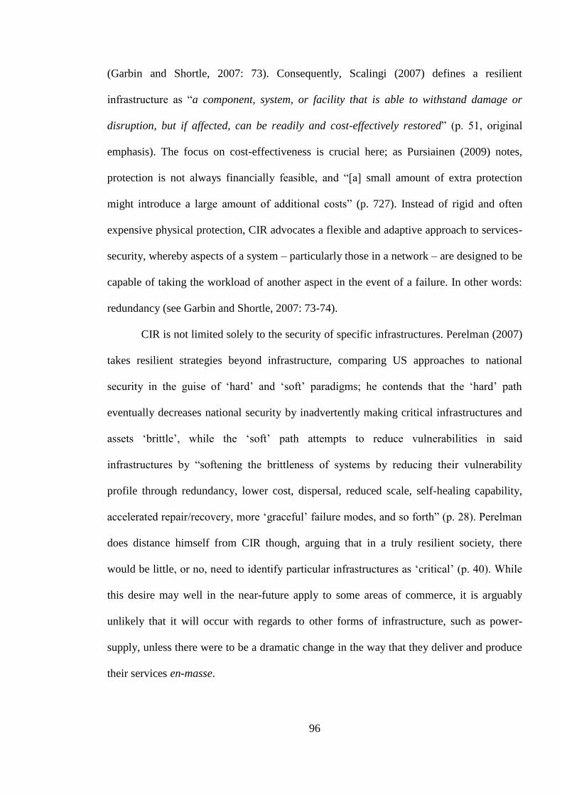
96
(Garbin and Shortle, 2007: 73). Consequently, Scalingi (2007) defines a resilient
infrastructure as “a component, system, or facility that is able to withstand damage or
disruption, but if affected, can be readily and cost-effectively restored” (p. 51, original
emphasis). The focus on cost-effectiveness is crucial here; as Pursiainen (2009) notes,
protection is not always financially feasible, and “[a] small amount of extra protection
might introduce a large amount of additional costs” (p. 727). Instead of rigid and often
expensive physical protection, CIR advocates a flexible and adaptive approach to services-
security, whereby aspects of a system – particularly those in a network – are designed to be
capable of taking the workload of another aspect in the event of a failure. In other words:
redundancy (see Garbin and Shortle, 2007: 73-74).
CIR is not limited solely to the security of specific infrastructures. Perelman (2007)
takes resilient strategies beyond infrastructure, comparing US approaches to national
security in the guise of ‘hard’ and ‘soft’ paradigms; he contends that the ‘hard’ path
eventually decreases national security by inadvertently making critical infrastructures and
assets ‘brittle’, while the ‘soft’ path attempts to reduce vulnerabilities in said
infrastructures by “softening the brittleness of systems by reducing their vulnerability
profile through redundancy, lower cost, dispersal, reduced scale, self-healing capability,
accelerated repair/recovery, more ‘graceful’ failure modes, and so forth” (p. 28). Perelman
does distance himself from CIR though, arguing that in a truly resilient society, there
would be little, or no, need to identify particular infrastructures as ‘critical’ (p. 40). While
this desire may well in the near-future apply to some areas of commerce, it is arguably
unlikely that it will occur with regards to other forms of infrastructure, such as power-
supply, unless there were to be a dramatic change in the way that they deliver and produce
their services en-masse.

97
CIR is already in place in some countries. While commenting on European
approaches to infrastructures security, Pursiainen (2009) argues that:
[t]he Finnish approach focuses on the functions themselves rather than
infrastructures that support them. The main emphasis is on the functioning of
society and government in all circumstances, not only in the protection of its
critical infrastructures against extreme events. Hence one could say that
Finland’s approach is much more based on ‘resilience’ […] than protection
(Pursiainen, 2009: 726).
Following this line of thinking, Pursiainen later comments that the focus solely upon the
protection of infrastructures, as is the case in CIP, is “becoming somewhat outdated […
and] the concept of CIP should be extended to Critical Infrastructure Resilience, of which
CIP is an important part” (p. 727). It would appear that many proponents of CIR advocate
such a restructuring, with one of the main concerns being CIP’s focus on the protection of
assets; an approach considered futile by Perelman (2007), Pommerening (2007: 18) and
Pursiainen (2009: 727), amongst others. Moving towards CIR also resolves the friction
discussed earlier between CIP and CIIP; there is no need for further debate about whether
CIP is separate to, or inclusive of, CIIP. Instead, both constitute integral aspects of a larger
CIR-based approach to security (see figure 3.1).
98
CIR
CIP CIIP
Figure 3.1 Critical Infrastructure Resilience
As Pursiainen (2009) implies, the shift from CIP to CIR does not diminish the need
for asset-protection (p 727); rather, the focus on services arguably reinforces the necessity
for physical and cyber infrastructures to be adequately and cost-effectively protected from
known dangers. Rather than replacing CIP, CIR is an extension of the concept to
encompass resilience as well as protection (Pursiainen, 2009; Perelman, 2007: 28;
Pommerening, 2007); while there is no doubt that resilience allows adaptability and
flexibility in the case of a crisis, balance between that and infrastructure protection must
remain (see Scalingi, 2007). If anything, moving towards CIR strengthens traditional CIP,
as it advocates a reduction in vulnerabilities against both known and unknown dangers,
arguably making the task of protection easier. In this fashion, CIR, CIP and CIIP
complement each other, enabling a comprehensive security strategy to be created and
maintained at minimal cost.
The logic underpinning CIR, and to some extent CIP and CIIP, is the security of
infrastructures against risks, both known and unknown. The focus on resilience and
redundancy within CIR discourses is intended to ensure that even though vulnerabilities
within infrastructures may have been minimised through protection measures, damage or
failures to parts of an infrastructure caused by unforeseen factors or risks should not affect
the entire system. It could therefore be argued that CIR measures are part of an anticipatory

99
approach to infrastructure security, as planners and decision-makers are attempting to
mitigate the impact any future risks could have upon infrastructures.
3.2.1 CIP and CIR representative of anticipatory security
Anticipatory security is an inclusive term for a number of security logics, such as
preemptive or preventive security measures (Anderson, 2010), although the terminologies
used differ depending on subject area (Stern and Wiener, 2006). With respect to historical
inter-state conflicts, Shue and Rodin (2010a) argue that preemptive war is often associated
with, and commonly justified as, an action taken to mitigate an imminent threat (p. 3).
Meanwhile, Strachan (2010) suggests that preventive security measures are
characteristically either actions taken by states to ensure that a potential threat does not
emerge, or the engagement with a potential opponent before they are too strong. In this
manner, preemptive and preventive wars are portrayed as part of a statist defensive security
logic, whereby an entity attempts to deal with a threat while it is in a position of
comparative strength (Stern and Wiener, 2006). The two have historically, Strachan (2010)
argues, been separated by their objectives: preemptive actions have largely been small
affairs, relying upon speed and precision to achieve a quick victory over a specific threat,
whilst preventive action has normally taken the shape of conflicts started by states against
stronger – though unprepared – powers to avoid future belligerence.
Away from the arena of inter-state conflict, anticipatory security is conceived quite
differently. Instead of being used to counter imminent dangers, preemptive action
“operates in the present on a future threat” (Massumi, 2007: para. 13). It is associated with
the ‘precautionary principle’ (de Goede and Randalls, 2009), a term originating in
environmental politics whereby “uncertainty is no excuse for inaction against serious or
irreversible risks [and], that absence of evidence of risk is not evidence of absence of risk”
100
(Stern and Wiener, 2006: 394). The principle has been adopted by the EU in various areas
of policy-making (de Goede, 2011: 6; European Commission, 2000b) and has also been
applied to terrorism studies, particularly following the September 2001 attacks on the US
and the subsequent global reactions (see for example Aradau and Van Munster, 2007; de
Goede, 2008a, b, 2011; Stern and Wiener, 2006). The fundamental logics of the
precautionary principle are the need to anticipate not only perceived threats but risks as
well, and the need to adequately manage those risks.
Preventive action is conceived of as being directed at clearer dangers which can be
predicted; Massumi (2007), for instance, theorises that “[p]revention operates in an
objectively knowable world in which uncertainty is a function of lack of information, and
in which events run a predictable, linear course from cause to effect” (para. 5). The
precaution that is necessary for preemptive action is not required for preventive security
measures, as these are intended to counter or mitigate a known and statistically calculable
threat (de Goede, 2011: 9). Massumi goes on to argue that:
[p]revention, in fact, has no ontology of its own because it assumes that what
it must deal with has an objectively given existence prior to its own
intervention. In practice, this means that its object is given to it predefined by
other formations, in whose terms and on whose terrain it must then operate
(2007: para. 5).
The nature of any preventive action, then, is dependent upon the risk, danger or threat it is
directed upon, making it as much reactionary as it is anticipatory. It is important to note
though that preventive action is still anticipatory as it is usually employed against threats or

101
dangers which, whilst “in principle, statistically knowable and calculable according to
cycles of regularity” (de Goede, 2011: 9), cannot be comprehensively defined or assessed.
The objective of anticipatory security practices is to secure against and manage
future uncertainties through preemptive or preventive action. As Anderson (2010) notes,
“the assumption is that the future will diverge from the past and present. It is neither a
perpetuation of the present, nor an imminent-transcendent End outside of time. Instead the
future will radically differ from the here and now” (p. 780). He goes on to contend that
anticipatory actions are underpinned by what Grusin (2004) calls ‘premediation’, whereby
the future is conceived of as a ‘surprise’ (Anderson, 2010: 782). Anderson argues that
thinking of the future in this way has two consequences:
[f]irst, disclosing the future as a surprise means that one cannot then
predetermine the form of the future by offering a deterministic prediction.
Instead, the future as surprise can only be rendered actionable by knowing a
range of possible futures that may happen, including those that are
improbable. Second, statements about the future as a surprise do not enable
the future to be grasped and handled through a process of induction from the
past distribution of events. Instead, anticipatory action must be based on a
constant readiness to identify another possible way in which a radically
different future may play out (p. 782).
Predictions of future events or risks still take place but the surprise largely pertains to the
occurrence of an event, rather the event itself. Taking space weather events (SWEs) –
which are discussed in detail in chapter 5 – as an example, predictions and models of the

102
risk of a potentially catastrophic SWE on the scale of the Carrington Event27 are on-going,
as are studies of the effect that these events have on satellites and terrestrial infrastructures.
The possibility that a significant SWE could occur is not in itself a surprise, however our
inability to predict such an event means that there will be an element of surprise if and
when one takes place. A pertinent example is the meteorite which entered the Earth’s
atmosphere over south-eastern Russia in February 2013, creating a shockwave which
damaged buildings over a significant area and leading to a large number of injuries
amongst people living in the area. In addition, there is always the chance that an
unforeseen danger could emerge, providing both surprise at the event and surprise at the
occurrence.
Both preventive and preemptive anticipatory security practices are intended to
compensate for and mitigate future surprise, the difference between the two being that the
former act upon ‘known’ threats or hazards – ones with an “objectively given existence”
(Massumi, 2007: para. 5) – whilst preemptive measures are directed towards uncertain
future risks. The element of ‘knowledge’ is crucial; de Goede (2011) contends that
prevention is commonly associated with “risks that are, in principle, statistically knowable
and calculable according to cycles of regularity” (p. 9). In other words, historical data and
statistics are used to calculate the probability of events occurring again in the future.
Preemption meanwhile “addresses threats, risks and dangers that are irregular,
incalculable, and, in important ways, unpredictable” (de Goede, 2011: 9). In terms of the
risks and dangers to the space segments of outer space infrastructures, the existing space
debris population and most space weather phenomena could arguably be classified as
“statistically knowable and calculable [risks] according to cycles of regularity” (de Goede,
27 The Carrington Event of 1859 remains the largest SWE on record. See chapter 5 for further discussion of
the Carrington Event and associated studies of large-scale SWEs.
103
2011: 9); efforts to track and catalogue the existing debris population and the scientific
monitoring of solar activity are directed at ensuring that it is possible to calculate the
probability that these risks may threaten outer space infrastructures. However, future debris
generation and significant space weather events constitute dangers for which precaution is
necessary given that they are impossible to predict or their effect upon outer space
infrastructures is uncertain.
Nonetheless, the three-dimensional spatio-temporal nature of geocentric orbits
means that although some phenomena such as the existing space debris population are
‘known’, the danger they pose to satellites is not always clear. A hypothetical piece of
catalogued space debris – the existence, size and orbital trajectory of which are known –
may not pose a threat to other space objects in its current orbit, but if its trajectory were to
be altered in any way – for instance through atmospheric drag – it may become a collision
risk for nearby satellites. Equally, unannounced or unexpected manoeuvres by operational
satellites can expose other space objects to the possibility of collision that did not exist
before. Anticipatory security practices oriented towards outer space activities must
therefore account not only for the generic danger posed by threats – the capacity for
phenomena to cause damage to satellites and other space objects – but also the likelihood
that specific satellites or other space objects will be exposed to those threats.
Consequently, the outer space environment arguably challenges Massumi’s conception of
prevention, as measures directed at ‘known’ dangers – such as the existing space debris
population – must still take into account the element of ‘surprise’ rather than expecting
“events [to] run a predictable, linear course from cause to effect” (Massumi, 2007: para. 5).
For the sake of clarity, it is worth emphasising that anticipatory security practices
occur after an entity has identified which risks and dangers they consider threatening. The
identification act itself has no effect upon the risks and dangers themselves, as it simply

104
represents the prioritisation of certain threats over others. Nonetheless, the predictability of
the risks and dangers – be they “statistically knowable and calculable according to cycles
of regularity” (de Goede, 2011: 9) or “irregular, incalculable, and, in important ways,
unpredictable” (de Goede, 2011: 9) – may well influence whether or not they are deemed
threatening. To put it another way, it is possible that entities may perceive calculable and
predictable risks as more urgent and threatening than unpredictable ones, even if the
latter’s potential impact is greater.
The security of critical infrastructures, particularly through CIR though to some
extent through practices associated with CIP, are also geared towards uncertain or
unknown risks and dangers, although logics of anticipatory security are arguably
understudied in literatures concerned with these approaches to infrastructure security.
However, significant investment is required for some of these infrastructure security
practices, meaning that they could be considered risks themselves. Simulations, such as
war games (Der Derian, 2009b), digital simulations in aviation (Budd and Adey, 2009) and
preparedness exercises (Adey and Anderson, 2012; Aradau, 2010b), can be quite costly
and time-consuming and the scenarios played out may never materialise. Their function is
to limit future surprise by conditioning those involved to possible future events, to the
extent that the scenarios may remain ingrained in the minds of those who participated and
in recorded in digital or written reports, existing in a state of uncertainty between the real
and the imagined/virtual. The events have ‘taken place’, insofar as participants have been
faced with choices, reacted to them and had to deal the consequences, even if only in their
imagination. Although those involved may not have experienced the full extent of the
scenarios as they would have done if they had been ‘real’, the objective of simulations, war
games and exercises is nonetheless to simulate events in a manner that is as close to reality
as is considered feasible by the organisers, or as far as the suspension of disbelief will

105
allow (Adey and Anderson, 2012: 100). This conditioning, although serving to improve the
resilience of participants in the face of an unexpected or overwhelming event, may well
blur the margins between the probable and improbable, or even the real and the simulated
(Der Derian, 2009b). Nonetheless, the objective of these practices is to instil a sense of
preparedness within those participating, so that if, or when, faced with a similar scenario,
they will be capable of reacting based upon an experience, simulated though it may be. As
Aradau (2010b) notes with respect to preparedness:
[p]reparedness does not try to find a rational way to avoid the ‘next terrorist
attack’ or to confront it with superior knowledge, but to use artifice to avoid
its consequences and ensure the self-preservation of atomistic individuals, the
entrepreneurs who have taken precautionary measures. Artifice allows
exercise players, like Odysseus, to lose themselves in order to save themselves
(p. 4).
Other forms of CIP and CIR measures can be considered risky due to the sizeable
investment required. As mentioned earlier, the physical protection of assets or hardware
can in some cases add considerable expenses to the development, construction or
deployment of the assets themselves (Pursiainen, 2009: 727). With regards to space assets,
for instance, any increase in weight requires more fuel or, depending on the amount of
weight added, even a larger launch vehicle. The cost-effectiveness of such anticipatory
measures against the risk of collision with space debris is thus an important consideration
for satellite designers, and will be discussed in more detail in chapter 5, however it should
be emphasised that the cost-effectiveness factor makes the measure itself an exercise in
risk-management. In other words, satellite manufacturers and the institutions or states

106
which order the satellites are having to constantly assess whether the physical protection of
a satellite against a particular danger is worthy of the additional costs that protection might
create, or whether the danger itself can be mitigated through other means, such as
increased awareness of the near-Earth orbital environment or a stronger system of
governance for outer space activities.
The need to strike a balance between the security of infrastructures and cost-
effectiveness means that CIP and wider CIR practices can indicate what future events a
state or institution considers more probable than others, as well as the overarching
approach that state or institution has to its security. To take the example of the risk that
near-Earth orbital space may in the future be host to active weapons systems; the actions of
states around the globe have varied from undertaking further research into orbital weapons
platforms, to engaging more with legal instruments aimed at minimising the likelihood of
such platforms being deployed. The weaponisation issue is a very complex one and will be
discussed greater detail later, however the summation above is nonetheless indicative of
the different approaches that may be taken to a particular problem. Chapters 4 and 5 of this
thesis focus upon the practices and measures aimed at mitigating risks and dangers against
European critical outer space infrastructures, and the specific visions of the future these
imply. However, it is first necessary to provide some background of terrestrial European
critical infrastructures and of the steps the EU has taken to acknowledge its satellite
constellations as being critical infrastructures themselves.
3.3 European Critical Infrastructures
In the aftermath of the terrorist attacks in the US on the 9th September 2001, the
protection of ECIs was allocated to the North Atlantic Treaty Organisation (NATO)
(Pursiainen, 2009: 723). However, Pursiainen (2009) argues that by 2005, there had been

107
another shift in responsibility towards the EU (p. 724). Indeed, the European Commission
(EC) published the Communication from the Commission on a European Programme for
Critical Infrastructure Protection in 2006, in which plans are outlined for, as the name of
the document suggests, a European Programme for Critical Infrastructure Protection
(EPCIP). This followed a Communication from the EC a year earlier relating specifically
to the security of European critical infrastructures from terrorism (see European
Commission, 2004). Although acknowledgement of critical infrastructures’ importance
began later in Europe than in the US (Pursiainen, 2009: 722), there has since been
considerable debate over means of identifying and protecting them. On the identification of
ECIs, the Communication states that they:
constitute those designated critical infrastructures which are of the highest
importance for the Community and which if disrupted or destroyed would
affect two or more MS, or a single Member State if the critical infrastructure
is located in another Member State (European Commission, 2006a: 4).
This definition has been further refined in the ‘Council Directive 2008/114/EC of 8
December 2008 on the identification and designation of European critical infrastructures
and the assessment of the need to improve their protection’, which establishes that:
‘European critical infrastructure’ or ‘ECI’ means critical infrastructure located
in Member States the disruption or destruction of which would have a
significant impact on at least two Member States. The significance of the
impact shall be assessed in terms of cross-cutting criteria. This includes
108
effects resulting from cross-sector dependencies on other types of
infrastructure (Council of the European Union, 2008a: L 345/77).
It would appear then that there are two levels of critical infrastructure within the EU; the
first of which pertains to infrastructures deemed critical by national governments, and the
second which includes infrastructures deemed critical by the EC. Crucially, the 2008
Directive clarifies that ECIs must now ‘significantly impact’ two separate Member States,
implying that infrastructure may only be considered critical on the European level if more
than one state is dependent upon it. The removal of the statement “or a single Member
State if the critical infrastructure is located in another Member State” (European
Commission, 2006a: 4) from the definition contained within the 2006 Communication from
the Commission on a European Programme for Critical Infrastructure Protection suggests
that a hypothetical situation, whereby a Member State is dependent on infrastructure
located in another Member State, despite the second state not deeming said infrastructure
‘critical’, is no longer feasible.
Importantly, the identification and classification of infrastructures as ECIs takes
place at state level. Member States wishing to designate particular infrastructures within
their borders as ECIs are required by Article 4 of Council Directive 2008/114/EC to inform
other Member States dependent upon those infrastructures about their intentions. Bilateral
or multilateral negotiations will then take place between all “significantly affected”
(Council of the European Union, 2008a: L 345/77) parties with the intention of agreeing to
classify an infrastructure as an ECI, though the identity of any ECI shall remain
confidential only to the Member States affected. In the case that a Member State feels an
infrastructure located within the territory of another state should be designated an ECI, it

109
should contact the EC, which will initiate bilateral or multilateral negotiations with all
affected parties (Council of the European Union, 2008a: L 345/78).
The final point to be considered from the Council of the European Union’s
definition of ECIs is the requirement that any candidate infrastructure must be “located in
Member States” (Council of the European Union, 2008a: L 345/77). While this
geographical requirement is relatively ambiguous, the argument can be made that it implies
that the entirety of a critical infrastructure must be located within the territorial boundaries
of Member States in order for it to be categorised as an ECI. This logically means that
outer space infrastructures, the subject of this thesis and discussed in greater detail later in
this chapter, are not eligible for the label ‘European Critical Infrastructure’. Not only are
the space segments of such infrastructures based beyond the confines of the Earth’s
atmosphere, but many of the ground segments (e.g. relay stations and launch sites) are
located across the globe (Anonymous, 2012b). Although the Arianespace launch facility in
Kourou, French Guiana, is located within an overseas department of France, the use of
Russian launch sites and the spread of relay stations and ground control segments across
EU and non-EU Member States is at odds with article 2(b) of Council Directive
2008/114/EC (see Council of the European Union, 2008a: L 345/77). Moreover, the
European Geostationary Navigation Overlay System (EGNOS) and Galileo programmes
are described the European Parliament and the Council of the European Union (2013) as
“infrastructures set up as trans-European networks of which the use extends well beyond
the national boundaries of the Member States” (p. L 347/1). This is problematic as it means
that European outer space infrastructures, which provide vital services supporting a host of
terrestrial critical infrastructures, are not themselves identified as being considered
‘European’ critical infrastructures merely because of their multiple astro- and geographical
locations. It is possible that an exception to this geographical restriction has been made for

110
outer space infrastructures, however bearing in mind that the identity of ECIs must remain
confidential, it is highly unlikely that a public acknowledgement of any such exception will
materialise.
The relationship between the geographical location of critical infrastructures and
their eligibility for ECI status is arguably problematic, not only for outer space
infrastructures but for terrestrial ones as well. As discussed earlier in this chapter,
infrastructures extend beyond the material assets and hardware which are often their most
visible aspects. The connectivity within and between infrastructures is also extremely
important and can exist physically, in the shape of pipelines for gas and oil, or virtually,
through the flow of digital information across cyber networks. With regards to outer space
infrastructures, this connectivity is largely virtual but plays a vital role in the functioning of
the infrastructure and is arguably as important as the material assets it links. If the
connection is lost between satellites, or between them and their ground control segments,
then the assets themselves are rendered redundant, even though they may be still be
operational. Moreover, the connectivity is not impervious to astro- and geographical
obstacles: the various radio-communications which enable extra-terrestrial operations
require line of sight between receivers on satellites and terrestrial ground stations. In
addition, launch facilities are also integral to the connectivity of an outer space
infrastructure as they enable the deployment of material assets into orbit, which is of vital
importance in the development of an infrastructure or the event of a satellite failure. As
noted in chapter 2 of this thesis, ESA has one launch facility operated by Arianespace and
located in Korou, French Guiana. Meanwhile, Galileo’s ground segment includes control
stations, survey stations, upload stations, and Search and Rescue (SAR) data collection
stations spread across the globe (European Commission, 2012a: L 52/30-L 52/31).
Therefore, tying down an infrastructure to a specific geographical location or container –
111
such as the state – ignores the connectivity necessary for infrastructures to perform the
tasks for which they are designed and presents a simplified perspective of the complex
networks and vulnerabilities upon which they are founded.
The aforementioned issues pertaining to the narrow definition of ECIs have
seemingly not gone unnoticed. In 2013, the EC published a Commission Staff Working
Document exploring means of improving the EPCIP. The Working Document notes that
“less [sic] than 20 European critical infrastructures have been designated” and that “[s]ome
clear critical infrastructures of European dimension, such as main energy transmission
networks, are not included” (European Commission, 2013b: 4). Indeed, the EC is of the
opinion that “[d]espite having helped foster European cooperation in the CIP process, the
[EPCIP] Directive has mainly encouraged bilateral engagement of Member States instead
of a real European forum for cooperation” (p. 4). The need for increased cooperation
between EU Member States and states outside the EU is also emphasised (pp. 5-6). The
answer proposed in the Working Document is a shift away from the existing “sectoral
approach, where each sector is treated separately with its own risk methodologies and risk
ranking”, towards a “systems approach, where critical infrastructures are treated as an
interconnected network” (p. 7). In addition to introducing new forms of risk associated
with interdependency, this shift is arguably reflective of the arguments made by Aradau
(2010a) on the need for awareness of the materialities of interconnectivity and intra-action,
as well as Egan’s (2007) work on LTSs. The pilot programme for this new approach to the
EPCIP involves four critical infrastructures: “Eurocontrol, Galileo, the electricity
transmission grid and the gas transmission network” (p. 7). One of the reasons given for
the selection of these four infrastructures for this pilot is the inherent interdependencies
involved:

112
[t]hey are cross-border both physically (i.e. the infrastructures are located in
the territory of more than one Member State) and at the level of the service
provided (i.e. a disruption of service in one Member State can affect several
other Member States – a domino effect) (p. 7).
It must be emphasised that this pilot programme is in its early stages, with a report on
progress due to be made in late 2014 (European Commission, 2013b: 10) but nonetheless,
the recognition of inter-state interdependences upon critical infrastructures can be seen as a
positive step towards addressing some of the problems with the current ECI-designation
process.
Returning to the security of ECIs, the EC maintains in the 2006 Communication
from the Commission on a European Programme for Critical Infrastructure Protection
that it:
will avoid duplicating existing efforts, whether at EU, national or regional
level, where these have proven to be effective in protecting critical
infrastructure. EPCIP will therefore complement and build on existing
sectoral measures (European Commission, 2006a: 3).
No further information is given in that particular document, however, about how it will be
decided whether existing protection efforts are ‘effective’ enough to be left in the hands of
national governments, although paragraph 14 of Council Directive 2008/114/EC states that
this process will rely upon cooperation between Member States and the EC:
113
Each Member State should collect information concerning ECIs located
within its territory. The Commission should receive generic information from
the Member States concerning risks, threats and vulnerabilities in sectors
where ECIs were identified, including where relevant information on possible
improvements in the ECIs and cross-sector dependencies, which could be the
basis for the development of specific proposals by the Commission on
improving the protection of ECIs, where necessary (Council of the European
Union, 2008a: L 345/76).
Importantly, paragraph 6 of the Directive states that “[t]he primary and ultimate
responsibility for protecting ECIs falls on the Member States and the owners/operators of
such infrastructures” (Council of the European Union, 2008a: L 345/76), suggesting that
despite the regional importance of ECIs, protection will still take place primarily at
national level, with European ‘Community level’ action being employed to complement
existing protection measures (p. 2). However, there appears to be little regulation of what
measures should be implemented by Member States to address security issues (Necesal et
al., 2011: 843).
While the aforementioned Council Directive is aimed specifically at the protection
of ECIs within the energy and transportation sectors, it “constitutes a first step in a step-by-
step approach to identify and designate ECIs and assess the need to improve their
protection” (Council of the European Union, 2008a: L 345/77) and thus can be considered
representative of the EU’s approach to the overall protection of ECIs.
As discussed earlier, while protection is a significant part of CIP, it represents only
one particular aspect of CIR. Although resilience is not specifically mentioned in EU
policy documents with regards to ECIs, it is alluded to in a manner suggesting that is

114
understood to be within the process of CIP; the 2006 Communication from the Commission
on a European Programme for Critical Infrastructure Protection states that “[c]ontingency
planning is a key element of the CIP process so as to minimize the potential effects of a
disruption or destruction of a critical infrastructure” (European Commission, 2006a: 8).
Given that contingency is a crucial aspect of resilience (see Scalingi, 2007), it can be
concluded that some form of resilient strategy is at the forefront of European policy-
making, albeit under the guise of CIP.
It appears though that the EU has not completely adopted the resilience-based
approach to security. The 2008 Council Directive 2008/114/EC defines ‘protection’ as: “all
activities aimed at ensuring the functionality, continuity and integrity of critical
infrastructures in order to deter, mitigate and neutralise a threat, risk or vulnerability”
(Council of the European Union, 2008a: L 345/77). On the one hand, the definition implies
some form of resilience given the inclusion of the terms ‘continuity’, ‘risk and
‘vulnerability’, however the desire to “deter, mitigate and neutralise a threat, risk or
vulnerability” (p. L 345/77) arguably hints at emphasis upon a more traditional and
reactive approach to CIP. As mentioned earlier, the intent to eradicate threats or
vulnerabilities is commonly agreed within resilience literature to be impossible, hence the
need for contingency in the event that prevention and protection efforts fail.
Notably, the introduction to a 2013 EC Staff Working Document states that “[b]y
ensuring a high degree of protection of EU infrastructures and increasing their
resilience (against all threats and hazards), we can minimise the consequences of loss of
services to society as a whole” (European Commission, 2013b: 2, original emphasis).
While protection remains prominent, the explicit reference to need for resilience can be
seen as an acknowledgement of the vulnerability of critical infrastructures and the
impossibility of complete protection. Although the Staff Working Document is only a

115
proposal describing a pilot programme, it is nonetheless indicative of a shift in EU policy-
making with respect to the security of critical infrastructures upon which European
societies depend, albeit one which has not been formalised at the time of writing.
3.4 CIP, CIR and European security in outer space
Regarding the security of European outer space assets and the services they
provide, there appears to be little reference to their designation as critical infrastructures
until relatively recently.28 The shift notably came to light with a speech by the President of
the EC in 2009, who stated that “we need more security in and from space. Our space
assets and infrastructure are indispensable for our economy and security and we need to
protect them” (Barroso, 2009: 3). Although the 2007 Communication from the Commission
to the Council and European Parliament European Space Policy, states that “[s]pace-
based systems […] are critical to key areas of the economy” (European Commission,
2007b: 3), the explicit designation of outer space assets as segments of critical
infrastructures in need of security does not appear to have been made public prior to
President Barroso’s 2009 speech. This stance is continued in the EC Communication from
the Commission to the Council, the European Parliament, the European Economic and
Social Committee and the Committee of the Regions towards a space strategy for the
European Union that benefits its citizens, which proposes that:
[s]pace infrastructure is critical infrastructure on which services that are
essential to the smooth running of our societies and economies and to our
citizens’ security depend. It must be protected and that protection is a major
28 Although an EC Communication concerning Galileo mentions the security of infrastructures, it identifies
these as “control centres and communication networks” and does not mention the outer space assets
themselves (European Commission, 1999: 11).

116
issue for the EU which goes far beyond the individual interests of the satellite
owners (European Commission, 2011a: 6).
Three details from this quote stand out. The first is the identification of outer space
infrastructure as ‘critical infrastructure’, which is indicative of its perceived importance to
European societies in general. This association between the terrestrial and the extra-
terrestrial is a microcosm of the EU’s wider involvement in outer space affairs, whereby
the institution has gradually recognised the importance of space assets to modes of life on
Earth (see Sheehan, 2011: 45; chapter 2 of this thesis). Importantly, there is no
identification of specific infrastructure within the aforementioned Communication; rather,
all outer space infrastructures are considered ‘critical’, an issue discussed further below.
While this may have been done to avoid the targeting of specific outer space systems, it is
nevertheless telling of the dependence terrestrial societies now have on extra-terrestrial
infrastructures. Nonetheless, the reference to ‘satellite owners’ is indicative of an implicit
acknowledgment of the need to secure Earth-orbiting assets as well as the services they
provide. In addition, in the 7th Space Council resolution, the Council of the European
Union calls upon “the EU, ESA and their Member States to undertake the necessary
actions […] to protect satellites and satellite signals and to secure frequencies, taking into
account emerging new threats to space assets” (Council of the European Union, 2010: 3-4).
This paragraph reveals the objects recognised as requiring protection measures, essentially
identifying what the EU perceives as the integral aspects of its outer space infrastructures.
The 8th Space Council resolution follows this line of thinking, stating explicitly that outer
space infrastructures are “critical” (Council of the European Union, 2011: C 377/1) but, as
might be expected, goes into more detail. Notably, the ground segments of outer space
infrastructures are included alongside outer space assets as being vulnerable to certain

117
threats (Council of the European Union, 2011: C 377/4), but there is no mention of space
or ground segments being targeted by state or non-state entities to disrupt the flow of
satellite services. Two risks are explicitly acknowledged within the 8th Space Council
resolution: collision between space objects and space weather events, although there is an
implicit nod to human activities in outer space in paragraph 29 of the resolution. That
paragraph notes, with reference to the draft International Code of Conduct for Outer Space
Activities, that “wider access to adequate and reliable information about space activities
will represent a confidence building measure, providing a foundation for increased trust
with regard to peaceful uses of outer space” (Council of the European Union, 2011: C
377/4).
The sentence used by the European Commission – “[s]pace infrastructure is critical
infrastructure on which services that are essential to the smooth running of our societies
and economies and to our citizens’ security depend” (European Commission, 2011a: 6) –
can arguably be interpreted in two ways; either that all space infrastructures are critical
infrastructures or that only outer space assets providing critical services can be deemed to
be outer space infrastructures. Both of these understandings are arguably problematic.
Beginning with the first interpretation, that all outer space infrastructures are ‘critical’ (see
European Commission, 2011a: 6), there is the issue that while some satellite systems may
well contribute to and uphold the contemporary mode of life on Earth, not all of them do.
For similar reasons to Wang (2009), when he dismisses scientific outer space programmes
from his analysis of transatlantic astropolitics (p. 435), it could be argued that the loss of
some satellites, while costly and to the detriment of scientific study, would in all likelihood
not severely affect terrestrial societies in the same way that the loss of Global Navigation
Satellite Service (GNSS) signals, for example, would. While it could be assumed that there
are valid reasons behind the blanket imposition of criticality, such as obscuring the

118
identification of those systems and networks which are truly valuable, at first glance an
interpretation labelling all outer space infrastructures as ‘critical’ hints at a European
hesitation and uncertainty regarding the focus of outer space security efforts. The second
understanding of the above quote, that only outer space assets providing critical services
can be designated as outer space infrastructures, is equally problematic. Although it does
avert the blanket imposition of criticality of the first interpretation, all outer space assets,
including scientific missions not integral to the “smooth running of […] societies and
economies and to […] citizens’ security” (European Commission, 2011a: 6) arguably
comply with the definition of infrastructure used at the beginning of this chapter (see
Aradau, 2010a; Coward, 2009; Metzger, 2004: 200). To put it another way, all outer space
assets contribute to the functioning of the state or society, even if the disruption of their
services would in all likelihood not cause problems significant enough for those services to
be deemed critical. Consequently, all outer space assets and their respective ground
segments are arguably outer space infrastructures. Given the problems associated with both
interpretations of the quote from the 2011 EC Communication, the argument can be made
that the EC’s definition of outer space infrastructures is too ambiguous and requires
clarification. Moreover, the 2013 European Commission Staff Working Document
introducing a pilot programme regarding the security of inter- and intra-sectoral
interdependencies states that:
[s]pace-based systems enable a wide spectrum of applications, which play a
fundamental role in our everyday life, are critical to key areas of the economy,
and help ensuring our security. […] the ability to protect space infrastructure
has become essential to our society (European Commission, 2013b: 13).

119
While this would appear to support the first interpretation of the quote from the
2011 EC Communication, issues remain concerning the blanket imposition of criticality
upon services which are not necessarily critical. Nonetheless, despite the issues outlined
above these definitions cannot simply be ignored. By seemingly attributing criticality to all
outer space infrastructures, the EC is arguably implying that all services provided by outer
space assets need to be secured. The second detail of note from the EC Communication is
that outer space infrastructure “[m]ust be protected” (European Commission, 2011a: 6).
Unfortunately, little more detail is provided within the aforementioned Communication
about what form(s) of protection exists regarding space infrastructure. There is however an
acknowledgment of the need for a European Space Situational Awareness (SSA) system to
enhance monitoring capabilities of potential dangers and threats to active satellites
(European Commission, 2011a: 7; European Commission and European Space Agency,
2010: 3-4), a need which echoes Barroso’s (2009) call for “an independent capacity to
monitor satellites and debris orbiting the Earth and space environment, and tackle possible
hazards” (p. 3). The SSA arguably represents part of an extra-terrestrial CIP approach
conforming to the EU’s territorial CIP strategy, as the intention is, in the words of Council
Directive 2008/114/EC on European critical infrastructures, to “mitigate and neutralise
[…any] threat, risk or vulnerability” (Council of the European Union, 2008a: L 345/77).
The importance of the SSA to the security of European outer space infrastructures is re-
iterated in the 8th Space Council resolution, which foresees an “effective” SSA as having
the capability to “enhance the safety of European space assets and of its future launches
from space debris and other objects in outer space as well as space weather phenomena”
(Council of the European Union, 2011: C 377/4). Nevertheless, combined with the
reference to resilience in the 2013 EC Staff Working Document (European Commission,
2013b: 2), the explicit recognition of the need to protect outer space infrastructures as well

120
as the services they carry and provide marks a positive shift in the European strategy for
outer space security.
The distinct absence of information in EU publications pertaining to the means
undertaken to ensure the security of European outer space infrastructures could be
explained by the requirements of Council Directive 2008/114/EC. By describing outer
space infrastructure as ‘critical’, the EC has associated it with terrestrial critical
infrastructure, meaning that their protection falls under the purview of Council Directive
2008/114/EC, which includes the provision that information regarding the protection of
ECIs is classified as confidential (Council of the European Union, 2008a). It is thus
possible that details or summaries of protection or resilience measures for outer space
infrastructures cannot be publicly disseminated. Nonetheless, it is noteworthy that while
European outer space infrastructures have been categorised as critical infrastructures by the
EC, this classification does not appear to have been translated into wider CIP or CIR
discourses on ECIs.
The final detail of interest from the quote from the EC Communication pertains to
the role space infrastructures play in European societies. Specifically, the Communication
states that “[s]pace infrastructure is critical infrastructure on which services that are
essential to the smooth running of our societies and economies and to our citizens’ security
depend” (European Commission, 2011a: 6). The breadth of terrestrial critical
infrastructures was mentioned earlier in this chapter, however many, if not all, of these
infrastructures rely on services provided partially or entirely through satellites. To offer
two examples; the provision of food and other essential goods to populations relies upon
GNSS signals to enhance the efficiency of the transportation of those goods through the
skies, by road and by train. Equally, the contemporary financial system depends upon the
precise timings transmitted by the atomic clocks present within GNSSs. Should these

121
timings lose synchronisation or cease to be transmitted, it is entirely possible that regional,
or even global, financial transactions could be affected. It could therefore be argued, using
the aforementioned quote as supporting evidence, that outer space infrastructures underpin
the majority of other critical infrastructures, making them not only part of the ‘rafting’
process described by Egan (2007) but also particularly essential to European societies.
As each satellite or satellite constellation has different properties and functions,
they operate at differing altitudes above the Earth. Consequently, the risks which must be
considered when planning their security vary; for instance, satellites orbiting in lower
orbits need not be provided with as robust radiation shielding as satellites in MEO, which
are located at the heart of the Van Allen radiation belts. It should also be noted that there is
often redundancy and resilience included within satellite constellations providing critical
services, such as the US Global Positioning System (GPS), so that if one satellite should
malfunction or be interfered with, a reserve satellite can be used to minimise the impact on
the transmission of signals. As this thesis is taking for case studies the Galileo and
Copernicus projects, the security measures it will examine will be mainly limited to those
applicable to satellites in LEO and MEO, although some issues, such as frequency and
orbit slot allocation, will be discussed as part of the wider outer space security problem.
3.5 Galileo
The drafting of the Convention of the European Launcher Development
Organisation (ELDO) in November 1961 signalled the beginning of efforts to construct an
independent European launcher capable of putting satellites into outer space (Madders and
Thiebaut, 1992: 117; Sheehan, 2007: 77). As mentioned in chapter 2, one of the most
significant factors in the establishment of ELDO was the scientific and political
122
collaboration which emerged through the development of the Europa launcher, even
though the project was eventually abandoned in the 1970s.
The failure of the Europa launcher, while a setback for European outer space
affairs, does not detract from the project’s reflection of the desire amongst European states
to develop an independent outer space capability. In 1976, the ESA Director of Planning
and Future Programmes described the sought-after European independence in outer space
affairs thusly: “[i]ndependence here does not mean isolation or refusal to co-operate, but
refusal to accept uncontrolled dependence” (Lebeau, 1976: 3). This desire was, and still is,
present in the motivations behind the Galileo project (see European Commission, 1999);
while the US GPS addresses many, if not most, European needs, the US reserves the right
to deny access to its signals in times of war. The absence of a guaranteed service means
that any systems that rely on GPS signals could potentially be crippled in the occasion,
however unlikely it may be, that the US were to withhold access to those signals. As
Sheehan (2007) contends, such concerns “triggered a similar response to the move into
launcher technology in the 1960s. It was not enough to have guaranteed access to US
capabilities virtually all the time, Europe needed a system under its own control that it
would have access to on a permanent basis” (p. 88).
On the 10th February 1999, the EC issued a Communication calling for the
establishment of an independent European GNSS, named Galileo, to reduce European
dependence on GPS and the Russian Globalnaya Navigatsionnaya Sputnikovaya Sistema
(GLONASS). The programme was approved by the European Council in June 1999 at a
meeting in Cologne (Bolton, 2012: 192), making it the first joint EU/ESA project
(European Space Agency Director General, 2003: 5). The importance of GNSS services to
European civil and military interests was clear to the EC and the risk of losing access to
those services through a potential denial of access by the US was a great strategic concern

123
(European Commission, 1999: 2). It was made clear from the outset that Galileo would
address weaknesses of GPS and GLONASS, particularly in terms of accuracy and
reliability (European Commission, 1999: 2), while maintaining a purely civilian approach
(Martin et al., 2009: 3). In particular, the EC was concerned that “[t]here are serious
problems of sovereignty and security if Europe’s critical navigation systems are out of
Europe’s control. Furthermore, the present system cannot fully meet civil users [sic]
requirements in terms of performance” (European Commission, 1999: iv).29 The civilian
nature of the project was in itself a novel concept, as both GPS and GLONASS are
operated by their respective state’s military (Elhefnawy, 2003: 57; Martin et al., 2009: 3).
In 1999, GPS and GLONASS dominated the GNSS market (European
Commission, 1999: 2), though investment in GLONASS stalled following the collapse of
the Soviet Union (Bolton, 2012: 192), to the extent that only eight satellites, out of a
constellation of 24, were operational in 2000 (Mathieu, 2010: 357) and GPS became the
superior system. A GNSS uses precise timing and geometric triangulation to offer accurate
three-dimensional positioning to users (Lindström and Gasparini, 2003: 6) and
consequently has a myriad of applications, including, but not limited to, improving
accurate navigation, efficient transportation, energy distribution and banking (European
Commission, 2006b: 3-4). The 1999 EC Communication estimated that the market for
GNSS applications would be in the whereabouts of €40 billion by 2005 (European
Commission, 1999: 3), while a 2006 Green Paper estimated that this figure would rise to
€400 billion by 2025 (European Commission, 2006b: 2). In 2007, it was suggested that
exploitation revenues from the Galileo programme could range between €4.6 and €11.7
billion over a 20 year period (European Commission, 2007c: 6).
29 The applications of Galileo and the role they play in supporting the European project will be the subject of
further discussion later in this chapter.

124
The European fears that access to GPS could be denied were not without
foundation. This is evidenced by the system’s signal architecture, whereby the civilian and
military signals transmitted by GPS are independent of each other. The civilian
Coarse/Acquisition (C/A) Code only uses the L1 frequency while the military Precision
Code (P-Code) uses both the L1 and L2 frequencies, increasing its accuracy and reliability
(Bolton, 2012: 191). However, this means that the C/A Code can be jammed without
significantly affecting the P-Code (Blanchard, 2003). The next generation of GPS
satellites, GPS III, will include an updated and more robust military signal, called the M-
Code, along with an improved civilian signal (Globalsecurity.org, 2011b), though the
capability to deny access to the civilian frequencies will remain.
Although the EC called for reduced dependency in its February 1999
Communication, it was not intending to construct a new GNSS on its own; negotiations
took place in 1998 with the US over a possible collaborative project, but the offer was
turned down by the US on military grounds. This did not deter the EC however, and from
the outset there were plans to include non-European states within the project, including
Russia and Japan (Europa.eu, 2006), while interoperability between Galileo and GPS was
considered of great importance (European Commission, 1999: 8-9). The 2007 European
Space Policy (ESP) continues this trend, noting positively that “[m]any non-EU countries
are seeking to become partners in the programme” (European Commission, 2007c: 5). In
2003, an agreement was met between the EU and China over a Chinese investment of
around €200 million into the Galileo programme in return for a 20% share of the project
(Wang, 2009: 451-452), although access to the Public Regulated Service (PRS) was not
discussed (Bolton, 2012: 195).30 From these events, it could be concluded that while the
30 Collaboration between the EU and China over the Galileo programme effectively ended in 2010 following
the announcement that Chinese payloads would be removed from the four initial satellites (de Selding, 2010).

125
EU is trying to consolidate its European spatial integration and independence through its
outer space programmes, it is simultaneously acknowledging the importance of external
investment and its inability to fund such ventures on its own.
The 1999 Communication was followed up by an EC Communication in 2000
whereby a development plan for Galileo was established. This plan called for a
development and validation phase, to last between 2001 and 2005, a deployment phase
between 2006 and 2007 and, finally, an operating phase from 2008 onwards (European
Commission, 2000a: 6). However, technical and financial obstacles severely delayed the
project, to the extent that the first Galileo In-Orbit Validation Element (GIOVE) satellite,
GIOVE-A, constructed by Surrey Satellites Technology Limited (SSTL), was not launched
until 2005 (European Commission, 2006b: 3). This satellite was ‘retired’ in July 2012 and
moved to an altitude of 23,200km, where it is engaged in monitoring radiation in MEO
(Satnews.com, 2012). The first two Galileo satellites were launched into orbit on 21st
October 2011, as part of the In-Orbit Validation (IOV) phase (Amos, 2011), which
continued with the launch of two more satellites in October 2012. The first successful
positional fix using only Galileo satellites and ground stations took place on the 12th March
2013, marking a significant milestone in the development of programme (European Space
Agency, 2013c). Not only was the event the first time a European system had provided a
positional fix, establishing independence from other GNSS operators, but it also indicated
that the system was functioning as expected. On the 22nd August 2014 the fifth and sixth
Galileo satellites – the first classed as having Fully Operational Capability (FOC) – were
launched from Kourou in French Guinea on-board a Soyuz launcher with intended orbits
of 29,900km altitude and 55° inclination. However, it was revealed shortly after the launch
– which was initially announced as successful – that the Galileo satellites had been placed
into an anomalous elliptical orbit with an apogee of approximately 26,200km and an
126
inclination of 49.8° (Arianespace.com, 2014; Clark, 2014). At the time of writing it
remains unclear whether any correctional manoeuvres may be possible and what impact
the incorrect orbit will have on the satellites’ operations.
Galileo was preceded by EGNOS, a Satellite-Based Augmentation System (SBAS)
which represented the first generation European GNSS, otherwise known as GNSS-1
(Eurocontrol, 2010b; Pasco, 2009).31 The EU was not the only actor working on a SBAS:
the US had a system called the Wide-Area Augmentation System (WAAS) and the
Japanese the Multi-transport Satellite-based Augmentation System (MSAS) (European
Commission, 2006a: ix). The development of these systems influenced the planning for the
European GNSS-2 project; in its February 1999 Communication, the EC considered
cooperating with Japan on Galileo as negotiations had already successfully taken place
between the two actors to ensure interoperability between their respective augmentation
systems (European Commission, 1999: 6).
EGNOS became operational in 2009 and augmented the existing GPS C/A Code by
providing “correction and integrity information intended to improve positioning,
navigation and timing services over Europe” (European Commission Directorate-General
for Energy and Transport, 2009: 5). The system uses 40 ground stations across Europe and
North Africa, and 3 geostationary satellites to increase the accuracy of existing GPS
signals in those regions. Again, the need for competition with and independence from GPS
appears as a justification for the development of EGNOS and Galileo, particularly given
that there is “no guarantee of service” (European Commission, 2010: 2) from GPS.
One of the primary applications for EGNOS is in the aviation sector, for which it
was approved in 2011. The EC planned and developed the system alongside ESA and the
31 GNSS-1 is the general term for first generation systems which augment existing GNSS services in a
specific geographical region, while Galileo is the European GNSS-2 (second generation) project: an
independent GNSS with worldwide coverage.

127
European Organisation for the Safety of Air Navigation (Eurocontrol) (Eurocontrol, 2010a;
European Space Agency, 2012g). This cooperation suggests that the project was, from the
very beginning, conceived to offer significant opportunities for improving European
aviation safety, and in particular, the usage of both EGNOS and Ground-Based
Augmentation Systems (GBASs) to increase the accuracy of aviation navigation and
enabling pilots to make more informed decisions for landing approaches through its Safety
of Life (SoL) service (European Commission Directorate-General for Enterprise and
Industry, 2011; European GNSS Supervisory Authority, 2009: 1).
Aviation is not, though, the only area to which EGNOS is being applied. The
various areas in which GNSS services can be employed are also enhanced through the use
of SBASs. Consequently, EGNOS is used throughout Europe to assist a large number of
applications, including but not limited to: agriculture, scientific research and transport
(European Commission, 2006b). Additionally, Europe is not the only region where
EGNOS could be employed. In the 7th Space Council resolution, the Council of the
European Union:
[acknowledges] the potential value added of EGNOS for air transport safety,
economic development in Africa and intercontinental exchanges; and […
invites] the European Commission to work with the African Union
Commission capacity building in this area and the way a similar infrastructure
to EGNOS could be implemented in Africa (Council of the European Union,
2010: 11).
The efforts detailed above to expand EGNOS capabilities to Africa fits with the EU’s
ambitions for leadership. While there is certainly a humanitarian aspect involved, the

128
opportunity to expand EGNOS would place the EU in a prime position to claim global
leadership of augmented navigation systems.
From the beginning of the operational phase, Galileo is expected to provide three
signals: the Open Service, which is a free signal for widespread usage; the PRS, an
encrypted signal for use by governments and organisations engaged in critical transport
and emergency services, law enforcement and border control; and finally a SAR service,
which will provide accurate data for the location of alert and distress signals. The
Commercial Service will be tested after the operational phase begins, with the intention
being for it to be provided once the full constellation is in orbit (European Commission
Enterprise and Industry, 2013).
As mentioned earlier, the EC intended for Galileo to be interoperable with GPS. In
this light, negotiations took place between the EU and the US during the early 2000s over
interoperability between the two systems. In December 2001, US Deputy Secretary of
Defence Paul Wolfowitz wrote to NATO members requesting that they put pressure on the
EC to stop Galileo, or at the very least ensure that the planned GNSS could be jammed by
the US in a manner that would not affect the GPS military signals (Bolton, 2012: 198).
Bolton (2012) notes that after this request seemingly met little or no response, the US
changed its strategy to ensure that the planned M-Code would not be compromised (p.
198). Specifically, there was concern on behalf of the US that the Galileo programme was
intending to use a frequency which had been earmarked for the M-Code (Trimble, 2003).
Although the EU eventually agreed to use a different frequency,32 the disagreement
highlights the competitive nature of outer space affairs, even when the ultimate objective is
interoperability. At the time of writing, ensuring compatibility and interoperability between
EGNOS, Galileo and other GNSSs remains prominent within the EU’s plans; it would
32 For a detailed account of the Galileo-GPS negotiations, see Bolton (2012).
129
appear that such compatibility and interoperability is to be agreed upon through bilateral
international agreements with actors operating GNSSs (see European Parliament and
Council of the European Union, 2013: L 347/10). Notably however, the European
Parliament and Council of the European Union (2013) stress that compatibility and
interoperability between EGNOS, Galileo and other GNSSs should take place “without
prejudice to the objective of strategic autonomy” (p. L 347/3).
3.6 Copernicus
Unlike Galileo, Copernicus is not replacing an existing non-European capability or
service. Nor is it based purely in outer space (European Commission, 2008). While Galileo
has been developed as a response to concerns over increasing European dependence upon
GPS, “the underlying principles of GMES[33] are”, as Pasco (2009) argues, “to promote a
convergence between the political (even social) demand for technology and the supply of
that technology” (p. 15). In other words, Copernicus was born out of a perceived need to
utilise Earth observation technologies based in outer space to assist terrestrial non-military
security efforts (see Council of the European Union, 2000; European Commission, 2008;
2009).
For the EU, the potential security applications of outer space technologies – and
particularly Copernicus – extend well beyond military objectives; as Robinson (2011a)
notes, they include “space-based systems for environmental concerns, energy security,
crisis management, peacekeeping, civil protection and other areas” (p. 3). In this way,
Copernicus contributes to the securitisation of terrestrial life through outer space (Peoples,
2010; 2011). In other words, Copernicus reflects the securitisation of scientific Earth
observation technologies as they are being channelled into supporting a multitude of non-
33 The GMES programme was renamed ‘Copernicus’ in December 2012.

130
military security projects. In addition to environmental security efforts, these projects
include, but are not limited to, “maritime surveillance, border control and support for EU
external actions” (Council of the European Union, 2010: 8).
Copernicus will not rely on assets and services based solely in outer space. The
project comprises of both outer space and in situ sensors, with the former relying on a
combination of existing national extra-terrestrial scientific infrastructures and Copernicus-
specific Sentinel satellites, while the in situ component uses “a large number of facilities,
instruments and services owned and operated at national, regional and intergovernmental
levels inside and outside the EU” (European Commission, 2008: 3). Last but not least, the
services component will involve the dissemination of data collected from the outer space
and in situ components. Importantly, Copernicus is not solely an EC-ESA project like
Galileo, as other EU institutions and member states have a vested interest in the
programme: the European Organisation for the Exploitation of Meteorological Satellites
(EUMETSAT), for example, owns and operates the satellites planned to be used for the
meteorology dimension (European Commission, 2008; 2009).
The space component of the Copernicus programme will, once launched, comprise
of up to 10 ‘Sentinel’ missions. Four of the missions will have two satellites, ‘A’ and ‘B’,
whilst Sentinel-5 will have a precursor mission in addition to its ‘A’ satellite (European
Space Agency, 2012b) housed within the TROPOspheric Monitoring Instrument
(TROPOMI) satellite (European Space Agency, 2014e) (see figure 3.2 for general details
of each mission). Unlike the first three Sentinel missions, Sentinels-4 and -5 will be housed
on meteorological satellites operated by EUMETSAT (European Space Agency, 2014e).
The purpose of the Sentinel-5 precursor mission is to avoid a gap in atmospheric
monitoring data between Envisat and the Sentinel-5. However, following the sudden
malfunction of Envisat on the 8th April 2012 (see Amos, 2012b) and subsequent

131
unsuccessful attempts to resume communications with the satellite, ESA declared on the
9th May 2012 that the mission had ended (European Space Agency, 2012a). The Sentinel
satellites are being developed by a consortium of European space industry companies:
Thales Alenia Space Italy is the prime contractor for Sentinel-1, with contributions from
Astrium Germany and Astrium UK; Astrium is the prime contractor for Sentinel-2; whilst
Thales Alenia Space is again prime contractor for Sentinel-3 with contributions from
Astrium for the payload (Astrium, 2011; European Space Agency, 2014b; 2012d; 2012e;
2012f).

132
Mission Orbit Instruments Purpose
Planned
launch for first
satellite
Sentinel-1 Polar-orbit
Synthetic
Aperture Radar
Land and ocean
monitoring
Launched (3rd
April 2013)
Sentinel-2 Polar-orbit
Multi-spectral
high-resolution
imaging
Land
monitoring and
emergency
services
2014
Sentinel-3 Polar-orbit
Multi-
instrument
Atmospheric,
land, ocean and
topography
monitoring
2014
Sentinel-4 Geostationary
Multi-
instrument
Atmospheric
monitoring
2019
Sentinel-5
precursor
Polar Orbit
Multi-
instrument
Atmospheric
monitoring
2016
Sentinel-5 Polar Orbit
Multi-
instrument
Atmospheric
monitoring
2020
Figure 3.2 The Copernicus space segment. Data from European Space Agency (2013e; 2013f; 2014b; 2014c;
2014d; 2014e; 2012a)
One of the objectives of the Copernicus project is to unify and strengthen existing
European Earth observation programmes. The objectives are still in progress of being
completed, according to an EC Communication in 2005:

133
Europe has developed world class assets and expertise. However, observing
systems are run independently and coverage is incomplete for both the in-situ
and satellite observing systems. Many satellites and in-situ observing
networks are experimental and cannot guarantee the required quality and
continuity of measurement to provide the basis of operational services now or
in the future (European Commission, 2005: 3).
By initiating a collaborative effort between EU Member States, the EC, ESA and other EU
organisations, the EU was clearly stating its intentions to strengthen the European space
industry and European scientific autonomy whilst simultaneously promoting its bid for
leadership in using Earth observation technologies for civil security applications (see
European Commission, 2005). Copernicus is not the only example of such an endeavour in
the field of Earth observation. The Multinational Space-based Imagery System (MUSIS),
although a military project, is a collaboration between seven European states – Belgium,
Germany, Greece, Spain, France, Poland and Italy (European Defence Agency, 2011) –
intending to pool their Earth observation resources and avoid the duplication of
technologies and capabilities. However, progress has been hampered by difficulties
agreeing which states should undertake which Earth observation functions. (Norris, 2010:
207). In this sense, Copernicus is arguably advantaged by the decision to use a separate set
of missions – the Sentinels – for its space component. This approach does not require EU
Member States to cancel or alter their own Earth observation capabilities by necessitating
the avoidance of duplication, a state of affairs furthered by the fact that no Sentinel
satellites will have a resolution smaller than 10m (Anonymous, 2012a), thus not competing
with existing EU Member State missions.

134
A minor digression is necessary to briefly explain the two general forms of Earth
observation imaging technologies. Earth observation is arguably an aspect of remote
sensing, which itself has many varying definitions,34 although for the purpose of this thesis,
a relatively general definition will suffice. Lintz and Simonett (1976a) choose to describe
remote sensing as “the acquisition of physical data of an object without touch or contact”
(p. 1). However this definition is, as Harris (1987) notes, “too broad, and […] could be
construed to include reading a thermometer” (p. 2). A slightly more specific and
appropriate definition is that proposed by Lillesand and Kiefer (1987): “[r]emote sensing is
the science and art of obtaining information about an object, area, or phenomenon through
the analysis of data acquired by a device that is not in contact with the object, area, or
phenomenon under investigation” (p. 1). Other, more specific definitions have been
proposed, however the limitations they impose on the technologies used in remote sensing
or the objects studied restrict their suitability in the context of Copernicus. In this light, it
could be argued that Earth observation pertains to the remote sensing of the Earth, with
studies of extra-terrestrial objects falling under other categories. Although the term Earth
observation implies that some form of physical surveillance is being undertaken, missions
of this kind are not limited to imaging satellites, though these are the most common.
There are two variants of imaging satellites: optical and radar. The capabilities of
these variants are outlined in figure 3.3, but the most effective Earth observation data is
derived from a combination of optical and radar satellite missions (Norris, 2010: 218). For
instance, while radar satellites can provide high resolution images, those images are subtly
different to data from optical satellites. Because of the characteristics of radar, the images
display the reflection of radio signals emitted by the satellites, rather than reflection of
34 See Campbell and Wynne (2011: 6) for a list of increasingly complex and specific definitions of remote
sensing.

135
light, as in optical imagery. Consequently, whilst radar imaging satellites can see through
clouds and darkness, the pictures they return can sometimes obscure the reality of a
situation; Norris (2010) notes that a smooth surface, such as calm water or dry sand,
usually appears black on a radar image due to the absence of radio signals reflected back to
the satellite, no matter which colour they actually are. Although the resolution of the
images provided by Earth observation satellites is significant, what is arguably even more
important is the revisit time of a satellite. The revisit time is, as its name suggests, the time
it takes for a satellite to pass over an area more than once. Ideally, the revisit time should
be as low as possible, so that movement or changes in a particular area can be detected
quickly and reliably.
Figure 3.3 Remote sensing imaging variants
Sentinels aside, most existing European Earth observation missions are either
designed for military or dual-use purposes. The French Helios-2 satellites are high-
resolution optical military satellites capable of 35cm resolutions (Norris, 2010). France is
also a partner with Italy in the Optical and Radar Federated Earth Observation (ORFEO)
programme, which uses the French Pléiades missions for optical surveillance and the
Italian Cosmo-Skymed for radar observation data. There are also data-sharing agreements
between France and Sweden, Belgium, Spain and Austria for data produced by the
Pléiades satellites (Centre National D’Études Spatiales, 2012). Another advantage of
Capabilities Optical Radar
High Resolution (< 5m) x x
Multi-spectral imaging x
All-weather imaging x
Detailed night-time imagery x

136
Pléiades is its manoeuvrability: when Envisat – the European polar-orbiting Earth
observation satellite which replaced the European Remote Sensing (ERS) satellites –
suddenly malfunctioned in April 2012, Pléiades was tasked to capture an image of the
stricken satellite (Amos, 2012b). The German SAR-Lupe system is a set of five radar
satellites providing 50cm resolution on captured images for military purposes. The
constellation of five satellites also means that there is a fairly short revisit time: 36 hours at
most (Norris, 2010: 216).
Envisat itself was launched by ESA in March 2002 with the objective of providing
“measurements of the atmosphere, ocean, land and ice” (European Space Agency, 2012c).
Until it officially ended in May 2012, it was one of a number of ESA Earth observation
missions, with others including CryoSat, ERS (the precursor to Envisat), the Gravity field
and Ocean Circulation Explorer (GOCE), Proba and the Soil Moisture Ocean Salinity
(SMOS) mission, although GOCE and SMOS do not use any imaging technologies. The
aforementioned missions are managed and operated by ESA, separating them from the
national missions mentioned above. Copernicus will support existing Earth observation
missions, including the ESA missions listed, either by offering additional data to what is
currently available, or, in the case of Sentinel-5, by replacing existing missions when they
end their operational lifetimes.
Returning to Copernicus, the path to the completion of the project has been by no
means straightforward. In June 2011, the EC announced that the Copernicus project would
not be included in the proposed Multi-annual Financial Framework (MFF) for the period
2014-2020 as “the costs and/or cost overruns are too large to be borne only by the EU
budget” (European Commission, 2011b: 21). Under this plan, the financing of the project
would depend upon direct contributions from EU Member States, which in a time of
recession may well struggle to persuade their populations of the importance of contributing
137
to Copernicus. This proposal, unsurprisingly, raised significant objections from ESA and
EU Member States, including a letter sent to the EC in November 2011 signed by ministers
from France, Germany, Italy, the Netherlands, Spain, Sweden and the UK (de Selding,
2011a; 2011b). By June 2012, no firm decision had been made over Copernicus funding,
with the EC deferring one until later in 2012 or 2013 (de Selding, 2012c). This put pressure
on ESA, which stated in February 2012 that it needed confirmation over the Copernicus
budget by June of that year in order to decide itself whether to commit to the launch of
Sentinel-1A, scheduled for 2013 (de Selding, 2012b). ESA had considered putting
Sentinel-1A into storage until funding had been confirmed (Amos, 2012a; de Selding,
2012b) though in end this did not take place. The impasse over funding was particularly
inconvenient given the failure of the Envisat mission in May 2012 mentioned earlier.
Although the Sentinel-1 mission carries different instruments to Envisat and is charged
with different objectives, any continued doubt over Copernicus financing had the potential
to delay progress on subsequent missions, including Sentinel-3, Sentinel-5 precursor and
Sentinel-5, which are intended to enhance or replace the data-stream from Envisat.
In June 2012 there was yet another twist in the tale: ESA came under pressure from
clients and Earth observation data users to replace, with the utmost expediency, the data
streams which had been lost with Envisat (de Selding, 2012a). This led to the decision by
ESA to reserve a launcher with Arianespace, with a view to launching Sentinel-1A in 2013
as originally planned. The situation was resolved in February 2013 when Copernicus was
eventually included within the MFF for the period 2014-2020: €3.786 billion of EU
funding was dedicated to the programme (European Council, 2013: 9), ensuring that there
would be no further imminent concerns over finances. It should be noted however that this
figure falls short of the €5.481 billion estimated to be the “maximum financial envelope”
required for the programme in a 2012 Communication from the EC (European

138
Commission, 2012c: 3). On the 3rd April 2014, the Sentinel-1A satellite was launched from
the Arianespace facility in Kourou, French Guiana (European Space Agency, 2014b), with
the introduction of the space segment to complement in situ data sources marking an
important stage of the Copernicus programme.
3.7 Galileo and Copernicus: Future European critical infrastructures
As has been charted above, both the Galileo and Copernicus projects have had
complicated beginnings. Nonetheless, it would appear that the Galileo project, after over a
decade of negotiations and political comprise, is on its way to becoming a reality, while the
future of Copernicus seems assured now that long-term funding has been guaranteed.
Although the various satellite assets may not yet be in place, the services for both
programmes have been decided upon, meaning that it is possible to categorise both Galileo
and Copernicus as future European critical infrastructures.
3.7.1 Galileo as a critical infrastructure
Once complete and operational, Galileo is expected provide a host of reasonably
accurate signals for civilian use, as well as dedicated SAR and specialised services tailored
for use by governments. It should also bring in a substantial amount of revenue for the EU
and assist the growth of businesses and industry throughout Europe. However, Galileo also
represents, as mentioned earlier, an independent European capability in the area of GNSS
services. Although this in itself does not make Galileo a critical infrastructure for the users
of the services, that independence is necessary for the long-term ambitions of the EU to
“exert global leadership in selected policy areas in accordance with European
interests and values” (European Commission, 2007b: 4, original emphasis). Although
GPS provides a similar service to Galileo, particularly when the planned upgrades to the

139
US system are completed in the next few decades, the chance that GPS signals could be
withdrawn at the whim of the US restricts the EU’s ambitions for global leadership.
Galileo can therefore be considered critical at the political level, even if the benefits it
provides to the EU in that respect do not make it a critical infrastructure in terms of its
relationship with the smooth-running of societies and states on Earth.
Since this thesis is investigating European outer space security practices, the
definition employed here with regards to critical infrastructures will be that of the Council
of the European Union (2008a: L 345/77). As discussed earlier in this chapter, determining
the criticality of an infrastructure is not simply a case of assessing whether that
infrastructure provides a unique and important service or services, but also the extent to
which its services are acknowledged as supplementing and supporting other
infrastructures. In the case of Galileo, as with Copernicus, the programme is in the process
of being developed and deployed and therefore it cannot be known with any certainty what
wider socio-political and –economic effects or applications its services will have.
Nonetheless, some assumptions can be made based on the predictions of the EC and the
existing example of GPS. Before proceeding with the analysis of the criticality of Galileo,
it is worth briefly noting the unpredictability of future technological innovations and
developments. GPS, as mentioned earlier, is a military programme operated by the US
government, although it is now an integral part of both commercial and non-commercial
civilian life. On the orders of President Reagan following the downing of flight KAL-007
by the USSR in 1983, the GPS C/A code was made available to civilian aircraft worldwide
upon completion of the GPS constellation (Pace et al., 1995: 263; Speakes, 2009).35 This
35 Although it is widely reported (see, for example, Rip and Hasik, 2002: 429) that the decision to make GPS
signals available to civilian aircraft was issued through a directive, it appears that the only public
announcement by the Reagan administration at the time was a statement to the press on September 16th 1983,
which established that “the United States is prepared to make available to civilian aircraft the facilities of its
Global Positioning System when it becomes operational in 1988” (Speakes, 2009).

140
decision, although made ostensibly to avoid the repetition of an event like that of KAL-
007, led to the rapid expansion of commercial applications associated with GPS signals,
which in turn was a significant factor behind the decision of the EU to pursue the
development of an independent GNSS. The point to be emphasised is that future
technological and socio-political developments may lead to GNSS signals being used for
currently unforeseen purposes or applications.
To begin with the civilian signals that an operational European GNSS will provide,
the EC lists a series areas with which it expects EGNOS and Galileo services to assist and
improve, including:
Handsets and mobile phones […] Civil protection and surveillance […]
Energy […] Mapping and land management […] Synchronisation of networks
[…] Meteorology and disaster prevention […] Precision agriculture and
environment […] Fishing […] Logistics […] Rail […] Urban transport […]
Road transport […] Maritime transport [… and] Aviation (European
Commission, 2010: 6)
This list represents a long-term expectation of GNSS applications and consequently not all
of these areas will be affected to the same extent by EGNOS and Galileo, however it is
indicative nonetheless of the wide-ranging influence that GNSS services have. It should be
noted though that, with the possible exception of the ‘synchronisation of networks’, none
of these areas necessarily depend upon the provision of GNSS signals; rather, they enjoy
the benefits of accurate timing and positioning signals but can operate without them. There
is not the space within this chapter to go into great detail on how Galileo, and in some
cases EGNOS, may affect all the areas included on the EC’s list. Therefore, what follows

141
is an examination of what benefits may be provided to the areas which the EC expects
EGNOS and Galileo to be the most valuable: aviation, fishing, maritime and road
transportation and the synchronisation of networks (European Commission, 2010: 6).
As mentioned earlier, EGNOS is already in use with regards to aviation in Europe,
offering more accurate positioning signals to aircraft through its Safety of Life service in
order to improve effectiveness, efficiency and safety. Aircraft do not require GNSS signals
to navigate or fly – as explained above, GPS signals were only made available to civilian
aircraft in the 1990s – but the increased accuracy of three dimensional positioning means
that air transportation is now much more efficient than it was previously, both in the air
and on the ground. In particular, approach procedures and navigation around airports have
been improved through more accurate GNSS signals, particular those provided by EGNOS
(European Commission Directorate-General for Enterprise and Industry, 2011). The
increase in airspace capacity in turn enables more aircraft to fly, transporting more people
and, perhaps more relevant to the nature of this discussion, more goods. To take a fairly
broad view, increased efficiency within the aviation sector benefits commerce and tourism
and thus state economies and the finances of state populaces. The Galileo programme is
also expected to be integral to future European Air Traffic Management (ATM) and is
considered integral to a number of aspects of the on-going Single European Sky ATM
Research (SESAR) project (European Commission, 2007a). Bearing in mind that the
criticality of infrastructures is often determined by the “necessarily negative” (Burgess,
2007: 475, original emphasis) approach of evaluating the impact their disruption or
destruction would cause, the loss of GNSS signals may not cripple the aviation industry
outright. However, it may well have a severe impact upon the number of flights that could
be managed in the air and at airports, as well the safety of aircraft and their abilities to
navigate terrain and weather formations. Equally, while an abrupt restriction of the aviation
142
sector may not prove disastrous to the survival of states, it is safe to assume that there
would be a significant disruption to the conduct of financial and commercial affairs. It
would appear then that while GNSS signals are not integral to aviation, insofar as their
disappearance or disruption would not necessitate a grounding of all aircraft throughout
affected regions, they are critical to the maintenance of current levels of traffic and it is
conceivable that their loss may have a ‘significant impact’ upon states.
Maritime navigation and fishing will for the purposes of this chapter be considered
in tandem, as the benefits to these sectors are broadly similar. The main applications of
Galileo to these sectors revolve around improved positioning signals, both on the high seas
and near and within harbours, with the objective being to enable more effective and
efficient sea-borne transportation, particularly in poor meteorological conditions. As with
aviation, maritime navigation is, of course, possible without the provision of GNSS signals
– evidence of this dates back millennia – but it cannot be denied that accurate positioning
data improves safety and efficiency. Whether or not this will make Galileo a critical
infrastructure when it comes into service is another matter however. Unlike aviation, an
accurate three-dimensional positioning signal is not in itself critical to maritime
transportation, although it should be noted that the EGNOS SoL service is considered
applicable to the maritime sector (Kaplan and Hegarty, 2006: 562), indicating that
augmented and reliable GPS signals are considered important if available. Maritime
navigation is often augmented using a number of systems, including EGNOS, WAAS and
the Maritime Differential Global Positioning System (MDGPS) (Kaplan and Hegarty,
2006: 14), which are all available within specific geographical regions. These
augmentation services, which include both GBASs and SBASs, enable vessels to navigate
near the shoreline and through major waterways efficiently and safely, as the crew has an
accurate understanding of their position in relation to geographical locations and other

143
vessels. The benefit of these augmented signals for the fishing industry is a more accurate
awareness of a ship’s position, meaning that crews can use their time more efficiently and
effectively, which may well lead to an increase in hauls and, consequently, income. In
addition, the use of GNSS receivers on fishing trawlers allows improved regulation of the
industry, ensuring that the sustainability of fishing can be monitored (European
Commission, 2006b: 7). It is debatable though whether or not this qualifies such services
as ‘critical’; the improved efficiency and sustainability of marine transportation and fishing
enabled by GNSS signals are certainly beneficial to European societies, however the extent
to which the loss or disruption of those signals would have a ‘significant impact’ upon a
Member State remains questionable. Certainly, from an economic and industrial
perspective, marine transportation and fishing are valuable sources of commerce and
income, meaning that they could be considered critical infrastructures insofar as they
maintain the economic welfare of certain societies. The question then is whether the loss or
disruption of GNSS services would have an impact on marine transportation and fishing
significant enough to threaten, or be acknowledged to threaten, the livelihoods and
economic stability of societies dependent upon those forms of income. If a Member State
were to deem the GNSS services supporting and improving marine transportation and
fishing as critical to the economy and welfare of their population, then those services and
the GNSS providing them become, in value even if not in name, critical infrastructures.
Another important means through which GNSS services, and particularly Galileo,
can assist marine transportation is improved SAR capabilities. Galileo will act as the EU’s
contribution to the existing international space-based SAR service, known as Cospas-

144
Sarsat,36 which involves a number of satellites located at different orbital altitudes working
to relay signals from the personal beacons of anyone stranded at sea. The main planned
improvement to existing SAR services is the transmission of information back to the
beacons of those stranded. The current process is purely unidirectional; positioning
information is relayed through the network of satellites to the ground stations and then on
to SAR teams. It is intended that Galileo, as well as reducing the time for information
relayed to the ground stations, will be capable of transmitting information or feedback to
the user of the beacon (European Space Agency, 2014b). In terms of the criticality of
Galileo, this service is expected to be unique, at least in the short-term, meaning that its
loss or disruption would have a significant impact upon the conduct of SAR operations.
Nonetheless, the fact that such operations are being conducted successfully at the moment
indicates that although certainly an added benefit to SAR, the shortened relay time and
transmission of feedback to beacon users is not a necessity.
The European road transportation sector is also expected to benefit greatly from
Galileo. The main advantage of GNSS signals providing improved accuracy to road-users
is, similar to aviation and marine transportation, an increase in efficiency. However,
Galileo’s services will also contribute to the wider European Spatial Development
Perspective (ESDP) and, in particular, the Trans-European Transport Network (TEN-T).
These two policies involve a specific spatial imagination of Europe towards which the EU
is directing its policies. An important part of the vision present within the ESDP is a
spatio-temporal reduction in the size of Europe through improved road and rail
transportation, enabling faster and more efficient travel across the region. In other words,
Europe will be ‘squeezed’ as infrastructural improvements reduce the time it takes to
36 Cospas stands for ‘Cosmicheskaya Sistyema Poiska Avariynich Sudov’, which translates from Russian as
‘Space System for the Search of Vessels in Distress’ and Sarsat stands for ‘Search and Rescue Satellite-
Aided Tracking’ (National Aeronautics and Space Administration Goddard Flight Center, 2000: 2)

145
journey between places (Jensen and Richardson, 2004). Although much of the TEN-T
requires a centralised organisation and co-ordination of European road and rail networks,
the enhanced accuracy of Galileo’s positioning and navigation signals over the existing
GPS constellation has the potential to improve the flow of traffic. This can largely be
achieved by mitigating congestion and increasing road safety by navigating drivers along
the shortest or quickest routes to their destinations (European Commission Mobility and
Transport, 2012). With respect to the criticality of the Galileo project to road transport, the
situation is similar to that of aviation and marine transportation; providing the planned
applications are successful, the increased accuracy of the positioning signals transmitted by
the Galileo constellation will certainly improve movement on Europe’s road networks but
the disruption of those signals will most likely not prove catastrophic. If anything, the
safety benefits which should be provided by Galileo are not as relevant to road
transportation compared with movement in the air and on the high seas, given the necessity
for an accurate knowledge of positioning present in the latter two forms of transport.
The final area to which Galileo is expected to contribute greatly is the
synchronisation of networks. GNSS constellations require a high level of timing accuracy
in order to offer reliable positioning data and are therefore capable of providing
synchronisation signals to users. These signals are crucial to a number of terrestrial
services, from energy infrastructures to communications and financial networks (European
Commission, 2013b: 13). If anything, this service is one of the most important
contributions that Galileo will provide to terrestrial critical infrastructures and LTSs. The
synchronisation of timing enables a network spread across a large geographical area to
function smoothly; for instance, telecommunication networks depend upon synchronisation
for servers and security measures such as encryption (Galileo Joint Undertaking, 2005: 4).
While timing and synchronisation signals are already offered by other GNSS operators,
146
Galileo’s signals, in addition to an expected increase in accuracy (Galileo Joint
Undertaking, 2005: 4), will offer another source for network synchronisation, increasing
redundancy in the event of a disruption in one of the GNSSs. In terms of criticality, the
existing synchronisation capability of the GPS constellation demonstrates that the
provision of these services by Galileo will not be unique or irreplaceable in case of failure.
Nonetheless, even if the increase in accuracy over competitors is not as large as expected,
particularly once the GPS III upgrade is completed, the redundancy introduced by Galileo
is a significant factor, making it an important component in the operations of terrestrial
critical infrastructures.
In a 2013 Commission Staff Working Document, the EC notes that “[a]ny
shutdown of even a part of space infrastructures could have significant consequences for
the well-functioning of economic activities and our citizens’ safety and security, and would
impair the provision of emergency services. This is particularly true for Galileo”
(European Commission, 2013b: 13). However, although many of the services offered by
Galileo may offer improvements over existing GNSS signals, the majority are not
necessarily unique. Nonetheless, the expected interoperability with GPS means that
eventually there will be a significant increase in the redundancy available for the services
offered by both Galileo and its US competitor. The bi-directional SAR services that
Galileo will provide are an exception though, as this capability does not currently exist and
thus it is reasonable to assume that a disruption may well “impair the provision of
emergency services” (European Commission, 2013b: 13). In this sector then, the European
GNSS will most likely be a vital component in the conduct of future SAR operations.
However, this does not necessarily make it a critical infrastructure; although SAR is
undoubtedly an important component of maritime activities, it is unlikely that the
“disruption or destruction” of Galileo’s bi-directional services would “have a significant
147
impact in a Member State” (Council of the European Union, 2008a: L 345/77). This being
said, it can be argued that the European independence offered by the Galileo programme
transforms it from a purely interoperable system to a critical one. A 2010 EC
Communication reiterates the importance of an independent system, contending that
“[a]pplications based on EGNOS and subsequently on GALILEO would make a decisive
contribution to the development of a knowledge-based society and the creation of high-
value jobs in the EU” (European Commission, 2010: 3). In other words, in addition to the
‘direct’ navigation and positioning services of Galileo, the economic benefits of a
European GNSS will be significant. Indeed, throughout the development of the
programme, commercial and economic growth was one of the main justifications proposed
by the EU for the substantial investment required.
As mentioned earlier in this chapter, the 2013 Commission Staff Working
Document emphasises the importance of interdependencies between “critical
infrastructures, industry, and state actors” (European Commission, 2013b: 1). Although the
document quotes the definition of ECIs provided by the Council of the European Union
(2008a: L 345/77), this “new approach” (European Commission, 2013b: 1) exploring intra-
and inter-sector interdependencies arguably breaks away from the existing definition of
ECIs. As discussed above, the Galileo programme does not comply with the Council of the
European Union’s definition of ECIs as it only offers one unique service: the bi-directional
SAR signals. The remaining services, although crucial to a number of other critical
infrastructures, are replications of existing GNSS services, albeit ones offering
independence from non-European GNSSs such as GPS. Given the planned Galileo-GPS
interoperability, a hypothetical disruption of Galileo’s services would only become an
issue for users in the occasion that GPS were to be simultaneously disrupted. If navigation,
positioning and timing signals from one of the GNSSs were to stop, the other system
148
would act as a redundancy. Consequently, there are two possible implications from the
explicit designation of Galileo as a critical infrastructure: either that GNSSs are critical
infrastructures, regardless of redundancies existing through other systems; or that the
existence of non-European systems are excluded from assessments of criticality regarding
the provision of navigation, positioning and timing signals for European societies. Of these
possibilities, the second is arguably the most likely, given the emphasis on independence
present within EU documents related to the Galileo programme. In other words, the
continued access to GNSS services provided by a European system is being prioritised
ahead of the redundancies provided by expected Galileo-GPS interoperability.
The access to independent navigation, positioning and timing signals which Galileo
provides is also critical to the EU’s wider ambitions for space power projection. Peter
(2010: 353) includes the need for a European GNSS in his list of areas Europe – by which
he means the EU, ESA and their respective Member States – needs to improve in order to
expand its space power. Not only will Galileo provide support for the regional and
domestic policies of the EU and its Member States respectively, but it will arguably be
symbolic of European industrial and scientific might. This is particularly important given
that at the time of writing it remains the only civilian-operated GNSS with the express
objective of global coverage. By displaying such industrial and scientific capabilities
through a successful Galileo programme, the EU would be working to establish the
legitimacy of its leadership in outer space affairs.37 The argument can thus be made that
from the perspective of the EU as an institution, any long-term disruption to Galileo’s
infrastructure may have a damaging effect upon its leadership ambitions.
37 See the discussions on consensual recognition of legitimacy and non-military power projections in chapter
2 of this thesis.
149
As mentioned earlier, future technological innovations may well lead to new
applications emerging for Galileo. At the time of writing however, the most significant
advantage it provides the EU is expected access to a substantial commercial market worth
around €124 billion in 2008 and estimated to provide revenues of between €55-63 billion
for EU Member States over the next 20 years (European Commission, 2010: 2-3).
Consequently, solely from the perspective of the economic benefits of Galileo, it can be
argued that the programme will become a critical infrastructure once operational, as a
disruption in its services would likely have a significant impact on European commerce.
The EU appears to be determined to establish Galileo’s credentials as a critical
infrastructure (see European Commission, 2013b: 13), despite – with the exception of bi-
direction SAR services – the fact that programme will not provide necessarily unique
GNSS services that taken individually would lead to a “significant impact in a Member
State” (Council of the European Union, 2008a: L 345/77) in the event of their disruption.
Nonetheless, considering the improved accuracy of navigation, positioning and timing
signals that Galileo is expected to provide, the opportunity for independence from non-
European GNSSs it offers, the financial and policy-multiplication opportunities for the EU,
and the redundancy for users worldwide offered by interoperability with the US, the
argument can be made that, taken as a whole, the programme will offer enough benefits
that a disruption to its services once operational may well have significant impacts on EU
member states. Moreover, as this thesis is questioning whether the EU considers Galileo to
be a critical outer space infrastructure, it would appear that this is indeed the case, as
evidenced by the inclusion of the GNSS in a pilot programme addressing intra- and inter-
sectoral interdependencies amongst critical infrastructures (see European Commission,
2013b). Although Galileo cannot be considered an ECI as it does not comply with the

150
existing definition of that term for a number of reasons discussed above, the argument can
be made that once operational, it will be a European critical outer space infrastructure.
3.7.2 Copernicus: complementary yet critical services
Unlike Galileo, Copernicus does not, at first glance, offer services which could be
deemed critical to the extent that their loss would result in severe disruption for states and
organisations receiving them. As mentioned earlier, when fully operational the Copernicus
programme is expected to employ a combination of orbital and in situ sensors. These
sensors provide data pertaining to a range of applications largely focused around the six
general themes of the programme: land monitoring, marine monitoring, atmospheric
monitoring, emergency management, security and, last but not least, climate change
(Copernicus.eu, 2013d). Many of the projects associated with the Copernicus programme
involve a focus upon sustainability, in line with the Seventh Framework Programme for
Research (FP7), which has an “overarching aim […] to contribute to sustainable
development” (The European Parliament and the Council of the European Union, 2006: L
412/7). According to Annex I of The European Parliament and the Council of the
European Union (2006) decision concerning FP7, Copernicus, or GMES as it was then
called, was originally expected to involve the:
development of satellite-based and in-situ monitoring and early-warning
systems, including for the safety of citizens, and techniques relating to the
management of the environment and security (including the management of
natural disasters) and their integration with ground-based, ship-borne and
airborne components; support for the integration, harmonisation, use and

151
delivery of GMES data (both satellite-based and in-situ, including ground-
based, shipborne [sic] and airborne) and services (p. L 412/25).
While the space-based and in situ components of the programme remain, the early-warning
capabilities of Copernicus have been given little mention in recent documentation.
Nonetheless, as discussed below with regards to the themes and projects of the programme,
many of the services which are expected to be offered when Copernicus becomes fully
operational will provide datasets which could be used for the early warning of
environmental change on land, in the sea and in the atmosphere.
This section will briefly summarise the objectives of each theme and analyse
criticality of the themes to users in Europe and around the world. As this thesis is exploring
European outer space security, this section focuses upon the space segment of the
Copernicus programme; although the criticality of each theme will be considered,
particular attention will be given to the role of the Sentinel satellites and the potential
disruption that may result from the loss of their services.
The land monitoring services for Copernicus are already operational, using existing
space-based and in situ sensors to “provide land cover information to users in the field of
environmental and other terrestrial applications” (European Environment Agency, 2012).
According to the European Parliament and Council of the European Union (2010):
Land monitoring services are important for monitoring biodiversity and
ecosystems and support climate change mitigation and adaptation measures
and the management of a wide range of resources and policies, most of which
relate to the natural environment: soil, water, agriculture, forests, energy and

152
utilities, built-up areas, recreational facilities, infrastructure and transport (p. L
276/3).
Whilst these services are undoubtedly important to long-term environmental sustainability
and infrastructure management, they are not necessarily critical to European societies or
EU Member States. In the short-term at least, the health and safety of European
populations do not depend upon land monitoring to the extent that the disruption of those
services would endanger societies. This is not to say that land monitoring capabilities are
unimportant but they are by no means as critical as the navigation and positioning signals
offered to aviation by Galileo, for example. Moreover, the fact that these services are
already considered operational when the dedicated Sentinel satellites have not, at the time
of writing, been launched could be considered evidence enough that the space segment of
the Copernicus programme is not a critical infrastructure with regards to land monitoring.
Although the Sentinel missions 1 through 3 will complement and improve upon existing
land monitoring capabilities, it could be argued that the work being undertaken by the
GMES In-Situ Coordination (GISC) project to coordinate and disseminate data from
existing in situ sensors demonstrates that a disruption of the programme’s space segment
may not be catastrophic.
A similar argument could be made with regards to the atmospheric and marine
monitoring capabilities that Copernicus will provide when fully operational. Although it is
highly likely that some short-term applications will emerge from the datasets produced by
the space-based and in situ components of the Copernicus programme, the objectives of
these thematic areas are largely directed towards the long-term sustainability of the
terrestrial and atmospheric environments. The atmospheric and marine monitoring services
are described as producing “information for monitoring and understanding climate change

153
and may contribute towards improvements in the transport sector and the deeper marine
knowledge needed for implementation of the EU's new Integrated Maritime Policy”
(European Commission, 2008: 4). It could be argued then that rather than providing
services integral to the health and safety of European populations, the atmospheric and
marine monitoring applications of Copernicus are intended to complement policy-making
and existing initiatives promoting sustainability in the activities of EU Member States.
Given their complementary nature, the atmospheric and marine monitoring services which
will be provided by Copernicus cannot be considered critical to EU Member States despite
their potential for policy-multiplication. However, the gap in atmospheric monitoring
which emerged following the failure of Envisat in May 2012 demonstrates that the Sentinel
missions dedicated to atmospheric and marine services will be vital to the applications and
projects which they serve.
The emergency management services of the Copernicus programme have, as with
those dedicated to land monitoring, been deemed operational since 2012 (European
Commission, 2012c: 3). The objective of the emergency management component of
Copernicus is to:
provide information for emergency response in relation to different types of
disasters, including meteorological hazards, geophysical hazards, deliberate
and accidental man-made disasters and other humanitarian disasters, as well
as the prevention, preparedness, response and recovery activities (The
European Parliament and the Council of the European Union, 2014b: L
122/53).

154
It appears then that there are two sides to the emergency management services; on the one
hand, the space-based and in situ sensors are assisting emergency responders following
natural and man-made disasters – the humanitarian security aspect – while data from those
sensors is also being used in long-term studies concerning “prevention, preparedness,
response and recovery activities” (The European Parliament and the Council of the
European Union, 2014b: L 122/53) pertaining to such disasters. With regards to the
humanitarian security application of Copernicus, a number of FP7-funded projects are
underway at the time of writing, one example of which is Increasing Resilience through
Earth Observation (IncREO). The website of the Copernicus programme describes this
project as attempting to:
provide actors responsible for disaster management, risk prevention, civil
protection and also spatial planning with EO-based solutions contributing
particularly to an improved preparedness and mitigation planning for areas
highly vulnerable to natural disasters and already noticeable climate change
trends (Copernicus.eu, 2013a).
The focus of IncREO then appears to be on complementing and enhancing existing
terrestrial emergency management measures through the improved coordination and
dissemination of information gathered through remote sensing. Other on-going projects
include the use of data from Copernicus with regards to volcanic activity and research into
the short-term prediction of earthquakes (Copernicus.eu, 2013b). Turning then to the
criticality of emergency management services offered by Copernicus, it could be argued
that in some cases, such as projects dealing with predictions of earthquakes and volcanic
activity, a hypothetical disruption might have more of an impact than a similar disruption

155
of atmospheric, land and marine monitoring services. It should be emphasised though
despite the increased criticality of these emergency management applications, they are still
only designed to complement and enhance existing terrestrial capabilities for disaster and
risk management. Furthermore, as with the land monitoring theme, the fact that these
services are considered operational, and that a number of projects already under way prior
to the launch of the Sentinel satellites, means that the dedicated space infrastructure of the
Copernicus programme is not necessarily critical to the emergency management theme.
The final theme for which Copernicus is expected to provide services is, quite
ambiguously, named ‘security’. Although there has been much political debate within the
EU and ESA over the use of dedicated and dual-use outer space assets for passive military
purposes (Pasco, 2009: 6), the security theme of the Copernicus programme involves
border and maritime surveillance and the provision of support for the EU External Action
Service “through the detection and monitoring of threats” (Copernicus.eu, 2013c; see also
The European Parliament and the Council of the European Union, 2014b: L 122/53). In
this fashion, Copernicus is contributing to the wider shift towards the anticipatory logic
underpinning EU security practices mentioned earlier in this chapter (see De Goede,
2008b; 2011). One of the Copernicus projects of note associated with security is the GMES
services for Management of Operations, Situation Awareness and Intelligence for regional
Crises (G-MOSAIC), which lasted from 2009-2011 and addressed the border surveillance
and EU External Action support objectives of the security theme. G-MOSAIC was
financed largely by the EC through the FP7 and provided data for use in “early warning
and crisis prevention” and “crisis management and rapid intervention” (gmes-mosaic.eu,
2010). Although G-MOSAIC was a pilot for future Copernicus security projects, the
choice of services it provided arguably indicates some of the EU’s concerns regarding
internal and external security threats. These services include the monitoring of critical

156
infrastructures inside and outside the geopolitical borders of the EU, migration, nuclear
facilities, treaty verification, the exploitation of natural resources, and, last but not least,
crisis management and response. With regards to the criticality of these services, they are
again largely complementary to existing efforts, offering improved coordination and
dissemination of information. Moreover, it can be inferred from the absence of a dedicated
Sentinel mission for the security theme that existing space-based and in situ sensors will be
used for the future provision of operational services.
Although not a ‘theme’ of the Copernicus programme, it is worth noting that in
addition to providing “spaceborne observations, serving primarily the [programme’s]
services” (The European Parliament and the Council of the European Union, 2014b: L
122/53), the space segment of the programme is also expected to provide “protection of
satellites against the risk of collision taking into account the [European] Union space
surveillance and tracking support framework” (The European Parliament and the Council
of the European Union, 2014b: L 122/53). At the time of writing it is not clear how the
Copernicus programme’s space segment will be expected to contribute the EU’s SST
support framework,38 particularly given that the Sentinel satellites will be primarily
dedicated to earth observation rather than orbital surveillance and tracking. Nonetheless, it
could be argued that by including this activity within the role of the programme’s space
segment, the EU is seeking synergy between its outer space programmes on the subject of
outer space security.
Given the repeated references to climate change within the majority of themes and
projects associated with Copernicus, it can be argued that the programme is designed to
complement and enhance existing terrestrial measures associated with environmental
security, making it an instrument of anticipatory security logic. Although the themes of
38 For further discussion of the EU’s SST support framework, see chapter 5 of this thesis.

157
atmospheric, land and marine monitoring, emergency management and security are
relatively broad, the projects which have emerged through the FP7 are arguably a mix of
both preemptive and preventive approaches to environmental security. On the one hand, a
number of projects focus upon specific dangers, such as volcanoes and earthquakes, whilst
at the other end of the scale many of the projects devoted to the monitoring of changes in
land and marine environments are designed to identify possible future risks – relating for
instance to forests and water quality – and inform efforts to mitigate them.
It has been argued above that the Copernicus programme does not provide services
which could be deemed “essential for the maintenance of vital societal functions, health,
safety, security, economic or social well-being of people, and the disruption or destruction
of which would have a significant impact in a Member State as a result of the failure to
maintain those functions” (Council of the European Union, 2008a: L 345/77).
Consequently, the programme does not appear to fulfil the requirements to be considered
an ECI according to the Council of the European’s definition. However, the declaration by
the European Commission (2011a) that “[s]pace infrastructure is critical infrastructure on
which services that are essential to the smooth running of our societies and economies and
to our citizens’ security depend” (p. 6) implies, as discussed earlier in this chapter, that all
outer space infrastructures are deemed vital by the EC, thus establishing the criticality of,
at the very least, the space segment of Copernicus. This position is continued in a 2013
Commission Staff Working Paper which, although not specifically mentioning Copernicus
as it does Galileo, states that “[a]ny shutdown of even a part of space infrastructures could
have significant consequences for the well-functioning of economic activities and our
citizens’ safety and security, and would impair the provision of emergency services”
(European Commission, 2013b: 13). Given the range of services and Horizon 2020-funded
projects expected to depend upon data from Copernicus’ space segment, the argument can

158
be made that the “provision of emergency services” in the event of a natural disaster may
become reliant – if not dependent – upon Copernicus in the future. Furthermore,
Copernicus will represent an autonomous European remote sensing capability, meaning
that the EU will not have to depend upon other spacefaring actors for data to support its
initiatives and policies in the areas of environmental security, emergency management and
border security, whilst enabling Member States to have equal access to the services it
provides. As discussed in chapter 2, independent outer space programmes enable the
projection of European space power by promoting European economic, industrial and
scientific capabilities. Given the remote sensing services Copernicus is expected to
provide, the programme will arguably be integral to the EU’s desire for leadership in outer
space affairs.
Although not necessarily fulfilling the requirements to be categorised as an ECI
under the existing EU definition, Copernicus, like Galileo, will arguably be a future critical
outer space infrastructure for the policy-multiplication opportunities it is expected to
provide once completed, along with the blanket criticality imposed by the European
Commission (2011a: 6) concerning outer space infrastructures.
3.8 Conclusion
As argued in chapter 2 of this thesis, outer space programmes are important
contributors to the EU’s terrestrial and extra-terrestrial policy objectives. However, at the
time of writing outer space infrastructures have not yet been included within the list of ECI
sectors covered by the EPCIP (see Council of the European Union 2008a: L 345/81).
Moreover, there is an emphasis on infrastructures to be located within the territorial
boundaries of an EU Member State in order for them to be eligible for designation as ECIs
(see Council of the European Union 2008a). Thus, despite the acknowledgement of their

159
vital role within European societies and economies (European Commission, 2011a: 6; The
European Parliament and the Council of the European Union, 2013: L 347/1; 2014b: L
122/44), extra-terrestrial infrastructures must be considered separate to their terrestrial
counterparts in terms of security. While there is an established process for the
identification and security of ECIs by EU Member States, the same does not exist, at least
detailed in the public realm, concerning outer space assets. However, there is evidence to
suggest that the EU’s position on European critical infrastructures is changing. The explicit
inclusion of Galileo in a pilot programme concerned with inter- and intra-sectoral
interdependencies arguably indicates a shift away from the narrow territorial boundaries
which frame the existing ECI legislature.
The EU currently has two critical outer space infrastructures under development;
the Galileo and Copernicus programmes. Through the provision of navigation and
positioning signals to users worldwide in the areas of aviation, SAR, land and maritime
transportation and fishing, Galileo may well become vital to a number of societal and
economic functions for EU Member States. This is underlined by the EU expectations that
once operational, Galileo will be integral to a number of inter- and intra-sectoral
interdependencies (see European Commission, 2013b). Meanwhile, Copernicus promises
to offer a number of services in the areas of land, marine and atmospheric monitoring,
emergency management and security, with a general theme of climate change running
across the aforementioned areas. Neither of these two programmes is offering completely
novel services, although their introduction will augment existing GNSS services; Galileo
may be the first European GNSS but the US GPS and Russian GLONASS are already
operational, while Copernicus is arguably as much about the coordination of data from
space-based and in situ sensors as it is about the provision of a new outer space
infrastructure to support the proposed services. With regards to criticality, the navigation

160
and positioning signals are arguably more vital to the societies they serve than the
monitoring services provided by Copernicus. In particular, the bi-directional SAR
capabilities that Galileo is expected to offer will be a significant improvement to existing
communications between SAR teams and stranded persons. Nonetheless, once operational,
both programmes will complement and augment existing capabilities in their respective
fields, making them important components in a variety of societal and economic functions.
They will, in other words, become integral to a number of inter- and intra-sectoral
interdependencies (see European Commission, 2013b). Moreover, Galileo will ensure
independence from the navigation and positioning signals provided by GPS, extending
European autonomy in its terrestrial and outer space capabilities. If not then, according to
the definition of the Council of the European Union (2008a: L 345/77), ECIs in
themselves, the contributions that Galileo and Copernicus are expected to offer to EU
societies and European space power once they are completed will make them critical outer
space infrastructures in need of security.
The next two chapters summarise the most significant threats to outer space
infrastructures and analyse the EU’s response to these threats in terms of anticipatory
security. Chapter 4 is focused upon what is termed ‘intentional’ threats, meaning dangers
which result from the intentional actions of an actor, including the deliberate fragmentation
of a space object or the increasing congestion at a number of popular orbital altitudes. The
anti-satellite (ASAT) programmes of the US, Russia and China are discussed, and the
chapter concludes by analysing the EU’s main contribution thus far to diplomatic
endeavours concerning outer space: the draft International Code of Conduct for Outer
Space Activities. The subsequent chapter deals with environmental hazards to outer space
infrastructures, including space weather and space debris, and analyses the EU’s efforts to
develop a European SSA.

161
4 Intentional man-made threats to the security of critical outer space infrastructures
As discussed in chapter 3, outer space assets and the services they provide are
considered critical infrastructures by the European Union (EU), even if they are not yet
afforded the same guarantees regarding identification and security as terrestrial European
Critical Infrastructures (ECIs). Nonetheless, these extra-terrestrial infrastructures must be
secured against a wide range of risks and threats, which will be the subject of the next two
chapters. This chapter will introduce and discuss what can be termed ‘intentional
interference’ against outer space infrastructures; in other words, deliberate actions by a
party with the objective of interfering with the operations of a satellite or satellite
constellation. The intentional interference with satellites is particularly strenuous on the
EU’s approach to outer space affairs, as it attempts to maintain a largely civilian space
programme. Although some of its programmes do have potential military applications,
military space projects are largely undertaken by the European Defence Agency (EDA)
and Member States rather than the EU or the European Space Agency (ESA).
Environmental risks and dangers – the largely unintentional interference – are the focus of
chapter 5.
This chapter begins by detailing the divide between the militarisation and the
weaponisation of space, two notions which are “sometimes blurred, intentionally or
unintentionally” (Johnson-Freese, 2007: 2). It then offers a brief history of the
development of anti-satellite (ASAT) systems and technologies as background to the on-
going debates over the weaponisation of outer space. As the US has undertaken the most

162
research into ASAT technologies, the military doctrine underpinning its space policies is
also discussed. The chapter then analyses the extent to which on-going efforts to prevent
intentional man-made threats to outer space infrastructures, and in particular the draft
International Code of Conduct for Outer Space Activities championed by the EU, are
advocating sustainability and logics of anticipatory security.
Terrestrial warfare takes place on land, at sea and in the air. It takes place beneath
ground through the use of tunnels for both offensive and defensive operations and in the
depths of the seas and oceans through the use of submarines and sea mines. It is not
particularly surprising that military strategists would look to outer space as an opportunity
for furthering operational capabilities, and the costs associated with developing, launching
and operating satellites meant that the early years of the exploitation and exploration of
near-Earth space were limited to projects afforded government or military funding. In the
early 21st Century, there remains a significant military presence in near-Earth space with
satellites dedicated to a number of tasks, including transmitting secure communications,
providing surveillance capabilities and early warning of missile launches. As yet however,
public knowledge is that there are no active weapons systems deployed in outer space
(Wright et al., 2005).
4.1 The militarisation and weaponisation of outer space
There has been substantial scholarly debate over the terms militarisation and
weaponisation with respect to the domain of outer space. The distinction between these
two terms must be emphasised: militarisation refers to the use of man-made assets orbiting
the Earth for passive military purposes, for instance force multiplication, surveillance and
treaty verification. Weaponisation, on the other hand, implies the deployment of systems in
outer space that could be used to strike targets within the Earth’s atmosphere or in the
163
domain of outer space itself. That near-Earth space is militarised is widely accepted
amongst academic scholarship (see Aldridge, 1987; O’Hanlon, 2004; Sheehan, 2007: 94),
however there is continued evidence of determination on behalf of the US, if not others, to
weaponise the domain.
The military applications of satellites have been at the forefront of political rhetoric
since the launch of Sputnik in 1957, an event which, Sheehan (2007) argues, infused the
US space programme with an energy that had not been present beforehand, as the USSR
was seen has having achieved technological superiority in matters pertaining to outer space
(p. 40). The 1955 US National Security Council (NSC) report NSC 5520 – which officially
recommended the development of a “small scientific satellite” (National Security Council,
1955: 6) – includes numerous references to the intelligence and military benefits of
launching a satellite into orbit. Although the NSC report acknowledges that a small
satellite will not be able to carry surveillance sensors “and therefore will have no direct
intelligence potential, it does represent a technological step toward the achievement of the
large surveillance satellite” (National Security Council, 1955: 2-3). Equally, in the
technical annex to the report, it is stated that “[a]nti-missile missile [sic] research will be
aided by the experience gained in finding and tracking artificial satellites” (National
Security Council, 1955: 8). It is apparent then that even while the US space programme
was in its infancy, the intelligence and military communities recognised the potential of
Earth-orbiting satellites for their respective fields of work. The focus, at this time, appears
to have been on what can be accounted for as the militarisation of outer space, however the
development of any launch vehicle with the capability of delivering a payload into orbit
could easily have other military applications, as these vehicles share a lot in common with
Inter-Continental Ballistic Missiles (ICBMs) and indeed many early launch vehicles were
adaptations or combinations of existing rocket designs.

164
Nowadays near-Earth space is host to a large number of satellites engaging in a
multitude of operations, many of which have military applications. A substantial
proportion – Johnson-Freese (2006: 131) suggests 95% of satellites and their services – can
have both military and civilian applications; these technologies are termed ‘dual-use’. To
take one example, meteorological satellites offer civilian populations information about
weather in the coming days or weeks so that they can plan for extreme weather events or
simply know whether to take an umbrella to work on a particular day. These
meteorological satellites also provide a stream of data to scientific research institutions
studying long- and short-term weather as well as other atmospheric phenomena. However,
the data from those same satellites can be used by militaries for a number of purposes,
including the coordination of ground and air operations. These meteorological satellites
and services could thus be considered critical infrastructures for both civilian and military
spheres.
From an academic standpoint, Johnson-Freese (2007) contends that there has been
little debate over the weaponisation of outer space, though this is not to say the issue has
not been scrutinised. There is, within the literature concerned with the weaponisation of
outer space, a divide between those who believe weaponisation must be prevented – the
‘sanctuary’ approach proposed by Ziegler (1999) – and those who believe weaponisation to
be a necessity for national security (Dolman, 2002; Kleinberg, 2007; A. Steinberg, 2012).
Much of the academic debate regarding the weaponisation of outer space that is written in
English originates from the US, though some notable exceptions include Sachdeva’s
(2009) discussion of the legality of ‘space mines’, contributions in Bormann and Sheehan’s
(2012) Securing Outer Space, Sheehan’s (2007) monograph titled The International
Politics of Outer Space and People’s (2008; 2010b; 2011) articles on securitisation and the
supposed inevitability of outer space becoming weaponised. From a scientific rather than
165
International Relations perspective, and although not explicitly calling for outer space to
remain a sanctuary from active weapons, Wright et al. (2005) critically evaluate the
physics and astrophysics behind space weapons, arguing that current technological
capabilities would render them costly and inefficient.
O’Hanlon (2004) argues in favour of the US looking towards the future
weaponisation of the domain but recommends that in the short-term it should avoid
developing ASATs, as he believes that the first country to do so will spark an arms race (p.
24). His argument is a representation of the security dilemma, with states attempting to
develop an offensive defensive weapon (ASATs) for their own security and in doing so
threatening other space users, thus leading to them developing weapons of their own.
O’Hanlon, like Dolman (2002), believes the US must maintain its dominance in outer
space and is of the opinion that the weaponisation will be an inevitable part of this
continued primacy. Dolman, though, goes further with his theory of adaptation of classical
geopolitics under the name ‘Astropolitik’. At the forefront of Astropolitik is the concept of
space control, whereby a state can achieve primacy in terrestrial politics through the
domination of near-Earth space, and in particular through the seizure of specific ‘choke-
points’, namely the Hohmann transfer orbits, the geostationary belt, the Lagrange libration
points and Lower Earth Orbit (LEO) (Dolman, 2002: 71-76). This approach takes outer
space to be “the ultimate high ground” (Dolman, 2002: 151), providing unrivalled strategic
advantage to whoever ‘controls’ it, which, in Dolman’s opinion, should be the US because
of its emphasis on morality as a core value.
However, while Astropolitik may only be one possible direction for US space
policy, it is nevertheless a potentially dangerous line of thinking for two reasons. Firstly,
the notion of space control advocates the use of ASAT weapons if required to establish and
maintain dominance in outer space, completely disregarding the environmental
166
implications this would have for the domain, despite the historical experiences of orbital
nuclear weapons-testing (Moltz, 2008: 51-56). Depending on its orbit, pieces of debris can
remain in outer space for decades, centuries and even millennia (National Aeronautics and
Space Administration, 2009: 22-23; O’Hanlon, 2004: 42; Wright, 2007; 2009), making it
an issue worthy of concern, especially considering that the use of physical ASAT weapons
can lead to the generation of large amounts of long-lasting debris, as shown by the Chinese
ASAT test of January 2007 (Wright, 2007; 2009).
Secondly, the perception of outer space as “the ultimate high ground” (Dolman,
2002: 151) transforms space into a strategic resource and an object of military desire.39 It
supports the notion that near-Earth space, or Terran space as Dolman (2002: 69) calls it, is
an extension of the planetary sphere. Activities within this region are imagined as being,
for all intent and purpose, as taking place within the confines of the Earth. This close
association between the Earth and near-Earth space is arguably a dangerous one, as it risks
providing justification for the extension of military practices normalised on Earth. There is
agreement that while outer space is already militarised (see Dolman, 2002; Grondin, 2012;
O’Hanlon, 2004; Sheehan, 2007), it is not yet weaponised. It is important to note though
that this strategic approach to outer space, combined with the idea of space control, could
well have implications for the concept of sovereignty and the benefits it provides to states
on Earth (Duvall and Havercroft, 2008).
Before any thorough discussion of the militarisation and weaponisation of outer
space can occur, the scope of both terms needs to be further established. For the purpose of
this thesis, militarisation shall be deemed to include activities with both military and dual-
use applications, including but not limited to: surveillance conducted by dedicated
39 For example, the Cold War ‘space race’ reflected the perceived strategic importance of outer space. For
more on this, see Cadbury (2005), Dolman (2002), O’Hanlon (2004) and Sheehan (2007).

167
military-operated satellites, the transmission of military and government communications
through dedicated or commercial satellite networks and the provision of navigation and
positioning signals used by military forces for movement or ordnance targeting. The
militarisation of outer space is a complex issue given the plethora of systems with dual-use
capabilities; for instance a commercial remote sensing satellite may in theory not be a
military system, but if its operators were to sell images from that satellite to governments
which use them for military purposes, the output arguably then becomes military in nature.
In addition, although ballistic missiles may have trajectories taking them briefly into ‘outer
space’, this thesis adopts a similar stance to Krepon et al. (2011) insofar as these systems
are considered to be “ground-based weapons aimed at ground-based targets, rather than
being weapons based in space or aimed at space-based targets” (p. 3).
In comparison, the use of the term weaponisation in this thesis is at first glance
fairly simple, in that it relates solely to the deployment of weapons systems in outer space.
However, like the complexity surrounding militarised satellite systems, there is, at the time
of writing, no widely agreed definition of a space weapon (Peoples, 2011: 78). The
problem is exacerbated by the fact that although terrestrial weapons systems such as
ASATs or jamming equipment would likely be important features of a hypothetical future
space war, they are not inherently space weapons, situated as they are within the confines
of the Earth’s atmosphere. Furthermore, some academics, such as Moltz (2008: 43), have
chosen to exclude systems which impose only temporary effects on satellite operations; an
approach which is arguably problematic as it ignores equipment capable of jamming and
spoofing signals. Although these systems may only interfere with the operations of a
satellite, rather than damage it, their capability to disrupt the provision of services means
that they should not be ignored as potential weapons.
168
For the purpose of this thesis, space-based ASAT weapons will be considered to be
any dedicated system based in near-Earth space used intentionally to interfere with the
structural integrity or operations of spacecraft – active or otherwise – without the
permission of the spacecraft’s owner. The intention here is to incorporate all forms of
intentional interference originating from outside the Earth’s atmosphere which may be
undertaken against man-made objects orbiting the Earth. As per the demarcation between
airspace and outer discussed in chapter 1, this definition includes any weapons systems
located above the Kármán line. Although this definition is thus relatively wide in its scope,
it includes a number of systems which may be excluded from existing definitions
elsewhere. It should also be re-emphasised that this definition does not include
terrestrially-based weapon systems. The reason for this is that although the systems they
will contribute to a hypothetical war in outer space, the location within the confines of the
Earth's atmosphere means that in this thesis, they are separated from those systems based
in outer space itself. It must be emphasised that this does not ignore the threat posed by
terrestrial ASAT systems, only that they are considered separately from their space-based
equivalents. The reason for this differentiation is that a number of Earth-based ASAT
weapons could be considered dual-use, insofar as with some adaptation they can be
directed at satellites or missiles; the US Ballistic Missile Defence (BMD) system used to
destroy USA-193 in 2008 is a case in point. Moreover, as discussed in more detail below,
terrestrial ASAT systems have been successfully tested, while at the time of writing there
is no information in the public domain indicating the existence of operational or
demonstration space-based weapons systems. Separating terrestrial ASAT systems and
space-based ones therefore allows a discussion of existing threats to the space segments of
outer space infrastructures whilst avoiding digressions into fantasy. For the purposes of
this thesis then, terrestrial ASAT systems refer to any systems based, launched or deployed

169
from below the Kármán line that are used to intentionally interfere with the structural
integrity or operations of spacecraft – active or otherwise – without the permission of the
spacecraft’s owner. With regards to the jamming and spoofing of satellite signals,
historical examples of these have originated from equipment based on Earth and thus,
according to the definition outlined above, they would not be considered space weapons.
However, should future systems capable of jamming or spoofing signals be deployed on
satellites, then those satellites would be deemed to be space weapons as soon as the
equipment were used.
The concept of militarisation in outer space is distinct from how the term is used
with regards to terrestrial contexts, where it is often associated with militarism (see Kohn,
2009). The wider terrestrial use of militarisation extends to studies in a number of
disciplines, including but not limited to the sociology of video games (see Martino, 2012),
social psychology (see Orr, 2004) and gender studies (see Cock, 1989). The narrow focus
of militarisation in this thesis and indeed much of the academic literature on outer space
arguably originates in the desire to differentiate between the use of satellites for passive
military purposes – in other words force multiplication – and the deployment of active
weapons into orbit.
The divide between militarisation and weaponisation may appear on the surface to
be unnecessary as the latter, if it occurs, would be part of a wider militarisation of outer
space. However, separating activities as being associated with militarisation or
weaponisation is arguably integral to both sides of the debate on space weapons; on the
one hand, the division normalises ‘good practice’ in outer space, where the domain is
maintained free from aggressive military operations, distinct as it were from the ground,
sea and air theatres of Earth (see Ziegler, 1999). Those in favour of weaponisation however
use the term almost as an ambition yet to be met. Although the deployment of space

170
weapons has been described as necessary for the protection of an actor’s space assets (see
Dolman, 2006; 2010; A. Steinberg, 2012), it has not yet taken place. Thus for advocates of
weaponisation, the term represents an objective towards which they continue to lobby.
This chapter will continue by discussing ASAT systems – which have a history of
successful testing – before turning to other forms of intentional dangers to outer space
assets. It will then explore the existing legal regimes on outer space activities, before
concluding with an analysis of European efforts to prevent the weaponisation of outer
space through international diplomatic initiatives.
4.1.1 ASAT weapons
ASAT weapons have been under development by spacefaring entities since very
early on in the history of human exploration and exploitation of outer space. Given that the
human species’ first concerted and successful efforts to travel beyond the confines of the
Earth’s atmosphere took place within the context of the Cold War, this is arguably
unsurprising. The first work on ASAT systems by the US and the USSR were during the
mid- to late 1950s not long after the launch of Sputnik, indicative of an acknowledgement
of the vertical vulnerability introduced by orbiting satellites. This manifestation of vertical
vulnerability is not unlike the fears of the British populace in the early 20th Century, when
there was a series of sightings of vast airships over the United Kingdom in 1909, which,
although later proven to be imaginary, nevertheless “expressed and fomented Britain’s
paranoia that its island security was soon to be at an end” (Adey, 2010: 55). It is also
representative of what Butler (2001) terms ‘technogeopolitics’ – “the recursive relationship
between technology and geopolitics” (p. 637) – insofar as the US and the USSR,
threatened by the possibility of operational weapons platforms orbiting in a frictionless
171
vacuum above their respective territories, felt the need to initiate research and development
of counter-measures before such weapons platforms even existed.
It must be emphasised that the testing and deployment of ASATs does not
necessarily infer the weaponisation of outer space. With the exception of the US Brilliant
Pebbles programme – which was cancelled in 1993 – it would appear that no space-based
systems with a potential ASAT capability have yet been developed. All the ASAT systems
about which information is available in the public sphere are exclusively ground-based.
Even the Soviet co-orbital ASAT – which destroyed satellites by manoeuvring nearby
before detonating explosives destroying both itself and its target – needed to be launched
from the Earth only hours before any planned intercept. Nonetheless, there remains a
possibility that space-based ASATs will be developed in the future. Moreover, the decision
to pursue the development of ASAT systems is arguably indicative of the stance an entity
takes towards near-Earth space.
There are three main types of ASATs: Isotropic Nuclear Weapons (INW), Kinetic-
Energy Weapons (KEW) – otherwise known as kinetic-kill weapons – and Directed-
Energy Weapons (DEW) (Johnson-Freese, 2009: 9). Although early ASAT systems,
particularly in the US, used INWs, contemporary systems, as far as information available
in the public domain indicates, employ KEWs or DEWs. It is outside the scope of this
thesis to provide a detailed account of all ASAT developments since the 1950s, however
some significant systems and events will be charted below in order to provide background.
4.1.1.1 US ASAT programmes
Although there was some reluctance within US political circles during the 1950s
about the need for orbital weapons systems, military commanders and planners were more
open to the idea (Sheehan, 2007). Early US ASAT efforts revolved around the use of

172
nuclear armaments to counter possible orbital nuclear weapons platforms
(Globalsecurity.org, 2011a). The first US ASAT test was in 1959 as part of project Bold
Orion and involved an Air-Launched Ballistic Missile (ALBM) targeting a US satellite,
although no impact took place. There were only two tests of the Bold Orion ALBM in its
ASAT format, although in the 1960s, the US Air Force (USAAF) maintained an
operational ASAT capability through ground-based Thor missiles (Aldridge, 1987). The
first successful US ASAT test took place in 1963 using the US Army’s Nike-Zeus rocket,
following the system’s ineffectiveness as an Anti-Ballistic Missile (ABM) system
(Globalsecurity.org, 2011a).
The Thor nuclear ASAT arsenal was withdrawn from service in 1976, although it
has been retained in a decommissioned state, with the capability to be returned to
operational service within six months should the US choose to resume above-ground
nuclear testing should the Limited Test Ban Treaty be abandoned (Globalsecurity.org,
2011a). The end of the Thor system did not spell the end of US ASAT projects though. In
1982, the Reagan administration issued a revised national space policy, replacing a
previous policy document published in 1981. Sheehan (2007) contends that the revised
document “called for development of an operational anti-satellite system” (p. 97), however
no such statement appears to exist within the declassified version (see White House,
2010a).40 Nonetheless, in 1985, the US tested the first Air-Launched Miniature Vehicle
(ALMV) ASAT, conducting a successful interception with the Solwind P78-1
meteorological satellite on September 13th of that year. The ALMV employed a kinetic-kill
Miniature Homing Vehicle (MHV) launched from modified F-15 (see figure 4.1), which
afforded it mobility ground-based ASATs could not match. The project continued despite a
40 It must be noted though that some sentences and paragraphs remain redacted as part of the declassification
process.
173
Congressional ban on ASAT testing issued in late 1985 (Grego, 2012a; Sheehan, 2007) but
it was eventually abandoned in 1988 after increasing costs and technical problems
(Dvorkin, 2010: 35).
Figure 4.1 The ALMV launched against the Solwind P78-1 satellite in September 1985 (Air Force Space
Command Public Affairs, 2012) – The image has been excluded from this electronic version of the thesis to ensure
compliance with copyright legislation.
The Congressional ban on ASAT testing ended in 1988 and the US military began
research into DEW ASATs (Grego, 2012a: 5-6). Although kinetic-kill weapons have a
longer range than laser and microwave weapons and are not affected by poor weather,
Grego (2012a) comments that “they are also likely to produce significant space debris and
are easily linked to the source of the attack”, while “ASAT weapons based on directed
electromagnetic energy (such as lasers or high-powered microwaves) […] produce a great
deal less debris and may allow for a cover attack (or at least delayed identification of the
attacker)” (p. 6, original emphasis). The two forms of ASAT also offer advantages and
disadvantages depending on the interference intended; kinetic-kill systems destroy

174
satellites, whilst, depending on the intensity of the beam, laser and microwave weapons
can temporarily or permanently interfere with a satellite’s sensors, or destroy the target
(Johnson-Freese, 2009: 9). The move towards directed electromagnetic energy ASATs
included the development of the Mid-Infrared Advanced Chemical Laser (MIRACL),
based at the White Sands Missile Range in New Mexico (Dvorkin, 2010). The system was
temporarily banned by Congress between 1991 and 1996 after it was confirmed that the
Soviet/Russian version was of little or no threat to US satellites (Webb, 2012). After its use
was allowed once again, MIRACL was successfully tested in October 1997, when it
‘illuminated’ a satellite orbiting at 420km altitude (Grego, 2012a: 7). The results of the test
are confidential (Grego, 2012a: 7) but Dvorkin (2010) suggests that the test indicated that
the system could cause damage to a satellite’s solar panels and optical sensors (p. 36).
Another DEW system developed by the US is the Airborne Laser (ABL), which
involved a Chemical Oxygen-Iodine Laser (COIL) housed within a modified Boeing 747-
400F capable of destroying missiles and either destroying or blinding satellites (Webb,
2012: 29), making it both useful as part of the US BMD system and as a potential ASAT
system. Although the ABL successfully destroyed two target missiles in 2010, funding was
cut in 2011, effectively ending the project (Butler, 2011). Additionally, Webb (2012) notes
that plans for a Space-Based Laser (SBL) using a chemical laser similar to MIRACL and
COIL appear to have fallen by the wayside, with efforts directed towards ground-based
lasers directed by mirrors mounted on aircraft or towards the less powerful but smaller and
longer-lasting Solid State Lasers (SSLs) (p. 29).
On the 20th February 2008, the US launched an ASAT against USA-193, a National
Reconnaissance Office (NRO) satellite launched in 2006 but which had malfunctioned
soon afterwards, leaving it in a deteriorating orbit. Although the covert nature of the
satellite’s planned operations meant that its orbital deterioration was not publically

175
announced until January 2008, amateur observers noted the malfunction and provided data
which enabled Pardini and Anselmo (2009) to calculate preliminary predictions for USA-
193’s re-entry. The destruction of the satellite was publically justified by fears that the
satellite’s fuel tank, containing the carcinogenic and toxic hydrazine fuel, might survive re-
entry into the atmosphere and land near a populated area (Shanker, 2008). The satellite was
destroyed by a kinetic-kill SM-3 missile launched from the USS Lake Eerie which collided
with its target at an altitude of around 133 miles (214km) (Mineiro, 2008: 349-350),
resulting in a “substantial debris cloud” (Pardini and Anselmo, 2009: 792), although very
little of said debris was long-lasting; by June 2008, only two catalogued space debris
objects (debris larger than 10cm) remained in orbit (Pardini and Anselmo, 2009: 794). The
event marked the first intentional destruction of a satellite by the US since the 1980s and
provoked concern from Russia and China (Johnson-Freese, 2009), despite the latter having
conducted an ASAT test a year earlier which had created a significant amount of debris in
LEO. One of the areas of concern was that the SM-3 missile employed is part of the US
BMD system, leading to suggestions that other SM-3 missiles could be modified to act as
offensive, as well as defensive, weapons (Grego, 2012a: 12).
4.1.1.1.1 US military doctrine on outer space
It is worth taking a brief deviation into US military doctrine – “the structured
thinking about military operations that guides the training, equipping and employment of
military forces” (Sheehan, 2007: 110) – as it offer insights into the development of how
military commanders and planners conceive conflict in and through the domain of outer
space. Although as mentioned above, development of ASAT systems began very soon after
Sputnik’s first successful orbit around the Earth, attempts to formulate a comprehensive

176
doctrine for their effective use in conflict did not emerge until the 1970s.41 There was a
doctrinal evolution through the 1970s and 1980s, with the first space-specific doctrinal
document published in 1977. During this time, the overarching approach of the US military
to outer space was split “between a desire to preserve space as a peaceful sanctuary and a
recognition of its potential as a theatre of military operations” (Sheehan, 2007: 110).
Outer space and, specifically, near-Earth orbital space offer a different set of
advantages and vulnerabilities for military commanders and planners. US military doctrine
advises its Joint Forces Commanders (JCFs) that they must be aware of these advantages
and vulnerabilities, warning that:
Commanders should consider the possibility of hostile actions from state and
non-state actors intended to deny friendly forces access to, or use of, space
capabilities while developing strategic estimates, plans, and other documents
and planning future operations and activities. They also should anticipate the
proliferation and increasing sophistication of space capabilities and products
with military utility that could be used by any adversary for hostile purposes.
Potential adversaries no longer have to develop large infrastructures to obtain
or interfere with space capabilities. Today, many capabilities can be easily
purchased (Joint Chiefs of Staff, 2013b: I-2).
It is apparent from this that the US military still perceives outer space to be a potential
battleground, or at least a domain in which assets can be deployed with the capability to
affect the conduct of terrestrial military operations. In other words, the US military is
41 See Sheehan (2007: 109-120) for a detailed account of the evolution of US military doctrine on space
warfare.
177
acknowledging the militarisation of outer space and warning against the future
weaponisation of the domain, or at least the possible use of ASATs by adversaries.
Contemporary US military doctrine on outer space involves five forms of
operations: space situational awareness, space force enhancement, space support, space
force application and space control (Joint Chiefs of Staff, 2013b: x-xi; United States Air
Force, 2011: 45). According to the 2013 Joint Publication 3-14 (JP3-14) document
published by the Joint Chiefs of Staff, space force enhancement involves “increasing the
combat potential of […a] force, enhancing operational awareness, and providing critical
joint force support” (Joint Chiefs of Staff, 2013b: II-4). It arguably incorporates all forms
of space-based applications which could be considered dual-use, including meteorology,
communications and navigation, as well as applications traditionally perceived as located
within the military sphere, such as surveillance, missile warning capabilities and Signals
Intelligence (SIGINT). All these missions are of critical importance to military operations;
meteorological information allows commanders to plan operations, both on the ground and
in the air, whilst navigation services enable accurate transportation and the use of so-called
‘smart’ weapons42 in combat. In addition, Joint Direct Attack Munitions (JDAMs) can be
attached to non-guided munitions, transforming them into ‘smart’ weapons. Military-
specific force enhancement technologies, such as military surveillance satellites, offer
high-resolution imagery of selected areas of the Earth’s surface. Although these satellites
can only view a certain area at one time, their orbital paths cover the entire globe, meaning
that features or locations of interest fall within their coverage around twice a day. Missile
warning capabilities are fairly straightforward, insofar as satellites dedicated to that task
report any events within the Earth’s atmosphere which display similar characteristics to a
rocket or missile launch. Finally, SIGINT satellites intercept electronic transmissions, both
42 These are munitions guided to their target by GNSS signals.

178
linguistic and non-linguistic. As Johnson-Freese (2007) notes, the interception of radar
signals can be as important as the interception of transmissions carrying written or voiced
commands, as the former can offer indications as to an opponent’s location and force
strength (pp. 90-91).
Space support, meanwhile, is concerned with the logistical side of space affairs,
including ‘spacelift operations’ – “the ability to deliver satellites, payloads, and material
into space” (Joint Chiefs of Staff, 2013b: II-6) – satellite operations – “operations
conducted to maneuver [sic], configure, operate and sustain on-orbit assets” (Joint Chiefs
of Staff, 2013b: II-7) – and reconstitution of space forces – “plans and operations for
replenishing lost or diminished space capabilities” (Joint Chiefs of Staff, 2013b: II-8).
Although, at first glance, this area could easily be considered the least important for
military operations as it does not contribute directly to them, space support missions are
arguably the complete opposite. The capability to launch satellites into orbit cost-
effectively and reliably is critical to a successful outer space programme, be it civilian or
military. Indeed, unlike other aspects of rocketry, such as the development of ballistic
missiles for military purposes, launchers for space payloads must have a very high degree
of reliability. While the occasional failure of a ballistic missile could cost a few thousand
dollars or pounds, the failure of a launcher could lead to costs in the millions because of
the price of producing replacement payloads and loss of profits (Johnson-Freese, 2007).
Finally, space support capabilities may well become the most critical in the event of a
conflict involving the use of ASAT systems, as the continued access to space assets and the
services they provide will be crucial.
Space control is one the two most controversial mission types, as it “provides
freedom of action in space for friendly forces, and when necessary, defeats adversary
efforts that interfere with or attack US or allied space systems and negates adversary space

179
capabilities” (Joint Chiefs of Staff, 2013b: II-8). The use of the term ‘adversary’ is
arguably ambiguous, with little indication as to whether an adversary would have to be an
entity actively engaged in military conflict the US. The possibility remains that the space
control doctrine could advocate the use of offensive weapons preemptively against an
entity the US fears could become an adversary in the future. Nonetheless, the inclusion of
both defensive and offensive spheres to space control is arguably more restrained than the
space control proposed by Dolman (2002) in his theory of Astropolitik, which centres on
the US seizing near-Earth space to ensure its dominance. Indeed, the 2013 JP3-14 doctrinal
document mentions a number of non-military means, including the “diplomatic,
informational, […] and economic measures (Joint Chiefs of Staff, 2013b: II-8), which can
be employed to prevent the use of systems which could limit the US or its allies the
freedom of action in outer space. The inclusion of ‘prevention’ as an integral aspect of
space control represents a shift from the definition of space control present in the US Air
Force Doctrine Document 1 of 1997, in which space control is defined as “[a]chieved
through offensive and defensive counterspace carried out to gain and maintain control of
activities conducted in or through the space environment (United States Air Force, 1997:
84-85). Additionally, although prevention is included in the 2002 JP3-14 document, its
description is quite ambiguous, with “military, diplomatic, political, and economic
measures” available for use “as appropriate” (see Joint Chiefs of Staff, 2002: IV-7). Of
course, systems designed to negate an adversary’s space assets or capabilities are also
discussed, as the US has actively researched such systems in the past. Perhaps surprisingly,
a capability described as vital to space control in the 2013 JP3-14 document is Space
Situational Awareness (SSA) (Joint Chiefs of Staff, 2013b: II-1). Although SSA is
regularly referred to in relation to the monitoring and tracking of space debris (see chapter
5 of this thesis) rather than military operations, the JP3-14 document makes it clear that
180
increased knowledge of objects orbiting the Earth and space weather phenomena are at a
similar level of importance to the knowledge of satellite manoeuvres (p. II-1-II-3). The
JP3-14 document also considers terrestrial reconnaissance by space-based or airborne
assets as part of SSA, presumably because it also includes an entity’s ground segments (for
example launch locations and control buildings) as part of its space capability (p. II-1).
Although this is a logical step from a military standpoint, it is notable that the European
SSA, run purely as a civilian programme, includes only the surveillance and tracking of
space objects. It could be argued that by expanding the space control mission from being
purely about the negation of an adversary’s space capabilities to the overall protection of
its space assets, the US has moved away from space ‘control’ to a more generic form of
space ‘defence’. At the very least, it is a far cry from the belligerent space dominance
advocated by Dolman (2002; 2006; 2010).
The final mission defined within the 2013 JP3-14 document is space force
application. Details on this mission are limited because the document does not provide
much information, stating that:
Space force application is combat operations in, through, and from space to
influence the course and outcome of conflict by holding terrestrial targets at
risk. The space force application mission area includes ballistic missile
defense and force projection capabilities such as intercontinental ballistic
missiles. This mission area is incorporated into national space policy as well.
Specific responsibilities can be found in DODI [Department of Defense
Instruction] S-3100.13, Space Force Application. (Joint Chiefs of Staff,
2013b: II-9-II-10, original emphasis).

181
Following attempts to access DODI S-3100.13, it appears that it remains a confidential
document currently not available for public access, so the specifics of space force
application contained within the instruction cannot be commented on. The Department of
Defense Dictionary of Military and Associated Terms repeats the definition included
within the JP3-14 document insofar as space force application refers to “combat operations
in, through, and from space to influence the course and outcome of conflict by holding
terrestrial targets at risk.” (Joint Chiefs of Staff, 2013a: 258). Consequently, it appears that
space force application includes the targeting of ground-based and sub-orbital targets using
technology which is launched from or passes through outer space, making it the only
mission area which explicitly calls for the development of space-based weapons systems.
Although all four of the aforementioned missions are incorporated within US
military doctrine, only one of them, space force application, may include the development
of space-based weapons systems. Space control, whilst controversial, could arguably be
achieved solely by the use of ground-based ASAT or BMD systems, although space-based
systems such as Brilliant Pebbles have been developed even though as yet it is not known
that any are operational.
4.1.1.2 Russian ASAT programmes
The USSR first maintained a potential ASAT capability in the 1960s, when it
deployed a ring of nuclear ICBMs around Moscow to act as an ABM system. Grego
(2012a: 2) and Webb (2012: 28) contend that these ICBMs, although ostensibly a
defensive measure, could easily have been adapted to act as a crude ASAT system as an
exo-atmospheric nuclear detonation would indiscriminately destroy any nearby satellites,
as well as substantially increasing the radiation levels in LEO.

182
The main Soviet ASAT programme, development of which began in the 1960s, was
a co-orbital weapon, whereby an interceptor with a payload of explosives would be
launched and manoeuvred to near a satellite, at which point the payload would be
detonated, destroying both the ASAT interceptor and its target (Grego, 2012a: 3; Sheehan,
2007: 103). The co-orbital interceptor was designed to approach its target within one or
two orbits – a time period of between one and a half to three hours (Grego, 2012a: 3) –
before destroying it with shrapnel from the detonated explosive payload. Testing of the co-
orbital ASAT system began in 1963 – with the first successful mission taking place in
1968 (Dvorkin, 2010: 32) – and continued until 1973. During this time, seven tests were
conducted, five of which involved confirmed detonations (Grego, 2012a: 3), indicating that
the system was effective from 230km to 1000km in altitude (Dvorkin, 2010: 32). Testing
resumed in 1978 and lasted until 1982, when a moratorium was issued on ASAT testing,
providing no other state deployed an operational ASAT system in outer space (Webb,
2012: 28). The system was eventually withdrawn from service, on the orders of then
Russian President Boris Yeltsin, in 1993 (Dvorkin, 2010: 32). The Soviet co-orbital ASAT
system was capable of destroying satellites, that much was proved through its years of
testing. However, it was limited by the fact it could only engage a satellite passing over its
launch site, meaning that a target was only within range twice a day (Grego, 2012a: 3;
Flynn, 1986: 28).
In 2009, it was reported that the Russian Federation was resuming its ASAT
programme as part of a plan to develop a comprehensive air and space defence capability
by the year 2020 (Kramnik, 2009). A year later, a Russian military officer claimed in an
interview that Russia had begun development of an ASAT system “that can destroy
potential targets in space” (Sigalov, E. quoted in: RIA Novosti, 2010). Kramnik (2009)
suggests that the ASAT system under development is based upon an air-launched missile

183
system – named KONTACT – originally developed during the 1980s employing a MiG-31
Foxhound to launch a KEW towards a target satellite (see Dvorkin, 2010: 32). This system
bears similarities to the US programme mentioned above, which involved an ALMV
launched from an F-15. Unlike Russia’s co-orbital ASAT programme, there is no definitive
evidence of the KONTACT system having been successfully tested, however it offers a
much more flexible ASAT capability than its predecessor, which may explain the decision
to update it as part of the renewed Russian efforts for space defence.
Although, at this time, few details exist of any new system other than reports on the
website of the Russian news outlet RIA Novosti, the resumption of ASAT development by
Russia would mark a significant change in its approach to outer space affairs, not least
because of its efforts on the international stage to promote the proposed Treaty on
Prevention of the Placement of Weapons in Outer Space and of the Threat or Use of Force
against Outer Space Objects (PPWT). This treaty was first proposed by the People’s
Republic of China (PRC) and the Russian Federation in 2008 as a legal instrument for the
prevention of the weaponisation of outer space. Although the PPWT will be discussed
later, suffice to say for the moment that, as its name suggests, it is particularly concerned
with the use of ASAT weapons against all objects in the domain of outer space. It is
perhaps telling then of the pessimism present within Russian political thought that
alongside these diplomatic efforts to prevent the weaponisation of outer space, the Russian
Federation is actively developing an ASAT capability, albeit allegedly only for defensive
purposes (see RIA Novosti, 2009). Indeed, Colonel General Zelin is quoted as predicting
that “By 2030…foreign countries, particularly the United States, will be able to deliver
coordinated high-precision strikes from air and space against any target on the whole
territory of Russia” (Zelin, A. quoted in: Ria Novosti, 2009). The plausibility of these
predictions is arguably debatable however, as discussed above, the US is certainly

184
proceeding in a doctrinal direction which could well lead to the future development of
systems capable of space-based force application; or in other words, space-to-Earth
weapons. It must be emphasised though that no matter what the justification is for the
resumption of ASAT development by the Russian Federation, such systems are not purely
defensive. Should Russia succeed with the deployment of an ASAT system in the coming
decades, it will inevitably have an offensive, as well defensive, capability.
4.1.1.3 Chinese ASAT programmes
In 2007, the PRC became the third country, after the US and the USSR, to
successfully destroy an orbiting satellite. On the 11th January of that year, it launched a
direct-ascent kinetic-kill missile against the Fen-Yung 1C (FY-1C) weather satellite,
impacting at an altitude of around 530 miles (853km) (Kan, 2007: 1), although there was
no public confirmation of the test by the PRC until the 23rd January (Mineiro, 2008: 341).
The test received criticism, not least because of the extensive debris field that it generated
(see Webb, 2012: 29), and was the first intentional destruction of a satellite since the US
launched the ALMV against the Solwind P78-1 satellite in 1985 (Kan, 2007: 2).
The Chinese ASAT programme appears to have been first reported to Congress by
the US Secretary of Defense in 1998 (Kan, 2007: 2), although Grego (2012a) suggests that
a kinetic-kill ASAT system had been under development since the 1980s (p. 13). Two tests
were conducted prior to the destruction of FY-1C: one in 2005 and one in 2006 (Gordon
and Cloud, 2007). Although US officials were aware of plans for a third kinetic-kill ASAT
test (Milowicki and Johnson-Freese, 2008: 4), a decision was made not to ask the Chinese
to forego it as it was “concluded that China was unlikely to cancel the test and that there
were few good options to punish China if they ignored an American warning to hold off”
(Gordon and Cloud, 2007). In addition to the limited diplomatic options, “American

185
intelligence agencies were loath to let the Chinese know they were aware of the state of
their preparations” (Gordon and Cloud, 2007).
The destruction of FY-1C generated 3000 catalogued pieces of space debris, that is
to say, 3000 objects larger than 10cm in size. Together with the 2000 pieces of catalogued
debris created by the collision between the Iridium-33 and Kosmos-2251 satellites in 2009,
the debris cloud from 2007 Chinese ASAT makes up over a third of the current catalogued
debris in LEO (Anonymous, 2012c), with 90% of the original clouds still in orbit (NASA
Orbital Debris Program Office, 2012b: 2). Moreover, because the altitude of impact was
much higher than that which destroyed USA-193 in 2008, the debris generated from the
Chinese test has a much longer orbital lifetime.
Testing of supposed Chinese ASAT systems has continued since the destruction of
FY-1C in 2007. In 2013, the PRC tested two possible ASAT systems; the first successfully
destroyed a ballistic missile with no space debris generation, while the second was
allegedly a rocket test. This second test, officially a scientific mission, was tracked on a
trajectory towards geosynchronous orbit and reached an altitude of about 10,000km before
re-entering the Earth’s atmosphere without placing any objects into an orbit (Weeden,
2013: 2). While the launch, which took place on the 13th May 2013, has not been officially
acknowledged as a test of ASAT rocket technology, if the allegations are to be believed it
indicates that PRC is in the process of developing a ground-based ASAT system capable of
reaching Geosynchronous Orbit (GEO) and Geostationary Orbit (GSO).
In addition to the kinetic-kill ASAT system used against FY-1C, there have been
reports of the PRC using DEW systems to ‘dazzle’ French satellites (The Economist,
2010). Dazzling refers to the use of lasers to interfere with the optical sensors of remote
sensing satellites. Whilst such interference is often only temporary, lasting as long as an

186
optical sensor is exposed to laser light, sufficiently intense lasers can permanently damage
components of an optical system (Wright et al., 2005: 128-129).
4.1.2 Europe and the militarisation of outer space
As discussed above, incorporating outer space within military strategy remains an
objective for some spacefaring actors. The prominence of outer space within US military
doctrine emphasises the importance of the domain for the US armed forces, and the
continued perception of outer space as a battleground (see Joint Chiefs of Staff, 2013b: I-2)
arguably implies that future inter-spacefaring actor conflict may involve widespread
counterspace operations. Whilst there is no guarantee that any such counterspace
operations would affect European space capabilities, it is noteworthy that the North
Atlantic Treaty Organisation (NATO), includes “technologies that impede access to space”
within “[a] number of significant technology-related trends [… that] appear poised to have
major global effects that will impact on NATO military planning and operations” (North
Atlantic Treaty Organisation, 2010). Given that NATO operations are largely confined to
the geographical region of Europe and that many members of NATO are also members of
the EU, it is possible that any counterspace activities directed at NATO Member States
may have consequences for the EU.
As described above, there is a substantial history of successful terrestrial ASAT
testing, indicating that in the event of a hypothetical conflict between actors with such a
capability there would be a credible possibility of ASAT strikes on satellites. In such an
eventuality, all satellites orbiting in or near the affected region may well be threatened
from space debris generated through the use of ASAT weapons. Consequently, the threat
posed by such systems is of serious concern for spacefaring actors, regardless of whether
or not they possess ASAT weapons of their own. As will be discussed later in this chapter,
187
the EU is championing the draft Code of Conduct for Outer Space Activities, which
includes provisions directed at preventing intentional interference with space objects unless
in specific circumstances.
At the time of writing, the highest successful ASAT test is estimated to have taken
place at about 1000km (see Dvorkin, 2010: 32; Grego, 2012a: 3; Stares, 1985: 262).43
Most, if not all ASAT systems have been directed at LEO because of the number of
satellites operational there and the expenses associated with developing a missile capable
of reaching Middle Earth Orbit (MEO), let alone GEO and GSO (Wright et al., 2005: 135).
If the Chinese launch in May 2013 were indeed a rocket test for an ASAT system, it would
represent a notable departure from the restriction to LEO. While the rocket was tracked on
a ballistic trajectory towards geosynchronous orbit (Weeden, 2013: 2), the altitude reached
indicates that such a system could also potentially threaten GNSS and other satellites in
MEO. This being said, there are a number of obstacles to developing an ASAT capability
directed towards satellites in MEO, including the need to shield the weapons against the
high levels of radiation found in the Van Allen Belts (Grego, 2012b).
Assuming that the 2013 Chinese launch was a rocket test, the development of
ASAT systems capable of threatening GNSS systems introduces a concern for the EU’s
critical outer space infrastructures. As discussed in chapter 3, the space segment of the
Copernicus programme – which will be divided between LEO and GSO – will not
necessarily be critical to the overall programme, which was already partially operational
prior to the launch of the first Sentinel satellite. This is not to say however that the loss of a
Sentinel satellite directly or indirectly through an ASAT strike would have a negligible
impact; not only would it be a loss of an expensive asset which has been many years in
43 Stares (1985: 262) notes that a successful interception was allegedly made by the Soviet Union in 1977 at
an altitude of 1575km, however there is conflicting evidence regarding the actual altitude.

188
development but services relying upon data from that satellite would be starved of input.
However, its loss would most likely not be fatal to the wider Copernicus programme,
which also uses in-situ data sources. Galileo, on the other hand, will be dependent upon its
space segment in order to function. The possibility of space debris being generated in
MEO through the intentional destruction of space objects is therefore a disconcerting, even
if hypothetical, one.
Non-kinetic interference may also pose a threat to European space programmes in
the future, as indicated by allegedly positive results from tests of the US MIRACL system
(see Dvorkin, 2010: 36) alongside continued research into DEW technologies (see Webb,
2012) and reports of China dazzling French remote sensing satellites (The Economist,
2010). In terms of the Galileo and Copernicus programmes, such interference is of
particular concern for the latter’s space segment, which will include remote sensing
satellites. This is not say that the Sentinel satellites will necessarily be targeted by entities
with DEW interference capabilities, but that the technology to interfere with optical
sensors exists and has been employed successfully in the past.
The elements of interdependency and mutual vulnerability are important factors
when considering the potential threat posed by ASAT systems to space segments of outer
space infrastructures. It must be noted that simply because states have the capability to
launch ASAT weapons against targets in MEO or GEO/GSO does not mean that they
would necessarily do so in the event of conflict between them and another spacefaring
state. As Grego (2012b) points out, China has its own Global Navigation Satellite System
(GNSS) satellites in MEO which would be at risk of damage from space debris resulting
from an ASAT strike. The same applies to the other two states that have successfully tested
ASAT systems. Moreover, if other actors without GNSS satellites of their own were to
develop high-altitude ASAT capabilities, it is likely that they would still be dependent

189
upon navigation, positioning and timing signals from a GNSS, making it doubtful as to
whether it would be in their interest to generate hazardous debris in a region populated by
such critical satellites.
Equally, as O’Hanlon (2004: 24) has discussed with reference to the US ASAT
programme, the use of ASAT systems – either in testing or in practice – may lead to a
security dilemma for spacefaring states. The warning signs exist already: there was strong
military and political support for the resumption of the dedicated US ASAT system
following the Chinese test in 2007 (Johnson-Freese, 2009). Additionally, India also
expressed an interest in ASAT technology after the destruction of FY-1C, which, as
Milowicki and Johnson-Freese (2008) note, increases “the risks of an eventual arms race
with Pakistan, Indonesia and other Asian nations” (p. 5). The risk of reciprocation is
possibly the most convincing argument against the deployment of weapons in outer space,
or even the continued development of ground-based ASAT systems.
4.2 Signal disruption
The use of ASAT systems to disable or destroy orbiting satellites is not the only
intentional threat to outer space infrastructures. The Consultative Committee for Space
Data Systems (CCSDS) published a Green Book in 2006 which lists a number of common
threats to extra-terrestrial operations including, but not limited to: data corruption, attacks
against ground infrastructure, the interception of data, jamming, spoofing, unauthorised
access, and intentional or unintentional software bugs. Some of these threats may be
accidental; for instance errors during coding could lead to bugs in software, whilst data
corruption may occur for a multitude of reasons, such as software or hardware failures or
interrupted data streams but equally from malicious interference (Consultative Committee
for Space Data Systems, 2006a: 3-1-3-2). Unintentional software updates can also lead to

190
problems; in April 2014 the Russian Globalnaya Navigatsionnaya Sputnikovaya Sistema
(GLONASS) programme suffered disruption for around 12 hours across the entire GNSS
constellation, supposedly because incorrect empherimes data – used to calculate the
position of satellites – was uploaded (Cameron, 2014). The disruption meant users of the
GLONASS system – as well as users of other systems that use GLONASS to augment the
accuracy of their services – received erroneous positional data.
Signal jamming on the other hand is by and large an intentional action; it involves
transmission of a radio frequency signal to block or overpower those emanating from a
satellite, “[disabling] the means of command and control and data communications, and in
this manner render[ing] satellites inoperable or unavailable” (Rendleman, 2010: 6). This
technology has been proved effective through its use in a number of scenarios; Iraq is
known to have temporarily jammed GPS satellites during operation Iraqi Freedom (Moore,
2005), while Iran has in the past blocked signals from commercial telecommunications
satellites (Dant, 2010: 171). However depending on the signals being used by satellites,
unintentional jamming is also a possibility. To provide its navigation and positioning
services, the GPS constellation, for instance, uses low-frequency signals which have been
vulnerable to accidental jamming from Television (TV) stations and Very High Frequency
(VHF) transmitters (John A. Volpe National Transportation Centre, 2001: 25-27).
Regardless of whether or not the act of jamming is intentional or unintentional, satellite
manufacturers and operators have to be aware of the risk that their transmissions may be
jammed. As might be expected, some satellite systems are more likely to be targeted than
others; in the case of Galileo and Copernicus, the nature of the two systems means that
jamming and spoofing – discussed below – are more of a concern for Galileo, which
involves a high degree of interaction with users (Anonymous, 2012a; 2013). This

191
prioritisation is reflected in the security measures which are employed; while Galileo’s
data transmissions are encrypted, Copernicus’ data is not (Anonymous, 2012a).
Spoofing – or ‘masquerading’, as the CCSDS (2006a; 2006b) calls it – refers to
malicious interference whereby persons impersonate a satellite's control centre, issuing
commands which may well have a negative or wasteful effect on the mission, or even
result in the failure or loss of the satellite in question (Rendleman, 2010: 6). In addition,
spoofing can be used to gain access to information or system passwords (Consultative
Committee for Space Data Systems, 2006b: 2-5). Although, as Remuss (2009) contends,
"[i]t can [...] be assumed that most actors have some capability to detect spoofing, since
basic electronic error code checking routines are relatively simple to implement" (p. 35),
the inclusion of the issue on the CCSDS list suggests that it remains a concern for satellite
operators. Spoofing is a potential problem for both Galileo and Copernicus (Anonymous,
2012a; 2013) however it must repeated once again that for reasons of confidentiality,
information pertaining to the protection measures for the Galileo and Sentinel satellites
designed to counter jamming and spoofing is not publicly available, other than that
telecommands between satellites and ground stations are encrypted (Anonymous, 2012a).
Consequently, it is assumed here that the recommendations set out by the CCSDS are
similar to those put in place by the EC and ESA. With regards to communications between
ground infrastructure and satellites, the CCSDS recommends that systems be designed to
cope with breaks in signal transmission, which could occur through loss of line of sight
with ground infrastructure or through intentional or accidental jamming (Consultative
Committee for Space Data Systems, 2012: 4-3).
The recommendations proposed by the CCSDS concerning jamming and spoofing
are not dissimilar to those advocated through Critical Information Infrastructure Protection
(CIIP). It appears then that even if outer space infrastructures are not being formally
192
associated with terrestrial critical infrastructure security discourses, the experiences of the
latter are informing the practices of the former.
4.3 Congestion as a threat to outer space activities
The weaponisation of outer space and the intentional interference with satellites are
not the only threats to the long-term sustainable access to the domain; orbital congestion
and frequency allocation are significant existing issues which may only worsen as the
exploitation of near-Earth space grows. Although these issues are not necessarily caused
through intentional actions, efforts to mitigate them arguably have more in common with
the regime-based discourses surrounding sustainable outer space activities than with the
preventive approaches directed towards space weather, near-Earth objects and, to some
extent, space debris. For this reason, these issues are discussed here rather than in the next
chapter.
The increased number of actors launching satellites into the Earth’s orbit has led a
situation which is often referred to as congestion (Pasco, 2009: 29). This problem is
becoming particularly acute in GEO/GSO, where states are assigned orbital slots and radio
frequencies by the International Telecommunications Union (ITU) (Moltz, 2008: 311),
although crowding is beginning at other orbital altitudes as well. In addition, as
Williamson (2012) notes, “[t]he proliferation of micro satellites, many developed by
universities or research groups, adds to the potential for crowding” (p. 155). Continued
congestion may lead to disruption of critical services and/or collisions between satellites or
space debris, generating debris clouds and further increasing the risk of collision. The term
‘orbital congestion’ is predominantly used in relation to active satellites but space debris
also contributes to the problem. If anything, it could be argued that the congestion issue is
a consequence of a number of separate issues, ranging from frequency allocation, space

193
debris and a lack of communication and coordination between actors. As Jakhu and Singh
(2009) note, “not all radio frequencies and orbital positions are, in practice, useful for all
types of users from anywhere. One needs to use only those radio frequencies and orbital
positions that are appropriate for one’s use and location of operation” (p. 79). The problem
then is one of sustainable practices in the presence of limited resources.
4.5.1 Orbital congestion
In addition to the congestion created by increasing numbers of active satellites,
there is also a limitation of the number orbital slots and frequencies available caused by so-
called ‘paper satellites’. The ITU distributes slots and radio frequencies to states on a first-
come, first-served basis, so some states have been submitting registration applications to
the organisation for satellites which may or may not be launched. This has slowed the
overall registration process for states with genuine applications and has meant that a
significant number of slots and frequencies have been reserved for non-existent satellites
(Jakhu and Singh, 2009: 83; Perek, 2004: 223). Despite efforts by the ITU to resolve the
problem, Jakhu (2007) argues that they have not been sufficiently effective (p. 184).
Although paper satellites may not be a threat to active satellites, they are detrimental to the
sustainability of outer space activities as they limit the future usage of near-Earth space
and, in particular, GEO/GSO; orbital slots and radio frequencies are finite resources and
the inefficient use of them affects most, if not all, spacefaring entities.
The post-mission disposal of satellites in GEO and GSO is another concern for the
ITU, and it has been a vocal advocate of so-called ‘graveyard orbits’ above the region
(Pasco, 2009: 29). Satellites which are not re-orbited prior to the end of their operational
lifetime occupy already limited orbital slots, compounding the growing problem of
congestion. The notion of a graveyard orbit involves the delimitation of orbital altitudes

194
into which satellites can be re-orbited to circle the Earth for millennia. This practice is not
necessarily without risks however, and there are some ethical concerns associated with the
deliberate pollution of orbits above GEO/GSO, particularly if the practice continues over
an extended period and efficient debris remediation strategies do not emerge. Graveyard
orbits and the potential risks involved are discussed in more detail in the next chapter.
4.5.2 Frequency allocation
All satellites need to communicate at the very least with their respective ground
control segments and sometimes, depending on the purpose and mission of the satellite,
directly with users. To do this, they require the allocation of radio frequencies free from
accidental or intentional interference. Intentional frequency interference has been discussed
earlier in this chapter, but the issue of accidental interference is equally significant. The
principle behind accidental frequency interference is the same as jamming; the
transmission of a signal in the direction of another at a similar frequency will often
degrade, block or overpower the second signal (Roberts, 2000: 1102). From the wider
perspective of satellite systems as critical infrastructures, guaranteed and secure frequency
transmission is necessary not only for the infrastructures themselves to function as
expected, but also for their contributions to other terrestrial infrastructures and networks.
As an example, as discussed in chapter 3, GNSS satellites play a significant role in what
Egan (2007) calls Large Technical Systems (LTSs), enabling the synchronisation of
designated critical infrastructures, such as energy, communications and financial systems,
across vast geographical expanses. It is conceivable that the disruption of these
synchronisation signals would have a debilitating affect upon critical infrastructures
dependent upon them.
195
It is thus imperative for effective and safe outer space activities that frequency
allocation be carefully monitored, a task currently undertaken by the Radiocommunication
Bureau of the ITU (Henri and Nozdrin, 2012: 187). The issue of regulation in GEO was
first discussed at an extraordinary conference of the ITU in 1963 (Collis, 2009; Hitchens,
2007: 176; Vogler, 2000: 112); although both frequencies and orbital slots are reusable, in
practice there is a need to prevent congestion. The current legal regime requires individual
countries to manage the frequency spectrums allocated to them by the ITU (Robinson,
2010: 38), necessitating a degree of trust that the national agencies or institutions
responsible for the frequency management are capable of doing so.44 Nonetheless,
problems remain; not least because “demand far outstrips the available supply of useful
frequencies” (Roberts, 2000: 1103; see Collis, 2009), whilst concerns remain over the
equitable distribution of frequencies amongst “both developing and developed countries, as
well as among civilian and military users” (Robinson, 2010: 39).
4.4 The legal regime on outer space activities
The risks posed by increasing congestion in near-Earth space and technologies
capable of interfering with satellite’s operations have led to numerous calls for increased
international cooperation and coordination towards the creation of a Space Traffic
Management (STM) regime (see Ailor, 2006; Cukurtepe and Akgun, 2009; Hitchens,
2007; Johnson, 2004; Lála, 2004; and Sgobba, 2008). Johnson (2004) posits that “[i]n the
final analysis, realistic space traffic management has a single aim: to minimize the
potential for electromagnetic or physical interference at any time” (p. 80). Although
elements of such a regime already exist in the form of the ITU’s regulation of orbital slots
44 In the UK, for instance, the Office of Communications (Ofcom) is charged with managing the distribution
and regulating the use of the UK’s frequency allocation (Ofcom, 2013).
196
and frequencies (see Hitchens, 2007), few mechanisms are in place regarding the
prevention of physical interference, accidental or otherwise. Discussions have taken place
at the UN Committee on the Peaceful Uses of Outer Space (UNCOPUOS) regarding how
an STM regime or international organisation would complement efforts for long-term
sustainability in outer space activities (see United Nations Committee on the Peaceful Uses
of Outer Space Scientific and Technical Subcommittee, 2010: 6), but at the time of writing
little further progress appears to have been made. However, there are overlaps between an
international STM regime and SSA capabilities maintained by some states and being
developed by others. For instance, Cukurtepe and Akgun (2009) propose an STM
architecture comprising of a ‘monitoring and tracking’ capability, a ‘data management
service’, an ‘operation service’ and a ‘warning service’ (pp. 874-877). Many aspects of this
architecture already exist in the form of SSA programmes, albeit structured under national
rather than international governance.45 This is not to say that the system Cukurtepe and
Akgun describe would be redundant; an increase in international coordination and data-
sharing would most likely have significant positive effects on the safety and security of
space-based operations. Nonetheless, should an international organisation dedicated to
STM fail to emerge, the foundations for future expansion of data-sharing, or perhaps even
data-acquisition, arguably exist in the form of existing national or regional SSA
programmes.
Although an STM regime or organisation may not appear likely in the short-term,
some legal mechanisms are in place to regulate outer space activities. The legal regime
pertaining to outer space activities was first codified in a legally-binding document in 1967
with the signing of the OST. However, the OST was not the first declaration by the UN
45 SSA capabilities, including the European SSA and EU-led Space Surveillance and Tracking (SST)
programmes, are discussed in greater detail in Chapter 5 of this thesis.
197
concerning activities in outer space; the 1963 Declaration of Legal Principles Governing
the Activities of States in the Exploration and Use of Outer Space established a series of
legal principles, some of which became the foundations for subsequent international law.
For instance, Article 2 of the 1963 Declaration includes the provision that outer space and
celestial bodies are not subject to national appropriation or imposition of sovereignty,
while Articles 7 and 8 establish that jurisdiction over an object is retained by the launching
state, which is also liable for any damage caused on the surface of the Earth, in airspace, or
in outer space. It is noteworthy that while the 1963 Declaration clearly attaches liability for
any damage caused by space objects in outer space to the state of registry (United Nations,
2002: 40), under the 1972 Convention on International Liability for Damage Caused by
Space,46 launching states are only liable for damage caused by space objects in outer space
if it is determined that the damage was a result of actions by themselves or persons for
whom they are responsible (United Nations, 2002: 14). Consequently, in practice
launching states have not been found liable under the 1972 Liability Convention for
damage caused by space debris to other space objects. Indeed, the liability convention has
only been invoked once, when Kosmos 954 re-entered the Earth's atmosphere over Canada
in 1977 (Shaw, 2003: 483) leaving a trail of radioactive debris across parts of the country.
There is thus arguably little legal pressure on states party to the Liability Convention to
remediate space debris originating from objects for which they are responsible. However,
the Liability Convention will be applicable in the event that any de-orbited47 space objects
cause to damage to objects or persons “on the surface of the Earth or to aircraft in flight”
(United Nations, 2002: 13).
46 Hereinafter referred to as the Liability Convention. 47 Space debris remediation, including the practices of de-orbiting and re-orbiting, are discussed in chapter 5
of this thesis.

198
Activities that may affect celestial bodies or space objects are addressed by Article
9 of the OST:
[i]f a State Party to the Treaty has reason to believe that an activity or
experiment planned by it or its nationals in outer space, including the Moon
and other celestial bodies, would cause potentially harmful interference with
activities of other States Parties in the peaceful exploration and use of outer
space, including the Moon and other celestial bodies, it shall undertake
appropriate international consultations before proceeding with any such
activity or experiment (United Nations, 2002: 6).
Therefore, according to Article 9, any activity which may result in the generation of space
debris should require international consultation before it can go ahead. Theoretically, this
would also preclude the use of any equipment or technology which interferes with
transmission of signals between satellites and ground segments. However, recent events,
such as the destruction of FY-1C and USA-193, suggest that this provision is not being
adhered to by spacefaring actors. There can be little doubt that those responsible for the
2007 Chinese ASAT test were well aware of the potential debris generation, particularly
given the fact that the Chinese space agency is a member of the Inter-Agency Space Debris
Coordination Committee (IADC), and thus they would have been in contravention of
Article 9 of the OST. Although the US may have been aware of the Chinese test
beforehand (Johnson-Freese, 2009), suspicions do not constitute international
consultations. Equally, although the event itself may not have resulted in a comparable
debris cloud, it can be concluded from Russian objections that international consultations
did not take place prior to the destruction of USA-193 in 2008. Even though the debris

199
cloud from USA-193 was short-lasting, prior to the event there remained a possibility that
it could interfere with the operations of other spacefaring actors.
While the OST may prohibit the deployment and use of weapons on celestial
bodies, there are no provisions within international law to prevent the weaponisation of
outer space. Consequently, other alternatives have been sought to address the issue of
space weapons, with the EU currently championing the draft International Code of
Conduct for Outer Space Activities.
4.5 European efforts to promote sustainable outer space activities: the draft International
Code of Conduct for Outer Space Activities
As discussed earlier, the EU has traditionally approached outer space affairs in a
civilian manner reflective of its terrestrial efforts promoting integration. Additionally, since
the signing of the ESA Convention in 1975, the agency has had a purely civilian focus,
insofar as it will “pursue only the ‘peaceful’ utilisation of space” (Sheehan, 2007: 88). This
reluctance to develop military space capabilities managed by EU institutions meant that
that the preparatory stage of Space Situational Awareness Space Surveillance and Tracking
(SSA-SST) segment did not include imaging sensors; in this case because ESA members
states wished to avoid the SSA having any possible militaristic applications (Anonymous,
2012f). Equally, although the EU has broadened its security agenda in recent years,
including in relation to outer space (Pasco, 2009: 6; Sheehan, 2007), it has repeatedly
emphasised that the Copernicus project will not have any military applications, despite the
inclusion of technologies which have the potential to be considered dual-use. This
determination to maintain a civilian space programme means that ESA has not developed
any military projects and the EU is directing its efforts towards establishing international
agreement over sustainable outer space activities.

200
In 2006, the United Nations (UN) General Assembly passed resolution 61/75,
which in its first paragraph, invites
all Member States to submit to the Secretary-General before its sixty-second
session concrete proposals on international outer space transparency and
confidence-building measures in the interest of maintaining international
peace and security and promoting international cooperation and the prevention
of an arms race in outer space (United Nations General Assembly, 2006: 1)
The call for submissions of ‘concrete proposals’ for Transparency and Confidence-
Building Measures (TCBMs) came at a time when there was an impasse at the UN
Conference on Disarmament (CD) over outer space affairs. Following the draft resolution
entitled ‘Prevention of an Arms Race in Outer Space’ (PAROS), submitted by Italy in
1981, a number of texts had been tabled at the UN attempting to limit or prevent the future
weaponisation of outer space, with little success (Rathgeber et al., 2009: 34). Although
some progress had been made, the 2006 US National Space Policy compounded existing
disagreements by establishing that the US would reject any “new legal regimes or other
restrictions that seek to prohibit or limit U.S. access to or use of outer space”, and that
“[p]roposed arms control agreements or restrictions must not impair the rights of the
United States to conduct research, testing, and operations or other activities in space for
U.S. interests” (White House, 2006: 2). TCBMs, on the other hand, are non-binding
agreements by actors which have been employed, with some success, in the areas of arms
control and nuclear non-proliferation, amongst others. The voluntary basis of TCBMs
means that, in theory, actors agree to concessions which they find acceptable, rather than
being forced into restrictions which they disagree with. Further concessions then develop

201
as negotiations progress, leading to an incremental regime for the issue in question
(Robinson, 2010; 2011c).
The draft International Code of Conduct for Outer Space Activities48 championed
by the EU was first proposed in 2008 under the name the Code of Conduct for Outer Space
Activities (Council of the European Union, 2008b; Robinson, 2011). The addition of the
word ‘international’ to the Code’s name, although a small alteration, signifies an
acknowledgement of the criticism that earlier drafts had been composed without sufficient
negotiation with some states. The Code is currently the most likely foundation for a set of
TCBMs pertaining to outer space (Robinson, 2010), with the US agreeing to back the
initiative, if not the current draft, for the time being (Listner, 2012b). For a variety of
reasons, alternatives such as the PPWT – co-authored by China and Russia in 2008 – and
PAROS have failed to acquire enough support in the CD and wider UN so far (see
Horikawa, 2014: 24; Pasco, 2014: 98). Nonetheless, there is no guarantee that the Code
will come to fruition, as a number of obstacles remain. In particular, China, Russia and
India maintain their position that a legally-binding treaty is required if any outer space
weaponisation regime is to succeed (Listner, 2012b; Pasco, 2014: 98; Robinson, 2012).
This is at odds with the 2006 US National Space Policy, as a legally-binding treaty would
prohibit the deployment of orbital weapons systems which the US may decide in the future
are necessary to its national security. Although the 2010 National Space Policy published
by Obama administration takes a much softer tone to outer space affairs, it still maintains
the right of the US to defend its space systems and, if necessary “defeat efforts to attack
them” (White House, 2010b: 3). There is some ambiguity in this statement, however it
could be concluded from the continued presence of space control and space force
application within US military doctrine (see Joint Chiefs of Staff, 2013a; 2013b) that the
48 Hereinafter referred to as ‘the Code’.

202
deployment of orbital weapons systems is still regarded as a potential avenue for the future
conduct of military operations. On the one hand, the Code needs the support of the US for
it to succeed but at the same time the alienation of China, Russia and other actors hoping
for a legally-binding treaty may be equally detrimental to the overall objective of
restricting any potential weaponisation of outer space.
Despite responsibility over negotiations on the Code having been given to the
United Nations Institute for Disarmament Research (UNIDIR) in 2012 (Council of the
European Union, 2012: L 140/69), progress appears to have stagnated (Foust, 2012),
leaving doubts about the Code’s prospects. Furthermore, although the Obama
administration has provided public support to the on-going negotiation processes, in
January 2013 President Obama signed the National Defense Authorization Act for Fiscal
Year 2013, which requires in Section 913 that in the occasion that the US signs any
international agreement on outer space activities that is not in itself legally-binding, the
President must assure Congress that the agreement “has no legally-binding effect or basis
for limiting the activities of the United States in outer space” (United States Congress,
2012: 243). Restrictive though it is, this clause does represent a small concession on behalf
of Congress, as the original May 2012 draft Act declares that government funds dedicated
to military projects cannot be used to implement any international agreement on outer
space activities that has not been ratified by the US Senate (United States House of
Representatives, 2012: 205). The result of Section 913 is that not only must Congress be
informed of the progress of negotiations on the Code, or any similar international
agreement on outer space activities but such agreements must not have legally-binding
clauses within them (Listner, 2013), or have the potential to become legally-binding in the
future.

203
It is worth emphasising that despite the reservations of some spacefaring states with
respect to the Code, others continue to maintain their support. For instance, the 2014 UK
National Space Security Policy states that:
[i]n promoting a safe and more secure space environment, [… the UK]
will: [… w]ork with international partners for the earliest and widest possible
subscription to norms of responsible behaviour in space, through the proposed
international Code of Conduct for Outer Space Activities (HM Government,
2014: 5, original emphasis).
The explicit reference to the Code as a means of promoting norms of “responsible
behaviour in space” (HM Government, 2014: 5) is arguably indicating that the UK is
declaring support for that initiative ahead of other proposed legal instruments such as the
PPWT. This stance is explained by the acknowledgment that “[d]ifficulties in reaching
international consensus on aspects of existing space treaties has led to the need for
complementary efforts to agree non-legally binding principles for responsible behaviour in
space” (HM Government, 2014: 16). Moreover, it is contended that “[i]n pursuing the
Code, it is recognised that most activity in space can have dual military and civilian use,
but does not seek to define civil or military applications or to prejudge issues before the
Conference on Disarmament” (HM Government, 2014: 17). The reference to avoiding
definitions of civil or military applications reflects existing debate over the PPWT, which
seeks to define and ban space weapons (see Conference on Disarmament, 2008: 3).
Although the future of the Code is by no means assured, the intentions of the EU in
drafting and championing it remain relevant. The latest public draft of the Code, made
available in June 2012, points to a number of possible dangers to outer space

204
infrastructures, though it is arguably weighted towards the dangers posed by space debris
and collisions between space objects.49 According to the first operative paragraph of the
Code, its purpose is to “enhance the security, safety and sustainability of all outer space
activities” (European Union, 2013: 2), and it is elsewhere noted that “space debris affects
the sustainable use of outer space, constitute [sic] a hazard to outer space activities and
potentially limit [sic] the effective deployment and utilisation of associated outer space
capabilities” (European Union, 2013: 2). The inclusion of ‘sustainability’ within the
objectives of the document reflects a wider shift amongst space-faring entities towards the
long-term security and safety of human activities in outer space (Arévalo-Yepes et al.,
2010; Grego and Wright, 2010; Weeden and Chow, 2012; Williamson, 2012), including an
initiative at UNCOPUOS (see Brachet, 2012). The term entered the Code in the 2010
revised draft, replacing “predictability”, which appeared in the 2008 version (Council of
the European Union, 2008b: 5). This change arguably represents an anticipatory stance on
outer space security reflective of precaution and premediation, whereby there is a
perceived need to manage future risks and dangers that could emerge from some current
activities if left unchecked.
Sustainability in outer space activities is not identical to its terrestrial counterpart;
unlike pollution and resource-extraction on Earth little human action can necessarily affect
the ‘environment’ of outer space. Space debris, for instance, while effectively a pollution
of the Earth’s orbit, does not directly affect the vacuum in which it exists. Perhaps the most
significant exception to this is the explosion of nuclear devices in LEO, which has been
proven to affect radiation particles in the Van Allen belts surrounding the Earth. The
objective of sustainable extra-terrestrial activities is to enable continued safe access and
49 For the purposes of this paper, the paragraphs and articles mentioned or quoted refer, unless stated
otherwise, to those in the September 2013 revised draft.

205
use of outer space through the labelling of certain actions as sustainable/unsustainable or,
in other words, positive/negative. As with other mechanisms of anticipatory security,
painting activities in a positive or negative light and respectively promoting or condemning
them is intrinsically risky as unforeseen consequences, increased knowledge or
technological developments may transform the way those actions are perceived.
‘Sustainable’ outer space activities are often mentioned with reference to space
debris (see Brachet, 2012; Williamson, 2012), and indeed much of the section within the
Code on safety, security and sustainability is dedicated to the generation of debris in outer
space (see European Union, 2013: 5-6). There is already a substantial amount of space
debris orbiting the Earth – the US Space Surveillance Network (USSSN) is currently
tracking around 23,000 objects with a diameter of 10cm or larger – and it is quite possible
that future debris generation could render some orbital altitudes unusable. Kessler and
Cour-Palais (1978) predict that should the density of debris at a particular altitude reach a
certain point, objects may begin colliding with other objects, leading to a significant
increase in debris generation. This chain of events, known as the Kessler Syndrome, has
not yet materialised, although the Space Debris Mitigation Guidelines of the Committee on
the Peaceful Uses of Outer Space50 text warns that “fragments generated by collisions are
expected to be a significant source of debris” in the future (United Nations Office of Outer
Space Affairs, 2010: 1).
Space debris could be considered a ‘known’ danger as the current debris population
is already an issue for current operations in outer space.51 To an extent, therefore, actions
taken to curb its generation or reduce the size of the debris population are not so much
50 Hereinafter referred to as the UN Space Debris Mitigation Guidelines. 51 To take the International Space Station (ISS) as an example, there were six recorded events between April
2011 and April 2012 where the risk of collision with a piece of space debris was significant enough to require
a Collision Avoidance Manoeuvre (CAM). Manoeuvres were successfully conducted in four of these cases,
whilst the crew was forced to evacuate to the Soyuz module for the remaining two events as the collision
warnings arrived too late (NASA Orbital Debris Program Office, 2012a: 1-2).

206
anticipating a future problem as trying to stem an existing one. Nonetheless, there is a need
to maintain awareness of the possibility of surprise, both in terms of debris generation or
the danger posed by existing debris to satellites. As mentioned earlier, alterations to the
orbit of a piece of space debris could threaten satellites which were not previously
considered at risk of collision. However, it is worth briefly noting that the issue of space
debris was largely ignored for the first thirty years of space exploration and exploitation
(Crowther, 2003: 157) and the first guidelines aimed at reducing the amount debris
generated through good practice only emerged in the 1990s.52 The notion of sustainable
outer space activities aimed at reducing debris generation could be seen as adhering to the
precautionary principle; although there is irrefutable evidence that the space debris
population is steadily increasing and that collisions between debris and space objects –
operational or otherwise – can be destructive, the wider effects of human exploration and
exploitation upon the outer space environment are by no means certain. At the time of
writing, no orbital altitudes are considered too dangerous for satellite operations, though
there is a risk of such a situation arising in the future if current debris generation rates are
not reduced. Moreover, just as the issue of space debris did not become apparent for years
after the launch of Sputnik in 1957 (Crowther, 2003), it is not inconceivable that other
environmental issues may emerge in the future. Signatories to the Code, or any
international agreement containing a similar emphasis on sustainability, would thus be
committing to a vision of outer space security predicated on the management of future
risks in order to ensure continued access to outer space.
In addition, while much of the Code is dedicated to mimising space debris
generation through improved TCBMs (Robinson, 2010; 2011) and the avoidance of
deliberate collisions and fragmentations in outer space, these measures may have the
52 Space debris is discussed in more detail in chapter 5 of this thesis.
207
subsequent effect of limiting the likelihood of terrestrial or space-based ASAT systems. As
mentioned earlier, the EU’s space programme is largely civilian in nature. Only one EU
institution – the EDA – openly operates satellites for military purposes, which are mainly
communications and remote sensing. Unlike some other spacefaring actors the EU
remains, for the time being at least, fervently opposed to the research and development of
space weapons. The Code thus represents a diplomatic strategic effort by the EU to secure
its critical outer space infrastructures by passively limiting the future use of ASATs.
Although the Code is not legally-binding in its current format, should it eventually be
signed it would nonetheless represent a commitment by the signatories to adhere to the
measures and principles contained within. Of particular importance to ASATs is the
paragraph which requests that actors:
refrain from any action which brings about, directly or indirectly, damage, or
destruction, of space objects unless such action is justified […] by imperative
safety considerations, in particular if human life or health is at risk; or […] by
the Charter of the United Nations, including the inherent right of individual or
collective self-defence; or […] in order to reduce the creation of space debris;
[…] and, where such exceptional action is necessary, that it be undertaken in a
manner so as to minimise, to the greatest extent practicable, the creation of
space debris (European Union, 2013: 6).
Rather than completely prohibiting the use of ASAT systems, the Code sets out specific
situations where the use of such weapons could be justified and, in doing so, arguably
seeks to preemptively to constrain future usage. Taking the recent examples of ASAT use,
the Chinese test of 2007 against FY-1C and the US destruction of USA-193 in 2008, the

208
latter would be justified under the provisions of the Code as not only was the mission
supposedly undertaken to prevent the atmospheric release of toxic fuel upon re-entry of the
satellite53 but the debris cloud created, while substantial, was not long-lasting (Pardini and
Anselmo, 2009: 794). The Chinese test, on the other hand, created a debris cloud which,
together with the cloud from a collision between two satellites in 2009, constitutes
approximately a third of all debris in LEO (NASA Orbital Debris Program Office, 2012b:
2). Although the Code is not legally-binding in its current format, should it eventually be
signed it would nonetheless represent a commitment by signatories to adhere to the
restricting measures and principles contained within.
Many references to sustainable outer space activities within the Code pertain to
space debris generation, although other issues such as orbital congestion, frequency
allocation and frequency interference – both accidental and intentional – remain a concern
(Williamson, 2012). Along with its provisions pertaining to space debris, the Code calls for
signatories to commit to “improve adherence to, and implementation of ITU regulations on
allocation of radio spectra and orbital assignments, and on addressing harmful radio-
frequency interference” (European Union, 2013: 6). As discussed earlier in this chapter,
orbital congestion and frequency allocation are issues which already exist, and can thus be
classified as immediate risks to on-going operations in near-Earth space, but they are likely
to worsen as the number of objects launched into outer space increases. The requirements
of the Code, which include the aforementioned commitment to existing ITU regulations,
are directed at increasing inter-actor cooperation through TCBMs, such as notification of
53 There has been some debate about whether the destruction of USA-193 was simply to prevent the
dispersion of carcinogenic and toxic chemicals or if it was also a reaction to the 2007 Chinese test and an
opportunity to prove that the US maintained a credible ASAT capability. For more on this, see Johnson-
Freese (2009: 108-116).
209
activities undertaken in outer space and the sharing of national outer space policies and
information on actors’ activities in the extra-terrestrial domain.
The Code can be conceived of as containing mostly precautionary and preemptive
principles promoting sustainability in outer space through good practices, international
notification of manoeuvres in orbit and avoidance of the deployment or use of anti-satellite
weapons systems. On the topic of space debris, the emphasis on minimising rather than
preventing debris generation implies an acknowledgement of surprise and unpredictability,
even though the generic danger space debris poses to satellites is well known. Notably
however, space debris is portrayed in the Code as originating from launcher and satellite
operations, with the existing debris population ignored. Whilst the international
commitment to space debris mitigation advocated by the Code is important, it is arguably
proposed in an unimaginative and restrictive manner; accidental collisions in outer space
resulting from the existing debris population are hardly considered and space debris
remediation is not mentioned at all. The absence of any considerations for reducing the
size of the existing space debris population is indicative of a short-term outlook intended to
mitigate the surprise of accidental debris generation by advocating the implementation of
UN guidelines. However, by not explicitly committing to develop remediation
technologies, the Code arguably fails to anticipate the dangers posed by existing space
debris, which represent clearer and more calculable threats to outer space operations than
debris generated in the future, of which the size, altitude and direction are obviously
unknown. If anything, preemption is arguably being prioritised ahead of prevention.
The issues of frequency allocation and orbital congestion, while existing in the
present, are not yet as imminent a danger to the security and safety of outer space
infrastructures as space debris. Nonetheless, the preemptive measures contained within the
Code are intended to reduce the likelihood that issues caused by a lack of communication,

210
cooperation or coordination between spacefaring entities will appear or worsen, to the
stage where they threaten outer space infrastructures. To put it another way, they are
oriented towards mitigating the element of surprise which might occur following
unannounced manoeuvres or other activities in outer space.
The Code is largely directed at existing or statistically calculable dangers, such as
space debris, even if it has long-term precautionary ambitions for ensuring the sustainable
access to outer space. These dangers are as much a concern for present outer space
activities as they are for future ones, and although there appears to be widespread
agreement on the need for increased cooperation and coordination between spacefaring
actors, there is still some political reluctance to agree to all of the measures proposed in the
Code. The apparent hiatus in negotiations over the Code demonstrates the tension between
the ambitions of anticipatory security mechanisms and the politico-bureaucratic reality; the
danger posed by space debris to operations in outer space is rooted in historical evidence,
as is the potential for substantial debris generation through the accidental or intentional
destruction of satellites. However, multinational efforts to prevent the intentional
destruction of satellites – exemplified most recently through the Code and the PPWT –
have yet to succeed. Analysis of the specific reasons for the failure of each diplomatic
initiative exceeds the focus of this thesis, however it could be argued that there is still not
enough global political support for the long-term sustainability of outer space activities to
overcome existing points of contention. The US is a pertinent example here; the restriction
placed upon international agreements containing legally-binding limitations on outer space
activities present within the National Defense Authorization Act for Fiscal Year 2013 is
indicative of the continued domestic opposition of practices promoting sustainability in
outer space, prioritising instead US national interests (see United States Congress, 2012:
243). Nevertheless, if the Code, or any international agreement containing similar
211
provisions on space debris generation and the intentional destruction of satellites, were to
be signed in the future, it would represent a significant commitment to a vision of outer
space security foregoing the strategic advantages of ASAT weapons for the sake of future
sustainable access to the domain.
4.6 Intentional threats to critical outer space infrastructures and European outer space
security
This chapter has explored the forms of intentional interference to which the space
segments of outer space infrastructures are vulnerable. It began by introducing the
militarisation of outer space, arguing that although it may not be an immediate concern for
the security of European outer space critical infrastructures, there is a significant risk that
future conflicts may involve widespread counterspace operations given the importance of
outer space activities to military strategists. The US, the Russian Federation and the PRC
have all successfully tested ASAT weapons systems and have displayed a willingness to
continue or resume development of said systems should they feel the need to do so. As an
example, in addition to outer space operations being of critical importance to US military
doctrine, said doctrine continues to portray near-Earth space as an extension of terrestrial
warfare, and includes the concepts of space control and space force application in its
doctrinal publications. For this reason, both terrestrial and space-based ASAT systems
represent a notable, if only potential, threat to the space segments of European critical
outer space infrastructures.
Other forms of intentional interference exist alongside the weaponisation of outer
space; particularly signal interference but also satellite and frequency congestion.
Congestion may not necessarily be an intentional form of interference but as it largely has
man-made origins and the means of mitigation are broadly similar to other man-made risks

212
and dangers, it has been included in this chapter. This being said, space debris has been
included in the next chapter as although there have been some instances of intentional
debris creation, much of it has been generated through a lack of effective post-mission
disposal practices or unintentional fragmentations during launch and operational stages.
The EU has openly acknowledged the need to protect the critical outer space
infrastructures upon which European societies depend, and appears determined to do so
without resorting to the use of military force. The international legal regime concerning
activities does not, for the moment, preclude the deployment of extra-terrestrial weapons
and the history of attempts to create a legally-binding ban on such systems – most recently
through the PPWT proposed by the Russian Federation and the PRC – does not offer much
hope. The EU-championed Code represents a non-legally binding commitment to the
sustainable access to and use of outer space through pacifistic means, though many of its
provisions concern existing issues such as space debris and orbital congestion rather than
weaponisation directly. It is representative of an anticipatory security logic underpinning
the EU’s approach to mitigating intentional man-made risks to its critical outer space
infrastructures, although this logic is for the most part arguably preemptive with elements
of prevention. As well as seeking to restrict future debris generation, the Code is arguably
attempting to reduce unexpected or unannounced manoeuvres of space objects through
TCBMs, thus mitigating the element of surprise to other actors that such manoeuvres can
introduce.
Nonetheless, questions persist over the continued dedication to the anticipatory
security mechanisms incorporated within the Code. The future of the document is by no
means assured, with strong reservations remaining amongst some spacefaring actors.
Should no agreement be met soon, it is quite possible that it will become yet another name
213
in the growing list of diplomatic initiatives on outer space affairs that have failed to come
to fruition.
The following chapter turns to environmental risks and dangers which may threaten
outer space infrastructures. As mentioned above, space debris is one of the most significant
of these risks and dangers alongside space weather phenomena. Just as the Code is
representative of a logic of anticipatory security in the diplomatic sphere, the EU is
beginning to develop an independent SSA capability to forewarn operators of impending
collisions and space weather events.
214
5 Environmental hazards to the security of critical outer space infrastructures
Chapters 2 and 3 argued that outer space assets are critical both to a number of
societal functions and to a host of European Union (EU) policies. Interference in the
functioning of these assets may well have detrimental effects upon terrestrial societies and
EU-policy making. The forms of intentional interference discussed in the previous chapter
are by no means the only security risks which need to be considered by actors involved in
outer space affairs. Environmental phenomena have the potential to damage or destroy
man-made assets in outer space: radiation and space weather phenomena can damage and
disrupt the electronics on board spacecraft whilst space debris, one of the most important
extra-terrestrial risks to satellites (Hitchens, 2007; Moltz, 2008; Wright, 2007; 2009;
Vogler, 2000), is an ever-increasing danger.
In a similar fashion to the draft International Code of Conduct for Outer Space
Activities discussed in the previous chapter, the measures undertaken by the EU and its
affiliated agencies to counter and mitigate the effects of extra-terrestrial environmental
hazards are analysed in the framework of anticipatory security. As discussed previously,
anticipatory security commonly takes the form of preventive or preemptive action and this
chapter makes the case that with regards to environmental security in outer space, the EU
has taken a largely preventive approach. Many risks that are being countered or mitigated
are already proving dangerous to on-going operations and thus although there is an element
of sustainability at play, the measures discussed in this chapter are designed to secure the
present as much as the future. There is also some discussion of whether existing responses

215
to environmental risks in outer space conform to terrestrial critical infrastructure resilience
or protection strategies.
5.1 Natural environmental risks
To begin with, it should be noted that for the purposes of this thesis, natural
environmental risks are considered as those present within the vacuum of outer space and
the gravitational well of the Earth which may affect Earth-orbiting satellites. Consequently,
the possibilities of microbial life on the Moon or other celestial bodies, or any chance of
human exploration contaminating those celestial bodies, are not being debated here. This
should not be taken as a devaluation of man-made debris being left on celestial bodies; that
issue, as highlighted by the decision in December 2012 to crash two satellites into the
Moon (Amos, 2012c), is of great importance and deserves an in-depth analysis of current
procedures54 but it lies outside of the focus of this thesis.
5.1.1 Radiation and space weather
It should be noted from the outset that radiation and space weather are complex
phenomena and it is beyond the context of this thesis to account for them in great detail.
Consequently, what follows is a relatively basic introduction to radiation and space
weather and the impacts they can have on satellites and, subsequently, satellite operators
and terrestrial societies.
One of the primary concerns for actors involved in extra-terrestrial exploration and
exploitation is radiation. The Earth is surrounded by the inner and outer Van Allen
radiation belts, where energetic charged particles – electrons and protons emanating mainly
54 For instance, the decision to crash the satellites was taken to avoid possible damage to lunar landing sites
identified as being heritage sites of human exploration (Amos 2012c), which raises questions about the
prioritisation of human structures and debris on the Moon over the natural landscape.

216
from the sun – are trapped by the Earth’s magnetic field (Ganushkina et al., 2011). These
particles have numerous effects, among which is an increased degradation of power
produced by solar panels to the effect of around 5% annually, compared to a predicted
degradation rate of around 2% for satellites orbiting outside of the Van Allen belts
(Odenwald et al., 2006: 283). The Van Allen belts were first discovered by a sensor,
designed by American physicist James Van Allen, carried on board Explorer I in 1958
(Krige and Russo, 2000: 20). The inner belt begins at around 200-1,200km depending on
latitude, and extends to around 10,000km in altitude. In this belt, the strongest radiation
can be found at 3,500km. The outer radiation belt, meanwhile, begins at about 10,000km in
altitude and extends to 84,000km, with the highest concentration found around 16,000km.
However, when exposed to sunlight, the size of the outer belt is reduced, extending to
about 59,500km (Dolman, 1999: 99). There is also an area located roughly above the South
Atlantic called the South Atlantic Anomaly, where, because the Earth’s magnetic field is
tilted with respect to the Earth’s axis, the end of the lower Van Allen belt is lower than the
rest of the belt. Satellites on polar sunsynchronous orbits regularly fly through this region
and will experience higher exposure to charged particle radiation (Anonymous, 2010e).
The potential disabling effects of the radiation present in the South Atlantic Anomaly were
illustrated in 2010, when the United States Air Force (USAAF) launched the first satellite
of the planned Space Based Surveillance System (SBSS) only for it to suffer electronic
problems after flying through the region. These problems accorded significant delays and
only in August 2012 was it announced that the satellite was eventually ready to begin
operations (Reuters, 2012).
In addition to the Van Allen belts, Space Weather Events (SWEs) emit substantial
amounts of radiation, interfering with communications between satellites and their ground
stations (Allianz Global Corporate & Speciality, 2012: 12; House of Commons Defence

217
Committee, 2012). Consequently, satellite manufacturers and operators have to carefully
consider the planned operations for each satellite, as the protection requirements will differ
depending on the intended altitude and orbit (see Allianz Global Corporate & Speciality,
2012: 12; Baines, 2004).
Radiation from SWEs threatens both satellites and terrestrial infrastructures (House
of Commons Defence Committee, 2012), with many of them originating from solar
geomagnetic storms (Allianz Global Corporate & Speciality, 2012: 12). For the purposes
of this thesis, the definition of space weather adopted by the United States National Space
Weather Program (2011) – “conditions on the Sun and in the space environment that can
influence the performance and reliability of space-borne and ground-based technological
systems, and can endanger human life or health” – will be used. There are three basic types
of SWE: Coronal Mass Ejections (CMEs), charged energetic particle bursts – otherwise
known as Solar Energetic Particle (SEP) events – and solar flares, although the House of
Commons Defence Committee (2012) includes solar radio bursts in their list (p. 10),
despite them being a consequence of the other SWEs.
The most ‘basic’ type of SWE is the solar flare, which is an emission of
electromagnetic energy from the Sun. CMEs involve the ejection of plasma from the Sun’s
atmosphere, usually violently and into interplanetary and interstellar space, while SEPs are
ejections of charged energetic particles. All these SWEs can take place on their own or in
combination with each other, with solar flares commonly but not always, taking place
alongside CMEs and SEPs, and they all emit radiation, either in electromagnetic or
energetic particle form. In addition to the charged protons and electrons emanating from
the Sun through CMEs and SEPs, ionised heavy elements are also released (Anonymous,
2012e). The largest recorded SWE took place in September 1859 and is now known as the
Carrington Event. The SWE began with a “solar flare so strong that it could be seen with

218
the naked eye” (House of Commons Defence Committee, 2012: 10). The solar flare was
followed by a huge CME which disrupted telegraph systems on Earth, to the extent that
“[o]perators were able to disconnect their batteries and continue to send messages using
only this induced current” (Committee on the Societal and Economic Impacts of Severe
Space Weather Events: A Workshop,55 2008: 7; see also House of Commons Defence
Committee, 2012: 10).
When it comes to radiation, there are, as mentioned above, two types associated
with SWEs: electromagnetic and energetic particle radiation. While energetic particle
radiation consists, as described above, of highly charged protons and electrons,
electromagnetic radiation involves a flash of light visible at all wavelengths, including
Ultra-Violet (UV) and x-ray (Anonymous, 2012e). There are also sometimes emissions of
solar radio bursts at radio frequencies which can impact technologies relying upon those
frequencies (House of Commons Defence Select Committee, 2012).
Although satellites “appear to be remarkably robust against most space weather
events encountered during the last 30 years” (Odenwald et al., 2006: 280), the potential
danger posed by radiation emanating from extreme space weather should not be ignored;
extreme space weather is commonly described as low-frequency/high-consequence
(LF/HC) by studies of its impact on outer space infrastructures (see CSEISSWE, 2008: 6).
In 2010, an Intelsat-owned geostationary satellite named Galaxy 15 suffered a
communications failure after allegedly being exposed to high-levels of electromagnetic
radiation from a solar flare (Allianz Global Corporate & Speciality, 2012: 12). Although
communications between the ground control and Galaxy 15 were eventually resumed and
the satellite recovered, the example nonetheless highlights the dangers posed by extreme
SWEs.
55 Hereinafter referred to as the CSEISSWE.
219
Charged energetic particle radiation can also cause significant damage to satellites
as they can sometimes penetrate through the aluminium skin of the satellite and reach the
fragile electronic components. If this happens, the radiation can cause transient failures
known as Single Event Upsets (SEUs), whereby there is a change of state in the electronics
which can interfere with any programmes being run at the time, necessitating a reboot of
the satellite. Additionally, a satellite’s photoelectric components can be damaged; with
solar cells suffering wearing from the bombardment of charged protons and electrons,
whilst imaging equipment can be distorted if the radiation is particularly dense. Finally,
charged energetic particle radiation can also disrupt sensors which control a satellite’s
attitude, in which case the attitude has to be controlled manually (Anonymous, 2012e).
In addition to the immediate effects of radiation upon satellites and their
components, long-term damage can also be caused. A 2013 report by the Royal Academy
of Engineering, assessing the potential dangers posed by an extreme SWE, notes that:
the significant cumulative radiation doses would be expected to cause rapid
ageing of many satellites. Very old satellites might be expected to fail in the
immediate aftermath of the storm while new satellites would be expected to
survive the event but with higher risk thereafter from further (more common)
storm events (Royal Academy of Engineering, 2013: 5).
It is thus important for satellite owners and operators to bear in mind the erosion of long-
term operational capacity caused by space weather as well as the short-term damage that
may result from SWEs.
As well as the physical effects of SWEs on satellites, a further consideration is the
economic impact of losing satellites’ operational capabilities through SWEs. Odenwald et

220
al. (2006) attempt to model the financial implications of such an eventuality, although they
note that such estimations are difficult as there is no standard formula for publishing the
costs of a satellite, so there is little means of knowing whether the published prices include
launch costs as well as hardware, or even insurance (p. 282), and many satellite operators
do not reveal the economic successes or failures of their operations (p. 283). Odenwald et
al. model an extreme SWE three times as severe as the 1859 Carrington Event, concluding
that such a ‘superstorm’ would lead to “potentially major economic and military impact on
our space assets”, and that “[u]nlike previous historical events, our current reliance on
satellite technology and human activities in space, [sic] place us in a unique and
unprecedented nexus of vulnerabilities from such an event” (p. 294). Additionally, the GPS
constellation – and presumably by association the Galileo, Globalnaya Navigatsionnaya
Sputnikovaya Sistema (GLONASS) and Beidou constellations – would most likely be
affected, with significant errors in the positioning data being transmitted and possible
temporary or permanent failures of satellites, necessitating replacements, leading to GPS
‘blackouts’ at periods when too few satellites are visible to receivers (p. 294-295).
Although these scenarios are of course based on scientific and mathematical models of a
“worst-case” (p. 282) ‘superstorm’, they are nonetheless indicative of the vulnerabilities of
terrestrial societies to extreme SWEs.
5.1.1.1 Forecasting and monitoring SWEs
There are currently two forms of defence against radiation damage to satellites:
mitigating damage through forecasting SWEs and protection through design. The
forecasting of SWEs is undertaken by the agencies, mainly of individual states, charged
with the monitoring of space weather. However, there is a long-running history of
cooperation and collaboration between those agencies, as space weather is considered

221
phenomena necessitating a global forecasting effort. Most of the data on space weather
gathered by ground-based and in situ sensors is shared between agencies, with the
exception of data gathered by some military satellites, which could reveal the orbits of said
satellites (Anonymous, 2012e).
The majority of US efforts to forecast and monitor SWEs are undertaken by the
National Oceanic and Atmospheric Administration (NOAA) – specifically the Space
Weather Prediction Centre (SWPC) – and the USAAF’s Weather Agency (AFWA). These
two agencies are responsible for SWE data requirements of the civilian and military
spheres respectively, whilst the National Aeronautics and Space Administration (NASA) is
also involved from a scientific, rather than operational, perspective. US SWE forecasting
relies upon data from a number of ground-based and in situ sources, including, but not
limited to, NASA’s Advanced Composition Explorer (ACE) and the NOAA’s
Geostationary Operational Environmental Satellite (GOES) and Polar Operational
Environmental Satellite (POES).
Within Europe, space weather studies take place at both the European and national
levels, with the European Space Agency (ESA) conducting the forecasting and monitoring
of SWEs at the European level through the Space Situational Awareness SWE segment
(SSA-SWE). Although the SSA has only recently completed its preparatory stage, the
space weather segment has benefited from existing European expertise and ground-based
and in situ sensors, to the extent that ESA has “been able to establish a federated precursor
service system, that is utilising existing national space weather assets and services”
(Anonymous, 2012e). With regards to dedicated satellite missions, ESA relies, like the US
forecasting efforts, on the ACE and the Solar and Heliospheric Observatory (SOHO)
missions, which are both based at the first Lagrange Point, otherwise known as L1. The
advantage of using L1 for SWE forecasting and monitoring is that it is at an Earth-Sun

222
gravitational equilibrium around 1,500,000km from the Earth and 148,500,000km from the
Sun, allowing for relatively stable orbits (Anonymous, 2012c; Christian and Davis, 2012).
Additionally, the distance from the Earth means that the solar view of satellites based there
will not be periodically eclipsed by the Earth as it travels through outer space (National
Aeronautics and Space Administration, 2012). Consequently, to take the ACE mission as
an example, it “has a prime view of the solar wind, interplanetary magnetic field and
higher energy particles accelerated by the Sun, as well as particles accelerated in the
heliosphere and galactic regions beyond” (Christian and Davis, 2012). However, despite
the advantages of using L1 for solar monitoring, satellites located there can only provide
“15 to 30 minutes’ warning in regards to CME-related effects which dominate many of the
most important impacts of a superstorm” (Royal Academy of Engineering, 2013: 14).
Consequently, plans have been proposed to send satellites closer to the Sun to allow the
opportunity for earlier warnings of geoeffective SWEs. NASA’s Sunjammer mission, due
to launch in 2015, will act as a demonstration mission for solar sail technologies enabling
closer studies of the Sun. It will also carry a solar wind analyser and magnetometer in
order to begin providing improved forecasting and monitoring of solar winds (National
Aeronautics and Space Administration, 2013; Royal Academy of Engineering, 2013: 14).
Data on space weather and the outer space environment is also acquired by sensors
placed on non-dedicated spacecraft, such as geostationary meteorological satellites and the
Galileo satellites (Anonymous, 2012e). Although these sensors can, depending on their
purpose, provide data on the environmental surroundings of their host satellites or of solar
activity, they are limited by the fact they are placed on satellites designed to face the Earth
and therefore may not have sight of phenomena SWE forecasters are particularly interested
in. Nonetheless, it is notable that the outer space segments of satellite networks, such as

223
Galileo, are being employed as part of the system of forecasting and monitoring of the
SWEs which threaten them.
The SWE segment of the European SSA contains both preventive and preemptive
elements. On the one hand, it involves the forecasting of imminent extra-terrestrial
phenomena in order to warn satellite operators of fluctuations in the solar and near-Earth
environments, making it a reactive security mechanism enabling calculable probabilities
based upon pre-existing solar activity. However, there is a preemptive aspect to its
operations insofar as the solar activity which produces space weather events cannot be
predicted. Moreover, the segment includes research undertaken into significant SWEs for
which there is little historical data.. A number of studies have considered the effects that a
severe SWE on a similar scale to, or larger than, the Carrington Event might have on
terrestrial and extra-terrestrial infrastructures (see CSEISSWE, 2008; Odenwald et al.,
2006). In addition, and although not strictly part of the SSA-SWE segment, the sensors
which have been placed on board the Galileo satellites (Anonymous, 2012e) are providing
data concerning radiation levels in Middle Earth Orbit (MEO). As well as contributing to
the development of more robust satellites, this research is also serving to condition those
working with vulnerable infrastructures to the possibility and danger of a severe SWE,
improving their preparedness if faced with a phenomenon of similar magnitude to the
Carrington Event. These studies and practices are contributing to the development and
refinement of imaginaries concerned with the impact of future significant space weather
events. Nothing can be done to prevent or stop an SWE but increased levels of awareness
and preparedness amongst those who deal with the consequences may lead to more
effective damage limitation and recovery, enhancing the resilience of affected
infrastructures.
224
5.1.1.2 Protection through design
The common method of satellite protection against radiation – both natural and
man-made – is through hardening, which involves designing and testing electronic
components so that they are resistant to both electromagnetic and energetic particle
radiation.
With regards to the US, satellites used for military purposes are commonly
hardened more than civilian ones, a state of affairs which Baines (2004) posits could be
“because private sector operators do not recognize the need for their systems to survive
nuclear war or other nuclear weapon detonation events” (p. 163). However, a more
mundane reason for the lack of commercial hardening could well be financial; hardened
components are expensive and consequently commercial and scientific operators have
turned to cheaper alternatives, such as shielding and radiation-tolerant parts (Lum et al.
1997: 2026). Although the possibility of a nuclear war or explosion may be minimal, it is
nonetheless telling that the main concern of much of the astropolitical literature is geared
towards warfare, rather than the natural radiation present in near-Earth space. This military
focus is, as discussed in chapter 4, representative of a wider obsession with weaponisation
and military security present within astropolitical literature, although there is some
justification for the fears over exo-atmospheric nuclear detonations.
Another method of protecting satellites and their operational capabilities is through
the use of software capable of error-detection. Such software would compensate for SEUs
caused by radiation penetrating the aluminium skin of the satellite and potentially reduce
the need for extensive radiation hardening of the electronics. However, for such error-
detection software to function correctly there must be no physical damage to a satellite’s
electronics (Odenwald et al., 2006: 292). Although, as Koons et al. (1999) note, reported
physical damage caused by radiation is a “surprisingly infrequent” occurrence, which they

225
believe may be due in part to “conservative” approaches to component hardening by
satellite manufacturers (p. 7), it is nonetheless a possibility necessitating the continued
hardening of electronic components.
An important design feature of satellites and their surrounding infrastructure is their
resilience. There are a number of ways to increase the resilience of an outer space
infrastructure, depending upon the nature of a satellite’s mission, the service it offers and
its wider infrastructural architecture. These means are not necessarily specific to particular
risks or dangers and therefore they will be discussed later in this chapter.
5.1.1.3 Manipulation of the near-Earth outer space environment
Because the Van Allen belts are made up of charged energetic particles, they are
extremely sensitive to man-made events, namely atmospheric and exo-atmospheric nuclear
explosions. This danger was illustrated when, in July 1962, the US detonated a 1.4
megaton hydrogen bomb at an altitude of 248 miles. The bomb, named Starfish Prime, was
part of Project Fishbowl, the US atmospheric and exo-atmospheric nuclear testing
programme. The explosion led to a significant increase in the number of electrons present
in the Van Allen belts (Moltz, 2008) and the Electromagnetic Pulse (EMP) discharge
eventually disabled six satellites: one British, one Soviet and four American (Hoerlin,
1976: 25-26).
Whilst the risk of radiation from nuclear weapons testing or warfare has been
secured against by the US military – to the extent that some of its satellites designed for
military purposes are hardened against radiation – as mentioned above, Baines (2004)
notes that the same is not true for US civilian satellite missions. This may not be due to an
ignorance of the threat of nuclear warfare in outer space but rather a consequence of the
inevitable balancing act which occurs when weighing up security and finances. Although
226
nearly every aspect of security, at whichever level chosen for analysis, involves some form
of consideration for financial viability, this is even more relevant for the physical
protection of satellites. Because of the high costs of launching satellites, any additional
weight or expensive production techniques must be thoroughly justified.
In the case of radiation, it would appear that the possibility of a nuclear explosion in
outer space is not thought probable enough to merit counter-measures. Indeed, the 2006
Consultative Committee for Space Data Systems (CCSDS) Green Book Security Threats
Against Space Missions does not list nuclear radiation as either a passive or active threat to
satellites (Consultative Committee for Space Data Systems, 2006a). The only mention of
radiation in the publication pertains to radiation originating from communications
hardware. It should be noted that the security threats under consideration in the 2006 Green
Book are largely human-focused, in that they are generally instigated intentionally or
unintentionally by humans. Nonetheless the absence of warning against radiation
emanating from an exo-atmospheric nuclear explosion is telling. As for natural radiation,
such as that present in the Van Allen belts, there is no mention of it either in the CCSDS
2006 Green Book, even though space debris is mentioned on two occasions as threats
present in the outer space environment which are not present in other terrestrial
environments.
5.1.2 Near-Earth Objects (NEOs)
It is worth briefly mentioning NEOs, as research in this field is steadily growing;
these are natural hazards such as asteroids with the potential to cause significant terrestrial
damage. The risk of NEOs hitting the Earth is arguably one of the more widely-known
extra-terrestrial environmental factors, with visible geological evidence of historical events

227
and numerous films using the scenario as a foundation.56 It has been estimated that around
100 tonnes of meteoroidal mass impacts the Earth’s atmosphere every day (Gattolin, 2013:
5) but meteorites – that is to say meteoroids which survive impact with the Earth’s
atmosphere – large enough to cause terrestrial damage are relatively rare. Moreover, the
NASA Near Earth Object Program only classifies asteroids as “potentially hazardous” if
they have a diameter larger than 150m and have an orbit which falls within specific
restrictions (NASA Near Earth Object Program, 2013). Nonetheless, the potential threat
posed by NEOs to terrestrial societies has been acknowledged by states, with the UK in
particular lobbying for increased international and regional coordination on the matter,
including a focus on NEOs in the European SSA. Additionally, an international committee
on NEOs, similar to the Inter-Agency Space Debris Coordination Committee (IADC), has
been mooted in an attempt to foster international cooperation on efforts to mitigate or
counter the risks of an NEO collision with the Earth (Anonymous, 2012d).
Although NEOs with a diameter larger than 10m present a danger to terrestrial
societies, the risk of collision with satellites orbiting the Earth is, in the words of an
employee of the UK Space Agency (UKSA), “negligible” (Anonymous, 2012d). Recent
research indicates that small meteoroidal particles may have been responsible for damage
to satellites – including the failure of ESA’s Olympus satellite in 1993 and loss of stability
of the Landsat-5 satellite in 2009 (Close et al., 2011: 1-2) – through the generation of
electromagnetic pulses upon impact with space objects (Close et al., 2011; Firth, 2013).
However given the size of the particles in question, it remains difficult at the time of
writing to ascertain with any certainty the danger posed by meteoroids. Consequently,
56 In recent decades, Armageddon, directed by Michael Bay, and Deep Impact, directed by Mimi Leder, are
examples of high-grossing films which depict an NEO on course to collide with the Earth. Although the
success of terrestrial efforts to counter the threat varies, the potential widespread destruction resulting from
an NEO collision is clearly emphasised in both films. Another film of note is Meteor, directed by Ronald
Neame and released in 1979, which combines the threat of an NEO about to collide with the Earth with the
political tensions of the Cold War.
228
although aspects of the SSA dealing with NEOs are discussed below, the risk of NEOs
colliding with spacecraft is not considered significant enough to be a credible threat
necessitating further detailed discussion. The subject has been briefly included within this
thesis as the NEO segment is a significant element of the European SSA, yet the author felt
it important to emphasise the low risk posed to the space segments of European critical
outer space infrastructures.
Both existing and planned efforts to identify NEOs on a potential collision course
with the Earth revolve around an increased knowledge of NEOs and their orbits. Much of
these efforts involve the deployment of terrestrial sensors to identify and track NEOs.
Alongside space weather and space debris, NEOs are an important aspect of the European
SSA and to this end, the SSA NEO Coordination Centre opened in May 2013 at ESA’s
European Space Research Institute (ESRIN) in Italy. The NEO Coordination Centre
provides the precursor services that were established during the preparatory stage of the
NEO segment of the SSA (SSA-NEO) (European Space Agency, 2013d).
Of all the segments of the SSA, the area devoted to NEOs is the most preemptive in
nature. The risk of an NEO colliding with the Earth is relatively small, yet there is
substantial financial and political backing for the detection of these astronomical
phenomena. To this end, the SSA-NEO segment is charged with searching for asteroids
with a trajectory which may lead to them impacting the Earth, as well as contributing to the
research and development of methods to deflect NEOs (European Space Agency, 2013d).
The development of deflection technologies is particularly preemptive, as it deals with a
threat that will remain unclear until an NEO is identified as being on a collision course
with the Earth. Nonetheless, once an NEO is identified as having a trajectory that may lead
it to collide with the Earth, the SSA-NEO segment will become preventive as it seeks to
229
calculate the probabilities of such a collision, as well as develop technologies to mitigate
the threat.
5.2 Space debris
Natural phenomena are not the only environmental risks to orbiting satellites.
Although early satellite development and design planned for natural debris (meteoroids) as
the main environmental risk to missions, this changed after nearly 30 years of space
exploration and exploitation with the recognition of the increasing man-made space debris
population in near-Earth space (Crowther, 2003: 157). The first comprehensive report on
space debris, published by the American Institute of Aeronautics and Astronautics in 1981
(International Academy of Aeronautics, 2005: 9), warns that the issue would become an
“unacceptable risk” (American Institute of Aeronautics and Astronautics, 1981, cited in
Deudney, 1985: 283) to orbital operations by the 1990s. Indeed, by 1995, NASA was
warning that there was a “significant debris environment” present in LEO (National
Aeronautics and Space Administration, 1995: 13). The need for states to consider space
debris in the planning of their space programmes and projects has now become widely
accepted (Hitchens, 2007: 173) and the threat posed by the problem has even made
proponents of anti-satellite (ASAT) weapons consider their positions (see Bormann, 2012:
84). Although there is substantial debate over the definition of space debris (see Listner,
2012c), this thesis will use the definition offered by the United Nations (UN) Space Debris
Mitigation Guidelines, which describes space debris as “all man-made objects, including
the fragments and elements thereof, in Earth orbit or re-entering the atmosphere, that are
non-functional” (United Nations Office for Outer Space Affairs, 2010: 1). Given this
definition, as soon as a satellite loses battery power or suffers a communications or power
malfunction, it becomes considered as debris and, unsurprisingly, this means there is a

230
significant amount of man-made debris orbiting the Earth. Additionally, spent rocket
stages used to propel payloads into their intended orbit become debris the moment they end
their planned function. Although there might be a legal argument to separate between
debris that is generated as part of a mission’s operations and cessation of said operations,
debris that is accidentally generated through on-orbit break-ups and debris which is
intentionally generated through deliberate collisions or explosions, such differentiation
would be of little practical use post-generation. Certainly, in terms of liability and
mitigation, the intentional generation of debris, or accidental generation through
malpractice, should be identified and criticised. However, with regards to the remediation
of debris, which will be discussed in more detail later, the origins of the debris being
remediated makes little practical difference, although it may affect the legal conditions
under which remediation is made possible.
Most of the debris in Lower Earth Orbit (LEO) will burn up in the Earth’s
atmosphere within 25 years of its generation, however debris with perigee altitudes higher
than 700km may remain in orbit for hundreds of years (National Aeronautics and Space
Administration, 2009: 22). Given its possible long-lasting existence, space debris is an
ever-growing problem for currently operational and future satellite missions, to the extent
that Babintsev (2010) warns “there will soon be a pollution challenge in near-Earth space
to add to the already acute problem of environmental pollution on Earth” (p. 22).
Further complication is caused by the fact that the issue of space debris is not static
and nor does its growth progress at a linear rate. In 1978, Kessler and Cour-Palais
predicted that
[b]ecause many of these satellites are in orbits which cross one another, there
is a finite probability of collisions between them. Satellite collisions will
231
produce a number of fragments, some of which may be capable of
fragmenting another satellite upon collision, creating even more fragments.
The result would be an exponential increase in the number of objects with
time, creating a belt of debris around the earth (Kessler and Cour-Palais,
1978: 2637).
In other words, the more debris that there is orbiting the Earth, the higher the risk of
collisions between pieces of debris or between debris and operational satellites. To come to
this conclusion, which has become known as the Kessler Syndrome, Kessler and Cour-
Palais (1978) apply the concept of “mutual collisions”, which they argue, “is thought to
have been responsible for creating most of the asteroids from planetlike [sic] bodies”, to a
formula for predicting the growth of a debris belt around the Earth (1978: 2637). However,
it is worth noting that while
[t]he time scale in which this [mutual collisions] process is taking place in the
asteroid belt is of the order of billions of years. A much shorter time scale in
earth orbit is suggested by the much smaller volume of space occupied by
earth-orbiting satellites compared to the volume of space occupied by the
asteroids (Kessler and Cour-Palais, 1978: 2637).
Space debris is currently generated in one of two fashions: “(a) accidental and intentional
break-ups which produce long-lived debris and (b) debris released intentionally during the
operations of launch vehicle orbital stages and spacecraft” (United Nations Office of Outer
Space Affairs, 2010: 1, original emphasis). The second means of generation was of
particular concern from the 1970s onwards, as it came to light that defunct spacecraft and

232
launcher stages were a significant part of the growth of debris in geosynchronous orbit
(GEO) (Anselmo and Pardini, 2008: 1091). However, the United Nations Office for Outer
Space Affairs (UNOOSA) warns that this situation of dual-generation may develop in the
future towards the scenario predicted by Kessler and Cour-Palais (1978), as “fragments
generated by collisions are expected to be a significant source of debris” (United Nations
Office of Outer Space Affairs, 2010: 1).
Unintentional collisions between man-made objects have already taken place in
near-Earth space: the first confirmed collision took place in late 1991 between the Russian
navigation satellite Cosmos-1934 and debris from Cosmos-926, although it was not
confirmed until years later (NASA Orbital Debris Program Office, 2005). The first
collision identified at the time occurred on the 24th July 1996 between a French military
reconnaissance satellite named Cerise and a fragment from an Ariane-1 H-10 upper stage
which had exploded ten years earlier (Klinkrad, 2007: 955). Then, on February 10th 2009,
the satellite Iridium-33 collided with Cosmos-2251 at an altitude of 790km (491 miles)
(NASA Orbital Debris Program Office, 2009). It was the first time two intact satellites had
collided in orbit and the energy involved in the impact was over a thousand times higher
than that involved in the Chinese ASAT test of 2007 (Marks, 2009). The collision served
as a reminder that “even though the heavens are vast, the orbital planes above the Earth are
finite, and there are few, if any, rules of the road when the traffic within that finite space
becomes congested” (Listner, 2012c). Although the collision occurred within LEO, it will
most likely take decades for debris from the event to re-enter the Earth’s atmosphere. In
July 2012, NASA noted that 90% of the debris from the Iridium-Cosmos collision and FY-
1C destruction was still in orbit, with the debris clouds emanating from the Cosmos-2251
and FY-1C satellites encircling the Earth and the debris from Iridium-33 still largely
continuing on polar orbits, like its parent satellite (NASA Orbital Debris Program Office,
233
2012b). Furthermore, in late September 2012, NASA confirmed that the International
Space Station (ISS) may have to be moved in order to avoid a piece of debris from
Cosmos-2251 (Stoker, 2012).
Collisions between satellites and debris are not limited solely to LEO and MEO.
Ailor (2004) predicts that there is around a one in ten chance of a collision involving a
satellite in GEO/GSO in the next decade. Although the timespan for that prediction is
running out, that the risk of collision exists at that altitude cannot be over-emphasised.
Many of the satellites in GEO/GSO are providing communication services which are
integral to both civilian and military walks of life.
The risks posed to satellites by space debris are considerable: because of the
distances involved, only objects larger than 10cm in diameter in LEO and larger than 1m in
GEO/GSO can be reliably detected and tracked (Anonymous, 2012f; Crowther, 2002:
1241). Numerous terrestrial institutions are involved in the detection and tracking of
objects orbiting the Earth, including the US Space Surveillance Network (USSSN), which
has the largest network of sensors and consequently maintains the most comprehensive
catalogue of space objects. The USSSN currently tracks 22,000-23,000 objects in the
Earth’s orbit. Of these, information on 16,000 is publically available, with data pertaining
to the remaining 6000-7000 restricted either because of the classified nature of the objects,
or because the data is not accurate enough (European Commission, 2013a). With regards to
the dissemination of information on space debris, bilateral agreements have been formed
between the US and other spacefaring actors (Anonymous, 2012f). However, as noted
above, only objects 10cm or larger are tracked by the USSSN and other catalogues. Of the
smaller debris, it is estimated that there is around 700,000 pieces of debris 1cm in size, and
130,000,000 pieces of debris at around 1mm in size (Anonymous, 2012c). Debris between
1-10cm is what Crowther (2002) calls the ‘lethal population’:

234
because they cannot be tracked or catalogued, yet they can catastrophic
damage when they collide with another satellite. Objects smaller than 1 cm
may disable a satellite on impact but can be defeated by physical shields; they
are termed the risk population (p. 1241).
Because of the astrophysical nature of orbits, the velocities involved in any collision
between satellites are extreme (Babintsev, 2010), hence the destruction that can be caused
by a relatively small debris fragment.
To take a brief digression into terminology, it is worth noting that whilst the UN
and the IADC use the term space debris, the US and, unsurprisingly therefore, NASA
prefer the name orbital debris. Although NASA’s justification for using the term orbital
debris to refer to man-made objects is that space debris includes meteoroidal as well as
man-made debris, the difference is largely cosmetic as all parties refer to the same risks
and possible solutions. Nonetheless, it is worthwhile briefly explaining the preference in
this thesis for ‘space’ over ‘orbital’. The main drawback with the term orbital, and indeed
probably the most obvious one, is that it refers to debris that is within the gravitational well
of a celestial body. At this moment in time, the debris over which there is concern is,
admittedly, orbiting the Earth, so the term ‘orbital’ is certainly applicable. However
limiting concern over debris to that orbiting the Earth is arguably symptomatic of short-
term thinking. Man-made debris is present in other parts of the solar system, including the
satellites intentionally crashed into the Moon in December 2012 (Amos, 2013c) and the
various rover missions to Mars that have since ceased to function. Of course, these defunct
rovers and exploratory scientific missions are not hazards to satellites orbiting the Earth,
but it is important to remember that man-made debris is not restricted to Earth-orbiting
235
objects. Consequently, in the context of this thesis, the term ‘space debris’ is considered
more appropriate, both in the short-term and, should human exploration extend beyond the
Earth’s gravitational well in the decades or centuries to come, the long-term. Although this
terminological clarification does not directly impact the argument and conclusions of this
thesis, the author felt it relevant to emphasise that ‘space debris’ and ‘orbital debris’ are
synonymous whilst outlining the reasons for their preference of the first term.
5.2.1 Protection against space debris
As noted above, a collision between an active satellite and a piece of debris larger
than 10cm would likely prove catastrophic for the satellite, while a collision involving
debris between 1 and 10cm in diameter could cause severe damage. The question then
turns to how satellites are being protected against this danger. Accepting the premise
discussed in chapter 3 of this thesis that satellites and their services are critical
infrastructures, the traditional form of security is Critical Infrastructure Protection (CIP), a
reactive approach which advocates the physical protection of infrastructures and the
mitigation of known threats. The velocities involved mean that complete protection of
satellites is, for all intents and purposes impossible, however some shielding can be used to
protect against debris smaller than 1cm in diameter. This shielding involves multiple layers
of material, such as Kevlar or Nextel, which are designed to absorb the force of objects
colliding with the satellite and reduce their velocity, thus protecting vital components
(Centre National D’Études Spatiales, 2009). However, the addition of material to a satellite
can greatly increase launch costs and thus a balance must be met between physical
protection and collision risk; Wiedemann et al. (2004) estimate that the addition of 1mm
aluminium shielding to a satellite with a mass of 1000kg would increase development costs

236
by around $8.3 million.57 Other methods for ensuring the safety of important components
include installing them behind other, less critical components or orienting the satellite so
that vulnerable surfaces face the Earth (Christian, 2003: 19).
It must re-emphasised that the methods described above may shield against debris
smaller than 1cm and, in some cases reduce the damage caused by larger debris, but it is
widely agreed that there is no protection against debris between 1 and 10cm in size (Centre
National D’Études Spatiales, 2009; Crowther, 2002: 1241). Predictions can be made
regarding the possibility of collisions with catalogued debris larger than 10cm in diameter
in order to allow operators to conduct Collision Avoidance Manoeuvres (CAMs), although
this requires the debris in question to have been catalogued beforehand.
The SST segment of the European SSA (SSA-SST) is a significant undertaking to
counter and mitigate the risk of collision between active satellites and space debris. Given
that it is concerned with the existing debris clouds, the SSA-SST is arguably contributing
to preventive action on the issue of space debris, albeit in a different manner to the Code
discussed in chapter 4. It remains important though, in terms of outer space security, to
note that while preventive security measures may be oriented towards threats with an
“objectively given existence” (Massumi, 2007: para. 5), the element of surprise is still
important. Whereas the measures included within the Code are directed at reducing future
debris generation, the monitoring of existing debris clouds and the compilation of a debris
catalogue by the SST segment serve to provide detailed orbital trajectory information to
satellite operators, with the objective of forewarning operators of impending collisions,
enabling them to make avoidance manoeuvres should they feel the need to do so. It could
be argued that, in terms of anticipatory security, the SST segment is seeking to enhance the
statistical calculability of the danger posed by the existing space debris population. The
57 This calculation was based on the US dollar’s value in 2002.
237
focus then is on securing the present through the mitigation of surprise, although there may
be further applications in the future should feasible space debris remediation technologies
be developed and deployed.
ESA is not the only European agency engaged in the monitoring and tracking of
space debris. National institutions and agencies have a number of radar installations
capable of detecting debris orbiting the Earth. The UK Fylingdales radar, operated by the
Royal Air Force (RAF), is part of the USSSN and is an example of bilateral data-sharing
between the UK and US. A number of European states have similar agreements with the
US, including Norway, whose GLOBOS radar was installed by the US and is also part of
the USSSN. Other notable European radars include the French Monge, a 10m-wide array
housed on a ship, and the German Tracking and Imaging Radar (TIRA), a 70m radar which
can provide images at a resolution of 10cm (Anonymous, 2012c). In addition to the Monge
radar, France is also the owner of the Grand Résau Adapté à la Veille Spatiale (GRAVES),
which works in conjunction with the TIRA radar to identify objects larger than 10cm
orbiting the Earth between 400 and 1000km in altitude (Gattolin, 2013). Although many
aspects of outer space affairs are usually shrouded in veils of national security, as with
space weather, there is substantial cooperation and collaboration amongst states and
scientific communities when it comes the monitoring and tracking of space debris. This is
not to say however that cooperation always trumps national security; as mentioned earlier,
data concerning a number space objects catalogued by the USSSN remains classified as
those objects are of military origin (European Commission, 2013a).
The EC has voiced concerns over the ageing technology and infrastructure which
makes up the USSSN (European Commission, 2013a: 14), as well as the need to refine and
verify unsolicited warnings of future collision risks (European Commission, 2013a: 13).
Given the danger posed by space debris to European outer space infrastructures and the

238
aforementioned inaccuracy of collision warnings originating from the US, the EC
announced on February 28th 2013 that it was proposing a European SST programme
supported by the EU (European Commission, 2013c: 1). On the 2nd April 2014, the
European Parliament adopted a position accepting a new version of the 2013 EC text (see
European Commission, 2013d) regarding the creation of an EU-led SST support
framework. The Decision outlining the support framework was published in May 2014
(see the European Parliament and the Council of the European Union, 2014a).
According to the Impact Assessment accompanying the 2013 EC proposal for the
creation of the European SST, EU Member States are unanimous in their agreement that an
independent European SST capability is required (European Commission, 2013a).
Furthermore, Member States of both the EU and ESA are in agreement that any SST
programme should be led by the former (European Commission, 2013a: 22). Whilst ESA
is currently managing the SWE and NEO segments of the SSA and was responsible for
developing the SST segment of the Space Situational Awareness Preparatory Programme
(SSA-PP),58 the EC Impact Assessment makes it clear that EU Member States have
expressed concerns that the use of military facilities and responsibility over confidential
information is beyond the competence of the civilian space agency (European
Commission, 2013a: 22).
The justification for the development of an EU-led SST support framework is not
focused solely on the avoidance of collisions between active satellites and debris; there are
additional financial and operational factors involved as well. Notably, the stated objectives
of the European SST framework are:
58 The SSA-PP ran between 2008 and 2012 with the objective of planning and developing precursor services
for the eventual European SSA (European Commission and European Space Agency, 2010: 3).

239
to contribute to ensuring the long-term availability of European and national
space infrastructure, facilities and services which are essential for the safety
and security of the economies, societies and citizens in Europe. [… And
specifically] a) assessing and reducing the risks to in-orbit operations of
European spacecraft relating to collisions and enabling spacecraft operators to
plan and carry out mitigation measures more efficiently; […] b) reducing the
risks relating to the launch of European spacecraft; […] c) surveying
uncontrolled re-entries of spacecraft or space debris into the Earth’s
atmosphere and providing more accurate and efficient early warnings with the
aim of reducing the potential risks to the safety of Union citizens and
mitigating potential damage to terrestrial infrastructure; […] d) seeking to
prevent the proliferation of space debris.
Whilst the potential for improvements concerning mitigation measures – such as CAMs –
stems from European concerns regarding the reliability of information originating from the
USSSN, it should be noted that CAMs can have negative effects on satellites’ operational
lifetimes. Undertaking a CAM uses valuable fuel reserves, which are required to maintain
a satellite’s orbit throughout its planned operational lifetime. Thus, reducing the fuel
reserves has a direct impact upon that satellite’s capability to remain in orbit. Given the
costs associated with producing and launching satellites, reductions in operational lifetimes
can prove to be very expensive, hence the need to ensure that mitigation measures are
employed efficiently.
The last stated objective for the proposed EU-managed SST concerns the safety and
security of terrestrial populations and critical infrastructures. This addresses the risk of
space debris surviving re-entry through the Earth’s atmosphere and causing damage to
240
terrestrial property or infrastructures, or injuring persons on the ground. There is a similar
concern regarding the danger posed to aircraft by re-entering space debris. At the time of
writing there is no automatic notification system in place, and ESA disseminates re-entry
information to individual state agencies with the competencies to decide whether to issue
Notice to Airmen (NOTAMs) warning pilots of hazards in specific geographical areas
(Anonymous, 2012f). However, the SSA-PP included re-entry prediction software, which
whilst an “imprecise science”, had the capability to “produce alerts of when objects start
re-enter[ing] the atmosphere, and also give a very rough estimate of where they could land
on the Earth’s surface” (Anonymous, 2012f). In addition, the software “generates a
NOTAM […] automatically” (Anonymous, 2012f), which if successfully implemented
would conceivably expedite warnings of space debris re-entry, enhancing aviation security.
Although the European SST support framework has, at the time of writing, only
recently been announced, some details are beginning to emerge as to its future architecture.
For instance, although ESA is developing phase array radars (Anonymous, 2012c; 2012f),
the EU-led programme will rely on existing sensors owned and operated by EU Member
States to complement ESA’s dedicated systems (The European Parliament and the Council
of the European Union, 2014a: L 158/299). Equally, although current plans involve only
Earth-based sensors, some research is being undertaken into the practicality of sensors
based on-board spacecraft (Anonymous, 2012c; 2012f) similar to those installed on
EUMETSAT and Galileo satellites to monitor space weather. This proposed architecture
has been the subject of criticism however; a proposal to the French Senate put forward in
June 2013 – following the original EC proposals in the February of that year – reacts
negatively to the EC decision to make EU Member States responsible for the maintenance
and development of new sensors. The criticism of the EU-led SST framework by the
Commission des Affairs Européennes is predicated upon the beliefs that the architecture,

241
governance and budget described by the EC Communication (see European Commission,
2013a) are inadequate and focused too much on short-term results. In particular, it claims
that:
if France accepts to provide an essential tool in this sector to the European
Union, should the latter not participate in the maintenance and improvement
of this tool? The GRAVES radar, which has allowed France to become a
major actor, is now old and its predictable obsolescence must be addressed.
The military programming law envisages the modernisation of GRAVES but
if is to become the principal European means of space surveillance, it is
expected that it would benefit from European financing (Gattolin, 2013: 11-
12, translated by author).59
The proposal goes on to criticise the budget allocated by the EC to the proposed EU-led
SST, arguing that:
[t]o reinforce the independence of the European Union, considering the
creation of new structures complementary to existing means (for example in
French Guiana or Spain) will be necessary, but it requires a higher budget
59 The original text reads: “si la France accepte d’apporter un outil essentiel en ce secteur à l’Union
européenne, celle-ci ne se doit-elle pas de participer à l’entretien et l’amélioration de cet outil? Le radar
GRAVES, s’il a permis à la France d’être un acteur majeur, est désormais assez ancien et ses obsolescences
prévisibles doivent être traitées. Certes, la loi de programmation militaire envisage une modernisation de
GRAVES, mais s’il doit devenir le principal moyen européen de surveillance de l’espace, il est normal qu’il
bénéficie de financements européens” (Gattolin, 2013: 11-12).

242
than that envisaged by the European Commission (Gattolin, 2013: 12,
translated by author).60
Lastly, although it acknowledges that there is a degree of confidentiality involved with
outer space surveillance given the military technologies and assets involved (p. 13), the
Commission des Affaires Européennes, calls for the establishment of a civilian space
surveillance programme (p. 18). These criticisms were reviewed and agreed upon by the
French Sénat, which passed a resolution in July 2013 expressing concern that the proposed
budget for the EU-led SST is insufficient and may draw funds away from the Galileo and
Copernicus programmes (Sénat, 2013: 3). Furthermore, the resolution affirms the French
support for the creation of a civilian SSA programme (p. 3) and advocates cooperation
between France and Germany over the issue of confidentiality of military data and
information gathered by their respective space surveillance capabilities (p. 4). In essence
then, the French proposals by the Commission des Affairs Européennes and the Sénat are
advocating a return to an architecture and governance structure similar to that of the
original SSA-PP. Though this may only be the reaction of one EU Member State, the
French contributions to European space surveillance capabilities through its GRAVES and
Monge radars, not to mention its political influence in the region, mean that the reaction
should not be ignored.
The new version of the EC’s proposed decision approved by the European
Parliament and the Council of the European Union in April 2014 appears not to address the
majority of the French concerns mentioned above. Notably, in terms of finance, the new
60 The original text reads: “[p]our renforcer l’indépendance de l’Union européenne, envisager la création de
nouvelles structures, complémentaires des moyens existants (par exemple en Guyane ou en Espagne), serait
nécessaire, mais elle impliquerait un budget plus important que celui envisagé par la Commission
européenne” (Gattolin, 2013: 12).

243
text retains the position that “[t]he SST support framework should not provide financial
support for the development of new SST sensors” (The European Parliament and the
Council of the European Union, 2014a: L 158/299), although it does acknowledge that
“[i]f a need for new sensors arises in order to meet user requirements, that need could be
addressed either nationally or through a European research and development programme,
where appropriate” (The European Parliament and the Council of the European Union,
2014a: L 158/299). The new text also emphasises that the development of new sensors
should only take place after existing national SST assets have been networked to provide
an EU-SST capability; this is unlikely to assuage French concerns over its ageing
GRAVES system (see Gattolin, 2013: 11-12). Regarding the financing of the SST support
framework itself, the new text continues to call for funds – with a proposed budget of €70
million – to be drawn from the Horizon 2020, Galileo and Copernicus programmes (The
European Parliament and the Council of the European Union, 2014a: L 158/230). Again,
this was an issue of a concern for the French Sénat (2013: 3) which appears not to have
been addressed.
It is important to note that the Decision of the European Parliament and the Council
of the European Union outlines the creation of a SST support framework, rather than an
SST programme itself. Consequently, as mentioned above the “SST support framework
shall not cover the development of new SST sensors” (The European Parliament and the
Council of the European Union, 2014a: L 158/231) but will be involved in “the
establishment and operation of a sensor function consisting of a network of Member State
ground-based and/or space-based sensors, including national sensors developed through
ESA, to survey and track space objects and to produce a database thereof” (p. L 158/231).
The framework will also include the “the establishment and operation of a processing
function to process and analyse the SST data at national level to produce SST information

244
and services for transmission” (p. 158/231) to a range of stakeholders. The SST support
framework will therefore cover the compilation, processing and dissemination of data
collected by SST sensors but not the operation of those sensors.
The use of an SST segment and other radars to monitor and track space debris
offers satellite operators forewarning in the event that a collision with their spacecraft and
a piece of debris may be a possibility. However in terms of anticipatory security measures,
the SST is purely preventive; it does not actively mitigate the generation of debris and only
deals with dangers that exist at the present moment. In other words it is operating upon a
threat with an “objectively given existence” (Massumi, 2007: para. 5). Additionally, as
mentioned above, pieces of debris smaller than 10 cm in diameter cannot be tracked,
although some radar arrays have the capability to detect them as they pass overhead
(Anonymous, 2012f). These issues mean that the SST segment of the European SSA is,
like the installation of protective shielding and component positioning, only part of the
solution to the issue of space debris. However, these measures and initiatives only address
the dangers posed by the existing debris population. Other alternatives must be sought for
the security of outer space infrastructures to complement situational awareness and
physical protection measures; namely, actions intended to limit debris generation and
reduce existing debris populations. It should be noted though that if and when space debris
remediation technologies become operational, SSA programmes and the data contained
within debris catalogues will most likely be integral to the remediation process through the
identification and tracking of large pieces of debris for de-orbiting or re-orbiting.
5.2.2 Space debris mitigation and remediation
There is currently no legally-binding international law on the topics of space debris,
its generation and its mitigation or removal. Although the United Nations Committee on

245
the Peaceful Uses of Outer Space (UNCOPUOS) has been debating the issue for some
years, the first substantial document did not emerge from the UN until 2007, with the
endorsement of the UN Space Debris Mitigation Guidelines, a set of guidelines based upon
those published by the IADC in 2002 and revised in 2007 (see Inter-Agency Space Debris
Coordination Committee, 2007). Space debris, like many other issues relating to the human
exploration and exploitation of outer space, is a controversial issue. On the one hand, most,
if not all, state and non-state satellite operators recognise the risks posed by space debris.
However, space debris can be generated in a number of ways, some of which some states
are not keen on preventing. In particular, the development of ASAT technology has proved
to be a stumbling block, with the US maintaining its right to the future research and
development of systems which can be used to protect its assets in outer space (see White
House, 2006; 2010b). Additionally, as Robinson (2012) argues, “[a]lthough most countries
agree that an arms race in space is not desirable, there is no consensus that such an arms
race is underway, and hence no [perceived] need for […] arms control measures”.
Consequently, current efforts to curb the growth of space debris orbiting the Earth revolve
around national and international mitigation guidelines. While international guidelines,
such as the UN Space Debris Mitigation Guidelines, are not legally-binding, they do
establish a set of recommended practices for states and organisations engaged in the
exploration and exploitation of outer space. National guidelines are, though, arguably more
effective, as they are enforced by the government which created them upon all space
missions developed within that state.
5.2.2.1 Space debris mitigation
Attempts to mitigate the generation of space debris tend to revolve around good
practice on behalf of the manufacturers and operators of launchers and satellites. Some

246
measures are perhaps more obvious than others; for example ensuring launchers or
satellites do not fragment or that components do not break away from their host whilst
operational. However a lot of emphasis has been placed on the passivation of fuel tanks, a
process which involves leftover fuel being expelled from the tanks at the end of a space
object’s operational lifetime to avoid combustion and the resulting fragmentation of the
object. Accidental collisions between space objects are also of concern and on this matter,
the UN Space Debris Mitigation Guidelines require that “the probability of accidental
collision with known objects during the system’s launch phase and orbital lifetime should
be estimated and limited” (United Nations Office for Outer Space Affairs, 2010: 3).
The IADC Space Debris Mitigation Guidelines propose the establishment of two
protected regions in which any activities should be undertaken with close concern for the
generation of space debris. These regions are LEO, up to an altitude of 2,000km, and the
area spanning 200km and 15 degrees of latitude above and below GSO (Inter-Agency
Space Debris Coordination Committee, 2007: 6). LEO and GEO/GSO are recognised as
being the most densely populated orbital regions, hence the attention to the promotion of
sustainability in these specific areas.
With regards to the post-operational disposal of satellites, the common
recommended practice involves the de-orbiting and re-orbiting of satellites just before their
operational life ends. These practices are commonly associated with satellites located in
densely populated orbital altitudes, such as LEO and GEO, where obsolete objects could
be occupying valuable physical space or could prove a danger to other active objects as
their orbits slowly degrade. As noted above, this also the reason that these regions have
been designed protected areas by the IADC. Satellites based in LEO are often de-orbited to
re-enter the Earth’s atmosphere, a journey intended to result in the destruction of much of
the object in question. Nonetheless, it should be noted here that fuel tanks or other sturdy

247
components often survive re-entry and fall to the surface of the Earth.61 Although these
components tend to land in oceans or sparsely populated regions (Ailor and Patera, 2007),
there have been some incidents where limited damage has been caused to property,
requiring compensation from the operator of the satellite from which the component
originated. As with collisions in outer space, the state under which the satellite is registered
is liable for the compensation, as per the 1972 Liability Convention. The first, and thus far
only, application of the Liability Convention occurred after Kosmos 954 re-entered the
Earth’s atmosphere over Canada in 1977 (Shaw, 2003: 483). The satellite had suffered an
on-orbit malfunction which resulted in its operators being unable to control its altitude or
eject its nuclear core into a disposal orbit. Some radioactive debris from the satellite
survived re-entry and was spread out over a distance of 600km. The incident was
eventually resolved through diplomatic negotiations without the need for independent
arbitration (Listner, 2012a) but serves as a reminder of the danger space debris can pose to
the Earth’s surface.62
Unlike satellites in LEO, spacecraft in GEO/GSO do not re-enter the Earth’s
atmosphere as the distances involved are too vast. Instead, they are re-orbited to what is
known as a graveyard orbit, located above GEO but far enough away to avoid collisions
between active and other re-orbited satellites. This practice, whilst thus far successful in
avoiding collisions in the protected zone of GEO is nonetheless creating a field of debris
which will likely remain in orbit for thousands of years. Until effective remediation
measures are developed, these obsolete satellites will continue to orbit the Earth and slowly
61 It has been estimated that between 10-40% of a satellite’s mass will survive re-entry, although very little is
ever recovered from the Earth’s surface (Ailor and Patera, 2007: 947). 62 Under Article 2 of the Liability Convention, “[a] launching State shall be absolutely liable to pay
compensation for damage caused by its space object on the surface of the Earth or to aircraft in flight”
(United Nations, 2002: 13). With regards to damage caused elsewhere – in outer space for instance – Article
3 of the Liability Convention states that a launching state “shall be liable only if the damage is due to its fault
or the fault of persons for whom it is responsible” (United Nations, 2002: 14).

248
fragment. Although the resulting debris may not be an urgent threat to active satellites,
questions must be raised about the ethics of deliberately generating debris fields for future
generations to deal with. Existing international and national standards, such as those of
NASA, only establish the distances which must be maintained between the protected zone
of GEO and these graveyard orbits (see National Aeronautics and Space Administration,
2009: 22; United Nations Office for Outer Space Affairs, 2010). Returning to the
precautionary principle found in arguments surrounding anticipatory security measures
(see chapter 3 of this thesis), although the possibility of overcrowding in graveyard orbits
is for the time being purely hypothetical, it is necessary to consider the implications of the
Kessler Syndrome emerging above GEO. The creation of debris fields above GEO could
be hazardous to operations in the region, particularly if orbits degrade to the extent that
perigees eventually breach the protected zone. Nonetheless, current technological
limitations mean that the re-orbiting of satellites in GEO is the only recourse available at
the end of their orbital lifetimes, and consequently the ethical ambiguity of this practice
serves only as a reminder of the continuous, and most likely permanent, pollution of the
extra-terrestrial environment being undertaken to support terrestrial societies.63
From the guidelines and measures mentioned above, it should be clear that although
states are liable for the satellites that are registered under their flag, the onus is firmly with
the satellite manufacturers and operators to limit debris generation. States are thus
responsible for ensuring that the manufacturers and operators for whom they have
registered satellites are adhering to the various international obligations that exist
concerning space debris and overall good practice in outer space activities. This is largely
63 The possibility exists for graveyard orbits to expand beyond their primary function and contribute to outer
space archaeology. Idziak (2013) contends that with appropriate planning and management, “orbital
preservation cluster positions and altitudes” (p. G:72) could be established to maintain records of the
development of spaceflight for future generations.

249
undertaken through national space policies and debris mitigation standards, although some
national space agencies have cooperated to create guidelines which reflect agreed
practices, such as the European Code of Conduct for Space Debris Mitigation.
Although the problem of space debris came to the attention of satellite operators
and policy-makers after around 30 years of space exploration and exploitation (Crowther,
2003), the first mitigation standards did not appear until 1995, when NASA published the
NASA Safety Standard Guidelines and Assessment Procedures for Limiting Orbital
Debris.64 This standard was replaced by the NASA Technical Standard Process for
Limiting Orbital Debris, published in 2007 and recently updated in 2009. While they apply
only to NASA missions, the standards are nonetheless indicative of the risk space debris is
perceived to pose and of the measures that can be taken to avoid its generation.
Importantly, these measures are, as of the 2009 NASA Standard, requirements rather than
simple guidelines (Johnson and Stansbery, 2010: 364), a change which, even if only
procedural, highlights the severity of the issue at hand.
Given the variations in orbital lifetimes between orbits of differing altitudes, debris
generation for missions passing through or operating within LEO and GEO are treated
separately within the 2009 NASA safety standard. Requirements 4.3-1 and 4.3-1a establish
that “[f]or missions leaving debris in orbits passing through LEO […] [a]ll debris released
during the deployment, operation and disposal phases shall be limited to a maximum
orbital lifetime of 25 years from the date of release” (National Aeronautics and Space
Administration, 2009: 22). Meanwhile, requirement 4.3-2 states that:
64 It should be noted that although the first NASA policy on space debris – NASA Management Instruction
1700.8 – was published in 1993 (Johnson and Stansbery, 2010: 362), the 1995 guidelines were the first
formal assessment of the generation of space debris conducted by NASA.

250
[f]or missions leaving debris in orbits with the potential of traversing GEO
(GEO altitude +/- 200 km and +/- 15 degrees latitude), released debris with
diameters of 5cm or greater shall be left in orbits which will ensure that within
25 years after release the apogee will no longer exceed GEO - 200 km
(National Aeronautics and Space Administration, 2009: 22).
It should be noted that as all missions to GEO must pass through LEO, they must also
adhere to requirement 4.3-1 and its subsequent clauses.
The 2009 NASA safety standard is, unsurprisingly, more comprehensive and
detailed than its 1995 precursor, reflecting many subsequent developments in policy-
making and research. One example of note pertains to debris generation around GEO; the
1995 document requires that any debris generated should, within 25 years, not have a
higher apogee than 300km below GEO (National Aeronautics and Space Administration,
1995: 12). Compared to the 2009 document quoted above, which recommends an apogee
no higher than 200km below GEO, there has arguably been a significant reduction in the
protected area around GEO. The 1995 safety standard required a 300km protection zone
below GEO in an attempt to “prevent the development of a significant debris environment,
as currently exists in LEO” (National Aeronautics and Space Administration, 1995: 13).
The reason for this reduction is, as explained in the 2009 safety standard, that:
In 1997 the IADC […] completed a detailed study of GEO with an objective
of developing a requirements-based recommendation for the disposal of space
structures near GEO. The IADC concluded that a region within 200 km of

251
GEO be preserved for the operation and relocation of GEO spacecraft
(National Aeronautics and Space Administration, 2009: 41).65
This example is illustrative of the ever-developing nature of outer space affairs. Although
space exploration and exploitation has been nearly constant since 1957, knowledge and
understanding of extra-terrestrial environmental factors is still growing. Consequently, it
must be remembered that all space debris mitigation guidelines and recommendations for
best practices are based upon current – and relatively short-term in comparison to the
orbital lifetimes of some debris – research.
NASA is not the only national space agency, and by association the US not the only
state, to have published space debris mitigation guidelines. In Europe, ESA published
space debris mitigation guidelines in 2008, which following the example set by the IADC,
designates LEO and GEO as ‘protected regions’ (European Space Agency Director
General’s Office, 2008: 6). Consequently, any ESA mission must ensure that any debris
generated during missions should not detach from the spacecraft. However, if the debris
must separate from the spacecraft, Design Requirement-02 of the guidelines states that said
debris must not enter into the GEO region and must not remain within LEO for longer than
25 years (European Space Agency Director General’s Office, 2008: 5). It is also notable
that with reference to the Copernicus programme, the European Parliament and the
Council of the European Union (2014b) explicitly requires the “safe decommissioning of
the [Sentinel] satellites at the end of life” (p. L 122/53).
Individual European states also have their own national approaches to outer space
activities, including the issue of space debris. To take the UK as an example; although it
65 The reduction of size in the protection region around LEO is also reflected in the IADC Space Debris
Mitigation Guidelines (Inter-Agency Space Debris Coordination Committee, 2007: 6).
252
does not have a specific space debris policy, the 1986 Outer Space Act outlines the
conformity of UK legislation with regards to international law concerning outer space
activities. As part of the Outer Space Act, all entities in the UK, its Overseas Territories or
its Crown Dependencies wishing to launch or operate satellites must obtain a license from
the UKSA on behalf of the UK government (Anonymous, 2012d; United Kingdom Space
Agency, 2013). This license grants licensees the right to launch and operate satellites on
the condition that those operations do not infringe the UK’s international legal obligations,
affect the national security of the UK, interfere with other entities’ activities in outer space
or, last but not least, contaminate either the outer space or Earth environments (Outer
Space Act, 1986: 5.-2e). A license can be revoked, altered or suspended at any moment if it
appears that the requirements of said license have not been adhered to, or if it is necessary
for the sake of public health or national security (Outer Space Act, 1986: 5.-2). In addition
to the regulation of licenses, the UK government is required to maintain a register of space
objects owned or operated by UK entities (Outer Space Act, 1986: 7.-1) in compliance with
the 1976 Registration Convention.
The 1986 Outer Space Act does not include any specific mentions to space debris,
however a number of conditions placed upon licensees arguably requires the limitation of
debris generation. Of particular relevance here are the conditions concerned with avoiding
liability for damage caused to other objects and ensuring that the outer space environment
is not contaminated. As the launching state for satellites owned by UK-registered entities,
the UK is liable for any damage they cause under the 1972 Liability Convention.
Applicants for UK licenses must provide a risk assessment including possible failures, any
conceivable effects of those failures and the risks associated with the launch and operations
of their satellite (Portelli et al., 2010: 1037). Moreover, it could be argued that the
condition requiring licensees to ensure that operations do not interfere with the activities of

253
other satellites applies to all forms of interference, including collisions and radio frequency
overlaps. The approval of an application is determined based upon existing international
standards and guidelines for outer space activities, including IADC recommendations and
the UN Space Debris Mitigation guidelines (Anonymous, 2012d; Portelli et al., 2010:
1038). Also included within the list of reference documents is the European Code of
Conduct for Space Debris Mitigation, a document drafted and signed by the space agencies
of France, Germany, Italy and the UK in 2004, as well as ESA in 2005. The Code of
Conduct includes a host of provisions aimed at reducing the generation of space debris
during and after active operations.
France is another pertinent example of the efforts undertaken by European states to
deal with the issue of space debris. Like the UK, France does not have a specific space
debris policy so to speak, although all new projects associated with the French Centre
National d’Études Spatiales (CNES) must adhere to the European Code of Conduct for
Space Debris Mitigation. The practice of doing so has revealed that some smaller launchers
and satellites which began operating before 2004 struggle to comply with this Code of
Conduct, particularly with regards to de-orbiting from LEO within a period of 25 years
(Portelli et al., 2010: 1039). Moreover, and with particular relevance to the Galileo and
Copernicus programmes, the French Loi n° 2008-518 du 3 Juin 2008 relative aux
opérations spatiales applies to all launches from territory under French jurisdiction or by a
French company. As Arianespace is a French company launching from a French overseas
territory, this law thus applies to its launcher operations. Pursuant to France’s international
obligations, under Article 12 of this law CNES is responsible for maintaining a registry of
all objects launched by French companies or from French territories (République
Française, 2013). Regarding the generation of space debris and in accordance with Article
3 of the Liability Convention (United Nations, 2002: 14), Article 13 of Loi n° 2008-518

254
establishes that operators are held responsible for any damage caused to persons or objects
on the ground or in the air but are only accountable for extra-terrestrial damage where fault
can be established (République Française, 2013). Although, like the UK’s Outer Space
Act, there is no explicit reference to existing space debris mitigation guidelines or
standards, it is expressed in Article 5 that:
[t]he authorisations delivered in application of the present law may be
accompanied by requirements enacted in the interest of the security of persons
and property and public and environmental health, notably with respect to
limiting the risks linked to space debris (République Française, 2013,
translated by author).66
5.2.2.2 Space debris remediation
Space debris remediation efforts are focused upon space objects which are
considered ‘non-responsive’, insofar as they cannot be controlled by commands from
Earth. This classification includes obsolete satellites or launch vehicles which have run out
of propellant, as well as fragments from man-made objects. While space debris
remediation technologies are being actively researched and developed, no non-responsive
objects in space have thus far been de-orbited or re-orbited.
Existing proposals for debris remediation methods include drag augmentation
technologies – designed to expand the cross-section of a space object increasing the
atmospheric or solar wind drag that it is subjected to – and tugs designed to attach
66 The original text reads: “Les autorisations délivrées en application de la présente loi peuvent être assorties
de prescriptions édictées dans l'intérêt de la sécurité des personnes et des biens et de la protection de la santé
publique et de l'environnement, notamment en vue de limiter les risques liés aux débris spatiaux”
(République Française, 2013, 2013).

255
themselves to a space object via use of a harpoon system (Amos, 2012d) or net before de-
orbiting or re-orbiting it. Research and development into these methods is being
undertaken by both scientific and academic institutions. ESA’s Clean Space initiative for
example, whilst looking towards the environmental impacts of outer space activities both
on Earth and in outer space, includes the development of space debris remediation
technologies as one of its primary concerns (European Space Agency, 2013b).
As an anticipatory security mechanism, space debris remediation is speculative yet
urgently required. Predictions for future debris generation indicate that large space objects
will need to be de-orbited from LEO at a rate of 10-15 per year in order to avoid onset of
the Kessler Syndrome (Klinkrad, 2013: 18). However, the choice of which objects to target
will be largely speculative, albeit directed towards those located in densely populated
orbits. Some objects may be more obvious targets that others; for instance satellites in LEO
which suffer technical failures meaning that they are expected to have uncontrolled
decaying orbits – ESA’s Envisat being a prime example – pose a danger to other outer
space activities. In addition, booster stages for GEO/GSO satellite missions may well not
have been passivated, making them dangers to other objects with nearby orbits. With
regards to GSO, obsolete satellites which have not been re-orbited occupy valuable orbital
slots and with time may begin to lose their position, also threatening nearby satellites.
Although the space debris situation in GEO/GSO is not as severe or urgent as in LEO,
long-term remediation strategies and technologies are nonetheless required given the
financial and practical value of the orbital region.
Despite the urgency associated with the issue, there are legal obstacles alongside
the technological ones. Space debris – including obsolete satellites and fragments –
remains under the ownership of the entity which launched it. That debris cannot be
intentionally influenced without the consent of the owning state. Furthermore, additional

256
liabilities would be introduced by debris remediation undertaken by an entity other than the
launching state; for instance, it would have to be established whether the de-orbiting entity
or launching state would be liable for any damage caused by de-orbited debris on the
surface of the Earth or to aviation in flight. Another issue with many existing space debris
remediation proposals is their potential for misuse. Taking the Astrium ‘harpoon’ system
as an example, which is designed to pierce an obsolete satellite before de-orbiting it
(Amos, 2012d), the problem lies in that the technology could be easily used as an
aggressive weapon against active satellites. Given these legal obstacles, there needs to be a
comprehensive governance structure in place accounting for liabilities and responsibilities
before space debris remediation can take place.
5.3 Resilience in European outer space activities
As mentioned in chapter 3, with regards to the security of terrestrial critical
infrastructures, measures associated with CIP are now commonly seen as being part of a
larger approach known as Critical Infrastructure Resilience (CIR). However, the efforts
detailed above undertaken by the EU and satellite manufacturers to protect outer space
infrastructures from NEOs, SWEs and space debris could be conceived of as being closer
to CIP than CIR; they are arguably largely attempting to negate the threats rather than
planning for scenarios where catastrophe occurs. From a wider perspective of outer space
security, the protection of infrastructures through the mitigation of possible vulnerabilities
fits with what Baines (2004) terms ‘passive defence’. According to Baines, “[p]assive
defences include employing information assurance, electronic protection and weapon
effects hardening. Space systems are also protected by dispersion, redundancy,
reconstitution and avoidance strategies” (pp. 151-152). From Baines’ description, it would
appear that the focus of ‘passive’ outer space security is split between mitigation,
257
protection and resilience, an account supported by Cooper’s (2003) analysis of the US
military doctrine of ‘responsive space’; “the ability to replace failed satellites quickly, to
re-attempt a launch after an aborted try, and to respond to operational requirements to
satisfy national security interests” (p. 44). One of the most common methods of
introducing resilience into a system is redundancy, yet with the exception of GNSS
constellations and some telecommunication networks very few operators maintain backup
components or satellites in case of failure.
Since launching and maintaining satellites is an expensive affair, for financial
reasons in-orbit backup satellites are often impractical unless part of the mission’s
operational requirements. Although backups can be kept in storage on Earth, ready should
there be a catastrophic failure of an operational satellite, it was estimated in 2002 that these
can take between four and six months to be launched (US General Accounting Office,
2002: 23).67 The reason for the delay is often due to the time necessary to procure a
launcher and organise the relevant registration documents. With regards to the registration
documents, the UKSA for instance, recommends applicants for UK satellite licences begin
their application at least six months before they intend to launch (United Kingdom Space
Agency, 2013).
Both the Galileo and Copernicus programmes have satellite redundancies in their
mission design. Galileo, like GPS, will most likely offer a guaranteed service based upon a
set number of operational satellites, although a number of backups will be in orbit in case
of malfunction or repair. At the time of writing, only six Galileo satellites have been
launched – and of those only two are classified as having Fully Operational Capability
(FOC) – so this redundancy does not yet exist, however the programme’s design calls for
67 The capability to launch satellites necessary for terrestrial force multiplication in “days or weeks” is an
objective of the on-going US Operationally Responsive Space initiative (Operationally Responsive Space
Office, 2013).

258
30 satellites while only 24 are required to provide a guaranteed service (Clark, 2014). Once
all 30 satellites have been launched there will therefore be six satellites offering on-orbit
redundancy in the event of malfunction. The Sentinel missions for Copernicus on the other
hand, are designed to be comprised of either two or three satellites and thus although the
failure of one of them would reduce the efficiency of the mission, the remaining satellite(s)
could feasibly compensate (Anonymous, 2013).
Redundancy within a satellite can be achieved through the installation of backups
for critical components, although once again this is an expensive process given the
exponential increase in launch costs for extra weight added to payloads. Nonetheless, the
2002 US General Accounting Office report into the security of commercial satellites notes
that US commercial operators often include redundant components "to ensure
survivability", even if complete hardware redundancy is uncommon (p. 23). Such
redundancy is an important factor in ensuring the continued operations of a satellite where
there is risk of exposure to radiation or collisions with space debris.
As discussed in chapter 3, Scalingi (2007) defines a resilient infrastructure as “a
component, system, or facility that is able to withstand damage or disruption, but if
affected, can be readily and cost-effectively restored” (p. 51, original emphasis). Following
the measures discussed above, it can be argued that the redundancy that will be present
within the Galileo constellation will mean that most damage or disruption to individual
satellites would not have a disastrous affect upon the programme’s services as a whole.
However, the time taken to develop, construct and launch the Galileo satellites indicates
that in the hypothetical event of a failure of one or more satellites, replacements could not
be launched soon. Moreover, from information available in the public realm it is unclear
how the Galileo programme would cope in the event of a constellation-wide software
failure similar to that suffered by GLONASS in April 2014 (see Cameron, 2014).

259
Nonetheless, given the redundancy that will eventually exist within the Galileo programme
the argument can be made that it will have a high degree of resilience once fully
operational.
In terms of the Copernicus programme, as mentioned above there should be some
redundancy in place once all the satellites have been launched. However the satellites for
each Sentinel mission will not always be launched simultaneously; as an example, ESA is
planning to launch the Sentinel-1B satellite in 2016, two years after its sister satellite
Sentinel-1A (European Space Agency, 2014a). As discussed with regards to anticipatory
security measures in chapter 3, contingency scenarios and simulations are often run to
condition those working a particular field on how best to react to a given situation. At the
time of writing, it would appear that at least as far as Copernicus it is concerned, there are
no plans for contingency scenarios by the EC in the event of a complete satellite failure or
loss of signal from one or more of the Sentinels (Anonymous, 2013). It can be assumed
therefore that the EC considers the inherent redundancy of the multiple-satellite missions
sufficient to accommodate for any malfunctions or failures. However, the malfunction of
Envisat in 2012 exists as a reminder that should all the Sentinels dedicated to a particular
mission malfunction or fail, replacement satellites may well take months or years to be
built and launched. Admittedly, the EC would be relatively powerless in the event that all
the satellites of a particular Sentinel mission fail but the absence of contingency scenarios
is striking nonetheless.
5.4 The astro- and geopolitics of the European SSA and SST programmes
As discussed above, the SSA or any European system dedicated to the monitoring
of space debris, space weather and NEOs relies upon a network of sensors located across a
wide geographical region. Prior to the SSA-PP individual states undertook their own space
260
surveillance, commonly using military systems and sharing data through bilateral
agreements (Anonymous, 2012f). In addition to the benefits provided by the pooling of
resources, a multi-actor SSA programme represents a coordination of data-sharing amongst
those actors. As the US currently maintains the most comprehensive SST programme and
space object catalogue, much of the information shared with regards to space debris
originates from there (Anonymous, 2012c; European Commission, 2013a). It could be
argued therefore that the USSSN is an example of ‘soft’ power projection, established
through the control that the US maintains over the dissemination of information obtained
through its space surveillance capabilities.
The concerns voiced by the EU and its Member States regarding the confidentiality
of data and installations associated with the proposed European SST point to the wider
complexities of outer space security. On the one hand, data compiled by any SST or SSA
programme needs to be disseminated, but the process through which that information is
obtained depends largely on military capabilities requiring high levels of confidentiality
and security. The dissemination of information is crucial; creating catalogues of data
relating to the size, shape and orbital paths of space debris means very little if satellite
operators are not given the opportunity to use that data. Consequently, there needs to be a
robust yet effective data policy with regards to the proposed European SST, and indeed it
appears that this is an issue that both the EU and its Member States are aware of (see
European Commission, 2013a). At the time of writing, it remains unclear what the specific
restrictions imposed by an SST data policy will be but the Impact Assessment associated
with the draft SST proposal states that "[u]nder any scenario, [an] SST data policy must
upheld [sic] the principle that information is by definition classified and it should only be
declassified on a case by case basis when the need arises" (European Commission, 2013a:
23). The need for confidentiality when it comes to the military facilities, activities and

261
information gathering practices of Member States is not subject to debate here, however
the assertion that data "should only be declassified on a case-by-case basis when the need
arises" (European Commission, 2013a: 23) is concerning, as it allows for the possibility of
variations in what is considered an acceptable 'need'. The Impact Assessment does
comment upon the requirement for what it terms a 'front desk function' dedicated to SST
data dissemination and comments that from discussions with EU member states, the
preferred means of achieving this is through entrusting the role to an existing organisation
"with a record as service provided and suitable credentials in the security domain, such as
the European Union Satellite Centre" (European Commission, 2013a: 40). However, it
should be noted that the French Sénat resolution on the proposed EU-led SST objects to
the inclusion of the European Union Satellite Centre within the programme (Sénat, 2013:
4), indicating that there is disagreement over the future SSA data policy.
Should the dedicated European SST programme come to fruition, it would arguably
represent a significant enhancement of European outer space capabilities. With respect to
the EU's ambitions for leadership in outer space affairs, a network of upgraded sensors,
processing centres and dissemination practices would most likely position Europe as, at the
very least, a competitor to the US in terms of the detection and tracking of space objects,
particularly given the ageing infrastructure of the USSSN. Moreover, as the February 2013
proposals for the EU-led SST establish that sensors will remain under the management of
the respective Member States which currently operate them, the programme would be an
example of European coordination and collaboration across institutional and national
levels.
Stepping back to a wider astropolitical perspective of SSA programmes, the
capability to monitor and track objects in near-Earth space arguably runs the risk of
transforming how the materiality of the region – and with it the materiality of outer space

262
security – is conceived. As reliance upon SST sensors increases, near-Earth space may
well metamorphose from a ‘material’, ‘real’ domain into a virtual catalogue of ‘safe’ and
‘unsafe’ objects, whereby the safety of said objects is determined by their operational
status and the statistical probability of collisions. The region is no longer a space of
astrophysical forces but a host of dangers, vulnerabilities and objects requiring protection.
This has already taken place to an extent, with space debris being applied as a blanket term
to any non-operational man-made objects in outer space. Operational objects are, by and
large, considered ‘safe’ as their trajectories can be manipulated by their terrestrial
operators, whilst obsolete and fragmented objects are ‘unsafe’ threats in potentia. The
inability of anyone to control these ‘unsafe’ objects necessitates the development and use
of SST sensors to protect the ‘safe’ objects, and by association the services they provide,
through advanced warning of possible collisions. In effect, awareness and statistical
probabilities are being used as a substitute for a capability to influence the ‘unsafe’ objects
and the dangers they pose. As de Montluc (2012) notes, with the exploration and
exploitation of outer space likely to increase in the future, “[s]uch surveillance might in
fact become a precondition of our capability to access space on acceptable security/safety
terms and to conduct operational activities” (p. 199). It is even possible, if not likely, that
the potential future importance of the SSA to outer space activities means that it soon
becomes considered as a critical infrastructure itself.
In addition, the active compilation of space object catalogues by actors with SSA
capabilities is arguably representative of a statistical cartography of near-Earth space and
its material population. Such catalogues bear similarities to what Dodds (2008; 2010b)
describes as US efforts to make the seabed of the Arctic Ocean “legible” (2010b: 66)
during the second half of the 20th Century. Just as the US was intent on monitoring and
tracking Soviet movements in the Arctic, cataloguing actors desire to monitor and track
263
space objects, both active and inactive or fragmented. Although the primary justification
for such catalogues may be to anticipate possible collision risks between objects, they
serve a secondary purpose of mapping near-Earth space with the trajectories of space
objects being the points of reference. This cartographically-enabled ‘legibility’
complements the aforementioned categorisation of space objects as ‘safe’ and ‘unsafe’
bodies, furthering the emerging bipolar subjectivity of materiality in near-Earth space.
5.5 Extra-terrestrial environmental security and the security of critical infrastructures
Understandably given the importance of satellite constellations, there is a high level
of confidentiality associated with outer space security and few, if any, details of the
protection technologies or the threats being protected against are available in the public
sphere. Nonetheless, some trends can be gleaned from general recommendations and
standards, such as those published by the CCSDS, the IADC, the UN and national space
agencies. The common approach to environmental risks and dangers is one of anticipatory
mitigation through those general recommendations and standards advocating ‘good
practice’. In terms of Europe, the focus of the European SSA on space weather and space
debris arguably indicates the environmental dangers the EU perceives to be most
threatening to its outer space segments.
Radiation has the potential to cause significant interruption to operations of outer
space critical infrastructures. It originates from both existing belts around the Earth, known
as the Van Allen belts, and from space weather phenomena. SWEs, which include CMEs,
charged energetic particle bursts and solar flares, produce two forms of radiation;
electromagnetic and energetic particle radiation. As the occurrence of SWEs cannot be
prevented, protection efforts turn towards resilience through forewarning and hardware
design. The forecasting of SWEs already takes place on a global scale involving

264
international cooperation and collaboration amongst scientific communities, although
Europe is in the process of attempting to improve its regional coordination through the
inclusion of SWE monitoring in its SSA programme. When framed within an anticipatory
security perspective, the focus on forecasting and forewarning means that the SSA-SWE
segment is both preemptive and preventive in its approach to the risks and dangers posed
by radiation originating from space weather phenomena. The research being undertaken
into large SWEs on a scale similar to the Carrington Event is particularly precautionary as
the overall objective of this research is to mitigate to some extent the surprise at the nature
and potency of the event should one occur in the future.
The design of satellites to mitigate the effects of radiation upon electronic
components and other hardware through hardening is arguably a form of protection along
the lines of physical security advocated by CIP recommendations. It is designed to protect
the critical components of a satellite from a danger that is partially unknown. Moreover,
this protection is the last line of defence, so to speak; it is complemented by hardware
redundancy and the ability of satellite operators – following forewarning from those
monitoring SWEs – to manoeuvre operational assets so that vital electronics are not
directly hit by waves of radiation following those events. Together, these practices and
design features introduce resilience into satellite operations, working to compensate for the
uncertainties of the effects of radiation upon satellites and their components, and are thus
arguably representative of an anticipatory logic.
With regards to space debris, there is a similar introduction of resilience through
design and forewarning. The use of shielding on satellites to protect vital components from
debris and other space objects alongside hardware redundancy – of both components and,
in some situations, satellites – mean that collisions with space debris smaller than 10cm are
not necessarily catastrophic. In addition, warnings from actors with space surveillance

265
capabilities – such as the USSSN and eventually the European SST – enable satellite
operators to undertake CAMs in order to avoid possible collisions between their outer
space assets and debris or other space objects. Again, these measures are relatively
preventive in their approach to the security of outer space infrastructures as they are
directed at avoiding the surprise of the occurrence of a relatively clear and imminent
danger. As with the USSSN, the role of the European SST will be to compile a catalogue
of existing space debris, monitor the debris populations and provide detailed orbital
trajectory information to satellite operators, with the objective of forewarning operators of
impending collisions. It is therefore primarily dedicated towards the imminent and extant
risks and dangers posed by the existing space debris population rather than the long-term
population growth.
There is an element of preemptive thinking however within the numerous space
debris mitigation guidelines and standards. Although these are not specific to Europe or the
EU, ESA has published its own guidelines (see European Space Agency Director
General’s Office, 2008) and the Code advocates adherence to the UN Space Debris
Mitigation Guidelines (European Union, 2013: 4-5). Whilst these guidelines are focused on
the short-term mitigation of space debris generation, they nonetheless represent a
preemptive and precautionary approach to the long-term sustainability of outer space
activities. The possibility that space debris will begin colliding with each other, causing an
exponential growth in the population at some orbital altitudes, is a risk with many
unknown consequences. As with research into SWEs on a similar scale to the Carrington
Event, the warnings that the Kessler Syndrome may become reality have a conditioning
effect, potentially reducing the surprise at the consequences of the event and perhaps even
at the occurrence of the event itself.

266
As the main EU collaborative project concerning extra-terrestrial environmental
security, the European SSA is a preemptive and preventive anticipatory security
mechanism; the SST and SWE segments are predominantly oriented towards forewarning
of imminent threats posed by space debris and space weather through the use of statistical
probability calculations. These two segments also seek to reduce the spatio-temporal
uncertainties inherent within outer space security by enabling the prediction of which space
objects may be affected by a certain danger or threat. In this manner, they work to mitigate
the element of surprise caused by unanticipated collisions or radiation by informing
operators of significant risks, allowing them to make avoidance manoeuvres if necessary.
Regarding preemptive measures, although research is being undertaken into the possibility
and consequences of cascading debris generation or large-scale space weather events, it
does not appear to be a central component of the European SSA. This being said, space
surveillance is intrinsically a passive security mechanism focused upon existing and
statistically calculable dangers and, until the technologies and governance structures are in
place for space debris remediation, the SST segment will have limited application in terms
of precautionary or preemptive actions other than the forewarning of impending collisions.
If and when space debris remediation becomes viable it is feasible that SST programmes
will be able to identify particularly hazardous debris necessitating de- or re-orbiting, but
until then the absence of practical application for such data means that they will remain
security mechanisms primarily dedicated to monitoring debris populations and providing
collision warnings.
There is a need to remain wary of placing complete dependence upon the SSA and
other space surveillance programmes. While there can be little doubt that the data they
provide is integral to sustainable outer space activities – particularly if and when space
debris remediation becomes commonplace – there needs to be a continued effort towards

267
advocating space debris mitigation standards and technologies alongside practices
introducing and improving resilience in critical outer space infrastructures. SSA
capabilities should be considered complementary to the aforementioned mitigation
standards and practices, as well as diplomatic initiatives directed at promoting
sustainability in outer space.

268
6 Conclusion
This thesis has explored the means through which the European Union (EU) is
looking to ensure the short- and long-term security of the space segments of its outer space
critical infrastructures from a broadly critical constructivist perspective by exploring the
risks and dangers that the EU publically perceives and constructs as being the most
threatening to those space segments. This research project has defined outer space security
as: ‘the secure and sustainable access to, and use of, outer space, whereby an entity is
confident that any unreasonable (unjustified) dangers or risks they identify as threatening
to their outer space infrastructures have been sufficiently mitigated against’. The emphasis
on actor-specific risks, dangers and responses outlined through policy documents,
legislation and semi-structured interviews has enabled an analysis of the EU’s unique outer
space security identity. The original contribution to knowledge offered by the thesis is the
framing of European outer space security as predicated upon anticipatory mechanisms
targeted towards the space segments of critical outer space infrastructures. It should be
noted that security in outer space is performed largely at a material, rather than
astrographical, level; the highly-mobile nature of near-Earth space means that the subjects
of outer space security are the infrastructures and the assets which comprise them, rather
than the orbits they occupy. These infrastructures are comprised of the ground and space
segments (the hardware) along with the connectivity between those segments, which
includes the services that the infrastructures are providing. This thesis has focused upon the
security of the space segments of the EU’s critical outer space infrastructures, although –

269
as mentioned later in this conclusion – there is the opportunity for future research to be
undertaken concerning the security of ground infrastructures.
As outlined in the introduction, this thesis has sought to answer four questions:
1. Are outer space infrastructures critical infrastructures for the EU, and if so,
why?
2. To what extent does the EU recognise this?
3. What risks and dangers does the EU perceive to be threatening to the space
segments of European critical outer space infrastructures?
4. How is the EU attempting to ensure the security of the space segments of its
critical outer space infrastructures against these risks and dangers, and how can
this be conceptualised?
6.1 Europe, outer space and European critical outer space infrastructures
With reference to the first two questions posed in the introduction, the European
Commission (EC) has identified European outer space infrastructure – by which it is
arguably referring to outer space programmes and associated hardware and services – as
being “critical infrastructure on which services that are essential to the smooth running of
our societies and economies and to our citizens’ security depend” (European Commission,
2011a: 6). As argued in chapters 2 and 3, pan-European space programmes, such as
Galileo and Copernicus, offer support for terrestrial EU policies on regional and external
issues ranging from improved transportation and promoting research into, and awareness
of, climate change. In doing so, these programmes arguably act as mechanisms of policy-
multiplication and space power projection, demonstrating the status of the EU as an
independent actor in outer space affairs.
270
Despite this and public acknowledgements of the need to secure critical outer space
infrastructures (see Council of the European Union, 2010; European Commission, 2013a),
they remain excluded from the categories of European Critical Infrastructures (ECIs)
(Council of the European Union 2008a: L 345/81), a label which activates legislation
regarding confidential identification and security. Although an important aspect of the
ECI-identification process is that such identification be confidential, chapter 3 of this thesis
argues that there is a tension between the existing definition of ECIs and the nature of outer
space infrastructures, in that important components including the satellites, ground
segments and launch facilities, are often located across and outside of the territorial borders
of EU Member States. This tension extends to some terrestrial infrastructures which often
involve connectivity between their components and other infrastructures. It can be assumed
therefore that, at least at the time of writing, European critical outer space infrastructures
are considered separate to terrestrial ECIs, even though they provide vital services to
multiple Member States.
The tension regarding the security of critical outer space infrastructures is not only
a European problem. Although states and institutions may regularly refer to outer space
assets as infrastructures, critical or otherwise (see Council of the European Union, 2010;
European Commission, 2011a; 2013a; House of Commons Defence Committee, 2012;
United States General Accounting Office, 2002), they remain ignored by on-going debates
concerned with critical infrastructure security. Although not a comprehensive solution, one
means of stimulating the inclusion of outer space assets in those debates may be to begin
incorporating them within lists of critical infrastructures, such as the ones published by the
US Department of Homeland Security (2012) and the Council of the European Union
(2008a). There is the possibility that outer space infrastructures will be included within a
future revision of the Council of the European Union’s critical infrastructure directive
271
(Anonymous, 2013), which may well act as the necessary stimulus. Indeed, there is
evidence to suggest that the EU’s position on European critical infrastructures is changing.
The explicit inclusion of Galileo in a pilot programme concerned with inter- and intra-
sector interdependencies (see European Commission, 2013b) arguably indicates a shift
away from the narrow territorial boundaries which frame the existing ECI legislature.
As argued in chapter 3, although the Galileo and Copernicus programmes may not
have been publically identified as being critical infrastructures, the impact they are
expected to have with respect to other terrestrial critical infrastructures, and EU regional
and external policies will arguably make them ‘critical’ upon completion. Once
operational, Galileo will provide a series of navigation and positioning signals to users
worldwide, enhancing services in the areas of aviation, Search and Rescue (SAR), land and
maritime transportation and, last but not least, fishing. Although the majority of these
services already benefit from signals transmitted by existing Global Navigation Satellite
Systems (GNSSs) – in particular the US Global Positioning System (GPS) – Galileo will
introduce further competition to the marketplace and is expected to offer improvements in
terms of signal accuracy. Of note, the bi-directional SAR communication capabilities that
Galileo will provide should be a significant enhancement of current capabilities. Moreover,
the programme will extend European autonomy and independence in terms of its outer
space capabilities; EU Member States and other states purchasing access will no longer be
dependent solely upon GPS navigation and positioning signals, which the US reserves the
right to deny. In terms of European space power therefore, Galileo can be considered a
future critical outer space infrastructure both for the services it will provide and the
independence it will ensure.
Like Galileo, Copernicus is not necessarily offering novel services and certainly not
ones which are “essential for the maintenance of vital societal functions, health, safety,

272
security, economic or social well-being of people, and the disruption or destruction of
which would have a significant impact in a Member State as a result of the failure to
maintain those functions” (Council of the European Union, 2008a: L 345/77). However, it
is expected to complement and enhance EU initiatives and policies in the areas of land,
marine and atmospheric monitoring, emergency management and security. If successful,
this policy-multiplication will make it a valuable resource to the EU and its Member
States. Consequently, Copernicus can be considered to have the potential of being a critical
outer space infrastructure through its expected contributions to European space power
projection.
6.2 The security of European critical outer space infrastructures
Both the Galileo and Copernicus programmes have the potential to become critical
outer space infrastructures once they are completed. As mentioned earlier though, outer
space infrastructures are rarely included within debates over infrastructure security. With
reference to the fourth question that this thesis has sought to answer, the EU’s efforts to
secure its critical outer space infrastructures have been conceptualised through the lens of
anticipatory security.
The EU has two main strategies to enhance the security of the space segments of its
critical outer space infrastructures: one at the diplomatic level, where it is attempting to
assert leadership over outer space affairs – particularly in relation to preventing the
weaponisation of outer space, the generation of space debris and the promotion of
sustainability in outer space activities – and one at an internal level, where the EU and its
Member States are actively developing technologies and programmes – such as the SSA
and EU-led SST – to mitigate the environmental threats existing in near-Earth space and
secure their satellites against the threats they cannot prevent. In addition to countering

273
threats to European space assets, these aforementioned strategies reveal the EU’s
identification of specific risks and dangers as being threatening to the space segments of its
critical outer space infrastructures. With reference to the third question that this thesis has
sought to answer, these threats include intentional actions, such as the destruction of
objects in outer space and unannounced manoeuvres resulting in collisions between space
objects, and environmental hazards such as space debris and space weather phenomena.
By championing the draft Code of Conduct for Outer Space Activities, the EU is
demonstrating its support for a non-legally binding initiative to promote ‘good’ practice by
spacefaring actors. Whilst this good practice involves adhering to existing legal treaties,
declarations and standards concerning outer space activities, the Code also represents a
commitment by any who agree to it that they will avoid the intentional destruction of
objects in outer space, with specific exceptions. As an anticipatory security mechanism, the
Code is largely preemptive in its scope as well as containing some preventive elements. If
the Code were to come to fruition, the recommended practices directed at the mitigation of
further debris generation and orbital congestion are expected to contribute to long-term
precautionary efforts to ensure sustainable outer space activities and avoid the onset of the
Kessler Syndrome. Moreover, as well as seeking to restrict future debris generation, the
Code is arguably attempting to reduce unexpected or unannounced manoeuvres of space
objects through Transparency and Confidence-Building Measures (TCBMs), thus
mitigating the element of surprise to other actors that such manoeuvres can introduce.
In terms of the environmental hazards discussed in chapter 5 as posing a danger to
space segments of critical outer space infrastructures, there are two forms of preventive
anticipatory mechanisms at play. The first is introducing resilience within outer space
activities through the design of space objects and the inclusion of hardware redundancy,
whilst the second is ensuring that operators can be forewarned of approaching space

274
weather phenomena or impending collisions with space debris through SSA capabilities.
Both these mechanisms are largely preventive in nature as they deal with imminent and
existing risks and dangers, namely Space Weather Events (SWEs) and the extant space
debris population. However, research into large-scale SWEs and the national and
international space debris mitigation guidelines and standards offer an element of
preemptive thinking by conditioning those working within their respective fields to the
possibilities of future events, such as SWEs similar to the Carrington Event or the
emergence of the Kessler Syndrome, at some orbital altitudes.
In addition to the mission-specific measures that can be introduced to enhance the
resilience of individual satellites or programmes, the EU and its Member States continue to
invest in Space Situational Awareness (SSA) capabilities. The European Parliament’s
approval of an EU-managed Space Surveillance and Tracking (SST) support framework in
April 2014 is indicative of this continued investment and demonstrates the European desire
to avoid being dependent upon the provision of data from the US Space Surveillance
Network (USSSN), as well as concerns over the ageing technology at the heart of the
USSSN (see European Commission, 2013a). As an anticipatory security mechanism, the
three segments of the SSA –SST segment, the SWE segment and the Near-Earth Object
(NEO) segment – are both preventive and preemptive in nature, although arguably more
the former than the latter. Whilst there is an element of precaution, the ultimate objective
of the SSA programme is to improve the statistical calculability of the threat(s) posed by
environmental risks and dangers to both satellites and terrestrial societies, whilst
simultaneously addressing the spatio-temporal uncertainties inherent within outer space
security. The SST segment is arguably the most preventive of the three, as it acts solely
upon the existing space debris population in order to catalogue and track debris in near-
Earth space. The SWE segment does include research into both solar activity and the

275
effects of SWEs upon satellites, making it both preemptive and preventive. Lastly, the
NEO segment, although addressing a danger which does not pose a significant threat to
satellites, is intended to search for NEOs with trajectories that may lead them on a collision
course with the Earth. In this manner it is relatively precautionary in nature, however once
if and when an NEO with such a trajectory is identified, the purpose of the NEO segment
will be to calculate the probabilities of collision with the Earth, thus introducing an
element of prevention.
The EU’s approach to outer space security is largely consistent with its terrestrial
policies, reinforcing the argument that its outer space infrastructures are a means of policy-
multiplication. Perhaps the most obvious example of the similarities between terrestrial and
extra-terrestrial EU policies is the permeation of discourses on sustainability, which are a
core feature of the Code and are also represented throughout projects associated with the
Copernicus programme. That being said, the sustainability advocated through many EU
policies is arguably not comprehensive. For instance, the EU-led SST programme does not
mention SWEs or NEOs. Given that the Space Situational Awareness Preparatory
Programme (SSA-PP) managed by ESA was a three-pronged approach to SSA,
incorporating SST alongside the monitoring and tracking of SWEs and NEOs, questions
are raised by the EU’s prioritisation of SST over SWEs and NEOs. On the one hand, the
EC has argued that ESA lacks the competence to manage the highly confidential
information an SST programme would require (European Commission, 2013a: 22), whilst
SWE and NEO monitoring is already undertaken by civilian and scientific communities
around the world. Nonetheless, it can be argued that the decision for the EU to manage
only the SST segment of the SSA indicates a hierarchy of issues of concern for the security
of outer space infrastructures, with space debris placed firmly above SWEs or NEOs. In
276
other words, the EU appears to be anticipating that space debris will be a greater danger to
its outer space infrastructures than SWEs or NEOs, hence its prioritisation.
Two forms of anticipatory security measures have been focused upon in this thesis;
preventive actions are directed towards risks and dangers that are “statistically knowable
and calculable according to cycles of regularity” (de Goede, 2011: 9), whilst preemptive
measures are concerned with risks that are “irregular, incalculable, and, in important ways,
unpredictable” (de Goede, 2011: 9). However, in the context of outer space anticipatory
security varies slightly from its application to terrestrial affairs. As discussed in chapter 3,
the inherent spatio-temporal uncertainties involved within outer space activities mean that
even statistically calculable risks may pose unexpected danger to satellites. The notion of
such ‘known’ risks being expected to run a “predictable, linear course from cause to
effect” (Massumi, 2007: para. 5) is thus insufficient in terms of outer space security.
Anticipatory security practices oriented towards outer space activities must therefore
account not only for the generic danger posed by threats – the capacity for phenomena to
cause damage to satellites and other space objects – but also the likelihood that specific
satellites or other space objects will be exposed to those threats. Calculations of such a
likelihood must take place on a regular, if not constant, basis, hence the need for situational
awareness capabilities. Improving the situational awareness of near-Earth space is thus
prominent within the majority of anticipatory security measures discussed in this thesis; as
a situational awareness programme, the SSA is self-evident of this, however the
importance of the commitment within the Code to informing other space actors of
satellites’ manoeuvres must also be emphasised. Sustainable operations in outer space are
dependent upon reducing the intrinsic spatio-temporal uncertainties, underlining de
Montluc’s (2012) contention that “surveillance [conducted by SSA programmes] might in

277
fact become a precondition of our capability to access space on acceptable security/safety
terms and to conduct operational activities” (p. 199).
6.3 Opportunities for further research
During the research project from which this thesis stems, some themes and topics
emerged which did not fit within the scope of the thesis, yet are deserving of further
analysis. This section will outline these themes and topics, explaining why it is felt they are
worthy of future research.
Beginning with the concept of space power, which has been discussed in some
detail in chapters 1 and 2 of this thesis; there are three opportunities for further work to be
done. Firstly, on how Galileo, Copernicus and, to some extent, the European SSA
programmes, complement and contribute to European space power projection. The EC has
voiced its belief that coordinated European space policies and strategies can “enable it to
exert global leadership in selected policy areas in accordance with European interests
and values” (European Commission, 2007b: 4, original emphasis), and, given the
substantial financial and political investment into Galileo, Copernicus and other space
programmes, it would appear that outer space is one of these policy areas. Moreover, the
EU’s championing of the Code indicates its desire for leadership in diplomatic matters
concerned with outer space affairs. Although at the time of writing the future success of the
Code is not assured, the document is arguably representative of the EU’s efforts to impose
its vision and values on other spacefaring actors, making it a tool of power projection. The
criticality of Galileo and Copernicus has been partially assessed in thesis based upon their
contributions to EU policy-multiplication and space power, but questions still exist on how
these programmes, the Code and the planned SSA inform EU terrestrial policies and shape
its space power projection.
278
Secondly, there is a need for further engagement with the astrographies and
geographies of space power. With the exception of Dolman (1999; 2002) and France and
Sellers (2011), little work has been done on the astrographical and astrophysical
restrictions on space power capabilities. Moreover, the intrinsic relationship between space
power and the conduct of terrestrial affairs deserves interrogation; particularly over
whether the increasing academic attention to space power is blurring the boundary between
the Earth and near-Earth space. There is a risk that near-Earth space – and mainly the
orbital altitudes comprising LEO – will be normalised as an extension of the terrestrial
military theatres of operations, harming efforts to maintain outer space as a domain free
from deployed active weapons systems.
Lastly, the relationship between the concepts of space power and outer space
security is also requiring further interrogation. For the purposes of this thesis these two
concepts have been separated by their ultimate objectives; space power looks towards the
enhancement of terrestrial policies and power, whilst outer space security is largely
focused upon access to outer space and the conduct of operations within the domain.
However, space power and outer space security are complementary and arguably mutually
dependent. The former could not exist without the latter as it relies upon the provision of
services from outer space infrastructures, whilst policy-multiplication and space power
offer the justification for the continued development and deployment of outer space
technologies and assets, without which debates over security in the domain would be
redundant.
As stated in the introduction, this thesis has focused solely on the space segments of
critical outer space infrastructures. Attention must also be paid to the ground segments in
order to comprehensively assess the security of critical outer space infrastructures. Such a
study will mostly likely include terrestrial environmental factors or political instability

279
threatening the bilateral agreements between the host state and infrastructure owner.
Moreover, given the argument of this thesis that the EU’s approach to security of the space
segments of its critical outer space infrastructures is based upon a logic of anticipatory
security, the opportunity emerges to explore whether the security of ground segments is
also anticipatory in nature.
Critical outer space infrastructures have been portrayed in this thesis as comprising
of both physical and virtual elements. The materiality of the security is therefore
problematized (see Aradau, 2010a), as there is a need to protect not only the hardware (the
ground stations, launch facilities and satellites) but also the connectivity between the
hardware. With respect to the ground stations, there is a need to incorporate issues
surrounding their security into wider debates on outer space infrastructures. Jurisdictional
and security matters concerning ground stations based on foreign territory from the
operating state or actor have arguably not received the attention they deserve in academic
debates in the discipline of International Relations. In addition, the combination of
hardware and connectivity which comprise outer space infrastructures requires critical
engagement with the materiality of outer space security. This has been discussed to some
extent in this thesis with respect to frequency congestion and jamming and spoofing but
there is nonetheless the need for further interrogation of whether the hardware underpins
the connectivity, or vice versa. This in turn may impact discussions of the astrographies
and geographies of outer space infrastructures; if it is argued that the connectivity in
between satellites and/or between satellites and ground segments are more valuable than
the outer space assets themselves, then it is possible that the focus of outer space security
may shift towards the ground segments. Given that these segments are often located
outside of the territorial borders of the operating actor or state, they may become perceived

280
as points of vulnerability, hence the need mentioned earlier for their incorporation within
debates over the security of outer space infrastructures.
Another area which emerged during this research project concerns imaginations and
uses of near-Earth space. There is an opportunity for a ‘social construction of near-Earth
space’ akin to P. E. Steinberg’s (2001) study of the Oceans, charting how the use of orbits
has evolved and how dependence on technologies has changed since the launch of Sputnik.
Moreover, the ‘real estate’ value of orbital space is beginning to extend beyond GEO/GSO,
and the danger of the increasing space debris population, perhaps even leading to the
Kessler Syndrome becoming a reality, has the potential to transform some orbital altitudes
into no-go areas. This makes satellites in those regions both vulnerable and important
given the possible future scarcity of secure orbital trajectories.
Finally, although this thesis has focused upon the conceptualisations of outer space
security by the EU, the framework of anticipatory critical infrastructure security could be
expanded to other actors with a high degree of dependence upon their outer space
infrastructures, namely the US. Such a project might not only offer a variation on existing
studies of US approaches to outer space security but would also be an opportunity to refine
the framework through its application to a very different case study than the one used in
this thesis.
Word Count: 83,491

281
References
Abulafia, D. (2008) The Discovery of Mankind Atlantic Encounters in the Age of
Columbus, New Haven: Yale University Press.
Adey, P. (2010) Aerial Life spaces, mobilities, affects, Chichester: Wiley-Blackwell.
Adey, P. and B. Anderson (2012) ‘Anticipating emergencies: Technologies of
preparedness and the matter of security’, Security Dialogue, 43(2): 99-117.
Agnew, J. (1994) ‘The territorial trap: the geographical assumptions of international
relations theory’, Review of International Political Economy, 1(1): 53-80.
Agnew, J. (2005) ‘Sovereignty Regimes: Territoriality and State Authority in
Contemporary World Politics’, Annals of the Association of American Geographers, 95(2):
437-461.
Agnew, J. (2010) ‘Still Trapped in Territory?’, Geopolitics, 15(4): 779-784.
Ailor, W. (2004) ‘Collision Avoidance and Improving Space Surveillance’, Astropolitics,
2(2): 107-120.
Ailor, W. H. (2006) ‘Space traffic management: Implementations and implications’, Acta
Astronautica, 58(5): 279-286.
Ailor, W. H. and R. P. Patera (2007) ‘Spacecraft re-entry strategies: meeting debris
mitigation and ground safety requirements’, Proceedings of the Institution of Mechanical
Engineers, Part G: Journal of Aerospace Engineering, 221(6): 947-953.
Air Force Space Command Public Affairs (2012) ‘AFSPC Milestone: First US ASAT
intercept’, Air Force Space Command News, [Online]
http://www.afspc.af.mil/news/story.asp?id=123317577, Created: 15/09/12, Accessed:
25/09/12.
Aldridge, E. C. (1987) ‘The myths of militarization of space’, International Security,
11(4): 151-156.
Allianz Global Corporate & Speciality (2012) Space Risks: A new generation of
challenges, Munich: Allianz Global Corporate & Speciality AG, [Online]
https://www.allianz.com/v_1342876324000/media/press/document/agcs_space_risks_whit
e_paper.pdf, Accessed: 16/08/13.
Amos, J. (2011) ‘Europe’s first Galileo satellites lift off’, BBC News Science &
Environment, [Online] http://www.bbc.co.uk/news/science-environment-15372540,
Created: 21/10/11, Accessed: 19/03/12.
Amos, J. (2012a) ‘Doubts hang over EU’s Sentinel radar mission’, BBC News Science &
Environment, [Online] http://www.bbc.co.uk/news/science-environment-17050547,
Created: 08/03/12, Accessed: 01/06/12.

282
Amos, J. (2012b) ‘Envisat imaged by sharp-eyed Pleiades’, BBC News Science &
Environment, [Online] http://www.bbc.co.uk/news/science-environment-17790420,
Created: 20/04/12, Accessed: 30/05/12.
Amos, J. (2012c) ‘Grail gravity satellites slam into Moon’, BBC News Science &
Environment, [Online] http://www.bbc.co.uk/news/science-environment-20761903,
Created: 17/12/12, Accessed: 16/08/13.
Amos, J. (2012d) ‘UK design to “harpoon” old satellites’, BBC News Science &
Environment, [Online] http://www.bbc.co.uk/news/science-environment-19803461,
Created: 02/10/12, Accessed: 21/01/13.
Anderson, B. (2010) ‘Preemption, precaution, preparedness: Anticipatory action and future
geographies’, Progress in Human Geography, 34(6): 777-798.
Anselmo, L. and C. Pardini (2008) ‘Space debris mitigation in geosynchronous orbit’,
Advances in Space Research, 41(7): 1091-1099.
Anonymous (2012a) ‘Interview with a European Space Agency official’, 26/03/12.
Anonymous (2012b) ‘Interview with a European Space Agency official’, 10/05/12.
Anonymous (2012c) ‘Interview with a European Space Agency official’, 31/07/12.
Anonymous (2012d) ‘Interview with a United Kingdom Space Agency official’, 10/08/12.
Anonymous (2012e) ‘Interview with a European Space Agency official’, 31/08/12.
Anonymous (2012f) ‘Interview with a European Space Agency official’, 19/09/12.
Anonymous (2013) ‘Interview with a European Commission official’, 25/02/13.
Aradau, C. (2010a) ‘Security That Matters: Critical Infrastructure and Objects of
Protection’, Security Dialogue, 41(5): 491-514.
Aradau, C. (2010b) ‘The myth of preparedness’, Radical Philosophy, 161: 2-7.
Aradau, C. and R. Van Munster (2007) ‘Governing Terrorism Through Risk: Taking
Precautions, (un)Knowing the Future’, European Journal of International Relations, 13(1):
89-115.
Aradau, C., L. Lobo-Guerrero and R. Van Munster (2008) ‘Security, Technologies of Risk,
and the Political: Guest Editors' Introduction’, Security Dialogue, 39(2-3): 147-154.
Arbatov, A. and V. Dvorkin (eds.) (2010) Outer Space Weapons, Diplomacy, and Security,
Washington D.C.: Carnegie Endowment for International Peace.
Arévalo-Yepes, C., A. Froelich, P. Martinez, N. Peter and K. Suzuki (2010) ‘The Need for
a United Nations space policy’, Space Policy, 26 (1): 3-8.

283
Arianespace.com (2013) ‘Launcher family’, Arianespace service & solutions – Launch
Services, [Online] http://www.arianespace.com/launch-services/launch-services-
overview.asp, Accessed: 03/06/13.
Arianespace.com (2014) ‘Galileo satellites experience orbital injection anomaly on Soyuz
launch: Initial report’, Arianespace Press Release, [Online]
http://www.arianespace.com/news-press-release/2014/8-23-2014.asp, Created: 23/08/14,
Accessed: 24/08/14.
Astrium (2011) ‘GMES’, Astrium – Programmes, [Online]
http://www.astrium.eads.net/en/programme/gmes.html, Created: 14/11/11, Accessed:
02/06/12.
Babintsev, V. (2010) ‘The Peaceful and Military Development if Space: A Historical
Perspective’ in: A. Arbatov and V. Dvorkin (eds.) Outer Space Weapons, Diplomacy, and
Security, Washington D.C.: Carnegie Endowment for International Peace: 16-29.
Bailes, A. J. K. and I. Frommelt (eds.) (2004) Business and Security: Public-Private Sector
Relationships in a New Security Environment, Oxford: Oxford University Press.
Baines, P. J. (2004) ‘Non-Offensive Defences: Space Protection Without Space-Based
Weapons’, Astropolitics, 2(2): 149-174.
Banner, S. (2008) Who Owns the Sky? The struggle to control airspace from the Wright
brothers on, Cambridge: MA: Harvard University Press.
Barroso, J. M. D. (2009) ‘The Ambitions of Europe in Space’, Conference on European
Space Policy Brussels, 15 October 2009, SPEECH/09/476.
Baylis, J., K. Booth, J. Garnett and P. Williams (1975) Contemporary Strategy, London:
Croom Helm.
Bell, D. and M. Parker (2009) Space Travel and Culture, Malden, MA: Blackwell
Publishing.
Bell, J. (2005) Doing your Research Project A guide for first-time researchers in
education, health and social science, Maidenhead: Open University Press.
Berenskoetter, F. (2007) ‘Thinking about power’ in: F. Berenskoetter and M. J. Williams
(eds.) Power in World Politics, Abingdon: Routledge: 1-22.
Berenskoetter, F. and M. J. Williams (eds.) (2007) Power in World Politics, Abingdon:
Routledge.
Bialasiewicz, L. (2008) ‘The Uncertain State(s) of Europe?’, European Urban and
Regional Studies, 15(1): 71-82.
Black, G. (2011) Satnav Dependence – The Reality, [Online]
http://www.google.co.uk/url?sa=t&rct=j&q=gordon%20black%2C%20logica&source=we
b&cd=6&ved=0CEIQFjAF&url=http%3A%2F%2Fconferences.theiet.org%2Fgnss%2F-

284
documents%2F005-
black.cfm&ei=KWCeT_aWIorF8gPX3IiSDw&usg=AFQjCNHxokH8bQkqEioj6gcWuM6
LzMGg6w, Accessed: 30/04/12.
Blanchard, W. F. (2003) ‘Achieving GPS-Galileo interoperability: the challenges ahead’,
Space Policy, 19(2): 95-99.
Bolton, I. R. B. (2012), ‘Neo-realism and the Galileo and GPS negotiations’ in: N.
Bormann and M. Sheehan (eds.) Securing Outer Space, Abingdon: Routledge: 186-204.
Bormann, N. (2012) ‘The lost dimension? A spatial reading of US weaponisation in space’
in: N. Bormann and M. Sheehan (eds.) Securing Outer Space, Abingdon: Routledge: 76-
90.
Bormann, N. and M. Sheehan (eds.) (2012) Securing Outer Space, Abingdon: Routledge.
Brachet, G. (2012) ‘The origins of the “Long-term Sustainability of Outer Space
Activities” initiative at UN COPUOS”, Space Policy, 28(3): 161-165.
Brunner, E. and M. Suter (2009) International CIIP Handbook 2008/2009 An Inventory of
25 National and 7 International Critical Information Infrastructure Protection Policies,
Zurich: Centre for Security Studies, ETH Zurich.
Bryman, A. (2008) Social Research Methods, Third Edition, Oxford: Oxford University
Press.
Budd, L. and P. Adey (2009) ‘The software-simulated airworld: anticipatory code and
affective aeromobilities’, Environment and Planning A, 41(6): 1366-1385.
Burgess, J. P. (2007) ‘Social values and material threat: the European Programme for
Critical Infrastructure Protection’, International Journal of Critical Infrastructures, 3(3-4):
471-487.
Butler, A. (2011) ‘Lights Out fort the Airborne Laser’, Aviation Week, [Online]
http://www.aviationweek.com/Article.aspx?id=/article-xml/asd_12_21_2011_p01-02-
408678.xml&p=1, Created: 21/12/11, Accessed: 04/10/12.
Butler, D. L. (2001) ‘Technogeopolitics and the struggle for control of world air routes’,
Political Geography, 20(5): 635-658.
Cadbury, D. (2005) Space Race The Untold Story of Two Rivals & Their Struggle For the
Moon, London: Fourth State.
Caldicott, H. and C. Eisendrath (2007) War in Heaven the arms race in outer space, New
York: The New Press.
Cameron, A. (2014) ‘GLONASS Gone … Then Back’, GPS World, [Online]
http://gpsworld.com/glonass-gone-then-back/, Created: 02/04/14, Accessed: 18/06/14.
285
Campbell, D. (1998) Writing Security United States Foreign Policy and the Politics of
Identity, Manchester: Manchester University.
Campbell, J. and R. H. Wynne (2011) Introduction to Remote Sensing, Fifth Edition, New
York: The Guildford Press.
Carter, S. and D. P. McCormack (2010) ‘Affectivity and Geopolitical Images’ in: F.
MacDonald, R. Hughes and K. Dodds (eds.) Observing States Geopolitics and Visual
Culture, I. B. Tauris & Co. Ltd.: 104-122.
Castells, M. (2001) The Internet Galaxy Reflections on the Internet, Business, and Society,
Oxford: Oxford University Press.
Centre National D’Études Spatiales (2009) ‘Are there solutions?’, Debris-spatiaux.cnes.fr,
[Online] http://debris-spatiaux.cnes.fr/english/existe_solution_eng.html, Created: 27/02/09,
Accessed: 12/02/13.
Centre National D’Études Spatiales (2012) ‘Pleiades: a multi-missions concept and a
partnership program’, PLEIADES Dual optical system for metric resolution observations,
[Online] http://smsc.cnes.fr/PLEIADES/, Created: 05/01/12, Accessed: 22/05/12.
Christian, E. L. (2003) Meteoroid/Debris Shielding, TP-2003-210788, Houston, TX:
National Aeronautics and Space Administration, [Online]
http://ston.jsc.nasa.gov/collections/TRS/_techrep/TP-2003-210788.pdf, Created: 03/10/03,
Accessed: 12/02/13.
Christian, E. R. and A. J. Davis (2012) ‘Advanced Composition Explorer (ACE) Mission
Overview’, Advanced Composition Explorer, [Online]
http://www.srl.caltech.edu/ACE/ace_mission.html, Created: 27/01/12, Accessed: 17/09/12.
Clark, S. (2014) ‘European navigation craft launched into wrong orbit’,
Spaceflightnow.com [Online] http://spaceflightnow.com/soyuz/vs09/140822anomaly/,
Created: 22/08/14, Accessed: 23/08/14.
Clemente, D. (2013) Cyber Security and Global Interdependence: What is Critical?,
London: Chatham House.
Clinton, W. J. (1996) Executive Order 13010 – Critical Infrastructure Protection,
15/07/1996, [Online] http://www.presidency.ucsb.edu/ws/?pid=53066, Accessed:
29/10/12.
Cock, J. (1989) ‘Keeping the fires burning: militarisation and the politics of gender in
South Africa’, Review of African Political Economy, 16(4-5): 50-64.
Close, S., M. C. Kelley, A. Fletcher, N. Lee and P. Colestock (2011) ‘RF Signatures of
Hypervelocity Impacts on Spacecraft’, 3rd AIAA Atmospheric Space Environments
Conference 27-30 June 2011, [Online]
http://sess.stanford.edu/sites/default/files/pubs/conf/201106%20-%20AIAA%20ASE%20-
%20RF%20signatures.pdf, Created: 29/06/11, Accessed: 23/07/13.

286
Cohen, F. (2010) ‘What makes critical infrastructures Critical?’, International Journal of
Critical Infrastructure Protection, 3(2): 53-54.
Collis, C. (2009) ‘The geostationary orbit: a critical legal geography of space’s most
valuable real estate’ in: D. Bell and M. Parker (eds.) Space Travel and Culture, Malden,
MA: Blackwell Publishing: 47-65.
Committee on the Societal and Economic Impacts of Severe Space Weather Events: A
Workshop (2008) Severe Space Weather Events - Understanding Societal and Economic
Impacts A Workshop Report. Washington, D.C.: The National Academies Press.
Conference on Disarmament (2008) Letter dated 12 February 2008 from the Permanent
Representative of the Russian Federation and the Permanent Representative of China to
the Conference on Disarmament addressed to the Secretary-General of the Conference
transmitting the Russian and Chinese texts of the Draft “Treaty on Prevention of the
Placement of Weapons in Outer Space and of the Threat or Use of Force Against Outer
Space Objects (PPWT)” introduced by the Russian Federation and China, CD/1839.
Consultative Committee for Space Data Systems (2006a) Security Threats Against Space
Missions, CCSDS 350.1-G-1, Washington, D.C.: CCSDS Secretariat.
Consultative Committee for Space Data Systems (2006b) The Application of CCSDS
Protocols to Secure Systems, CCSDS 350.0-G-2, Washington, D.C.: CCSDS Secretariat.
Consultative Committee for Space Data Systems (2012) Security Architecture For Space
Data Systems, CCSDS 351.0-M-1, Washington, D.C.: CCSDS Secretariat.
Consultative Committee for Space Data Systems (2013a) ‘About CCSDS’, CCSDS.org –
About, [Online] http://public.ccsds.org/about/default.aspx, Accessed: 16/08/13.
Consultative Committee for Space Data Systems (2013b) ‘Member Agencies’, CCSDS.org
– Participation, [Online] http://public.ccsds.org/participation/member_agencies.aspx,
Accessed: 16/08/13.
Cooper, L. (2003) ‘The Strategy of Responsive Space’, Astropolitics, 1(3): 44-62.
Copernicus.eu (2013a) ‘Database of projects – IncREO’, Copernicus The European Earth
Observation Programme, [Online] http://copernicus.eu/pages-principales/projects/project-
database/database-of-
projects/?idproj=275&what=1&filter=9&page=0&cHash=32d1edf6eaf71079727a3d89b95
f97b2, Accessed: 15/03/13.
Copernicus.eu (2013b) ‘Emergency Management’, Copernicus The European Earth
Observation Programme, [Online] http://copernicus.eu/pages-principales/projects/other-
fp7-projects/emergency-management/, Accessed: 15/03/13.
Copernicus.eu (2013c) ‘Priority Areas for Security Applications (Draft for validation by
EC)’, Copernicus The European Earth Observation Programme, [Online]
http://copernicus.eu/pages-principales/services/security-draft-for-validation-by-ec/priority-
areas-for-security-applications-draft-for-validation-by-ec/, Accessed: 20/03/13.

287
Copernicus.eu (2013d) ‘Services’, Copernicus The European Earth Observation
Programme, [Online] http://copernicus.eu/pages-principales/services/, Accessed: 13/03/13.
Council of the European Union (2000) ‘Council Resolution of 16 November 2000 on a
European Space Strategy’, Official Journal of the European Communities, 23/12/00: C
371/2-C 371/3.
Council of the European Union (2007) Resolution on the European Space Policy,
10037/07 ANNEX, Brussels: Council of the European Union.
Council of the European Union (2008a) ‘Council Directive 2008/114/EC of 8 December
2008 on the identification and designation of European critical infrastructures and the
assessment of the need to improve their protection’, Official Journal of the European
Union, 23/12/2008: L 345/75-L 345/82.
Council of the European Union (2008b) Council Conclusions and draft Code of Conduct
for outer space activities, 17175/08, Brussels: Council of the European Union.
Council of the European Union (2010) Council Resolution: ‘Global Challenges: taking full
benefit of European space systems’, 16865/10, Brussels: Council of the European Union.
Council of the European Union (2011) ‘Council Resolution of 6 December 2011
‘Orientations concerning added value and benefits of space for the security of European
citizens’, Official Journal of the European Union, 23/12/11, C 377/1-C 377/4.
Council of the European Union (2012) ‘Council Decision 2012/281/CFSP of 29 May 2012
in the framework of the European Security Strategy in support of the Union proposal for an
international Code of Conduct on outer-space activities’, Official Journal of the European
Union, 30/05/12: L 140/68-L 149/73.
Council of the European Union (2013) ‘Council Decision of 3 December 2013 establishing
the specific programme implementing Horizon 2020 – the Framework Programme for
Research and Innovation (2014-2020) and repealing Decisions 2006/971/EC,
2006/972/EC, 2006/973/EC, 2006/974/EC and 2006/975/EC’, Official Journal of the
European Union, 20/12/13: L 347/965-L 347/1041.
Coward, M. (2009) ‘Network-Centric Violence, Critical Infrastructure and the
Urbanization of Security’, Security Dialogue, 40(4-5): 399-418.
Crampton, J. W. and S. Elden (eds.) (2009) Space, Knowledge and Power Foucault and
Geography, Farnham: Ashgate Publishing Limited.
Crowther, R. (2002) ‘Space Junk: Protecting Space for Future Generations’, Science,
296(5571): 1241-1242.
Crowther, R. (2003) ‘Orbital Debris: A Growing Threat to Space Operations’,
Philosophical Transactions: Mathematical, Physical and Engineering Sciences, 361: 157-
168.
288
Cukurtepe, H. and I. Akgun (2009) ‘Towards space traffic management system’, Acta
Astronautica, 65(5-6): 870-878.
Dalby, S. (2008) ‘Imperialism, Domination, Culture: The Continued Relevance of Critical
Geopolitics’, Geopolitics, 13(3): 413-436.
Dalby, S. (2010) ‘Recontextualising violence, power and nature: The next twenty years of
critical geopolitics?’, Political Geography, 29(5): 280-288.
Dant, D. (2010) ‘Addressing Opportunities and Challenges of the Strategic Environment’,
Astropolitics, 8(2-3): 170-174.
de Goede, M. (2008a) ‘Beyond Risk: Premediation and the Post-9/11 Security
Imagination’, Security Dialogue, 39(2-3): 155-176.
de Goede, M. (2008b) ‘The Politics of Preemption and the War on Terror in Europe’,
European Journal of International Relations, 14(1): 161-185.
de Goede, M. (2011) European Security Culture Preemption and Precaution in European
Security, Amsterdam: Vossiuspers UvA.
de Goede, M. and S. Randalls (2009) ‘Precaution, pre-emption: arts and technologies of
the actionable future’, Environment and Planning D: Society and Space, 27(5): 859-878.
de Montluc, B. (2012) ‘SSA: Where does Europe stand now?’, Space Policy, 28(3): 199-
201.
de Selding, P. B. (2010) ‘European Officials Poised To Remove Chinese Payloads From
Galileo Sats’, Space News – Civil Space, [Online]
http://www.spacenews.com/article/european-officials-poised-remove-chinese-payloads-
galileo-sats, Created: 12/03/13, Accessed: 13/08/13.
de Selding, P. B. (2011a) ‘European GMES Program at Risk as Battle Over Funding
Escalates’, Space News – Civil, [Online] http://www.spacenews.com/civil/111110-budget-
battle-threatens-gmes.html, Created: 10/11/11, Accessed: 02/06/12.
de Selding, P. B. (2011b) ‘New pressure to add GMES back to long-term budget’, Space
News – Civil, [Online] http://www.spacenews.com/civil/111411-european-commission-
pressured-add-gmes-back-long-term-budget.html, Created: 14/11/11, Accessed: 01/06/12.
de Selding, P. B. (2012a) ‘Envisat Failure Changes ESA Calculus on Sentinel Launches’,
Space News – Policy, [Online] http://spacenews.com/policy/120606-envisat-failure-
sentinel-launches.html, Created: 06/06/12, Accessed: 07/06/12.
de Selding, P. B. (2012b) ‘ESA, European Commission Near GMES Funding Rubicon’,
Space News – Civil, [Online] http://www.spacenews.com/civil/200220-esa-european-
commission-near-gmes-funding-rubicon.html, Created: 20/02/12, Accessed: 02/06/12.

289
de Selding, P. B. (2012c) ‘European Union Defers GMES Funding Decision’, Space News
– Policy, [Online] http://www.spacenews.com/policy/120529-eu-defers-gmes-funding-
decision.html, Created: 29/05/12, Accessed: 02/06/12.
de Selding, P. B. (2013) ‘Europe Urged to Halt Work on ‘Dead End’ Ariane 6 Design’,
Space News – Launch Report, [Online] http://www.spacenews.com/article/launch-
report/35546europe-urged-to-halt-work-on-%E2%80%98dead-end-ariane-6-
design#.UayWtEDI3ng, Created: 30/05/13, Accessed: 03/06/13.
DeBlois, B. M. (ed.) (1999) Beyond the Paths of Heaven The Emergence of Space Power
Thought, Maxwell Air Force Base, AL: Air University Press.
Denemark, R. A. (ed.) (2010) The International Studies Encyclopedia, Wiley-Blackwell
Publishing, Blackwell Reference Online 2010.
Denzin, N. K. and Y. S. Lincoln (eds.) (2003) Collecting and Interpreting Qualitative
Materials, Thousand Oaks: Sage Publications.
Der Derian, J. (ed.) (2009a) Critical Practices in International Theory Selected Essays,
Abingdon: Routledge.
Der Derian, J. (2009b) ‘Cyberwar, videogames and the Gulf War syndrome’ in: J. Der
Derian (ed.) Critical Practices in International Theory Selected Essays, Abingdon:
Routledge: 120-136.
Deudney, D. (1985) ‘Forging Missiles into Spaceships’, World Policy Journal, 2(2): 271-
303.
Diez, T. (2006) ‘The Paradoxes of Europe’s Borders’, Comparative European Politics,
4(2/3): 235-252.
Dodds, K. (2008) ‘Icy Geopolitics’, Environment and Planning D: Society and Space,
26(1): 1-6.
Dodds, K. (2010a) ‘Classical Geopolitics Revisited’ in: R. A. Denemark (ed.) The
International Studies Encyclopedia, Wiley-Blackwell Publishing, Blackwell Reference
Online 2010, [Online],
http://www.isacompendium.com/subscriber/tocnode?id=g9781444336597_chunk_g97814
443365975_ss1-8, Accessed: 26/03/10.
Dodds, K. (2010b) ‘Flag planting and finger pointing: The Law of the Sea, the Arctic and
the political geographies of outer continental shelf’, Political Geography, 29(2): 63-73.
Dolman, E. C. (1999) 'Geostrategy in the Space Age: An Astropolitical Analysis' in: C. S.
Gray and G. Sloan (eds.), Geopolitics Geography and Strategy, London: Frank Cass: 83-
106.
Dolman, E. C. (2002) Astropolitik Classical Geopolitics in the Space Age, Abingdon:
Frank Cass.

290
Dolman, E. C. (2006) ‘A Debate About Weapons in Space: For U.S. Military
Transformation and Weapons in Space’, SAIS Review, 26(1): 163-175.
Dolman, E. C. (2010) ‘The Case for Weapons in Space: A Geopolitical Assessment’,
APSA Annual Meeting [Online]
http://papers.ssrn.com/sol3/Delivery.cfm/SSRN_ID1678002_code1532576.pdf?abstractid=
1676919&mirid=1, Created: 17/09/10, Accessed: 19/08/13.
Dolman, E. C. and H. F. Cooper Jr. (2011) ‘Increasing the Military Uses of Space’,
[Online] http://www.ndu.edu/press/lib/pdf/spacepower/space-Ch19.pdf, Created: 06/06/11,
Accessed: 19/07/13.
Duffy, B. (2005) ‘The analysis of documentary evidence’ in: J. Bell, Doing your Research
Project A guide for first-time researchers in education, health and social science,
Maidenhead: Open University Press: 122-135.
Dunn, M. (2006) ‘Understanding Critical Information Infrastructures: An Elusive Quest’
in: M. Dunn and V. Mauer (eds.) International CIIP Handbook 2006 Vol. II Analyzing
Issues, Challenges, and Prospects, Zurich: Centre for Security Studies, ETH Zurich: 27-
53.
Dunn, M. and V. Mauer (eds.) (2006) International CIIP Handbook 2006 Vol. II Analyzing
Issues, Challenges, and Prospects, Zurich: Centre for Security Studies, ETH Zurich.
Dunn Cavelty, M. (2008) Cyber-Security and Threats US efforts to secure the information
age, Abingdon: Routledge.
Duvall, R. and J. Havercroft (2008) ‘Taking Sovereignty Out of this World: Space
Weapons and Empire of the Future’, Review of International Studies, 34(4): 755-775.
Dvorkin, V. (2010) ‘Space Weapons Programs’ in: A. Arbatov and V. Dvorkin (eds.)
Outer Space Weapons, Diplomacy, and Security, Washington D.C.: Carnegie Endowment
for International Peace: 31-45.
Egan, M. J. (2007) ‘Anticipating Future Vulnerability: Defining Characteristics of
Increasingly Critical Infrastructure-like Systems’, Journal of Contingencies and Crisis
Management, 15(1): 4-17.
Elden, S. (2010) ‘Thinking Territory Historically’, Geopolitics, 15(4): 757-761.
Elhefnawy, N. (2003) ‘Territorializing space? Revising an old idea’, Astropolitics, 1(2):
55-63.
Eurocontrol (2010a) ‘Implementing Approaches with Vertical Guidance Using EGNOS’,
[Online] http://www.eurocontrol.int/eec/public/standard_page/ETN_2010_2_APV.html,
Created: 01/07/2010, Accessed: 02/12/10.
Eurocontrol (2010b) ‘Satellite Based Augmentation Systems’, Eurocontrol Navigation
Domain, [Online] http://www.ecacnav.com/RNAV_Applications/SBAS, Accessed:
08/01/11.

291
Europa.eu (2006) ‘Satellite Navigation: Galileo’, Europa Summaries of EU legislation,
[Online]
http://europa.eu/legislation_summaries/internal_market/single_market_for_goods/motor_v
ehicles/interactions_industry_policies/l24205_en.htm, Created: 13/01/06, Accessed:
19/03/12.
Europa.eu (2013) ‘Context: the European Year of Citizens 2013’, European Year of
Citizens 2013, [Online] http://europa.eu/citizens-2013/en/about/context, Created: 13/05/13,
Accessed: 10/06/13.
European Commission (1999) Communication from the Commission Galileo Involving
Europe in a New Generation of Satellite Navigation Services, COM(1999) 54 final,
Brussels: Commission of the European Communities.
European Commission (2000a) Commission Communication to the European Parliament
and the Council on GALILEO, COM(2000) 750 final, Brussels: Commission of the
European Communities.
European Commission (2000b) Communication from the Commission on the
precautionary principle, COM(2000) 1, Brussels: Commission of the European
Communities.
European Commission (2004) Communication from the Commission to the Council and
the European Parliament Critical Infrastructure Protection in the fight against terrorism,
COM(2004) 702 final, Brussels: Commission of the European Communities.
European Commission (2005) Communication from the Commission to the Council and
the European Parliament Global Monitoring for Environment and Security (GMES): From
Concept to Reality, COM(2005) 565 final, Brussels: Commission of the European
Communities.
European Commission (2006a) Communication from the Commission on a European
Programme for Critical Infrastructure Protection, COM(2006) 786 final, Brussels:
Commission of the European Communities.
European Commission (2006b) Green Paper on Satellite Navigation Applications,
COM(2006) 769 Final/2, Brussels: Commission for the European Communities.
European Commission (2007a) Communication from the Commission State of progress
with the project to implement the new generation European air traffic management system
(SESAR), COM(2007) 103 final, Brussels: Commission of the European Communities.
European Commission (2007b) Communication from the Commission to the Council and
European Parliament European Space Policy, COM(2007) 212 Final, Brussels:
Commission of the European Communities.
European Commission (2007c) Communication from the Commission to the European
Parliament and the Council Progressing Galileo: Re-profiling the European GNSS

292
Programmes, COM(2007) 534 Final, Brussels: Commission of the European
Communities.
European Commission (2008) Communication from the Commission to the European
Parliament, the Council, the European Economic and Social Committee and the
Committee of the Regions Global Monitoring for Environment and Security (GMES): we
care for a safer planet, COM(2008) 748 Final, Brussels: Commission of the European
Communities.
European Commission (2009) Communication from the Commission to the European
Parliament, the Council, the European Economic and Social Committee and the
Committee of the Regions Global Monitoring for Environment and Security (GMES):
Challenges and Next Steps for the Space Component, COM(2009) 589 Final, Brussels,
Commission of the European Communities.
European Commission (2010) Communication from the Commission to the Council, the
European Parliament, the European Economic and Social Committee and the Committee
of the Regions Action Plan on Global Navigation Satellite System (GNSS) Applications,
COM(2010) 308 final, Brussels: European Commission.
European Commission (2011a) Communication from the Commission to the Council, the
European Parliament, the European Economic and Social Committee and the Committee
of the Regions towards a space strategy for the European Union that benefits its citizens,
COM(2011) 152 Final, Brussels: European Commission.
European Commission (2011b) Communication from the Commission to the European
Parliament, the Council, the European Economic and Social Committee and the
Committee of the Regions A Budget for Europe 2020, COM(2011) 500 final, Brussels:
European Commission.
European Commission (2012a) ‘Commission Implementing Decision of 23 February 2012
establishing a list of key decision points to evaluate the implementation of the Galileo
programme with regard to the ground-based centres and stations to be created as part of the
programme development and deployment (2012/117/EU)’, Official Journal of the
European Union, 24/02/12: L 52/28-L 52/31.
European Commission (2012b) Communication from the Commission to the Council and
the European Parliament Establishing appropriate relations between the EU and the
European Space Agency, COM(2012) 617, Brussels: European Commission.
European Commission (2012c) Communication from the Commission to the European
Parliament, the Council, the European Economic and Social Committee and the
Committee of the Regions on the establishment of an Intergovernmental Agreement for the
operations of the European Earth monitoring programme (GMES) from 2014-2020,
COM(2012) 218 final, Brussels: European Commission.
European Commission (2013a) Commission Staff Working Document Impact Assessment
Accompanying the document Proposal for a Decision of the European Parliament and of
the Council establishing a space surveillance and tracking support programme,
SWD(2013) 55 final, Brussels: European Commission.

293
European Commission (2013b) Commission Staff Working Document on a new approach
to the European Programme for Critical Infrastructure Protection Making European
Critical Infrastructures more secure, SWD(2013) 318 final. Brussels: European
Commission.
European Commission (2013c) Memo Avoiding damage from space debris – space
surveillance and tracking proposal, [Online] http://europa.eu/rapid/press-release_MEMO-
13-149_en.htm, Created: 28/02/13, Accessed: 24/04/13.
European Commission (2013d) Proposal for a Decision of the European Parliament and
of the Council Establishing a space surveillance and tracking support programme,
COM(2013) 107 final, Brussels: European Commission.
European Commission and European Space Agency (2010) EC/ESA Joint Secretariat
Paper Space and Security, [Online]
http://www.europarl.europa.eu/meetdocs/2009_2014/documents/sede/dv/sede170310ecesa
spaceandsecurity_/sede170310ecesaspaceandsecurity_en.pdf, Created: 15/03/10,
Accessed: 04/07/11.
European Commission Directorate-General for Energy and Transport (2009) EGNOS
Service Definition Document Open Service, EGN-SDD OS V1.1, [Online] http://egnos-
portal.gsa.europa.eu/sites/default/files/content/documents/egnos-service-definition_en.pdf,
Created: 30/10/09, Accessed: 19/04/12.
European Commission Directorate-General for Enterprise and Industry (2011) EGNOS
Safety of Life Service Definition Document, EGN-SDD SoL, V1.0, [Online]
http://ec.europa.eu/enterprise/policies/satnav/egnos/files/egnos-sol-sdd-v1.0_en.pdf,
Created: 17/02/11, Accessed: 13/12/12.
European Commission Enterprise and Industry (2013) ‘Galileo – What do we want to
achieve?’, Satellite Navigation – Galileo, [Online]
http://ec.europa.eu/enterprise/policies/satnav/galileo/index_en.htm#h2-7, Created:
14/03/13, Accessed: 18/08/13.
European Commission Mobility and Transport (2012) ‘Intelligent Transport Systems –
Road’, European Commission Mobility and Transport – Transport Themes, [Online]
http://ec.europa.eu/transport/themes/its/road/index_en.htm, Created: 09/10/12, Accessed:
19/12/12.
European Council (2013) Conclusions (Multiannual Financial Framework), EUCO 37/13,
Brussels: European Council.
European Defence Agency (2011) ‘MUSIS’, European Defence Agency, [Online]
http://eda.europa.eu/Capabilitiespriorities/coredrivers/Space/Earthobservation/MUSIS,
Accessed: 22/05/12.
European GNSS Supervisory Authority (2009) EGNOS: making landing approaches more
precise and efficient, [Online]
https://knowledge.gsa.europa.eu/livelink/livelink.exe/447556/2009-12-15_EGNOS_-

294
_Making_Landing_Approaches_More_Precise_and_Efficient.pdf?func=doc.Fetch&nodeid
=447556&vernum=2, Created: 15/12/09, Accessed: 23/04/12.
European Space Agency (2005) ‘Closer Ties Between ESA and Russia’, Esa.int Industry
Portal [Online]
http://www.esa.int/About_Us/Industry/Industry_how_to_do_business/Closer_ties_between
_ESA_and_Russia, Created: 19/01/05, Accessed: 03/06/13.
European Space Agency (2007) Full deployment and operations Galileo System, [Online]
http://www.esa.int/esaNA/SEM5K8W797E_galileo_2.html, Created: 16/08/07, Accessed:
07/09/11.
European Space Agency (2011) ‘What is Galileo?’, ESA The Future – Galileo, [Online]
http://www.esa.int/Our_Activities/Navigation/The_future_-_Galileo/What_is_Galileo,
Created: 21/10/11, Accessed: 18/12/12.
European Space Agency (2012a) ‘ESA declares end of mission for Envisat’, ESA News,
[Online] http://www.esa.int/esaCP/SEM1SXSWT1H_index_0.html, Created: 09/05/12,
Accessed: 31/05/12.
European Space Agency (2012b) ‘ESA’s Sentinel Satellites’, ESA GMES observing the
earth, [Online] http://www.esa.int/esaLP/SEM097EH1TF_LPgmes_0.html, Created:
16/03/12, Accessed: 22/05/12.
European Space Agency (2012c) ‘History’, ESA Earthnet Online, [Online]
https://earth.esa.int/web/guest/missions/esa-operational-eo-missions/envisat/history,
Accessed: 30/05/12.
European Space Agency (2012d) Sentinel-1 ESA's Radar Observatory Mission for GMES
Operational Services, SP-1322/1, Noordwijk: ESA Communications.
European Space Agency (2012e) Sentinel-2 ESA's Optical High Resolution Mission for
GMES Operational Services, SP-1322/2, Noordwijk: ESA Communications.
European Space Agency (2012f) Sentinel-3 ESA's Global Land and Ocean Mission for
GMES Operational Services, SP-1322/3, Noordwijk: ESA Communications.
European Space Agency (2012g) ‘What is EGNOS?’, ESA Egnos Navigation, [Online]
http://www.esa.int/esaNA/egnos.html, Created: 12/02/12, Accessed: 19/04/12.
European Space Agency (2013a) ‘Ariane 6’, ESA – Launch Vehicles, [Online]
http://www.esa.int/Our_Activities/Launchers/Launch_vehicles/Ariane_6, Created:
18/04/13, Accessed: 03/06/13.
European Space Agency (2013b) ‘Clean Space’, ESA – clean space, [Online]
http://www.esa.int/TEC/Clean_Space/, Created: 10/04/13, Accessed: 15/07/13.
European Space Agency (2013c) ‘Galileo fixes Europe’s position in history’, ESA
Navigation, [Online]

295
http://www.esa.int/Our_Activities/Navigation/Galileo_fixes_Europe_s_position_in_history
, Created: 12/03/13, Accessed: 22/03/1
European Space Agency (2013d) ‘Near-Earth Objects – NEO Segment’, ESA – Space
Situational Awareness, [Online]
http://www.esa.int/Our_Activities/Operations/Space_Situational_Awareness/Near-
Earth_Objects_-_NEO_Segment, Accessed: 19/06/13.
European Space Agency (2013e) Sentinel-2 The Operational Copernicus Optical High
Resolution Land Mission, [Online] http://esamultimedia.esa.int/docs/S2-Data_Sheet.pdf,
Accessed: 18/06/14.
European Space Agency (2013f) Sentine-3 Copernicus Medium Resolution Land and
Ocean Mission, [Online] http://esamultimedia.esa.int/docs/S3-Data_Sheet.pdf, Accessed:
18/06/14.
European Space Agency (2014a) ‘Sentinel-1’, ESA Future Missions – Copernicus –
Sentinels, [Online] https://earth.esa.int/web/guest/missions/esa-future-missions/sentinel-1,
Accessed: 18/06/14.
European Space Agency (2014b) ‘Sentinel-1’, ESA – Our Activities – Observing the Earth,
[Online] http://www.esa.int/Our_Activities/Observing_the_Earth/Copernicus/Sentinel-
1/Facts_and_figures, Accessed: 08/05/14.
European Space Agency (2014c) ‘Sentinel-2’, ESA – Our Activities – Observing the Earth,
[Online] http://www.esa.int/Our_Activities/Observing_the_Earth/Copernicus/Sentinel-2,
Accessed: 08/05/14.
European Space Agency (2014d) ‘Sentinel-3’, ESA – Our Activities – Observing the Earth,
[Online] http://www.esa.int/Our_Activities/Observing_the_Earth/Copernicus/Sentinel-3,
Accessed: 08/05/14.
European Space Agency (2014e) ‘Sentinels-4/-5 and -5P’, ESA – Our Activities –
Observing the Earth, [Online]
http://www.esa.int/Our_Activities/Observing_the_Earth/Copernicus/Sentinels_-4_-
5_and_-5P, Accessed: 08/05/14.
European Space Agency Director General (2003) Agenda 2007 – A Document by the ESA
Director General, BR-213, Noordwijk: ESA Publications Division.
European Space Agency Director General’s Office (2008) Space Debris Mitigation for
Agency Projects, ESA/ADMIN/IPOL(2008)2, [Online]
http://www.cnsa.gov.cn/n615708/n676979/n676983/n893604/appendix/200852915833.pdf
, Created: 26/05/2008, Accessed: 03/08/2012.
European Space Agency Ministerial Council (2012) Resolution on the role of ESA in
sustaining competitiveness and growth in Europe, ESA/C-M/CCXXXIV/Res. 1, [Online]
http://esamultimedia.esa.int/docs/MinisterialCouncil/ESA-C-2012-186.pdf, Created:
01/02/13, Accessed: 27/03/13.
296
European Union (2013) Draft International Code of Conduct for Outer Space Activities,
Available at: http://eeas.europa.eu/non-proliferation-and-
disarmament/pdf/space_code_conduct_draft_vers_16_sept_2013_en.pdf (accessed 2
December 2013).
European Union (2014) ‘DECISION OF THE EUROPEAN PARLIAMENT OF THE
COUNCIL establishing a Framework for Space Surveillance and Tracking support’,
2013/0064 (COD).
Firth, S. (2013) ‘Stanford scientist closes in on a mystery that impedes space exploration’,
Stanford – News, [Online] http://news.stanford.edu/news/2013/february/space-dust-threat-
022613.html, Created: 26/02/13, Accessed: 23/07/13.
Flynn, N. (1986) War in Space, Leicester: Windward.
Foucault, M. (2009) ‘Meshes of Power’, translated by G. Moore in: J. W. Crampton and S.
Elden (eds.) Space, Knowledge and Power Foucault and Geography, Farnham: Ashgate
Publishing Limited: 153-162.
Foust, J. (2012) ‘Key space issues for 2013’, The Space Review essays and commentaries
about the final frontier, [Online] http://thespacereview.com/article/2211/1, Created:
31/12/12, Accessed: 07/01/13.
France, M. E. and J. J. Sellers (2011) ‘Real Constraints on Spacepower’, [Online]
http://www.ndu.edu/press/lib/pdf/spacepower/space-Ch4.pdf, Created: 06/06/11, Accessed:
20/06/13.
Fuller Jr., J., J. Foust, C. Frappier, D. Kaiser and D. Vaccaro (2011) ‘The Commercial
Space Industry: A Critical Spacepower Consideration’, [Online]
http://www.ndu.edu/press/lib/pdf/spacepower/space-Ch6.pdf, Created: 06/06/11, Accessed:
16/06/13.
Galileo Joint Undertaking (2005) GALILEO Research and Development Activities Call
8608 Galileo Time and Synchronization Applications Statement of Work, [Online]
http://www.gsa.europa.eu/sites/default/files/content/8068_en.pdf, Created: 07/12/05,
Accessed: 22/03/13.
Ganushkina, N. Y., I. Dandouras, Y. Y. Shprits and J. Cao (2011) ‘Locations of boundaries
of outer and inner belts as observed by Cluster and Double Star’, Journal of Geophysical
Research, 116: 1-18.
Garbin, D. A. and J. F. Shortle (2007) ‘Measuring Resilience in Network-Based
Infrastructures’ in: J. A. McCarthy, C. Pommerening, L. J. Perelman, P. L. Scalingi, D. A.
Garbin, J. F. Shortle, D. Arsenault, A. Sood, D. B. Moody, E. M. Jackson, Critical
Thinking: Moving from Infrastructure Protection to Infrastructure Resilience, George
Mason University CIP Program Discussion Paper Series: 73-86.
Garnett, J. (1975) ‘The Role of Military Power’ in: J. Baylis, K. Booth, J. Garnett and P.
Williams, Contemporary Strategy, London: Croom Helm: 50-64.

297
Gattolin, A. (2013) Proposition de Résolution Européene Présentée au nom de la
Commission des Affaires Européennes en application de l’Article 73 Quater du Règlement
sur la surveillance de l’espace (Texte E 8141 - COM (2013) 107 final), N° 646, Sénat
Session Ordinaire de 2012-2013, 10/06/13, [Online] http://www.senat.fr/leg/ppr12-
646.pdf, Created: 10/06/13, Accessed: 18/06/13.
Giannopapa, C. and G. Oren (eds.) (2011) Views on Public Perception and International
Aspects of the European Space Flagship Programmes Galileo/EGNOS and GMES, ESPI
Report 33, Vienna: European Space Policy Institute.
Gleason, M. (2006) ‘European Union Space Initiatives: The Political Will for Increasing
European Space Power’, Astropolitics, 4(1): 7-41.
Globalsecurity.org (2011a) ‘Anti-Satellite Weapons – Overview’, Globalsecurity.org,
[Online] http://www.globalsecurity.org/space/systems/asat-overview.htm, Created:
21/07/11, Accessed: 24/09/12.
Globalsecurity.org (2011b) ‘GPS III/ GPS Block III’, Globalsecurity.org, [Online]
http://www.globalsecurity.org/space/systems/gps_3.htm, Created: 21/07/11, Accessed:
01/05/12.
Gmes-mosaic.eu (2010) ‘G-MOSAIC in a Nutshell’, G-MOSAIC GMES Pilot Services for
Security – Project Overview, [Online] http://www.gmes-gmosaic.eu/project-overview/19,
Accessed: 20/03/13.
Gordon, M. R. and D. S. Cloud (2007) ‘U.S. Knew of China’s Missile Test, but Kept
Silent’, The New York Times, 23rd April 2007, [Online]
http://www.nytimes.com/2007/04/23/washington/23satellite.html, Created: 23/04/07,
Accessed: 20/08/13.
Gray, C. S. and G. Sloan (eds.) (1999) Geopolitics Geography and Strategy, London:
Frank Cass.
Grego, L. (2012a) ‘A History of Anti-Satellite Programs’, Union of Concerned Scientists,
[Online] http://www.ucsusa.org/assets/documents/nwgs/a-history-of-ASAT-programs_lo-
res.pdf, Created: 31/01/12, Accessed: 25/09/12.
Grego, L. (2012b) ‘Does a High-Altitude ASAT Test Make Sense’, Union of Concerned
Scientists, [Online] http://allthingsnuclear.org/does-a-high-altitude-asat-test-make-sense/,
Created: 20/12/12, Accessed: 19/02/14.
Grego, L. and D. Wright (2010) Securing the skies ten steps the United States should take
to improve the security and sustainability of space, Union of Concerned Scientists.
Grondin, D. (2012) ‘The (power) politics of space the US astropolitical discourse of global
dominance in the War on Terror’ in: N. Bormann and M. Sheehan (eds.) Securing Outer
Space, Abingdon: Routledge: 108-127.
Grusin, R. (2004) ‘Premediation’, Criticism, 46(1): 17-39.

298
Guillaume, X. (2013) ‘Criticality’ in: M. B. Salter and C. E. Multu (eds.) Research
Methods in Critical Security Studies An Introduction, London: Routledge: 29-32.
Harris, A. and R. Harris (2006) ‘The need for air space and outer space demarcation’,
Space Policy, 22 (1): 3-7.
Harris, R. (1987) Satellite remote sensing An introduction, London: Routledge & K. P.
Hartong, M., R. Goel and D. Wijesekera (2008) ‘Security and the US rail infrastructure’,
International Journal of Critical Infrastructure Protection, 1(1): 15-28.
Havercroft, J. & R. Duvall (2012) 'Critical astropolitics The geopolitics of space control
and the transformation of state sovereignty' in: N. Bormann and M. Sheehan (eds.)
Securing Outer Space, Abingdon: Routledge: 42-58.
Hays, P. L. (2011) ‘Space Law and the Advancement of Spacepower’, [Online]
http://www.ndu.edu/press/space-Ch28.html, Created:
Henri, Y. and V. Nozdrin (2012) ‘Economic methods of improving efficient use of the
orbit/spectrum resource by satellite systems’, Space Policy, 28(3): 185-191.
Hercheui, M. D., D. Whitehouse, W. McIver Jr. and J. Phahlamohlaka (eds.) (2012) ICT
Critical Infrastructures and Society, Heidelberg: Springer Berlin Heidelberg.
Hertzfeld, H. R. (2011) ‘Commercial Space and Spacepower’, [Online]
http://www.ndu.edu/press/lib/pdf/spacepower/space-Ch5.pdf, Created: 06/06/11, Accessed:
16/06/13.
Hitchens, T. (2007) 'Debris, Traffic Management and Weaponization: Opportunities for
and Challenges to Cooperation in Space', Brown Journal of World Affairs, 14 (1): 173-186.
HM Government (2014) National Space Security Policy, UKSA/13/1292 [Online]
https://www.gov.uk/government/uploads/system/uploads/attachment_data/file/307346/Nati
onal_Space_Security_Policy.pdf, Created: 30/04/14, Accessed: 08/05/14.
Hodder, I. (2003) ‘The Interpretation of Documents and Material Culture’ in: N. K. Denzin
and Y. S. Lincoln (eds.) Collecting and Interpreting Qualitative Materials, Thousand
Oaks: Sage Publications: 155-175.
Hoerlin, H. (1976) United States High-Altitude Test Experiences A Review Emphasizing
the Impact on the Environment, Los Alamos, NM: Los Alamos Scientific Laboratory
Monograph [Online] http://www.fas.org/sgp/othergov/doe/lanl/docs1/00322994.pdf,
Accessed: 23/08/11.
Horikawa, Y. (2014) ‘ICoC and Long-Term Sustainability of Outer Space Activities’ in: R.
P. Rajagopalan and D. A. Porras, Awaiting Launch: Perspectives on the Draft ICOC for
Outer Space Activities, Observer Research Foundation [Online]
http://orfonline.org/cms/export/orfonline/modules/report/attachments/AwaitingLaunch_13
97728623369.pdf, Accessed: 17/04/14: 19-25
299
House of Commons Defence Committee (2012) Developing Threats: Electro-Magnetic
Pulses (EMP) Tenth Report of Session 2010-12, HC 1552, London: The Stationery Office
Limited.
Idziak, L. A. ‘Cultural Resources Management in Outer Space: Historic Preservation in the
Graveyard Orbits’, Sysesis A Journal of Science, Technology, Ethics, and Policy, 4: G61-
G75.
Inter-Agency Space Debris Coordination Committee (2007) IADC Space Debris
Mitigation Guidelines, IADC – 02-01 Revision 1, Steering Group and Working Group 4.
Jakhu, R. (2007) ‘Legal Issues of Satellite Telecommunications, the Geostationary Orbit,
and Space Debris’, Astropolitics, 5(2): 173-208.
Jakhu, R. and K. Singh (2009) ‘Space Security and Competition for Radio Frequencies and
Geostationary Slots’, Zeitschrift Für Luft-und Weltraumrecht, 58(1): 74-93.
Jaramillo, C. (ed.) (2012) Space Security Index 2012, Project Ploughshares: Waterloo,
Ontario.
Jensen, O. B. and T. Richardson (2004) Making European Space mobility, power and
territorial identity, Abingdon: Routledge.
John A. Volpe National Transportation Centre (2001) Vulnerability Assessment of the
Transportation Infrastructure Relying on the Global Positioning System Final Report,
[Online] http://www.navcen.uscg.gov/pdf/vulnerability_assess_2001.pdf, Created:
29/08/01, Accessed: 26/02/13.
Johnson, N. and E. Stansbery (2010) ‘The new NASA orbital debris mitigation procedural
requirements and standards’, Acta Astronautica, 66(3-4): 362-367.
Johnson, N. L. (2004) ‘Space traffic management: concepts and practices’, Space Policy,
20(2): 79-85.
Johnson, R. E. (2006) Europe’s Space Policies and their relevance to the ESDP, Brussels:
European Parliament.
Johnson-Freese, J. (2006) ‘A New US-Sino Space Relationship: Moving Toward
Cooperation’, Astropolitics, 4(2): 131-158.
Johnson-Freese, J. (2007) Space as a Strategic Asset, New York: Columbia University
Press.
Johnson-Freese, J. (2009) Heavenly Ambitions America’s Quest to Dominate Space,
Philadelphia, University of Pennsylvania Press.
Joint Chiefs of Staff (2002) Joint Doctrine for Space Operations, Joint Publication 3-14,
9th August 2002, [Online] http://www.bits.de/NRANEU/others/jp-doctrine/jp3_14(02).pdf,
Created: 30/07/02, Accessed: 05/10/12.

300
Joint Chiefs of Staff (2013a) Department of Defense Dictionary of Military and Associated
Terms, Joint Publication 1-02, 8th November 2010 (As Amended Through 15 June 2013)
[Online] http://www.dtic.mil/doctrine/new_pubs/jp1_02.pdf, Created: 02/07/13, Accessed:
23/07/13.
Joint Chiefs of Staff (2013b) Space Operations, Joint Publication 3-14 29th May 2013,
[Online] http://www.fas.org/irp/doddir/dod/jp3_14.pdf, Created: 05/06/13, Accessed:
23/07/13.
Jönsson, C., S. Tägil and G. Törnqvist (2000) Organizing European Space, London: Sage
Publications Ltd.
Kan, S. (2007) ‘China’s Anti-Satellite Weapon Test’, Congressional Research Service,
[Online] http://www.fas.org/sgp/crs/row/RS22652.pdf, Created: 23/04/07, Accessed:
27/09/12.
Kaplan, C. (2009) ‘The biopolitics of Technoculture in the Mumbai Attacks’, Theory,
Culture and Society, 26(7-8): 301-313.
Kaplan, E. D. and C. J. Hegarty (2006) Understanding GPS Principles and Applications,
2nd Edition, Norwood, MA: Artech House Inc.
Kessler, D. J. and B. G. Cour-Palais (1978) ‘Collision Frequency of Artificial Satellites:
The Creation of a Debris Belt’, Journal of Geophysical Research, 83(A6): 2637-2646.
Klein, J. J. (2012) ‘Space Strategy Considerations for Medium Space Powers’,
Astropolitics, 10(2): 110-125.
Kleinberg, H. (2007) ‘On war in space’, Astropolitics, 5(1): 1-27.
Klinkrad, H. (2007) ‘On-orbit risk reduction – collision avoidance’, Proceedings of the
Institution of Mechanical Engineers, Part G: Journal of Aerospace Engineering, 221(6):
955-962.
Klinkrad, H. (2013) ‘The Space Debris Environment Its Current State & Future Evolution’,
Space Traffic Control – Is the Space Debris Problem Solvable? RAES Space Conference
2nd July 2013, [Online]
http://aerosociety.com/Assets/Docs/Events/718/(1)%20The%20Space%20Debris%20Probl
em.pdf, Accessed: 17/07/13.
Kohn, R. H. (2009) ‘The Danger of Militarization in an Endless “War” on Terrorism, The
Journal of Military History, 73(1): 177-208.
Koons, H. C., J. E. Mazur, R. S. Selesnick, J. B. Blake, J. F. Fennell, J. L. Roeder and P. C.
Anderson (1999) The Impact of the Space Environment on Space Systems, TR-99(1670)-1,
El Segundo, CA: The Aerospace Corporation Technology Operations [Online]
http://klabs.org/richcontent/Reliability/space_environment/TR-99-1670-1.pdf, Accessed:
18/09/12.

301
Kramnik, I. (2009) ‘Is Russia ready for Star Wars?’, RIANovosti – Features & Opinion,
[Online] http://en.rian.ru/analysis/20090812/155794013.html, Created: 12/08/2009,
Accessed: 05/11/12.
Krepon, M., T. Hitchens and M. Katz-Hyman (2011) ‘Preserving Freedom of Action in
Space: Realizing the Potential and Limits of U.S. Spacepower’, [Online]
http://www.ndu.edu/press/lib/pdf/spacepower/space-Ch20.pdf, Created: 06/06/11,
Accessed: 19/07/13.
Krige, J. and A. Russo (2000) A History of the European Space Agency 1958-1987 Volume
I The Story of ESRO and ELDO, 1958-1973, Noordwijk: ESA Publications Division.
Krige, J., A. Russo and L. Sebesta (2000) A History of the European Space Agency 1958-
1987 Volume II The Story of ESA, 1973 to 1987, Noordwijk: ESA Publications Division.
Lála, P. (2004) ‘Traffic Management Rules for Space Operations’, Astropolitics, 2(2): 121-
132.
Lebeau, A. (1976) ‘The Changing Role of Europe in Space/La Mutation de l’Europe
spatiale’, ESA Bulletin, 6: 3-5.
Lévy, J. (ed.) (2001) From Geopolitics to Global Politics, London: Frank Cass.
Lillesand, T. M. and R. W. Kiefer (1987) Remote Sensing and Image Interpretation,
Second Edition, New York: John Wiley & Sons.
Lindström, G. and G. Gasparini (2003) ‘The Galileo satellite system and its security
implications’, Occasional Papers, no. 44, Paris: The European Union Institute for Security
Studies.
Lintz, J. and D. S. Simonett (1976a) ‘Preface and Introduction’ in: J. Lintz and D. S.
Simonett (eds.) Remote Sensing of the Environment, Reading, MA: Addison-Wesley
Publishing Company: 1-9.
Lintz J. and D. S. Simonett (eds.) (1976b) Remote Sensing of the Environment, Reading,
MA: Addison-Wesley Publishing Company.
Listner, M. (2012a) ‘A new paradigm for arbitrating disputes in outer space’, The Space
Review essays and commentaries about the final frontier, [Online]
http://www.thespacereview.com/article/2002/1, Created: 09/01/12, Accessed: 10/01/12.
Listner, M. (2012b) ‘Geopolitical Challenges to Implementing the Code of Conduct for
Outer Space Activities’, e-International Relations, [Online] http://www.e-
ir.info/2012/06/26/geopolitical-challenges-to-implementing-the-code-of-conduct-for-outer-
space-activities/, Created: 26/06/12, Accessed: 07/01/12.
Listner, M. (2012c) ‘Iridium 33 and Cosmos 2251 three years later: where are we now?
The Space Review essays and commentaries about the final frontier, [Online]
http://www.thespacereview.com/article/2023/1, Created: 13/02/12, Accessed: 04/10/12.
302
Listner, M. (2013) ‘Separation of powers battle continues over the Code of Conduct’, The
Space Review essays and commentaries about the final frontier, [Online]
http://www.thespacereview.com/article/2215/1, Created: 07/01/13, Accessed: 19/08/13.
Lobo-Guerrero, L. (2013a) ‘Archives’ in: M. B. Salter and C. E. Multu (eds.) Research
Methods in Critical Security Studies An Introduction, London: Routledge: 121-124.
Lobo-Guerrero, L. (2013b) ‘Wondering as a research attitude’ in: M. B. Salter and C. E.
Multu (eds.) Research Methods in Critical Security Studies An Introduction, London:
Routledge: 25-28.
Lukes, S. (ed.) (1994) Power, Oxford: Blackwell Publishers.
Lukes, S. (2005) Power A Radical View, Second Edition, Basingstoke: Palgrave
MacMillan.
Lum, G. K., N. R. Bennett and J. M. Lockhart (1997) ‘System Hardening Approaches for a
LEO Satellite With Radiation Tolerant Parts’, IEEE Transactions on Nuclear Science,
44(6): 2026-2033.
Lutes, C. D., P. L. Hays, V. A. Manzo, L. M. Yambrick and M. E. Bunn (eds.) (2011a)
Toward a Theory of Spacepower Selected Essays, Washington, D.C.: National Defense
University Press.
Lutes, C. D., P. L. Hays, V. A. Manzo, L. M. Yambrick and M. E. Bunn (2011b)
‘Introduction’ in: Lutes, C. D., P. L. Hays, V. A. Manzo, L. M. Yambrick and M. E. Bunn
(eds.) (2011a) Toward a Theory of Spacepower Selected Essays, Washington, D.C.:
National Defense University Press: xiii-xx.
MacDonald, F. (2007) ‘Anti-Astropolitik outer space and the orbit of geography’, Progress
in Human Geography, 31(5): 592-615.
MacDonald, F., R. Hughes and K. Dodds (eds.) (2010b) Observing States Geopolitics and
Visual Culture, I. B. Tauris & Co. Ltd.
Madders, K. J. and W. M. Thiebaut (1992) ‘Two Europes in One Space: The Evolution of
Relations Between the European Space Agency and the European Community in Space
Affairs’, Journal of Space Law, 20: 117-132.
Marks, P. (2009) ‘Satellite collision “more powerful than China’s ASAT test”’, New
Scientist Space, [Online] http://www.newscientist.com/article/dn16604-satellite-collision-
more-powerful-than-chinas-asat-test.html, Created: 13/02/09, Accessed: 04/10/12.
Marta, L. (2013) ‘National visions of European space governance: Elements for a new
institutional architecture”, Space Policy, 29(1): 20-27.
Martin, A., M. Couston and L. Ravillon (2009) Galileo Chronique d’une politique spatiale
européenne annoncée, Paris: LexisNexis.

303
Martino, J. (2012) ‘Video Games and the Militarisation of Society: Towards a Theoretical
and Conceptual Framework’ in: M. D. Hercheui, D. Whitehouse, W. McIver Jr. and J.
Phahlamohlaka (eds.) ICT Critical Infrastructures and Society, Heidelberg: Springer
Berlin Heidelberg: 264-273.
Massumi, B. (2007) ‘Potential politics and the primacy of preemption’, Theory & Event,
10(2), [Online] http://muse.jhu.edu/journals/theory_and_event/v010/10.2massumi.html,
Accessed: 04/07/13.
Mathieu, C. (2010) ‘Assessing Russia’s space cooperation with China and India –
Opportunities and challenges for Europe’, Acta Astronautica, 66(3-4): 355-361.
McCarthy, J. A. (2007) ‘Introduction From Protection to Resilience: Injecting “Moxie”
Into the Infrastructure Security Continuum’ in: J. A. McCarthy, C. Pommerening, L. J.
Perelman, P. L. Scalingi, D. A. Garbin, J. F. Shortle, D. Arsenault, A. Sood, D. B.
Moody, E. M. Jackson, Critical Thinking: Moving from Infrastructure Protection to
Infrastructure Resilience, George Mason University CIP Program Discussion Paper Series:
1-7.
McCarthy, J. A., C. Pommerening, L. J. Perelman, P. L. Scalingi, D. A. Garbin, J. F.
Shortle, D. Arsenault, A. Sood, D. B. Moody, E. M. Jackson (2007) Critical Thinking:
Moving from Infrastructure Protection to Infrastructure Resilience, George Mason
University CIP Program Discussion Paper Series.
Meek, P. A. (2012) ‘The CPR approach to space sustainability: Commentaries on Weeden
and Chow’, Space Policy, 28(3): 173-176.
Metzger, J. (2004) ‘The Concept of Critical Infrastructure Protection (CIP)’ in: A. J. K.
Bailes and I. Frommelt (eds.) Business and Security: Public-Private Sector Relationships
in a New Security Environment, Oxford: Oxford University Press: 197-209.
Milowicki, G. V. and J. Johnson-Freese (2008) ‘Strategic Choices: Examining the United
States military response to the Chinese Anti-satellite test’, Astropolitics, 6(1): 1-21.
Mineiro, M. C. (2008) ‘FY-1C and USA-193 ASAT intercepts: An assessment of legal
obligations under Article IX of the Outer Space Treaty’, Journal of Space Law, 34(2): 321-
356.
Ministry of Defence (2012) Protecting access to space, Multinational Experiment (MNE)
7, [Online]
https://www.gov.uk/government/uploads/system/uploads/attachment_data/file/28680/2012
1204mne7_protecting_access.pdf, Created: 08/12/12, Accessed: 24/07/13.
Moltz, J. C. (2008) The Politics of Space Security Strategic Restraint and the Pursuit of
National Interests, Stanford, CA: Stanford University Press.
Moore, M. (2005) ‘Space war – now we’re jammin’!’, Bulletin of Atomic Scientists,
March/April: 6-8.

304
Müller, M. (2010) ‘Doing discourse analysis in Critical Geopolitics’, L’Espace Politique,
12(3): 1-21.
Mutschler, M. M. and C. Venet (2012) ‘The European Union as an emerging actor in space
security?’ Space Policy, 28(2): 118-124.
Nardon, L. and C. Venet (2011) ‘GMES, the second flagship’, Europe and Space Series,
11: 1-6.
NASA Near Earth Object Program (2013) ‘Frequently Asked Questions’, National Space
and Aeronautics Administration Near Earth Object Program, [Online]
http://neo.jpl.nasa.gov/faq/#pha, Created: 18/06/13, Accessed: 18/06/13.
NASA Orbital Debris Program Office (2005) ‘Accidental Collisions of Catalogued
Satellites Identified’, Orbital Debris Quarterly News, 9(2): 1-2.
NASA Orbital Debris Program Office (2009) ‘Satellite Collision Leaves Significant Debris
Clouds’, Orbital Debris Quarterly News, 13(2): 1-2.
NASA Orbital Debris Program Office (2012a) ‘Increase in ISS Debris Avoidance
Maneuvers’, Orbital Debris Quarterly News, 16(2): 1-2.
NASA Orbital Debris Program Office (2012b) ‘Status of Three Major Debris Clouds’,
Orbital Debris Quarterly News, 16(3): 2.
National Aeronautics and Space Administration (1995) NASA Safety Standard Guidelines
and Assessment Procedures for Limiting Orbital Debris, Washington D.C.: NASA Office
of Safety and Mission Assurance.
National Aeronautics and Space Administration (2009) Process for Limiting Orbital
Debris, NASA-STD 8719.14, Washington D.C.: National Aeronautics and Space
Administration.
National Aeronautics and Space Administration (2012) ‘SOHO’s Orbit’, SOHO Solar and
Heliospheric Observatory, [Online] http://soho.nascom.nasa.gov/about/orbit.html, Created:
17/01/12, Accessed: 17/09/12.
National Aeronautics and Space Administration (2013) ‘Solar Sail Demonstrator’,
Technology Demonstration Missions, [Online]
http://www.nasa.gov/mission_pages/tdm/solarsail/solarsail_overview.html, Created:
30/10/13, Accessed: 19/02/14.
National Aeronautics and Space Administration Goddard Flight Center (2000) COSPAS-
SARSAT Search and Rescue System, LG 2000-XX-XXX-GSFC, [Online]
http://www.nasa.gov/centers/goddard/pdf/105930main_cospas.pdf, Created: 17/11/00,
Accessed: 18/12/12.
National Security Council (1955) NSC 5520 Statement of Policy on U.S. Scientific Satellite
Program 20th May 1955, [Online] http://www.marshall.org/pdf/materials/805.pdf, Created:
20/04/10, Accessed: 31/10/12.

305
Necesal, L., L. Lukas and R. Jasek (2011) ‘Measures for Critical Infrastructure Protection
in the Czech Republic’, Annals of DAAAM for 2011 & Proceedings of the 22nd
International DAAAM Symposium, 22(1): 843-845.
Nickolov, E. (2005) ‘Critical Information Infrastructure Protection: Analysis, Evaluation
and Expectations’, Information & Security: An International Journal, 17: 105-119.
Norris, P. (2010) Watching Earth from Space how surveillance helps us – and harms us,
Chichester: Praxis Publishing.
North Atlantic Treaty Organisation (2010) ‘Official Text: Active Engagement, Modern
Defence Strategic Concept for the Defence and Security of the Members of the North
Atlantic Treaty Organisation adopted by Heads of State and Government in Lisbon’,
[Online] http://www.nato.int/cps/en/natolive/official_texts_68580.htm, Created: 19/11/10,
Accessed: 25/08/11.
O’Hanlon, M. E. (2004) Neither Star Wars nor Sanctuary Constraining the Military Uses
of Space, Washington D.C.: Brookings Institution Press.
Ó Tuathail, G. (1994) ‘(Dis)placing geopolitics: writing on the maps of global politics’,
Environment and Planning D: Society and Space, 12(5): 525-546.
Ó Tuathail, G. (1996) Critical Geopolitics, London: Routledge.
Ó Tuathail, G. (1998) ‘Postmodern Geopolitics? The modern geopolitical imagination and
beyond’ in: G. Ó Tuathail and S. Dalby (eds.) Rethinking Geopolitics, London: Routledge:
16-38.
Ó Tuathail, G. (1999) ‘Understanding Critical Geopolitics: Geopolitics and Risk Society’
in: C. S. Gray and G. Sloan (eds.) Geopolitics Geography and Strategy, London: Frank
Cass: 107-124.
Ó Tuathail, G. (2002) ‘Theorizing practical geopolitical reasoning: the case of the United
States’ response to the war in Bosnia’, Political Geography, 21(5): 601-628.
Ó Tuathail, G. (2010) ‘Localizing geopolitics: Disaggregating violence and return in
conflict regions’, Political Geography, 29(5): 256-265.
Ó Tuathail, G. and S. Dalby (1998a) ‘Introduction: Rethinking Geopolitics Towards a
critical geopolitics’ in: G. Ó Tuathail and S. Dalby (eds.) Rethinking Geopolitics, London:
Routledge: 1-15.
Ó Tuathail, G. and S. Dalby (eds.) (1998b) Rethinking Geopolitics, London: Routledge.
Oberg, J. (1999) Space Power Theory, US Air Force Academy.
Oberg, J. (2003) ‘Toward a Theory of Space Power: Defining Principles for U.S. Space
Policy’, [Online] http://www.marshall.org/pdf/materials/140.pdf, Created: 14/07/2003,
Accessed: 12/09/11.

306
Odenwald, S., J. Green and W. Taylor (2006) ‘Forecasting the impact of an 1859-calibre
superstorm on satellite resources’, Advances in Space Research, 38(2): 280-297.
Odenwald, G. (2003) ‘The Never Ending Dispute: Legal Theories on the Spatial
Demarcation Boundary Plane between Airspace and Outer Space’, Hertfordshire Law
Journal, 1(2): 64-84.
Oduntan, G. (2012) Sovereignty and Jurisdiction in the Airspace and Outer Space Legal
Criteria for Spatial Delimitation, Abingdon: Routledge.
Ofcom (2013) ‘Frequency planning and licensing’, Ofcom – Frequency Planning, [Online]
http://licensing.ofcom.org.uk/radiocommunication-licences/regulations-technical-
reference/rules/policy-manual/freq_planning, Accessed: 23/07/13.
Oikonomou, I. (2012) ‘The European Defence Agency and EU military space policy:
Whose space odyssey?’, Space Policy, 28(2): 102-109.
Operationally Responsive Space Office (2013) ‘Mission’, Operationally Responsive Space,
[Online] http://ors.csd.disa.mil/mission/, Created: 21/02/13, Accessed: 19/06/13.
Orr, J. (2004) ‘The Militarization of Inner Space’, Critical Sociology, 30(2): 451-481.
Outer Space Act (1986) Chapter 38, London: Her Majesty’s Stationary Office.
Pace, S., G. Frost, I. Lachow, D. Frelinger, D. Fossum, D. K. Wassem and M. Pinto (1995)
The Global Positioning System Assessing National Policies, Santa Monica, CA: RAND.
Paglen, T. (2011) ‘The Other Night Sky’, Trevor Paglen – Work, [Online]
http://www.paglen.com/?l=work&s=othernightsky, Accessed: 15/08/13.
Pape, R. A. (1996) Bombing to Win Air Power and Coercion in War, New York: Cornell
University Press.
Pardini, C. and L. Anselmo (2009) ‘USA-193 decay predictions using public domain
trajectory data and assessment of the post-intercept orbital debris cloud’, Acta
Astronautica, 64(7-8): 787-795.
Parker, N. (2010) ‘Empire as Geopolitical Figure’, Geopolitics, 15(1): 109-132.
Parry, J. H. (1973) The Age of Reconnaissance Discovery, Exploration and Settlement
1450-1650, London: Cardinal.
Pasco, X. (2009) A European Approach to Space Security, Cambridge, MA: American
Academy of Arts and Sciences.
Pasco, X. (2011) ‘The European “Spacepower”? A Multifaceted Concept’, [Online]
http://www.ndu.edu/press/lib/pdf/spacepower/space-Ch25.pdf, Created: 18/05/11,
Accessed: 16/06/13.
307
Pasco, X. (2014) ‘ICoC: An Imperfect but Necessary Step?’ in: R. P. Rajagopalan and D.
A. Porras, Awaiting Launch: Perspectives on the Draft ICOC for Outer Space Activities,
Observer Research Foundation [Online]
http://orfonline.org/cms/export/orfonline/modules/report/attachments/AwaitingLaunch_13
97728623369.pdf, Accessed: 17/04/14: 95-100.
Pavelec, S. M. (2012) ‘The Inevitability of the Weaponization of Space: Technological
Constructivism Versus Determinism’, Astropolitics, 10(1): 39-48.
Peoples, C. (2008) ‘Assuming the Inevitable? Overcoming the Inevitability of Outer Space
Weaponization and Conflict’, Contemporary Security Policy, 29(3): 502-520.
Peoples, C. (2010) ‘The growing ‘securitization’ of outer space, Space Policy, 26(4): 205-
208.
Peoples, C. (2011) ‘The Securitization of Outer Space: Challenges for Arms Control’,
Contemporary Security Policy, 32(1): 76-98.
Perelman, L. J. (2007) ‘Shifting Security Paradigms: Toward Resilience’ in: J. A.
McCarthy, C. Pommerening, L. J. Perelman, P. L. Scalingi, D. A. Garbin, J. F. Shortle, D.
Arsenault, A. Sood, D. B. Moody, E. M. Jackson, Critical Thinking: Moving from
Infrastructure Protection to Infrastructure Resilience, George Mason University CIP
Program Discussion Paper Series: 23-48.
Peter, N. (2005) ‘Space and Security: The Emerging Role of Europe’, Astropolitics, 3(3):
265-296.
Peter, N. (2010) ‘Space power and its implications – The case of Europe’, Acta
Astronautica, 66(3-4): 348-354.
Pfaltzgraff, R. L. and J. L. Deghand (1968) ‘European Technological Collaboration: The
Experience of the European Launcher Development Organization (ELDO)’, Journal of
Common Market Studies, 7(1): 22-34.
Pfaltzgraff Jr., R. L. (2011) ‘International Relations Theory and Spacepower’, in: Lutes, C.
D., P. L. Hays, V. A. Manzo, L. M. Yambrick and M. E. Bunn (eds.) (2011a) Toward a
Theory of Spacepower Selected Essays, Washington, D.C.: National Defense University
Press: 37-56.
Pommerening, C. (2007) ‘Resilience in Organizations and Systems. Background and
Trajectories of an Emerging Paradigm’ in: J. A. McCarthy, C. Pommering, L. J.
Perelman, P. L. Scalingi, D. A. Garbin, J. F. Shortle, D. Arsenault, A. Sood, D. B.
Moody, E. M. Jackson, Critical Thinking: Moving from Infrastructure Protection to
Infrastructure Resilience, George Mason University CIP Program Discussion Paper Series:
9-21.
Portelli, C., F. Alby, R. Crowther and U. Wirt (2010) ‘Space Debris Mitigation in France,
Germany, Italy and United Kingdom’, Advances in Space Research, 45(8): 1035-1041.
308
President’s Commission on Critical Infrastructure Protection (1997) Critical Foundations
Protecting America’s Infrastructures The Report of the President’s Commission on
Critical Infrastructure Protection, [Online] http://www.fas.org/sgp/library/pccip.pdf,
Created: 22/04/05, Accessed: 08/12/11.
Prieto, R. (2003) ‘Business community views’, Technology in Society, 25(4): 517-522.
Prior, L. (2003) Using Documents in Social Research, London: Sage Publications.
Pursiainen, C. (2009) ‘The Challenges for European Critical Infrastructure Protection’,
European Integration, 31(6): 721-739.
Rajagopalan, R. P. and D. A. Porras (2014) Awaiting Launch: Perspectives on the Draft
ICOC for Outer Space Activities, Observer Research Foundation [Online]
http://orfonline.org/cms/export/orfonline/modules/report/attachments/AwaitingLaunch_13
97728623369.pdf, Accessed: 17/04/14.
Rathgeber, W., N.-L. Remuss and K.-U. Schrogl (2009) ‘Space Security and the European
Code of Conduct for Outer Space Activities’ in: United Nations Institute for Disarmament
Research, Disarmament Forum No. 4 – A Safer Space Environment?, UNIDIR/2009/14,
Geneva: United Nations: 33-41.
Remuss, N.-L. (2009) Space and Internal Security – Developing a Concept for the Use of
Space Assets to Assure a Secure Europe, ESPI Report 20, Vienna: European Space Policy
Institute.
Rendleman, J. D. (2010) ‘Lawful Response to Attacks on Space Systems’, Space and
Defense, 4(1): 3-52.
République Française (2013) Loi n° 2008-518 du 3 Juin 2008 relative aux opérations
spatiales, [Online]
http://legifrance.gouv.fr/affichTexte.do?cidTexte=JORFTEXT000018931380, Created:
30/05/13, Accessed: 08/07/13.
Retaillé, D. (2001) ‘Geopolitics in History’ in: Lévy, J. (ed.) From Geopolitics to Global
Politics, London: Frank Cass: 35-51.
Reuters (2012) ‘US Air Force Begins Using Boeing Surveillance Satellite’, Aviation Week
Defense, [Online] http://www.aviationweek.com/Article.aspx?id=/article-
xml/awx_08_21_2012_p0-488015.xml, Created: 21/08/12, Accessed: 05/09/12.
Rex, D. (1998) ‘Space debris mitigation and space systems design’, Acta Astronautica,
41(4): 311-316.
RIA Novosti (2009) ‘Russia to revamp air-space defenses by 2020 – Air Force Chief’ RIA
Novosti – Defense, [Online] http://en.rian.ru/mlitary_news/20090811/155782307.html,
Created: 11/08/09, Accessed: 05/11/12.

309
RIA Novosti (2010) ‘Russian officer says developing new weapon for space defense’, RIA
Novosti – Russia, [Online] http://en.rian.ru/russia/20100515/159029349.html, Created:
15/05/10, Accessed: 01/11/12.
Richardson, T. (2006) ‘The Thin Simplifications of European Space: Dangerous
Calculations?’, Comparative European Politics, 4(2-3): 203-217.
Roberts, L. D. (2000) ‘A lost connection: Geostationary satellite networks and the
International Telecommunications Union’, Berkeley Technology Law Journal, 15(3): 1095-
1144.
Robinson, J. (2010) The Role of Transparency and Confidence-Building Measures in
Advancing Space Security, ESPI Report 28, Vienna: European Space Policy Institute.
Robinson, J. (2011a) ‘Advancing Key Foreign Policy Objectives Via Space: Europe Case
Study’, Proceedings of the 62nd IAC, International Astronautical Congress, IAC-11-
E3.1.2.
Robinson, J. (2011b) Enabling Europe’s Key Foreign Policy Objectives Via Space, ESPI
Report 30, Vienna: European Space Policy Institute.
Robinson, J. (2011c) ‘Transparency and confidence-building measures for space security’,
Space Policy, 27(1): 27-37.
Robinson, J. (2012) ‘Advancing an International Space Code of Conduct’, e-International
Relations, [Online] http://www.e-ir.info/2012/07/13/transparency-and-confidence-
building-measures-as-practical-tools-for-advancing-an-international-space-code-of-
conduct/, Created: 13/07/12, Accessed: 13/07/12.
Royal Academy of Engineering (2013) Extreme space weather: impacts on engineered
systems and infrastructure, London: Royal Academy of Engineering.
Russell, B. (1994) ‘The Forms of Power’ in: S. Lukes (ed.) Power, Oxford: Blackwell
Publishers: 19-27.
Russo, A. (2000) ‘The Beginning of the Telecommunications Satellite Programmes in
ESRO’ in: J. Krige and A. Russo, A History of the European Space Agency 1958-1987
Volume I The Story of ESRO and ELDO, 1958-1973, Noordwijk: ESA Publications
Division: 253-298.
Sachdeva, G. S. (2009) ‘Space Mines: Dialectics of Legality’, Astropolitics, 7(2): 135-149.
Sadeh, E. (2011) ‘Spacepower and the environment’, [Online]
http://www.ndu.edu/press/lib/pdf/spacepower/space-Ch13.pdf, Created: 18/05/11,
Accessed: 24/06/13.
Said, E. W. (1993) Culture and Imperialism, London: Chatto & Windus.
Said, E. W. (2003) Orientalism, London: Penguin.

310
Salter, M. B. and C. E. Multu (eds.) (2013) Research Methods in Critical Security Studies
An Introduction, London: Routledge.
Satnews.com (2012) ‘Surrey Satellite Technology Ltd. (SSTL)… Retiring, Yet Remaining
Operational’, Satnews.com Satnews Daily [Online] http://www.satnews.com/cgi-
bin/story.cgi?number=1557778556, Created: 08/07/12, Accessed: 25/07/12.
Scalingi, P. L. (2007) ‘Moving Beyond Critical Infrastructure Protection to Disaster
Resilience’ in: J. A. McCarthy, C. Pommerening, L. J. Perelman, P. L. Scalingi, D. A.
Garbin, J. F. Shortle, D. Arsenault, A. Sood, D. B. Moody, E. M. Jackson, Critical
Thinking: Moving from Infrastructure Protection to Infrastructure Resilience, George
Mason University CIP Program Discussion Paper Series: 49-71.
Schmitt, C. (2006) The Nomos of the Earth in the International Law of Jus Publicum
Europaeum, Translated by G. L. Ulmen, New York: Telos Press Publishing.
Seed, P. (1998) Ceremonies of Possession in the Europe’s Conquest of the New World
1492-1640, Cambridge: Cambridge University Press.
Sénat (2013) Résolution Européenne sur la surveillance de l’espace (E 8141), N° 194
Sénat Session Extraordinaire de 2012-2013, 16/07/13, [Online]
http://www.senat.fr/leg/tas12-194.pdf, Created 16/07/13, Accessed: 17/08/13.
Sgobba, T. (2008) ‘An International Civil Aviation Organization for Outer Space?’ in:
United Nations Institute for Disarmament Research, Security in Space The Next
Generation Conference Report 31 March – 1 April 2008, UNIDIR/2008/14, Geneva:
United Nations Institute for Disarmament Research: 103-120.
Shanker, T. (2008) ‘Missile Strikes a Spy Satellite Falling From Its Orbit’, The New York
Times, [Online] http://www.nytimes.com/2008/02/21/us/21satellite.html, Created:
21/02/08, Accessed: 27/09/12.
Shaw, M. N. (2003) International Law, 5th Edition, Cambridge: Cambridge University
Press.
Sheehan, M. (2007) The International Politics of Space, Abingdon: Routledge.
Sheehan, M. (2011) ‘EU Strategy, CSDP and the European Space Programme’, Studia
Diplomatica – The Brussels Journal of International Relations, LXIV(1): 41-53.
Sheehan, M. (2012) ‘Profaning the path to the sacred The militarisation of the European
Space Programme’ in: N. Bormann and M. Sheehan (eds.) Securing Outer Space,
Abingdon: Routledge: 170-185.
Sheldon, J. B. and C. S. Gray (2011) ‘Theory Ascendant? Spacepower and the Challenge
of Strategic Theory’ in: C. D. Lutes, P. L. Hays, V. A. Manzo, L. M. Yambrick and M. E.
Bunn (eds.) Toward a Theory of Spacepower Selected Essays, Washington, D.C.: National
Defense University Press: 1-17.
311
Shue, H. and D. Rodin (2010a) ‘Introduction’ in: H. Shue and D. Rodin (eds.) Preemption
Military Action and Moral Justification, Oxford: Oxford University Press: 1-22.
Shue, H. and D. Rodin (eds.) (2010b) Preemption Military Action and Moral Justification,
Oxford: Oxford University Press.
Simmel, G. (1994) ‘Domination and Freedom’ in: S. Lukes (ed.) Power, Oxford:
Blackwell Publishers: 203-210.
Slijper, F. (2008) From Venus to Mars The European Union’s steps towards the
militarisation of space, Transnational Institute, [Online]
http://www.tni.org/sites/www.tni.org/files/download/venustomars.pdf, Created: 10/11/08,
Accessed: 20/08/13.
Sokolow, J. A. (2003) The Great Encounter Native Peoples and European Settlers in the
Americas, 1492-1800, New York: M. E. Sharpe.
Spacenews.com (2012) ‘Battle Brewing Between ESA and EU Over Space Policy, Budget
Authority’, spacenews.com – Civil Space, [Online]
http://www.spacenews.com/article/battle-brewing-between-esa-and-eu-over-space-policy-
budget-authority, Created: 30/11/12, Accessed: 05/12/12.
Spacy II, W. (2003) ‘Assessing the military utility of space-based weapons’, Astropolitics,
1(3): 1-43.
Sparke, M. (2007) ‘Geopolitical Fears, Geoeconomic Hopes, and the Responsibilities of
Geography’, Annals of the Association of American Geographers, 97(2): 338-349.
Speakes, L. M. (2009) ‘Statement by Deputy Press Secretary Speakes on the Soviet Attack
on a Korean Civilian Airliner September 16, 1983’ [Online]
http://www.reagan.utexas.edu/archives/speeches/1983/91683c.htm, Created: 06/10/09,
Accessed: 10/12/12.
Stares, P. B. (1985) The Militarization of Space U.S. Policy, 1945-1984, Ithaca: Cornell
University Press.
Steinberg, A. (2012) ‘Weapons in Space: The Need to Protect Space Assets’, Astropolitics,
10(3): 248-267.
Steinberg, P. (2012) ‘The Shape of Things to Come (or Things that Were): Revisiting
Politomorphology’, Geopolitics & Security Critical Perspectives from Royal Holloway,
[Online] http://rhulgeopolitics.wordpress.com/2012/06/06/the-shape-of-things-to-come-or-
things-that-were-revisiting-politomorphology/, Created: 06/06/12, Accessed: 19/08/13.
Steinberg, P. E. (2001) The Social Construction of the Ocean, Cambridge: Cambridge
University Press.
Stern, J. and J. B. Wiener (2006) ‘Precaution Against Terrorism’, Journal of Risk
Research, 9(4): 393-447.

312
Stoker, L. (2012) ‘Does the Earth need a space fence? Being hit by space junk is rubbish’,
Thenewstatesman.com The Business End, [Online]
http://www.newstatesman.com/blogs/business-blog/2012/10/does-earth-need-space-fence,
Created: 04/10/12, Accessed: 04/10/12.
Strachan, H. (2010) ‘Preemption and Prevention in Historical Perspective’ in: H. Shue and
D. Rodin (eds.) Preemption Military Action and Moral Justification, Oxford: Oxford
University Press: 23-39.
Stuart, J. (2012) 'Unbundling sovereignty, territory and the state in outer space Two
approaches' in: N. Bormann and M. Sheehan (eds.) Securing Outer Space, Abingdon:
Routledge: 8-23.
Suzuki, K. (2003) Policy Logics and Institutions of European Space Collaboration,
Aldershot: Ashgate.
The Economist (2010) ‘Satellite wars: Endangered birds’, The Economist, [Online]
http://www.economist.com/node/17647639, Created 09/12/10, Accessed: 08/05/14.
The European Parliament and the Council of the European Union (2006) ‘Decision No
1982/2006/EC of the European Parliament and of the Council of 18 December 2006
concerning the Seventh Framework Programme of the European Community for research,
technological development and demonstration activities (2007-2013)’, Official Journal of
the European Union, 30/12/06: L 412/1-L 412/41.
The European Parliament and the Council of the European Union (2013) ‘Regulation (EU)
No 1285/2013 of the European Parliament and of the Council on the implementation and
exploitation of European satellite navigation systems and repealing Council Regulation
(EC) No 876/2002 and Regulation (EC) No 683/2008 of the European Parliament and of
the Council’, Official Journal of the European Union, 20/12/13: L 347/1-L 347/24.
The European Parliament and the Council of the European Union (2014a) ‘Decision No
541/2014/EU of the European Parliament and of the Council of 16 April 2014 establishing
a Framework for Space Surveillance and Tracking Support’, Official Journal of the
European Union, 27/05/2014: L 158/227-L 158/234.
The European Parliament and the Council of the European Union (2014b) ‘Regulation
(EU) No 377/2014 of the European Parliament and of the Council of 3 April 2014
establishing the Copernicus Programme and repealing Regulation (EU) No 911/2010’,
Official Journal of the European Union, 24/04/14: L 122/44-L 122/66.
Todorov, T. (1992) The Conquest of America The Question of the Other, Translated by
Richard Howard, New York: HarperPerennial.
Topychkanov, P. (2010) ‘Features of the Outer Space Environment’ in: A. Arbatov and V.
Dvorkin (eds.) Outer Space Weapons, Diplomacy, and Security, Washington D.C.:
Carnegie Endowment for International Peace: 3-15.

313
Trimble, C. R. (2003) ‘Phantom Menace’, Foreign Affairs, [Online]
http://www.foreignaffairs.com/articles/59197/charles-r-trimble/phantom-menace,
Accessed: 20/03/12.
United Kingdom Space Agency (2013) ‘The Outer Space Act 1986’, UK Space Agency –
UK capabilities for overseas markets, [Online]
http://www.bis.gov.uk/ukspaceagency/what-we-do/space-and-the-growth-agenda/uk-
capabilities-for-overseas-markets/the-outer-space-act-1986, Created: 16/01/13, Accessed:
11/02/13.
United Nations (2002) United Nations Treaties and Principles on Outer Space Text of
treaties and principles governing the activities of States in the exploration and use of outer
space, adopted by the United Nations General Assembly, ST/SPACE/11, New York:
United Nations.
United Nations General Assembly (2006) Transparency and confidence-building measures
in outer space activities, A/RES/61/75, New York: United Nations.
United Nations Office for Outer Space Affairs (2010) Space Debris Mitigation Guidelines
of the Committee on the Peaceful Uses of Outer Space, Vienna: United Nations.
United States Air Force (1997) Air Force Doctrine Basic Doctrine, Air Force Doctrine
Document 1, September 1997, [Online] http://www.fas.org/man/dod-
101/usaf/docs/afdd/afdd1.pdf, Created: 30/03/1999, Accessed: 05/10/12.
United States Air Force (2011) Air Force Basic Doctrine, Organization, and Command,
Air Force Doctrine Document 1, 14th October 2011, [Online] http://www.e-
publishing.af.mil/shared/media/epubs/AFDD1.pdf, Created: 14/10/11, Accessed: 05/10/12.
United States Congress (2012) National Defense Authorization Act for Fiscal Year 2013,
[Online] http://www.gpo.gov/fdsys/pkg/BILLS-112hr4310enr/pdf/BILLS-
112hr4310enr.pdf, Created: 28/12/12, Accessed: 08/01/13.
United States Department of Homeland Security (2012) ‘Critical Infrastructure Protection’,
Homeland Security, [Online] http://www.dhs.gov/critical-infrastructure-sectors, Accessed:
03/01/12.
United States General Accounting Office (2002) Critical Infrastructure Protection
Commercial Satellite Security Should Be More Fully Addressed, GAO-02-781,
Washington, D.C.: United States General Accounting Office, [Online]
http://www.gao.gov/new.items/d02781.pdf, Created: 30/08/02, Accessed: 25/02/13.
United States Government (1997) U.S. Government Orbital Debris Mitigation Standard
Practices, [Online]
http://orbitaldebris.jsc.nasa.gov/library/USG_OD_Standard_Practices.pdf, Created:
01/10/04, Accessed: 06/08/13.
United States House of Representatives (2012) National Defense Authorization Act for
Fiscal Year 2013 Report of the Committee on Armed Services House of Representatives on
H.R. 4310 Together with Additional and Dissenting Views, Washington, D.C.: U.S.
314
Government Printing Office, [Online] http://www.gpo.gov/fdsys/pkg/CRPT-
112hrpt479/pdf/CRPT-112hrpt479.pdf, Created: 02/01/13, Accessed: 07/01/13.
United States National Space Weather Program (2011) ‘Agency Participants’, NSWP.gov,
[Online] http://www.nswp.gov/, Created: 28/09/11, Accessed: 05/09/12.
Vogler, J. (2000), The Global Commons Environmental and Technological Governance,
Chichester: John Wiley & Sons, Ltd.
von der Dunk, F. (2010) ‘Europe and Security Issues in Space: The Institutional Setting’,
Space and Defense, 4(1): 71-99.
Von Prittwitz, V. (2011) ESPI Perspectives 50 Space as Environment: On the Way to
Sustainable Space Policy, Vienna: European Space Policy Institute.
Wang, S.-C. (2009) ‘The Making of New ‘Space’: Cases of Transatlantic Astropolitics’,
Geopolitics, 14(3): 433-461.
Webb, D. (2012) ‘Space Weapons Dream, Nightmare or Reality?’ in: N. Bormann and M.
Sheehan (eds.), Securing Outer Space, Abingdon: Routledge: 24-41.
Weeden, B. (2013) Anti-Satellite Tests in Space – The Case of China, [Online]
http://swfound.org/media/115643/China_ASAT_Testing_Fact_Sheet_Aug2013.pdf,
Created: 29/08/13, Accessed: 19/02/14.
Weeden, B. C. and T. Chow (2012) ‘Taking a common-pool resources approach to space
sustainability: A framework and potential policies’, Space Policy, 28(3): 166-172.
White House (2006) U.S. National Space Policy,
http://www.fas.org/irp/offdocs/nspd/space.pdf, Created: 9/10/06, Accessed: 13/04/11.
White House (2010a) National Security Decision Directive Number 42 National Space
Policy, [Online] http://www.marshall.org/pdf/materials/845.pdf, Created: 21/04/10,
Accessed: 25/09/12.
White House (2010b) National Space Policy of the United States of America, Washington
D.C.: White House.
Wiedemann, C., H. Krag, J. Bendisch, H. Sdunnus (2004) ‘Analyzing costs of space debris
mitigation methods’, Advances in Space Research, 34(5): 1241-1245.
Williams, A. J. (2010) ‘Flying the Flag: Pan American Airways and the Projection of US
Power Across the Interwar Pacific’ in: F. MacDonald, R. Hughes and K. Dodds (eds.)
Observing States Geopolitics and Visual Culture, I. B. Tauris & Co. Ltd.: 81-99.
Williams, A. J. (2011) ‘Reconceptualising spaces of the air: performing the multiple
spatialities of UK military airspaces’, Transactions of the Institute of British Geographers,
36(2): 253-267.

315
Williamson, M. (2006) Spacecraft Technology The early years, London: The Institution of
Engineering and Technology.
Williamson, R. A. (2012) ‘Assuring the sustainability of space activities’, Space Policy,
28(3): 154-160.
Wright, D. (2007) ‘Debris from China's Kinetic Energy ASAT Test’, [Online]
http://www.ucsusa.org/global_security/space_weapons/debris-from-chinas-asat-test.html
Accessed: 16/11/07.
Wright, D. (2009) ‘Colliding Satellites: Consequences and Implications’, [Online]
http://www.ucsusa.org/assets/documents/nwgs/SatelliteCollision-2-12-09.pdf, Created:
26/02/09, Accessed: 25/10/10.
Wright, D., L. Grego and L. Gronlund (2005) The Physics of Space Security A Reference
Manual, Cambridge, MA: American Academy of Arts and Sciences.
Wright, R. (1992) Stolen Continents Conquest and Resistance in the Americas, London:
Phoenix Press.
Ziegler, D. W. (1999) ‘Safe Heavens: Military Strategy and Space Sanctuary’ in: B. M.
DeBlois (ed.) Beyond the Paths of Heaven The Emergence of Space Power Thought,
Maxwell Air Force Base, AL: Air University Press: 185-245.