phased array radar r&d overview
TRANSCRIPT
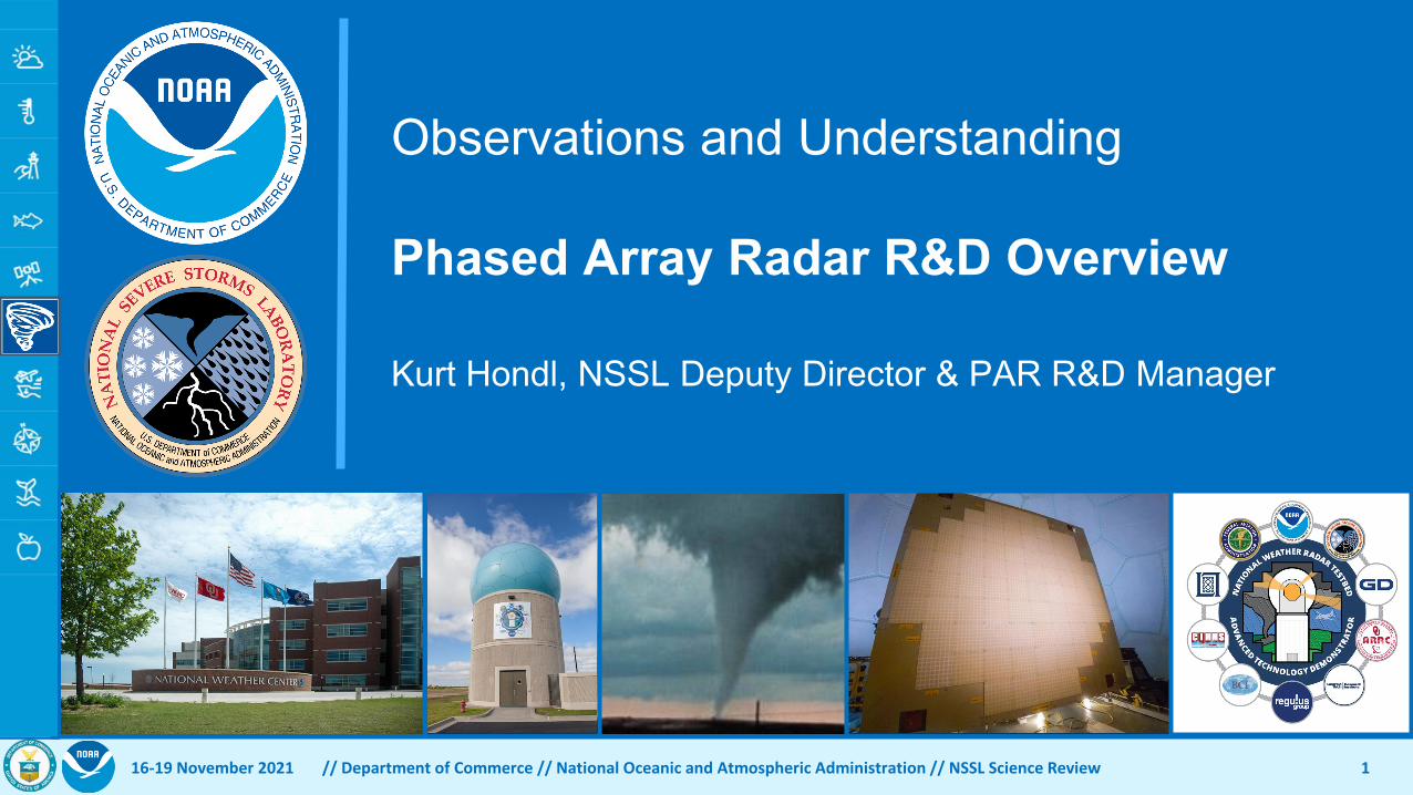
Observations and Understanding
Phased Array Radar R&D Overview
Kurt Hondl, NSSL Deputy Director & PAR R&D Manager
16-19 November 2021 // Department of Commerce // National Oceanic and Atmospheric Administration // NSSL Science Review 1

Radar Observations are Important• NSSL is severe weather lab
• Radar is primary input for forecasters issuing warnings for severe weather• NSSL is NOAA’s de facto Radar Laboratory
• Developed Doppler weather radar (1970s) which led to the deployment of the WSR-88D network in the early 1990s
• Developed Dual Polarization technologies (1980s-2000s) which led to WSR-88D system upgrade in 2012-2013
• NSSL is working on the Future Weather Radar program• Began investigation of Phased Array Radar (PAR) for use as a weather
radar in 2003 • Current WSR-88D network is estimated to be viable through ~2035
16-19 November 2021 // Department of Commerce // National Oceanic and Atmospheric Administration // NSSL Science Review 2
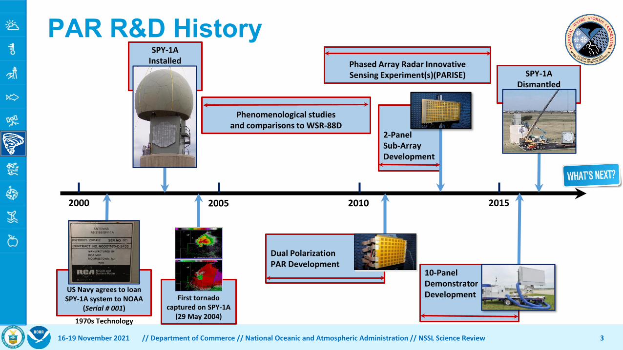
2000 201520102005
US Navy agrees to loan SPY-1A system to NOAA
(Serial # 001)
2-PanelSub-ArrayDevelopment
SPY-1AInstalled
Dual Polarization .PAR Development .
10-PanelDemonstratorDevelopment
Phased Array Radar InnovativeSensing Experiment(s)(PARISE)
1970s Technology
First tornado captured on SPY-1A
(29 May 2004)
PAR R&D History
3
Phenomenological studiesand comparisons to WSR-88D
SPY-1ADismantled
16-19 November 2021 // Department of Commerce // National Oceanic and Atmospheric Administration // NSSL Science Review
Relevance In Support of NOAA’s Mission• Congress
• Weather Research and Forecasting Innovation Act of 2017, 15 U.S.C. § 8501;• DOC Strategy: Reduce Severe Weather Impacts• NOAA R&D Plan: Reduce societal impacts from hazardous weather• OAR R&D Strategy
• Make Forecasts (and Warnings) Better • Design tools and processes to forecast high-impact weather events• Transition science that meets users’ current and future needs
• Drive Innovative Science • Invest in high-risk, high-reward science• Accelerate the delivery of mission-ready, next-generation science
• OAR Implementation Plan• Demonstrate Warn-on-Forecast can provide guidance for NWS tornado warnings at least one hour
in advance• Assess the capabilities of phased array technology (compared to the current WSR-88D) for
meteorological applications and inform NOAA’s future weather radar system investment decisions• NWS Weather Ready Nation
16-19 November 2021 // Department of Commerce // National Oceanic and Atmospheric Administration // NSSL Science Review 4

NSSL’s Radar Mission / Objective• Ensure that NOAA has the best radar tools to accomplish its
mission. • NSSL Grand Challenge: Investigate PAR and its capabilities to provide
the future weather radar observations needed by NOAA to accomplish its mission• Develop, refine, and evaluate the engineering and science
technologies of new radar systems and understand their application to weather radar operations.
• This knowledge provides the foundation that will enable an informed and pivotal decision on the technological and operational design of the next generation weather radar network that must be robust enough to serve us decades into the future as a critical piece of the national infrastructure
16-19 November 2021 // Department of Commerce // National Oceanic and Atmospheric Administration // NSSL Science Review 5
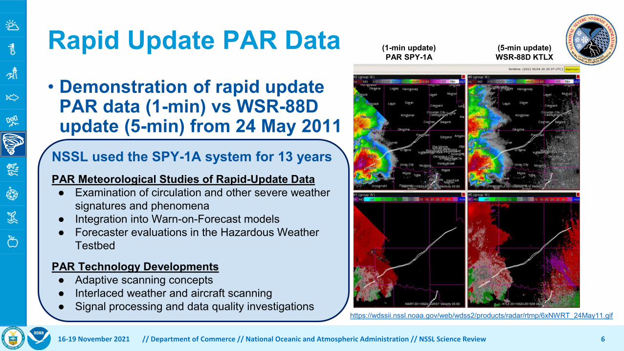
Rapid Update PAR Data
6
(1-min update)PAR SPY-1A
(5-min update)WSR-88D KTLX
• Demonstration of rapid update PAR data (1-min) vs WSR-88D update (5-min) from 24 May 2011
NSSL used the SPY-1A system for 13 yearsPAR Meteorological Studies of Rapid-Update Data
● Examination of circulation and other severe weather signatures and phenomena
● Integration into Warn-on-Forecast models● Forecaster evaluations in the Hazardous Weather
Testbed
PAR Technology Developments● Adaptive scanning concepts● Interlaced weather and aircraft scanning● Signal processing and data quality investigations
16-19 November 2021 // Department of Commerce // National Oceanic and Atmospheric Administration // NSSL Science Review
https://wdssii.nssl.noaa.gov/web/wdss2/products/radar/rtmp/6xNWRT_24May11.gif
What We’ve Learned from PAR R&D
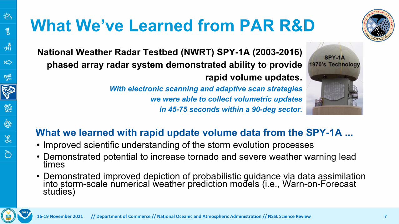
What we learned with rapid update volume data from the SPY-1A ...• Improved scientific understanding of the storm evolution processes• Demonstrated potential to increase tornado and severe weather warning lead
times• Demonstrated improved depiction of probabilistic guidance via data assimilation
into storm-scale numerical weather prediction models (i.e., Warn-on-Forecast studies)
16-19 November 2021 // Department of Commerce // National Oceanic and Atmospheric Administration // NSSL Science Review 7
National Weather Radar Testbed (NWRT) SPY-1A (2003-2016) phased array radar system demonstrated ability to provide
rapid volume updates.With electronic scanning and adaptive scan strategies
we were able to collect volumetric updatesin 45-75 seconds within a 90-deg sector.

Quality is our Mission• 34 formal publications
concerning “phased array” from 2016-2021• Both meteorological and
engineering subjects• 9 NSSL technical reports
• Documenting technical data that may not be appropriate for journal publications, but necessary for external collaborations
• Problem solving • Building, testing, and
calibrating a dual polarization PAR
16-19 November 2021 // Department of Commerce // National Oceanic and Atmospheric Administration // NSSL Science Review 8

Performance - Pushing the Boundaries• Developed the most advanced dual
polarization PAR Advanced Technology Demonstrator (ATD) for evaluation as a weather radar
• 3 Written reports and numerous briefings to Congress on PAR R&D activities
• All this led to support from Congress and the Administration resulting in increased appropriations for PAR R&D
16-19 November 2021 // Department of Commerce // National Oceanic and Atmospheric Administration // NSSL Science Review 9

Collaborations on PAR R&D
10
https://wdssii.nssl.noaa.gov/web/wdss2/products/radar/NWRTatd/AGIF_ATD_install.gif
16-19 November 2021 // Department of Commerce // National Oceanic and Atmospheric Administration // NSSL Science Review
Previews of Coming PresentationsWhat answers will PAR R&D provide?
• Can we perform the polarimetric calibration of a planar PAR over the field of view and trust its performance?
• Can a PAR provide weather radar data quality commensurate with NWS requirements?
• What are the benefits of adaptive scanning and rapid-update dual polarization data?
PAR R&D is necessary to establish NOAA’s knowledge of dual polarization PAR technology
prior to NOAA’s future radar investment decisions.
16-19 November 2021 // Department of Commerce // National Oceanic and Atmospheric Administration // NSSL Science Review 11

Observations and UnderstandingPhased Array Radar R&DAdvanced Technology DemonstratorDaniel Wasielewski, Electronics Engineer, RRDD
16-19 November 2021 // Department of Commerce // National Oceanic and Atmospheric Administration // NSSL Science Review 12

What is the ATD?Following up the success of the SPY-1 NSSL initiated the development of the first full-scale S-band, dual-pol, phased array radar for weather observations—the Advanced Technology Demonstrator (ATD)
1316-19 November 2021 // Department of Commerce // National Oceanic and Atmospheric Administration // NSSL Science Review

Why Invest in the ATD?
14
The ATD explores the combination of dual-polarization and phased array radar technology• Dual-polarization: more information →
discriminate between rain, snow, etc.• Phased array: more flexible scanning →
faster, adaptable to weather
ATD purposes1. One of NSSL’s major severe weather
research tools for the next decade or more2. A proof of concept of dual-pol phased array
technology for the National Weather Service• Demonstrate benefits• Reduce technical risk
16-19 November 2021 // Department of Commerce // National Oceanic and Atmospheric Administration // NSSL Science Review
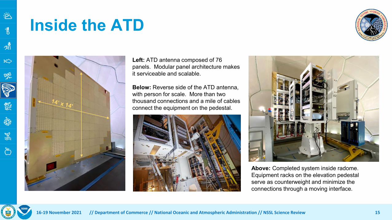
Left: ATD antenna composed of 76 panels. Modular panel architecture makes it serviceable and scalable.
Below: Reverse side of the ATD antenna, with person for scale. More than two thousand connections and a mile of cables connect the equipment on the pedestal.
Inside the ATD
15
Above: Completed system inside radome. Equipment racks on the elevation pedestal serve as counterweight and minimize the connections through a moving interface.
16-19 November 2021 // Department of Commerce // National Oceanic and Atmospheric Administration // NSSL Science Review
Calibration Infrastructure
16
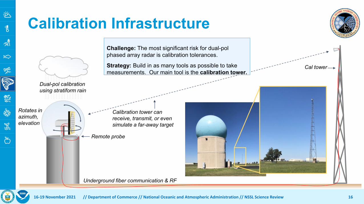
Challenge: The most significant risk for dual-pol phased array radar is calibration tolerances.
Strategy: Build in as many tools as possible to take measurements. Our main tool is the calibration tower.
Underground fiber communication & RF
Remote probe
Cal tower
Dual-pol calibration using stratiform rain
Rotates in azimuth, elevation
Calibration tower can receive, transmit, or even simulate a far-away target
16-19 November 2021 // Department of Commerce // National Oceanic and Atmospheric Administration // NSSL Science Review

ATD Timeline
17
2014 2015 2016 2017 2018 2019 2020 2021
Greenlight for full-scale ATD
Dual-pol phased array prototype completed
ATD Installation in Norman
System testing successfulDeclared operational!
First weather images
Production Integration and Test
16-19 November 2021 // Department of Commerce // National Oceanic and Atmospheric Administration // NSSL Science Review
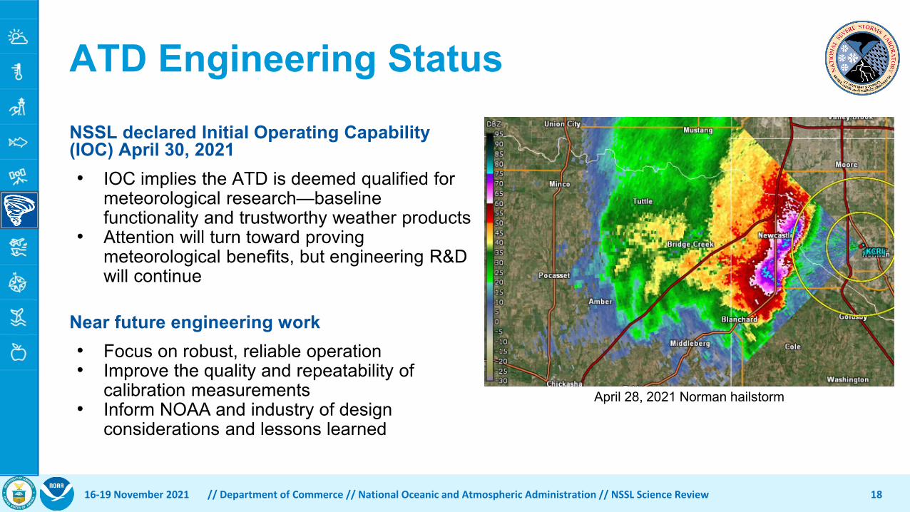
ATD Engineering StatusNSSL declared Initial Operating Capability (IOC) April 30, 2021• IOC implies the ATD is deemed qualified for
meteorological research—baseline functionality and trustworthy weather products
• Attention will turn toward proving meteorological benefits, but engineering R&D will continue
Near future engineering work• Focus on robust, reliable operation• Improve the quality and repeatability of
calibration measurements• Inform NOAA and industry of design
considerations and lessons learned
1816-19 November 2021 // Department of Commerce // National Oceanic and Atmospheric Administration // NSSL Science Review
April 28, 2021 Norman hailstorm
Observations and UnderstandingPhased Array Radar R&DEngineering R&DSebastián Torres PhD, CIWRO Assistant Director for Radar R&D and Sr. Research Scientist, RRDD
16-19 November 2021 // Department of Commerce // National Oceanic and Atmospheric Administration // NSSL Science Review 19

PAR Engineering R&DTechnology with a mission
• Is PAR the next radar revolution?Challenges and opportunities
• Developing calibration processes to produce high-quality radar data
• Designing an affordable system that can meet current/future NWS needs
• Exploiting unique capabilities to meet evolutionary radar requirements
Our work will inform NOAA’s future weather radar system investment decisions
16-19 November 2021 // Department of Commerce // National Oceanic and Atmospheric Administration // NSSL Science Review 20

The Challenge of PAR Calibration
Polarimetric radars require precise characterization of radar beams• The quality of weather observations
depends on our ability to accountfor the radar system
PAR electronic steering changes radar beams• Pointing direction, beam shape,
polarization orientation
Calibration of a dish antenna = characterize 1 beamCalibration of a PAR antenna = characterize 1,000s of beams
16-19 November 2021 // Department of Commerce // National Oceanic and Atmospheric Administration // NSSL Science Review 21

ATD Calibration Demonstration
ATD uncalibrated data show expected electronic steering artifacts
ATD calibrated data agree well with data from a NEXRAD radar
22
Reflectivity DIFFERENTIAL PHASE
Correlation Coef.
ATD
Unc
alib
rate
dAT
D C
alib
rate
dN
EXR
AD (K
CR
I)
Diff. Reflectivity Diff. Phase
16-19 November 2021 // Department of Commerce // National Oceanic and Atmospheric Administration // NSSL Science Review

The Challenge of PAR System Design
PARs come in many flavors• Architecture and geometry are
key characteristics• More advanced capabilities
require more complex systems
23
PAR designs must consider trade-offs between cost and capabilities• Any concept of operations meeting NWS
requirements must be compatible with the capabilities/performance of the radar system
Cos
t
System design
Requirements
Concept of
Operations
16-19 November 2021 // Department of Commerce // National Oceanic and Atmospheric Administration // NSSL Science Review

Data Quality SimulationsSimulator produces radar data as if they were obtained by radars with different characteristics• Analysis of cost-driving requirements• Evaluation of impacts to forecaster interpretation
2416-19 November 2021 // Department of Commerce // National Oceanic and Atmospheric Administration // NSSL Science Review
Beam 1 Beam 2 Beam 3From left to right, increasingly degraded beam shapes

Data Quality SimulationsSimulator produces radar data as if they were obtained by radars with different characteristics• Analysis of cost-driving requirements• Evaluation of impacts to forecaster interpretation
25
Acceptable Marginal UnacceptableFrom left to right, simulated radar data obtained by radars with increasingly degraded beam shapes.
Impacts to forecaster interpretation are greater as the beam degradation increases.
16-19 November 2021 // Department of Commerce // National Oceanic and Atmospheric Administration // NSSL Science Review

The Opportunity of PAR Adaptive Scanning
Adaptive scanning: automatically changing what the radar does in response to changes in the atmosphere• The radar you need when and where you need it
PAR’s beam agility is the key to unlock the full potential of adaptive scanning• Scans can be focused on regions of interest
and tailored to get the best observations• Fundamental trade-offs can be
optimized to produce the radar datathat users need, when and where they need it
26
Triangle of radar scanning trade-offsarea = radar resources (constant)
vertices = scan performance (adaptable)
16-19 November 2021 // Department of Commerce // National Oceanic and Atmospheric Administration // NSSL Science Review

Adaptive Scanning SimulationsSimulations allow the development, demonstration, and evaluation of advanced scanning techniques • compare performance of different techniques • evaluate performance on different weather events• compare performance of different radar designs
27
Adap
tive
Scan
ning
Con
vent
iona
l Sca
nnin
g
Simulated reflectivity fields obtained with conventional and adaptive scanning (focused and tailored scans). For this case, update times with
adaptive scanning are ~5x faster than with conventional scanning
16-19 November 2021 // Department of Commerce // National Oceanic and Atmospheric Administration // NSSL Science Review

Future workDemonstrate PAR calibration
• Use ATD to assess calibration performance and to develop operational calibration techniques
Demonstrate PAR capabilities• Use ATD and simulations to evaluate radar design trade-offs and
demonstrate advanced scanning and processing techniquesComplete analysis of different PAR designs
• Explore single-face rotating geometry• Demonstrate “all-digital” architecture (ARRC)
Lead the design of future systems• Assess NWS Radar Functional Requirements (MIT/LL)• Use ATD to understand long-term O&M costs• Document lessons learned to inform future developments
16-19 November 2021 // Department of Commerce // National Oceanic and Atmospheric Administration // NSSL Science Review 28

Observations and UnderstandingPhased Array Radar R&DMeteorological R&DCharles KusterCIWRO Research Associate, RRDD
16-19 November 2021 // Department of Commerce // National Oceanic and Atmospheric Administration // NSSL Science Review 29
16-19 November 2021 // Department of Commerce // National Oceanic and Atmospheric Administration // NSSL Science Review 30
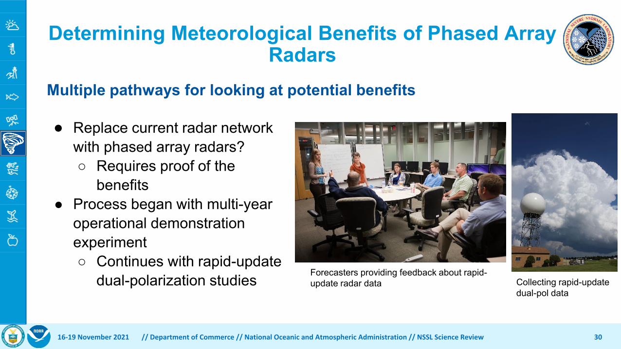
● Replace current radar network with phased array radars?○ Requires proof of the
benefits● Process began with multi-year
operational demonstration experiment○ Continues with rapid-update
dual-polarization studies
Determining Meteorological Benefits of Phased Array Radars
Multiple pathways for looking at potential benefits
Forecasters providing feedback about rapid-update radar data Collecting rapid-update
dual-pol data

Goal: Does radar update time matter?• Build on previous PARISE experiments• Involved participation of 30 NWS forecasters • Forecasters saw various update times (1, 2, or 5-min) of single-pol data• Warnings issued on severe weather hazards• Focus groups to gather feedback and insights• Eye-tracking experiment to gather even more quantitative information
16-19 November 2021 // Department of Commerce // National Oceanic and Atmospheric Administration // NSSL Science Review 31
Phased Array Radar Innovative Sensing Experiment (PARISE)
Forecaster working a supercell case Forecaster working through eye-tracking case

Phased Array Radar Innovative Sensing Experiment (PARISE)
16-19 November 2021 // Department of Commerce // National Oceanic and Atmospheric Administration // NSSL Science Review 32
PARISE Results:● Use of rapid-update radar data:
○ Improved all tornado warning metrics■ 1 min better than 2 min
○ Increased confidence in warning decision○ Changed when warning was issued but
not how it was issued
● Changes in displays, training, and warning paradigm likely needed
● What about dual-pol data?
Wilson et al. (2017)
Warning Metric
1-min Updates
2-min Updates
5-min Updates
Tornado warning
lead Time (min)
12.7 8 9
Tornado warning
probability of detection
0.78 0.74 0.62
Tornado warning
false alarm ratio
0.29 0.45 0.44
16-19 November 2021 // Department of Commerce // National Oceanic and Atmospheric Administration // NSSL Science Review 33
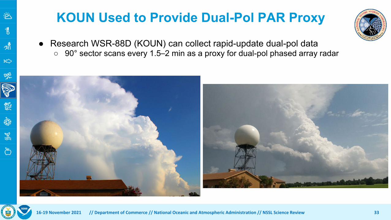
KOUN Used to Provide Dual-Pol PAR Proxy
● Research WSR-88D (KOUN) can collect rapid-update dual-pol data○ 90° sector scans every 1.5–2 min as a proxy for dual-pol phased array radar
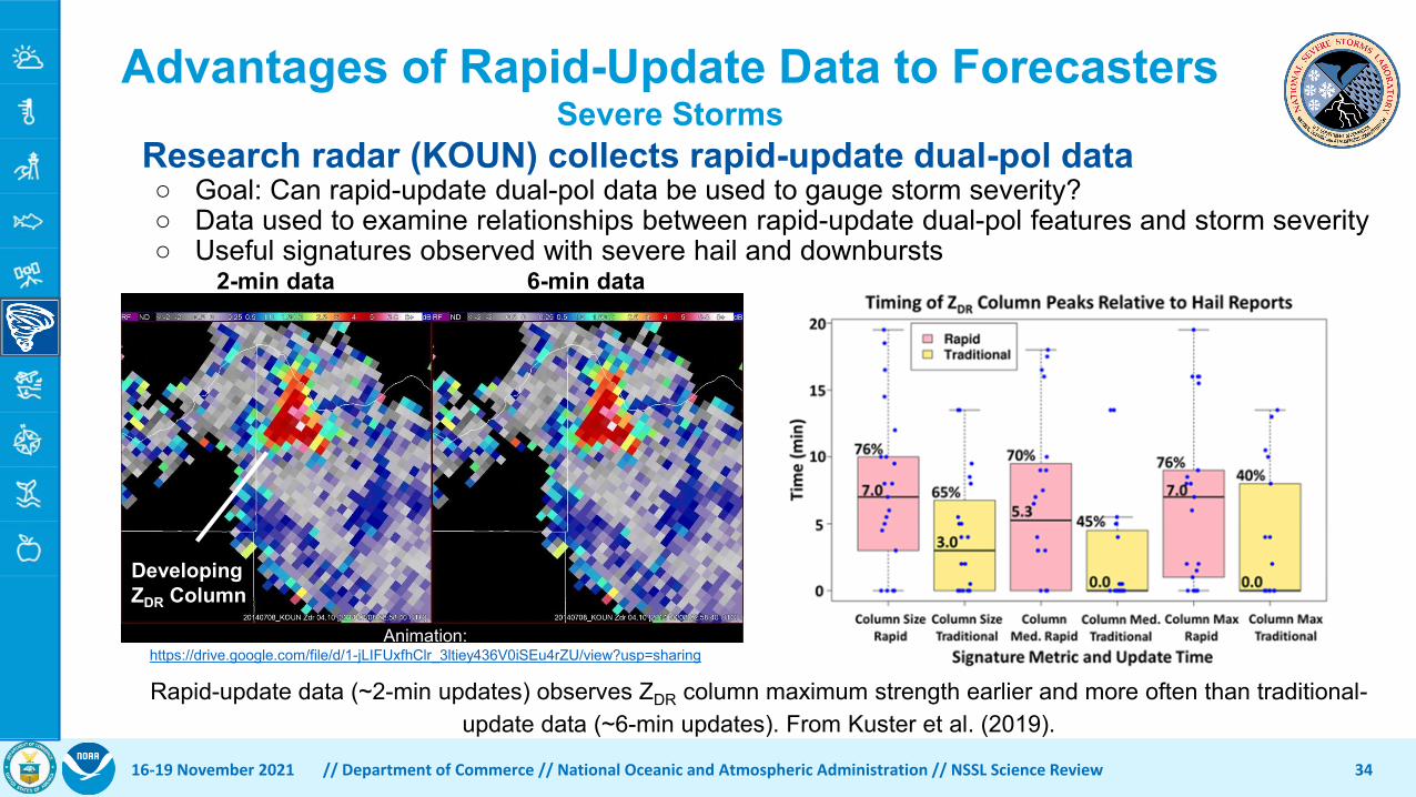
16-19 November 2021 // Department of Commerce // National Oceanic and Atmospheric Administration // NSSL Science Review 34
Research radar (KOUN) collects rapid-update dual-pol data○ Goal: Can rapid-update dual-pol data be used to gauge storm severity?○ Data used to examine relationships between rapid-update dual-pol features and storm severity○ Useful signatures observed with severe hail and downbursts
Advantages of Rapid-Update Data to ForecastersSevere Storms
Rapid-update data (~2-min updates) observes ZDR column maximum strength earlier and more often than traditional-update data (~6-min updates). From Kuster et al. (2019).
Animation: https://drive.google.com/file/d/1-jLIFUxfhClr_3ltiey436V0iSEu4rZU/view?usp=sharing
2-min data 6-min data
DevelopingZDR Column

16-19 November 2021 // Department of Commerce // National Oceanic and Atmospheric Administration // NSSL Science Review 35
Advantages of Rapid-Update Data to ForecastersFlash Floods
Wen et al. (2021)
Research radar (KOUN) collects rapid-update dual-pol data○ Goal: Can rapid-update dual-pol data be used to improve hydrologic models?○ Data used to examine impacts of different update times and datasets○ Compared to KOUN, KTLX missed 50% of flash flood area

16-19 November 2021 // Department of Commerce // National Oceanic and Atmospheric Administration // NSSL Science Review 36
Future Work● Continue investigation of dual-pol benefits in predicting downbursts and tornadoes● Work to understand tradeoffs between update rate, spatial sampling, and data quality
for each unique severe weather hazard.○ Evaluate ability of the ATD to perform WSR-88D function and any impact on
forecasters and algorithms.○ Develop more advanced scanning strategies
● Investigate how existing radar algorithms can best take advantage of the ATD’s capabilities.
● Evaluate how rapidly- and adaptively- scanned radar observations can be integrated into future forecast and warning paradigms that are likely to include 1) advanced numerical models, 2) probabilistic warnings for severe weather hazards, and 3) MRMS.

Observations and Understanding
Phased Array Radar R&D Future Plans
Kurt Hondl, NSSL Deputy Director & PAR R&D Manager
16-19 November 2021 // Department of Commerce // National Oceanic and Atmospheric Administration // NSSL Science Review 37

Current State of PAR R&D• Phased Array Radar capabilities
• Benefits of rapid updates• Adaptive scanning• All-digital technologies
• Phased Array Radar challenges• Dual polarization calibration• Rapid scanning technologies• Data quality
• Warning and Forecast benefits• Improved warning lead times• Improved guidance via Warn-on-Forecast
• Additional R&D• Rotating PAR concept • PAR technical configurations
16-19 November 2021 // Department of Commerce // National Oceanic and Atmospheric Administration // NSSL Science Review 38
Towards the Next Generation Operational Meteorological RadarMark Weber, Kurt Hondl, Nusrat Yussouf, Youngsun Jung, Derek Stratman, Bryan Putnam, Xuguang Wang, Terry Schuur, Charles Kuster, Yixin Wen, Juanzhen Sun, Jeff Keeler, Zhuming Ying, John Cho, James Kurdzo, Sebastian Torres, Chris Curtis, David Schvartzman, Jami Boettcher, Feng Nai, Henry Thomas, Dusan Zrnić, Igor Ivić, Djordje Mirković, Caleb Fulton, Jorge Salazar, Guifu Zhang, Robert Palmer, Mark Yeary, Kevin Cooley, Michael Istok, and Mark Vincent
This article summarizes research and risk reduction that will inform acquisition decisions regarding NOAA’s future national operational weather radar network. A key alternative being evaluated is polarimetric phased-array radar (PAR). Research indicates PAR can plausibly achieve fast, adaptive volumetric scanning, with associated benefits for severe-weather warning performance. We assess these benefits using storm observations and analyses, observing system simulation experiments, and real radar-data assimilation studies. Changes in the number and/or locations of radars in the future network could improve coverage at low altitude. Analysis of benefits that might be so realized indicates the possibility for additional improvement in severe-weather and flash-flood warning performance, with associated reduction in casualties. Simulations are used to evaluate techniques for rapid volumetric scanning and assess data quality characteristics of PAR. Finally, we describe progress in developing methods to compensate for polarimetric variable estimate biases introduced by electronic beam-steering. A research-to-operations (R2O) strategy for the PAR alternative for the WSR-88D replacement network is presented.
July 2021

Weather Radar Follow-On Plan• Consolidated Appropriations Act of
2019 requested NOAA’s weather radar follow-on transition-to-operations plan
• Key Elements ...• Sustain and enhance NEXRAD through
current expected service life (2035)• Conduct PAR R&D to reduce technical
risk and inform future acquisition• Protect NEXRAD spectrum• Organize for success
16-19 November 2021 // Department of Commerce // National Oceanic and Atmospheric Administration // NSSL Science Review 39
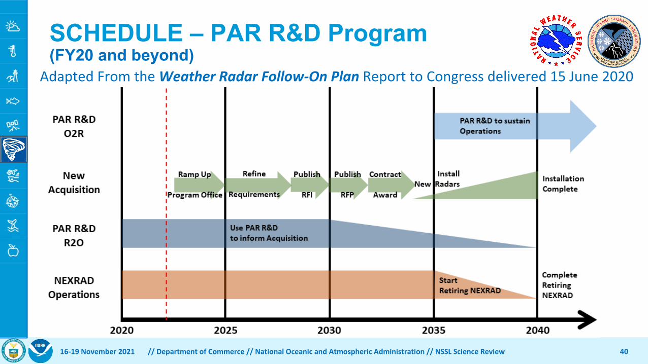
Adapted From the Weather Radar Follow-On Plan Report to Congress delivered 15 June 2020
SCHEDULE – PAR R&D Program (FY20 and beyond)
16-19 November 2021 // Department of Commerce // National Oceanic and Atmospheric Administration // NSSL Science Review 40

Weather Radar Follow-On Plan• Future Acquisition Key Decision in ~2030
• Analysis of Alternatives including cost/benefit analysis• Another Service Life Extension Program for the WSR-88D• Replace WSR-88D with modern reflector dish technology• Replace WSR-88D with PAR technology
• Multiple PAR configurations possible• Key decision timeline gives us 8 years of PAR R&D to ensure
PAR is a viable alternative as a WSR-88D replacement • Will necessarily include industry engagement
• What will PAR technology alternative look like?
16-19 November 2021 // Department of Commerce // National Oceanic and Atmospheric Administration // NSSL Science Review 41

PAR R&D Next Steps• Gain useful information from ATD
• Development of calibration tools suitable for an operational platform • Meteorological studies of rapid update dual polarization observations
• Gain useful information from other technology demonstrators• Funded all-digital PAR development at OU Advanced Radar Research
Center (ARRC) and Massachusetts Institute of Technology Lincoln Laboratory (MIT/LL)
• Continue research as outlined in Weather Radar Follow-On Plan …
• Develop additional technology demonstrators to further reduce risk • Work with NWS to establish collaborative R&D and acquisition planning
16-19 November 2021 // Department of Commerce // National Oceanic and Atmospheric Administration // NSSL Science Review 42
PAR R&D - Key Questions for Next Review• Will PAR be a viable alternative as a WSR-88D replacement?
• How can we ensure that future WSR-88D replacement meets the needs of future NWS operational requirements?
• What will the PAR alternative look like?
16-19 November 2021 // Department of Commerce // National Oceanic and Atmospheric Administration // NSSL Science Review 43

Thank Youon behalf of the NSSL PAR R&D team.
4416-19 November 2021 // Department of Commerce // National Oceanic and Atmospheric Administration // NSSL Science Review
More photos and videos of the ATD can be found here … https://www.flickr.com/photos/noaanssl/albums/72157699464311325/with/43118021910/