ph parks and trails plan
TRANSCRIPT

Pleasant Hill Parks & Trails Plan
FALL 2013
2
Acknowledgements
Pleasant Hill City Hall 5160 Maple Dr, Suite A Pleasant Hill, IA 50327 Ph: (515) 262-‐9368 Fx: (515) 262-‐9570
CRP 432 Class
Salem Al Junaibi Yaser Al Mazrouei Joebany Corvera Alexander Eppel Dachon Freeman
Jacob Heil Bryce Johnson Christopher Lee Derek Silverthorn Alexander Wagner
City Staff
Ben Champ | Community Development Director Heath Ellis | Parks and Recreation Supervisor
Madeline Sturms | Associate Planner
CRP 432 Instructors
Eric Jensen David Wilwerding
3
Table of Contents
Executive Summary-‐-‐-‐-‐-‐-‐-‐-‐-‐-‐-‐-‐-‐-‐-‐-‐-‐-‐-‐-‐-‐-‐-‐-‐-‐-‐-‐-‐-‐-‐-‐-‐-‐-‐-‐-‐-‐-‐-‐-‐-‐-‐-‐-‐-‐-‐-‐-‐-‐-‐-‐-‐-‐-‐-‐-‐-‐-‐-‐-‐-‐-‐-‐-‐-‐-‐-‐-‐-‐-‐-‐-‐4
Park & Trail Benefits-‐-‐-‐-‐-‐-‐-‐-‐-‐-‐-‐-‐-‐-‐-‐-‐-‐-‐-‐-‐-‐-‐-‐-‐-‐-‐-‐-‐-‐-‐-‐-‐-‐-‐-‐-‐-‐-‐-‐-‐-‐-‐-‐-‐-‐-‐-‐-‐-‐-‐-‐-‐-‐-‐-‐-‐-‐-‐-‐-‐-‐-‐-‐-‐-‐-‐-‐-‐-‐-‐-‐5
Policies -‐-‐-‐-‐-‐-‐-‐-‐-‐-‐-‐-‐-‐-‐-‐-‐-‐-‐-‐-‐-‐-‐-‐-‐-‐-‐-‐-‐-‐-‐-‐-‐-‐-‐-‐-‐-‐-‐-‐-‐-‐-‐-‐-‐-‐-‐-‐-‐-‐-‐-‐-‐-‐-‐-‐-‐-‐-‐-‐-‐-‐-‐-‐-‐-‐-‐-‐-‐-‐-‐-‐-‐-‐-‐-‐-‐-‐-‐-‐-‐-‐-‐-‐-‐-‐-‐-‐-‐8
Parks -‐-‐-‐-‐-‐-‐-‐-‐-‐-‐-‐-‐-‐-‐-‐-‐-‐-‐-‐-‐-‐-‐-‐-‐-‐-‐-‐-‐-‐-‐-‐-‐-‐-‐-‐-‐-‐-‐-‐-‐-‐-‐-‐-‐-‐-‐-‐-‐-‐-‐-‐-‐-‐-‐-‐-‐-‐-‐-‐-‐-‐-‐-‐-‐-‐-‐-‐-‐-‐-‐-‐-‐-‐-‐-‐-‐-‐-‐-‐-‐-‐-‐-‐-‐-‐-‐-‐-‐-‐14
Park Classifications-‐-‐-‐-‐-‐-‐-‐-‐-‐-‐-‐-‐-‐-‐-‐-‐-‐-‐-‐-‐-‐-‐-‐-‐-‐-‐-‐-‐-‐-‐-‐-‐-‐-‐-‐-‐-‐-‐-‐-‐-‐-‐-‐-‐-‐-‐-‐-‐-‐-‐-‐-‐-‐-‐-‐-‐-‐-‐-‐-‐-‐-‐-‐-‐-‐-‐-‐-‐14
Existing Parks -‐-‐-‐-‐-‐-‐-‐-‐-‐-‐-‐-‐-‐-‐-‐-‐-‐-‐-‐-‐-‐-‐-‐-‐-‐-‐-‐-‐-‐-‐-‐-‐-‐-‐-‐-‐-‐-‐-‐-‐-‐-‐-‐-‐-‐-‐-‐-‐-‐-‐-‐-‐-‐-‐-‐-‐-‐-‐-‐-‐-‐-‐-‐-‐-‐-‐-‐-‐-‐-‐-‐-‐-‐-‐15
Park Needs Assessment -‐-‐-‐-‐-‐-‐-‐-‐-‐-‐-‐-‐-‐-‐-‐-‐-‐-‐-‐-‐-‐-‐-‐-‐-‐-‐-‐-‐-‐-‐-‐-‐-‐-‐-‐-‐-‐-‐-‐-‐-‐-‐-‐-‐-‐-‐-‐-‐-‐-‐-‐-‐-‐-‐-‐-‐-‐-‐-‐-‐-‐19
Future Parks-‐-‐-‐-‐-‐-‐-‐-‐-‐-‐-‐-‐-‐-‐-‐-‐-‐-‐-‐-‐-‐-‐-‐-‐-‐-‐-‐-‐-‐-‐-‐-‐-‐-‐-‐-‐-‐-‐-‐-‐-‐-‐-‐-‐-‐-‐-‐-‐-‐-‐-‐-‐-‐-‐-‐-‐-‐-‐-‐-‐-‐-‐-‐-‐-‐-‐-‐-‐-‐-‐-‐-‐-‐-‐-‐-‐22
Trails-‐-‐-‐-‐-‐-‐-‐-‐-‐-‐-‐-‐-‐-‐-‐-‐-‐-‐-‐-‐-‐-‐-‐-‐-‐-‐-‐-‐-‐-‐-‐-‐-‐-‐-‐-‐-‐-‐-‐-‐-‐-‐-‐-‐-‐-‐-‐-‐-‐-‐-‐-‐-‐-‐-‐-‐-‐-‐-‐-‐-‐-‐-‐-‐-‐-‐-‐-‐-‐-‐-‐-‐-‐-‐-‐-‐-‐-‐-‐-‐-‐-‐-‐-‐-‐-‐-‐-‐-‐-‐25
Existing Trails-‐-‐-‐-‐-‐-‐-‐-‐-‐-‐-‐-‐-‐-‐-‐-‐-‐-‐-‐-‐-‐-‐-‐-‐-‐-‐-‐-‐-‐-‐-‐-‐-‐-‐-‐-‐-‐-‐-‐-‐-‐-‐-‐-‐-‐-‐-‐-‐-‐-‐-‐-‐-‐-‐-‐-‐-‐-‐-‐-‐-‐-‐-‐-‐-‐-‐-‐-‐-‐-‐-‐-‐-‐-‐-‐25
Trails Needs Assessment-‐-‐-‐-‐-‐-‐-‐-‐-‐-‐-‐-‐-‐-‐-‐-‐-‐-‐-‐-‐-‐-‐-‐-‐-‐-‐-‐-‐-‐-‐-‐-‐-‐-‐-‐-‐-‐-‐-‐-‐-‐-‐-‐-‐-‐-‐-‐-‐-‐-‐-‐-‐-‐-‐-‐-‐-‐-‐-‐-‐25
Future Trails-‐-‐-‐-‐-‐-‐-‐-‐-‐-‐-‐-‐-‐-‐-‐-‐-‐-‐-‐-‐-‐-‐-‐-‐-‐-‐-‐-‐-‐-‐-‐-‐-‐-‐-‐-‐-‐-‐-‐-‐-‐-‐-‐-‐-‐-‐-‐-‐-‐-‐-‐-‐-‐-‐-‐-‐-‐-‐-‐-‐-‐-‐-‐-‐-‐-‐-‐-‐-‐-‐-‐-‐-‐-‐-‐-‐26
Greenways-‐-‐-‐-‐-‐-‐-‐-‐-‐-‐-‐-‐-‐-‐-‐-‐-‐-‐-‐-‐-‐-‐-‐-‐-‐-‐-‐-‐-‐-‐-‐-‐-‐-‐-‐-‐-‐-‐-‐-‐-‐-‐-‐-‐-‐-‐-‐-‐-‐-‐-‐-‐-‐-‐-‐-‐-‐-‐-‐-‐-‐-‐-‐-‐-‐-‐-‐-‐-‐-‐-‐-‐-‐-‐-‐-‐-‐-‐-‐-‐-‐-‐31
Funding-‐-‐-‐-‐-‐-‐-‐-‐-‐-‐-‐-‐-‐-‐-‐-‐-‐-‐-‐-‐-‐-‐-‐-‐-‐-‐-‐-‐-‐-‐-‐-‐-‐-‐-‐-‐-‐-‐-‐-‐-‐-‐-‐-‐-‐-‐-‐-‐-‐-‐-‐-‐-‐-‐-‐-‐-‐-‐-‐-‐-‐-‐-‐-‐-‐-‐-‐-‐-‐-‐-‐-‐-‐-‐-‐-‐-‐-‐-‐-‐-‐-‐-‐-‐-‐-‐33
Implementation-‐-‐-‐-‐-‐-‐-‐-‐-‐-‐-‐-‐-‐-‐-‐-‐-‐-‐-‐-‐-‐-‐-‐-‐-‐-‐-‐-‐-‐-‐-‐-‐-‐-‐-‐-‐-‐-‐-‐-‐-‐-‐-‐-‐-‐-‐-‐-‐-‐-‐-‐-‐-‐-‐-‐-‐-‐-‐-‐-‐-‐-‐-‐-‐-‐-‐-‐-‐-‐-‐-‐-‐-‐-‐-‐34
Action Steps-‐-‐-‐-‐-‐-‐-‐-‐-‐-‐-‐-‐-‐-‐-‐-‐-‐-‐-‐-‐-‐-‐-‐-‐-‐-‐-‐-‐-‐-‐-‐-‐-‐-‐-‐-‐-‐-‐-‐-‐-‐-‐-‐-‐-‐-‐-‐-‐-‐-‐-‐-‐-‐-‐-‐-‐-‐-‐-‐-‐-‐-‐-‐-‐-‐-‐-‐-‐-‐-‐-‐-‐-‐-‐-‐-‐34
Order of Goals -‐-‐-‐-‐-‐-‐-‐-‐-‐-‐-‐-‐-‐-‐-‐-‐-‐-‐-‐-‐-‐-‐-‐-‐-‐-‐-‐-‐-‐-‐-‐-‐-‐-‐-‐-‐-‐-‐-‐-‐-‐-‐-‐-‐-‐-‐-‐-‐-‐-‐-‐-‐-‐-‐-‐-‐-‐-‐-‐-‐-‐-‐-‐-‐-‐-‐-‐-‐-‐-‐-‐-‐-‐34
Dedication of Parkland-‐-‐-‐-‐-‐-‐-‐-‐-‐-‐-‐-‐-‐-‐-‐-‐-‐-‐-‐-‐-‐-‐-‐-‐-‐-‐-‐-‐-‐-‐-‐-‐-‐-‐-‐-‐-‐-‐-‐-‐-‐-‐-‐-‐-‐-‐-‐-‐-‐-‐-‐-‐-‐-‐-‐-‐-‐-‐-‐-‐-‐-‐-‐35
Conclusion-‐-‐-‐-‐-‐-‐-‐-‐-‐-‐-‐-‐-‐-‐-‐-‐-‐-‐-‐-‐-‐-‐-‐-‐-‐-‐-‐-‐-‐-‐-‐-‐-‐-‐-‐-‐-‐-‐-‐-‐-‐-‐-‐-‐-‐-‐-‐-‐-‐-‐-‐-‐-‐-‐-‐-‐-‐-‐-‐-‐-‐-‐-‐-‐-‐-‐-‐-‐-‐-‐-‐-‐-‐-‐-‐-‐-‐-‐-‐-‐-‐-‐36
Index of Tables -‐-‐-‐-‐-‐-‐-‐-‐-‐-‐-‐-‐-‐-‐-‐-‐-‐-‐-‐-‐-‐-‐-‐-‐-‐-‐-‐-‐-‐-‐-‐-‐-‐-‐-‐-‐-‐-‐-‐-‐-‐-‐-‐-‐-‐-‐-‐-‐-‐-‐-‐-‐-‐-‐-‐-‐-‐-‐-‐-‐-‐-‐-‐-‐-‐-‐-‐-‐-‐-‐-‐-‐-‐-‐-‐-‐37
References-‐-‐-‐-‐-‐-‐-‐-‐-‐-‐-‐-‐-‐-‐-‐-‐-‐-‐-‐-‐-‐-‐-‐-‐-‐-‐-‐-‐-‐-‐-‐-‐-‐-‐-‐-‐-‐-‐-‐-‐-‐-‐-‐-‐-‐-‐-‐-‐-‐-‐-‐-‐-‐-‐-‐-‐-‐-‐-‐-‐-‐-‐-‐-‐-‐-‐-‐-‐-‐-‐-‐-‐-‐-‐-‐-‐-‐-‐-‐-‐-‐-‐38
4
Executive Summary This parks and trails plan for Pleasant Hill will address the community’s existing park and trail conditions, needs assessments for parks and trails, future park and trail recommendations, policies for future park and trail development and implementation, funding strategies for these recommendations, as well as action steps and goals in order to achieve the future development plans. This plan should serve as a catalyst for park, trail, and recreational growth. This plan will point out vulnerable areas in the Pleasant Hill community, and will address ways to resolve their impending crises. The park and trail needs assessments will address both the behavioral and social aspect of parks and trails in the community, and what needs to be done in order to have a thriving community that is provided with adequate and desirable recreation facilities and amenities. This plan will address three major areas of concern for the Pleasant Hill community. The three areas that were the primary objectives were: 1) more soccer fields, 2) better connectivity, and 3) greenway protection. Given these three primary objectives, this plan will present multiple land parcels and paths throughout the community as ideal multi-‐use open play fields, trail and park connectivity paths and points, and large open plats of land that can be used primarily for soccer. Soccer is a predominant concern in the Pleasant Hill community. Overall community connectivity is another pertinent issue. Of the 500 miles of trails the central Iowa area has Pleasant Hill is not a significant contributor. Pleasant Hill only contains the Gay Lea Wilson Trail and Copper Creek Lake Trail, both of which only address the western corridor of the community. This plan will focused trail and park expansion in the eastern corridor of the community in order to remedy this imbalance of amenities. Trail and park expansion in the eastern corridor will attract developers and homebuyers, resulting in a widespread community that makes viable use of their land. East/west trail expansion is a main objective, and ideal locations for this expansion will be considered. Options for large open plats of land that are ideal for soccer will also be located. These land parcels would be great venues for multiple soccer fields to be used simultaneously. These recommendations can serve as a framework for locations of long-‐term future park and trail development in order to expand Pleasant Hill both physically and socially. The most important fundamental purpose of this plan is to address the community’s demands, and plan to make accommodations based on those community desires. By expanding the park and trail network, Pleasant Hill will become an even better place to “grow, play, and live.”
5
Park and Trail Benefits Providing a community with open space, recreation, and trail networks have many advantageous effects that have been noted in various studies over the years. Parks and trails serve many purposes to a single community, aside from the present physical aspects. Parks and trails provide settings for collaborative and positive community engagement, community revitalization, safer neighborhoods, health benefits, transportation options, and multiple economic benefits.
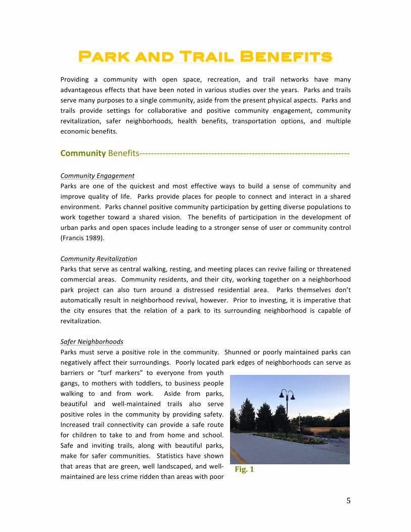
Community Benefits-‐-‐-‐-‐-‐-‐-‐-‐-‐-‐-‐-‐-‐-‐-‐-‐-‐-‐-‐-‐-‐-‐-‐-‐-‐-‐-‐-‐-‐-‐-‐-‐-‐-‐-‐-‐-‐-‐-‐-‐-‐-‐-‐-‐-‐-‐-‐-‐-‐-‐-‐-‐-‐-‐-‐-‐-‐-‐-‐-‐-‐-‐-‐-‐-‐-‐-‐-‐-‐-‐-‐-‐-‐ Community Engagement Parks are one of the quickest and most effective ways to build a sense of community and improve quality of life. Parks provide places for people to connect and interact in a shared environment. Parks channel positive community participation by getting diverse populations to work together toward a shared vision. The benefits of participation in the development of urban parks and open spaces include leading to a stronger sense of user or community control (Francis 1989). Community Revitalization Parks that serve as central walking, resting, and meeting places can revive failing or threatened commercial areas. Community residents, and their city, working together on a neighborhood park project can also turn around a distressed residential area. Parks themselves don’t automatically result in neighborhood revival, however. Prior to investing, it is imperative that the city ensures that the relation of a park to its surrounding neighborhood is capable of revitalization. Safer Neighborhoods Parks must serve a positive role in the community. Shunned or poorly maintained parks can negatively affect their surroundings. Poorly located park edges of neighborhoods can serve as barriers or “turf markers” to everyone from youth gangs, to mothers with toddlers, to business people walking to and from work. Aside from parks, beautiful and well-‐maintained trails also serve positive roles in the community by providing safety. Increased trail connectivity can provide a safe route for children to take to and from home and school. Safe and inviting trails, along with beautiful parks, make for safer communities. Statistics have shown that areas that are green, well landscaped, and well-‐maintained are less crime ridden than areas with poor
Fig. 1
6
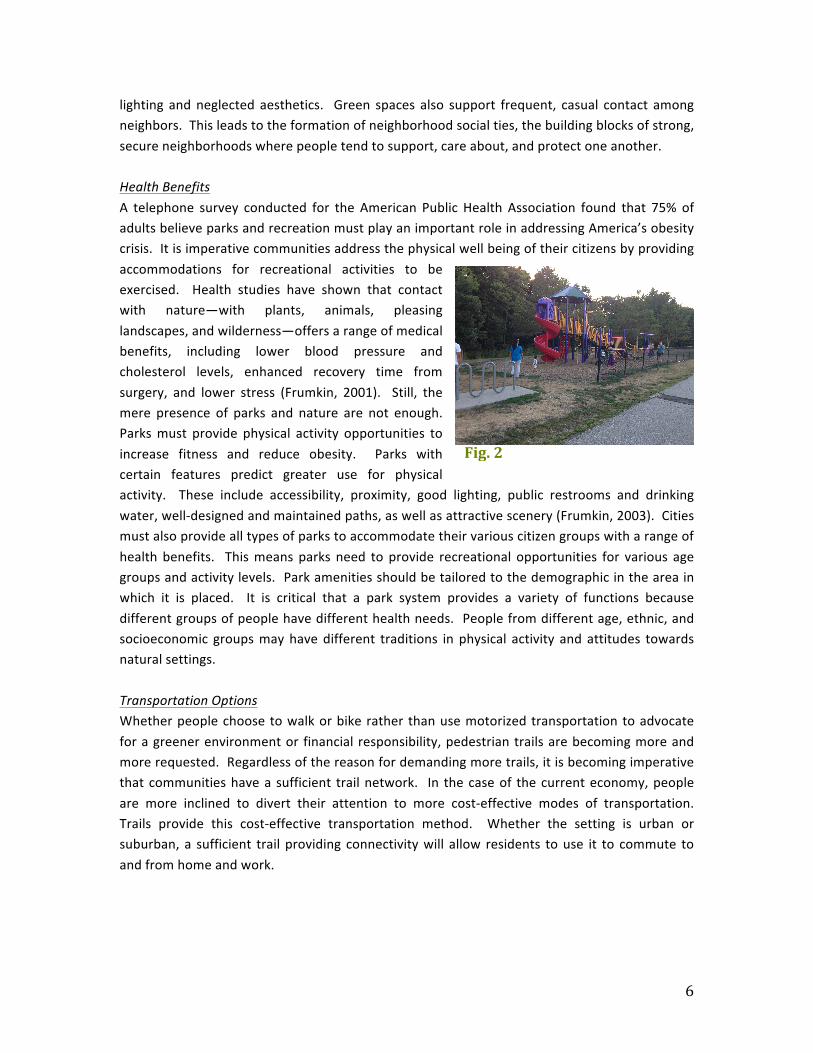
lighting and neglected aesthetics. Green spaces also support frequent, casual contact among neighbors. This leads to the formation of neighborhood social ties, the building blocks of strong, secure neighborhoods where people tend to support, care about, and protect one another. Health Benefits A telephone survey conducted for the American Public Health Association found that 75% of adults believe parks and recreation must play an important role in addressing America’s obesity crisis. It is imperative communities address the physical well being of their citizens by providing accommodations for recreational activities to be exercised. Health studies have shown that contact with nature—with plants, animals, pleasing landscapes, and wilderness—offers a range of medical benefits, including lower blood pressure and cholesterol levels, enhanced recovery time from surgery, and lower stress (Frumkin, 2001). Still, the mere presence of parks and nature are not enough. Parks must provide physical activity opportunities to increase fitness and reduce obesity. Parks with certain features predict greater use for physical activity. These include accessibility, proximity, good lighting, public restrooms and drinking water, well-‐designed and maintained paths, as well as attractive scenery (Frumkin, 2003). Cities must also provide all types of parks to accommodate their various citizen groups with a range of health benefits. This means parks need to provide recreational opportunities for various age groups and activity levels. Park amenities should be tailored to the demographic in the area in which it is placed. It is critical that a park system provides a variety of functions because different groups of people have different health needs. People from different age, ethnic, and socioeconomic groups may have different traditions in physical activity and attitudes towards natural settings. Transportation Options Whether people choose to walk or bike rather than use motorized transportation to advocate for a greener environment or financial responsibility, pedestrian trails are becoming more and more requested. Regardless of the reason for demanding more trails, it is becoming imperative that communities have a sufficient trail network. In the case of the current economy, people are more inclined to divert their attention to more cost-‐effective modes of transportation. Trails provide this cost-‐effective transportation method. Whether the setting is urban or suburban, a sufficient trail providing connectivity will allow residents to use it to commute to and from home and work.
Fig. 2
7
Economic Benefits-‐-‐-‐-‐-‐-‐-‐-‐-‐-‐-‐-‐-‐-‐-‐-‐-‐-‐-‐-‐-‐-‐-‐-‐-‐-‐-‐-‐-‐-‐-‐-‐-‐-‐-‐-‐-‐-‐-‐-‐-‐-‐-‐-‐-‐-‐-‐-‐-‐-‐-‐-‐-‐-‐-‐-‐-‐-‐-‐-‐-‐-‐-‐-‐-‐-‐-‐-‐-‐-‐-‐-‐-‐-‐-‐-‐ Property Value Parks and trails have proved to be a reason for an increase in property values. Atlanta’s Centennial Olympic Park is an example of this. After Centennial Olympic Park was built, adjacent condominium prices rose from $115 to $250 per square foot. The price of real estate may vary depending on whether it is located near park space and the corresponding size of the park space, but effective parks and trails undoubtedly boost local economies. Municipal Revenue Park and trail systems increase municipal revenue in a multitude of ways. Property taxes are one of the most important revenue streams for cities. By creating a positive climate for increased property values, the tax rolls will benefit in turn. Location of these recreational facilities and open space can be a predominant source of monetary value to the municipality. Parks and park activities can also attract tourists. Exceptional parks often host special events or tournaments that lure an abundance of non-‐local tourists to the area. These non-‐local tourists benefit outdoor cafés, shops, bars, and hotels. The City of Des Moines and Gray’s Lake Park hosts the annual Hy-‐Vee Triathlon, which attracts thousands of tourists across the nation—and even across the globe. This event spurs hundreds of thousands of dollar in economic revenue for the city. Attracting Homebuyers All across the nation, developers and homebuyers are regarding parks as one of the top residential selling points. The desire to live near parks also translates into real dollars. Placement of parks and trails near real estate developments can increase economic benefits to developers, either through higher priced homes or faster sales. A 2001 survey by the National Association of Realtors (NAR) revealed that 57% of voters would choose a home close to parks and open space over one that was not. Also, the National Association of Home Builders found that 65% of home shoppers surveyed that parks would seriously influence them to move to a community. With these statistics in mind, it is essential to implement park and trail development in ideal locations on the eastern corridor of the community in order to attract real estate development. While placing parks near residential development is imperative, it is also equally important to plan future park development in generally undeveloped areas in order to spur future residential development interests.
8
Park and Trail Policies
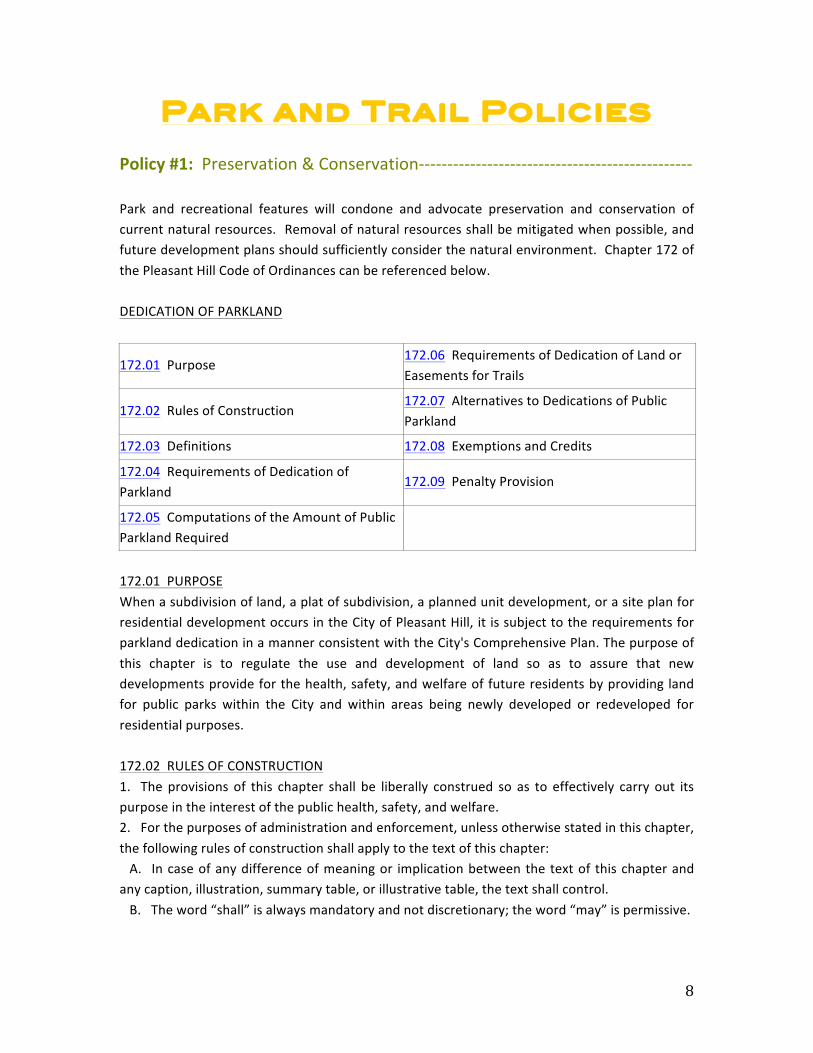
Policy #1: Preservation & Conservation-‐-‐-‐-‐-‐-‐-‐-‐-‐-‐-‐-‐-‐-‐-‐-‐-‐-‐-‐-‐-‐-‐-‐-‐-‐-‐-‐-‐-‐-‐-‐-‐-‐-‐-‐-‐-‐-‐-‐-‐-‐-‐-‐-‐-‐-‐-‐-‐ Park and recreational features will condone and advocate preservation and conservation of current natural resources. Removal of natural resources shall be mitigated when possible, and future development plans should sufficiently consider the natural environment. Chapter 172 of the Pleasant Hill Code of Ordinances can be referenced below. DEDICATION OF PARKLAND
172.01 Purpose 172.06 Requirements of Dedication of Land or Easements for Trails
172.02 Rules of Construction 172.07 Alternatives to Dedications of Public Parkland
172.03 Definitions 172.08 Exemptions and Credits
172.04 Requirements of Dedication of Parkland
172.09 Penalty Provision
172.05 Computations of the Amount of Public Parkland Required 172.01 PURPOSE When a subdivision of land, a plat of subdivision, a planned unit development, or a site plan for residential development occurs in the City of Pleasant Hill, it is subject to the requirements for parkland dedication in a manner consistent with the City's Comprehensive Plan. The purpose of this chapter is to regulate the use and development of land so as to assure that new developments provide for the health, safety, and welfare of future residents by providing land for public parks within the City and within areas being newly developed or redeveloped for residential purposes. 172.02 RULES OF CONSTRUCTION 1. The provisions of this chapter shall be liberally construed so as to effectively carry out its purpose in the interest of the public health, safety, and welfare. 2. For the purposes of administration and enforcement, unless otherwise stated in this chapter, the following rules of construction shall apply to the text of this chapter: A. In case of any difference of meaning or implication between the text of this chapter and any caption, illustration, summary table, or illustrative table, the text shall control. B. The word “shall” is always mandatory and not discretionary; the word “may” is permissive.
9
C. Words used in the present tense shall include the future; and words used in the singular number shall include the plural, and the plural the singular, unless the context clearly indicates the contrary. D. The phrase “used for” includes “arranged for”, “designed for”, “maintained for” or “occupied for”. E. The word “person” includes an individual, a corporation, a partnership, an incorporated association, or any other legal entity. F. Unless the context clearly indicates the contrary, where a regulation involves two (2) or more items, conditions, provisions, or events connected by the conjunction and, or, or either ...or, the conjunction shall be interpreted as follows: (1) “And” indicates that all the connected terms, conditions, provisions, or events shall apply. (2) “Or” indicates that the connected items, conditions, provisions, or events may apply singly or in any combination. (3) “Either ...or” indicates that the connected items, conditions provisions or events shall apply singly but not in combination. G. The word “includes” shall not limit a term to the specific example, but is intended to extend its meaning to all other instances or circumstances of like kind or character. H. “Zoning Administrator” means the zoning administrator or the municipal official(s) he/she may designate to carry out the administration of this chapter. 172.03 DEFINITIONS 1. “Capital improvement” includes parks planning, land acquisition, site improvements, buildings, and equipment but excludes maintenance and operation. 2. “Developer” means any person, individual, firm, partnership, association, corporation, estate, trust or other entity acting or proposing to subdivide land for the construction of any of the residential buildings identified in Section 172.05. 3. “Development order” means a regulatory approval by the City. 4. “Dwelling unit” means a room or group of rooms which are arranged, designed, or used as a dwelling for the occupancy of one (1) family containing sleeping, bathroom, and kitchen facilities. 5. “Mobile home unit” is defined in Section 165.03 (79). 6. “Multiple-‐family dwelling” means a dwelling designed for or occupied by three (3) or more families with separate housekeeping and cooking facilities for each, but excluding townhomes or condominiums. 7. “Park” means any neighborhood park or neighborhood recreational trail. 8. “Pond” means any still body of standing water. 9. “Private recreational facility” means any recreational facility which is not owned by or dedicated to the City. 10. “Recreational facility improvements” consist of the acquisition and installation of equipment, building construction, grading, landscaping and extension of services. These

10
improvements include only those activities that are directly associated with the development of the proposed recreational facilities from raw ground. 11. “Single-‐family attached dwelling” includes a two family dwelling, townhomes and condominiums. 12. “Single-‐family detached dwelling” means the same as a single-‐family dwelling. 13. “Waterway” means a channel through which water runs. 172.04 REQUIREMENTS OF DEDICATION OF PARKLAND 1. Any developer who, after the effective date of the ordinance codified in this chapter (August 18, 2004), seeks to develop land for residential purposes within the City shall be required to dedicate public parkland. 2. No new plats or site plans for residential development shall be approved unless and until the provisions of this chapter are complied with. 172.05 COMPUTATIONS OF THE AMOUNT OF PUBLIC PARKLAND REQUIRED This section shall prescribe the minimum amount of space to be provided in a proposed development for use as a public park. Such space shall be required to be provided for by a developer who, after the effective date of the ordinance codified in this chapter, seeks to develop land within the City by submitting a plat or site plan for approval. 1. The amount of public parkland required in a proposed development shall be a minimum of 20,000 square feet and computed as follows: A. Residential Occupancy Per Living Units. In determining the anticipated occupancy for the proposed development, it shall be assumed that the following dwellings will accommodate the following number of individuals:
LAND USE TYPE (UNIT)
Individuals Per Each Residential Living Unit
Single-‐Family Detached 2.980 individuals
Single-‐Family Attached 1.954 individuals
Multi-‐Family 1.615 individuals
Mobile Home each Unit 1.600 individuals
B. Public Parkland Per Individual. In determining the space required for public parkland in a proposed development, it shall be required that 5 acres of recreational space be provided for every 1,000 individuals. Since some developments will not house 1,000 individuals, the space requirement is to be applied on a per individual basis. Therefore, .005 acres of public parkland shall be provided for each individual proposed to be housed in the new development based on the assumptions contained in paragraph 1A, above. C. Calculation of Required Public Parkland for Each Development.

11
(1) For single family detached developments generally intended for individual ownership, the following formula shall be utilized: (number of lots) x (2.980 individuals/lot) x (.005 acres/individual) Example for illustration purposes only: For a single family detached residential development subject to the requirements of this chapter that proposes 75 lots, the calculation under this paragraph would be as follows: 75 lots x 2.980 x .005 = 1.118 acres Under this illustration, the developer would be required to dedicate public parkland of at least 1.118 acres of property within the proposed development. (2) For single family attached developments generally intended for individual ownership, the following formula shall be utilized: (number of lots) x (1.954 individuals/lot) x (.005 acres/individual) Example for illustration purposes only: For a single family attached residential development subject to the requirements of this chapter that proposes 75 lots, the calculation under this paragraph would be as follows: 75 lots x 1.954 x .005 = .7328 acres Under this illustration, the developer would be required to dedicate public parkland of at least .7328 acres of property within the proposed development. (3) For multi-‐family developments generally intended for rental, the following formula shall be utilized: (number of units) x (1.615 individuals/unit) x (.005 acres/individual) (Note: The 1.615 is based upon 2000 census for rental occupancy.) Example for illustration purposes only: For a multi-‐family residential development subject to the requirements of this chapter that proposes 100 units, the calculation under this paragraph would be as follows: 100 units x 1.615 x .005 = .8075 acres Under this illustration, the developer would be required to dedicate public parkland of at least .8075 acres of property within the proposed development. (4) For mobile home developments, the following formula shall be utilized: (number of lots) x (1.60 individuals/lot) x (.005 acres/individual) Example for illustration purposes only: For a mobile home development subject to the requirements of this chapter that proposes 75 mobile home lots, the calculation under this paragraph would be as follows: 75 lots x 1.60 x .005 = .60 acres Under this illustration, the developer would be required to dedicate public parkland of at least .60 acres of property within the proposed development. 2. If a plat or site plan is requested for mixed uses, then subsection 1 of this section shall apply only to those areas of the plat or site plan devoted to residential uses. 3. The dedicated public parkland may include waterways and ponds, provided the area of such waterways and ponds is not used to satisfy the amount of public park land required in subsection 1 of this section.
12
4. In the case of change of use, redevelopment, expansion, or modification of an existing use which requires the approval of an amended plat or site plan, the above space requirements for public parkland shall be based upon the new lots or new units being proposed for development. 5. Where proposed subdivisions abut undeveloped lands, the dedicated public parkland shall be located adjacent to the subdivision boundaries with the undeveloped land, at the discretion of the Council, to allow the public parkland to be increased in size when the adjacent property develops. 6. The amount of public parkland required to be dedicated under this section shall be capped and shall not exceed the following percentages when compared to the amount of acres being developed. A. Single-‐Family Detached. The amount of acres required to be dedicated as public parkland shall not exceed 5% of the total number of acres being developed as single-‐family detached. B. Single-‐Family Attached and Multi-‐family. The amount of acres required to be dedicated as public parkland shall not exceed 10% of the total number of acres being developed, as long as the proposed development does not exceed 12 units per acre. If the proposed development exceeds 12 units per acre, the amount of acres required to be dedicated as public parkland shall not exceed 15% of the total number of acres being developed as single-‐family attached or multifamily. C. Mobile Homes. The amount of acres required to be dedicated as public parkland shall not exceed 10% of the total number of acres being developed as mobile homes. 172.06 REQUIREMENTS OF DEDICATION OF LAND OR EASEMENTS FOR TRAILS Where bike/pedestrian or recreational trails are indicated in the Comprehensive Plan the developer shall be required to dedicate land or trail easements of at least twenty (20) feet in width. This land or easements, if approved by the Council, may serve to satisfy parkland dedication requirements. 172.07 ALTERNATIVES TO DEDICATIONS OF PUBLIC PARKLAND If a developer does not desire to dedicate public parkland required in Section 172.05, the developer may make a request to the Council that the developer be allowed to meet the requirements of Section 172.05 through other arrangements agreeable to the Council and the developer as long as such agreement provides equal value to the City. Such arrangements shall be made between the Council and the developer in the form of a Development Agreement. 172.08 EXEMPTIONS AND CREDITS The following shall be exempted from the requirements of Sections 172.04, 172.05 and 172.06: 1. Alterations or expansion of an existing building where no additional residential units are created and where the use is not changed. 2. The construction of accessory buildings or structures. 3. The replacement of a destroyed or partially destroyed building or structure with a new building or structure of the same size and use. 4. The installation of a replacement mobile home.
13
5. The construction of any non-‐residential building or structure or the installation of a non-‐residential mobile home. 6. Minor subdivisions as defined in Section 175.08 (1). Any claim of exemption shall be made no later than the time of application for a preliminary plat approval. Any claim not so made shall be deemed waived. 172.09 PENALTY PROVISION A violation of this chapter shall be prosecuted in the same manner as misdemeanors are prosecuted and upon conviction the violator shall be punishable according to law; however, in addition to or in lieu of any criminal prosecution, the City shall have the power to issue a civil infraction for any violation of this chapter and shall be entitled to any fines, injunctive relief, and other remedies allowed the City under the civil infraction provisions of the Code of Iowa. It is specifically declared that the failure of a developer, individual, or entity to comply with the provisions of this chapter shall be a nuisance subject to all fines and remedies provided in this Code. (Ch. 172 -‐ Ord. 610 – Aug. 04 Supp.)
Policy #2: Future Development-‐-‐-‐-‐-‐-‐-‐-‐-‐-‐-‐-‐-‐-‐-‐-‐-‐-‐-‐-‐-‐-‐-‐-‐-‐-‐-‐-‐-‐-‐-‐-‐-‐-‐-‐-‐-‐-‐-‐-‐-‐-‐-‐-‐-‐-‐-‐-‐-‐-‐-‐-‐-‐-‐-‐-‐-‐-‐ Parks and trails shall be located and sized to serve the growing population. Future developers should work with the city to provide the newly developing community with adequate and useful parks. Future trails will work with existing trails and parks to promote connectivity to new developments in the eastern corridor of the community.
Policy #3: Design and Safety-‐-‐-‐-‐-‐-‐-‐-‐-‐-‐-‐-‐-‐-‐-‐-‐-‐-‐-‐-‐-‐-‐-‐-‐-‐-‐-‐-‐-‐-‐-‐-‐-‐-‐-‐-‐-‐-‐-‐-‐-‐-‐-‐-‐-‐-‐-‐-‐-‐-‐-‐-‐-‐-‐-‐-‐-‐-‐-‐-‐-‐-‐ The city will provide the Pleasant Hill community with safely designed parks for a diverse population. Park and trail designs should allow for a diverse population to utilize the space simultaneously. Trails will provide multi-‐modal nonautomotive transportation uses, and bicycle and pedestrian crossing points shall be properly identified. In addition, maintenance services should be provided for all parks and trails in order to prevent safety hazards to bicyclists and pedestrians utilizing the space.
Policy #4: Connectivity-‐-‐-‐-‐-‐-‐-‐-‐-‐-‐-‐-‐-‐-‐-‐-‐-‐-‐-‐-‐-‐-‐-‐-‐-‐-‐-‐-‐-‐-‐-‐-‐-‐-‐-‐-‐-‐-‐-‐-‐-‐-‐-‐-‐-‐-‐-‐-‐-‐-‐-‐-‐-‐-‐-‐-‐-‐-‐-‐-‐-‐-‐-‐-‐-‐-‐-‐-‐-‐-‐ Parks, trails, and other means of recreation will promote connectivity and cohesiveness within the community. The park system should work with the trail system to promote cohesiveness and connectivity. The trail system should promote the ability to travel around the city by recreational and nonautomotive means.
14
Parks
Park Classifications-‐-‐-‐-‐-‐-‐-‐-‐-‐-‐-‐-‐-‐-‐-‐-‐-‐-‐-‐-‐-‐-‐-‐-‐-‐-‐-‐-‐-‐-‐-‐-‐-‐-‐-‐-‐-‐-‐-‐-‐-‐-‐-‐-‐-‐-‐-‐-‐-‐-‐-‐-‐-‐-‐-‐-‐-‐-‐-‐-‐-‐-‐-‐-‐-‐-‐-‐-‐-‐-‐-‐-‐-‐-‐-‐ Offering a community with a range of parks in sizes and amenities is vital to having a comprehensive park system. A categorical park system is used in order to assess existing parks, and plan for the development of future parks. Each of Pleasant Hill’s parks are classified by size and amenities under the following specifics: Mini Parks Mini parks generally address specific recreation or open space needs. These parks will cover less than 1 acre and have a service area of ¼ mile. Oak Hill Park, Sunset Park, Dar Mar Park and Christie Lane Park are examples of existing mini parks in Pleasant Hill. Generally, no parking facilities are provided for visitors, and the park space is often small, open grassland unspecified for use. Due to maintenance difficulties with mini parks, most cities don’t focus their efforts towards the development of these parks. Neighborhood Parks Neighborhood parks are considered the basic unit of a community’s park system, and provide a recreational and social focus for residential areas. These parks provide space for informal active and passive recreational activities. Neighborhood parks typically cover between 5 and 10 acres. The typical service radius for neighborhood parks is between ¼ and ½ mile. Of this total acreage, 2 to 3 acres should be a relatively flat, open space area suitable for a number of activities including pick-‐up ball games and soccer practice. Sunrise Park is an example of a current neighborhood park in the Pleasant Hill community. School Parks School facilities can help a community meet neighborhood park needs, particularly when located in areas not currently served by parks. The playgrounds, open space, play fields, and basketball courts offered often make schools function as neighborhood parks and typically attract residents within ¼ mile to ½ mile. Pleasant Hill currently provides facilities such as 4 Mile Creek Elementary School and Southeast Polk High School to serve as school parks. Although these facilities often help meet a neighborhood’s need for additional recreation space, the city should not depend on these sites to meet the neighborhood park needs. Schools in Pleasant Hill do not currently provide any facilities for community use—only facilities to be used by students who attend those schools. Cities should consider developing parks in conjunction with or adjacent to school sites, creating a civic destination center within areas of new growth. Community Parks These types of parks typically include areas of diverse use and environmental quality. Such parks meet community-‐based recreational needs, may preserve significant natural areas, and

15
often include areas suited for intense recreational facilities. Typical criteria for community parks include: 1) Adequate size to accommodate activities associated with neighborhood parks, but with space for additional activity; and 2) A special attraction that draws people from a larger area, such as a pond or lake, ice skating rink, trails, special environmental or cultural features, or specialized parks. Community parks generally contain between 20 and 50 acres and serve a variety of needs. The typical service radius of a community park is approximately ½ mile to 2 miles. Doanes Park and Copper Creek Lake Park are two examples of community parks currently serving Pleasant Hill. Doanes Park is about 47 acres in size and contains unique community features such as little league fields, a gazebo, and parking availability. Doanes Park is a venue that holds numerous community celebrations, including wedding events. Copper Creek Lake Park is about 62 acres and contains some of the most utilized community features such as the lighted trail surrounding the lake. Special Use Parks These parks typically cover a broad range of facilities and activities oriented toward a single use, including cultural or social sites and specialized facilities. A specialized park, such as one for soccer or baseball, is an example of a special use park. The Pleasant Hill Community Garden is a current example of a special use park in the city.
Existing Parks-‐-‐-‐-‐-‐-‐-‐-‐-‐-‐-‐-‐-‐-‐-‐-‐-‐-‐-‐-‐-‐-‐-‐-‐-‐-‐-‐-‐-‐-‐-‐-‐-‐-‐-‐-‐-‐-‐-‐-‐-‐-‐-‐-‐-‐-‐-‐-‐-‐-‐-‐-‐-‐-‐-‐-‐-‐-‐-‐-‐-‐-‐-‐-‐-‐-‐-‐-‐-‐-‐-‐-‐-‐-‐-‐-‐-‐-‐-‐-‐-‐-‐ Doanes Park – 4900 Doanes Park Rd Doanes Park is the oldest park in Pleasant Hill, covering 47 acres of land, and serving the community with many features for active and passive recreation. Located on South Pleasant Hill Boulevard this park’s multiple amenities serve the neighborhood, school, and community. Facilities include two open shelters, one enclosed shelter, two restrooms, four baseball diamonds, two playgrounds, three tennis courts, one basketball court, six soccer fields, and 211 parking stalls. The youth center is located on the eastern edge of the park, and serves as the location for many community recreation programs and activities year-‐round. Copper Creek Lake Park – 4390 E University Ave A lighted 1.22-‐mile trail surrounds Copper Creek’s 40-‐acre lake. A playground, restrooms, shelter, fishing, and trail provide leisurely activities for families throughout this entire 62-‐acre park. Copper Creek Lake Park also offers non-‐gas powered, carry-‐in boating with access at the
Fig. 3

16
south end of the park. Cyclists and walkers can enjoy traveling through the heart of this park as part of the Gay Lea Wilson Trail system that connects Pleasant Hill to several other communities in the Des Moines Metropolitan Area. Lake-‐view dining, neighboring shopping opportunities, and local entertainment are available on the park’s southeast side. A plaza for special events and parking is located on the southwest corner of the park. Additional parking is available off of 42nd St and E Washington Ave. Located along E University Ave near HWY 65, this park is easily accessible from Pleasant Hill as well as the Des Moines community. Additional parking and a trailhead, managed by the City of Des Moines, are available on the northwest side and are accessible from Williams St. The park has become a major draw for special events such as the Copper Creek Triathlon, Chill on the Hill, Family Fest, and various private walk/run events. Oak Hill Park– 2115 Copper Wynd Dr This 1.75-‐acre neighborhood park features a shelter with electricity, drinking fountain, an informal open play area, a regulation size basketball court and modern play equipment. The playground equipment includes a two-‐seat swing, a tire swing, spider climber, and a funnel tunnel slide. Sunrise Park -‐ 5414 E Oakwood Dr This 7.64-‐acre neighborhood park is located south of E University Ave on E Oakwood Dr, west of NE 56th Ave. An open shelter, restrooms, playground, full basketball court, informal ball diamond and soccer fields are great for accommodating youth soccer practices and small gatherings. In 2009 the facility received some much-‐needed improvements. The shelter was re-‐shingled and sidewalks were installed to allow for better connectivity between the park features. An electric service panel was placed near the shelter as well. Future improvements call for an upgrade to the basketball courts (new hoops and surface overlay).
Fig. 4
Fig. 5
Fig. 5
Fig. 6
17
Sunset Park – 4490 E Oakwood Dr This 2.32-‐acre neighborhood park located on Oakwood Dr includes a drinking fountain, portable restroom, and picnic tables. Over the past ten years the park has primarily been used for youth soccer practice and games. Twenty-‐nine parking spaces are available at the park. Dar Mar Park – Intersection of N Shadyview Blvd and E Oakwood Dr This 0.20-‐acre park is located at the intersection of Oakwood Dr and N Shadyview Blvd. This narrow strip of space includes an informal open play area and a swing set. The most recent master plan review indicates that this park lacks space in order to make any improvements.
18
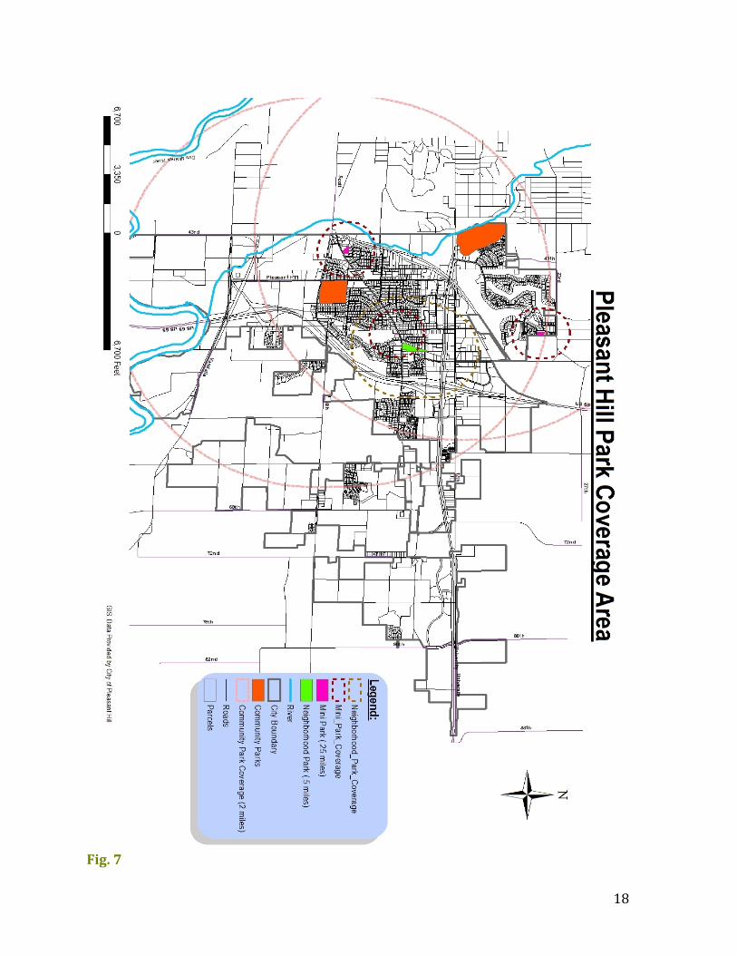
Fig. 7
19
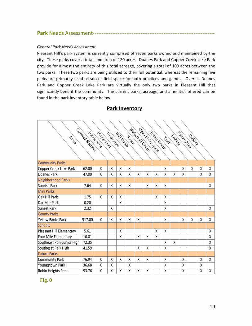
Park Needs Assessment-‐-‐-‐-‐-‐-‐-‐-‐-‐-‐-‐-‐-‐-‐-‐-‐-‐-‐-‐-‐-‐-‐-‐-‐-‐-‐-‐-‐-‐-‐-‐-‐-‐-‐-‐-‐-‐-‐-‐-‐-‐-‐-‐-‐-‐-‐-‐-‐-‐-‐-‐-‐-‐-‐-‐-‐-‐-‐-‐-‐-‐-‐-‐-‐-‐-‐-‐-‐-‐ General Park Needs Assessment Pleasant Hill’s park system is currently comprised of seven parks owned and maintained by the city. These parks cover a total land area of 120 acres. Doanes Park and Copper Creek Lake Park provide for almost the entirety of this total acreage, covering a total of 109 acres between the two parks. These two parks are being utilized to their full potential, whereas the remaining five parks are primarily used as soccer field space for both practices and games. Overall, Doanes Park and Copper Creek Lake Park are virtually the only two parks in Pleasant Hill that significantly benefit the community. The current parks, acreage, and amenities offered can be found in the park inventory table below.
Acres
Covered Shelters
Picnic Area
Playground
Restrooms
Ball Fields
Soccer
Basketball Courts
Open Field Space
Tennis Courts
Trail
Fishing
Nature Area
Parking
Community)Parks)Copper)Creek)Lake)Park 62.00 X X X X X X X X XDoanes)Park 47.00 X X X X X X X X X X X XNeighborhood)ParksSunrise)Park 7.64 X X X X X X X XMini)ParksOak)Hill)Park 1.75 X X X X XDar)Mar)Park 0.20 X XSunset)Park 2.32 X X XCounty)ParksYellow)Banks)Park 517.00 X X X X X X X X X XSchoolsPleasant)Hill)Elementary 5.61 X X X XFour)Mile)Elementary 10.01 X X X X XSoutheast)Polk)Junior)High 72.35 X X XSouthesat)Polk)High 41.59 X X X XFuture)ParksCommunity)Park) 76.94 X X X X X X X X X XYoungstown)Park 36.68 X X ) X X X XRobin)Heights)Park 93.76 X X X X X X X X X X
Fig. 8
Park Inventory

20
The park space currently offered in Pleasant Hill is roughly 120 acres for the community’s current population of 9,009. According to the APA, the recommended acreage of recreational use provided for a population is 1 acre per 66 2/3 people. In accordance with this APA recommendation, Pleasant Hill currently lacks 15 acres of recreational land use. By 2025, Pleasant Hill’s population is projected to grow to 16,009 people, requiring a total of 240.38 acres of recreational land use, in accordance with the APA recommendation. The projected population growth pattern can be viewed in the graph below.
Park and recreational development should focus on a primary objective of meeting multiple interests and needs with a diversity of amenities by providing adequate recreational facilities for all people. A proportional distribution of parks is needed throughout the community, ranging from neighborhood parks to community parks, to special use parks—all of which offering something unique to the community, and fulfilling the primary objective of meeting multiple interests and needs with a diversity of amenities. When selecting sites for future parks and current park revitalization strategies, a key component should be how the space interacts with Pleasant Hill’s surrounding landscape. The ability to connect to greenways and natural areas will help build trails, providing Pleasant Hill with better connectivity between different parks and amenities. With this ability, many residents will have the opportunity to experience different recreational opportunities. Development of new parks also needs to coincide heavily with ideal locations of future residential development and trails, especially in the eastern corridor where there is currently
Fig. 9
21
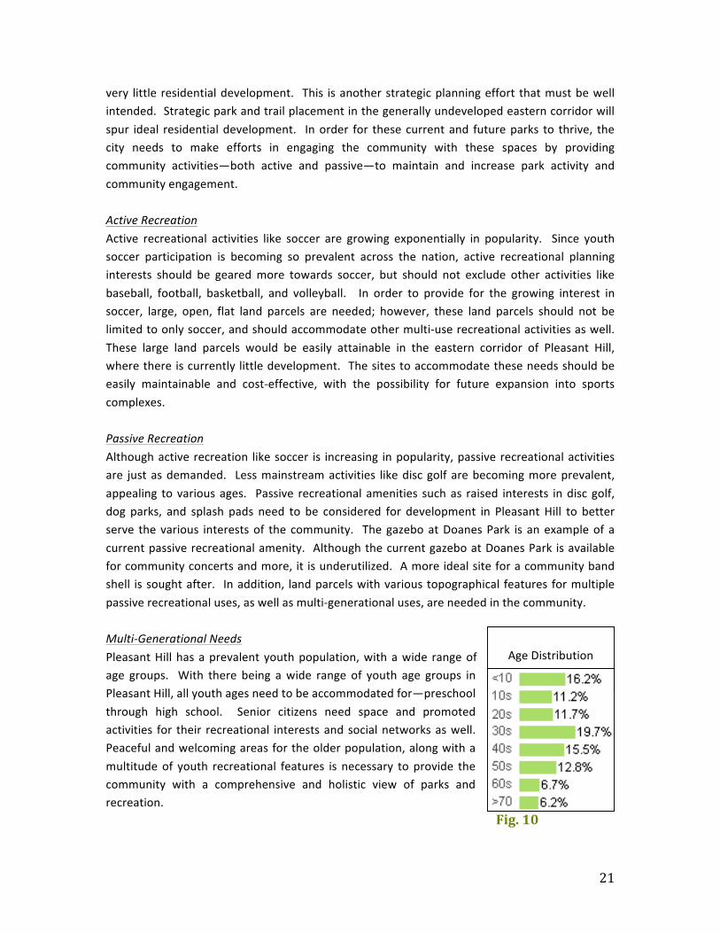
very little residential development. This is another strategic planning effort that must be well intended. Strategic park and trail placement in the generally undeveloped eastern corridor will spur ideal residential development. In order for these current and future parks to thrive, the city needs to make efforts in engaging the community with these spaces by providing community activities—both active and passive—to maintain and increase park activity and community engagement. Active Recreation Active recreational activities like soccer are growing exponentially in popularity. Since youth soccer participation is becoming so prevalent across the nation, active recreational planning interests should be geared more towards soccer, but should not exclude other activities like baseball, football, basketball, and volleyball. In order to provide for the growing interest in soccer, large, open, flat land parcels are needed; however, these land parcels should not be limited to only soccer, and should accommodate other multi-‐use recreational activities as well. These large land parcels would be easily attainable in the eastern corridor of Pleasant Hill, where there is currently little development. The sites to accommodate these needs should be easily maintainable and cost-‐effective, with the possibility for future expansion into sports complexes. Passive Recreation Although active recreation like soccer is increasing in popularity, passive recreational activities are just as demanded. Less mainstream activities like disc golf are becoming more prevalent, appealing to various ages. Passive recreational amenities such as raised interests in disc golf, dog parks, and splash pads need to be considered for development in Pleasant Hill to better serve the various interests of the community. The gazebo at Doanes Park is an example of a current passive recreational amenity. Although the current gazebo at Doanes Park is available for community concerts and more, it is underutilized. A more ideal site for a community band shell is sought after. In addition, land parcels with various topographical features for multiple passive recreational uses, as well as multi-‐generational uses, are needed in the community. Multi-‐Generational Needs Pleasant Hill has a prevalent youth population, with a wide range of age groups. With there being a wide range of youth age groups in Pleasant Hill, all youth ages need to be accommodated for—preschool through high school. Senior citizens need space and promoted activities for their recreational interests and social networks as well. Peaceful and welcoming areas for the older population, along with a multitude of youth recreational features is necessary to provide the community with a comprehensive and holistic view of parks and recreation.
Age Distribution
Fig. 10

22
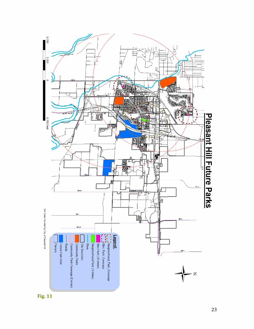
Future Parks-‐-‐-‐-‐-‐-‐-‐-‐-‐-‐-‐-‐-‐-‐-‐-‐-‐-‐-‐-‐-‐-‐-‐-‐-‐-‐-‐-‐-‐-‐-‐-‐-‐-‐-‐-‐-‐-‐-‐-‐-‐-‐-‐-‐-‐-‐-‐-‐-‐-‐-‐-‐-‐-‐-‐-‐-‐-‐-‐-‐-‐-‐-‐-‐-‐-‐-‐-‐-‐-‐-‐-‐-‐-‐-‐-‐-‐-‐-‐-‐-‐-‐-‐ This future park plan designates three areas that would be ideal in contributing to a comprehensive park and trail plan. These sites will offer multiple features and amenities to the community. The community has had a growing interest in large, open, flat land parcels that can be primarily used for soccer. In that regard, each of these proposed park sites would help fulfill that community interest. The proposed land parcels have been assessed by their maximum acreage possible for development, although not every acre of each site must be utilized. Within each area, preservation and conservation of natural resources should be a main priority.
23
Fig. 11
24
Site #1 (76.94 total acres) – Community Park This site is located directly behind Four Mile Elementary School on SE 6th Ave and SE 68th St, which is zoned by agricultural land. The entire agricultural area accounts for 76.94 total acres of land, surrounded by 46 acres of established cultivated land, and 31 acres of mixed timber. This area includes the most sought after parcel of land that may be available for potential development. This land parcel has been considered for development since 1998, and now is the time to move forward and utilize this ideal space to its potential. The proposed development for this parcel of land would be to incorporate a large area of open space, ideal for soccer fields. This area is spacious, and has the potential to increase activity levels and residential development. There currently are existing soccer fields located in other areas and parks throughout Pleasant Hill; however, future development of this particular site will provide a common place for active sports, like soccer, requiring large open spaces. Site #2 (36.68 total acres) – Youngstown Park This site is located along the western edge of HWY 65, connected to SE Parkridge Dr. This site is also adjacent to Jordan Blvd, which is neighboring to a one and two family residential area made up of low-‐density estates. The entire agricultural area accounts for 36.68 total acres of land, surrounded by 26.5 acres of established cultivated land, 1 acre of fallow land, and 8.8 acres of mixed timber. Being located next to a residential community, this spacious site can offer multiple means of recreation to these immediate neighbors, as well as other residents in the community. The proposed development for this parcel of land is to create a neighborhood park used for multiple purposes. This park would be ideal in the northern corner of the site. A future trail will pass through this park, and connect to the nearby community where residents will be able to easily access this trail. This trail development would enhance the Youngstown trail loop in that area. Site #3 (93.76 total acres) – Robin Heights Park Located on the eastern edge of HWY 65 directly across from Site #2, this site is currently zoned as an agricultural land. Within this site are five separate, connected sub-‐parcels. The Department of Transportation (DOT) currently owns the two northern sub-‐parcels of this site. Three of the five sub-‐parcels are privately owned by the Sunrise Developing Company. These three privately owned sub-‐parcels account for 23.657 total acres of land. The two DOT-‐owned sub-‐parcels account for 69.505 total acres, and are a priority for future development. Both DOT-‐owned sub-‐parcels are agriculturally zoned and the topography of land is primarily flat. The proposed development for this parcel of land is important because it can be a huge opportunity for integrating park space in the eastern corridor of the community. There are currently a few existing neighborhood facilities nearby; however, this plan will provide a framework for development in the eastern corridor. The proposed development for this site
25
could be another place to incorporate large open spaces of land ideal for soccer fields. This area would also be a good place to incorporate a community park. This future development will attract people commuting through Highway 65 and nearby communities. It would be ideal if Pleasant Hill were able to develop some agreements with the property owners of the Sunrise Developing Company, ensuring that those privately owned sub-‐parcels might need to be acquired within the next few years for park development purposes. Even if the city is unable to acquire the privately owned land parcels, the two DOT-‐owned land parcels are very sizable themselves, and would be ample for development.
Trails
Existing Trails-‐-‐-‐-‐-‐-‐-‐-‐-‐-‐-‐-‐-‐-‐-‐-‐-‐-‐-‐-‐-‐-‐-‐-‐-‐-‐-‐-‐-‐-‐-‐-‐-‐-‐-‐-‐-‐-‐-‐-‐-‐-‐-‐-‐-‐-‐-‐-‐-‐-‐-‐-‐-‐-‐-‐-‐-‐-‐-‐-‐-‐-‐-‐-‐-‐-‐-‐-‐-‐-‐-‐-‐-‐-‐-‐-‐-‐-‐-‐-‐-‐-‐
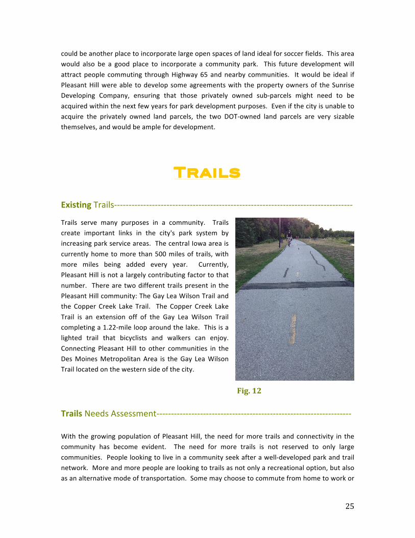
Trails serve many purposes in a community. Trails create important links in the city's park system by increasing park service areas. The central Iowa area is currently home to more than 500 miles of trails, with more miles being added every year. Currently, Pleasant Hill is not a largely contributing factor to that number. There are two different trails present in the Pleasant Hill community: The Gay Lea Wilson Trail and the Copper Creek Lake Trail. The Copper Creek Lake Trail is an extension off of the Gay Lea Wilson Trail completing a 1.22-‐mile loop around the lake. This is a lighted trail that bicyclists and walkers can enjoy. Connecting Pleasant Hill to other communities in the Des Moines Metropolitan Area is the Gay Lea Wilson Trail located on the western side of the city.
Trails Needs Assessment-‐-‐-‐-‐-‐-‐-‐-‐-‐-‐-‐-‐-‐-‐-‐-‐-‐-‐-‐-‐-‐-‐-‐-‐-‐-‐-‐-‐-‐-‐-‐-‐-‐-‐-‐-‐-‐-‐-‐-‐-‐-‐-‐-‐-‐-‐-‐-‐-‐-‐-‐-‐-‐-‐-‐-‐-‐-‐-‐-‐-‐-‐-‐-‐-‐-‐-‐ With the growing population of Pleasant Hill, the need for more trails and connectivity in the community has become evident. The need for more trails is not reserved to only large communities. People looking to live in a community seek after a well-‐developed park and trail network. More and more people are looking to trails as not only a recreational option, but also as an alternative mode of transportation. Some may choose to commute from home to work or
Fig. 12
26
school via trails. Pleasant Hill must provide these trails in order to satisfy their needs and expectations. A comprehensive trail system will attract people to the community and promote sociability and stronger ties amongst current and future residents. There is an obvious lack of a comprehensive trail system in not only the eastern corridor, but also in Pleasant Hill as a whole. The rising need for safe trails that provide connectivity for the community’s residents is not being met. As already mentioned, the Gay Lea Wilson Trail runs for a total of 9.73 miles, and the Copper Creek Lake Trail runs for a total of 1.22 miles; both of these trails lack overall connectivity in the community. They primarily serve the western corridor of Pleasant Hill, and serve no role in the eastern corridor of the community. Although these trails serve the western corridor, there remains a lack of connectivity between the two. A main reason for this gap in connectivity is E University Ave, a main artery for automotive travel in Pleasant Hill. There needs to be a safe and effective trail connection at this point. It is essential to provide viable and accessible means for bicyclists and pedestrians to safely travel through and between communities. It is important for Pleasant Hill to develop a plan to protect its natural green areas and identify wetland areas. Included must be essential aspects of Pleasant Hill, such as wildlife viewing areas, trailheads, and natural prairies. Greenway and trail systems should serve these multiple purposes, as well as recreational and transportation needs that contribute to values of trail development. A sustainable trail plan provides high quality recreational experiences for trail users and protects the natural beauty of the environment. Any future development for greenway and trail systems should be built to enhance the existing systems to allow connectivity between the two.
Future Trails-‐-‐-‐-‐-‐-‐-‐-‐-‐-‐-‐-‐-‐-‐-‐-‐-‐-‐-‐-‐-‐-‐-‐-‐-‐-‐-‐-‐-‐-‐-‐-‐-‐-‐-‐-‐-‐-‐-‐-‐-‐-‐-‐-‐-‐-‐-‐-‐-‐-‐-‐-‐-‐-‐-‐-‐-‐-‐-‐-‐-‐-‐-‐-‐-‐-‐-‐-‐-‐-‐-‐-‐-‐-‐-‐-‐-‐-‐-‐-‐-‐-‐-‐-‐ Implementing future trails for walking, bicycling, and hiking are vital in attaining a desirable and adequate trail network in Pleasant Hill. These trails are fundamental for the recreation of the community, and are shared among many different users. The goal of the future trail system is to connect the newly developing community with other existing trails, as well as current and future parks. Connective trail use will help promote alternative forms of transportation for commuting to and from home, school, and work. The ideal plan for trail use is to connect the residents to local businesses and other amenities in the metro area. Connection to the Des Moines metro will allow for further community and economic development. Six Principles for Future Trail Development Six principles for future trail development and use should dictate how the city implements future trails into the community’s trail network. These six principles are as follows:
1. The trail system should be community wide. Pleasant Hill’s community destinations
27
are spread throughout the city, including parks, schools, shopping, and recreation destinations. A citywide system not only provides access to all of these destinations, but also promotes contact among all existing and future neighborhoods and helps visitors experience the city and its unique qualities.
2. The system should benefit a wide variety of users. Although pedestrians and bicyclists are the dominant users of the trails, multiple opportunities in the trail systems can meet the needs of a wide variety of users. Trails can serve all types of people with many different interests and capabilities. The future trails should provide access to people of all ages and activity levels.
3. The system should have multiple benefits. Recreation and physical activity are the primary uses of trails, but trails need to have benefits beyond recreation and health. These benefits include transportation, education, family experience, safety, and economic development.
4. The trail system should create economic opportunities. Trails are increasingly important to the effort of attracting residents and investments. The success of trails nationwide has caused people to expect their own communities to provide high-‐quality trail systems.
5. The trail system must be strategic and sustainable. Pleasant Hill’s future trail system must be focused on areas that will most efficiently and effectively meet both user needs and the overall goals of the city without compromising the financial and funding situation of the city.
6. The system should build on and enhance existing networks and efforts. Future trail development should utilize and build off the existing trails in the community.
Along with abiding by the above guidelines, future trail development will follow regulations and recommendations that are outlined in the current comprehensive plan. It is essential that in order to provide the community with adequate recreational facilities and amenities, they must be properly maintained. Maintenance of the trail system shall be the responsibility of the City of Pleasant Hill. Maintenance includes the trails themselves, and structures located on or near the trail system. Snow removal, landscaping, and pavement repairs are all covered under trail maintenance. Physical Trail Implementation Regulations Listed below are the basic regulations for trail implementation on or along roadways.
• Developers must leave minimum 20 feet for potential trail development through new developments.
• Any new road that is developed will have 8’ minimum for additional connectivity • Any road or street that is shared with a bike lane will have a 5’ minimum width bike
lane that will be clearly marked on pavement and with proper signage. • Off-‐street shared use trails will have 10’ minimum width.

28
• Curb cuts on and off future trails and through intersections will follow the ADA guidelines for accessibility.
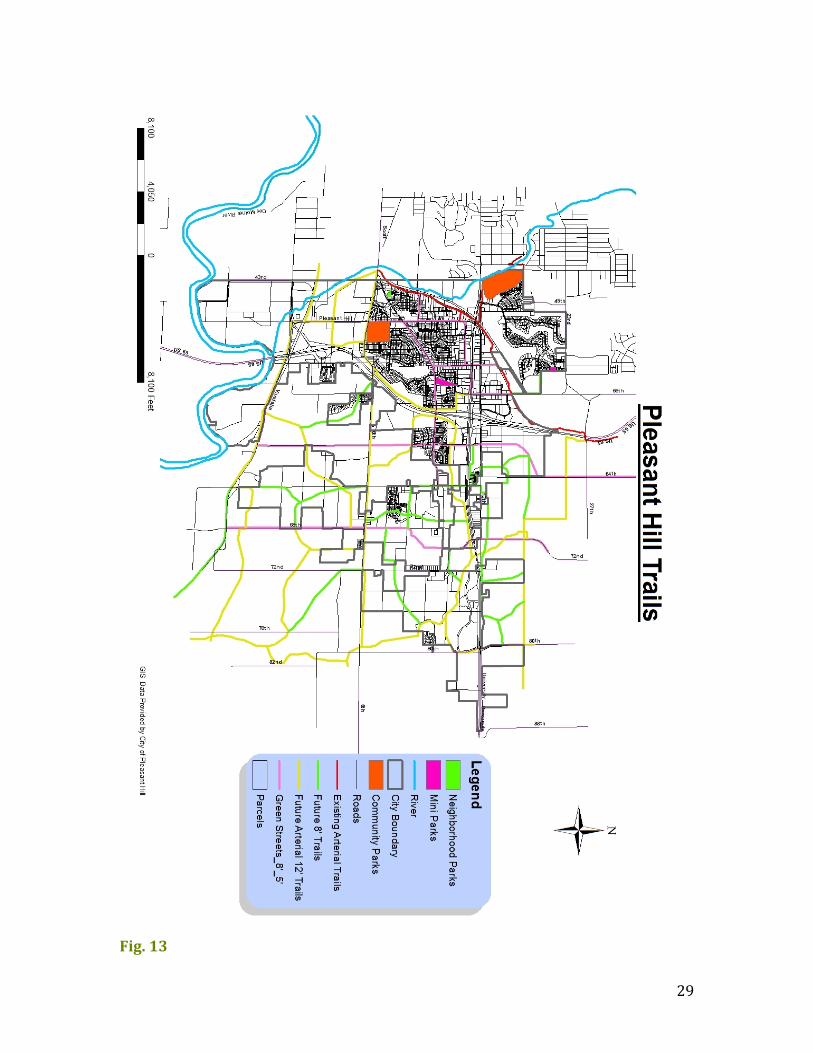
This future trail plan will encompass 8’ secondary and 12’ primary trails, as well as green streets or complete streets. To combat Pleasant Hill’s current lack of east/west trail coverage the city needs to implement these trails along primary east/west connecting points, as well as the generally undeveloped eastern corridor in its entirety. Two of the vital connection points are along HWY 65, at E Oakwood Dr and SE 6th Ave. To further expand and serve a larger role in the eastern corridor of the community, a mix of trails will be implemented, including 8’ trails, 12’ trails, and green streets throughout the corridor. The future trail plan proposes a 12’ trail across SE 6th Ave and an 8’ trail across E Oakwood Dr. The placement of these proposed trails will effectively coincide with the western and eastern corridors of the community. The proposed expanded trail network is designed to attract development in particular areas and spur future residential development in the eastern corridor. The proposed expanded trail network will also provide connectivity between future parks. Below is a list of key influential sites that will provide for effective trail use throughout the entire Pleasant Hill community.
• SE Connector—leading to Des Moines Metro Trails • Gay Lea Wilson Trail • City of Altoona • Copper Creek Park • SE Polk High School • East Oakwood Drive • Safe Crossing Over/Under University Ave.
Trail Classification In order to implement a comprehensive trail system, multiple types of trails should be implemented. There are typically three classifications of trails. These are:
• Shared roadway trail • Nature and recreational trails (8’ and 12’ trails) • Green streets/Complete streets
29
Fig. 13
30
Trails should be designed and implemented uniquely, yet based on a standard set of guidelines. These guidelines will dictate a uniform checklist of trail amenities and features in the Pleasant Hill community. These amenities will be provided to ensure safety and hospitability to users. Trail implementation and design standards are as follows:
• Lighting on trails will be located at poorly lit areas to provide adequate safety and well-‐being.
• Trash will be handled through the use of aesthetically designed trash receptacles, and be maintained by the local municipality. These receptacles will be located at intervals that are deemed appropriate for discarding trash.
• Benches and seating areas will be provided along trails for users of the trails to have a place to rest.
• Water fountains should be provided along water lines on or near trails. These will be provided at locations that are major points of interest such as shelters.
• Shelters will provide trail users a place to protect themselves from the sun or inclement weather, along with a place to sit for breaks. Shelters will be placed in locations where there are no other places to provide shelter, but will be located in places of value. Shelters will also include restrooms.
• Bike racks are vital for trail functions. Racks can be located at shelters, benches, and other points that have potential interest for cyclists using the trails. Racks can also be placed at business near or on the trails.
• Trail access points are necessary for a central trail system. Neighborhood trails will connect to larger, regional trails. These access points will not happen at set intervals, but rather where the terrain and surrounding trails are deemed to be appropriate for connection.
• Way-‐finding signage will be provide along trails that direct users towards parks or other points of interest. Way-‐finding signage will be located in parks to direct park users to other parks and access points to trails. The design of the signage will be part of the unified sign design that was developed by the Greater Des Moines Metropolitan Cities.
The system should build on and enhance existing networks and efforts. Pleasant Hill needs to pursue trail development as suggested in the Des Moines Metropolitan Planning Organization future trails plan. Future trail development should utilize and build off of the existing trail network to create a comprehensive trail network for the community.
31
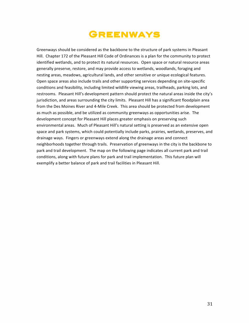
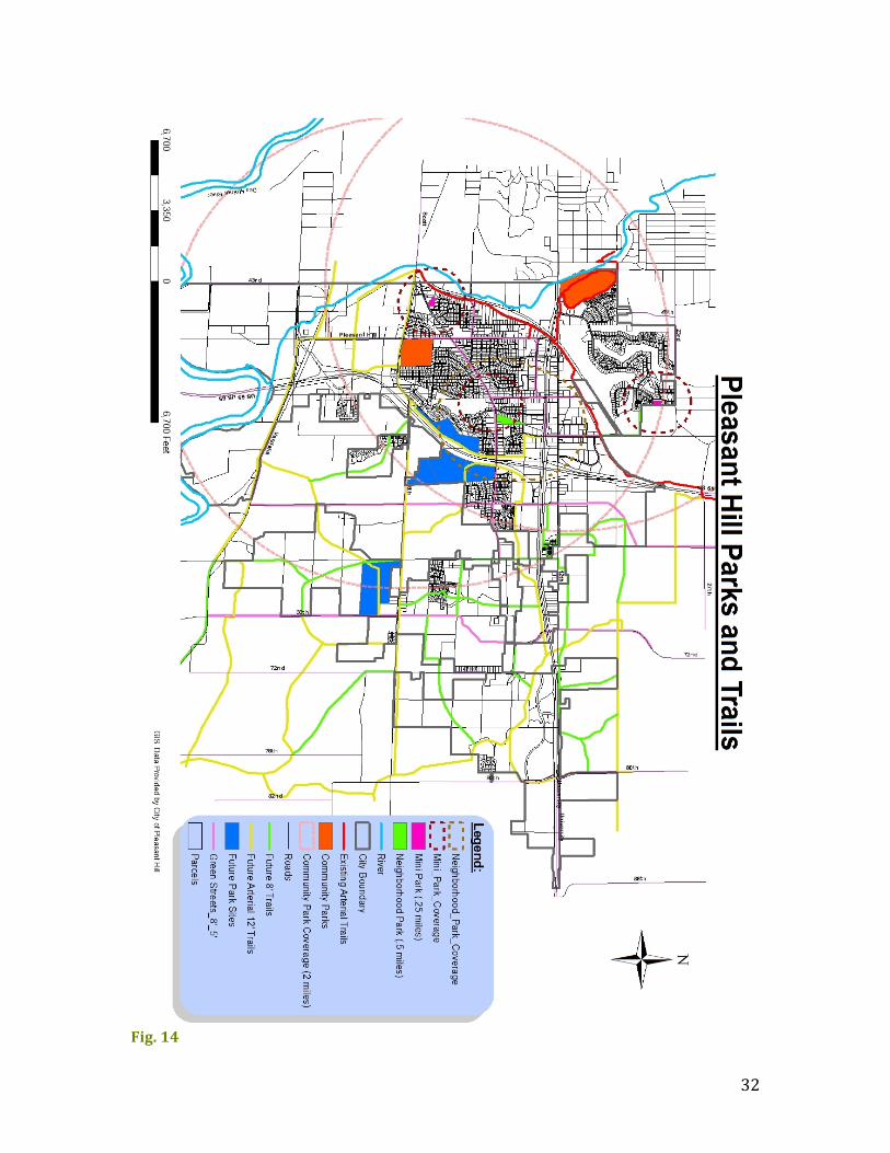
Greenways Greenways should be considered as the backbone to the structure of park systems in Pleasant Hill. Chapter 172 of the Pleasant Hill Code of Ordinances is a plan for the community to protect identified wetlands, and to protect its natural resources. Open space or natural resource areas generally preserve, restore, and may provide access to wetlands, woodlands, foraging and nesting areas, meadows, agricultural lands, and other sensitive or unique ecological features. Open space areas also include trails and other supporting services depending on site-‐specific conditions and feasibility, including limited wildlife viewing areas, trailheads, parking lots, and restrooms. Pleasant Hill’s development pattern should protect the natural areas inside the city’s jurisdiction, and areas surrounding the city limits. Pleasant Hill has a significant floodplain area from the Des Moines River and 4-‐Mile Creek. This area should be protected from development as much as possible, and be utilized as community greenways as opportunities arise. The development concept for Pleasant Hill places greater emphasis on preserving such environmental areas. Much of Pleasant Hill’s natural setting is preserved as an extensive open space and park systems, which could potentially include parks, prairies, wetlands, preserves, and drainage ways. Fingers or greenways extend along the drainage areas and connect neighborhoods together through trails. Preservation of greenways in the city is the backbone to park and trail development. The map on the following page indicates all current park and trail conditions, along with future plans for park and trail implementation. This future plan will exemplify a better balance of park and trail facilities in Pleasant Hill.
32
Fig. 14
33
Funding
The City needs to make efforts to budget additional amounts to be used for Capital Facilities Improvements (Pleasant Hill Comp Plan). There are many funding options available, and it is in the city’s best interest to capitalize upon the available resources. Other funding sources may be available other than those listed in this plan. The city should reach out and obtain funding from as many sources as possible in order to maximize the potential of future park and trail development. Federal Recreational Trails Program The Recreational Trails Program (RTP) is a DOT grant program that provides funds to the states to develop and maintain recreational trails and trail-‐related facilities for both non-‐motorized and motorized recreational trail uses. State Recreational Trails Program The Iowa Transportation Alternatives Program (ITAP) is another DOT grant program. This statewide program is intended to provide worthy projects and initiatives that are statewide or multi-‐regional in nature an opportunity to receive Transportation Alternatives Program funding. Transportation Enhancement Funds Transportation Enhancement (TE) Funds are appropriated through federal transportation legislation for trails, corridor beautification, and enhancement. This is administered through the Iowa DOT, and provides 80% of funding for approved projects. General Obligation Bonds General Obligation (GO) Bonds form the core of park financing mechanisms, with funds used for a variety of rehabilitation and development purposes. General obligation bonds are issued with the belief that a municipality will be able to repay its debt obligation through taxation or revenue from projects. No assets are used as collateral. GO bonds give municipalities a tool to raise funds for projects that will not provide direct sources of revenue-‐-‐roads and bridges, parks and equipment, and the like. As a result, GO bonds are typically used to fund projects that will serve the entire community Surface Transportation Program Funds Surface Transportation Program (STP) funds provide flexible funding that may be used by states and localities for projects to preserve and improve the conditions and performance on any federal-‐aid highway, bridge and tunnel projects on any public road, pedestrian and bicycle infrastructure, and transit capital projects, including intercity bus terminals.
34
Private Foundations and Contributions Foundations and donors can play important roles in park and recreational development. Community projects that benefit the quality of life in a community are worthy of private foundation funding and citizen donations.
Park, Trail, and Greenway Implementation
In order to most effectively implement this park and trail plan the city must be very methodical in their process. To do this, a set of action steps has been formulated. These action steps should be followed as guidelines
Park Action Steps-‐-‐-‐-‐-‐-‐-‐-‐-‐-‐-‐-‐-‐-‐-‐-‐-‐-‐-‐-‐-‐-‐-‐-‐-‐-‐-‐-‐-‐-‐-‐-‐-‐-‐-‐-‐-‐-‐-‐-‐-‐-‐-‐-‐-‐-‐-‐-‐-‐-‐-‐-‐-‐-‐-‐-‐-‐-‐-‐-‐-‐-‐-‐-‐-‐-‐-‐-‐-‐-‐-‐-‐-‐-‐-‐-‐-‐
1. Provide a variety of facilities in the park and recreation system that include active and passive recreation, conservation, cultural sites and public art.
2. Acquire parkland to alleviate trail connectivity issues and soccer facility pressures. 3. Encourage eastward development within Pleasant Hill to achieve a more
proportional balance of facilities throughout the community. 4. Annually review progress of park development prior to council budget workshops.
Trail Action Steps-‐-‐-‐-‐-‐-‐-‐-‐-‐-‐-‐-‐-‐-‐-‐-‐-‐-‐-‐-‐-‐-‐-‐-‐-‐-‐-‐-‐-‐-‐-‐-‐-‐-‐-‐-‐-‐-‐-‐-‐-‐-‐-‐-‐-‐-‐-‐-‐-‐-‐-‐-‐-‐-‐-‐-‐-‐-‐-‐-‐-‐-‐-‐-‐-‐-‐-‐-‐-‐-‐-‐-‐-‐-‐-‐-‐-‐
1. Ensure that bicycle routing is considered as part of street design within new development so that bike lanes and pathways form a connected system.
2. Identify weak links and discontinuities in the existing network, and develop a plan for prioritizing and funding solutions to remedy them.
3. Promote intermodal transportation through the routing of bikeways and trails. Routes should interconnect with bus routes/transit corridors to maximize mobility.
4. Annually review progress of trail development prior to council budget workshops.
Order of Goals-‐-‐-‐-‐-‐-‐-‐-‐-‐-‐-‐-‐-‐-‐-‐-‐-‐-‐-‐-‐-‐-‐-‐-‐-‐-‐-‐-‐-‐-‐-‐-‐-‐-‐-‐-‐-‐-‐-‐-‐-‐-‐-‐-‐-‐-‐-‐-‐-‐-‐-‐-‐-‐-‐-‐-‐-‐-‐-‐-‐-‐-‐-‐-‐-‐-‐-‐-‐-‐-‐-‐-‐-‐-‐-‐-‐-‐-‐-‐-‐-‐ Short-‐Term Goals These goals are to be realistically achievable within a couple of years. Short-‐term goals depend on the availability and readiness of funds and communal support. Such goals are the primary focus of the community, and “open the door” to potential future development, especially
35
eastward. The short-‐term goals are, but not limited to, Site #1 located at Four-‐Mile Elementary. This site focuses on the most important communal goals, which are to provide amenities for youth sports, particularly soccer. This site will also encourage eastward residential development. Mid-‐Term Goals Mid-‐term goals are important assets to analyze where the city will stand ten years from now. Also, these goals rely on the city to complete some sort of development prior to their construction. They are just as important as short-‐term goals; however, they differ in that they require further attention in respect to accessibility and efficiency. Site #2 west of HWY 65 is an adequate space for recreational activities in Pleasant Hill; however, in order for this development to be permitted the trail system must be redesigned in a manner that would make this site accessible. Long-‐Term Goals Long-‐term goals promote the expansion and growth of a city; however, such goals rely on several variables like available finances, land acquisition, population growth, etc., all contributing to the outcome of long-‐term goals. Regarding this, Site #3 east of HWY 65 may be a long-‐term goal. This site is an option for recreational space, but acquiring the land from the DOT and private owner could pose difficulties.
Dedication of Parkland-‐-‐-‐-‐-‐-‐-‐-‐-‐-‐-‐-‐-‐-‐-‐-‐-‐-‐-‐-‐-‐-‐-‐-‐-‐-‐-‐-‐-‐-‐-‐-‐-‐-‐-‐-‐-‐-‐-‐-‐-‐-‐-‐-‐-‐-‐-‐-‐-‐-‐-‐-‐-‐-‐-‐-‐-‐-‐-‐-‐-‐-‐-‐-‐-‐-‐-‐-‐-‐-‐ Parkland Dedication Plans help the community meet the demand for neighborhood and community parks generated by the development of new land parcels. Currently, Pleasant Hill has a parkland dedication plan that states, “When a subdivision of land, a plat of subdivision, a planned unit development, or a site plan for residential development occurs in the City of Pleasant Hill, it is subject to the requirements for parkland dedication in a manner consistent with the City's Comprehensive Plan.” This plan was constructed in 2004 and is still relevant. As such, there are no recommended additions or changes to be made to Pleasant Hill’s current Parkland Dedication Ordinance.

36
Conclusion
This parks and trails plan for Pleasant Hill has addressed the community’s existing park and trail conditions, needs assessments for parks and trails, future park and trail recommendations, policies for future park and trail development and implementation, funding strategies for these recommendations, as well as action steps and goals in order to achieve the future development plans. This plan should serve as a catalyst for park, trail, and recreational growth. This plan has pointed out vulnerable areas in the Pleasant Hill community, and has addressed ways to resolve their impending crises. The park and trail needs assessments addressed both the behavioral and social aspect of parks and trails in the community, and what needs to be done in order to have a thriving community that is provided with adequate and desirable recreation facilities and amenities. This plan has assessed three major areas of concern for the Pleasant Hill community. The three areas that were the primary objectives were: 1) more soccer fields, 2) better connectivity, and 3) greenway protection. Given these three primary objectives, this plan has presented multiple land parcels and paths throughout the community as ideal multi-‐use open play fields, trail and park connectivity paths and points, and large open plats of land that can be used primarily for soccer. Soccer was a predominant concern due to the rising interest in soccer nationally. Overall community connectivity was another pertinent issue. Of the 500 miles of trails the central Iowa area has Pleasant Hill is not a significant contributor. Pleasant Hill only contains the Gay Lea Wilson Trail and Copper Creek Lake Trail, both of which only address the western corridor of the community. This plan has focused trail and park expansion in the eastern corridor of the community in order to remedy this imbalance of amenities. Trail and park expansion in the eastern corridor will attract developers and homebuyers, resulting in a widespread community that makes viable use of their land. Options for large open plats of land that are ideal for soccer were pinpointed on the east side of HWY 65 and just south of Four Mile Elementary. These land parcels would be great venues for multiple soccer fields to be used simultaneously. Trail connectivity was analyzed using GIS. East/west trail expansion was a main objective, and two ideal locations for this were on E Oakwood Dr and SE 6th Ave/Parkridge Ave. These eastward trail expansion points, along with the Youngstown trail loop parallel to HWY 65, are key to implementing a comprehensive park and trail system in Pleasant Hill. Many questions for opportunities have risen from this plan. These recommendations can serve as a framework for locations of long-‐term future park and trail development in order to expand Pleasant Hill both physically and socially. The most important fundamental purpose of this plan was to address the community’s demands and plan to make accommodations based on those community desires. By expanding the park and trail network, Pleasant Hill will become an even better place to “grow, play, and live.”
37
Appendix of Tables Figure 1: Copper Creek Lake Park (p. 4)
Figure 2: Copper Creek Lake Park (p. 5)
Figure 3: Doanes Park (p. 14)
Figure 4: Copper Creek Lake Park (p. 15)
Figure 5: Oak Hill Park (p. 15)
Figure 6: Sunrise Park (p. 15)
Figure 7: Park Coverage Area Map (p. 17)
Figure 8: Park Inventory Table (18)
Figure 9: Pleasant Hill Population Projection (p. 19)
Figure 10: Age Distribution (p. 20)
Figure 11: Future Park Sites (p. 22)
Figure 12: Copper Creek Lake Trail (p. 24)
Figure 13: Future Trails Map (p. 30)
Figure 14: Complete Park & Trail Map (p. 33)
38
References
"American Legal Publishing -‐ Online Library." American Legal Publishing -‐ Online Library. N.p., n.d. Web. 22 Oct. 2013. <http://www.amlegal.com/nxt/gateway.dll/Iowa/pleasanthill_ia/codeofordinancesofthecityofpleasanthilli?f=templates$fn=default.htm$3.0$vid=amle
Carlisles Park and Recreation Plan. (n.d.). City Parks Forum Briefing Papers. (n.d.). Briefing Papers. Retrieved from
http://www.planning.org/cityparks/briefingpapers/ Comprehensive Development Plan. (2005). Retrieved October 14, 2013, from
http://www.ci.pleasant-‐hill.ia.us/DocumentCenter/Home/View/37 “Comprehensive Development Plan: Planning Towards 2025.” Pleasant Hill, Iowa. JEO
Consulting Group, Inc. 2005. Print. 8 Oct. 2013. "City of Chesapeake, Virginia." City of Chesapeake, Virginia. N.p., n.d. Web. 22 Oct. 2013.
<http://www.cityofchesapeake.net>. Gay Lea Wilson Trail. (n.d.). Retrieved from
http://www.polkcountyiowa.gov/conservation/parks-‐trails/11-‐gay-‐lea-‐wilson-‐trail/ How Cities Use Parks for Community Engagement. (n.d.). How Cities Use Parks for ... Community
Engagement. Retrieved from https://www.planning.org/cityparks/briefingpapers/communityengagement.htm
"Iowa Trails 2000." IowaDOT.gov. Iowa Department of Transportation, 11 May 1999. Web. 6
Oct. 2013. Iowa Statewide Transportation. (n.d.). Retrieved from
http://www.iowadot.gov/systems_planning/pdf/IA_Statewide_Trans_Enhance_book.pdf
MAP-‐21. (n.d.). -‐ Fact Sheets. Retrieved from http://www.fhwa.dot.gov/map21/stp.cfm My APA. (n.d.). How Cities Use Parks for ... Community Revitalization. Retrieved October 23,
2013, from http://www.planning.org/cityparks/briefingpapers/communityrevitalization.htm

39
My APA. (n.d.). How Cities Use Parks for ... Economic Development. Retrieved October 23, 2013, from https://www.planning.org/cityparks/briefingpapers/economicdevelopment.htm
My APA. (n.d.). How Cities Use Parks to ... Create Safer Neighborhoods. Retrieved October 23,
2013, from https://www.planning.org/cityparks/briefingpapers/saferneighborhoods.htm
My APA. (n.d.). How Cities Use Parks to ... Promote Tourism. Retrieved October 23, 2013, from
http://www.planning.org/cityparks/briefingpapers/tourism.htm Office of Systems Planning. (n.d.). -‐ Iowa Department of Transportation. Retrieved October 23,
2013, from http://www.iowadot.gov/systems_planning/trans_enhance.htm Office of Systems Planning. (n.d.). -‐ Iowa Department of Transportation. Retrieved October 23,
2013, from http://www.iowadot.gov/systems_planning/trans_enhance.htm Pleasant Hill Demographics. (n.d.). Zillow. Retrieved October 23, 2013, from
http://www.zillow.com/local-‐info/IA-‐Pleasant-‐Hill-‐people/r_19984/ Recreational Trails Program. (n.d.). Recreational Trails. Retrieved from
http://www.fhwa.dot.gov/environment/recreational_trails/ Standards for Outdoor Recreational Areas. N.p., n.d. Web. 22 Oct. 2013.
<http://www.planning.org/pas/at60/report194.htm>. "Welcome to an Engaged Community." Johnston, IA. N.p., n.d. Web. 22 Oct. 2013.
<http://cityofjohnston.com>. "Welcome to the Healthy Maine Partnerships." Welcome to Healthy Maine Partnerships l Home.
N.p., n.d. Web. 22 Oct. 2013. <http://www.healthymainepartnerships.org