pgcd management plan - texas water development board€¦ · i pineywoods groundwater conservation...
TRANSCRIPT

i
Pineywoods Groundwater Conservation District
Management Plan
Approved February 25, 2004
Amended December 11, 2008
Amended November 8, 2012
P.O. Box 635187
Nacogdoches, TX 75963-5187
(936) 568-9292
Fax (936) 568-9296

ii
Page left blank

iii
Table of Contents
SECTION I INTRODUCTION .....................................................................................
A. DEFINITIONS ...........................................................................................
B. PURPOSE OF THE DISTRICT ...............................................................
C. HISTORY AND STATUTES ...................................................................
D. THE GOVERNING BODY ......................................................................
E. ADMINISTRATIVE..................................................................................
F. METHODOLOGY FOR TRACKING PROGRESS………………….
SECTION II PLANNING PERIOD ................................................................................
A. Supply and Demand……………………………………………………...
B. Projected Surface Water Supply .............................................................
C. Projected Total Water Demand ................................................................
D. Projected Water Needs……………………………………………….…..
E. Projected Water Management Strategies………………………….……
SECTION III GROUNDWATER SUPPLY ....................................................................
A. GENERAL GEOLOGY, STRATIGRAPHY, AND
HYDROLOGY ...........................................................................................
Carrizo-Wilcox, Queen City, ....................................................................
Sparta, Yegua-Jackson…………………………………………………..
B. MODELED AVAILABLE GROUNDWATER.......................................
Scope............................................................................................................
Methodology ...............................................................................................
C. ANNUAL VOLUME DISCHARED TO SURFACE WATER...... .........
Scope............................................................................................................
Methodology ...............................................................................................
D. ANNUAL RECHARGE FROM PRECIPITATION ..............................
Scope............................................................................................................
Methodology ...............................................................................................
Results .........................................................................................................
E. ANNUAL FLOW INTO/OUT AND BETWEEN AQUIFERS………
Scope………………………………………………………………………
Methodology………………………………………………………………
Results……………………………………………………………………..
SECTION IV COLLECTION OF DATA........................................................................
GOAL A. WATER QUANTITY .................................................................................
Water Well Registration…………………………………………………
Water Well Permit Application ................................................................
Well Log and Registration ........................................................................
Water Level Observation Wells ................................................................
GOAL B. USE OF WATER QUANTITY DATA .....................................................
Information Reports ..................................................................................
Responding to Other Requests .................................................................
GOAL C. WATER QUALITY ...................................................................................
GOAL D. COLLECTION OF WATER QUALITY DATA ...................................
Analysis on Request ...................................................................................

iv
Page left blank

v
SECTION V MANAGEMENT AND PROTECTION OF THE GROUNDWATER
SUPPLY ..........................................................................................................
GOAL A. RULES..........................................................................................................
GOAL B. GROUNDWATER QUALITY PROTECTION MEASURES ...............
GOAL C. WASTE. .......................................................................................................
GOAL D. PROVIDING FOR THE MOST EFFICIENT USE OF GROUNDWATER
GOAL E. DROUGHT CONDITIONS...………………………..…………………..
GOAL F. DESIRED FUTURE CONDITIONS
SECTION VI WATER CONSERVATION PROGRAMS ..............................................
SECTION VII PUBLIC RELATIONS AND EDUCATION ............................................
A. INFORMATION ........................................................................................
Quarterly Newsletter .................................................................................
News Articles and News Releases .............................................................
Other Publications and Reports ...............................................................
B. EDUCATION .............................................................................................
Public Education Programs ......................................................................
Public School Education Programs ..........................................................
SECTION VIII GOALS DETERMINED TO BE NOT APPLICABLE ..........................
A. SURFACE WATER ...................................................................................
B. SUBSIDENCE ............................................................................................
C. RECHARGE ...............................................................................................
D. REGIONAL PLAN ....................................................................................
E. NATURAL RESOURCE ISSUES………………………………………
F. RECHARGE ENHANCEMENT……………………………………….
G. RAINWATER HARVESTING…………………………………………
H. PRECIPITATION ENHANCEMENT…………………………………
I. BRUSH CONTROL……………………………………………………..
SECTION IX FUTURE ACTIVITIES, PLANS AND PROGRAMS ............................
SECTION X DOCUMENTATION ..................................................................................
A. CERTIFICATION OF ISSUES NOT APPLICABLE ............................
Conjunctive Surface Water Management Issues ...................................
Subsidence .................................................................................................
Recharge ....................................................................................................
Regional Water Plan .................................................................................
Natural Resource Issues ...........................................................................
B. Copies of Letters to Surface Water Entities ............................................
C. Public Notice of Hearing ............................................................................
D. Board Resolution ........................................................................................

vi
Page left blank
vii
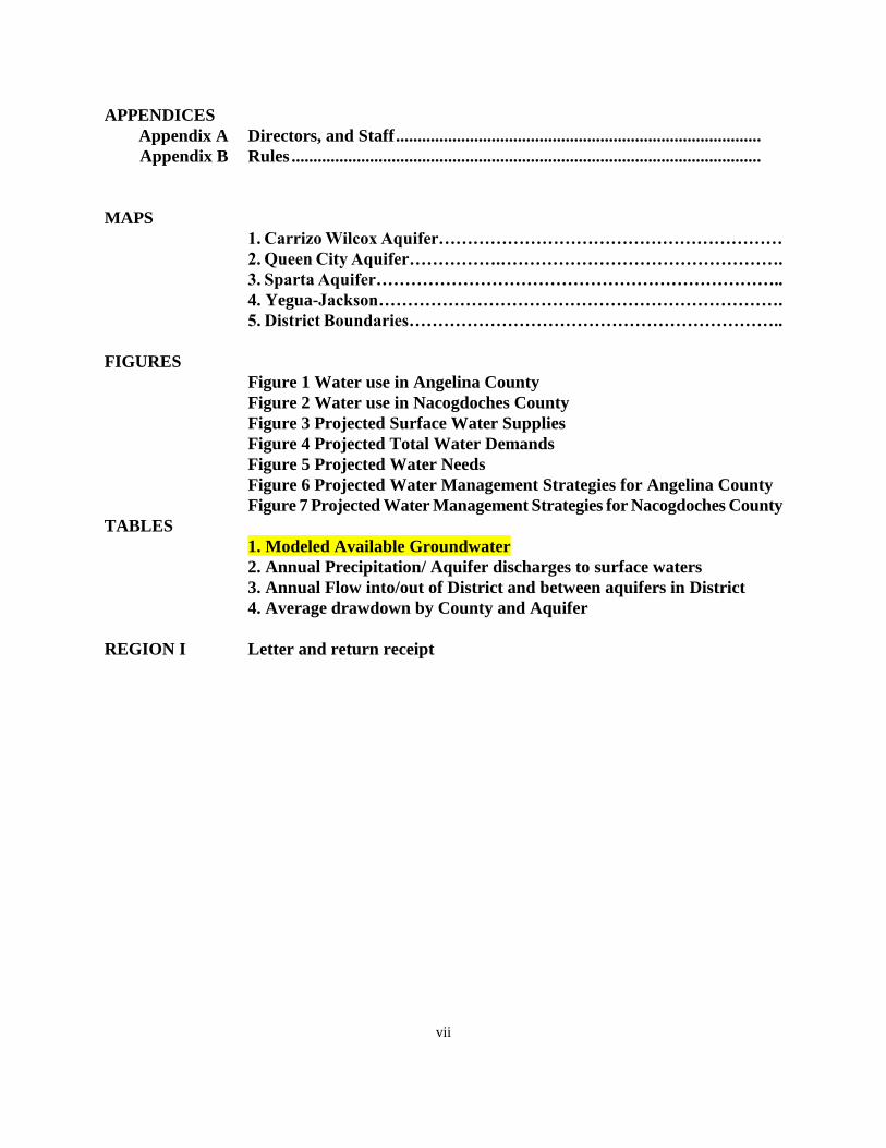
APPENDICES
Appendix A Directors, and Staff ....................................................................................
Appendix B Rules ............................................................................................................
MAPS
1. Carrizo Wilcox Aquifer……………………………………………………
2. Queen City Aquifer…………….………………………………………….
3. Sparta Aquifer……………………………………………………………..
4. Yegua-Jackson…………………………………………………………….
5. District Boundaries………………………………………………………..
FIGURES
Figure 1 Water use in Angelina County
Figure 2 Water use in Nacogdoches County
Figure 3 Projected Surface Water Supplies
Figure 4 Projected Total Water Demands
Figure 5 Projected Water Needs
Figure 6 Projected Water Management Strategies for Angelina County
Figure 7 Projected Water Management Strategies for Nacogdoches County
TABLES
1. Modeled Available Groundwater
2. Annual Precipitation/ Aquifer discharges to surface waters
3. Annual Flow into/out of District and between aquifers in District
4. Average drawdown by County and Aquifer
REGION I Letter and return receipt

viii
Page left blank
9
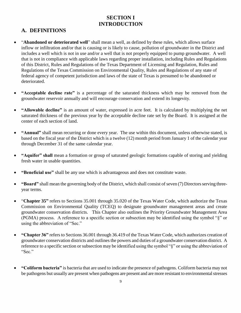
SECTION I
INTRODUCTION
A. DEFINITIONS
“Abandoned or deteriorated well” shall mean a well, as defined by these rules, which allows surface
inflow or infiltration and/or that is causing or is likely to cause, pollution of groundwater in the District and
includes a well which is not in use and/or a well that is not properly equipped to pump groundwater. A well
that is not in compliance with applicable laws regarding proper installation, including Rules and Regulations
of this District, Rules and Regulations of the Texas Department of Licensing and Regulation, Rules and
Regulations of the Texas Commission on Environmental Quality, Rules and Regulations of any state of
federal agency of competent jurisdiction and laws of the state of Texas is presumed to be abandoned or
deteriorated.
“Acceptable decline rate” is a percentage of the saturated thickness which may be removed from the
groundwater reservoir annually and will encourage conservation and extend its longevity.
“Allowable decline” is an amount of water, expressed in acre feet. It is calculated by multiplying the net
saturated thickness of the previous year by the acceptable decline rate set by the Board. It is assigned at the
center of each section of land.
“Annual” shall mean recurring or done every year. The use within this document, unless otherwise stated, is
based on the fiscal year of the District which is a twelve (12) month period from January 1 of the calendar year
through December 31 of the same calendar year.
“Aquifer” shall mean a formation or group of saturated geologic formations capable of storing and yielding
fresh water in usable quantities.
“Beneficial use” shall be any use which is advantageous and does not constitute waste.
“Board” shall mean the governing body of the District, which shall consist of seven (7) Directors serving three-
year terms.
“Chapter 35” refers to Sections 35.001 through 35.020 of the Texas Water Code, which authorize the Texas
Commission on Environmental Quality (TCEQ) to designate groundwater management areas and create
groundwater conservation districts. This Chapter also outlines the Priority Groundwater Management Area
(PGMA) process. A reference to a specific section or subsection may be identified using the symbol “§” or
using the abbreviation of “Sec.”
“Chapter 36” refers to Sections 36.001 through 36.419 of the Texas Water Code, which authorizes creation of
groundwater conservation districts and outlines the powers and duties of a groundwater conservation district. A
reference to a specific section or subsection may be identified using the symbol “§” or using the abbreviation of
“Sec.”
“Coliform bacteria” is bacteria that are used to indicate the presence of pathogens. Coliform bacteria may not
be pathogens but usually are present when pathogens are present and are more resistant to environmental stresses

10
than pathogens.
“Desired Future Conditions” (DFC), is the desired, quantified condition of groundwater resources (such as
water levels, water quality, spring flows, or volumes) for a specified aquifer within a management area at a
specified time or times in the future.
“Discharge” means the amount of water that leaves an aquifer by natural or artificial means.
“District” shall mean Pineywoods Groundwater Conservation District, maintaining its principal office in
Nacogdoches County, Nacogdoches, Texas. Where applications, reports and other papers are required to be
filed with or sent to “the District”, this means where the District’s headquarters are at. The District shall also be
known as “Pineywoods GCD”, and the acronym “PGCD” shall also refer to the Pineywoods Groundwater
Conservation District.
“Each year” shall mean recurring or done every calendar year.
“Evidence of historic or existing use” means evidence that is material and relevant to a determination of the
amount of groundwater beneficially used without waste by a permit applicant during the relevant time periods
set by district rule that regulates groundwater based on historic use. Evidence in the form of oral or written
testimony shall be subject to cross-examination. The Texas Rules of Evidence govern the admissibility and
introduction of evidence of historic or existing use, except that evidence not admissible under the Texas Rules of
Evidence may be admitted if it is of the type commonly relied upon by reasonably prudent persons in the
conduct of their affairs.
“Executive Administrator” is the executive administrator of the Texas Water Development Board.
“Groundwater” shall mean water percolating below the surface of the earth.
“Groundwater reservoir” shall mean a specific subsurface water-bearing reservoir having ascertainable
boundaries containing groundwater.
“Hydraulic conductivity” is a measurement of the capacity of a porous medium to transmit water. It is
expressed as the volume of water at the kinematic viscosity that will move in a unit time under a unit hydraulic
gradient through a unit area measured at right angles to the direction of flow.
“Inflows” means the amount of water that flows into an aquifer from another formation.
“Irrigation distribution system or irrigation system” shall mean a device or combination of devices having a
hose, pipe or other conduit which connects directly to any water well through which water or a mixture of water
and chemicals is drawn and applied to land. The term does not include any hand held-hose sprayer or other
similar device which is constructed so that an interruption in water flow automatically prevents any backflow to
the water source.
“Modeled available groundwater” (MAG) means the amount of water that the executive administrator
determines may be produced on an average annual basis to achieve a desired future condition established under
Section 36.108 of the Texas Water Code.

11
“Management plan” is the groundwater management plan required pursuant to Texas Water Code §36.1071.
“Monitoring well or observation well” shall mean an artificial excavation constructed to measure or monitor
the quality or quantity or movement of substances, elements, chemicals, or fluids beneath the surface of the
ground. The term shall not include any monitoring well which is used in conjunction with the production of oil,
gas, or any other minerals.
“Natural resource” is a material source of wealth, such as timber, water or a mineral deposit that occurs in a
natural state.
“Owner” shall mean and include any person or other entity, public or private, that has the right to produce water
from the land either by ownership, contract, lease, easement or any other estate in the land or water.
“Person” shall mean any individual, partnership, firm or corporation.
“Pollution” shall mean the alteration of the physical, thermal, chemical, or biological quality of, or the
contamination of, water in the District that renders the water harmful, detrimental, or injurious to humans,
animal life, vegetation, or property or to public health, safety, or welfare, or which impairs the usefulness or the
public enjoyment of the water for any lawful or reasonable purpose.
“Porosity” is a measurement of the voids or openings in a medium. It may be expressed quantitatively as the
ratio of the volume of openings to the total volume.
“Recharge” means the amount of water that infiltrates to the water table of an aquifer.
“Saturated thickness” is the vertical distance between the water table and the base of the groundwater
reservoir, and the pores between the solid particles are filled with water.
“Specific yield” is the ratio of the volume of water that will drain under the influence of gravity to the total
volume.
“Texas Water Code (TWC)” shall refer to the laws which govern the use and disposition of water in the state
of Texas.
“Texas Water Development Board (TWDB)” shall refer to the Texas Water Development Board of the State
of Texas in Austin, Texas.
“Total aquifer storage” means the total calculated volume of groundwater that an aquifer is capable of
producing.
“Underground water” is used synonymous with groundwater.
“Waste” as used herein shall have the same meaning as defined by Chapter 36 of the Texas Water Code as now
or hereafter amended.
“Waste means any one or more of the following:

12
1. Withdrawal of groundwater from a groundwater reservoir at a rate and in an amount that causes or
threatens to cause intrusion into the reservoir of water unsuitable for agricultural, gardening, domestic, or
stock-raising purposes;
2. The flowing or producing of wells from a groundwater reservoir if the water produced is not used for a
beneficial purpose;
3. Escape of groundwater from a groundwater reservoir to any other reservoir or a geologic stratum that
does not contain groundwater;
4. Pollution or harmful alteration of groundwater in a groundwater reservoir by saltwater or by other
deleterious matter admitted from another stratum or from the surface of the ground;
5. Willfully or negligently causing, suffering, or allowing groundwater to escape into any river, creek,
natural watercourse, depression, lake, reservoir, drain, sewer, street, highway, road, or road ditch, or onto any
land other than that of the owner of the well unless such discharge is authorized by permit, rule, or order;
6. Groundwater pumped for irrigation that escapes as irrigation tailwater onto land other than that of the
owner of the well unless permission has been granted by the occupant of the land receiving the discharge; or
7. For water produced from an artesian well, “waste” has the meaning.
“Water” is used synonymous with groundwater and underground water.
“Water rights” shall mean a defined number of surface acres, within each section of land which a person has
acquired the right to capture the groundwater from beneath, subject to the Rules of this District.
“Water well” shall mean any artificial excavation constructed for the purpose of exploring for or producing
groundwater. The term, however, shall not include any test or blast holes in quarries or mines, or any well or
excavation for the purpose of exploring for, or producing oil, gas, or any other minerals unless the holes are used
to produce groundwater. The term shall not include any injection water source well regulated by the Railroad
Commission of Texas.
“Well” shall mean water well, injection well, recharge well, dewatering well, test well, or monitoring well and is
in compliance with the District Rules.
B. PURPOSE OF THE DISTRICT
The purpose of the District is to provide for the conservation, preservation, protection, recharging, and prevention of
waste of the groundwater, and of groundwater reservoirs or their subdivisions, and to control subsidence within the
defined boundary of the District. The purpose of the District is achieved through rules, education programs, District-
provided services, and through mutual cooperation of local, state, and federal agencies. The District issues water
well permits, collects groundwater information and other services. Extensive databases are used to store, retrieve,
and analyze the groundwater information for the District. It is the belief of the District’s residents and the Board of
Directors that groundwater is best managed locally through a groundwater conservation district. This belief is
realized by the adoption and implementation of a management plan outlining the goals, methods, and procedures to
be utilized in the management of the groundwater resources of the District. This management plan will provide a
better understanding of the goals and objectives of the District by the residents and promote cooperation in its
implementation.
This document has been developed in accordance with the requirements of Chapter 36 of the Texas Water Code, and
13
the provisions of Texas Administrative Code Title 31, Chapter 356 Groundwater Management Plan Certification.
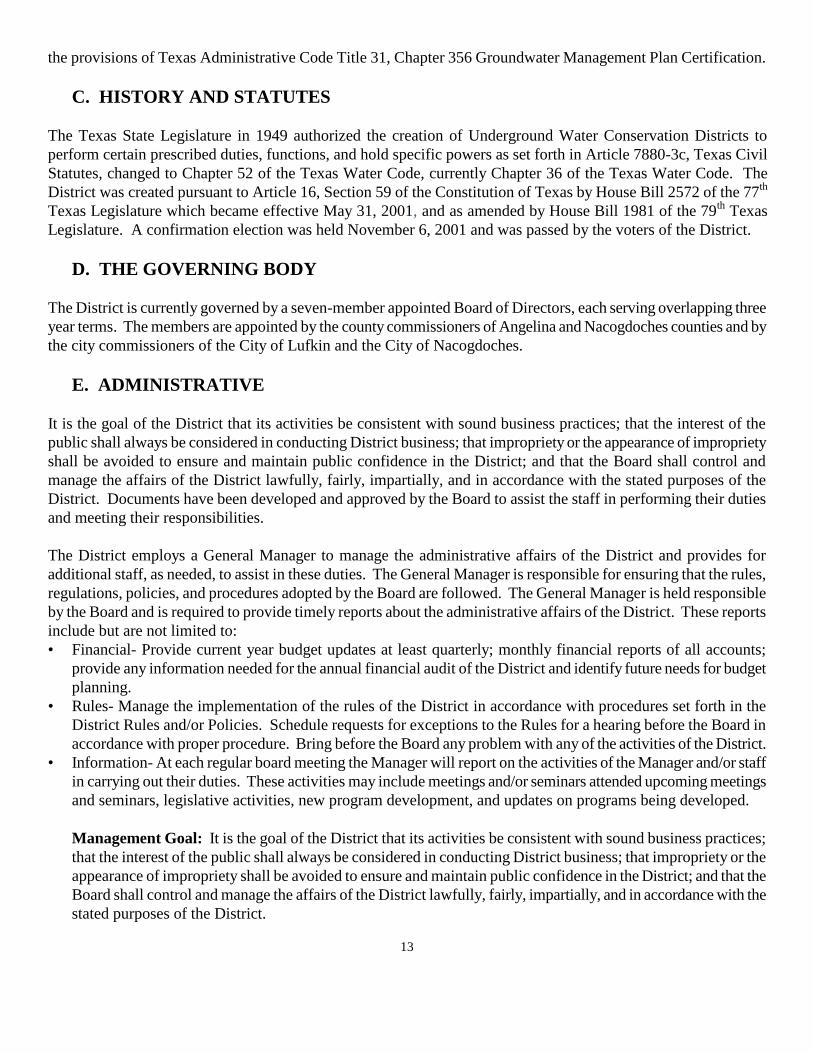
C. HISTORY AND STATUTES
The Texas State Legislature in 1949 authorized the creation of Underground Water Conservation Districts to
perform certain prescribed duties, functions, and hold specific powers as set forth in Article 7880-3c, Texas Civil
Statutes, changed to Chapter 52 of the Texas Water Code, currently Chapter 36 of the Texas Water Code. The
District was created pursuant to Article 16, Section 59 of the Constitution of Texas by House Bill 2572 of the 77th
Texas Legislature which became effective May 31, 2001, and as amended by House Bill 1981 of the 79th
Texas
Legislature. A confirmation election was held November 6, 2001 and was passed by the voters of the District.
D. THE GOVERNING BODY
The District is currently governed by a seven-member appointed Board of Directors, each serving overlapping three
year terms. The members are appointed by the county commissioners of Angelina and Nacogdoches counties and by
the city commissioners of the City of Lufkin and the City of Nacogdoches.
E. ADMINISTRATIVE
It is the goal of the District that its activities be consistent with sound business practices; that the interest of the
public shall always be considered in conducting District business; that impropriety or the appearance of impropriety
shall be avoided to ensure and maintain public confidence in the District; and that the Board shall control and
manage the affairs of the District lawfully, fairly, impartially, and in accordance with the stated purposes of the
District. Documents have been developed and approved by the Board to assist the staff in performing their duties
and meeting their responsibilities.
The District employs a General Manager to manage the administrative affairs of the District and provides for
additional staff, as needed, to assist in these duties. The General Manager is responsible for ensuring that the rules,
regulations, policies, and procedures adopted by the Board are followed. The General Manager is held responsible
by the Board and is required to provide timely reports about the administrative affairs of the District. These reports
include but are not limited to:
• Financial- Provide current year budget updates at least quarterly; monthly financial reports of all accounts;
provide any information needed for the annual financial audit of the District and identify future needs for budget
planning.
• Rules- Manage the implementation of the rules of the District in accordance with procedures set forth in the
District Rules and/or Policies. Schedule requests for exceptions to the Rules for a hearing before the Board in
accordance with proper procedure. Bring before the Board any problem with any of the activities of the District.
• Information- At each regular board meeting the Manager will report on the activities of the Manager and/or staff
in carrying out their duties. These activities may include meetings and/or seminars attended upcoming meetings
and seminars, legislative activities, new program development, and updates on programs being developed.
Management Goal: It is the goal of the District that its activities be consistent with sound business practices;
that the interest of the public shall always be considered in conducting District business; that impropriety or the
appearance of impropriety shall be avoided to ensure and maintain public confidence in the District; and that the
Board shall control and manage the affairs of the District lawfully, fairly, impartially, and in accordance with the
stated purposes of the District.

14
Management Objective: Adopt rules, regulations, policies, and procedures as needed and insure that the
Management and staff have a clear understanding of their duties in accordance with the administrative goals of
the District.
Performance Standard: Annually review and include a summary in the annual report to the Board of Directors
that the Administrative duties as set forth are carried out as stated.
(A list of the current Directors, Officers, and Staff is included in Appendix A and area is on map 5.)
F. METHODOLOGY FOR TRACKING PROGRESS
Methodology for Tracking District Progress in Achieving Management Goals
The District manager will prepare and present an annual report to the Board of Directors on
District performance in regards to achieving management goals and objectives. The presentation
of the report will occur at a regularly scheduled meeting during the first quarter of each fiscal year.
The report will include the activity, goal, objective, performance standard and comments on
details. The comments of each activity will be referenced to the appropriate performance standard
for each management objective describing the activity, so that the effectiveness and efficiency of
the Districts operations may be evaluated. The District will maintain the report on file, for public
inspection at the Districts offices upon adoption. This methodology will apply to all management
goals contained within this plan.”
SECTION II
PLANNING PERIOD
The Board may review the management plan annually and must review and readopt the plan, with or without
revisions, at least once every five years. For the purpose of 31 TAC §356.5(a) this management plan uses a planning
period of at least ten (10) years from the date of acceptance by the TWDB.
A. Supply and Demand
Amount of Water being used within the District Annually

15
The following charts are projections of the annual water usage within the District from 1974 to 2004. These charts
include ground and surface water, and account for municipal, manufacturing, agriculture, mining and power supply
usage. They show an annual usage of 11, 785 ac/ft/yr and 23, 945 ac/ft/yr for Nacogdoches and Angelina Counties,
respectively, for the year 2004.
Figure 1
Angelina County
Year Source Municipal Manufacturing
Steam
Electric Irrigation Mining Livestock Total
1974 GW 6,698 27,131 0 462 15 79 34,385
SW 0 4,175 0 0 0 404 4,579
Total 6,698 31,306 0 462 15 483 38,964
1980 GW 9,308 23,164 0 563 0 117 33,152
SW 4 5,217 0 0 9 158 5,388
Total 9,312 28,381 0 563 9 275 38,540
1984 GW 9,127 21,840 0 563 0 243 31,773
SW 3 5,876 0 0 0 364 6,243
Total 9,130 27,716 0 563 0 607 38,016
1985 GW 9,026 21,842 0 450 0 189 31,507
SW 4 7,652 0 0 0 284 7,940
Total 9,030 29,494 0 450 0 473 39,447
1986 GW 8,765 21,202 0 400 0 169 30,536
SW 4 7,604 0 0 0 253 7,861
Total 8,769 28,806 0 400 0 422 38,397
1987 GW 8,545 20,972 0 400 0 176 30,093
SW 5 7,130 0 0 0 264 7,399
Total 8,550 28,102 0 400 0 440 37,492
1988 GW 8,160 18,717 0 400 0 199 27,476
SW 4 11,526 0 0 0 298 11,828
Total 8,164 30,243 0 400 0 497 39,304
1989 GW 8,981 26,070 0 0 0 176 35,227
SW 3 9,153 0 0 0 265 9,421
Total 8,984 35,223 0 0 0 441 44,648
1990 GW 9,104 17,608 0 0 0 174 26,886
SW 4 10,315 0 0 0 262 10,581
Total 9,108 27,923 0 0 0 436 37,467
1991 GW 8,920 16,460 0 0 22 178 25,580
SW 3 7,094 0 0 0 267 7,364
Total 8,923 23,554 0 0 22 445 32,944
1992 GW 9,615 15,375 0 0 22 251 25,263
SW 0 11,418 0 0 0 377 11,795
Total 9,615 26,793 0 0 22 628 37,058
1993 GW 9,773 14,433 0 30 22 245 24,503
SW 0 17,352 0 0 0 367 17,719
Total 9,773 31,785 0 30 22 612 42,222
1994 GW 9,367 14,927 0 30 22 202 24,548
SW 0 19,412 0 0 0 304 19,716
Total 9,367 34,339 0 30 22 506 44,264
1995 GW 9,726 15,352 0 30 22 202 25,332

16
SW 0 9,176 0 0 0 302 9,478
Total 9,726 24,528 0 30 22 504 34,810
1996 GW 10,329 14,875 0 30 22 183 25,439
SW 0 12,036 0 0 0 274 12,310
Total 10,329 26,911 0 30 22 457 37,749
1997 GW 10,523 14,433 0 30 22 178 25,186
SW 0 8,977 0 0 0 267 9,244
Total 10,523 23,410 0 30 22 445 34,430
1998 GW 11,991 15,029 0 30 22 201 27,273
SW 0 9,538 0 0 0 302 9,840
Total 11,991 24,567 0 30 22 503 37,113
1999 GW 12,057 14,261 0 30 22 233 26,603
SW 0 2,907 0 0 0 350 3,257
Total 12,057 17,168 0 30 22 583 29,860
2000 GW 12,493 13,681 0 30 22 231 26,457
SW 0 11,557 0 0 0 347 11,904
Total 12,493 25,238 0 30 22 578 38,361
2001 GW 11,143 11,656 0 9 22 226 23,056
SW 0 7,250 0 0 0 339 7,589
Total 11,143 18,906 0 9 22 565 30,645
2002 GW 10,331 11,830 0 9 22 213 22,405
SW 0 7,358 0 0 0 320 7,678
Total 10,331 19,188 0 9 22 533 30,083
2003 GW 12,859 12,006 0 25 22 201 25,113
SW 0 7,468 0 130 0 301 7,899
Total 12,859 19,474 0 155 22 502 33,012
2004 GW 11,034 7,496 0 109 22 199 18,860
SW 0 4,662 0 125 0 298 5,085
Total 11,034 12,158 0 234 22 497 23,945
NOTE: All Pumpage reported in acre-feet
TWDB:
6/23/2008
Source: TWDB Water Use Survey Database (http://www.twdb.state.tx.us/wushistorical/DesktopDefault.aspx?PageID=1)
Figure 2 Nacogdoches County
Year Source Municipal Manufacturing
Steam
Electric Irrigation Mining Livestock Total
1974 GW 5,050 1,779 0 0 58 637 7,524
SW 0 49 0 21 0 1,056 1,126
Total 5,050 1,828 0 21 58 1,693 8,650
1980 GW 5,440 1,182 0 0 0 789 7,411
SW 2,510 882 0 0 200 564 4,156
Total 7,950 2,064 0 0 200 1,353 11,567
1984 GW 6,197 589 0 19 0 695 7,500
SW 2,826 401 0 5 12 1,042 4,286
Total 9,023 990 0 24 12 1,737 11,786
1985 GW 6,239 503 0 39 0 507 7,288
SW 2,668 325 0 10 12 761 3,776
Total 8,907 828 0 49 12 1,268 11,064
1986 GW 6,726 566 0 40 0 533 7,865

17
SW 2,429 330 0 11 13 800 3,583
Total 9,155 896 0 51 13 1,333 11,448
1987 GW 6,900 541 0 40 0 511 7,992
SW 2,908 339 0 11 14 767 4,039
Total 9,808 880 0 51 14 1,278 12,031
1988 GW 7,444 513 0 40 0 512 8,509
SW 3,618 386 0 10 14 768 4,796
Total 11,062 899 0 50 14 1,280 13,305
1989 GW 7,529 558 0 138 0 534 8,759
SW 2,776 307 0 138 12 802 4,035
Total 10,305 865 0 276 12 1,336 12,794
1990 GW 7,026 567 0 140 0 637 8,370
SW 3,092 403 0 140 12 956 4,603
Total 10,118 970 0 280 12 1,593 12,973
1991 GW 6,660 683 0 140 0 637 8,120
SW 2,556 443 0 140 220 956 4,315
Total 9,216 1,126 0 280 220 1,593 12,435
1992 GW 7,150 695 0 140 0 638 8,623
SW 2,802 467 0 140 220 957 4,586
Total 9,952 1,162 0 280 220 1,595 13,209
1993 GW 7,474 874 0 980 0 656 9,984
SW 2,446 474 0 245 220 984 4,369
Total 9,920 1,348 0 1,225 220 1,640 14,353
1994 GW 7,083 840 0 1,117 0 712 9,752
SW 2,558 497 0 143 220 1,068 4,486
Total 9,641 1,337 0 1,260 220 1,780 14,238
1995 GW 7,966 723 0 1,016 0 642 10,347
SW 2,490 372 0 254 220 962 4,298
Total 10,456 1,095 0 1,270 220 1,604 14,645
1996 GW 6,738 637 0 1,016 0 860 9,251
SW 2,836 492 0 254 220 1,290 5,092
Total 9,574 1,129 0 1,270 220 2,150 14,343
1997 GW 6,664 1,110 0 1,016 0 599 9,389
SW 1,516 115 0 254 220 899 3,004
Total 8,180 1,225 0 1,270 220 1,498 12,393
1998 GW 6,484 742 0 1,016 0 538 8,780
SW 3,452 204 0 254 220 807 4,937
Total 9,936 946 0 1,270 220 1,345 13,717
1999 GW 6,448 915 0 1,016 0 582 8,961
SW 149 47 0 254 220 873 1,543
Total 6,597 962 0 1,270 220 1,455 10,504
2000 GW 6,209 767 0 186 0 607 7,769
SW 4,542 1,131 0 116 220 910 6,919
Total 10,751 1,898 0 302 220 1,517 14,688
2001 GW 6,197 1,700 0 419 0 583 8,899
SW 987 176 0 257 220 875 2,515
Total 7,184 1,876 0 676 220 1,458 11,414
2002 GW 5,841 1,597 0 187 0 584 8,209
SW 1,066 166 0 114 220 876 2,442
Total 6,907 1,763 0 301 220 1,460 10,651

18
2003 GW 5,268 2,389 0 395 0 507 8,559
SW 1,789 247 0 148 220 761 3,165
Total 7,057 2,636 0 543 220 1,268 11,724
2004 GW 5,691 2,061 0 281 0 495 8,528
SW 1,958 213 0 123 220 743 3,257
Total 7,649 2,274 0 404 220 1,238 11,785
NOTE: All Pumpage reported in acre-feet
TWDB:
6/23/2008
Source: TWDB Water Use Survey Database (http://www.twdb.state.tx.us/wushistorical/DesktopDefault.aspx?PageID=1)
B. Projected Surface Water Supplies
The following charts show the surface water supplies for Angelina and Nacogdoches Counties for 2000 and the
projected surface water supplies through the year 2060. This also shows available sources from Sam Rayburn
Reservoir and Kurth Lake.
Figure 3 Angelina County
RWPG Water User
Group
County River
Basin
Source Name 2010 2020 2030 2040 2050 2060
I Lufkin Angelina Neches Sam Rayburn
Reservoir
28,000 28,000 28,000 28,000 28,000 28,000
I Lufkin Angelina Neches Kurth Lake 19,100 19,100 19,100 19,100 19,100 19,100
Source: City of Lufkin
acre-feet per year
RWPGWater User
GroupCounty
River
BasinSource Name 2000 2010 2020 2030 2040 2050 2060
I Manufacturing Angelina Neches Striker Lake/Reservoir 10,000 10,000 10,000 10,000 10,000 10,000 10,000
I Manufacturing Angelina Neches Kurth Lake/Reservoir 19,000 18,421 18,417 18,413 18,408 18,404 18,400
I Livestock Angelina Neches Livestock Local Supply 377 347 347 347 347 347 347
29,377 28,768 28,764 28,760 28,755 28,751 28,747
Source: Volume 3, 2007 State Water Planning Database 6/23/2008
(http://www.twdb.state.tx.us/DATA/db07/defaultReadOnly.asp)
RWPGWater User
GroupCounty
River
BasinSource Name 2000 2010 2020 2030 2040 2050 2060
I Nacogdoches Nacogdoches Neches Nacogdoches Lake/Reservoir 18,996 6,937 6,541 6,194 5,837 5,543 5,197
I County-Other Nacogdoches Neches Nacogdoches Lake/Reservoir 0 200 183 168 156 149 144
I Manufacturing Nacogdoches Neches Nacogdoches Lake/Reservoir 1,166 2,082 1,983 1,872 1,772 1,569 1,437
I Mining Nacogdoches Neches Other Local Supply 220 220 220 220 220 220 220
I Irrigation Nacogdoches NechesNeches River Combined Run-
of-River Irrigation 254 136 136 136 136 136 136
I Livestock Nacogdoches Neches Livestock Local Supply 1,290 910 910 910 910 910 910
I Appleby WSC Nacogdoches Neches Nacogdoches Lake/Reservoir 0 240 346 414 477 575 652
21,926 10,725 10,319 9,914 9,508 9,102 8,696
Source: Volume 3, 2007 State Water Planning Database 6/23/2008
(http://www.twdb.state.tx.us/DATA/db07/defaultReadOnly.asp)
Nacogdoches County
Total Projected Surface Water Supplies (acre-feet per year) =
Total Projected Surface Water Supplies (acre-feet per year) =
Angelina County
19
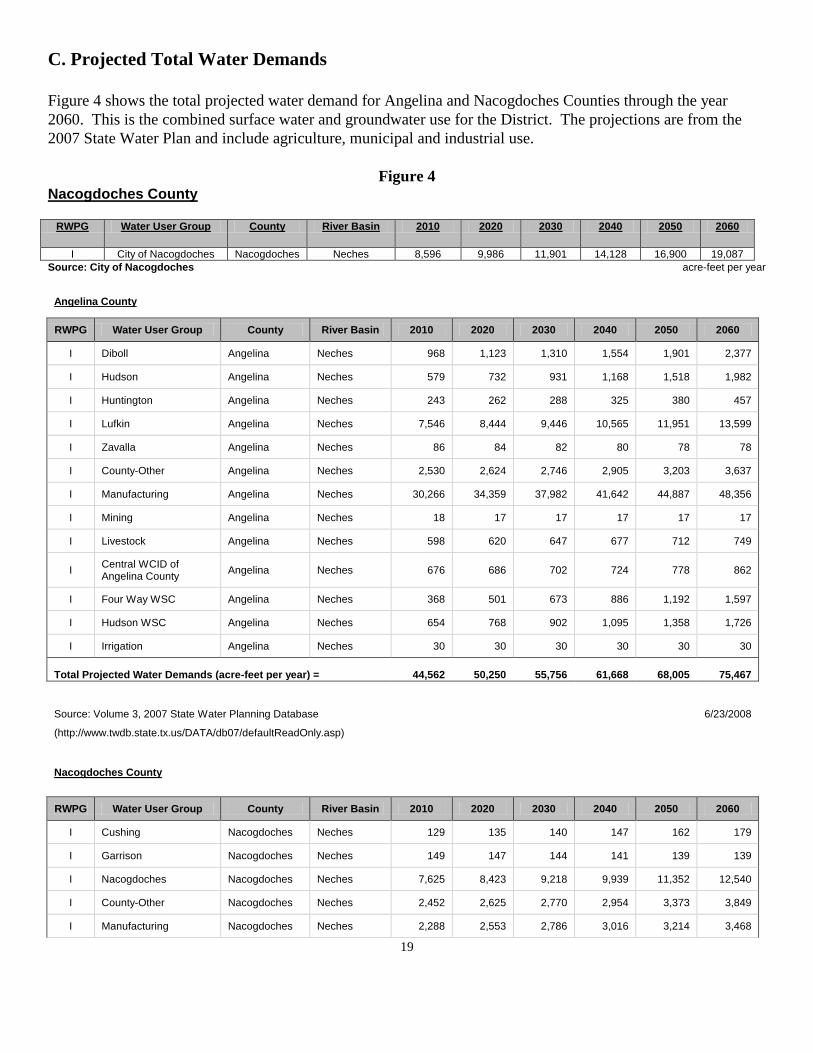
C. Projected Total Water Demands
Figure 4 shows the total projected water demand for Angelina and Nacogdoches Counties through the year
2060. This is the combined surface water and groundwater use for the District. The projections are from the
2007 State Water Plan and include agriculture, municipal and industrial use.
Figure 4 Nacogdoches County
RWPG Water User Group County River Basin 2010 2020 2030 2040 2050 2060
I City of Nacogdoches Nacogdoches Neches 8,596 9,986 11,901 14,128 16,900 19,087
Source: City of Nacogdoches acre-feet per year
Angelina County
RWPG Water User Group County River Basin 2010 2020 2030 2040 2050 2060
I Diboll Angelina Neches 968 1,123 1,310 1,554 1,901 2,377
I Hudson Angelina Neches 579 732 931 1,168 1,518 1,982
I Huntington Angelina Neches 243 262 288 325 380 457
I Lufkin Angelina Neches 7,546 8,444 9,446 10,565 11,951 13,599
I Zavalla Angelina Neches 86 84 82 80 78 78
I County-Other Angelina Neches 2,530 2,624 2,746 2,905 3,203 3,637
I Manufacturing Angelina Neches 30,266 34,359 37,982 41,642 44,887 48,356
I Mining Angelina Neches 18 17 17 17 17 17
I Livestock Angelina Neches 598 620 647 677 712 749
I Central WCID of Angelina County
Angelina Neches 676 686 702 724 778 862
I Four Way WSC Angelina Neches 368 501 673 886 1,192 1,597
I Hudson WSC Angelina Neches 654 768 902 1,095 1,358 1,726
I Irrigation Angelina Neches 30 30 30 30 30 30
Total Projected Water Demands (acre-feet per year) = 44,562 50,250 55,756 61,668 68,005 75,467
Source: Volume 3, 2007 State Water Planning Database
6/23/2008
(http://www.twdb.state.tx.us/DATA/db07/defaultReadOnly.asp)
Nacogdoches County
RWPG Water User Group County River Basin 2010 2020 2030 2040 2050 2060
I Cushing Nacogdoches Neches 129 135 140 147 162 179
I Garrison Nacogdoches Neches 149 147 144 141 139 139
I Nacogdoches Nacogdoches Neches 7,625 8,423 9,218 9,939 11,352 12,540
I County-Other Nacogdoches Neches 2,452 2,625 2,770 2,954 3,373 3,849
I Manufacturing Nacogdoches Neches 2,288 2,553 2,786 3,016 3,214 3,468

20
I Steam Electric Power Nacogdoches Neches 4,828 6,911 8,079 9,504 11,241 13,358
I Mining Nacogdoches Neches 215 213 212 211 210 209
I Irrigation Nacogdoches Neches 302 302 302 302 302 302
I Livestock Nacogdoches Neches 1,719 1,954 2,227 2,544 2,911 3,332
I Appleby WSC Nacogdoches Neches 763 945 1,117 1,311 1,678 2,074
I Lilly Grove SUD Nacogdoches Neches 423 533 641 752 982 1,224
I Swift WSC Nacogdoches Neches 483 567 640 730 903 1,093
Total Projected Water Demands (acre-feet per year) = 21,376 25,308 28,276 31,551 36,467 41,767
Source: Volume 3, 2007 State Water Planning Database
6/23/2008
(http://www.twdb.state.tx.us/DATA/db07/defaultReadOnly.asp)
D. Projected Water Needs
Figure 5 shows the projected water needs for Angelina and Nacogdoches Counties through the year 2060.
Negative numbers indicate an additional amount of water that will be needed to supply the needs of the District.
Figure 5
RWPG WUG County River Basin 2010 2020 2030 2040 2050 2060
I Diboll Angelina Neches -32 -187 -374 -618 -965 -1,441
I Hudson Angelina Neches -41 -194 -393 -630 -980 -1,444
I Huntington Angelina Neches 497 473 446 410 360 292
I Lufkin Angelina Neches -827 -1,748 -2,725 -3,805 -5,104 -6,657
I Zavalla Angelina Neches 107 109 111 113 115 115
I County-Other Angelina Neches -30 -127 -251 -411 -709 -1,143
I Manufacturing Angelina Neches 13,687 9,600 5,965 2,287 -995 -4,504
I Mining Angelina Neches 10 11 11 11 11 11
I Livestock Angelina Neches 62 40 13 -17 -52 -89
ICentral WCID of
Angelina CountyAngelina Neches
198 188 172 150 96 12
I Four Way WSC Angelina Neches 1,004 871 699 486 180 -225
I Hudson WSC Angelina Neches 6 -108 -242 -435 -698 -1,066
I Irrigation Angelina Neches 8 8 8 8 8 8
14,649 8,936 3,440 -2,451 -8,733 -16,131
Source:Volume 3, 2007 State Water Planning Database 6/23/2008
(http://www.twdb.state.tx.us/DATA/db07/defaultReadOnly.asp)
Total Projected Water Needs
(acre-feet per year) =
Angelina County
A positive value indicates a projected water surplus; a negative value indicates a projected water supply need.

21
(Figure 5 cont.)
RWPG WUG County River Basin 2010 2020 2030 2040 2050 2060
I Cushing Nacogdoches Neches 108 102 97 90 75 58
I Garrison Nacogdoches Neches 311 313 316 319 321 321
I Nacogdoches Nacogdoches Neches 1,585 358 -804 -1,906 -3,616 -5,175
I County-Other Nacogdoches Neches 1,306 1,116 956 760 334 -147
I Manufacturing Nacogdoches Neches 476 109 -243 -578 -1,024 -1,431
ISteam Electric
PowerNacogdoches Neches
-4,828 -6,911 -8,079 -9,504 -11,241 -13,358
I Mining Nacogdoches Neches 5 7 8 9 10 11
I Irrigation Nacogdoches Neches 1,230 1,230 1,230 1,230 1,230 1,230
I Livestock Nacogdoches Neches 266 31 -242 -559 -926 -1,347
I Appleby WSC Nacogdoches Neches 247 211 138 37 -183 -458
I Lilly Grove SUD Nacogdoches Neches 124 14 -94 -205 -435 -677
I Swift WSC Nacogdoches Neches -78 -162 -235 -325 -498 -688
752 -3,582 -6,952 -10,632 -15,953 -21,661
Source:Volume 3, 2007 State Water Planning Database 6/23/2008
(http://www.twdb.state.tx.us/DATA/db07/defaultReadOnly.asp)
Nacogdoches County
Total Projected Water Needs
(acre-feet per year) =
A positive value indicates a projected water surplus; a negative value indicates a projected water supply need.
22
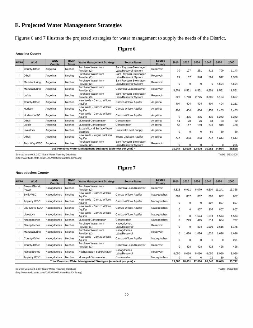
E. Projected Water Management Strategies
Figures 6 and 7 illustrate the projected strategies for water management to supply the needs of the District.
Figure 6 Angelina County
RWPG WUGWUG
County
River
BasinWater Management Strategy Source Name
Source
County2010 2020 2030 2040 2050 2060
I County-Other Angelina NechesPurchase Water from
Provider (2)
Sam Rayburn-Steinhagen
Lake/Reservoir SystemReservoir
30 127 251 411 709 1,143
I Diboll Angelina NechesPurchase Water from
Provider (2)
Sam Rayburn-Steinhagen
Lake/Reservoir SystemReservoir
21 167 348 584 912 1,369
I Manufacturing Angelina NechesPurchase Water from
Provider (2)
Sam Rayburn-Steinhagen
Lake/Reservoir SystemReservoir
0 0 0 0 4,504 4,504
I Manufacturing Angelina NechesPurchase Water from
Provider (2)Columbia Lake/Reservoir Reservoir
8,551 8,551 8,551 8,551 8,551 8,551
I Lufkin Angelina NechesPurchase Water from
Provider (3)
Sam Rayburn-Steinhagen
Lake/Reservoir SystemReservoir
827 1,748 2,725 3,805 5,104 6,657
I County-Other Angelina NechesNew Wells - Carrizo Wilcox
AquiferCarrizo-Wilcox Aquifer Angelina
404 404 404 404 404 1,211
I Hudson Angelina NechesNew Wells - Carrizo Wilcox
AquiferCarrizo-Wilcox Aquifer Angelina
404 404 404 1,453 1,453 1,453
I Hudson WSC Angelina NechesNew Wells - Carrizo Wilcox
AquiferCarrizo-Wilcox Aquifer Angelina
0 435 435 435 1,242 1,242
I Diboll Angelina Neches Municipal Conservation Conservation Angelina 11 20 26 34 53 72
I Lufkin Angelina Neches Municipal Conservation Conservation Angelina 50 117 189 249 319 408
I Livestock Angelina NechesExpand Local Surface Water
SuppliesLivestock Local Supply Angelina
0 0 0 89 89 89
I Diboll Angelina NechesNew Wells - Yegua Jackson
AquiferYegua-Jackson Aquifer Angelina
646 646 646 646 1,614 1,614
I Four Way WSC Angelina NechesPurchase Water from
Provider (2)
Sam Rayburn-Steinhagen
Lake/Reservoir SystemReservoir
0 0 0 0 0 225
10,944 12,619 13,979 16,661 24,954 28,538
Source: Volume 3, 2007 State Water Planning Database TWDB: 6/23/2008
(http://www.twdb.state.tx.us/DATA/db07/defaultReadOnly.asp)
Total Projected Water Management Strategies (acre-feet per year) =
Figure 7 Nacogdoches County
RWPG WUGWUG
County
River
BasinWater Management Strategy Source Name
Source
County2010 2020 2030 2040 2050 2060
ISteam Electric
PowerNacogdoches Neches
Purchase Water from
Provider (2)Columbia Lake/Reservoir Reservoir
4,828 6,911 8,079 9,504 11,241 13,358
I Swift WSC Nacogdoches NechesNew Wells - Carrizo Wilcox
AquiferCarrizo-Wilcox Aquifer Nacogdoches
807 807 807 807 807 807
I Appleby WSC Nacogdoches NechesNew Wells - Carrizo Wilcox
AquiferCarrizo-Wilcox Aquifer Nacogdoches
0 0 0 807 807 807
I Lilly Grove SUD Nacogdoches NechesNew Wells - Carrizo Wilcox
AquiferCarrizo-Wilcox Aquifer Nacogdoches
0 0 807 807 807 807
I Livestock Nacogdoches NechesNew Wells - Carrizo Wilcox
AquiferCarrizo-Wilcox Aquifer Nacogdoches
0 0 1,574 1,574 1,574 1,574
I Nacogdoches Nacogdoches Neches Municipal Conservation Conservation Nacogdoches 0 229 425 514 654 787
I Nacogdoches Nacogdoches NechesPurchase Water from
Provider (1)
Nacogdoches
Lake/ReservoirReservoir
0 0 804 1,906 3,616 5,175
I Manufacturing Nacogdoches NechesPurchase Water from
Provider (1)
Nacogdoches
Lake/ReservoirReservoir
0 1,626 1,626 1,626 1,626 1,626
I County-Other Nacogdoches NechesNew Wells - Carrizo Wilcox
AquiferCarrizo-Wilcox Aquifer Nacogdoches
0 0 0 0 0 291
I County-Other Nacogdoches NechesPurchase Water from
Provider (1)Columbia Lake/Reservoir Reservoir
0 428 428 428 428 428
I Nacogdoches Nacogdoches Neches Neches Basin SubordinationNacogdoches
Lake/ReservoirReservoir
8,050 8,050 8,050 8,050 8,050 8,050
I Appleby WSC Nacogdoches Neches Municipal Conservation Conservation Nacogdoches 0 0 0 22 39 62
13,685 18,051 22,600 26,045 29,649 33,772
Source: Volume 3, 2007 State Water Planning Database TWDB: 6/23/2008
(http://www.twdb.state.tx.us/DATA/db07/defaultReadOnly.asp)
Total Projected Water Management Strategies (acre-feet per year) =

23
SECTION III
GROUNDWATER SUPPLY
A. GENERAL GEOLOGY, STRATIGRAPHY, AND HYDROLOGY
Carrizo-Wilcox Aquifer
The Wilcox Group and the overlying Carrizo Formation of the Claiborne Group form a hydrologically
connected system known as the Carrizo-Wilcox aquifer. This aquifer extends from the Rio Grande in South
Texas northeastward into Arkansas and Louisiana, providing water to all or parts of 60 counties. The Carrizo
Sand and Wilcox Group crop out along a narrow band that parallels the Gulf Coast and dips beneath the land
surface toward the coast, except in the East Texas structural basin adjacent to the Sabine Uplift, where the
formations form a trough.
Municipal and irrigation pumpage account for about 35 percent and 51 percent, respectively, of total pumpage.
The largest metropolitan areas dependent on ground water from the Carrizo-Wilcox aquifer are Bryan-College
Station, Lufkin-Nacogdoches, and Tyler. Irrigation is the predominant use in the Winter Garden region of South
Texas.
The Carrizo-Wilcox aquifer is predominantly composed of sand locally interbedded with gravel, silt, clay, and
lignite deposited during the Tertiary Period. South of the Trinity River and north of the Colorado River, the
Wilcox Group is divided into three distinct formations: the Hooper, Simsboro, and Calvert Bluff. Of the three,
the Simsboro typically contains the most massive water-bearing sands. This division cannot be made south of
the Colorado River or north of the Trinity River due to the absence of the Simsboro as a distinct unit. Aquifer
thickness in the down dip artesian portion ranges from less than 200 feet to more than 3,000 feet. Well yields
are commonly 500 gal/min, and some may reach 3,000 gal/min in the down dip where the aquifer is under
artesian conditions. Some of the greatest yields (more than 1,000 gal/min) are produced from the Carrizo Sand
in the southern, or Winter Garden, area of the aquifer. Yields of greater than 500 gal/min are also obtained from
the Carrizo and Simsboro formations in the central region.
Regionally, water from the Carrizo-Wilcox aquifer is fresh to slightly saline. In the outcrop, the water is hard,
yet usually low in dissolved solids. Down dip, the water is softer, has a higher temperature, and contains more
dissolved solids. Hydrogen sulfide and methane may occur locally. Excessively corrosive water with high iron
content is common throughout much of the northeastern part of the aquifer. Localized contamination of the
aquifer in the Winter Garden area is attributed to direct infiltration of oil field brines on the surface and to
downward leakage of saline water to the overlying Bigford Formation. Significant water-level declines have
developed in the semiarid Winter Garden portion of the Carrizo aquifer, as the region is heavily dependent on
ground water for irrigation. Since 1920, water levels have declined as much as 100 feet in much of the area and
more than 250 feet in the Crystal City area of Zavala County. Significant water-level declines resulting from
extensive municipal and industrial pumpage also have occurred in Northeast Texas. Tyler and the Lufkin-
Nacogdoches area have experienced declines in excess of 400 feet, and in a few wells, as much as 500 feet since
the 1940s. In this area, conversion to surface-water use is slowing the rate of water-level decline. The northeast
outcrop area has been dewatered in the vicinity of lignite surface-mining operations, and the Simsboro Sand
Formation of the Wilcox Group has been affected by water-level declines in parts of Robertson and Milam
counties. (Map 1)

24
Queen City Aquifer
The Queen City aquifer extends across Texas from the Frio River in South Texas northeastward into Louisiana.
The aquifer provides water for domestic and livestock purposes throughout most of its extent, significant
amounts of water for municipal and industrial supplies in Northeast Texas, and water for irrigation in Wilson
County. Yields of individual wells are commonly low, but a few exceed 400 gal/min. Sand, loosely cemented
sandstone, and interbedded clay units of the Queen City Formation of the Tertiary Claiborne Group make up the
aquifer. These beds fill the East Texas structural basin adjacent to the Sabine Uplift and then dip gently to the
south and southeast toward the Gulf Coast. Although total aquifer thickness is usually less than 500 feet, it can
approach 700 feet in some areas of Northeast Texas. Water of excellent quality is generally found within the
outcrop and for a few miles down dip, but water quality deteriorates with depth in the down dip direction. In
some areas, water of acceptable quality may occur at depths of approximately 2,000 feet. The water may be
acidic in much of Northeast Texas and relatively high in iron concentrations in some locations. (Map 2)
Sparta Aquifer
The Sparta aquifer extends in a narrow band from the Frio River in South Texas northeastward to the Louisiana
border in Sabine County. The Sparta provides water for domestic and livestock supplies throughout its extent,
and water for municipal, industrial, and irrigation purposes in much of the region. Yields of individual wells are
generally less than 100 gal/min, although most high-capacity wells average 400 gal/min to 500 gal/min. A few
wells produce as much as 1,200 gal/min. The Sparta Formation, part of the Claiborne Group deposited during
the Tertiary, consists of sand and interbedded clay with massive sand beds in the basal section. These beds dip
gently to the south and southeast toward the Gulf Coast and reach a total thickness of up to 300 feet. Water of
excellent quality is commonly found within the outcrop and for a few miles down dip, but it deteriorates with
depth in the down dip direction. Locally, water within the aquifer may contain iron concentrations in excess of
drinking water standards. (Map 3)
Yegua-Jackson Aquifer
The Yegua-Jackson aquifer extends in a narrow band from the Rio Grande and Mexico across the State to the
Sabine River and Louisiana. Although the occurrence, quality, and quantity of water from this aquifer are
erratic, domestic and livestock supplies are available from shallow wells over most of its extent. Locally water
for municipal, industrial, and irrigation purposes is available. Yields of most wells are small, less than 50
gallons per minute, but in some areas, yields of adequately constructed wells may range to more than 500
gallons per minute. The Yegua-Jackson aquifer consists of complex associations of sand, silt, and clay deposited
during the Tertiary Period. Net freshwater sands are generally less than 200 feet deep at any location within the
aquifer. Water quality varies greatly within the aquifer, and shallow occurrences of poor-quality water are not
uncommon. In general, however, small to moderate amounts of usable quality water can be found within
shallow sands (less than 300 feet deep) over much of the Yegua-Jackson aquifer. (Map 4)
B. MODELED AVAILABLE GROUNDWATER
Scope: The modeled available groundwater is the amount of groundwater available for permitting purposes in each
of the major and minor aquifers within Angelina and Nacogdoches Counties.

25
Methodology: The Modeled Available Groundwater (MAG) was determined by the TWDB after the Desired Future
Conditions (DFC) were approved for the Groundwater Management Area 11 (GMA-11) by the Texas Water
Development Board. The MAG was determined with groundwater availability model (GAM) run 10-016
Table 1. Estimates of total annual pumping for the Carrizo-Wilcox, Queen City, Sparta, and
Yegua-Jackson aquifers by county for each decade between 2010 and 2060. Results are in acre-feet
per year.
County Year
2010 2020 2030 2040 2050 2060
Anderson 29,494 29,494 29,494 29,494 29,494 29,494
Angelina 45,086 45,086 45,086 45,086 45,086 44,703
Bowie 11,126 8,216 7,976 7,533 7,533 7,083
Camp 7,746 7,583 7,583 7,583 7,583 7,583
Cass 42,726 42,726 42,726 42,726 42,726 42,726
Cherokee 33,977 33,977 33,977 33,977 33,977 33,977
Franklin 9,746 9,484 9,484 9,484 9,484 9,484
Gregg 15,222 15,222 15,222 15,222 15,222 15,222
Harrison 19,284 19,210 19,159 19,071 19,056 19,012
Henderson 25,102 25,035 25,035 25,035 25,035 25,035
Hopkins 3,433 3,391 3,391 3,391 3,391 3,391
Houston 12,047 12,047 12,047 12,047 12,047 12,047
Marion 17,626 17,626 17,626 17,626 17,626 17,626
Morris 12,268 12,268 12,210 12,210 12,095 12,095 Nacogdoches
27,031 27,031 27,031 27,031 27,031 27,031
Panola 9,097 8,227 8,227 8,069 8,069 8,069
Rains 1,703 1,703 1,620 1,620 1,620 1,583
Red River 0 0 0 0 0 0
Rusk 25,263 20,901 20,891 20,891 20,891 20,872
Sabine 11,461 11,453 11,453 11,453 11,453 11,453 San Augustine 4,104 4,104 4,104 4,104 4,104 4,104
Shelby 12,044 11,217 10,901 10,447 10,311 9,729
Smith 87,502 87,502 87,502 87,492 87,478 87,478
Titus 10,994 10,459 10,157 10,006 9,776 9,776
Trinity 5,721 5,721 5,721 5,721 5,721 5,721
Upshur 32,685 32,685 32,685 32,685 32,504 32,504
Van Zandt 14,428 14,097 14,097 14,097 14,097 13,865
Wood 31,828 31,651 31,563 31,520 31,445 31,423
Total 558,744
548,116
546,968
545,621
544,855
543,086
Table 1

26
C. ANNUAL VOLUME OF WATER DISCHARGING TO SURFACE WATER
Scope: This includes groundwater discharging from each aquifer within the District to springs and surface water
bodies including lakes, streams and rivers.
Methodology: Using the data from GAM run 08-49, table 2 summarizes the flow from each aquifer to surface water
springs, lakes, streams and rivers.
Table 2
Ac/ft/yr
D. ANNUAL RECHARGE FROM PRECIPITATION
Scope: This is the distributed recharge sourced from precipitation falling on the outcrop areas of the aquifers (where the
aquifer is exposed at land surface) within the district.
Methodology: Using data from the TWDB GAM run 08-49, the annual precipitation is shown in acre feet per year
(ac/ft/yr) and rounded to the nearest 1 acre foot.
Results: Table 2 shows a breakdown of the recharge from precipitation for each aquifer within the district in acre
feet per year. This equals to 54,000 acre feet per year.
E. ANNUAL FLOW INTO/OUT AND BETWEEN AQUIFERS
Management Plan
requirement
Aquifer or confining
unit
Results
Estimated annual amount of
recharge from precipitation to
the district
Jasper 16
Sparta 18,401
Weches 3,200
Queen City 8,030
Reklaw 3,025
Carrizo 18,455
Wilcox (upper) 2,464
Wilcox (middle) 409
Wilcox (lower) 0
Estimated annual volume of
water that discharges from the
aquifer to springs and any
surface water body including
lakes, streams, and rivers
Jasper 0
Sparta 8,509
Weches 546
Queen City 601
Reklaw 351
Carrizo 4,056
Wilcox (upper) 2,737
Wilcox (middle) 0
Wilcox (lower) 0

27
Scope: Flow into and out is the flow into and out of the district described in lateral flow within the aquifer between
the district and adjacent counties. Flow between aquifers describes the vertical flow, or leakage, between aquifers or
confining units. Flow out of the district from each aquifer is considered to be the same as flow into the district.
Methodology: Summaries of water budgets derived from the Groundwater Availability Model Run 08-49. Selected
components were extracted from the groundwater budget for the aquifers located within the district and averaged
over the duration of the calibrated portion of the model run (1980 to 1999) in the district.
Results: Table 3 shows the flows into and out of the district and the flows between aquifers within the district.
Table 3
Management Plan
requirement
Aquifer or confining
unit
Results
Estimated annual volume of
flow into the district within
each aquifer in the district
Jasper 0
Sparta 1,488
Weches 139
Queen City 383
Reklaw 685
Carrizo 11,677
Wilcox (upper) 12,574
Wilcox (middle) 9,381
Wilcox (lower) 1,398
Estimated annual volume of
flow out of the district within
each aquifer in the district
Jasper 16
Sparta 357
Weches 87
Queen City 317
Reklaw 530
Carrizo 2,282
Wilcox (upper) 2,191
Wilcox (middle) 1,397
Wilcox (lower) 271
Estimated net annual volume
of flow between each aquifer
in the district
Burkeville into Jasper 0
Sparta into Weches 9,482
Weches into Queen City 9,957
Queen City into Reklaw 11,307
Reklaw into Carrizo 16,402
Carrizo into Wilcox
(upper)
1,891
Wilcox (middle) into
Wilcox (upper)
1,936
Wilcox (lower) into
Wilcox (middle)
2,227
Ac/ft/yr
28
SECTION IV
COLLECTION OF DATA
GOAL A. WATER QUANTITY
Water Well Registration:
The Rules require an exempt well that produces less than 25,000 gallons per day and meets other criteria as an
exempt well, to be registered with the District prior to drilling. The registration is reviewed by the staff to determine
it to be in compliance with the District’s Rules and spacing waivers are assessed if requested and approved. Upon
completion of the well and submittal of the well log by the driller, the well is recorded by the District. Water wells
for oil and gas wells permitted by the Texas Railroad Commission must be registered with the District prior to
drilling and a well log is to be submitted upon completion of the well.
Water Well Permit Application:
The Rules require an application be made to the District for a water well permit prior to drilling a well capable of
producing groundwater in excess of 25,000 gallons per day. The first step in this process is to provide certain base
information to the District. The application requires the owner’s name, address, legal description of the land,
location of the well on the property, estimated amount of production, proposed use, and distance from other wells on
the property as well as adjoining property, the name of the driller, and the date drilling is planned. The staff will
assist in determining some of this information as well as determining if the proposed location will meet the Rules of
the District. After an application is completed and the fee has been paid, the staff will then verify the information
and schedule it for review by the appropriate individual or Board and consider it in accordance with District Rules.
If at anytime during this process a discrepancy is found which would invalidate the application, the applicant is
notified and a correction may be made. After approval by the Board or General Manager, the permit is then placed
in a pending file until the well log and registration form is received from the applicant or driller. Well drilling may
be started as soon as the application is completed by the applicant; however, until it has been reviewed by the staff
and approved by the Board, drilling is at the risk of the applicant. A water well permit is in effect for 120 days from
the time the application is made. An applicant may apply for two extensions for an additional 120 days each. After
the expiration date of the original application or extensions, the permit expires. After that time another application
must be submitted with the appropriate fee.
Management Goal: Provide prompt and timely processing of all applications for water well permits.
Management Objective: Complete administrative review process, including staff review and schedule for
Board or General Manager consideration within 30 to 60 days of application date.
Performance Standard: Annually review all water well permit applications to determine if they were
considered by the Board or General Manager within 60 days of application date, provided they were administratively
complete and had been recommended for approval. This review will be included in the annual report to the Board of
Directors.
Well Log and Registration:
The Rules require that the District be provided a well drilling log and completion report within 30 days after
completion of the well and before production begins. In some cases a well may be completed but not equipped. In
this case, the available well completion information is submitted to the District and will remain incomplete until the
pump has been installed and that information provided to the District. The deposit is not returned until required
information has been received by the District in accordance with District policy.

29
The information required on the well log and registration form adds needed data about the well and includes: a
location of the well using longitude and latitude measurements, a descriptive log of the formation from the surface to
the bottom of the well, the total depth of the well and casing, zone or zones of perforation, and size and depth of the
pump. After this information is received by the District it is reviewed for accuracy in relation to the well permit
application and field-verified. Information is then entered into the well log database. Additional requested
information includes discharge in gallons per minute, and any other production tests that may have been made (such
as pumping level and production under pressure).
Management Goal: Maintain a well completion/equipment information database to include each permitted
well completed.
Management Objective: Review Well Log and Registration information for accuracy and enter information
into databases within 30 working days of receipt.
Water Level Observation Wells:
A water level observation program will be initiated within the District. This program will consist of annual static
water levels measurements in representative wells across the District. The District will collect data from each of the
water users in the District and chart the water level measurements. The data will be recorded. These measurements
will be corrected to land surface elevation and tabulated to reflect the change in water level elevations between the
current year and the previous year. Observations will be made about the condition of the well, the accuracy of the
data obtained from the well and whether the well is still a satisfactory representative of the wells within the area.
The staff will tabulate the data and check for discrepancies. After completion, the information is entered into the
District’s water level database. Data will also be received from industries and municipalities within the District and
added to the database.
Management Goal: Maintain the most accurate and representative database of water level elevation
information possible within the equipment, staff and financial capabilities of the District.
Management Objective: Annually obtain a static water level measurement from at least eighty percent of the
wells, review static water level tabulations for accuracy (visit observation wells if necessary to resolve any
inaccuracy) and enter observation well tabulations in the water level database.
Performance Standard: Annually compare the number of water level observation well measurements
obtained, tabulated, and entered into the database with the total number of water level observation wells. This
review will be included in the annual report to the Board of Directors.
GOAL B. USE OF WATER QUANTITY DATA
Well permitting, registration, and the water level observation program provide the District with baseline
information. The following programs use part or all of the information
Annually the District will develop a water table decline map of the District. In conjunction with the decline map,
hydrographs for each of the observation wells will also be developed each year. Water level measurements for the
current year are tabulated to reflect a one-year change for each observation well.
Management Goal: Provide accurate and timely depletion information of the District.
Management Objective: Prepare necessary information by December 31 each year.
Performance Standard: Annually review data for completeness and include a summary in the annual report

30
to the Board of Directors.
Information Reports:
The data generated from the programs outlined above provides the District with the capability to develop various
informational reports in regard to the quantity of water within the District. These reports are available to the general
public upon request in addition to summary reports published in certain editions of the District newsletter (PGCD
Newsletter). One issue of the newsletter will carry a summary of recent water level changes, plus an annual average
change for each county of the District. Each edition of the newsletter includes a report of the number of well permit
applications and the number of new wells completed for each county for the previous quarter. The District will have
available the following reports, when completed:
The existing total usable amount of groundwater,
Estimates of the amount of groundwater being used on an annual basis,
Projected groundwater supply,
Activity of well permitting/well drilling per year by county and District-wide, and
Annual water level changes for current year by county and District-wide.
Management Goal: Develop readily available up-to-date water quantity reports for the general public.
Management Objective: Update current water quantity reports within thirty days after new data is tabulated.
Performance Standard: Annually check to see if water quantity reports are updated and are readily available
to the general public. This review will be included in the annual report to the Board of Directors.
Responding to Other Requests:
The District receives requests from individuals and organizations within the District as well as outside the District
and Texas in regard to the groundwater supply, depletion, saturated thickness, expected yield and projected life of
the aquifer. Some of these requests are general in nature or are considered routine operations; for some, a pre-
prepared report may meet the request. Other times, the information must be generated for a specific area or areas of
the District and may require considerable time to prepare, and an estimated time of delivery may be required.
Management Goal: Respond to all requests for information.
Management Objective: Within 10 days from the time a specific request is made, provide the requested
information or provide an estimate of time needed to develop the information.
Performance Standard: Annually compare date of request with date information is provided. This review
will be included in the annual report to the Board of Directors.
GOAL C. WATER QUALITY
The quality of the groundwater within the District is considered very good. With a few exceptions, the total
dissolved solids (TDS) average less than 500 mg/L. The areas of higher TDS are generally considered naturally
occurring and include higher concentrations of sodium, chloride and/or sulfate. The range is from a high of 14,356
mg/L TDS (Sparta, Angelina Co., unusually high) to 10 mg/L TDS (Carrizo, Nacogdoches Co.) The water quality
information collected from the Texas Water Development Board Ground Water Data System December 13, 2001.
Water Quality Protection: It is the District’s belief that the primary source for contaminates to enter our
groundwater is through a well or well bore. This includes active as well as abandoned wells. To help prevent
contamination the District requires wells to be completed in accordance with the Texas Water Well Drillers Act.

31
Abandoned wells are required to be capped or plugged. If the District is informed of an abandoned well which is not
capped or plugged, the District will require the landowner to cap or plug the well. In the event this well is located
where contaminates could enter the well, the District will require the well to be properly plugged.
GOAL D. COLLECTION OF WATER QUALITY DATA
The District collects water data from the groundwater users and new well data to compile a database to use to track
the water quality variances in the District. This information is to be compared to data collected by the TWDB.
Management Goal: Collect water quality data from new wells in the District and to provide adequate
information to determine any change in the water quality within the District and seek remedial or corrective action if
warranted.
Management Objective: Collect and enter results in the District water quality database of the water quality
observation wells annually.
Performance Standard: Annually check the number of water quality well samples collected, analyzed,
verified, and entered in the database. This review will be included in the annual report to the Board of Directors.
Analysis on Request: The District staff will assist any person in the District to interpret a water analysis of their
wells and make recommendations if requested or warranted.
SECTION V
MANAGEMENT AND PROTECTION
OF THE GROUNDWATER SUPPLY
GOAL A. RULES
The Powers and Duties of Chapter 36 (Subchapter D) and the Rules of the District provide an outline for many of
the items contained within this Management Plan. In addition to the Rules; the Board, County Committees,
landowners, residents, and the staff of the District have developed programs, policies and services which are put into
practice and in accordance with other provisions of Chapter 36 of the Water Code. As changes are made in the
Water Code and other state or federal laws that relate to a district as defined in §35.002 and in respect to the Texas
Water Code, §36.052, the District will update its rules, policies, procedures and management plan accordingly.
The Board adopted Rules for the District on February 7, 2002. The Rules of the District are in compliance with
Chapter 36, Texas Water Code.
(A copy of the District Rules is included in Appendix B)
The Rules of the District are considered to be the most important tool available to the District to manage the
groundwater supply.
Management Goal: Enforce the Rules of the District to conserve and protect the quantity and quality of the
resource to the best of the District’s ability through the powers and duties provided in Chapter 36 of the Texas Water
Code.
Management Objective: Ensure that all rules of the District are enforced fairly and equitably within the
District, through the use of hearings before the Board of Directors and/or any other measures available to the District

32
in rendering a decision if a dispute arises in regard to rules, procedures, policies, services, and any other activity of
carrying out the purpose of the District.
Performance Standard: Annually review the Minutes of Board Meetings to determine if decisions in
regard to the enforcement of, or exceptions to, the Rules of the District were rendered in accordance with the
provisions of the Rules of the District and Chapter 36 of the Texas Water Code. This review will be included in the
annual report to the Board of Directors.
GOAL B. GROUNDWATER QUALITY PROTECTION MEASURES
The District will take appropriate actions when it becomes aware of any contaminate threatening the water quality of
the aquifers of the District. Whether it is point source or non-point source, the District will use any controls at its
disposal to maintain high quality water. This can be in the form of education or enforcement actions.
Management Goal: Take appropriate action within the powers of the District to protect the quality of the
groundwater, and keep the public educated to help prevent contamination.
Management Objective: Maintain a constant awareness of activities which may be or become a threat to the
quality of groundwater and be prepared to adopt rules, resolutions, orders and/or directives to address the issue.
Performance Standard: Annually review the Minutes of Board Meetings to determine if all water quality
issues considered by the Board were addressed. This review will be included in the annual report to the Board of
Directors.
GOAL C. WASTE
It is the intent of the District to prevent the waste of groundwater. When possible sources of waste become known to the
District, the District will take whatever actions are determined to be correct.
Management Goal: To prevent the waste of groundwater in the District and promote its efficient use in
order to maintain ample water supplies for the future.
Management Objective: Determine waste as defined in the Rules of the District and the Water Code and
respond to reports of waste within 4 days.
Performance Standard: Annually review all reported sources of waste, and if corrective actions were
taken when warranted. A summary that includes the number of reports of waste and the number of days the District
took to respond to each report of waste will be included in the annual report to the District Board of Directors.
GOAL D. PROVIDING FOR THE MOST EFFICIENT USE OF GROUNDWATER
It is the intent of the District to provide for the most efficient use of groundwater by regulating the drilling of
wells within the District and by enforcement of the District Rules.
Management Goal: To provide for the most efficient use of groundwater within the District.
Management Objective: Each year, beginning in FY2002, the District will require the registration of all
new wells drilled within the District’s jurisdiction and the District will require a permit for all non-exempt wells,
new and existing.
Performance Standard: Each month at regularly scheduled meetings the General Manager reports to the
District Board of Directors the number of new and existing wells registered with the District and the number of
applications received for new wells within the District.

33
GOAL E. DROUGHT CONDITIONS
During drought conditions within the District, all efforts will be made to see that all municipalities and public water
supply companies follow their Drought Contingency Plans as they have been presented to the District. During
severe drought conditions, the District staff will closely monitor the aquifer levels to ensure that adequate quantities
of water are available to the District, and coordinate with the Region I Water Planning Area.
Management Goal: The District will prevent any waste of groundwater by any public or private source by
promoting the most efficient use of groundwater during drought conditions whether the conditions are mild,
moderate or severe.
Management Objective: The District shall call for the most efficient use of groundwater by all users in the
District to maintain sufficient groundwater aquifer resources during periods of drought and for future resources by
preventing waste and by regulation of users, if necessary, to prevent depletion of the aquifers. To work closely with
groundwater users and provide assistance where it is possible to control customer usage as it is outlined in their
Drought Contingency Plans.
Performance Standard: Periodically review the Texas Palmer Drought Index and the Texas Drought
Preparedness Report, and monitor production figures quarterly. A summary of any drought conditions will be given
to the Board of Directors in the annual report along with any recommendations and make necessary changes, as
needed.
GOAL F. DESIRED FUTURE CONDITIONS
The Desired Future Conditions of the groundwater within the District have been established in accordance with
Chapter 36.108 of the Texas Water Code at a meeting of the GMA-11 representatives on April 13, 2010. The
Desired Future Conditions are established at a 17 foot overall average drawdown based on 178 individual
drawdowns by aquifer and county as represented in table 4:
Management Goal: To conserve and manage groundwater resources in order to provide sufficient water
resources for domestic, industrial and public water supply use to meet the needs of the future.
Management Objective: The District will issue permits with annual pumping limits and will maintain a
database to limit the total annual withdrawal by permit to be representative of the Modeled Available Groundwater
volume without restricting industrial or domestic growth.
Performance Standard: The District will frequently monitor the total permitted allowances to determine if
the permitted volume is within or representative of the Modeled Available Groundwater allowable.

34
Table 4
SECTION VI
WATER CONSERVATION PROGRAMS

35
Water conservation is an important part of protection of the aquifers in the District. In order for the groundwater to
provide for the future needs of the District, conservation of the resource must be constantly addressed. Conservation
includes, but is not limited to, preventing waste and making use of the groundwater in a beneficial way. Education
is a large part of conservation. The District will encourage conservation by using the newsletter and other public
educational material it determines to be beneficial to the conservation of water in the District.
Management Goal: Prevent unnecessary waste of the groundwater and encourage conservation.
Management Objective: Maintain a constant review of all projects to ensure that they are using the best
available technology. Publish a newsletter at least quarterly and include some educational information to promote
conservation. Provide public education at any opportunity to promote conservation.
Performance Standard: Annually review all projects to determine if they are using best available technology
and if educational materials are benefiting the conservation program. This review will be included in the annual
report to the Board of Directors.
SECTION VII
PUBLIC RELATIONS & EDUCATION
One of our goals is that the activities of the District be consistent with sound business practices, insure that the
public interest is always considered and make every effort possible to maintain public confidence. It is the District’s
opinion that public relations and education is a necessity to achieve this goal. The District will provide information
and education opportunities to the public upon request and will seek any opportunity within its ability to promote
public trust and protection of the groundwater.
A. INFORMATION
Quarterly Newsletter:
A newsletter is published quarterly, or as information is needed to the principles of the District. This newsletter will
include current information that will be useful to the District to promote conservation and prevent waste and
contamination.
News Articles and News Releases:
News articles will be issued as needed to promote beneficial use of groundwater, encourage conservation and correct
information made public that is incorrect by other sources.
Management Goal: Provide current information to the residents of the District about water conservation and
waste prevention.
Management Objective: Publish current information and or reports in the newsletter and other local news
media as they become available.
Performance Standard: Annually verify that each edition of the newsletter contains current information and
or reports about water conservation and waste prevention. This review will be included in the annual report to the
Board of Directors.
B. EDUCATION
Public Education Programs:

36
The District will provide educational programs and materials upon request when feasible to do so. The limited staff
of the District will prevent an aggressive program of public education, but every effort will be made to supply every
demand of the public for education.
Management Goal: Inform people within the District and outside the District about the benefits, goals,
programs, duties and responsibilities of the District.
Management Objective: Inform people about the benefits, goals, programs, duties and responsibilities of
the District.
Performance Standard: Annually review programs the District has provided or helped to provide which
inform people about the goals, programs, duties and responsibilities of the District, and determine if more is needed
and can be done to promote the District and its benefits. This review will be included in the annual report to the
Board of Directors.
Public School Education Programs:
The District encourages the cities and other entities within the District to promote public education through school
programs. Several of the cities in the District have such programs now. The District staff will strive to help school
programs in the District to educate students about the necessity and benefits of conservation.
Management Goal: Encourage the cities and rural areas to help provide public school education material to
the schools of the District and to provide assistance from the District when available.
Management Objective: Inform the cities and rural areas of the District about the benefits of providing
conservation education to the schools through the newsletters and other correspondence.
Performance Standard: Periodically review school education programs that cities and rural areas have
begun. This review will be included in the annual report to the Board of Directors.
SECTION VIII
GOALS DETERMINED TO BE NOT APPLICABLE
A. SURFACE WATER One city in the District currently uses surface water. The City of Nacogdoches treats surface water from Lake
Nacogdoches in their 25 MGD plant. The City of Nacogdoches provides surface water to groundwater at a ratio of
65:35.
The City of Lufkin is in the planning stages of expanding its groundwater capacity with the purchase of 13 additional
water wells. The City’s long term plan is to construct a water treatment plant near Kurth Lake which will allow the
City to utilize its water rights from the Angelina River and Sam Rayburn Reservoir. This will reduce the demand on
the Carrizo-Wilcox and Yegua-Jackson aquifers in the District.
It is the opinion of the District that the Conjunctive Surface Water goal is not an issue in the District. Therefore, this
goal is not applicable at this time.
B. SUBSIDENCE
It is the opinion of the District that subsidence is not an issue within the District. Therefore, this goal is not
applicable to the District at this time.
C. RECHARGE
A small part of the northeast portion of Nacogdoches County is the outcrop of the Carrizo-Wilcox aquifer. This area

37
of the county is rural and is the only recharge site for the Carrizo-Wilcox in the District. The main recharge areas
lay in counties in the north and east of the Pineywoods GCD.
From the information contained in the above report, the District has determined that for the reasons listed, recharge,
natural or artificial, including precipitation enhancement, rainwater harvesting or brush control is not an appropriate
management goal of the District at this time.
D. REGIONAL PLAN
The East Texas Regional Water Planning Group (ETRWPG) area covers all of and portions of 20 counties.
Counties whose boundaries fall entirely in the region include Anderson, Angelina, Cherokee, Hardin, Houston,
Jasper, Jefferson, Nacogdoches, Newton, Orange, Panola, Rusk, Sabine, San Augustine, Shelby, Tyler.
Counties located within the ETRWPG and Region H includes Polk and Trinity counties. Henderson County is
located within the ETRWPG and Region C. Smith County is located within the ETRWPG and Region D.
The major water resources include groundwater from the Carrizo-Wilcox and Gulf Coast Aquifers and surface
water from reservoirs and run-of-river located within the Neches and Sabine River Basins. The planning area
also encompassed portions of the Trinity Basin, Neches-Trinity Coastal Basin and approximately one square
mile in Cypress Creek Basin. The District participates in the efforts of the ETRWPG in the development of a
regional plan for the area.
E. NATURAL RESOURCE ISSUES
There are no known Natural Resource Issues in the District that have an impact on the groundwater quantity or
quality at this time. Therefore, this goal is not applicable to the District at this time.
F. RECHARGE ENHANCEMENT East Texas has one of the highest annual rainfalls in Texas. Therefore, this goal is not applicable at this time.
G. RAINWATER HARVESTING At the present time, there is not a shortage of water in the District. Therefore, this goal is not applicable at this time.
H. PRECIPITATION ENHANCEMENT With the high amount of rainfall in the District, precipitation enhancement is not needed. Therefore, this goal is not
applicable at this time.
I. BRUSH CONTROL A great amount of the area in the District is heavily forested. There is an ample amount of water for growth.
Therefore, this goal is not applicable at this time.

38
SECTION IX
FUTURE ACTIVITIES, PLANS AND PROGRAMS
The District is always open for suggestions which will help in the conservation and protection of water. This section
of the Management Plan is provided to identify plans, programs, services, and activities the District may develop in
the future. Some items may be in some stage of development only through the association it may have with current
activities of the District. Other items may only be suggestions and never be developed. All activities, plans and
programs of the District have been developed after consideration and approval of the Board based on the benefit to
the residents and the financial and staff capabilities of the District.

39

40

41
PUBLIC HEARING
The Board of Directors for the Pineywoods Groundwater Conservation District will consider amending their
Management Plan at the regularly scheduled meeting on November 8, 2012 at Kurth Lake Lodge at 2:00 PM.
The purpose of the hearing is to receive comments and/or discuss the 2008 District Management Plan and
amendments prior to Board adoption and submittal to the Texas Water Development Board for approval.
Copies of the proposed Management Plan will be available on October 30, 2012 at the District Office room 132
at Nacogdoches City Hall, 202 E. Pilar, Nacogdoches, TX, (936) 568-9292, or at the City of Lufkin Deputy City
Manager’s office room 130, Lufkin City Hall. The Management Plan will also be available for reviewing or
downloading at their website at www.pgcd.org.
Published Nacogdoches Daily Sentinel and Lufkin Daily News – October 30, 2012

42
Page left blank

43

44

45
Appendix A
Pineywoods Groundwater Conservation District Board
Pineywoods Groundwater Conservation District Board Room 213 202 E. Pilar Nacogdoches, TX 75961
Keith Wright
President City of Lufkin P.O. Box 190 Lufkin, TX 75902 936-633-0203 936-633-0416 (FAX) [email protected] City of Lufkin Appointment
David Alders
Vice-President 8740 FM 226 Nacogdoches, TX 75961 936-569-1284 936-569-1284 (FAX) [email protected] Nacogdoches County Appointment
Gloria Montes
Secretary P.O. Box 13072, SFA Station Nacogdoches, Texas 75962 (936) 468-2188 (936) 468-7037 fax [email protected] Nacogdoches County Appointment
Keith Weathers
Treasurer/Finance Officer 5646 FM 843 Pollock, TX 75969 (936) 824-2865 (936) 824-2965 fax [email protected] Angelina County Appointment
Jimmy Mize
Director 1009 N. University Nacogdoches, TX 75961 (936) 559-5100 [email protected] City of Nacogdoches Appointment

46
Patrick Miller
Director (936) 829-1427 P.O. Drawer N 303 S. Temple Drive Diboll, Texas 75941 [email protected] Angelina County Appointment
Kelley Holcomb
Director ANRA P.O. Box 387 Lufkin, TX 75902 (936) 632-7795 [email protected] Angelina and Nacogdoches Counties Appointment
STAFF
David Alford General Manager [email protected]
Lynn Thomas Administrative Assistant [email protected]

47
______________________________________________________
PINEYWOODS GROUNDWATER
CONSERVATION DISTRICT
_____________________________________________________
DISTRICT RULES Revised January 13, 2011
Board Members:
Keith Wright – President
David Alders - Vice President
Gloria Montes - Secretary
Keith Weathers – Treasurer/Finance Officer
Jimmy Mize– Member
Kelley Holcomb - Member
Pat Miller - Member

48
Page left Blank

49
PINEYWOODS GROUNDWATER CONSERVATION DISTRICT
TABLE OF CONTENTS: PAGE
RULE 1 Definitions and Concepts 3 RULE 2 Waste 7 RULE 3 Permit and Registration Required 8 RULE 4 Fees and Reports 11 RULE 5 Issuance of Permits 12 RULE 6 Requirements of Driller’s Log, Casing, and Pump Data 15 RULE 7 Minimum Spacing of Wells 16 RULE 8 Exception to Spacing Rules 17 RULE 9 Place of Drilling Well 18 RULE 10 Right to Inspect and Test Wells 18 RULE 11 Open Wells to be Capped 18 RULE 12 General Rules of Procedure for Hearing 20 RULE 13 Well Validation 20 RULE 14 Transfer of Groundwater Out of the District 20 RULE 15 Enforcement 25

50
Page left Blank

51
RULES OF THE PINEYWOODS
GROUNDWATER CONSERVATION DISTRICT
Effective as of Feb. 7, 2002
In accordance with Section 59 of Article 16 of the Texas Constitution and with the Acts of the 77
th Legislature (2001), Ch. 313, H.B. 2572 and Chapters 35 and 36 of the Texas
Water Code, Pineywoods Groundwater Conservation District adopts the following Rules as the Rules of the District. Each rule as worded below herein has been in effect since date of passage and as may be amended. The Rules, regulations, and modes of procedure contained below are and have been adopted for the purposes of achieving the goals of the District Act and the Management Plan, prevent waste, and protect rights of owners of interest in groundwater while simplifying procedure, avoiding delays, saving expense, and facilitating the administration of the groundwater laws of the State and the Rules of this District. To the end that these objectives be attained, these Rules shall be so construed. These Rules may be used as guides in the exercise of discretion, where discretion is vested. However, under no circumstances and in no particular case shall they, or any of them, be construed as a limitation or restriction upon the exercise of any discretion of the Board, where such exist; nor shall they in any event be construed to deprive the Board of an exercise of powers, duties and jurisdiction conferred by law, nor to limit or restrict the amount and character of data or information which may be required for the proper administration of the law. Any reference to the Texas Water Code includes the section referenced and any subsequent amendments.
RULE 1 – DEFINITIONS AND CONCEPTS
1.1 Unless the context indicates a contrary meaning, the words hereinafter defined shall have the following meaning in these Rules:
(a) “Beneficial use” means: (1) agricultural, gardening, domestic, stock raising, municipal, mining,
manufacturing, industrial, commercial, recreational, or pleasure purposes;
(2) exploring for, producing, handling, or treating oil, gas, sulfur, or other minerals; or
(3) any other purposes that is useful and beneficial to the user and approved by the Board.
(b) The “Board” shall mean the Board of Directors of the Pineywoods Groundwater
Conservation District, consisting of seven (7) Board members. (c) “District Act” means acts of the 77
th Legislature (2001), Chapter 313, H.B. 2572

52
and the nonconflict of provisions of Chapter 36, Texas Water Code, as same may be amended.
(d) “District Office or Offices” shall mean the location or locations as may be
established by resolution of the Board. (e) “District” shall mean Pineywoods Groundwater Conservation District.
(f) “Domestic Use” means the use of water at a single-family household to support
domestic activities including drinking, washing, and sanitation. Domestic use does not include use for any commercial purpose or at any commercial establishment. Domestic use does not include a use at any commercial establishment with a single-family household.
(g) “Drilling” includes drilling, equipping, or completing wells or modifying the size of
wells or well pumps to change pumpage volume.
(h) “Drilling Permit” means a permit issued by the District allowing a water well to be drilled.
(i) “Fee or Fees” means the amount required to be paid as established by the
Board of Directors.
(j) “Groundwater” means water percolating below the surface of the earth. (k) “Hearing Body” means the Board, any committee of the Board, or a hearing
examiner at any hearing held under the authority of the District Act. (l) “Hearing Examiner” means a person appointed by the Board to conduct a
hearing or other proceeding. (m) “Hearing Rules and Procedures” means the rules and procedures for
hearings adopted by the Board for hearings and other proceedings of the District, as they may be supplemented or amended from time to time.
(n) “Operator” shall mean the person who operates a well. (o) “Operating Permit” means a permit issued by the District for a water well,
allowing groundwater to be withdrawn from a water well for a designated period. (p) “Owner” shall mean and include any person that has the right to produce water
from the land either by ownership, contract, lease or easement
(q) “Person” shall mean any individual, partnership, firm, or corporation, limited liability company, or other legal entity.

53
(r) “Rules” shall mean these Rules of the District and the Hearing Rules and Procedures as they may be supplemented or amended from time to time.
(s) “Waste” means any one or more of the following:
(1) withdrawal of groundwater from a groundwater reservoir at a rate and in
an amount that causes or threatens to cause intrusion into the reservoir of water unsuitable for agricultural, gardening, domestic, or stock raising purposes;
(2) the flowing or producing of wells from a groundwater reservoir if the water
produced is not used for a beneficial purpose;
(3) escape of groundwater from a groundwater reservoir to any other reservoir or geologic strata not containing groundwater;
(4) pollution or harmful alteration of groundwater in a groundwater reservoir
by saltwater or by other deleterious matter from another stratum or from the surface of the ground;
(5) willfully or negligently causing, suffering, or allowing groundwater to
escape into any river, creek, natural watercourse, depression, lake reservoir, drain, sewer, street, highway, road, or road ditch, or onto any land other than that of the owner of the well unless such discharge is authorized by permit, rule, or order issued by the commission under Chapter 26, Texas Water Code; groundwater released on well startup or well development in order to improve water quality shall not constitute waste as defined above.
(6) groundwater pumped for irrigation that escapes as irrigation tailwater
onto land other than that of the owner of the well unless permission has been granted by the occupant of the land receiving the discharge; or
(7) for water produced from an artesian well, “waste” has the meaning
assigned by Section 11.205, Texas Water Code.
(t) “Well” or “Water Well” shall mean and include any artificial excavation constructed for the purpose of producing groundwater including a test well constructed for the purpose of determining the location, quality or quantity of groundwater.
(1) “Abandoned or deteriorated well” shall mean a well, as defined by these rules, or any other well which allows surface inflow or infiltration and/or that is causing, or is likely to cause, pollution of groundwater in the District and includes a well which is not in use and/or compliance with applicable laws regarding proper installation, including Rules and Licensing and Regulation,

54
Rules and Regulations of the Texas Commission on Environmental Quality, Rules and Regulations of any state of federal agency of competent jurisdiction and laws of the state of Texas is presumed to be abandoned or deteriorated.
(u) “Exempt Well” shall mean any well for which the District is prohibited to require a
permit under the District Act, Texas Water Code §36.117 or the District Rules. Exempt wells include wells used solely for domestic or agriculture use or for providing water for livestock or poultry that is either drilled, completed, or equipped so that it is incapable of producing more than 25,000 gallons per day and certain wells for hydrocarbon production. Wells to supply water for a subdivision of land for which plat approval is required by law or regulation are not exempt. For all purposes herein, an Exempt Well shall be exempt from permitting requirements and production fees but shall not be exempt from pre-registration or registration requirements.
(v) “Monitor Well,” means any well used for the sampling or measurement of any
chemical or physical property of subsurface strata or their contained fluids. (w) “Remediation Well” means any well used to produce contaminated water from a
subsurface strata pursuant to a plan approved by the Texas Commission on Environmental Quality or other agency with applicable jurisdiction.
(x) “Accurately metered” shall mean use of a properly calibrated and functioning
water meter, meeting the American Water Works Association (AWWA) standards for the line size, pressures, and flow, installed according to the manufacturer’s specifications, or other metering or measuring device approved by the District.
(y) ”Open Loop Geothermal Well” – Groundwater drawn from an aquifer through one well, passed through the heat pump’s heat exchanger, and discharged to the same aquifer through a second well at a distance from the first. (z) “Closed Loop Geothermal Well”- TDLR Chapter 76.10 (10), “A vertical closed system well used to circulate water, and other fluids or gases through the earth
as a heat source or heat sink”. (aa) “Brackish, Salt or Brine water” – water with a chloride concentration greater than
300 ppm (30 TAC §290.105(b).
1.2 The definitions contained in Texas Water Code Section 36.001 shall also be included to the extent that they are used in these Rules.
1.3 Purpose of Rules. The Rules are the foundation for achieving the goals of the
District Act and Management Plan. 1.4 Use and Effect of Rules. The District uses these Rules as guides in the

55
exercise of the powers conferred by law and in the accomplishment of the purposes of the District Act and Management Plan.
1.5 Amendment of Rules. The Board may, following notice and hearing, amend these Rules or adopt new Rules from time to time.
1.6 Headings and Caption. The section and other headings and captions contained
in these Rules are for reference purposes only. They do not affect the meaning or interpretation of these Rules in any way.
1.7 Construction. A reference to a title, chapter or section without further
identification is a reference to a title, chapter or section of the Water Code, Construction of words and phrases are governed by the Code Construction Act, Subchapter B, Chapter 311, Government Code.
1.8 Method of Service under these Rules. Except as otherwise expressly provided in
these Rules, any notice or documents required by these Rules to be served or delivered may be delivered to the recipient, or the recipient’s authorized representative, in person, by agent, by courier receipted delivery, by certified mail sent to the recipient’s last known address, or by telephonic document transfer to the recipient’s current telecopier number. Service by mail is complete upon deposit in a post office or other official depository of the United States Postal Service. Service by telephonic document transfer is complete upon transfer, except that any transfer occurring after 5:00 p.m. will be deemed complete on the following business day. If service or delivery is by mail, and the recipient has the right, or is required, to do some act within a prescribed time after service, three days will be added to the prescribed period. Where service by one of more methods has been attempted and failed, the service is complete upon notice publication in a general circulated newspaper in Angelina or Nacogdoches County.
1.9 Severability. If any one or more of the provisions contained in these Rules are for
any reason held to be invalid, illegal, or unenforceable in any respect, the invalidity, illegality, or unenforceability may not affect any other Rules or provisions of these Rules, and these Rules must be construed as if such invalid, illegal or unenforceable Rules or provision had never been contained in these Rules.
1.10 Burden of Proof: In all matters regarding applications for permits, exceptions,
and other matters for which District approval is required, the burden shall be upon the applicant or other persons seeking a permit, exception, or other authority to establish that all conditions, criteria, standards, or prerequisites have been met.
RULE 2 – WASTE

56
(a) Groundwater shall not be produced within, or used within or without the District, in such a manner or under such conditions as to constitute waste as defined in Rule 1 hereof.
(b) Any person producing or using groundwater shall use every possible
precaution, in accordance with the most approved methods, to stop and prevent waste of such water.
(c) No person shall pollute or harmfully alter the character of a groundwater
reservoir of the District by means of salt water or other deleterious matter admitted from other stratum or strata or from the surface of the ground.
(d) No person shall commit waste as that term is defined by Rule 1.1 (s).
RULE 3 – PERMIT AND REGISTRATION REQUIRED
3.1 No person shall drill, modify, complete, change type of use, plug, abandon, or alter the size of a well within the District without first registering the well with the District, or making application for a new well even though the well may be exempt from the requirement of a permit under Texas Water Code Section 36.117 or Rule 1.1 (u).
3.2 The District staff will review the application for registration and make a
preliminary determination on whether the well meets the requirements, exclusions, or exemptions.
3.3 No permit shall be required for the drilling of wells exempt by Texas Water Code §36.117 or Rule 1.1 (u). Regardless of whether a permit is required, all wells must be installed consistent with 16 Texas Administrative Code §76.1000 (Technical Requirements – Locations and Standards of Completion for Wells).
3.4 Exempted Wells shall be registered with the District before drilling. All
exempt wells shall be equipped and maintained so as to conform to the District’s Rules requiring installation of casing, pipe and fittings to prevent the escape of groundwater from a groundwater reservoir to any reservoir not containing groundwater and to prevent the pollution or harmful alteration of the character of the water in any groundwater reservoir. Forms for registrations and applications for permits shall be provided by the District.
3.5 Any existing operational well not exempt under Rule 1.1 (u), in existence
prior to effective date of these Rules is considered grandfathered and will automatically be granted an operating permit upon completion of the well validation procedure as provided in Rule 13. These grandfathered wells
57
will not be assessed a registration or permit fee if the procedure is completed by January 1, 2003 and the owner or operator provides all the information requested by the District. Said grandfathering is only for the initial term of the permit. The volume allowed by the permit will be determined by past or planned production of the well.
3.6 A water well used solely to supply water for a rig that is actively engaged
in drilling or exploration operations for an oil or gas well permitted by the Texas Railroad Commission is exempt from District Fees provided the person holding the permit is responsible for drilling and operating the water well and it is located on the same lease or field associated with the drilling rig.
3.7 A well-exempted under provision Rule 1.1 (u) above must be permitted
and comply with all District Rules if: (1) the purpose of the well is no longer solely to supply water for a rig
that is actively engaged in drilling or exploration operations for an oil or gas well permitted by the Railroad Commission of Texas; or
(2) the withdrawals are no longer necessary for mining activities or are
greater than the amount necessary for mining activities specified in the permit issued by the Railroad Commission of Texas under Chapter 134, Natural Resources Code.
3.8 All permits are granted subject to these rules, orders of the Board, and the
laws of the State of Texas. In addition to any special provisions or other requirements incorporated into the permit, each permit issued must contain the following standard permit provisions:
(a) This permit is granted in accordance with the provisions of the Rules of
the District, and acceptance of this permit constitutes an acknowledgment and agreement that the permittee will comply with the Rules of the District.
(b) This permit confers only the right to operate and its terms may be
modified or amended. To protect the permit holder from the illegal use by a new landowner, within 10 days after the date of sale, the operating permit holder must notify the District in writing the name of the new owner of a permitted well. Any person who becomes the owner of a currently permitted well must, within 20 calendar days from the date of the change in ownership, file an application for a permit amendment to affect a transfer of the permit.
(c) The operation of the well for the authorized withdrawal must be conducted
in a non-wasteful manner.

58
(d) Withdrawals from all non-exempt wells and wells exempt pursuant to Rule 1.1 (u) shall be accurately metered and the quantity of groundwater produced shall be reported to the District quarterly. Wells used for Domestic or agricultural purposes capable of providing more than 25,000 gallons per day but less than 100,000 gallons per day are not required to be metered or report production.
(e) The well site must be accessible to District representatives for inspection,
and the permittee agrees to cooperate fully in any reasonable inspection of the well and well site by the District representatives.
(f) The application pursuant to which this permit has been issued is
incorporated in the permit, and the permit is granted on the basis of, and contingent upon, the accuracy of the information supplied in that application. A finding that false information has been supplied is grounds for immediate revocation of the permit.
(g) Violation of a permit’s terms, conditions, requirements, or special
provisions is punishable by civil penalties as provided by the District Rules and by law.
(h) The permit may also contain provisions relating to the means and methods of transportation of water produced within the District.
3.9 Except as provided below, a permit is not required for a Monitor Well or a Remediation Well. A copy of the Driller's Report must be filed with the District within (60) sixty days. If the use of Monitor Well or Remediation Well is changed to produce non-contaminated water, it then becomes subject to the permitting or registration requirements of these Rules depending upon use and volume.
3.10 GEOTHERMAL LOOPS
(a) Application and fee must be submitted to the Pineywoods Groundwater Conservation District (PGCD) office for approval. The District will charge a one-time administrative fee of $50 for the drilling application for the borehole and /or a series of boreholes. A drilling log shall be filed with the State of Texas and PGCD. A file will be maintained in the PGCD district offices of the drilling and equipping.
(b) The closed loop geothermal system shall be designed and installed by a
licensed installer. The design shall be submitted to PGCD prior to inspection. The installer shall notify the district prior to installation.
(c) A licensed water well driller shall drill the boreholes. The driller shall notify
the district prior to drilling.

59
(d) A district representative shall be allowed on the property to inspect the
drilling of the borehole, installation and sealing of the closed loop piping, if the district determines it is necessary.
(e) Construction of the borehole will follow TDLR regulation described in
Technical Standards Chapter 76.1000 (b) (5) of the TDLR rules: “The annular space of a closed loop geothermal well used to circulate water or other fluids shall be backfilled to the total depth with impervious bentonite or similar material, closed loop injection well where there is no water or only one zone of water is encountered you may use sand, gravel or drill cuttings to back fill up to ten (10) feet from the surface. The top ten (10) feet shall be filled with impervious bentonite or similar materials and meets the standards pursuant to Texas Commission on Environmental Quality 30 TAC, Chapter 331.”
(f) Spacing: Any borehole shall be located a minimum horizontal distance of
fifty (50) feet from any watertight sewage and liquid-waste collection facility, and a minimum horizontal distance of fifty (50) feet from the nearest property line.
3.11 An open loop geothermal well system is prohibited within the Pineywoods
Groundwater Conservation District. (addition)
RULE 4 – FEES AND REPORTS
In accordance with HB 2572 and Section 36.205 of the Texas Water Code,
the Board adopts a production fee of $0.02 per 1000 gallons for all nonexempt wells except wells used for Domestic use or providing water to livestock or poultry which are not capable of producing more than 100,000 gallons per day. The fee is payable on water produced on or after April 1, 2002. Operators of nonexempt wells shall provide payment to the District each quarter. Payment shall be due within thirty (30) days of the last day of March, June, September, and December with their quarterly reports. Operators shall provide monthly or quarterly production records to document payment amount. The payment shall be accompanied by the report form specified by the Board or made when an invoice is received from the District.
4.1 In accordance with Section 36.122 of the Texas Water Code the District
adopts a transfer fee of 50% of and in addition to the production fee for water transported out of the District.
4.2 Each application for a permit to drill a well shall be accompanied by the fee
or fees as established herein or by resolution of the Board.
4.3 Each day that a payment remains unpaid after it is due shall constitute a

60
separate violation of these Rules. A late payment charge equal to one percent per month following the due date shall be assessed on past due production fees.
4.4 An entity holding a permit issued by the Railroad Commission of Texas
under Chapter 134, Natural Resources Code, that authorized the drilling of a water well shall accurately meter each water well and report monthly to the District:
(a) the total amount of water withdrawn during the month; (b) the quantity of water necessary for mining activities;
(c) the quantity of water withdrawn for other purposes; Multiple wells in the same well field may provide the information described in a-c above in aggregate for all water wells within the well field or separately for each well.
4.5 Owners of wells subject to the production fees described above are excepted from paying production fees if the annual production from the well is less than 1,250,000 gallons per year. Owners of wells excepted from paying production fee under this provision must still report production from the well quarterly; such reports must include all production for the previous 3 calendar months and be received by the District within 30 days of the last day of the end of each quarter of the calendar year.
RULE 5 – ISSUANCE OF PERMITS
5.1 Every person who drills a water well after the effective date of these Rules, other than an Exempt Well, must file an Application for Permit on a form approved by the Board. Each permit application must be accompanied by the fee.
5.2 Drilling Permit Requirement: The well owner, well operator, or any other
person acting on behalf of the well owner must obtain a drilling permit from the District prior to drilling a new water well other than an exempt well, developing a well field or perforating an existing well.
5.3 Operating Permit Requirement: Within 14 days after the completion of a
new water well, reworking, or re-equipping of an existing water well as provided in Rule 5.10 below, the well owner or well operator must file a completed operating permit application.
5.4 Permit Applications: Each original application for a water well drilling

61
permit, operating permit, transport permit, and permit amendment requires a separate application and payment of the associated fee. Application forms will be provided by the District and furnished to the applicant upon request.
The application for a permit shall be in writing and sworn to, and shall include the following: a) the name and mailing address of the applicant and the owner of
the land on which the well will be located; b) if the applicant is other than the owner of the property,
documentation establishing the applicable authority to construct and operate a well for the proposed use;
c) a location map of all existing wells within a quarter (1/4) mile radius of the proposed well or the existing well to be modified;
d) a map from the county appraisal District indicating the location of the proposed well or the existing well to be modified, the subject property, and adjacent owners’ physical addresses and mailing addresses;
e) notice of any application to the responsible State Agency to obtain or modify a Certificate of Convenience and Necessity to provide water or wastewater service with water obtained pursuant to the requested permit;
f) a statement of the nature and purpose of the proposed use and the amount of water to be used for each purpose.
g) a declaration that the applicant will comply with the District’s Rules and all groundwater use permits and plans promulgated pursuant to the District’s Rules.
h) a water conservation plan or a declaration that the applicant will comply with the Management Plan.
i) the location of each well and the estimated rate at which water will be withdrawn;
j) a water well closure plan or a declaration that the applicant will comply with all District well plugging and capping guidelines and report closure to the Commission.
k) a hydrogeological report addressing the area of influence, draw down, recovery time, and other pertinent information required by the District shall be required for the following:
(1) Requests to drill a well with a daily maximum capacity of
more than 2 million gallons; (2) Requests to modify to increase production or production
capacity of a Public Water Supply, Municipal, Commercial, Industrial, Agricultural or Irrigation well with an outside casing diameter greater than 6 5/8 inches.

62
The well must be equipped (or tested at a rate equal to or greater than the rate necessary) for its ultimate planned use and the hydrogeologic report must address the impacts of that use. The report must include hydrogeologic information addressing and specifically related to the proposed water pumpage levels at the proposed pumpage site intended for the proposed well or for the proposed transporting of water outside the District. Applicants may not rely solely on reports previously filed with or prepared by the District.
5.5 Transfer Permit Requirement: The well owner, well operator, or any other person
acting on behalf of the well owner must obtain a transfer permit to transfer groundwater produced from within the District outside the District’s boundaries.
A groundwater transfer permit is not required for transferring groundwater that is part of a product manufactured in the District, or if the groundwater is to be used on property that straddles the District boundary line. Water that is bottled is not considered to be a product manufactured for this exclusion.
5.6 Notice of Permit Hearing: Once the District has received a completed original
application for a water well drilling permit, operating permit, a transport permit, or a permit amendment and associated fees the General Manager will issue written notice indicating a date and time for a hearing on the application in accordance with these Rules. The District may schedule as many applications at one hearing as deemed necessary.
5.7 Drilling Permits: Unless specified otherwise by the Board or these Rules, drilling
permits are effective for a term ending 120 calendar days after the date the permit application was received.
5.8 Transfer Permits: Unless specified otherwise by the Board or these Rules,
transport permits are effective for five (5) years. Notwithstanding the period specified above, the District may periodically review the amount of water that may be transferred under the permit and may limit the amount.
5.9 Effect of Acceptance of Permit: Acceptance of the permit by the person to whom
it is issued constitutes acknowledgment of and agreement to comply with all of the terms, provisions, conditions, limitations, and restrictions.
5.10 Reworking and Replacing a Well: a) An existing well may be reworked or re-equipped in a manner that will not
change the permitted well status. A change in the permitted well status will require an operating permit amendment.
b) A permit must be applied for if a party wishes to replace an existing well with a replacement well.
63
c) A replacement well, in order to be considered such, must be drilled within fifteen feet of the existing well.
d) The location of the old well (the well being replaced) shall be protected in accordance with the spacing Rules of the District until the replacement well is drilled and tested. The landowner or his/her agent must within 120 days of the issuance of the permit declare in writing to the District which one of these two wells he desires to produce. If the landowner does not notify the District of his/her choice within this 120 days, then it will be conclusively presumed that the new well is the well he/her desires to retain. Immediately after determining which well is retained for production, the other well shall be:
(1) Properly equipped in such a manner that it cannot produce more than 25,000 gallons of water a day; or
(2) Closed in accordance with applicable state law and regulation Section
756.002, Texas Health and Safety Code (3) Violation of such Article is made punishable by a fine as provided by law.
A permit to rework, re-equip, re-drill or replace an existing well may be granted by the Board without notice or hearing so long as the production
capacity of the new well does not exceed the capacity of the existing well. 5.11 Emergency Authorization:
Any person, who has a Permit or Certificate of Registration from the District to Operate a well, may apply to the District for emergency authorization to drill and operate a replacement well as set forth below. The emergency must meet all of the following conditions: (a) The “emergency” must present an imminent threat to the public health and safety or to an agricultural activity, must be explained to the satisfaction of the District and include any documentation requested by the District. (b) Neither the emergency authorization nor an applicant for a permit to drill the well has been denied. (c) A completed application as required by these Rules must be sent by telecopy or hand delivery within three (3) business days after notifications of the emergency conditions is given. (d) All application fees must be paid within 7 days of the emergency notifications.

64
(e) Such other information as requested has been received by the District. (f) The well must comply with all the other provisions for a replacement well as specified in Rule 5.10
RULE 6 – REQUIREMENT OF DRILLERS LOG, CASING AND PUMP DATA
(a) Complete records shall be kept and reports thereof made to the District concerning the drilling, maximum production potential, equipping and completion of all wells drilled. Such records shall include an accurate driller’s log, any electric log which shall have been made, and such additional data concerning the description of the well, its potential, hereinafter referred to as “maximum rate of production” and its actual equipment and rate of discharge permitted by said equipment as may be required by the Board. Such records shall be filed with the District Board within 60 days after completion of the well.
(b) The well driller shall deliver either in person, by fax, email, or send by first-class
mail, a photocopy of the State Well Report to the District within 60 days from the completion or cessation of drilling, deepening, or otherwise altering a well.
(c) No person shall produce water from any well hereafter drilled and equipped
within the District, except that necessary to the drilling and testing of such well and equipment, unless or until the District has been furnished an accurate driller’s log, any electric log which shall have been made, and a registration of the well correctly furnishing all available information required on the forms furnished by the District.
(d) All completed well reports shall include the gallons per minute (gpm) from a
pump test completed on the well, as equipped, before an operating permit will be issued. If a pump is not installed and the well is capped, no permit shall be issued until the pumping capacity can be determined when a pump is installed.
RULE 7 – MINIMUM SPACING OF WELLS
(a) Distance Requirements:
(1) Non-Exempt Wells Non-exempt wells shall not be drilled nearer than one hundred fifty (150) feet from the nearest property line and shall be located at the minimum distance from sources of potential contamination as described in 16 TAC 76.1000 (a) (3) (4) (5) and shall meet all other standards as described in 16 TAC Chapter 76. The Board may grant exceptions from this requirement.

65
(2) Exempt Wells An exempt well shall not be drilled nearer than fifty (50) feet from any property line provided the well is located at the minimum distance from sources of potential contamination as described in 16 TAC 76.1000 (a) (3) (4) (5) and meets all other standards as described in 16 TAC Chapter 76. The Board may grant exceptions from this requirement. (3) In the interest of protecting life and for the purpose of preventing waste, preventing overlapping cones of depression resulting from production rates and preventing confiscation of property, the Board reserves the right to limit the number of wells on a tract of land or require a minimum distance between wells.
(4) Subdivision of property:
(i) In applying this rule and applying every special rule with relation to spacing in all of the subterranean water zones and/or reservoirs underlying the confines of this District, no subdivision of property made subsequent to the adoption of the original spacing rule will be considered in determining whether or not any property is being confiscated within the terms of such spacing rule, and no subdivision of property will be regarded in applying such spacing rule or in determining the matter of confiscation if such subdivision took place subsequent to the promulgation and adoption of the original spacing rule.
(ii) Any subdivision of property creating a tract of such size and shape that it is necessary to obtain an exception to the spacing rule before a well can be drilled thereon is a voluntary subdivision and not entitled to a permit to prevent confiscation of property if it were either, (a) segregated from a larger tract in contemplation of water resource development, or (b) segregated by fee title conveyance from a larger tract after the spacing rule became effective and the voluntary subdivision rule attached.
(b) Change in Use of Well:
Any well existing at the date of enactment of this Rule must comply with the provisions of this rule if after the date of enactment of this rule the ultimate use of the water produced from the well is changed in whole or in part such that the water produced from the well annually is increased. Ultimate use of the water shall be defined as domestic, municipal, industrial, agricultural, or irrigation use.

66
RULE 8 – EXCEPTION TO SPACING RULE
(a) In order to protect vested property rights, to prevent waste, to prevent confiscation of property, or to protect correlative rights, the Board may grant exception to the above spacing regulations. This rule shall not be construed so as to limit the power of the Board, and the powers stated are cumulative only of all other powers possessed by the Board.
(b) If an exception to such spacing regulations for a non-exempt well is desired, application therefore shall be submitted by the applicant in writing to the Board at its District office on forms furnished by the District. The application shall be accompanied by a plat or sketch, drawn to scale of one (1) inch equaling one thousand (1000) feet. The plat or sketch shall show thereon the property lines in the immediate area and shall show accurately to scale all wells within a quarter mile of the proposed well site. The application shall also contain the names of all property owners adjoining the tract on which the well is to be located and the ownership of the wells within a quarter mile of the proposed location. Such application and plat shall be certified by some person actually acquainted with the facts who shall state that all the facts therein are true and correct. All Public Water Supply Wells shall be completed by a registered professional engineer licensed in the State of Texas.
(c) If an exception to such spacing regulations for an exempt well is requested, application therefore shall be submitted by the applicant or driller in writing to the District on forms furnished by the District. The application shall be accompanied by a plat or sketch showing the property lines of the tract where the proposed well is to be located as well as all adjacent property and all other wells within 100 feet of the proposed well. The application shall also contain the names and addresses of all adjacent property owners and owners of wells within 100 feet of the proposed well. The plat or sketch shall be verified as being true and correct by someone familiar with the factual assertions contained therein.
(d) Such exception may be granted ten (10) days after written notice has been
given to the applicant and all adjoining owners and all well owners within a quarter mile of the proposed location, and after a public hearing at which all interested parties may appear and be heard, and after the Board has decided that an exception should be granted. Provided, however, that if all such owners execute a waiver in writing stating that they do not object to the granting of such exception, the Board may thereupon proceed to decide upon the granting or refusing of such application without notice of hearing except to the applicant. The applicant may also waive notice or hearing or both.

67
RULE 9 – PLACE OF DRILLING WELL
After an application for a well permit has been granted, the well, if drilled, must be drilled within fifty feet of the location specified in the permit so long as that location does not violate any spacing requirements in these rules. If the well should be commenced or drilled at a different location, the drilling or operation of such well may be enjoined by the Board pursuant to Chapter 36, Texas Water Code, as amended. The District shall have the right to confirm reported distances and inspect the wells or well locations.
RULE 10 – RIGHT TO INSPECT AND TEST WELLS
Any authorized officer, employee, agent, or representative of the District shall have the right at all reasonable times to enter upon lands upon which a well or wells may be located within the boundaries of the District, to inspect such well or wells and to read, or interpret any meter, weir box or other instrument for the purpose of measuring production of water from said well or wells; and any authorized officer, employee, agent, or representative of the District shall have the right at all reasonable times to enter upon any lands upon which a well or wells may be located within the boundaries of the District for the purposes of testing the pump and the power unit of the well or wells and of making any other reasonable and necessary inspections and tests that may be required or necessary for the information or the enforcement of the Rules and regulations of the District. The operation of any well may be enjoined by the Board immediately upon the refusal to permit the gathering of information as above provided from such well. The District shall have the right to install or to require the installation of necessary metering equipment in order to determine well production capacity and monthly production rates.
RULE 11 – OPEN WELLS TO BE CAPPED
(a) At a minimum, open or uncovered wells must be capped in accordance with the requirements of the TCEQ, the Texas Department of Licensing and Regulation’s Water Well Drillers and Pump Installers Program, and the District Rules and Well Construction Standards. The owner or lessee shall keep the well permanently closed or capped with a watertight covering capable of sustaining weight of at least 400 pounds, except when the well is in actual use. The covering for a capped well must be constructed with a watertight seal to prevent entrance of surface pollutants into the well itself, either through the well bore or well casing. (b) Unless granted an exception by the General Manager or Board, all

68
abandoned wells that are not capped in accordance with Rule 11(a) must be closed or capped in accordance with the requirements of the TCEQ, the Texas Department of Licensing and Regulation’s Water Well Drillers and Pump Installers Program, District Rule 11, and other applicable Rules and Well Construction Standards adopted by the Board of Directors. Prior to closing or capping a well, the District Well Construction Standards require as a minimum, registration of the well with the District, a site inspection by District staff, submission to the District for review and approval a Close and Abandonment Plan by the owner or the well driller, and payment of the Well Abandonment Fee. The General Manager may require the well owner to take a water sample and have a water quality analysis conducted as part of or prior to the closing or capping operation at the well owner's expense. (c) In accordance with 16 TAC Section 76.700, Texas Water Well Drillers Rules, within 60 days of completing the plugging of a well located within the District, the well driller shall provide the District a copy of the Plugging Report. (d) If the owner or lessee fails or refuses to close or cap the well in compliance with this Rule and District standards within ten (10) days after being requested to do so in writing by an officer, agent, or employee of the District, then, upon Board approval, any person, firm. or corporation employed by the District may go on the land (pursuant to Texas Water Code Chapter 36.118) and close or cap the well safely and securely. (e) Reasonable expenses incurred by the District in closing or capping a well constitute a lien on the land on which the well is located. The District shall perfect the lien by filing in the deed records of the county where the well is located an affidavit, executed by any person conversant with the facts, stating the following:
(1) The existence of the well; (2) The legal description of the property on which the well is located; (3) The approximate location of the well on the property; (4) The failure or refusal of the owner or lessee, after notification, to close the well within ten (10) days after the notification; (5) The closing of the well by the District, or by an authorized agent, representative, or employee of the District; and

69
(6) The expense incurred by the District in closing the well.
(f) Wells closed or capped pursuant to this section may be physically
sealed and red tagged to indicate that the District has sealed the well. The District may take other action as necessary to preclude operation of the well or to identify unauthorized operation of the well.
RULE 12 – GENERAL RULES OF PROCEDURE FOR HEARING
All hearings whether conducted by the Board or before a Hearings Examiner shall be conducted in accordance with the Hearing Rules and Procedures as adopted by the Board and as they may be amended from time to time.
RULE 13 – WELL VALIDATION
In order to provide for the “grandfathering” of existing non exempt water wells, a certification of validation for a well can be issued only after the location of the well and the wellhead equipment of the well has been determined by field survey by District personnel, and/or designated agents acting for the District. A well owner or agent may apply to the District for validation. The costs to the well owner or the well owner’s agent shall be set by the Board. The Board on its own initiative may cause to be issued a validation certificate for wells drilled and equipped within the District for which the landowner or his agent has not applied for a Permit or for wells not otherwise properly permitted, provided that such wells were not drilled, equipped and operated (pumped) in such a manner as to violate any other Rules and regulations of the District. To the extent available, the well owner shall provide all of the information required in Rules 6 and 5.4 and as may otherwise be requested by the District. It is the intent of the District to utilize the information collected hereunder to establish a historic use for each well validated.
RULE 14 – TRANSFER OF GROUNDWATER OUT OF THE DISTRICT
(a) Purpose. In recognition of the fact that the transfer of groundwater resources from the District for use outside of the District impacts residents and property owners of the District differently than use within the District, and in order to manage and conserve groundwater resources within the District, and provide reasonable protection of the public health and welfare of residents and property owners of the District, a ground water transfer permit is required to produce groundwater from within the District’s boundaries and to transfer such groundwater for use outside the District.
(b) Scope. A groundwater transfer permit is required for production of any water
from a well within the District, all or part of which is regularly transported for use

70
outside the District. A groundwater transfer permit shall be obtained prior to commencing construction of wells or other facilities utilized to transfer groundwater from the District. Water wells to be used for the transfer of water outside of the District shall be subject to all other requirements of the District.
(c) Exceptions. A groundwater transfer permit is not required for transfers of
groundwater from the District in the following cases:
(1) Transfers of groundwater from the District that were occurring on or before March 14, 2002 to the extent the production or transportation capacity of facilities used to produce or transfer groundwater from the District are not increased over the capacity of such facilities that were existing or permitted by the District on or before March 14, 2002.
(2) Transfers of groundwater from the District which are incidental to beneficial use within the District.
(d) Application. An application for groundwater transfer permit shall be filed in the District office by the owner of the groundwater rights or owner or operator of the production facilities. The following information shall be provided:
(1) The name and mailing address of the applicant and the owner of the land
on which the well is or will be located; (2) If the applicant is other than the owner of the property, documentation
establishing the applicable authority to construct and operate a well for the proposed use;
(3) A statement of the nature and purpose of the proposed use and the amount
of water to be used for each purpose;
(4) A water conservation plan;
(5) A declaration that the applicant will comply with the District’s management plan;
(6) The location of each well and the estimated rate at which water will be
withdrawn;
(7) A water well closure plan or a declaration that the applicant will comply with well plugging guidelines and report closure to the Board.
(8) A drought contingency plan;

71
(9) Data showing the availability of water in the District and in the proposed receiving area during the period for which water supply is requested;
(10) Alternate sources of supply that might be utilized by the applicant, and the feasibility and the practicability of utilizing such supplies;
(11) The amount and purposes of use in the proposed receiving
area for which water is intended;
(12) The projected effect of the proposed transfer on aquifer conditions, depletion, subsidence, or existing permit holders or other groundwater users within the District;
(13) The indirect costs and economic and social impacts associated with the proposed transfer of water from the District.
(14) Proposed plan of the applicant to mitigate adverse hydrogeologic, social or economic impacts of the proposed transfer of water from the District;
(15) How the proposed transfer is addressed in the approved regional water plan and certified District management plan;
(16) The names and addresses of the property owners within one-half (1/2) mile of the location of the well(s) from which water to be transported is to be produced, and the location of any wells on those properties.
(17) The time schedule for construction and/or operation of the well.
(18) Construction and operation plans for the proposed facility,
including, but not limited to:
I. A technical description of the proposed well(s) and production facility, including depth of the well, the casing diameter, type and setting, the perforated interval, and the size of pump.
II. A technical description of the facilities to be used for transportation of water.
(19) If the water is to be used by someone other than the applicant, a signed contract between the applicant and the user or users. (20) Additional information that may be required by the District.

72
(e) Application Processing Fee. An application processing fee, sufficient to
cover all reasonable and necessary costs to the District of processing the
application, will be charged. The application must be accompanied by the Fee. If the fee is determined by the General Manager or the Board to be insufficient to cover anticipated costs of processing the application, the applicant may be required to post a deposit in an amount determined by the General Manager or the Boards representative to be sufficient to cover anticipated processing cost. As costs are incurred by the District in processing the application, those costs may be reimbursed from funds deposited by the applicant. The applicant shall be provided a monthly accounting of billings against the application processing deposit. Any funds remaining on deposit after the conclusion of application processing shall be returned to the applicant. If initially deposited funds are determined by the General Manager to be insufficient to cover costs incurred by the District in processing the application, an additional deposit may be required. If the applicant fails to deposit funds as required by the District, the application may be dismissed.
(f) Notice. Within 30 days following a determination by the District that the
application is complete, notice of the application shall be mailed by the applicant to all property owners within one-half mile of the property upon which the well(s) is to be located and published in a newspaper of general circulation within the District. The District will provide the notice to the applicant for mailing and publication. Notice shall include at least the following information:
(1) the name and address of the applicant;
(2) the date the application was filed;
(3) the time and place of the hearing;
(4) the location of the proposed well(s) from which water to be
transported is to be produced;
(5) A description of the production facility; and
(6) A brief summary of the information in the application.
(g) Hearing. If requested by the applicant, any affected person opposed to the

73
application having a justifiable interest, or the General Manager, a contested case public hearing shall be conducted in accordance with provisions of the Texas Administrative Procedure Act, Gov’t Code- 2000.01, et seq. If not requested by any party, the public hearing on the application may be conducted by the Board at a regular or special meeting.
(h) Permit
(1) The permit to transfer groundwater out of the District may be issued as a consolidated permit authorizing drilling, production, and transfer of water from the District. Whether issued as a consolidated permit or separately, the requirements for a permit to transfer groundwater out of the District are cumulative with all other permits or other requirements of the District.
(2) In determining whether to issue a permit to transfer groundwater out of the District, Board shall consider, in addition to all other factors applicable to issuance of a permit from the District:
I. The availability of water in the District and in the proposed
receiving area during the period for which the water supply is requested;
II. The availability of feasible and practicable alternative supplies to
the applicant;
III. The amount and purposes of use for which water is needed in the proposed receiving area;
IV. The projected effect of the proposed transfer on aquifer
conditions, depletion, subsidence, or effects on existing permit holders or other groundwater users within the District;
V. The indirect cost and economic and social impacts associated
with the proposed receiving area;
VI. The approved regional water plan and certified District management plan; and,
VII. Other facts and considerations necessary by the Board for
protection of the public health and welfare and conservation and management of natural resources in the District.
(3) If it determines to issue a permit to transfer groundwater out of the District,
the Board may limit the permit as warranted by consideration of those factors identified above. In addition to conditions identified by Texas Water Code – 36.1131, the permit to transfer water out of the District shall specify:

74
I. The amount of water that may be transferred out of the District;
II. The period for which the water may be transferred
III. Any monitoring or reporting requirements determined to be
appropriate; and,
IV. Such other terms and provisions with reference to the drilling, equipping, completion, or alterations of wells or pumps that may be necessary to conserve the groundwater, prevent waste, minimize as far as practicable the drawdown of the water table or the reduction of artesian pressure, lessen interference between wells, or control and prevent subsidence.
V. That it may be cancelled if the required production and transfer fees
are not paid when due.
RULE 15 – ENFORCEMENT In accordance with the Texas Water Code, 36.102, the District may enforce Chapter 36 of the Texas Water Code and its Rules by injunction, mandatory injunction or other appropriate remedy in a court of competent jurisdiction. The Board adopts civil penalties for breach of Chapter 36 of the Texas Water Code and any rule of the District. Civil penalties shall not exceed $10,000 per day per violation, and each day of a continuing violation shall constitute a separate violation of the Rules.
End of District Rules

75
Map 1

76
Page left blank

77
Page left blank
Map 2

78
Page left blank

79
Map 3

80
Page left blank

81
Map 4

82
Page left blank

83
Map 5

84
End