persatuan geologi malaysia - publications of the … · pp 188112/90 issn 0126·5539 persatuan...
TRANSCRIPT
PP 188112/90 ISSN 0126·5539
PERSATUAN GEOLOGI MALAYSIA
NEWSLETTER OF THE GEOLOGICAL SOCIETY OF MALAYSIA
Jil. 17, No.1 (Vol. 17, No.1) Jan-Feb 1991
KANDUNGAN (Contents) :::::: ;;:::A :~i)fi'::N':::':':':~E' j;«~:':;;;;':b.:I' "~~A:i=l;i;:kl~~'I"":'N"~~~~V':'::', , ','"'''''' ., "", ;::;,/,,:::b:':' : .. ::,::,:: ,:::::: ;;:.:'.':,': ::::;:;;::":':':':"'\\i\:::::::::::)'/ ::: '::::::::: :fr}~:~~;I:H:t~ :::.~, :~~~~ "':\~:W:~IU¥ ~:¥. . ~I~~l "" ':"" ..... ': ................. ::::::)trm t ........... :::::;:::::: ~r :!j~jrff: ::.:.:::::::.:.:.:.:.:.:::::::::::::::. rj :::::::::::-:., :::H'."Sa~~ta '~::N~te' ~~ fossi1' 'iocalityofcrabs''and ' cutttefi'shh~ne ' l~i)lelst~~~~~ """":y:
marine sandy clay at Sungai Kolok, southeast-most Thailand Peter H. Stauffer: Geological observations at the Seng Mines, Sungai Way, Selangor, 11
in July 1972
111:1:::,iliillllmIIYII"lli_'Y_II'I~I!II~',II!',illlll11~11~:IIIIIIIIIIIIII,lli,i,li::I " ,:::i :::,!'!i:,::r::;;':::,:'::!,-I!I':'i::,:::,:!:!I!::1::::,;;;::":::,:,:::,::i::::';:'!::i'~:'::;::;:::::::::,:,:':;:,: M.Yogeswaran : Hydrogeology of Sarawak with some aspects on groundwater 19
development M. Fuller: Tertiary palaeomagnetism of regions around the South China Sea 21 P. Gutteridge : Carbonate sand bodies at the northern margins of the Darbyshire 23
Carbonate Platform (Lower Carboniferous) U.K Tajul Anuar Jamaluddin : Survei ketakselanjaran dan ragam kegagalan cerun batuan 26
di Lebuh Raya Timur-Barat Abdul Hadi Abdul Rahman : The use of wireline logs and cuttings for the prediction 26
of subsurface sedimentary facies - A case study from the Northumberland Trough, Northern England
"=;:::::,:",, Ili:i:{Nlw~'::af'itfj(I'iS~IAtv\: Jawatankuasa Pencalunan (Nominations Committee) 29 Appointment of New Councillor and Chairman of Engineering Geology Working Group 29 Keahlian (Membership) 30 Pertukaran Alamat (Change of Address) 30 Wanted: Current address of one member 31 Pertambahan Barn Perpustakaan (New Library Additions) 31
:::",:,:::::'!!~rrl:i~:!~!@)!~,I:::::f,~!!:!,~!!~~ :,:::, ',::::,,:::::',:,::::::'::::'::::'i:':,::,::::::::::::::'::,;:::::i,:",::,;:::;:' , ',:::;:',',»:::,: , ::::::,'::::::::":'!'!:'::'::,::"::'::'::::::::;::',::,;:,f.j':':;:':r::;::::::':
Geological Survey of Malaysia - Annual Report & Conference Proceedings 29th International Geological Congress Petronas Inventors' Award Kursus-kursus Latihan dan Bengkel-bengkel (Training Courses and Workshop) Kalender (Calender)
GEOLOGICAL SOCIETY OF MALAYSIA
DIKELUARKAN DWIBULANAN ISSUED BIMONTHLY
32 35 39 43 45

Majlis (Council) 1991 /92 ~: . . ~:~:'7::r:?~y;::r~?"~~~-:;'';.~::»-':-:'-';·;'-:::»=:=''' ... ~:-:::-:0.E"W:::
Presiden (President) Naib Presiden (Vice-President) Setiausaha Kehormat (Hon. Secretary)
Ahmad Said KhalidNgah
Penolong Setiausaha Kehormat (Asst. Hon. Secretary) : Jimmy Khoo Kay Khean Ahmad Tajuddin Ibrahim Lee Chai Peng TehGuanHoe
Bendahari Kehormat (Hon. Treasurer) Pengarang Kehormat (Hon. Editor) Presiden Yang Dahulu (Immediate Past President) : Hamzah Mohamad Juruodit Kerhormat (Honorary Auditor)
1991-93 Abdul Ghani Mohd. Rafek Mazlan Madon Nik Ramli Nik Hassan Tan Teong Hi.D.g
Peter Chew
1991-92 Andrew Spykerman Cheang Kok Keong Chin Lik Suan FatehChand
Jawatankuasa Kecil Pengarang (Editorial Subcommittee) " '.f'< .... :: .. :, ..... ". : ... < ..... ~.:~~ ... , .. :''' ........ , ... , .. ' ..... " .. , ... ~:.: ... :.:,. J
Teh Guan Hoe (Pengerusi/Chairman) Lee Chai Peng Ng Tham Fatt Lili Sulastri Tan Boon Kong Mazlan Madon Tan Teong Hing
Lembaga Penasihat Pengarang (Editorial Advisory Board) .~ ·~~?:'~r~~~:,·«>·'. .... ::<.: ...... :" .... ~ ................... ,', .,. .•• :.~~;%~.
AwPeckChin Azhar Hj. Hussin K.R. Chakraborty Cheang Kok Keong Choo Mun Keong Chu Leng Heng Dennis N.K. Tan
C.A Foss N.S. Haile KF.G. Hosking C.S. Hutchison Ian Metcalfe John Kuna Raj Leong Lap Sau
Senathi Rajah Shu Yoon Khoon P.H. Stauffer Tan Boon Kong H.D.1Jia Yeap Cheng Hock Yin Ee Heng
The Society was founded in 1967 with the aim of promoting the advancement of earth " sciences particularly in Malaysia and the Southeast Asian region.
The society has a membership of about 600 earth scientists interested in Malaysia and other Southeast Asian regions. The membership is worldwide in distribution.
Published by the Geological Society of Malaysia, Department of Geology, University of Malaya, 59100 Kuala Lumpur. Tel: 003-757 7036 Fax: 003-756 3900
Printed by M Printing Works Sdn. Bhd .. 29 Jalan Riong, 59100 Kuala Lumpur.
Note on fossil locality of crabs and cuttlefish bone in Pleistocene marine sandy clay at Sungai Kolok,
southeast-most Thailand
H. SAWATA Geological Research Project, Prince ofSongkhla University, Thailand
On 23 June 1977, Prof. N .S. Haile, head of the Department of Geology, University of Malaya at that time, sent a letter to the writer enclosing a photostat copy of a photograph showing the location of fossil crabs and fossilized cuttlefish bone. He guessed the deposit containing fossils is Pleistocene or perhaps Pliocene and considered it would be interesting to see whether there are any foraminifera or other fossils there.
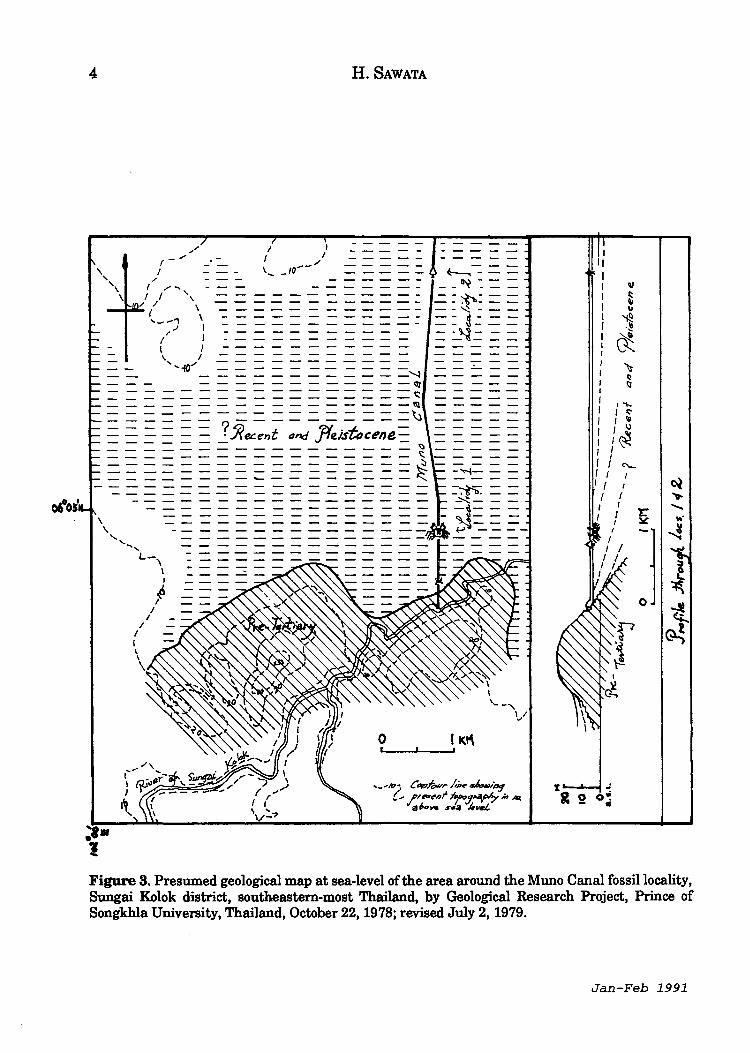
The British Museum studied the samples of these fossils sent by Prof. Haile and determined the cuttlefish is Sepia bandensis Adam (identified by Dr. M.K Howarth) and the crabs areMacrophthalmus (Venitus) latreillei (Desmarest) (identified by Dr. S.F. Morris) (Figs. 1,4-6). Dr. Morris writes that it ranges from Pleistocene to Recent and usually lives in estuaries or mangrove swamps. This species is known from the Pleistocene ofSabah and Ceylon; it is common as a sub-fossil from the Chinese coast and northern Australia. Its geographical range as an extant species covers most of southeast Asia, from the Gulf of Bengal to Japan and northern Australia
Material submitted by N.S. Haile and extracted with permission from Prince of Songkhla University Geological Research Project Publication No.4 (1979).
(Dr. Morris' letter dated 14th July 1977 to Prof. Haile). Prof. Haile also suggested dating of suitable samples from the locality, since this would give an estimation of the rate of build out of the coast, as the crabs plus cuttlefish would seem to indicate a shore line; he suspected the age was about 5,000 years.
On 22 October 1978, the writer had a chance during his holiday trip to visit the fossil locality with the kind guidance of Miss Patcharin Phannanukul, chief of Japanese course of this university and her brother-inlaw.
The attached sketch map (Fig. 2) shows the locality(loc. 1 in Fig. 3). Unfortunately, the high level of water in the Muno Canal prevented him from doing any geological study of the outcrop of locality itself, and only small amounts of imperfect fragments of crab fossils and white stone - cuttlefish bone fossil? - were shown to him by local inhabitants and one fragment of crab fossil was presented by one of them. The local people related that one or two years before about a thousand pieces offossil were found in the canal, and a buyer from Bangkok exhausted all the collection. These local people seemed to believe these fossils are valuable as medicine, and that might be the reason why the price offossils is so high and
ISBN 0126-5539 Warta Geologi, Vol.17, No.1, Jan-Feb 1991

2 H. SAWATA
the people are not so willing to offer their fossil collection to non-merchants.
The level of surface of the formation with these fossils is unknown and only be presumed at around 5 m above sea-level.
On the northern extension of Muno Canal, at the crossing point with the road from Sungai Kolok to Tak BailNarathiwat, ca. 14.5 km from Sungai Kolok (loc. 2 in Fig. 3), under and around the road bridge in the canal, there are found several outcrops of mud. Dark-grey mud 50 cm plus thick is covered by a black woody layer 5 cm thick. There is one independently standing trunk around 10 cm in diameter and 50 cm in height which may be natural wood stem or artificial post. This wood is black in its outer part and more brownish at the centre. No macrofossil was found at the outcrop. It was told that sometime before, a boat with a
buddha image ofInman style was found near the locality of fossils in the Muno Canal.
About 2 km west-north west of the fossil locality, the road cuts through a hill 33 m high and exposures of decomposed bedrock of possibly Palaeozoic are seen. The presumed geology of the area is shown on Figure 3.
It is hoped that a geological study of the fossil locality in the M uno Canal will become possible in the not too distant future when lowering water level in the canal may expose the fossil-bearing formation above water, and its stratigraphy may then become clarified and more fossils be collected for age determination.
The writer wishes to specially express his gratefulness to Prof. N.H. Haile for his kind information, valuable suggestions and improvement of this report.
Figure 1. Part of plate LX of Rumphius' "D'Amboinsche Rariteitkamer" 1741, showing fossil Macrophthalmus (No.1 and No.2).
Jan-Feb 1991

r.,.,
On base c1- topographic sheet maps 1: sqooo L7017 5321 11 and 54Z1 III and his glimpse
city of
\ \
, \ '\
\
I THAILAND
" .... ~ ') ..... _,
I
J
\
I
MALAYSIA
LEGEND _ decot"ro.sed lolls .. ,...,.Jc.: 'fi.e-18 .. tiary
X fossil looa~ >-< canal ja1e
/ loci'l rc>aGl _/..- hijhway I I t"" yaiL",aj
i 2 3 KM c.~~~~d~:===:=:d' ____ ..... '
Figure 2. Locality map of crab and cuttlefish bone fossils in Muno Canal, Sungai Kolok District, on the Thai-Malaysian border, southeastern-most Thailand.
04°05'
4 H. SAWATA
\
I I I I \ _ _ '0--/
- = = = = = = = = = -~ --- ------------~
=================~ -----------------~
======?==========~ = = ..:... :Rec.ent and }teis"tt,cene_ -----------------~ -----------------~ =================~ ---_-------------t:::::..
I I
I I
I
J
~ I
',IU • :I
~-:== --~:== -= :;tt.: = = --~---
=: 3':== = :....~.: = =
-""'1- --
=-~. = = ~---
:~== ~ ----
~ c:
" " ~ .~
(!:. ~ ~ I;l
I~
I c:-I 1\1 I \)
I~ I
I ~ I ....
r ....... ~ "'.
] ~
! ~
-t ~
Figure 3. Presumed geological map at sea-level of the area around the Muno Canal fossil locality, Sungai Kolok district, southeastern-most Thailand, by Geological Research Project, Prince of Songkhla University, Thailand, October 22, 1978; revised July 2, 1979.
Jan-Feb 1991
FOSSIL CRAB AND CUTTLE-FISH BONE IN PLEISTOCENE MARINE CLAY, THAILAND 5
023 W L.J LJ L..J U l..J ~-W
Scale In Cent imetres
023 W L.J L.J L..J U l..J I...J..--W Scale In Centimetres
Figure 4. Macrophthalmus (Venitus) latreillei from Muno Canal, Sungai Kolok, southeastern-most Thailand; collected by Prof. Haile at Kuala Lumpur; photo: courtesy of Department of Geology, University of Malaya.
Warr.a Geologi, Vol.17,No.l
6 H. SAWATA
o I 2 3 Ll L.J I..Jd....l w l.J ;....J W Scale In Centimetres
023 WwL.Juul..Juu Scale In Centimetres
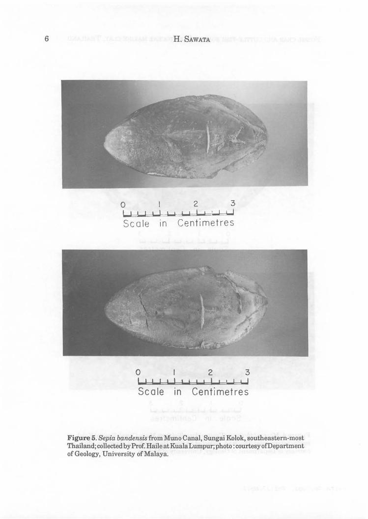
Figure 5. Sepia bandensis from Muno Canal, Sungai Kolok, southeastern-most Thailand; collected by Prof. Haile at Kuala Lumpur; photo: courtesy of Department of Geology, University of Malaya.
• o
o I
•
FOSSIL CRAB AND CUTTLE-FISH BONE IN PLEISTOCENE MARINE CLAY, THAILAND 7
• 5 err
1'" ,
o
fo. 1\ .1 o 2
dorsal right
side
left
side jlrl
back side ventral
front side
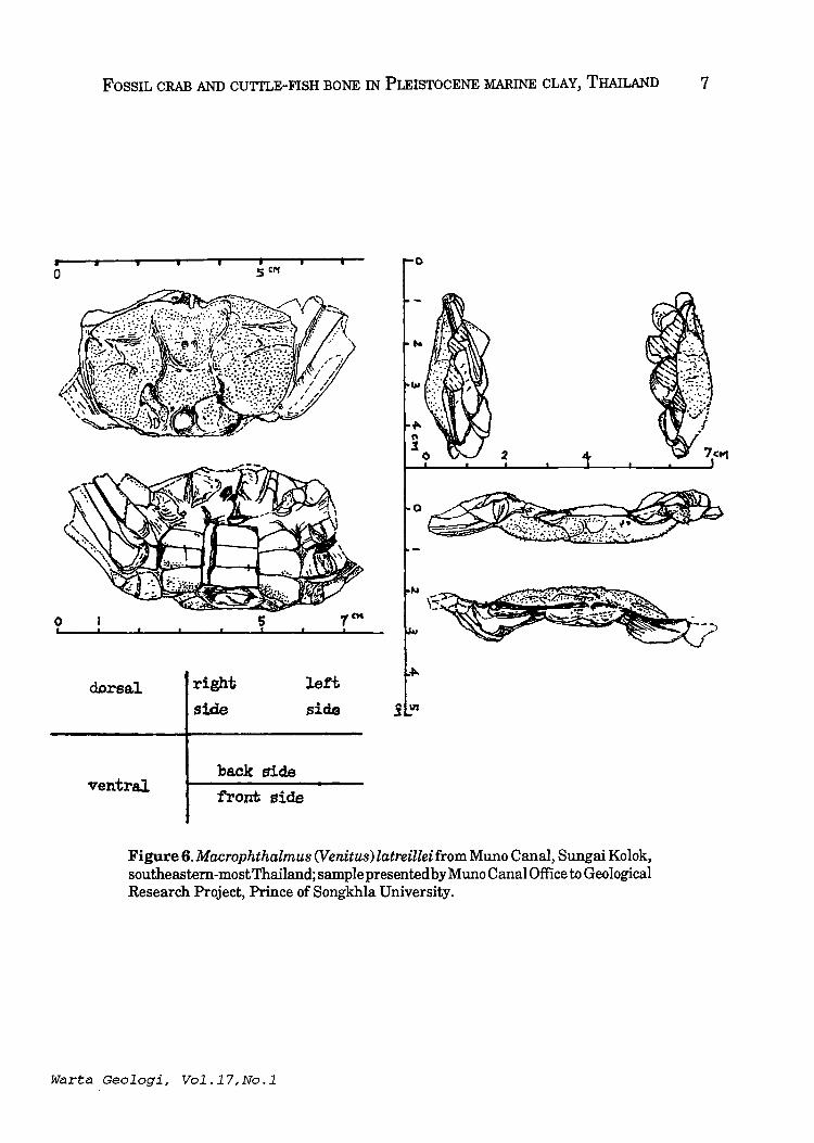
Figure 6. Macrophthalmus (Venitus) latreillei from Muno Canal, Sungai Kolok, southeastem-mostThailand; sample presented by Muno Canal Office to Geological Research Project, Prince ofSongkhla University.
Warta Geologi, Vol.17,No.l

8 H. SAWATA
Additional note on fossil locality of crabs and cuttlefish bones in Pleistocene clay at Sungai Kolok, southeast
most Thailand
Geological Research Project, Prince of Songkhla University, Thailand.
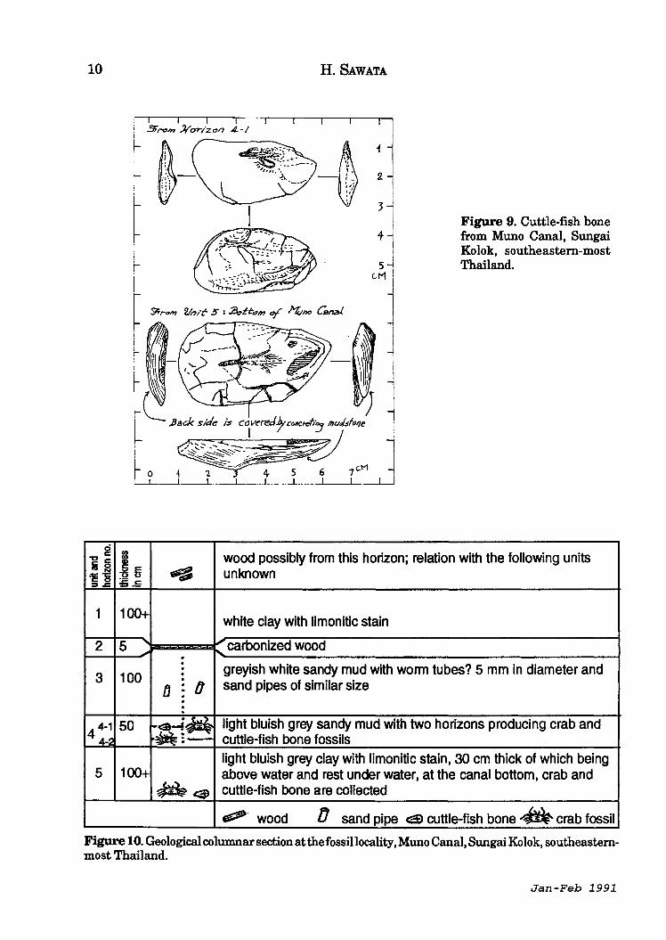
After the note of 25 October 1978 was prepared, on 1 July 1979, the Geological Research Project team of the Prince of Songkhla University finally managed to see the fossils locality of Muno Canal and collected a considerable amountoffossilcrabs and cuttlefish bones, nodules containing fossils, semi-carbonized wood and the clay and sandy mud accompanying.
The occurrence of the fossils is as follows from top to bottom:
Unit Description Thickness N~ mcm
1. White clay with limonitic stain. 100+
2. Carbonized wood 5
3. Greyish white sandy mud with worm tubes? 5 mm in diameter 100 and sand pipes of similar size.
4. Light bluish grey sandy mud with 50 two producing crab and cuttlefish bone fossils.
5. Light bluish grey clay with limonitic 100 + stain, 30 cm thick of which being above water and the rest under water of canal. In water, at the canal bottom crab and cuttlefish bone fossils are collected.
Most of fossils are forming nodules in clay and reveal no or a part of fossils.
Around 100 m south of the locality, carbonized and semi-carbonized wood is
found in light grey clay. This unit seems to form top horizon-present surface beside the canal. Exact relation between this and the units 1-5 above is unknown but presumably this covers the unit 1 with conformable? boundary. Sample of the woods of this unit and the unit 2 are also collected ..
Oneofthecrabfossils presented through the kindness of the Muno Canal Office was sent to the British Museum to be determined as Charybdis (Charybdis) aff. sinhaleya (identified by Dr. S.F. Morris)(Figs. 7-9). Dr. Morris tells that the genus Charybdis belongs to the family Portunidae, which is a group of predatory, swimming crabs, living in very shallow inshore waters; together with the Macrophthalmus (an inshore form) -mentioned in the note of25 October 1978, it suggests that these specimens lived on relatively soft sandy muds ranging from littoral to 20 m in depth (Fig. 10); the age of the fauna is almost certainly Pleistocene, but crabs do not enable us to sub-divide this period in any way.
A nodule sent to the New Zealand Geological Survey for radiocarbon dating however, showed the absence of carbon. Micropalaeontological study of sediments containing fossils is being sought.
As the shortest distance from the fossil locality to the present sea shore is around 17.5 km, it may be presumed the sea shore advanced for this distance during the time of Pleistocene to Recent with a mean value of advancement of shore line at around 0.01- 2 m/year.
***** Manuscript received 29 December 1990
Jan-Feb 1991

FOSSIL CRAB AND CUTTLE-FISH BONE IN PLEISTOCENE MARINE CLAY, THAILAND 9
1 ~ /~~ .. I' _ ............. •
...... -..
dor~ abdominal
Figure 7. Charybdis (Charybdis) afT. sinhaleya from Muno Canal, Sungai Kolok, southeastern-most Thailand; sample presented by Muno Canal Office to Geological Research Project, Prince of Songkhla University.
abdOll1ina.l dorsal
~nter1or posterior
~ .. .. ,
\. -~~.-.
2 .J
:,'.~:/ m.uddy cover ~ limonitic mater-ial
Figure 8. A fragmental sample offossil crab ofMuno Canal, Sungai Kolok, southeastern-most Thailand.
Warta Geologi, vol.17,No.l
10
g "l:I c Ii :::I
."'1:::: ·c C 0 ~ ..c
1
2
3
44-1 4-:;1
5
H. SAWATA
~ !!J;.T~~~ ~ :~I
i
2l 31
~ ! !
r I I r
+J 5 I
eM i
Figure 9. Cuttle-fish bone from Muno Canal, Sungai Kolok, southeastern-most Thailand.
~ ~~,., Vnlt- 5" I ~~~ 0/ ~no Cs~ ~ r l
j
81 wood possibly from this horizon; relation with the following units ~~ ~ unknown = .. 5
100+ white clay with limonitic stain
5 carbonized wood ~ .- " · greyish white sandy mud with worm tubes? 5 mm in diameter and · 100 •
fJ ~ 0 sand pipes of similar size
· : 50 ... .a~~ light bluish grey sandy mud with two horizons producing crab and ~;- cuttle-fish bone fossils
light bluish grey clay with limonitic stain, 30 cm thick of which being 100+ above water and rest under water, at the canal bottom, crab and
~ca> cuttle-fish bone are collected
~ wood IJ sand pipe c:tl cuttle-fish bone. crab fossil
Figure 10. Geological columnar section at the fossil locality, Muno Canal, Sungai Kolok, southeasternmost Thailand.
Jan-Feb 1991
Geological observations at the Seng Mines, Sungai Way, Selangor, in July 1972
PETER H. STAUFFER, U.S. Geological Survey, Menlo Park, California, U.S.A.
Abstract: The main opencast pit at the Seng Mines, active in 1972, exposed a complex section of unconsolidated sediments overlying bedrock of metamorphic (marble) and plutonic (granitic) rocks. The surface of the marble was eroded into rounded pillow shapes; this morphology is consistent with solution under saturated alluvium, and the jagged microkarst topography commonly seen on carbonate rocks in alluvial mines is probably formed subaerially. A mass of organic material (peat and wood) more than 20 m thick indicates long-term persistence of local swamp conditions; alluvial bedding dipping down toward the mass supports its origin by progressive solution of the underlying marble, facilitated by acids from the organic material itself. Fractures formed in the mass during subsidence are filled by veins ofvitrain-like coaly material derived from the peat and similar to those described earlier from Perak. Bedding layers in alluvial sediments on part of the granitic bedrock surface are steeply folded in conformity with irregularities in the granite surface. The inference that this geometry resulted from subsidence consequent on total removal by solution of intervening carbonate bedrock is supported by the presence of a boulder of reddish, cemented cave earth typical of solution cavity fillings.
These several features document in instructive ways the complex interactions of bedrocks, alluvial sediments, and water in this geologic environment, and they provide clues that can be used to interpret the history of events in other similar environments.
11
INTRODUCTION Just north of the junction of the old
Subang road with the Federal Highway, behind the row of old Sungai Wayshophouses, there was a series of opencast tin-mining pits active in the early 1970's. In July 1972, while I was Senior Lecturer in the Department of Geology, University of Malaya, I went out to visit the large and deep pit of the Seng Mines, just behind those shophouses. The visit was part of the course of instruction in Honours Sedimentology at U.M., and I was accompanied by the four students in the class: Kumar Khuttan, Lim Tee Peng, Tai Say Ann, and Tan Jee Theng.
evolution of bedrock and overlying sediment, and these instructive features cannot be seen again: not only are the mine pits long since filled, but the stratigraphy and structures of the unconsolidated sedimentary section have of course been totally destroyed during mining.
The features seen in the mine pit were of such interest that I have thought it worthwhile to put them on record from my notes and memory, even at this late date. They had much to say about the interrelated
GEOLOGY OF THE MINE
The Seng Mines at Sungai Way lay in the lower Klang valley, a flat tract formed by Quaternary sediment, mainly terrestrial, covering eroded pre-Cenozoic bedrock (Fig. 1). The general geology of this area has been described by Tharmarajan (1970). Regional geologic maps (Gobbett, 1972; Chung, 1973) show the mine site as being on the boundary between a unit of recrystallized sedimentary
ISSN 0126-5539 Warta Geologi, Vol.17, No.1, Jan-Feb 1991

12 PETER H. STAUFFER
carbonate rocks, probably continuous with the lower Paleozoic Kuala Lumpur Limestone (Gobbett, 1964), on the west and an area of granitic intrusive rocks, apparently an offshoot of the early Mesozoic Main Range (Hutchison, 1973), on the east. Indeed, both marble and granitic rocks were exposed in the mine pit in 1972 (Figs. 2, 3). The bedrock in the Seng Mines and its mineralization have been described by Goh (1975).
Above these bedrocks was exposed a section of Quaternary sediment approximately 25 m (75 ft) thick. The lower part of this section, directly on the bedrock, consisted, wherever it could be seen, of fairly pervasively weathered fine- to coarse-grained
o 10 km I
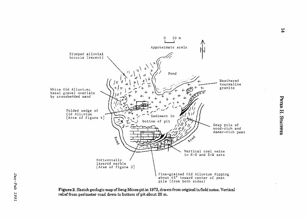
bedded clastic sediment that fit the characteristics of the Old Alluvium (Sivam, 1969; Stauffer, 1973). On the north side of the pit, such alluvial material, varying from white clay to grey, weathered gravel, was the only Quaternary sediment type visible (Fig. 2). Broken and slumped masses of this material formed the upper walls ofthe pit on the north side and most of the west side.
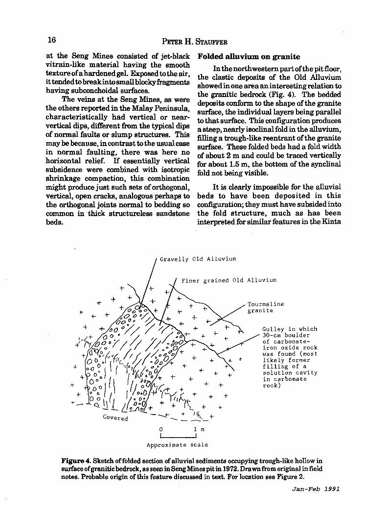
One area of Old Alluvium lying on the granite bedrock that underlay all the northern half of the pit (Fig. 2) showed particularly interesting features (Fig. 4). Here the bedding layers in the alluvium followed the shape ofthe underlying granite surface, even though this put them in a tight
[Not to scale]
SEN G
MIN E S
--
Figure 1. Location of the Seng Mines pit that was active in 1972, at the time of the observations described in the text, in relation to the Federal Highway and the old Sungai Way shophouses. Although the map is not to scale, the pit was no more than about 100 m from the shophouses.
Jan-Feb 1991
GEOLOGICAL OBSERVATIONS AT THE SENG MINEs, SuNGAl WAY, SELANGOR 13
synclinal fold with nearly vertical limbs. The implications of this will be discussed later. .
On the south and southeast sides of the pit the alluvial section had quite a different character (Fig. 2). Above the basal sequence, only a few meters thick, of clastic sediment similar to that in the other parts of the pit, the section here consisted of a deep mass, at least 20 m thick, of dark peat, rich in wood fragments and pieces of damar (solidified resin from forest trees). Layering in the Old Alluvium at the base of this section dipped south or southeast, toward the peaty mass, at about 45 degrees. One can infer, therefore, that the section of peat thickens in that direction, and the total maximum thickness is not known.
At the southern edge of the mine pit, on the exposed upper surface of the peat mass, could be observed numerous thin, vertical, black, tabular bodies, arranged in two orthogonal sets more or less east-west and north-south and mostly a few miJ1imeters to about 1 cm thick. These dark veins consisted of hard, brittle coaly material, and there seems little doubt that they correspond to the "coal veins" described by Fermor (1939) and Richardson (1941).from localities in the Kinta Valley and noted also by Fitch (1952, P. 46) in the Kuantan area of Pahang. Specimens of these veins were collected and are now in the University of Malaya Department of Geology collection.
FEATURE OF INTEREST
The geology of the Seng Mines pit as described here and as seen in July 1972 included several significant and instructive features. These features tell us some interesting things about the evolution of the Quaternary section at this site and particularly about the role of the bedrock in that evolution.
Warta Geologi, vol.17,No.l
Morphology of the marble surface
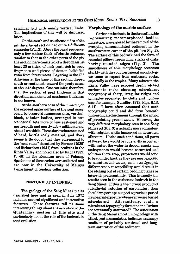
Carbonate bedrock, in the form of marble representing metamorphosed bedded limestone was exposed by the removal of the overlying' unconsolidated sediment in the southwestern comer of the pit (see Fig. 2). The surface of this bedrock had the form of rounded pillows resembling stacks of disks having rounded edges (Fig. 3). The smoothness of this morphology contrasts starkly with the rough erosional morphology we come to expect from carbonate rocks, especially in the tropics. Many mines in the Kinta Valley have exposed deeply etched carbonate rocks showing microkarst topography of sharp, irregular ridges and pinnacles separated by clefts and hollows (see, for example, Stauffer, 1973, Figs. 6.13, 6.14). I have often assumed that such topography could and did form beneath unconsolidated sediment through the action of percolating groundwater. However, the very different morphology seen in the Seng Mines pit (Fig. 3) is actually more consistent with solution while immersed in saturated alluvium. Under such conditions, all parts of the surface would be constantly in contact with water, the water in deeper cracks and embayments would become saturated and solution there stop, projections would tend to be rounded back as they are most exposed to unsaturated water, and stratigraphic differences in susceptibility would result in the etching out of certain bedding planes or intervals preferentially. This is exactly the results seen in the carbonate bedrock in the Seng Mines. If this is the normal product of suballuvial solution of carbonates, then should we perhaps suspect a previous period of subaerial exposure whenever we see buried microkarst? Alternatively, could a microkarst topography form under alluvium not continually saturated? The association of the Seng Mines smooth morphology with a thick peat accumulation indicates a swampy condition of probably continual and long-term saturation of the sediment.
Slumped alluvial breccia (recent)
White Old Alluvium; basal gravel overlain by crossbedded sand
Folded wedge of Old Alluvium [Area of figure
HorizontaHy layered marble [Area of figure 3]
o 10 m ~
Approximate scale
Pond
Weathered tourmaline granite
Deep pile of wood-rich and damar-rich peat
Vertical coal veins in N-S and E-W sets
Fine-grained Old Alluvium dipping about 45° toward center of peat pile (from both sides)
Figure 2. Sketch geologic map ofSeng Mines pit in 1972, drawn from original in field notes. Vertical relief from perimeter road down to bottom of pit about 25 m.

GEOLOGICAL OBSERVATIONS AT THE SENG MINES, SUNGAI WAY, SELANGOR 15
Deep peat accumulation and associated coal veins
The southern and southeastern walls of the mine pit were made up of very dark organic sediment richly studded with wood fragments of all sizes and with pieces of damar. It was clear that considerable quantities of such organic sediment had already been removed in the process of excavating the mine pit. This deep accumulation must be the deposits of a stagnant swamp or lake that was present over a considerable period of time. Persistence of such a water body was probably maintained by continuing subsidence ofthe substrate - the carbonate bedrock - through subsurface solution. Organic acids derived from the living and dead vegetation would, in turn, have facilitated solution of the carbonate bedrock by percolating groundwater, thus providing for further subsidence and therefore maintenance of the surface depression holding the stagnant water body that was producing the acids. This is a good example of an unstable system whose instability becomes self-perpetuating through positive feedback. Such a system
_. ---- ~ ~~ .... -~~.-~ ~-..:.- --~ ------ ------------ -- ~ --- -- . ./'"
.-.- -- ~-.-'.
o I
can continue to evolve until stopped by exhaustion of one or another ofthe elements involved in the feedback loop - in this case possibly the removal of all carbonate rock down to insoluble bedrock (granite) over much of the area of the surface water body, thus inhibiting further subsidence and allowing the water body to be destroyed by infilling with sediment.
During the active subsidence of the organic sediment, differential displacement of parts of the mass would give rise to stresses that result in fracturing, faulting, and offset. At the same time, disintegration and decay of the organic matter would produce concentrated solutions and colloidal suspensions of organic substances. These fluids could in turn be injected into the cracks formed during the uneven subsidence and compaction of the sediment sequence. In this way the organic material could inject upwards (and downwards) into the cracks, and squeezing out ofthe water from repeated or prolonged injections would leave behind an organic residue that eventually hardened to form the coal veins.
Like the similar veins reported in Perak (Fermor, 1939; Richardson, 1941), the veins
--
1 m I
------- . --_.
Approximate scale
Figure 3. Sketch of exposed marble bedrock in Seng Mines pit in 1972, showing smooth rounded shapes resembling stacks of discoid pillows. Drawn from original in field notes. For location see Figure 2.
Warta Geologi, Vol.17,No.l
16 PETER H. STAUFFER
at the Seng Mines consisted of jet-black vitrain-like material having the smooth textureofahardenedgel. Exposed to the air, it tended to break into small blocky fragments having subconchoidal surfaces.
The veins at the Seng Mines, as were the others reported in the Malay Peninsula, characteristically had vertical or nearvertical dips, different from the typical dips of normal faults or slump structures. This may be because, in contrast to the usual case in normal faulting, there was here no horizontal relief. IT essentially vertical subsidence were combined with isotropic shrinkage compaction, this combination might produce just such sets of orthogonal, vertical, open cracks, analogous perhaps to the orthogonal joints normal to bedding so common in thick structureless sandstone beds.
Folded alluvium on granite
In the northwestern partofthe pitfioor, the clastic deposits of the Old Alluvium showed in one area an interesting relation to the granitic bedrock (Fig. 4). The bedded deposits conform to the shape of the granite surface, the individual layers being parallel to that surface. This configuration produces a steep, nearly isoclinal fold in the alluvium, filling a trough-like reentrant of the granite surface. These folded beds had a fold width of about 2 m and could be traced vertically for about 1.5 m, the bottom of the synclinal fold not being visible.
It is clearly impossible for the alluvial beds to have been deposited in this configuration; they must have subsided into the fold structure, much as has been interpreted for similar features in the Kinta
Gravelly Old Alluvium
+
+
+
+ +-
COvered
Finer grained Old Alluvium
+
-I-
+
0 1 m I I
Approximate scale
+
+
+ +
+
+
Gulley in which 30-cm boulder of carbonateiron oxide rock was found (most likely former filling of a solution cavity in carbonate rock)
Figure 4. Sketch offolded section of alluvial sediments occupying trough-l~k.e ho~low in surface of granitic bedrock, as seen in Seng Mines pit in 1972. Dra~ from o,?gmal m field notes. Probable origin of this feature discussed in text. For location see Figure 2.
Jan-Feb 1991

GEOLOGICAL OBSERVATIONS AT THE SENG MINEs, SuNGAI WAY, SELANGOR 17
Valley (Ayob, 1970, Fig.4). However, in such previously reported examples, the bedrock beneath the alluvium. has been of carbonate rocks, and suballuvial solution of the carbonate provides a convenient explanation for the subsidence of the clastic deposits. Here at the Seng Mines the bedrock was granite, and such rock is not susceptible to solution as are carbonate rocks. However, carbonate bedrock was present elsewhere in the mine pit, and the mass of peaty sediment provides indirect evidence that much carbonate rock has been removed by solution (see above).
It is not unreasonable, therefore, to infer that the contact of granite and folded alluvium. seen in the northern part of the mine pit was originally a contact between granite below and carbonate rocks above, that is, that carbonate bedrock overlay the granite in at least that area. Solution then gradually removed the carbonate rock, and the overlying alluvial deposits were let down onto the insoluble granite. This process must have continued until no carbonate rock at all remained over considerable areas. Where the originalgranite-carbonate contact was in the shape of a trough, the alluvial beds would have been distorted as they were let down and ended up in a tight syncline.
Some support for the inferred former presence of carbonate rocks above the granite in the northern part of the mine pit was provided by the presence of a boulder observed during the 1972 visit (see Fig. 4). This boulder, which was found lying on the granite surface a few meters from the folded alluvial beds, was composed of a red-brown mixture of carbonate andiron oxides such as is commonly found filling solution cavities in limestone hills. Being only partly of carbonate mineral (and that sometimes siderite), such material is less soluble than the carbonate bedrock and so commonly survives as residual boulders and fragments where the latter has been extensively dissolved. This particular boulder was about 30 em across, larger than the clasts in the alluvial section, and it lay at an elevation
Warta Geologi, vol.17,No.l
above the carbonate bedrock exposed elsewhere in the mine. Therefore it was most likely a residual boulder let down onto the granite surface by solution of its surrounding carbonate material.
DISCUSSION
The features seen in the Seng Mines and described above indicate the complex interaction of bedrock and alluvium. in areas were soluble carbonate rocks occur, and they provide clues we can use to interpret other exposures, particularly where the carbonate rock has totally disappeared.
The interrelated evolution of alluvium. and bedrock is best seen in the feedback loop of the peat swamp over carbonate bedrock. Here the acids released in the swamp help dissolve the underlying carbonate rocks, causing surface subsidence that in turn perpetuates the swamp conditions at the surface. This feedback loop operated here long enough to build up a thick mass of peaty sediment and possibly to remove all carbonate bedrock, down to the contact with insoluble bedrock, underneath most of the swamp.
The nature of the bedrock, therefore, has here influenced or determined the nature of the sediment deposited above it, even after that bedrock was already buried. The nature of the sediment has, in turn, promoted the continued solution of the bedrock.
The folded alluvium on the granite surface also is a product of the interrelation of bedrock and unconsolidated sediment. In this case, deformation of the alluvium. has resulted because of the irregularity of the original contact between soluble and insoluble bedrocks. Because the soluble bedrock has been entirely removed by solution in that area, this interpretation must be inferred from indirect clues. Fortunately, exposures elsewhere in the mine pit gave much evidence of the story. If the granite-alluvium. contact had not, however, been exposed, interpreting the fold structure

18 PETER H. STAUFFER
in the alluvium would have been very FERMOR, L.L., 1939. Coal veins in Malaya. problematical. Geological Magazine, v. 76, p. 465-472.
If the interpretation is correct that the rounded morphology of the marble surface in the mine pit formed under saturated alluvium, that alluvium (already removed by mining at the time I visited the mine pit) must have subsided and deformed to accommodate the evolving shape of the bedrock surface. The resulting structures formed in the sediment should have had the form of irregular, wrinkled synforms separated by smooth, arching, domelike antiform. Their shape in plan view would depend on any pattern of preferred orientation of solution depressions in the bedrock (following joints, perhaps).
Finally, consider the boulder of redbrown cave deposit. Recognitionofthenature and origin of this rock provided an important clue to the complex history of this area. Had no carbonate bedrock been visible in the mine pit, would this boulder have been overlooked? Would it have been recognized but dismissed as a fluke or a boulder somehow introducedduringminingoperations? Would it have been regarded as irrelevant? If there is one main lesson to be learned from all these observations, it is this: do not overlook anything, no matter how seemingly trivial or irrelevant. Geologic histories are usually more complex than we would like to think, and the more obscure parts of those histories may have left only few and very indirect clues.
REFERENCES
AYOB, MOHAMMAD, 1970. Quaternary sediments at Sungei Besi, West Malaysia. Geological Society of Malaysia Bulletin, v. 3, p. 53-61.
CHUNG, S.K, 1973. Geological map of West Malaysia, seventh edition (1:500,000). Federation of Malaysia, Geological Survey Department.
FITCH, F.H., 1952. The geology and mineral resources of the neighborhood of Kuantan, Pahang. Federation of Malaya, Geological Survey Department Memoir, v. 6, 114 p.
GoBBE'IT,D.J.,1964. The Lower Palaeozoic rocks of Kuala Lumpur, Malaysia. Federation Museums Journal, v. 9, p. 67-79.
GoBBE'IT,'D.J., 1972. Geological map of Malay Peninsula (1:1,000,000). Kuala Lumpur, Geological Society of Malaysia.
GoH YOK LENG, 1975. Bedrock geology and mineralisation of the Seng Mines, Sungei Way, Selangor. University of Malaya B.Sc. (Hons.) thesis, 62 p.
HUTCHISON, C.S., (1973). Plutonic activity. Chapter 8 in Gobbett, D.J., and Hutchison, C.S., eds., Geology of the Malay Peninsula (West Malaysia and Singapore). New York, Wiley-Interscience, p. 215-252.
RICHARDSON, J.A, 1941. The coal veins of British Malaya. Geological Magazine, v. 78, p. 451-462.
SIVAM, S.P., 1969. Quaternary alluvial deposits in the north Kinta Valley, Perak. University of Malaya, M.Sc. thesis, 170 p.
STAUFFER, P.H., 1973. Cenozoic. Chapter 6 in Gobbett, D.J., and Hutchison, C.S., eds., Geology of the Malay Peninsula (West Malaysia and Singapore). New York, Wiley-Interscience, p.143-176.
1'HARMARAJAN, N., 1970. Studies in geology and Quaternary sediments of the Sg. Way - Sg. Buloh area, Selangor, West Malaysia. University of Malaya B.Sc. (Hons.) thesis, 125p.
Original draft completed December 14, 1988. Revised February 27, 1989; December 31, 1990. Final revision February 1, 1991.
***** Manuscript received 4 March 1991
Jan-Feb 1991
M. Yogeswaran Hydrogeology of Sarawak with some aspects on groundwater development
Laporan (Report)
19
The above talk was held on the 21 January 1991 at Geology Department, University of Malaya. What follows is a synopsis of the talk as prepared by the speaker, Yogeswaran Mailvaganam, who is with the Geological Survey of Malaysia in Kuching. .
Sinopsis (Synopsis)
Sarawak is endowed with abundant surface water resources contributed by the large surplus of over 2 m of rainfall over evapotranspiration. However, the distribution of the rainfall in time and space have resulted in limited availability· of water of acceptable quantity and quality for existing and proposed Water Supplies in some parts of the State. This has, in the recent years, forced water-resource professionals to explore and exploit alternative sources, including groundwater.
The distribution of groundwater in Sarawak is illustrated in the Hydrogeological Map of Sarawak, 1986, and this represents the first concerted effort to record the overall groundwater resources ofSarawak; the map, on a scale of1:500,OOO was based on infonnation available as at 1983, and, since its publication, a wealth of new infonnation has been obtained necessitating the updating and, in some cases, revision of the map.
The Quarternary alluvial deposits in the coastal plains form the most important aquifers, with the shallow coastal sands fringing the coast being the most extensively exploited aquifers. The development of these coastal sand aquifers takes into consideration that they are, in most cases, surrounded and underlain by saline water and that the flow of water in these sands is slow with hydraulic conductivities ranging from 5 to about 15 mid. The two types of well and well-field designs which have been adopted to tap water from these aquifers cater for the transient nature of the flow of groundwater and thus reduce the danger of saline intrusion particularly by upcoming. These well designs consist of:
1. a large number oflow-yielding wells which are arranged either singlely or in arrays of 4 wells or 8 wells which are evenly spaced at predetermined locations over the catchment area.
2. a series of horizontal wells which are installed parallel to the groundwater flow front or along the crest of a groundwater mound.
Warta Geologi, Vol.17, No.1

20
Connate saline water are not uncommon in these coastal aquifers; mixing of waters from the fresh water portion ofthe aquifers and the connate water has enlarge the useable size of the aquifers in some of groundwater supply schemes.
The deeper sand aquifers in the coastal plains are multi-layered and are brackish to saline towards the coast, but are of acceptable quality towards the inland areas.
Peat, which underlies about 1.6 million hectares of the coastal plain and some inland valleys is also considered an important source of water. They contribute to the base flow of the coastal streams and also to water wells, parlicularlythe low-humified woody peat. The concept of utilising the water directly from peat aquifers involves the abstraction of water from the peat and allowing for a predetermined drop in the overall natural water-level during the dry spell. This is to prevent an accelerated subsidence normally expected when peat is drained or when oxidizing rainwater is allowed to infiltrate deeper into the peat profile.
Several major sedimentary basins with good groundwater potential occur in Sarawak and notable among them are the late Tertiary rock formations in northwest Sarawak. These formations include the Tukau, Lambir, Miri and Belait Formations; the wells ofthe large groundwater scheme which supplements the Miri water supply is located within the sandy facies ofthe Tukau Formation. The rocks ofthe Nyalau Formation, which has a wide distribution in the Bintulu and Nanga Merit areas are also noteworthy. The Silantek' Formation and Kayan Sandstone are cris-crossed by numberous sills and dykes, and these have a tendency to reduce the transmissivities of the rock aquifers.
Fractured rocks occupy more than half of the State ofSarawak, and these include the igneous, metamorphic and the older sedimentary rocks; the aquifers located in these rocks are seldom extensive and are only locally important. These aquifers are being increasingly tapped in the recent years for industrial and agricultural uses.
M. Yogeswaran
* **** Jan-Feb 1991
M. Fuller: Tertiary paleomagnetism of regions around the South China Sea
Loporon (Report)
21
The above talk by Dr. M. Fuller (Department of Geological Sciences, University of California, Santa Barbara, California) was sponsored by the Geological Society of Malaysia in collaboration with the Geology Department, University of Malaya. It was held at the Geology Department, University of Malaya on 30 January 1991 and attracted a crowd of about 45. The speaker has kindly supplied an abstract of the talk.
Abstrok (Abstract)
Paleomagnetic data from the Philippine Sea Plate reveal a history of clockwise (CW) rotation and northerly translation, since the late Eocene, which appears to be plate wide. The results imply a pole of rotation to the east. The motion generated left lateral oblique convergence between the Philippine Sea Plate and SE Asia.
Late Miocene paleomagnetic data from the Philippines show CW rotation in the northern island of Luzon, while to the south in the Central and Southern Philippines no rotations are seen. This defines the North and the Central and South Philippines Paleomagnetic Domains (NPPD and SCPPD). In the Miocene, the NPPD exhibits rapid counterclockwise (CCW) rotation, but the SCPPD shows CW rotation. There are indications of pre-Miocene CCW rotation from Zambales, the Visayans and the Celebes Sea.
In Borneo, a history of Tertiary CCW rotation has been found in Sarawak, Sabah and West Kalimantan. In central Kalimantan, there are conflicting results, some of which show no rotation with respect to stable Eurasia, while others give CCW rotations consistent with those seen elsewhere.
M. Fuller
Warta Geologi, Vol.17, No.1

22
In the Malaysian peninsula, the Segamat basalts, of late Cretaceous Early Tertiary age show CCW rotations similar to those seen in Sarawak. To the north in the Thai peninsula, CW rotations have been found in two Tertiary basins. Late Tertiary basalts from Central Thailand have given similar results, but on the Khorat plateau comparable basalts are unrotated.
The tectonic implications of the results remain controversial. In particular, the relative importance of true plate rotations and localized rotation of upper crustal blocks in distributed shear zones is unclear. The CW rotations seen in Thailand are consistent with, though do not require, propagating extrusion tectonics. The substantial region of CCW rotation in Borneo and the Philippines is consistent with the broad features of the Holloway model. However, the eastern boundary of SE Asia has experienced left lateral oblique convergence, since the late Eocene, and the effect of interaction with the Philippine Sea Plate must be added to the Holloway model.
*****
Jan'-Feb 1991

23
Peter Gutteridge : Carbonate sand bodies at the northern margin of the Darbyshire Carbonate Platform (Lower Carboniferous) U.K.
Laporan (Report)
Dr. P. Gutteridge (22 George Street, Cambridge, CB4 1AJ, U.K.) presented the above talk on 7 February 1991 at the Geology Department, University of Malaya. What follows is a Summary of the talk prepared by the speaker.
Ringkasan (Summary)
The Darbyshire carbonate platform is one of the numerous carbonate platforms which were present overmuch of northern England during the Lower Carboniferous. Two main types of carbonate sands are present at the northern margin of this platform: a sand-body complex developed on the shelf-top in the immediate vicinity of the platform margin, and a submarine carbonate fan or apron draped over the lower platform margin slope. Trace resedimented carbonates were derived from the shelf margin sand body.
The shelf margin carbonate sand body complex was built-up by repeated basinward progradation and abandonment of large-scale carbonate bedforms in response to minor sea-level fluctuations. The presence of occasional foresets within these bedforms composed of micritised grains and marine cements suggests that the migration ofthese bedforms was episodic. The large-size suggests that the bedforms were active only during periods of storms.
The bedforms show a consistent basinward migration. The predominant direction of sand transport at this margin of the carbonate platform was thus basinward. The carbonate sands transported oft'shelf accumulated in a submarine fan or apron deposit which was draped over the lower slope and base of slope of the platform as are series of ?high and low density turbidites and probable grain-flow deposits.
*****
Wart a Geologi, Vol.17, No.1
GEOLOGICAL SOCIETY OF MALAYSIA PUBLICATIONS BULLETIN OF THE GEOLOGICAL SOCIETY OF MALAYSIA
WART A GEOLOGI - NEWSLETTER OF THE GEOLOGICAL SOCIETY OF MALAYSIA
ADVERTISING SPACE ORDER FORM
RATES:
Inside full page per issue Inside half page per issue Inside full page for 6 issues Inside half page for 6 issues
WARTA GEOLOGI Fonnat: 20 cm X 28 cm
Black & White
MS300 MS200 MSI500 MSIOOO
Colour
MS600 MS500 MS3000 MS2500
BULLETIN Fonnat: 18 cm X 25 cm
Black & White Colour
MSlOOO MS500
MSI500 MS800
Artwork and positive films or slides (for colour or black & white) should be supplied by the advertiser.
Please send the completed fonn below together with remittance payable to "Geological Society of Malaysia' to
The Editor, Geological Society of Malaysia c/o Dept. of Geology, University of Malaya, 59100 Kuala Lumpur, Malaysia.
For further infonnation, please ring 03-7577036.
The Editor, Geological Society of Malaysia, c/o Dept. of Geology, University of Malaya, 59100 Kuala Lumpur.
We would like to take up advertising spar.e in WARTA GEOLOGVBULLETIN in the fonn (please tick as appropriate):
WARTA GEOLOGI BULLETIN Black & White Colour Black & White Colour
Inside full page one issue 0 one issue 0 one issue 0 one issue 0 six issues 0 six issues 0 issues 0 issues 0
Inside half page one issue 0 one issue 0 one issue 0 one issue 0 six issues 0 six issues 0 issues 0 issues 0
ArtworklPositive filmlslide* enclosed 0 not enclosed 0
Company ................................................................................................................................................................ .
Address .................................................................................................................................................................. ..
Enclosed cheque/money orderlbank draft* ......................................... for MS ................................................... .
Person to be contacted ......................................................................... Tel ......................................................... .
Designation .......................................................................................... Signature .............................................. .
* Please delete as appropriate
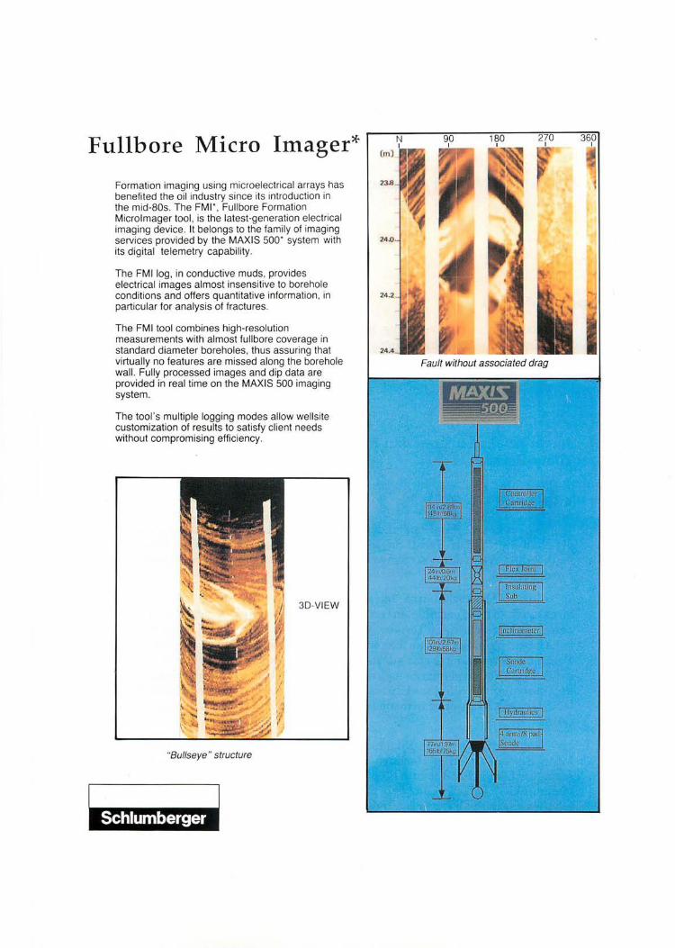
Fullbore Micro Imager*
Formation imaging using microelectrical arrays has benefited the oil industry since its introduction in the mid-80s. The FMI", Fullbore Formation Microlmager tool, is the latest-generation electrical imaging device. It belongs to the family of imaging services provided by the MAXIS 500' system with its digital telemetry capability.
The FMllog, in conductive muds, provides electrical images almost insensitive to borehole conditions and offers quantitative information , in particular for analysis of fractures.
The FMI tool combines high-resolution measurements with almost fullbore coverage in standard diameter boreholes, thus assuring that virtually no features are missed along the borehole wall. Fully processed images and dip data are provided in real time on the MAXIS 500 imaging system.
The tool 's multiple logging modes allow wellsite customization of results to satisfy client needs without compromising efficiency.
3D-VIEW
"Bullseye " structure
Fault without associated drag
26
) Tajul Anuar Jamaluddin : Survei ketakselanjaran dan ragam kegagalan cerun batuan di Lebuh Raya Timur-Barat
2) Abdul Hadi Abdul Rahman : The use of wireline logs and cuttings for the prediction of subsurface s~dimentary facies - A case study from the Northumberland Trough, Northern England
Laporan (Report)
To encourage our new, young lecturers to present their fmdings, the Society in collaboration with the Geology Dept., University of Malaya sponsored the talks by Tajul Anuar Jamaluddin and Abdul Hadi Abdul Rahman on the evening of20 February 1991 at the Geology Department, University of Malaya. The 2 speakers have kindly supplied the abstracts to their talks.
1) Survei ketakselanjaran dan ragam kegagalan ceron batuan di Lebuh Raya Timur-Barat
Abstrak (Abstract)
Survei ketakselanjaran telah dijalankan pada 14 buah ceron potongan batuan di Lebuh Raya Timur-Barat. Survei ini bertujuan untuk menjelaskan kehadirannya padajasad batuan dan seterusnya digunakan untuk meramalkan ragam kegagalan ceron batuan.
Survei ketakselanjaran ini menggunakan teknik garis pengimbasan yang direntangkan pada permukaan ceron. Setiap ketakselanjaranyangmenyilangigaris pengimbasan dicatatkan berikut: jenis, jarak pisahan, orientasi, panjang, bukaan, kekasaran permukaan dan bahan pengisi ketakselanjaran serta kehadiran air. Parameter bentuk serta saiz purata blok batuan yang terbentuk akibat persilangan satah-satah ketakselanjaranjuga diambil kira untuk menjelaskan kepadatan relatif ketakselanjaran pada jasad batuan. Panjang ketakselanjaran dijelaskan secara lebih terperinci lagi dengan menjelaskan keterusan dan pendedahannya pada muka ceron.
Data daripada survei ini dapat digunakan untuk menentukan nilai Penanda Mutu Batuan (PMB). Hasilnya menunjukkan jasad batuan pembentuk ceron mempunyai nilai PMB sekitar 65-85%. Plot stereografi kutub satah ketakselanjaran menunjukkan kebanyakan ceron memperlihatkan ragam kegagalan baji, satah dan tebalikan, atau gabungan lebih daripada satu ragam kegagalan tersebut. Ujlan Markland digunakan untuk mengecam satah ketakselanjaran 'genting' dan meramalkan kestabilan ceron batuan.
Jan-Feb 1991

27
2) The use of wireline logs and cuttings samples for the prediction of subsurface sedimentary facies: A case study from the Northumberland Trough, Northern England.
Abstrak (Abstract)
Four 280 metre boreholes have been drilled through a cyclical sequence of sandstones, shales and carbonates in Whitchester, in the Northnumberland Trough region, Northern England. Two ofthe holes, Whitchester Boreholes 1 and 2 have been fully cored and have cuttings samples collected during borehole enlargements.
This study on the use of basic and advanced wireline logs and cuttings for the prediction of subsurface sedimentary facies has been carried out on the well data of Whitchester Boreholes 1 and 2 of Northumberland basin, west of Newcastle-uponTyne.
The analysis ofwireline log cross-plots ofNGS(Natural Gamma-ray Spectrometry) Tool revealed some important relationships between the different lithofacies and their K, Th and U content. These are:-
a. The claystone facies which overlies the limestone units, which was interpreted as prodeltaic, show low uranium content and fairly high thorium and potassium content;
b. The mudstone facies which overlies the coals show high uranium content and high thorium content but slightly lower potassium content compared to the claystone. This lithofacies has been interpreted to be lagoonal or bay pelagic mud.
From the analysis of cuttings samples of BH-1, five important observational features were noted:-
i. A major facies - a lithofacies - is broken down into several different subfacies in the cuttings. These have been referred to here as the "cuttings facies".
ii. Each "cutting facies" consist of cuttings chips of distinctive "lithology" and shape.
iii. There seem to be a preference in the size of the cuttings. Greater amount of cuttings were collected in the intermediate size classes - 1.00 and 2.36 em, 2.36 to 3.35 cm and 3.35 to 4.75 em.
iv. The siderite/ironstone facies picks out well in size classes 1.00 to 2.36 em and 2.36to 3.35 cm, but not in the larger classes. They seem to show greater depth lag in the larger classes. This could probably be related to the density of the cuttings facies.
v. The distribution of coal cuttings seem to be fairly erratic and independent of the coal zones.
Warta Geologi I vol.17 I No.1

28
From the overall investigations that have been carried out, the following conclusions have been drawn:-
1. The prediction and interpretation of subsurface lithology by the analysis of wireline logs prove to be very useful and reliable method for subsurface analysis. In the case of the cyclic deltaic sequence of Whitchester, the Natural Gamma-ray Spectrometry (NGS) Tool logs in particular is very useful in that it reveals the distribution of potassium, thorium and uranium in different lithofacies, and thus became very useful in the characterisation and correlation of the various facies.
2. Cuttings analysis can be utilized to improve the characterisation of subsurface sedimentary facies. The cuttings samples need to be separated into several different size classes before they can be usefully analysed and be able to give meaningful results. This is because the arrival of drill cuttings to the surface is influenced by its size, density and also the annular velocity. The presence of cuttings of a particular lithology - "cuttings facies" - in all the different size classes improves the reliability of its correlation with subsurface lithology.
3. Cuttings of size ranging from 1. 00 mm to 4.70 mm are the most representative ofthe lithology oftheir recorded collection depth in the case ofthe cuttings samples ofthe Whitchester Boreholes.
4. Cuttings breaks down a major lithofacies into several different "cuttings facies" of distinctive lithology and shape. The understanding of the association of the different "cuttings facies" that derives from a major lithofacies is important in utilizing the cuttings to improve and enhance subsurface lithological and facies interpretations by wireline logs.
Tajul Anuar Jamaluddin and Abdul Hadi Abdul Rahman
* * * * *
Jan-Feb 1991

29
Jawatankuasa Pencalunan (Nominations Committee)
The Council nominated the following members to form the Nominations Committee:
Fateh Chand (Chairman) S. Paramananthan Azhar Hj. Husin
The Committee Chairman, Fateh Chand reported to the Council that three nominations were received before the closing date of 3 December 1990.
Taking into account the nominations, the Nominations Committee then presented its list of nominations for GSM Council 1991192.
President: Vice-President : Hon. Secretary : Hon. Asst. Secretary : Hon. Treasurer: Hon. Editor:
Councillors (2-year term) :
Councillors (1-year term):
Ahmad Said KhalidNgah JimmyKhoo Ahmad Tajuddin Ibrahim Lee Chai Peng TehGuanHoe
Abdul Ghani Mohd Rafek Mazlan Madon Nik Ramli Nik Hassan Tan Teong Hing
Andrew Spykerman Cheong Kok Keong Chin Lik Suan FatehChand
* * * * *
AppOintment of New Councillor & Chairman of Engineering Geology Working Group
The Council in its January 1991 meeting co-opted Dr. Ghani Rafek to replace Dr. S. Paramananthan as Councillor for 1990-91.
Dr. Ghani Rafek has also taken over as Chairman, Engineering Geology Working Group.
* * * * *
Wart a Geologi, Vol.17, No.1
30
The following applications for membership were approved:
Full Members
1. DannySoo Core Lab., Lot lOB, Jalan 51A1223, 46100 Petaling Jaya, Selangor.
2. Yusni Mohamed Yusuf SyedMohammad, Hooi & Binnie, P.O. Box 12610, 50784 Kuala Lumpur.
3. Samsudin Hj. Taib Dept. of Geology, UniversityofMalaya, 59100 Kuala Lumpur.
4. PA Comet Geochemical & Environmental Research Group, 833, South Graham Raod, College Station, TX 77845, U.S.A
5. IvanKok WMC Petroleum, 12 Floor, Bangunan Getah Asli, 148 Jalan Ampang, 50450 Kuala Lumpur.
6. Lim Heng Gaul 405 Blk. A2, Seksyen 4, Bandar Baru Wangsa Maju, 53300 Kuala Lumpur.
7. Jonathan Redfern Petrofina Far East, 138 Cecil St., 12-01, Cecil Court, S'pore 0106.
Student Members
1. Kung Soo Hui School of Physics, 11800 USM, P.Pinang.
2. Sulaiman Salleh Dept. of Geology, UniversityofMalaya, 59100 Kuala Lumpur.
Institutional Members
1. Total CFP Attn: Jacques Marie, 435 Orchard Road, 17-01/03 Wisma Atria, S'pore 0923.
*****
The following members have informed the Society of their new addresses:
1. Parameswaran Suppiah Petronas Carigali Sdn., P.O. Box 12407,50776 Kuala Lumpur.
2. Leow Sui Fan 83, Persiaran Wira Jaya Timor 42, TamanDatoLeow Yan Sip, 31350 Ipoh, Perak.
3. Cheah Tik Wah Mainline Resources Ltd., Suite 2061 207, Setiabudi2 Bldg., JI. H.R. Rasuna Said Kuningan, Jakarta 12920, Indonesia.
4. Zainol bin Hj. Husin Geological Survey of Malaysia, P.O. Box 1015, 30820 Ipoh, Perak'
Jan-Feb 1991

5. Engku Nasir syed Mohamad MMC Bhd., 4129-A, Jalan Tongku Ismail, Off Jalan Telipot, 15150 Kota Bharu, Kelantan.
6. AJ. Burley Flat 7H, Grove End House, Grove End Road, London NW8 9HL, U.K.
7. Chan Foo Khee Mamut Copper MiningSdn. Bhd., P.O. Box 5, 89307 Ranau, Sabah.
8. James K Blake Petroconsultants (Far East) Pte. Ltd., Afro-Asia Building #07-12, 63 Robinson Road, Singapore 0106.
31
9. Tan YongPhang c/o BHP Minerals Ltd. No. 76, 2nd Floor, Block C, Kompleks KUWASA, 88000 Kota Kinabalu.
10. Mohd. Badzran bin Mat Taib Pejabat Penyiasatan Kajibumi, Seberang Jalan Putera, 05150 Alor Setar, Kedah Darulaman.
11. Triton Energy Corporation 6688 North Central, Suite 1400, Dallas, TX 75206. Attn: G.M. Smart.
*****
1. Dale C. Beeson formerly of 1517 West 3rd Street, Irving, Tx. 75060, U.S.A.
The Society has received the following publications:
1. U.S.G.S. Bulletin, 1990: 1730-D,1751-0, 1752, 1753-B, 1839-E, F, 1745-C, 1757-J, 1915, 1857-E, 1857-F, 1911, 1922, 1936, 1944, 1891, 1717-D, 1857-H, 1908, 1756-F.
2. Chronique de la Recherche Miniere, no. 501, 1990.
3. AAPG Explorer, Jan, Feb 1991. 4. Bulletin Centres Rech. Exploration
Production Elf Aquitaine, vol. 14, no. 2,1990.
5. Mem. Expl. Cartes Geologiques et Minieres de la Belgique, no. 28 & 29, 1990.
6. Geological literature of USSR. Bibliographical Yearbook for 1985 year, vols. I & II, 1990.
7. U.S. Geological Survey Circular, 1990: 1053,1036,1052,1049,1000.
8. U.S. Geological Survey Professional Paper, 1990: 1370-H, 1403-E, 1468, 1504.
9. Gazetteer of the Antarctic, 1989. 10. Seatrad Bulletin vol. XI, nos. 2, 3 & 4,
1990. 11. A history of the water resources
divisions, U.S. Geological Survey: vol. V, July 1, 1947 to April 30, 1957.
12. Berliner Geowissenschaftliche Abhandlungen, 1989: Band 111, 114, 115; 1990: Band 119, 121, 122, 123.
13. 28th International Geological Congress, abstracts: 3 vols. 1989.
***** Warta Geologi, Vol.17, No.1
32
Geological Survey of Malaysia - Annual Report" Proceedings of Annual Geological Conference
For 1988, the Geological Survey of Malaysia has changed the format ofits Annual Report. It now comes in two separate volumes. One volume is the Annual Report proper and the other volume is called the Proceedings of the Annual Geological Conference and carries the Technical Papers.
The Annual Report Geological Survey of Malaysia now deals only with the various achievements and regional activities dealing with geological mapping, mineral exploration, hydrogeology, engineering geology and geoscience services. Included too are cooperation with international agencies and institutes and lists of latest publications and reports available. An overview of the regional geology and mineral resources for Malaysia is described in considerable details. The inside front cover carries a 2-page coloured map of Peninsular Malaysia based on the 8th Edition
Geological Map 1985 while the inside back cover carries a2-pagecolouredmap ofSarawak and Sabah based on the 4th Edition Geological Map 1986.
The second and separate volume consists of technical papers presented during Annual Geological Conferences, the 20th Geological Conference held in Cameron Highlands in January 1989 and the 21st Geological Conference held in Pulau Pinang in January 1990. The progress and technical findings for the year are deliberated, complete with maps and statistics.
Each volume, in soft cover, is priced at M$20.00 and obtainable from Ibu Pejabat Penyiasatan Kajibumi, Tingkat20, Bangunan Tabung Haji, Peti Surat 11110, Jalan Tun Ruak, 50736 Kuala Lumpur
Proceedings of the 20th Geological Conference, 1989 - Contents
Lithogeochemistry of the Mersing Area, Johor and Its Implication for Gold Exploration in the Eastern BeltofPeninsular Malaysia Aw Peck Chin and Loh Chiok Hoang
Kajian Geokimia Tanah, Kawasan Marup, Engkilili, Sarawak Mohd Faisal Abdullah dan A. Unya Ambun
Persampelan Emas di Kawasan Marang, Eksplorasi Geokimia, Kawasan Labis, Syit Terengganu 116,Johor Ong Wee Seck dan Mohd Sidek Zakaria Hussain
KajianKemungkinan Kewujudan EmasPlaser di dalam Lapisan. Aluvium Berpebel di Utara Tasik Chini, Maran, Pahang Darul Makmur Mohd Pauzi Abdullah
Follow-up Geochemical Exploration in the Ladang Dafa Gold Prospect, LunduSametan Area, Sarawak Tennent Ahai and Victor Hon
Base-metal Exploration in the UluMarasimsim Area, Marudu Bay, Sabah Joanes Muda and Alexander Yan
Explorasi Susulan Mineral Radioaktif, Sungai Kaneteh, Menek Urai, Kelantan Mohd Zaidi bin Mohd Hassan
Uranium-bearing Minerals in Heavy Mineral Concentrates from Bukit Telor and Sungai Lebur, Pahang Darul Makmur Mohd Anuar Mohd YUBO!
Jan-Feb 1991
Geology and Coal Potential of the Northeastern Meliau Basin, Sabah Lim Peng Siong and Tungah Surat
Preliminary Results of the Evaluation of Coal Resources in the Merit South Block, MeritPila Coal Field, Sarawak Liaw Kim Kiat
Laporan Kemajuan: Projek Penyiasatan Menentukan Mineral, Rancangan Malaysia Kelima Mohd Sidek dan Abndul Rahman bin Mohd Yusoff
Laporan Kemajuan: Pemetaan Geologi, Kawasan Kuala Nerang, Syit 1, Kedah Zainol Haji Husin
Progress Report: Geological Mapping, Tanjung Mani-Roban Area, Sarawak Richard Batoi
Progress Report: Geological Mapping, Northern Usun Apau Area, Sarawak by R. Mani Banda
33
Penyiasatan dan Kemajuan Sumber AirTanah di Felda Rimbas Mas, Padang Besar, Perlis Abdul Rashid dan Mahisham Ibrahim
Very Low Frequency Electromagnetic and Resistivity Sounding Surveys for Groundwater Exploration in Bedrock in the JengkaArea, Temerloh, Pahangdarul Makmur Azhari Ahmad
Kedudukan Sumber Air Tanah dalam Batu Keras, Pahang Darul Makmur Mohd Nazam Awang
Horizontal Well Drilling at Tampin, Negeri Sembilan Doll Said
Computerization of Industrial Mineral Test Data using the Geochemistry Division Database (GDD) Program: A Status Report Mohd.AriffOmarand Wong Yew Choong
Analytical Services introduced in 1988, Progress Report: GeologicalMapping,Sarikei- Geological Survey of Malaysia, Ipoh
Pakan Area, Sarawa Lee Kim Hock Sulong Enjop
Summary of Fossil Localities in Negeri Sembilan Ibrahim Amnan
A Status Report on the Upgrading of Testing Facilities in the Industrial Mineral Laboratory Ong Hock Peng and Fan Choon Meng
Proceedings of the 21 st Geological Conference, 1990 - Contents
Orientation study on sampling density using heavy mineral stream concentrates for reconnaissance gold exploration in the Selin sing area, Pahang darul Makmur Lee Ah Kow and Mior Sallehuddin MiorJadid
Reconnaissance geochemical appraisal of the Kuala betis area, Sheet 44, Kelantan Mohd. Azmer Ashari
Kajian susulan geokimia kewujudan emas plaser di kawasan Sungai MempelasSungai Kincir-Sungai Gumum, di bahagian Utara Tasik Cini, Pahang Darul Makmur Mohamad Pauzi Abdullah
Warta Geologi, Vol.17,No.l
Some exploration criteria for gold mineralization in the Bau area, Sarawak VictorHon
Progress export: Follow-up mineral exploration intheBukitJebongarea,Lundu,Sarawak Tennent Ahai, Wan Zawawie Wan Akil and Victor Hon
Laporan Kemajuan: Projek Menentukan Mineral di kawasan cadangan projek hydroelektrik Bakun, Sarawak EnggongAji
Preliminary mineral clearance survey along the middle reaches ofSungai Liwagu and Sungai Kagib.angan, Sabah Mohd. Yusof Ramli

34
Alluvial gold exploration project, middle Bole area, Lahad Datu, Sabah JoanesMuda
Detailed kaolinitic clay exploration along Sungai Kayu, lllu Sedili, Johor Zainol Abidin Sulaiman
Beberapa aspek industri kaolin di Semenanjung Malaysia Kamal Daril
Keperluan lempung dalam industri ·seramik di Semenanjung Malaysia oleh Ab. Nizar Embi
Penyiasatan pasir silika di kawasan Terengganu utara Mohammad Sidek
Pembinaan telaga berluahan antara yang tertinggi dan berkualiti terbaik di Malaysia Mohd. Nazan Awang
Computer groundwater modelling ofa shallow coastal sand aquifer in Kabong, SriAman Division, Sarawak Mohd. Hatta Abdul Karim
Computer groundwater modelling ofhorizontal well systems in Kampung Sungai China, Kampung Loba and Kampung Rambungan, west coastal region of Sarawak Mohd. Zailon Ramli
Thermal springs in west Sarawak Sulong Enjop
Stratigraphy of the "Main Foothills" area of A study of the Dabong and Kemubu damsites: Peninsular Malaysia Geology and construction materials Khoo Han peng Saf/een Baharuddin
Petrologi dan petrokimia granitoid, kawasan Bukit Damar dan Bukit Peteri, Kuala Lipis, Pahang Darul Makmur Askury Abd. Kadir
Pemetaangeologi, sebahagian kawasanKuala Tembeling (Syit 69), Pahang Darul Makmur Jasmi Ab. Talib
Geologi dan sumber mineral, kawasan Kota Tinggi (Syit 131), Johor oleh Mohd. Fauzey Zuhdi
Progress report: Geological mapping, Linau Balui area, Sarawak Richard Mani Banda
Status of the Regional Gravity Survey of Peninsular Malaysia Jamaludin Othman
Determination of modulus of rupture Fan Choon Meng
An X-ray fluorescence method for determining Th02 in monazite concentrates Lee Kim Hock
A report on the inconsistency between total iron in natural water determined in the field and in the laboratory using 1, 10-phenanthroline Mohd. AriffOmar
Comparison of the hardgrove grindability of Eksplorasi untuk sumber air tanah, Pulau coal of Sarawak
Redang, Terengganu Vivien Tan Yan Yan P. Loganathan
*****
Jan-Feb 1991

35
29th International Geological Congress Kyoto, Japan 24 August - 3 September, 1992
The Congress site, Kyoto International Conference Hall, is located in the northern part of Kyot City, the ancient capital of Japan.
Registration ========================= According to the Statutes of the
Congress, no professional qualifications are required in order to register for the Congress. In filling the quotas for the geological excursions organized before and after the Congress, however, priority will be given to persons engaged in geological studies or in the practice of a branch of the earth sciences.
Registration fees ===================
ParticipatiI!g member Accompanying member Student in 1992 Non-attending member
Pre-regis- On-site ration registration *
¥45,000 18,000 15,000 15,000
¥55,OOO 22,000 18,000
* Currently exchange rate as of March 1990 is U8$1.00 = Y150.
The fees include the rights to attend scientific events associated with the Congress, to receive Congress publications, and to take part in social events especially organized for the Congress.
Warta Geologi, Vol.17,No.l
Scientific program ================ From Origin of the Earth to Human Survival
The scientific program of the 29th IGC consists of Special Symposia A, B and C, Symposia I, Symposium II and Lecture Series. Special Symposium A, which includes 6 sessions, will deal with the history of the Earth, from its origin to the evolution of island arcs and active continental margins. A session on the origin and evolution of the biosphere will also be included. Special Symposium B, which includes 5 sessions, will deal with frontier geoscience studies for human survival, including research on energy, r.esources, natural hazards and the environment. These two Special Symposium will be conducted during each morning of the Congress and will constitute the mainstreamofthe entire scientific program. Special Symposium C will deal with the highlights and progress of several major international geoscience projects.
Special Symposium A =============
History of the Earth with Special Emphasis on the Evolution of Arcs
AI. Early history of the solar system and origin of the Earth.
A2. Early history of the Earth: Birth of continents, oceans and the atmosphere.
A3. Dynamics and evolution of the mantle and core.
A4. Evolution of oceanic and continental crust.

36
A5. Evolution of island arcs and active continental margins.
A6. Origin of life and evolution of the biosphere.
Special Symposium B ==========
Frontier Studies for Human Survival
B1. Global climatic change and future environment.
B2. Prediction of natural hazards and environmental protection.
B3. Mineral and energy resources in the 21st century.
B4. Geological disposal of radioactive and hazardous wastes.
B5. Human survival in the 21st century: A panel discussion.
Special Symposium C ===========
Summary, Highlights and Progress of International Geoscience Projects.
C1. Ocean Drilling Program (ODP)
C2. International Lithosphere Project(ILP)
C3. Kaiko Project (Oceanic trench exploration project)
04. International programs on global changes (lGBP and others)
C5. Continental deep-drilling projects C6. International Decade for Natural
Disaster Reduction (IDNDR) C7. STARMER Project (Exploration project
of marginal sea rifts)
C8. Circum-Pacific Map Project: Tectonics, energy and mineral resources.
C9. Activities of International Geological Correlation Program (IGCP)
Abstracts ===========================
All abstracts must reach the Organizing Committee by 1 January 1992. The abstracts must be written in English.
PublicatioDS======================
All abstracts will be published in a series of Abstract Volumes, distributed to all participants. Complete papers will not be published by the Congress.
Fieldtrips ==========================
Geologicalfieldtripshave been planned forthe29th IGC to examine and understand the evolution of island arcs and plate boundary geological phenomena. Most of the trips will be held in the Japanese Islands with two overseas trips (one in Korea and the other in the Philippines).
Pre-Congress Fieldtrips Cretaceous arc-trench systems in Hokkaido Cenozoic volcanism in southwestern Hokkaido Hydrothermal ore deposits in southwestern Hokkaido
Paleozoic and Mesozoic sequences in the Kitakami Mountains Transverse of Quaternary volcanoes in Northeast Japan Kuroko and epithermal gold mineralizations in northeastern Honshu Transect of the Kanto Mountains Stratigraphy and tectonics of the Kanto Basin .
Plio-Pleistocene forearc basin-fill in the Boso Peninsula Taphonomy and paleoecology of the plio-Pleistocene molluses in the BosoMiura area
Jan-Feb 1991

Management of environmental resources and the development of the Kanto submarine basin Metropolitan urban geology
Arc-arc collision in the South Fossa Magma, central Japan
Cenozoic systems and petroleum accumulation in the Niigata Basin
Hida metamorphic complex Geochronology and isotope geology of igneous and metamorphic rocks in Japan
Late Mesozoic accretionary complex: Mino Terrane, central Japan
Transect of central Japan: from Maizuru to Sanbagawa
Transect of western Honshu
Paired metamorphic belts: Ryoke and Sanbagawa
Continental margin tectonics in I(yushu, Southwest Japan
Quaternary volcanic rocks in central I(yushu
Transect of the Ryukyu Arc
Geotraverse across the Southwest Japan Arc
During-Congress Fieldtrips I(amenose landslide, geology and control works
Active faults, deep weathering and disaster
Low to medium grade Ryoke metamorphic rocks in the Watsuka area, southern Kyoto
Late Cretaceous Ibaraki zoned granitic complex, southwestern I(yoto Mesozoic accreted terranes in northwestern I(yoto
Cretaceous strike-slip basin along the Median Tectonic Line
Warta Geologi, vol.17,No.l
37
Sedimentary history of the paleo-Lake Biwa in Iga-Ueno, the southern Lake Biwa Pleistocene sequence of the Lake Biwa sediments on its west shore Sedimentary facies of the Pleistocene Osaka Group
Evolution of Lake Biwa: A boat tour
Quaternary basaltic volcanism, northern Kinki District I(ansai International Airport and Honshu-Shikoku Bridge
Permian Tethyan biota and sedimentary facies of the Akasaka Limestone Group Triassic and Jurassic sequences of the Mino Terrane in central Japan
Atera and Neodani Active Faults in central Japan
Mylonites along the Median Tectonic Line (MTL) in central Japan
Miocene sequences and the fossil museum of Mizunami, northeastern Nagoya
Tonominegallery(Tsukiyoshideposit) and Shomasama hydrological test site
Post-Congress Fieldtrips Collision-related and high- and low-PI T metamorphic belts in Hokkaido
Litho- and biofacies of the Cretaceous Yezo Supergroup in Hokkaido
Cenozoic volcanism in southwestern Hokkaido
Manganese and manganiferous iron deposits in bedded chert in Hokkaido
Spreading tectonics of the Sea of Okhotsk
Cenozoic geology of the Northeast Honshu Arc
Tanakura Tectonic Line: its movement and the opening of the Japan Sea

38
Abukuma and Sanbagawa metamorphic belts in Kanto District Asama and Kusatsu-Shirane Volcanoes Mesozoic melanges and associated rocks in the Kanto Mountains Neotectonics around SagamiBay TephrochronologicalhistoryofMt. Fuji lzu-Oshima and Hakone Volcanoes Volcanic and tectonic history of the lzu Peninsula Boninite and related rocks in the Bonin Islands Geologic hazards in the northern. Fossa Magna Late Cenozoic forearc basin filling: Kak.egawa group Ryoke metamorphic belt and the Median Tectonic Line, central Japan Transect of central Japan: from Hida to Shimanto Mineral deposits and magmatism in the Hida and Hida marginal belts, central Japan In-situ and engineering R&Dfacilities for high level radioactive waste management Yakuno ophiolite complex
*****
Transect of the Outer Zone of the Southwest Japan Arc in the Kii Peninsula Sanukite and alkalic basalt of Southwest Japan Paired metamorphic belts in Southwest Japan Uplift tectonicsofhigh-PfrSanbagawa metamorphic belt, Southwest Japan Transect of Shikoku Magnetite- and ilmenite-series granitoids and related Mo and W mineralizations Akiyoshi Limestone Group Cretaceous and Tertiary active margin sedimentation: Transect ofKyushu Continental margin tectonics in Kyushu, Southwest Japan Calderas and pyroclastic flows in southern. Kyushu Gold mineralization in volcanogeothermal areas ofKyushu Transect of the Rhukyu Arc Recent coral reefs and Pleistocene limestones in the Ryukyu Islands Porphyry copper and gold mineralizations in the Philippines Granites and associated metallic mineralization in South Korea
Jan-Feb 1991
39
PETRONAS INVENTORS' AWARD
Invitation is now open to Malaysian individuals and Malaysianregistered organisations to participate in the PETRONAS Investors' Award Scheme.
Objective:
To promote R&D and to give Malaysians and Malaysian-registered organisations the opportunity to contribute and develop new ideas and discoveries in the field of petroleum, petrochemicals and other related areas.
Eligibility :
1. All inventions submitted must be new, involve an inventive step and must be industrially applicable.
2. The scheme is open to Malaysian individuals and Malaysian-registered organisations. Submissions by an organisation must be works originating in Malaysia.
3. Submissions may comprise articles of invention and process innovations or industrial designs related to the petroleum industry.
All such articles and processes are eligible irrespective of whether:
a) the owner intends to rue for patent or registration; b) the owner has filed for patent or registration; c) the owner has been granted patent or registration; d) the owner has commercialised the article; in any part of the world.
4. Inventors, innovators and designers who are in the process offilingtheir applications for Letters of Patent or Certificate of Utility Innovation or Registration of Designs may submit
5. All inventions must comply with Malaysian laws and regulations currently in force.
For Rules of the Award, applicantion forms and enquiries, please write to :-
The Organising Committee PETRONAS Inventors' Award petroleum Research Institute, PETRONAS Lot 1026, PKNS IndustrIal Estate 54200 Hulu Kelang Selangor Darnl Ehsan Tel: 03-4071022 Fax:03-4087471 Closing date for submission is by 4.30 pm, 31 October 1992
Warta Geologi, Vol.17,Nq.l
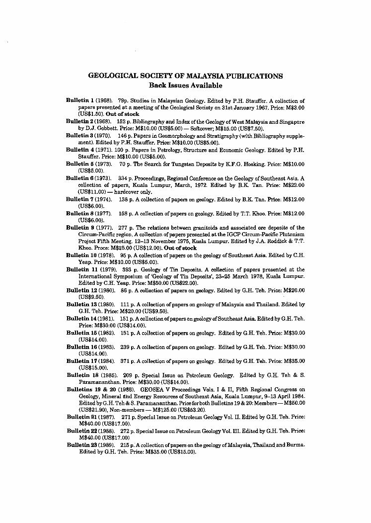
GEOLOGICAL SOCIETY OF MALAYSIA PUBLICATIONS Back Issues Available
Bulletin 1 (1968). 79p. Studies in Malaysian Geology. Edited by P.H. Stauffer. A collection of papers presented at a meeting of the Geological Society on 31st January 1967. Price: M$3.00 (US$1.50). Out of stock
Bulletin 2 (1968). 152 p. Bibliography and Index of the Geology of West Malaysia and Singapore by D.J. Gobbett. Price: M$10.00 (US$5.00) - Softcover; M$15.00 (US$7.50).
Bulletin 3 (1970). 146 p. Papers in Geomorphology and Stratigraphy (with Bibliography supplement). Edited by P.H. Stauffer. Price: M$10.00 (US$5.OO).
Bulletin 4 (1971). 100 p. Papers in Petrology, Structure and Economic Geology. Edited by P.H. Stauffer. Price: M$10.00 (US$5.00).
Bulletin 5 (1973). 70 p. The Search for Tungsten Deposits by KF.G. Hosking. Price: M$10.00 (US$5.00).
Bulletin 6 (1973). 334 p. Proceedings, Regional Conference on the Geology of Southeast Asia. A collection of papers, Kuala Lumpur, March, 1972. Edited by B.K. Tan. Price: M$22.00 (US$I1.00) - hardcover only.
Bulletin 7 (1974). 138 p. A collection of papers on geology. Edited by B.K. Tan. Price: M$12.00 (US$6.00).
Bulletin 8 (1977). 158 p. A collection of papers on geology. Edited by T.T. Khoo. Price: M$12.00 (US$6.00).
Bulletin 9 (1977). 277 p. The relations between granitoids and associated ore deposits of the Circum-Pacific region. A collection of papers presented at the IGCP Circum-Pacific Plutonism Project Fifth Meeting. 12-13 November 1975, Kuala Lumpur. Edited by J.A. Roddick & T.T. Khoo. Proce: M$25.00 (US$12.00). Out of stock
Bulletin 10 (1978). 95 p. A collection of papers on the geology of Southeast Asia. Edited by C.H. Yeap. Price: M$10.00 (US$5.00).
Bulletin 11 (1979). 393 p. Geology of Tin Deposits. A collection of papers presented at the International Symposium of 'Geology of Tin Deposits', 23-25 March 1978, Kuala Lumpur. Edited by C.H. Yeap. Price: M$50.00 (US$22.00).
Bulletin 12 (1980). 86 p. A collection of papers on geology. Edited by G.H. Teh. Price: M$20.00 (US$9.50).
Bulletin 13 (1980). 111 p. A collection of papers on geology of Malaysia and Thailand. Edited by G.H. Teh. Price: M$20.00 (US$9.50).
Bulletin 14 (1981). 151 p. A collection of papers on geology of Southeast Asia. Edited by G.H. Teh. Price: M$30.00 (US$14.00).
Bulletin 15 (1982). 151 p. A collection of papers on geology. Edited by G.H. Teh. Price: M$30.00 (US$14.00).
Bulletin 16 (1983). 239 p. A collection of papers on geology. Edited by G.H. Teh. Price: M$30.00 (US$14.00).
Bulletin 17 (1984). 371 p. A collection of papers on geology. Edited by G.H. Teh. Price: M$35.00 (US$15.00).
Bulletin 18 (1985). 209 p. Special Issue on Petroleum Geology. Edited by G.H. Teh & S. Paramananthan. Price: M$30.00 (US$14.00).
Bulletins 19 & 20 (1986). GEOSEA V Proceedings Vols. I & II, Fifth Regional Congress on Geology, Mineralllhd Energy Resources of Southeast Asia, Kuala Lumpur, 9-13 April 1984. Edited by G.H. Teh & S. ParaIilananthan. Price for both Bulletins 19 & 20: Members-M$50.00 (US$21.90), Non-members ~ M$125.00 (US$53.20).
Bulletin 21 (1987). 271 p. Special Issue on Petroleum Geology Vol. II. Edited by G.H. Teh. Price: M$40.00 (US$17.00).
Bulletin 22 (1988). 272 p. Special Issue on Petroleum Geology Vol. III. Edited by G.H. Teh. Price: M$40.00 (US$17.00)
Bulletin 23 (1989). 215 p. A collection of papers on the geology of Malaysia, Thailand. and Burma. Edited by G.H. Teh. Price: M$35.00 (US$15.00).

Bulletin 24 (1989). 199 p. A collection of papers presented at GSM Annual Geological Conference 1987 and 1988. Edited by G.H. Teh. Price: M$35.00 (U815.00).
Bulletin 25 (1989). 161 p. 8pecial Issue on Petroleum Geology Vol. IV. Edited by G.H. Teh. Price M$40.00 (U8$17.00).
Bulletin 26 (1990). 223 p. A collection of papers presented at G8M Annual Geological Conference 1989 and others. Edited by G.H. Teh. Price: M$40.00 (U8$17.00).
Bulletin 27 (1990). 292 p. 8pecial Issue on Petroleum Geology Vol.V. Edited by G.H. Teb. Price: M$40.00 (U8$17.00).
Field Guide 1 (1973). A 7-day one thousand mile, geological excursion in Central and 80uth Malaya (West Malaysia and 8ingapore). 40 p. by C.8. Hutchison. Price: M$5.00 (U8$2.50).
Abstracts of papers. (1972). Regional Conference on the Geology of 80utheast Asia, Kuala Lumpur, 1972. 64 p, 8 figs. 3 tables, many extended abstracts. Edited by N.8. Haile. Price: M$6.00 (U8$3.OO).
Proceedings of the Workshop on Stratigraphic Correlation of Thailand and Malaysia VoL 1. (1983). Technical Papers. 383 p. Price: M$25.00 (U8$12.40) (Members: M$12.001U8$6.50)
W ARTA GEOLOGI (Newsletter of the Geological 80ciety of Malaysia). Price: M$5.00 (U8$3.20) per bimonthly issue from July 1966.
PACKAGE DEAL 1: Bulletin nos. 2-8, 10 + Field Guide 1 8tudent Members : M$10.00 (U8$5.60) Members : M$20.00 (U8$10.00) Non-Members : M$40.00 (U8$19.00)
PACKAGE DEAL 2: Bulletin nos. 11-14 8tudent Members : M$30.00 (U8$14.50) Members : M$40.00 (u8$19.00) Non-Members : M$60.00 (U8$28.00)
PACKAGE DEAL 3: Bulletin nos. 15-18 and 21 Student Members : M$60.00 (US$28.00) Members : M$80.00 (u8$37.00) Non-Members : M$100.00 (U8$45.90)
PACKAGE DEAL 4: Combination of Package Deals 1-3 Student Members : M$100.00 (U8$45.90) Members : M$140.00 (U8$64.00) Non-Members : M$200.00 (U8$90.60)
PACKAGE DEAL 5: Bulletin nos. 19 & 20 + Proceedings ofWorkshop on 8tratigraphic Correlation of Thailand & Malaysia Vol. 1.
8tudent Members : M$30.00 (U8$14.50) Members : M$50.00 (U8$21.90) Non-Members : M$125.00 (U8$53.20)
Please note that the Package Deal offers is limited to ONE order per member only. There is no limit on the number of orders for non-members. Prices may be changed without notice (especially prices in US dollars).
Individual copies of Bulletin nos. 1-10 and Warta Geologi are available to members at half price. All prices quoted are inclusive of postage and packing by surface mail; for airmail, please write in for inquiries. Allow 8-10 weeks for delivery. Cheques, money orders or bank drafts must accompany all orders.
Orders should be addressed to: The Hon. Assistant 8ecretary Geological Society of Malaysia rio Dept of Geology University of Malaya 59100 Kuala Lumpur MALAY8IA TEL: 03-7577036 FAX: 603-7563900

PP 187/12189 ISSN 0126-6187
[g3(lJJ[L~~~ ~~~
~~(j)~(j)~~ Wl~~~'J~~~ BULLETIN OF THE GEOLOGICAL SOCIETY OF IALAYSIA
SPECIAL ISSUE ON PETROLEUM GEOLOGY VOL. V
KANDUNGAN (CONTENTS)
1 A Triassic "reefal" limestone in the basement of the Malay Basin, South China Sea: Regional implications Fontaine Henri, Rodziah Daud & Singh Updesh
27 Depositional environments, diagenesis, and porosity of reservoir sandstones in the MalongField, offshore West Malaysia Noor Azim Ibrahim & Mazlan Madon
67 A dl8C1l88ion 01 "SNIFFER" geochemical surveying offshore Malaysia Mark E. Geneau
71S Application of sonic waveform attributes in reservoir studies R.Gir
103 Thin bed resolution and the determination 01 flushed zone resistivity in on based mud Joseph F. Goetz, Roland Chemali & Douglas J. Seifert
117 Miocene-Pliocene paleogeographic evolution of a tract of Sarawak offshore between Bintulu and Miri Eros Agostinelli, Mohamad Raisuddin, Eugenio Antonielli & Mohamad
137 The application of detailed reservoir geological studies in the DI8 Field, Balingian Province, offshore Sarawak. J. Almond, P. Vincent & L.R. Williams
181 The use ofSAK imagery for hydrocarbon ellploration in Sarawak Chiu Shao-Kang, Mohd Khair Abd Kadir
183 Re.ervoir Description: A synergistic approach to more accurate determination of oil and gas reserves D. G. Bowen, T. Kennaird, J. Hill & E.J. Frost
211 Induction, reaistivity and MWD tools in horizontal wells S. Gianzero, R. Chemali &S.M.Su
227 Structural style and tectonics of Western and Northern Sabah Felix Tongkul
241 Tectonic evolution of the NW Sabah continental margin since the Late Eocene Denis N.K. Tan & J.M. Lamy
:181 The Maliau Basin, Sahah: Geology and tectonic setting H. D.1Jia, Ibrahim Komoo, P.S. Lim & Tungah Surat
Editor G.H. TEH
NOVEMBER 1990
August 1992-July 1993 AEROSPACE SURVEYS FOR: GEOLOGICAL SURVEY; WATER-RESOURCES SURVEY; AND APPLIED GEOMORPHOLOGY (Delft, The Netherlands). Annual postgraduate diploma and MSc degree courses organized by the International Institute for Aerospace Survey and Earth Sciences (ITC). Language: English. For Information: ITC Student Registration Office, P.O. Box 6, 7500 AA, Enschede, The Netherlands.
September 22-24 GROUND-WATER GEOCHEMISTRY (San Antonio, Texas). Short course. For Information: National Ground Water Association, Education Department, 6375 Riverside Drive, Dublin, Ohio 43017. Phone: 614/761-1711. Fax: 6141761-3446)
September 28-0ctober 2 SAFETY AT HAZARDOUS MATERIALS SITES (Valhalla, N. Y.). Short course by National Ground Water Association, and USGS. For Information: NGWA, Dept. 17, Box 182039, Columbus, Ohio 43218-2039. Phone: 614/761-1711)
October 20-22 GROUND-WATER HYDROLOGY (Clearwater, Fla.). Short course. ForInformation: National Ground Water Association, Education Department, 6375 Riverside Drive, Dublin, Ohio 43017. Phone: 614/761-1711. Fax: 6141761-3446)
November 1992-December 1993 REMOTE SENSING APPLICATIONS FOR EARTH SCIENCES (Enschede, The Netherlands). Annual short course organized by the International Institute for Aerospace Survey and Earth Sciences (lTC). Language: English. For Information: ITC Student Registration Office, P.O. Box 6 7500 AA , , Enschede, The Netherlands.
Warta Geologi, Vol.17,No.l
43
GEOLOGICAL TECHNIQUES (London, UK). Course designed to teach modem techniques to those technicians or trainee technicians who areorwishtobecomeengagedinthegeoscientific industry. Course aimed at those from the developing countries. For Information: J.R. Blount, Department of Geology , Royal School of Mines, Imperial College, Prince Consort Road, London SW7 2BP, UK
HYDROLOGY (Brussels, Belgium). One-year diploma course and two-year Master's degree course under Inter-university Postgraduate program. Fellowships available. Language: English. For Information: Prof. A. Van DerBeken. Programs in Hydrology, Free University, Pleinlaan 2, B-1050 Brussels, Belgium.
CONTINUING EDUCATION SEMINARS FOR ENGINEERS, MANAGERS, AND TECHNICIANS OF OIL, OIL-CONCERNED, AND RELATED INDUSTRIES. Conducted by the Petroleum Exploration Center, ENS PMFormation Industries. For Information: ENSPM Centre d'Exploration Petroliere, ENSPMFormation Industries, 4 Avenue de Bois-Preau, 92500 Rueil-Malmaison, France.
October 14-18 GEOLOGY OF SANDSTONE FORMATIONS (Spanish Pyrenees). Language: French.
October 21-25 CASED HOLE LOGGING (Rueil-Malmaison). Language: French (English, if number of participants allows).
November 4-8 INTRODUCTION TO THE PRACTICE OF FORMATION EVALUATION (RueilMalmaison). Language: French (English, if number of participants allows).

44
November 18-22 GEOLOGY AND GEOPHYSICS FOR THE RESERVOIR ENGINEER (Rueil-Malmaison). Language: French (English, if number of participants allows).
December 2-13 WELL LOG ANALYSIS. (Rueil-Malmaison). Language: French (English, if number of participants allows).
MINING MANAGEMENT (Kensington, New South Wales,Australia). Master's and graduate diploma degrees in Mining Management, as well as individual short courses. (Courses may be presented at other locations by arrangement.) For Information: Dr. Mike Katz, Associate Director, International Key Center for Mines, University of New South Wales, P.O. Box 1, Kensington NSW 2033, Australia.
PROFESSIONAL DEVELOPMENT SEMINARS IN MINERAL ENGINEERING AND MINERAL ECONOMICS. Conducted by the Department of Mining and Metallurgical Engineering, McGill University. Language: English. For Information: Lorna McFadden, Department of Mining and Metallurgical Engineering, McGill University, 3480 University Street, Montreal, Quebec H3A 2A7, Canada.
SHORT COURSES IN PETROLEUM GEOLOGY AND RELATED DISCIPLINES. ConductedbyDBJUDC. Language: English. For Information: IHRDC Instructional Programs, 535 Boylston Street, Boston, MA 02116, USA
SWEDISH INTERNATIONAL UNIVERSITY CONSORTIUM (Stockholm, Sweden). Master's degree programs lasting three semesters, including a Master's thesis project. Courses in applied Geophysics and Geochemistry at Lulea. Language: English. For Information: Dr. Bjorn Ohlander, Economic Geology, Lulea University ofTechnology, S-951 Lulea, Sweden.
TWAS ITALIAN AWARDS SCHEME. Aseries of grants for developing-country geoscientists of proven ability to work and study for periods up to 10 months at the following Italian universities: Florence, Milan, Padua, Pisa, Rome, Trieste, Turin, and CNR Pisa. For Information: Executive Secretary, Third World Academy of Sciences, International Centre for Theoretical Physics, P.O. Box 586, Strada Costiera 11, 1-34100 Trieste, Italy.
WEDC (Water, Engineering and Development Centre). Concerned with urbanization and urban infrastructure. Courses offered range in duration from 6 weeks to 12 months, deal with a wide variety of water, engineering, developmental, environmental, and management topics, and lead to certificates, diplomas, or MSc degrees. For Information: ProfessorJohn Pickford, WEDC, Loughborough University of Technology, Leicestershire LE11 3TU, UK. Phone: 0(44) 509 222390; telex: 34319 UNITECG; fax: 0(44) 509 610231.
THE ROBERTSON GROUP pIc, Llandudno, Gwynedd, UK, attention: Dr. C.J. Burgess, Manager, Petroleum Training Centre. Phone: 44(0) 492 581811; fax: 44(0) 492 583416; telex; 61216 ROBRES G.
U.S. GEOLOGICAL SURVEY, Office of International Geology, Training Section, 917 National Center, Reston, Virginia 22092. USA
Jan-Feb 1991
August 24-September 3 INTERNATIONAL GEOLOGICAL CONGRESS (29th), Kyoto, Japan. (Dr. Tadasahi Sato, Chairman, Japanese National Committee on Geology, Inst. of Geoscience, The University of Tsukuba, Ibaraki 305, Japan
August 31-September 2 LARGE METEORITE IMPACTS AND PLANETARY EVOLUTION (International Conference), Sudbury, Ontario, Canada. (Sudbury 1992, rio B. Dressler, Ontario Geological Survey, 77 Grenville St., Toronto, Ontario M7 A 1W4, Canada. Phone: (416) 965-4817; telefax: (416) 324-(933)
September 11-20 GERMAN MINERALOGICAL SOCIETY, anniversary meeting, Tubingen, Germany. (P. Metz, Petrographisches Institut der Universitat Tubingen, Wilhelmstrasse 56,7400 Tubingen, Germany)
September 12-15 ASSOCIATION OF EARTH SCIENCE EDITORS, ann. mtg., Glacier National Park, Whitefish,Mont. (H.L. James, Montana Bureau of Mines and Geology, Butte, 59701. Phone: 406/496-(175)
September 13-18 DOLOMITES, mtg., Banff, Alberta, by University of Alberta and Canadian Society of Petroleum Geologists. (Pat Larlham, Faculty of Extension, University of Alberta, Edmonton, Alberta T6G 2G4. Phone: 403/492-5038. Fax: 403/492-1857)
September 13-18 GEOSTATISTICS, mtg., Troia, Portugal. (Amilcar Soares, Centro de Valorizacao de Recursos Minerais, 1ST Av. Rovisco Pais, 1096 Lisbon, Portugal. Fax: 35111-8486935)
September 21-25 PALEOCEANOGRAPHY-GLOBAL CHANGE (4th International Conference), Kiel, FRG. (ICP IV Organizing Committee, rio GEOMAR, Wischbof-strasse 1-31BIdg., 4, D-2300 Kiel 14, FRG)
Warta Geologi, Vol.17,No.l
45
September 22-28 MODERN CLASTIC DEPOSITIONAL ENVIRONMENTS, field mtg., Columbia, S.C., Charleston S.C., and Wilmington, N.C. (American ~sociation of Petroleum Geologists, Education Department, Box 879. Tulsa, Okla. 74101-0979. Phone: 9181584-2555. Fax: 9181 584-0(69) Fee: $1,685 (includes guidebook, transportation, and some meals).
September 25-30 LOW-K SILICIC MAGMAS IN SUBDUCTION SETTINGS, a GSA Penrose Conference, Chelan, Wash. Games S. Beard, Virginia Museum of Natural History, Martinsville, Va. 24112. Phone: 703/666-8611)
September 27-October 1 AMERICAN INSTITUTE OF PROFESSIONAL GEOLOGISTS, ann. mtg., Lake Tahoe, Nev. (Jon Price, MPG, Box 665, Carson City, Nev. 89702. Phone: 7021784-6691)
September 28-30 PETROLEUM-INDUSTRY DATA EXCHANGE, mtg., New Orleans. (American Petroleum Institute, 1220 L St. N.W., Washington D.C. 20005. Phone: 202168218000)
October~ SUDBURY-NORIL'SK NICKEL CAMPS, symposium, Sudbury, Ontario (AJ. Naldrett, Dept. of Geology, University of Toronto, Toronto, Ontario, M5S 3B1. Fax: 416/978-3938)
OctoberU ASSOCIATION OF ENGINEERING GEOLOGISTS, ann. mtg., Long Beach, Calif. (John W. Beyer, 444-A E. Broadway, Glendale, Calif. 91205. Phone: 8181549-9959. Fax: 8181 242-24(2)
October 4-7 SOCIETY OF PETROLEUM ENGINEERS, ann. mtg., Washington,D.C. (SPE, Box 833836, Richardon, Texas 75083-3836. Phone: 214/ 669-3377. Fax: 214/669-0135 October 4-9 FLUIDNOLCANO INTERACTIONS, GSA Penrose Conference, WarmSprings, Ore. (Steve Ingebritsen, USGS, MS 439,345 Middlefield Road, Menlo Park, Calif. 94025. Phone: 415/ 329-4422. Fax: 415/329-4(63)
46
October 14-30 DAM SAFETY, int'l. seminar and tour, Denver, Las Vegas, Nev., and Phoenix, Ariz., by American Water Foundation, and U.S. Bureau of Reclamation. (AWF, 1616 17th St. Denver, 80202. Phone: 303/628-5516. Fax: 303/628-5(69) Fee: members, $1,700; non-members, $1,800.
October 17-22 HYDROLOGY AND HYDROGEOLOGY, mtg., Portland, Ore. (American InstituteofHydrology, 3416 University Ave. S.E., Minneapolis, 55414-3328. Phone: 6121279-1030)
October 18-28 LATE PRECAMBRIAN TECTONICS AND THE DAWN OF THE PHANEROZOIC, GSA Penrose Conference, Death Valley, Calif. (Ian W.D. Dalziel, Institute for Geophysics, UniversityofTexas, Austin, 78759-8345. Phone: 512/471-6156. Fax: 5121471-8844)
October 19-21 BIO-LEACHING MINERALS AND MINERAL-LAND RECLAMATION, mtg. and workshop, Sacramento, Calif. (Yung Sam Kim, Nevada Institute of Technology, Box 8894, Campus Station, Reno, Nev. 89507. Phone :7021673-4466)
October 25-80 IN-SITU MINERALS RECOVERY, mtg., Santa Barbara, Calif. (Engineering Foundation, 345 E. 47th St., New York, 10117. Phone: 2121 705-7835. Fax: 2121705-7441)
October 26-28 EXTRACTIVE METALLURGY OF GOLD AND BASE METALS, int'l. mtg., Kalgoorlie, Western Australia. (V.N. Misra, Kalgoorlie Metallurgical Laboratory, Box 881, Kalgoorlie, 6430, Australia. Phone: (090) 220 120. Fax: (090) 912 762) Papers invited.
October 26-29 GEOLOGICAL SOCIETY OF AMERICA (Annual Meeting), Cincinnati, Ohio, USA. (Jean Kinney, GSA Headquarters, P.O. Box 9140, Boulder, Colo. 80301, USA. Phone: (303) 447-2020).
November 8-18 WATER RESOURCES AND ENVIRONMENTAL ENGINEERING, mtg., Santa Barbara. Calif. (C.V. Freiman, Engineering Foundation, 345 E. 47th St., New York, 10017. Phone:2121 705-7835. Fax: 2121705-7441)
November 29-December 2 TECTONIC FRAMEWORK AND ENERGY RESOURCES, mtg., Kuala Lumpur, Malaysia. (Secretariat, c/o Dept. of Geology, University of Malaya, 59100 Kuala Lumpur, Malaysia)
November 80-December 8 OFFSHORE SOUTHEAST ASIA, mtg., Singapore. (Society of Petroleum Engineers, Box 833836, Richardson, Texas 75083-3836. Phone: 2141669-3377. Fax: 2141669-0135)
December 28-81 GEODYNAMICS OF THE ARABIAN LITHOSPHERE, int'!. mtg., Baghdad. (Sahil Alsinawi, Dept. of Geology, College of Science, University of Baghdad, Jadiryah, Iraq)
April 17-20 EXPLORATION AND DISCOVERY, mtg., Denver, by Society of Economic Geoloiists, Society of Exploration Geophysicists, and others. (J. Alan Coope, SEG Conference '93, Box 571, Golden, Colo. 80402. Phone: 303/837-5819. Fax: 303/837-5851)
April 25-28 AMERICAN ASSOCIATION OF PETROLEUM GEOLOGISTS, ann. mtg., New Orleans. (AAPG, Box 979, Tulsa, Okla. 74101-0979. Phone: 918/584-2555. Fax: 9181 584-0(69)
May 16-20 ENVIRONME~TAL HYDROLOGY AND HYDROGEOLOGY, mtg., Washington, D.C. (Secretariat, Americal Institute of Hydrology, Second USA/USSRConference, 3416University Ave. S.E., Minneapolis, 55414-3328. Phone: 612/379-1030. Fax: 6121379-0169)
May 17-19 GEOLOGICAL ASSOCIATION OF CANADA! MINERALOGICAL ASSOCIATION OF CANADA (Joint Annual Meeting), Edmonton, Alberta, Canada. (J.W. Kramers, Alberta Geological Survey, P.O. box 8330, Station F, Edmonton, Alberta T6H 5X2, Canada. Phone: (403) 438-7644; telefax: (403) 438-3644)
Jan-Feb 1991

May 2lhJune 15 BASIN TECTONIC AND HYDROCARBON ACCUMULATION, mtg., Nanjing, People's Republic of China, by Nanjing University. USGS, Society of Petroleum Geology of China, and others. (David G. Howell, MS902, USGS, 345 Middlefield Road, Menlo Park, Calif. 94025. Phone: 415/329-5430. Fax: 415/354-3224)
June 1-5 GEOTECHNICAL ENGINEERING, int1. mtg., St. Louis. (Norma R.Fleming, 119 ME Annex, University of Missouri, Rolla, 65401-0249. Phone: 3141341-6061; 800/752-5057. Fax: 3141 341-4992)
June 7-11 EUROPEAN ASSOCIATION OF EXPLORATION GEOPHYSICISTS (55th Annual Meeting and Exhibition), Forum, Stavanger, Norway. (Evert van der Gaag, Business Manager, European Association of Exploration Geophysicists, Utrechtseweg 62, NL-3704 HE Zeist, The Netherlands. Phone: (03404) 56997)
June 20-27 ZEOLITES, int'l. mtg., Boise, Idaho, by International Committee on Natural Zeolites. (F.A Mumpton, Dept. of Earth Sciences, State University of New York, Brockport, 14420. Phone: 716/395-2635; 716/637-2324. Fax: 716/ 395-2416)
June 21-25 ROCK ENGINEERING, mtg. and workshop, Lisbon, Portugal, by International Society for Rock Mechanics. (Luis Ribeiro e Sousa, Portuguese Society for Geotechnique, Laboratorio N acional de Engenharia Civil, Av. do Brasil, 101, 1799 Lisboa Codex Portugal. Phone: 848 21 31. Fax: 89 76 60)
July ENVIRONMENTAL CONTEXT OF HUMAN EVOLUTION (International Scientific Congress and Exhibition), The Netherlands and Indonesia. (Dr. Hans Beijer, Geological Survey of The Netherlands, P.O. Box 157, NL-2000AD Haarlem, The Netherlands. Telefax: 31 23 351614
Warta Geologi, Vol.17,No.l
47
July 18-23 CLAY CONFERENCE (10th International Conference in conjunction with Commission VII of the International Soil Science Society), Adelaide, South Australia. (Dr. Tony Eggleton, Geology Department, ANU, GPO Box 4, Canberra, ACT 2601, Australia)
August 23-29 GEOMORPHOLOGY C3rd International Conference), Hamilton, Ontario, Canada. (3rd International Conference on Geomorphology, McMaster University, Hamilton, Ontario L8S 4Kl, Canada. Phone: (416) 525-9140, ext. 4535; telefax: (416) 546-0463; telex: 061-8347)
August 23-29 COASTAL SEDIMENTOLOGY, mtg., Hamilton, Ontario. (William F. Tanner, Dept. of Geology B-160, Florida State University, Tallahassee, 32306. Phone: 9041644-3208)
September 25-0ctober 1 INTERNATIONAL ASSOCIATION OF VOLCANOLOGY AND CHEMISTRY OF THE EARTH'S INTERIOR, mtg., Canberra, Australia. (IA VCEI ACTS, GPO Box 2200, Canberra ACT 2601, Australia. Phone: 61/6/ 257-3299. Fax: 61/6/257-3256)
June 6-10 EUROPEAN ASSOCIATION OF EXPLORATION GEOPHYSICISTS (56th) Annual Meeting and Exhibition), Austria Center, Vienna, Australia. (Evert Van der Gaag, Business Manager, European Association of Exploration Geophysicists, Utrechtseweg62, NL-3704 HE Zeist, the Netherlands. Phone: (03404) 56997; telefax (03404) 62640; telex:33480)
May 29-June 2 EUROPEAN ASSOCIATION OF EXPLORATION GEOPHYSICISTS (57th Annual Meeting and Exhibition), Glasgow, UK (Evert van der Gaag, European ,Association of Exploration Geophysicists, Utrechtseweg 62, NL-3704 HE Zeist, The Netherlands. Phone: (03404) 56997; telefax: (03404) 62640; telex: 33480)
ORDER FORM
GEOLOGICAL SOCIETY OF MALAYSIA PUBLICATIONS
The Hon. Assistant Secretary, Geological Society of Malaysia, do Dept. of Geology, University of Malaya, 59100 Kuala Lumpur, MALAYSIA
Dear Sir,
Date: ................................ .
Please send me the following publications. I enclose US$IM$* .............................. in cheque/money orderlbank draft. *
Item No. of copies Price
......................................................................................................................................................
*Delete where applicable.
Please mail to: (Please print>
Sub-T.otal
Total
Signature: .................................................. .
.. ~ ........................................................................................................................................................................................................................... ..
GEOLOGICAL SOCIETY OF MALAYSIA PUBLICATIONS
General Information
The Society publishes the BuletiT! Geoiogi MaLaysia (Bulletin of the Geological Society of Malaysia) and the bimonthly Warta Geologi (Newsletter of the Geological Society of Malaysial.
Papers of general interest or on the geology of the Southeast Asian region (South China, Burma, Thailand, Indochina, Malaysia, Singapore, Indonesia, Brunei and the Philippinesl and also marine areas within the region are welcome for publication in the Bu.letiT!. Short notes, progress reports and general items of information are best submitted to the Warta Geoiogi.
Papers should be as concise as possible. However, there is no fixed limi~ as to the length and number of illustrations. Therefore, papers of monograph length are also welcome. Normally, the whole paper should not exceed 30 printed pages and it is advisable that authors of papers longer than 30 printed pages should obtain the consent of the Editor before submission of the papers.
The final decision of any paper submitted for publication rests with the Editor who is aided by an Editorial Advisory Board. The Editor may send any paper submitted for review by one or more reviewers. Scripts of papers found to be unsuitable for publication may not be returned to the authors but reasons for the rejection will be given. The authors of papers found to be unsuitable for publication may appeal only to the Editor for reconsideration if they do not agree 'ith the reasons for rejection. The Editor will consider the appeal together with the Editorial Advisory Board.
Unless with the consent of the Editor, papers which have been published before should not be submitted for consideration.
Authors must agree not to publish elsewhere a paper submitted to and accepted by the Society.
Authors alone are responsible for the facts and opinions given in their papers and for the correctness of references etc.
Twenty-five reprints of each paper are free-of-charge. Contributors should notify the Editor of extra reprints (which are of non-profit costs) required.
All papers should be submitted to the Editor, Geological Society of Malaysia, do Department of Geology, University of Malaya, 59100 Kuala Lumpur, MALAYSIA.
Script Requirements
Scripts must be written in Bahasa Malaysia (Malay) or English.
Two copies of the text and illustrations must be submitted. The scripts must be typewritten double-spaced on papers not exceeding 21 x 33 cm. One side of the page must only be typed on.
Figure captions must be typed on a separate sheet of paper. The captions must not be drafted on the figures.
Original maps and illustrations or as glossy prints should ideally be submitted with sufficiently bold and large lettering to permit reduction to 15 x 22 cm: fold-outs and large maps will be considered only under special circumstances.
Photographs should be of good quality, sharp and with contrast. For each photograph, submit two glossy prints, at least 8 x 12 cm and preferably larger. Use of metric system of measurements (lSU) is strongly urged wherever possible.
Reference cited in the text should be listed at the end of the paper and arranged in alphabetical order and typed double-spaced. The references should be quoted in the following manner:
Suntharalingam,T., 1968. Upper Palaezoic stratigraphy of the area west of Kampar, Perak. Geol. Soc. Malaysia Bull., I, 1 - 15.
Hosking, K.F.G., 1973. Primary mineral deposits. In Gobbett, D.J. and Hutchison, C.S. (Eds), "Geology of the Malay Peninsula (West Malaysia and Singapore)". Wiley-Interscience, New York, 335 - 390.
The name of the book or publication must be underlined and will be later printed in italics.
A concise and informative abstract in English is required for each paper written in Bahasa Malaysia or English. A paper written in Bahasa Malaysia must have all abstract in Bahasa Malaysia as well.
For format, kinds of subheadings and general style, use this and the previous Buletins as a guide.
The final decision regarding the size of the illustrations, sections of the text to be in small type and other matters relating to printing rests with the Editor.
If authors have trouble over the script requirements, please write in to the Editor.

100 ° E.
./
CAMBODIA -: ~ . ~'t-
.,- , .,J ~«..
/' ~"
o
o ~ . P. Langk awl " '\ Kota Bharu
~ \J\~ Alo r Star 2 /-., . ') /'/ '-". <..., 3al/ > t ~.;. "'4/ 5 1
o ~ • \ 6 .... ~ ~ • ~ ...... A/ ''- J..",
... ..., Ipoh l J C>c> -f-..., \ "', ...... ..... ... °1 8
7 Kua a 'r-....
Lumpur'/ - ', Seremban« 9 r 0
~~ .... '--.. 0 10(.11\ ~ ~or Bahru
O~ SINGAPORE
~ °Singkep
N
-} 200km
LAUT CHINA SELATAN (South China Sea)
o Natuna
~ngka ~ D Belitung
10 0° E. llU "
NEGERI-NEGERI MALAYSIA (STATES OF MALAYSIA)
1. PERLI S 2. KEDAH 3. PULAU PIN ANG 4. PERAK 5. KELANTAN 6. TERENGGANU 7. SELAN GOR
8. PAHAN G 9. NEGERI SEMBI LAN
10 . MELAKA 11 . JOHOR 12. SABAH 13. SARAWAK
./ ./
#{;' P. Banggi
13 , I
KALIMANTAN
CYH/10/89
100 N.