period summaries - sussex past · 6. period summary: the palaeolithic 17 ... by matthew pope ......
TRANSCRIPT

Period Summaries


6 . per iod summary: the palaeolithic 17
6 . 1 . t h e pa l a e o l i t h i c o f t h eW e s t s u s s e x c o a s ta l p l a i n i n
n at i o n a l c o n t e x t
tisimportanttonoteattheoutsetthatthegeographical area covered by the frcf en-compassesmuchthemostcriticallyimportant
seriesofQuaternarydepositsinsouthernBritain.the target area not only includes the globallyimportantpalaeolithic siteofBoxgrove (roberts1986)andthebulkofpreservedsedimentsdatingtoBoxgroveinterglacialperiod(mis13),butalsoincorporateswideareasoflaterQuaternaryland-scapesandassociatedartefacts(Bateset al. 1997;apsimonet al.1977).inthissectionthenatureofthisuniquerecordwillbeoutlinedaswellasthe
6. Period summary: the Palaeolithic
bymatthewpope
◆
ihistoryofitsstudy,andbothcurrentandfuturedirectionsinitsresearch.
nationallytherearecurrentlytwomajornewinitiativesguidingtheoverallstudyofpalaeolithicarchaeology:theancienthumanoriginsofBritainproject and the national ice age network. theleverhulme-fundedancienthumanoccupationofBritainproject (ahoB) is currentlyundertak-ingasystematicreassessmentofkeypalaeolithiclocalitiesthroughoutBritain.Whileco-ordinatedbythenaturalhistorymuseum,thisprojectutilizesexpertisefromuniversities,museumservicesandfield units to undertake targeted fieldwork andpost-excavationanalysis.Whileyettoreport,theproject looks set to change our ideas about the
fig.3.moderncoastlineandwatercourses,peninsulasmarked.
f i sh Bourne research and conservation frame Work 17
18 6 . per iod summary: the palaeolithic
timingofcolonizationandpreviousinterpretationsofkey-locales.
in addition, the rolling out of the nationaliceagenetwork(nian)hascommenced.thisisaninitiativefundedthroughtheaggregateslevysustainabilityfund(alsf)whichisaimedatpro-vidingacoherentbutregionallybasedapproachto the conservationand researchofpalaeolithicarchaeology. the alsf also continues to fundtargetedresearchprojectssuchastheexcavationofthenationallyimportantneanderthalbutcherysiteoflyndford(norfolk)and,in2006,thevaldoeassessmentsurveywithinthefrcfarea.
the frcf area has itself been the focus forintensive study and front-line palaeolithic re-search during the past 20 years. Between theucl-basedBoxgroveproject team (figs. 7&8)and the alsf-funded coastal corridor projectrunfromsouthamptonandlampeteruniversi-ties,thepleistocenegeologyoftheWestsussexcoastalplainhasbeencomprehensivelymapped.however,thisworkhasonlysoughttoestablish
the enormous potential for further detailed ar-chaeologicalinvestigations.
6 . 2 . o v e r v i e W o f t h e pa l a e o l i t h i c r e c o r d
o f t h e f r c f a r e a
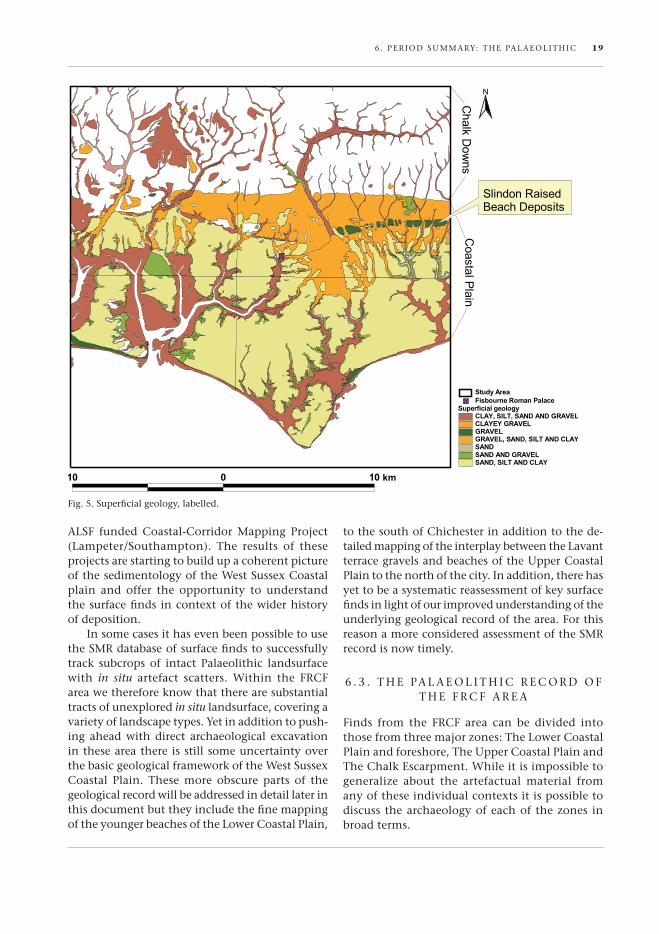
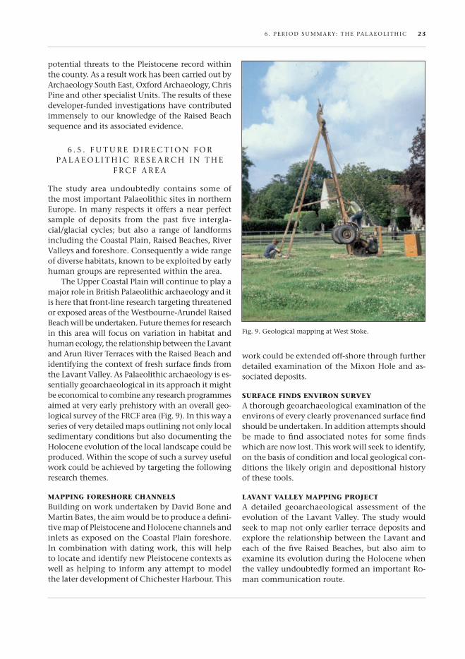
some43separatefindspotsarelistedonthesmrforthefrcfstudyarea(fig.7).forthemostpartthese tend to comprise surface finds, recoveredoutofcontextandsometimeswithoutclearprov-enance.however,includedwithinthesefindspotsare locales suchasBoxgroveandslindonwherethousandsofstonetoolsandassociateddebitagehavebeenrecoveredfromin situdeposits.on-go-ingresearchbytheBoxgroveproject,throughboththeraisedBeachmappingproject(fig.9)andthevaldoeassessmentsurvey,hassoughttodeterminethewiderlimitsofthepreservedpalaeolandsurfacessowelldocumentedattheBoxgrovesite.similarworkisbeingundertakenfortheyoungerraisedbeachesof thelowercoastalplain through the
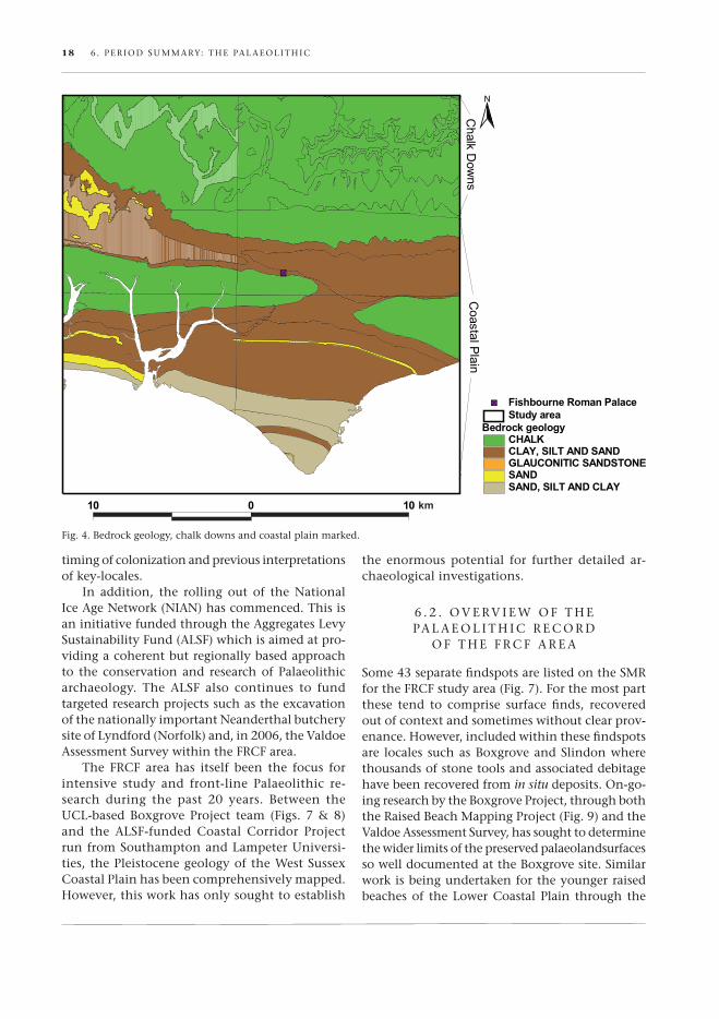
fig.4.Bedrockgeology,chalkdownsandcoastalplainmarked.
6 . per iod summary: the palaeolithic 19
alsf funded coastal-corridor mapping project(lampeter/southampton). the results of theseprojectsarestartingtobuildupacoherentpictureofthesedimentologyoftheWestsussexcoastalplain and offer the opportunity to understandthesurfacefindsincontextofthewiderhistoryofdeposition.
insomecasesithasevenbeenpossibletousethesmrdatabaseofsurfacefindstosuccessfullytrack subcrops of intact palaeolithic landsurfacewith in situ artefact scatters. Within the frcfareawethereforeknowthattherearesubstantialtractsofunexploredin situlandsurface,coveringavarietyoflandscapetypes.yetinadditiontopush-ing ahead with direct archaeological excavationintheseareathereisstillsomeuncertaintyoverthebasicgeologicalframeworkoftheWestsussexcoastal plain. these more obscure parts of thegeologicalrecordwillbeaddressedindetaillaterinthisdocumentbuttheyincludethefinemappingoftheyoungerbeachesofthelowercoastalplain,
tothesouthofchichesterinadditiontothede-tailedmappingoftheinterplaybetweenthelavantterracegravelsandbeachesoftheuppercoastalplaintothenorthofthecity.inaddition,therehasyettobeasystematicreassessmentofkeysurfacefindsinlightofourimprovedunderstandingoftheunderlyinggeologicalrecordofthearea.forthisreasonamoreconsideredassessmentofthesmrrecordisnowtimely.
6 . 3 . t h e pa l a e o l i t h i c r e c o r d o ft h e f r c f a r e a
finds from the frcf area can be divided intothosefromthreemajorzones:thelowercoastalplainandforeshore,theuppercoastalplainandthechalkescarpment.Whileitisimpossibletogeneralize about the artefactual material fromanyoftheseindividualcontextsitispossibletodiscussthearchaeologyofeachofthezones inbroadterms.
fig.5.superficialgeology,labelled.
20 6 . per iod summary: the palaeolithic
The Lower CoasTaL PLain
this group include a range of finds from thosefoundrolledonthemodernforeshoretoappar-ently in situ material from pleistocene depositsoverlyingthecoastalplain(West&sparks1960).ofnotearethemiddlepalaeolithicflakesfromapleistocene channel exposed on the selsey fore-shore(Woodcock1981)andafurther17surfacefindsofpalaeolithictoolsincludingasinglebifacefromfishbourneitself.thisareaincludesthees-tablishedbeachlinesofthemis5apaghamraisedBeachandthemis7merstonraisedBeach.itisprobablethatmostbifacesintheareadatefromapost-mis7periodbutthiscannotbeassumed.
The UPPer CoasTaL PLain
this critical Group includes not only tools as-sociated with the mis 7 and mis 11 beaches ofBrighton-nortonandaldingbourne(oving,port-field,peartreeknap)butalsotheimportantsites
of the mis13 Westbourne-arundel raised BeachwhichincludestheBoxgrove(roberts1986;rob-erts&parfitt1999),slindon (fig.7)andlavantsites.itincludestheimportantlavantvalleyasitdissectsthechalkplateauandthereforeincludesthe area most likely to form the focus of palae-olithic research in the next few years. the sitescomprisematerialfromarangeofageswithvaryingdegreesofpreservation.howeveritisinthiszonethattheoldestandbest-preservedarchaeologicalsignaturesarelikelytobeencountered.itisworthnotingthatnolevalloisianmaterialhasbeenre-coveredfromthiszone.
The ChaLk esCarPmenT
sixbifacesofaprobablepalaeolithicagehavebeenrecovered from the chalk plateau of the southdowns. these finds do need to be critically ad-dressedandre-examinedinlightofthepotentialthatexistsforconfusingpalaeolithicbifaceswith
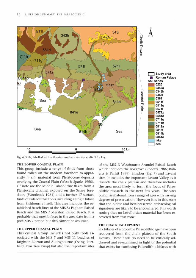
fig.6.soils,labelledwithsoilseriesnumbers;seeappendix3forkey.

6 . per iod summary: the palaeolithic 21
neolithicpolishedaxepre-forms.thisisaproblemthatisespeciallyacuteinthestudyareagiventhelocalpresenceofneolithicflintmines.however,there can be little doubt that the downs wereintensively occupied during the middle pleisto-cenegiventhevastquantitiesoftoolsrecoveredfrom the head Gravels which cover their flank-ing slopes and the upper coastal plain. indeedit must be remembered that downland erosionhasbeensoextensiveduringthepleistocenethatmoreevidencefortheiroccupationnowexistsonthemarginsoftheplateauandinthedissectingvalleys thanwithin the impoverished subsoiloftheirsummits.thepossibilityexists,however,forsolutionfeaturesontheplateautohavepreservedin situremnantsofpleistocenelandsurface(scott-Jackson1996;pope2001).theseshouldbeactivelyprospectedforandinvestigated.
this is, of course,only abrief summaryof awide and varied record of occupation coveringover500,000years andavarietyof climatic andecological conditions.therefore it shouldnotbesurprising thatanequallyvaried rangeofpreser-vationalconditionsshouldexistinthestudyareaandthisisreflectedinthequalityofthematerial.WhilethevalueofexcavatedassemblagesfromBox-groveandslindonrequiresnofurtherelaboration,it is importanttonotethatmanyfindsclassifiedas ‘surface’aresometimes found ina remarkablyexcellentstateofpreservationsuggestingonlyre-centdisturbancefromhigh-qualitypreservationalcontexts.thesefindsundoubtedlyareindicationsoflocal,importantsitescurrentlyunderthreatfromeithertheploughoron-goingerosionalprocesses.itisthecontextofthesefindswhichshouldnowbetargetedinfutureresearchplans.
fig.7.palaeolithicsitedistributions/osmap.
22 6 . per iod summary: the palaeolithic
6 . 4 . a h i s t o ry o f pa l a e o l i t h i cr e s e a r c h i n t h e f r c f a r e a
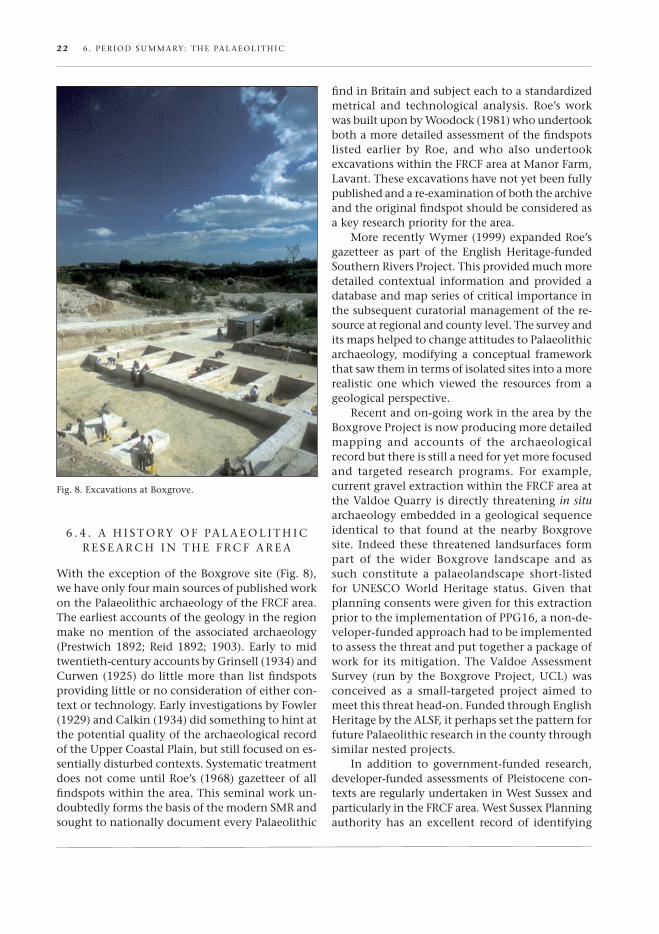
WiththeexceptionoftheBoxgrovesite(fig.8),wehaveonlyfourmainsourcesofpublishedworkonthepalaeolithicarchaeologyofthefrcfarea.theearliestaccountsofthegeologyintheregionmakenomentionof theassociatedarchaeology(prestwich1892;reid1892;1903).early tomidtwentieth-centuryaccountsbyGrinsell(1934)andcurwen(1925)dolittlemorethanlistfindspotsprovidinglittleornoconsiderationofeithercon-textortechnology.earlyinvestigationsbyfowler(1929)andcalkin(1934)didsomethingtohintatthepotentialqualityofthearchaeologicalrecordoftheuppercoastalplain,butstillfocusedones-sentiallydisturbedcontexts.systematictreatmentdoesnotcomeuntilroe’s(1968)gazetteerofallfindspotswithinthearea.thisseminalworkun-doubtedlyformsthebasisofthemodernsmrandsoughttonationallydocumenteverypalaeolithic
findinBritainandsubjecteachtoastandardizedmetrical and technological analysis. roe’s workwasbuiltuponbyWoodock(1981)whoundertookbothamoredetailedassessmentofthefindspotslisted earlier by roe, and who also undertookexcavationswithinthefrcfareaatmanorfarm,lavant.theseexcavationshavenotyetbeenfullypublishedandare-examinationofboththearchiveandtheoriginalfindspotshouldbeconsideredasakeyresearchpriorityforthearea.
morerecentlyWymer(1999)expandedroe’sgazetteer as part of the english heritage-fundedsouthernriversproject.thisprovidedmuchmoredetailed contextual information and provided adatabaseandmapseriesofcriticalimportanceinthesubsequentcuratorialmanagementofthere-sourceatregionalandcountylevel.thesurveyanditsmapshelpedtochangeattitudestopalaeolithicarchaeology,modifyinga conceptual frameworkthatsawthemintermsofisolatedsitesintoamorerealisticonewhichviewed the resources fromageologicalperspective.
recentandon-goingworkintheareabytheBoxgroveprojectisnowproducingmoredetailedmapping and accounts of the archaeologicalrecordbutthereisstillaneedforyetmorefocusedand targeted research programs. for example,currentgravelextractionwithinthefrcfareaatthevaldoeQuarryisdirectlythreateningin situarchaeologyembeddedinageologicalsequenceidentical to that foundat thenearbyBoxgrovesite. indeed these threatened landsurfaces formpart of the wider Boxgrove landscape and assuch constitute a palaeolandscape short-listedfor unesco World heritage status. Given thatplanningconsentsweregivenforthisextractionpriortotheimplementationofppG16,anon-de-veloper-fundedapproachhadtobeimplementedtoassessthethreatandputtogetherapackageofwork for itsmitigation.thevaldoeassessmentsurvey (runby theBoxgroveproject,ucl)wasconceived as a small-targeted project aimed tomeetthisthreathead-on.fundedthroughenglishheritagebythealsf,itperhapssetthepatternforfuturepalaeolithicresearchinthecountythroughsimilarnestedprojects.
in addition to government-funded research,developer-fundedassessmentsofpleistocenecon-textsareregularlyundertakeninWestsussexandparticularlyinthefrcfarea.Westsussexplanningauthority has an excellent record of identifying
fig.8.excavationsatBoxgrove.
6 . per iod summary: the palaeolithic 23
potentialthreatstothepleistocenerecordwithinthecounty.asaresultworkhasbeencarriedoutbyarchaeologysoutheast,oxfordarchaeology,chrispineandotherspecialistunits.theresultsofthesedeveloper-fundedinvestigationshavecontributedimmenselytoourknowledgeoftheraisedBeachsequenceanditsassociatedevidence.
6 . 5 . f u t u r e d i r e c t i o n f o r pa l a e o l i t h i c r e s e a r c h i n t h e
f r c f a r e a
the study area undoubtedly contains some ofthemostimportantpalaeolithicsitesinnortherneurope. inmanyrespects itoffersanearperfectsample of deposits from the past five intergla-cial/glacialcycles;butalsoa rangeof landformsincludingthecoastalplain,raisedBeaches,rivervalleysandforeshore.consequentlyawiderangeofdiversehabitats,knowntobeexploitedbyearlyhumangroupsarerepresentedwithinthearea.
theuppercoastalplainwillcontinuetoplayamajorroleinBritishpalaeolithicarchaeologyanditisherethatfront-lineresearchtargetingthreatenedorexposedareasoftheWestbourne-arundelraisedBeachwillbeundertaken.futurethemesforresearchinthisareawillfocusonvariationinhabitatandhumanecology,therelationshipbetweenthelavantandarunriverterraceswiththeraisedBeachandidentifyingthecontextoffreshsurfacefindsfromthelavantvalley.aspalaeolithicarchaeologyises-sentiallygeoarchaeologicalinitsapproachitmightbeeconomicaltocombineanyresearchprogrammesaimedatveryearlyprehistorywithanoverallgeo-logicalsurveyofthefrcfarea(fig.9).inthiswayaseriesofverydetailedmapsoutliningnotonlylocalsedimentaryconditionsbutalsodocumentingtheholoceneevolutionofthelocallandscapecouldbeproduced.Withinthescopeofsuchasurveyusefulworkcouldbeachievedbytargetingthefollowingresearchthemes.
maPPing foreshore ChanneLs
BuildingonworkundertakenbydavidBoneandmartinBates,theaimwouldbetoproduceadefini-tivemapofpleistoceneandholocenechannelsandinletsasexposedonthecoastalplainforeshore.incombinationwithdatingwork,thiswillhelptolocateandidentifynewpleistocenecontextsaswellashelpingtoinformanyattempttomodelthelaterdevelopmentofchichesterharbour.this
workcouldbeextendedoff-shorethroughfurtherdetailedexaminationofthemixonholeandas-sociateddeposits.
sUrfaCe finds environ sUrvey
athoroughgeoarchaeologicalexaminationoftheenvironsofeveryclearlyprovenancedsurfacefindshouldbeundertaken.inadditionattemptsshouldbemade tofindassociatednotes for somefindswhicharenowlost.thisworkwillseektoidentify,onthebasisofconditionandlocalgeologicalcon-ditionsthelikelyoriginanddepositionalhistoryofthesetools.
LavanT vaLLey maPPing ProjeCT
a detailed geoarchaeological assessment of theevolutionofthelavantvalley.thestudywouldseektomapnotonlyearlierterracedepositsandexploretherelationshipbetweenthelavantandeachof thefiveraisedBeaches,butalsoaimtoexamineitsevolutionduringtheholocenewhenthevalleyundoubtedlyformedanimportantro-mancommunicationroute.
fig.9.GeologicalmappingatWeststoke.


7 . 1 . P e r i o d o v e r v i e w
wing to the lack of material culture, apart from worked flint and stone and the oc-casional feature, on the vast majority of
Mesolithic sites in southern Britain, there has been little to help us understand the settlement patterns, economic systems and social organization of these communities. it has been assumed until recently that all Mesolithic communities were engaged in exploiting local resources by hunting and gather-ing, without having any significant impact on their local environments. Certainly the evidence from sites such as Star Carr in Yorkshire and Mount San-dal in ireland have provided models for temporary seasonal camps, on which most later studies have been based.
The Mesolithic period has recently been subject to some major re-evaluation (Young 2000). The na-ture of the evidence recovered from Mesolithic sites makes interpretation difficult. A good example of this is the numerous re-evaluations of Star Carr (e.g. Legge & rowley-Conwy 1988), which have seen the interpretation change from a winter base camp to a summer hunting camp — all employing the same evidence (Bewley 2003). in addition, a number of discoveries have been made both in Britain and on the Continent, which have suggested that Meso-lithic communities may have been more sedentary than we had thought. The recent discovery of a per-manent hut structure at Howick in Northumberland (waddington et al. 2003), and the numerous sites in denmark (Grøn 1995) suggest more permanent settlement during the later Mesolithic period, even if they were only seasonally occupied.
Some recent major studies of Mesolithic settle-ment in landscape settings from northern england have considered not only the material culture, but also environmental evidence, and have taken into account ethnographic data (Spikins 1999; waddington 1999). From these studies models for the use of a landscape have been proposed, which with some adaptations may also be applicable to southern Britain.
7. Period summary: the Mesolithic
by Chris Butler
◆
oThe current state of Mesolithic studies in Sussex
has been succinctly summarized by Holgate (2003). drawing on the work of early archaeologists whose excavation of important sites, predominantly lo-cated on the Greensand to the north of the South downs, including an initial summary by Jacobi (1978), and incorporating more recent discoveries, Holgate proposed different settlement patterns for the earlier and later Mesolithic periods. during the earlier Mesolithic period the settlement pattern was of a traditional nomadic way of life, with the seasonal exploitation of resources taking place over a large area from a sequence of temporary residence locations occupied on more than one occasion (Jacobi 1987). in the later Mesolithic period a new pattern of settlement and resource exploitation ap-peared with short-stay temporary hunting camps, and inland task-specific, seasonally occupied sites suggesting that a sedentary pattern of settlement could not be ruled out (Holgate 2003, 36). it is also likely that there was extensive exploitation of coastal resources, however the effect of coastal erosion and sea-level change means that this infor-mation has been largely lost (woodcock 2003).
7 . 2 . M e S o L i T H i C S i T e S i N T H e F i S H B o u r N e F r A M e w o r k A r e A
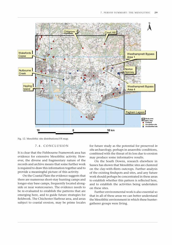
An SMr search has produced a total of 145 records of Mesolithic date from the Fishbourne framework area. of these, 38 are located on the Coastal Plain, 72 on downland, 13 in the weald, and 22 are unclassified (Fig. 12).
These records are derived from a wide variety of sources, with many of them being findspots for single flint artefacts of diagnostic Mesolithic date, such as tranchet adzes, picks, microliths and blades/bladelets (Fig. 10). other records relate to chance finds of groups of Mesolithic flintwork, whilst a small number have come from excava-tions, or during the course of PPG16 fieldwork.
it is possible to determine broadly the type of activity going on in the Mesolithic period by
F i SHB our Ne re SeArCH AN d CoNS ervATio N FrAM ework 25

26 7 . Per iod SuMMA rY: TH e MeSoLiTH iC
analysing the flintwork that has been found or recovered at some of the sites (Butler 2005). For example, a broader range and different types of implements would be found at more permanent base camps from those found at short-stay hunting camps, and where the same type of implement is found at both, the relative quantities of imple-ments, area covered and other features present may also provide an indication of the type of site.
This determination will only be possible, how-ever, where either a substantial quantity of flint artefacts have been recovered from a site, or the site has been subject to excavation. For the great
majority of sites known about in the Fishbourne Framework area, this will not be possible as they comprise just a single or at best a handful of flint pieces. There are however, a number of sites where more substantial fieldwork or excavation has taken place, and therefore it is possible to make some broad interim statements about the types of site found within the Fishbourne Framework area.
The CoasTal Plain (Fig. 11)
A summary of the Mesolithic flintwork found on the Coastal Plain (Pitts 1980) noted that the most frequent artefacts that had been found were tranchet adzes and other core imple-ments such as picks, and that microliths were completely absent. Although no evidence for the production or use of tranchet adzes was found dur-ing the recent excavations at Fishbourne, examples have been found there in the past (wymer 1977). However, the excavations did produce some 200 pieces of Mesolithic flint-work, which included five obliquely-blunted microliths, together with bladelets, blade-let fragments and bladelet cores, all of which are indicative of microlith production (Butler
2003). excavations in 1985–6 on the new A27 road east of Fishbourne produced an assemblage of 340 pieces of flintwork of which the majority were Mesolithic (Goodburn 1996), including four microliths and a single microburin.
other assemblages of Mesolithic flintwork have been recovered from excavations at knapp Farm, Bosham and from the westhampnett Bypass. At knapp Farm, the small assemblage included blades, bladelets, cores, a microdenticulate and two trun-cated blades, together with a single small scalene triangle microlith suggesting a temporary camp of later Mesolithic date (Holgate 1997). Two clusters
Fig. 10. Mesolithic flints from Fishbourne: 1–3) cores; 4–8) microliths; 9–10) notched implements.

7 . Per iod SuMMA rY: TH e MeSoLiTH iC 27
of Mesolithic flintwork were encountered during excava-tions on the route of the westhampnett Bypass in 1992 (Fitzpatrick et al. forth-coming): Area 1 was located on a small knoll overlook-ing a stream, whilst Area 4 was located on the lower slopes of a knoll, again over-looking a stream. Area 1 produced some 4500 flints, whilst Area 4 produced 6000 flints. These included a broad range of debitage and implements including microliths and microburins, together with tranchet adze-sharpening flakes and adze fragments. radiocarbon dates from charred hazel-nuts of 9120±90 bp for Area 1 and 8880±100 bp for Area 4, and a second date of 8300±90 bp on charcoal from Area 4 suggest this is early Mesolithic activity. The wide range and quantity of implement types at the westhamp-nett sites, together with their location adjacent to a watercourse, suggests that they functioned as long-stay camps (Holgate 2003).
recent work along the Coastal Plain, much of it PPG16 prompted, has resulted in the recovery of numerous assemblages of flintwork. when these assemblages have been analysed they are predominantly later prehistoric in date, but nor-mally include a significant proportion of residual Mesolithic pieces.
ChiChesTer harbour
A field survey of Chichester harbour was under-taken in August 1982 to assess the extent of coastal erosion (Cartwright 1984). Although the flintwork recovered was largely Neolithic in character, there were a small number of pieces that may have been Mesolithic. A few other findspots are known from around Chichester Harbour (e.g. dell Quay – SMr ref: CH2162), but our knowledge of Mesolithic ac-tivity in this part of the Fishbourne Framework area is poor. The recent survey of Langstone Harbour to the west found little evidence for early Mesolithic activity, but there was some evidence for activ-ity during the later Mesolithic (Allen & Gardiner
2000). The changing coastline means that both Langstone and Chichester Harbours would have been some way inland during the later Mesolithic period, and the landscape would have comprised a series of valleys with watercourses running through them to the coast. These would have made ideal locations for both hunting camps and longer-stay base camps, which are now perhaps buried in the alluviated valleys or have been eroded away (Allen & Gardiner 2000, 204).
The Mesolithic flintwork recovered in Lang-stone Harbour comprised mostly debitage and a restricted range of tools, including tranchet adzes and sharpening flakes, picks, scrapers and serrated and retouched flakes. interestingly, there have been very few microliths found in Langstone Harbour, which draws some parallels with the situation in east kent. At Finglesham on the east kent coast a Mesolithic site excavated in 1981–2 produced a very similar assemblage; with large numbers of tranchet adzes and associated material, but no microliths, and no evidence for microlith production (Butler 2005, 118). it is not clear whether these sites are task-related, but their location in coastal regions, and the predominance of woodworking tools in their tool assemblages may suggest that they were perhaps involved in making and maintaining boats. By comparison, on the Pevensey Levels, in east Sussex, the known Mesolithic sites are clus-
Fig. 11. The Coastal Plain, a typical location for Mesolithic sites.

28 7 . Per iod SuMMA rY: TH e MeSoLiTH iC
tered around the 5 m contour, as subsequent sea level change has resulted in any lower sites being covered with peat (woodcock 2003). Around the Pevensey Levels the known Mesolithic sites have produced both tranchet adzes and microliths, indicating that there may not be the same type of task specialization here (Butler 2002).
The DownlanD
Almost half of the known Mesolithic sites recorded on the SMr from within the Fishbourne Frame-work area are located on downland, although this category also appears to include sites on the Green-sand, to the north of the South downs. Many of the sites comprise just a few pieces of flintwork, whilst others were recorded during the excavation of sites dating to other periods. The knowles collection of flintwork, amounting to some 300 pieces, derives from a number of locations around Midhurst.
The flintwork that has been found normally comprises diagnostic pieces such as cores, blades and bladelets, together with the occasional tranchet adze and microlith. in addition to the flintwork, three quartzite pebble maceheads, of probable Mesolithic date, have also been found.
None of the sites or findspots on the chalk South downs appears to have come from any systematic work. Further west near Brighton, systematic fieldwalking and other fieldwork has associated Mesolithic sites with clay-with-flints outcrops (e.g. Butler 2001; Butler & Holgate 2002), and it does seem that this pattern may be repeated within the Framework area, although further work is required to confirm this.
A number of Mesolithic sites have been in-vestigated on the Lower Greensand to the north of the downs. At west Heath a pit sealed below a Bronze Age barrow produced a radiocarbon date of 8100±70 bp, whilst the excavations produced a quantity of Mesolithic flintwork including a small number of microliths (drewett 1976). Pollen analy-sis at this site suggested that partial clearance of the forest was taking place in the Mesolithic period (Scaife 1988). Surface flint collection at Graffham Common produced an assemblage of almost 2000 pieces of Mesolithic flintwork from three dense scatters (Holgate et al. 1986), which included cores, blade and bladelet debitage, and a small number of implements including microliths. At Minsted, an assemblage of Mesolithic flintwork was found below a Bronze Age barrow (drewett 1975). These
sites on the Lower Greensand to the north of the South downs belong to a group of early Mesolithic sites stretching from here through into east Sussex that appear to favour this location (Jacobi 1978).
The wealD
A small number of Mesolithic sites are classified on the SMr as coming from the weald, and are probably too far north to be considered within the Fishbourne Framework area. wealden Mesolithic sites tend to fall into two types of site. in the central and eastern part of the Sussex weald there are nu-merous rock-shelter sites associated with microliths and microlith production, which can probably be interpreted as short-stay hunting camps. The second type of site is found in streamside locations across the weald, and they appear to be associated with a broader range of implements, including both mi-croliths (frequently Horsham Points) and tranchet adzes; these may be longer-stay camps.
7 . 3 . Q u A L i T Y o F T H e A r C H i v e A N d A r C H A e o L o G i C A L r e C o r d
As the majority of the sites listed on the SMr (Fig. 12) relate to single, or small groups of, artefacts, many of which may be in private hands or local museums, a full re-evaluation of these may not be possible, although many of the earlier finds will have been included in wymer’s Gazetteer of Mesolithic Sites (1977).
Most of the major sites discovered during the course of excavation or other fieldwork have been published and the archive should be available from one of the local museums. An increasing number of sites have been discovered during the course of PPG16 work along the Coastal Plain, and in most cases the reports are available in the ‘grey literature’, and the archives should be accessible in local museums. However, in the majority of these cases the quantity of Mesolithic material is small, and is derived from residual contexts. it is possible that a small number of sites remain unpublished, although it has not been possible to identify these from the SMr information provided.
Some re-evaluation of the data is essential, and it cannot necessarily be taken at face value; for example in one published report some pieces are classified and described as microliths, but from the published drawings and descriptions appear to be simply retouched bladelets.
7 . Per iod SuMMA rY: TH e MeSoLiTH iC 29
7 . 4 . C o N C L u S i o N
it is clear that the Fishbourne Framework area has evidence for extensive Mesolithic activity. How-ever, the diverse and fragmentary nature of the records and archive means that some further work is required to draw this information together and to provide a meaningful picture of this activity.
on the Coastal Plain the evidence suggests that there are numerous short-stay hunting camps and longer-stay base camps, frequently located along-side or near watercourses. The evidence needs to be re-evaluated to establish the patterns that are emerging here, and to guide future strategies for fieldwork. The Chichester Harbour area, and areas subject to coastal erosion, may be prime locales
Fig. 12. Mesolithic site distributions/oS map.
for future study as the potential for preserved in situ archaeology, perhaps in anaerobic conditions, combined with the threat of its loss due to erosion may produce some informative results.
on the South downs, research elsewhere in Sussex has shown that Mesolithic sites are clustered on the clay-with-flints outcrops. Further analysis of the existing findspots and sites, and any future work should perhaps be concentrated in these areas to establish whether this pattern is reflected here, and to establish the activities being undertaken on these sites.
Further environmental work is also essential so that in all of these areas we can better understand the Mesolithic environment in which these hunter-gatherer groups were living.

8 . 1 . P e r i o d o v e r v i e w
he Neolithic (c. 4500–2500/250 bc) has always been a somewhat difficult period to define. even in Stuart Piggott’s seminal
work on the Neolithic Cultures of the British Isles (1954) he noted the ‘dubious validity’ of the term but accepted that it marked the arrival of agricul-ture into Britain. He suggested that the area of lowland Britain south of the wash formed a homo-geneous unit, his ‘windmill Hill Culture’. defining features of the Neolithic were seen as agriculture, permanent settlements, causewayed enclosures, long barrows, flint mines, polished stone tools and pottery. As these elements were thought to have been brought by immigrants from the continent then the model of settlement should match that of Continental europe. The fact that permanent set-tlements remained elusive in lowland Britain and that evidence for crop cultivation is often missing in the early stages of the Neolithic was generally assumed to result from lack of evidence rather than suggesting something rather different in the english Neolithic. The last twenty years has seen a shift away from the idea of a single Neolithic in lowland Britain to a greater emphasis on regional variation (e.g. Thomas 1993). instead of permanent settlements we should perhaps be looking for ter-ritories of use where ‘permanence’ comes in the siting of monuments rather than settlements. This may be more associated with herding of domesti-cated cattle than cultivation of crops. in many ways the Fishbourne research and Conservation study area presents a ‘typical’ lowland British ‘Neolithic’ with its monuments (causewayed enclosures, long barrows and flint mines), polished stone tools, pottery, lithic spreads and isolated pits but lack of evidence for ‘permanent’ settlements and conclu-sive evidence for crop growth early in the period. it is therefore an ideal area for testing some of the alternative ‘neolithics’ being proposed (e.g. in Cot-ton & Field 2004).
8. Period summary: the Neolithic◆
T8 . 2 . T H e S T u d y A r e A —
i T S m o N u m e N T S A N d F i N d S
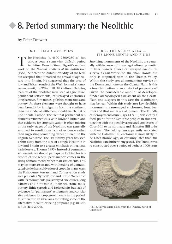
Surviving monuments of the Neolithic are gener-ally within areas of lower agricultural potential in later periods. Hence causewayed enclosures survive as earthworks on the chalk downs but only as cropmark sites in the Thames valley. within this study area all monuments survive on the downs and none on the Coastal Plain. is this a true distribution or an artefact of preservation? Given the considerable amount of developer-funded archaeological assessment on the Coastal Plain one suspects in this case the distribution may be real. within this study area key Neolithic monuments, causewayed enclosures, long bar-rows and flint mines are all present. The Trundle causewayed enclosure (Figs 13 & 15) was clearly a focal point for the Neolithic peoples in this area, together with the possibly associated enclosures of Court Hill to its northeast and Halnaker Hill to its southeast. The field system apparently associated with the Halnaker Hill enclosure is more likely to be Later Bronze Age, or certainly later than the Neolithic date hitherto suggested. The Trundle was re-constructed over a period of perhaps 1000 years
by Peter drewett
Fig. 13. Carved chalk block from the Trundle, north of Chichester.
F i SHB our Ne re SeArCH AN d CoNS ervATio N FrAmework 31

32 8 . Per iod Summ Ary: TH e Neo LiTH iC
with overlapping circuits of discontinuous ditches while Court Hill and Halnaker Hill perhaps had a much shorter life. The Trundle remains one of the best-preserved Neolithic causewayed enclosures surviving in Britain and has been subjected to only small-scale targeted excavations (Curwen 1929; 1931; Bedwin 1981). it has dates of 3290±140 bc (i-11615) and 3090±170 bc (i-11616).
To the west of the Trundle is the great long barrow of Bevis’s Thumb (Fig. 14) with, possibly associated, oval barrows to its northeast (North marden) and southeast (Stoughton i and ii). Bevis’s Thumb has a single date of 2596±95 bc (i-11,843) while North marden has a date of 2760±110 bc (Har-5544). Although so few dates must be treated with caution it is possible that in this case (unlike other parts of england) the causewayed enclosures may pre-date the barrows. Bevis’s Thumb and Stoughton i and ii survive as reasonably well-preserved field monuments (although with clear agricultural, and in the case of Bevis’s Thumb, road-edge damage). The North marden barrow had been largely destroyed in antiquity and further damaged by post-wwii agriculture so was subjected to a salvage excavation (drewett 1986).
The study area includes two flint mine shaft clusters (Long down and west Stoke) and a single shaft at Nore down (Fig. 15). earlier suggestions of flint mines at Lavant down and Bow Hill are now generally discounted as more recent flint-/chalk-working (Barber et al. 1999). The single shaft at
Nore down, west marden (Aldsworth 1983), however, sounds a degree of cau-tion when discounting any hollows on the downs as possible flint-mine sites un-less there is clear evidence of a later date. Two of the c. 24 shafts at Long down (Salisbury 1961) and three of the c. 20 shafts at west Stoke (wade, 1924) have been excavated. Although these shafts were used to extract flint for the produc-tion of axes and other tools, recent reconsideration of structured deposits within shafts and galleries empha-size their potential symbolic
role within the cultural landscape. A general lack of other activity near the flint mines may suggest they were liminal areas to which particular people travelled at significant times (Topping 2004).
Pits containing the remains of apparently ‘do-mestic’ material culture (pot sherds, animal bones, flint tools and the like) were formerly thought of as possible indicators of settlement (Field et al. 1964). it now appears more likely that such pits and their contents represent a wider use of the landscape than specific settlement at the particular spot where the pit was dug. Pit deposits may have more of a symbolic than economic role, a way of fixing domesticity in a landscape being tamed (Thomas 1991, 76). Such pits in Sussex are found both within causewayed enclosure ditches and in the wider landscape (drewett 2003, 43). A line of five pits were found to the east of the North marden oval barrow in 1987 (down & welch,1990, 221). These pits were roughly circular with diameters of under 1 m and less than 400 mm deep. The 408 sherds found represented a minimum of 30 early Neolithic round-based pots together with flintwork and animal bone. Single pits have also been located on the Coastal Plain. one located by chance during the excavation of the Copse Farm iron Age settle-ment at oving contained ten rim sherds from a single round-based pot with a rim diameter of some 250 mm (Bedwin & Holgate 1985, 220). Two pits were also found during the westhampnett Bypass excavations, one in Area 3 and another in Area
Fig. 14. Bevis’s Thumb long barrow.
8 . Per iod Summ Ary: TH e Neo LiTH iC 33
8. A further seven pits containing Late Neolithic (but also early Bronze Age) material were found at Chalkpit Lane and another pit (also containing Late Neolithic and early Bronze Age material) at Graylingwell (Chichester). The mixture of Late Neolithic and early Bronze Age material perhaps underlines the possibility that these pits contain structured depositions including curated items. if all these pits in the landscape have more to do with symbolism than direct economic activities on settlement sites then the problem of where people actually lived remains.
Although house-like structures akin to the eu-ropean Neolithic long houses have been found on the chalklands of north kent (white Horse Stone site in the medway valley) none have been found in Sussex and it remains uncertain as to whether these structures are the remains of domestic houses or are related to the (mortuary) structures found under long barrows elsewhere in england. Lithic spreads on the downs and Coastal Plain of the study area together with polished flint and other stone axes and leaf-shaped arrowheads across the whole area indicate activity across all geologies. A simplistic attempt to divide these lithic scatters into Strand and Salt marsh resource utilization Camps (on the Coastal Plain and particularly Chichester Harbour), open Agricultural Settlements (on the chalk downs) and woodland Camps (in the weald) was an at-tempt to create some (Processual) order out of this scanty evidence (drewett et al. 1988, 44–7). what these lithic concentrations and broad landscape spreads do show, however, is the extensive use of all resource zones available in the Neolithic.
Lithic scatters in the wetter coastal areas prob-ably do represent some specific range of activities. The site at Chidham in what is now Chichester Harbour, produced a high percentage of hollow scrapers and notched flakes together with three in-complete leaf-shaped arrowheads (Bedwin 1980). This assemblage may represent the preparation of osiers to be plaited into wicker fish traps and the manufacture of arrowshafts and spears for fishing and fowling. Lithic scatters on the chalk downs create a greater problem of interpretation. Some probably represent surface flint-working sites while those with a greater range of tool types may represent some form of settlement, but perhaps shifting following herds of domesticated cattle rather than permanent settlements with agricul-tural plots.
The exact number of lithic scatters and findspots within the Fishbourne research and Conservation study area which can be certainly dated to the Neolithic remains uncertain although the Sites and monuments record includes some 162 locations from fairly large assemblages to just one or two artefacts. early records often refer to flints as ‘Neolithic’ when in fact many are Bronze Age. This particularly applies to rather indetermi-nate clusters of flakes (including a number around Chichester Harbour where association with burnt flint spreads may suggest a Later Bronze Age date). Having said that, of the more certain Neolithic flint scatters and spot finds (both early and late) there appears to be a general spread across all geologies. Apparent clustering around Chichester Harbour and Selsey probably suggest discovery after erosion rather than real concentrations. Likewise apparent concentrations in the built-up areas of Chichester and Bognor may result more from development led discovery than real concentration.
The Fishbourne research and Conservation study area contains a number of spot finds of com-plete polished flint and stone axes spread across all geologies. These are mainly unassociated findspots perhaps suggesting deliberate deposition in the landscape. At least two examples were however, found in well-dated medieval or post-medieval contexts (one for example was found incorporated into a timber-framed house at walderton) empha-sizing the significance of these ‘thunderbolts’ in the superstitions of later periods (and the fact that they may have been moved around the landscape much later than the Neolithic period).
8 . 3 . C o N C L u S i o N S
The Fishbourne research and Conservation area in many ways represents a ‘classic’ lowland english ‘neolithic’ with its distinct sites and many uncer-tainties. monuments are represented by major and minor enclosed spaces with a clear ritual focus (the causewayed enclosures) and long and oval mounds with some burial evidence (the barrows) (Fig. 15). industrial sites (the flint mines) also see processes of extraction, and perhaps preliminary knapping, embedded within forms of ritual behaviour. Pits may represent a wider use of the landscape than purely at the spot where they were dug. They may therefore not represent actual settlement sites but
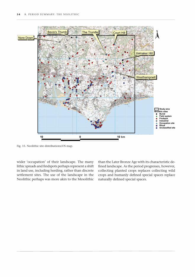
34 8 . Per iod Summ Ary: TH e Neo LiTH iC
Fig. 15. Neolithic site distributions/oS map.
wider ‘occupation’ of their landscape. The many lithic spreads and findspots perhaps represent a shift in land use, including herding, rather than discrete settlement sites. The use of the landscape in the Neolithic perhaps was more akin to the mesolithic
than the Later Bronze Age with its characteristic de-fined landscape. As the period progresses, however, collecting planted crops replaces collecting wild crops and humanly defined special spaces replace naturally defined special spaces.
9 . 1 . B r i e f O v e r v i e w
uropean communities three to four-and-a-half thousand years ago are said to have experienced the first golden or international
age. The period of time between 2500–700 bc saw exceptionally rapid economic developments and social changes in comparison with anything that had gone on before. During the Bronze Age,2 widely-spaced parts of the continent were drawn together by an expanding communications network result-ing in the rapid spread of new ideas, technological advances and material wealth. in england, a politi-cally dominant english Channel–North Sea region developed with concentrated settlements along the Thames, the east Anglian fenlands and the South Coast (fig. 16). Access to the wider european exchange and alliance network was important and a farming surplus funded the accumulating scale of bronze metalwork found in the archaeological record. it was a time of profound changes in the way land was managed with rectilinear fields, pasture plots and straight droveways creating an imposing landscape. within this working landscape burial practices changed. The dead increasingly became incorporated into the landscape of the living, buried within settlements or within the farmed grounds. widespread social dislocation in southern england at the end of the Bronze Age reflected a significant shift in the patterns of long-distance exchange in europe and the collapse of the bronze-based prestige goods economy.
9 . 2 . w h AT ’ S N e w
Until the advent of developer-funded archaeology in 1990, Bronze Age studies were largely confined to investigation of upland earthworks especially the surviving downland barrows, earthen banks and ditches. Large-scale commercial archaeol-ogy has transformed that narrow focus and has revealed the hidden legacy of Bronze Age activity on lowland river terraces and coastal brick-earths
9. Period summary: the Bronze Age◆
e— ground which provides no surface indicator of what lies beneath. it is now apparent that these rich farmlands, including the loess of Sussex, formed the core areas of Bronze Age settlement. it now seems that early Bronze Age pits may have marked out the first land plots. These became formalized by digging permanent field boundaries, particularly in the Later Bronze Age (Knight 2002; Chapman et al. 2005, 19). Some early Bronze Age barrows may have been constructed as clearance cairns at the edges of fields.
The field banks and ditches defined large areas of ground in which the farming communities lived out their daily lives, toiling to make a success of their existence. researchers now recognize that certain dominant elements of farm life (those critical to the perpetual success of the community) were associated with acts of ritualization (Bradley 2003). There is increasing evidence to show that field systems and farmsteads were associated with particular depositional practices. Critical points in the fields and the settlement were marked by the deposition of artefact concentrations or the plac-ing of special single finds including quernstones, bronze objects, curated curios and token human cremations (Brück 2001, 151; Dunkin 2001; Gutt-mann & Last 2000, 155). Offerings in watering holes, in particular, show concern for the contin-ued welfare of the breeding herd (Bradley 2003; Barrett et al. 2001). Decommissioning rites marking the abrupt erasure of a settlement (Nowakowski 1991) or formal closure of a watering hole have also been recorded. All such actions provide clues to the complexity of a cultural landscape in which formal land tenure was not solely an impersonal expression of demographic and economic forces (fokkens 1999, 41). The construction of field sys-tems and roundhouses aligned on the rising sun appears to have created a spatial setting in which people, their livestock and cultivated land were closely linked in a complex cosmology.
research suggests a drive to maximize output during the Bronze Age that is quite independent
by David Dunkin & David Yates
f i ShBOU rNe re SeArCh AND CONS ervATiON fr Amew OrK 35

36 9 . per i OD SU mm ArY: The BrON ze AG e
of population pressure. intensified production may have been adopted to meet social demands for feasting, exchange and alliance formation. fierce competition between political economies puts pressure on the most valued land, i.e. that ground with the greatest fertility or strategic advantage. it was in those locations that innovations in livestock management and plant species were pursued. There is more evidence of manuring on the lowland sites to add to the existing evidence from the uplands. The discovery of massive Later Bronze Age middens at east Chisenbury and potterne (mcOmish et al. 2002, 73; Lawson 2000; Guttmann 2005) on the wessex Chalklands has significant implications for future research in Sussex. There are signs of spiritual replenishment. work in Cornwall and Cambridge-shire suggests that field shrines were incorporated into the farmlands (Nowakowski 1991; Bender et al. 1997, 173; pollard 2002) and the discovery of hu-man bones within manure matrices (Nowakowski pers. comm.) suggests a special emphasis on soil enrichment. it signals the continued participation of the dead in the life-giving land in an attempt
to ensure the perpetuation of the farming cycle (Brück 2001).
research into marine transgression has high-lighted the scale of coastal erosion during the holocene (Long & Shennan 1993; Long & roberts 1997). Large stretches of Bronze Age coastline along the North Sea, in the Thames estuary and the english Channel are now submerged. increasing data on relative sea levels provide a context for the surviving archaeological record.
9 . 3 . T h e e A r LY B r O N z e A G e D ATA i N T h e S T U D Y A r e A
Barrows on the Downs anD Coastal Plain
The most visible form of evidence in the study area for the early Bronze Age is the barrow. These have been, until recently, almost exclusively confined to the downland block. The majority of these are ‘Bowl’ barrows though there are a number of ‘Bell’ and ‘pond/Saucer’ barrows which lie within the Kingley vale/Bow hill enclave. The Devil’s Jumps on Bow hill (fig. 17) contain a number of
fig. 16. Bronze Age site distributions/OS map.

9 . per i OD SU mm ArY: The BrON ze AG e 37
the latter and these are very much in the wessex tradition. This has been further emphasized by the discovery of a ‘whetstone pendant’ from Barrow 3 on Bow hill (Garwood 2003). The discovery of two barrows (‘ring-ditches’) on the westhampnett Bypass excavations (Allen & Gardiner 2000, 12) lie within the study area and add to the only other known barrow on the Coastal plain, the ‘hove Barrow,’ which was destroyed in the nineteenth century. The westhampnett discoveries suggest that further barrows, perhaps in ‘ring-ditch’ form, await discovery on the Coastal plain.
Other clusters of barrows within the study area which lie on the Chalk to the north and northwest of Chichester, are in the vicinity of Goodwood, the mardens and Chalton. The Bow hill and the Goodwood Group overlook the upper reaches of the Lavant on the west and east sides respectively. The Chalton valley Group on the Chalk, in the extreme northwest of the study area, now over-looks what is essentially a dry valley. research may show that the marden and Bow hill Groups demonstrate a continuity of funerary expression and other activities from the later Neolithic. The proximity of these two groups to Late Neolithic
oval barrows at North marden (Drewett 1986) and Stoughton respectively, may provide an important sequence.
There is a great diversity of funereal and ritual expression encompassed within the tradition of barrow construction (Garwood 2003, 57). each bar-row and/or barrow group will have its own unique history. A continuum of change must be expected in a tradition which lasted for at least a thousand years. furthermore, the re-use of these monuments over a much longer time-frame (Bradley 2002) informs us that there are still many more strands of evidence that research into barrows needs to consider and unravel.
other Forms oF eviDenCe
The other main body of evidence for the early period is the artefact scatters, in particular the char-acteristic flintwork and distinctive Beaker pottery. The latter has been identified on both the Chalk (e.g. Stoke Clump) and the Coastal plain at Selsey and North Bersted. early Bronze Age metalwork has been recorded at a number of locations on the Chalk, the Coastal plain and the Upper Coastal plain. Some of the finds include a flanged axe from
fig. 17. Devil’s Jumps, Bow hill, reconstruction.

38 9 . per i OD SU mm ArY: The BrON ze AG e
Bracklesham Bay and flat axes from Selsey, west-hampnett and west Stoke (Trumley Copse).
The virtual absence of early Bronze Age structures is in marked contrast to the developed farmscape of the later period (from c. 1500 bc). The study area contains much evidence of continuity from the earlier to the later period. in the Stoke Down/Bow hill area early Bronze Age barrows are juxtaposed with late prehistoric field systems, lin-ear boundaries (cross ridge dykes) and Later Bronze Age settlement (below). The landscape around Bow hill therefore provides possibilities for researching the transitional period where this apparent shift to a settled lifestyle took place.
9 . 4 . m i D D L e A N D L AT e B r O N z e A G e D ATA
selsey anD the Coastal region oF the stuDy area
it has been conjectured that the Bronze Age coastline was 1–2 kilometres further south of the present-day foreshore and perhaps as far south as the mixon reef (woodcock 2003, 4). Considerable erosion of the shoreline at Selsey has occurred and continues to do so. This is hastened by the fact that the tidal effects of long-shore drift, both to the east and the west of Selsey Bill (woodcock 2003, 4), cause a greatly increased scouring effect. This has recently resulted in deposits of Later Bronze Age date being uncovered (Seager-Thomas 1998). There is a large and growing body of evidence of Late Bronze Age occupation and high-status metalwork known from the Selsey peninsula. This together with evidence of land division and cremation sug-gests an important farming and settlement focus within the region.
The coastal region of the study area has pro-duced significant concentrations of Later Bronze Age activity. On hayling island in particular, there are a number of hoard sites; for example a middle Bronze Age hoard of c. 20 palstaves from central hayling and another mBA palstave hoard from Gable head, have been identified. At North hayling a putative burnt mound has been located (Bradley pers. comm.) and these may have a hoard association (Dunkin 2001). At the northern tip of hayling island a possible timber platform site has been recorded with a radiocarbon date centring on the early Bronze Age/middle Bronze Age transition and at South hayling Late Bronze Age hearths sug-gest occupation.
At Bracklesham Bay two Later Bronze Age hoards and a gold ring are recorded from coastal deposits. To the immediate east of Selsey in the vicinity of Bognor regis, another important enclave of Late Bronze Age activity is centred on the Aldingbourne rife. At North Bersted a recent evaluation (worrall 2005) identified a Later Bronze Age land surface containing burnt-flint concentrations, capped by an alluvial sequence provisionally dated to the early iron Age. further work here should identify significant environmental data for the period. The proximity of further hoard sites (flansham, Bilsham, Yapton, Bognor) and a settlement focus at wester-gate (Stevens 2000) indicates that the western fringes of the Sussex Coastal plain were central to the overall emerging picture of the region.
the river valleys
Distribution of Later Bronze Age activity shows a marked coastal/riverine/valley orientation and the Lavant and the Bosham Stream are of particular significance.
The upper and middle parts of the Lavant, north and east of Chichester have evidence for occupation and significant metalwork. At mid Lavant a Late Bronze Age spearhead was discovered close to the river and at east Dean at the river’s head a hoard containing two Sussex loops and three quoit-headed pins were discovered in 1936 (Anon. 1936).
The development of Chichester and subsequent gravel quarrying to the south and east of the city have seen many changes to the former courses of the lower reaches of the Lavant. in Chichester itself occupation evidence was identified at Graylingwell and burnt mound material was discovered in a palaeochannel during an evaluation just to the west of the cathedral (priestley-Bell pers. comm.). in the north of the city close to the Lavant a frag-ment of Late Bronze Age cauldron was identified. Other metalwork finds are known in the vicinity. Some of the most important discoveries to date on the Coastal plain, and investigated prior to gravel extraction, are centred on the Drayton/Oving area to the east of the city. Droveways, ditches, cremation cemeteries and settlement foci indicate that this area was intensively occupied during the Later Bronze Age. At Drayton South a number of elements of the Late Bronze Age landscape came together with two burnt mounds, cremation de-posits, and metalwork immediately abutting the line of a braided stream which formerly fed into the Lavant south of the city.

9 . per i OD SU mm ArY: The BrON ze AG e 39
The area immediately to the west and north of fishbourne has yielded a number of metalwork finds close to or within the Bosham Stream/fish-bourne Creek. An important ‘ornament horizon’ middle Bronze Age hoard was found by a metal detectorist in the west Ashling/funtington area (Chichester District museum) (fig. 18). This area is characterized by the alluvium of the upper reaches of the Bosham Stream, a classic location. The hoard is comprised of arm-rings, metal-working tools, finger-rings and side-looped spearheads. Also from the area come two Late Bronze Age spearheads from the streambed together with the findspots of several middle Bronze Age palstaves close by (e.g. Trumley Copse). One of the spearheads appears to have been broken deliberately and may represent an act of decommissioning (York 2002).
9 . 5 . e x C AvAT i O N S TA N D A r D S A N D h i S T O rY O f i N v e S T i G AT i O N
most of the earlier investigations on the Chalk amounted to antiquarian curiosity and therefore the visible barrows were targeted. Only two barrows have been fully excavated to modern standards (see Table 1).
regarding sites of the Later Bronze Age period, which lie within the area of interest, very few have been excavated to modern standards prior to ppG16 in 1990. principally these are: the Trundle, at which a campaign of excavation at the middle iron Age hillfort in the late 1920s (Curwen 1929; 1931) identified a pre-hillfort phase dated on pottery to the Late Bronze Age/early iron Age (hamilton & manley 1997). Also on the Chalk at Kingley vale a sample excavation by Curwen in 1932 revealed a
possible middle Bronze Age house platform associ-ated with a small assemblage of Deverel-rimbury pottery (Curwen 1954). A small scale investigation at Selsey (Golf Links Lane) on the Coastal plain by mrs Graham Clark (white 1934) uncovered evi-dence for Late Bronze Age occupation. fifty years later James Kenny’s excavations at the pontins’ Broadreeds holiday Camp (Kenny 1989) located Later Bronze Age pottery, some of which may be related to middle Bronze Age cremations (hamilton 2003) together with other occupation evidence (e.g. middle Bronze Age roundhouse).
Since 1990, and principally under the aegis of ppG16, the picture has changed dramatically, particularly on the Coastal plain. A large body of this evidence is unpublished (client reports), but lies within the public domain. The published and unpublished reports are summarized in Table 2.
indeed this evidence reflects the emerging picture across the entire west Sussex Coastal plain. This new data helps to contextualize the great corpus of Bronze Age metalwork recorded over a much longer period in the region.
9 . 6 . pA r A D i G m S O f T h e pA S T A N D T h e p r e S e N T
No longer therefore can the Coastal plain be regard-ed as an uninhabited void for the Later Bronze Age. The high archaeological visibility of the Downland block in the past ensured that its earthworks were always going to be the subject of excavation and survey. The imbalance has been heightened by the fact that the identification of features on the ‘brick-earth’ soils in extreme wet or dry conditions is very difficult. Other reasons contributing to the earlier paucity of evidence would include the general absence of extant prehistoric earthworks
fig. 18. west Ashling mBA arm-ring.
Table 1. record of excavation for eBA barrows within study area (after Garwood 2003, 63).
Modern standards
racton park farm (partial exca-vation)
Bow hill (Devil’s Jumps 2) (sample)
Lavant (total excavation)
westhampnett Areas 2 (sample) and 3 (total excavation - unpub-lished)
Pre-modern standardsApple Down (urn only)
Goodwood (sample)
Poorly recordedBow hill (Devil’s Jumps 3)
Bow hill (west and east spurs)

40 9 . per i OD SU mm ArY: The BrON ze AG e
on the coastal plain (Bedwin 1978). much of the region is characterized by deep deposits of topsoil/subsoil/alluvium which mask the identification of sites from the air. Also, for this reason, prehistoric pottery is not commonly found in the ploughsoil and this fact is further compounded by the acidic nature of the ‘brick-earth’ soils.
The view perpetuated by Curwen (1954) that metalwork deposition (single finds and hoards) could be accounted for by casual loss or the delib-erate burial for later retrieval, by smiths (founder’s hoard) or merchants for example, is no longer ten-able. The term ‘structured deposition’ has gained widespread acceptance and the work of richard Bradley in particular (Bradley 1990; Barber 2003), has clearly shown the ritual significance of the burial or placement of bronze artefacts during the Later Bronze Age.
environmental archaeology has begun to al-low some fine tuning regarding the chronology of woodland clearance. many studies indicate that the first major prolonged sequences in the opening up of parts of the landscape specifically occurred
Table 2. published/Unpublished reports for the Later Bronze Age within the study area.
location author(s)/reference evidence found
Published articles
Knapp farm, Bosham hamilton & Gardiner 1997 Late Bronze Age pits
Lavant Kenny 1994 Unenclosed Late Bronze Age/early iron Age settlement
Selsey west Beach Seager-Thomas 1998; 2001 Late Bronze Age wells/settlement
westhampnett fitzpatrick 1997 (vol. 2); vol. 1 forthcoming
middle Bronze Age houses/pits/pottery/fence-lines
Unpublished client reports
main road, Birdham Stevens 2003 Late Bronze Age pottery/ditches
westergate Community College Stevens 2000 Late Bronze Age ditch/post-hole/occupation deposits
N. Bersted worrall 2005 Late Bronze Age land surface/occupation deposits
Thomas à Becket Church, pagham Kirk 1996 middle Bronze Age pottery/3 x cremation urns
Drayton/Oving priestley-Bell 2000; 2002 palimpsest of LBA activity
Claypit Lane, westhampnett wessex Archaeology 2000; 2002
intense middle Bronze Age activity; Late Bronze Age trackway/field system
Chichester road, Selsey preston 2002 Late Bronze Age pits/post-holes/field boundaries
during the Later Bronze Age (e.g. Drewett 1989). This continuing work is going to be invaluable to placing the new archaeological data into an envi-ronmental context.
9 . 7 . C O N C L U S i O N
The Bronze Age communities were well placed to benefit from major changes affecting southern england. They had clear advantages in a new outward-looking world where social standing was increasingly defined in terms of long-distance alli-ances and the ability to compete for prestige goods. The shorelines gave direct access to coastal and cross-channel traffic. The loess deposits forming the plain were rich, inexhaustible soils — habitats which were capable of agricultural intensification — sustaining a burgeoning political economy. This would explain the siting of wessex Tradition conspicuous barrows on Bow hill with their out-looks over this rich territory and the abundance of Later Bronze Age finds which signal the political ascendancy of this region.