period 18-11: october 07, 2018 november 03, 2018 · 7.10.2018 · firearm offenses 0 1 n/a 0 1 n/a...
TRANSCRIPT

Period 18-11: October 07, 2018 – November 03, 2018
Sheriff Michael J. Chitwood
Chief Deputy John W. Creamer

COMPSTAT STATISTICAL CRIME COMPARISON TO PREVIOUS 28 DAY PERIODS
COUNTYWIDE 7/15/2018 10/7/2018 8/12/2018 10/7/2018 9/9/2018 10/7/2018 3 PeriodsVolusia County Sheriff's Office 8/11/2018 11/3/2018 9/8/2018 11/3/2018 10/6/2018 11/3/2018 Average % VCSO Offense Data Current - 3 Current (28d) % Change Current - 2 Current (28d) % Change Current - 1 Current (28d) % Change ChangeHomicides 0 0 0% 0 0 0% 0 0 0% 0%
Auto Thefts 23 13 -43% 20 13 -35% 14 13 -7% -29%
Total Burglaries 46 52 13% 52 52 0% 48 52 8% 7%
Residence 40 45 13% 43 45 5% 46 45 -2% 5%
Non Residence 6 7 17% 9 7 -22% 2 7 250% 81%
Total Larcenies 130 158 22% 138 158 14% 169 158 -7% 10%
Larcenies 69 75 9% 80 75 -6% 92 75 -18% -5%
Larceny Carbreak 41 51 24% 33 51 55% 48 51 6% 28%
Larceny Shoplifting 18 22 22% 21 22 5% 21 22 5% 11%
Larceny Bicycle 2 10 400% 4 10 150% 8 10 25% 192%
Total Robberies 8 6 -25% 7 6 -14% 5 6 20% -6%
Armed 4 3 -25% 4 3 -25% 2 3 50% 0%
Strongarmed 4 3 -25% 3 3 0% 3 3 0% -8%
Total Agg. Assaults/Bat. 27 32 19% 37 32 -14% 51 32 -37% -11%
Agg. Assaults/Batteries 20 19 -5% 20 19 -5% 40 19 -53% -21%
Agg. Domestic Assault/Batteries 7 13 86% 17 13 -24% 11 13 18% 27%
Person Shot 3 0 -100% 3 0 -100% 2 0 -100% -100%
Total Sexual Bat. 13 8 -38% 14 8 -43% 10 8 -20% -34%
Sexual Battery 1 3 200% 3 3 0% 3 3 0% 67%
Sexual Battery Child 12 5 -58% 11 5 -55% 7 5 -29% -47%
Total Part One Crimes 247 269 9% 268 269 0% 296 269 -9% 0%
Part One Property Crimes 199 223 12% 210 223 6% 231 223 -3% 5%
Part One Person Crimes 48 46 -4% 58 46 -21% 65 46 -29% -18%
Total Calls For Service 8,483 8,041 -5% 8,571 8,041 -6% 8,914 8,041 -10% -7%
Firearm Offenses 12 18 50% 15 18 20% 29 18 -38% 11%
All Domestic Violence Cases 122 131 7% 123 131 7% 156 131 -16% -1%
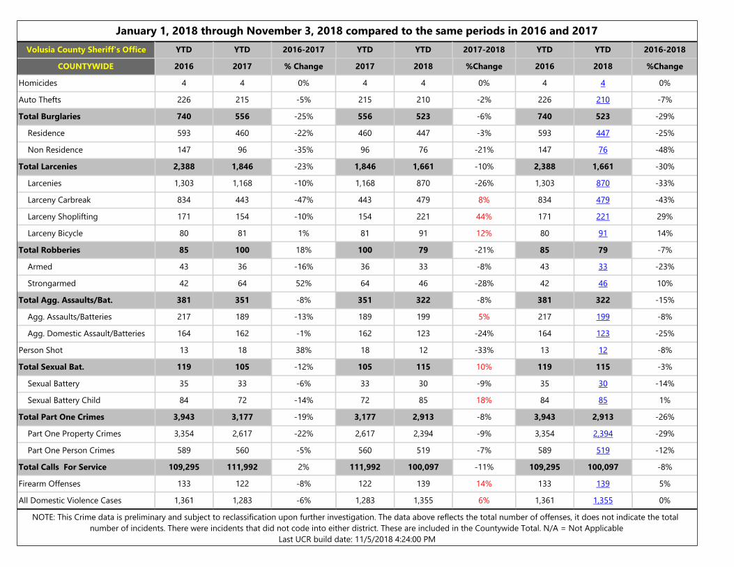
January 1, 2018 through November 3, 2018 compared to the same periods in 2016 and 2017Volusia County Sheriff's Office YTD YTD 2016-2017 YTD YTD 2017-2018 YTD YTD 2016-2018
COUNTYWIDE 2016 2017 % Change 2017 2018 %Change 2016 2018 %Change
Homicides 4 4 0% 4 4 0% 4 4 0%
Auto Thefts 226 215 -5% 215 210 -2% 226 210 -7%
Total Burglaries 740 556 -25% 556 523 -6% 740 523 -29%
Residence 593 460 -22% 460 447 -3% 593 447 -25%
Non Residence 147 96 -35% 96 76 -21% 147 76 -48%
Total Larcenies 2,388 1,846 -23% 1,846 1,661 -10% 2,388 1,661 -30%
Larcenies 1,303 1,168 -10% 1,168 870 -26% 1,303 870 -33%
Larceny Carbreak 834 443 -47% 443 479 8% 834 479 -43%
Larceny Shoplifting 171 154 -10% 154 221 44% 171 221 29%
Larceny Bicycle 80 81 1% 81 91 12% 80 91 14%
Total Robberies 85 100 18% 100 79 -21% 85 79 -7%
Armed 43 36 -16% 36 33 -8% 43 33 -23%
Strongarmed 42 64 52% 64 46 -28% 42 46 10%
Total Agg. Assaults/Bat. 381 351 -8% 351 322 -8% 381 322 -15%
Agg. Assaults/Batteries 217 189 -13% 189 199 5% 217 199 -8%
Agg. Domestic Assault/Batteries 164 162 -1% 162 123 -24% 164 123 -25%
Person Shot 13 18 38% 18 12 -33% 13 12 -8%
Total Sexual Bat. 119 105 -12% 105 115 10% 119 115 -3%
Sexual Battery 35 33 -6% 33 30 -9% 35 30 -14%
Sexual Battery Child 84 72 -14% 72 85 18% 84 85 1%
Total Part One Crimes 3,943 3,177 -19% 3,177 2,913 -8% 3,943 2,913 -26%
Part One Property Crimes 3,354 2,617 -22% 2,617 2,394 -9% 3,354 2,394 -29%
Part One Person Crimes 589 560 -5% 560 519 -7% 589 519 -12%
Total Calls For Service 109,295 111,992 2% 111,992 100,097 -11% 109,295 100,097 -8%
Firearm Offenses 133 122 -8% 122 139 14% 133 139 5%
All Domestic Violence Cases 1,361 1,283 -6% 1,283 1,355 6% 1,361 1,355 0%
NOTE: This Crime data is preliminary and subject to reclassification upon further investigation. The data above reflects the total number of offenses, it does not indicate the total number of incidents. There were incidents that did not code into either district. These are included in the Countywide Total. N/A = Not Applicable
Last UCR build date: 11/5/2018 4:24:00 PM

Volusia County Sheriff's Office 9/9/2018 10/7/2018 Percent 5/21/2017 10/7/2018 PercentArrest Data 10/6/2018 11/3/2018 Change 6/3/2017 11/3/2018 Change
Homicides 0 0 0% 1 0 -100%
Auto Thefts 3 3 0% 5 3 -40%
Total Burglaries 32 31 -3% 46 31 -33%
Residence 8 8 0% 11 8 -27%
Non Residence 24 23 -4% 35 23 -34%
Total Larcenies 29 18 -38% 27 18 -33%
Larcenies 17 8 -53% 22 8 -64%
Larceny Carbreak 0 0 0% 0 0 0%
Larceny Shoplifting 11 10 -9% 4 10 150%
Larceny Bicycle 1 0 -100% 1 0 -100%
Total Robberies 6 1 -83% 8 1 -88%
Armed 4 1 -75% 5 1 -80%
Strongarmed 2 0 -100% 1 0 -100%
Total Agg. Assaults/Batteries 29 31 7% 43 31 -28%
Agg. Assaults/Batteries 14 12 -14% 13 12 -8%
Agg. Domestics/Batteries 15 19 27% 30 19 -37%
Total Sexual Batteries 2 6 200% 2 6 200%
Sexual Battery 1 6 500% 0 6 N/A
Sexual Battery Child 1 0 -100% 2 0 -100%
Total Part 1 Arrests 101 90 -11% 131 90 -31%
Non-Violent Crime Arrests 64 52 -19% 78 52 -33%
Violent Crime Arrests 37 38 3% 53 38 -28%
Prostitution 0 0 0% 3 0 -100%
Narcotics 170 124 -27% 190 124 -35%
Miscellaneous 592 515 -13% 1312 515 -61%
Total Arrests 863 729 -16% 1,637 729 -55%CompStat 10 CompStat 11 LY CompStat 11 CompStat 11
NOTE: This data is to be used internally for Volusia County Sheriff's Office use only. This Crime data is Preliminary and subject to reclassification upon further Investigation. N/A = Not Applicable

January 1, 2018 through November 3, 2018 compared to the same periods in 2016 and 2017VCSO YTD 2016 YTD 2017 YTD 2018
Countywide Clearances Offense Clrs % Clr Adult Juv Offense Clrs % Clr Adult Juv Offense Clrs % Clr Adult Juv
Homicides 4 1 25% 1 0 4 4 100% 4 0 4 3 75% 3 0
Auto Thefts 226 58 26% 48 10 215 78 36% 64 14 210 94 45% 75 19
Total Burglaries 740 184 25% 151 33 556 167 30% 146 21 523 167 32% 139 28
Residence 593 155 26% 127 28 460 137 30% 122 15 447 140 31% 116 24
Non Residence 147 29 20% 24 5 96 30 31% 24 6 76 27 36% 23 4
Total Larcenies 2388 593 25% 516 77 1846 450 24% 389 61 1661 452 27% 402 50
Larcenies 1303 339 26% 293 46 1,168 288 25% 252 36 870 213 24% 199 14
Larceny Carbreak 834 147 18% 126 21 443 72 16% 52 20 479 116 24% 89 27
Larceny Shoplifting 171 91 53% 85 6 154 80 52% 78 2 221 111 50% 108 3
Larceny Bicycle 80 16 20% 12 4 81 10 12% 7 3 91 12 13% 6 6
Total Robberies 85 60 71% 52 8 100 72 72% 61 11 79 59 75% 54 5
Armed 43 28 65% 26 2 36 19 53% 17 2 33 21 64% 20 1
Strongarmed 42 32 76% 26 6 64 53 83% 44 9 46 38 83% 34 4
Total Agg. Assaults/Bat. 381 264 69% 245 19 351 260 74% 234 26 322 210 65% 193 17
Agg. Assaults/Batteries 217 126 58% 115 11 189 116 61% 103 13 199 104 52% 95 9
Agg. Domestic Assault/Batteries 164 138 84% 130 8 162 144 89% 131 13 123 106 86% 98 8
Person Shot 13 5 38% 4 1 18 8 44% 7 1 12 10 83% 10 0
Total Sexual Bat. 119 66 55% 56 10 105 70 67% 59 11 115 67 58% 44 23
Sexual Battery 35 25 71% 25 0 33 18 55% 18 0 30 16 53% 16 0
Sexual Battery Child 84 41 49% 31 10 72 52 72% 41 11 85 51 60% 28 23
Total Part One Crimes 3,943 1,226 31% 986 157 3,177 1,101 35% 957 144 2,913 1,052 36% 910 142
Part One Property Crimes 3354 835 25% 715 120 2617 695 27% 599 96 2394 713 30% 616 97
Part One Person Crimes 589 391 66% 271 37 560 406 73% 358 48 519 339 65% 294 45
NOTE: This Crime data is preliminary and subject to reclassification upon further investigation. The data above reflects the total number of offenses, it does not indicate the total number of incidents.
Last UCR build date: 11/5/2018 4:24:00 PM

Period 18-11: October 07, 2018 – November 03, 2018
Sheriff Michael J. Chitwood
Chief Deputy John W. Creamer

0 20 2
3 S3 S0 40 4
3 N3 N
0 60 6
Sources: Esri, HERE, DeLorme, Intermap, increment P Corp., GEBCO, USGS, FAO, NPS,NRCAN, GeoBase, IGN, Kadaster NL, Ordnance Survey, Esri Japan, METI, Esri China(Hong Kong), swisstopo, MapmyIndia, © OpenStreetMap contributors, and the GIS UserCommunityLegend
Prepared by: Patrick HardingCrime Intelligence AnalystVolusia County Sheriff's OfficePrinted On: 5/10/2017
0 5.5 11 16.5 222.75Miles ¯
This is not a legal document.Due to address incompatabilities, some
incidents may not be represented andthe information on this map should not be
viewed as the legal representation ofproperty boundaries, roads, facilities, etc.
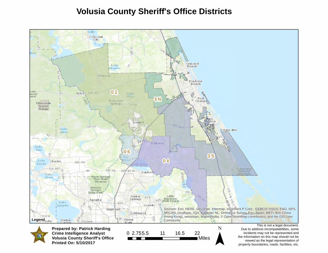
Volusia County Sheriff's Office Districts

Period 18-11: October 07, 2018 – November 03, 2018
Captain Paul W. Kammerer

COMPSTAT STATISTICAL CRIME COMPARISON TO PREVIOUS 28 DAY PERIODS
District 4 7/15/2018 10/7/2018 8/12/2018 10/7/2018 9/9/2018 10/7/2018 3 PeriodsVolusia County Sheriff's Office 8/11/2018 11/3/2018 9/8/2018 11/3/2018 10/6/2018 11/3/2018 Average %VCSO Offense Data Current - 3 Current (28d) % Change Current -2 Current (28d) % Change Current - 1 Current (28d) % Change Change
Homicides 0 0 0% 0 0 0% 0 0 0% 0%
Auto Thefts 10 4 -60% 6 4 -33% 4 4 0% -31%
Total Burglaries 17 15 -12% 19 15 -21% 11 15 36% 1%
Residence 16 12 -25% 15 12 -20% 11 12 9% -12%
Non Residence 1 3 200% 4 3 -25% 0 3 N/A 58%
Total Larcenies 31 55 77% 60 55 -8% 61 55 -10% 20%
Larcenies 15 19 27% 28 19 -32% 32 19 -41% -15%
Larceny Carbreak 8 24 200% 20 24 20% 14 24 71% 97%
Larceny Shoplifting 8 9 13% 12 9 -25% 13 9 -31% -14%
Larceny Bicycle 0 3 N/A 0 3 N/A 2 3 50% 17%
Total Robberies 3 1 -67% 2 1 -50% 4 1 -75% -64%
Armed 2 0 -100% 2 0 -100% 1 0 -100% -100%
Strongarmed 1 1 0% 0 1 N/A 3 1 -67% -22%
Total Agg. Assaults/Bat. 7 15 114% 17 15 -12% 19 15 -21% 27%
Agg. Assaults/Batteries 6 8 33% 8 8 0% 17 8 -53% -7%
Agg. Domestic Assault/Batteries 1 7 600% 9 7 -22% 2 7 250% 276%
Person Shot 1 0 -100% 2 0 -100% 1 0 -100% -100%
Total Sexual Bat. 4 2 -50% 4 2 -50% 4 2 -50% -50%
Sexual Battery 0 0 0% 0 0 0% 0 0 0% 0%
Sexual Battery Child 4 2 -50% 4 2 -50% 4 2 -50% -50%
Total Part One Crimes 72 92 28% 108 92 -15% 102 92 -10% 1%
Part One Property Crimes 58 74 28% 85 74 -13% 76 74 -3% 4%
Part One Person Crimes 14 18 29% 23 18 -22% 26 18 -31% -8%
Total Calls For Service 2,550 2,610 2% 2,783 2,610 -6% 2,770 2,610 -6% -3%
Firearm Offenses 5 5 0% 8 5 -38% 12 5 -58% -32%
All Domestic Violence Cases 61 53 -13% 55 53 -4% 70 53 -24% -14%
NOTE: This Crime data is preliminary and subject to reclassification upon further investigation. The data above reflects the total number of offenses, it does not indicate the total number of incidents. N/A = Not Applicable
Last UCR build date: 11/5/2018 4:24:00 PM

January 1, 2018 through November 3, 2018 compared to the same periods in 2016 and 2017Volusia County Sheriff's Office YTD YTD 2016-2017 YTD YTD 2017-2018 YTD YTD 2016-2018 % OF
District 4 2016 2017 % Change 2017 2018 %Change 2016 2018 %Change COUNTYWIDE
Homicides 2 2 0% 2 4 100% 2 4 100% 100%
Auto Thefts 67 62 -7% 62 65 5% 67 65 -3% 31%
Total Burglaries 258 180 -30% 180 165 -8% 258 165 -36% 32%
Residence 215 154 -28% 154 138 -10% 215 138 -36% 31%
Non Residence 43 26 -40% 26 27 4% 43 27 -37% 36%
Total Larcenies 867 684 -21% 684 621 -9% 867 621 -28% 37%
Larcenies 462 381 -18% 381 273 -28% 462 273 -41% 31%
Larceny Carbreak 278 192 -31% 192 206 7% 278 206 -26% 43%
Larceny Shoplifting 102 87 -15% 87 107 23% 102 107 5% 48%
Larceny Bicycle 25 24 -4% 24 35 46% 25 35 40% 38%
Total Robberies 37 46 24% 46 41 -11% 37 41 11% 52%
Armed 20 21 5% 21 18 -14% 20 18 -10% 55%
Strongarmed 17 25 47% 25 23 -8% 17 23 35% 50%
Total Agg. Assaults/Bat. 155 144 -7% 144 114 -21% 155 114 -26% N/A
Agg. Assaults/Batteries 79 71 -10% 71 64 -10% 79 64 -19% 32%
Agg. Domestic Assault/Batteries 76 73 -4% 73 50 -32% 76 50 -34% 41%
Person Shot 11 11 0% 11 7 -36% 11 7 -36% 58%
Total Sexual Bat. 50 47 -6% 47 46 -2% 50 46 -8% 40%
Sexual Battery 10 20 100% 20 8 -60% 10 8 -20% 27%
Sexual Battery Child 40 27 -33% 27 38 41% 40 38 -5% 45%
Total Part One Crimes 1,436 1,165 -19% 1,165 1,055 -9% 1,436 1,055 -27% 37%
Part One Property Crimes 1,192 926 -22% 926 851 -8% 1,192 851 -29% 36%
Part One Person Crimes 244 239 -2% 239 204 -15% 244 204 -16% 39%
Total Calls For Service 35,645 34,359 -4% 34,359 31,687 -8% 35,645 31,687 -11% 32%
Firearm Offenses 70 59 -16% 59 59 0% 70 59 -16% 42%
All Domestic Violence Cases 613 540 -12% 540 604 12% 613 604 -1% 45%
NOTE: This Crime data is preliminary and subject to reclassification upon further investigation. The data above reflects the total number of offenses, it does not indicate the total number of incidents. There were incidents that did not code into either district. These are included in the Countywide Total. N/A = Not Applicable
Last UCR build date: 11/5/2018 4:24:00 PM

January 1, 2018 through November 3, 2018 compared to the same periods in 2016 and 2017Volusia County Sheriff's Office YTD 2016 YTD 2017 YTD 2018
District 4 Clearances Offense Clrs % Clr Adult Juv Offense Clrs % Clr Adult Juv Offense Clrs % Clr Adult Juv
Homicides 2 1 50% 1 0 2 1 50% 1 0 4 3 75% 3 0
Auto Thefts 67 22 33% 17 5 62 23 37% 19 4 65 27 42% 19 8
Total Burglaries 258 67 26% 55 12 180 64 36% 54 10 165 58 35% 44 14
Residence 215 53 25% 45 8 154 56 36% 49 7 138 48 35% 37 11
Non Residence 43 14 33% 10 4 26 8 31% 5 3 27 10 37% 7 3
Total Larcenies 867 265 31% 234 31 684 179 26% 156 23 621 190 31% 154 36
Larcenies 462 130 28% 114 16 381 97 25% 89 8 273 72 26% 64 8
Larceny Carbreak 278 66 24% 58 8 192 34 18% 20 14 206 66 32% 46 20
Larceny Shoplifting 102 63 62% 59 4 87 47 54% 46 1 107 43 40% 41 2
Larceny Bicycle 25 6 24% 3 3 24 1 4% 1 0 35 9 26% 3 6
Total Robberies 37 28 76% 24 4 46 31 67% 24 7 41 31 76% 28 3
Armed 20 14 70% 13 1 21 10 48% 9 1 18 13 72% 12 1
Strongarmed 17 14 82% 11 3 25 21 84% 15 6 23 18 78% 16 2
Total Agg. Assaults/Bat. 155 103 66% 96 7 144 102 71% 88 14 114 78 68% 68 10
Agg. Assaults/Batteries 79 39 49% 36 3 71 34 48% 28 6 64 35 55% 29 6
Agg. Domestic Assault/Batteries 76 64 84% 60 4 73 68 93% 60 8 50 43 86% 39 4
Person Shot 11 3 27% 3 0 11 2 18% 2 0 7 8 114% 8 0
Total Sexual Bat. 50 23 46% 18 5 47 32 68% 30 2 46 29 63% 16 13
Sexual Battery 10 6 60% 6 0 20 13 65% 13 0 8 4 50% 4 0
Sexual Battery Child 40 17 43% 12 5 27 19 70% 17 2 38 25 66% 12 13
Total Part One Crimes 1,436 509 35% 413 64 1,165 432 37% 372 60 1,055 416 39% 332 84
Part One Property Crimes 1192 354 30% 306 48 926 266 29% 229 37 851 275 32% 217 58
Part One Person Crimes 244 155 64% 107 16 239 166 69% 143 23 204 141 69% 115 26
NOTE: This Crime data is preliminary and subject to reclassification upon further investigation. The data above reflects the total number of offenses, it does not indicate the total number of incidents.
Last UCR build date: 11/5/2018 4:24:00 PM

3218 UTAH DR18002350210/7/2018 00:16:03
916 VERCELLI ST18002463510/20/2018 13:10:33
1537 NORBERT TER18002359810/8/2018 16:01:21
2720 ELKCAM BLVD18002408710/14/2018 10:25:19
41
41
49
46
45
47
42
4844
43
Sources: Esri, HERE, Garmin, Intermap, increment P Corp., GEBCO, USGS, FAO, NPS, NRCAN,GeoBase, IGN, Kadaster NL, Ordnance Survey, Esri Japan, METI, Esri China (Hong Kong),swisstopo, © OpenStreetMap contributors, and the GIS User Community
District 4 Auto Thefts10/07/2018 thru 11/03/2018
This is not a legal document.due to address incompatabilities, someincidents may not be represented and
the information on this map should not be viewed as the legal representation of
property boundaries, roads, facilities. etc.¯0 1 2 30.5Miles
LegendAuto Theft (4)
* Map reflects total number of Incidents andnot total number of victims
Prepared by: VC Crime CenterCrime Intelligence AnalystVolusia County Sheriff's OfficePrinted On: 11/6/2018

3300 SKY ST18002415310/15/2018 10:58:29
507 DADE CT18002376110/10/2018 11:50:24
755 TRAFALGAR ST18002561311/1/2018 16:42:52
51 CHILDRENS WAY18002550910/31/2018 15:02:02
415 LAKEFRONT CT18002514910/26/2018 15:01:04
665 W LORRAINE DR18002539610/30/2018 08:52:08
1233 BUCCANEER AV18002477810/22/2018 13:26:27
2743 AUGUSTINE CT18002429510/16/2018 18:34:23 289 COURTLAND BLVD
18002488410/23/2018 13:39:16
1333 LAKE BATON DR18002377710/10/2018 14:05:14
3006 CHAMBERLAIN ST18002418810/15/2018 15:34:11
271 FORT SMITH BLVD18002384010/11/2018 07:23:11
3239 SCENIC WOODS DR18002446210/18/2018 15:54:29
2091 SAXON BLVD #10418002441510/18/2018 06:58:25
121 HOWLAND BLVD #100B18002546310/31/2018 00:56:40
41
41
46
4945
4742
4844
43
Sources: Esri, HERE, Garmin, Intermap, increment P Corp., GEBCO, USGS, FAO, NPS, NRCAN,GeoBase, IGN, Kadaster NL, Ordnance Survey, Esri Japan, METI, Esri China (Hong Kong),swisstopo, © OpenStreetMap contributors, and the GIS User Community
District 4 Burglaries10/07/2018 thru 11/03/2018
This is not a legal document.due to address incompatabilities, someincidents may not be represented and
the information on this map should not be viewed as the legal representation of
property boundaries, roads, facilities. etc.¯0 1 2 30.5Miles
LegendBurglary Non-Residence (3)
Burglary Residence (12)
* Map reflects total number of Incidents andnot total number of victims
Prepared by: VC Crime CenterCrime Intelligence AnalystVolusia County Sheriff's OfficePrinted On: 11/6/2018

1199 AZORA DR18002352610/7/2018 15:57:08
821 SYLVIA DR18002474310/22/2018 07:56:53
2850 ASCOT LN18002437910/17/2018 19:20:32
2911 HARPER ST18002504610/25/2018 09:06:11
1370 LODGE TER18002401710/13/2018 08:09:53
3342 SANBORN LN18002494010/24/2018 08:48:15
2059 NEWMARK DR18002459010/19/2018 20:49:26
2001 SAXON BLVD18002451210/19/2018 01:26:36
1239 SEYBOLD TER18002480910/22/2018 19:49:58
3031 KIRKLAND ST18002452410/19/2018 07:25:22
430 EL CAMINO DR18002431710/16/2018 23:17:49
3221 LACKLAND DR18002403410/13/2018 13:51:18
2009 GALVESTON AV18002357610/8/2018 12:36:54
3195 LYNNHAVEN ST18002402110/13/2018 09:09:18
1908 VAN ALLEN CIR18002355810/8/2018 08:55:57
1352 S PRAIRIE CIR18002470510/21/2018 12:43:58
2761 THORNBERRY CT18002457710/19/2018 18:57:07
2050 OSWEGO AV18002470710/21/2018 13:26:52
1717 LANDFAIR AV18002351210/7/2018 09:38:04
1281 SEYBOLD TER18002469210/21/2018 09:55:39
1811 N MERRICK DR18002473310/21/2018 23:03:47
2058 GREENVIEW DR18002468810/21/2018 08:22:11 2043 E BARLINGTON DR
18002452810/19/2018 08:00:16
LAREDO DR/LYNNHAVEN ST18002401310/13/2018 04:09:40
41
41
46
4945
47
42
4844
43
Sources: Esri, HERE, Garmin, Intermap, increment P Corp., GEBCO, USGS, FAO, NPS, NRCAN,GeoBase, IGN, Kadaster NL, Ordnance Survey, Esri Japan, METI, Esri China (Hong Kong),swisstopo, © OpenStreetMap contributors, and the GIS User Community
District 4 Larceny Carbreaks10/07/2018 thru 11/03/2018
This is not a legal document.due to address incompatabilities, someincidents may not be represented and
the information on this map should not be viewed as the legal representation of
property boundaries, roads, facilities. etc.¯0 1 20.5Miles
LegendLarceny Carbreak (24)
* Map reflects total number of Incidents andnot total number of victims
Prepared by: VC Crime CenterCrime Intelligence AnalystVolusia County Sheriff's OfficePrinted On: 11/6/2018

1200 DELTONA BLVD18002371910/9/2018 21:28:23
41
42
44
4743
46
45 49
48
46
Sources: Esri, HERE, Garmin, Intermap, increment P Corp., GEBCO, USGS, FAO, NPS, NRCAN,GeoBase, IGN, Kadaster NL, Ordnance Survey, Esri Japan, METI, Esri China (Hong Kong),swisstopo, © OpenStreetMap contributors, and the GIS User Community
District 4 Robberies10/07/2018 thru 11/03/2018
This is not a legal document.due to address incompatabilities, someincidents may not be represented and
the information on this map should not be viewed as the legal representation of
property boundaries, roads, facilities. etc.¯0 1 20.5Miles
LegendRobberies (1)
* Map reflects total number of Incidents andnot total number of victims
Prepared by: VC Crime CenterCrime Intelligence AnalystVolusia County Sheriff's OfficePrinted On: 11/6/2018

2400 EUSTACE AV18002355410/8/2018 08:16:02
736 MERRIMAC ST18002467010/20/2018 21:27:31
1640 HASTINGS DR18002469410/21/2018 11:03:01
51 CHILDRENS WAY18002466010/20/2018 20:24:36
1811 PENNINGTON AV18002502210/25/2018 03:02:02
1842 MARYSVILLE DR18002429610/16/2018 18:27:59
1570 COPPERFIELD AV18002553610/31/2018 19:03:21
41
41
46
49
47
45
42
4844
43
Sources: Esri, HERE, Garmin, Intermap, increment P Corp., GEBCO, USGS, FAO, NPS, NRCAN,GeoBase, IGN, Kadaster NL, Ordnance Survey, Esri Japan, METI, Esri China (Hong Kong),swisstopo, © OpenStreetMap contributors, and the GIS User Community
District 4 Aggravated Assaults and Batteries10/07/2018 thru 11/03/2018
This is not a legal document.due to address incompatabilities, someincidents may not be represented and
the information on this map should not be viewed as the legal representation of
property boundaries, roads, facilities. etc.¯0 1 20.5Miles
LegendAgg. Assaults/Batteries (7)
* Map reflects total number of Incidents andnot total number of victims
Prepared by: VC Crime CenterCrime Intelligence AnalystVolusia County Sheriff's OfficePrinted On: 11/6/2018

41
46
4945
424748
44
43
Sources: Esri, HERE, Garmin, Intermap, increment P Corp., GEBCO, USGS, FAO, NPS, NRCAN,GeoBase, IGN, Kadaster NL, Ordnance Survey, Esri Japan, METI, Esri China (Hong Kong),swisstopo, © OpenStreetMap contributors, and the GIS User Community
District 4 Hot Zone 4810/07/2018 thru 11/03/2018
This is not a legal document.due to address incompatabilities, someincidents may not be represented and
the information on this map should not be viewed as the legal representation of
property boundaries, roads, facilities. etc.¯0 1 2 3 4 50.5Miles
LegendAgg. Domestic Assault (6)
Simple Domestic Assault (42)
* Map reflects total number of Incidents andnot total number of victims
Prepared by: VC Crime CenterCrime Intelligence AnalystVolusia County Sheriff's OfficePrinted On: 11/6/2018

41
42 46
47
44
43
48
45 49
Sources: Esri, HERE, Garmin, Intermap, increment P Corp., GEBCO, USGS, FAO, NPS, NRCAN,GeoBase, IGN, Kadaster NL, Ordnance Survey, Esri Japan, METI, Esri China (Hong Kong),swisstopo, © OpenStreetMap contributors, and the GIS User Community
District 4 Sexual Batteries10/07/2018 thru 11/03/2018
This is not a legal document.due to address incompatabilities, someincidents may not be represented and
the information on this map should not be viewed as the legal representation of
property boundaries, roads, facilities. etc.¯0 10.5Miles
LegendSexual Battery (2)
* Map reflects total number of Incidents andnot total number of victims
Prepared by: VC Crime CenterCrime Intelligence AnalystVolusia County Sheriff's OfficePrinted On: 11/6/2018

3300 SKY ST18002415310/15/2018 10:58:29
1720 DUBLIN RD18002502510/25/2018 06:53:59
1370 LODGE TER18002401710/13/2018 08:09:53
1717 LANDFAIR AV18002351210/7/2018 09:38:04
3031 KIRKLAND ST18002452410/19/2018 07:25:22
3221 LACKLAND DR18002403410/13/2018 13:51:18
1811 N MERRICK DR18002473310/21/2018 23:03:47
2170 HOWLAND BLVD18002403910/13/2018 14:01:36
3195 LYNNHAVEN ST18002402110/13/2018 09:09:18
1908 VAN ALLEN CIR18002355810/8/2018 08:55:57
1811 PENNINGTON AV18002502210/25/2018 03:02:02
1570 COPPERFIELD AV18002553610/31/2018 19:03:21
3006 CHAMBERLAIN ST18002418810/15/2018 15:34:11
3342 SANBORN LN18002494010/24/2018 08:48:15
1537 NORBERT TER18002359810/8/2018 16:01:21
3320 MERCHANT TER18002351610/7/2018 10:38:39
LAREDO DR/LYNNHAVEN ST18002401310/13/2018 04:09:40
46
47
41
49
48
45
44
42
43
4141 Sources: Esri, HERE, Garmin, Intermap, increment P Corp., GEBCO, USGS, FAO, NPS, NRCAN,GeoBase, IGN, Kadaster NL, Ordnance Survey, Esri Japan, METI, Esri China (Hong Kong),swisstopo, © OpenStreetMap contributors, and the GIS User Community
District 4 Hot Zone 4810/07/2018 thru 11/03/2018
This is not a legal document.due to address incompatabilities, someincidents may not be represented and
the information on this map should not be viewed as the legal representation of
property boundaries, roads, facilities. etc.¯0 10.5Miles
LegendLarceny Carbreak (9)
Auto Theft (1)
Agg. Assaults/Batteries (2)
Burglary Residence (2)
Larcenies (1)
Larceny Shoplifting (1)
* Map reflects total number of Incidents andnot total number of victims
Prepared by: VC Crime CenterCrime Intelligence AnalystVolusia County Sheriff's OfficePrinted On: 11/6/2018

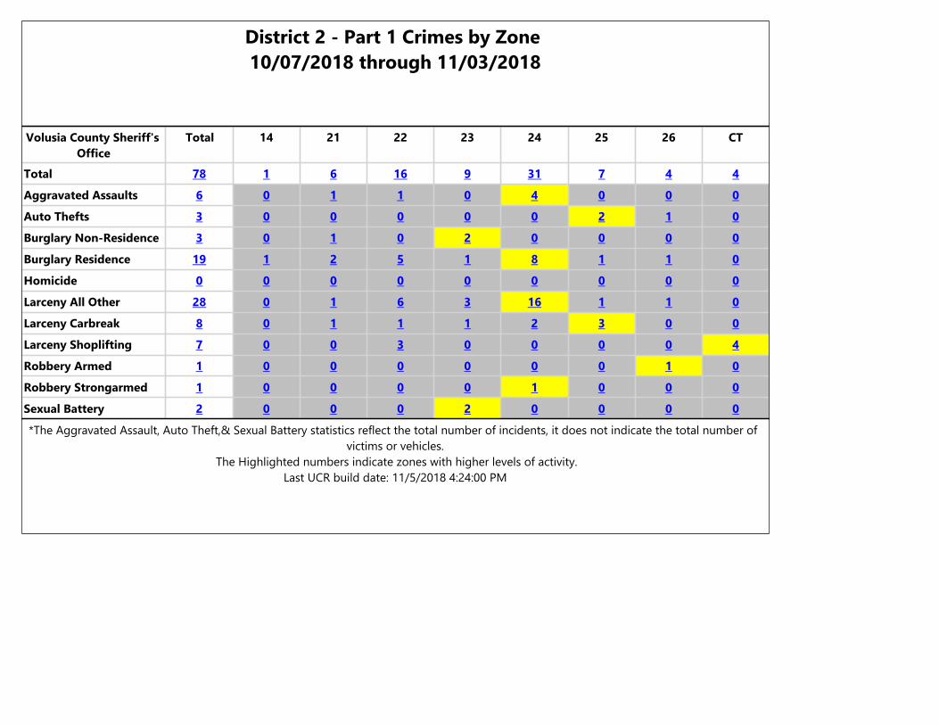
District 4 - Part 1 Crimes by Zone 10/07/2018 through 11/03/2018
Volusia County Sheriff's Office
Total 41 42 43 44 45 46 47 48 49
Total 87 11 9 7 14 5 6 9 16 10
Aggravated Assaults 13 1 1 2 0 1 0 4 2 2
Auto Thefts 4 0 0 0 1 0 0 0 1 2
Burglary Non-Residence 3 0 0 0 1 0 2 0 0 0
Burglary Residence 12 2 3 1 1 1 2 0 2 0
Homicide 0 0 0 0 0 0 0 0 0 0
Larceny All Other 19 3 3 1 3 2 0 2 1 4
Larceny Carbreak 24 0 0 1 8 1 1 3 9 1
Larceny Shoplifting 9 5 1 1 0 0 0 0 1 1
Robbery Armed 0 0 0 0 0 0 0 0 0 0
Robbery Strongarmed 1 0 1 0 0 0 0 0 0 0
Sexual Battery 2 0 0 1 0 0 1 0 0 0
*The Aggravated Assault, Auto Theft,& Sexual Battery statistics reflect the total number of incidents, it does not indicate the total number of victims or vehicles.
The Highlighted numbers indicate zones with higher levels of activity.Last UCR build date: 11/5/2018 4:24:00 PM

Period 18-11: October 07, 2018 – November 03, 2018
Captain Brian Henderson

345 8TH ST18002518910/27/2018 00:31:36
339 PARK DR18002536610/29/2018 18:38:56
2545 LPGA BLVD18002377210/10/2018 13:26:23
3562 MONUMENT DR18002357910/8/2018 12:37:36
2186 E GLORIA DR18002536710/29/2018 18:26:38
402 BRENTWOOD AV18002477510/22/2018 13:06:03
MASON AV/N NOVA RD18002523310/27/2018 21:27:22
4 OCEANS WEST BLVD18002520610/27/2018 11:10:38
1209 SUNNINGDALE LN18002540710/30/2018 10:29:56
661 SPREADING OAK AV18002350110/7/2018 23:35:13
2233 N NORMANDY BLVD18002528010/28/2018 16:32:00
1417 SUNSET BLVD18002377310/10/2018 11:57:3221
41
22
52
51
57 53
25
35
23
32
26
05
24
14
5561
4945
62474642
4854
4443
31
56
3433
Sources: Esri, HERE, Garmin, Intermap, increment P Corp., GEBCO, USGS, FAO, NPS, NRCAN,GeoBase, IGN, Kadaster NL, Ordnance Survey, Esri Japan, METI, Esri China (Hong Kong),swisstopo, © OpenStreetMap contributors, and the GIS User Community
Legend
ca Stolen Other Agency/Recoverd VCSO (12)
0 3.5 7 10.5 141.75Miles ¯
This is not a legal document.Due to address incompatabilities, some
incidents may not be represented andthe information on this map should not be
viewed as the legal representation ofproperty boundaries, roads, facilities, etc.
Agencywide Auto Recoveries 10/07/2018 thru 11/03/2018
Prepared by: VC Crime CenterCrime Intelligence AnalystVolusia County Sheriff's OfficePrinted On: 11/6/2018

41
41
46
4945
47
42
4844
43
Sources: Esri, HERE, Garmin, Intermap, increment P Corp., GEBCO, USGS, FAO, NPS, NRCAN,GeoBase, IGN, Kadaster NL, Ordnance Survey, Esri Japan, METI, Esri China (Hong Kong),swisstopo, © OpenStreetMap contributors, and the GIS User Community
District 4 Part I Arrests by Location10/07/2018 thru 11/03/2018
This is not a legal document.due to address incompatabilities, someincidents may not be represented and
the information on this map should not be viewed as the legal representation of
property boundaries, roads, facilities. etc.¯0 1 2 30.5Miles
LegendAGGRAVATED ASSAULT (10)
BURGLARY (11)
LARCENY/THEFT (4)
* Map reflects total number of Incidents andnot total number of victims
Prepared by: VC Crime CenterCrime Intelligence AnalystVolusia County Sheriff's OfficePrinted On: 11/6/2018

2008 DEARING AV1800114935/14/2018 17:34:21
2790 ELKCAM BLVD1800078444/3/2018 02:31:35
1201 HOWLAND BLVD1800088604/13/2018 22:23:15
2525 HOWLAND BLVD1800048312/27/2018 11:38:45
41
41
46
4945
47
42
4844
43
Sources: Esri, HERE, Garmin, Intermap, increment P Corp., GEBCO, USGS, FAO, NPS, NRCAN,GeoBase, IGN, Kadaster NL, Ordnance Survey, Esri Japan, METI, Esri China (Hong Kong),swisstopo, © OpenStreetMap contributors, and the GIS User Community
District 4 Homicides 2018
This is not a legal document.due to address incompatabilities, someincidents may not be represented and
the information on this map should not be viewed as the legal representation of
property boundaries, roads, facilities. etc.¯0 1 20.5Miles
LegendHomicides (4)
* Map reflects total number of Incidents andnot total number of victims
Prepared by: VC Crime CenterCrime Intelligence AnalystVolusia County Sheriff's OfficePrinted On: 11/6/2018

Period 18-11: October 07, 2018 – November 03, 2018
Captain Richard Fortin

COMPSTAT STATISTICAL CRIME COMPARISON TO PREVIOUS 28 DAY PERIODS
District 6 7/15/2018 10/7/2018 8/12/2018 10/7/2018 9/9/2018 10/7/2018 3 PeriodsVolusia County Sheriff's Office 8/11/2018 11/3/2018 9/8/2018 11/3/2018 10/6/2018 11/3/2018 Average %VCSO Offense Data Current - 3 Current (28d) % Change Current -2 Current (28d) % Change Current - 1 Current (28d) % Change Change
Homicides 0 0 0% 0 0 0% 0 0 0% 0%
Auto Thefts 3 1 -67% 3 1 -67% 3 1 -67% -67%
Total Burglaries 3 6 100% 4 6 50% 6 6 0% 50%
Residence 0 5 N/A 4 5 25% 6 5 -17% 3%
Non Residence 3 1 -67% 0 1 N/A 0 1 N/A -22%
Total Larcenies 22 19 -14% 22 19 -14% 24 19 -21% -16%
Larcenies 11 11 0% 16 11 -31% 9 11 22% -3%
Larceny Carbreak 11 6 -45% 4 6 50% 14 6 -57% -18%
Larceny Shoplifting 0 2 N/A 0 2 N/A 0 2 N/A 0%
Larceny Bicycle 0 0 0% 2 0 -100% 1 0 -100% -67%
Total Robberies 2 1 -50% 1 1 0% 0 1 N/A -17%
Armed 1 0 -100% 0 0 0% 0 0 0% -33%
Strongarmed 1 1 0% 1 1 0% 0 1 N/A 0%
Total Agg. Assaults/Bat. 4 3 -25% 5 3 -40% 9 3 -67% -44%
Agg. Assaults/Batteries 1 2 100% 4 2 -50% 6 2 -67% -6%
Agg. Domestic Assault/Batteries 3 1 -67% 1 1 0% 3 1 -67% -44%
Person Shot 1 0 -100% 0 0 0% 0 0 0% -33%
Total Sexual Bat. 5 3 -40% 2 3 50% 3 3 0% 3%
Sexual Battery 0 2 N/A 1 2 100% 2 2 0% 33%
Sexual Battery Child 5 1 -80% 1 1 0% 1 1 0% -27%
Total Part One Crimes 39 33 -15% 37 33 -11% 45 33 -27% -18%
Part One Property Crimes 28 26 -7% 29 26 -10% 33 26 -21% -13%
Part One Person Crimes 11 7 -36% 8 7 -13% 12 7 -42% -30%
Total Calls For Service 1,086 1,123 3% 1,161 1,123 -3% 1,156 1,123 -3% -1%
Firearm Offenses 2 0 -100% 4 0 -100% 6 0 -100% -100%
All Domestic Violence Cases 14 18 29% 8 18 125% 13 18 38% 64%
NOTE: This Crime data is preliminary and subject to reclassification upon further investigation. The data above reflects the total number of offenses, it does not indicate the total number of incidents. N/A = Not Applicable
Last UCR build date: 11/5/2018 4:24:00 PM

January 1, 2018 through November 3, 2018 compared to the same periods in 2016 and 2017Volusia County Sheriff's Office YTD YTD 2016-2017 YTD YTD 2017-2018 YTD YTD 2016-2018 % OF
District 6 2016 2017 % Change 2017 2018 %Change 2016 2018 %Change COUNTYWIDE
Homicides 0 1 N/A 1 0 -100% 0 0 0% 0%
Auto Thefts 25 24 -4% 24 31 29% 25 31 24% 15%
Total Burglaries 86 65 -24% 65 56 -14% 86 56 -35% 11%
Residence 59 57 -3% 57 47 -18% 59 47 -20% 11%
Non Residence 27 8 -70% 8 9 13% 27 9 -67% 12%
Total Larcenies 330 231 -30% 231 224 -3% 330 224 -32% 13%
Larcenies 171 149 -13% 149 128 -14% 171 128 -25% 15%
Larceny Carbreak 136 60 -56% 60 81 35% 136 81 -40% 17%
Larceny Shoplifting 12 10 -17% 10 6 -40% 12 6 -50% 3%
Larceny Bicycle 11 12 9% 12 9 -25% 11 9 -18% 10%
Total Robberies 9 7 -22% 7 7 0% 9 7 -22% 9%
Armed 6 2 -67% 2 4 100% 6 4 -33% 12%
Strongarmed 3 5 67% 5 3 -40% 3 3 0% 7%
Total Agg. Assaults/Bat. 35 47 34% 47 40 -15% 35 40 14% N/A
Agg. Assaults/Batteries 16 27 69% 27 23 -15% 16 23 44% 12%
Agg. Domestic Assault/Batteries 19 20 5% 20 17 -15% 19 17 -11% 14%
Person Shot 1 1 0% 1 1 0% 1 1 0% 8%
Total Sexual Bat. 15 6 -60% 6 18 200% 15 18 20% 16%
Sexual Battery 6 1 -83% 1 8 700% 6 8 33% 27%
Sexual Battery Child 9 5 -44% 5 10 100% 9 10 11% 12%
Total Part One Crimes 500 381 -24% 381 376 -1% 500 376 -25% 13%
Part One Property Crimes 441 320 -27% 320 311 -3% 441 311 -29% 13%
Part One Person Crimes 59 61 3% 61 65 7% 59 65 10% 13%
Total Calls For Service 14,767 15,669 6% 15,669 13,454 -14% 14,767 13,454 -9% 13%
Firearm Offenses 14 20 43% 20 15 -25% 14 15 7% 11%
All Domestic Violence Cases 152 160 5% 160 142 -11% 152 142 -7% 10%
NOTE: This Crime data is preliminary and subject to reclassification upon further investigation. The data above reflects the total number of offenses, it does not indicate the total number of incidents. There were incidents that did not code into either district. These are included in the Countywide Total. N/A = Not Applicable
Last UCR build date: 11/5/2018 4:24:00 PM

January 1, 2018 through November 3, 2018 compared to the same periods in 2016 and 2017Volusia County Sheriff's Office YTD 2016 YTD 2017 YTD 2018
District 6 Clearances Offense Clrs % Clr Adult Juv Offense Clrs % Clr Adult Juv Offense Clrs % Clr Adult Juv
Homicides 0 0 0% 0 0 1 1 100% 1 0 0 0 0% 0 0
Auto Thefts 25 7 28% 7 0 24 11 46% 11 0 31 13 42% 12 1
Total Burglaries 86 20 23% 11 9 65 24 37% 23 1 56 21 38% 19 2
Residence 59 18 31% 10 8 57 17 30% 17 0 47 19 40% 17 2
Non Residence 27 2 7% 1 1 8 7 88% 6 1 9 2 22% 2 0
Total Larcenies 330 69 21% 60 9 231 49 21% 44 5 224 55 25% 48 7
Larcenies 171 36 21% 31 5 149 32 21% 29 3 128 39 30% 35 4
Larceny Carbreak 136 29 21% 25 4 60 10 17% 10 0 81 14 17% 11 3
Larceny Shoplifting 12 2 17% 2 0 10 4 40% 4 0 6 2 33% 2 0
Larceny Bicycle 11 2 18% 2 0 12 3 25% 1 2 9 0 0% 0 0
Total Robberies 9 4 44% 4 0 7 6 86% 6 0 7 6 86% 6 0
Armed 6 3 50% 3 0 2 2 100% 2 0 4 3 75% 3 0
Strongarmed 3 1 33% 1 0 5 4 80% 4 0 3 3 100% 3 0
Total Agg. Assaults/Bat. 35 26 74% 21 5 47 34 72% 30 4 40 25 63% 21 4
Agg. Assaults/Batteries 16 11 69% 8 3 27 18 67% 16 2 23 9 39% 8 1
Agg. Domestic Assault/Batteries 19 15 79% 13 2 20 16 80% 14 2 17 16 94% 13 3
Person Shot 1 1 100% 0 1 1 1 100% 1 0 1 1 100% 1 0
Total Sexual Bat. 15 10 67% 9 1 6 1 17% 1 0 18 9 50% 8 1
Sexual Battery 6 6 100% 6 0 1 0 0% 0 0 8 3 38% 3 0
Sexual Battery Child 9 4 44% 3 1 5 1 20% 1 0 10 6 60% 5 1
Total Part One Crimes 500 136 27% 100 24 381 126 33% 116 10 376 129 34% 114 15
Part One Property Crimes 441 96 22% 78 18 320 84 26% 78 6 311 89 29% 79 10
Part One Person Crimes 59 40 68% 22 6 61 42 69% 38 4 65 40 62% 35 5
NOTE: This Crime data is preliminary and subject to reclassification upon further investigation. The data above reflects the total number of offenses, it does not indicate the total number of incidents.
Last UCR build date: 11/5/2018 4:24:00 PM

8 VALENCIA RD18002453810/19/2018 10:09:39
6261
63
Sources: Esri, HERE, Garmin, Intermap, increment P Corp., GEBCO, USGS, FAO, NPS, NRCAN,GeoBase, IGN, Kadaster NL, Ordnance Survey, Esri Japan, METI, Esri China (Hong Kong),swisstopo, © OpenStreetMap contributors, and the GIS User Community
District 6 Auto Thefts10/07/2018 thru 11/03/2018
This is not a legal document.due to address incompatabilities, someincidents may not be represented and
the information on this map should not be viewed as the legal representation of
property boundaries, roads, facilities. etc.¯0 0.70.35Miles
LegendAuto Theft (1)
* Map reflects total number of Incidents andnot total number of victims
Prepared by: VC Crime CenterCrime Intelligence AnalystVolusia County Sheriff's OfficePrinted On: 11/6/2018

6 SANFORD AV18002524310/27/2018 23:16:05
82 DIRKSEN DR18002446110/18/2018 15:15:15
130 DIRKSEN DR18002446910/18/2018 16:24:14
517 N PINE MEADOW DR18002408910/14/2018 11:40:18
104 DIRKSEN DR18002416010/15/2018 11:42:46
1 W HIGHBANKS RD18002561211/1/2018 16:17:57
61
63
62
64
Sources: Esri, HERE, Garmin, Intermap, increment P Corp., GEBCO, USGS, FAO, NPS, NRCAN,GeoBase, IGN, Kadaster NL, Ordnance Survey, Esri Japan, METI, Esri China (Hong Kong),swisstopo, © OpenStreetMap contributors, and the GIS User Community
District 6 Burglaries10/07/2018 thru 11/03/2018
This is not a legal document.due to address incompatabilities, someincidents may not be represented and
the information on this map should not be viewed as the legal representation of
property boundaries, roads, facilities. etc.¯0 10.5Miles
LegendBurglary Residence (5)
Burglary Non-Residence (1)
* Map reflects total number of Incidents andnot total number of victims
Prepared by: VC Crime CenterCrime Intelligence AnalystVolusia County Sheriff's OfficePrinted On: 11/6/2018

21 DIRKSEN DR18002499310/24/2018 18:21:26
314 DEBARY DR18002452110/19/2018 05:02:57
1254 CENTRAL AV18002414510/15/2018 08:21:33
20 CUNNINGHAM RD18002469910/21/2018 11:30:25
630 S CHARLES R BEALL BLVD18002544610/30/2018 17:57:45
168 DEBARY DR18002406910/13/2018 22:19:03
61
63
64
65
62
Sources: Esri, HERE, Garmin, Intermap, increment P Corp., GEBCO, USGS, FAO, NPS, NRCAN,GeoBase, IGN, Kadaster NL, Ordnance Survey, Esri Japan, METI, Esri China (Hong Kong),swisstopo, © OpenStreetMap contributors, and the GIS User Community
District 6 Larceny Carbreaks10/07/2018 thru 11/03/2018
This is not a legal document.due to address incompatabilities, someincidents may not be represented and
the information on this map should not be viewed as the legal representation of
property boundaries, roads, facilities. etc.¯0 1 2 30.5Miles
LegendLarceny Carbreak (6)
* Map reflects total number of Incidents andnot total number of victims
Prepared by: VC Crime CenterCrime Intelligence AnalystVolusia County Sheriff's OfficePrinted On: 11/6/2018

1120 17TH ST18002551510/31/2018 15:20:59
65
64Sources: Esri, HERE, Garmin, Intermap, increment P Corp., GEBCO, USGS, FAO, NPS, NRCAN,GeoBase, IGN, Kadaster NL, Ordnance Survey, Esri Japan, METI, Esri China (Hong Kong),swisstopo, © OpenStreetMap contributors, and the GIS User Community
District 6 Robberies10/07/2018 thru 11/03/2018
This is not a legal document.due to address incompatabilities, someincidents may not be represented and
the information on this map should not be viewed as the legal representation of
property boundaries, roads, facilities. etc.¯0 10.5Miles
LegendRobberies (1)
* Map reflects total number of Incidents andnot total number of victims
Prepared by: VC Crime CenterCrime Intelligence AnalystVolusia County Sheriff's OfficePrinted On: 11/6/2018
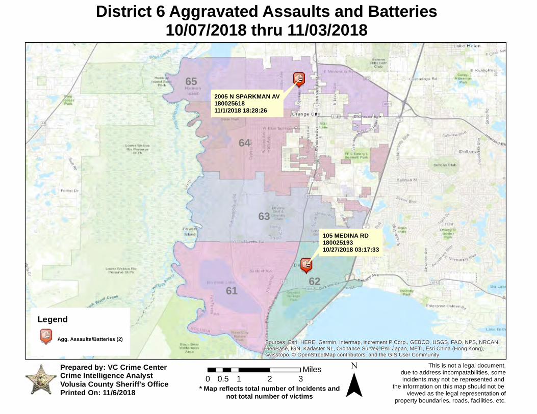
105 MEDINA RD18002519310/27/2018 03:17:33
2005 N SPARKMAN AV18002561811/1/2018 18:28:26
61
63
64
65
62
Sources: Esri, HERE, Garmin, Intermap, increment P Corp., GEBCO, USGS, FAO, NPS, NRCAN,GeoBase, IGN, Kadaster NL, Ordnance Survey, Esri Japan, METI, Esri China (Hong Kong),swisstopo, © OpenStreetMap contributors, and the GIS User Community
District 6 Aggravated Assaults and Batteries10/07/2018 thru 11/03/2018
This is not a legal document.due to address incompatabilities, someincidents may not be represented and
the information on this map should not be viewed as the legal representation of
property boundaries, roads, facilities. etc.¯0 1 2 30.5Miles
LegendAgg. Assaults/Batteries (2)
* Map reflects total number of Incidents andnot total number of victims
Prepared by: VC Crime CenterCrime Intelligence AnalystVolusia County Sheriff's OfficePrinted On: 11/6/2018

61
63
64
62
65
Sources: Esri, HERE, Garmin, Intermap, increment P Corp., GEBCO, USGS, FAO, NPS, NRCAN,GeoBase, IGN, Kadaster NL, Ordnance Survey, Esri Japan, METI, Esri China (Hong Kong),swisstopo, © OpenStreetMap contributors, and the GIS User Community
District 6 Domestic Assaults and Batteries10/07/2018 thru 11/03/2018
This is not a legal document.due to address incompatabilities, someincidents may not be represented and
the information on this map should not be viewed as the legal representation of
property boundaries, roads, facilities. etc.¯0 1 20.5Miles
LegendAgg. Domestic Assault (1)
Simple Domestic Assault (11)
* Map reflects total number of Incidents andnot total number of victims
Prepared by: VC Crime CenterCrime Intelligence AnalystVolusia County Sheriff's OfficePrinted On: 11/6/2018

63
64
61
65
62Sources: Esri, HERE, Garmin, Intermap, increment P Corp., GEBCO, USGS, FAO, NPS, NRCAN,GeoBase, IGN, Kadaster NL, Ordnance Survey, Esri Japan, METI, Esri China (Hong Kong),swisstopo, © OpenStreetMap contributors, and the GIS User Community
District 6 Sexual Batteries10/07/2018 thru 11/03/2018
This is not a legal document.due to address incompatabilities, someincidents may not be represented and
the information on this map should not be viewed as the legal representation of
property boundaries, roads, facilities. etc.¯0 1 20.5Miles
LegendSexual Battery (3)
* Map reflects total number of Incidents andnot total number of victims
Prepared by: VC Crime CenterCrime Intelligence AnalystVolusia County Sheriff's OfficePrinted On: 11/6/2018

105 MEDINA RD18002519310/27/2018 03:17:33
21 DIRKSEN DR18002499310/24/2018 18:21:26
8 VALENCIA RD18002453810/19/2018 10:09:39
314 DEBARY DR18002452110/19/2018 05:02:57
82 DIRKSEN DR18002446110/18/2018 15:15:15
168 DEBARY DR18002406910/13/2018 22:19:03
312 DIRKSEN DR18002551010/31/2018 15:02:01
130 DIRKSEN DR18002446910/18/2018 16:24:14
20 CUNNINGHAM RD18002469910/21/2018 11:30:25
105 PLANTATION RD18002534210/29/2018 13:48:22
239 LAGO VISTA ST18002427610/16/2018 00:00:00
104 DIRKSEN DR18002416010/15/2018 11:42:46
6261
63
Sources: Esri, HERE, Garmin, Intermap, increment P Corp., GEBCO, USGS, FAO, NPS, NRCAN,GeoBase, IGN, Kadaster NL, Ordnance Survey, Esri Japan, METI, Esri China (Hong Kong),swisstopo, © OpenStreetMap contributors, and the GIS User Community
District 6 Hot Zone 6210/07/2018 thru 11/03/2018
This is not a legal document.due to address incompatabilities, someincidents may not be represented and
the information on this map should not be viewed as the legal representation of
property boundaries, roads, facilities. etc.¯0 0.850.425Miles
LegendLarceny Carbreak (4)
Larcenies (3)
Auto Theft (1)
Agg. Assaults/Batteries (1)
Burglary Residence (3)
* Map reflects total number of Incidents andnot total number of victims
Prepared by: VC Crime CenterCrime Intelligence AnalystVolusia County Sheriff's OfficePrinted On: 11/6/2018

District 6 - Part 1 Crimes by Zone 10/07/2018 through 11/03/2018
Volusia County Sheriff's Office
Total 61 62 63 64 65 CT
Total 33 7 12 3 5 5 1
Aggravated Assaults 3 1 1 0 1 0 0
Auto Thefts 1 0 1 0 0 0 0
Burglary Non-Residence 1 1 0 0 0 0 0
Burglary Residence 5 1 3 1 0 0 0
Homicide 0 0 0 0 0 0 0
Larceny All Other 11 2 3 0 4 2 0
Larceny Carbreak 6 1 4 0 0 1 0
Larceny Shoplifting 2 0 0 2 0 0 0
Robbery Armed 0 0 0 0 0 0 0
Robbery Strongarmed 1 0 0 0 0 1 0
Sexual Battery 3 1 0 0 0 1 1
*The Aggravated Assault, Auto Theft,& Sexual Battery statistics reflect the total number of incidents, it does not indicate the total number of victims or vehicles.
The Highlighted numbers indicate zones with higher levels of activity.Last UCR build date: 11/5/2018 4:24:00 PM

Period 18-11: October 07, 2018 – November 03, 2018
Captain Brian Henderson

345 8TH ST18002518910/27/2018 00:31:36
339 PARK DR18002536610/29/2018 18:38:56
2545 LPGA BLVD18002377210/10/2018 13:26:23
3562 MONUMENT DR18002357910/8/2018 12:37:36
2186 E GLORIA DR18002536710/29/2018 18:26:38
402 BRENTWOOD AV18002477510/22/2018 13:06:03
MASON AV/N NOVA RD18002523310/27/2018 21:27:22
4 OCEANS WEST BLVD18002520610/27/2018 11:10:38
1209 SUNNINGDALE LN18002540710/30/2018 10:29:56
661 SPREADING OAK AV18002350110/7/2018 23:35:13
2233 N NORMANDY BLVD18002528010/28/2018 16:32:00
1417 SUNSET BLVD18002377310/10/2018 11:57:3221
41
22
52
51
57 53
25
35
23
32
26
05
24
14
5561
4945
62474642
4854
4443
31
56
3433
Sources: Esri, HERE, Garmin, Intermap, increment P Corp., GEBCO, USGS, FAO, NPS, NRCAN,GeoBase, IGN, Kadaster NL, Ordnance Survey, Esri Japan, METI, Esri China (Hong Kong),swisstopo, © OpenStreetMap contributors, and the GIS User Community
Legend
ca Stolen Other Agency/Recoverd VCSO (12)
0 3.5 7 10.5 141.75Miles ¯
This is not a legal document.Due to address incompatabilities, some
incidents may not be represented andthe information on this map should not be
viewed as the legal representation ofproperty boundaries, roads, facilities, etc.
Agencywide Auto Recoveries 10/07/2018 thru 11/03/2018
Prepared by: VC Crime CenterCrime Intelligence AnalystVolusia County Sheriff's OfficePrinted On: 11/6/2018

63
64
65
61Sources: Esri, HERE, Garmin, Intermap, increment P Corp., GEBCO, USGS, FAO, NPS, NRCAN,GeoBase, IGN, Kadaster NL, Ordnance Survey, Esri Japan, METI, Esri China (Hong Kong),swisstopo, © OpenStreetMap contributors, and the GIS User Community
District 6 Part I Arrests by Location10/07/2018 thru 11/03/2018
This is not a legal document.due to address incompatabilities, someincidents may not be represented and
the information on this map should not be viewed as the legal representation of
property boundaries, roads, facilities. etc.¯0 1 20.5Miles
LegendAGGRAVATED ASSAULT (5)
BURGLARY (2)
* Map reflects total number of Incidents andnot total number of victims
Prepared by: VC Crime CenterCrime Intelligence AnalystVolusia County Sheriff's OfficePrinted On: 11/6/2018

Period 18-11: October 07, 2018 – November 03, 2018
Captain Paul A. Adkins

COMPSTAT STATISTICAL CRIME COMPARISON TO PREVIOUS 28 DAY PERIODS
District 2 7/15/2018 10/7/2018 8/12/2018 10/7/2018 9/9/2018 10/7/2018 3 PeriodsVolusia County Sheriff's Office 8/11/2018 11/3/2018 9/8/2018 11/3/2018 10/6/2018 11/3/2018 Average %VCSO Offense Data Current - 3 Current (28d) % Change Current -2 Current (28d) % Change Current - 1 Current (28d) % Change Change
Homicides 0 0 0% 0 0 0% 0 0 0% 0%
Auto Thefts 7 3 -57% 3 3 0% 4 3 -25% -27%
Total Burglaries 18 22 22% 20 22 10% 18 22 22% 18%
Residence 17 19 12% 16 19 19% 16 19 19% 16%
Non Residence 1 3 200% 4 3 -25% 2 3 50% 75%
Total Larcenies 47 45 -4% 28 45 61% 46 45 -2% 18%
Larcenies 22 28 27% 18 28 56% 26 28 8% 30%
Larceny Carbreak 17 8 -53% 5 8 60% 13 8 -38% -10%
Larceny Shoplifting 6 7 17% 5 7 40% 5 7 40% 32%
Larceny Bicycle 2 2 0% 0 2 N/A 2 2 0% 0%
Total Robberies 1 2 100% 4 2 -50% 1 2 100% 50%
Armed 0 1 N/A 2 1 -50% 1 1 0% -17%
Strongarmed 1 1 0% 2 1 -50% 0 1 N/A -17%
Total Agg. Assaults/Bat. 10 10 0% 10 10 0% 13 10 -23% -8%
Agg. Assaults/Batteries 8 6 -25% 5 6 20% 7 6 -14% -6%
Agg. Domestic Assault/Batteries 2 4 100% 5 4 -20% 6 4 -33% 16%
Person Shot 1 0 -100% 1 0 -100% 0 0 0% -67%
Total Sexual Bat. 2 2 0% 7 2 -71% 2 2 0% -24%
Sexual Battery 1 1 0% 2 1 -50% 0 1 N/A -17%
Sexual Battery Child 1 1 0% 5 1 -80% 2 1 -50% -43%
Total Part One Crimes 85 84 -1% 72 84 17% 84 84 0% 5%
Part One Property Crimes 72 70 -3% 51 70 37% 68 70 3% 12%
Part One Person Crimes 13 14 8% 21 14 -33% 16 14 -13% -13%
Total Calls For Service 1,651 1,556 -6% 1,526 1,556 2% 1,850 1,556 -16% -7%
Firearm Offenses 4 9 125% 2 9 350% 6 9 50% 175%
All Domestic Violence Cases 21 34 62% 22 34 55% 37 34 -8% 36%
NOTE: This Crime data is preliminary and subject to reclassification upon further investigation. The data above reflects the total number of offenses, it does not indicate the total number of incidents. N/A = Not Applicable
Last UCR build date: 11/5/2018 4:24:00 PM

January 1, 2018 through November 3, 2018 compared to the same periods in 2016 and 2017Volusia County Sheriff's Office YTD YTD 2016-2017 YTD YTD 2017-2018 YTD YTD 2016-2018 % OF
District 2 2016 2017 % Change 2017 2018 %Change 2016 2018 %Change COUNTYWIDE
Homicides 1 1 0% 1 0 -100% 1 0 -100% 0%
Auto Thefts 75 66 -12% 66 46 -30% 75 46 -39% 22%
Total Burglaries 213 163 -23% 163 161 -1% 213 161 -24% 31%
Residence 155 129 -17% 129 137 6% 155 137 -12% 31%
Non Residence 58 34 -41% 34 24 -29% 58 24 -59% 32%
Total Larcenies 556 417 -25% 417 415 0% 556 415 -25% 25%
Larcenies 296 289 -2% 289 236 -18% 296 236 -20% 27%
Larceny Carbreak 216 85 -61% 85 107 26% 216 107 -50% 22%
Larceny Shoplifting 28 24 -14% 24 58 142% 28 58 107% 26%
Larceny Bicycle 16 19 19% 19 14 -26% 16 14 -13% 15%
Total Robberies 29 26 -10% 26 17 -35% 29 17 -41% 22%
Armed 13 9 -31% 9 5 -44% 13 5 -62% 15%
Strongarmed 16 17 6% 17 12 -29% 16 12 -25% 26%
Total Agg. Assaults/Bat. 83 60 -28% 60 87 45% 83 87 5% N/A
Agg. Assaults/Batteries 55 29 -47% 29 55 90% 55 55 0% 28%
Agg. Domestic Assault/Batteries 28 31 11% 31 32 3% 28 32 14% 26%
Person Shot 1 1 0% 1 3 200% 1 3 200% 25%
Total Sexual Bat. 24 26 8% 26 31 19% 24 31 29% 27%
Sexual Battery 11 4 -64% 4 9 125% 11 9 -18% 30%
Sexual Battery Child 13 22 69% 22 22 0% 13 22 69% 26%
Total Part One Crimes 981 759 -23% 759 757 0% 981 757 -23% 27%
Part One Property Crimes 844 646 -23% 646 622 -4% 844 622 -26% 26%
Part One Person Crimes 137 113 -18% 113 135 19% 137 135 -1% 26%
Total Calls For Service 19,548 23,552 20% 23,552 19,460 -17% 19,548 19,460 0% 19%
Firearm Offenses 34 22 -35% 22 37 68% 34 37 9% 27%
All Domestic Violence Cases 279 267 -4% 267 303 13% 279 303 9% 22%
NOTE: This Crime data is preliminary and subject to reclassification upon further investigation. The data above reflects the total number of offenses, it does not indicate the total number of incidents. There were incidents that did not code into either district. These are included in the Countywide Total. N/A = Not Applicable
Last UCR build date: 11/5/2018 4:24:00 PM

January 1, 2018 through November 3, 2018 compared to the same periods in 2016 and 2017Volusia County Sheriff's Office YTD 2016 YTD 2017 YTD 2018
District 2 Clearances Offense Clrs % Clr Adult Juv Offense Clrs % Clr Adult Juv Offense Clrs % Clr Adult Juv
Homicides 1 0 0% 0 0 1 1 100% 1 0 0 0 0% 0 0
Auto Thefts 75 16 21% 12 4 66 22 33% 14 8 46 26 57% 19 7
Total Burglaries 213 52 24% 46 6 163 35 21% 29 6 161 49 30% 44 5
Residence 155 40 26% 34 6 129 27 21% 22 5 137 42 31% 37 5
Non Residence 58 12 21% 12 0 34 8 24% 7 1 24 7 29% 7 0
Total Larcenies 556 114 21% 100 14 417 90 22% 81 9 415 121 29% 117 4
Larcenies 296 77 26% 68 9 289 64 22% 57 7 236 56 24% 56 0
Larceny Carbreak 216 25 12% 21 4 85 14 16% 12 2 107 23 21% 20 3
Larceny Shoplifting 28 10 36% 9 1 24 9 38% 9 0 58 42 72% 41 1
Larceny Bicycle 16 2 13% 2 0 19 3 16% 3 0 14 0 0% 0 0
Total Robberies 29 21 72% 20 1 26 20 77% 16 4 17 12 71% 10 2
Armed 13 8 62% 8 0 9 6 67% 5 1 5 3 60% 3 0
Strongarmed 16 13 81% 12 1 17 14 82% 11 3 12 9 75% 7 2
Total Agg. Assaults/Bat. 83 53 64% 49 4 60 47 78% 42 5 87 51 59% 50 1
Agg. Assaults/Batteries 55 28 51% 25 3 29 18 62% 15 3 55 26 47% 25 1
Agg. Domestic Assault/Batteries 28 25 89% 24 1 31 29 94% 27 2 32 25 78% 25 0
Person Shot 1 1 100% 1 0 1 1 100% 0 1 3 1 33% 1 0
Total Sexual Bat. 24 17 71% 15 2 26 21 81% 16 5 31 17 55% 12 5
Sexual Battery 11 8 73% 8 0 4 4 100% 4 0 9 4 44% 4 0
Sexual Battery Child 13 9 69% 7 2 22 17 77% 12 5 22 13 59% 8 5
Total Part One Crimes 981 273 28% 225 31 759 236 31% 199 37 757 276 36% 252 24
Part One Property Crimes 844 182 22% 158 24 646 147 23% 124 23 622 196 32% 180 16
Part One Person Crimes 137 91 66% 67 7 113 89 79% 75 14 135 80 59% 72 8
NOTE: This Crime data is preliminary and subject to reclassification upon further investigation. The data above reflects the total number of offenses, it does not indicate the total number of incidents.
Last UCR build date: 11/5/2018 4:24:00 PM

119 W I-418002405310/13/2018 17:46:02407 ALBANY AV
18002479610/22/2018 16:32:22
339 CUMBERLAND RD18002538810/30/2018 07:27:39
25
2624
23
22
26
26
26
26
22
Sources: Esri, HERE, Garmin, Intermap, increment P Corp., GEBCO, USGS, FAO, NPS, NRCAN,GeoBase, IGN, Kadaster NL, Ordnance Survey, Esri Japan, METI, Esri China (Hong Kong),swisstopo, © OpenStreetMap contributors, and the GIS User Community
District 2 Auto Thefts10/07/2018 thru 11/03/2018
This is not a legal document.due to address incompatabilities, someincidents may not be represented and
the information on this map should not be viewed as the legal representation of
property boundaries, roads, facilities. etc.¯0 1 20.5Miles
LegendAuto Thefts (3)
* Map reflects total number of Incidents andnot total number of victims
Prepared by: VC Crime CenterCrime Intelligence AnalystVolusia County Sheriff's OfficePrinted On: 11/6/2018

120 LEE ST18002444410/18/2018 11:11:16
1750 2ND AV18002449410/18/2018 20:56:03
13 REYES RD18002429010/16/2018 16:49:11
711 HELEN AV18002484310/23/2018 08:49:51
405 ALBANY AV18002361910/8/2018 19:42:20
1125 ROANOKE AV18002463910/20/2018 13:42:39
109 NEW HOPE AV18002401510/13/2018 05:10:54
2450 WILMHURST RD18002562011/1/2018 19:24:42
1535 ELSASSER ST18002391710/11/2018 21:06:29
4490 CAVE LAKE RD18002463210/20/2018 12:34:29
1820 ORMANDS JUNGLE DEN RD #8518002350910/7/2018 07:42:27
121 DOVER LN18002433310/17/2018 09:42:03
51 VIRGINIA AV18002362510/8/2018 21:48:15
1010 LOUISE LN18002465610/20/2018 19:21:08
830 LANCASTER RD18002488310/23/2018 13:24:00
350 W LISBON PKWY18002511810/26/2018 09:16:33
721 W BERESFORD RD18002535410/29/2018 16:07:50
1020 SADDLE HILL RD18002476510/22/2018 11:16:02
2174 S SPRING GARDEN AV18002535010/29/2018 15:31:30
300 PADRICK AV18002482710/22/2018 23:15:02
1820 ORMANDS JUNGLE DEN RD18002417510/15/2018 14:56:08
300 PADRICK AV18002444310/18/2018 11:22:03
21
22
26
25
14
26Sources: Esri, HERE, Garmin, Intermap, increment P Corp., GEBCO, USGS, FAO, NPS, NRCAN,GeoBase, IGN, Kadaster NL, Ordnance Survey, Esri Japan, METI, Esri China (Hong Kong),swisstopo, © OpenStreetMap contributors, and the GIS User Community
District 2 Burglaries10/07/2018 thru 11/03/2018
This is not a legal document.due to address incompatabilities, someincidents may not be represented and
the information on this map should not be viewed as the legal representation of
property boundaries, roads, facilities. etc.¯0 2 4 6 8 101Miles
LegendBurglary Residence (19)
Burglary Non-Residence (3)
* Map reflects total number of Incidents andnot total number of victims
Prepared by: VC Crime CenterCrime Intelligence AnalystVolusia County Sheriff's OfficePrinted On: 11/6/2018

307 CHIPOLA AV18002562611/1/2018 21:29:38
10 DOMINGO RD18002405410/13/2018 20:02:33
300 PADRICK AV18002471510/21/2018 16:16:29
930 N AMELIA AV18002355710/8/2018 08:55:10
344 NAPOLEON DR18002414210/15/2018 08:17:28
689 CUMBERLAND RD18002565111/2/2018 08:50:05
1660 S US HWY 1718002515510/26/2018 16:32:59
2801 E NEW YORK AV18002485510/23/2018 10:16:28
22
21
2523
2624
26
26 26
14 14
Sources: Esri, HERE, Garmin, Intermap, increment P Corp., GEBCO, USGS, FAO, NPS, NRCAN,GeoBase, IGN, Kadaster NL, Ordnance Survey, Esri Japan, METI, Esri China (Hong Kong),swisstopo, © OpenStreetMap contributors, and the GIS User Community
District 2 Larceny Carbreaks10/07/2018 thru 11/03/2018
This is not a legal document.due to address incompatabilities, someincidents may not be represented and
the information on this map should not be viewed as the legal representation of
property boundaries, roads, facilities. etc.¯0 1 2 3 4 50.5Miles
LegendLarceny Carbreaks (8)
* Map reflects total number of Incidents andnot total number of victims
Prepared by: VC Crime CenterCrime Intelligence AnalystVolusia County Sheriff's OfficePrinted On: 11/6/2018

509 MATHIS AV18002456610/19/2018 16:45:09
2408 OAK PARK DR18002474010/22/2018 07:03:59
2523
24 26
26
26
26
26
Sources: Esri, HERE, Garmin, Intermap, increment P Corp., GEBCO, USGS, FAO, NPS, NRCAN,GeoBase, IGN, Kadaster NL, Ordnance Survey, Esri Japan, METI, Esri China (Hong Kong),swisstopo, © OpenStreetMap contributors, and the GIS User Community
District 2 Robberies10/07/2018 thru 11/03/2018
This is not a legal document.due to address incompatabilities, someincidents may not be represented and
the information on this map should not be viewed as the legal representation of
property boundaries, roads, facilities. etc.¯0 1 2 30.5Miles
LegendRobberies (2)
* Map reflects total number of Incidents andnot total number of victims
Prepared by: VC Crime CenterCrime Intelligence AnalystVolusia County Sheriff's OfficePrinted On: 11/6/2018

246 QUEBEC AV18002452210/19/2018 06:22:02
432 NAPOLEON DR18002493310/24/2018 05:50:09
1200 W BERESFORD AV18002512810/26/2018 10:56:241250 LAKEVIEW DR #47
18002401610/13/2018 07:51:12
22
25
23
24 26
21
26
26 2626
Sources: Esri, HERE, Garmin, Intermap, increment P Corp., GEBCO, USGS, FAO, NPS, NRCAN,GeoBase, IGN, Kadaster NL, Ordnance Survey, Esri Japan, METI, Esri China (Hong Kong),swisstopo, © OpenStreetMap contributors, and the GIS User Community
District 2 Aggravated Assaults and Batteries10/07/2018 thru 11/03/2018
This is not a legal document.due to address incompatabilities, someincidents may not be represented and
the information on this map should not be viewed as the legal representation of
property boundaries, roads, facilities. etc.¯0 1 2 3 4 50.5Miles
LegendAgg. Assaults/Batteries (4)
* Map reflects total number of Incidents andnot total number of victims
Prepared by: VC Crime CenterCrime Intelligence AnalystVolusia County Sheriff's OfficePrinted On: 11/6/2018

21
2225
23
2624
14
2626
2626
Sources: Esri, HERE, Garmin, Intermap, increment P Corp., GEBCO, USGS, FAO, NPS, NRCAN,GeoBase, IGN, Kadaster NL, Ordnance Survey, Esri Japan, METI, Esri China (Hong Kong),swisstopo, © OpenStreetMap contributors, and the GIS User Community
District 2 Domestic Assaults and Batteries10/07/2018 thru 11/03/2018
This is not a legal document.due to address incompatabilities, someincidents may not be represented and
the information on this map should not be viewed as the legal representation of
property boundaries, roads, facilities. etc.¯0 2 4 6 8 101Miles
LegendAgg. Domestic Assault (2)
Simple Domestic Assault (24)
* Map reflects total number of Incidents andnot total number of victims
Prepared by: VC Crime CenterCrime Intelligence AnalystVolusia County Sheriff's OfficePrinted On: 11/6/2018

23
24
25
22
26
26
26
26
25
26
26
26
26Sources: Esri, HERE, Garmin, Intermap, increment P Corp., GEBCO, USGS, FAO, NPS, NRCAN,GeoBase, IGN, Kadaster NL, Ordnance Survey, Esri Japan, METI, Esri China (Hong Kong),swisstopo, © OpenStreetMap contributors, and the GIS User Community
District 2 Sexual Batteries10/07/2018 thru 11/03/2018
This is not a legal document.due to address incompatabilities, someincidents may not be represented and
the information on this map should not be viewed as the legal representation of
property boundaries, roads, facilities. etc.¯0 1 20.5Miles
LegendSexual Battery (2)
* Map reflects total number of Incidents andnot total number of victims
Prepared by: VC Crime CenterCrime Intelligence AnalystVolusia County Sheriff's OfficePrinted On: 11/6/2018

307 CHIPOLA AV18002562611/1/2018 21:29:38
509 MATHIS AV18002456610/19/2018 16:45:09
1010 LOUISE LN18002465610/20/2018 19:21:08
1516 BOUNDARY ST18002566911/2/2018 10:35:44
2255 W DALE CIR18002512610/26/2018 10:55:10
2260 E DALE CIR18002490010/24/2018 15:48:45
2235 E DALE CIR18002496610/24/2018 13:18:36
1125 ROANOKE AV18002463910/20/2018 13:42:39
344 NAPOLEON DR18002414210/15/2018 08:17:28
1629 LADY FERN TR18002566111/2/2018 09:51:14
1288 MCGREGOR RD18002489310/24/2018 15:04:19
1535 ELSASSER ST18002391710/11/2018 21:06:29
210 W BERESFORD AV18002486410/23/2018 11:39:13
1020 SADDLE HILL RD18002476510/22/2018 11:16:02
1250 LAKEVIEW DR #4718002401610/13/2018 07:51:12
604 S SPRING GARDEN AV18002425610/16/2018 11:00:34
2174 S SPRING GARDEN AV18002535010/29/2018 15:31:30
711 HELEN AV18002484310/23/2018 08:49:51
432 NAPOLEON DR18002493310/24/2018 05:50:09
2145 W DALE CIR18002475510/22/2018 10:17:04
2200 E DALE CIR18002464410/20/2018 16:14:17
950 S PARSONS AV18002476710/22/2018 11:53:04
350 W LISBON PKWY18002511810/26/2018 09:16:33955 S WOODWARD AV
18002379410/10/2018 15:41:11
721 W BERESFORD RD18002535410/29/2018 16:07:50
1200 W BERESFORD AV18002512810/26/2018 10:56:24
605 W NEW HAMPSHIRE AV18002495510/24/2018 11:57:18
638 S SPRING GARDEN AV18002410410/14/2018 18:22:13
605 W NEW HAMPSHIRE AV18002387210/11/2018 11:53:54
2058 S SPRING GARDEN AV18002455410/19/2018 14:36:34
24
26
23
26
26
25
Sources: Esri, HERE, Garmin, Intermap, increment P Corp., GEBCO, USGS, FAO, NPS, NRCAN,GeoBase, IGN, Kadaster NL, Ordnance Survey, Esri Japan, METI, Esri China (Hong Kong),swisstopo, © OpenStreetMap contributors, and the GIS User Community
District 2 Hot Zone 2410/07/2018 thru 11/03/2018
This is not a legal document.due to address incompatabilities, someincidents may not be represented and
the information on this map should not be viewed as the legal representation of
property boundaries, roads, facilities. etc.¯0 10.5Miles
LegendStrongarmed Robbery (1)
Larceny Carbreak (2)
Agg. Assaults/Batteries (3)
Agg. Domestic Assault (1)
Burglary Residence (8)
Larcenies (16)
* Map reflects total number of Incidents andnot total number of victims
Prepared by: VC Crime CenterCrime Intelligence AnalystVolusia County Sheriff's OfficePrinted On: 11/6/2018
District 2 - Part 1 Crimes by Zone 10/07/2018 through 11/03/2018
Volusia County Sheriff's Office
Total 14 21 22 23 24 25 26 CT
Total 78 1 6 16 9 31 7 4 4
Aggravated Assaults 6 0 1 1 0 4 0 0 0
Auto Thefts 3 0 0 0 0 0 2 1 0
Burglary Non-Residence 3 0 1 0 2 0 0 0 0
Burglary Residence 19 1 2 5 1 8 1 1 0
Homicide 0 0 0 0 0 0 0 0 0
Larceny All Other 28 0 1 6 3 16 1 1 0
Larceny Carbreak 8 0 1 1 1 2 3 0 0
Larceny Shoplifting 7 0 0 3 0 0 0 0 4
Robbery Armed 1 0 0 0 0 0 0 1 0
Robbery Strongarmed 1 0 0 0 0 1 0 0 0
Sexual Battery 2 0 0 0 2 0 0 0 0
*The Aggravated Assault, Auto Theft,& Sexual Battery statistics reflect the total number of incidents, it does not indicate the total number of victims or vehicles.
The Highlighted numbers indicate zones with higher levels of activity.Last UCR build date: 11/5/2018 4:24:00 PM

Period 18-11: October 07, 2018 – November 03, 2018
Captain Brian Henderson

345 8TH ST18002518910/27/2018 00:31:36
339 PARK DR18002536610/29/2018 18:38:56
2545 LPGA BLVD18002377210/10/2018 13:26:23
3562 MONUMENT DR18002357910/8/2018 12:37:36
2186 E GLORIA DR18002536710/29/2018 18:26:38
402 BRENTWOOD AV18002477510/22/2018 13:06:03
MASON AV/N NOVA RD18002523310/27/2018 21:27:22
4 OCEANS WEST BLVD18002520610/27/2018 11:10:38
1209 SUNNINGDALE LN18002540710/30/2018 10:29:56
661 SPREADING OAK AV18002350110/7/2018 23:35:13
2233 N NORMANDY BLVD18002528010/28/2018 16:32:00
1417 SUNSET BLVD18002377310/10/2018 11:57:3221
41
22
52
51
57 53
25
35
23
32
26
05
24
14
5561
4945
62474642
4854
4443
31
56
3433
Sources: Esri, HERE, Garmin, Intermap, increment P Corp., GEBCO, USGS, FAO, NPS, NRCAN,GeoBase, IGN, Kadaster NL, Ordnance Survey, Esri Japan, METI, Esri China (Hong Kong),swisstopo, © OpenStreetMap contributors, and the GIS User Community
Legend
ca Stolen Other Agency/Recoverd VCSO (12)
0 3.5 7 10.5 141.75Miles ¯
This is not a legal document.Due to address incompatabilities, some
incidents may not be represented andthe information on this map should not be
viewed as the legal representation ofproperty boundaries, roads, facilities, etc.
Agencywide Auto Recoveries 10/07/2018 thru 11/03/2018
Prepared by: VC Crime CenterCrime Intelligence AnalystVolusia County Sheriff's OfficePrinted On: 11/6/2018

21
22
25
23
2624
14
2626
2626
Sources: Esri, HERE, Garmin, Intermap, increment P Corp., GEBCO, USGS, FAO, NPS, NRCAN,GeoBase, IGN, Kadaster NL, Ordnance Survey, Esri Japan, METI, Esri China (Hong Kong),swisstopo, © OpenStreetMap contributors, and the GIS User Community
District 2 Part I Arrests by Location10/07/2018 thru 11/03/2018
This is not a legal document.due to address incompatabilities, someincidents may not be represented and
the information on this map should not be viewed as the legal representation of
property boundaries, roads, facilities. etc.¯0 1 2 3 4 50.5Miles
LegendAGGRAVATED ASSAULT (7)
AUTO THEFT (1)
BURGLARY (5)
LARCENY/THEFT (6)
* Map reflects total number of Incidents andnot total number of victims
Prepared by: VC Crime CenterCrime Intelligence AnalystVolusia County Sheriff's OfficePrinted On: 11/6/2018

Period 18-11: October 07, 2018 – November 03, 2018
Sheriff Michael J. Chitwood
Chief Deputy John W. Creamer
0 20 2
3 S3 S0 40 4
3 N3 N
0 60 6
Sources: Esri, HERE, DeLorme, Intermap, increment P Corp., GEBCO, USGS, FAO, NPS,NRCAN, GeoBase, IGN, Kadaster NL, Ordnance Survey, Esri Japan, METI, Esri China(Hong Kong), swisstopo, MapmyIndia, © OpenStreetMap contributors, and the GIS UserCommunityLegend
Prepared by: Patrick HardingCrime Intelligence AnalystVolusia County Sheriff's OfficePrinted On: 5/10/2017
0 5.5 11 16.5 222.75Miles ¯
This is not a legal document.Due to address incompatabilities, some
incidents may not be represented andthe information on this map should not be
viewed as the legal representation ofproperty boundaries, roads, facilities, etc.
Volusia County Sheriff's Office Districts

Period 18-11: October 07, 2018 – November 03, 2018
Captain Shane Summers
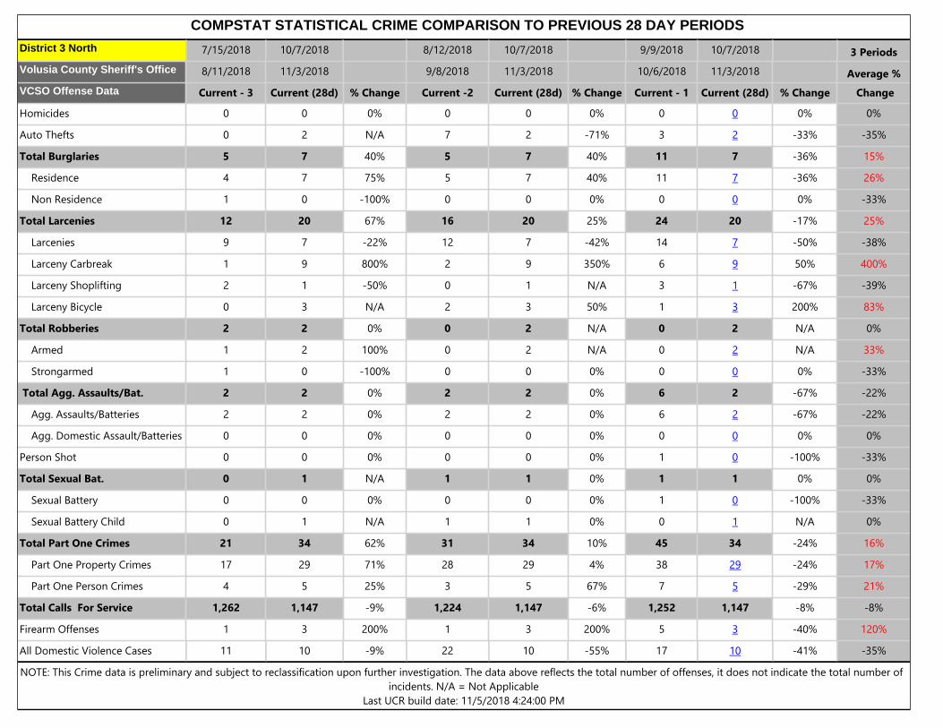
COMPSTAT STATISTICAL CRIME COMPARISON TO PREVIOUS 28 DAY PERIODS
District 3 North 7/15/2018 10/7/2018 8/12/2018 10/7/2018 9/9/2018 10/7/2018 3 PeriodsVolusia County Sheriff's Office 8/11/2018 11/3/2018 9/8/2018 11/3/2018 10/6/2018 11/3/2018 Average %VCSO Offense Data Current - 3 Current (28d) % Change Current -2 Current (28d) % Change Current - 1 Current (28d) % Change Change
Homicides 0 0 0% 0 0 0% 0 0 0% 0%
Auto Thefts 0 2 N/A 7 2 -71% 3 2 -33% -35%
Total Burglaries 5 7 40% 5 7 40% 11 7 -36% 15%
Residence 4 7 75% 5 7 40% 11 7 -36% 26%
Non Residence 1 0 -100% 0 0 0% 0 0 0% -33%
Total Larcenies 12 20 67% 16 20 25% 24 20 -17% 25%
Larcenies 9 7 -22% 12 7 -42% 14 7 -50% -38%
Larceny Carbreak 1 9 800% 2 9 350% 6 9 50% 400%
Larceny Shoplifting 2 1 -50% 0 1 N/A 3 1 -67% -39%
Larceny Bicycle 0 3 N/A 2 3 50% 1 3 200% 83%
Total Robberies 2 2 0% 0 2 N/A 0 2 N/A 0%
Armed 1 2 100% 0 2 N/A 0 2 N/A 33%
Strongarmed 1 0 -100% 0 0 0% 0 0 0% -33%
Total Agg. Assaults/Bat. 2 2 0% 2 2 0% 6 2 -67% -22%
Agg. Assaults/Batteries 2 2 0% 2 2 0% 6 2 -67% -22%
Agg. Domestic Assault/Batteries 0 0 0% 0 0 0% 0 0 0% 0%
Person Shot 0 0 0% 0 0 0% 1 0 -100% -33%
Total Sexual Bat. 0 1 N/A 1 1 0% 1 1 0% 0%
Sexual Battery 0 0 0% 0 0 0% 1 0 -100% -33%
Sexual Battery Child 0 1 N/A 1 1 0% 0 1 N/A 0%
Total Part One Crimes 21 34 62% 31 34 10% 45 34 -24% 16%
Part One Property Crimes 17 29 71% 28 29 4% 38 29 -24% 17%
Part One Person Crimes 4 5 25% 3 5 67% 7 5 -29% 21%
Total Calls For Service 1,262 1,147 -9% 1,224 1,147 -6% 1,252 1,147 -8% -8%
Firearm Offenses 1 3 200% 1 3 200% 5 3 -40% 120%
All Domestic Violence Cases 11 10 -9% 22 10 -55% 17 10 -41% -35%
NOTE: This Crime data is preliminary and subject to reclassification upon further investigation. The data above reflects the total number of offenses, it does not indicate the total number of incidents. N/A = Not Applicable
Last UCR build date: 11/5/2018 4:24:00 PM

January 1, 2018 through November 3, 2018 compared to the same periods in 2016 and 2017Volusia County Sheriff's Office YTD YTD 2016-2017 YTD YTD 2017-2018 YTD YTD 2016-2018 % OF
District 3 North 2016 2017 % Change 2017 2018 %Change 2016 2018 %Change COUNTYWIDE
Homicides 0 0 0% 0 0 0% 0 0 0% 0%
Auto Thefts 35 37 6% 37 37 0% 35 37 6% 18%
Total Burglaries 106 81 -24% 81 71 -12% 106 71 -33% 14%
Residence 98 65 -34% 65 61 -6% 98 61 -38% 14%
Non Residence 8 16 100% 16 10 -38% 8 10 25% 13%
Total Larcenies 351 288 -18% 288 206 -28% 351 206 -41% 12%
Larcenies 193 173 -10% 173 105 -39% 193 105 -46% 12%
Larceny Carbreak 126 72 -43% 72 56 -22% 126 56 -56% 12%
Larceny Shoplifting 16 29 81% 29 32 10% 16 32 100% 14%
Larceny Bicycle 16 14 -13% 14 13 -7% 16 13 -19% 14%
Total Robberies 4 15 275% 15 10 -33% 4 10 150% 13%
Armed 2 3 50% 3 6 100% 2 6 200% 18%
Strongarmed 2 12 500% 12 4 -67% 2 4 100% 9%
Total Agg. Assaults/Bat. 49 56 14% 56 39 -30% 49 39 -20% N/A
Agg. Assaults/Batteries 29 36 24% 36 30 -17% 29 30 3% 15%
Agg. Domestic Assault/Batteries 20 20 0% 20 9 -55% 20 9 -55% 7%
Person Shot 0 5 N/A 5 1 -80% 0 1 N/A 8%
Total Sexual Bat. 20 14 -30% 14 10 -29% 20 10 -50% 9%
Sexual Battery 6 5 -17% 5 4 -20% 6 4 -33% 13%
Sexual Battery Child 14 9 -36% 9 6 -33% 14 6 -57% 7%
Total Part One Crimes 565 491 -13% 491 373 -24% 565 373 -34% 13%
Part One Property Crimes 492 406 -17% 406 314 -23% 492 314 -36% 13%
Part One Person Crimes 73 85 16% 85 59 -31% 73 59 -19% 11%
Total Calls For Service 15,710 15,871 1% 15,871 13,727 -14% 15,710 13,727 -13% 14%
Firearm Offenses 7 17 143% 17 17 0% 7 17 143% 12%
All Domestic Violence Cases 185 170 -8% 170 143 -16% 185 143 -23% 11%
NOTE: This Crime data is preliminary and subject to reclassification upon further investigation. The data above reflects the total number of offenses, it does not indicate the total number of incidents. There were incidents that did not code into either district. These are included in the Countywide Total. N/A = Not Applicable
Last UCR build date: 11/5/2018 4:24:00 PM

January 1, 2018 through November 3, 2018 compared to the same periods in 2016 and 2017Volusia County Sheriff's Office YTD 2016 YTD 2017 YTD 2018
District 3 North Clearances Offense Clrs % Clr Adult Juv Offense Clrs % Clr Adult Juv Offense Clrs % Clr Adult Juv
Homicides 0 0 0% 0 0 0 0 0% 0 0 0 0 0% 0 0
Auto Thefts 35 7 20% 7 0 37 9 24% 9 0 37 17 46% 14 3
Total Burglaries 106 24 23% 22 2 81 22 27% 21 1 71 22 31% 15 7
Residence 98 24 24% 22 2 65 18 28% 18 0 61 18 30% 12 6
Non Residence 8 0 0% 0 0 16 4 25% 3 1 10 4 40% 3 1
Total Larcenies 351 65 19% 59 6 288 67 23% 62 5 206 46 22% 43 3
Larcenies 193 45 23% 41 4 173 37 21% 36 1 105 23 22% 21 2
Larceny Carbreak 126 6 5% 6 0 72 10 14% 8 2 56 9 16% 8 1
Larceny Shoplifting 16 10 63% 9 1 29 18 62% 17 1 32 12 38% 12 0
Larceny Bicycle 16 4 25% 3 1 14 2 14% 1 1 13 2 15% 2 0
Total Robberies 4 3 75% 3 0 15 10 67% 10 0 10 6 60% 6 0
Armed 2 1 50% 1 0 3 0 0% 0 0 6 2 33% 2 0
Strongarmed 2 2 100% 2 0 12 10 83% 10 0 4 4 100% 4 0
Total Agg. Assaults/Bat. 49 40 82% 39 1 56 41 73% 41 0 39 29 74% 27 2
Agg. Assaults/Batteries 29 23 79% 23 0 36 25 69% 25 0 30 20 67% 19 1
Agg. Domestic Assault/Batteries 20 17 85% 16 1 20 16 80% 16 0 9 9 100% 8 1
Person Shot 0 0 0% 0 0 5 4 80% 4 0 1 0 0% 0 0
Total Sexual Bat. 20 9 45% 7 2 14 6 43% 6 0 10 5 50% 4 1
Sexual Battery 6 3 50% 3 0 5 0 0% 0 0 4 4 100% 4 0
Sexual Battery Child 14 6 43% 4 2 9 6 67% 6 0 6 1 17% 0 1
Total Part One Crimes 565 148 26% 132 11 491 155 32% 149 6 373 125 34% 109 16
Part One Property Crimes 492 96 20% 88 8 406 98 24% 92 6 314 85 27% 72 13
Part One Person Crimes 73 52 71% 44 3 85 57 67% 57 0 59 40 68% 37 3
NOTE: This Crime data is preliminary and subject to reclassification upon further investigation. The data above reflects the total number of offenses, it does not indicate the total number of incidents.
Last UCR build date: 11/5/2018 4:24:00 PM

1985 DIMMERS RD18002481410/22/2018 20:33:04
2992 W INTL SPEEDWAY BLVD18002472210/21/2018 18:48:08
35
32
34
33
Sources: Esri, HERE, Garmin, Intermap, increment P Corp., GEBCO, USGS, FAO, NPS, NRCAN,GeoBase, IGN, Kadaster NL, Ordnance Survey, Esri Japan, METI, Esri China (Hong Kong),swisstopo, © OpenStreetMap contributors, and the GIS User Community
District 3 North Auto Thefts10/07/2018 thru 11/03/2018
This is not a legal document.due to address incompatabilities, someincidents may not be represented and
the information on this map should not be viewed as the legal representation of
property boundaries, roads, facilities. etc.¯0 1 2 3 40.5Miles
LegendAuto Thefts (2)
* Map reflects total number of Incidents andnot total number of victims
Prepared by: VC Crime CenterCrime Intelligence AnalystVolusia County Sheriff's OfficePrinted On: 11/6/2018

1501 ELGIN ST18002399410/12/2018 21:53:02
1717 MARYLAND AV18002559511/1/2018 14:12:02
308 SEMINOLE DR18002425010/16/2018 10:48:36
1717 MARYLAND AV18002553110/31/2018 17:32:57
1417 SUNSET BLVD18002376710/10/2018 11:57:32
270 N TYMBER CREEK RD18002402610/13/2018 00:00:00
1233 TOMMY HITCHCOCK AV18002421910/16/2018 23:20:11
35
32
34
33
Sources: Esri, HERE, Garmin, Intermap, increment P Corp., GEBCO, USGS, FAO, NPS, NRCAN,GeoBase, IGN, Kadaster NL, Ordnance Survey, Esri Japan, METI, Esri China (Hong Kong),swisstopo, © OpenStreetMap contributors, and the GIS User Community
District 3 North Burglaries10/07/2018 thru 11/03/2018
This is not a legal document.due to address incompatabilities, someincidents may not be represented and
the information on this map should not be viewed as the legal representation of
property boundaries, roads, facilities. etc.¯0 1 2 3 40.5Miles
LegendBurglary Residence (7)
* Map reflects total number of Incidents andnot total number of victims
Prepared by: VC Crime CenterCrime Intelligence AnalystVolusia County Sheriff's OfficePrinted On: 11/6/2018

1311 10TH ST18002557711/1/2018 11:16:07
1509 ELGIN ST18002424410/16/2018 08:52:08
780 CORDOVA AV18002425510/16/2018 11:22:30
1312 FAIRWAY AV18002526210/28/2018 09:48:30
9 WATERBERRY CIR18002380110/10/2018 17:10:32
1905 SUNNY PALM DR18002453610/19/2018 09:33:45
1565 OCEAN SHORE BLVD18002521010/27/2018 12:32:51
1279 CEDAR CIR18002398310/12/2018 19:27:36
1485 DERBYSHIRE RD18002424210/16/2018 08:51:24
32
31
34
33
Sources: Esri, HERE, Garmin, Intermap, increment P Corp., GEBCO, USGS, FAO, NPS, NRCAN,GeoBase, IGN, Kadaster NL, Ordnance Survey, Esri Japan, METI, Esri China (Hong Kong),swisstopo, © OpenStreetMap contributors, and the GIS User Community
District 3 North Larceny Carbreaks10/07/2018 thru 11/03/2018
This is not a legal document.due to address incompatabilities, someincidents may not be represented and
the information on this map should not be viewed as the legal representation of
property boundaries, roads, facilities. etc.¯0 1 2 30.5Miles
LegendLarceny Carbreaks (9)
* Map reflects total number of Incidents andnot total number of victims
Prepared by: VC Crime CenterCrime Intelligence AnalystVolusia County Sheriff's OfficePrinted On: 11/6/2018

1230 HAND AV18002408610/14/2018 09:46:32
800 S NOVA RD #T18002467810/21/2018 00:22:37
34
Sources: Esri, HERE, Garmin, Intermap, increment P Corp., GEBCO, USGS, FAO, NPS, NRCAN,GeoBase, IGN, Kadaster NL, Ordnance Survey, Esri Japan, METI, Esri China (Hong Kong),swisstopo, © OpenStreetMap contributors, and the GIS User Community
District 3 North Robberies10/07/2018 thru 11/03/2018
This is not a legal document.due to address incompatabilities, someincidents may not be represented and
the information on this map should not be viewed as the legal representation of
property boundaries, roads, facilities. etc.¯0 0.30.15Miles
LegendRobberies (2)
* Map reflects total number of Incidents andnot total number of victims
Prepared by: VC Crime CenterCrime Intelligence AnalystVolusia County Sheriff's OfficePrinted On: 11/6/2018

50 PLAZA DR18002350710/7/2018 05:00:00
1424 CONTINENTAL DR18002411410/14/2018 20:48:05
3234
31
33
Sources: Esri, HERE, Garmin, Intermap, increment P Corp., GEBCO, USGS, FAO, NPS, NRCAN,GeoBase, IGN, Kadaster NL, Ordnance Survey, Esri Japan, METI, Esri China (Hong Kong),swisstopo, © OpenStreetMap contributors, and the GIS User Community
District 3 North Aggravated Assaults and Batteries10/07/2018 thru 11/03/2018
This is not a legal document.due to address incompatabilities, someincidents may not be represented and
the information on this map should not be viewed as the legal representation of
property boundaries, roads, facilities. etc.¯0 1 2 30.5Miles
LegendAgg. Assaults/Batteries (2)
* Map reflects total number of Incidents andnot total number of victims
Prepared by: VC Crime CenterCrime Intelligence AnalystVolusia County Sheriff's OfficePrinted On: 11/6/2018

32
34
31
33
Sources: Esri, HERE, Garmin, Intermap, increment P Corp., GEBCO, USGS, FAO, NPS, NRCAN,GeoBase, IGN, Kadaster NL, Ordnance Survey, Esri Japan, METI, Esri China (Hong Kong),swisstopo, © OpenStreetMap contributors, and the GIS User Community
District 3 North Domestic Assaults and Batteries10/07/2018 thru 11/03/2018
This is not a legal document.due to address incompatabilities, someincidents may not be represented and
the information on this map should not be viewed as the legal representation of
property boundaries, roads, facilities. etc.¯0 1 2 3 40.5Miles
LegendSimple Domestic Assault (8)
* Map reflects total number of Incidents andnot total number of victims
Prepared by: VC Crime CenterCrime Intelligence AnalystVolusia County Sheriff's OfficePrinted On: 11/6/2018

3234
33
Sources: Esri, HERE, Garmin, Intermap, increment P Corp., GEBCO, USGS, FAO, NPS, NRCAN,GeoBase, IGN, Kadaster NL, Ordnance Survey, Esri Japan, METI, Esri China (Hong Kong),swisstopo, © OpenStreetMap contributors, and the GIS User Community
District 3 North Sexual Batteries10/07/2018 thru 11/03/2018
This is not a legal document.due to address incompatabilities, someincidents may not be represented and
the information on this map should not be viewed as the legal representation of
property boundaries, roads, facilities. etc.¯0 1 20.5Miles
LegendSexual Battery (1)
* Map reflects total number of Incidents andnot total number of victims
Prepared by: VC Crime CenterCrime Intelligence AnalystVolusia County Sheriff's OfficePrinted On: 11/6/2018

1311 10TH ST18002557711/1/2018 11:16:07
1224 13TH ST18002360110/8/2018 16:05:49
1509 ELGIN ST18002424410/16/2018 08:52:08
1501 ELGIN ST18002399410/12/2018 21:53:02
1279 CEDAR CIR18002398310/12/2018 19:27:36
1275 LPGA BLVD18002396510/12/2018 14:32:56
1126 VALENCIA AV18002556011/1/2018 06:59:32
1245 KILGORE ST18002406810/13/2018 23:00:17
1417 SUNSET BLVD18002376710/10/2018 11:57:32
1424 CONTINENTAL DR18002411410/14/2018 20:48:05
1417 SUNSET BLVD18002377310/10/2018 11:57:32
1485 DERBYSHIRE RD18002424210/16/2018 08:51:24
33
34
Sources: Esri, HERE, Garmin, Intermap, increment P Corp., GEBCO, USGS, FAO, NPS, NRCAN,GeoBase, IGN, Kadaster NL, Ordnance Survey, Esri Japan, METI, Esri China (Hong Kong),swisstopo, © OpenStreetMap contributors, and the GIS User Community
District 3 North Hot Zone 3310/07/2018 thru 11/03/2018
This is not a legal document.due to address incompatabilities, someincidents may not be represented and
the information on this map should not be viewed as the legal representation of
property boundaries, roads, facilities. etc.¯0 0.60.3Miles
LegendLarceny Carbreak (4)
Sexual Battery (1)
Agg. Assaults/Batteries (1)
Burglary Residence (2)
Larcenies (2)
Larceny Shoplifting (1)
* Map reflects total number of Incidents andnot total number of victims
Prepared by: VC Crime CenterCrime Intelligence AnalystVolusia County Sheriff's OfficePrinted On: 11/6/2018

District 3 North - Part 1 Crimes by Zone 10/07/2018 through 11/03/2018
Volusia County Sheriff's Office
Total 31 32 33 34 35 CT
Total 31 4 4 11 6 2 4
Aggravated Assaults 2 1 0 1 0 0 0
Auto Thefts 2 0 1 0 0 0 1
Burglary Non-Residence 0 0 0 0 0 0 0
Burglary Residence 7 0 2 2 2 1 0
Homicide 0 0 0 0 0 0 0
Larceny All Other 7 2 0 2 0 1 2
Larceny Carbreak 9 1 1 4 3 0 0
Larceny Shoplifting 1 0 0 1 0 0 0
Robbery Armed 2 0 0 0 1 0 1
Robbery Strongarmed 0 0 0 0 0 0 0
Sexual Battery 1 0 0 1 0 0 0
*The Aggravated Assault, Auto Theft,& Sexual Battery statistics reflect the total number of incidents, it does not indicate the total number of victims or vehicles.
The Highlighted numbers indicate zones with higher levels of activity.Last UCR build date: 11/5/2018 4:24:00 PM
Period 18-11: October 07, 2018 – November 03, 2018
Captain Shane Summers

COMPSTAT STATISTICAL CRIME COMPARISON TO PREVIOUS 28 DAY PERIODS
District 3 South 7/15/2018 10/7/2018 8/12/2018 10/7/2018 9/9/2018 10/7/2018 3 PeriodsVolusia County Sheriff's Office 8/11/2018 11/3/2018 9/8/2018 11/3/2018 10/6/2018 11/3/2018 Average %VCSO Offense Data Current - 3 Current (28d) % Change Current -2 Current (28d) % Change Current - 1 Current (28d) % Change Change
Homicides 0 0 0% 0 0 0% 0 0 0% 0%
Auto Thefts 2 3 50% 1 3 200% 0 3 N/A 83%
Total Burglaries 3 2 -33% 4 2 -50% 2 2 0% -28%
Residence 3 2 -33% 3 2 -33% 2 2 0% -22%
Non Residence 0 0 0% 1 0 -100% 0 0 0% -33%
Total Larcenies 16 17 6% 10 17 70% 14 17 21% 33%
Larcenies 12 9 -25% 6 9 50% 11 9 -18% 2%
Larceny Carbreak 4 4 0% 2 4 100% 1 4 300% 133%
Larceny Shoplifting 0 2 N/A 2 2 0% 0 2 N/A 0%
Larceny Bicycle 0 2 N/A 0 2 N/A 2 2 0% 0%
Total Robberies 0 0 0% 0 0 0% 0 0 0% 0%
Armed 0 0 0% 0 0 0% 0 0 0% 0%
Strongarmed 0 0 0% 0 0 0% 0 0 0% 0%
Total Agg. Assaults/Bat. 4 2 -50% 3 2 -33% 4 2 -50% -44%
Agg. Assaults/Batteries 3 1 -67% 1 1 0% 4 1 -75% -47%
Agg. Domestic Assault/Batteries 1 1 0% 2 1 -50% 0 1 N/A -17%
Person Shot 0 0 0% 0 0 0% 0 0 0% 0%
Total Sexual Bat. 1 0 -100% 0 0 0% 0 0 0% -33%
Sexual Battery 0 0 0% 0 0 0% 0 0 0% 0%
Sexual Battery Child 1 0 -100% 0 0 0% 0 0 0% -33%
Total Part One Crimes 26 24 -8% 18 24 33% 20 24 20% 15%
Part One Property Crimes 21 22 5% 15 22 47% 16 22 38% 30%
Part One Person Crimes 5 2 -60% 3 2 -33% 4 2 -50% -48%
Total Calls For Service 1,068 951 -11% 953 951 0% 1,072 951 -11% -7%
Firearm Offenses 0 1 N/A 0 1 N/A 0 1 N/A 0%
All Domestic Violence Cases 15 16 7% 15 16 7% 19 16 -16% -1%
NOTE: This Crime data is preliminary and subject to reclassification upon further investigation. The data above reflects the total number of offenses, it does not indicate the total number of incidents. N/A = Not Applicable
Last UCR build date: 11/5/2018 4:24:00 PM

January 1, 2018 through November 3, 2018 compared to the same periods in 2016 and 2017Volusia County Sheriff's Office YTD YTD 2016-2017 YTD YTD 2017-2018 YTD YTD 2016-2018 % OF
District 3 South 2016 2017 % Change 2017 2018 %Change 2016 2018 %Change COUNTYWIDE
Homicides 1 0 -100% 0 0 0% 1 0 -100% 0%
Auto Thefts 22 26 18% 26 30 15% 22 30 36% 14%
Total Burglaries 77 67 -13% 67 70 4% 77 70 -9% 13%
Residence 66 55 -17% 55 64 16% 66 64 -3% 14%
Non Residence 11 12 9% 12 6 -50% 11 6 -45% 8%
Total Larcenies 275 219 -20% 219 184 -16% 275 184 -33% 11%
Larcenies 174 171 -2% 171 125 -27% 174 125 -28% 14%
Larceny Carbreak 77 32 -58% 32 28 -13% 77 28 -64% 6%
Larceny Shoplifting 13 4 -69% 4 11 175% 13 11 -15% 5%
Larceny Bicycle 11 12 9% 12 20 67% 11 20 82% 22%
Total Robberies 6 5 -17% 5 3 -40% 6 3 -50% 4%
Armed 2 1 -50% 1 0 -100% 2 0 -100% 0%
Strongarmed 4 4 0% 4 3 -25% 4 3 -25% 7%
Total Agg. Assaults/Bat. 52 42 -19% 42 41 -2% 52 41 -21% N/A
Agg. Assaults/Batteries 31 24 -23% 24 27 13% 31 27 -13% 14%
Agg. Domestic Assault/Batteries 21 18 -14% 18 14 -22% 21 14 -33% 11%
Person Shot 0 0 0% 0 0 0% 0 0 0% 0%
Total Sexual Bat. 9 12 33% 12 7 -42% 9 7 -22% 6%
Sexual Battery 1 3 200% 3 0 -100% 1 0 -100% 0%
Sexual Battery Child 8 9 13% 9 7 -22% 8 7 -13% 8%
Total Part One Crimes 442 371 -16% 371 335 -10% 442 335 -24% 12%
Part One Property Crimes 374 312 -17% 312 284 -9% 374 284 -24% 12%
Part One Person Crimes 68 59 -13% 59 51 -14% 68 51 -25% 10%
Total Calls For Service 13,143 14,339 9% 14,339 12,325 -14% 13,143 12,325 -6% 12%
Firearm Offenses 7 3 -57% 3 10 233% 7 10 43% 7%
All Domestic Violence Cases 128 143 12% 143 160 12% 128 160 25% 12%
NOTE: This Crime data is preliminary and subject to reclassification upon further investigation. The data above reflects the total number of offenses, it does not indicate the total number of incidents. There were incidents that did not code into either district. These are included in the Countywide Total. N/A = Not Applicable
Last UCR build date: 11/5/2018 4:24:00 PM

January 1, 2018 through November 3, 2018 compared to the same periods in 2016 and 2017Volusia County Sheriff's Office YTD 2016 YTD 2017 YTD 2018
District 3 South Clearances Offense Clrs % Clr Adult Juv Offense Clrs % Clr Adult Juv Offense Clrs % Clr Adult Juv
Homicides 1 0 0% 0 0 0 1 N/A 1 0 0 0 0% 0 0
Auto Thefts 22 6 27% 5 1 26 13 50% 11 2 30 10 33% 10 0
Total Burglaries 77 21 27% 17 4 67 22 33% 19 3 70 17 24% 17 0
Residence 66 20 30% 16 4 55 19 35% 16 3 64 13 20% 13 0
Non Residence 11 1 9% 1 0 12 3 25% 3 0 6 4 67% 4 0
Total Larcenies 275 80 29% 63 17 219 65 30% 46 19 184 30 16% 30 0
Larcenies 174 51 29% 39 12 171 58 34% 41 17 125 21 17% 21 0
Larceny Carbreak 77 21 27% 16 5 32 4 13% 2 2 28 3 11% 3 0
Larceny Shoplifting 13 6 46% 6 0 4 2 50% 2 0 11 5 45% 5 0
Larceny Bicycle 11 2 18% 2 0 12 1 8% 1 0 20 1 5% 1 0
Total Robberies 6 4 67% 1 3 5 4 80% 4 0 3 3 100% 3 0
Armed 2 2 100% 1 1 1 1 100% 1 0 0 0 0% 0 0
Strongarmed 4 2 50% 0 2 4 3 75% 3 0 3 3 100% 3 0
Total Agg. Assaults/Bat. 52 39 75% 37 2 42 34 81% 31 3 41 27 66% 27 0
Agg. Assaults/Batteries 31 22 71% 20 2 24 19 79% 17 2 27 14 52% 14 0
Agg. Domestic Assault/Batteries 21 17 81% 17 0 18 15 83% 14 1 14 13 93% 13 0
Person Shot 0 0 0% 0 0 0 0 0% 0 0 0 0 0% 0 0
Total Sexual Bat. 9 6 67% 6 0 12 10 83% 6 4 7 4 57% 1 3
Sexual Battery 1 1 100% 1 0 3 1 33% 1 0 0 0 0% 0 0
Sexual Battery Child 8 5 63% 5 0 9 9 100% 5 4 7 4 57% 1 3
Total Part One Crimes 442 156 35% 112 27 371 149 40% 118 31 335 91 27% 88 3
Part One Property Crimes 374 107 29% 85 22 312 100 32% 76 24 284 57 20% 57 0
Part One Person Crimes 68 49 72% 27 5 59 49 83% 42 7 51 34 67% 31 3
NOTE: This Crime data is preliminary and subject to reclassification upon further investigation. The data above reflects the total number of offenses, it does not indicate the total number of incidents.
Last UCR build date: 11/5/2018 4:24:00 PM

549 N CR 41518002462910/20/2018 00:00:00
148 CENTER ST18002430110/16/2018 18:59:37
2495 TOMOKA FARMS RD18002398110/12/2018 17:49:39
51
57 5355
52
54
52
52
56
52
52
Sources: Esri, HERE, Garmin, Intermap, increment P Corp., GEBCO, USGS, FAO, NPS, NRCAN,GeoBase, IGN, Kadaster NL, Ordnance Survey, Esri Japan, METI, Esri China (Hong Kong),swisstopo, © OpenStreetMap contributors, and the GIS User Community
District 3 South Auto Thefts10/07/2018 thru 11/03/2018
This is not a legal document.due to address incompatabilities, someincidents may not be represented and
the information on this map should not be viewed as the legal representation of
property boundaries, roads, facilities. etc.¯0 1 2 3 4 50.5Miles
LegendAuto Thefts (3)
* Map reflects total number of Incidents andnot total number of victims
Prepared by: VC Crime CenterCrime Intelligence AnalystVolusia County Sheriff's OfficePrinted On: 11/6/2018

1296 S SR 41518002552810/31/2018 16:41:07
401 BRIDGET ST18002381310/10/2018 19:27:14
51
5753
52
5252
52
Sources: Esri, HERE, Garmin, Intermap, increment P Corp., GEBCO, USGS, FAO, NPS, NRCAN,GeoBase, IGN, Kadaster NL, Ordnance Survey, Esri Japan, METI, Esri China (Hong Kong),swisstopo, © OpenStreetMap contributors, and the GIS User Community
District 3 South Burglaries10/07/2018 thru 11/03/2018
This is not a legal document.due to address incompatabilities, someincidents may not be represented and
the information on this map should not be viewed as the legal representation of
property boundaries, roads, facilities. etc.¯0 1 2 3 40.5Miles
LegendBurglary Residence (2)
* Map reflects total number of Incidents andnot total number of victims
Prepared by: VC Crime CenterCrime Intelligence AnalystVolusia County Sheriff's OfficePrinted On: 11/6/2018

1120 S SR 41518002504810/25/2018 09:42:08
3745 LACEY LN18002427010/16/2018 13:29:23
6458 ENGRAM RD18002465810/20/2018 19:46:56
250 H H BURCH RD18002457310/19/2018 17:06:49
51
57 53 55
52
54
5252
56
52
52
Sources: Esri, HERE, Garmin, Intermap, increment P Corp., GEBCO, USGS, FAO, NPS, NRCAN,GeoBase, IGN, Kadaster NL, Ordnance Survey, Esri Japan, METI, Esri China (Hong Kong),swisstopo, © OpenStreetMap contributors, and the GIS User Community
District 3 South Larceny Carbreaks10/07/2018 thru 11/03/2018
This is not a legal document.due to address incompatabilities, someincidents may not be represented and
the information on this map should not be viewed as the legal representation of
property boundaries, roads, facilities. etc.¯0 1 2 3 4 50.5Miles
LegendLarceny Carbreaks (4)
* Map reflects total number of Incidents andnot total number of victims
Prepared by: VC Crime CenterCrime Intelligence AnalystVolusia County Sheriff's OfficePrinted On: 11/6/2018

3636 CARDINAL BLVD #318002413810/15/2018 03:42:49
52
52
Sources: Esri, HERE, Garmin, Intermap, increment P Corp., GEBCO, USGS, FAO, NPS, NRCAN,GeoBase, IGN, Kadaster NL, Ordnance Survey, Esri Japan, METI, Esri China (Hong Kong),swisstopo, © OpenStreetMap contributors, and the GIS User Community
District 3 South Aggravated Assaults and Batteries10/07/2018 thru 11/03/2018
This is not a legal document.due to address incompatabilities, someincidents may not be represented and
the information on this map should not be viewed as the legal representation of
property boundaries, roads, facilities. etc.¯0 10.5Miles
LegendAgg. Assaults/Batteries (1)
* Map reflects total number of Incidents andnot total number of victims
Prepared by: VC Crime CenterCrime Intelligence AnalystVolusia County Sheriff's OfficePrinted On: 11/6/2018

51
535755
52
54
5252
56
52
5252
Sources: Esri, HERE, Garmin, Intermap, increment P Corp., GEBCO, USGS, FAO, NPS, NRCAN,GeoBase, IGN, Kadaster NL, Ordnance Survey, Esri Japan, METI, Esri China (Hong Kong),swisstopo, © OpenStreetMap contributors, and the GIS User Community
District 3 South Domestic Assaults and Batteries10/07/2018 thru 11/03/2018
This is not a legal document.due to address incompatabilities, someincidents may not be represented and
the information on this map should not be viewed as the legal representation of
property boundaries, roads, facilities. etc.¯0 2 4 6 8 101Miles
LegendAgg. Domestic Assault (1)
Simple Domestic Assault (13)
* Map reflects total number of Incidents andnot total number of victims
Prepared by: VC Crime CenterCrime Intelligence AnalystVolusia County Sheriff's OfficePrinted On: 11/6/2018

1038 JUNE TER18002361210/8/2018 18:26:04
1800 S NOVA RD18002400910/13/2018 02:52:27
123 DEMOTTE AV18002391310/11/2018 19:56:49
401 BRIDGET ST18002381310/10/2018 19:27:14
2350 SELLECK AV18002408510/14/2018 10:02:46
1408 PIONEER TR18002387710/11/2018 13:21:57
1584 ELIZABETH ST18002481910/22/2018 21:01:01
3636 CARDINAL BLVD #318002413810/15/2018 03:42:49
1850 S CLYDE MORRIS BLVD18002417810/15/2018 14:59:11
51
52
52
56
52
54
52
52
52
53 53Sources: Esri, HERE, Garmin, Intermap, increment P Corp., GEBCO, USGS, FAO, NPS, NRCAN,GeoBase, IGN, Kadaster NL, Ordnance Survey, Esri Japan, METI, Esri China (Hong Kong),swisstopo, © OpenStreetMap contributors, and the GIS User Community
District 3 South Hot Zone 5210/07/2018 thru 11/03/2018
This is not a legal document.due to address incompatabilities, someincidents may not be represented and
the information on this map should not be viewed as the legal representation of
property boundaries, roads, facilities. etc.¯0 1 2 3 4 50.5Miles
LegendAgg. Assaults/Batteries (1)
Burglary Residence (1)
Larcenies (6)
Larceny Shoplifting (1)
* Map reflects total number of Incidents andnot total number of victims
Prepared by: VC Crime CenterCrime Intelligence AnalystVolusia County Sheriff's OfficePrinted On: 11/6/2018

District 3 South - Part 1 Crimes by Zone 10/07/2018 through 11/03/2018
Volusia County Sheriff's Office
Total 51 52 53 54 55 CT
Total 22 5 9 3 2 3 0
Aggravated Assaults 2 0 1 1 0 0 0
Auto Thefts 3 2 0 1 0 0 0
Burglary Non-Residence 0 0 0 0 0 0 0
Burglary Residence 2 1 1 0 0 0 0
Homicide 0 0 0 0 0 0 0
Larceny All Other 9 0 6 0 1 2 0
Larceny Carbreak 4 2 0 1 1 0 0
Larceny Shoplifting 2 0 1 0 0 1 0
Robbery Armed 0 0 0 0 0 0 0
Robbery Strongarmed 0 0 0 0 0 0 0
Sexual Battery 0 0 0 0 0 0 0
*The Aggravated Assault, Auto Theft,& Sexual Battery statistics reflect the total number of incidents, it does not indicate the total number of victims or vehicles.
The Highlighted numbers indicate zones with higher levels of activity.Last UCR build date: 11/5/2018 4:24:00 PM

Period 18-11: October 07, 2018 – November 03, 2018
Captain Brian Henderson
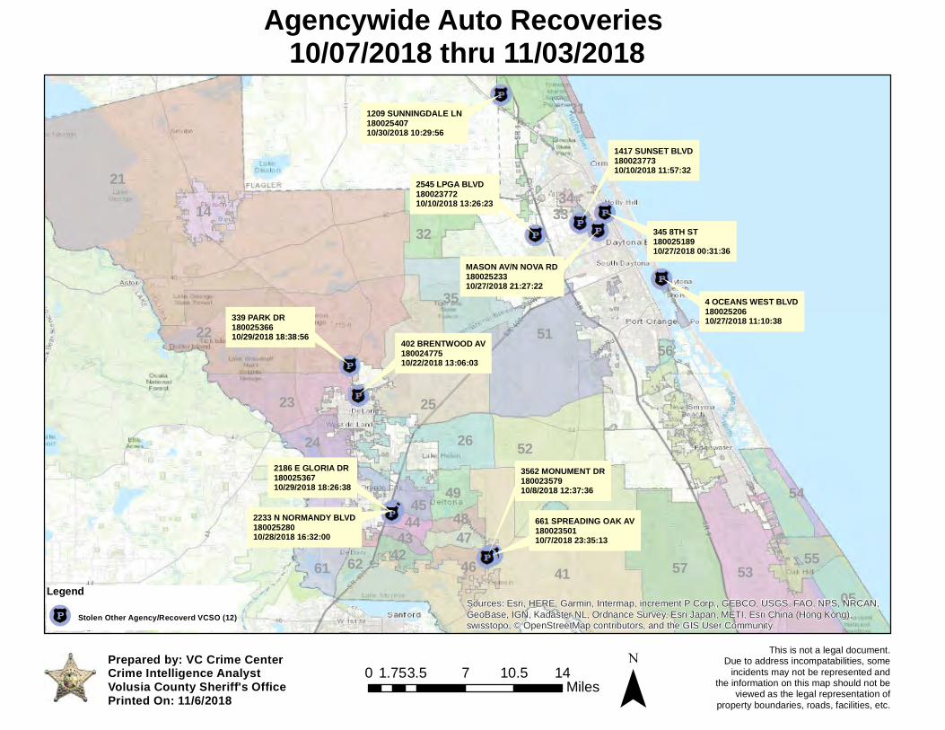
345 8TH ST18002518910/27/2018 00:31:36
339 PARK DR18002536610/29/2018 18:38:56
2545 LPGA BLVD18002377210/10/2018 13:26:23
3562 MONUMENT DR18002357910/8/2018 12:37:36
2186 E GLORIA DR18002536710/29/2018 18:26:38
402 BRENTWOOD AV18002477510/22/2018 13:06:03
MASON AV/N NOVA RD18002523310/27/2018 21:27:22
4 OCEANS WEST BLVD18002520610/27/2018 11:10:38
1209 SUNNINGDALE LN18002540710/30/2018 10:29:56
661 SPREADING OAK AV18002350110/7/2018 23:35:13
2233 N NORMANDY BLVD18002528010/28/2018 16:32:00
1417 SUNSET BLVD18002377310/10/2018 11:57:3221
41
22
52
51
57 53
25
35
23
32
26
05
24
14
5561
4945
62474642
4854
4443
31
56
3433
Sources: Esri, HERE, Garmin, Intermap, increment P Corp., GEBCO, USGS, FAO, NPS, NRCAN,GeoBase, IGN, Kadaster NL, Ordnance Survey, Esri Japan, METI, Esri China (Hong Kong),swisstopo, © OpenStreetMap contributors, and the GIS User Community
Legend
ca Stolen Other Agency/Recoverd VCSO (12)
0 3.5 7 10.5 141.75Miles ¯
This is not a legal document.Due to address incompatabilities, some
incidents may not be represented andthe information on this map should not be
viewed as the legal representation ofproperty boundaries, roads, facilities, etc.
Agencywide Auto Recoveries 10/07/2018 thru 11/03/2018
Prepared by: VC Crime CenterCrime Intelligence AnalystVolusia County Sheriff's OfficePrinted On: 11/6/2018

3234
35
33
Sources: Esri, HERE, Garmin, Intermap, increment P Corp., GEBCO, USGS, FAO, NPS, NRCAN,GeoBase, IGN, Kadaster NL, Ordnance Survey, Esri Japan, METI, Esri China (Hong Kong),swisstopo, © OpenStreetMap contributors, and the GIS User Community
District 3 North Part I Arrests by Location10/07/2018 thru 11/03/2018
This is not a legal document.due to address incompatabilities, someincidents may not be represented and
the information on this map should not be viewed as the legal representation of
property boundaries, roads, facilities. etc.¯0 1 2 30.5Miles
LegendAGGRAVATED ASSAULT (3)
BURGLARY (2)
LARCENY/THEFT (2)
* Map reflects total number of Incidents andnot total number of victims
Prepared by: VC Crime CenterCrime Intelligence AnalystVolusia County Sheriff's OfficePrinted On: 11/6/2018

53
57
55
54
Sources: Esri, HERE, Garmin, Intermap, increment P Corp., GEBCO, USGS, FAO, NPS, NRCAN,GeoBase, IGN, Kadaster NL, Ordnance Survey, Esri Japan, METI, Esri China (Hong Kong),swisstopo, © OpenStreetMap contributors, and the GIS User Community
District 3 South Part I Arrests by Location10/07/2018 thru 11/03/2018
This is not a legal document.due to address incompatabilities, someincidents may not be represented and
the information on this map should not be viewed as the legal representation of
property boundaries, roads, facilities. etc.¯0 1 20.5Miles
LegendAGGRAVATED ASSAULT (2)
LARCENY/THEFT (1)
* Map reflects total number of Incidents andnot total number of victims
Prepared by: VC Crime CenterCrime Intelligence AnalystVolusia County Sheriff's OfficePrinted On: 11/6/2018

UPCOMING EVENTS
Southeast CompStat Presentation: Thursday, November 29, 2018 at 1800 hours, Brannon Center, 105 S. Riverside Dr, New Smyrna Beach.
Next Countywide CompStat Session: Thursday, December 13, 2018 at 0830 hours, Deltona City Hall, Commission Chambers, 2345 Providence Blvd, Reporting Period 18-12: November 04, 2018 – December 08, 2018.