perfect solutions for professional surveying · 2019-09-06 · after completing your measurements...
TRANSCRIPT

Point. Shoot. Done.
SiteMaster Perfect Solutions for Professional Surveying Anytime. Anywhere. Anyone.
SiteMaster BuildingTS Building Survey with Distancemeter and Totalstation SiteMaster Building The mobile solution for professional Building Surveys SiteMaster BuildingLT The low-cost entrance for Building Surveys
SiteMaster TopoSurvey Land Survey with Totalstation SiteMaster Facade Facade Survey with Totalstation
SiteMaster Elevation Photogrammetric Facade Survey SiteMaster Office Floor Plan Editing back in the office SiteMaster Exchange Interface for Survey Data
Sales: 0871 789 [email protected]

Mobile Surveying Solutions for Building Survey SiteMaster BuildingTS SiteMaster Building SiteMaster BuildingLT
SiteMaster Building is a professional mobile surveying solution that creates AutoCAD® compatible floor plans on-site that can be used by professional surveyors and other non CAD professionals alike. Un-like the traditional tape, pen and paper method, SiteMaster Building embraces Bluetooth technology to capture the measurements taken and puts them into the software creating instant digital floor plans
on-site in .DWG, .FLX, .DWF or .DXF on a Microsoft Windows Mobile 6®, Windows CE® Tablet and every Windows XP® or Windows Vista device. This ensures that you carry out the Survey in ½ the time at ½ the cost but with 100% accuracy. SiteMaster Building supports devices by Leica, Hilti and Bosch.
SiteMaster Building The mobile solution for professional Building Surveys The extensive features of SiteMaster Building are especially interesting for users that need to create and deliver professional CAD drawings.
The layer management supports the combination of several floor plans in one single file. Heights of rooms, openings and symbols can be recorded and exported. Lasered distances are recorded in the background and saved on an extra layer for proofing purposes.
Draw fast and accurate walls (as single or double line), windows, doors and symbols. You can draw rectangular and circular columns, Recesses, chimneys and niches/ducts. SiteMaster Building offers you more than 250 CAD and numerous editing commands. The program features associative dimensioning and room area calculation.
The Camera function allows you to insert icon-referenced inspection pho-tos and images. SiteMaster Building contains an Image function for direct insertion and scaling of photos and image underlays with support for file formats as BMP, JPG, PNG, TIFF and RLC digital photos and images.
VoiceNotes that can easily been inserted eliminate time consuming text markup by providing record and playback of high-compressed audio notes and instructions directly inside your drawings.
AutoCAD-compatible drawing symbols / blocks can be used. The Visual Symbol Manager lets you insert symbols – as-measured, referenced or free in the drawing. You can export Excel-compatible .csv files with room/area lists and room schedule reports/symbol lists. The Check Distance function lets you compare »as-built« distances to plan distances and record this comparison.
Experienced power users can use the visual Desktop, Menu and Toolbar Editor (DME2) and Lisp and/or C++ programming APIs to customize and extend the program. The combination of Distancemeters and Totalstations in SiteMaster BuildingTS optimises the working process when doing large building surveys. Survey for example the outside surface and the complicated inside of a building with a Totalstation and complement the digital floor plan with a Distancemeter on-site. Any errors shown allows you the opportunity to make corrections there and then.
•Collectionandinputofnewpositions
•Survey of walls and symbols with a Totalstation
•Import and Export of standpoint coordinates through ASCII-Files Totalstations by Leica, Topcon, Trimble and South are supported.
Architects Civil
Engineers Appraisers Builders Contractors
Designers Estimators Realtors Condition
Surveyors Facility Managers
Installers Skilled
Craftsmen Real Estate Renovators Trades
SiteMaster BuildingTS offers additional features:
Mobile Surveying Solutions for Totalstations
SiteMaster BuildingTS SiteMaster TopoSurvey
SiteMaster Facade
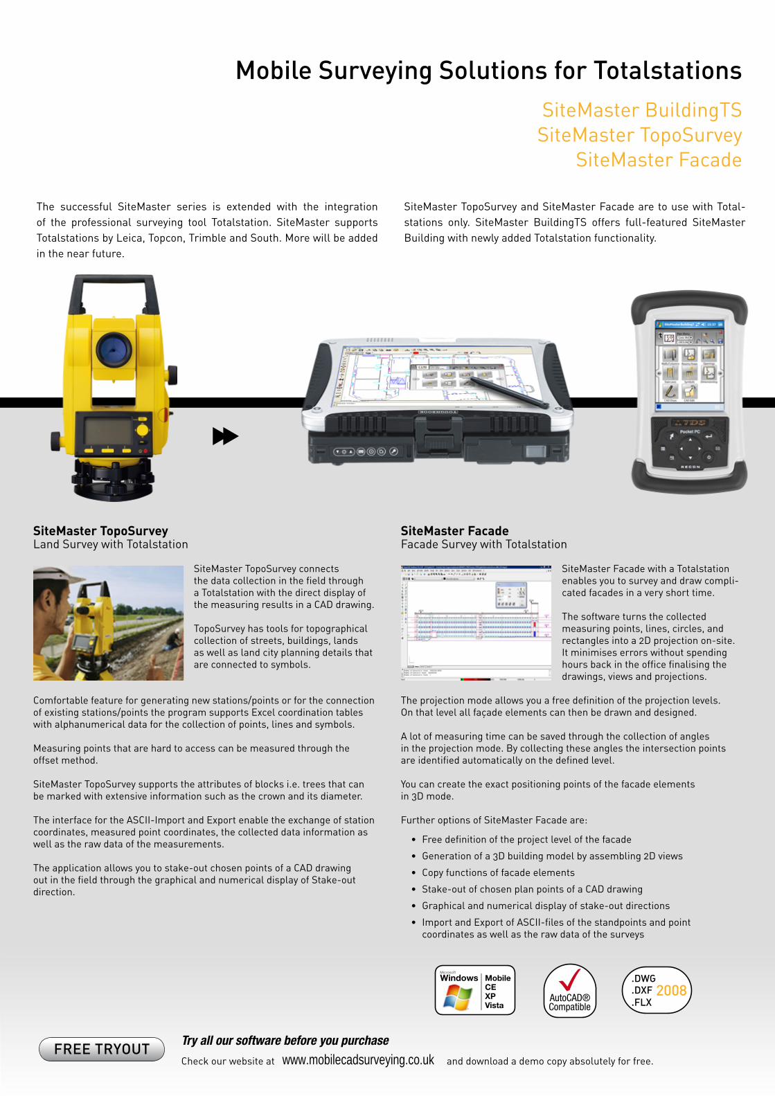
The successful SiteMaster series is extended with the integration of the professional surveying tool Totalstation. SiteMaster supports Totalstations by Leica, Topcon, Trimble and South. More will be added in the near future.
SiteMaster TopoSurvey and SiteMaster Facade are to use with Total-stations only. SiteMaster BuildingTS offers full-featured SiteMaster Building with newly added Totalstation functionality.
SiteMaster TopoSurvey Land Survey with Totalstation
SiteMaster TopoSurvey connects the data collection in the field through a Totalstation with the direct display of the measuring results in a CAD drawing.
TopoSurvey has tools for topographical collection of streets, buildings, lands as well as land city planning details that are connected to symbols.
Comfortable feature for generating new stations/points or for the connection of existing stations/points the program supports Excel coordination tables with alphanumerical data for the collection of points, lines and symbols.
Measuring points that are hard to access can be measured through the offset method.
SiteMaster TopoSurvey supports the attributes of blocks i.e. trees that can be marked with extensive information such as the crown and its diameter.
The interface for the ASCII-Import and Export enable the exchange of station coordinates, measured point coordinates, the collected data information as well as the raw data of the measurements.
The application allows you to stake-out chosen points of a CAD drawing out in the field through the graphical and numerical display of Stake-out direction.
SiteMaster Facade Facade Survey with Totalstation
SiteMaster Facade with a Totalstation enables you to survey and draw compli-cated facades in a very short time.
The software turns the collected measuring points, lines, circles, and rectangles into a 2D projection on-site. It minimises errors without spending hours back in the office finalising the drawings, views and projections.
The projection mode allows you a free definition of the projection levels. On that level all façade elements can then be drawn and designed.
A lot of measuring time can be saved through the collection of angles in the projection mode. By collecting these angles the intersection points are identified automatically on the defined level.
You can create the exact positioning points of the facade elements in 3D mode.
Further options of SiteMaster Facade are:
•Freedefinitionoftheprojectlevelofthefacade
•Generationofa3Dbuildingmodelbyassembling2Dviews
•Copyfunctionsoffacadeelements
•Stake-outofchosenplanpointsofaCADdrawing
•Graphicalandnumericaldisplayofstake-outdirections
•ImportandExportofASCII-filesofthestandpointsandpoint coordinates as well as the raw data of the surveys
FREE TRYOUT Try all our software before you purchase Check our website at and download a demo copy absolutely for free. www.mobilecadsurveying.co.uk
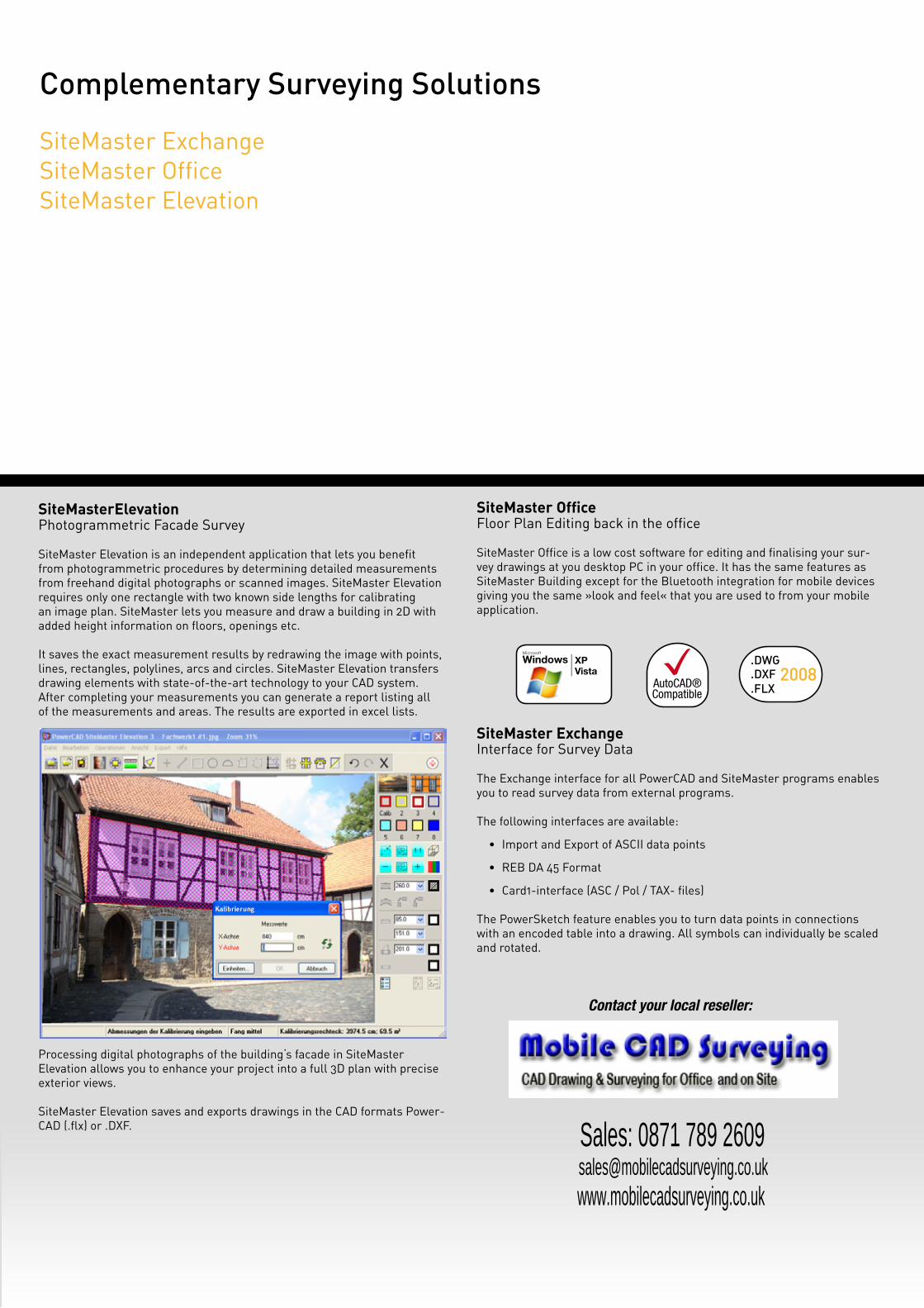
SiteMasterElevation Photogrammetric Facade Survey SiteMaster Elevation is an independent application that lets you benefit from photogrammetric procedures by determining detailed measurements from freehand digital photographs or scanned images. SiteMaster Elevation requires only one rectangle with two known side lengths for calibrating an image plan. SiteMaster lets you measure and draw a building in 2D with added height information on floors, openings etc. It saves the exact measurement results by redrawing the image with points, lines, rectangles, polylines, arcs and circles. SiteMaster Elevation transfers drawing elements with state-of-the-art technology to your CAD system. After completing your measurements you can generate a report listing all of the measurements and areas. The results are exported in excel lists.
Processing digital photographs of the building‘s facade in SiteMaster Elevation allows you to enhance your project into a full 3D plan with precise exterior views. SiteMaster Elevation saves and exports drawings in the CAD formats Power-CAD (.flx) or .DXF.
SiteMaster Office Floor Plan Editing back in the office SiteMaster Office is a low cost software for editing and finalising your sur-vey drawings at you desktop PC in your office. It has the same features as SiteMaster Building except for the Bluetooth integration for mobile devices giving you the same »look and feel« that you are used to from your mobile application.
SiteMaster Exchange Interface for Survey Data The Exchange interface for all PowerCAD and SiteMaster programs enables you to read survey data from external programs.
The following interfaces are available:
•Import and Export of ASCII data points
•REB DA 45 Format
•Card1-interface (ASC / Pol / TAX- files)
The PowerSketch feature enables you to turn data points in connections with an encoded table into a drawing. All symbols can individually be scaled and rotated.
Complementary Surveying Solutions SiteMaster Exchange SiteMaster Office SiteMaster Elevation
Contact your local reseller:
Sales: 0871 789 [email protected]