penrose field guide - geological society of america
TRANSCRIPT

Exploring Juneau from Ice to Estuary: Climatic and Tectonic Controls on South-eastern Alaskan Landscapes
A field guide prepared for the Geological Society of America Penrose Conference on
Climatic controls on continental erosion and sediment transport—CLAST2019
4-10 August 2019
Led by Cathy Connor, Sonia Nagorski, and Eran Hood
University of Alaska Southeast Wednesday, 7 August 2019
Penrose Conference Conveners Tara N. Jonell Jan H. Blöthe Peter D. Clift
© I. Johannsen,

2
Introduction Wednesday, 7 August, 2019 Assembly at BW Baranof Hotel by 7:45 am in the lobby. South-eastern Alaska is considered one of the best natural laboratories on earth to observe the interaction among solid earth and earth surface processes. The broad region of Alaska is one of the most seismically and tectonically active areas in the world, accommodating oblique convergence of the North American plate and Yakutat microplate, with modern convergence rates on par with those in the Himalaya (Yakutat Block is converging 50.3 ± 0.8 mm/yr towards N22.9 ± 70.6˚ W; Elliot et al., 2010). Two coastal mountain ranges dominate the region surrounding Juneau: The Coast Range, trending southeast to the Dixon Entrance and continuing farther south; and the Chugach-St. Elias Range following along the Gulf of Alaska into Cross Sound (Figs. 1 and 2). These ranges are the product of a complex late Cretaceous-Cenozoic accretion of arc terranes and magmatism, overprinted by extensive Late Cenozoic glaciation (Figs. 3-6). The overall cool temperate climate and abundant moisture delivered by the North Pacific Ocean provide the necessary ingredients to develop vigorous glaciomarine systems and maritime rainforest. This interplay between Late Cenozoic tectonics, climate, and a variety of surface processes are documented throughout SE Alaska (SEAK) in uplifted coastal terraces and marine shell beds, abandoned cirques, offset glacier valleys, subglacial lava flows, and unglaciated refugia along the Yakutat forelands and continental shelf edge bordering the islands (Baranof, Heceta, Suemez, and Prince of Wales Islands) that comprise the Alexander Archipelago (Carrara et al., 2007; Karl et al., 2008). Despite the relatively narrow margin from icefield to the ocean, the climate histories have been reconstructed using myriad records: from bogs (here, muskegs) and a variety fluvial, lacustrine, glacial, estuarine, shelf, and abyssal fan sediments, from biogeochemical signatures in sediments, ice and runoff, and leftover as clues across local topography. Repeated glaciations and interstadial interludes resulted in a complex biogeography established since the end of the Last Glacial Maximum (LGM), in part re-established by animals and plants hosted in ice-free refugia on the continental shelf and on alpine nunataks. The first human occupants migrating into this region were similarly supported by these unique habitats (Cook et al. 2006). This GSA Penrose Field Guidebook is developed and updated from the 2003 National Association of Geoscience Teachers guide and 2008 Alaska cell of Friends of the Pleistocene (FOP) Guidebook compiled by Cathy Connor and Roman Motyka for the Juneau area to provide an overview of Late Cenozoic neotectonic, climatic, and glacial control over sedimentation. In particular, this guidebook focuses on local glacial geology and weathering; the unique paleoecology, palynology, soils and landscape succession in SEAK; biogeography and anthropogenic development, and on the effects of recent climate change and warming.

3
Figure 1. Map of south-eastern Alaska showing geographic features.
http://www.alaskais.com/akse.htm)
Figure 2. Terrane and geology map of Coastal Alaska, The Yukon, and Northern BC (Haeussler et al. 2006). Gulf of Alaska area, showing location of study area and tectonostratigraphic terranes of Alaska, Yukon Territory, and British Columbia (from Nokleberg and others, 1998). Terranes: CG, Chugach; ST, Stikine; YT, Yukon-Tanana. Faults: BR, Border Ranges; CS, Chatham Straight; DE, Denali; TI, Tintina.

4
Northern Cordillera Tectonics Rupture zones of major earthquakes have been mapped for twentieth century earthquakes around the Northern Gulf of Alaska (Fig. 3; Plafker and Thatcher, 2008). Two great earthquakes (Mw=8.1 and 8.2) occurred in September 1899 in Yakutat Bay. These ruptures are related to the ongoing collision of the Yakutat block with North America in this region (Fig. 4; Plafker and Thatcher, 2008). Data from Leonhard et al. (2007) infer that relative Yakutat–North America motion is accommodated across the eastern collision boundary by right-lateral motion (∼40 mm/yr), mainly on the Fairweather Fault with minor shortening (∼6 mm/yr). To the northwest, collision is taken up by shortening (∼31 mm/yr) mainly on the Chugach–St. Elias fault system, with westward extrusion and possible counterclockwise rotation of the Yakutat block and Alaskan forearc. This rotation is facilitated by ∼23 mm/yr right-lateral motion that accommodated across several faults. Glacier redistribution of eroded material resulted in progradation of the continental shelf edge southward, shifting the location of deformation centers and changing collision dynamics across the region (Gulick et al, 2007, Chapman et al, 2008). Strain from this collision has resulted in “escape tectonics” in the form of movement of western interior Alaska toward Russia (Redfield et al. 2007), a rotation of the Kenai Peninsula crust clockwise and westward, uplift of Denali and Foraker
Figure 3. Twentieth century major earthquake rupture zones in the Gulf of Alaska (Plafker and Thatcher 2008). Rupture zones of major 20th century earthquakes (shaded areas) around the northern Gulf of Alaska showing date and magnitude for each event.
Figure 4. Overview Map of Yakutat Block with plate motion velocities. Locations of N-S cross section A-A’ in Figure 4 below. CSEF, Chugach Saint Elias fault; CGT, Chugach terrane. Velocity vectors from Fletcher and Freymueller (2003).
5
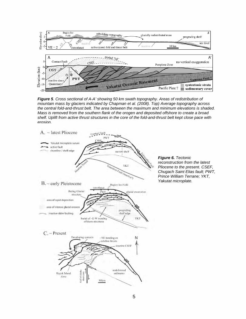
Figure 5. Cross sectional of A-A’ showing 50 km swath topography. Areas of redistribution of mountain mass by glaciers indicated by Chapman et al. (2008). Top) Average topography across the central fold-and-thrust belt. The area between the maximum and minimum elevations is shaded. Mass is removed from the southern flank of the orogen and deposited offshore to create a broad shelf. Uplift from active thrust structures in the core of the fold-and-thrust belt kept close pace with erosion.
Figure 6. Tectonic reconstruction from the latest Pliocene to the present. CSEF, Chugach Saint Elias fault; PWT, Prince William Terrane; YKT, Yakutat microplate.

6
Mountains, in the Central Alaska Range, and has produced strain throughout eastern Alaska, Yukon, and western Northwest Territories, at least 400 km from the Yakutat collision front (Leonhard et al, 2007). STOP 1. BLUBERRY HILL OVERLOOK Douglas, AK We will board the bus and proceed through downtown Juneau to Douglas Island. We will pass Lemon Creek and Salmon Creek on the mainland to your left (northeast). We are following the Fanshaw Fault (Gastineau Channel Fault; Fig. 7) on the east and paralleling the axis of the Jurassic-Cretaceous collapsed Gravina Belt basin along the Gastineau Channel, an ice-carved valley or fjord. As we proceed down the channel, you will notice outcrops of the Taku Terrane, too. These mainland rocks of the Taku Terrane include Permian metabasalts and marble of the Gastineau Group that overlie metapelites of the Perseverance Group that crop out on ridges north and east of downtown Juneau (Gehrels et al., 1992). The western boundary of this package of rocks is fault-bounded and thrust over Gravina Belt basin rocks along the Fanshaw/Gastineau Fault. To the east, the Taku terrane is bounded by the Sumdum fault. This terrane does not match up well with adjacent terranes. After the downtown Douglas Roundabout, turn right onto Blueberry Hills road and follow the topography to the intersection of this road with Goodwin Hills Road. Turn Left onto Pioneer Ave. and continue up the hillside to a good viewing spot. Here, at an overlook of downtown Juneau, we observed Gastineau Channel’s tectonic geomorphology, glacial features, and Juneau’s notorious avalanche paths and landslide slopes within residential areas.
Figure 7. Approximate locations of Fanshaw/Gastineau Channel, Sumdum faults, Silverbow, and Fish Creek faults along the Coast Range Shear Zone after Gehrels and Stowell (2000).
7
Gastineau Channel Bedrock and Tectonics Directly below us Gastineau Channel lies along the western edge of the Coast Range Plutons. A wide zone of fault-sheared rock attributed to convergent thrusting along the Fanshaw Fault was mapped during mine exploration (Gehrels, 2000). The Taku Terrane underlying mainland mountains like Mt. Juneau, Gastineau Peak, and Mt. Roberts Ridge, was thrust upward and westward over the Gravina Belt rocks under our feet here on Douglas Island. This occurred during the collapse of the Gravina Belt basin around 90 Ma. Emplacement of dioritic, tonalitic, and later granodioritic plutons in the Taku and Tracy Arm terrane rocks between 70 and 50 Ma, metamorphosed these continental oceanic affinity rocks to greenschist-amphibolite and granulite facies. Subsequent exhumation and uplift were probably related to the migration and eventual subduction of the Resurrection Plate and Ridge system, then located southeast of the Kula Plate and north of the Farallon Plate in Paleocene-Eocene time (Haeussler et al., 2003). From the west, near Seward, AK, on the Kenai Peninsula, a trench-ridge-trench triple junction migrated along the coast between the Kenai Peninsula and Oregon approximately 61-50 Ma (Haeussler et al., 2003). These authors attribute many geologic features such as near-trench magmatism, progressively younger outer coast gold deposits from NW to SE, uplift and magmatism in the Coast Mountains prior to 50 Ma, and cessation of magmatism in the Coast Mountains of Alaska and British Columbia around 50 Ma to this migrating triple junction. A major change in Pacific-North American Plate motion and the beginning of activity on the Queen Charlotte-Fairweather transform began around 50 Ma as the Resurrection Plate and ridge were consumed beneath SEAK, British Columbia, Washington, and Oregon. Ore was replaced in Eocene time following mid-Cretaceous to Paleocene closure of the Gravina Belt basin as the Alexander Superterrane collided with the mainland. Fluids were released along the entire 160 km long, 5–8 km wide Juneau Gold Belt (Twenhofel and Sainsbury, 1958; Goldfarb et al., 1991; Miller et al., 1994) and coincided with 56.5–52.8 Ma faulting. Vein deposits are found in all the adjacent terranes and the tonalitic sills. This event formed a series of low sulfide gold-quartz veins hosted by ductile-brittle and brittle shear zones (Miller et al., 2000). Metamorphic fluids rose through permeable fault zones and cooled to temperatures between 280 and 350 ºC at pressures >4kbar (Goldfarb et al., 1988). Miller et al. (2000) report that of the 210 tons of gold produced in the belt, ~50% came from veins hosted by the phyllite and metagabbro of the Taku Terrane and 48% was recovered from veins within diorites of the Gravina Belt. Transpressional plate motion related to dextral movement along the Denali-Chatham Strait fault systems can be observed in the veins and structures formed during emplacement of the Juneau Gold Belt (Miller et al., 2000). The Silverbow fault offsets the North and South A.J. Mine gold ore bodies suggesting post Eocene activity on this fault.
8
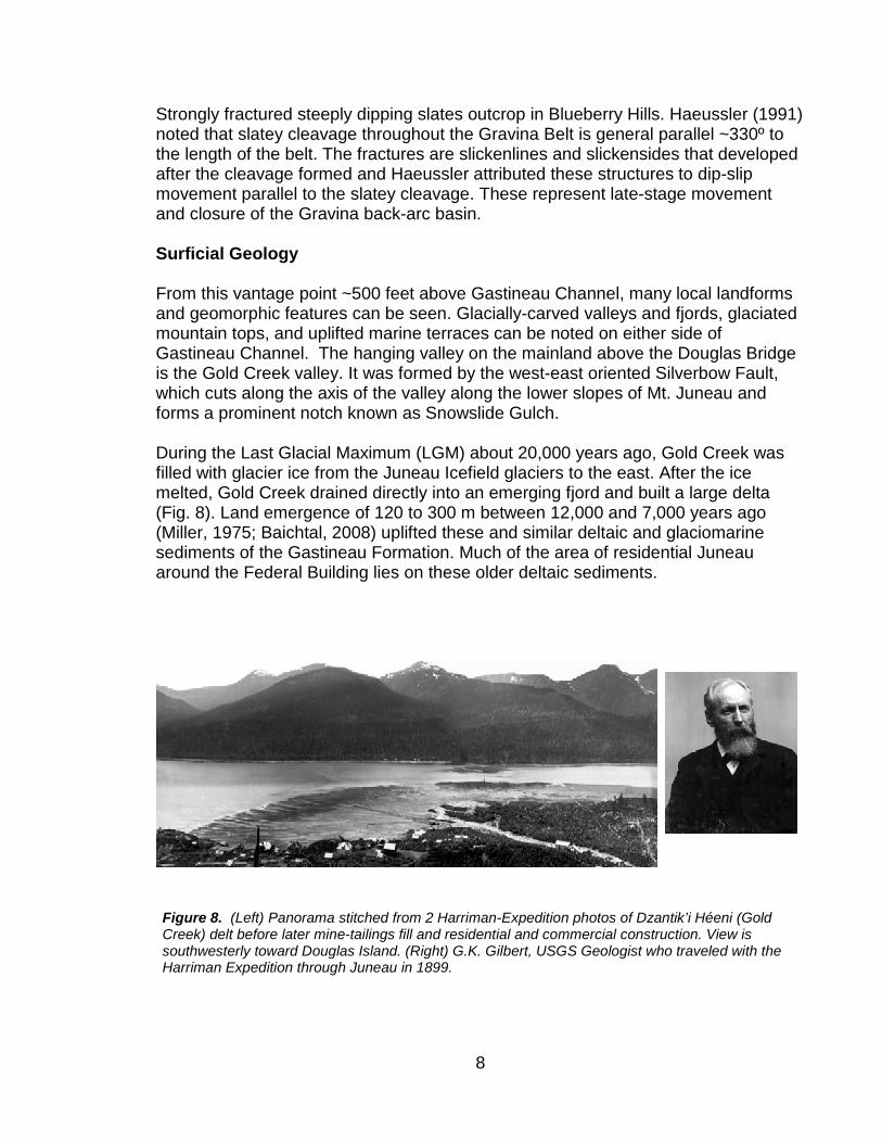
Strongly fractured steeply dipping slates outcrop in Blueberry Hills. Haeussler (1991) noted that slatey cleavage throughout the Gravina Belt is general parallel ~330º to the length of the belt. The fractures are slickenlines and slickensides that developed after the cleavage formed and Haeussler attributed these structures to dip-slip movement parallel to the slatey cleavage. These represent late-stage movement and closure of the Gravina back-arc basin. Surficial Geology From this vantage point ~500 feet above Gastineau Channel, many local landforms and geomorphic features can be seen. Glacially-carved valleys and fjords, glaciated mountain tops, and uplifted marine terraces can be noted on either side of Gastineau Channel. The hanging valley on the mainland above the Douglas Bridge is the Gold Creek valley. It was formed by the west-east oriented Silverbow Fault, which cuts along the axis of the valley along the lower slopes of Mt. Juneau and forms a prominent notch known as Snowslide Gulch. During the Last Glacial Maximum (LGM) about 20,000 years ago, Gold Creek was filled with glacier ice from the Juneau Icefield glaciers to the east. After the ice melted, Gold Creek drained directly into an emerging fjord and built a large delta (Fig. 8). Land emergence of 120 to 300 m between 12,000 and 7,000 years ago (Miller, 1975; Baichtal, 2008) uplifted these and similar deltaic and glaciomarine sediments of the Gastineau Formation. Much of the area of residential Juneau around the Federal Building lies on these older deltaic sediments.
Figure 8. (Left) Panorama stitched from 2 Harriman-Expedition photos of Dzantik’i Héeni (Gold Creek) delt before later mine-tailings fill and residential and commercial construction. View is southwesterly toward Douglas Island. (Right) G.K. Gilbert, USGS Geologist who traveled with the Harriman Expedition through Juneau in 1899.

9
High local uplift rates of 1.4 cm/yr (Larsen et al., 2003) following the Little Ice Age (LIA), coupled with a steady supply of glaciofluvial sediments transported to tidewater by the Mendenhall River and Lemon Creek, contribute to large river deltas developing along the channel causing infilling of Gastineau fjord near the Juneau Airport. Dredge spoil islands, created in the 1960s, are now forested and have elevations well above MHHW. This allows Douglas Island to be the Douglas “Peninsula” at low tides. On the southwest Douglas Island side of the channel, notice the prominent knobs and terraces at approximate 600–700 feet above sea level. These were eroded into the Treadwell Formation rocks of the Gravina Belt bedrock during Late Miocene to Early Holocene time as successive glaciations filled Gastineau Channel with ice. Crustal unloading and sea level rise at the end of the LGM produced glaciomarine diamictons (poorly sorted, largely unconsolidated glacially-derived sediments) and deltas unconformably overlying Gravina belt bedrock (Fig. 9). Uplifted marine sediments and beach deposits now remain in marked bathtub ring-like bands at low elevations around the Gastineau Channel area (Miller, 1975). The name Gastineau is thought to have come from John Gastineau, an English surveyor who came to Canada in 1858 (Orth, 1967).
Figure 9. Cross Section of Gastineau Channel showing glaciomarine, beach and deltaic deposits Gastineau Channel Formation Facies are first facies (gt), second facies (gg) and third facies (gs), providing information about uplift following deglaciation (R.D. Miller, 1975)

10
In the Gulf of Alaska glacially-derived sediments have created a depositional record that includes Late Pleistocene and Holocene offshore marine sediments. These sediments can be traced back to their specific bedrock terrane by using the sediments magnetic properties (e.g., Cowan et al, 2006) or the lithology of terrestrial morainal clasts (e.g., Glacier Bay, Ovenshine, 1967, Zhang and Gulick 2019). In Northern British Columbia, seismic surveys on the continental shelf primarily for oil exploration yielded information from sediment cores that have newly expanded our understanding of the LGM bathymetric, archeological and sea level history of this region (Carrara et al, 2006; Fedje and Mathewes, 2005). Landslides, Cruise ships, Powerlines
SEAK over-steepened fjords are vulnerable to mass wasting following deglaciation, seismic and storm events. In Glacier Bay the Tidal Inlet landslide (Fig. 10) could fail and generate large period impulse waves in the west arm of the bay imperiling cruise ship traffic (Wieczorek et al. 2007). Prominent avalanche and landslide paths can be seen on the channel facing slopes of Mt. Juneau and Mt. Roberts. These landslide chutes (Figs. 11 and 12) create serious hazards for the Juneau residents living downslope. The flatter, nearshore parts of the city and the Egan Highway were built on fill constructed from mine waste rock extracted from the A.J. Mine, whose mill ruins are just visible under vegetation on the lower slopes of Mt. Roberts.
The A.J. Mine extracted gold from quartz and calcite veins, mostly in the Taku Terrane greenschist facies phyllites (known as the Perseverance Group slates) that structurally overlie Gastineau Group metamorphic volcanic flows, breccias, and greenstones. In total, nearly 90 million tons of rock averaging ~0.05 oz/ton was
Figure 11. Surficial Geology of the Downtown Juneau-Gold Creek Area (R.D. Miller, 1975). Pink-shaded areas are landslides.
Figure 10. Tidal Inlet Landslide (Connor 2008).

11
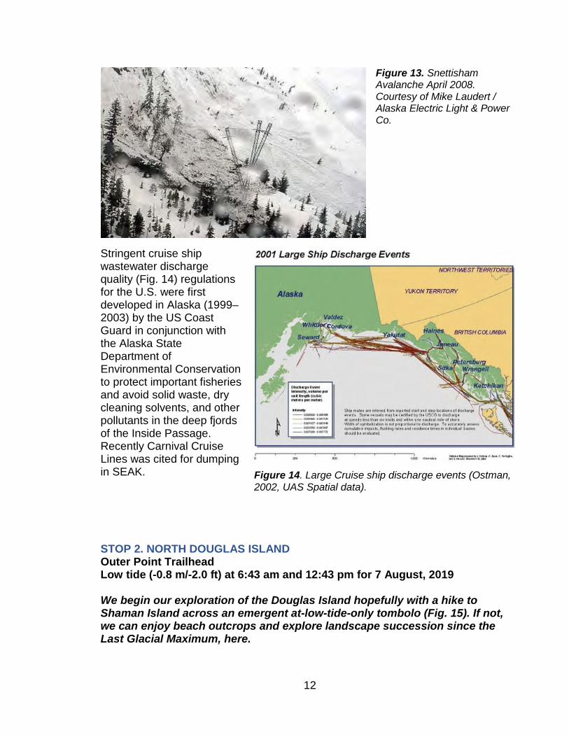
mined between 1887 and 1944 (Stone and Stone, 1983). The A.J. Mine was the most successful low-grade gold mine in North America. It produced $80 million worth of gold during a time when gold prices varied between $20/oz (1897–1933) and $35/oz (1934–1944). The mine closed permanently in 1944 during World War II. Efforts to reopen the mine by Echo Bay Mining Company between 1989 and 1997 failed due to combination of low gold prices ($368.62 average) and difficulties with obtaining permits for mine tailings disposal. In Juneau, avalanche paths have been mapped and monitored above the city. On April 16, 2008 and again in January 2009 heavy snowfall generated avalanches that knocked down hydropower transmission lines about 3 miles from the Snettisham Powerhouse, ~40 miles to the south of Juneau (Fig. 13). This required the local power company to run expensive diesel generators until repairs could be made. Record-breaking snow fall at high elevations in 2007–2009 suggested a shift in snowfall regime. Snowfall patterns in the following decade have changed since then.
Figure 12. Downtown Juneau avalanche paths avalanche path and corresponding used in the Juneau Access Draft Environmental Impact Statement (Steininger et al., 2003).
12
Stringent cruise ship wastewater discharge quality (Fig. 14) regulations for the U.S. were first developed in Alaska (1999–2003) by the US Coast Guard in conjunction with the Alaska State Department of Environmental Conservation to protect important fisheries and avoid solid waste, dry cleaning solvents, and other pollutants in the deep fjords of the Inside Passage. Recently Carnival Cruise Lines was cited for dumping in SEAK. STOP 2. NORTH DOUGLAS ISLAND Outer Point Trailhead Low tide (-0.8 m/-2.0 ft) at 6:43 am and 12:43 pm for 7 August, 2019 We begin our exploration of the Douglas Island hopefully with a hike to Shaman Island across an emergent at-low-tide-only tombolo (Fig. 15). If not, we can enjoy beach outcrops and explore landscape succession since the Last Glacial Maximum, here.
Figure 14. Large Cruise ship discharge events (Ostman, 2002, UAS Spatial data).
Figure 13. Snettisham Avalanche April 2008. Courtesy of Mike Laudert / Alaska Electric Light & Power Co.

13
Surficial Geology As we follow the Outer Point Loop trail toward the beach between Outer Point and False Outer Point near Shaman Island, we are traveling through an old growth maritime rainforest of Sitka spruce (Picea sitchensis) and western hemlock (Tusga hetrophylla). Past the old beaver dam pond filled with pond lilies and skunk cabbage is a muskeg with Lodgepole pine (Pinus contorta; Fig. 16). This surface was formed
Figure 15. Top) Map of the Outer Point Trail area and Shaman Island tombolo. Bottom) Vegetation succession diagram after Motyka (2003) indicating the relative age of various elevated surfaces can be determined by type and size of vegetation.

14
as a post-Little Ice Age uplift creating a raised barrier beach. The local sediment supply probably came from nearby Peterson Creek. Landward infilling with muskeg heath plants and sphagnum mosses culminated in the present western-hemlock forest (Brock, 2000, pers. commun.). Mann and Streveler (1997) found that this landward berm and upland complex contains well-developed soils with thick organic soil horizons. The Bsh horizon of this raised barrier beach surface yielded a radiocarbon age for 400 ± 50 yr. B.P. (Mann and Streveler, 1997). They also described the younger, lower seaward storm berm now forested with youthful Sitka spruce that we will walk through enrooted to the water’s edge. At Nine Mile North Douglas Highway, uplift and lack of local sediment supply resulted in a wave-eroded marine terrace that represents the emergence of 3.2 m since the late 18th century (Motyka, 2003). The surface is composed of Gastineau Formation Third Facies glaciomarine diamicton (Miller, 1975). By applying dendrochronology to local geomorphology, Motyka (UA Fairbanks) was able to determine LIA loading and unloading in the Juneau area (Fig. 17). Using tree cores to determine timing and rates of downslope spruce recolonization and comparing these chronologies with land emergence recorded as sea-level fall in local tide gauge data, an uplift rate of 1.3 cm/yr beginning between A.D. 1770 and 1790 was argued. Later, Larsen et al. (2003) measured a local Juneau uplift rate of 1.4 cm/yr using precise GPS measurements.
Figure 17. Spruce trees growing seaward on accretionary land after uplift (Motyka, 2003).
Figure 16. Muskeg Meadows on glacier till.
15
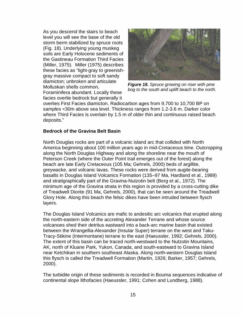
As you descend the stairs to beach level you will see the base of the old storm berm stabilized by spruce roots (Fig. 18). Underlying young muskeg soils are Early Holocene sediments of the Gastineau Formation Third Facies (Miller, 1975). Miller (1975) describes these facies as “light-gray to greenish-gray massive compact to soft sandy diamicton; unbroken and articulate Molluskan shells common, Foraminifera abundant. Locally these facies overlie bedrock but generally it overlies First Facies diamicton. Radiocarbon ages from 9,700 to 10,700 BP on samples <30m above sea level. Thickness ranges from 1.2-3.6 m. Darker color where Third Facies is overlain by 1.5 m of older thin and continuous raised beach deposits.” Bedrock of the Gravina Belt Basin North Douglas rocks are part of a volcanic island arc that collided with North America beginning about 100 million years ago in mid-Cretaceous time. Outcropping along the North Douglas Highway and along the shoreline near the mouth of Peterson Creek (where the Outer Point trail emerges out of the forest) along the beach are late Early Cretaceous (105 Ma; Gehrels, 2000) beds of argillite, greywacke, and volcanic lavas. These rocks were derived from augite-bearing basalts in Douglas Island Volcanics Formation (135–97 Ma, Hardland et al., 1989) and stratigraphically part of the Gravina-Nutzotin belt (Berg et al., 1972). The minimum age of the Gravina strata in this region is provided by a cross-cutting dike of Treadwell Diorite (91 Ma, Gehrels, 2000), that can be seen around the Treadwell Glory Hole. Along this beach the felsic dikes have been intruded between flysch layers. The Douglas Island Volcanics are mafic to andesitic arc volcanics that erupted along the north-eastern side of the accreting Alexander Terrane and whose source volcanoes shed their detritus eastward into a back-arc marine basin that existed between the Wrangellia-Alexander (Insular Super) terrane on the west and Taku-Tracy-Stikine (Intermontane) terrane to the east (Haeussler, 1992; Gehrels, 2000). The extent of this basin can be traced north-westward to the Nutzotin Mountains, AK, north of Kluane Park, Yukon, Canada, and south-eastward to Gravina Island near Ketchikan in southern southeast Alaska. Along north-western Douglas Island this flysch is called the Treadwell Formation (Martin, 1926; Barker, 1957; Gehrels, 2000). The turbidite origin of these sediments is recorded in Bouma sequences indicative of continental slope lithofacies (Haeussler, 1991; Cohen and Lundberg, 1988).
Figure 18. Spruce growing on riser with pine bog to the south and uplift beach to the north.

16
Evidence of collision structures include syndepositional soft sediment folding and possible block tilting, were also observed by Healer (1992). However, fossils are rare in these flysch beds. Berg et al. (1972) found an Albian (113 to 98 Ma) Cretaceous Inoceramus sp. fragment in strongly deformed slates on Douglas Island. Intrusion of dioritic dikes and sills of the Treadwell Diorite began 91 ± 2 Ma (Gehrels, 2000). Tectonically these bodies record arc magmatism along the inboard margin of the Alexander and Wrangellia terranes just before the beginning of mid-Cretaceous deformation. The collision zone to the east is marked by folding, thrust faulting and juxtaposition of the eastern terranes atop the younger Gravina belt rocks. Deformation continued until about 60 Ma, burying Tracy Arm terrane inboard rocks to depths as great as 30 km in Tracy and Endicott Arms south of Juneau. The Treadwell Formation flysch shows evidence of burial up to 300 ºC by presence of zeolite facies minerals such as prehnite and pumpellyite (Ford and Brew, 1977). The arc complex was structurally repeated and thickened along mid-Cretaceous imbricate thrust faults over the course of collision with North America This magmatism was followed by right-lateral strike slip motion along NNW oriented faults. Strain measured by Haeussler (1992) in Gravina flysch beds suggested the Gravina belt was shortened by half across its width (normal to foliation). Shortening was followed by right-lateral faulting parallel to the trend of the basin that may have displaced the Alexander Terrane rocks several tens of kilometers to the east in respect to rocks of the Taku Terrane. These sedimentary structures record a Resurrection Plate-driven head-on collision between these two terranes (Haeussler et al., 2003). To the west lies Admiralty Island where Gravina Belt conglomerates of the Seymour Canal Formation overlie Alexander terrane bedrock. The Chilkoot Peninsula to the northwest is composed of Alexander Terrane rocks. North of Shaman Island lie Portland and Shelter Islands over which the conglomeratic facies of the Graven Belt’s Seymour Canal Formation crop out. North of Outer Point, the Chatham Strait/Lynn Canal fjord was formed by dextral displacement along the Chatham Strait fault and later deeply eroded by glacier ice. This fault links up with the Denali fault to the north, which continues to the northwest through British Columbia and the Yukon and back into Alaska, where it slices the Alaska Range near Denali National Park. Activity on the Chatham Strait Fault began after mid-Cretaceous time with over 150 km of dextral offset measured (Hudson et al., 1982). The Denali fault is thought by Hickman et al. (1990) to have begun active displacement in Paleocene time. Lanphere (1978) and Nokleberg et al. (1985) estimate 350-400 km of dextral offset. The difference in offset between these two faults may be accommodate by strike slip in shear zones along the Fanshaw and Sumdum faults paralleling the western flanks of the Coast Mountains (Gehrels, 2000). This fault made national news on Nov. 3, 2002, when an Mw (moment magnitude) 7.9 earthquake associated with 340 km of surface rupture, was the largest strike-slip earthquake in North America in almost 150 years (Eberhart et al., 2003). GPS
17
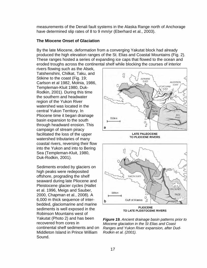
measurements of the Denali fault systems in the Alaska Range north of Anchorage have determined slip rates of 8 to 9 mm/yr (Eberhard et al., 2003). The Miocene Onset of Glaciation By the late Miocene, deformation from a converging Yakutat block had already produced the high elevation ranges of the St. Elias and Coastal Mountains (Fig. 2). These ranges hosted a series of expanding ice caps that flowed to the ocean and eroded troughs across the continental shelf while blocking the courses of interior rivers flowing such as the Alsek, Tatshenshini, Chilkat, Taku, and Stikine to the coast (Fig. 19; Carlson et al 1982, Molnia, 1986, Templeman-Kluit 1980, Duk-Rodkin, 2001). During this time the southern and headwater region of the Yukon River watershed was located in the central Yukon Territory. In Pliocene time it began drainage basin expansion to the south through headward erosion. This campaign of stream piracy facilitated the loss of the upper watershed tributaries of many coastal rivers, reversing their flow into the Yukon and into to Bering Sea (Templeman-Kluit, 1980, Duk-Rodkin, 2001). Sediments eroded by glaciers on high peaks were redeposited offshore, prograding the shelf seaward during late Pliocene and Pleistocene glacier cycles (Hallet et al. 1996, Meigs and Sauber, 2000, Chapman et al., 2008). A 6,000 m thick sequence of inter-bedded, glaciomarine and marine sediments is well exposed in the Robinson Mountains west of Yakutat (Photo 2) and has been recovered from cores in continental shelf sediments and on Middleton Island in Prince William Sound.
Figure 19. Ancient drainage basin patterns prior to Miocene glaciation in the St Elias and Coast Ranges and Yukon River expansion, after Dud-Rodkin et al. (2001).

18
Alaska’s first tidewater glaciers deposited the basal glacial-marine unit of the Yakataga Formation between 6.0 and 5.0 Ma (Miller, D.J., 1957, Eyles et al 1991, Lagoe et al, 1993). From west to east the Yakataga Formation extends 400 km along the Gulf of Alaska and inland 100 km; it is at least 1150 m thick under Prince William Sound (Molnia, 1986). Following a mid-Pliocene warming, glaciation intensified from 3 to 2 Ma. Deep Sea Drilling cores from Site 178 (von Heune, 1973, 1976) on the abyssal plain 400 km south of the coast contain ice-rafted debris of middle Pliocene age. Paleomagnetic reversals in Yakataga Formation sediments record deposition during the Olduvai Normal Polarity Subchron of 1.8 to 1.6 Ma through the Matuyama-Reversed Polarity Subchron 1.6-0.8 Ma (Figs. 20 and 21; Allison, 1976, Lagoe et al.,1993). Ice-rafted debris from Gulf of Alaska marine or nearshore ice lobes (Zhang and Gulick, 2019) have been found as far south as 44° N, offshore of Oregon, some 2000 km south of the Alaskan coast (Griggs and Kulm, 1969). The upper 100 m of the Yakataga Formation sediments indicate a second phase of glaciation began about 2.5 Ma. The sediment record also indicates an intensification in glacier cycling, presumably from repeated advances and retreats, between 100 ka and 40 ka. Glacier activity and not tectonic exhumation
Figure 20. Generalized stratigraphy of the Yakataga Formation and underlying Poul Creek Formation with magnetostratigraphy (Lagoe et al. 1993). Interpreted magnetic polarity bar shows periods of normal (black) and reversed (white) polarity. Ages of polarity transitions from Berggren and others (1985).
Figure 21. Yakataga Formation near Yakutat, as viewed from a Alaska Airlines 737 (Connor, 2006).

19
is responsible for these sediments as revealed by high resolution seismic data (Gulick et al. 2007). The Northern Cordilleran Volcanic Complex Following subduction of the Resurrection and Essamy ridges beginning 50 Ma (Madsen et al. 2006), the Queen Charlotte-Fairweather transform fault was formed and began the right lateral translation of the Pacific Plate to the NW past the North American Plate Margin (Figs. 22-25). To the south of Dixon Entrance, subduction of
Figure 22. Paleocene to Oligocene forearc, arc, and backarc magmatism of the Pacific Northwest, USA (Madsen et al., 2006), with the Coast Range Basalt Province, and the Chugach and Yakutat terranes, which accreted to the forearc area during Tertiary time. Arc magmatism is depicted in the pink fields and Eocene extended-arc to backarc magmatism in the light-green fields. Within these fields, the intrusions are pink and volcanic rocks are green. Shown in light gray are selected metamorphic core complexes exhumed during Eocene time. MCC—metamorphic core complex. Where plutons and volcanic exposures are small, they are depicted as diamonds or squares. Major strike-slip faults are shown as thin black lines

20
the present-day Explorer Ridge system has propagated a slab window under northern BC and southern SEAK and is exposing crustal rocks directly to the upper mantle. Extension and right lateral offset has created an extensive fracture system and widespread magmatism resulting in eruptions of the Northern Cordilleran Volcanic Province (Karl et al, 2008). Neogene-Quaternary magmas have surfaced through the fracture systems mostly in two distinct pulses (8-4 Ma and 2-0 Ma), and the mean rate of magma production was higher from 7 to 5 Ma than from 2 to 0 Ma (250 km3 /m.y. vs. 100 km 3 /m.y.; Edwards and Russell, 2000).The first pulse of magmatism correlates with a period of net extension along the Pacific-North American plate margin. The second pulse (2-0 Ma) resulted from local domains of extension during a period of net compression between the Pacific and North American plates (Edwards and Russell, 2000).
Figure 24. Subducted Pacific Plate beneath SEAK at 10 Ma ((Madsen et al., 2006)
Figure 23. Model of slab-window boundaries beneath the Yukon, BC and SEAK related to subduction of Resurrection and Essamy Ridges at 53 Ma (Madsen et al., 2006).

21
Figure 25. Present day slab window boundaries related to migration of the Explorer, North American, and Pacific Plate Triple Junction and oblique subduction of Pacific Plate along the Queen Charlotte Fairweather Fault. (Madsen et al, 2006). LM—Level Mountain, ME—Mount Edziza. Ice loading and migration of glacial forebulges during successive glaciations may have influenced the timing of eruptive phases from Yakutat to Suemez Island resulting in earthquakes and subglacial eruptions (Baichtal and Karl, 2009, Sauber and Ruppert, 2008; Greene et al. 2007). Alkaline and bimodal volcanoes such as Tseax Cone north of Prince Rupert, and the 2,787 m Mt. Edziza volcano shield volcano in the upper Stikine River watershed have all formed since Miocene time. Volcanic Hawaiite
Figure 26. Lava Falls in the Bradfield canal area on the mainland in central SEAK (Stephen B. Lewis, 2005).

22
basalts from Suemez Island near Obsidian Bay have yielded ages of about 684,000 years ago (Karl et al. 2008). Subglacial eruptions of obsidian are likely on Suemez Island (Baichtal and Karl, 2009) and on the mainland near Ketchikan, forming an important resource and trade item for early southeast Alaskan coastal residents. Additional obsidian sources have been found ~80 km from tidewater up the Stikine River at Mt Edziza (Photo 3; Moss et al, 2001). Young lava flows (100 to 300 years in age) can be found at Lava Falls in the Bradfield Canal area east of Ketchikan and Wrangell (Fig. 26). The Edgecumbe volcanic field is identified by the prominent stratocone on Kruzof Island (Fig. 27) as viewed from Sitka’s western skyline. The field formed initially as basaltic aquagene tuffs emerged onto the continental shelf beginning about 600,000 YA near Krestoi Point (Photo 5; Riehle, 1996). Explosive dacitic and rhyolitic eruptions began about 14,000 YA following withdrawal of glacier ice (Riehle, 1996). Ash layers ~1m thick can be seen around Sitka, and are 100m thick on Kruzof Island. An eruption which occurred 11,250 BP was recorded widely in tephra layers around northern Southeast AK (Mann and Streveler, 2008; Beget and Motyka, 1998; Riehle, 1996). The extensive Mt Edgecumbe volcanic field erupted about 600 km2 of pahoehoe and a’a lavas flows, lobate lavas, collapsed lava tubes and vesiculated basalts about 7,000 years ago across the continental shelf along the west side of Kruzof Island
Figure 27. (Top) Mt Edziza from the Cassiar Highway (Connor 2005); (Middle) Mud Bay, Kruzof Island ~600,000 YA aquagene tuffs erupted onto glaciated Cretaceous Sitka graywacke bedrock (Jess Parks Photo 2008); (Bottom) Mt Edgecumbe and Crater Ridge Peaks on Kruzof Island NW of Sitka (Jess Parks Photo 2008).

23
(Greene et al. 2007). The lack of pillow basalts in the presently submerged portions of the lava field suggest it was either formed subaerially, subglacially, or in shallow marine water and that it has subsided 300 m since its formation (Greene et al. 2007). The Pleistocene Climate in Southeast Alaska Middle Pleistocene (700–130 ka) On Prince of Wales (POW) Island and elsewhere, carbonate bedrock of the Alexander Archipelago, rainwater and low pH muskeg waters have dissolved Silurian and Devonian-aged limestones to form an extensive karst landscape with abundant caves formed along the regional vertical bedrock fracture system (Fig. 28). Many caves have been mapped and inventoried by volunteers with the Tongass Cave Project (1970-2009). U-Th ages determined on speleothems from On Your Knees Cave on Northern POW indicate that by 185 ka, caves were already well-developed (Dorale, 2003). Fossils recovered from deposits represent a variety of plant and animal remains, including the oldest human remains found to date in the region (10,300 calendar years). Radiocarbon ages range to >40 ka to middle Wisconsin and late Holocene (Heaton and Grady, 2003; Dixon, 2001). Obsidian, rhyolite, and hawaiite were erupted subglacially on Suemez Island off the Southwest Coast of POW about 684 kyr (Karl et al., 2008). Middle Wisconsin Interstadial Mid-Late Pleistocene (70–20 ka) Remains of mammals, birds, fish and pollen from cave sediments over time represent multiple environments ranging from cold Arctic tundra, to drier and warmer fire-prone pine forests, to cool and wet maritime rainforests. Caves such as El Capitan (Fig. 28) contained the remains of arctic mammal faunas that thrived during the LGM when local sea ice expanded (Table 1). Alpine fauna found in caves that were extirpated from POW Island during the LGM include hoary marmot (Marmota), heather vole (Phenocomys intermedius), lemming (Lemmus sibericus), red fox (Vulpes vulpes), and steppe antelope (Saiga). In addition northern sea lion (Eumetopias jubatus) and harbor seal (Phoca vitulina) were present. Ringed seals disappeared with glacier retreat but arctic foxes were present an additional 2,000 years after the end of the Pleistocene (Heaton and Grady, 2003). Brown bear (Ursus arctos), American black bear (Ursus americanus), river otter (Lontra sp.), and caribou (Rangifer tarandus) were present both before
Figure 28. Ice over karst is recorded by morainal deposits at the entrance to El Capitan Cave on Northern POW (Connor 2005)

24
and after the LGM but brown bear and caribou are no longer present on POW island. Remains from the cave reveal that during the LGM, parts of the southern Alexander Archipelago were nonglaciated refugium that integrally supported arctic and temperate terrestrial mammal populations (Heaton and Grady, 2003). In the northern archipelago radiocarbon ages >49 kyr cal. B.P. on Juneau area sediment from the east side of Montana Creek, record a pollen assemblage of sage (Artemisia, 35% of total) and sedge (25% of total), with pine (Pinus, 14%), fir (Abies 6 %), hemlock (Tsuga, 1%), spruce (Picea), and alder (Alnus) that together reflect the ice withdrawal from interior valleys prior to the LGM. (Leopold and Mann, 1986; Ager, personal comm. 2008).
Table 1. Timeline for selected species from Prince of Wales (POW) Island from Heaton and Grady (2003).

25
Sea Level Change The history of sea level change is complicated in this region. Globally the eustatic sea level was 125 m lower during the LGM (24–16 ka; Yokoyama et al, 2000) but locally, variation in ice loading and the viscoelastic response of the underlying crust significantly affected relative sea levels (Fig. 29). Glacier limits in this region show up best in continental shelf bathymetry where piedmont lobes expanded onto and across an emergent continental shelf, and carved U-shaped submarine troughs that transect the continental shelf between Cape Suckling and Dixon Entrance (Greene et al. 2007). Onshore piedmont glacier lobes align seaward with these erosional geomorphic features from major fjord mouths or river valleys (Carlson et al, 1982, Molnia, 1986). The presently submerged shelf platform varies from 100 km wide near Cross Sound narrowing to 50 km near the Queen Charlotte Islands (Fig. 30; Carrara et al, 2006). On the
Figure 29. Profile of flexure and migration of glacier forebulge in southeast Alaska.
Figure 30. Icesheet over flexible lithosphere with forebulge loading forward of ice terminus near the Queen Charlotte Islands (Hetherington et al. 2003)

26
mainland, glaciers also carved grooves into bedrock pavements (Miller, D.J. 1953), formed alpine cirque basins (Miller, M.M., 1961) and scoured trimlines into areas like the upper Juneau Icefield (Fig. 31), the Alsek River Valley, Lynn Canal, and Glacier Bay National Park and Preserve (McKenzie and Goldthwait, 1971) STOP 3. EAGLECREST AND FISH CREEK Eaglecrest Fish Creek Quarry We continue 5.4 miles eastward along the North Douglas Highway to the Eaglecrest Ski Area turnoff. About 4 miles up the road we will stop at a small City and Borough of Juneau Quarry. Bedrock near Fish Creek We are driving through metagraywacke and slates metamorphosed to prehnite-pumpellyite facies (Ford and Brew, 1977). These two USGS researchers named the geomorphic lineament that defines the Fish Creek Valley as the Fish Creek thrust. There is no evidence of shearing along this fault to the east in North Douglas Highway road-cuts. However, one kilometer to the west of Fish Creek, there are 1-2 m sections of deformed rocks with preserved bedding (Haeussler, 1992). These show intensely asymmetrical folds in foliated schistose rocks and also contain slickensides which imply a sense of northeast over southwest shear (Haeussler, 1992). The Fish Creek fault extends to the south-southeast on Douglas Island and probably continues across Stephen’s Passage into Northern Admiralty Island near Oliver’s Inlet. Miller (1975) mapped offset in the Silverbow fault where it is crossed by the Fish Creek fault about 1 mile past the Fish Creek Bridge along the Eaglecrest Road.
Figure 31. Nunataks above glacially sculpted bedrock of the Paleocene Great Tonalite Sill forms the eastside of Lynn Canal (fjord) along proposed Juneau Access Road corridor (Connor, 2005).
27
The Silverbow Fault is an east-west trending thrust fault that has in turn offset an Eocene (Miller et al., 2000) gold orebody. Cross-cutting structural relationships from mining adits suggests activity on the Fish Creek fault postdates Juneau Gold Belt ore emplacement during Eocene time. We continue to see Gravina Belt volcanic rocks on Douglas Island that are porphyritic augite basalts (Gehrels, 2000). The diopsidic augite phenocrysts are subhedral to euhedral ~5 mm and aluminous (~6 wt.% Al2O3). The high Ca content of these clinopyroxenes are comparable with those in the Bridgit Cove basalts northwest of Auke Bay. In both areas, the basalts show increasing Al2O3, TiO2, and Na2O with increasing Mg/Fe (Stowell et al., 2000). Surficial Deposits About 3 to 30 meters of Pleistocene and Holocene older outwash and gray to greenish-gray heterogeneous, deeply weathered and very compact Older Till (Pleistocene) were mapped by Miller (1975) in middle to upper Fish Creek Valley respectively. Miller attributes the till to Juneau Icefield expansion moving south-westward during pre-Fraser to early Fraser (Wisconsin) time across Gastineau Channel and over Douglas Island. Damore and others (2004) characterized soil type, storage, and export of carbon in SEAK peatlands and forested wetlands to investigate carbon storage in wetland soils and its export to streams. The majority of terrestrial carbon in SEAK is stored in extensive wetlands dominated by peat, i.e., in bogs/muskegs. This carbon stock is believed to contribute much dissolved organic carbon (DOC) to streams. Wetland soils in SEAK vary widely in organic matter depth and decomposition that inherently influence both carbon and nutrient cycles within these different soils. Here, the bog has a deeper peat accumulation compared to the forested wetland although DOC concentrations are higher in lysimeters in the forested wetland (70 to 90 mg C/L) than the peatland (20 to 49 mg C/L). DOC concentration in wells (15 to 45 mg C/L) and export from tributaries (5 to 41 mg C/L) draining both the forested wetland and peatland was similar with peak DOC concentrations and export linked to high soil temperatures and storm flushing in mid-summer. This relationship would support a positive feedback of increased DOC export with warmer temperatures and higher rainfall in the hypermaritime ecosystem of coastal North America (Damore et al, 2004). STOP 4. LEMON CREEK To Lemon Creek Older Delta Deposits Taku Terrane As we drive back across the Gastineau Channel and along the base of Mount Juneau and Blackerby ridge into the Lemon Creek Valley we are following the trace of the Fanshaw fault and looking at rocks of the overriding Permian to Triassic Taku Terrane. These rocks were accreted to the mainland inboard of the Gravina Belt

28
rocks and overrode them along the Fanshaw Fault. The fault zone developed a 400 m thick zone of phyllite and chlorite schist, documented within a 1600 m drill hole beneath Gastineau Channel that displays evidence of both ductile and brittle deformation (Miller et al., 1992). The Taku Terrane was defined originally by Berg et al., (1972, 1978) as a volcanic and sedimentary sequence of rocks that outcrop along the western flanks of the Coast Mountains. The Gastineau Group of this terrane package consists of unnamed Permian or older slate and volcaniclastic layers, and Permian metabasalt and marble. The Perseverance Group of the Taku Terrane is made of Middle and Upper Triassic metabasalt and overlying metapelite (Gehrels et al., 1992). The Taku Terrane is truncated north of Berner’s Bay by the Coast Shear Zone and tonalitic sills. This package of rocks is fault bounded to the east along the Sumdum thrust where it has been overridden by rocks of the Tracy Arm Terrane (Berg et al., 1978). These rocks are also variability identified as as the Yukon Tanana Terrane (Gehrels et al., 1992), the Nisling terrane (Wheeler et al., 1991), and the Florence Range metamorphic suite (Currie, 1990). We will encounter the Tracy Arm terrane rocks on Saturday in…Tracy Arm! Plafker and Hudson (1980) believed the Taku Terrane was deposited as distal and deeper water facies of the Wrangellia terrane that overlies the Alexander Terrane to the west of this region. The Taku Terrane contains tholeiitic lavas interbedded with basinal chert and shale (Gehrels, 2000). Note the NE-dipping Taku Terrane rocks cropping out along the top of Heintzelman Ridge on the west side of the Lemon Creek valley. The Fanshaw/Gastineau Channel Fault cuts through the southern (channel-side) end of lower Heintzelman Ridge and Gravina Belt rocks form the southern knobby end of the ridge. Uplift and Sea level Rise following LGM Deglaciation
Local area crustal change began with the maximum late Pleistocene loading of the land that was followed by ice sheet retreat and marine incursion into the glacially eroded valleys. A halt and/or slowing of uplift allowed the older delta deposits to accumulate in Auke Bay, Montana Creek, Lemon Creek, Salmon Creek, and God Creek along the mainland eastern shore of Gastineau Channel, and Eagle, Lawson, and Bear Creeks on the Douglas Island side of Gastineau Channel. Some of these deposits were later covered by younger diamicton as land lift accelerated relative to sea level rise. Reworked Gastineau Formation First Facies erratics were deposited as beach gravels atop the Third Facies. Miller (1973) reported a minimum LGM land emergence in the Juneau area of 152 m with local highs of 229 m in places like Salmon Creek. This uplift carried the oldest First Facies of the Gastineau Formation above its sea level origin. On the hillside above the Costco parking lot and across Lemon Creek from the Lemon Creek Correctional Facility, the City and Borough of Juneau has been
29
excavating. Late Pleistocene to early Holocene brown to dark-brown silty sandy gravels and gravelly sand beds were deposited here between 12–10 ka (Miller, 1975). The beds are steeply dipping (45º dip slopes on foresets beds are common) and contain layers of diamicton interbedded with gravel. Locally a blanket of diamicton overlies the deltaic gravels with an average thickness of about 9 m. Miller (1975) studied the variable glaciomarine sediments, uplifted deltaic and beach deposits throughout the Juneau region as the three facies of the Gastineau Formation. He used their elevations and locations to construct an uplift scenario following the LGM for this area. Lemke and Yehle (1978) mapped similar uplifted glaciomarine diamicton sediments in upper Lynn Canal and around Petersburg on northern Mitkof island. In the southern archipelago and northern Queen Charlotte Islands, glacier loading depressed the crust and locally raised sea level during the LGM. Large regions of emergent outer continental shelf provided refugia and formed a prominent terrace at 165 m below modern sea level. These were subsequently inundated when the rising forebulge collapsed and the rising sea flooded over. Uplifted marine shell beds
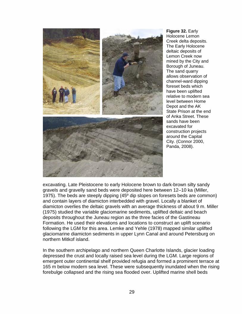
Figure 32. Early Holocene Lemon Creek delta deposits. The Early Holocene deltaic deposits of Lemon Creek now mined by the City and Borough of Juneau. The sand quarry allows observation of channel-ward dipping foreset beds which have been uplifted relative to modern sea level between Home Depot and the AK State Prison at the end of Anka Street. These sands have been excavated for construction projects around the Capital City. (Connor 2000, Panda, 2008).

30
record high sea stands on POW (Baichtal, 2008). Marine transgression was as great as 350 m in the Juneau area (Miller, 1972, 1973a, b; 1975, Baichtal, 2008) when a
31
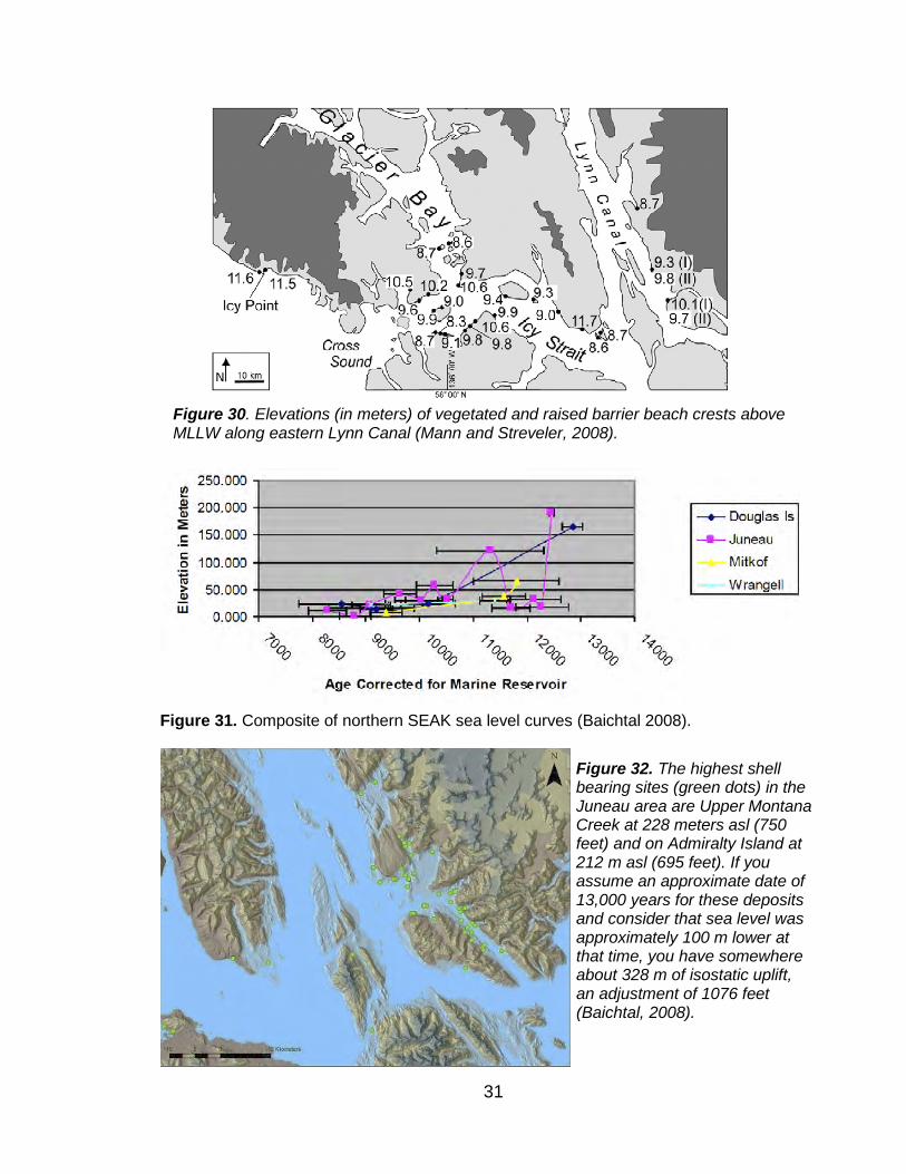
Figure 30. Elevations (in meters) of vegetated and raised barrier beach crests above MLLW along eastern Lynn Canal (Mann and Streveler, 2008).
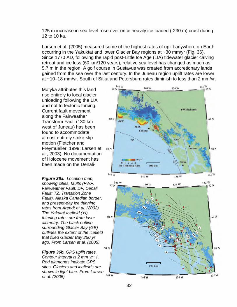
Figure 31. Composite of northern SEAK sea level curves (Baichtal 2008).
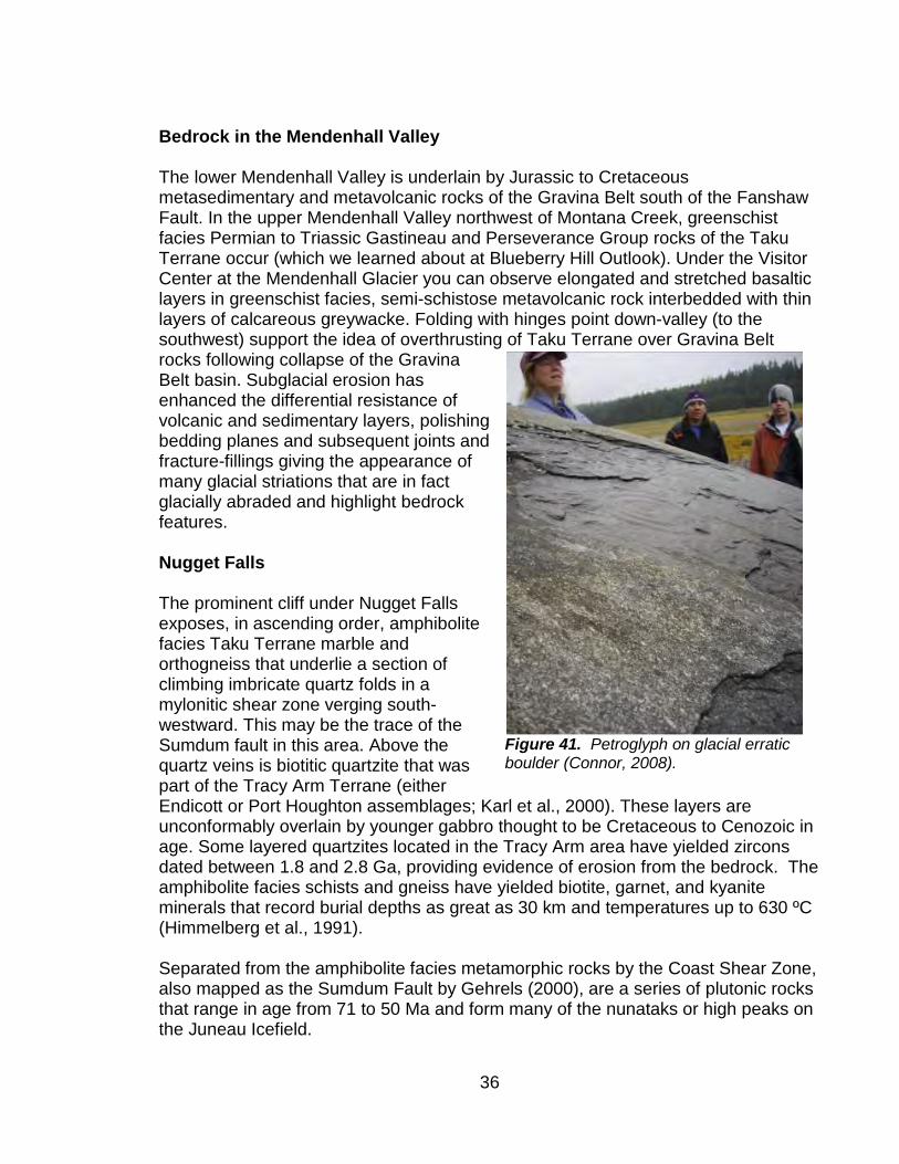
Figure 32. The highest shell bearing sites (green dots) in the Juneau area are Upper Montana Creek at 228 meters asl (750 feet) and on Admiralty Island at 212 m asl (695 feet). If you assume an approximate date of 13,000 years for these deposits and consider that sea level was approximately 100 m lower at that time, you have somewhere about 328 m of isostatic uplift, an adjustment of 1076 feet (Baichtal, 2008).
32
125 m increase in sea level rose over once heavily ice loaded (-230 m) crust during 12 to 10 ka. Larsen et al. (2005) measured some of the highest rates of uplift anywhere on Earth occurring in the Yakuktat and lower Glacier Bay regions at ~30 mm/yr (Fig. 36). Since 1770 AD, following the rapid post-Little Ice Age (LIA) tidewater glacier calving retreat and ice loss (60 km/120 years), relative sea level has changed as much as 5.7 m in the region. A golf course in Gustavus was created from accretionary lands gained from the sea over the last century. In the Juneau region uplift rates are lower at ~10–18 mm/yr. South of Sitka and Petersburg rates diminish to less than 2 mm/yr. Motyka attributes this land rise entirely to local glacier unloading following the LIA and not to tectonic forcing. Current fault movement along the Fairweather Transform Fault (130 km west of Juneau) has been found to accommodate almost entirely strike-slip motion (Fletcher and Freymueller, 1999; Larsen et al., 2003). No documentation of Holocene movement has been made on the Denali-
Figure 36a. Location map, showing cities, faults (FWF, Fairweather Fault; DF, Denali Fault; TZ, Transition Zone Fault), Alaska Canadian border, and present-day ice thinning rates from Arendt et al. (2002). The Yakutat Icefield (YI) thinning rates are from laser altimetry. The black outline surrounding Glacier Bay (GB) outlines the extent of the icefield that filled Glacier Bay 250 yr ago. From Larsen et al. (2005). Figure 36b. GPS uplift rates. Contour interval is 2 mm yr−1. Red diamonds indicate GPS sites. Glaciers and icefields are shown in light blue. From Larsen et al. (2005).

33
Chatham Strait Fault system that lies 30 km to the west of Juneau. STOP 5. MENDENHALL GLACIER VISITOR CENTER Photo Point Outlook Trail We will proceed from the Visitor Center along the Photo Point Trail to the outlook at the end of the spit; alternately along Nugget Falls trail. The Last Glacial Maximum in Southeast Alaska (22, 000-17,000 B.P.) The high mountains bordering the Gulf of Alaska combine cool temperatures and prodigious precipitation from the Northern Pacific Aleutian Low to support one of the largest concentrations of glaciers outside of polar regions. These glacier systems extend from Yakutat Bay to Dixon Entrance, and profoundly influence the extant maritime rainforest (Carrara et al, 2006).
During the LGM, Cordilleran ice flowing out of icefields in the St Elias, Fairweather, and Coast Mountains, coalesced with local valley glaciers and filled fjords to flow seaward (Figs. 37 and 38; Kaufman and Manley, 1996, Carrara, et al. 2006). The North Pacific was relatively ice free during this time (Mann and Hamilton, 1995). Maximum glacier extents were out of phase from north to south. Northern glaciers
Figure 37. Paleoglacier Atlas of Alaska during the Late Wisconsin glacier Maximum (Manley and Kaufman, 1996). http://instaar.colorado.edu/QGISL/ak_paleoglacier_atlas/index.html

34
on Shelikof Strait and Cook Inlet reached their outer limits between 23,000 and 16,000 yr BP. In southeast AK, the Cordilleran glaciers expanded and flowed into fault-formed valleys such as Cross Sound, Lynn Canal, Chatham Strait, Gastineau Channel, Stephens Passage, Clarence Strait, and Frederick Sound At high elevations in the Alexander Archipelago and coastal British Columbia, ice thickened to the 1829 m level between 28,000 and 17,000 BP. To the far south, the ice formed a lobe that filled Puget Sound and flowed over Seattle by 17,000 BP (Carrara et al, 2003; Clague et al, 2004). Glacier retreat was also time-transgressive; 16,000 BP in south-central Alaska and 14,000–13,000 in SEAK and BC (Mann and Hamilton, 1998).
Mendenhall Glacier History Repeated Pleistocene erosion by glacier ice flowing off the Juneau Icefield eroded the Mendenhall Valley (Figs. 39 and 40). Ice reached maximum thickness of ~1.6 km near the Mendenhall Towers during the LGM (Coulter et al., 1962). More recent studies of the Mendenhall Glacier by University of Alaska researchers (i.e., Motyka et al., 2002) has revealed that the Mendenhall Glacier’s area-per-unit elevation at the 2000 A.D equilibrium line (1150 m) was quite high. There is no doubt it will be above 1225 m this summer likely reaching at least 1300 m (Pelto, pers. com., July 2019). The average annual temperature has increased ~1.6 ºC since 1943. Glacier-wide net mass balance in 2000 A.D. was strongly positive and equivalent to about +1.14 m water-equivalent, reversing a long trend of negative balances. The terminus region continues to thin, losing as much as 8 m annually since 1995. The glacier has retreated 4.5 km between 2000 and 1767 A.D. Seventy percent of this retreat occurred during the 20th century and shrinkage is mostly due to climatic warming.
Figure 38. Map of southern southeast Alexander Archipelago showing locations of Cordillera Ice on the continental shelf and ice-free refugia (Carrara et al. 2006).

35
The summers of 2016-2019 in Alaska have broken all previous records for high temperatures. The glacier lost 5.5 km3 of its ice volume between 2000 and 1948, the equivalent of an ice cube 1.6 km on each side. Excess glacier melt contributes to 13% of the average annual discharge of the Mendenhall River and up to ~50% of the average
daily discharge of the Mendenhall River during the summer. The thickest ice was at the 700 m elevation is ~600 m thick in 2000. Surface ice velocity at this locality was 160 m/yr. Connor (2002, unpublished data) measured bathymetry along the lakefront terminus, and found a 90 m maximum depth to the lake bottom (110 m below sea level). Ice
thickness deepens to 110 m (130 m below sea level) up-glacier from the terminus and continues for another 600 m. The near-buoyant lakefront terminus was particularly vulnerable to ice loss by calving because of low ice cliffs and this deep lake basin between 2000 and 2014. It is likely the Mendenhall Glacier terminus will recede completely out of the lake and onto land within the few years if current climatic conditions continue.
Figure 39. Mendenhall Glacier and River at the start of the 20th century (C. Wright, 1902).
Figure 40. Surficial Deposits of North Douglas Island (Miller, 1975)
36
Bedrock in the Mendenhall Valley The lower Mendenhall Valley is underlain by Jurassic to Cretaceous metasedimentary and metavolcanic rocks of the Gravina Belt south of the Fanshaw Fault. In the upper Mendenhall Valley northwest of Montana Creek, greenschist facies Permian to Triassic Gastineau and Perseverance Group rocks of the Taku Terrane occur (which we learned about at Blueberry Hill Outlook). Under the Visitor Center at the Mendenhall Glacier you can observe elongated and stretched basaltic layers in greenschist facies, semi-schistose metavolcanic rock interbedded with thin layers of calcareous greywacke. Folding with hinges point down-valley (to the southwest) support the idea of overthrusting of Taku Terrane over Gravina Belt rocks following collapse of the Gravina Belt basin. Subglacial erosion has enhanced the differential resistance of volcanic and sedimentary layers, polishing bedding planes and subsequent joints and fracture-fillings giving the appearance of many glacial striations that are in fact glacially abraded and highlight bedrock features. Nugget Falls The prominent cliff under Nugget Falls exposes, in ascending order, amphibolite facies Taku Terrane marble and orthogneiss that underlie a section of climbing imbricate quartz folds in a mylonitic shear zone verging south-westward. This may be the trace of the Sumdum fault in this area. Above the quartz veins is biotitic quartzite that was part of the Tracy Arm Terrane (either Endicott or Port Houghton assemblages; Karl et al., 2000). These layers are unconformably overlain by younger gabbro thought to be Cretaceous to Cenozoic in age. Some layered quartzites located in the Tracy Arm area have yielded zircons dated between 1.8 and 2.8 Ga, providing evidence of erosion from the bedrock. The amphibolite facies schists and gneiss have yielded biotite, garnet, and kyanite minerals that record burial depths as great as 30 km and temperatures up to 630 ºC (Himmelberg et al., 1991). Separated from the amphibolite facies metamorphic rocks by the Coast Shear Zone, also mapped as the Sumdum Fault by Gehrels (2000), are a series of plutonic rocks that range in age from 71 to 50 Ma and form many of the nunataks or high peaks on the Juneau Icefield.
Figure 41. Petroglyph on glacial erratic boulder (Connor, 2008).
37
Up the Mendenhall Glacier, Mt. Stroller White, The Mendenhall Towers, and Mt. Wrather are made of a Late Cretaceous (71 Ma in Juneau area) Tonalite Sill extending 1500 km from Skagway to Prince Rupert and is synkinematic with respected to steeply dipping, ductile fabrics of the latest Cretaceous-Paleocene Coast Shear Zone (Gehrels, 2000). The tonalite sill grades to the east into granodiorite bodies that are overall less elongated and less deformed. STOP 7. SKATER’S CABIN
Figure 42. (Top) Skater’s Cabin first built by the Civilian Conservation Corps in the 1930s. From Santosh Panda, 2008; (Bottom) Skater’s Cabin and Mendenhall Glacier in 2013.

38
Juneau and the Little Ice Age Glacier Bay Tlingit people were forced out of the bay by an advancing glacier around 1760 (Dauenhauer and Dauenhauer, 1987, Monteith et al. 2007, Mann and Streveler, 2008, Connor et al. 2009). By 1794, George Vancouver had explored the region and documented ice terminus positions especially in Glacier Bay, where a calving retreat had begun following the destabilization of LIA shoal and tidewater terminus in Icy Strait (Mann and Streveler, 2008). In the Mendenhall Valley, the terminal Little Ice Age moraine of the Mendenhall Glacier was positioned over Back Loop Road and occupied the upper Mendenhall Valley (Miller, 1975). Finney and others (2000) have utilized fish weir records and nitrogen isotopes in lake sediments to reconstruct salmon population histories in the region. The 35 year fish weir record in Auke Lake maintained by the NOAA Auke Bay Lab (Taylor, 2008) has the potential to support similar studies of paleo-salmon productivity in lake cores for this locality. Calkin et al (1988, 2001) and Barclay et al (2006) have summarized the Holocene and LIA history of the Gulf Coast. Studies in the Mendenhall Valley include dendrochronology (Lawrence, 1950; Lacher, 1999), valley stratigraphy (Barnwell and Boning 1968; Miller, 1975), soils (Heusser, 1960; Alexander and Burt, 1996), fluvial and groundwater hydrology (Neal and Host, 1999; Hood and Scott, 2008), glacial history (Miller, 1975; Miller,1986; Motyka et al., 2002), and current glacier recession (Boyce et al., 2007). A fishtrap buried near the confluence of the Mendenhall and Montana Creek Rivers was dated at ~1252 AD (Moss, 2004). Alexander and Burt, (1996) studied soils on the sequence of well drained Neoglacial moraines up to 240 years-old in the Mendenhall Valley, plus an older soil, to investigate soil development through the initial stages of podzolization. Pebbles and cobbles in the moraines are about 75 to 80% granitic rock. Computations based on minerals observed optically and on chemical analyses indicate that plagioclase and quartz are the predominant minerals.The climate is perihumid. Leaching of the moraines may have begun before they were free of glacial ice but little organic matter accumulated under the initial vegetative cover of sparse dwarf fireweed (10-year site). As alder thicket developed, organic matter accumulated rapidly in Oi, Oe, and A horizons (38-year site). As spruce trees began to replace alder, organic matter was lost from the surface mineral soil to form an E horizon and an incipient Bs horizon formed below it, an Oa horizon formed, and the A horizon disappeared (70- and 90-year sites). Organic acid leaching continued, to form a spodic Bhs horizon in spruce forest (240-year site) and a spodic Bh horizon in spruce−hemlock forest (>240-year site). Hornblende has been etched slightly within 240 years, apatite has been lost from E horizons and free-Fe, presumably held in ferrihydrite, has accumulated in B horizons. The younger moraine soils, both with and without incipient Bs horizons, are Typic Cryorthents and the 240-year-old and older soils with spodic Bhs and Bh horizons are Typic Haplocryods. They are expected to

39
accumulate more organic matter and become Andic Humicryods, which is the most common subgroup of soils in the area (Alexander and Burt, 1996). Ongoing Change Motyka and Beget (1996) and Post and Motyka (1995) documented calving advance and retreat of the Taku Glacier across Taku Inlet. Nolan et al. (1996) used geophysical methods to determine that the Juneau Icefield’s largest glacier, the Taku Glacier, was 1477 m thick in its lower regions and found that for over half the length (35/55 km) it lies well below sea level.
Studies by the Juneau Icefield Research Program (JIRP) for the past 60 years in the region measured 7.5 km of advance on the Taku Glacier, glacier thickening, and equilibrium flow for the past 50 years (Pelto et al. 2008). Ongoing measurements collected by a distributed sensor network have documented the timing and subglacial discharge of glacial lake outburst floods on the Lemon Creek Glacier system (Heavner et al. 2008). Arendt et al. (2002) have measured ice loss and glacier thinning along Alaska’s coastal glaciers and attribute 0.27 mm/yr of global sea level rise to Alaskan glacier ice loss. Hood and Scott (2008) found the concentration of nutrients entering coastal watersheds in southeast Alaska is in part controlled by the extent of glacial coverage in the river catchment area. Changing amounts of glacial coverage in southeast Alaska watersheds could affect nutrient
Figure 43. Repeat photography of Taku Glacier taken by William S. Cooper in 1916 and R. Lawrence in 1949. Note growth of Taku Glacier (right) and reduction in Norris Glacier (Left). (Lawrence, 1950)

40
concentrations and change the nutrient cycling in coastal ecosystems along the Gulf of Alaska.
Return to the Glacier Highway and continue right (west) toward Auke Bay. Our next stop will be a new highway exposure just past the turn-off for Auke Village Recreation area at 13.9 miles north of the Douglas Bridge. Take the main road to the right.
Figure 44. Repeat photography pair looking south from Mount McGinnis over Mendenhall Glacier. Top) Original, in 1894, was by Canadian surveyor William Ogilvie. Newly-created Mendenhall River had only just broken through the terminal and recessional moraines. Earlier outwash had flowed down channels now occupied by Duck and Jordan Creeks. Pink and blue lines show approximate positions for the glacier and extreme high tide in 1867, about 3 decades earlier. Bottom) Repeat in 2005 by Terry Schwartz—at that time a naturalist with Discovery Southeast.

41
STOP 8. MONTANA CREEK Brotherhood Bridge parking lot, west side Mendenhall River at Glacier Highway and on Kaxdigoowu Heen Dei Trail If time allows, we will take a short walk along Kaxdigoowu Heen Dei Trail to look at LIA fluvial features.
The Mendenhall River channel has been changing from a braided outwash drainage into a single channel meandering river since the end of the LIA. About 3 m of river bank has been incised since 1767 as the river adjusts its grade through glacial unloading and uplift of 1.5 cm/yr (Motyka, 2003). Along the Mendenhall River meander, the peninsula within the bend has been severely undercut over the last decade and is was recently breached by the river as its meander loop was cut off. In School children attending Riverbend School on the rip-rapped bank at the
apex of the old bend now have an oxbow lake to call their own. The City and Borough of Juneau will be able to relocate their rip-rapping efforts to new venues as the river adjusts its channel to a straighter downstream course Montana Creek Peat, Volcanic Ash, and Gastineau Formation As we make our way up Montana Creek Trail, keep your eye out for ashes intercalated within fluvial deposits and most easily spied in the cutbanks. At the large
Figure 45. Surficial geology of the Mendenhall valley overlain on shaded topography. From Richard Cartenson, STREAM Institute, 2013.

42
cutbank, there is a volcanic ash sourced from Mt. Edgecumbe in Sitka dated to 11,250 ± 5014 cal. yr B.P (Beget and Motyka, 1998). Around you in exposed in the bluffs along Montana Creek are thick sections of uplifted Gastineau Formation Third Facies. STOP 9. AUKE BAY (as time/weather allows) We drove by Auke Lake just over the Goat Hill divide between the Mendenhall system and the Auke Bay watershed (Figs. 46 and 47) The Auke Lake basin was probably formed by the Fish Creek fault, plucked out by repeated advances of the Mendenhall glacier and drowned by transgressive Auke Bay about 10 kyr. Post LIA uplift has elevated the lake out of the reach of saltwater. The lake surface is presently 17 m above mean sea level.
Auke Bay School Gastineau Formation--Sinking Building History Last year, on August 30, Juneau celebrated the 50th anniversary of the opening of Auke Bay School. The geoengineering story of this site began during the mid-1960s as Juneau’s population began to sprawl out of the downtown area into the Mendenhall Valley and Auke Bay areas. No large structures had been built in Auke Bay up until this time. By 1965 the Auke Bay School site was being investigated for construction and planning for a school was underway. Geoengineering pre-construction assessment consisted of some shallow soil probing and plate bearing (load) tests which saved the City and Borough of Juneau (CBJ) ~$1,000. Between 1967 and 1968 Construction took place concurrent with some more site investigation, saving the CBJ several thousands of dollars. The organic mat, peat, and underlying silts were removed from the site surface and
Figure 46. South to north bedrock profile from Auke Bay to Mendenhall Glacier through the central Mendenhall valley. Green rocks are Cretaceous Gravina Belt basin volcanics and turbidites and purple sediments are the Late Holocene Gastineau Formation with younger fluvial and deltaic sediments atop. Bedrock at the north end of the profile is Devonian to Mississippian (Carboniferous) Yukon Tanana terrane amphibolite facies metamorphic rock. Auke Lake has not been overrun by ice for ~13,000 years (Barnwell and Boning, 1968)

43
replaced by much heavier sand and gravel. The Auke Bay School opened in September 1968 with the building already showing signs of distress. The foundation
had been structurally “floated” on the site but tied to a heavy boiler-heating system at the southeast end of the building. Differential settlement occurred as the imported gravel building pad and the school building exceeded the bearing capacity of the underlying (and previously undetected) Early Holocene glaciomarine Gastineau Formation. Geo-engineering preceding site preparation had focused on the shallow and cheaper style of investigation and not detected the weakness of the site’s deeper substrate. In May 1969 borings were cored to bedrock. The CBJ opted to watch and wait. From 1970-1980, the building showed continued distress with wracking doors and windows while columns and beams had actually twisted. Building distress and settlement had been observed for 12 years before action was taken. The CBJ options were to tear the building down ($5,931,530...replacement costs), move it to another
portion of the site ($1,750,000), upgrade the building structure, or underpin the building (~$2,152,004). In the 1980s the students were sent on a split-schedule to Glacier Valley Elementary School, as engineers drilled pilings through the gym floor to pin the structure to bedrock through some 40 feet of glacier-marine silt. Auke Bay citizens and the CBJ learned the lessons to pay for the site geo-engineering
Figure 47. Inner Áak’w Tá, little lake bay (Auke Bay). Upper is LiDAR-derived bare-earth hillshade. On this bare-earth image, with forest cover digitally stripped away, you can easily make out wave-cut escarpments from higher sea level in the early Holocene. Most prominent is a sudden step-up at 230 feet—same level as the dominant riser on northeastern Sayéik, spirit helper (Douglas Island). Discovery Southeast.

44
assessment upfront before construction rather than after the building was been built. (R&M Engineering, 1980) Gastineau Formation Between tidewater and ~46 m above tidewater, Gastineau Formation Third Facies deposits occur. These deposits are especially fine-grained beneath Auke Bay School and led to post-construction pile-driving through the gymnasium floor in the middle 1970s. Thilenius (1999) identified more than forty species of invertebrate macrofossils from these deposits near Auke Nu Cove and two other Auke Bay sites along a site in Montana Creek. These fauna (Fig. 48) represent deposition in water depths from intertidal to 47 meters. Thilenius found numerous barnacle fragments as well as deep water bivalves including Clinocardium cillatum, Nuculana fossa, Cyclocardita ventricose, and less common Tridonta alaskensis and Nuclula tenuis. The deepest water form was Puncturella galeata. Trichotropis borealis, a filter feeder, was common. Cryptobranchia concentrica was the most numerous limpet. Continue on the Glacier Highway and turn left at the bottom of the hill to the Auke Village recreation Area. This was the site of the Auk Tlingit, many of whom have descendants living around Auke bay. STOP 10. Auke Village Recreation Area
Human Occupation of SEAK Daniel Monteith, UAS Social Science Department summarized the archaeological (Figs. 49 and 50) and ethnographic evidence
Figure 48. The most abundant foraminifera Elphidium clavatum, recovered from Early Holocene Gastineau Formation near Auke Village recreation Site (after Thilenius, 2005).
Figure 49. Auke Recreation area in 1888 and 2010. It is thought the village was dissembled/relocated and timbers repurposed not long after the top photograph was taken (Richard Cartensen, 2013).

45
from POW caves, Alexander Archipelago village and shell midden sites, and obsidian trade discoveries that altogether support the Coastal Migration theory for early human occupation of North America. The Coastal Migration Theory The Cordilleran Ice Sheet, formed multiple times over the central and southern Yukon, southeast Alaska, and British Columbia. Glaciers filled interior river channels that once flowed through the coastal mountains
and created challenging barriers for Beringian interior humans and animals from accessing the coast (Fig. 51). Archaeological evidence has emerged for the late Pleistocene or Early Holocene coastal migration of ancient seafaring Asians who followed the coastline from the northwestern Pacific, along the Aleutian Islands into SEAK. By ~15 ka, these first Alaskan people utilized nearshore marine routes and marine food sources to immigrate into the unglaciated landscapes around the North Pacific. Their food preferences were recorded through stable carbon and nitrogen isotopes analyzed
from a 20 year old male found on northern POW. At this time, sea level was regionally about 125–130 m lower and the emergent continental shelf provided refugia between piedmont glacier lobes along the Gulf of Alaska, southeast Alaska and in northern British Columbia (Molnia, Kaufman, Carrera et al. 2007, Dixon, 2009). Genetic information from the remains of a lone 23 year old male human recovered from a cave in southern SEAK suggest a link between these maritime
Figure 51. Left) Map of present day SEAK showing distribution of major glacier systems; Right). LGM Dark green areas are possible lands that escaped glaciation. These "refugia" supported tundra, shrub and subalpine vegetation. White dots in Gulf of Alaska indicate abundant icebergs (Carrara et al 2003).
Figure 50. Petroglyph from Auke Bay region (Connor, 2007).

46
people with the Chumash of Southern California, Tarahumara and Zapotec in Mexico, and the Quechua, Mapuche, Yaghuri, and Tierra del Fuegans of South America whom all share Haplotype Group D and subhaplogroup QM-3 (Kemp et al. 2007). With access to the deglaciated Queen Charlotte Islands (Haida Gwaii), and to Vancouver Island, WA, OR, and the CA coast as well as Central America and South America, ancient Asian mariners discovered the “new world” by ~15,000 years ago (Figs. 51-53), creating important archaeological sites at Monte Verde, Chile by 12.5 ka (Madsen, 2004). Molnia (1986) created a post LGM sea level landscape isostatic dynamism model scenario above from Alaska Gulf Coast data. Lower Cook Inlet by was ice free by 16–14.7 ka (Reger et al, 2007) and by ~15 ka in the Queen Charlotte Island. McKenzie and Goldthwait, (1971) and Goldthwait (1987) found that ice had retreated to near modern positions by ~13.5 ka in the inner fjords of Muir Inlet in Glacier Bay. Mann and Streveler (2008) constructed a relative sea level (RSL) curve for northern southeast using marine shells and terrestrial vegetation in the Icy strait and Glacier Bay region. They found that regional deglaciation following the LGM was completed
by 13,900 cal yr BP and that sea level remained several meters below modern levels until middle Holocene time. Evidence from Palynology Pollen evidence from cores obtained from the continental shelf in the Queen Charlotte Islands indicate that arboreal species did not survive in offshore refugia through the LGM, but herb and shrub tundra did (Fedje and Mathewes, 2005). Hansen and Engstrom (1996) took cores on Pleasant Island in Icy Strait near the entrance to Glacier Bay and found that by ~12 cal yr BP Lodgepole pine and alder were growing on the island. A Younger Dryas reversal (10,800-9,800 cay yr BP) showed vegetation change to a shrub and herb tundra replacing the lodgepole pine/alder. Charcoal mats on POW Island and abundant fish remains of Pacific Sardines suggest a change in rainfall as well as ocean conditions (Baichtal, 2008). By 10,000 cal yr BP,
Sitka Spruce, Western Hemlock, and mountain hemlock were growing on Pleasant island. Western red cedar reached its modern northern extent on southern Mitkof island by middle Holocene, migrating from the south.
Figure 52. Extent of North American Ice Sheet and possible colonization pathways between 19-15.5 ka (Lesnek et al., 2018).

47
The southern end of the Chilkat Peninsula near Excursion Inlet has three well-defined marine terraces documenting human occupation by ~9.2 ka that further suggest a complex uplift history synchronous with early human occupation of the region (Ackerman, et al, 1979). Modern sea level was attained by ~9 ka in SEAK (Mann and Hamilton, 1995). Tlingit Oral history addresses flooding through many narratives and identifies islands from that time period that have since been inundated (Monteith, pers. commun.). Raised marine shell beds throughout SEAK record shoreline uplift and subsidence during deglaciation that in southern southeast may have as high as 5 cm/yr (Baichtal, 2008). During the lifespan of a 50-year-old person living along this dynamic coastline, sea level change could have been as great as 2.5 m (Baichtal, 2008). Evidence for human habitation of the archipelago (Dixon, 1999) following deglaciation has been found in the form of microblade tradition obsidian, faunal, and human remains at Ground Hog Bay in Icy Strait (9, 130 ± 130 BP Ackerman, 1996), Hidden Falls on Baranof Island (>9,000 cal. yr BP), On Your
Figure 53. Climate records and key chronologies along the Pacific coast (Lesnek et al., 2018). (A) Alkenone-derived sea surface temperature reconstruction from the Gulf of Alaska (36). (B) Ice-rafted debris from core MD0299, near Vancouver Island; (C) Composite diagram of individual 10Be ages from SEAK (gray and light blue lines summed 10Be ages for CIS deglaciation (black lines), and local deglaciation (blue lines; this study). (D) The first pulse of human migration to the Americas (square) the ecological opening of the inland corridor (purple triangle) and 14C ages from SEAK caves. (E) Cave fauna from SEAK. Vertical graybar denotes the timing of maximum ice extent from reported ages.
48
Knees Cave (9,200 cal. yr BP; Dixon, 1999) and Thorne River (7,500 cal. yr BP) on POW, and at Chuck Lake/Rice Creek on Heceta Island (8,200 cal. yr. BP). Ancient obsidian trade routes using Suemez Island and Stikine River (Edziza) bedrock sources have been documented (Erlandson and Moss, 1996) Evidence from Archeology and Ethnohistory: The Neoglacial Tlingit, Haida, Tsimshian, and other northwest cultures have oral histories that record human observations of this late Pleistocene dynamic landscape. As glaciers receded to the mainland and their crustally-depressed and raised forebulge troughs and rises followed, shorelines were first drowned and then uplifted (Hetherington et al., 2003). Throughout the day we have observed how the flooding ecology and climate transformation bordering the northeastern Pacific basin shores were recorded by the now-uplifted marine shell beds, and through submerged freshwater lakes and artifacts as well (Baichtal and karl, 2009; Dixon, 1999). Further evidence is established through the given place names in the ancient languages and ethnohistory of Alaska Native and Canada First Nation peoples (Fedje and Mathewes, 2005, Huna Tribe placename map) and by their cultural artifacts, dating back to at least 9,400 cal yr BP at sites such as Groundhog Bay, Hidden Falls, and On Your Knees Cave (Ackerman, 1966). Glacial evidence shows a readvance of glaciers out of the Fairweather Mountains into western Glacier Bay beginning 6,000-5,000 BP in Reid Inlet (McKenzie and Goldthwaite, 1960, Goodwin 1988). The Neoglacial transformation of the bay to an ice-filled fjord by 3500-3500 BP is recorded in Beardslee Formation sediments (Connor et al 2008 in press). Huna Tlingit ethnohistory and place names record the impact of these cooling conditions on the people living on the glacier forefield that filled the lower bay again at this time (Dauenhauer and Dauenhauer, 1987, Monteith et al 2007, Connor et al, 2008). STOP 12. EAGLE BEACH STATE RECREATION AREA As we continue from Auke Village Recreation Area to Eagle Beach, we can consider the topography on this side of Lynn Canal and the vetoed development of the East Lynn Canal Highway system north of Juneau. We can also will see the post-Little Ice age accretionary lands, salt chucks, and meadows of this region that highlight the rapid and ongoing uplift. The rapid deglaciation of Glacier Bay beginning about 1760 resulted in extreme ice lost and proximal to the region, the highest uplift rates in the world here in SEAK. At the same time warming climate is contributing to great ice loss in non-tidewater glaciers around the southern Alaska coast from the Kenai Peninsula, through Prince William Sound, across the Gulf of Alaska and into the Alexander Archipelago. This net global sea level rise can attribute 7% of the input in 2002 alone to Alaska glacier meltwater (Arendt et al 2002).

49
References Ackerman, R.E., 1996, Ground Hog Bay, Site 2. In American Beginnings: The Prehistory and Palaeoecology of Beringia. edited by Frederick Hadleigh West, p. 424-429, University Chicago Press. Addison, J. 2008, Sedimentary Trace Metal and Stable Isotope Trends in Fjord & Shelf Environments
along the Southeast Alaska Margin. In: Estuarine and Fjord Sedimentary Processes in Modern and Holocene Systems. Program with Abstracts 2008 Joint Annual Meeting Geological Society of America, Oct 5-9, Houston,Texas.
Ager, T., 1998, 1998 Field Notes-ager Pollen Research Southeast Alaska: p. 3. http://esp.cr.usgs.gov/research/alaska/alaska.html
Arendt, A.A., Echelmeyer, K.A., Harrison, W.D., Lingle, C.S., and Valentine, V.B., 2003, Rapid wastage of Alaska glaciers and their contribution to rising sea level: Science, v. 297, p. 382-386.
Alexander, E.B. and Burt, R., 1996, Soil development on moraines of Mendenhall Glacier, southeast Alaska. 1. The moraines and soil morphology Geoderma, vol. 72, no1-2, pp. 1-17 ISSN 0016-7061
Allred, K., 2004, Some Carbonate Weathering Rates in Southeast Alaska. Journal of Cave and Karst Studies, v. 66, no 3, pp 89-97.
Baichtal, J.F., 2008, Paleogeography of Late Pleistocene and Quaternary Coastlines and their potential for early maritime occupation, Paths Across the Pacific VI, July 23-27, 2008, Sitka, AK
Baichtal, J.F. and Carlson, R.J. 2007a, New Mapping of Old Landforms: the Paleogeography of shell-bearing raised marine deposits in Southeast Alaska and their potential archeological significance. www.alaskaanthropology.org/2007Abstracts. Baichtal, J.F. and Carlson, R.J. 2007b, Possible evidence of Warmer Drier Climates During the Early Holocene in Southeast Alaska from shell-bearing raised marine and peat deposits. www.alaskaanthropology.org/2007Abstracts
Baichtal, J.F., and Fifield, T., Streveler, G.P., 1997, The geological, glacial, and cultural history of southern southeast, in Southern Southeast Alaska: Alaska Geographic, p. 6-31.
Baichtal, J. F. and Karl, S. M., 2009, Pleistocene and Holocene Volcanoes, Obsidian Sources, and Shell-bearing Raised Marine deposists in Southeran outheast Alaska.Alaska Anthropology Association, Annual Meeting, Juneau, AK, March 11-14, 2009. Program and Abstracts.
Barclay, D.J., Barclay, J.L., Calkin, P.E., and Wiles, G.C., 2006, A revised and Extended Holocene Glacial History of Icy Bay, Southern Alaska, USA: Arctic, Antarctic, and Alpine Research, v. 38, p. 153-162. Barnwell, W.W. and Boning C.W., 1968, Water Resources and Surficial Geology of the Mendenhall Valley, Alaska: Hydrological Investigations Atlas HA 259, scale 1:63,360, 1 sheet(s).
Barto, D.L. 2004, Assessing the production of sockeye salmon (Oncorhynkus nerka) at Chilkat Lake using current trophic conditions and paleosediment record. Unpublished M.S. Thesis UAF School f fisheries. Beget, J.E., and Motyka, R.J., 1998, New dates on Late Pleistocene dacitic tephra from the Mount Edgecumbe volcanic field, southeastern Alaska: Quaternary Research, v. 49, p. 123-125.
Berger , A.L., Spotila , J.A., Gulick , S.P.S., Pavlis, T.L., and Upton, P., 2008, Orogenic Response to Intense Quaternary Glaciation: The St. Elias Orogen, Alaska. In: Continental and Marine Fold and Thrust Belts I. Program with Abstracts 2008 Joint Annual Meeting Geological Society of America, Oct 5-9, Houston,Texas. Boyce, E.S., Motyka, R.J., and Truffer, M., 2007, Flotation and retreat of lake-calving terminus, Mendenhall Glacier, Southeast Alaska, USA: Journal of Glaciology, v. 53, p. 211-224.
Calkin, P.E., Wiles, G.C., and Barclay, D.J., 2001: Holocene coastal glaciation of Alaska. Quaternary Science Reviews, 20: 449-461. Calkin, P.E., 1988, Holocene Glaciation of Alaska (and Adjoining Yukon Territory, Canada): Quaternary Science Review, v. 7, p. 159-184.
Carlson, P.R., Bruns, T.R., Molnia, B.F., and Schwab, W.C., 1982, Submarine Valleys in the northeastern Gulf of Alaska-Characteristics and Probable origin: Marine geology, v. 37, p. 217-242
Carrara, P.E., Ager, T.A., and Baichtal J.F., 2007, Possible Refugia in the Alexander Archipelago of southeastern Alaska during late Wisconsin glaciation. Canadian Journal of Earth Science, v. 44, p 229-244.

50
Carrara, P.E., Ager, T.A., Baichtal J.F. and Van Sistine, D.P., 2003, Map of Glacial Limits and Possible Refugia in the Southern Alexander Archipelago, Alaska MF-2424: Miscellaneous Field Studies Map, Changes Alexander Archipelago. Biological Conservation, v. 133, p. 1-15.
Chapman, J.B., T.L. Pavlis, S. Gulick, A. Berger, L. Lowe, J. Spotila, R. Bruhn, M. Vorkink, P. Koons, A. Barker, C. Picornell, K. Ridgway, B. Hallet, J. Jaeger, and J. McCalpin, 2008, Neotectonics of the Yakutat collision: Deformation driven by mass redistribution. In Freymueller, J.T., Haeussler, P.J., Wesson , R.L., Ekström, G. (editors), 2008, Active Tectonics and Seismic Potential of Alaska. Geophysical Monograph Series, Volume 179, 350 pp., ISBN 978-0-87590-444-3, AGU Code GM1794443.
Clague, J.J., Mathews, R.W., Ager, T., 2004, Environments of Northwest North America before the last glacial maximum. In: Entering America Northeast Asia and Berignia before the last Glacial Maximum Edited by D.B. Madsun University Utah Press Salt Lake City, p. 63-94. Connor, C.L. (2009) Field Glaciology and Earth Systems Science: The Juneau Icefield Research Program (JIRP) 1946-2008. in "Field Geology Education--Historical Perspectives and Modern Approaches", Geological Society of America Special Papers series.
Connor, C.L., Streveler, G.P., Post, A, Monteith, D., and Howell, W., 2009, The Neoglacial landscape and human history of Glacier Bay, Glacier Bay National Park and Preserve, southeast Alaska, USA: The Holocene, 19, 3, 9, 375-387.
Connor, C., Smith, L., Knuth, E., Farrell, M., and Monteith, D., 2005, Alaska Undergraduates Produce a New Bathymetric Map of Auke Lake near Juneau Using an Acoustic Depth Sounder, Differential GPS, and ArcGIS as part of collaboration between the City and Borough of Juneau and the University of Alaska Southeast. Eos Trans. AGU, 87 (52), Fall Meet. Suppl., Abstract ED31A-1360
Cook, J. A., N. G. Dawson, and S. O. MacDonald, 2006. Conservation of highly fragmented systems: the north temperate Alexander Archipelago. Biological Conservation. 133:1-15.
Cowan, E. A., Brachfield, S. A., Powell, R.D., and Schoolfield, S.C., 2006, Terrane specific rock magnetic characteristics, preserved in glaciomarine sediment from southern coastal Alaska, Canadian Journal of Earth Sciences, v. 43, p 1269-1282.
Cowan, E.A., Seramur, K.C., Willems, B.A., Powell , R.D. Sean P.S. Gulick, S.P.S. and Jaeger, J.M., 2008, Retreat Sequences from the Last Glacial Maximum and Little Ice Age Preserved in Muir Inlet, Glacier Bay National Park, Southeastern Alaska. In Estuarine and Fjord Sedimentary Processes in Modern and Holocene Systems Program with Abstracts 2008 Joint Annual Meeting Geological Society of America, Oct 5-9, Houston, Texas.
Coulter, H.W., Hopkins, D.M. , Karlstrom, T.N.V., Pewe, T.L., Wahrhaftig, C. and Williams, J.R., 1965, Map showing extents of glaciations in Alaska: USGS Miscellaneous Geological Investigations Series, scale 1:2,500,000, Map !-415 sheet(s).
Cruikshank, J., 2001, Glaciers and Climate Change: Perspectives from Oral Tradition: Arctic, v. 54, p. 377-393.
Cwynar, L.C., 1990, A late Quaternary vegetation history from Lily Lake, Chilkat Peninsula, southeast Alaska. Canadian Journal of Botany, 68:1106-1112.
D'Amore , D. V., Edwards , R.., Ping, C.L., Berkowitz, J., and Valentine, D, 2008, Beyond Hydric Soils: Applying Process to Soil Patterns through Hydropedological Research in the Coastal Temperate Rainforest of Southeastern Alaska. In: Hydrogeomorphology and Hydropedology: Emerging Disciplines that Embrace Earth and Soil Sciences Program with Abstracts 2008 Joint Annual Meeting Geological Society of America, Oct 5-9, Houston, Texas.
D’Amore, D.; Fellman, J.; Edwards, R.; Hood, E.; and Lange, B. 2004 carbon storage in wetland soils and its export to streams in Southeastern Alaska. EOS Trans. AGU, 85(47), Fall Meet. Suppl., Abstract B21C-0901.
D’Amore, D.,and Lynn, W., 2002, Classification of forested histosols in southeast Alaska. Soil Science Society of America Journal, V. 66, p. 554-562 Dauenhauer, N.M and Dauenhauer, R.,1987; Haa Shuka, Our Ancestors. University Washington Press, 514 pages.
De Laguna, F., 1972, Under Mount Saint Elias: The History and Culture of the Yakutat Tlingit. Smithsonian Institution. Dixon, E.J., 2001, Human colonization of the Americas: timing, technology and process: Quaternary Science Reviews, p. 277-299.
Dixon, E.J., 1999, Bones Boats & Bison Archeology and the First Colonization of Western North America: Albuquerque, NM, University New Mexico Press, p. 322. Dixon, E.J., Heaton, T.H.,
51
Fifield, T.E., Hamilton, T.D., Putnam, D.E., and Grady, F., 1997, Late Quaternary regional geoarcheology of southeast Alaska karst: A progress report: Geoarcheology, v. 12, p. 689-712.
Dorale, J.A., 2003, U-TH Dating of Fossil-Associated Cave Calcites From Southeastern Alaska. Geological Society of America Abstracts with Programs, Vol. 35, No. 6, September 2003, p. 334
Duk-Rodkin, A., Barendregt, R.W., White, J.M. and Singhroy, V.H., 2001. Geologic evolution of the Yukon River: implications for placer gold. Quaternary International, 82, p. 5-31.
Dziak, R.P., 2006, Explorer deformation zone: Evidence of a large shear zone and reorganization of the Pacific-Juan de Fuca-North American triple junction. In: Geology, February, p. 213-216. Emmons, George T., 1991, The Tlingit Indians. With additions by Frederica de Laguna, ed. Seattle: University of Washington Press; Vancouver: Douglas and McIntyre; New York: The American Museum of Natural History.
Edwards, B. R., and Russell, J.K., 1999, Northern Cordilleran volcanic province; a northern Basin and Range? Geology; v. 27; no. 3; p. 243-246
Elliott, J. L., Larsen, C. F., Freymueller, J. T., and Motyka, R. J., 2010, Tectonic block motion and glacial isostatic adjustment in southeast Alaska and adjacent Canada constrained by GPS measurements. Journal of Geophysical Research: Solid Earth, 115(B9)
Erlandson, J.M and Moss, M.L., 1996, the Pleistocene-Holocene transition along the Pacific coast of North America. In Lawrence Guy Strauss, B.V. Erickson, J.M. Erlandson, and D.R. Yesner eds. Humans at the End of the Ice Age: The Archeology of the Pleistocene-Holocene Transition, New York, Plenum Press, 277-301.
Eyles, C. H., Eyles, N., and Lagoe, M. B., 1991, The Yakataga Formation; A Late Miocene to Pleistocene record of temperate glacial marine sedimentation in the Gulf of Alaska. In: Glacial Marine Sedimentation; Paleoclimatic Significance (Ed. by J.B. Anderson and G.M. Ashley), Geol. Soc. Am. Special Paper, 261, 159-180.
Fedje, D.W., and Mathewes, R.W., 2005, Haida Gwaii: Human History and environment from the Time of Loon to the Time of the Iron People: p. 426. UBC Press.
Fetters, C., Wiles, G., Lawson, D., Krivicich , Koch ,M.J., 2008, Tlingit Legends and Tree Ring Dated Little Ice Age Maximum in Glacier Bay during the Early 18th Century. In: Quaternary Geology. Program with Abstracts 2008 Joint Annual Meeting Geological Society of America, Oct 5-9, Houston,Texas.
Field, W.O., 1967, Maps of glacier termini in southern Alaska, first and second series: American Geographical Society, p. 3 pages and maps.
Finney, B P. Gregory-Eaves, I., Sweetman, J., Douglas, M.S.V., Smol, J.P., 2000, Impacts of Climatic Change and Fishing on Pacific Salmon Abundance Over the Past 300 Years Science, Vol. 290. no. 5492, pp. 795 – 799 DOI: 10.1126/science.290.5492.795
Golder Associates Inc, 2006, Final Report Lynn Canal Highway Phase 1 Zone 4 Geotechnical Investigation: www.golder.com, Report 71100, 1-361 p.
Goldschmidt, Walter K., Haas, Theodore, H., 1998, Haa Aani Our Land Tlingit and Haida Land rights Use: Seattle, WA, University Washington Press, p. 1-219.
Goodwin, R.G., 1988, Holocene Glaciolacustrine Sedimentation in Muir Inlet and Ice Advance in Glacier Bay, Alaska, USA: Arctic and Alpine Research, v. 20, p. 55-69.
Greene, H.G., O’Connell, V.M., Wakefield W.W., and Brylinsky, C.K., 2007, the offshore Edgecumbe lava field, southeast Alaska. geologic and habitat characterization of a commercial fishing ground. In: Todd, B.J. and Greene, H.G. eds. Mapping the seafloor for Habitat Characterization. Geological Association of Canada Special Paper 47, p. 277-295
Gulick, S.P.S., Lowe, L., Pavilis, T., Mayer, L., and Garner, J., 2007, Geophysical insights into the Transition Fault debate: Propagating strike-slip in response to stalling Yakutat block subduction in the Gulf of Alaska: Geology, v. 35, p. 763-766; doi:10.1130/G23585A
Hallet, B., Hunter, L. and Bogen, J., 1996. Rates of erosion and sediment evacuation by glaciers: A review of field data and their implications. Global and Planetary Change, 12, 213-235.
Hamilton, T.D., Ackerman, R.E., and Stuckenrath, R., Nov. 8-11, 1976, Late Quaternary glacier history, sea-level changes, and human occupation of Ground Hog Bay, southeastern Alaska, in The Geological Society of America, 1976 annual meeting, Denver, Colo. United States: Boulder, CO, United States, Geological Society of America (GSA), p. 900-901.
Hansen, B.C.S., and Engstrom, D.R., 1996, Vegetation history on Pleasant Island southeastern Alaska since 13,000 B.P. Quaternary Research, v. 46, p. 161-175.

52
Heaton, T. H., Grady, F. 2007. The Vertebrate Fossil Record of On Your Knees Cave, Prince of Wales Island, Southeast Alaska. Quaternary International, vol. 167-168 Supplement, p. 160.
Heaton, T., Talbot, T.L., and Shields, G.F., 1996, Ice Age Refugium for large mammals in Alexander Archipelago southeast Alaska: Quaternary Research, v. 46, p. 186-192.
Heavner, M., Fatland , R., Hood , E., Connor, C. , Haber 2008, Monitoring Lemon Glacier Using a Wireless Sensor Network in Juneau, Alaska: The SEAMONSTER Project. In: Global Warming Science: Implications for Geoscientists, Educators, and Policy Makers II. Program with Abstracts, 2008 Joint Annual Meeting Geological Society of America, Oct 5-9, Houston, Texas.
Hetherington, R, Barrie, J.V., Reid, R.G.B., MacLeod, R. and Smith, D.J., 2004, Paleogeography, glacially induced crustal displacement, and Late quaternary coastlines on the continental shelf of British Columbia Canada Quaternary Science Reviews, v.23 ,p. 295-318
Heusser, C.J., 1960, Late-Pleistocene environments of North Pacific North America. Special Paper of the American Geographical Society 35.
Heusser, C.J., 1989, North Pacific Coastal Refugia: the Queen Charlotte Islands in Perspective. In The Outer Shores, edited by G.G.E. Scudder and N.Gessler, pp 91-106. Queen Charlotte Islands Museum Press, Skidgate, BC.
Hicks, S.D. and Shofnos, W., 1965, The determination of land emergence from sea level observations in Southeast Alaska. Journal of Geophysical Research, v. 70, no 114, 3315-20.
Hood, E. and Scott, D., 2008, Riverine organic matter and nutrients in southeast Alaska affected by glacial coverage. Nature Geoscience. V. 1, Sept. 583-587.
Hoock, L. and Connor, C.L., 2008, Determination of Bedrock Weathering Rates in the Juneau Area, Northern Southeast Alaska. In: Sigma Gamma Epsilon Undergraduate Research (Posters). Program with Abstracts, 2008 Joint Annual Meeting Geological Society of America, Oct 5-9, Houston, Texas.
Hudson, T.L. et al, 1982, Regional uplift in southeastern Alaska: USGS Accomplishments, v. 844, p. 132-135.
Jaeger, J., Cowan, E.A., Powell, R.D., and Chapman, G., 2008, A Multi-Proxy Sedimentary Record of Hubbard Glacier Meltwater Production, Disenchantment Bay, Alaska. In: Estuarine and Fjord Sedimentary Processes in Modern and Holocene Systems. Program with Abstracts, 2008 Joint Annual Meeting, Geological Society of America, Oct 5-9, Houston, Texas.
Karl, S.M., Baichtal, J.F., Layer, P.W., Drake, J.P., and Klimasauskas, E.P., 2008, Pleistocene age for basalt porphyry on Suemez Island, Southeast Alaska, Alaska Geological Society Technical Conference Abstracts with Program, p.27
mann, M., Berner, L., Kemp, B.M, Malhi, R.S., McDonough, J., Bolnick, D. A., Eshleman, J.A., Olga Rickards ,O., Martinez-Labarga , C., Johnson , J.R., Lorenz , J.G., Dixon , E.J., Fifield , T.E., Heaton , T.H., Worl , R., Smith , D.G., (2007) Genetic analysis of early holocene skeletal remains from Alaska and its implications for the settlement of the Americas. American Journal of Physical Anthropology V. 132, # 4, P. 605 - 621
Klein, D.R., 1965, Post glacial distributions of mammals in the southern coastal regions of Alaska: Arctic, v. 18, p. 7-20.
Klotz, O.J., 1899, Notes on glaciers of southeastern Alaska and adjoining territory: Geography Journal, v. 14, p. 523-534.
Knopf, A., 1912, The Eagle River region, southeastern Alaska: U.S. Geological survey Report.. Kondzela, C.M., Guthrie, C.M., Hawkins, S.L., Russell, C.D., Helle, J.H., and Gharrett, A.J., 1994,
Genetic relationships among Chum salmon populations in southeast Alaska and northern British Columbia: Canadian Journal of Fisheries and Aquatic Sciences, v. 51, p. 50-64.
Kuriger, E.M., Truffer, M., Motyka, R.J., and Bucki, A.K., 2006, Episodic reactivation of large-scale push moraines in front of the advancing Taku Glacier, Alaska: Journal of Geophysical Research, v. 111, p. 13 pages total, doi: 10.1029/2005JF000385.
Lacher, S., 1999, Dendrochronologische Untersuchungen moderner und historischer Gletscherstande in den Vorfeldern von Mednenhall- und Herbert-Gletscher (Juneau Icefield/Alaska) [Ph.D. thesis]: Zurich, Switzerland, Geografisches Institute der Universitat Zurich, p. 1-126.
Lagoe, M.B., Eyles, C.H., Eyles, N., Hale, C., 1993, Timing of Cenozoic tidewater glaciation in the far North Pacific: Geological Society Bulletin, v. 105, p. 1542-1560. Larsen, C. et al, 2003, Tide gauge records of uplift along the northern Pacific-North American plate boundary, 1937 to 2001. Journal of Geophysical Research, v. 108, p. 2214.

53
Larsen, C.F., Motyka, R.J., Freymueller, J.T., Echelmeyer, K.A., and and Ivins, E.R., 2005, Rapid Visco-elastic uplift in southeast Alaska caused by post-Little Ice Age glacial retreat: Earth and Planetary Science Letters, v. 237, p. 548-560, doi: 10.1016/j.epsl.2005.06.032.
Kemp, B.M, Malhi, R.S., McDonough, J., Bolnick, D. A., Eshleman, J.A., Olga Rickards ,O., Martinez-Labarga , C., Johnson , J.R., Lorenz , J.G., Dixon , E.J., Fifield , T.E., Heaton , T.H., Worl , R., Smith , D.G., (2007) Genetic analysis of early holocene skeletal remains from Alaska and its implications for the settlement of the Americas. American Journal of Physical Anthropology V. 132, P. 605 - 621
Klein, D.R., 1965, Post glacial distributions of mammals in the southern coastal regions of Alaska: Arctic, v. 18, p. 7-20.
Klotz, O.J., 1899, Notes on glaciers of southeastern Alaska and adjoining territory: Geography Journal, v. 14, p. 523-534.
Knopf, A., 1912, The Eagle River region, southeastern Alaska: U.S. Geological survey Report.. Kondzela, C.M., Guthrie, C.M., Hawkins, S.L., Russell, C.D., Helle, J.H., and Gharrett, A.J., 1994,
Genetic relationships among Chum salmon populations in southeast Alaska and northern British Columbia: Canadian Journal of Fisheries and Aquatic Sciences, v. 51, p. 50-64.
Kuriger, E.M., Truffer, M., Motyka, R.J., and Bucki, A.K., 2006, Episodic reactivation of large-scale push moraines in front of the advancing Taku Glacier, Alaska: Journal of Geophysical Research, v. 111, p. 13 pages total, doi: 10.1029/2005JF000385.
Lacher, S., 1999, Dendrochronologische Untersuchungen moderner und historischer Gletscherstande in den Vorfeldern von Mednenhall- und Herbert-Gletscher (Juneau Icefield/Alaska) [Ph.D. thesis]: Zurich, Switzerland, Geografisches Institute der Universitat Zurich, p. 1-126.
Lagoe, M.B., Eyles, C.H., Eyles, N., Hale, C., 1993, Timing of Cenozoic tidewater glaciation in the far North Pacific: Geological Society Bulletin, v. 105, p. 1542-1560. Larsen, C. et al, 2003, Tide gauge records of uplift along the northern Pacific-North American plate boundary, 1937 to 2001. Journal of Geophysical Research, v. 108, p. 2214.
Larsen, C.F., Motyka, R.J., Freymueller, J.T., Echelmeyer, K.A., and and Ivins, E.R., 2005, Rapid Visco-elastic uplift in southeast Alaska caused by post-Little Ice Age glacial retreat: Earth and Planetary Science Letters, v. 237, p. 548-560, doi: 10.1016/j.epsl.2005.06.032.
Lesnek, A.J., Briner, J.P., Lindqvist, C., Baichtal, J.F. and Heaton, T.H., 2018, Deglaciation of the Pacific coastal corridor directly preceded the human colonization of the Americas. Science advances, 4, 5040.
Madsen, J.K., Thorkelson, D.J., Friedman, R.M. and Marshall, D.D., 2006. Cenozoic to Recent plate configurations in the Pacific Basin: Ridge subduction and slab window magmatism in western North America. Geosphere, 2(1), pp.11-34.
Mann, D.H. and Streveler, G.P., 2008, Post-glacial relative sea level, isostasy, and glacial history in Icy Strait, Southeast Alaska, USA: Quaternary Research, v. 69, p. 201-216, doi: 10.1016/j
Mann, D.H., Crowell, A.R., Hamilton, T.D., and Finney, B.P., 1998, Holocene Geologic and Climatic History Around the Gulf of Alaska. Arctic Anthropology, v. 35, p 11-131.
Mann, D.H., and Hamilton, T.D., 1995, Late Pleistocene and Holocene environments of the north Pacific Coast: Quaternary Science Reviews, v. 14, p. 449-471.
McDonald, S.O., and Cook, J.A., 1999, Mammal fauna of Southeast Alaska: University Alaska Museum, p. 141.
McKenzie, Garry D.: Goldthwait, Richard P., 1971, Glacial History of the Last Eleven Thousand Years in Adams Inlet, Southeastern Alaska: Geological Society of America Bulletin, v. 82, p. 1767-1782.
Meigs, A. and J. Sauber, 2000, Southern Alaska as an example of the long-term consequences of mountain building under the influence of Glaciers. Quaternary Science Reviews, 105(B4), 8055-8077. Miller, D.J., 1957, Geology of the southwest part of the Robinson Mountains, Yakataga District. USGS
Miller, M.M., 1985, Recent climatic variations, their causes and Neogene perspectives: American Association for the Advancement of Science, Pacific Division, California Academy of Sciences, p. 357-414.
Miller, M.M., 1963, Taku Glacier Evaluation study: Alaska Department of Highways and U.S. Department of Commerce, 245 pages p.
Miller, M.M., 1961, A distribution Study of Abandoned Cirques in the Alaska-Canada Boundary range. Geology of the Arctic. University of Toronto Press.

54
Miller, R.D., 1975, Surficial geologic map of the Juneau urban area and vicinity, Alaska: Reston, VA US Report I-0885.
Miller, R.D., 1972, Surficial geology of the Juneau urban area and vicinity, Alaska, with emphasis on earthquake and other geologic hazards: Reston, Report OF 72-0255, 108 . 2 sheets p.
Miller, R.D., 1973, Gastineau Channel Formation, a composite glaciomarine deposit near Juneau, Alaska: Reston, Report B 1394-C, C1-C20 p. Molnia, B.F., 2008, GLACIERS OF ALASKA-Glaciers of North America. in: Satellite Image Atlas of Glaciers of the World, edited by Richard S. Williams, Jr., and Jane G. Ferrigno U.S. Geological Survey Professional Paper 1386-K
Molnia, B.F., 1986, Glacial history of the northeastern Gulf of Alaska; a synthesis, in Hamilton, T.D., Reed, K.M. and Thorson, R.M., eds., Glaciation in Alaska; the geologic record: Anchorage, AK, United States, Alaska Geol. Soc, p. 219-235.
Monteith, D., C. Connor, G. Streveler, and W. Howell., 2007, Geology and oral history: complementary views of a former Glacier Bay landscape. in J. F. Piatt and S. M. Gende, editors. Proceedings of the Fourth Glacier Bay Science Symposium, 2004. U.S. Geological Survey, Information and Technology Report USGS/BRD/ITR-2007-5047, Washington, D.C. http://pubs.usgs.gov/sir/2007/5047
Moss, M., 2004, The Status of Archaeology and Archaeological Practice in Southeast Alaska in Relation to the Larger Northwest Coast Arctic Anthro. 41(2):177-196; doi:10.3368/aa.41.2.177
Moss, Madonna L. and Jon M. Erlandson, 2001, The Archaeology of Obsidian Cove, Suemez Island, Southeast Alaska. Arctic Anthropology 38(1):27–47.
Motyka, R.J., Little Ice Age subsidence and post Little Ice Age uplift at Juneau, Alaska, inferred from dendrochronology and geomorphology. Quaternary Research, v. 59, p 300-309.
Motyka, R.J., and Beget, 2003, Taku glacier on the move again: Active deformation of proglacial sediments: Journal of Glaciology, .
Motyka, R.J., and Post, 1995, Influence of sedimentation, accumulation to total area ratio, and channel geometry on the advance of a fjord-type glacier. Proceedings of the Third Glacier Bay Symposium, US National Park Service.
Motyka, R.J., 2003, Post little ice age uplift at Juneau, Alaska reconstructed from dendrochronology and geomorphology: Quaternary Research, v. 59, p. 300-309.
Motyka, R.J., and Truffer, M., 2007, Hubbard Glacier, Alaska 2002 closure and outburst of Russell Fjord and postflood conditions at Gilbert Point: Journal of Geophysical Research, v. 112, p. 15 pages total, doi: 10.1029/2006JF000475.
Motyka, R.J., Truffer, M., Kuriger, E.M., and Bucki, A.K., 2006, Rapid erosion of soft sediments by tidewater glacier advance: Taku Glacier, Alaska, USA. GEOPHYSICAL RESEARCH LETTERS, v. 33, , doi: doi:10.1029/2006GL028467.
Motyka, R.J., and Beget, J.E., 1996, Taku Glacier, Southeast Alaska, U.S.A.; late Holocene history of a tidewater glacier: Arctic and Alpine Research, v. 28, p. 42-51.
Motyka, R.J., O'Neel, S., Connor, C.L., and Echelmeyer, K.A., 2003, Twentieth century thinning of Mendenhall Glacier, Alaska, and its relationship to climate, lake calving, and glacier run-off: Global and Planetary Change, v. 35, p. 93-112.
Muir, J., 1915, Travels in Alaska: Houghton Mifflin Company, p. 325. National Snow and Ice data Center, 1976-2008, Historic Glacier Photos from the Boundary
Commission Surveys between Alaska and Canada. (Olgilivie and Wright photos) http://nsidc.org/gallery/glaciers/index.html
Neal, E.G., M.T. Walter, C. Coffeen. 2002. Linking the Pacific Decadal Oscillation to seasonal stream discharge patterns in Southeast Alaska. Journal of Hydrology 263(1-4): 188-197.
Neal, E., and Host, R.H., 1999, Hydrology, Geomorphology, and Flood Profiles of the Mendenhall River, Juneau, AK: U.S. Geological Survey Water Resources Division, Report 99-4150, 1-35 p.
Nokelberg, W.J., Parfenov, I.M., Monger, J.W.H., Norton, I.O., Khanchuk, A.I., Stone, D.B, Scholl D.W. and Fujitoa, K., 1998, Phanerozoic tectonics evolution of the Circum-North Pacific: USGS p 98-754.
Nolan, M., Motyka, R.J., Echelmeyer, K.A., and Trabant, D., 1996, Ice-thickness measurements of Taku Glacier, Alaska, and their relevance to its dynamics: Journal of Glaciology, v. 41, p. 139.
O'Clair, R.M., Armstrong, R.H., and Carstensen, R., 1992, The Nature of Southeast Alaska: Bothell, WA, Alaska Northwest Books, 254 p.

55
Orth, D.J., 1967, Reprinted 1971 with minor revisions, Dictionary of Alaska Place Names: Washington, D.C., United States Government Printing Office, p. 1083.
Ostman, J., 2002, Cruiseship Wastewater Discharge GIS data and map for Southern Alaska. Southeast Alaska Spatial Data Library/UAS Spatial Data/GINA http://gina.uas.alaska.edu/joomla/index.php?option=com_content&task=view&id=61&Itemid=138#1
Ovenshine, A.T., 1967, Provenance of recent glacial ice in lower Glacier Bay, southeastern Alaska: USGS, p. 198-202. Pavlis , T.L., Chapman , J.B., Berger , A.L., Spotila , J.A., Enkelmann , E., Bruhn, R.L., Ridgway , K., Worthington , L.A., Gulick , S.P.S., 2008, Active Tectonics of An Onshore-Offshore Fold-Thrust Belt Undergoing Intense Mass Redistribution by Erosion and Deposition: Initial Results from the ST. Elias Erosion and Tectonics Project (STEEP).Program with Abstracts 2008 Joint Annual Meeting Geological Society of America, Oct 5-9, Houston, Texas.
Pellant, M.G., Mathewes, R.W., and Ager, T., 1997, Holocene Tree Line and Climate Change on the Queen Charlotte Islands, Canada: Quaternary Research, v. 48, p. 88-99.
Pelto, M.S., McGee, S.R., Adema, G.W., Beedle, M.J., Miller, M.M., Sprenke, K.F., and Lang, M, 2008, The equilibrium flow and mass balance of the Taku Glacier, Alaska 1950-2006. The Cryosphere, Vol 2, pp 275-298.
Phillips, A.C., Smith, N.D., and Powell, R.D., 1991, Laminated sediments in prodeltaic deposits, Glacier Bay Alaska: Boulder, CO, Glacial Marine Sedimentation, p. 227.
Plafker, G., Hudson, T., Bruns, T. R., and Rubin, M., 1978, Late quaternary offsets along the Fairweather Fault and crustal plate interactions in southern Alaska. Canadian Journal of Earth Sciences, v. 15, p 805-816.
Plafker , G. and Thatcher, W., 2009, Geological and geophysical Evalution of the Mechanisms of the Great 1899 Yakutat Bay Earthquake. In: Active tectonics and Seismic Potential of Alaska. Geophysical Monograph Series 179, American Geophysical Union. Freymueller, Haeussler, Wesson and Ekstrom editors, p. 215-236.
Pelto M.S., McGee, S. R., Adema, G.W., Beedle, M.J., Miller, M.M., 2008,, The equilibrium flow and mass balance of the Taku Glacier, Alaska 1950-2006. The Cryosphere Volume 2, Issue 3, pp.275-298.
Post, A., and Motyka, R.J., 1995, Taku and LeConte Glaciers, Alaska: Calving speed control of late Holocene asynchronous advances and retreats: Physical Geography, v. 16, p. 59-82.
Powell, R.D., 2008, Estimates of Glacial Erosion Rates Based on Sediment Accumulation in Fjords and Their Inferences In Estuarine and Fjord Sedimentary Processes in Modern and Holocene Systems Program with Abstracts 2008 Joint Annual Meeting Geological Society of America, Oct 5-9, Houston, Texas.
Powell, R.D., 1984, Guide to the Glacial Geology of Glacier Bay, Southeastern Alaska: p. 85. Prussian, K.M., and Baichtal, J.F., Delineation of a Karst Watershed on Prince of Wales Island, Alaska, in Advancing the Fundamental Sciences: Proceedings from the Forest Service Earth Sciences Conference, Oct 18-22, 2004, San Diego, CA: Portland OR, USFS.
R & M Engineering Consultants, 1980, Auke Bay Elementary School Site Evaluation. Unpublished technical report, 23 pages, with appendices of test boring logs, pit logs, laboratory test results, summary of buildings vertical movement etc.
Redfield, T. F., Scholl, D. W., Fitzgerald, P. G., and Beck, M. E. Jr., 2007, Escape tectonics and the extrusion of Alaska: Past, present, and future. Geology, . 35, no. 11, p. 1039-1042.
Redman, E., 1987, History of the Mines in the Juneau Goldbelt: A collection of stories telling about the mines, the prospectors, their golden dreams, and how they tried to achieve them: p. 313.
Reger, R. Sturmann, A.G., Berg, E.E., and Burns, P.A.C., 2007, A Guide to the Late Quaternary of History of Northern And Western Kenai Peninsula, Alaska.. State of Alaska, Department of Natural Resources, Division of Geological and Geophysical Surveys.
Reid, H.F., 1896, Glacier Bay and Its glaciers: 415-461 p. Riehle, J., 1990s, The Mount Edgecumbe Volcanic Field: USGS USFS R10, . Riehle, J. R.: Budhan, J. R., Lanphere, M.A., and and Brew, D. A., 1994, Rare earth element contents
and multiple mantle sources of the transform-related Mount Edgecumbe basalts, southeastern Alaska:Canadian Journal of Earth Sciences, v. 31, p. 85-864.

56
Riehle, J.R., Champion, D.E., Brew, D.A., and and Lanphere, M. A., 1992, Pyroclastic deposits of the Mount Edgecumbe volcanic field, Southeast Alaska: eruptions of a stratified magma chamber: Journal of Volcanology and Geothermal Research, v. 53, p. 117-144.
Riehle, J.R., Champion, D.E., Brew, D.A., and Lanphere, M.A., 1992, Pyroclastic deposits of the Mount Edgecumbe volcanic field, Southeast Alaska; eruptions of a stratified magma chamber: Journal of Volcanology and Geothermal Research, v. 53, p. 117-143.
Rohr, K.M.M. and Furlong, K.P. 1995, Ephemeral plate tectonics at the Queen Charlotte triple junction Geology; November 1995; v. 23; no. 11; p. 1035-1038
Rusmore, M.E., Bogue, S.W., Farley, K.A., Woodsworth, G.J., Chavez , K., 2008, Deformation of Continental Crust along the Queen Charlotte Transform Boundary, Coast Mountains, British Columbia and SE Alaska. In Spatial and Temporal Evolution of Transform Faults. Program with Abstracts 2008 Joint Annual Meeting Geological Society of America, Oct 5-9, Houston, Texas.
Sirkin, L.A., and Tuthill, S., 1969, Late Pleistocene palynology and stratigraphy of Controller Bay region, Alaska: Mirelle Ed. Etudes Sur Le Quaternaire Dans Le Monde: 8th Congress INQUA, v. 1, p. 197-208.
Steininger, N., Ashe, S., Morin, P., Taylor, L., and Windom, C., 2003, Juneau Access Road Snow Avalanche Report. seagrant.uaf.edu/nosb/papers/2003/avalanche-southeast.html
Stone, D., and Stone, B., 1983, Hard rock gold; the story of the great mines that were the heartbeat of Juneau: AK, Juneau Centenn. Comm., United States, Juneau, p. 108.
Swanston, D.N., 1969, A Late-Pleistocene glacial Sequence from Prince of Wales Island, Alaska: Arctic, v. 22, No 1, p. 25-33.
Taylor, S.G., 2008, Climate warming causes phenological shift in Pink Salmon, Oncorhynchus gorbuscha, behavior at Auke Creek, Alaska in Global Change Biology, vol 14, Issue 2
Thilenius, C., Bleidorn, D, and Connor, C., 2007, Subfossils of the Early Holocene Gastineau Formation: http://www.uas.alaska.edu/envs/gastineau_formation/index.html
Thornton, T.F., 2008, Being and Place Among the Tlingit: USA, University Washington Press in association with Sealaska Heritage Institute, p. 245.
Thornton, T.F., 1999, TLEIKW AANI, The "Berried" Landscape:The Structure of Tlingit Edible Fruit Resources at Glacier Bay: Journal of Ethnobiology, v. 19, p. 27-48.
Thornton, T.F., 1993, Tlingit and Euro-American Toponymies in Glacier Bay, in Proceedings of the Third Glacier Bay Symposium, Glacier Bay National Park: Anchorage AK, National Park Service, p. 294-299.
Tongass Cave Project (1970-2009) Cave maps and reports in the Alaska Caver Newletters posted at http://www.uas.alaska.edu/envs/caving/caver-newsletters.html
Trabant, D.C., Krimmel, R.M., Echelmeyer, K.A., Zirnheld, S.L., and Elsberg, D.H., 2003, The slow advance of a calving glacier: Hubbard Glacier, Alaska USA: Annals of Glaciology, v. 36, p. 45-50, doi: 10.3189/172756403781816400.
Twenhofel, W.S., and Sainsbury, C.L., 1958, Fault patterns in southeastern Alaska: Geological Society of America Bulletin, v. 69, p. 1431-1442.
UAS Spatial Data 2001-2008 Byers and Students maps of Mendenhall Watershed, Juneau Avalanche Paths, Cruise ship waster water discharge. http://gina.uas.alaska.edu/joomla/
Vancouver, G., 1798, A Voyage of Discovery to the North Pacific Ocean and Around the World, 1791-1795, 4 vols. London, UK, Hakluyt Society, .
Warner, B.G., Mathewes, R.W., and Clague, J.J., 1982, Ice free Conditions on the Queen Charlotte Islands British Columbia at the height of the late Wisconsinan glaciation: Science, v. 218, p. 675-677.
Wieczorek, M.J., Motyka, R.J., and Zirnheld, Sandra L. and Craw, Patricia, 2002, Preliminary assessment of landslide-induced wave hazards: Tidal Inlet, Glacier Bay National Park, Alaska: GBNP, 1-45 p.
Yalcin, K., Wake, C.P., Kreutz, K.J., Germani, M.S., and Whitlow, S.I., 2007, Ice core paleovolcanic records from the St. Elias Mountains, Yukon, Canada: Journal of Geophysical Research, v. 112, p. 21 pages, doi: 10/1029/2006JD007497.
Yokohama, Y., Lambeck, K., De Deckker, P., Johnson, P., Fifield, K., 2000, Timing of the last glacial maximum from observed sea-level minima. Nature 406, 713-716