pennsylvania natural heritage program q2 pnhp newsletter.pdf · pennsylvania natural heritage...
TRANSCRIPT

Pennsylvania Natural Heritage ProgramPennsylvania Natural Heritage Program
information for the conservation of biodiversityinformation for the conservation of biodiversity
Wild Heritage News Summer 2015
January 1, 2015 was a significant date for
Pennsylvania’s mammals, marking the
official start date for field collection of the
Pennsylvania Mammal Atlas. The initiation
of the project was spearheaded by retired
Pennsylvania Game Commission (PGC)
Wildlife Diversity Supervisor, Jerry
Hassinger, and with his enthusiastic
rousing of the state’s mammologists, a ten
year project began to take form as a
collaboration between the PGC and the
Pennsylvania Biological Survey’s Mammal
Technical Committee.
On the heels of the 2nd Breeding Bird
Atlas (BBA) completion, a natural move
was for the PGC to model the survey
efforts for the mammal atlas after the
BBA. However, for the most part, bird
surveys for the 190 resident breeding
birds in the state all involve the same
survey technique. On top of that, the 2nd
BBA employed the help of more than
2,000 volunteers who were all
knowledgeable (many of whom are world-
renowned experts) in the nuances of bird
identification. Mammal surveys on the
other hand, require dozens of different
survey techniques and there are far fewer
subject matter expert volunteers.
With the exception of the species that
PGC actively monitors (mostly listed
species such as the Allegheny woodrat
and Indiana bat) our mammals have not
received the attention they deserve given
the vital ecological roles they play.
Pennsylvania’s mammals are valued not
only as game species, but are important
predators, prey, scavengers, herbivores,
seed dispersers, soil aerators, and even
tree planters (think gray squirrels) and
play huge roles in the ecology of our
forests, fields, and backyards.
Much Ado About Mice, Moles, Mustelids, and Myotis! by
Charlie Eichelberger
Inside This Issue
Much Ado About
Mice, Moles,
Mustelids, and Myotis
Pg 1
DCNR to Release
Major Upgrade of
Online Environmental
Review Tool
Pg 4
Management
Practices Affecting
Bryophyte and Lichen
Diversity
Pg 6
Notes from the Field Pg 9
Measures of
Progress
Pg 12
Photo Banner:
Charlie Eichelberger
Streams lined with
overhanging banks, or
rock and root crevices are
prime habitat for water
shrews.

Two occurrences of Price’s cave isopod were updated this quarter.
Wild Heritage News 2
The Pennsylvania
Mammal Survey
conducted from
1946 to 1951
comprehensively
inventoried and
loosely mapped
the state’s
mammals, but
much has
changed in the
nearly 70 years
since that
project’s
beginning.
Habitats have
been degraded
or improved,
raptors have
rebounded, fur-
trapping has
declined, invasive
species have
flourished, and once extirpated species are now
common – all adding to the complex, yet seemingly
simple question of “who lives where?”
Mammal survey techniques have also changed. Seventy
years ago remotely triggered cameras were used
experimentally only by a handful of mammologists,
whereas today these compact and inexpensive trail-
cams are a staple of the mammal surveyor’s toolbox.
Pygmy shrews (Sorex hoyi) were unknown in
Pennsylvania, despite the Mammal Survey trapping
efforts, until pitfall traps targeting them were deployed
in the 1980s.
Late in 2013, the PGC hired Lindsey Heffernan to
coordinate the Mammal Atlas effort. In order to
address some of the problems that are bound to arise
in an effort of this magnitude, Lindsey and other
Wildlife Diversity staff opted to begin with a smaller
scale pilot project, keying in on the Central Mountains
Important Mammal Area (IMA #20, see
www.pgc.state.pa.us and look under the “wildlife” tab),
deploying Mammal Atlas arrays in 20x20 km atlas
blocks, using a mix of live traps, lethal traps, and camera
traps intended to document the majority of our most
under-surveyed species. Selected atlas arrays, based on
GIS habitat classification schemes will be surveyed for
three trap nights, using methods intended to document
Pennsylvania’s smallest mammal (pygmy shrew – as
small as 0.08 ounces) on up to the largest (black bear –
Pennsylvania specimens have exceeded 800 pounds).
With fieldwork beginning in 2015, PNHP began assisting
Lindsey with survey efforts within the pilot study area
thanks to a Wild Resource Conservation Program grant
allowing multiple approaches to assessing the mammal
composition of this rugged and biogeographically
interesting area. For mammals, the pilot study area is a
north meets south and east meets west crossroads,
with a unique mix of potential species and a wide range
of habitats to be surveyed. The region also has many
public lands, allowing simpler access to conduct our
surveys. The atlas blocks surrounding IMA #20 also
range over varied habitats including deciduous forests,
coniferous forests, marshes, streams, lakes, agricultural
fields, fallow fields, and suburban landscapes –
landscapes that one could say are typical of much of our
unique state.
Inexpensive remote trail cameras allow for months of continuous
data collection. These cameras are now a staple for detecting
reclusive animals such as the Allegheny woodrat and eastern
spotted skunk.
Rya
n M
ille
r
The pilot study area follows the southern limit of the northern water
shrew, and our survey results should allow for a better
understanding of just where that line is, and perhaps what limits
the species distribution. By targeting ideal habitats, such as this
Mifflin County stream, over a wide area on either side of the
delimited range we hope to clarify where this cryptic species exists.
Ch
arl
ie E
ich
elb
erg
er
Pennsylvania’s largest bat species, the hoary
bat (Lasiurus cinereus), is found foraging in
open habitats and thin forests that allow for
their fast flight.
Ch
arl
ie E
ich
elb
erg
er

Wild Heritage News 3
Thus far, PNHP staff have run 22 small mammal lines,
targeting the northern water shrew (Sorex palustris
albibarbis) and the long-tailed shrew (Sorex dispar).
While the long-tailed shrews have eluded us so far, we
were able to document nine new northern water shrew
occurrences. Our results are beginning to suggest the
northern water shrew is restricted to distinct
geographic patterns, and is more limited in the region
than we had surmised at the beginning of the project.
Additionally, while we’re getting to know the area,
we’re also noting where potential habitat appears
suitable for our other target species. As the field season
progresses, we’ll be conducting surveys in these areas
for other lesser known mammals including the eastern
small-footed bat (Myotis leibii), least weasel (Mustela
nivalis), hairy-tailed mole (Parascalops breweri), and
southern bog lemming (Synaptomys cooperi).
With the hope for a clearer picture of the distributions
of the region’s mammals, the Pennsylvania Mammal
Atlas will start moving statewide in 2016.
Complementing the results of PGC and PNHP’s
trapping efforts, the public will be able to provide a
critical piece of information by providing photo-
vouchered records through a web portal. Trail camera
photographs and even high quality track and scat
photographs (depending on the species) will be used to
not only provide a snapshot of verified mammal
distributions, but also allow for habitat modeling to
project the potential range and density for some species.
The Pennsylvania Mammal Atlas is a massive-scale and
complex project. It will require the input of
professionals and volunteers alike to make the results
as robust as possible, providing us with a much better
view of the statuses of the commonwealth’s mammals
as well as the contributions and impacts these
understudied species have on the ecology of
Pennsylvania’s landscapes. Stay tuned for more
information on the project as the website is nearing
launch, and volunteers are sought to help with this
unique and challenging citizen-science and professional-
science effort.
The hairy-tailed mole (Parascalops breweri) is well equipped for
trenching, with large paddle-like forelimbs tipped with impressive claws.
Northern water shrews have poor eyesight and sense underwater
prey by using a well-developed thicket of whiskers and by partially
exhaling and inhaling air bubbles.
Ch
arl
ie E
ich
elb
erg
er
Ch
arl
ie E
ich
elb
erg
er
Recent bat surveys have been successful at documenting a
new occurrence of the state-threatened eastern small-footed
bat (Myotis leibii). We will conduct additional bat surveys later
this summer.
Ch
arl
ie E
ich
elb
erg
er
Fleshy appendages covered with Eimer’s organs allow star-nosed
moles to detect prey in their subterranean habitat.
Joe
Wis
go

Wild Heritage News 4
DCNR is preparing to launch a major update to the
online screening tool that a decade ago helped establish
Pennsylvania as a national leader in the protection of
threatened, endangered, and rare species. Following a
year-long planning and website development effort, the
state-of-the-art mapping application will utilize the latest
geographic information system technology and
extensive biological and ecological information to help
conserve the commonwealth’s rich natural heritage.
“To protect and conserve our natural heritage,
Pennsylvania’s resource agencies work together to
provide current, reliable, objective information about
rare plant and wildlife species and their locations,”
according to DCNR Bureau of Forestry Director Dan
Devlin. “Natural heritage information should always be
used to help guide decisions about proposed land and
water development.”
Pennsylvania Conservation Explorer—for Conservation
Planning and PNDI Environmental Review, generates
custom reports of potential impacts, informing site
selection and pre-permitting for most any type of
project. The tool is currently used to search for possible
conflicts on approximately 50,000 project locations per
year. About 16,000 of those searches result in
Department of Environmental Protection permits.
The new tool’s enhancements include improved map
visualization, access to more geographic data, including
protected lands, high-value surface water resources,
threatened and endangered species (while withholding
and protecting information about species that are at
risk for collection or over-visitation), custom Natural
Heritage Area reports, and more accurate and detailed,
site-specific conservation measures and recommendations.
Conservation Planning on Demand
The new PNDI tool includes a free conservation
planning report function. The application automatically
generates formatted reports that are specific to user-
defined geography, providing valuable information for
avoiding impacts and carrying out responsible
development and management of land and water
resources.
The conservation planning feature is available to anyone
visiting the website, and it does not require registration
or login. Anyone can view and create maps of Natural
Heritage Areas and search the heritage database for
information useful for land use planning. The system
uses a spatial database engine for delivering location
information that planners need. Just click on the
interactive map, and details about the selected features,
e.g., Natural Heritage Area core habitats or state forest
lands, appear in an info-window. Click on links in the
info-window and the tool will redirect you to specific
passages from the latest County Natural Heritage
Inventory reports, all of which are available online as
downloadable pdf documents.
Environmental Review at Your Fingertips
Most visitors to the website will want to create an
account in order to view environmental review
polygons and generate PNDI receipts for pre-
permitting. You must be a registered user to view
known locations of threatened, endangered, and special
concern species and/or submit a project footprint for
analysis and agency review. Projects may require
avoidance measures, conservation measures, or other
DCNR to Release Major Upgrade of Online Environmental Review Tool by
Kent Taylor
The number of PNDI searches and potential impacts have gradually
increased over more than a decade.
Conservation Explorer info-windows provide useful links and quick
information.

Wild Heritage News 5
agency-specific responses. Registering is easy, and all
potentially sensitive data and information, such as
project locations and sensitive species names, are
protected and never shared outside of the reviewing
agencies.
Once finalized and submitted, project reports (called
receipts) are managed through a powerful user
interface. Users can search electronic versions of their
project receipts, print them, attach documents, and drill
down for additional project notes and details with just
one or two clicks. The status of each project review
can be updated by agency reviewers and monitored by
applicants in a common and transparent internet
dashboard. Communication is facilitated with email
functions built right into the tool for use throughout
the duration of a project review.
Keeping Costs Manageable
There are costs associated with the tool, but the return
on the investment will be considerable. Project
applications will be processed faster, meaning fewer
delayed projects and higher customer satisfaction.
Thousands of projects will move to construction
sooner as the result of using the online tool, and that
will potentially save businesses, local governments, and
taxpayers a lot of time and money. In addition, state and
federal agency staff will be able to focus on high priority
site surveys and spend less time reviewing projects that
are not likely to have a significant impact on threatened,
endangered, and rare species of concern.
DCNR is currently considering charging a fee for the
convenience of using the online tool for submitting
projects for environmental reviews. The proposed fee
would generate needed revenue to recover some of the
costs of the software, hardware, and data management.
In summary, the new online tool will offer a collection
of new features and functions that will help the growing
community of PNDI users to explore project locations
for potential impacts on threatened and endangered
species, leveraging over 20 years of field-verified
biological inventories. The new tool combines both a
planning function and a project screening function. It
will streamline project submission, document
management, and improve natural resources
visualization for a better overall user experience.
For more information and upcoming announcements,
visit www.natural heritage.state.pa.us or contact Kent
Taylor at [email protected].
The web-map application provides improved access to conservation information while helping to protect species from potential impacts.
Wild Heritage News 6
Bryophytes and lichens are ubiquitous but overlooked
organisms living in our forests despite the documented
evidence of their ecological importance. They are
excellent organisms to study as indicators of habitat
quality due to their direct uptake of nutrients from the
atmosphere or microhabitat substrate. Many of these
organisms require particular types of microhabitats and
are sensitive to changes in them; species richness and
abundance are directly correlated to microhabitat
quantity and quality.
In addition, many species take decades to establish
viable populations on woody plants making them very
susceptible to forest management practices. For
example, populations of the moss Leucodon julacea and
lichens in the genus Usnea are positively correlated with
trees greater than 50 years old in forests with little air
pollution. Because of these traits, it is suggested that
bryophytes and lichens make good surrogates for
determining overall forest quality and integrity.
However, there is a great need for research on species
in undisturbed forests to establish these organisms for
use as reliable indicators. Very little is known about
bryophyte and lichen diversity and the ecological roles
that these organisms play in Pennsylvania’s forests.
To advance our knowledge, PNHP staff conducted a
research study in 2014 to examine the impacts of
Marcellus Shale gas development and current timber
management practices on the biodiversity of bryophytes
and lichens in the dry oak-heath forests of the
Tiadaghton State Forest. The primary goal was to
identify species indicative of forests of good quality and
integrity. In particular we examined and compared late
successional second growth forest stands from Miller
Run Natural Area to disturbed forests in an area nearby
with disturbance from both timber management and gas
development. Disturbances, such as selective timber
stand thinning and clear-cutting either for timber sales
or for gas well pad development, will alter the
temperature and humidity regimes of many different
microhabitats in a forest. The result of these alterations
will likely exceed the limits of tolerance for some
species, thereby changing the species assemblages in the
forest.
We selected three sites at two locations in Tiadaghton
State Forest for this study. One site is located in a
contiguous (unfragmented) stand of dry-oak heath
forest within Miller Run Natural Area, but outside of
the area that experienced a series of intense wildfires.
Management Practices Affecting Bryophyte and Lichen Diversity by
Scott Schuette
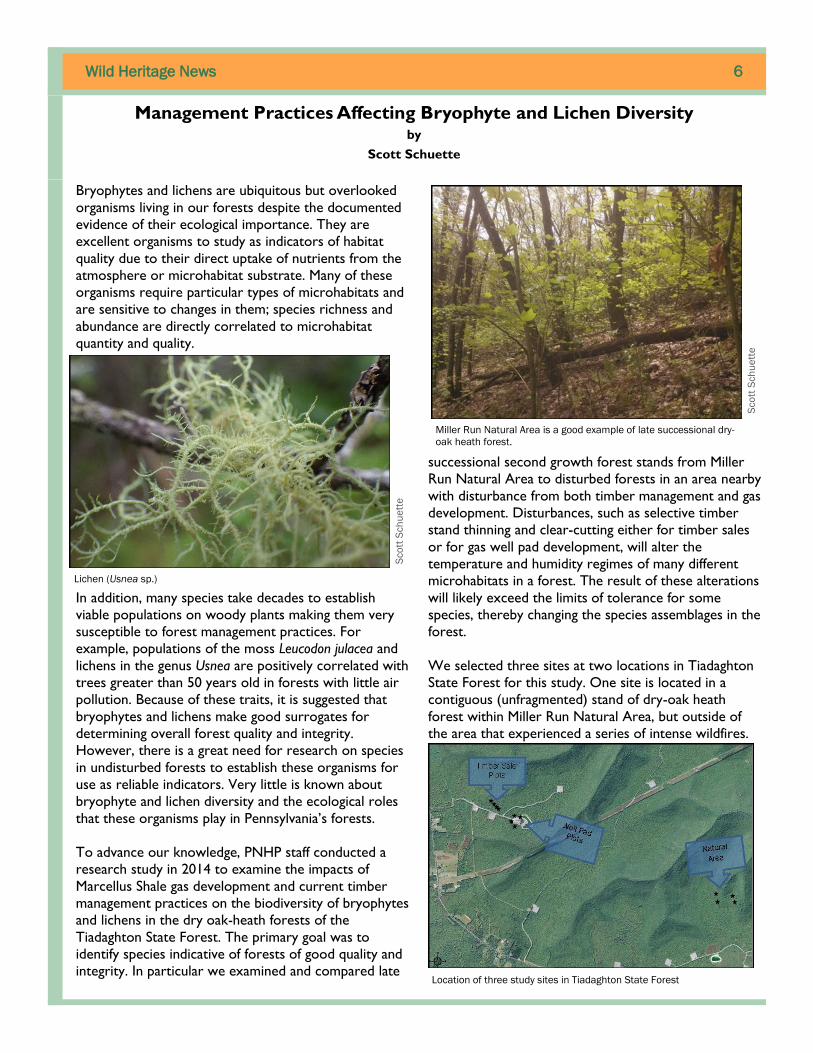
Lichen (Usnea sp.)
Miller Run Natural Area is a good example of late successional dry-
oak heath forest.
Location of three study sites in Tiadaghton State Forest
Sco
tt S
ch
ue
tte
Sco
tt S
ch
ue
tte

Wild Heritage News 7
The other two sites are located in a fragmented dry oak
-heath forest stand. One site is experiencing
development for natural gas extraction including several
well pads, a large compressor station, and roads
paralleled by pipelines. The second site is recovering
from a low thinning timber sale that occurred in 2004
where red maple was removed from the subcanopy and
understory. Subsequent treatment of the maple stump
sprouts with basal bark application of herbicide
occurred in late 2013 at this site. At each site, we
sampled four plots of 400 m2 each for all bryophytes
and lichens and recorded forest stand characteristics
and environmental variables. We then analyzed this data
to determine patterns in species diversity attributable
to site differences due to disturbance.
Dry oak-heath forests lack species richness, but this
traditional assessment usually references vascular plant
species and excludes bryophyte and lichen species. If
bryophytes and lichens are included in total species
richness, then dry oak heath forests have much greater
diversity than previously thought for this community
type. A total of 186 species, including 114 lichens and
72 bryophytes, are present from the combined study
site plots in Tiadaghton State Forest. The highest
average species richness was found in the natural area
compared with the well pad and timber sale sites.
These differences in combined total number of species
were statistically significantly different between Miller
Run Natural Area and the disturbed sites, while there
was no statistical difference between the disturbed sites.
Another way to look at species diversity is to compare
an index value that averages the number of different
species relative to the total species present at a site.
When we calculated and analyzed this diversity index, it
showed that the natural area is only statistically
different from the timber sale site. However when
bryophytes and lichen diversity indices were analyzed
separately, bryophytes are significantly different
between natural area and disturbance sites, while for
lichens the natural area is significantly different from
only the timber sale. This suggests that few bryophyte
species are shared between the natural area and
disturbance sites. Likewise few lichen species are shared
between the natural area and timber sale. However
while lichen species richness in the natural area is
significantly different from the well pad, the diversity
index for lichens from these two sites suggests little
variability in species composition. Nonetheless, overall
there are species differences among the sites.
The next question addressed in this study was to
determine if there are indicator species of disturbed
and natural sites. When the sites were analyzed for
indicator species, there were no significant and
meaningful indicator species found in any of the sites.
There was considerable overlap in species composition
requiring a much larger sample size than we used in this
study to fully tease out the minute species differences
necessary to identify any significant indicator species.
Average species richness of bryophytes and lichens at each study site.
Natural area plots supported significantly higher richness values for
both bryophytes and lichens.
The study site at the timber sale location demonstrates an open
canopy, high light intensity habitat that is low in species diversity.
Sco
tt S
ch
ue
tte

Wild Heritage News 8
However these results suggest that something
attributable to each site is driving the difference in
species richness and diversity. When the environmental
variables and site characteristics were analyzed with the
species diversity, a pattern emerged that helped explain
the differences among the sites. Using a method that
made no assumptions about the variability of the sites,
it showed that the presence of rocks, exposed soil
with high light intensity, and coarse woody debris were
important variables in separating the sites based on
their species composition. This suggests that forest
management practices can play a significant role in
altering substrate quality and availability for bryophyte
and lichen species establishment.
Evidence from this study indicates that clear-cutting a
forest, whether for a timber sale or natural gas
development, greatly alters the dry oak – heath forest
community structure and helps define the subsequent
succession of that community following disturbance.
These activities on the forest ecosystem altered the
bryophyte and lichen communities, affected
temperature and humidity levels, and removed or
disrupted microhabitat and substrate continuity.
If bryophytes and lichens are considered important to
the forest ecosystem then management practices in
those forests should incorporate factors that promote
and maintain their biodiversity. To facilitate this, a
reduction in the number and size of machinery access
roads (skid paths) and staging areas should be
considered when forest stands are selected for harvest.
This practice alone leaves forest patches that escape
substrate disturbances, providing refugia within
harvested lands that can promote bryophyte and lichen
survival by reducing dispersal distances and
recolonization times.
Additionally, large tracts of late successional forest
should be preserved around disturbed sites to maintain
extensive propagule sources for regeneration. If these
types of practices are employed, bryophyte and lichen
diversity may benefit and possibly even increase over
time in the Tiadaghton State Forest. Bryophytes and
lichens may hold the key to fully understanding and
following changes in forest community structure related
to changes in microclimate, pollution levels, proximity
to pad run-off, and proximity to catchment ponds.
The moss Dicranum montanum can be found on rotting stumps and
logs, tree bases, and occasionally soil or humus over rock. This
moss was one of the three most common species encountered
during this study.
The plots at the well pad study site were located 25 meters off the developed pad to avoid edge effect of the grassy buffer.
Sco
tt S
ch
ue
tte
Sco
tt S
ch
ue
tte

Wild Heritage News 9
Wood Turtle Monitoring
Interest in the distribution and condition of wood turtle
populations in Pennsylvania and the Northeast has been
renewed this spring through the implementation of a
Competitive State Wildlife Grant called “Conservation
Planning and Implementation for the Wood Turtle
(Glyptemys insculpta) and Associated Riparian Species of
Greatest Conservation Need from Maine to Virginia.”
The Pennsylvania Fish and Boat Commission is leading
the state’s participation in the project and PNHP will
conduct the majority of the field sampling. The
purposes of the project in Pennsylvania are to obtain
rigorous abundance estimates for a sample of wood
turtle populations in the state, assemble detailed
population data for a network of reference sites, and
collect genetic samples to provide to University of
Massachusetts researchers for analysis of genetic
structure and relatedness of wood turtle populations
within the Northeast.
The basic sampling framework incorporates two tiers of
survey intensity. The regional network of study sites
will encompass a network of ≥20 long-term (LT) and
≥50 rapid assessment (RA) research sites. Field surveys
commenced this spring to establish up to five LT sites
that indicate robust populations and to sample RA sites
on a broad geographic distribution, including data
deficient regions. We visited ten sites across central
and western Pennsylvania multiple times in April and
May of 2015 to survey for wood turtles. Volunteers
interested in the program visited additional study sites
during the same period. Data is being entered and
genetic samples are undergoing preliminary analysis this
summer in order to direct additional efforts in the fall
of 2015, and spring and fall of 2016.
Northern Long-Eared Bat Update
On April 1, 2015 the United States Fish and Wildlife
Service (USFWS) announced that it was listing the
northern long-eared bat (Myotis septentrionalis) as a
threatened species under the Endangered Species Act
(ESA). The listing took effect on May 4, 2015 following a
30 day period after the final listing determination in the
Federal Register. Under the ESA, the USFWS is able to
enforce regulations necessary to provide increased
protection for the northern long-eared bat and further
range wide conservation efforts.
This decision was made following the recent but
dramatic decline of northern long-eared bats caused by
the introduced, cold-loving fungus Pseudogymnoascus
destructans (otherwise referred to as Pd). Pd causes
White-nose Syndrome (WNS) in hibernating bats which
produces lesions on the patagia (wing membranes) and
frequent bouts of awakening during hibernation. Since
stored energy is burned in excess during these aroused
states, hibernating bats deplete their fat stores and
essentially starve to death during winter months when
insects are unavailable. WNS was first documented in
Pennsylvania during the winter of 2008-2009. While a
definitive cure has yet to be discovered for WNS,
Notes from the Field
PNHP staff mark a captured wood turtle by notching its outer shell in
order to identify it in future surveys. Shell shavings are collected and
preserved for analysis of DNA.
Ka
thy
Gip
e
Northern long-eared bat (Myotis septentrionalis) roosting. C
ha
rlie
Eic
he
lbe
rge
r

Wild Heritage News 10
protection of known hibernacula and preservation of
summer habitats can help mitigate the effects of WNS
by providing minimal disturbance during hibernation and
ample foraging areas.
Currently, PNHP staff are working with our agency
partners to not only document occurrences of this
species, but also to keep our PNDI environmental
review tool current. We receive a constant influx of
data from both the USFWS and the Pennsylvania Game
Commission regarding the locations of hibernacula,
maternity roosts, and foraging areas utilized by the
northern long-eared bat. This data is processed and
reviewed by our staff and then entered into our PNDI
tool which aids in the protection of habitats critical to
the life history needs of this species. While it is
apparent that the damage caused by WNS isn’t likely to
be reversed anytime soon, the federal listing of these
resilient survivors is an important step toward the
future conservation of this species.
A Closer Look
The peat mosses (genus Sphagnum) are a large group
that exhibit many interesting variations in form and
color. Sphagnum capillifolium (above) has been given
several common names, including small red peat moss,
which describes it well. Red coloration in mosses, as
well as in vascular plants, is usually an expression of a
group of pigments called anthocyanins. The red color is
more pronounced when the plant is exposed to high
light levels.
Knights plume moss (Ptilium crista-castrensis) is a very
elegant forest species with leaves that curl toward the
base of the plant. If you don’t get small, you will miss
much of the beauty and interest in nature!
Bedford County Inventory Update
Field work for the Bedford County Natural Heritage
Inventory Update began this spring with vernal pool
surveys. Approximately 225 vernal pools had been
identified over the winter, using a combination of aerial
photography and LIDAR-derived topographic contours.
PNHP staff began visiting those pools this April to
document which obligate vernal pool breeding animals
might be using them. In numerous pools, we found the
eggs and larvae of spotted salamanders and wood frogs,
as well as invertebrates such as fairy shrimp and pea
clams. Other ‘potential pools’ were dry depressions,
Ptilium crista-castrensis, Potter County
Fairy shrimp and wood frog tadpoles among empty wood frog eggs
Pe
te W
oo
ds
Ste
ve
Gru
nd
Ste
ve
Gru
nd
The individual stems on the top of this Sphagnum
capillifolium moss may be signs that a bird or small
mammal has been foraging for insects and other
invertebrates living in the peat moss.
Wild Heritage News 11
although they may hold water in wetter years. A few
pools were identified as having potential to support the
federally endangered northeastern bulrush (Scirpus
ancistrochaetus). We will revisit these sites in the late
summer when that species is identifiable. Surveys of
pools will continue next spring. After the 2016 field
season, Natural Heritage Areas (NHAs) will be
designated for high quality complexes of vernal pools:
those with a combination of many pools in one
complex, a high abundance or diversity of vernal pool
obligate breeding species, and an intact envelope of
forest surrounding the pools.
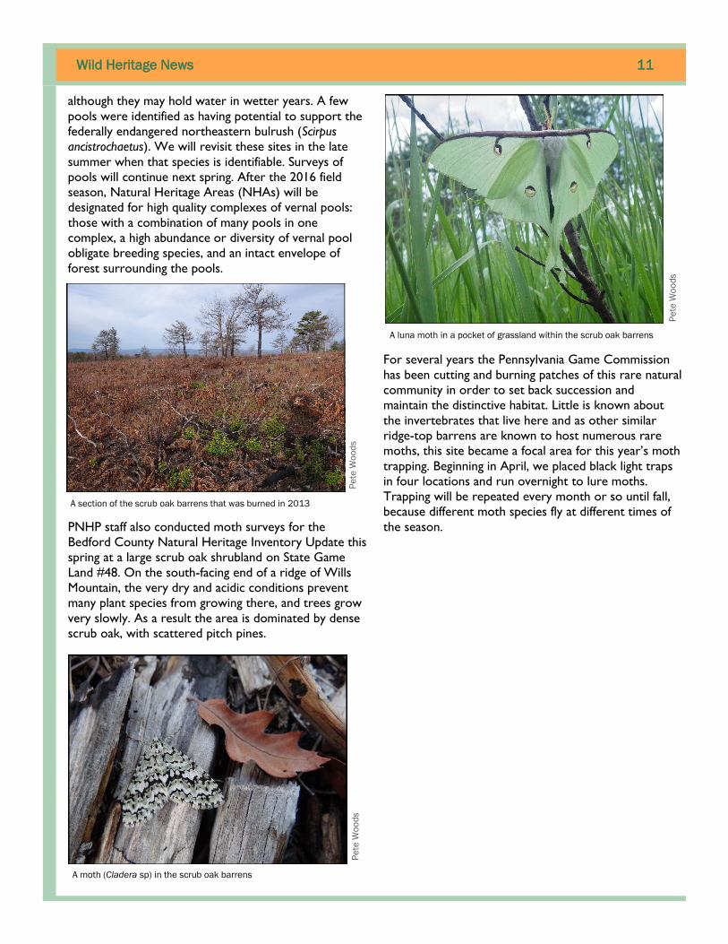
PNHP staff also conducted moth surveys for the
Bedford County Natural Heritage Inventory Update this
spring at a large scrub oak shrubland on State Game
Land #48. On the south-facing end of a ridge of Wills
Mountain, the very dry and acidic conditions prevent
many plant species from growing there, and trees grow
very slowly. As a result the area is dominated by dense
scrub oak, with scattered pitch pines.
For several years the Pennsylvania Game Commission
has been cutting and burning patches of this rare natural
community in order to set back succession and
maintain the distinctive habitat. Little is known about
the invertebrates that live here and as other similar
ridge-top barrens are known to host numerous rare
moths, this site became a focal area for this year’s moth
trapping. Beginning in April, we placed black light traps
in four locations and run overnight to lure moths.
Trapping will be repeated every month or so until fall,
because different moth species fly at different times of
the season.
A moth (Cladera sp) in the scrub oak barrens
A section of the scrub oak barrens that was burned in 2013
A luna moth in a pocket of grassland within the scrub oak barrens
Pe
te W
oo
ds
Pe
te W
oo
ds
Pe
te W
oo
ds

Wild Heritage News 12
Measures of Progress
PNHP is a partnership of the Pennsylvania Department of Conservation and Natural Resources, the Western
Pennsylvania Conservancy, the Pennsylvania Game Commission, and the Pennsylvania Fish and Boat Commission.
PNHP performs many functions and provides many services as part of its mission. The measures of progress that are detailed here are meant
to capture a number of important program activities and provide a picture of our progress in achieving our essential goals. The program
goals and the measures provided for those goals will change over time as we complete certain aspects of our work and as new program
responsibilities arise.
Biotics Records Updated indicates the amount of activity expended in improving and updating the more than 20,000
records in the PNDI database.
New EOs Documented is a way to measure the success of our inventory effort in finding new occurrences of elements of
ecological concern (plants, animals, and exemplary natural communities). Biotics records are created for each new Element
Occurrence documented.
New Records Entered into HGIS indicates our level of activity in reviewing, quality controlling, and entering biotics
records into the environmental review data layers. The timely and consistent refreshment of these data are critical to
providing protection to the state’s species of greatest concern.
Field Surveys Reported is a strong indicator of the effort expended on one of the basic functions of the program –
inventory of the state’s flora and fauna. Every field visit results in the entering of a field survey, regardless of the outcome of
the survey.
New Conservation Planning Polygons (CPPs) Developed is a measure of our progress in creating ecological based
mapping for the species and natural communities that we track as part of the PNDI database. Our goal is to have CPPs for all
species and communities that we track.
NHAs Updated is a measure of our effort in developing, mapping, and describing sites (Natural Heritage Areas - NHAs) that
are important to conservation of Pennsylvania’s biodiversity. This process began with County Natural Heritage Inventory
projects and will now continue at a statewide level with the updating of existing sites and the creation of new sites. Site
polygons will be based upon and consistent with CPPs.
Sites Actively Monitored indicates how many established geo-referenced plots that we visited and sampled. These sites
allow us to collect data on structure, species composition, and physical context (soils, hydrology, etc.) in a systematic way and
by following the same protocols to directly compare future data to previous data.
The following Measures of Progress represent a significant cross-section of results of the work that we do as a program. These measures will
be reviewed and updated, as needed, to best reflect the activities and goals of PNHP. Progress for these measures reflects seasonality of
program activity.
Measure of Progress Annual Goal
(2015)
1st
Quarter
Cumulative
Total
Percent of
Annual Goal
2nd
Quarter
Biotics Records Updated 300 115 193 64% 78
New EOs Documented 800 137 310 39% 173
New Records Entered into HGIS 350 65 149 43% 84
Field Surveys Reported 300 0 73 24% 73
New CPPs Developed 400 0 149 37% 149
NHAs Updated 150 95 113 75% 18
Sites Actively Monitored 35 0 25 71% 25