pennsylvania highlands trail network - amazon s3 highlands trail network - trail concept plan -...
TRANSCRIPT

Pennsylvania Highlands Trail Network
Trail Concept Plan Unami Hills to
Hopewell Big Woods
Appalachian Mountain Club May 2015
Pennsylvania Highlands Trail Network - Trail Concept Plan - Unami Hills to Hopewell Big Woods - Page 2
Acknowledgements The Pennsylvania Highlands Trail Network (PHTN) Trail Concept Plan was completed by the Appalachian Mountain Club in 2015 with guidance from the PHTN Steering Committee. The progress that has been achieved would not have been possible without the talent and vision of many partner organizations and individuals who generously contributed their time and expertise. The local knowledge shared by Steering Committee members, municipal representatives, and local/county/state park managers is invaluable to our efforts to establish the Pennsylvania Highlands Trail Network. The Pennsylvania Highlands Trail Network is being developed as part of The Circuit, a network of 750 miles of existing and planned trails in Eastern Pennsylvania and New Jersey. Learn more at http://connectthecircuit.org For a complete list of project partners, visit: http://www.PAHighlands.org
Support for the development of the Pennsylvania Highlands Trail Network has been generously provided by the Community Conservation Partnerships Program under the administration of the Pennsylvania Department of Conservation and Natural Resources (DCNR), Bureau of Recreation and Conservation; the William Penn Foundation; and the M. Edward Morris Foundation. Photographs for this report were generously provided by John Brunner, Robert Thomas, Stephen Warren, Mark Zakutansky, and the Montgomery County Planning Commission.
Pennsylvania Highlands Trail Network - Trail Concept Plan - Unami Hills to Hopewell Big Woods - Page 3
Table of Contents
Acknowledgments ………………… 2 Table of Contents ………………… 3 About the Highlands ………………… 4 Project Background ………………… 5 Trail Concept Plan ………………… 8 Executive Summary ………………… 8 Study Area Map ………………… 9 Segment Planning Overview ………………… 10 Segment Two – Unami Hills to the Perkiomen Trail ………………… 11 Segment Three – Perkiomen Trail to the Schuylkill River Trail ………………… 20 Segment Four – Big Woods Trail to the Horse-Shoe Trail ………………… 25 Spur Routes for Consideration ………………… 28 Appendix ………………… 31
Pennsylvania Highlands Trail Network - Trail Concept Plan - Unami Hills to Hopewell Big Woods - Page 4
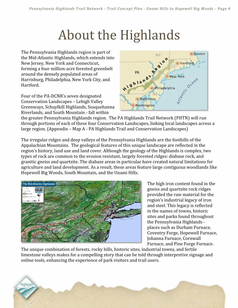
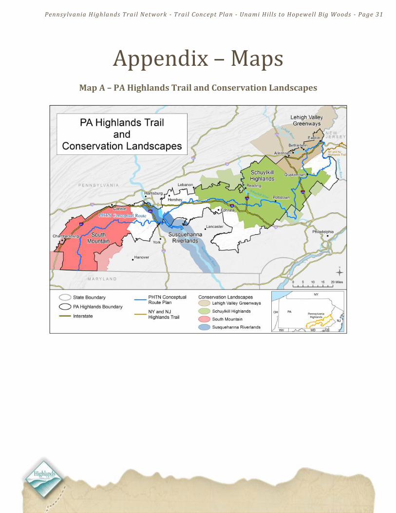
About the Highlands The Pennsylvania Highlands region is part of the Mid-Atlantic Highlands, which extends into New Jersey, New York and Connecticut, forming a four million-acre forested greenbelt around the densely populated areas of Harrisburg, Philadelphia, New York City, and Hartford. Four of the PA-DCNR’s seven designated Conservation Landscapes – Lehigh Valley Greenways, Schuylkill Highlands, Susquehanna Riverlands, and South Mountain - fall within the greater Pennsylvania Highlands region. The PA Highlands Trail Network (PHTN) will run through portions of each of these four Conservation Landscapes, linking local landscapes across a large region. (Appendix – Map A - PA Highlands Trail and Conservation Landscapes) The irregular ridges and deep valleys of the Pennsylvania Highlands are the foothills of the Appalachian Mountains. The geological features of this unique landscape are reflected in the region’s history, land use and land cover. Although the geology of the Highlands is complex, two types of rock are common to the erosion resistant, largely forested ridges: diabase rock, and granitic gneiss and quartzite. The diabase areas in particular have created natural limitations for agriculture and land development. As a result, these areas feature large contiguous woodlands like Hopewell Big Woods, South Mountain, and the Unami Hills.
The high iron content found in the gneiss and quartzite rock ridges provided the raw material for the region’s industrial legacy of iron and steel. This legacy is reflected in the names of towns, historic sites and parks found throughout the Pennsylvania Highlands - places such as Durham Furnace, Coventry Forge, Hopewell Furnace, Johanna Furnace, Cornwall Furnace, and Pine Forge Furnace.
The unique combination of forests, rocky hills, historic sites, industrial towns, and fertile limestone valleys makes for a compelling story that can be told through interpretive signage and online tools, enhancing the experience of park visitors and trail users.

Pennsylvania Highlands Trail Network - Trail Concept Plan - Unami Hills to Hopewell Big Woods - Page 5
Project Background MISSION STATEMENT: To create a trail network that promotes and protects the Pennsylvania Highlands and provides communities with a physical connection to the outdoors through close-to-home recreation.
VISION: An interconnected trail network linking people to where they live in the Pennsylvania Highlands by providing recreational opportunities and protection of natural, scenic, and historical resources.
The Appalachian Mountain Club (AMC) is working with partner organizations and local, state and county governments to develop the Pennsylvania Highlands Trail Network (PHTN) within the 1.9 million-acre, 13 county Pennsylvania Highlands region. The plan to develop a trail through the Mid-Atlantic Highlands region began to take shape in the early 1990's when the New York-New Jersey Trail Conference began a multi-year effort to establish the New York-New Jersey Highlands Trail, covering over 160 miles from the Hudson River near Storm King Mountain to the Delaware River at Riegelsville, PA.
In 2006, AMC initiated discussions about extending the Highlands Trail into Pennsylvania at two roundtable meetings held at Nolde Forest and Kings Gap Environmental Education Centers. Participants included county planners, state park managers, land conservancies and trail organizations. These discussions helped AMC gage the opportunity and interest for a PA Highlands Trail Network (PHTN). An outcome of the roundtable meetings was the formation of a region-wide PA Highlands Trail Steering Committee, created in 2007, and made up of participants representing land trusts, state parks, trail organizations, and county planning commissions from across the Pennsylvania Highlands region.
An illustration of the Highlands Trail in New Jersey and New York States

Pennsylvania Highlands Trail Network - Trail Concept Plan - Unami Hills to Hopewell Big Woods - Page 6
The PA Highlands Trail in Riegelsville
Iconic geology of the Pennsylvania Highlands includes diabase rock, pictured here on the Unami Creek
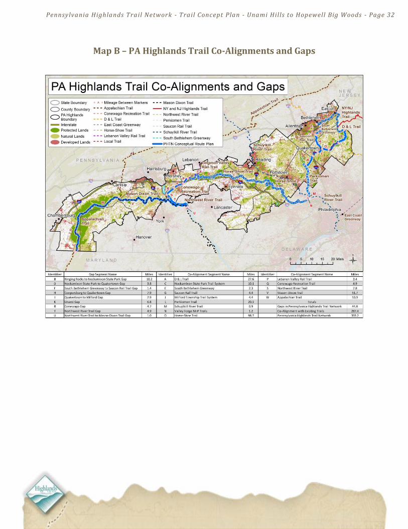
The Steering Committee participants helped form the vision and mission statement for the PHTN and develop the conceptual PA Highlands Trail trunk route. This route was based partly on opportunities to connect and co-align with existing trails in the region, while linking its many outstanding natural and cultural features, including state parks, national historic sites and landmarks, water trails, scenic vistas, and revitalized downtowns. AMC's Geographic Information Systems (GIS) staff and Mid-Atlantic staff produced a map of the route that identifies the gaps between the major co-aligned trail systems (Appendix – Map B). AMC also conducted municipal outreach programs in townships and boroughs in Bucks, Montgomery and Northampton Counties to discuss the project and gather preliminary input from stakeholders. A significant portion of the identified PA
Highlands Trail Network gaps are located between the D&L Trail along the Delaware River and the Perkiomen Trail, including portions of Bucks, Northampton, Lehigh and Montgomery Counties. To determine how to close these gaps, the PA Highlands Steering Committee convened in 2008 to focus on the Bucks-Northampton-Lehigh County area, with representation from local and regional partner organizations, county and municipal governments, and interested individuals. The Steering Committee, which has since expanded to include Montgomery County, meets several times a year to discuss trail routes, trail planning progress, and construction activities. In 2009, AMC and the New York-New Jersey Trail Conference co-hosted a trail celebration in Riegelsville, Pennsylvania. A Highlands Trail marker was installed at the new footbridge over the Delaware Canal in Rieglesville. This event catalyzed efforts to develop the trail through Pennsylvania by marking the official beginning of efforts to develop the PA Highlands Trail Network. An important step in the identification of potential trail routes in the easternmost portion of the Pennsylvania Highlands was completed in 2010 with the publication of the "Analysis of Protected and Unprotected Lands in Upper Bucks and Lower Northampton Counties for Potential Trail Easements as Part of the Pennsylvania Highlands Trail Network." The information contained in the land analysis report combined with field surveys, identification of existing trails, and a series of trail planning meetings enabled the PHTN Steering Committee to identify potential routes to connect co-aligned trails.
Pennsylvania Highlands Trail Network - Trail Concept Plan - Unami Hills to Hopewell Big Woods - Page 7
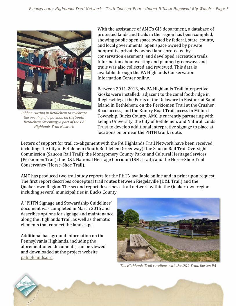
Ribbon cutting in Bethlehem to celebrate the opening of a pavilion on the South Bethlehem Greenway, a part of the PA
Highlands Trail Network
The Highlands Trail co-aligns with the D&L Trail, Easton PA PA
With the assistance of AMC’s GIS department, a database of protected lands and trails in the region has been compiled, showing public open space owned by federal, state, county, and local governments; open space owned by private nonprofits; privately owned lands protected by conservation easement; and developed recreation trails. Information about existing and planned greenways and trails was also collected and reviewed. This data is available through the PA Highlands Conservation Information Center online. Between 2011-2013, six PA Highlands Trail interpretive kiosks were installed: adjacent to the canal footbridge in Rieglesville; at the Forks of the Delaware in Easton; at Sand Island in Bethlehem; on the Perkiomen Trail at the Crusher Road access; and the Kumry Road Trail access in Milford Township, Bucks County. AMC is currently partnering with Lehigh University, the City of Bethlehem, and Natural Lands Trust to develop additional interpretive signage to place at locations on or near the PHTN trunk route.
Letters of support for trail co-alignment with the PA Highlands Trail Network have been received, including: the City of Bethlehem (South Bethlehem Greenway); the Saucon Rail Trail Oversight Commission (Saucon Rail Trail); the Montgomery County Parks and Cultural Heritage Services (Perkiomen Trail); the D&L National Heritage Corridor (D&L Trail); and the Horse-Shoe Trail Conservancy (Horse-Shoe Trail). AMC has produced two trail study reports for the PHTN available online and in print upon request. The first report describes conceptual trail routes between Riegelsville (D&L Trail) and the Quakertown Region. The second report describes a trail network within the Quakertown region including several municipalities in Bucks County. A “PHTN Signage and Stewardship Guidelines” document was completed in March 2015 and describes options for signage and maintenance along the Highlands Trail, as well as thematic elements that connect the landscape. Additional background information on the Pennsylvania Highlands, including the aforementioned documents, can be viewed and downloaded at the project website pahighlands.org.
Pennsylvania Highlands Trail Network - Trail Concept Plan - Unami Hills to Hopewell Big Woods - Page 8
PHTN Trail Concept Plan Unami Hills to the Horse-Shoe Trail
Executive Summary From the Unami Hills to the Horse-Shoe Trail in the Hopewell Big Woods, the PA Highlands Trail Network (PHTN) presents a vision for connecting noteworthy natural resources to established communities and existing trails and parks across the Schuylkill Highlands region, which encompasses portions of Bucks, Montgomery, Chester and Berks Counties. The PHTN plans to work with project partners to close trail gaps and spur additional trail development. Across the 13-county PA Highlands region, AMC and the PA Highlands Trail Network Steering
Committee have identified and mapped a conceptual Highlands Trail route that traverses 333 miles. The
most sizable trail gaps located in the project area are addressed in this trail concept plan. Of the currently
planned 333-mile PHTN trunk route, approximately 288 miles are co-located on established trails, with
approximately 45 miles of trail gaps that need to be closed to complete the PHTN trunk route from the
Delaware River to the Maryland border. (Appendix – Map B)
For the purposes of trail planning over such a large region, the PA Highlands Trail Network has been divided into seven Planning Segments. These segments are listed below in sequence from east to west: PHTN Planning Segments:
1) Riegelsville to Finland 2) Finland to the Perkiomen Trail (the Unami Hills) 3) Perkiomen Trail to the Schuylkill River Trail 4) Hopewell Big Woods to the Horse-Shoe Trail 5) Lebanon Valley Rail Trail to the Conewago Trail 6) Conewago Gap to the Northwest River Trail 7) Mason Dixon Trail to the Appalachian Trail
This Trail Concept Plan focuses on PHTN Planning Segments 2, 3 and 4. All are within the state-designated Schuylkill Highlands Conservation Landscape. Within these three trail planning segments, the Highlands Trail will provide a common thread connecting the Perkiomen Trail, Schuylkill River Trail and Horse-Shoe Trail, as well as three of the largest contiguous forests in southeastern Pennsylvania: the Unami Hills, Stone Hills, and Hopewell Big Woods.
Pennsylvania Highlands Trail Network - Trail Concept Plan - Unami Hills to Hopewell Big Woods - Page 9
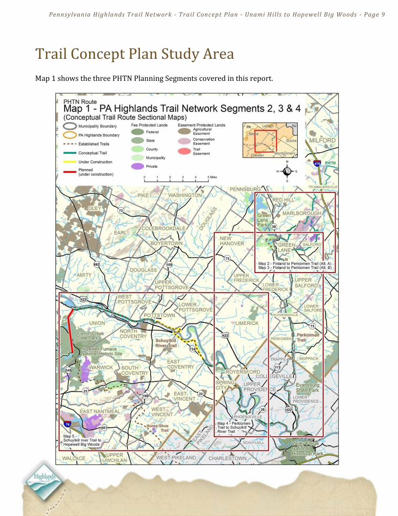
Trail Concept Plan Study Area Map 1 shows the three PHTN Planning Segments covered in this report.
Pennsylvania Highlands Trail Network - Trail Concept Plan - Unami Hills to Hopewell Big Woods - Page 10
About PHTN Planning Segments #2, #3, & #4 PHTN Planning Segment #2 (Finland to the Perkiomen Trail): The recommendations contained in this report for Segment #2 are intended as a starting point for more detailed planning and implementation in the Unami Hills area. The trail routes that have been identified may evolve over time as new opportunities for off-road trail development emerge. This is particularly true for the interim road routes described in the following section. Continued efforts to preserve land as private or public open space will present new opportunities to move road-aligned trails off-road. There may also be opportunities in future land development projects to accommodate trails within designated areas of open space. The possibilities for future trail development projects are notable in Planning Segment #2, as the Unami Hills area has long been the focus for open space preservation by land trusts as well as local and county governments. Establishing the Highlands Trail through the Unami Hills will require a sustained effort featuring two distinct approaches. The first approach will be to build discrete sections of the trail piece-by-piece in those areas that already feature trail easements. The second approach will involve working with municipalities and county planners as well as nonprofit partners such as Natural Lands Trust to identify and preserve priority parcels to close the gaps between completed or planned sections of trail. PHTN Planning Segment #3: The need for additional trail planning in Segment #3 will be minimal as this area includes well established multi-use trails. The Highlands Trail can be co-located on the Perkiomen Trail and on completed sections of the Schuylkill River Trail with little or no modification beyond the placement of directional and interpretive signage. PHTN Planning Segment #4: This planning segment features the planned Big Woods Trail, which will
provide the Highlands Trail with a connection between the Schuylkill River Trail and the Horse-Shoe
Trail. The Big Woods Trail is in the early stages of construction. More detailed descriptions and maps of PHTN Planning Segments 2, 3, 4 are found in the following Planning Overview and Route Description sections of the report.
Trail routes have not been, and will not be, proposed to run through privately owned parcels of land, except where a property owner has voluntarily granted an easement or written agreement for trail access.
Pennsylvania Highlands Trail Network - Trail Concept Plan - Unami Hills to Hopewell Big Woods - Page 11
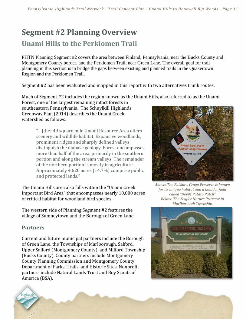
Above: The Fulshaw Craeg Preserve is known for its unique habitat and a boulder field
called “Devils Potato Patch” Below: The Zeigler Nature Preserve in
Marlborough Township
Segment #2 Planning Overview
Unami Hills to the Perkiomen Trail PHTN Planning Segment #2 covers the area between Finland, Pennsylvania, near the Bucks County and
Montgomery County border, and the Perkiomen Trail, near Green Lane. The overall goal for trail
planning in this section is to bridge the gaps between existing and planned trails in the Quakertown
Region and the Perkiomen Trail. Segment #2 has been evaluated and mapped in this report with two alternatives trunk routes. Much of Segment #2 includes the region known as the Unami Hills, also referred to as the Unami Forest, one of the largest remaining intact forests in southeastern Pennsylvania. The Schuylkill Highlands Greenway Plan (2014) describes the Unami Creek watershed as follows:
“…[the] 49 square mile Unami Resource Area offers scenery and wildlife habitat. Expansive woodlands, prominent ridges and sharply defined valleys distinguish the diabase geology. Forest encompasses more than half of the area, primarily in the southern portion and along the stream valleys. The remainder of the northern portion is mostly in agriculture. Approximately 4,620 acres (14.7%) comprise public and protected lands.”
The Unami Hills area also falls within the “Unami Creek Important Bird Area” that encompasses nearly 10,000 acres of critical habitat for woodland bird species. The western side of Planning Segment #2 features the village of Sumneytown and the Borough of Green Lane.
Partners
Current and future municipal partners include the Borough of Green Lane, the Townships of Marlborough, Salford, Upper Salford (Montgomery County), and Milford Township (Bucks County). County partners include Montgomery County Planning Commission and Montgomery County Department of Parks, Trails, and Historic Sites. Nonprofit partners include Natural Lands Trust and Boy Scouts of America (BSA).
Pennsylvania Highlands Trail Network - Trail Concept Plan - Unami Hills to Hopewell Big Woods - Page 12
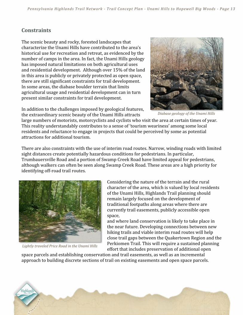
Ridge Valley Creek in the Unami Hills
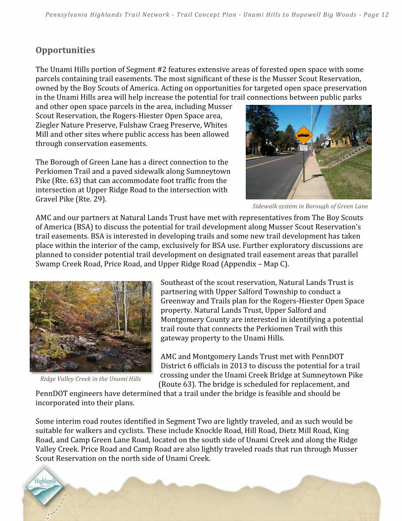
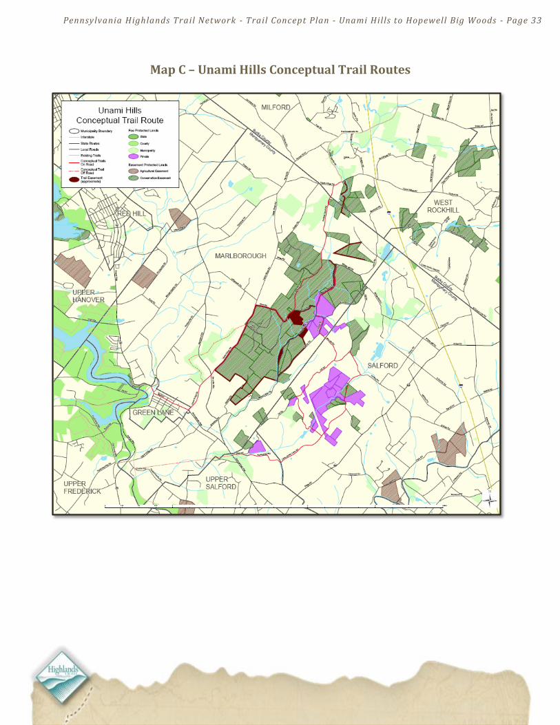
Opportunities The Unami Hills portion of Segment #2 features extensive areas of forested open space with some parcels containing trail easements. The most significant of these is the Musser Scout Reservation, owned by the Boy Scouts of America. Acting on opportunities for targeted open space preservation in the Unami Hills area will help increase the potential for trail connections between public parks and other open space parcels in the area, including Musser Scout Reservation, the Rogers-Hiester Open Space area, Ziegler Nature Preserve, Fulshaw Craeg Preserve, Whites Mill and other sites where public access has been allowed through conservation easements. The Borough of Green Lane has a direct connection to the Perkiomen Trail and a paved sidewalk along Sumneytown Pike (Rte. 63) that can accommodate foot traffic from the intersection at Upper Ridge Road to the intersection with Gravel Pike (Rte. 29). AMC and our partners at Natural Lands Trust have met with representatives from The Boy Scouts of America (BSA) to discuss the potential for trail development along Musser Scout Reservation’s trail easements. BSA is interested in developing trails and some new trail development has taken place within the interior of the camp, exclusively for BSA use. Further exploratory discussions are planned to consider potential trail development on designated trail easement areas that parallel Swamp Creek Road, Price Road, and Upper Ridge Road (Appendix – Map C).
Southeast of the scout reservation, Natural Lands Trust is partnering with Upper Salford Township to conduct a Greenway and Trails plan for the Rogers-Hiester Open Space property. Natural Lands Trust, Upper Salford and Montgomery County are interested in identifying a potential trail route that connects the Perkiomen Trail with this gateway property to the Unami Hills. AMC and Montgomery Lands Trust met with PennDOT District 6 officials in 2013 to discuss the potential for a trail crossing under the Unami Creek Bridge at Sumneytown Pike (Route 63). The bridge is scheduled for replacement, and
PennDOT engineers have determined that a trail under the bridge is feasible and should be incorporated into their plans. Some interim road routes identified in Segment Two are lightly traveled, and as such would be suitable for walkers and cyclists. These include Knockle Road, Hill Road, Dietz Mill Road, King Road, and Camp Green Lane Road, located on the south side of Unami Creek and along the Ridge Valley Creek. Price Road and Camp Road are also lightly traveled roads that run through Musser Scout Reservation on the north side of Unami Creek.
Sidewalk system in Borough of Green Lane
Pennsylvania Highlands Trail Network - Trail Concept Plan - Unami Hills to Hopewell Big Woods - Page 13
Diabase geology of the Unami Hills
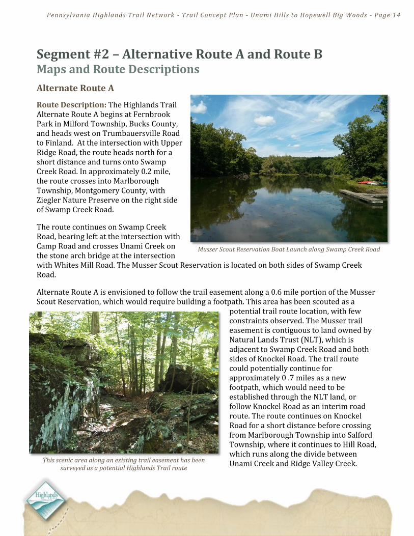
Constraints The scenic beauty and rocky, forested landscapes that characterize the Unami Hills have contributed to the area’s historical use for recreation and retreat, as evidenced by the number of camps in the area. In fact, the Unami Hills geology has imposed natural limitations on both agricultural uses and residential development. Although over 15% of the land in this area is publicly or privately protected as open space, there are still significant constraints for trail development. In some areas, the diabase boulder terrain that limits agricultural usage and residential development can in turn present similar constraints for trail development. In addition to the challenges imposed by geological features, the extraordinary scenic beauty of the Unami Hills attracts large numbers of motorists, motorcyclists and cyclists who visit the area at certain times of year. This reality understandably contributes to a sense of ‘tourism weariness’ among some local residents and reluctance to engage in projects that could be perceived by some as potential attractions for additional tourism. There are also constraints with the use of interim road routes. Narrow, winding roads with limited sight distances create potentially hazardous conditions for pedestrians. In particular, Trumbauersville Road and a portion of Swamp Creek Road have limited appeal for pedestrians, although walkers can often be seen along Swamp Creek Road. These areas are a high priority for identifying off-road trail routes.
Considering the nature of the terrain and the rural character of the area, which is valued by local residents of the Unami Hills, Highlands Trail planning should remain largely focused on the development of traditional footpaths along areas where there are currently trail easements, publicly accessible open space, and where land conservation is likely to take place in the near future. Developing connections between new hiking trails and viable interim road routes will help close trail gaps between the Quakertown Region and the Perkiomen Trail. This will require a sustained planning effort that includes preservation of additional open
space parcels and establishing conservation and trail easements, as well as an incremental approach to building discrete sections of trail on existing easements and open space parcels.
Lightly traveled Price Road in the Unami Hills
Pennsylvania Highlands Trail Network - Trail Concept Plan - Unami Hills to Hopewell Big Woods - Page 14
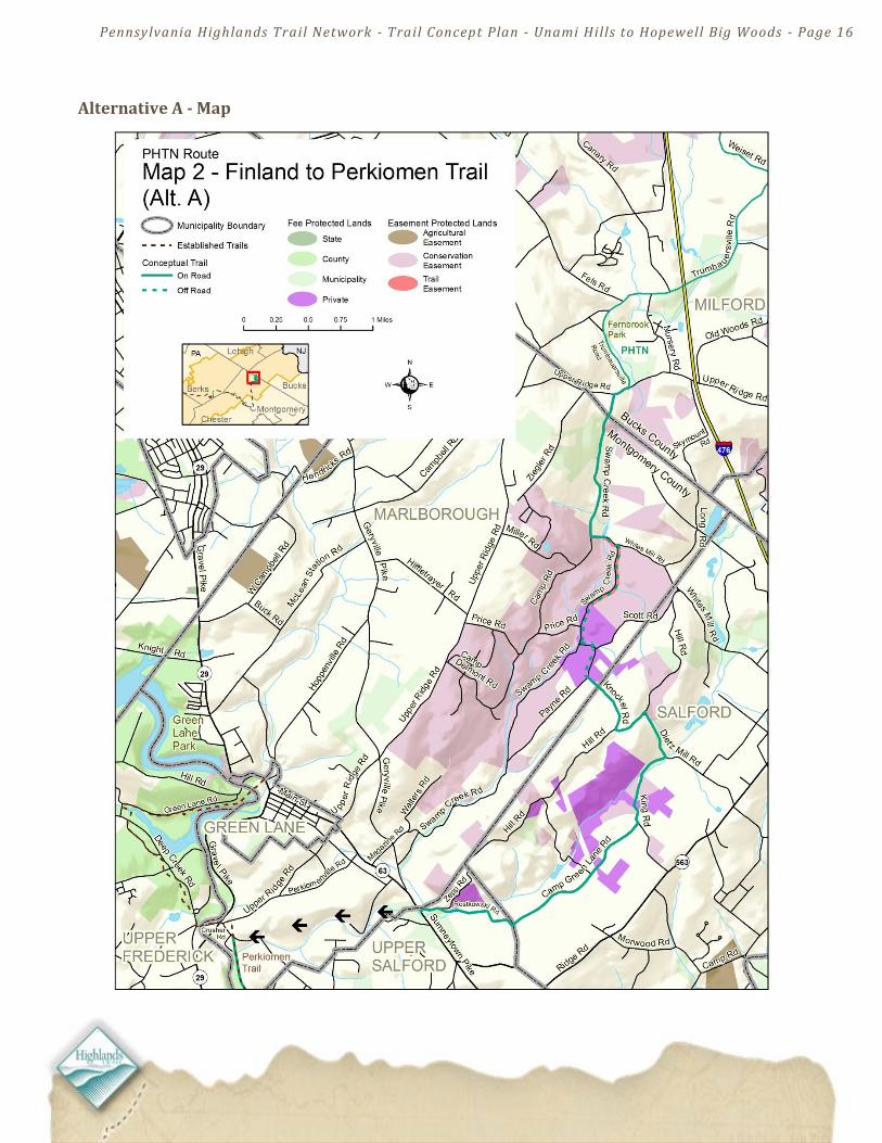
Segment #2 – Alternative Route A and Route B Maps and Route Descriptions
Alternate Route A
Route Description: The Highlands Trail Alternate Route A begins at Fernbrook Park in Milford Township, Bucks County, and heads west on Trumbauersville Road to Finland. At the intersection with Upper Ridge Road, the route heads north for a short distance and turns onto Swamp Creek Road. In approximately 0.2 mile, the route crosses into Marlborough Township, Montgomery County, with Ziegler Nature Preserve on the right side of Swamp Creek Road.
The route continues on Swamp Creek Road, bearing left at the intersection with Camp Road and crosses Unami Creek on the stone arch bridge at the intersection with Whites Mill Road. The Musser Scout Reservation is located on both sides of Swamp Creek Road.
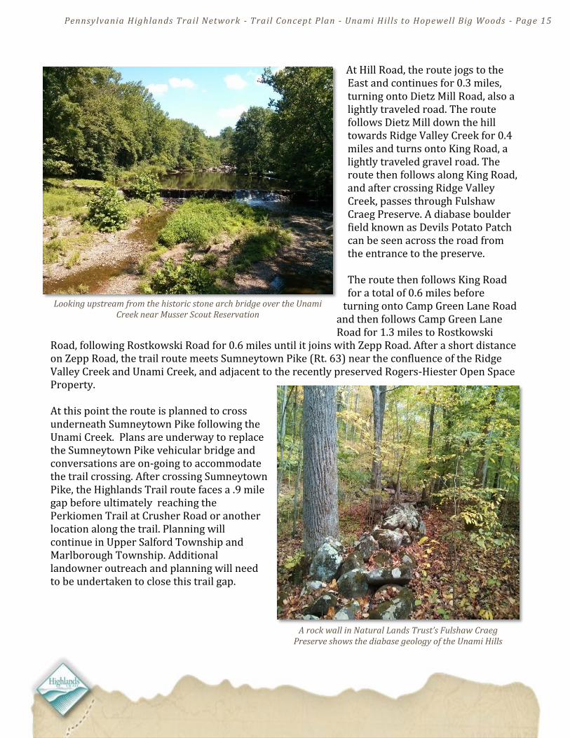
Alternate Route A is envisioned to follow the trail easement along a 0.6 mile portion of the Musser Scout Reservation, which would require building a footpath. This area has been scouted as a
potential trail route location, with few constraints observed. The Musser trail easement is contiguous to land owned by Natural Lands Trust (NLT), which is adjacent to Swamp Creek Road and both sides of Knockel Road. The trail route could potentially continue for approximately 0 .7 miles as a new footpath, which would need to be established through the NLT land, or follow Knockel Road as an interim road route. The route continues on Knockel Road for a short distance before crossing from Marlborough Township into Salford Township, where it continues to Hill Road, which runs along the divide between Unami Creek and Ridge Valley Creek.
Musser Scout Reservation Boat Launch along Swamp Creek Road
This scenic area along an existing trail easement has been surveyed as a potential Highlands Trail route
Pennsylvania Highlands Trail Network - Trail Concept Plan - Unami Hills to Hopewell Big Woods - Page 15
Looking upstream from the historic stone arch bridge over the Unami Creek near Musser Scout Reservation
A rock wall in Natural Lands Trust’s Fulshaw Craeg Preserve shows the diabase geology of the Unami Hills
At Hill Road, the route jogs to the East and continues for 0.3 miles, turning onto Dietz Mill Road, also a lightly traveled road. The route follows Dietz Mill down the hill towards Ridge Valley Creek for 0.4 miles and turns onto King Road, a lightly traveled gravel road. The route then follows along King Road, and after crossing Ridge Valley Creek, passes through Fulshaw Craeg Preserve. A diabase boulder field known as Devils Potato Patch can be seen across the road from the entrance to the preserve. The route then follows King Road for a total of 0.6 miles before
turning onto Camp Green Lane Road and then follows Camp Green Lane Road for 1.3 miles to Rostkowski
Road, following Rostkowski Road for 0.6 miles until it joins with Zepp Road. After a short distance on Zepp Road, the trail route meets Sumneytown Pike (Rt. 63) near the confluence of the Ridge Valley Creek and Unami Creek, and adjacent to the recently preserved Rogers-Hiester Open Space Property. At this point the route is planned to cross underneath Sumneytown Pike following the Unami Creek. Plans are underway to replace the Sumneytown Pike vehicular bridge and conversations are on-going to accommodate the trail crossing. After crossing Sumneytown Pike, the Highlands Trail route faces a .9 mile gap before ultimately reaching the Perkiomen Trail at Crusher Road or another location along the trail. Planning will continue in Upper Salford Township and Marlborough Township. Additional landowner outreach and planning will need to be undertaken to close this trail gap.
Pennsylvania Highlands Trail Network - Trail Concept Plan - Unami Hills to Hopewell Big Woods - Page 16
Alternative A - Map

Pennsylvania Highlands Trail Network - Trail Concept Plan - Unami Hills to Hopewell Big Woods - Page 17
Trail easements along the perimeter of Musser Scout Reservation offer an attractive route for the Highlands
Trail
The diabase geology of the Unami Hills is evident along Camp Road and Price Road
Alternate Route B Route Description: The Highlands Trail Alternate Route B follows the same route as Highlands Trail Alternate Route A to the point where Swamp Creek Road meets Camp Road a short distance from the stone arch bridge. Alternate Route B turns onto Camp Road, a lightly traveled gravel road, following it through Musser Reservation for 0.9 miles to Price Road. At Price Road, the route aligns with the trail easement adjacent to the road, following it for 0.7 miles to Upper Ridge Road. From here, the route follows a trail easement along the western boundary of Musser Scout Reservation for 1.2 miles. As shown on Map 3, an opportunity may exist to cross over Upper Ridge Road to establish a trail on municipal property that would eliminate approximately one mile of the on-road route. This conceptual trail is contingent on obtaining an easement on the parcel that would close this gap.
At some point, the trail would need to be established along the aforementioned municipal open space, or along Upper Ridge Road. In either case, the route would cross Geryville Pike to pick-up the last half mile of Upper Ridge Road for a connection to Main Street and the Green Lane Borough sidewalk system. The route will continue west on the sidewalk along Sumneytown Pike for 0.6 miles, and cross at the traffic signal at the intersection of Rt. 63 and Rt. 29 to continue onto the Perkiomen Trail. The Perkiomen Trail is reached from Rt. 29 on the south border of the William Penn Auto business, on the west side of Rt. 29 from the intersection of Rt. 29 and Lumber Street.

Pennsylvania Highlands Trail Network - Trail Concept Plan - Unami Hills to Hopewell Big Woods - Page 18
Alternative B - Map
Pennsylvania Highlands Trail Network - Trail Concept Plan - Unami Hills to Hopewell Big Woods - Page 19
Action Items in Segment #2:
1) Work with partners to identify trail route connections with the Rogers-Hiester Open Space Property.
2) Address the remaining 0.9 mile trail gap in Alternate Route A between Sumneytown Pike and the Perkiomen Trail.
3) Develop a footpath along the designated trail easement located adjacent to Swamp Creek Road within Musser Scout Reservation.
4) Explore development of a footpath within the Natural Lands Trust parcel in the Knockel Road area that will connect with the Musser Scout Reservation trail easement area along Swamp Creek Road.
5) Work with partners to preserve the Yocum property along Upper Ridge Road to create a trail connection between the Musser Scout Reservation trail easement area and existing Marlborough Township open space.
6) Continue working with project partners to identify off-road routes in Segment #2 through targeted outreach and securing conservation and trail easements with willing property owners.
Pennsylvania Highlands Trail Network - Trail Concept Plan - Unami Hills to Hopewell Big Woods - Page 20
Montgomery County’s Perkiomen Trail
PA Highlands Trail Kiosk at the Crusher Road Access of the Perkiomen Trail
Segment #3 Planning Overview
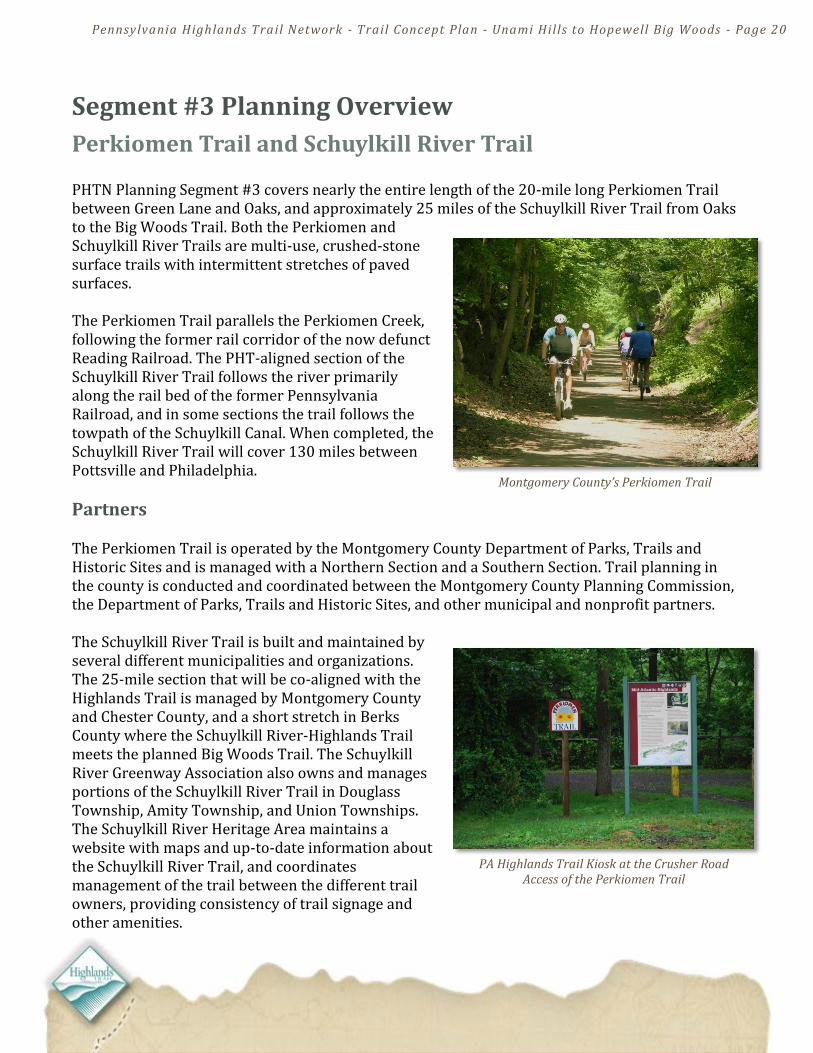
Perkiomen Trail and Schuylkill River Trail PHTN Planning Segment #3 covers nearly the entire length of the 20-mile long Perkiomen Trail between Green Lane and Oaks, and approximately 25 miles of the Schuylkill River Trail from Oaks to the Big Woods Trail. Both the Perkiomen and Schuylkill River Trails are multi-use, crushed-stone surface trails with intermittent stretches of paved surfaces. The Perkiomen Trail parallels the Perkiomen Creek, following the former rail corridor of the now defunct Reading Railroad. The PHT-aligned section of the Schuylkill River Trail follows the river primarily along the rail bed of the former Pennsylvania Railroad, and in some sections the trail follows the towpath of the Schuylkill Canal. When completed, the Schuylkill River Trail will cover 130 miles between Pottsville and Philadelphia.
Partners The Perkiomen Trail is operated by the Montgomery County Department of Parks, Trails and Historic Sites and is managed with a Northern Section and a Southern Section. Trail planning in the county is conducted and coordinated between the Montgomery County Planning Commission, the Department of Parks, Trails and Historic Sites, and other municipal and nonprofit partners. The Schuylkill River Trail is built and maintained by several different municipalities and organizations. The 25-mile section that will be co-aligned with the Highlands Trail is managed by Montgomery County and Chester County, and a short stretch in Berks County where the Schuylkill River-Highlands Trail meets the planned Big Woods Trail. The Schuylkill River Greenway Association also owns and manages portions of the Schuylkill River Trail in Douglass Township, Amity Township, and Union Townships. The Schuylkill River Heritage Area maintains a website with maps and up-to-date information about the Schuylkill River Trail, and coordinates management of the trail between the different trail owners, providing consistency of trail signage and other amenities.
Pennsylvania Highlands Trail Network - Trail Concept Plan - Unami Hills to Hopewell Big Woods - Page 21
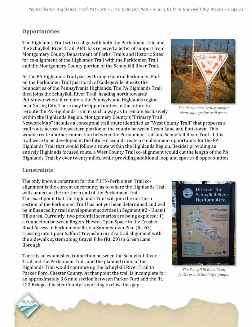
The Perkiomen Trail provides clear signage for trail users
The Schuylkill River Trail features outstanding signage.
Opportunities
The Highlands Trail will co-align with both the Perkiomen Trail and the Schuylkill River Trail. AMC has received a letter of support from Montgomery County Department of Parks, Trails and Historic Sites for co-alignment of the Highlands Trail with the Perkiomen Trail and the Montgomery County portion of the Schuylkill River Trail.
As the PA Highlands Trail passes through Central Perkiomen Park on the Perkiomen Trail just north of Collegeville, it exits the boundaries of the Pennsylvania Highlands. The PA Highlands Trail then joins the Schuylkill River Trail, heading north towards Pottstown where it re-enters the Pennsylvania Highlands region near Spring City. There may be opportunities in the future to reroute the PA Highlands Trail in such a way as to remain exclusively within the Highlands Region. Montgomery County’s “Primary Trail Network Map” includes a conceptual trail route identified as “West County Trail” that proposes a trail route across the western portion of the county between Green Lane and Pottstown. This would create another connection between the Perkiomen Trail and Schuylkill River Trail. If this trail were to be developed in the future it would create a co-alignment opportunity for the PA Highlands Trail that would follow a route within the Highlands Region. Besides providing an entirely Highlands focused route, a West County Trail co-alignment would cut the length of the PA Highlands Trail by over twenty miles, while providing additional loop and spur trail opportunities.
Constraints
The only known constraint for the PHTN-Perkiomen Trail co-alignment is the current uncertainty as to where the Highlands Trail will connect at the northern end of the Perkiomen Trail. The exact point that the Highlands Trail will join the northern section of the Perkiomen Trail has not yet been determined and will be influenced by trail development activities in Segment #2 - Unami Hills area. Currently, two potential scenarios are being explored: 1) a connection between Rogers-Hiester Open Space to the Crusher Road Access in Perkiomenville, via Sumneytown Pike (Rt. 63) crossing into Upper Salford Township or; 2) a trail alignment with the sidewalk system along Gravel Pike (Rt. 29) in Green Lane Borough.
There is an established connection between the Schuylkill River Trail and the Perkiomen Trail, and the planned route of the Highlands Trail would continue up the Schuylkill River Trail to Parker Ford, Chester County. At that point the trail is incomplete for an approximately 3.6 mile section between Parker Ford and the Rt. 422 Bridge. Chester County is working to close this gap.

Pennsylvania Highlands Trail Network - Trail Concept Plan - Unami Hills to Hopewell Big Woods - Page 22
Maps and Route Descriptions
The PA Highlands Trail co-aligns with and follows the Perkiomen Trail for nearly its entire length of 19 miles, connecting Green Lane County Park with the Schuylkill River Trail. There are numerous high quality access points along the trail with a variety of amenities like restaurants in Spring Mount, Schwenksville, Graterford, and Collegeville. In addition to Montgomery County’s Green Lane Park, the Perkiomen Trail passes through or near Central Perkiomen Park, Pennypacker Mill Historic Site, Lower Perkiomen Valley Park and John James Audubon Center at Mill Grove.
The Perkiomen Trail joins the Schuylkill River Trail near the confluence of the Perkiomen Creek and Schuylkill River. The Highlands Trail follows the Schuylkill River Trail north for approximately 25.2 miles. At Mont Clare, the trail crosses the Schuylkill River into the Borough of Phoenixville, Chester County. The Schuylkill River Trail continues northwest in Chester County to Parker Ford where there is a 3.6-mile section where trail users must follow an interim road route to Pottstown. The Schuylkill River Trail will be intersected by the planned Big Woods Trail at the Union Township-Schuylkill River Trailhead.
The PA Highlands Trail trunk route follows the Perkiomen Trail, shown here at Graterford, near Central Perkiomen Park.
Schuylkill River Trail Bridge over the Perkiomen Creek
Cyclist near the junction of the Perkiomen Trail and the Schuylkill River Trail

Pennsylvania Highlands Trail Network - Trail Concept Plan - Unami Hills to Hopewell Big Woods - Page 23

Pennsylvania Highlands Trail Network - Trail Concept Plan - Unami Hills to Hopewell Big Woods - Page 24
Action Items in Segment #3:
1) Meet with project partners including Montgomery County Parks and Planning Commission, Schuylkill River Heritage Area, and Chester County for updates on PHTN planning, discussion of Highlands Trail signage, and co-alignment issues for Perkiomen Trail and Schuylkill River Trail.
2) Conduct field surveys on the Perkiomen and Schuylkill River Trail to assess PHTN signage needs and opportunities.
3) Meet with project partners, including Schuylkill River Heritage Area and Chester County, to discuss status of unfinished sections of the Schuylkill River Trail.
Pennsylvania Highlands Trail Network - Trail Concept Plan - Unami Hills to Hopewell Big Woods - Page 25
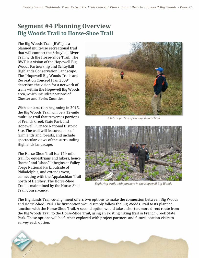
A future portion of the Big Woods Trail
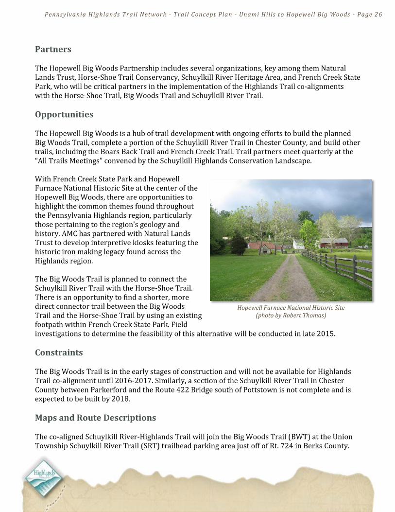
Exploring trails with partners in the Hopewell Big Woods
Segment #4 Planning Overview Big Woods Trail to Horse-Shoe Trail The Big Woods Trail (BWT) is a planned multi-use recreational trail that will connect the Schuylkill River Trail with the Horse-Shoe Trail. The BWT is a vision of the Hopewell Big Woods Partnership and Schuylkill Highlands Conservation Landscape. The “Hopewell Big Woods Trails and Recreation Concept Plan 2009” describes the vision for a network of trails within the Hopewell Big Woods area, which includes portions of Chester and Berks Counties. With construction beginning in 2015, the Big Woods Trail will be a 12-mile multiuse trail that traverses portions of French Creek State Park and Hopewell Furnace National Historic Site. The trail will feature a mix of farmlands and forests, and include spectacular views of the surrounding Highlands landscape. The Horse-Shoe Trail is a 140-mile trail for equestrians and hikers, hence, “horse” and “shoe.” It begins at Valley Forge National Park, outside of Philadelphia, and extends west, connecting with the Appalachian Trail north of Hershey. The Horse-Shoe Trail is maintained by the Horse-Shoe Trail Conservancy. The Highlands Trail co-alignment offers two options to make the connection between Big Woods and Horse-Shoe Trail. The first option would simply follow the Big Woods Trail to its planned junction with the Horse-Shoe Trail. A second option would take a shorter, more direct route from the Big Woods Trail to the Horse-Shoe Trail, using an existing hiking trail in French Creek State Park. These options will be further explored with project partners and future location visits to survey each option.
Pennsylvania Highlands Trail Network - Trail Concept Plan - Unami Hills to Hopewell Big Woods - Page 26
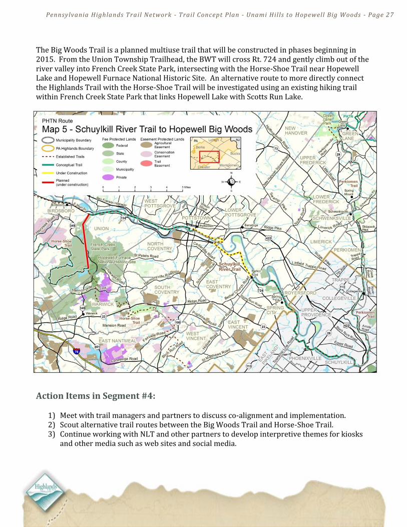
Hopewell Furnace National Historic Site (photo by Robert Thomas)
Partners The Hopewell Big Woods Partnership includes several organizations, key among them Natural Lands Trust, Horse-Shoe Trail Conservancy, Schuylkill River Heritage Area, and French Creek State Park, who will be critical partners in the implementation of the Highlands Trail co-alignments with the Horse-Shoe Trail, Big Woods Trail and Schuylkill River Trail.
Opportunities The Hopewell Big Woods is a hub of trail development with ongoing efforts to build the planned Big Woods Trail, complete a portion of the Schuylkill River Trail in Chester County, and build other trails, including the Boars Back Trail and French Creek Trail. Trail partners meet quarterly at the “All Trails Meetings” convened by the Schuylkill Highlands Conservation Landscape. With French Creek State Park and Hopewell Furnace National Historic Site at the center of the Hopewell Big Woods, there are opportunities to highlight the common themes found throughout the Pennsylvania Highlands region, particularly those pertaining to the region’s geology and history. AMC has partnered with Natural Lands Trust to develop interpretive kiosks featuring the historic iron making legacy found across the Highlands region. The Big Woods Trail is planned to connect the Schuylkill River Trail with the Horse-Shoe Trail. There is an opportunity to find a shorter, more direct connector trail between the Big Woods Trail and the Horse-Shoe Trail by using an existing footpath within French Creek State Park. Field investigations to determine the feasibility of this alternative will be conducted in late 2015.
Constraints The Big Woods Trail is in the early stages of construction and will not be available for Highlands Trail co-alignment until 2016-2017. Similarly, a section of the Schuylkill River Trail in Chester County between Parkerford and the Route 422 Bridge south of Pottstown is not complete and is expected to be built by 2018.
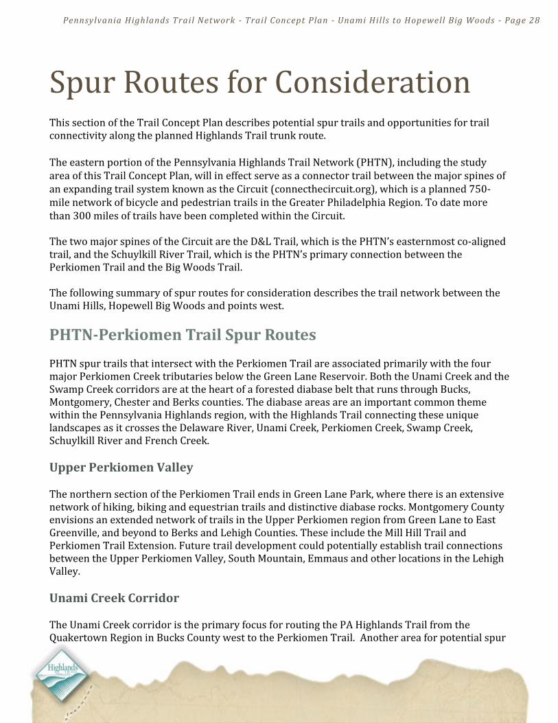
Maps and Route Descriptions The co-aligned Schuylkill River-Highlands Trail will join the Big Woods Trail (BWT) at the Union Township Schuylkill River Trail (SRT) trailhead parking area just off of Rt. 724 in Berks County.
Pennsylvania Highlands Trail Network - Trail Concept Plan - Unami Hills to Hopewell Big Woods - Page 27
The Big Woods Trail is a planned multiuse trail that will be constructed in phases beginning in 2015. From the Union Township Trailhead, the BWT will cross Rt. 724 and gently climb out of the river valley into French Creek State Park, intersecting with the Horse-Shoe Trail near Hopewell Lake and Hopewell Furnace National Historic Site. An alternative route to more directly connect the Highlands Trail with the Horse-Shoe Trail will be investigated using an existing hiking trail within French Creek State Park that links Hopewell Lake with Scotts Run Lake.
Action Items in Segment #4:
1) Meet with trail managers and partners to discuss co-alignment and implementation. 2) Scout alternative trail routes between the Big Woods Trail and Horse-Shoe Trail. 3) Continue working with NLT and other partners to develop interpretive themes for kiosks
and other media such as web sites and social media.
Pennsylvania Highlands Trail Network - Trail Concept Plan - Unami Hills to Hopewell Big Woods - Page 28
Spur Routes for Consideration This section of the Trail Concept Plan describes potential spur trails and opportunities for trail connectivity along the planned Highlands Trail trunk route. The eastern portion of the Pennsylvania Highlands Trail Network (PHTN), including the study area of this Trail Concept Plan, will in effect serve as a connector trail between the major spines of an expanding trail system known as the Circuit (connecthecircuit.org), which is a planned 750-mile network of bicycle and pedestrian trails in the Greater Philadelphia Region. To date more than 300 miles of trails have been completed within the Circuit. The two major spines of the Circuit are the D&L Trail, which is the PHTN’s easternmost co-aligned trail, and the Schuylkill River Trail, which is the PHTN’s primary connection between the Perkiomen Trail and the Big Woods Trail. The following summary of spur routes for consideration describes the trail network between the Unami Hills, Hopewell Big Woods and points west.
PHTN-Perkiomen Trail Spur Routes PHTN spur trails that intersect with the Perkiomen Trail are associated primarily with the four major Perkiomen Creek tributaries below the Green Lane Reservoir. Both the Unami Creek and the Swamp Creek corridors are at the heart of a forested diabase belt that runs through Bucks, Montgomery, Chester and Berks counties. The diabase areas are an important common theme within the Pennsylvania Highlands region, with the Highlands Trail connecting these unique landscapes as it crosses the Delaware River, Unami Creek, Perkiomen Creek, Swamp Creek, Schuylkill River and French Creek.
Upper Perkiomen Valley The northern section of the Perkiomen Trail ends in Green Lane Park, where there is an extensive network of hiking, biking and equestrian trails and distinctive diabase rocks. Montgomery County envisions an extended network of trails in the Upper Perkiomen region from Green Lane to East Greenville, and beyond to Berks and Lehigh Counties. These include the Mill Hill Trail and Perkiomen Trail Extension. Future trail development could potentially establish trail connections between the Upper Perkiomen Valley, South Mountain, Emmaus and other locations in the Lehigh Valley.
Unami Creek Corridor The Unami Creek corridor is the primary focus for routing the PA Highlands Trail from the Quakertown Region in Bucks County west to the Perkiomen Trail. Another area for potential spur

Pennsylvania Highlands Trail Network - Trail Concept Plan - Unami Hills to Hopewell Big Woods - Page 29
trail development within in the Unami Creek corridor is the Ziegler Nature Preserve, which Marlborough Township and Natural Lands Trust has identified as a passive recreation park, with the intent of developing a trail to connect from Swamp Creek Road to the park entrance at Ziegler Road. A preserve trail system could potentially provide connectivity to other nearby open space parcels.
Sunrise Trail and Swamp Creek Corridor The Swamp Creek corridor is currently being studied by Montgomery County Planning Commission for the potential development of the Swamp Creek Greenway and Sunrise Trail, which will provide a trail connection from the Perkiomen Trail, near Spring Mount, to Sunrise Mill, which is a county historic site. The Sunrise Trail will also provide a connection to the Stone Hills Greenway, State Gameland #234, and the Eva R. Meng Wildlife Preserve and Sanctuary, which is owned and managed by Valley Forge Audubon. The Stone Hills Greenway includes several hundred acres of contiguous woodlands and diabase geology.
East Branch Perkiomen Creek and Skippack Creek Trail planning and development in the upper East Branch Perkiomen Creek corridor is ongoing in West Rockhill Township, Bucks County, where collaborative efforts with Natural lands Trust are being undertaken to extend the existing multiuse trail that follows the creek in Sellersville and Perkasie Boroughs further west through the Township. The lower East Branch Perkiomen Creek in Montgomery County is not currently an active focus area for trail planning, however the Montgomery County Planning Commission and the Circuit have mapped the Evansburg Trail, which is a conceptual trail route that follows the East Branch Perkiomen Creek from its confluence with the Perkiomen Creek eastward to its confluence with the Indian Creek. From this point the conceptual Evansburg Trail joins a series of existing paved multiuse trails and planned trails that connect to the upper portion of Evansburg State Park. At this point, the Evansburg Trail follows the Skippack Creek Trail back to the Perkiomen Creek and Perkiomen Trail. To view this trail network visit connecthecircuit.org.
The Yellow Trail in the Stone Hills Greenway (photo by Phil Smith)
East Branch Perkiomen Creek

Pennsylvania Highlands Trail Network - Trail Concept Plan - Unami Hills to Hopewell Big Woods - Page 30
PHTN-Schuylkill River Trail Spur Routes: The Highlands Trail joins the Schuylkill River Trail near the Perkiomen Trail junction, where the Highlands Trail then follows the Schuylkill River west towards Pottstown and the planned connection with the Big Woods Trail, as described in this Trail Concept Plan - Segment #4.
Chester Valley Trail As the Highlands Trail-Perkiomen Trail passes through the Borough of Phoenixville there may be an opportunity for a future connection with the proposed DeVault Rail Trail, which would run south to the proposed Warner Spur Trail with a connection to the new Chester Valley Trail. Heading southwest to the end of the Chester Valley Trail near Exton, the proposed Chester Valley Trail extension would in continue southwest and connect with the Enola Low Grade Trail, which is a rail trail that runs from Atglen, Chester County and crosses Lancaster County to the Susquehanna River at a point just south of Columbia Borough. The Highlands Trail is planned to cross the Susquehanna River at Columbia, with an approach from the north via the Northwest Lancaster County River Trail. While these proposed Chester County trails are not within the designated Pennsylvania Highlands region, the potential for this southern route to create part of a Schuylkill River to Susquehanna loop connection is compelling. The Highlands Trail will co-align on a series of trails including the Horse-Shoe Trail, Lebanon Valley Rail Trail, Conewago Trail and Northwest River Trail to make a similar, albeit more northerly Schuylkill to Susquehanna connection through the heart of the Pennsylvania Highlands Region. Looking at these two Schuylkill River to Susquehanna River trail routes together, the vision of a great loop system emerges that would traverse the agricultural heartland of Pennsylvania, including the central portion of the Highlands region across Berks, Lebanon, Lancaster and Chester Counties.
French Creek Trail The Big Woods Trail is the primary Highlands Trail connection between the Schuylkill River Trail and the Horse-Shoe Trail. Another potential connection for the PHTN in this area is the French Creek Trail, which is envisioned primarily as a footpath connection to both the Horse-Shoe Trail and Big Woods Trail in French Creek State Park. The French Creek Trail would parallel French Creek from Warwick County Park to Phoenixville, where it would connect with the Schuylkill River Trail.
The proposed Chester Valley Trail extension would provide additional connections for the PA Highlands Trail. (photo by Stephen Warren)
Pennsylvania Highlands Trail Network - Trail Concept Plan - Unami Hills to Hopewell Big Woods - Page 31
Appendix – Maps
Map A – PA Highlands Trail and Conservation Landscapes
Pennsylvania Highlands Trail Network - Trail Concept Plan - Unami Hills to Hopewell Big Woods - Page 32
Map B – PA Highlands Trail Co-Alignments and Gaps
Pennsylvania Highlands Trail Network - Trail Concept Plan - Unami Hills to Hopewell Big Woods - Page 33
Map C – Unami Hills Conceptual Trail Routes

Pennsylvania Highlands Trail Network - Trail Concept Plan - Unami Hills to Hopewell Big Woods - Page 34
PAHighlands.org