pedestrian and bicycle master plan...june 2018 2 pedestrian and bicycle master plan / in order to...
TRANSCRIPT

Pedestrian and Bicycle Master Plan
City of Savage
JUNE 2018 Prepared by WSB
City of Savage
June 2018 Pedestrian and Bicycle Master Plan / i
TABLE OF CONTENTS
1. Plan Overview .................................................................................................................................... 1
A. Purpose of Plan ............................................................................................................................. 1
B. Importance of Walking and Biking .................................................................................................. 2
C. Planning Process Summary ........................................................................................................... 3
D. Goals and Outcomes ..................................................................................................................... 4
2. Existing Conditions ............................................................................................................................ 5
A. Existing and Planned Ped/Bike Network ........................................................................................ 5
B. Other Facilities ............................................................................................................................... 8
C. Known Pedestrian/Bicycle Safety Problems ................................................................................. 11
3. Public Engagement Summary .......................................................................................................... 13
A. On-Line Engagement - Interactive Mapping Tool ......................................................................... 13
B. Open House ................................................................................................................................. 13
C. Direct Contact with Staff .............................................................................................................. 13
D. Summary of Public Input and Key Themes .................................................................................. 14
4. Issues and Opportunities ................................................................................................................. 18
A. Issues Identified in Previous Plans ............................................................................................... 18
B. City Policies and Ordinances ....................................................................................................... 21
C. Ten-Year Street Improvement Plan ............................................................................................. 22
D. Gaps, Crossings, Safety, etc........................................................................................................ 22
E. Winter Uses ................................................................................................................................. 23
F. Maintaining the Sidewalk and Trail Network ................................................................................. 23
5. Best Practices .................................................................................................................................. 24
A. Considerations for All Facilities .................................................................................................... 24
B. Pedestrian Facilities ..................................................................................................................... 25
C. Multi-Use Trail Facilities ............................................................................................................... 31
D. Bicycle Facilities .......................................................................................................................... 32
6. Recommendations ........................................................................................................................... 33
A. Sidewalk and Trail Network Vision ............................................................................................... 33
B. General Goals and Recommendations ........................................................................................ 35
C. Sidewalk and Trail Development Recommendations ................................................................... 35
D. Maintenance and Preservation Recommendations ...................................................................... 36
E. Safety Recommendations ............................................................................................................ 36

City of Savage
June 2018 Pedestrian and Bicycle Master Plan / ii
F. Current City Policy Revision Recommendations .......................................................................... 37
G. System Enhancement Recommendations ................................................................................... 37
7. Implementation Plan ........................................................................................................................ 38
A. List of Priority Projects ................................................................................................................. 38
B. Funding the System ..................................................................................................................... 41
C. External Funding Sources ............................................................................................................ 41
D. Recommended Maintenance Schedule ....................................................................................... 43
E. Ongoing Monitoring (Performance Measures) .............................................................................. 44
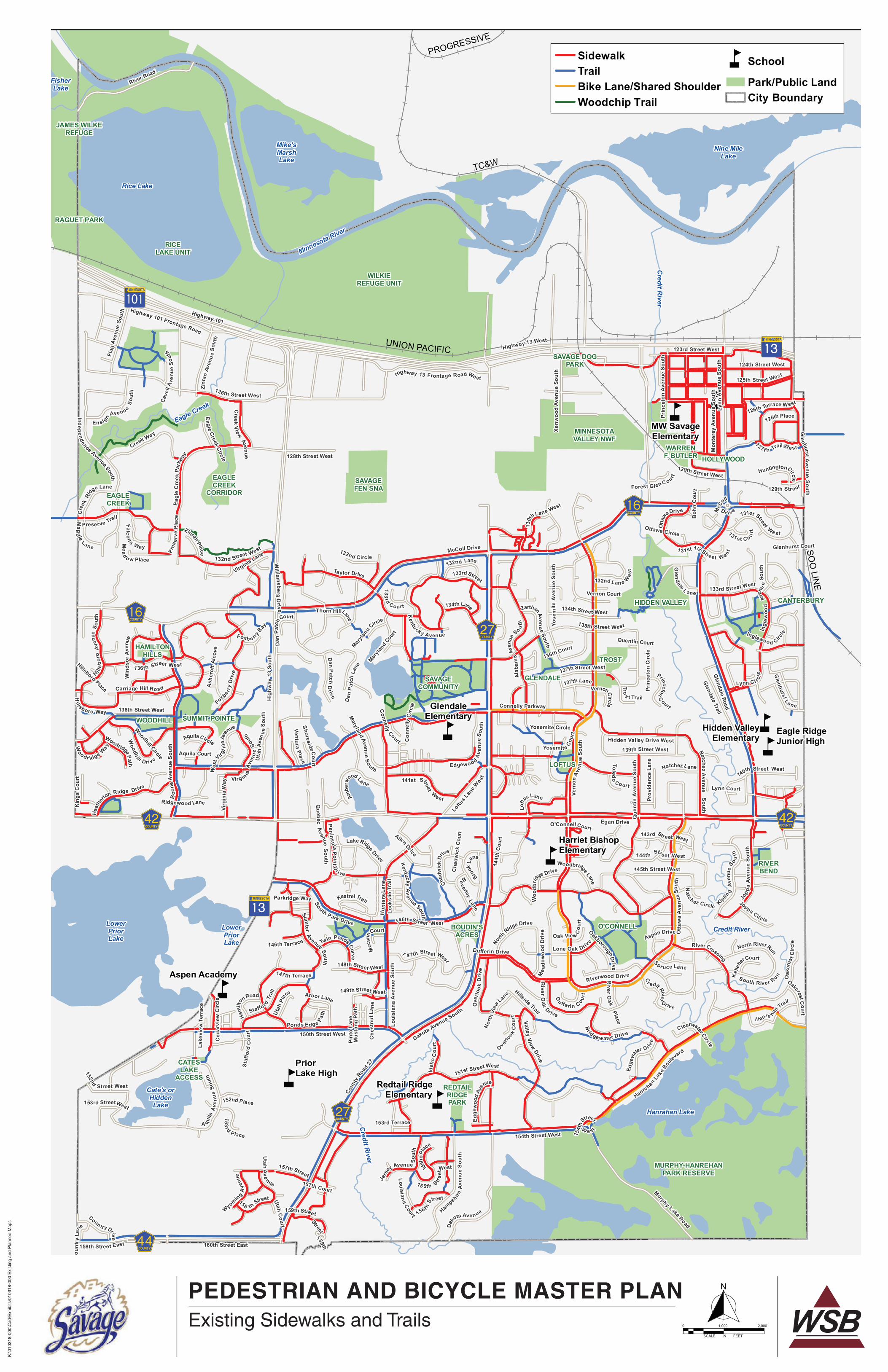
LIST OF FIGURES Figure 1: Existing Sidewalk and Trail Network ....................................................................................... 7
Figure 2: Neighboring Communities and Regional Destinations ............................................................. 9
Figure 3: Pedestrian-Vehicle and Bicycle-Vehicle Crashes, 2006-2015 ............................................... 12
Figure 4: Number of Public Comments Received ................................................................................. 14
Figure 5: Number of Liked and Disliked Comments ............................................................................. 15
Figure 6: Number of Comments by General Location .......................................................................... 16
Figure 7: Key Themes from Public Input .............................................................................................. 17
Figure 8: Issues Map ........................................................................................................................... 20
Figure 9: Planned Sidewalk and Trail Network ..................................................................................... 34
Figure 10: Priority Projects Map ........................................................................................................... 39
LIST OF TABLES Table 1: Top 10 “Liked” Comments ...................................................................................................... 15
Table 2: List of Priority Projects ........................................................................................................... 40
Table 3: Recommended Performance Measures ................................................................................. 44
APPENDIX Appendix A: Public Comments Received
Appendix B: Trail Maps for Nearby Regional Parks
City of Savage
June 2018 Pedestrian and Bicycle Master Plan / 1
1. PLAN OVERVIEW The City of Savage is a suburban community located along the Minnesota River Valley in
northeastern Scott County. The city offers a relatively short drive to downtown Minneapolis due to
its proximity to both the I-35W and US Highway 169 river crossings. The landscape itself is of high-
quality, providing scenic views and bluff vistas over the river valley, unique features such as the
Savage Fen, and preserved natural areas along the Credit River and Murphy-Hanrehan Park
Reserve. These factors along with first-rate schooling and city services have attracted residents to
Savage, an established community of over 30,000 residents. Most of this growth has occurred in
the last few decades following suburban development patterns.
Savage has an extensive pedestrian and bicycle system with over 30 miles of existing trails, 64
miles of sidewalks, and 142 miles of streets and county and state highways. As the community
continues to evolve, the city is exploring opportunities to enhance connections and promote walking
and biking throughout the community and neighboring communities to key destinations including
parks, schools, civic buildings, commercial and employment areas, and between neighborhoods.
This Pedestrian and Bicycle Master Plan, the first of its kind for the City of Savage, builds upon
existing facilities to guide future efforts and investments in bicycle- and pedestrian-friendly
infrastructure and practices.
A. PURPOSE OF PLAN
The purpose of the Savage Pedestrian and Bicycle Master Plan is to provide a framework for
maintaining and expanding the sidewalk and trail system, taking advantage of the ongoing
evolution of non-motorized transportation facilities and increased walking and biking trends
nationwide. This plan provides direction for future implementation and maintenance work of the
city’s sidewalk and trail system in the following areas.
Increase Walking and Biking
The City of Savage is committed to making walking and biking more attractive for transportation,
recreational and health purposes. Ultimately, the city wants to increase walking and bicycling by
providing the necessary infrastructure, policies and encouragement to make walking and biking
more attractive, safe and enjoyable for residents of all ages and backgrounds.
Engage the Community
In order to enhance the existing sidewalk and trail system, the city needs to understand what
residents want and/or need to make walking and biking more attractive options – be it for health,
transportation or recreational reasons. Public engagement efforts were made to gather input on
the existing sidewalk and trail system and identify where current issues or barriers exist that
prohibit or reduce the ability to walk and bike in Savage. This input was used to identify plan
recommendations and prioritize future improvements.
Make Recommendations to Enhance the System
Along with understanding the needs and desires of residents, this plan identifies methods and
practices that the city can utilize to develop a safe, efficient and enjoyable sidewalk and trail
system. This plan identifies recommendations and revisions to current ordinances or standards
City of Savage
June 2018 Pedestrian and Bicycle Master Plan / 2
in order to effectively implement the outcomes of the master plan and support increased walking
and biking activity.
Identify Opportunities for Implementation
Finally, this master plan intends to identify opportunities that the city can use to prioritize
sidewalk and trail investments, implement improvements over time, and track pedestrian and
bicycle use to ensure that the ongoing needs of users are evaluated and addressed.
B. IMPORTANCE OF WALKING AND BIKING
America’s communities are undergoing many changes that have emerged over the past
decade. Notably, the population is aging – the baby boomers are getting older and their
transportation and recreational needs are changing. The population is also becoming
increasingly diverse, racially and economically, with increased demand for affordable and
accessible transportation options that cater to varying needs. Additionally, health concerns
about cardiovascular disease and obesity have come to the forefront of the medical community.
These conditions occur at the adult and childhood levels and have associated negative effects
like high cholesterol, diabetes, strokes and certain types of cancer. These concerns have
increased while insurance premiums have increased and the national health care debate has
taken place.
Since the 1970s, the percent of children who are obese has tripled, with the largest increases
seen in low-income populations. The trends for adults are no less concerning. Today more than
one third of American adults are obese. Regular exercise and physical activity can reduce
obesity – yet studies show that less than half of children meet and less than 10 percent of adults
meet recommended guidelines for physical activity.
Benefits Associated with Pedestrian and Bicycle Planning
The changes in our communities, both in terms of health and demographics, are beginning to
make their impact and influence felt. Many cities have started to think about the actions they can
take to encourage physical activity, to make their communities healthier, and to make
transportation systems more accessible for all residents. Physical activity is likely to occur for
four primary reasons – work, household activities, recreation/leisure and transportation. One of
the ways in which communities can make a difference is by improving their recreational and
transportation facilities and their connections to key destinations.
Creating conditions that make walking and biking convenient and safe are beneficial for several
reasons. One of the most important benefits is that increased biking and walking rates
encourage a healthier community. If conditions are in place to make it safe, convenient and
enjoyable to walk or bike, more people will have the opportunity to choose non-motorized
transportation for commuting, running errands, getting to and from school or for recreational and
leisure activities. For many people, walking and biking as a means of transportation may be
their only opportunity for exercise in a given day. And for many people, walking and biking may
be their only means of transportation. It is important to realize that not every resident is an
automobile driver, but every resident is a pedestrian. An equitable approach to transportation
starts with making walking and biking safe for everyone.
City of Savage
June 2018 Pedestrian and Bicycle Master Plan / 3
Another benefit of increased walking and biking is reduced dependency on fossil fuels. While
the number of electric and hybrid vehicles is increasing, most vehicles still operate on regular
gasoline or diesel fuel which emits pollutants that contribute to poor air quality. Even at low
levels, these emissions are known to cause respiratory issues, and are a suspected cause of
some cancers. With the volume of vehicle related emissions produced, efforts to increase non-
motorized transportation are welcome for overall community and environmental health.
C. PLANNING PROCESS SUMMARY
This master plan was developed under the direction of the City Council, Parks, Recreation and
Natural Resource Commission (PRNRC), Planning Commission, and City of Savage staff. A
Project Management Team (PMT) consisting of city staff and consulting staff was established to
guide the overall planning process, develop plan goals and outcomes, provide technical
analysis, and ensure plan development is consistent with direction provided by the Council and
advisory commissions. PMT members met monthly over the course of eight months to discuss
these issues and continue advancing development of the plan. The following is the list the PMT
members:
• Greg Boatman, Public Works Director (staff lead)
• Barry Stock, City Administrator
• Seng Thongvanh, City Engineer
• Terri Dill, Senior Planner
• Trent Jutting, Assistant Public Works Director
• Andy Hingeveld (consulting staff)
• Jeff Feulner (consulting staff)
• John Powell (consulting staff)
Input from other sources was provided throughout the planning process. At the beginning of
the planning process, PMT members provided a presentation to the City Council, PRNRC,
and Planning Commission to introduce the master plan process and gain feedback on plan
goals and outcomes. Public engagement (further described in Section 3) was collected using
multiple formats to gain an understanding of issues and opportunities related to the existing
sidewalk and trail system. PMT members used the inputs provided by the public and city
officials along with technical analyses to develop a draft master plan document that was
presented back to the public and PRNRC prior to going to the City Council for final action.

City of Savage
June 2018 Pedestrian and Bicycle Master Plan / 4
D. GOALS AND OUTCOMES
The following set of goals with actionable outcomes were established as part of the Pedestrian
and Bicycle Master Plan process to guide development of the master plan and support the City
of Savage’s future efforts for advancing walking and biking activities:
Goal #1: Provide a safe and comfortable pedestrian and bicycle network for all ages
and abilities.
Outcomes:
• Identify deficiencies in the pedestrian and bicycle network.
• Recommend improvements that maximize network connectivity, comfort, equity and safety
while minimizing levels of stress.
• Recommend revisions to City policy that would further support use of the pedestrian and
bicycle network.
Goal #2: Promote the City’s pedestrian and bicycle network to improve the health of
the community.
Outcomes:
• Identify resources and outreach programs that can be used to inform residents of the
City’s current pedestrian and bicycle network.
• Promote the health benefits associated with walking and bicycling.
• Explore potential partnerships that could result in increased walking and bicycling.
Goal #3: Maintain the existing pedestrian and bicycle network to preserve previous
and future public investments.
Outcomes:
• Develop trail maintenance policies for the City to preserve the existing network and
provide safe and comfortable facilities.
• Incorporate sustainable practices in maintaining the network that considers seasonal use
and condition of the infrastructure.
Goal #4: Develop a Pedestrian and Bicycle Master Plan that is both actionable and
measurable.
Outcomes:
• Develop a ten-year plan for network improvements that can be implemented in
coordination with the capital improvement program and 10-year street improvement plan.
• Identify possible funding sources that can be utilized to finance the implementation plan.
• Identify a set of performance measurements to monitor the on-going implementation of the
master plan and to measure pedestrian and bicycle activity.
City of Savage
June 2018 Pedestrian and Bicycle Master Plan / 5
2. EXISTING CONDITIONS This section describes Savage’s existing pedestrian and bicycle network. Understanding the current
network provides the basis for analysis and recommendations. See Figure 1 for a map of existing
sidewalks and trails.
A. EXISTING AND PLANNED PED/BIKE NETWORK
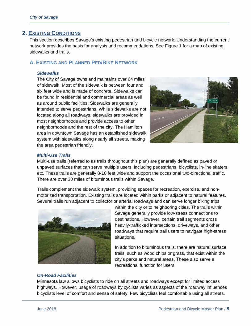
Sidewalks
The City of Savage owns and maintains over 64 miles
of sidewalk. Most of the sidewalk is between four and
six feet wide and is made of concrete. Sidewalks can
be found in residential and commercial areas as well
as around public facilities. Sidewalks are generally
intended to serve pedestrians. While sidewalks are not
located along all roadways, sidewalks are provided in
most neighborhoods and provide access to other
neighborhoods and the rest of the city. The Hamilton
area in downtown Savage has an established sidewalk
system with sidewalks along nearly all streets, making
the area pedestrian friendly.
Multi-Use Trails
Multi-use trails (referred to as trails throughout this plan) are generally defined as paved or
unpaved surfaces that can serve multiple users, including pedestrians, bicyclists, in-line skaters,
etc. These trails are generally 8-10 feet wide and support the occasional two-directional traffic.
There are over 30 miles of bituminous trails within Savage.
Trails complement the sidewalk system, providing spaces for recreation, exercise, and non-
motorized transportation. Existing trails are located within parks or adjacent to natural features.
Several trails run adjacent to collector or arterial roadways and can serve longer biking trips
within the city or to neighboring cities. The trails within
Savage generally provide low-stress connections to
destinations. However, certain trail segments cross
heavily-trafficked intersections, driveways, and other
roadways that require trail users to navigate high-stress
situations.
In addition to bituminous trails, there are natural surface
trails, such as wood chips or grass, that exist within the
city’s parks and natural areas. These also serve a
recreational function for users.
On-Road Facilities
Minnesota law allows bicyclists to ride on all streets and roadways except for limited access
highways. However, usage of roadways by cyclists varies as aspects of the roadway influences
bicyclists level of comfort and sense of safety. Few bicyclists feel comfortable using all streets.

City of Savage
June 2018 Pedestrian and Bicycle Master Plan / 6
Most potential bicyclists indicate feeling interested but cautious about bicycling. Factors that
influence feelings of safety for bicyclists include road width, traffic speed, traffic volume and the
presence of bicycle infrastructure. Roadways that have bike lanes and paved shoulders typically
make bicyclists feel safer as they separate the bicycle and car traffic.
Most residential streets in Savage may have low enough traffic and speeds that all users can
feel safe biking on them. Savage has several on-road paved shoulders on its collector roadways
that provide space for cyclists to use outside of the travel lane. Painted lines delineate the wide
shoulder from the travel lane, giving additional space for cyclists to ride away from the travel
lane. It is important to note that while bicyclists can use the paved shoulder, they are not
required to and in many instances, some bicyclists feel more comfortable and choose to ride in
the travel lane with traffic.
There is currently one bike lane signed and striped within Savage. It is located along Murphy
Lake Boulevard near the city border with Burnsville. This bike lane does not connect to the
entire city, leaving many bike-friendly areas isolated from one another, separated by busy
roadways that do not have bike lanes or infrastructure.
Pedestrian Crossings
Pedestrian crossings enable pedestrians and bicyclists to
access locations on either side of streets and highways.
Pedestrian crossings can be either marked with signs and
striping or unmarked and can be placed at intersections or in
mid-block locations. Marked crosswalks are intended to
enhance visibility and awareness for drivers that pedestrians
may be present in the crossing. Uncontrolled pedestrian
crossings are crossing locations that are not controlled by a
stop sign, yield sign, or traffic signal. There are several
marked crosswalks located within Savage.
Five pedestrian activated crossings have been recently
installed in Savage to further enhance visibility of pedestrians
at key crossing locations. The pedestrian activated crossings
include a striped crosswalk and enhanced pedestrian
crossing signs that light up or flash when a pedestrian pushes the button. Pedestrian activated
crossings have been installed at locations with a higher presence of pedestrian activity near
local parks at these three locations:
• Boone Avenue and 138th Street (between Woodhill Park and Summit Point Park)
• Vernon Avenue and 137th Street (near Trost Park)
• Lynn Avenue and 128th Street (near Hollywood Park)
• 150th Street and Virginia Avenue
• 150th Street and Zinran Avenue
PEDESTRIAN AND BICYCLE MASTER PLAN
K:\0
1031
8-00
0\C
ad\E
xhib
its\0
1031
8-00
0 E
xist
ing
and
Pla
nned
Map
s
Existing Sidewalks and Trails
5
5
55
5
5
5
5
5
?ûA@
?±A@
MINNESOTAVALLEY NWF
SAVAGEFEN SNA
Eagle Creek
Credit R
iver
Credit River
Credit R
iver
Minnesota River
GpWX
G|WX
G|WX
G±WX G±WX
G³WX
?±A@
GpWX
BOUDIN'SACRES
CANTERBURY
CATESLAKE
ACCESS
EAGLECREEK
GLENDALE
HAMILTONHILLS
HIDDEN VALLEY
HOLLYWOOD
JAMES WILKEREFUGE
LOFTUS
RAGUET PARK
O'CONNELL
REDTAILRIDGEPARK
RICELAKE UNIT
RIVERBEND
SAVAGECOMMUNITY
SUMMIT POINTE
TROST
WARRENF. BUTLER
WILKIEREFUGE UNIT
WOODHILL
MURPHY-HANREHANPARK RESERVE
EAGLECREEK
CORRIDOR
SAVAGE DOGPARK
PriorLake High
Harriet BishopElementary
Eagle RidgeJunior High
Hidden ValleyElementary
MW SavageElementary
GlendaleElementary
Redtail RidgeElementary
Aspen Academy
OverlookLake
Rice Lake
FisherLake
Cate's orHiddenLake
Nine MileLake
Hanrahan Lake
Mike'sMarshLake
LowerPriorLake
LowerPriorLake
PROGRESSIVE
TC&W
SOO
LINE
UNION PACIFIC
McColl Drive
Highway 101
Cou
ntry
Lane
Highway 101 Frontage Road
Dakota Ave nue
Hig
hway
13
Sout
h
Boo
neAv
enue
Sout
h
Hampsh
ireAv
enue
Sout
h
Connelly Parkway
Que
ntin
Aven
ueSo
uth
160th Street East
125th Street West
145th Street West
Taylor Drive
Heat
he
rton Ridge Drive
Edge
woo
dAv
enue
Otta
wa
Ave
nue
Sout
h
154th Street West
135th Street West
Queb ec
Avenue
S o uth
Dakota Avenue South
South Park Drive
Loftu
s Lane
West
Lynn
Ave
nue
Sout
h
Dufferin Drive
Sumter
Avenue So uth
Highway 13 West
Twin Ponds Curve
Kentuck y Avenue
Prov
iden
ce L
ane
Kipling
Aven
u e
S o uth
Zinr
anAv
enu e
Sout
h
Lake
view
Ter
race
River Road
Vern
onAv
enu e
Sout
h
Brook
Lane
Yosemite Cour
t
Prin
ceto
nAv
enue
Sout
h
Hillside Trail
NatchezA
venueSouth
P eninsu laPointD
r ive
Oak View Cou
rt
131st Street West
Ambe
rw
ood La ne
151st Street West
138th Street West
123rd Street West
Alab
ama
Aven
ue
So uth
Glendale Road
150th Street West
Che
stnu
tLa n
e
Wil l iam
s bergD
rive
Preserve Trail
RiverCrossing
Ottawa Circle
Loftu
s Lane
Pint
o La
ne
Ced
arvi
ew C
ircle
156t hStreet
129th Street
Gle
nhurstAve nueSouth
Mus
tang
Pat
h
A quila
Aven
ueSo
uth
143rd Str eet West
12 7t h Trail We st
Inglewood Circle
139th Street West
Carriage Hill Ro ad
157th Court
Kestrel Trail
133rd Street West
Beverley
Lane
Quentin Court
Yosemite CircleWoodhill Circle
15 5th Stree
tWest
144t
h C
ourt
Otta
waDrive
132nd Lan e Wes
t
Glenhurst Court
Ridgewood Lane
Lynn Court
Foxb e rryBay
Woodr idge Way
148th Street West
140th Street West
Virginia Lane
Cha
dwic
k Co
urt
Lake Ridge Drive
Ea g
leC
ree k
Park
way
Foxbe rry
Driv
e
V all eyVi ew
Drive
158 thStreet
1 31st 1/2 Street W est
Jers
ey Avenue Sout
h
Maryla
nd Cou
rt
136th Street West
Staf
ford
Cou
rt
Hills
boro
Ave
nue
Sou t
h
Jop pa
Aven
ueSo
uth
Staffo rdTr
ail
H anre han Trail
Dan
Pa t
chLa
ne
Aquila Court
Over
look
Driv
e
O'Connell Court
Pres
erve
Plac
e
Glenhurst L a ne
Boh
nC
ourt
Ingl
ewoo
dAve
nue
Sout
h
137th Street West
Glendale Trail
UtahC
ourt
Lynn Ci rcle
Hillsboro Place
OakcrestCourt
Con
nelly
Circ
le
Riverwood Drive
DanPatch
Drive
Flag
Aven
ueSo
uth
126th Street West
C learwater Circle
137th Lane
Lone Oak Drive
Loui
sian
aA
venu
eSo
uth
Ash
crof
t Alc
ove
Win
dsor
Aven
ue
Vernon Court
Kentuc kyAve nue South
132nd Street West
Uta
hA v
enue
S out
h
Yose
mite
Aven
ueSo
uth
Chadw
ick
Drive
Rive rO
ak
Dr ive
Nat ch ez Circle
159th Stree t
144th Str e et West
Woodh
ill D rive
South Riv er Run
Edge
wa
ter D rive
Utah
Av e nue
133rd Street
Hidden Valley Drive West
149th Street West
Virgin iaAv
enu
eSo
uth
HanrehanLa
keBou
levard
WyomingA
venu
e
Xenw
ood
Aven
ueSo
uth
Wes
tVirg
i nia
Avenue
147th Terrace
Joppa Circle
152nd
Street West
North RiverRun
136th Court
Spr uce Lane
131 st C o urt
Connelly
Court
Aspen Drive
153rd Terrace
158th Street East
124th Street West
153rd StreetWest
Cr edit River
Drive
Overlo
okC
ourt
L ou isianaCourtCoun tryDrive
En signAve nueS
outh
Arbor Lane
AquilaCircle
Brid gewater Drive
152nd Place
146th Terrace
Prin
ceto
n Ci
rcle
Egan Drive
Parkridge Way
Mcc
annC
ourt
Highway 13 Frontage Road West
Cave
llAv
enue
Sou
th
Lock
slie
Tra
il
Toledo
Court
VernonCi rcle
Forest Gl enC ou rt
Allen Drive
Idaho
Place
1 47th Stre et West
134th Lane
Mead
o w Place
ZinranPlace
Sho resideCourt
North
Ridge Drive
126th Place
RiverO
akPlace
133rd
Court
Mea
dow
ood
Driv
e
Ponds Edge Path
Maryla
nd Circle
North
View
Lane
Kel
lehe
rCourt
146th Street West
134th Street West
Dan
Patc
hCourt
Kin
gs C
ourt
Vent ur aPlace
Thorn HillLane
Eag leCreek
Circle
126th Terrace W est
HuntingtonCirc le
Virg
inia
Way
T ro
s t Trail
Utah
Place
Edgewoo dAv
enue
Sou t
h
D
u fferin Co urt
Idah
oC
ourt
OakboroughDri ve
132nd Circle
Natchez Lane
Woo
dbrid
ge Drive
Ham
ilt
on Road
129th Street West
Glen
dale L ane
Woodbridge Lane
157th Street
Princeton
Court
ZarthanAvenu e
South
153rd
Place
Oak
cres
t Circ
le
Mag
g ie
Lane
Woodridge Path
1 30t
hLane West
Falcon s Way
Maryland Avenu e
South
Mon
tere
yAv
enue
Sout
h
128th Street West
Cre
ekRi
dge Lane
Creek
V iewAvenue
132nd Lane
Hill sbo ro Way
Hun
ters
Lan e
141st Street
West
Creek Way
Coun
tyRoa
d 27
Murphy Lake Road
Indep endence Avenue South
McC
oll
Dr iv e
154t
hS
treet
W es t
159th
Street
1 inch = 2,000 feet
Docum
ent Path: K
:\010318-000\GIS
\Maps\Existing S
idewalk Trails M
ap.mxd D
ate Saved: 6/14/2018 2:40:36 PM
Savage, MN
SidewalkTrailBike Lane/Shared ShoulderWoodchip Trail
5 School
Park/Public LandCity Boundary
Pedestrian & Bicycle Master PlanExisting Sidewalks and Trails 0 2,000
Feet¯SCALE IN FEET
0 2,0001,000
City of Savage
June 2018 Pedestrian and Bicycle Master Plan / 8
B. OTHER FACILITIES
Parks
Savage is home to 23 parks that range in size from small neighborhood parks to large, regional
parks like Murphy-Hanrehan Park Reserve. Park, recreational and preserve land makes up 20
percent of Savage’s land area, at 2,145 total acres. Savage’s parks boast amenities like
playgrounds, picnic areas, trails and nature areas. The city’s parks are a popular destination for
walking and biking, and many parks are already connected to the city’s sidewalk and trail
system.
Murphy-Hanrehan Park Reserve has an extensive nature trail network as well as a popular
single-track mountain bike course. Nearby Cleary Lake Regional Park also has several trails
including a popular paved trail loop around the lake. These regional parks are key attractions to
city residents. See Appendix B for maps of these regional parks and their trail networks.
County Roadway Trails
Scott County operates several highways within Savage. The County supports constructing
sidewalk and trail facilities along both sides of its highways to accommodate walking and biking
activities. Within Savage, the approach has been to construct a sidewalk on one side of the road
and a trail on the other side.
There are few sidewalk and trail gaps remaining along county highways within Savage. One of
the major remaining gaps will be completed when Egan Drive (County Highway 42) is
reconstructed in 2018 between Boone Avenue and Louisiana Avenue. The project will include
an 8-foot trail on the south side of the road from Harbor Place to Allen Boulevard and a 5-foot
sidewalk on the north side from Heatherton Ridge Drive to Louisiana Avenue. One other key
gap that remains are sidewalk and trail facilities along McColl Drive (County Highway 16)
between Shakopee and Highway 13.
Transit
Savage is served by three bus routes and a park and ride location by the Minnesota Valley
Transit Authority (MVTA). Routes 421, 444 and 464 serve Savage with connection to the
Burnsville Transit Station, the Mall of America, and Downtown Minneapolis. The Savage Park
and Ride is located near Egan Drive (County Highway 42) and Huntington Avenue and currently
has 182 parking stalls. There are currently no bike lockers or storage racks at the park and ride
location. Other nearby park and rides that serve Savage residents include Southbridge
Crossings and Eagle Creek in Shakopee and the Burnsville Transit Station.
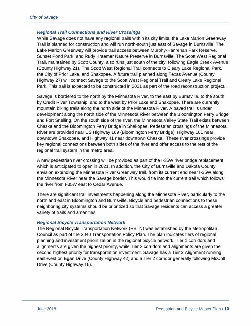
Adjoining City Networks
The cities of Burnsville, Shakopee, and Prior Lake all have their own sidewalk and trail systems.
It is recognized that several key gaps between Savage and neighboring cities exist. Completing
these gaps will provide access beyond Savage into nearby commercial locations and connect
residents to the metropolitan area. Figure 2 shows sidewalk and trail connections to neighboring
communities.

City of Savage
June 2018 Pedestrian and Bicycle Master Plan / 9
Figure 2: Neighboring Communities and Regional Destinations
City of Savage
June 2018 Pedestrian and Bicycle Master Plan / 10
Regional Trail Connections and River Crossings
While Savage does not have any regional trails within its city limits, the Lake Marion Greenway
Trail is planned for construction and will run north-south just east of Savage in Burnsville. The
Lake Marion Greenway will provide trail access between Murphy-Hanrehan Park Reserve,
Sunset Pond Park, and Rudy Kraemer Nature Preserve in Burnsville. The Scott West Regional
Trail, maintained by Scott County, also runs just south of the city, following Eagle Creek Avenue
(County Highway 21). The Scott West Regional Trail connects to Cleary Lake Regional Park,
the City of Prior Lake, and Shakopee. A future trail planned along Texas Avenue (County
Highway 27) will connect Savage to the Scott West Regional Trail and Cleary Lake Regional
Park. This trail is expected to be constructed in 2021 as part of the road reconstruction project.
Savage is bordered to the north by the Minnesota River, to the east by Burnsville, to the south
by Credit River Township, and to the west by Prior Lake and Shakopee. There are currently
mountain biking trails along the north side of the Minnesota River. A paved trail is under
development along the north side of the Minnesota River between the Bloomington Ferry Bridge
and Fort Snelling. On the south side of the river, the Minnesota Valley State Trail exists between
Chaska and the Bloomington Ferry Bridge in Shakopee. Pedestrian crossings of the Minnesota
River are provided near US Highway 169 (Bloomington Ferry Bridge), Highway 101 near
downtown Shakopee, and Highway 41 near downtown Chaska. These river crossings provide
key regional connections between both sides of the river and offer access to the rest of the
regional trail system in the metro area.
A new pedestrian river crossing will be provided as part of the I-35W river bridge replacement
which is anticipated to open in 2021. In addition, the City of Burnsville and Dakota County
envision extending the Minnesota River Greenway trail, from its current end near I-35W along
the Minnesota River near the Savage border. This would tie into the current trail which follows
the river from I-35W east to Cedar Avenue.
There are significant trail investments happening along the Minnesota River, particularly to the
north and east in Bloomington and Burnsville. Bicycle and pedestrian connections to these
neighboring city systems should be prioritized so that Savage residents can access a greater
variety of trails and amenities.
Regional Bicycle Transportation Network
The Regional Bicycle Transportation Network (RBTN) was established by the Metropolitan
Council as part of the 2040 Transportation Policy Plan. The plan indicates tiers of regional
planning and investment prioritization in the regional bicycle network. Tier 1 corridors and
alignments are given the highest priority, while Tier 2 corridors and alignments are given the
second highest priority for transportation investment. Savage has a Tier 2 Alignment running
east-west on Egan Drive (County Highway 42) and a Tier 2 corridor generally following McColl
Drive (County Highway 16).

City of Savage
June 2018 Pedestrian and Bicycle Master Plan / 11
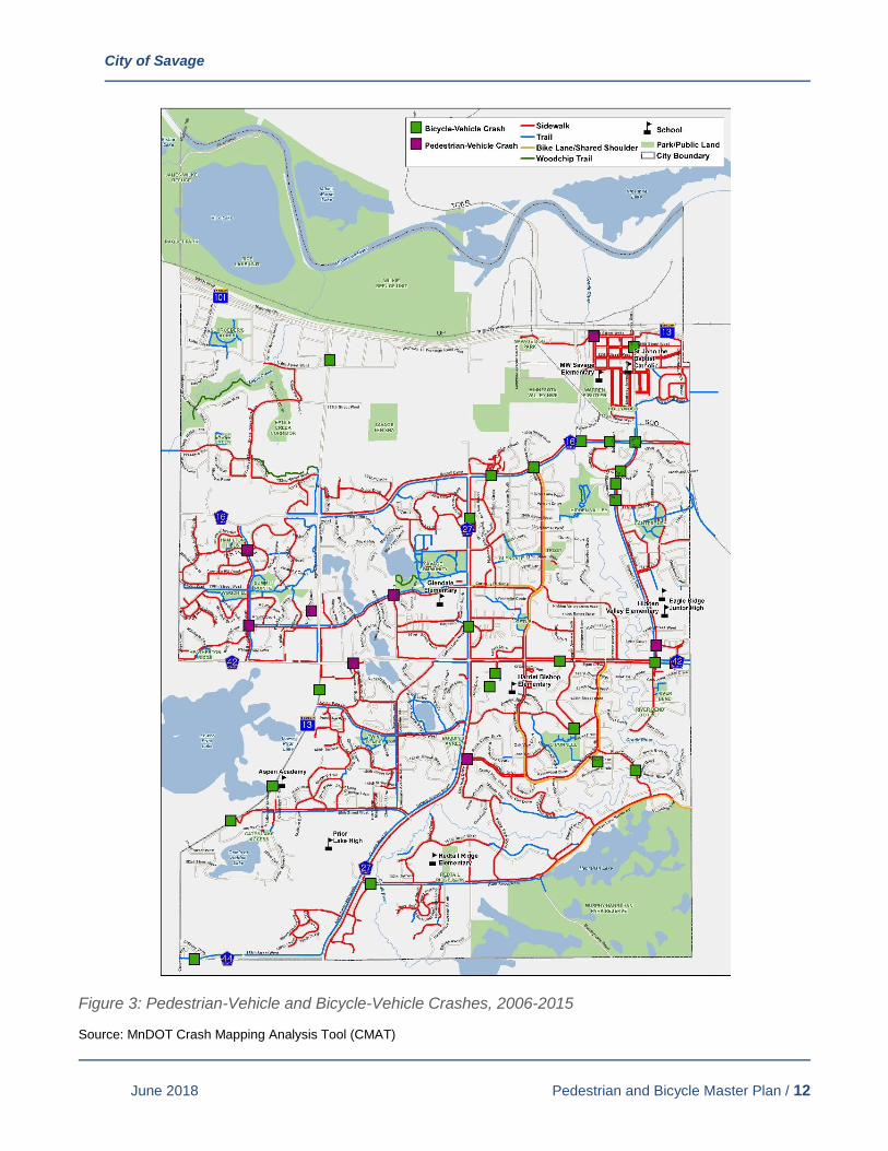
C. KNOWN PEDESTRIAN/BICYCLE SAFETY PROBLEMS
Pedestrian and bicycle safety is a primary concern for the City of Savage. A search of the
Minnesota Department of Transportation (MnDOT) Crash Mapping Analysis Tool (CMAT) data
showed a total of 12 pedestrian-vehicle and 28 bicycle-vehicle crashes occurred in Savage in
the 10-year period between 2006 and 2015. Figure 3 shows the location of traffic crashes
involving pedestrians and bicyclists.
Crashes involving pedestrians and bicyclists occurred along several corridors, including
Highway 13, Egan Drive (County Highway 42), McColl Drive (County Highway 16), Dakota
Avenue (County Highway 27), and Glendale Road. Of the 40 total crashes, 20 crashes resulted
in personal injuries. There were no pedestrian or bicyclist fatalities reported during this time.
In addition to the reported crashes, participants of the public engagement process noted several
locations along major roadways where crossing the street via walking or biking is difficult or
unsafe, especially during the afternoon rush hours. Key roadways identified included 154th
Street, McColl Drive (County Highway 16), Dakota Avenue (County Highway 27), and Highway
13. High vehicle speeds, high volumes of traffic, lack of pedestrian crossing facilities or traffic
signals, and length of crossing distances for pedestrians were attributed to these crossing safety
concerns.
City of Savage
June 2018 Pedestrian and Bicycle Master Plan / 12
Figure 3: Pedestrian-Vehicle and Bicycle-Vehicle Crashes, 2006-2015
Source: MnDOT Crash Mapping Analysis Tool (CMAT)
City of Savage
June 2018 Pedestrian and Bicycle Master Plan / 13
3. PUBLIC ENGAGEMENT SUMMARY In development of this master plan, public feedback was pursued early in the process to help
identify opportunities and deficiencies within the current trail, sidewalk and roadway network. The
public engagement process included three general methods: on-line engagement, public open
house meeting, and direct contact with staff. The three methods gave flexibility and opportunity for
the public to provide feedback in a manner that fit their schedule and utilized their preferred
communication style. A summary of each of the public engagement methods is described in the
following this section.
A. ON-LINE ENGAGEMENT - INTERACTIVE MAPPING TOOL
An on-line interactive mapping tool (Social Pinpoint) was utilized and publicized on the city’s
social media accounts, city newsletter, and via a press release. A set of instructions were
provided, asking users to add comments to the interactive map of the city’s sidewalk and trail
network to describe what they currently like about the pedestrian and bicycle infrastructure
within Savage and what could be improved. Users could provide three types of comments:
“Make a Comment” (general), “Something I Like,” and “Something I Don’t Like.” Comments
added to the map were available for others to see, and users could then “Like” or “Dislike” these
comments. The interactive map was available for comment December 2017-January 2018. A
total of 159 comments were provided on-line, with 56 unique commenters.
B. OPEN HOUSE
A public meeting was held on January 18th, 2018, to provide an additional opportunity for
residents to provide input into the master planning process. The meeting was held at the
Environmental Learning Center in an open house format. The meeting was publicized via the
city’s social media accounts, city newsletter, and a press release. News articles were provided
in the Savage Pacer and Star Tribune prior to the meeting date.
Twelve people attended the open house. Participants could view presentation boards displaying
information related to the study process, study goals and outcomes, schedule, and the current
and planned sidewalk and trail network as identified in the city’s 2030 Comprehensive Plan.
Participants could provide feedback in four ways: 1) writing on large maps of the sidewalk and
trail network, 2) comment cards, 3) use available computers to access the on-line interactive
map, and 4) discuss with project staff. Participants primarily utilized the large maps and
discussions with project staff to provide feedback. Comments received were largely consistent
to those provided on-line. In general, participants discussed gaps in the trail network and
emphasized connections to key regional destinations and adjacent communities. These
comments have been incorporated into the on-line interactive mapping tool for tracking
purposes.
C. DIRECT CONTACT WITH STAFF
Residents were also invited to discuss the master plan directly with city staff via e-mail, phone,
or in person. A handful of e-mails were received. These comments were incorporated into the
on-line interactive mapping tool for tracking purposes.
City of Savage
June 2018 Pedestrian and Bicycle Master Plan / 14
D. SUMMARY OF PUBLIC INPUT AND KEY THEMES
Comments received from the three public input methods were consolidated into the interactive
mapping tool. A total of 184 comments from 64 participants were provided. The list of all
comments received is provided in Appendix A. Several general themes emerged and are listed
in this section along with general locations that had the most comments. Overall, comments
provided a positive light on the city’s sidewalk and trail network. For the most part, users enjoy
and utilize the existing network for recreation and commuting purposes. Enhancements could
be made by completing small gaps and by making larger connections to the neighboring
communities and across the Minnesota River. Commenters demonstrate a strong desire to
increase access to the city’s natural areas, especially the Minnesota River, Savage Fen, Eagle
Creek and Credit River.
Other issues that emerged are the conflict of pedestrians (walkers/runners) with snowmobiles,
demand for bike lanes, and demand for natural surface trails. In terms of pedestrian and
snowmobile conflicts, pedestrians lose access to certain trails that become designated
snowmobile routes during winter months. This conflict was recognized by three commenters. In
addition, bike lanes along major roadways (County Highways 16, 27, 42) for commuting
purposes was noted by six commenters, while four commenters provided comments opposing
bike lanes. The use of natural surface (grass and woodchip) trails in open space and natural
areas was also identified by several commenters, particularly near Eagle Creek and Credit
River. The use of natural surface trails recognizes the desire to access natural areas without
disturbing or over-developing them.
Figure 4: Number of Public Comments Received
113
"Make a Comment"
16 "Something
I Like"
55 "Something
I Don't Like"
64 Participants
184 Total Comments
City of Savage
June 2018 Pedestrian and Bicycle Master Plan / 15
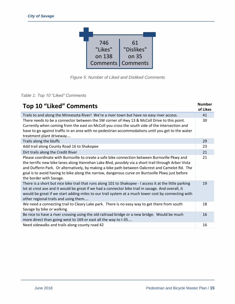
Figure 5: Number of Liked and Disliked Comments
Table 1: Top 10 “Liked” Comments
Top 10 “Liked” Comments Number of Likes
Trails to and along the Minnesota River! We're a river town but have no easy river access. 41 There needs to be a connector between the SW corner of Hwy 13 & McColl Drive to this point. Currently when coming from the east on McColl you cross the south side of the intersection and have to go against traffic in an area with no pedestrian accommodations until you get to the water treatment plant driveway….
30
Trails along the bluffs 29 Add trail along County Road 16 to Shakopee 23
Dirt trails along the Credit River 21 Please coordinate with Burnsville to create a safe bike connection between Burnsville Pkwy and the terrific new bike lanes along Hanrehan Lake Blvd, possibly via a short trail through Arbor Vista and Dufferin Park. Or alternatively, by making a bike path between Oakcrest and Camelot Rd. The goal is to avoid having to bike along the narrow, dangerous curve on Burnsville Pkwy just before the border with Savage.
21
There is a short but nice bike trail that runs along 101 to Shakopee - I access it at the little parking lot at crest ave and it would be great if we had a connector bike trail in savage. And overall, it would be great if we start adding miles to our trail system at a much lower cost by connecting with other regional trails and using them....
19
We need a connecting trail to Cleary Lake park. There is no easy way to get there from south Savage by bike or walking.
18
Be nice to have a river crossing using the old railroad bridge or a new bridge. Would be much more direct than going west to 169 or east all the way to I-35….
16
Need sidewalks and trails along county road 42 16
746 "Likes" on 138
Comments
61 "Dislikes"
on 35 Comments

City of Savage
June 2018 Pedestrian and Bicycle Master Plan / 16
Figure 6: Number of Comments by General Location

City of Savage
June 2018 Pedestrian and Bicycle Master Plan / 17
Figure 7: Key Themes from Public Input
Amenities/features/surface type
•22 Comments
•46 "Likes"
•12 "Dislikes"
Condition of trail/sidewalk
•10 Comments
•16 "Likes"
•1 "Dislike"
Connections to other communities and regional attractions
•39 Comments
•267 "Likes"
•2 "Dislikes"
General feedback/user demand
•16 Comments
•35 "Likes"
•6 "Dislikes"
Local connections/gaps
•60 Comments
•230 "Likes"
•25 "Dislikes"
Pedestrian and snowmobile conflicts
•7 Comments
•30 "Likes"
•2 "Dislikes"
Roadway crossing and/or safety concern
•30 Comments
•122 "Likes"
•13 "Dislikes"
City of Savage
June 2018 Pedestrian and Bicycle Master Plan / 18
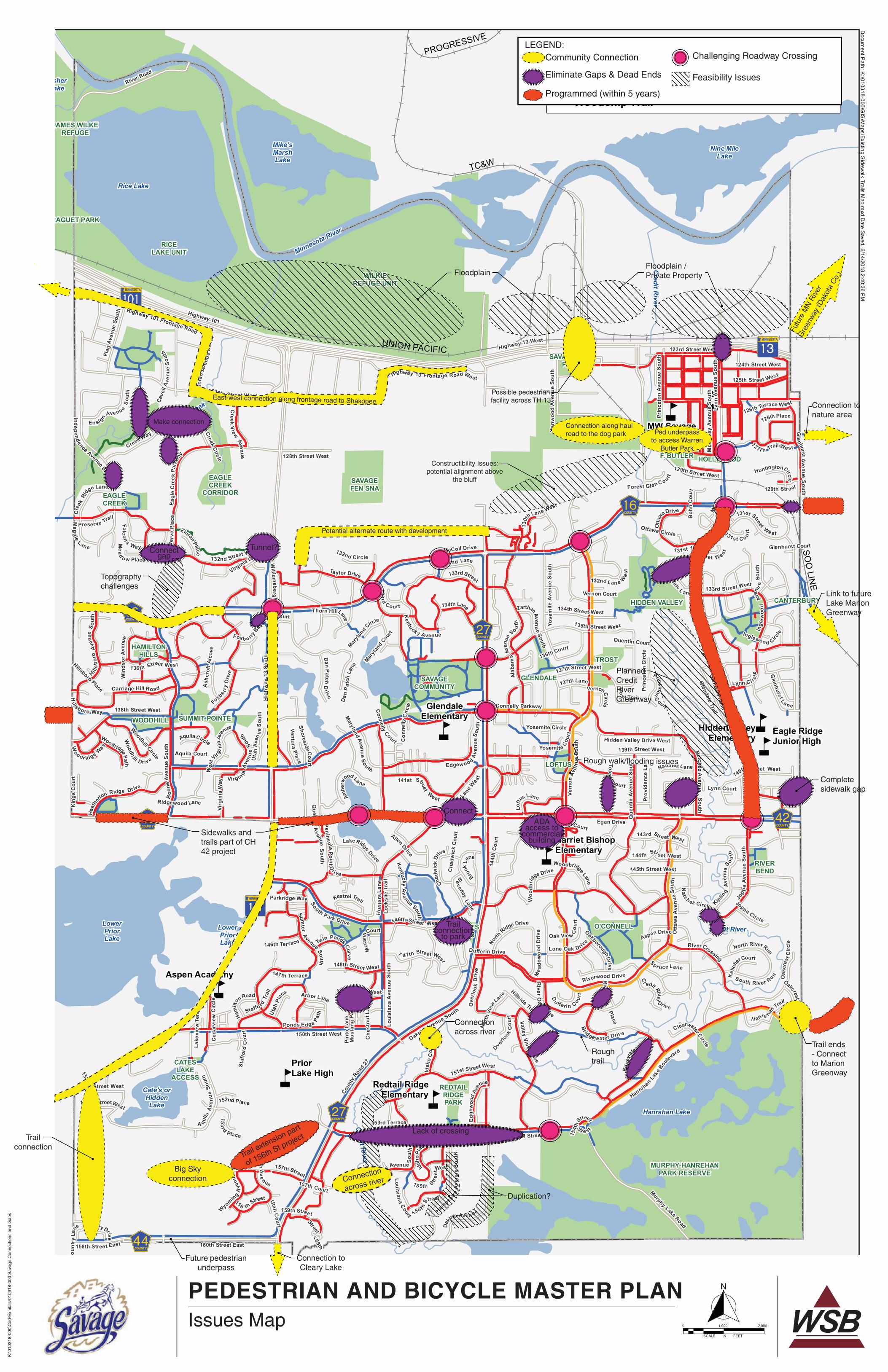
4. ISSUES AND OPPORTUNITIES This section summarizes key issues and opportunities that were evaluated as part of this master
plan. Issues were developed based on review of current city plans and policies, public input, input
from city staff, and technical and best practices review. Figure 8 provides the Issues Map that was
developed based on these inputs to geographically summarize issues related to the city’s
pedestrian and bicycle network. Within each of the issues, key challenges and obstacles that may
limit the ability for implementation are identified.
A. ISSUES IDENTIFIED IN PREVIOUS PLANS
Two previous city plans provided key discussions and recommendations for the pedestrian and
bicycle network. The 2006 Parks, Trails & Open Space System Plan and the 2030
Comprehensive Plan transportation and parks chapters were reviewed to better understand
past efforts and review what has since been implemented.
The 2006 Park, Trail & Open Space System Plan recommended several new sidewalk and trail
connections designed to connect neighborhoods, parks, schools and commercial areas. Also
identified was the need to overcome physical barriers and gaps to pedestrian and bicyclist
movement across the city. The 2030 Comprehensive Plan carried forward the recommendations
from the 2006 Park, Trail & Open Space System Plan. The following is a summary of key issues
identified in each of these plans.
Grade Separated Crossings along Major Roadways
Several potential locations for grade separated (overpass/underpass) crossings of major
roadways (County Highways 16, 27, 42, 44, 154th Street, Highway 13, Lynn Avenue, Quentin
Avenue) were identified. Grade separated crossings can greatly enhance access and
connectivity for pedestrians and bicyclists, but the cost and physical impact of such crossings
create significant challenges in implementing. Recent roadway improvements along County
Highway 44 and 154th Street have also been completed, and certain locations may warrant
other crossing treatment considerations.
Sidewalk/Trail Connections to Hamilton Area
Improved trail and sidewalk access to the downtown Hamilton area was prioritized as a short-
term action plan. Sidewalk improvements on Lynn Avenue and the pedestrian activated
crossing at Lynn Avenue and 128th Street have been made in recent years. These
improvements provide a connection from McColl Drive to the Hamilton area via the existing
sidewalk network along adjacent local streets. The addition of wayfinding signage could assist
with users accessing the Hamilton area via the existing sidewalk network.
Other sidewalk and trail gaps that have been identified along Lynn Avenue and Quentin Avenue
to connect to the Hamilton area have significant implementation challenges due to the cost of
constructing, topography issues, limited right of way, and the need to replace the sub-standard
railroad bridges. Remaining improvements are likely to be considered long-term issues as
opportunities arise.

City of Savage
June 2018 Pedestrian and Bicycle Master Plan / 19
Trail Connections to MN River
Although Savage is a river city, there is little to no access to the Minnesota River. Floodplains,
wetlands, Highway 13, railroads, and industrial properties all make it very challenging to connect
the rest of the city to the river. The 2030 Comprehensive Plan identifies the desire to provide
recreational access to the Minnesota River and connect to its scenic views and natural
amenities. While progress has been made for providing trails along the river in nearby
communities, the obstacles to overcome in Savage require long-term opportunities. However,
there are some upcoming projects that should be evaluated to whether they may be able to
assist in providing trail access to the Minnesota River. These include the construction of a
grade-separated access near Dakota Avenue and Yosemite Avenue at Highway 13 and a
potential interchange in the Highway 13 and Chowen Avenue area in Burnsville. Also, the city
should continue to monitor any future trail or access opportunities along the Dan Patch rail line.
Trail Connections along Savage Fen and Minnesota River Bluffs
A future trail generally along the Savage Fen between Quentin Avenue and Highway 13 was
identified in the previous plans. This trail segment was identified to provide both public access to
the Savage Fen and to improve east-west connections near the city offices complex. In recent
years, the City of Savage pursued development of this trail by identifying an alignment that was
previously disturbed and minimized impact to the Savage Fen on a Scientific and Natural Area
property that was obtained by the Minnesota Department of Natural Resources (DNR). The
project was halted due to design requirements that did not make construction feasible. Design
variances and approvals from the DNR would be needed to allow for future improvements to be
provided.
Credit River Trail Greenway
Several properties along the Credit River between Egan Drive (County Highway 42) and McColl
Drive (County Highway 16) are under city ownership as part of Hidden Valley Park and other
parcels that have been purchased over time for natural resource protection. Both previous plans
state that the city should continue to acquire key parcels or easements needed to complete trail
connections and to protect lands along the Credit River. Without future acquisitions, providing
trail access to the Credit River is not feasible. Conversations with city staff and current
landowners have led to the understanding that future acquisitions are likely limited. In addition,
development of trails along the river is restricted due to topography, wetlands, floodplains, and
cost constraints. Hence, the concept for trails along the Credit River is a long-term goal should
opportunities arise.
Improving Trail Connections to Parks
This was a key theme intended to enhance access and connectivity between the sidewalk and
trail system within the city to the trails located within parks. While several connections have
been completed or enhanced, this continues to be a key goal for the city to pursue.
PEDESTRIAN AND BICYCLE MASTER PLAN
K:\0
1031
8-00
0\C
ad\E
xhib
its\0
1031
8-00
0 S
avag
e C
onne
ctio
ns a
nd G
aps
Issues Map
5
5
55
5
5
5
5
5
?ûA@
?±A@
MINNESOTAVALLEY NWF
SAVAGEFEN SNA
Eagle Creek
Credit R
iver
Credit River
Credit R
iver
Minnesota River
GpWX
G|WX
G|WX
G±WX G±WX
G³WX
?±A@
GpWX
BOUDIN'SACRES
CANTERBURY
CATESLAKE
ACCESS
EAGLECREEK
GLENDALE
HAMILTONHILLS
HIDDEN VALLEY
HOLLYWOOD
JAMES WILKEREFUGE
LOFTUS
RAGUET PARK
O'CONNELL
REDTAILRIDGEPARK
RICELAKE UNIT
RIVERBEND
SAVAGECOMMUNITY
SUMMIT POINTE
TROST
WARRENF. BUTLER
WILKIEREFUGE UNIT
WOODHILL
MURPHY-HANREHANPARK RESERVE
EAGLECREEK
CORRIDOR
SAVAGE DOGPARK
PriorLake High
Harriet BishopElementary
Eagle RidgeJunior High
Hidden ValleyElementary
MW SavageElementary
GlendaleElementary
Redtail RidgeElementary
Aspen Academy
OverlookLake
Rice Lake
FisherLake
Cate's orHiddenLake
Nine MileLake
Hanrahan Lake
Mike'sMarshLake
LowerPriorLake
LowerPriorLake
PROGRESSIVE
TC&W
SOO
LINE
UNION PACIFIC
McColl Drive
Highway 101
Cou
ntry
Lane
Highway 101 Frontage Road
Dakota Ave nue
Hig
hway
13
Sout
h
Boo
neAv
enue
Sout
h
Hampsh
ireAv
enue
Sout
h
Connelly Parkway
Que
ntin
Aven
ueSo
uth
160th Street East
125th Street West
145th Street West
Taylor Drive
Heat
he
rton Ridge Drive
Edge
woo
dAv
enue
Otta
wa
Ave
nue
Sout
h
154th Street West
135th Street West
Queb ec
Avenue
S o uth
Dakota Avenue South
South Park Drive
Loftu
s Lane
West
Lynn
Ave
nue
Sout
h
Dufferin Drive
Sumter
Avenue So uth
Highway 13 West
Twin Ponds Curve
Kentuck y Avenue
Prov
iden
ce L
ane
Kipling
Aven
u e
S o uth
Zinr
anAv
enu e
Sout
h
Lake
view
Ter
race
River Road
Vern
onAv
enu e
Sout
h
Brook
Lane
Yosemite Cour
t
Prin
ceto
nAv
enue
Sout
h
Hillside Trail
NatchezA
venueSouth
P eninsu laPointD
r ive
Oak View Cou
rt
131st Street West
Ambe
rw
ood La ne
151st Street West
138th Street West
123rd Street West
Alab
ama
Aven
ue
So uth
Glendale Road
150th Street West
Che
stnu
tLa n
e
Wil l iam
s bergD
rive
Preserve Trail
RiverCrossing
Ottawa Circle
Loftu
s Lane
Pint
o La
ne
Ced
arvi
ew C
ircle
156t hStreet
129th Street
Gle
nhurstAve nueSouth
Mus
tang
Pat
h
A quila
Aven
ueSo
uth
143rd Str eet West
12 7t h Trail We st
Inglewood Circle
139th Street West
Carriage Hill Ro ad
157th Court
Kestrel Trail
133rd Street West
Beverley
Lane
Quentin Court
Yosemite CircleWoodhill Circle
15 5th Stree
tWest
144t
h C
ourt
Otta
waDrive
132nd Lan e Wes
t
Glenhurst Court
Ridgewood Lane
Lynn Court
Foxb e rryBay
Woodr idge Way
148th Street West
140th Street West
Virginia Lane
Cha
dwic
k Co
urt
Lake Ridge Drive
Ea g
leC
ree k
Park
way
Foxbe rry
Driv
e
V all eyVi ew
Drive
158 thStreet
1 31st 1/2 Street W est
Jers
ey Avenue Sout
h
Maryla
nd Cou
rt
136th Street West
Staf
ford
Cou
rt
Hills
boro
Ave
nue
Sou t
h
Jop pa
Aven
ueSo
uth
Staffo rdTr
ail
H anre han Trail
Dan
Pa t
chLa
ne
Aquila Court
Over
look
Driv
e
O'Connell Court
Pres
erve
Plac
e
Glenhurst L a ne
Boh
nC
ourt
Ingl
ewoo
dAve
nue
Sout
h
137th Street West
Glendale Trail
UtahC
ourt
Lynn Ci rcle
Hillsboro Place
OakcrestCourt
Con
nelly
Circ
le
Riverwood Drive
DanPatch
Drive
Flag
Aven
ueSo
uth
126th Street West
C learwater Circle
137th Lane
Lone Oak Drive
Loui
sian
aA
venu
eSo
uth
Ash
crof
t Alc
ove
Win
dsor
Aven
ue
Vernon Court
Kentuc kyAve nue South
132nd Street West
Uta
hA v
enue
S out
h
Yose
mite
Aven
ueSo
uth
Chadw
ick
Drive
Rive rO
ak
Dr ive
Nat ch ez Circle
159th Stree t
144th Str e et West
Woodh
ill D rive
South Riv er Run
Edge
wa
ter D rive
Utah
Av e nue
133rd Street
Hidden Valley Drive West
149th Street West
Virgin iaAv
enu
eSo
uth
HanrehanLa
keBou
levard
WyomingA
venu
e
Xenw
ood
Aven
ueSo
uth
Wes
tVirg
i nia
Avenue
147th Terrace
Joppa Circle
152nd
Street West
North RiverRun
136th Court
Spr uce Lane
131 st C o urt
Connelly
Court
Aspen Drive
153rd Terrace
158th Street East
124th Street West
153rd StreetWest
Cr edit River
Drive
Overlo
okC
ourt
L ou isianaCourtCoun tryDrive
En signAve nueS
outh
Arbor Lane
AquilaCircle
Brid gewater Drive
152nd Place
146th Terrace
Prin
ceto
n Ci
rcle
Egan Drive
Parkridge Way
Mcc
annC
ourt
Highway 13 Frontage Road West
Cave
llAv
enue
Sou
th
Lock
slie
Tra
il
Toledo
Court
VernonCi rcle
Forest Gl enC ou rt
Allen Drive
Idaho
Place
1 47th Stre et West
134th Lane
Mead
o w Place
ZinranPlace
Sho resideCourt
North
Ridge Drive
126th Place
RiverO
akPlace
133rd
Court
Mea
dow
ood
Driv
e
Ponds Edge Path
Maryla
nd Circle
North
View
Lane
Kel
lehe
rCourt
146th Street West
134th Street West
Dan
Patc
hCourt
Kin
gs C
ourt
Vent ur aPlace
Thorn HillLane
Eag leCreek
Circle
126th Terrace W est
HuntingtonCirc le
Virg
inia
Way
T ro
s t Trail
Utah
Place
Edgewoo dAv
enue
Sou t
h
D
u fferin Co urt
Idah
oC
ourt
OakboroughDri ve
132nd Circle
Natchez Lane
Woo
dbrid
ge Drive
Ham
ilt
on Road
129th Street West
Glen
dale L ane
Woodbridge Lane
157th Street
Princeton
Court
ZarthanAvenu e
South
153rd
Place
Oak
cres
t Circ
le
Mag
g ie
Lane
Woodridge Path
1 30t
hLane West
Falcon s WayM
aryland Avenu eSouth
Mon
tere
yAv
enue
Sout
h
128th Street West
Cre
ekRi
dge Lane
Creek
V iewAvenue
132nd Lane
Hill sbo ro Way
Hun
ters
Lan e
141st Street
West
Creek Way
Coun
tyRoa
d 27
Murphy Lake Road
Indep endence Avenue South
McC
oll
Dr iv e
154t
hS
treet
W es t
159th
Street
1 inch = 2,000 feet
Docum
ent Path: K
:\010318-000\GIS
\Maps\Existing S
idewalk Trails M
ap.mxd D
ate Saved: 6/14/2018 2:40:36 PM
Savage, MN
SidewalkTrailBike Lane/Shared ShoulderWoodchip Trail
5 School
Park/Public LandCity Boundary
Pedestrian & Bicycle Master PlanExisting Sidewalks and Trails 0 2,000
Feet¯SCALE IN FEET
0 2,0001,000
Big Sky connection
Connection to Cleary Lake
Trail connection
Future pedestrian underpass
Connection
across river
Trail ends - Connect to Marion Greenway
Connection across river
Rough trail
Floodplain
Topography challenges
Floodplain / Private Property
Connect gap
Tunnel?
Connection to nature area
Link to future Lake Marion Greenway
Complete sidewalk gap
Connect
Sidewalks and trails part of CH 42 project
Trail connection
to park
ADA access to
commercial building
Planned Credit River Greenway
Rough walk/flooding issues
Trail extension part
of 156th St project
Futu
re M
N R
iver
Gre
enw
ay (D
akot
a C
o.)
Possible pedestrian facility across TH 13
Constructibility Issues: potential alignment above
the bluff
Connection along haul road to the dog park Ped underpass
to access Warren Butler Park
Duplication?
Challenging Roadway CrossingCommunity ConnectionLEGEND:
Feasibility IssuesEliminate Gaps & Dead Ends
Programmed (within 5 years)
Make connection
East-west connection along frontage road to Shakopee
Potential alternate route with development
Lack of crossing
City of Savage
June 2018 Pedestrian and Bicycle Master Plan / 21
B. CITY POLICIES AND ORDINANCES
City Code
In general, the City Code is consistent other City plans and policies. The items of note are
summarized below per the City Code:
Snowmobiling: Snowmobile use is prohibited on sidewalk or bituminous trails except on
designated snowmobile trails. Using city streets for direct snowmobile trail access to or from the
closest designated snowmobile trail is allowed at a maximum speed of 15 mph.
Sidewalks: The owner and occupant of property adjacent to a public sidewalk must keep it safe
for pedestrians and cannot allow snow, ice, dirt or rubbish to remain on the walk longer than 24
hours.
Sidewalk repairs are the responsibility of the adjoining property owner. If the City of Savage
notices the property owner that repairs are needed, the property owner has three weeks to
make the necessary repairs. After three weeks, the city may make the necessary repairs as the
expense of the property owner. Actual enforcement and current practice by city staff may not be
fully consistent with City Code.
Sidewalk and Trail Assessments: Class A improvements (including public park, playground or
recreational facility) provide general benefit to the city at large. These improvements are
financed from general city funds and not from special assessments.
Class B improvements (including construction of sidewalk/pedestrian pathways) provide both
general benefit and special benefit to abutting or nearby property. Pedestrian circulation
systems located within or adjacent to the boundaries of a subdivision are to be constructed and
paid for by the developer or, in an existing development, assessed on a frontage or unit basis
against lots within the development if sidewalks are petitioned to be installed, as deemed
appropriate by the City Council.
Zoning and Subdivision Ordinances
The County Road 42 Overlay District requires pedestrian walkways to support connections to
parks, schools, and shopping facilities. The location of all trails and sidewalks shall conform to
the comprehensive plan and/or similar city-approved trail/sidewalk plan. Other trails and
sidewalks would be required to provide for the continuation or appropriate projection of existing
walkways in surrounding areas; or conform to a specific pedestrian plan for the neighborhood.
The Design Standards within the Subdivision Ordinance limit direct driveways along arterial
streets and collector streets. This reduces the potential for bicyclist and pedestrian conflicts
between vehicles at driveways and increases the ability for arterial and collector streets to
accommodate bicycle facilities.
Like the County Road 42 Overlay District as stated in the Zoning Ordinance, the Subdivision
Ordinance also states that the City Council may require the provision of sidewalks, trails or
pathways in proximity to public service areas such as parks, schools, shopping facilities or in
City of Savage
June 2018 Pedestrian and Bicycle Master Plan / 22
other appropriate locations of a similar nature. However, this text does not appear to be limited
to the County Road 42 Overlay District. The text states:
151. 11 DESIGN STANDARDS. (C) - Pedestrian walkways. The City Council may
require the provision of sidewalks, trails or pathways in proximity to public service
areas such as parks, schools, shopping facilities or in other appropriate locations of
a similar nature. All facilities shall conform to city design standards and ADA
guidelines and shall be constructed at the sole expense of the developer.
(1) The location of all trails and sidewalks shall conform to the park and trail
corridor master plan, as outlined in the comprehensive plan, and shall be
considered in their relation to existing and planned walkways, to topographical
conditions, to public convenience and safety and in their appropriate relation to the
proposed uses of the land.
(2) Where not specifically illustrated in the comprehensive plan, or similar city-
approved trail/sidewalk plan, the arrangement of walkways in the subdivision shall
either:
(a) Provide for the continuation or appropriate projection of existing walkways in
surrounding areas; or (b) Conform to a specific pedestrian plan for the
neighborhood approved or adopted by the City Council to meet a particular
situation.
Engineering Standards
The City of Savage Engineering Standards include standard plate design templates for
sidewalks and trails. The standard plate (no. 107) identifies a bituminous trail width of 8 feet with
1/2 foot clear zones on each side for a total width of 9 feet. The concrete sidewalk standard
plate width is 5 feet. The local roadway standard plate (no. 112) shows a 5-foot sidewalk on one
side of the road with a 7- to 7.5-foot boulevard between the sidewalk and the road surface.
C. TEN-YEAR STREET IMPROVEMENT PLAN
In 2017, the City of Savage adopted a 10-year street improvement plan to implement major
roadway improvements including mill and overlays and reconstruction. Alongside the roadway
improvements, sidewalk and trail facilities are evaluated to determine whether maintenance or
reconstruction is needed. Coordination between the activities performed as part of the 10-year
street improvement plan, on-going sidewalk and trail maintenance operations, and
recommended improvements identified in this master plan should be evaluated annually.
D. GAPS, CROSSINGS, SAFETY, ETC.
The City of Savage strives to design and maintain a sidewalk and trail network that is accessible
for all pedestrians and bicyclists, including those who use walkers, wheelchairs, and scooters.
The city understands that obstructions in sidewalks, poor sidewalk/curb ramp surface
conditions, and lack of snow/ice removal leads to unsafe and undesirable travel conditions.
City of Savage
June 2018 Pedestrian and Bicycle Master Plan / 23
Creating a consistent, continuous and connected network improves access to local and regional
systems. It also ensures that the system is generally convenient. Sidewalks, trails, and
bikeways provide safety benefits, as these designated facilities make it less likely that
pedestrians and bicyclists will be involved in a traffic crash.
Sidewalk Gaps
The city has a rather extensive sidewalk system. However, there are still gaps in the network
that would enhance connectivity and access if completed. Completing gaps along already
developed neighborhoods are quite challenging and often face opposition from adjoining
property owners.
Trail Gaps
Along with gaps in the sidewalk network, there are also some key gaps in the trail network.
Gaps are identified regardless of the agency that may ultimately own and operate the trail.
Crossings
Several locations have been identified where it is challenging for bicyclists and/or pedestrians to
cross the roadway. Locations were identified for several reasons such as: heavy traffic volumes,
a large roadway or barrier to cross, high-speed traffic, and lack of crossings for a significant
distance or lack of crossings at a desired destination.
E. WINTER USES
During the winter season, the city plows key sidewalks and trails within parks and along arterial
and collector streets. Keeping these facilities clear of snow and ice increases the ability for
residents to travel and recreate throughout the city during winter. Snow and ice removal for the
remaining sidewalk facilities are the responsibility of the adjoining property owners. Most trails
are generally plowed by city staff.
The operation of snowmobiles is allowed on designated trails within city limits. A designated
snowmobile trail is a trail that is maintained by a snowmobile club recognized by the Minnesota
Department of Natural Resources. More than 24 miles of trails in Savage are maintained by
Scott County Sno-Trails Inc. and supported by the Savage Sno-Pacers. The demand for winter
use of trails for walking and biking has increased in recent years as the demand for
snowmobiling within Savage has decreased. There are some trails that bicyclists and walkers
lose access to in the winter as they become designated snowmobile trails. This conflict of users
was brought up in community engagement conversations.
F. MAINTAINING THE SIDEWALK AND TRAIL NETWORK
Savage should continue to inventory and monitor its existing network of sidewalks and trails to
ensure that they offer a comfortable, barrier-free, high quality user experience year-round.
Bituminous paved trails may need to be resurfaced and bike lanes/shared shoulders may need
to be repainted. Sidewalks should be replaced as necessary and crosswalks should be ADA
compliant. Investing in the ongoing quality of the network signals to residents that the city
prioritizes pedestrians and bicyclists and is committed to ensuring that people traveling via all
modes of transportation are traveling safely and easily.
City of Savage
June 2018 Pedestrian and Bicycle Master Plan / 24
5. BEST PRACTICES Just as there are best practices and design guidelines associated with developing roadway
facilities, there are also best practices and design guidelines associated with developing pedestrian
and bicycle facilities. This section of the report identifies best practices that should be considered
as projects are developed. Some of the recommendations apply to the system while others are
targeted to a portion (e.g., sidewalk, trail, on-road facility) of the network. The best practices that are
specific to portions of the network are not intended to be applied in every situation or that one
recommendation is always better than another.
A. CONSIDERATIONS FOR ALL FACILITIES
There are some practices that should be considered regardless of the facility type that is being
developed. These considerations include eliminating gaps, utilizing the Minnesota Manual on
Uniform Traffic Control Devices (MMUTCD), conducting studies, and wayfinding.
Eliminate Gaps
One of the most frustrating challenges for pedestrians and bicyclists is to reach a gap in the
system and interrupt their trip, leave them in a location where they are unable to complete their
journey without some challenges or require them to reroute significantly out of their way.
Systems with a number of gaps in them will reduce the likelihood of users and will create
frustration and safety concerns for those willing to use the system.
For pedestrians, if the gap is on a city street (local roadway) with low traffic volumes, lower
speeds and with opportunities to use the roadway facility, the gap may be overcome by the
user. However, on facilities with heavier traffic volumes (collector roadways and above) or
higher speeds, a gap in the sidewalk or trail system can be a significant barrier because the
user will not feel safe mixing with traffic and may not have anywhere else to go.
The City of Savage should continue to eliminate gaps identified in this master plan when
opportunities arise. Gaps can be completed in coordination with new land development projects,
as standalone projects, or as part of roadway improvement projects. When reconstructing city or
county roadways, this master plan should be consulted to check for identified gaps in the
sidewalk and trail network.
In addition, considerations of future on-road bicycles facilities need to ensure that gaps are not
created when making roadway improvements. Failure to have a complete connection with on-
road facilities could create a safety problem. At this time, it is not anticipated that additional on-
road bicycle facilities will be provided. But should the opportunity arise, it is recommended that
additional studies be completed to determine the appropriate on-road improvement and logical
termini.
Consult MMUTCD
All improvements related to signage, striping and traffic control devices should be reviewed
against the current Minnesota Manual on Uniform Traffic Control Devices (MMUTCD). This
manual provides the most up-to-date requirements and design practices. If additional
information is needed, an additional resource is the federal Manual on Uniform Traffic Control
City of Savage
June 2018 Pedestrian and Bicycle Master Plan / 25
Devices (MUTCD). However, the MMUTCD should be the guiding reference document for
improvements.
Conduct Studies
The improvements identified in this section of the report are best practices. Not all practices
should be used in all situations. Some situations favor one type of treatment over another given
a set of circumstances. As such, treatments should be evaluated on a case-by-case basis and
not just applied because a treatment has been identified as a best practice.
Signage and Wayfinding Materials
Signage can be helpful to direct pedestrians and cyclists towards popular destinations such as
parks, community facilities, transit stations, commercial areas, or other trail connections.
Generally, signage for wayfinding is used on regional trail facilities and on important city and
county trail and/or sidewalk connections. Signage is generally not used on sidewalks within
residential areas on roadways classified as local. Coordination with multiple agencies (Scott
County, Dakota County, Three Rivers Park District, MVTA, etc.) may be needed for regional
facilities and for connections to regional destinations.
B. PEDESTRIAN FACILITIES
The following are best practices for improving pedestrian sidewalk facilities:
ADA Requirements
The American with Disability Act has requirements for the slopes, size, crossing placement and
other elements of pedestrian facilities. Any new construction and reconstruction of existing
facilities should take these requirements into account to ensure that all potential users are able
to enjoy the pedestrian network developed by the city.
Sidewalks
Sidewalks are the basis of the pedestrian network. As noted previously, gaps in the system
should be eliminated where possible, but especially in areas where roadways are classified as
collector facilities and above and where there are linkages to important community facilities
such as schools, parks, etc.
Design Standards and Guidelines for Sidewalks
▪ Minimum width is 5 feet; 6 feet preferred in residential areas.
▪ Minimum width in commercial areas should be wider – 6 to 8 feet to accommodate heavier
use.
▪ Maximum cross slope should be 2 percent.

City of Savage
June 2018 Pedestrian and Bicycle Master Plan / 26
Curb Extensions
Curb extensions extend the sidewalk and shorten
crossing distance. They decrease the amount of time
needed to cross at intersections and can help to lower
traffic speeds by narrowing the street. Curb extensions
are most beneficial at intersections with wide crossings.
Curb extensions can be done as standalone projects or
as part of a roadway reconstruction project. Generally,
they are constructed to assist pedestrians and bicyclists
in crossing higher-volume roadways and are most
relevant in established urban areas such as the
Hamilton District.
Design Standards and Guidelines for Curb Extensions
▪ Should not extend into traffic lanes or cut off bike lanes.
▪ Intended for streets with on-street parking or wide shoulders.
▪ Should be visible for oncoming traffic.
Median Refuge Islands
Median refuge islands provide bicyclists and pedestrians a
safe zone halfway through an intersection. By providing a
safe midpoint while crossing a street, pedestrians and
bicyclists are only required to focus on one direction of
oncoming traffic at a time. This is especially beneficial
when crossing wide roads with high traffic volumes and
speeds. Median refuge islands allow pedestrians and
bicyclists to take advantage of gaps in one direction of
traffic which decreases the amount of time waiting to cross.
Placing a median refuge island within a roadway can also
calm traffic.
Like curb extensions, refuge medians can be constructed as a standalone project or as part of a
roadway reconstruction project. They are generally constructed on busier state or county
roadways.
Design Standards and Guidelines for Median Refuge Islands
▪ Can be applied at signalized or unsignalized intersections.
▪ Minimum width is 6 feet.
▪ Medians should be raised at least 6 inches.
▪ Shape of the island should conform to the natural vehicle paths.
▪ Must be clearly visible for oncoming vehicles.
▪ Reflective markers around the median are recommended.
City of Savage
June 2018 Pedestrian and Bicycle Master Plan / 27
▪ Should only occupy the minimum area necessary while providing enough space to serve its
purpose.
If median refuge islands are placed in locations where bicyclists can or will likely use them, then
the city may wish to have a minimum width of 10 feet to accommodate bicyclists that have
trailers or connect with a second bicycle.
Marked Pedestrian Crosswalks
Crosswalks are a marked portion of the roadway indicating use for pedestrians to cross.
Striping the roadway at the location of a crosswalk alerts drivers that this is a location where
pedestrians may be present and have the right to enter the roadway. Mid-block crossings
should be avoided if there is an intersection alternative that is close and likely to be used by
pedestrians. If mid-block crossings are truly the appropriate location for a crossing, active
notification should be considered as part of the design.
Design Standards and Guidelines for Crosswalks
▪ May be used at intersections or uncontrolled/mid-block locations.
▪ Marked crossings are especially beneficial for intersections with high levels of vehicle traffic
and high speeds.
▪ Crosswalks at midblock locations may be accompanied by active warning systems (options
discussed on the following pages) to increase awareness. This should be evaluated on a
case-by-case basis.
▪ Should be at least 6 feet in width.
▪ Continental markings or zebra-style are recommended (perpendicular to crosswalk
direction). Lines should be 12-24 inches wide and be spaced 12-24 inches apart.
▪ Marked crossings should extend the full width of the crossing.
▪ Appropriate signage warning drivers of crossings may be considered.
▪ Durable materials (rather than paint) should be used when feasible. The more durable
materials can last several years versus the one to two years that may be obtained by paint.
Leading Pedestrian Interval
The leading pedestrian interval feature (LPI) activates the walk sign a few seconds prior to the
vehicle light changing to green, giving the pedestrian a chance to get out into the intersection
where they may be more visible to right-turning vehicles. Studies have found that the LPI
method reduces conflicts for pedestrians.
Coordination with Scott County or MnDOT should be considered as part of larger roadway
construction projects or as part of intersection or standalone projects on county and state
facilities.
Standards and Guidelines for LPI
▪ The FHWA recommends the LPI method be used where older pedestrians may frequently
use an intersection.
▪ The leading pedestrian interval should be at least three seconds in duration.
▪ During the LPI, consideration should be given to prohibiting turns across the crosswalk.
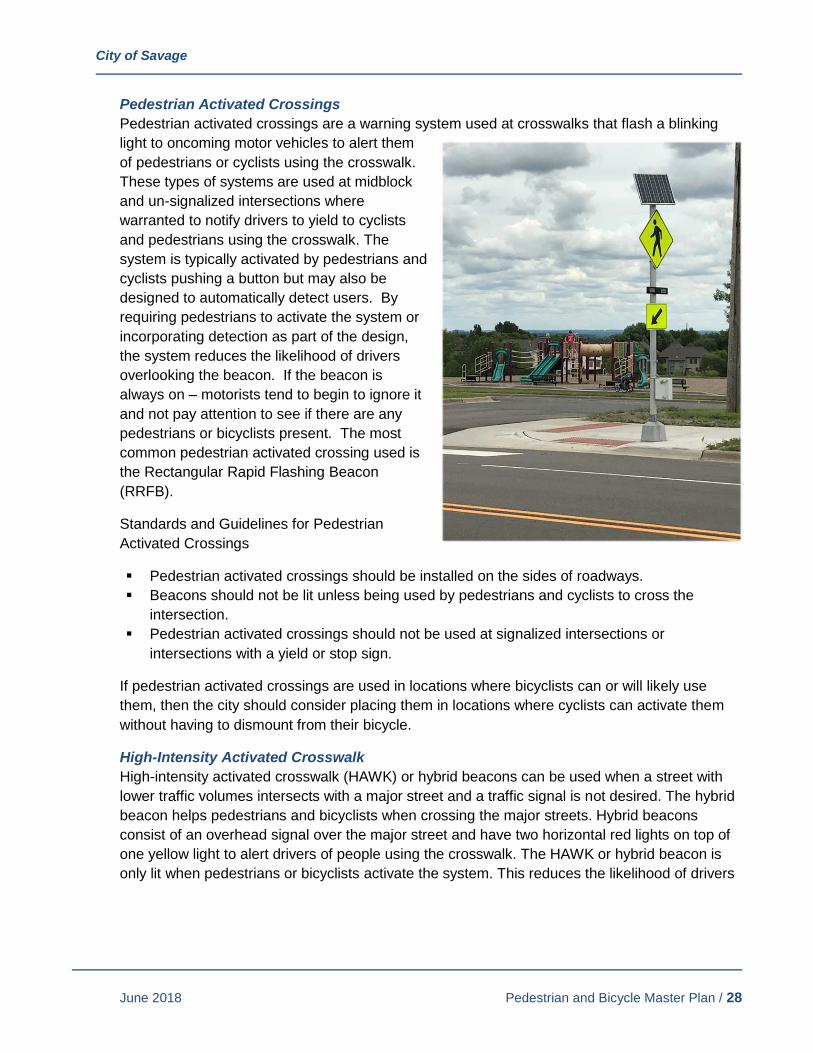
City of Savage
June 2018 Pedestrian and Bicycle Master Plan / 28
Pedestrian Activated Crossings
Pedestrian activated crossings are a warning system used at crosswalks that flash a blinking
light to oncoming motor vehicles to alert them
of pedestrians or cyclists using the crosswalk.
These types of systems are used at midblock
and un-signalized intersections where
warranted to notify drivers to yield to cyclists
and pedestrians using the crosswalk. The
system is typically activated by pedestrians and
cyclists pushing a button but may also be
designed to automatically detect users. By
requiring pedestrians to activate the system or
incorporating detection as part of the design,
the system reduces the likelihood of drivers
overlooking the beacon. If the beacon is
always on – motorists tend to begin to ignore it
and not pay attention to see if there are any
pedestrians or bicyclists present. The most
common pedestrian activated crossing used is
the Rectangular Rapid Flashing Beacon
(RRFB).
Standards and Guidelines for Pedestrian
Activated Crossings
▪ Pedestrian activated crossings should be installed on the sides of roadways.
▪ Beacons should not be lit unless being used by pedestrians and cyclists to cross the
intersection.
▪ Pedestrian activated crossings should not be used at signalized intersections or
intersections with a yield or stop sign.
If pedestrian activated crossings are used in locations where bicyclists can or will likely use
them, then the city should consider placing them in locations where cyclists can activate them
without having to dismount from their bicycle.
High-Intensity Activated Crosswalk
High-intensity activated crosswalk (HAWK) or hybrid beacons can be used when a street with
lower traffic volumes intersects with a major street and a traffic signal is not desired. The hybrid
beacon helps pedestrians and bicyclists when crossing the major streets. Hybrid beacons
consist of an overhead signal over the major street and have two horizontal red lights on top of
one yellow light to alert drivers of people using the crosswalk. The HAWK or hybrid beacon is
only lit when pedestrians or bicyclists activate the system. This reduces the likelihood of drivers

City of Savage
June 2018 Pedestrian and Bicycle Master Plan / 29
overlooking the signal. Drivers
tend to ignore traditional
pedestrian signals because
they are always on and are
usually green for the motorists.
Coordination with Scott County
or MnDOT should be
considered as part of larger
roadway construction projects
or as part of intersection or
standalone projects on county
and state facilities.
Standards and Guidelines for
HAWKs
▪ Typically used when a major street intersects a minor road with low traffic volumes and
does not warrant a traffic signal.
▪ The MMUTCD permits the use of hybrid beacons depending on vehicle speed, traffic
volume, intersection length, and pedestrian volume.
▪ The MMUTCD provides standards for hybrid beacons including location and height, as well
as length of signal phases.
▪ Sight obstructions such as on-street parking should not be permitted within 100 feet in front
of a hybrid beacon or 20 feet beyond the marked crossing.
▪ The signal should not be lit unless being used by pedestrians to cross the intersection.
▪ Installation of a HAWK system should be based on meeting one of the signal warrants of
Chapter 4C of the MMUTCD and justification through an engineering study. The
engineering study should consider major-street volumes, speeds, widths and gaps in
conjunction with pedestrian volumes, walking speeds and delay if no warrants are met.
Systems should be installed based upon the provisions of Chapters 4D and 4E.
Countdown Pedestrian Signals
Countdown timers at signalized intersections display the amount of time pedestrians have
available to cross a roadway before the traffic signal changes. The countdown timers and
audible/vibrotactile indicators allows users to use their judgment as to whether they can safely
cross the intersection in the time available. Without timers and/or audible/vibrotactile indicators,
pedestrians may enter the intersection believing they have enough time to cross only to have
the signal change before reaching the other side. This is especially helpful for wider crossings
and benefits those who need more time to cross intersections. Although countdown timers have
been shown to increase the number of pedestrians entering the crosswalk after the flashing
orange hand starts, they reduce the percentage of pedestrians that do not complete crossing
the intersection in time. This is likely due to people speeding up their walk as the timer
approaches zero.
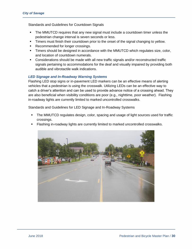
City of Savage
June 2018 Pedestrian and Bicycle Master Plan / 30
Standards and Guidelines for Countdown Signals
▪ The MMUTCD requires that any new signal must include a countdown timer unless the
pedestrian change interval is seven seconds or less.
▪ Timers must finish their countdown prior to the onset of the signal changing to yellow.
▪ Recommended for longer crossings.
▪ Timers should be designed in accordance with the MMUTCD which regulates size, color,
and location of countdown numerals.
▪ Considerations should be made with all new traffic signals and/or reconstructed traffic
signals pertaining to accommodations for the deaf and visually impaired by providing both
audible and vibrotactile walk indications.
LED Signage and In-Roadway Warning Systems
Flashing LED stop signs or in-pavement LED markers can be an effective means of alerting
vehicles that a pedestrian is using the crosswalk. Utilizing LEDs can be an effective way to
catch a driver’s attention and can be used to provide advance notice of a crossing ahead. They
are also beneficial when visibility conditions are poor (e.g., nighttime, poor weather). Flashing
in-roadway lights are currently limited to marked uncontrolled crosswalks.
Standards and Guidelines for LED Signage and In-Roadway Systems
▪ The MMUTCD regulates design, color, spacing and usage of light sources used for traffic
crossings.
▪ Flashing in-roadway lights are currently limited to marked uncontrolled crosswalks.
City of Savage
June 2018 Pedestrian and Bicycle Master Plan / 31
C. MULTI-USE TRAIL FACILITIES
Multi-use trails are popular with recreational bicyclists and pedestrians alike. Bicyclists that are
focused on purely commuting/transportation purposes are not as likely to use these facilities
because they have a mix of users and those users can block their way through the corridor.
Additionally, the more advanced cyclists do not like interruptions (driveways and other
interruptions) that require them to slow or stop as compared to on-road facilities. Multi-use trails
generally link to major community destinations such as parks, schools, community centers and
popular retail/commercial destinations. The following describe best practices for multi-use trail
facilities:
Consult MnDOT’s Bikeway Facility Design Manual
MnDOT has put together a manual targeted to designing bicycle facilities. The manual provides
recommendations and guidelines to improve safety and to provide a consistent facility for users
throughout the state. When designing trails and on-road facilities, this manual should be
consulted.
ADA Requirements
The American with Disability Act has requirements for the slopes, size, crossing placement and
other elements of pedestrian facilities. As time has passed, many agencies have been
incorporating some of the ADA requirements into their recreational trail facilities. ADA design
standards are an option the city should consider as part of its trail design.
Off-Road Trails
The existing network of off-road trails in the City of Savage provides a safe way for pedestrians
and cyclists to get around the community. Off-road trails can be a much more comfortable
option than an on-street bike lane for less experienced cyclists because they are separated from
motorized vehicles. Multi-use trails provide a great opportunity for children and less experienced
cyclists to use non-motorized transportation and feel safe. In many cases, off-road trails are
used by multiple types of users such as cyclists, joggers, people on rollerblades, and people
walking their dog. This variety can present some safety conflicts and should be anticipated by
users. Providing adequate signage can be one way of alerting users of potential conflicts.
Standards and Guidelines for Off-Road Multi-Use Trails
▪ For two-way trails, the minimum width is 10 feet. For trails that experience significant use,
12-14 feet is encouraged.
▪ Center lines should be provided for heavily used trails.
▪ Cautionary signage should be utilized as necessary.
▪ Intersection crossings should be at flat grades.
▪ Off-road paths should not cross roadways in areas where the roadway is not straight.
▪ Trails should be maintained in good condition to avoid potential safety hazards.
▪ If a route experiences significant traffic from a variety of users (cyclists, pedestrians, people
on rollerblades, etc.) separate trail facilities should be considered.
▪ A 2-foot graded shoulder should be provided on each side of the path in case cyclists drift
off the path or need to avoid hazards.

City of Savage
June 2018 Pedestrian and Bicycle Master Plan / 32
▪ Any signage, poles, trees or other obstructions should be at least 3 feet from the edge of
the path. However, signage for cyclists should not be farther than 6 feet from the edge of
the path.
▪ Pedestrian-scale lighting should be considered for user safety and security.
For routes that receive significant use, separate trails for different users may be necessary.
When separate paths are provided, proper signage should indicate which paths are to be used
by pedestrians and which should be used by cyclists. Using different paving materials or
providing a median between the separate facilities can further reinforce designation for different
users.
▪ Separated facilities for cyclists and pedestrians should be considered when peak hour
bicycle traffic volumes exceed 100 users per hour or where combined pedestrian and cycle
user volume is greater than 2,000 individuals per day.
D. BICYCLE FACILITIES
In some instances, it may be advantageous to provide exclusive facilities for bicyclists. (In
general, most city and regional trails are designed to accommodate both the bicyclist and the
pedestrian. These trails are discussed in the Multi-Use Facilities section). The more expert
bicyclists generally prefer on-road facilities. The expert cyclists are comfortable riding alongside
vehicles. They primarily use the larger roadways which are more likely to provide bicycle
facilities such as shoulders, bicycle lanes, etc. Having a system in place for these users is not
necessarily the focus of this plan – however, their needs and desires should be considered and
evaluated as county and state facilities are updated.
Before a decision is made for the use of on-road facilities, traffic volumes, speeds, right of way
availability and connectivity to other bicycle facilities (on- or off-road) should be considered. If
on-road facilities are considered for use, the following should be evaluated as part of the
process in selecting the preferred method of delivering the facility:
Consult MnDOT’s Bikeway Facility Design Manual
MnDOT has put together a manual targeted to designing bicycle facilities. The manual provides
recommendations and guidelines to improve safety and to provide a consistent facility for users
throughout the state. When designing trails and on-road facilities, this manual should be
consulted.
City of Savage
June 2018 Pedestrian and Bicycle Master Plan / 33
6. RECOMMENDATIONS
The City of Savage has the opportunity as part of its Pedestrian and Bicycle Master Plan to create
the foundation for providing important community links and connections that would allow individuals
to pursue walking and biking as part of their work, household, recreation, and transportation activities
by making its system of sidewalks, trails and transportation facilities safer and more convenient. The
city also can update policies, coordinate with other agencies, and implement practices that will
encourage walking and bicycling within the community.
This section outlines an overall vision for pedestrian and bicycle facilities within the community and
provides some broad recommendations for activities and practices that will encourage the long-term
use of the system and a healthy lifestyle.
A. SIDEWALK AND TRAIL NETWORK VISION
The sidewalk and trail network master plan should reflect the input of plan participants and good
planning practices that encourage connections to important destinations within the community,
that provide opportunities for recreation as well as commuting purposes, and that provide
connections throughout the entire community. The vision for the trail and sidewalk network:
• Connects to existing and planned recreational facilities and parks.
• Completes gaps in the network to connect neighborhoods and community destinations.
• Provides access to other communities and regional attractions.
• Provides opportunities to connect to the natural environment.
This is a long-term vision. It is to be used as a guide for the city when making both long- and
short-term decisions with regard to planning and construction of facilities. It is intended to be
used to incorporate pedestrian and bicycle needs not only into projects immediately on the
table, but to not preclude them as part of planning and other activities. For instance, a trail may
not be completed or constructed as a single parcel redevelops, but right of way or an easement
should be preserved if it is included as part of the vision so that it can be constructed at some
point when there are enough parcels for a trail to be constructed.
Figure 9 shows the planned sidewalk and trail network. Sidewalk and trails shown in solid lines
represent facilities already in place. Dashed lines show “planned” connections needed to
complete the network. "Planned" improvements will be evaluated on a project by project basis and brought through the appropriate process for discussion on feasibility. All projects identified in this document as “planned” require City Council approval.

PEDESTRIAN AND BICYCLE MASTER PLAN
K:\0
1031
8-00
0\C
ad\E
xhib
its\0
1031
8-00
0 E
xist
ing
and
Pla
nned
Map
s
Planned Sidewalk and Trail Network
5
5
55
5
5
5
5
5
?ûA@
?±A@
MINNESOTAVALLEY NWF
SAVAGEFEN SNA
Eagle Creek
Credit R
iver
Credit River
Credit R
iver
Minnesota River
GpWX
G|WX
G|WX
G±WX G±WX
G³WX
?±A@
GpWX
BOUDIN'SACRES
BOUDINS
CANTERBURY
CARDINALRIDGE
CATES LAKEACCESS
COUNTRY COURT PARK
EAGLECREEK
GLENDALE
GREENOAKS
HAMILTONHILLS
HEATHERTONRIDGE
HIDDEN VALLEY
HOLLYWOOD
JAMESWILKE
REFUGE
LOFTUS
RAGUETPARK
O'CONNELL
OAKLAND BEACH
REDTAILRIDGEPARK
RICELAKE UNIT
RIVERBEND
SAVAGECOMMUNITY
SUMMIT POINTE
TROST
WARRENF. BUTLER
WILKIEREFUGE UNIT
WOODHILL
MURPHY-HANREHANPARK RESERVE
PriorLake High
Harriet BishopElementary
Eagle RidgeJunior High
Hidden ValleyElementary
MW SavageElementary
GlendaleElementary
Redtail RidgeElementary
Aspen Academy
OverlookLake
Rice Lake
FisherLake
Cate's orHiddenLake
Nine MileLake
Hanrahan Lake
Mike'sMarshLake
Lower PriorLake
LowerPriorLake
PROGRESSIVE
TC&W
SOO
LINE
UNION PACIFIC
McColl Drive
Highway 101
Highway 101 Frontage Road
Dakota Ave nue
Hig
hway
13
Sout
h
Boo
neAv
enue
Sout
h
Hampsh
ireAv
enue
Sout
h
Connelly Parkway
Que
ntin
Aven
ueSo
uth
160th Street East
125th Street West
145th Street West
Taylor Drive
Edge
woo
dAv
enue
Otta
wa
Ave
nue
Sout
h
154th Street West
135th Street West
Queb ec
Avenue
S o uth
Dakota Avenue South
South Park Drive
Loftu
s Lane
West
Lynn
Ave
nue
Sout
h
Dufferin Drive
Sumter
Avenue So uth
Highway 13 West
Twin Ponds Curve
Kentuck y Avenue
Prov
iden
ce L
ane
Kipling
Aven
u e
S o uth
Zinr
anAv
enu e
Sout
h
Lake
view
Ter
race
River Road
Vern
onAv
enu e
Sout
h
Brook
Lane
Yosemite Cour
t
Prin
ceto
nAv
enue
Sout
h
Hillside Trail
NatchezA
venueSouth
P eninsu laPointD
r ive
Oak View Cou
rt
131st Street West
Ambe
rw
ood La ne
151st Street West
138th Street West
123rd Street West
Alab
ama
Aven
ue
So uth
Glendale Road
150th Street West
Che
stnu
tLa n
e
Wil l iam
s bergD
rive
Preserve Trail
RiverCrossing
Ottawa Circle
Loftu
s Lane
Pint
o La
ne
Ced
arvi
ew C
ircle
156t hStreet
129th Street
Gle
nhurstAve nueSouth
Mus
tang
Pat
h
A quila
Aven
ueSo
uth
143rd Str eet West
12 7t h Trail We st
Inglewood Circle
139th Street West
Carriage Hill Ro ad
157th Court
Kestrel Trail
133rd Street West
Beverley
Lane
Quentin Court
Yosemite CircleWoodhill Circle
15 5th Stree
tWest
144t
h C
ourt
Otta
waDrive
132nd Lan e Wes
t
Glenhurst Court
Ridgewood Lane
Lynn Court
Foxb e rryBay
Woodr idge Way
148th Street West
140th Street West
Virginia Lane
Cha
dwic
k Co
urt
Lake Ridge Drive
E agl
eCr
eek Pa
rkway
Foxbe rry
Driv
e
V all eyVi ew
Drive
158 thStreet
1 31st 1/2 Street W est
Jers
ey Avenue Sout
h
Maryla
nd Cou
rt
136th Street West
Staf
ford
Cou
rt
Hills
boro
Ave
nue
Sou t
h
Jop pa
Aven
ueSo
uth
Staffo rdTr
ail
H anre han Trail
Dan
Pa t
chLa
ne
Aquila Court
Over
look
Driv
e
O'Connell Court
Pres
erve
Plac
e
Glenhurst L a ne
Boh
nC
ourt
Ingl
ewoo
dAve
nue
Sout
h
137th Street West
Glendale Trail
UtahC
ourt
Lynn Ci rcle
Hillsboro Place
OakcrestCourt
Con
nelly
Circ
le
Riverwood Drive
DanPatch
Drive
Flag
Aven
ueSo
uth
126th Street West
C learwater Circle
137th Lane
Lone Oak Drive
Loui
sian
aA
venu
eSo
uth
Ash
crof
t Alc
ove
Win
dsor
Aven
ue
Vernon Court
Kentuc kyAve nue South
Rid
gePo
intCourt
132nd Street West
Uta
hA v
enue
S out
h
Yose
mite
Aven
ueSo
uth
Chadw
ick
Drive
Rive rO
ak
Dr ive
Nat ch ez Circle
159th Stree t
144th Str e et West
Woodh
ill D rive
South Riv er Run
Edge
wa
ter D rive
Utah
Av e nue
133rd Street
Hidden Valley Drive West
149th Street West
Virgin iaAv
enu
eSo
uth
HanrehanLa
keBou
levard
WyomingA
venu
e
Xenw
ood
Aven
ueSo
uth
Wes
tVirg
i nia
Avenue
147th Terrace
Joppa Circle
152nd
Street West
North RiverRun
136th Court
Spr uce Lane
131 st C o urt
Connelly
Court
AspenDrive
153rd Terrace
158th Street East
124th Street West
153rd StreetWest
Cr edit River
Drive
Overlo
okC
ourt
L ou isianaCourtCoun tryDrive
En signAve nueS
outh
Arbor Lane
AquilaCircle
Brid gewater Drive
152nd Place
146th Terrace
Prin
ceto
n Ci
rcle
Egan Drive
Parkridge Way
Hillsboro Court
Mcc
annC
ourt
Highway 13 Frontage Road West
Cave
llAv
enue
Sou
th
Lock
slie
Tra
il
Toledo
Court
VernonCi rcle
Forest Gl enC ou rt
Allen Drive
Idaho
Place
1 47th Stre et West
134th Lane
Mead
o w Place
ZinranPlace
Sho resideCourt
North
Ridge Drive
126th Place
RiverO
akPlace
133rd
Court
Mea
dow
ood
Driv
e
Ponds Edge Path
Maryla
nd Circle
North
View
Lane
Kel
lehe
rCourt
146th Street West
134th Street West
Dan
Patc
hCourt
Kin
gs C
ourt
Vent ur aPlace
Thorn HillLane
Eag leCreek
Circle
126th Terrace W est
HuntingtonCirc le
Virg
inia
Way
T ro
s t Trail
Utah
Place
Edgewoo dAv
enue
Sou t
h
D
u fferin Co urt
Idah
oC
ourt
OakboroughDri ve
132nd Circle
Natchez Lane
Woo
dbrid
ge Drive
Ham
ilt
on Road
129th Street West
Glen
dale L ane
Woodbridge Lane
157th Street
Princeton
Court
ZarthanAvenu e
South
153rd
Place
Oak
cres
t Circ
le
Mag
g ie
Lane
Woodridge Path
1 30t
hLane West
Falcon s WayM
aryland Avenu eSouth
Mon
tere
yAv
enue
Sout
h
128th Street West
Cre
ekRi
dge Lane
Creek
V iewAvenue
132nd Lane
Hill sbo ro Way
Hun
ters
Lan e
141st Street
West
Creek Way
Coun
tyRoa
d 27
Murphy Lake Road
Indep endence Avenue South
McC
oll
Dr iv e
154t
hS
treet
W es t
159th
Street
1 inch = 2,000 feet
Docum
ent Path: K
:\010318-000\GIS
\Maps\PedBicycleM
asterPlan-6-14-18.mxd D
ate Saved: 6/14/2018 2:45:48 PM
SidewalkTrailBike Lane/Shared ShoulderWoodchip Trail
Planned SidewalkPlanned TrailPlanned Bike Lane/Shared ShoulderPlanned Nature Trail
5 School
City Boundary
Pedestrian & Bicycle Master PlanPlanned Sidewalk and Trail Network 0 2,000
Feet¯SCALE IN FEET
0 2,0001,000

City of Savage
June 2018 Pedestrian and Bicycle Master Plan / 35
B. GENERAL GOALS AND RECOMMENDATIONS
The following general recommendations were developed to help meet the goals and outcomes
established as part of the Pedestrian and Bicycle Master Plan:
• The City of Savage has a robust sidewalk and trail system. The city should maximize the
value of the infrastructure by maintaining this system, completing key gaps, and enhancing
safety and comfortability for users of all ages and abilities.
• Support healthy and active lifestyles through a pedestrian and bicycle infrastructure
system that connects neighborhoods, schools, parks, community centers, commercial
centers, and places of employment.
• Continue to improve access and connectivity between parks and the sidewalk and trail
system.
• Prioritize completing trail and sidewalk connections that improve access between Savage
and its neighboring communities and beyond to the rest of the region. Also emphasize
improved access to regional destinations and facilities including Cleary Lake Regional
Park, regional trails and bikeways, and major river crossings.
• Provide opportunities to connect residents to the unique natural environments within
Savage in a sustainable manner, and pursue future endeavors that may enhance access
to the Minnesota River, Credit River, Eagle Creek, Murphy-Hanrehan Park Reserve, and
the Minnesota River Bluffs.
• Evaluate designated snowmobile trails within the city regarding how they may conflict with
pedestrian and bicycle activity during winter months and consider what changes could be
made to reduce such conflicts. The city should also evaluate current designated
snowmobile trails and determine whether they should be reduced or eliminated over time
to meet the long-term needs of the city.
C. SIDEWALK AND TRAIL DEVELOPMENT RECOMMENDATIONS
The City of Savage has been successful in developing its sidewalk and trail network by
coordinating with developers, other agencies, and incorporating improvements into roadway
projects. These activities can be further enhanced by:
• Continue to require new developments to install sidewalks and trails that are consistent
with this master plan and provide pedestrian and bicycle access between neighborhoods
and the rest of Savage.
• Consider pedestrian and bicycle improvements as part of street improvement projects.
City staff should consult this plan during the early stages of street improvement projects
so that identified pedestrian and bicycle infrastructure can be included at the beginning
of a project if feasible.
• Limit use of boulevard widths under six feet between sidewalk/trails and roadways to
provide a more safe and comfortable user experience and to provide snow storage for
the adjacent road.
• Work with neighboring communities, Scott County, Dakota County, Three Rivers Park
District, and MnDOT to complete gaps in the sidewalk and trail system and enhance

City of Savage
June 2018 Pedestrian and Bicycle Master Plan / 36
access between Savage and the region. Consider holding annual meetings with these
agencies to discuss opportunities and implementation approaches to completing gaps.
• Monitor the railroad status of the Dan Patch railroad line and pursue trail use in the
corridor should the opportunity arise.
• Should the opportunity arise for the replacement of the railroad bridges over Quentin
Avenue and Lynn Avenue, pursue adding pedestrian and bicycle facilities along these
roads to complete these key connections to downtown Savage.
D. MAINTENANCE AND PRESERVATION RECOMMENDATIONS
Regular maintenance of facilities shows the city’s commitment to and investment in walking and
biking. Things the city can do to improve maintenance include:
• Utilize sustainable practices to protect the public investment and ensure the safety and
quality of sidewalks and trails through long-term management.
• Include sidewalk repairs and panel replacements in roadway rehabilitation projects
including mill and overlay projects.
• Continue replacing curb ramps to comply with ADA requirements: The city should
identify and replace necessary curb ramps to bring them into compliance with ADA
design requirements to improve accessibility for all users.
• Maintain vegetation to ensure horizontal and vertical clearances on all sidewalks and
trails.
• Sweep trails annually.
• Inspect and repair sidewalks on a rotating five-year basis to ensure that sidewalks are in
good condition for residents of all abilities.
• The city should continue to repaint crosswalks annually so that crosswalks are in good
condition throughout the summer and fall.
• Continue to plow trails within 48-72 hours of a snow event.
• Educate residents about snow removal requirements. Utilize city communication
materials to emphasize property owner responsibility to clear sidewalks within 12 hours
of a snow event. Communications materials should highlight the importance of clear
sidewalks for pedestrian mobility.
E. SAFETY RECOMMENDATIONS
Additional considerations should be made to ensure a safe sidewalk and trail network is
provided for residents:
• Assure that planned trails, sidewalks and grade-separations associated with road and
intersection projects occur as an integral part of the improvement project.
• Work with Scott County and MnDOT to identify appropriate locations and treatments for
the safe crossing of county and state highways.
• Educate community members on safe walking, bicycling, and driving around
pedestrians/bicyclists. The Savage Police Department should seek opportunities to
educate community members on safe walking, bicycling, and driving in interactions with
the public and at community events such as Dan Patch Days.
City of Savage
June 2018 Pedestrian and Bicycle Master Plan / 37
F. CURRENT CITY POLICY REVISION RECOMMENDATIONS
The City of Savage has been successful with its street reconstruction projects in adding
neighborhoods to the sidewalk network and the city has successfully negotiated with developers
to incorporate trails and/or sidewalks as part of major redevelopment efforts. These activities
can be further enhanced by:
City Code
• The City Council should evaluate the sidewalk assessment policy so the City Code and
current practices are consistent.
Subdivision Ordinance
• Update references to this master plan.
• Consider updating Subdivision Ordinance to require a sidewalk on at least one side of all
new local roadways.
• Consider future improvements along arterial roadways with 8- to 10-foot trails along both
sides of arterial roadways to support bicycle use and reduce the crossing of arterial
roadways.
Zoning Ordinance
• Update references to this master plan.
• Consider updating the County Road 42 Overlay District and Hamilton Overlay District to
strengthen ordinance language that ensures pedestrian facilities are provided between
commercial uses and sidewalk/trail facilities and meet ADA requirements. Consider
requiring pedestrian access (sidewalks and crosswalks) through new parking lots. Parking
lots can be uncomfortable places for pedestrians to walk when there is not a designated
pedestrian route to the entrance of a building.
• Review existing ordinances regarding pedestrian-friendly building and parking design,
sidewalk construction, and bike parking.
G. SYSTEM ENHANCEMENT RECOMMENDATIONS
Education and encouragement strategies are often paired because they are complementary
efforts. When people have more information about how and where to walk and bike safely, they
often feel encouraged to walk and bike more often. The following strategies address ways to
educate and encourage residents to walk and bike.
• Regularly promote the pedestrian and bicycle system via city communication resources
(newsletter, social media, website, etc.). Topics should include safe walking and bicycling
behaviors, information about the health benefits of walking and bicycling, and information
on local walking and bicycling routes.
• Develop a map with existing trails and sidewalks on the city’s website. The map should
also include the schools, parks and other major destinations. Printed copies of the map
could be made available at city hall, the library and the community center.
• Explore installing park and trail system maps at key locations to enhance Savage’s identity
and build sense of community.
City of Savage
June 2018 Pedestrian and Bicycle Master Plan / 38
• Install bike racks and bike parking facilities at parks and city facilities. Also explore the
opportunity to install amenities such as trailhead kiosks, drinking fountains, restrooms, and
bike repair stations at key locations that can accommodate both trail users as well as
serve the main facility needs.
• Coordinate with MVTA to explore the need and opportunity to add bike parking and
supporting facilities at key transit facilities.
• Encourage businesses to install bike parking, especially in the County Road 42 and
Hamilton Overlay Districts. The city could consider establishing a cost sharing program for
bike racks and/or updating city zoning codes/ordinances to require bike parking to be
installed as part of new commercial and multifamily residential development.
7. IMPLEMENTATION PLAN Plan implementation will occur over many years. To reach the goals of this master plan, the city will
need to focus on plan recommendations and strategically construct and maintain pedestrian and
bicycle infrastructure. This section provides a suggested framework on how to implement this master
plan by identifying a list of priority improvement projects, discussing city and external funding
sources to finance the system, providing a trail maintenance schedule for future maintenance
operations, and identifying performance measures to evaluate how this plan has been implemented
over time.
A. LIST OF PRIORITY PROJECTS
The city has identified the following sidewalks, trails, and facility improvements as the highest
priority for short-, medium-, and long-term implementation of this plan. These projects have
been prioritized based on community input, potential to improve safety, connections to key
destinations, and the ability to coordinate with currently funded projects.
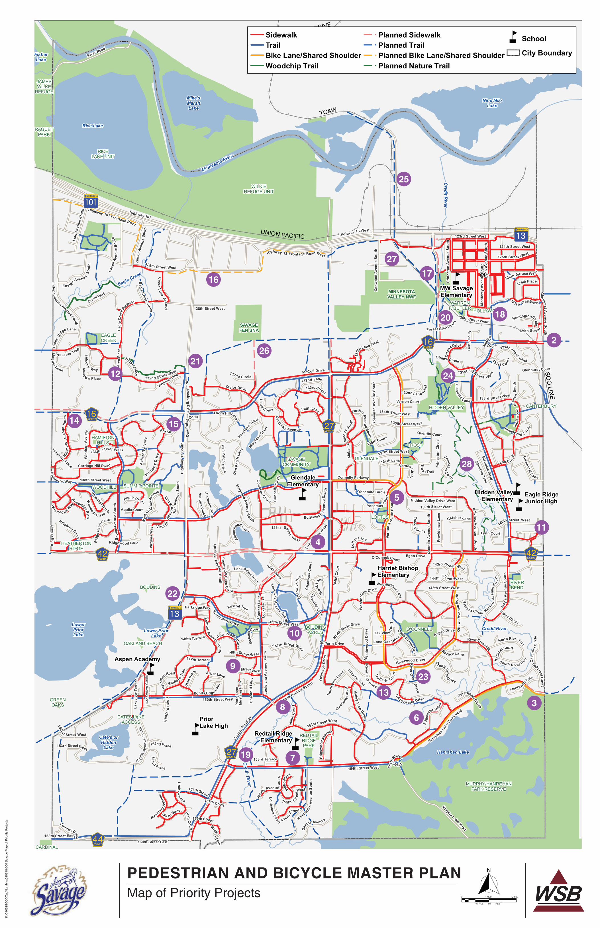
PEDESTRIAN AND BICYCLE MASTER PLAN
K:\0
1031
8-00
0\C
ad\E
xhib
its\0
1031
8-00
0 S
avag
e M
ap o
f Prio
rity
Pro
ject
s
Map of Priority Projects
5
5
55
5
5
5
5
5
?ûA@
?±A@
MINNESOTAVALLEY NWF
SAVAGEFEN SNA
Eagle Creek
Credit R
iver
Credit River
Credit R
iver
Minnesota River
GpWX
G|WX
G|WX
G±WX G±WX
G³WX
?±A@
GpWX
BOUDIN'SACRES
BOUDINS
CANTERBURY
CARDINALRIDGE
CATES LAKEACCESS
COUNTRY COURT PARK
EAGLECREEK
GLENDALE
GREENOAKS
HAMILTONHILLS
HEATHERTONRIDGE
HIDDEN VALLEY
HOLLYWOOD
JAMESWILKE
REFUGE
LOFTUS
RAGUETPARK
O'CONNELL
OAKLAND BEACH
REDTAILRIDGEPARK
RICELAKE UNIT
RIVERBEND
SAVAGECOMMUNITY
SUMMIT POINTE
TROST
WARRENF. BUTLER
WILKIEREFUGE UNIT
WOODHILL
MURPHY-HANREHANPARK RESERVE
PriorLake High
Harriet BishopElementary
Eagle RidgeJunior High
Hidden ValleyElementary
MW SavageElementary
GlendaleElementary
Redtail RidgeElementary
Aspen Academy
OverlookLake
Rice Lake
FisherLake
Cate's orHiddenLake
Nine MileLake
Hanrahan Lake
Mike'sMarshLake
Lower PriorLake
LowerPriorLake
PROGRESSIVE
TC&W
SOO
LINE
UNION PACIFIC
McColl Drive
Highway 101
Highway 101 Frontage Road
Dakota Ave nue
Hig
hway
13
Sout
h
Boo
neAv
enue
Sout
h
Hampsh
ireAv
enue
Sout
h
Connelly Parkway
Que
ntin
Aven
ueSo
uth
160th Street East
125th Street West
145th Street West
Taylor Drive
Edge
woo
dAv
enue
Otta
wa
Ave
nue
Sout
h
154th Street West
135th Street West
Queb ec
Avenue
S o uth
Dakota Avenue South
South Park Drive
Loftu
s Lane
West
Lynn
Ave
nue
Sout
h
Dufferin Drive
Sumter
Avenue So uth
Highway 13 West
Twin Ponds Curve
Kentuck y Avenue
Prov
iden
ce L
ane
Kipling
Aven
u e
S o uth
Zinr
anAv
enu e
Sout
h
Lake
view
Ter
race
River Road
Vern
onAv
enu e
Sout
h
Brook
Lane
Yosemite Cour
t
Prin
ceto
nAv
enue
Sout
h
Hillside Trail
NatchezA
venueSouth
P eninsu laPointD
r ive
Oak View Cou
rt
131st Street West
Ambe
rw
ood La ne
151st Street West
138th Street West
123rd Street West
Alab
ama
Aven
ue
So uth
Glendale Road
150th Street West
Che
stnu
tLa n
e
Wil l iam
s bergD
rive
Preserve Trail
RiverCrossing
Ottawa Circle
Loftu
s Lane
Pint
o La
ne
Ced
arvi
ew C
ircle
156t hStreet
129th Street
Gle
nhurstAve nueSouth
Mus
tang
Pat
h
A quila
Aven
ueSo
uth
143rd Str eet West
12 7t h Trail We st
Inglewood Circle
139th Street West
Carriage Hill Ro ad
157th Court
Kestrel Trail
133rd Street West
Beverley
Lane
Quentin Court
Yosemite CircleWoodhill Circle
15 5th Stree
tWest
144t
h C
ourt
Otta
waDrive
132nd Lan e Wes
t
Glenhurst Court
Ridgewood Lane
Lynn Court
Foxb e rryBay
Woodr idge Way
148th Street West
140th Street West
Virginia Lane
Cha
dwic
k Co
urt
Lake Ridge Drive
E agl
eCr
eek Pa
rkway
Foxbe rry
Driv
e
V all eyVi ew
Drive
158 thStreet
1 31st 1/2 Street W est
Jers
ey Avenue Sout
h
Maryla
nd Cou
rt
136th Street West
Staf
ford
Cou
rt
Hills
boro
Ave
nue
Sou t
h
Jop pa
Aven
ueSo
uth
Staffo rdTr
ail
H anre han Trail
Dan
Pa t
chLa
ne
Aquila Court
Over
look
Driv
e
O'Connell Court
Pres
erve
Plac
e
Glenhurst L a ne
Boh
nC
ourt
Ingl
ewoo
dAve
nue
Sout
h
137th Street West
Glendale Trail
UtahC
ourt
Lynn Ci rcle
Hillsboro Place
OakcrestCourt
Con
nelly
Circ
le
Riverwood Drive
DanPatch
Drive
Flag
Aven
ueSo
uth
126th Street West
C learwater Circle
137th Lane
Lone Oak Drive
Loui
sian
aA
venu
eSo
uth
Ash
crof
t Alc
ove
Win
dsor
Aven
ue
Vernon Court
Kentuc kyAve nue South
Rid
gePo
intCourt
132nd Street West
Uta
hA v
enue
S out
h
Yose
mite
Aven
ueSo
uth
Chadw
ick
Drive
Rive rO
ak
Dr ive
Nat ch ez Circle
159th Stree t
144th Str e et West
Woodh
ill D rive
South Riv er Run
Edge
wa
ter D rive
Utah
Av e nue
133rd Street
Hidden Valley Drive West
149th Street West
Virgin iaAv
enu
eSo
uth
HanrehanLa
keBou
levard
WyomingA
venu
e
Xenw
ood
Aven
ueSo
uth
Wes
tVirg
i nia
Avenue
147th Terrace
Joppa Circle
152nd
Street West
North RiverRun
136th Court
Spr uce Lane
131 st C o urt
Connelly
Court
AspenDrive
153rd Terrace
158th Street East
124th Street West
153rd StreetWest
Cr edit River
Drive
Overlo
okC
ourt
L ou isianaCourtCoun tryDrive
En signAve nueS
outh
Arbor Lane
AquilaCircle
Brid gewater Drive
152nd Place
146th Terrace
Prin
ceto
n Ci
rcle
Egan Drive
Parkridge Way
Hillsboro Court
Mcc
annC
ourt
Highway 13 Frontage Road West
Cave
llAv
enue
Sou
th
Lock
slie
Tra
il
Toledo
Court
VernonCi rcle
Forest Gl enC ou rt
Allen Drive
Idaho
Place
1 47th Stre et West
134th Lane
Mead
o w Place
ZinranPlace
Sho resideCourt
North
Ridge Drive
126th Place
RiverO
akPlace
133rd
Court
Mea
dow
ood
Driv
e
Ponds Edge Path
Maryla
nd Circle
North
View
Lane
Kel
lehe
rCourt
146th Street West
134th Street West
Dan
Patc
hCourt
Kin
gs C
ourt
Vent ur aPlace
Thorn HillLane
Eag leCreek
Circle
126th Terrace W est
HuntingtonCirc le
Virg
inia
Way
T ro
s t Trail
Utah
Place
Edgewoo dAv
enue
Sou t
h
D
u fferin Co urt
Idah
oC
ourt
OakboroughDri ve
132nd Circle
Natchez Lane
Woo
dbrid
ge Drive
Ham
ilt
on Road
129th Street West
Glen
dale L ane
Woodbridge Lane
157th Street
Princeton
Court
ZarthanAvenu e
South
153rd
Place
Oak
cres
t Circ
le
Mag
g ie
Lane
Woodridge Path
1 30t
hLane West
Falcon s Way
Maryland Avenu e
South
Mon
tere
yAv
enue
Sout
h
128th Street West
Cre
ekRi
dge Lane
Creek
V iewAvenue
132nd Lane
Hill sbo ro Way
Hun
ters
Lan e
141st Street
West
Creek Way
Coun
tyRoa
d 27
Murphy Lake Road
Indep endence Avenue South
McC
oll
Dr iv e
154t
hS
treet
W es t
159th
Street
1 inch = 2,000 feet
Docum
ent Path: K
:\010318-000\GIS
\Maps\PedBicycleM
asterPlan-6-14-18.mxd D
ate Saved: 6/14/2018 2:45:48 PM
SidewalkTrailBike Lane/Shared ShoulderWoodchip Trail
Planned SidewalkPlanned TrailPlanned Bike Lane/Shared ShoulderPlanned Nature Trail
5 School
City Boundary
Pedestrian & Bicycle Master PlanPlanned Sidewalk and Trail Network 0 2,000
Feet¯SCALE IN FEET
0 2,0001,000
19 7
8
9
22
10
313
6
23
4
5
11
28
24
2
18
14
12
15
2126
16
20
17
27
25

City of Savage Pedestrian and Bicycle Master Plan
Table 2: List of Priority Projects
Map
Reference Location
Priority
A (High) -
D (Low)
Timeframe
(Short 0-5 yrs.,
Mid 5-10 yrs.,
Long 10+ yrs.)
Range of Cost
(Low, Mid,
High) Notes
Relation to 10-Year
Street
Improvement
Program?
-- Various locations - sidewalk and trail maintenance A Short Low Incorporate sidewalk and trail improvements into annual street improvement projects Yes
1 Add bike racks to community facilities (ELC, City Hall, dome, park and rides, etc.) A Short Low Can be added to future park improvements or as a standalone project No
2 County Highway (CH) 16 sidewalk extension at Savage/Burnsville border A Short (2018) Low Potential cost share with City of Burnsville Rose Bluff 2018 project No
3 Hanrehan Lake Boulevard/Burnsville Parkway trail extension into Burnsville A Short (2021) Mid Potential cost share with City of Burnsville 2021 project No
4 Complete sidewalk between Loftus Lane and CH 27 on CH 42 A Short Low After CH 42 reconstruction, this is the last remaining gap along CH 42. Identified as part of
County's 2022 CH 42 rehabilitation project
No
5 Sidewalk repairs on Vernon Avenue from 141st Street to Utica Avenue B Short/Mid Mid Sidewalk floods / collects ice 2018
6 Sidewalk/Trail near Edgewater Drive C Short/Mid Mid Complete loop - evaluate adding to 2019 street project 2019
7 Pedestrian crossing on 154th Street by school B Mid Low Need to evaluate safety issues and road conditions No
8 Pedestrian bridge over Credit River between Idaho Court and CH 27 B Mid High Provides neighborhood connection to CH 27 trails No
9 Oregon Avenue and 149th Street sidewalk extension B Mid Mid Completes gap No
10 Trail connections to Boudins Acres Park B Mid Mid Improve access to park No
11 Sidewalk connection on 141st Street to Preserve Boulevard (Connection to Burnsville) C Mid Mid Improve access to Sunset Pond Park and businesses No
12 Sidewalk extension on Meadow Place/Lane to 132nd Street B Mid Mid Pending development and/or road extension No
13 Repave trail between Hillside Trail and Bridgewater Drive C Mid Mid Maintenance project No
14 CH 16 trail project (south side of road) at Savage/Shakopee border A Mid/Long Mid City supports trail along south side of road to tie into existing development, could be a cost-
share project with County
No
15 Highway 13 and CH 16 - improve intersection crossing (also add connection in SW
quadrant)
B Mid/Long Low Several public comments received at this location No
16 Bike lanes or shared shouders along Highway 13 frontage roads between Burnsville and
Shakopee
C Mid/Long Mid May require road or shoulder widening - Can incorporate into programmed street improvement
projects
2020, 2024, 2027
17 Pedestrian connection along Quentin Avenue between downtown and CH 16 (both sides) D Long High May need to be tied to replacement of railroad bridge 2027
18 Pedestrian connection along Lynn Avenue between 126th Street and 128th Street D Long High Alternate routes currently exist No
19 Pedestrian connection between Jersey Avenue and CH 27 over Credit River D Long High No
20 Quentin Avenue to Warren Butler Park - underpass C Long High Future pedestrian underpass gateway to park
21 North of Highway 13 and CH 16 - potential underpass C Long High Grade separated crossing of Highway 13 No
22 Trail along Highway 13 south between Savage/Prior Lake (south of CH 42) C Long High Long-term need for Savage and Prior Lake, but difficult to construct No
23 Pedestrian connection between River Oak Drive and Dufferin Drive C Long Mid Complete loop 2018, 2023
24 Trail to Hidden Valley Park D Long High Feasibility issues No
25 Access to MN River north of Highway 13 D Long High Long-term endeavor to pursue should opportunity arise - Evaluate as part of Dakota-Yosemite
Grade Separation and Chowen Avenue Interchange projects
No
26 Trail along bluff and Savage Fen D Long High Long-term endeavor to pursue should opportunity arise No
27 Dan Patch Line and river crossing - regional trail D Long High Long-term endeavor to pursue should opportunity arise No
28 Credit River (soft surface/nature trails) near Hidden Valley Park D Long Mid Long-term endeavor to pursue should opportunity arise, property access issues No
City of Savage
June 2018 Pedestrian and Bicycle Master Plan / 41
B. FUNDING THE SYSTEM
On-going investments in the sidewalk and trail network are needed to implement the
recommendations, improvements, and maintenance practices identified in this master plan. The
city should incorporate trail maintenance funding and additional maintenance equipment needs
into the Capital Improvement Program (CIP) to ensure the system is preserved and to maximize
the value of the initial investment. Annual sidewalk and trail improvement funds should be
evaluated to determine whether they will address the demand. To assist with meeting funding
needs, the city should consider the reallocation of Aquatic Center Debt Service Levy to General
Levy with proceeds split between the Park Improvement Fund and Sidewalk Fund.
There will be opportunities for the city to extend the pedestrian and bicycle system through other
transportation projects. City staff should annually review the CIP to identify opportunities to
integrate sidewalk and bikeway projects into upcoming capital improvement projects, including
the 10-year street improvement program.
In addition, the city should explore cost participation opportunities with Scott County and
MnDOT for completing new sidewalks and trails along county and state highways as identified
in this master plan.
C. EXTERNAL FUNDING SOURCES
Local funding resources can be supplemented by funding from county sources and regional,
state and federal grants or cost participation programs. The city should budget for local funds to
construct short sidewalk segments and low-cost bikeways and focus on grant funding sources
for larger sidewalk and trail projects that connect to or serve as part of the regional system.
Smaller, more localized projects may not be appropriate for grant funding programs because of
the time and costs associated with compliance with grant funder requirements. While the grant
programs and other funding opportunities may change over time, consideration should be given
to pursue programs that will enable the city to eliminate gaps and crossing challenges. Potential
funding sources to consider include:
Scott County Transportation Improvement Program - Cost Participation
Scott County updates its 10-year Transportation Improvement Program annually. This funding is
generally used in conjunction with highway reconstruction, but has also been used to construct
standalone trail projects along an existing county highway. For projects that are programmed
within Savage, local funds may be required based on the County’s cost participation policy.
As part of the County’s Transportation Improvement Program update, the County typically
requests cities and townships to recommend proposed improvements to the county highway
system to be considered for adding to the program. Proposed improvements could include
roadway, intersection, sidewalk, or trail improvements within the county road right of way.
Where key sidewalk and trail gaps or safety issues occur along county highways, the City of
Savage could suggest these improvements as part of future updates to the County’s
Transportation Improvement Program. Scott County cost participation is typically 50 percent of
the cost for new sidewalk/trail construction.
City of Savage
June 2018 Pedestrian and Bicycle Master Plan / 42
Regional Solicitation
The Metropolitan Council and Transportation Advisory Board (TAB) are responsible for
allocating federal Surface Transportation Block Grant Program (STBGP) funding within the
metropolitan area. The funds are distributed through a competitive application process where
each project request is evaluated and scored based on standardized criteria. These programs
can fund up to 80 percent of project costs. The Regional Solicitation process typically occurs
every two years. Project applications must demonstrate a regional benefit in order receive a
competitive score.
Standalone sidewalk and trail projects are eligible for this funding under the Bicycle and
Pedestrian Facilities category, which is further broken into multiuse trail and bicycle projects,
pedestrian facility projects, and Safe Routes to School Infrastructure projects. Sidewalk and trail
improvements can also be included as part of roadway reconstruction and expansion projects
are limited to the non-freeway principal arterial and A-minor arterial systems.
Savage should consider applying for Regional Solicitation funding for larger sidewalk and trail
projects (greater than $250,000) that serve a transportation purpose or complete a key regional
gap. Projects along A-Minor or Principal Arterials (County Highway 16, County Highway 27,
County Highway 42, and Highway 13), along the RBTN corridors (County Highway 16, County
Highway 42), or complete connections to key regional destinations may provide the best
opportunity to obtain funding.
Highway Safety Improvement Program
The Highway Safety Improvement Program provides funding to smaller projects that address a
targeted safety issue. The funding is administered by MnDOT. Depending upon the year, the
program can be used to address safety problems in a proactive or reactive manner. Reactive
projects generally include improvements at intersections. Proactive improvements can include
countdown timers, median construction, signing and striping, sidewalks, and other smaller-scale
improvements designed to improve safety. Funding can provide 90 percent of project costs.
Minnesota DNR Local Trail Connections Program and Federal Recreational Trail Program
The Local Trail Connections Program is used to promote relatively short trail connections
between residential areas and desirable locations. The Federal Recreational Trail Program
promotes similar trail projects, with funding categories prioritized annually prior to the solicitation
process. Up to 75 percent of the total eligible costs up to a maximum of $150,000 are provided
by these grants.
Statewide Health Improvement Program
The Statewide Health Improvement Program (SHIP) is part of the Minnesota Department of
Health initiatives to improve the overall health of Minnesotans and to decrease obesity rates.
Funding for this program typically goes through Scott County, so the city will need to partner
with the county to be eligible for funding. Funding can be used for the education,
encouragement and enforcement strategies in this plan, as well as planning studies.

City of Savage
June 2018 Pedestrian and Bicycle Master Plan / 43
Blue Cross and Blue Shield Center for Prevention
The Blue Cross and Blue Shield Center for Prevention regularly funds bicycle and pedestrian
planning, education, encouragement, and enforcement in Minnesota. Savage staff should
monitor future funding opportunities through the Center for Prevention that may support the
implementation of this plan.
Livable Communities Demonstration Account
The Livable Communities Demonstration Account funds innovative development/redevelopment
projects that efficiently link housing, jobs, services and transit in an effort to create inspiring and
lasting communities. Grants are available to fund basic public infrastructure and site assembly.
Projects can vary significantly from one community to the next, but they all provide linkages
between multiple uses. Infrastructure, such as sidewalks, trails, benches, bicycle racks, etc.
could be incorporated and paid for as part of this grant. However, the projects are generally
large-scale in effort and are focused on redevelopment efforts.
There may be opportunities for the city to work with developers and the Metropolitan Council to
explore options for using funding from this program to support overall redevelopment as well as
pedestrian and bicycle infrastructure.
D. RECOMMENDED MAINTENANCE SCHEDULE
The following is a recommended maintenance schedule for the city’s bituminous trail system.
This schedule is intended to provide a general structure for maintenance needs to ensure safe
travels for recreation and transportation activities and to get the best value out of the useful life
of the trail surface. Trail use, quality of initial construction, and environmental factors can all
affect the lifecycle of trail conditions, and the maintenance schedule may need to be adjusted
for certain trail segments based on trail performance.
Ongoing Maintenance
• Vegetation – mow shoulders and maintain 2-3 feet clear zone
• Snow Plowing and Ice Removal – on designated routes
• Litter and Debris Cleanup
• Use/Safety Inspections
o ROW Encroachment Inspections
o Verify Safety for Trail Users (no fallen/hanging branches, large cracks, slippery spots,
etc.)
o Graffiti/Vandalism
o Inventory Surface Failures (cracks, dips, crumbling edges, trip hazards)
o Drainage/Culvert (ensure no blockages and are in proper working order)
Annual Maintenance
• Vegetation
o Weed Control (if needed)
o Trim Trees/Shrubs to Maintain Minimum 10-feet Overhead Clearance
o Other Annual Resource Management Activities
• Trail Surface Sweeping (Spring)

City of Savage
June 2018 Pedestrian and Bicycle Master Plan / 44
Short-Term Maintenance
• Asphalt Crack Repair and Patching – 3-5 years (where needed)
• Fog Seal – Year 1 following construction, then every 4-5 years (MnDOT Spec. 2355 CSS
1H Diluted)
• Signs and Lane/Crossings Striping – every 3 years or as needed
Long-Term Maintenance
• Overlay in Place or Full-Depth Reclamation – 15-20 years
• Reconstruction – 20-25 years if no overlay in place/full-depth reclamation
• Overpass/Underpass Structure Replacement – 20-50 years (based on lifespan of
structure)
E. ONGOING MONITORING (PERFORMANCE MEASURES)
The following performance measures should be tracked on an annual basis to ensure progress
towards the goals of this plan. Monitoring these performance measures will help determine
whether the strategies in this plan are effective or need to be adjusted to reach the plan’s goals.
Performance measures should be reported to the Savage City Council for their review.
Table 3: Recommended Performance Measures
Measure Data source
Number and severity of pedestrian-vehicle crashes Police Department, MnDOT
Number and severity of bicycle-vehicle crashes Police Department, MnDOT Feet of new sidewalk/trail segments constructed Public Works/Engineering
Feet of sidewalk/trail segments repaired/reconstructed Public Works/Engineering List of sidewalk/trail segments and gaps completed as identified in this master plan
Public Works/Engineering
Pavement condition index of sidewalk and trail system based on city’s pavement management program (updated every few years)
Public Works
Percent of curb ramps compliant with ADA requirements
Public Works/Engineering
Percent of trail system in place Public Works/Engineering
Percent of sidewalk system in place Public Works/Engineering Percent of residents who walk or bike to work US Census
Number of snow events and average time to clear trails Public Works/Engineering Number of city communications encouraging walking/bicycling and/or promoting pedestrian/bicycle safety
Communications
Number of targeted enforcement campaigns for pedestrian/bicycle safety
Police Department
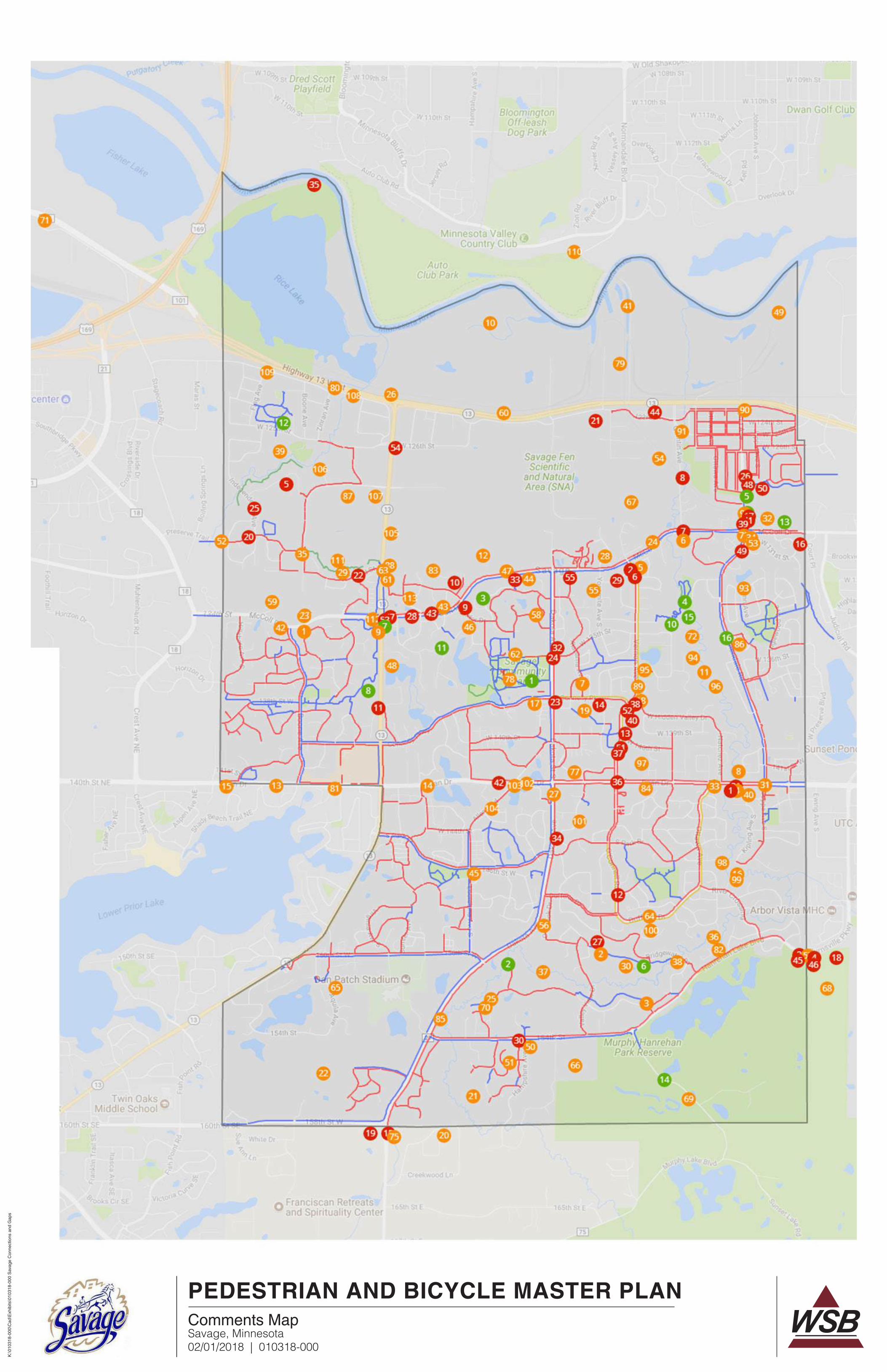
PEDESTRIAN AND BICYCLE MASTER PLAN
Savage, Minnesota02/01/2018 | 010318-000
K:\0
1031
8-00
0\C
ad\E
xhib
its\0
1031
8-00
0 S
avag
e C
onne
ctio
ns a
nd G
aps
Comments Map

PEDESTRIAN AND BICYCLE MASTER PLAN
Savage, Minnesota02/01/2018 | 010318-000
K:\0
1031
8-00
0\C
ad\E
xhib
its\0
1031
8-00
0 S
avag
e C
onne
ctio
ns a
nd G
aps
Comments
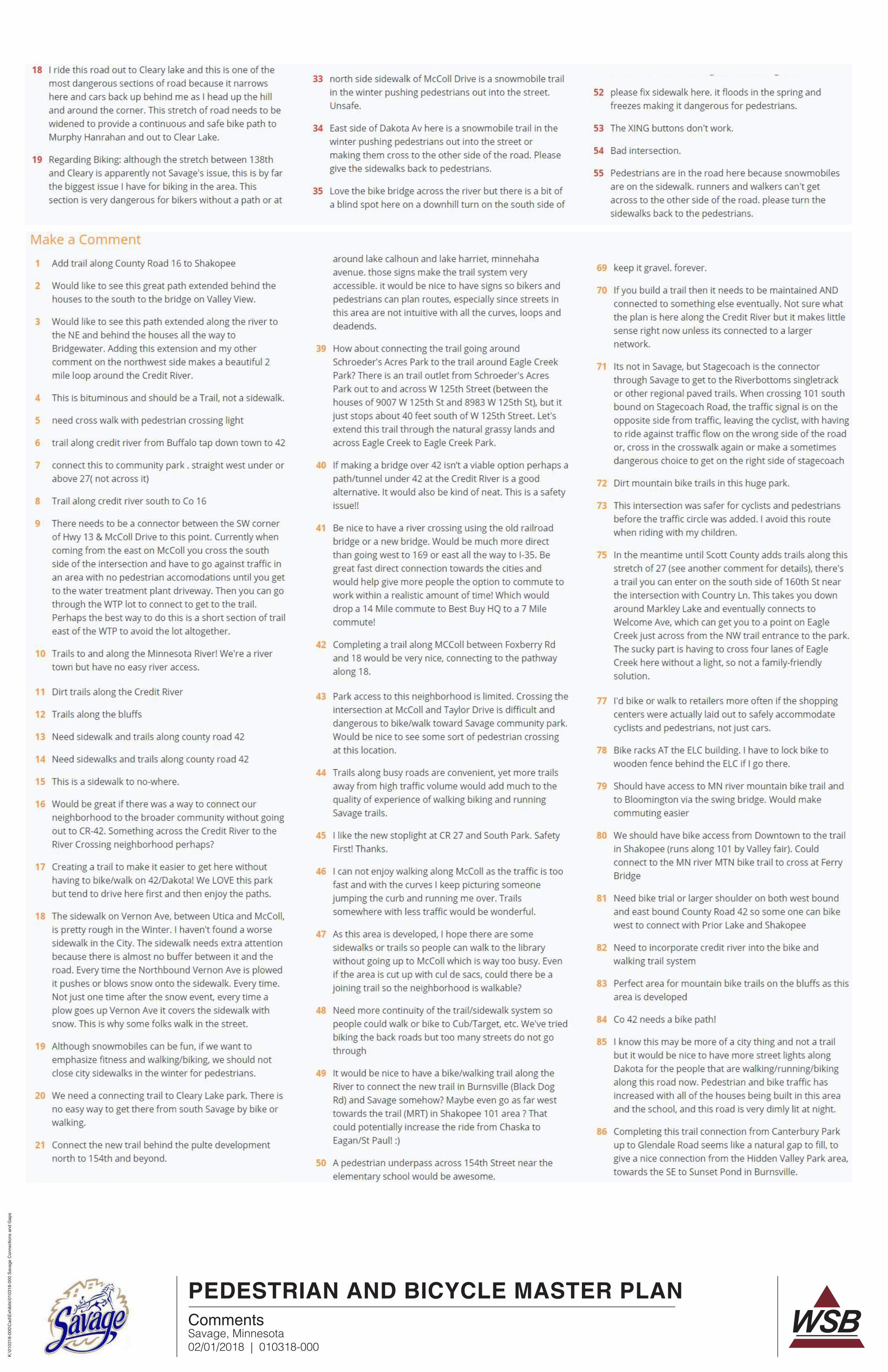
PEDESTRIAN AND BICYCLE MASTER PLAN
Savage, Minnesota02/01/2018 | 010318-000
K:\0
1031
8-00
0\C
ad\E
xhib
its\0
1031
8-00
0 S
avag
e C
onne
ctio
ns a
nd G
aps
Comments
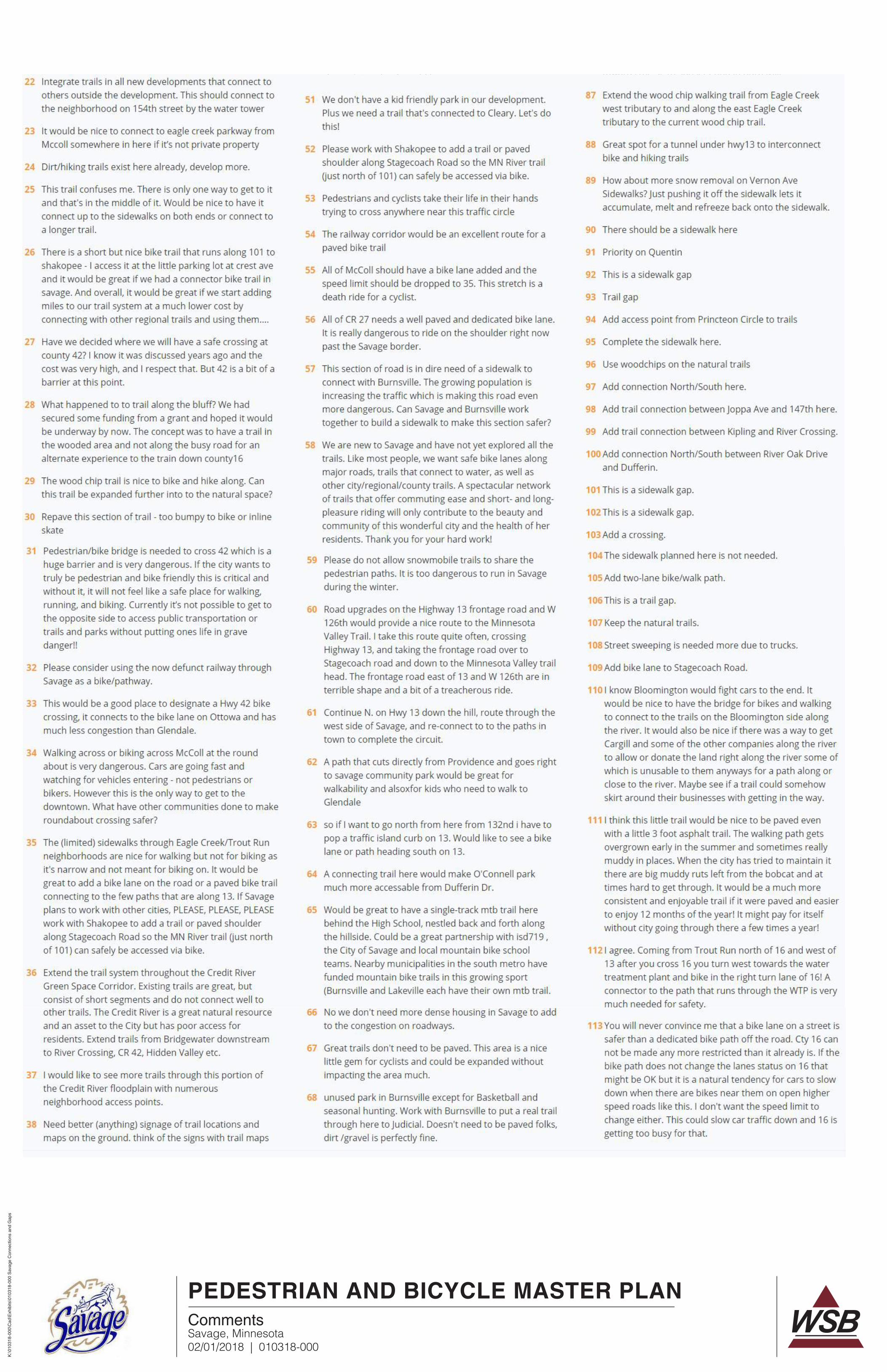
PEDESTRIAN AND BICYCLE MASTER PLAN
Savage, Minnesota02/01/2018 | 010318-000
K:\0
1031
8-00
0\C
ad\E
xhib
its\0
1031
8-00
0 S
avag
e C
onne
ctio
ns a
nd G
aps
Comments
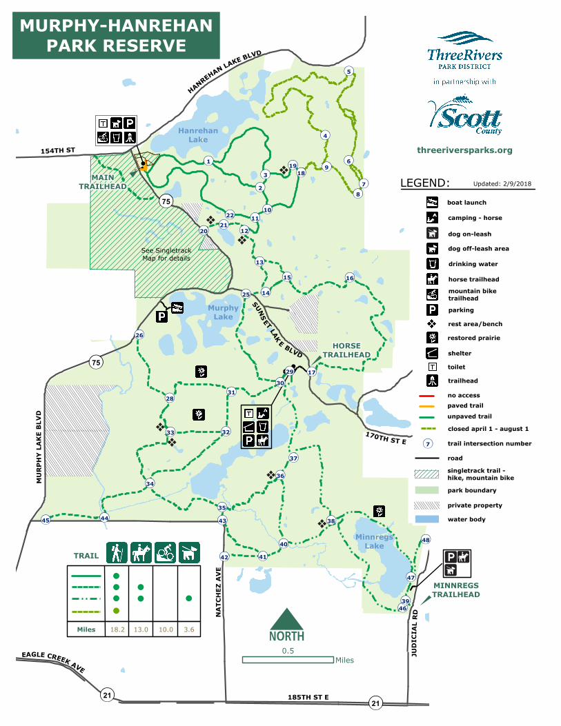
75
75
JUDI
CIAL
RD
170TH ST E
44
34
33 32
3128
26
35
25
41
3029 17
36
37
14
1615
38
12
13
1110
23
1
87
6
5
MinnregsLake
MurphyLake
HanrehanLake
MAINTRAILHEAD
HANREHAN LAKE BLVD
154TH ST
MURP
HYLA
KEBL
VD
NATC
HEZ
AVE
4
9
21
46
22
39
MURPHY-HANREHANPARK RESERVE
TRAIL
Miles 18.2 13.0 10.0 3.6
0.5Miles
LEGEND:boat launch
drinking water
camping - horse
park boundary
toilet
no access
road
water body
trail intersection number
parking
shelter
horse trailhead
private property
closed april 1 - august 1
7
Updated: 2/9/2018
unpaved trail
restored prairie
dog off-leash area
HORSETRAILHEAD
threeriversparks.org
rest area/bench
paved trail
48
47
20
1819
45
42
43
40
trailhead
singletrack trail -hike, mountain bike
mountain biketrailhead
See SingletrackMap for details
MINNREGSTRAILHEAD
SUNS ET LAK E BLVD
21 185TH ST E
EAGLE CREEK AVE
21
dog on-leash

75
1
MURPHY LAKE RD
5090
51
52
89
88 5354
56
55
87
60
61
57 6259
86
58
63
85
6484
66 74
67
68
73
75
65
77
69
7072
71
7678
83
79
81
82
80
MURPHY LAKE BLVD
MurphyLake
500Feet
threeriversparks.org
LEGEND:
drinking watermountain bike trailhead
parking
park boundary
toilet
easy trail - 0.9 mi
road
water body
1/4 mile marker
private property
7
intermediate trail - 2.3 miadvanced trail - 6.9 mi
trailhead
unpaved hike trailunpaved hike, horse trail
154TH ST
Updated: 2/9/2018
trail direction
MURPHY-HANREHANSINGLETRACK
TRAIL
dog off-leash area
bridge/boardwalkpaved trail
fence
No dogs allowedon MTB Trails

Maintenance
Birchwood
Red Pine
OakGrove PARK
ENTRANCE
9 HoleCourse
Lakeview
Basswood
NorwayRidge
ClearyPoint
To PriorLake
To 185th St
21
27
TEXA
SAV
E
190TH ST 68
REVE
REWAY
87
CLEARY LAKE REGIONAL PARKLEGEND:
0.2Miles
boat launchcampground - walk-in
concessions
drinking waterfishing pier
pavilion - reservations only
golfing/driving range
camping - group reservation
parking
picnic area
road
water body
park boundary
play arearentals
picnic area - reservable shelter
rest area/benchrestroom
swimming
visitor center/information
dog off-leash area
shared serviceroad and hike,bike, leasheddog trail
paved trailunpaved trail
threeriversparks.org
trails at your pace
ClearyLake
EAGLE CREEK AVE
Updated: 2/9/2018
campground shelter
LEGEND: bunkerfairway/tee boxgreen
GolfMaintenance
toilet
Lakes ideTra i l
UpperIronwood
Tra i l
PoplarCreekTra i l
trail intersectionnumber7
8
5
6
7
3
111
2104
9no access
fence
camping - rv
TRAIL
Miles 8.4 3.8 3.81.7
0.36
0.760.88
0.07
0.56
0.24
0.68
0.23
0.32
0.55
0.18
0.47
0.18
0.53
0.88
firewood
Areas