options for modernizing military weather satellites paper series congressional budget office...
TRANSCRIPT

Working Paper Series
Congressional Budget Office
Washington, D.C.
Options for Modernizing Military Weather Satellites
Michael Bennett
Congressional Budget Office
September 2012
Working Paper 2012-11
To enhance the transparency of CBO’s work and to encourage external review of it, CBO’s working paper series includes both papers that provide technical descriptions of official CBO analyses and papers that represent original, independent research by CBO analysts. Working papers are not subject to CBO’s regular review and editing process. Papers in this series are available at http://go.usa.gov/ULE. The author would like to thank Jeanine Rees and Raymond Hall for helpful comments and suggestions. This paper was prepared under the supervision of David E. Mosher and Matthew S. Goldberg of CBO’s National Security Division. It draws on earlier analysis initiated by Kevin Eveker, formerly of CBO, and preliminary drafts were enriched by helpful comments from Bob Shackleton, Thomas Vonder Haar, and Bonnie Morehouse.

Abstract
Over the next several years, the Department of Defense (DoD) will launch the last of its weather
satellites, which it uses to plan military operations and generate weather forecasts. Long-running efforts to
develop replacements for those satellites encountered schedule and cost difficulties, and in December
2011, the Congress directed DoD to cancel its latest program and to prepare for a follow-on program.
DoD’s plans now call for a new development effort, but it has not yet determined the capabilities it wants
in that satellite. In this paper, the Congressional Budget Office (CBO) examines three different satellite
design concepts that DoD might consider and compares the cost and capability of those designs. The
paper also discusses alternative approaches that DoD might take, such as fielding single instruments on
several small satellites instead of several instruments on a single satellite and foregoing a new generation
of military weather satellites altogether and instead relying on other sources for weather data.
Contents
Summary ...................................................................................................................................................... 1
Current U.S. Polar-Orbiting Weather Satellite Programs ......................................................................... 1
Options for DoD ....................................................................................................................................... 2
Table 1. Summary of Options .............................................................................................................. 3
Other Possible Approaches ....................................................................................................................... 4
Polar-Orbiting Weather Satellite Programs in the U.S. .......................................................................... 4
How Weather Satellites Operate ............................................................................................................... 6
Existing Polar-Orbiting Weather Satellites ............................................................................................. 10
Figure 1. Polar Orbits of Selected Currently-Deployed Weather Satellites ..................................... 11
Future U.S. Polar-Orbiting Satellites ...................................................................................................... 13
Figure 2. Planned Schedules for Current and Future U.S. Polar-Orbiting Weather Satellites ...... 14
Options for DoD ........................................................................................................................................ 15
Description of the Options ...................................................................................................................... 16
Table 2. Instruments Carried Aboard Satellites ................................................................................ 17
Capabilities of the Options ...................................................................................................................... 19
Table 3. Capabilities of the Satellites................................................................................................ 20
Costs of the Options ................................................................................................................................ 23
Table 4. Costs of Options .................................................................................................................. 24
Other Possible Approaches ...................................................................................................................... 25
Distribute Instruments among Multiple Satellites................................................................................... 26
Continue to Field Satellites in Both the AM and Mid-AM Orbits .......................................................... 27
Stop Fielding DoD Weather Satellites .................................................................................................... 28
Appendix: Risks Related to the Start Date of the Weather Satellite Follow-On Program ................ 30
When is a New Satellite Needed? ........................................................................................................... 30
How Long Will It Take to Produce the New Satellite? .......................................................................... 31

1
Summary
The Department of Defense (DoD) operates weather satellites in two specific orbits to provide weather
forecasts and other information about the environment for military operations. Over the next few years,
those satellites will reach the end of their useful lives in space, and, although DoD has two more satellites
in storage awaiting launch, it is formulating plans for replacement satellites. The Congressional Budget
Office (CBO) has examined several options that DoD might pursue to replace its existing satellites. Those
options range in cost from $4.4 billion to $6.1 billion through 2037 and feature satellites with a range of
capabilities, from those comparable to the current generation of weather satellites to those equipped with
more modern, state-of-the-art instruments.
Current U.S. Polar-Orbiting Weather Satellite Programs For more than 50 years, the United States has deployed weather satellites to perform a variety of
missions. In the early 1960s, DoD pioneered the use of weather satellites to observe cloud patterns so that
intelligence analysts would not waste the limited supply of film carried by spy satellites by taking pictures
of areas—primarily in the Soviet Union—that were covered by clouds. Within a few years, the military’s
mission had expanded to fielding satellites in two separate orbits, and satellite observations of weather
conditions have been used directly in the planning of military operations since the Vietnam War.
Today, weather satellites play a crucial role in the operations of both military and civilian agencies. Those
satellites provide information used for weather forecasting, monitoring long-term trends in climate
conditions, planning for military operations and disaster relief, and monitoring near-earth space for
conditions that affect satellite operations. A number of military and civilian programs are now in
operation. DoD fields satellites from the Defense Meteorological Satellite Program (DMSP) in two polar
orbits, while the National Oceanic and Atmospheric Agency (NOAA), often partnering with the National
Aeronautics and Space Administration (NASA), fields several weather satellites, including those from the
Polar-Orbiting Operational Environmental Satellite (POES) system in one polar orbit.
In the past 50 years, several efforts have been made to combine the military and civilian weather satellite
missions into a single program. The latest of those efforts was the National Polar-Orbiting Operational
Environmental Satellite System (NPOESS) program. It began in 1995 and was intended to develop new
satellites to replace the DMSP and POES satellites. The NPOESS program sought to build satellites
centered on a common set of instruments and that would operate in all three orbits currently covered by
U.S. polar-orbiting weather satellites. However, the program was technically ambitious, and it suffered a
series of problems with the program management structure, cost growth, and schedule delays. In 2010,
2
after about 15 years of development and several program restructurings, the NPOESS program was
terminated and replaced by separate NOAA and DoD programs. NOAA, partnering with NASA,
established the Joint Polar Satellite System (JPSS) program, while DoD formed the Defense Weather
Satellite System (DWSS). Both the JPSS and DWSS programs were intended to draw heavily on
development done in the NPOESS program. In the fiscal year 2012 appropriation process, however, the
Congress instructed DoD to terminate the DWSS system. In response, DoD now plans to delay the need
for a new weather satellite by changing the way in which it will field the two DMSP satellites that have
yet to be launched; the department is also considering the best approach for developing the next
generation of satellites, dubbed Weather Satellite Follow-On (WSF).
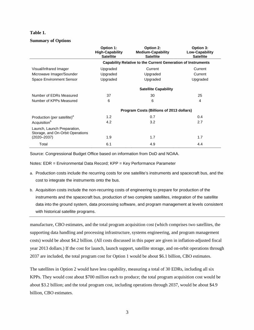
Options for DoD CBO has analyzed three options that DoD might consider for WSF (see Table 1). Each option is built
around a core set of three types of instruments: a visual/infrared imager, which, among other things, is
used to determine the presence and properties of clouds and the temperature of the earth’s surface; a
microwave imager/sounder, which is used primarily to determine the atmospheric humidity and
temperature as a function of altitude; and a space environment sensor, which is used to determine
conditions in outer space that affect satellite operations. The options are differentiated by the relative
capabilities of the instrument sets and are meant to illustrate a range of potential choices that DoD could
make as it weighs trade-offs between cost and capability.
• Option 1, which would provide the most capable—and most expensive—satellite, would
incorporate upgraded versions of all three instruments, using designs that were part of the
NPOESS program. Option 1 is most similar to the satellite that DoD was planning prior to
cancellation of the DWSS program.
• Option 2 would reduce the cost by replacing the more capable visual/infrared instrument with the
version carried on the current generation of POES satellites.
• Option 3 would reduce the cost even further by using both the visual/infrared imager and the
microwave imager/sounder carried on current-generation satellites.
CBO anticipates that the satellites in Option 1 would be capable of measuring a total of 37 quantities of
interest (referred to as Environmental Data Records, or EDRs), including all six EDRs that the NPOESS
program had designated as Key Performance Parameters, or KPPs (imagery, soil moisture, the speed and
direction of sea surface winds, atmospheric vertical moisture profiles, atmospheric vertical temperature
profiles, and sea surface temperature). Each of those satellites would cost about $1.2 billion to
3
Table 1.
Summary of Options
Option 1: High-Capability
Satellite
Option 2: Medium-Capability
Satellite
Option 3: Low-Capability
Satellite
Capability Relative to the Current Generation of Instruments Visual/Infrared Imager Upgraded Current Current Microwave Imager/Sounder Upgraded Upgraded Current Space Environment Sensor Upgraded Upgraded Upgraded
Satellite Capability Number of EDRs Measured 37 30 25 Number of KPPs Measured 6 6 4
Program Costs (Billions of 2013 dollars)
Production (per satellite)a 1.2 0.7 0.4 Acquisitionb 4.2 3.2 2.7
Launch, Launch Preparation, Storage, and On-Orbit Operations (2020–2037) 1.9 1.7 1.7
Total 6.1
4.9
4.4
Source: Congressional Budget Office based on information from DoD and NOAA.
Notes: EDR = Environmental Data Record; KPP = Key Performance Parameter
a. Production costs include the recurring costs for one satellite’s instruments and spacecraft bus, and the
cost to integrate the instruments onto the bus.
b. Acquisition costs include the non-recurring costs of engineering to prepare for production of the
instruments and the spacecraft bus, production of two complete satellites, integration of the satellite
data into the ground system, data processing software, and program management at levels consistent
with historical satellite programs.
manufacture, CBO estimates, and the total program acquisition cost (which comprises two satellites, the
supporting data handling and processing infrastructure, systems engineering, and program management
costs) would be about $4.2 billion. (All costs discussed in this paper are given in inflation-adjusted fiscal
year 2013 dollars.) If the cost for launch, launch support, satellite storage, and on-orbit operations through
2037 are included, the total program cost for Option 1 would be about $6.1 billion, CBO estimates.
The satellites in Option 2 would have less capability, measuring a total of 30 EDRs, including all six
KPPs. They would cost about $700 million each to produce; the total program acquisition cost would be
about $3.2 billion; and the total program cost, including operations through 2037, would be about $4.9
billion, CBO estimates.

4
The option with the lowest cost and capability, Option 3, would measure 25 EDRs, including four of the
six KPPs; the unit production cost would be about $400 million; the total program acquisition cost would
be about $2.7 billion; and the total program cost, including operations through 2037, would be about $4.4
billion, CBO estimates.
CBO’s assessments of the cost of the three main satellite options reflect the assumption that DoD will
continue with its new plans for fielding the last two DMSP satellites and will choose to build new WSF
satellites to take the place of DMSP satellites when they reach the end of their operational lives. CBO also
assumed that DoD will attempt to minimize the risk of gaps in satellite coverage by starting WSF
development around 2014, with the goal of having a new WSF satellite ready as a backup when the last
DMSP is launched around 2020.
Other Possible Approaches DoD could take other approaches, some of which would cost less and some of which would cost more
than the plans described above: delay the start of WSF development to reduce near-term costs; field
sensors on several smaller satellites rather than on a single satellite; retain DoD coverage in both orbits
currently covered by DMSP satellites; or not replace the DMSP satellites and instead rely on other
national and international sources for weather data. Although CBO has not performed quantitative
analyses of these alternate approaches, this paper discusses some of their potential advantages and
disadvantages.
Polar-Orbiting Weather Satellite Programs in the U.S. Since the 1960s, military and civilian space communities in the United States have operated satellites to
observe weather phenomena on earth. The satellites provide data on current conditions that form a basis
for forecasting future weather and that are also immediately useful in planning military operations. Over
the long term, the measurements made by those satellites are used to perform scientific research on the
dynamics of the earth’s atmosphere and to monitor trends in the earth’s climate.
Today, DoD fields satellites as part of DMSP, and those satellites provide data used to determine weather
conditions, cloud cover, ocean wave conditions, soil moisture, and other quantities of direct use to
military planners. For example, knowledge about areas with cloud cover—which can interfere with
visibility—is useful in determining the best use of surveillance aircraft or which types of ordnance (laser-
guided or GPS-guided bombs) to use for strike aircraft missions. The DMSP satellites also provide data
that feed into computer models to generate weather forecasts. DMSP satellite data are transmitted to a

5
ground station network and then routed to major weather forecast centers. DMSP satellites also broadcast
local observations directly to users in the field, both on land and onboard ships, via remote terminals.
Currently, DoD operates DMSP satellites in two polar orbits, referred to as AM and mid-AM orbits for
the times that they cross the equator. The last currently-fielded DMSP satellite in the AM orbit is
expected to function until about 2014; the last such satellite in the mid-AM orbit is expected to function
until 2016. DoD also has two DMSP satellites in storage on the ground remaining to be launched.
In the civilian community, NOAA, part of the Department of Commerce and home to the National
Weather Service, currently operates a number of weather satellites, including several under the POES and
Geostationary Operational Environmental Satellite (GOES) programs. POES satellites operate in a
different polar orbit than do DoD’s DMSP satellites; that orbit is referred to as the PM orbit. Those
satellites provide data for input to weather forecasts as well as information useful for responding to
environmental events such as volcanic eruptions and forest fires. In addition, NASA fields a number of
satellites to support research into the physical and chemical interactions between land, ocean, atmosphere,
and space that determine the earth’s weather and climate. Some of the data that those research satellites
collect are similar to the data collected by operational weather satellites.
The effort to develop replacements for DMSP and POES satellites has been underway for nearly 20 years.
In 1994, NOAA and DoD were directed to integrate their programs with the goal of reducing duplication
and improving efficiency. The resulting program, NPOESS, sought to not only improve efficiency but
also the quality and quantity of environmental data collected by the satellites. Throughout its history, the
NPOESS program experienced a series of technical and management problems that led to schedule delays
and increased costs. Costs continued to rise even after the program was restructured in 2006. Part of that
restructuring included the decision to stop fielding U.S. satellites in the mid-AM orbit, where DoD had
operated weather satellites since the 1960s, and to rely instead on European satellites for weather data in
that orbit. Under the NPOESS program restructuring, U.S. coverage in the mid-AM orbit was to end
around 2020, when the last of the DMSP satellites that DoD planned to deploy there reached the end of its
life.
In February 2010, the NPOESS program was terminated and split into separate programs, with NOAA
and NASA given responsibility for new satellites in the PM orbit and DoD given responsibility for new
satellites in the AM orbit. Following that decision, NOAA announced a new program, JPSS, to be
undertaken in partnership with NASA. Shortly thereafter, DoD announced it would begin the DWSS
program. Both of these programs would draw heavily on development done by the NPOESS program.

6
In the defense appropriations bill for fiscal year 2012, the Congress directed DoD to terminate the DWSS
program, citing a “difficult and confusing set of management issues.”1 As an alternative, the Congress
appropriated $125 million for DoD to continue research into sensor technology and to prepare for a
program to follow DMSP. As a result of that direction, DoD is analyzing alternative approaches for the
follow-on effort, WSF, and is researching technologies for that program. In a related decision that delays
the date by which WSF will need to be available, DoD has chosen to change the orbit where it will
operate the final DMSP satellite, opting to launch the satellite into the AM orbit around 2020 rather than
into the mid-AM orbit around 2016. This schedule change extends the coverage of DMSP satellites in the
AM orbit longer than had been planned, but it moves earlier by about six years the date at which U.S.
satellites will cease operating in the mid-AM orbit.
The remainder of this section reviews how weather satellites operate, provides an overview of existing
polar-orbiting weather satellites, and discusses future polar-orbiting satellites.
How Weather Satellites Operate The ability to forecast what the weather will be at some point in the future requires the forecaster to have
both an understanding of atmospheric dynamics and a detailed knowledge of the current weather
conditions. To this end, government and commercial weather organizations around the world have fielded
a vast array of instruments to measure the weather. According to the World Meteorological Organization
(WMO), which facilitates the integration and coordination of weather data between participating nations,
worldwide weather data sources include:
• More than 10,000 manned or automated land-based weather stations;
• More than 3,000 commercial aircraft and 7,000 commercial ships carrying special weather
sensors;
• More than 100 moored and 1,000 drifting buoys;
• Hundreds of weather radars; and
• More than 60 weather satellites, including operational satellites in both geostationary and polar
orbits and research satellites in various orbits.2
1 Senate Committee on Appropriations, Department of Defense Appropriation Bill, 2012, Report 112-77, Sept. 15, 2011, p. 203.
2 Operational satellites are designed to produce data their parent agencies need to execute specific missions, like producing weather forecasts on a regular basis or performing day-to-day military mission planning. As such, they are designed to be very reliable and to provide their data promptly. Research satellites, in contrast, are designed

7
Which source is most useful depends on the nature of the particular type of weather forecast, namely the
size of the region and the time period the forecast is covering. In general, because of their high altitude,
satellites are able to perform measurements over a much larger area and are able to access more remote
areas than other methods can. Satellite measurements, however, are generally less precise than those
made by the other types of instruments, and they can be made only when the area of interest is within
view of the satellite’s orbit.
Over the last few decades, substantial effort has gone into learning how to generate more reliable
forecasts from the high-quality weather data collected by a growing number of operational and research
satellites in polar, geostationary, and other orbits. A 2004 National Research Council report associates
this effort with a marked increase in the accuracy of forecasts, especially in the southern hemisphere,
where local ground-based sensors and radars often do not exist. For example, in 1980, the typical
accuracy of five-day forecasts in the northern hemisphere was found to be about 65 percent, while those
in the southern hemisphere were about 50 percent accurate; by 2004, the accuracy of both northern and
southern hemisphere five-day forecasts had improved to about 85 percent.3
The usefulness of weather satellites and the data they produce are determined by several important
characteristics of the satellites and the ground network that supports them. Those characteristics include:
• Where and how often the satellites are able to view the earth, which largely depends on the orbits
in which they operate;
• The type and quality of the observations they make, which is determined by the instruments they
carry to perform measurements;
• The length of time the satellite is expected to operate before it would need to be replaced, referred
to as the operational lifetime; and
• The time lag between when conditions are measured by the satellite and when the processed data
are available for use, which is referred to as data latency.
Orbits Weather satellites are typically launched into either a geostationary orbit, which is synchronized to the
rotation of the earth so that the satellite remains over a fixed spot on the equator at all times, or a polar primarily for scientific research. Data from research satellites are sometimes used in weather forecasting, but those satellites are generally not subject to the same standards for reliability or promptness as operational satellites.
3 Committee on Environmental Satellite Data Utilization, National Research Council, Utilization of Operational Environmental Satellite Data: Ensuring Readiness for 2010 and Beyond, (2004), pp. 124-129.

8
orbit, which passes over regions near the north and south poles during each orbit around the earth. A
geostationary satellite sees a large portion of the earth—about one-quarter—from its vantage point 36,000
kilometers above the surface, but that altitude limits the spatial resolution of the measurements.4
Moreover, geostationary satellites are not well suited for viewing the polar regions because they view
those areas at large angles. Satellites in polar orbits are much closer to the earth (usually less than 1,000
kilometers from the surface), and though they view a much smaller portion of the earth at any one time,
they can perform measurements with better spatial resolution. Polar satellites view the polar regions about
14 times in the course of their daily orbits, while they generally pass over a specific area on the equator
only twice each day.
Polar-orbiting weather satellites are typically launched into sun-synchronous orbits—orbits that are
synchronized with the Earth’s rotation so that the satellite passes over a specific point on the ground at the
same local time every day.5 Those orbits provide consistent viewing conditions, which facilitate the
comparison of observations taken on different days. The orbits are generally defined by the time they
cross the equator each day: AM (morning), mid-AM (mid-morning), or PM (afternoon).
NOAA operates weather satellites in both geostationary and polar orbits, but DoD fields weather satellites
only in polar orbits.
Instruments The instruments on weather satellites measure electromagnetic radiation from the earth and the
atmosphere, and particles and electromagnetic radiation from space just outside the atmosphere in various
frequencies, energies, and geometries. The data collected are then analyzed to infer different properties of
the Earth and its environs. In the NPOESS program, those computed properties were referred to as EDRs
and were to be generated by ground-based processing of the data collected by the satellites. Instruments
can be improved by increasing the number of frequencies at which radiation is being measured, increasing
the number of geographic points at which measurements are taken so as to measure with better spatial
resolution, and increasing the sensitivity of the device that is measuring the radiation. For some
instruments, the NPOESS program attempted all of these methods of improvement simultaneously.
4 Spatial resolution refers to the smallest object or area on the earth that an instrument is capable of measuring at a point in time and the pixel size of the resulting image. Higher spatial resolution produces more detailed imagery.
5 Local time refers to a fixed offset relative to Greenwich Mean Time, which is not necessarily the same as the time in the local time zone.
9
The EDRs generated from weather satellite data can be used for a variety of purposes, including
producing medium-range outlook weather forecasts (out to 15 days); forecasting conditions such as cloud
cover, wave height, and ice conditions for aviation or maritime operations; producing severe weather
warnings; collecting imagery to aid in disaster relief operations; long-term climate monitoring; and aiding
military planners by monitoring soil moisture levels (which affect maneuverability of ground forces) and
conditions for weapon systems utilization.
In terms of the EDRs measured, the capability of a given satellite configuration depends on which
instruments the satellite carries. Some EDRs are measured with a single instrument, while other EDRs
require correlating measurements between multiple instruments. The capabilities of a given instrument
can affect the quality of EDRs. For example, better spatial resolution on a sensor that measures soil
moisture will allow it to measure variations over smaller areas on the ground.
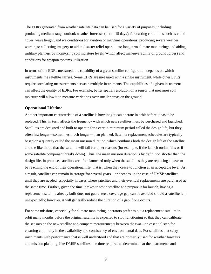
Operational Lifetime Another important characteristic of a satellite is how long it can operate in orbit before it has to be
replaced. This, in turn, affects the frequency with which new satellites must be purchased and launched.
Satellites are designed and built to operate for a certain minimum period called the design life, but they
often last longer—sometimes much longer—than planned. Satellite replacement schedules are typically
based on a quantity called the mean mission duration, which combines both the design life of the satellite
and the likelihood that the satellite will fail for other reasons (for example, if the launch rocket fails or if
some satellite component breaks down). Thus, the mean mission duration is by definition shorter than the
design life. In practice, satellites are often launched only when the satellites they are replacing appear to
be reaching the end of their operational life, that is, when they cease to function at an acceptable level. As
a result, satellites can remain in storage for several years—or decades, in the case of DMSP satellites—
until they are needed, especially in cases where satellites and their eventual replacements are purchased at
the same time. Further, given the time it takes to test a satellite and prepare it for launch, having a
replacement satellite already built does not guarantee a coverage gap can be avoided should a satellite fail
unexpectedly; however, it will generally reduce the duration of a gap if one occurs.
For some missions, especially for climate monitoring, operators prefer to put a replacement satellite in
orbit many months before the original satellite is expected to stop functioning so that they can calibrate
the sensors on the new satellite and compare measurements between the two—an essential step for
ensuring continuity in the availability and consistency of environmental data. For satellites that carry
instruments with performance that is well understood and that are primarily used for weather forecasts
and mission planning, like DMSP satellites, the time required to determine that the instruments and

10
spacecraft are working properly, referred to as on-orbit checkout, can be considerably shorter. The
operational lifetime of a satellite refers to the period after on-orbit checkout is completed until the satellite
is expected to fail, and it is equal to the mean mission duration minus the checkout period. For example,
the Suomi-NPP satellite has a spacecraft design life of seven years, a mean mission duration of five years,
and an operational life of four years. The actual operational life of the existing polar-orbiting weather
satellites will determine how soon NOAA and DoD will need to have replacements for POES and DMSP
satellites ready for launch.
Data Latency A fourth important characteristic of a satellite system is how quickly the measured data are available to
users on the ground for forecasting weather or planning operations. This time lag, usually referred to as
latency, is a function of the design of the satellite and the design of the network of ground stations that
receive the data. For some tasks, such as long-term climate research, the timeliness of the data is not as
important as it is for other missions, such as near-term weather forecasts or measuring environmental
conditions during military operations.
Existing Polar-Orbiting Weather Satellites The United States currently has two types of satellites in polar orbits, operational weather satellites and
research satellites, and they collect data for weather forecasts and monitoring environmental conditions.
Operational Weather Satellites DoD has two DMSP operational weather satellites in orbit and NOAA has one POES satellite in orbit.6
Each of those satellites circles the earth about 14 times a day in a sun-synchronous orbit. For the purposes
of weather prediction and climate monitoring, each of the three satellites operates in a different sun-
synchronous orbit that is defined by the local time at which it crosses the equator. A satellite in the AM
(morning) orbit crosses the equator at about 5:30 am; one in the mid-AM orbit, at about 9:30 am; and the
PM orbit, at about 1:30 pm (see Figure 1). Today, one DMSP satellite operates in the AM orbit and
another operates in the mid-AM orbit because those orbits provide observations at times that are useful
for planning daily military operations. Those satellites each measure 29 EDRs. A POES satellite that
measures 27 EDRs operates in the PM orbit, and it complements the other two orbits by providing
coverage at times that are most useful for forecast activity on the west coast of the United States.
Together, the current constellation of DMSP and POES satellites measures a total of 41 different EDRs.
6 Those numbers refer to primary operational satellites. There are also older DMSP and POES satellites that are still in orbit and at least partially functional that serve as backups.

11
Figure 1.
Polar Orbits of Selected Currently-Deployed Weather Satellites
Source: Congressional Budget Office using Satellite Took Kit from Analytical Graphics, Inc.
Notes: POES = Polar-Orbiting Operational Environmental Satellite; NOAA = National Oceanic and
Atmospheric Administration; NASA = National Aeronautics and Space Administration; DMSP =
Defense Meteorological Satellite Program; DoD = Department of Defense; EUMETSAT =
European Organization for the Exploitation of Meteorological Satellites.
a. NOAA operates the POES satellite and NASA and their international partners operate the A-Train
satellites in the PM orbit.
b. DoD operates a DMSP satellite in the AM orbit.
c. DoD operates a DMSP satellite and EUMETSAT operates a Metop satellite in the mid-AM orbit.
The Suomi-NPP satellite, built by NASA in cooperation with NOAA as part of the NPOESS program,
was launched into the PM orbit in October 2011. It will eventually replace the POES satellite, which is
nearing the end of its operational life, as the primary operational satellite in the PM orbit.7 As of August
2012, the satellite is still undergoing an extensive on-orbit checkout process before it can be declared
fully operational. Suomi-NPP carries a total of five instruments and is capable of measuring 30 EDRs.
7 The satellite was originally referred to as NPP, an acronym that stood for NPOESS Preparatory Project, consistent with the original research mission for the satellite. The name was changed to Suomi-NPP to honor satellite meteorology pioneer Verner Suomi, and the NPP portion was changed to stand for National Polar-Orbiting Partnership.

12
Research Satellites Under its Earth Observing System and Earth System Science Pathfinder programs, NASA also operates a
number of research satellites with missions related to monitoring earth’s weather and climate. Although
the satellites were designed to conduct scientific research, the data they collect are often used in
operational weather forecasting models. Some of those satellites currently operating are Terra and Aqua,
which measure multiple quantities related to properties of the earth’s atmosphere and surface; Aura,
which measures quantities specific to the atmosphere; and CloudSat, which performs detailed
measurements of the vertical structure of cloud systems. Some of the instruments those satellites carry are
of the same design as those that had been intended for the NPOESS program.
Several of the NASA satellites operate as a constellation using what is known as formation flying—
traveling in close proximity on the same orbit so that the satellites pass over the same areas on the Earth
within minutes of each other. As of late 2010, that constellation, referred to as the A-Train (short for
“afternoon train” because the satellites operate in the PM orbit), consists of four NASA satellites: Aqua,
Aura, CloudSat, and CALIPSO (Cloud-Aerosol Lidar and Infrared Pathfinder Satellite Observation). At
various times, the constellation has also included satellites from other countries, such as the French
satellite PARASOL and the Japanese GCOM-W1.
In addition to operating their own satellites, U.S. agencies supplement the weather and climate data
available to them by using data from other countries, made possible through a number of bilateral and
multilateral data-sharing agreements. In particular, NOAA and the European Organization for the
Exploitation of Meteorological Satellites (EUMETSAT) agreed in November 1998 to establish the Initial
Joint Polar-Orbiting Operating Satellite System (IJPS). Today, a direct fiber link between Germany and
the United States provides satellite data from EUMETSAT to NOAA. In addition, NOAA and
EUMETSAT together have upgraded ground stations to reduce the latency of EUMETSAT data for all
users. Also in place are agreements to acquire weather data from satellites fielded by Japan, India,
Canada, and the European Space Agency.
Currently, EUMETSAT operates one Metop satellite in the mid-AM orbit under their EUMETSAT Polar
System program, and two replacement Metop satellites have already been built and await launch. Those
satellites are EUMETSAT’s contribution to the IJPS. Metop satellites carry a suite of instruments that are
the same as, or have capability similar to, instruments on DMSP or POES satellites. The data from those
instruments can be used to measure 28 EDRs. Future versions of Metop satellites, sometimes referred to
as Post-EPS or EPS Second Generation satellites, are currently in the early planning stages, and they may
carry more advanced instruments like those initially planned for the NPOESS satellites.
13
Many other countries also have operational and research weather satellites. According the World
Meteorological Organization (WMO), as of August 2012, Russia, China, India, Japan, and South Korea
were all fielding both operational geostationary satellites and operational polar satellites. The
Coordination Group for Meteorological Satellites provides a forum for sharing data among its member
organizations (with representative organizations from all of the countries listed, as well as from Europe
and the United States), and for coordinated planning of future satellite constellations.
Future U.S. Polar-Orbiting Satellites Both DoD and NOAA have plans to field polar-orbiting satellites in the future (see Figure 2). For NOAA,
the future satellites are part of the JPSS program. DoD has two more DMSP satellites remaining to be
launched, and after that, it would continue the mission in the AM orbit with WSF satellites, although
plans for that new system are still being formulated.
As of March 2012, NOAA’s plans call for two JPSS satellites.8 The first satellite, JPSS-1, would carry the
same set of instruments as Suomi-NPP, and the payload for the second satellite, JPSS-2, has yet to be
finalized. JPSS-1 is slated to be available for launch in 2017, and JPSS-2 would be available for launch in
2021. Because of improvements to the ground system made as part of the NPOESS program, JPSS is
expected have data latency of about 80 minutes, an improvement over the current 120 minutes for POES
data.
Currently, DoD has two DMSP satellites awaiting launch, DMSP-19 and DMSP-20. Those satellites were
built in the 1990s as part of the DMSP Block 5D-3 group. Before the cancellation of the DWSS program,
DoD’s plans called for DMSP-19 to be launched into the AM orbit around 2013 as a replacement for the
current satellite DMSP-17, and DMSP-20 to be launched into the mid-AM orbit around 2014 as a
replacement for the current satellite DMSP-18. Since the cancellation, DoD plans instead to launch the
DMSP-20 satellite into the AM orbit, replacing DMSP-19 when it reaches the end of its life around 2020.
After DMSP-18 reaches the end of its life around 2016, DoD will no longer field satellites in the mid-AM
orbit—about six years earlier than previously planned. The unlaunched DMSP satellites recently
underwent refurbishment to extend their operational lives, but they were built in the late 1990s and will
have been in storage for roughly 20 years by the time they are launched; it is not known how such
extended storage may affect the reliability and lifetime of the satellites in orbit.
8 NOAA also plans to field several instruments that had previously been intended for the NPOESS program on smaller satellites or as secondary payloads on host satellites.

14
Figure 2.
Planned Schedules for Current and Future U.S. Polar-Orbiting Weather Satellites
Source: Congressional Budget Office based on information from DoD and NOAA.
Notes: Satellites may be launched any time after they become available. Typically, launches are
scheduled early enough to allow several months or more of in-orbit testing and calibration before
the satellite becomes operational. DMSP-19 and DMSP-20 were built years ago, so a date for their
availability for launch does not appear in the figure.
NOAA = National Oceanic and Atmospheric Administration; DoD = Department of Defense;
NPP = National Polar-orbiting Partnership; JPSS = Joint Polar Satellite System;
DMSP = Defense Meteorological Satellite Program; WSF = Weather Satellite Follow-On.
a. NOAA has not yet determined plans beyond JPSS-2.
b. European Metop satellites also operate in the mid-AM orbit.
c. Dates for launch availability and operational periods for WSF satellites are based on CBO analysis of DoD plans.
X X
X X
X
2012 2016 2020 2024 2028 2032 2036
WSF 2WSF 1
DMSP 20DMSP 19DMSP 17
DMSP 18DMSP 16
JPSS 2JPSS 1
Suomi-NPPNOAA 19
Fiscal Year
X Available for Launch
On-Orbit Checkout Period
Operational Period
Operational Beyond Design Life
Mid-AM Orbit b
PM Orbit
AM Orbit
c
c
15
DoD is currently evaluating various concepts for the WSF satellites with a focus on affordable, mature
technology and plans to use $125 million appropriated by the Congress to continue to assess current
technologies. DoD’s decision to launch DMSP-20 into the AM orbit has given DoD more time to develop
the WSF satellites. How long the development of the WSF satellite can be put off depends on how much
risk of a potential gap in coverage that DoD is willing to accept. Determining the start date for new
development involves two main issues: when the new satellite needs to be available for launch and how
long it will take to produce the satellite. Each of those issues has some risk associated with it (see the
Appendix for further discussion of those risks).
In addition to the operational impact of leaving the mid-AM orbit six years earlier than previously
planned, the decision to use DMSP-20 in the AM orbit also affects DoD’s budget. In the long run, the
move essentially swaps DMSP-20 for what would have been a new satellite in the AM orbit after DMSP-
19, so that one fewer of the new generation of satellites needs to be purchased. In the near term, however,
delaying the launch of DMSP-20 means that the satellite will need to be stored longer; currently, DoD
spends about $90 million per year to support the unlaunched DMSP satellites, including maintaining a
level of readiness that would allow the satellites to be launched in about nine months if an on-orbit
satellite should falter. Under previous plans, the cost to support unlaunched DMSP satellites was expected
to decrease shortly after DMSP-20 was launched, but with the need to store the satellite longer than
previously planned, support is expected to remain at about $90 million per year through at least 2017.
Options for DoD
To assist the Congress in its oversight of DoD’s environmental satellite programs, CBO has analyzed a
range of options for DoD as it moves forward with its weather satellite mission, including WSF to replace
the last of the DMSP satellites. For this paper, CBO has assumed that DoD will decide to build WSF
satellites, and has estimated the potential capability and cost of three different WSF design options that
DoD could pursue.
The satellites in those options would all carry the same types of instruments—a visual/infrared imager, a
microwave imager/sounder, and a space environment instrument—but the overall capability of the
satellite would vary depending on whether a given instrument was a new, upgraded version or a version
carried on currently-operating satellites.

16
• Option 1 would have the highest capability, carrying all upgraded instruments.
• Option 2 would have mid-level capability, carrying a mix of new and current-generation
instruments.
• Option 3 would be the least capable of the options, carrying current-generation versions of both
the visual/infrared imager and the microwave sensor.
As may be expected, higher capability comes with higher cost: $4.2 billion for Option 1, $3.2 billion for
Option 2, and $2.7 billion for Option 3, according to CBO’s estimates of acquisition costs.
The options are intended to illustrate a range of potential choices in the trade-off between cost and
capability for WSF satellites. The cost estimates for the options are based on the assumptions that the
WSF satellites would operate in the AM orbit only, that development of the WSF satellites would begin
around 2014, that the first satellite would be complete around 2020 and the second around 2022, and that
the satellites would be maintained until launch at a level of readiness similar to that of DMSP satellites
today. It is possible, however, that DoD could choose to offset some of the near-term cost associated with
extending DMSP by delaying the beginning or stretching out the development efforts on the new WSF
satellite.
Although reports suggest that DoD seems inclined to develop WSF along the lines outlined above, the
department could pursue other approaches. For example, it could distribute sensors among several smaller
satellites, continue to deploy satellites in both the AM and mid-AM orbits, or stop building dedicated
defense weather satellites and rely on other sources for weather data. The last section of this paper
explores those approaches.
Description of the Options All of the options are built around the same set of instrument types that had been planned for DWSS. For
each type of instrument, the options would include either an instrument that has demonstrated its
reliability and capability on the current generation of existing operational satellites or one that has been
designed or developed for the upgraded capability envisioned for the NPOESS program (see Table 2).
The instruments fall into three categories based on what they do:

17
Table 2.
Instruments Carried Aboard Satellites
Type of Instrument Instrument
Name
Option
Technical Highlights
History
Visual/Infrared Imager
Operational Line Scanner (OLS)
Current DMSP satellite
Produces imagery using 2 frequency bands, including a high-sensitivity "day-night" band; Has high spatial resolution and low distortion over field of view
Most recent version has flown on multiple DMSP satellites since at least 2003, with original versions dating to the 1960s
Visible-Infrared Imager
Radiometer Suite (VIIRS)
Option 1
Produces imagery using 22 frequency bands; Has high spatial resolution with low distortion over field of view
Developed for NPOESS; Currently undergoing on-orbit checkout on the Suomi-NPP satellite
Advanced Very High Resolution Radiometer (AVHRR)
Options 2 and 3
Produces imagery using 5 frequency bands; Has high spatial resolution but reduced resolution at the edge of field of view
Versions flown on POES and Metop satellites since 1998
Microwave Imager/Sounder
Special Sensor Microwave
Imager/Sounder (SSMIS)
Current DMSP satellite
Produces imagery and sounding using 21 frequency bands
Flown on multiple DMSP satellites since at least 2003
Microwave Imager/Sounder
(MIS)
Options 1 and 2
Produces imagery and sounding using 23 frequency bands
Designed for NPOESS to replace a more capable detector originally planned for NPOESS that was removed in the 2006 program restructure
Advanced Microwave
Sounding Unit (AMSU-A)
Option 3
Produces sounding using 15 frequency bands; Not optimized for imagery
Versions flown on POES and Metop satellites since 1998
Space Environment Sensor
Space Environment Monitor + (SEM +)
Current DMSP satellite
Upgraded from earlier versions; Comprises 5 specialized sensors to measure electron and ion properties, magnetic fields, and electromagnetic radiation
Flown on multiple DMSP satellites since at least 2003
Space Environment Monitor-NPOESS
(SEM-N)
Options 1, 2
and 3
Has a suite of three sensors to measure electron and ion properties in different energy regimes
Designed for NPOESS; Not yet flown but designs draw on sensors that flew on POES and DMSP satellites
Source: Congressional Budget Office based on information from DoD and NOAA.
Note: DMSP=Defense Meteorological Satellite Program; NPOESS=National Polar-Orbiting Operational
Environmental Satellite System; POES=Polar-Orbiting Operational Environmental Satellite;
NPP=National Polar-Orbiting Partnership; DoD=Department of Defense; NOAA=National Oceanic
and Atmospheric Administration.

18
• Imagery and other measurements in the visible and infrared spectrum,
o Current-generation instrument: Advanced Very High Resolution Radiometer (AVHRR)
o Upgraded version: Visible-Infrared Imager Radiometer Suite (VIIRS)
• Sounding and imagery in the microwave spectrum, and
o Current-generation instrument: Advanced Microwave Sounding Unit-A (AMSU-A)
o Upgraded version: Microwave Imager/Sounder (MIS)
• Measurements of the space environment
o Current-generation instrument: None considered in this paper
o Upgraded version: Space Environment Monitor-NPOESS (SEM-N).
Using existing designs and recently-produced instruments would require less research than is usually
necessary for satellite programs. The upgraded instruments originally designed for the NPOESS program
were intended to perform all of the missions for both NOAA and DoD and to do so at a much higher level
of performance than the current instruments, but their complexity would make them expensive to
construct. Also, their performance has yet to be proven over years in orbit.
CBO’s Option 1 would carry all upgraded instruments (VIIRS, MIS, SEM-N). Option 2 would carry the
current-generation visual/IR instrument (AVHRR) and upgraded microwave and space environment
instruments (MIS and SEM-N). Option 3 would carry current generation visual/IR and microwave
instruments (AVHRR and AMSU-A, respectively) and upgraded space environment instruments (SEM-
N).
For the purpose of estimating the cost of the options, CBO has assumed that DoD would purchase two
WSF satellites. Those satellites would allow for operations in the single AM orbit until about 2037 if
DMSP-19 and DMSP-20 are launched sequentially into the AM orbit as scheduled and operate for their
full lifetimes before the first WSF is launched (see Figure 2). If DoD should choose instead to continue
operations in the mid-AM orbit or launch the new satellites earlier than currently planned, additional
satellites would be required to maintain operational capability until 2037.

19
Capabilities of the Options CBO used several measures to compare the capabilities of the WSF options and existing weather
satellites, including the quantity of environmental data records the satellite could produce, key
performance parameters, and the satellites’ effects on military operations.
Environmental Data Records CBO’s primary metric for assessing overall satellite capability is the total number of environmental data
records (EDRs) they would produce. For this report, CBO has used the same set of EDRs as the NPOESS
program, of which a total of 56 were specified. Satellite systems other than NPOESS have not necessarily
organized their processed data products in a way that aligns precisely with the defined EDRs, but based
on information provided by the NPOESS Integrated Program Office, CBO has estimated which EDRs
those other systems would measure.
Option 1 would measure 37 EDRs, Option 2 would measure 30 EDRs, and Option 3 would measure 25
EDRs (see Table 3). For comparison, a DMSP satellite measures 29 EDRs, and, before the program split,
the NPOESS AM-orbit satellite was expected to measure 32 EDRs. Relative to the number of EDRs
currently measured by DMSP satellites, Option 1 has an increase in capability of about 25 percent, Option
2 has no substantial change, and Option 3 has a decrease in capability of about 15 percent.
A simple EDR count could be misleading because it neglects any difference between the relative
importance of individual EDRs, their relevance to particular missions, or the quality of the EDR
measurements provided by the sensors included in each option.9 For instance, DMSP satellites measure
10 EDRs related to the space environment, whereas the relevant instrument used on all three options
measures only 5 space environment EDRs. In missions other than space environment, however, all of the
options have more capability than DMSP satellites. Even the least capable option (Option 3) measures 20
non-space EDRs, while DMSP measures only 19.
Key Performance Parameters The NPOESS program designated six EDRs as key performance parameters (KPPs), parameters “so
significant that failure to meet the threshold [level of performance required] is cause for the system to be
9 In determining EDR counts, CBO considered only whether each EDR could or could not be measured and did not assess whether the quality of a given measurement would meet the technical specifications defined for that EDR in the NPOESS operational requirements.

20
Table 3.
Capabilities of the Satellites
Current DMSP
Satellite
Option 1: High-Capability
Satellite
Option 2: Medium-Capability
Satellite
Option 3: Low-Capability
Satellite
Instruments Carrieda
Visual/Infrared Imager OLS
VIIRS
AVHRR
AVHRR Microwave Imager/Sounder SSMIS
MIS
MIS
AMSU-Ab
Space Environment Sensor SEM +
SEM-N
SEM-N
SEM-N
Satellite Capabilities
Number of EDRs Measured 29
37
30
25 Number of KPPs Measured 5
6
6
4
NPOESS KPPs
Imagery Yes
Yes
Yes
Yes
Soil moisture Yes
Yes
Yes
No
Speed and direction of sea surface winds Yes
Yes
Yes
No
Atmospheric vertical moisture profile Yes
Yes
Yes
Yes
Atmospheric vertical temperature profile Yes
Yes
Yes
Yes
Sea surface temperature No
Yes
Yes
Yes
WMO Rating of Instrument Measurement Quality (Scale of 0 to 9)
Visual/Infrared Imagery 4
9
6
6 Microwave Imagery 4
9
9
No Rating
Microwave Temperature and
Humidity Vertical Profiles 8
8
8
7
Source: Congressional Budget Office based on information from DoD, NOAA, and WMO’s The Space-
Based Global Observing System in 2011 (GOS-2011), June 2011.
Notes: DMSP = Defense Meteorological Satellite Program; EDR = Environmental Data Record; KPP =
Key Performance Parameter; NPOESS = National Polar-orbiting Operational Environmental
Satellite System; WMO = World Meteorological Organization; NOAA = National Oceanic and
Atmospheric Administration; POES = Polar-orbiting Operational Environmental Satellite.
a. Individual instruments are described in Table 2.
b. The AMSU-A instrument is not optimized for imagery, but its data can be displayed in a format similar to other imagers, and NOAA archives data from the AMSU-A instrument aboard POES in an imagery format.
reevaluated or the program to be reassessed or terminated.”10 The WSF program might ultimately identify
a different set of KPPs, but for the purpose of its analysis, CBO used the KPPs from the NPOESS
program. Option 1 and Option 2 would measure all six KPPs, and Option 3 would measure four 10 Integrated Operational Requirements Document (IORD) II, National Polar-Orbiting Environmental Satellite System (NPOESS), December 10, 2001.
21
(see Table 3). The two KPPs that Option 3 would not measure are the speed and direction of sea surface
winds, which is useful in planning naval operations, and soil moisture, which is useful in planning ground
operations, particularly for heavy vehicles. However, DoD could potentially rely on other sources for
those data—they are available from international satellites that have data-sharing agreements with the
U.S. weather community. The European Metop and the Japanese GCOM-W satellites, for instance, each
measure at least one of those two KPPs. The other planned U.S. satellite, JPSS-1, doesn’t measure either
of those KPPs.
Effects on Military Operations In addition to analyzing EDRs and KPPs, CBO qualitatively evaluated how the three instruments
(visual/IR imager, microwave imager/sounder, and space environment sensor) included in the options
compare in informing military and other operations planning. Similarly, CBO qualitatively evaluated the
data the satellites in the three options would provide for weather forecasting.
Visual and Infrared Imagery. The use of visual/infrared imagery to determine near-term local weather
conditions such as cloud cover date back to the earliest days of military weather satellites. Information on
weather conditions is critical today for planning operations like inserting troops, airdropping equipment,
and combat search and rescue. It can be especially useful in planning unmanned air vehicle operations
because those aircraft often do not have the instruments to directly observe the local weather conditions
and must rely on regional weather forecasts to avoid thunderstorms or icing conditions.
Both VIIRS (carried on Option 1), a new instrument that flies on the recently launched Suomi-NPP
satellite, and AVHRR (carried on Options 2 and 3), an older instrument that flies on POES satellites,
provide continuous imagery as they pass overhead and cover similar geographical areas. VIIRS was
designed to incorporate desirable features of the Operational Linescan System imager that the DMSP
satellite carries, and those features provide it with several advantages over AVHRR. VIIRS has higher
spatial resolution (it can measure areas as small as 0.5 km to 1 km on a side, while AVHRR can only
measure areas 1 km to 6 km on a side); its pixel size varies less over the field of view, making the
imagery easier to interpret visually; and it includes a high-sensitivity day-night band that permits imagery
in low-light conditions like moonlight. Despite those advantages, the long-term performance of VIIRS on
orbit has yet to be fully determined, whereas versions of AVHRR have been operating in orbit since 1998,
and its performance is well understood. Also, by attempting to combine the best features of several
existing imagers into a single instrument, designers experienced difficulties in developing VIIRS and it is
more expensive to produce than AVHRR.

22
Microwave Instruments. Because microwaves are absorbed in the atmosphere differently than visible and
infrared light, microwave imagery complements visual/infrared imagery and is more informative when
there is cloud cover. Microwaves are sensitive to moisture in the atmosphere or earth’s surface, so
microwave instruments can provide information about soil moisture (muddy conditions) and snow depth,
which is important for planning ground operations, and about sea surface conditions, which is important
for planning naval operations. Microwave data are also important in tracking tropical storms; that is
especially useful in the Pacific region because other storm-monitoring assets (like the “hurricane hunter”
aircraft) are generally available only in the Atlantic/Caribbean region.
The MIS instrument (carried on Options 1 and 2) that was being designed for NPOESS is similar in
design to the microwave instrument currently flying on the DMSP satellite, but its larger antenna would
make the spatial resolution of the imagery about three times better. The AMSU-A instrument (carried on
Option 3) that flies on POES has an imagery resolution about three to five times lower than that that of
the MIS, depending on the frequency band. The pixel size varies over the field of view, and the imagery
suffers from spatial distortion. Because the AMSU-A would not measure the KPPs associated with soil
moisture or sea surface winds, DoD would need to rely on other satellites for that information. The
AMSU-A does have an advantage over the MIS, however: its field of view, or swath width, is wider.
Neither instrument has a swath width as large as the distance between consecutive satellite orbits, so there
are gaps between the areas observed, particularly near the equator. (Generally, those gaps are filled in the
second daily pass over any given area, about 12 hours later.) The wider swath width of the AMSU-A
would make the coverage gaps smaller than those of MIS, so the AMSU-A would come closer to viewing
the entire globe twice per day.
Space Environment Instruments. Instruments that measure the space environment provide information
that is useful to both satellite operators and users of satellite services. The increased radiation from solar
storms can damage satellites, particularly onboard electronics, so operators may need to temporarily shut
down systems to avoid such damage. Solar storms can also affect the transmission of radiation through
the atmosphere, which can interfere with satellite communications or lead to errors in Global Positioning
System location information. All three satellite options carry the same space environment instrument, so
their performance in this area would be the same.
Weather Forecasting. Ratings from the WMO on the ability of selected instruments to perform certain
weather forecasting missions allow for a quantitative comparison of the instruments in the three satellite
options. WMO has evaluated the instruments’ performance on a 10-point color scale (which CBO has
translated to a numeric scale from 0 to 9, with 9 as the highest score) for the following three missions

23
relevant to this study: visual/infrared multipurpose imagery, microwave multipurpose imagery, and
microwave temperature and humidity vertical profiles (see Table 3). For weather forecasting, spatial
resolution of the instruments is still important, but the level of sensitivity and the number of wavelength
bands sampled also play an important role. Different materials absorb electromagnetic radiation in
different wavelengths, so measuring and comparing the total radiation in different wavelength bands can
indicate the level of particular materials (like volcanic ash determined from the presence of sulfuric acid)
in the atmosphere. Sampling in different wavelength bands also allows weather forecasters to derive the
vertical profile of temperature and humidity, which provides critical input to computer weather
forecasting models.
For visual/infrared imagery, WMO rated VIIRS (carried on Option 1) at 9 and AVHRR (carried on
Options 2 and 3) at 6. The OLS instrument on the current DMSP satellite is rated at 4, and so all three
new satellite options would be an improvement over current DMSP capability. For microwave imagery,
WMO rated the MIS instrument (carried on Option 1 and 2) at 9, but it did not rate AMSU-A (carried on
Option 3), which is not optimized for imagery. The microwave imagery from the DMSP satellite is rated
at 4, so MIS would be a considerable improvement over current capability and AMSU-A would be,
presumably, worse. For temperature and humidity vertical profiles from the microwave instruments, MIS
is rated at 8 and AMSU-A is rated at 7, whereas the DMSP instrument is rated at 8. Thus, both
instruments’ capabilities are similar to the current standards, but AMSU-A would represent a slight
decrease in capability.
Costs of the Options CBO has estimated the costs of the three options, including the costs of acquisition, launch, satellite
storage and ground support, and operations in orbit (see Table 4). CBO’s estimates of acquisition costs
include non-recurring engineering costs and recurring production costs both for the set of instruments
described above and for a spacecraft bus large enough to carry the complement of instruments for that
option. The estimate also includes integration of the instruments onto the bus, integration of the satellite’s
data into the ground system, development of data analysis software, and program management costs at
levels consistent with historical satellite programs.11 All costs are in constant fiscal year 2013 dollars.
11 CBO’s estimate does not include any funds to upgrade the ground system if necessary to accommodate WSF. When the NPOESS program was split, NOAA retained responsibility for providing the ground system; CBO has assumed that the agreement will still hold for WSF.

24
Table 4.
Costs of Options
(Billions of 2013 dollars)
Option 1: High-Capability
Satellite
Option 2: Medium-Capability
Satellite
Option 3: Low-Capability
Satellite Production (Cost per satellite)a 1.2
0.7
0.4
Acquisitionb 4.2
3.2
2.7 Launch, Launch Preparation, Storage,
and On-orbit Operations (2020–2037) 1.9
1.7
1.7
Total 6.1
4.9
4.4
Source: Congressional Budget Office.
a. Production costs include the recurring costs for one satellite’s instruments and spacecraft bus, and the
cost to integrate the instruments onto the bus.
b. Acquisition costs include the non-recurring costs of engineering to prepare for production of the
instruments and the spacecraft bus, production of two complete satellites, integration of the satellite
data into the ground system, data processing software, and program management at levels consistent
with historical satellite programs.
For each option, CBO has assumed that DoD would acquire two satellites, which would provide coverage
of the AM orbit through around 2037 if all satellites (including the remaining DMSP satellites) operate
for the full planned lifetime.12 CBO also assumed that DoD would begin the development of WSF around
2014, that the first satellite would be complete around 2020 and the second around 2022, and that until
launched, the WSF satellites would be maintained at a level of readiness similar to that of DMSP
satellites today.
For Option 1, with all upgraded instruments (VIIRS, MIS, and SEM-N), the total acquisition costs would
be about $4.2 billion, with a satellite production unit cost of about $1.2 billion each.13 For Option 2, in
which the lower-cost AVHRR instrument would replace the VIIRS instrument, the total acquisition costs
would be 24 percent less than that of Option 1, about $3.2 billion. The reduction is driven primarily by
the lower satellite production unit cost of about $700 million each. For Option 3, in which the lower-cost
12 If DoD were to continue fielding weather satellites beyond 2037, development of the new satellites would need to occur well before 2037. No costs associated with development of satellites to replace WSF are included in CBO’s estimate.
13 Satellite production unit cost includes the recurring production cost for one satellite’s instruments and spacecraft bus, and the cost to integrate the instruments onto the bus.

25
AVHRR and AMSU-A instruments would replace VIIRS and MIS, respectively, the total acquisition
costs would be 36 percent less than that of Option 1, about $2.7 billion. The unit cost of production for
each satellite in Option 3 would be about $400 million, or about one-third the cost of the satellites in
Option 1.
The total program cost of Option 1 would be $6.1 billion. Option 2 would cost $4.9 billion (20 percent
less than Option 1) and Option 3 would cost $4.4 billion (28 percent less than Option 1). Total program
costs cover acquisition, storage of satellites prior to launch, ongoing pre-launch testing to maintain
readiness in case of premature failure of the on-orbit satellite (as currently done with DMSP satellites),
buying rockets to launch the satellites, preparing the satellite and rocket for launch, supporting the
satellite from the ground after launch, and on-orbit operations through 2037.14 The storage costs are
estimated assuming the first WSF satellite would be available for launch around 2020 and the second
available around 2022.
To estimate the cost of the instruments and spacecraft buses, CBO has used actual historical costs in the
few instances when possible, but it has relied primarily on estimated costs adapted from DWSS and JPSS
program budgets and from an analysis of the detailed breakdown of estimated NPOESS program costs
developed by the NPOESS program office in April 2009. CBO has taken this approach because
estimating the cost of these satellites is difficult—the satellites and the instruments they carry are more
sophisticated and complicated than the majority of other earth-observation satellites. Thus, using the
standard approach of weight-based cost models based on analogous historical satellites would
significantly underestimate the potential cost of the satellites considered here. CBO’s cost estimates are
most useful as having identified relative differences between the options rather than as independent cost
estimates for individual options.
Other Possible Approaches In addition to the options considered by CBO, DoD could take other approaches for the weather satellite
mission, including:
• Distribute sensors among multiple smaller satellites or as payloads on other satellites;
• Continue to field satellites in both the AM and mid-AM orbits; and
• Stop fielding DoD weather satellites and rely on other sources for weather data. 14 Currently, NOAA operates the DMSP satellites for DoD on a reimbursable basis. CBO has assumed that arrangement will continue with WSF and that the cost of operations will be similar to those for DMSP satellites.

26
CBO has not performed a quantitative analysis of these approaches, but because DoD is early in the
process of assessing its options for replacing DMSP satellites, CBO examined some of the advantages
and disadvantages of these alternative approaches.
Distribute Instruments among Multiple Satellites Fielding the desired instruments on separate, smaller satellites rather than grouping them onto a single
spacecraft would be similar to the approach taken by NASA, NOAA, and their international partners in a
set of research satellites (the A-Train) in which complementary measurements are made by satellites
flying in closely-spaced orbits. Smaller, simpler satellites would be easier to build, and having the
instruments distributed among multiple satellites would offer greater flexibility in deploying and
replacing satellites, such as in response to the loss of a satellite in orbit or during launch or to production
delays caused by problems with a single instrument. For example, the Japanese-led Advanced Earth
Observing Satellite (ADEOS) program suffered early on-orbit failures of its first two satellites; in
response, in the follow-on program, the two core instruments from ADEOS are carried by two separate
satellites.15 Distributing the instruments among different satellites could also allow DoD to deploy
instruments on the orbits in which they would best be able to carry out their missions rather than
deploying all instruments on a single orbit. For example, in the DWSS program (and indeed, all of the
options CBO analyzed), the space weather instruments would be carried in only the AM orbit, but some
of the measurements from those instruments are most useful when they are taken after the sun has heated
the upper atmosphere—a situation that does not always occur in the AM orbit.
The primary disadvantage of the distributed approach is that it might cost more than the single-satellite
approach, depending on the specific configuration of the satellites. In general, single instruments could be
carried on smaller spacecraft buses that are less expensive to build and launch, and integrating a single
instrument onto the bus would be less expensive than integrating multiple instruments. The distributed
approach, however, would require more satellites, so the net change in the total cost would depend on
how much less expensive those smaller satellites would be.
A variation on the distributed approach would place some of the instruments as payloads hosted on other
satellites, in which the instrument would essentially “piggyback” on a satellite launched for a different
mission. Examples include nuclear detonation detectors that are hosted on Global Positioning System
satellites and DoD’s Commercially-Hosted Infrared Payload research sensor that is hosted on a
commercial communications satellite. Press reports indicate that the Air Force has explored the feasibility
15 The GCOM-W will carry the microwave sensor and the GCOM-C will carry the visual/infrared imager.

27
of placing space weather sensors as hosted payloads on the commercial Iridium communications satellite
constellation.16 Such an approach could be beneficial to both DoD and the other party by sharing costs for
the spacecraft bus and launch, but it does require a willing partner with the appropriate orbit and
spacecraft to support the mission.
Continue to Field Satellites in Both the AM and Mid-AM Orbits Under this approach, DoD would reverse its decision to stop fielding satellites in the mid-AM orbit and
return to its long-held practice of operating weather satellites in two polar orbits. Initial NPOESS plans
called for U.S. satellites in three orbits—AM, mid-AM, and PM—but when cost growth triggered a
mandatory review of that program, one of the measures taken to control costs was to forego new U.S.
satellites in the mid-AM orbit and to rely on data from European satellites in that orbit after the last
DMSP satellite reached the end of its life. The recent decision to launch DMSP-20 into the AM orbit has
moved the point at which DoD will need to rely on European data in the mid-AM orbit to around 2016,
about six years earlier than previously planned.
The decision to rely on European satellites instead of fielding new U.S. satellites would likely have little
or no effect on the mission of providing data for weather forecasts. The currently-operating European
Metop satellites collect a total of 28 EDRs, very similar to the 29 EDRs currently measured by DMSP
satellites. With upgrades to the ground data network made as part of the NPOESS program, Metop data is
available to U.S. forecasters as quickly as data from U.S. satellites would be.
Retaining satellite coverage in the AM and mid-AM orbits would have the greatest effect on military
operational planners, for whom having the most recent local observations, particularly visual imagery, is
important. Early morning imagery from the AM satellite is well-timed for planning daytime operations,
whereas evening imagery from the mid-AM satellite—which is usually taken after dark—is well-timed
for planning nighttime operations. Metop satellites carry the AVHRR imager (the same instrument
included in Options 2 and 3), which has some spatial distortion that makes its imagery less than ideal for
visual interpretation, and it does not have the high-sensitivity day-night band that is available on DMSP.
Further, DMSP satellites broadcast data directly to users in the field, both on land and onboard ships. That
capability is not currently available with Metop. Should DoD determine that a more capable imager, like
the VIIRS instrument that was planned for the DWSS program and is included in Option 1, is necessary
in the AM orbit, it may also determine that the increased performance is also needed in the mid-AM for
16 Titus Ledbetter III, “U.S. Air Force Spending $123.5M Weather Sat Funding on Tech Studies,” Space News, June 4, 2012.

28
planning night operations. If two mid-AM orbit satellites were added to Option 1 to retain the current
two-orbit DoD coverage, CBO estimates that it would require an additional $3.2 billion to procure and
launch those satellites, not counting any additional storage costs.
Stop Fielding DoD Weather Satellites Under this approach, DoD would not field a weather satellite after DMSP-20 reached the end of its life
around 2026, and it would instead rely on other sources for weather data. In this case, DoD would be able
to avoid the cost of developing and fielding a new set of weather satellites, potentially saving several
billion dollars. These savings, however, would come at some operational cost.
Foregoing the mid-AM orbit, as described above, would mean relying on an imager that is less suited for
nighttime observations and visual interpretation than is currently carried on DMSP satellites. However, no
other U.S. or international polar-orbiting satellites operate in the AM orbit, so if DoD chose to stop
fielding satellites in that orbit, planners would need to rely on less recent polar satellite observations or,
more likely, other sources for imagery and other measurements.
Other potential sources of data exist, including local sensors, geostationary satellites, and other low-earth-
orbit satellites. Local sensors, such as ground-based weather stations, can measure local conditions and
provide useful input for local weather forecasts if enough sensors are available. However, military
operations often occur in remote areas where local sensors are not available. Geostationary weather
satellites also provide visual/infrared imagery and other measurements. They can view a large, fixed
region of the earth at all times, so that in many cases they may provide more recent observations than
polar-orbiting satellites. NOAA’s Geostationary Operational Environmental Satellites (GOES) and the
Europeans’ Meteosat are such satellites. Other, less conventional geostationary sources include
observations from the Space-Based Infrared System (SBIRS), which is designed to provide early warning
of ballistic missile launches but could possibly be used to support a limited number of weather missions
as well. In general, though, geostationary satellites provide measurements with lower spatial resolution
than polar satellites because of their greater distance from the earth. Further, geostationary satellites
cannot view areas at high latitudes because of the earth’s curvature. Some missions could potentially be
filled by smaller, special-purpose satellites. For example, DoD fields WindSat—an instrument similar to
MIS that provides data on sea-surface winds—on its Coriolis research satellite.
A decision by DoD to stop fielding weather satellites could have a significant impact on large-scale
weather forecast modeling. WMO conducts a semiannual assessment of current and planned weather
satellites’ capabilities, and for polar-orbiting satellites, that assessment is built around the AM, mid-AM,

29
and PM orbits.17 For certain critical missions, WMO stipulates a need for at least one primary and one
backup satellite in each orbit. While several of the WMO member nations intend to field satellites in the
mid-AM and PM orbits, only DoD fields satellites in the AM orbit. Thus, should DoD decide to stop
fielding weather satellites, the WMO standard would not be met in the AM orbit—unless some other
nation were to field an AM satellite.
The operational impact of a gap in orbital coverage is difficult to assess, and few studies are available in
the open literature that address the issue. One recent study by EUMETSAT, however, concluded that a
loss of data from any single polar orbit would affect forecasts significantly less than loss of data from all
of the orbits; for example, loss of data from a single orbit was estimated to reduce the accuracy of five-
day forecasts in the European region by only about two percent, whereas the loss of data from all orbits
would reduce the accuracy of those forecasts by about 12 percent.18
17 World Meteorological Organization, The Space-Based Global Observing System in 2011 (GOS-2011), June 2011.
18 Peter B. deSelding, “Figures Demonstrate Value of Polar-orbiting Weather Satellites,” Space News, November 21, 2011.

30
Appendix: Risks Related to the Start Date of the Weather Satellite Follow-On Program
Determining the start date for new development of the WSF satellite involves two main issues: when the
new satellite needs to be available for launch and how long the satellite will take to produce. Each of
these issues has some risk associated with it.
When is a New Satellite Needed? If DMSP-19 and DMSP-20 are launched as scheduled and operate as planned, the pair should provide
coverage of the AM orbit until around 2027. In this case, a new satellite would not be needed until around
2026. Satellite lifetimes, however, can vary a great deal, so there is some risk in assuming the full
operational lives will be realized. This risk may be even greater than usual for the DMSP satellites
because they have been in storage for many years. Although both DMSP-19 and DMSP-20 recently
underwent refurbishment to extend their service lives, original construction of the DMSP Block 5D-3
satellites, which include DMSP-19 and DMSP-20, was completed in 1998. Thus, if DMSP-20 launches in
2020, it will have been in storage for more than 20 years since it was built. How such extended storage
may affect the reliability and lifetime of the satellites once they are launched is unknown.
When making schedules, estimates of satellite lifetimes are generally conservative, and the assumed
lifetimes are often shorter than those actually experienced by operational satellites. To a large degree, this
occurs because systems that are declared operational will have already survived the period in which most
premature failures occur (launch and initial operational turn-on), so their average life expectancy is longer
than that for satellites that have not yet launched. Thus, if both remaining DMSP satellites survive their
launch and turn-on process, there is a good chance that they could provide coverage even beyond the
planned 2027 end date.
As a hedge against premature failure, schedules are often designed to ensure that satellites are ready to
launch earlier than the expected deadline. For example, initial plans called for NPOESS satellites to be
ready before the scheduled launch date of the DMSP and POES satellites they would eventually replace
so that they could serve as a backup in case of failure during launch or early deployment of those
satellites. If a satellite does fail earlier than expected, having a replacement satellite already built will
generally reduce the duration of a coverage gap, but it will probably not avoid a gap altogether—a year or
more can be required to obtain a rocket to launch the replacement satellite, integrate the satellite with the

31
rocket, schedule and execute the launch, and perform even a minimal on-orbit checkout of the satellite
after launch. If such an approach was taken with WSF, a new satellite would need to be ready around
2019—about a year before the planned launch of DMSP-20—to allow the satellite to be fully tested and
ready for integration with a launch rocket should DMSP-20 run into problems. While such an approach
may be prudent to ensure continuous coverage or at least to minimize potential coverage gaps, it could
incur extra cost because the new satellites must be stored and maintained if they are not needed
immediately.
The dates by which a new WSF satellite would be needed range from around 2019 for the lowest risk of a
coverage gap to as late as 2026 in the case with the highest risk of a coverage gap.
How Long Will It Take to Produce the New Satellite? Historically, the duration of weather satellite development programs have varied widely. The first military
polar-orbiting weather satellite program, begun in 1961, produced a satellite for launch in 10 months. At
the other end of the spectrum, the NPOESS program began in 1995, and the first satellite resulting from
that effort, the Suomi-NPP satellite, was launched 16 years later in October 2011. That long duration was
due to the involved process of developing multiple detectors with ambitious performance requirements.
DoD has indicated that it intends to use mature technology for WSF, which should reduce the risk of a
protracted development program. Before its cancellation, the DWSS program was scheduled to have the
first satellite ready for launch around 2018, about seven years after the program was established. As
envisioned at that time, the DWSS program would have drawn heavily on NPOESS instrument
development and would have carried the same set of instruments as CBO’s Option 1. The remaining
DMSP satellites are part of the DMSP Block 5D-3, a continuation of the DMSP program that made
improvements to instruments and the spacecraft bus from prior blocks. For that block, the first satellite
was completed in December 1991, about 5.5 years after the design contract was awarded.
Based on the DMSP Block 5D-3 analogy, the first WSF satellite would take about six years to develop
and produce in CBO’s analysis, although that estimate comes with substantial uncertainty. If all goes well
with development and DoD chooses to make minimal changes to existing instrument designs, it could
take less time to produce the first satellite; it could certainly take longer, however, if problems arise
during development.
The scenario with the lowest risk of a substantial gap in satellite coverage in the AM orbit would be one
in which DoD started development around 2014 with the goal of having a new WSF satellite available for
launch before DMSP-20 launches in 2020. That is the scenario CBO assumed when preparing the cost

32
estimates for the options. That timeline still carries some risk of a gap should DMSP-20 fail during launch
or early on-orbit operations, and in either of those cases, the gap could be prolonged should WSF take
longer than six years to develop. Even having the first new WSF satellite ready in 2020 would not
guarantee that there would be no gap in coverage because preparing to launch even a fully-constructed
satellite and the rocket that carries can take a year or more. The 2014 start date also comes at some cost—
should DMSP-20 reach orbit and operate as expected, DoD will need to pay to store and maintain the new
WSF satellites until they are launched.
DoD could choose to wait to begin development of WSF. If the development program was delayed until,
say, 2020, the first new WSF satellite could potentially be ready in 2026—in time to replace DMSP-20
before it reaches the end of its expected operational life. That approach increases risk in several ways.
First, should DMSP-19 or DMSP-20 fail earlier than expected, there could be an extended gap in
coverage even if WSF development proceeds as expected. Second, if WSF runs into problems during
development, there could be a gap in coverage even if DMSP-20 operates for its full expected operational
lifetime. Finally, delaying the beginning of the development program could increase the chances of
developmental problems because the existing instrument designs on which the WSF program would draw
would be older and the component parts they use could be more difficult to obtain. Since the WSF
satellites would be produced later under this approach, though, DoD would not need to pay for storage
and maintenance of the satellites before they are launched. Assuming those storage costs would be similar
to current costs for DMSP satellites, CBO estimates that DoD could reduce the cost of storage by a total
of about $300 million by delaying the start of production until 2020. Those savings could be reduced,
however, should the delay result in difficulties in development.