meeting notice & agenda village board … notice & agenda village board committee of the...
TRANSCRIPT

1200 Wilmette Avenue WILMETTE, ILLINOIS 60091
MEETING NOTICE & AGENDA VILLAGE BOARD COMMITTEE OF THE WHOLE
September 25, 2017
7:10 p.m. Village Hall Council Chambers
1) Call to Order
2) Stantec Presentation – Storm Water Project
3) Village Board Questions and Discussion
4) Public Comment
5) Other Business
6) Adjournment
Robert T. Bielinski Village President
If you are a person with a disability and need special accommodations to participate in and/or attend any Village public meeting, please notify the Village Manager’s Office at (847) 853-
7509 or TDD (847) 853-7634. For additional information please call (847) 853-7511, the Village Clerk’s Office.

Village of Wilmette, Illinois
September 25, 2017
Alternatives Update
Separate Storm Sewer
System Study
1

Agenda
1Objectives and Approach
2 Presentation of Alternatives
3Alternative Comparison
4Next Steps
2

Village Objectives
Data, Facts
- Right Solution
- Costs
- Benefits
- Uncertainty, Risks
Plan of Action
- Capital Plan
- Program Schedule
- Financing Strategy
Wilmette seeks to move confidently from analysis to action.
3

Flood Mitigation Objectives
Nuisance Flooding
Access Impairment
Structure Flooding
Sewage Backup
10-year Level of Protection10% Annual Risk of Flooding
4

Wilmette Topography
623.5--100-yr WSELLake Ave.
5
Low ground elevations and lack of positive overland outlet make draining the west side of Wilmette difficult.

Existing Conditions – 10-yr Storm
6
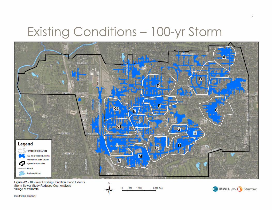
Existing Conditions – 100-yr Storm
7

Approach to Date
• January 2015 Stormwater Management Report (CBBEL)
• Stantec Review of Relief Sewer Project
• Development of Reduced Cost Alternative
• Value Engineering Review of CBBEL Alternative 1
• Supplemental Analysis of Potential Alternatives
8
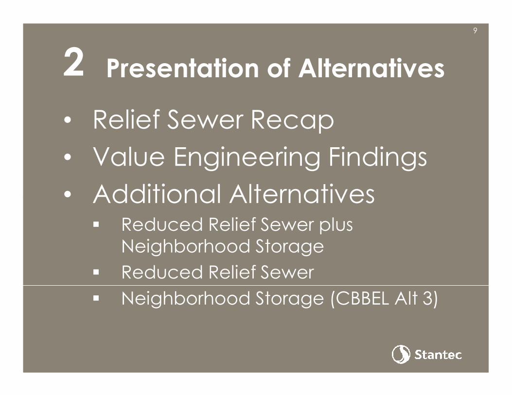
Presentation of Alternatives
• Relief Sewer Recap
• Value Engineering Findings
• Additional Alternatives� Reduced Relief Sewer plus
Neighborhood Storage
� Reduced Relief Sewer
� Neighborhood Storage (CBBEL Alt 3)
29
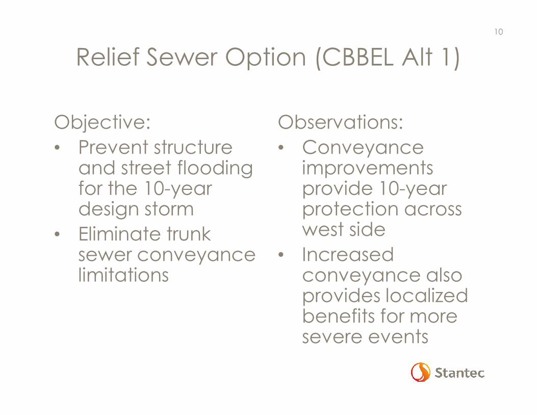
Relief Sewer Option (CBBEL Alt 1)
Objective:
• Prevent structure and street flooding for the 10-year design storm
• Eliminate trunk sewer conveyance limitations
Observations:
• Conveyance improvements provide 10-year protection across west side
• Increased conveyance also provides localized benefits for more severe events
10

Relief Sewer Option (CBBEL Alt 1)
Study Areas Served 14 of 14
Reduction in Vulnerable Structures
95% (10-yr)36% (100-yr)
Project Cost (2017 dollars) $80 - $95 million
11

Relief Sewer Value Engineering Findings
Overall Project Concept• Use of deeper large diameter
jacked pipe to provide storage, reduce potential utility conflicts, reduce downstream pipe sizes (not effective)
• Alternative outlet to North Shore Channel (not effective)
Design Considerations• Relax TBF specification
• Allow flexibility in JC sizing, materials, approach
• Allow for alternate pipe materials
• Establish bypass flow constraints for construction
• Stage construction to facilitate competition, manage disruption
Conclusion: VE review did not identify options to dramatically reduce the cost of the relief sewer project.Refinements in design criteria and implementation strategy could provide cost savings on the order of 5%-10%.
12
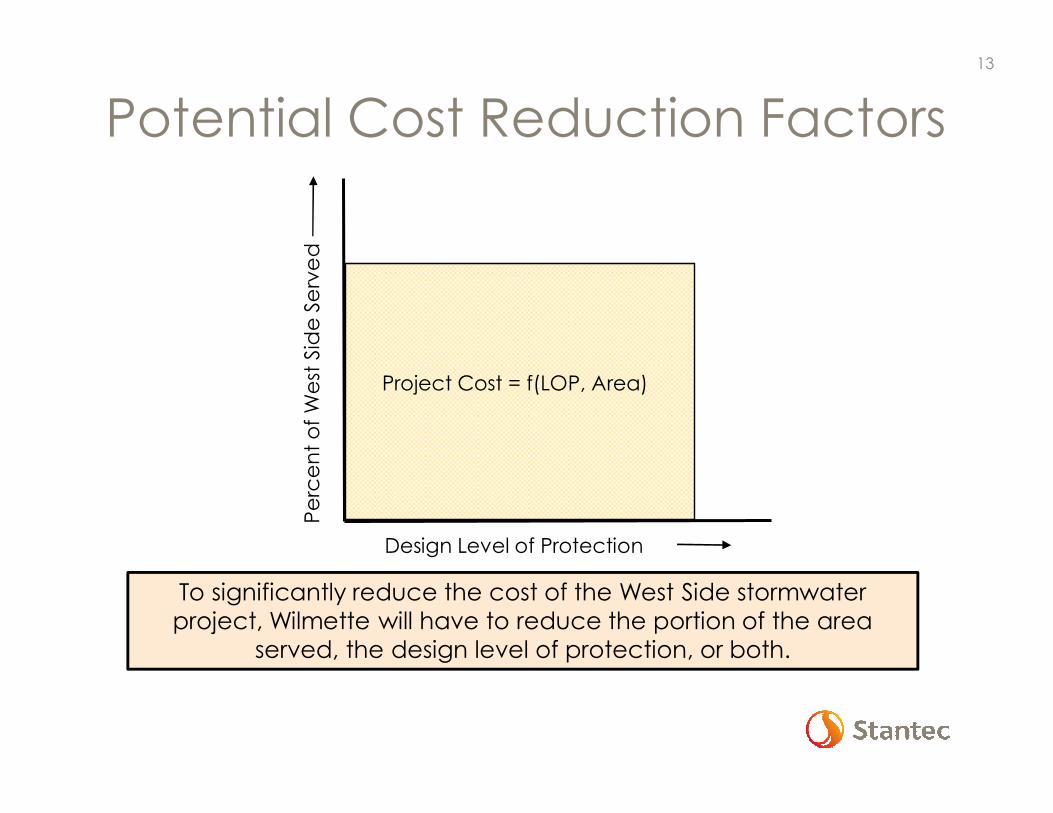
Potential Cost Reduction Factors
Percent of West Side Served
Design Level of Protection
Project Cost = f(LOP, Area)
To significantly reduce the cost of the West Side stormwater project, Wilmette will have to reduce the portion of the area
served, the design level of protection, or both.
13

Additional Alternatives
• Reduced Relief Sewer plus
Neighborhood Storage
• Reduced Relief Sewer
• Neighborhood Storage(CBBEL Alternative 3)
14
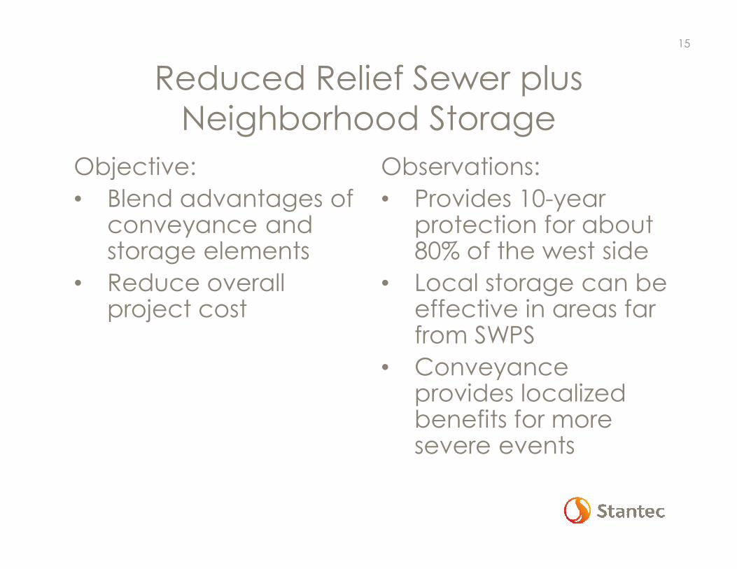
Reduced Relief Sewer plus Neighborhood Storage
Objective:
• Blend advantages of conveyance and storage elements
• Reduce overall project cost
Observations:
• Provides 10-year protection for about 80% of the west side
• Local storage can be effective in areas far from SWPS
• Conveyance provides localized benefits for more severe events
15

Reduced Relief Sewer plusNeighborhood Storage
16
Study Areas Served 10 of 14
Reduction in Vulnerable Structures
81% (10-yr)35% (100-yr)
Project Cost (2017 dollars) $70 - $80 million

Reduced Relief Sewer Option
Objectives:
• Evaluate relative cost to serve study areas
• Seek out “cost-effective” solution
Observations:
• Does not provide 10-year protection for all areas
• Cost to address flooding is relatively high across all areas
• Cost-effectiveness influenced by density of vulnerable structures
17
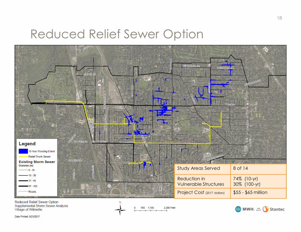
Reduced Relief Sewer Option
18
Study Areas Served 8 of 14
Reduction in Vulnerable Structures
74% (10-yr)30% (100-yr)
Project Cost (2017 dollars) $55 - $65 million

Flood Risk Density
19

Incremental Cost – West to East
20
$0
$10
$20
$30
$40
$50
$60
$70
$80
$90
$100
0 100 200 300 400
Estimated Project Cost -Alt 1
Vulnerable Structures Protected
10-year
Flooding
$0
$10
$20
$30
$40
$50
$60
$70
$80
$90
$100
0 200 400 600 800 1000 1200
Estimated Project Cost -Alt 1
Vulnerable Structures Protected
100-year
Flooding

Neighborhood Storage
Objectives:
• Use distributed storage to reduce peak flows
• Reduce length and cost of sewer required
Observations:
• Does not provide 10-year level of protection for all areas
• Significant disruption of three parks
21

Neighborhood Storage Option
22
Study Areas Served 11 of 14
Reduction in Vulnerable Structures
71% (10-yr)12% (100-yr)
Project Cost (2017 dollars) $48 - $55 million

Alternative Comparison
• Benefit Measure – Structures
• Benefit Measure - Properties
• Alternative Scorecard
323

Benefit Measures
Goal: Quantify vulnerable structures
Challenge: Critical Elevations are site specific
Approach: Spatial Analysis with GIS
- Ground elevation at proxy for structure = flood elevation
24

Benefit Evaluation - StructuresMetric Relief
SewerReduced Relief Sewer +Neighbor-hood Storage
Reduced Relief Sewer
Neighbor-hoodStorage
Study Areas Served 14/14 10/14 8/14 11/14
10-yr Design Storm (10% Annual Risk)
Vulnerable Structures 311 311 311 311
Vulnerable Structures Protected 295 253 231 220
Reduction in Vulnerable Structures 95% 81% 74% 71%
100-yr Design Storm (1% Annual Risk)
Vulnerable Structures 1305 1305 1305 1305
Vulnerable Structures Protected 475 461 387 162
Reduction in Vulnerable Structures 36% 35% 30% 12%
Estimates of vulnerable structures based on model results and approximate analysis of elevations. Site specific survey required to improve accuracy of estimates.
25

Benefit Evaluation - PropertiesMetric Relief
SewerReduced Relief Sewer +Neighbor-hood Storage
Reduced Relief Sewer
Neighbor-hoodStorage
Study Areas Served 14/14 10/14 8/14 11/14
10-yr Design Storm (10% Annual Risk)
Vulnerable Properties 1268 1268 1268 1268
Vulnerable Properties Protected 1226 997 771 855
Reduction in Vulnerable Properties 97% 79% 61% 67%
100-yr Design Storm (1% Annual Risk)
Vulnerable Properties 2779 2779 2779 2779
Vulnerable Properties Protected 578 603 398 169
Reduction in Vulnerable Properties 21% 22% 14% 6%
Estimates of vulnerable properties based on model results and approximate parcel elevations. Site specific survey required to improve accuracy of estimates.
26

Alternative ComparisonMetric Relief
Sewer
Reduced
Relief Sewer
+ Neighbor-
hood
Storage
Reduced
Relief Sewer
Neighbor-
hood
Storage
Study Areas Served 14/14 10/14 8/14 11/14
Vulnerable Structures Protected- 10-yr Storm (10% Annual Risk)- 100-yr Storm (1% Annual Risk)
95%36%
81%35%
74%30%
71%12%
Vulnerable Properties Protected- 10-yr Storm (10% Annual Risk)- 100-yr Storm (1% Annual Risk)
97%21%
79%22%
61%14%
67%6%
Total Project Cost Range(millions of 2017 Dollars)
$80 - $95 $70 - $80 $55 - $65 $48 - $55
Disruption- Parks 0 1 0 3
Phasing Flexibility Limited Moderate Limited Significant
27

Cost/Benefit Comparison
Metric Relief
Sewer
Reduced
Relief Sewer
+ Neighbor-
hood
Storage
Reduced
Relief Sewer
Neighbor-
hood
Storage
Total Project Cost Range(millions of 2017 Dollars)
$80 - $95 $70 - $80 $55 - $65 $48 - $55
Thousands of 2017 Dollars per Structure or Property Protected
Cost per Structure Protected- 10-yr Storm (10% Annual Risk)- 100-yr Storm (1% Annual Risk)
$270 - $320$170 - $200
$280 - $320$150 - $170
$240 - $280$140 - $170
$220 - $250$300 - $340
Cost per Property Protected- 10-yr Storm (10% Annual Risk)- 100-yr Storm (1% Annual Risk)
$65 - $80$140 - $165
$70 - $80$115 - $135
$70 - $85$140 - $165
$55 - $65$285 - $325
Cost perWest Side Wilmette Property $16 - $19 $14 - $16 $11 - $13 $10 - $11
28
Note: For every $10 million in debt issued, the median sewer bill would increase by approximately $46.

Next Steps
• Consider Options
• Additional Clarification
• Stakeholder Input
• Detailed Financial Analysis
• Decision
429

Village of Wilmette, Illinois
September 25, 2017
Alternatives Update
Separate Storm Sewer
System Study
30
Response to Trustee Questions
- Supplemental Analysis of
Stormwater Options
This document presents
responses to questions regarding
the Village’s plan for stormwater
improvements west of Ridge
Road as posed by Village
Trustees during the Summer of
2017.
Prepared for:
Village of Wilmette
1200 Wilmette Avenue
Wilmette, Illinois 60091
Prepared by:
Stantec Consulting Services, Inc.
350 N. Orleans Street, Suite 1301
Chicago, Illinois 60654
September 25, 2017

This page left blank intentionally for two-sided printing

RESPONSE TO TRUSTEE QUESTIONS - SUPPLEMENTAL ANALYSIS OF STORMWATER OPTIONS
September 25, 2017
jj wilmette_responses_20170922 1.1
1.0 RESPONSE TO CONSOLIDATED TRUSTEE QUESTIONS
The following responses are intended to be reviewed along with the presentation
slides developed for the Village Board Meeting to be held on Monday,
September 25, 2017. The presentation slide set has the title:
Alternatives Update – Separate Storm Sewer System Study
Village of Wilmette, Illinois
September 25, 2017
1. Comparison of Alternative 1 and 3
Provide a comparison of Alternatives 1 and 3.
CBBEL Alternatives 1 (Relief Sewer) and 3 (Neighborhood Storage) were
developed and presented in the Village of Wilmette Separate Storm Sewer
System Stormwater Management Report (Christopher B. Burke Engineering, Ltd.,
January 2015). Alternative 1 was developed to eliminate surface ponding of
stormwater on Village streets west of Ridge Road for events up to a 10-year
rainfall event. Alternative 1 relies upon the construction of additional storm
sewer capacity to capture and convey stormwater flows to the Lake Avenue
Stormwater Pump Station while maintaining a hydraulic grade line in the sewer
system below the existing street level. Alternative 3 was developed to reduce
the amount of new storm sewer required to alleviate flooding on the west side of
Wilmette through the construction of three neighborhood stormwater storage
facilities in existing park areas. While Alternative 3 provides for improved
management of stormwater flows, it does not achieve the goal of eliminating
street ponding for events up to the 10-year rainfall event.
Slides 11 and 22 from the attached presentation show the configuration and
model-predicted inundation areas for CBBEL Alternatives 1 and 3, respectively.
Comparisons of performance, costs, and other metrics are highlighted in slides
23-26 of the attached presentation.
2. Enhancements to Alternative 3
Could enhancements (e.g., large diameter sewer) be added to Alternative 3 to
cover hot spots not served effectively by the Neighborhood Storage option
alone?
Elements from Alternatives 1 (Relief Sewer) can be added to Alternative 3
(Neighborhood Storage) to improve the overall performance of the project.
Slide 16 in the attached presentation shows the configuration and model-

RESPONSE TO TRUSTEE QUESTIONS - SUPPLEMENTAL ANALYSIS OF STORMWATER OPTIONS
September 25, 2017
1.2 jj wilmette_responses_20170922
predicted 10-year inundation areas for this hybrid alternative referred to as
Reduced Relief Sewer plus Neighborhood Storage.
Performance and cost metrics for the Reduced Relief Sewer plus Neighborhood
Storage alternative are included in the comparison tables in slides 25-28 of the
presentation.
3. Neighborhood storage possibilities
Are there locations where neighborhood storage could be effectively created
assuming that the Village could acquire a sufficient number of homes to provide
a large enough area?
Mapping for several areas known to experience significant flooding has been
reviewed to assess the potential for the creation of localized storage using
purchased residential parcels.
In the low elevation areas on the west side of Wilmette, the topography is such
that localized storage would have to be designed to accommodate flows from
multiple blocks tributary to the proposed storage site. While there are localized
low points along individual blocks, the elevation difference between adjacent
blocks is very small, increasing the potential that excess runoff from one block
would eventually find its way to adjacent areas limiting the potential for block-
by-block solutions. As a result, a neighborhood storage facility constructed on
one block would need to be sized to serve the entire area tributary to that block.
If residential parcels were to be purchased to create space for a typical
neighborhood storage facility (10 acre-foot capacity), it is estimated that
anywhere from 8-12 parcels would need to be purchased to provide sufficient
area for construction of the facility.
It is also important to note that the areas that would benefit from a
neighborhood storage facility are limited to those from which stormwater is
captured and conveyed to the facility. As shown in the Neighborhood Storage
alternative (Slide 22), multiple storage facilities are required to provide improved
flood protection over larger parts of the west side of Wilmette.
4. Mid-Range Alternative
Is there an option with a cost between Alternative 1 ($80 - $90 million) and
Alternative 3 ($45 - $50 million) that should be considered?
Two additional alternatives with estimated project costs between $50 million and
$80 million have been developed and documented in the attached slide deck
(Reduced Relief Sewer plus Neighborhood Storage, Reduced Relief Sewer). The
configuration and performance of these options is shown on Slides 16 and 18.
RESPONSE TO TRUSTEE QUESTIONS - SUPPLEMENTAL ANALYSIS OF STORMWATER OPTIONS
September 25, 2017
jj wilmette_responses_20170922 1.3
Additional metrics related to the cost and performance of these options are
included in the alternative comparisons slides (Slides 25-28) in the attached
presentation.
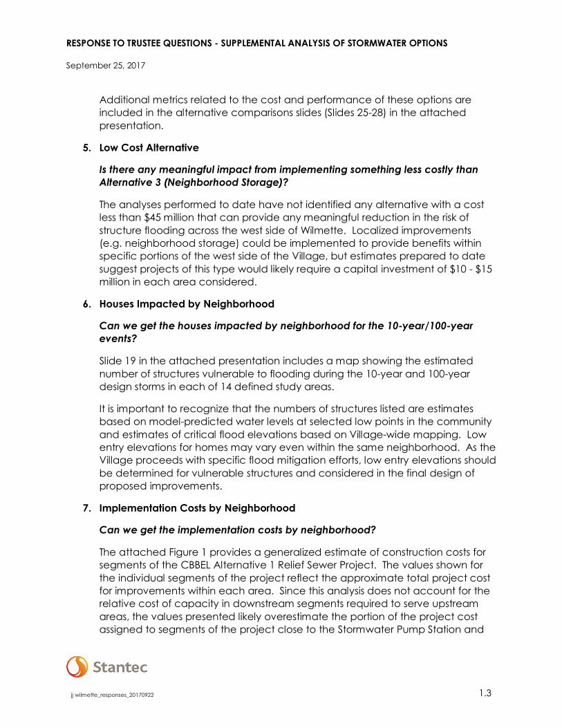
5. Low Cost Alternative
Is there any meaningful impact from implementing something less costly than
Alternative 3 (Neighborhood Storage)?
The analyses performed to date have not identified any alternative with a cost
less than $45 million that can provide any meaningful reduction in the risk of
structure flooding across the west side of Wilmette. Localized improvements
(e.g. neighborhood storage) could be implemented to provide benefits within
specific portions of the west side of the Village, but estimates prepared to date
suggest projects of this type would likely require a capital investment of $10 - $15
million in each area considered.
6. Houses Impacted by Neighborhood
Can we get the houses impacted by neighborhood for the 10-year/100-year
events?
Slide 19 in the attached presentation includes a map showing the estimated
number of structures vulnerable to flooding during the 10-year and 100-year
design storms in each of 14 defined study areas.
It is important to recognize that the numbers of structures listed are estimates
based on model-predicted water levels at selected low points in the community
and estimates of critical flood elevations based on Village-wide mapping. Low
entry elevations for homes may vary even within the same neighborhood. As the
Village proceeds with specific flood mitigation efforts, low entry elevations should
be determined for vulnerable structures and considered in the final design of
proposed improvements.
7. Implementation Costs by Neighborhood
Can we get the implementation costs by neighborhood?
The attached Figure 1 provides a generalized estimate of construction costs for
segments of the CBBEL Alternative 1 Relief Sewer Project. The values shown for
the individual segments of the project reflect the approximate total project cost
for improvements within each area. Since this analysis does not account for the
relative cost of capacity in downstream segments required to serve upstream
areas, the values presented likely overestimate the portion of the project cost
assigned to segments of the project close to the Stormwater Pump Station and

RESPONSE TO TRUSTEE QUESTIONS - SUPPLEMENTAL ANALYSIS OF STORMWATER OPTIONS
September 25, 2017
1.4 jj wilmette_responses_20170922
underestimate the cost to serve areas further east that are more distant from the
Pump Station.
8. Pareto Analysis
Can we get a Pareto Analysis (80/20 Rule) to see how project costs relate to the
percentage of benefits achieved?
In place of a formal Pareto Analysis of individual properties within the west side of
Wilmette, we have considered how different alternatives might be modified to
be more cost-effective. Initially we reviewed various analysis results to see if we
there were areas where the requirement to protect a small number of properties
was driving the need for major infrastructure elements. After reviewing elevation
mapping for the various flood areas on the west side, we found that most areas
include multiple low spots where adjacent structures are particularly prone to
flooding. Since the west side sewer system is all connected, alternatives that did
or did not address flooding at one low spot generally did or did not address
flooding at adjacent low spots. As such it was not practical to identify areas
where significant changes in proposed elements would result in only modest
changes in overall performance.
However, a subsequent analysis did show that there is some variation in the
relative cost for the conveyance improvements needed to implement the CBBEL
Alternative 1. As noted above in the response to Question 7, the attached
Figure 1 and plots on Slide 20 show that the incremental cost to extend the Relief
Sewer Option (CBBEL Alternative 1) increases as areas farther from the
Stormwater Pump Station are served. These results led to the development of
two Reduced Relief Sewer Alternatives (one combined with a neighborhood
storage element) intended to focus on providing service to areas most cost-
effectively (See Slides 16 and 18 for alternative layouts, and Slides 25-28 for
alternative comparisons)
9. Neighborhood Solutions
Could we close off a portion of a street and put in a small amount of retention
storage, or purchase homes in the worst flooding areas and provide local
retention more cost effectively than connecting the areas to new, large-diameter
storm sewers?
Localized storage can help to reduce peak stormwater flows to downstream
sewers; however, as noted in the response to Question 3, Wilmette’s topography
makes it difficult to isolate small areas and address their flooding issues
independently from adjacent areas at about the same elevation and served by
the same storm sewer system.

RESPONSE TO TRUSTEE QUESTIONS - SUPPLEMENTAL ANALYSIS OF STORMWATER OPTIONS
September 25, 2017
jj wilmette_responses_20170922 1.5
Where neighborhood storage has been found to be an effective alternative
(e.g., Kenilworth Gardens), the cost of purchasing and demolishing existing
homes to create available space for such storage adds quickly to the project
costs, and would seem to be more disruptive than coordinated use of existing
open space (park areas).
10. Increased Stormwater Capacity at the “top of the bowl”
Can we do something to increase capacity at the top of the bowl so as to
reduce the need to tear up all the ancillary roads?
Stormwater storage in the upstream parts of a watershed can be effective at
reducing the need for major infrastructure downstream in some cases. Two
alternatives previously considered for the west side of Wilmette (CBBEL
Alternative 2 and CBBEL Alternative 3) included upstream storage elements
(Storage at Community Playfield, Centennial Park, and Thornwood Park) as a
means for eliminating the need for some of the large downstream storm sewers
included in CBBEL Alternative 1. However, an extensive network of in-street
storage would be needed to provide the volumes needed to achieve these
benefits. For example, a mile of 8-foot high x 10-foot wide box culvert would be
required to provide the 10-acre feet of storage proposed for the Thornwood Park
site under CBBEL Alternative 3 (Slide 22) and the Relief Sewer plus Neighborhood
Storage Alternative (Slide 16) presented in the attached slide deck. Some
relatively mature communities that lack open space for larger detention facilities
have considered oversizing local storm sewers to provide linear detention in
conjunction with other roadway or infrastructure construction projects. However,
such an approach is typically considered as a supplement to other larger
stormwater projects designed to provide reliable outlet capacity to low-lying
areas.
11. Project Risks
What are the biggest risk areas for this project? What are the areas where the
cost of the project is most unknown and could change?
The most significant risks related to underground construction of sewers and or
storage facilities are typically associated with uncertainty regarding subsurface
conditions. For the Relief Sewer alternative developed for Wilmette, the impact
of potential utility interferences and/or soil conditions on construction
productivity represent a significant source of uncertainty related to project costs.
Until a detailed review of existing infrastructure data is performed, initial soil data
gathered, and preliminary plans prepared, it is difficult to accurately assess how
subsurface conditions will impact open cut and tunnel construction costs for the
large diameter sewers to be installed.

RESPONSE TO TRUSTEE QUESTIONS - SUPPLEMENTAL ANALYSIS OF STORMWATER OPTIONS
September 25, 2017
1.6 jj wilmette_responses_20170922
Subsurface conditions also represent a significant source of risk for alternatives
that include the proposed construction of surface or subsurface stormwater
storage facilities. Physical soil characteristics, groundwater levels, and
environmental characteristics are all factors that can significantly impact
foundation and drainage system designs for facilities as well as the eventual cost
of excavating and disposing of spoil from the site.
Portions of the alternatives considered will require significant coordination with
external entities (Illinois Department of Transportation, Cook County Highway
Department, Wilmette Park District). As the improvements proposed are similar in
character to other projects frequently coordinated with these agencies, this
coordination is not believed to be a major source of risk to the project at this
time. However, coordination requires time, and early and frequent interaction
with external agencies will reduce the risk of surprises that could delay or impact
proposed improvement projects during implementation.
12. Reduced Cost Option
What improvements would be recommended if the Village could only spend $60
- $70 million?
Project costs for two of the alternatives presented in the attached slide
presentation (Reduced Relief Sewer – Slide 18, Neighborhood Storage – Slide 22)
are estimated to be less than $70 million. These two options highlight the difficult
choices that the Village will need to consider if a decision is made to proceed
with a reduced cost alternative. The Reduced Relief Sewer alternative achieves
a lower total cost by serving portions of the west side where improvements can
be implemented more cost-effectively than in other areas. In contrast, the
Neighborhood Storage alternative is formulated to benefit most of the west side,
but provides a lower level of flood risk mitigation, especially for storm events that
exceed the 10-year design event.
13. Benefits Timeline
Would the early phases of a conveyance alternative provide any relief to the
eastern parts of the west side project area?
Construction of new storm sewer capacity near the Wilmette Stormwater
Pumping Station would reduce the “head” or energy required to drive
stormwater flows through that part of the system and slightly reduce water
surface elevations in existing upstream trunk sewers. The lower water surface
elevations in the trunk sewer will provide increased outlet capacity for the
upstream branch and lateral sewers, providing modest benefits in flood level
reduction. However, model simulations show that additional sewer capacity is
required to effectively drain low spots in most of the study areas on the west side
RESPONSE TO TRUSTEE QUESTIONS - SUPPLEMENTAL ANALYSIS OF STORMWATER OPTIONS
September 25, 2017
jj wilmette_responses_20170922 1.7
of Wilmette. Thus, the most significant benefits for individual areas will not be
realized until both downstream trunk sewer and improved capacity branch
sewers are constructed.
14. Green Stormwater Projects
Are there green projects already identified in the Burke/Stantec studies that
could supplement and build on the Storm Sewer Improvement?
Neither the alternatives presented in the CBBEL Stormwater Management Report
nor the alternatives described in the attached slide deck include specific green
stormwater management measures.
Green infrastructure measures can contribute to reduced runoff volume and
peak rates of discharge that benefit overall flood mitigation efforts, However,
previous analyses documented in the CBBEL Stormwater Management Report
(Sections 6.1.4 through 6.1.6) have shown that significant additional stormwater
conveyance and/or storage capacity will be required to achieve Wilmette’s
design objectives even if green stormwater practices were implemented on a
large scale throughout the community. As such, we recommend that the Village
continue to develop and implement a strategy for encouraging residents
throughout Wilmette to adopt stormwater best management practices for their
individual properties as a compliment to its plans for significant upgrades to the
stormwater management infrastructure serving the west side of the Village.
15. XP-SWMM Model Data
When will Stantec/CBBEL share XP-SWMM modeling data with residents?
We will defer to the Village on plans for presenting or sharing details of the XP-
SWMM modeling analyses. However, our license agreement precludes us from
distributing copies of the XP-SWMM software required to perform model
simulations, and we cannot accept responsibility for design decisions that could
be made by others who use our modeling work as the basis for development of
independent designs.
16. Water Quality Improvements
Would the Storm Sewer Upgrade result in improved water quality in any way?
Would it reduce the storm runoff going into the sanitary sewers?
The stormwater management alternatives developed to date have been
formulated to reduce the risk of surface flooding of structures or roadways in the
western part of Wilmette. None of the alternatives developed to date include
specific, permanent elements focused on the management of stormwater
quality. It is likely that modest measures to provide for pollutant removal from

RESPONSE TO TRUSTEE QUESTIONS - SUPPLEMENTAL ANALYSIS OF STORMWATER OPTIONS
September 25, 2017
1.8 jj wilmette_responses_20170922
stormwater runoff (e.g., roadway filter strips, bioswales, inlet filter boxes,
detention basin enhancements) could be incorporated into most of the
alternatives without a major impact on anticipated project cost or schedule.
The Illinois Environmental Protection Agency (IEPA) is currently working to
complete and issue a Total Maximum Daily Load Report for the North Branch of
the Chicago River, including the portion of the river to which the Wilmette
Stormwater Pump Station discharges. It is possible that the TMDL report will
include proposed pollutant reduction goals to be met over some period of time
by communities tributary to the river system. These requirements could be
incorporated into communities’ NPDES stormwater discharge permits.
As additional information related to the TMDL Report becomes available,
Wilmette will need to review its existing stormwater practices, as well as planned
improvements, and consider what additional measures may be required to meet
the pollutant reduction goals.
With regards to the Village’s sanitary sewer system, it is anticipated that as
improvements to the west side stormwater management network increase
stormwater capture and conveyance capacity they will also reduce street
ponding and storm sewer surcharging that contribute to wet weather infiltration
and inflow into the west side sanitary sewer system.
17. Storm Sewer System Performance Metrics
What other metrics can be used to calculate a per-structure cost other than
stormwater within one foot of a property’s highest elevation?
Because the west side of Wilmette is so flat, the difference between a structure
that is vulnerable to surface flooding and one that is not can be a matter of a
few inches difference in elevation or a slight difference in the style of the house
(e.g., number of steps to the first floor, presence/absence of below grade
window wells, etc.). At the level of planning performed for this analysis and the
CBBEL Stormwater Management Report, available data must be used to
establish an efficient, yet representative basis for estimating the vulnerability of
structures.
The “1 foot below the highest elevation on a parcel” methodology used
previously is a reasonable approach for generating initial estimates of potentially
vulnerable structures. However, it is easy to imagine conditions under which that
approach might not accurately assess the vulnerability of a structure. For the
purpose of our most recent analysis, we used a slightly different methodology.
Using Geographic Information System (GIS) tools, a 50-foot diameter circle was
placed at the centroid of each parcel on the west side of Wilmette. Visual spot
checks confirmed that in most cases, the circle covered a significant part of the
RESPONSE TO TRUSTEE QUESTIONS - SUPPLEMENTAL ANALYSIS OF STORMWATER OPTIONS
September 25, 2017
jj wilmette_responses_20170922 1.9
structure within each parcel. The ground elevation along the circumference of
the circle was adopted as the critical flood elevation for the structure on that
parcel. While a 50-foot diameter circle does not precisely represent the shape of
any structures in Wilmette, we believe that this approach does provide for a
representative indication of the elevation at which structures across the west side
of the Village are vulnerable to flooding.
As the Village proceeds with its flood risk management efforts, it may want to
consider options for encouraging individual property owners to obtain a formal
elevation certificate that accurately defines the critical low entry elevation for a
structure. These data can then be used to improve the accuracy of tools used
to evaluate flood risks and complete final designs for mitigation projects.
18. Homes Vulnerable to Flooding
If we use the current metric for per-structure cost, which homes are as being
saved in 10-year flood events that currently flood?
The map on Slide 6 in the attached presentation shows the extent of surface
flooding predicted for the 10-year design storm under current conditions on the
west side of Wilmette.
The greatest concentration of homes vulnerable to flooding during a 10-year
event are located in the far southwestern part of the Village in the area
generally bounded by Lake Avenue, Skokie Boulevard, Glenview Road, and I-94.
More than one-half of the structures identified as being vulnerable to flooding
during the 10-year design event are located in this area. This is also the area that
includes the lowest ground elevations on the west side of the Village.
Other areas with significant numbers of structures identified as vulnerable to
structure flooding during the 10-year design event include:
• Areas east of Skokie Boulevard and between Wilmette Avenue and
Glenview Road;
• Areas along Orchard Lane, Hawthorn Lane, Birchwood Lane, and
adjacent streets south of Lake Avenue between Locust Road and
Romona; and
• Areas along the streets east of Hunter Road between Lake Avenue and
Highland Avenue.
More than 95% of these structures, and other structures identified as vulnerable to
flooding for the 10-year design event, would be protected from flooding by the
CBBEL Alternative 1 Relief Sewer improvement as shown in Slide 11. If the Village
were to implement the CBBEL Alternative 3 Neighborhood Storage improvement,

RESPONSE TO TRUSTEE QUESTIONS - SUPPLEMENTAL ANALYSIS OF STORMWATER OPTIONS
September 25, 2017
1.10 jj wilmette_responses_20170922
structures that would remain vulnerable to 10-year flooding include those west of
Hunter between Lake and Highland as well as several structures located
between Locust Road and Skokie Boulevard as shown in Slide 22.
19. Cost for Buy Out of Vulnerable Properties
In the scenario of the project not proceeding, what is the estimated cost for the
Village to purchase these homes that cannot be served to 10-year protection?
The methodology used by our Stantec team to calculate the number of
structures vulnerable to flooding for various storm events produced an estimate
of 311 structures distributed across the west side of Wilmette. The methodology
used previously by the CBBEL team estimated that 120 homes were vulnerable to
flooding for the 10-year design event.
The median value of a home in Wilmette is reported by Zillow.com to be
$631,900. If a value of $500,000 per home is used for the average value of
homes to be purchased, the total cost for the buyout program would be
between $60 million and $155 million, depending on the final delineation of
vulnerable homes.
Using an average value of $25,000 for demolition of each structure and
restoration of the site, demolition costs would add between $3 million and $7.5
million, bringing the overall cost of a buy-out program to between $63 million
and $163 million.
20. Impact of Reduced Standard for Project Performance
What would be the impact if the standard for performance for the proposed
project were reduced to allow a modest level of ponding on streets, but still
prevent structure flooding?
The CBBEL Team prepared a memorandum for the Village in July 2015 detailing
how a change in design criteria would impact the cost and performance of the
alternatives presented in the 2015 Stormwater Management Report. For the
analysis, CBBEL assumed that the design criterion for the alternatives was relaxed
to allow ponding on streets up to the back of the sidewalks along each street.
The resulting analysis found that the change in design criteria could reduce the
estimated project cost for each of the alternatives by approximately 10% without
affecting the number of structures protected.
RESPONSE TO TRUSTEE QUESTIONS - SUPPLEMENTAL ANALYSIS OF STORMWATER OPTIONS
September 25, 2017
jj wilmette_responses_20170922 1.11
21. Engineering Costs
Are the engineering costs included in the estimates for alternatives reasonable?
Many factors can impact the cost for design engineering services for a specific
project. In the case of the potential Wilmette stormwater improvement projects,
significant effort will be required to define the unique surface and sub-surface
conditions that exist along each segment of the project and prepare detailed
design drawings and specifications. Challenges associated with the installation
of large diameter storm sewer along relatively narrow streets within a mature,
developed community will also require significant attention and effort. Lastly,
plans for staging of the project are not yet defined. It is likely that the project
would be bid as multiple construction contracts, requiring effort to support
bidding and contracting for each job, and extending the total amount of time
that resident engineering support is required.
Allowances such as those used in the cost estimates prepared for Wilmette’s
stormwater improvement projects (6% of construction cost for design
engineering; 6% of construction cost for engineering services during construction)
are reasonable, and not overly conservative at this point in the process of
project planning. As the work moves forward from planning into design and
construction, the Village can continue to procure services for each stage of the
project in a manner that promotes competition among qualified engineering
firms.
22. Buy-out/Redevelopment Potential
Is there an opportunity to buy the most severely affected homes, demolish them,
and then sell them back to developers for reconstruction as slab on grade
structures?
Potential costs associated with the purchase of structures identified as being
vulnerable to flooding for the 10-year design storm are discussed in the response
to Question 19 above. As the focus of this analysis is primarily overland
stormwater flooding of structures, the construction of slab on grade homes at
these locations would likely not reduce the risk for potential structure flooding.
Rather, new homes would need to be constructed to elevate any potential low
entry points for floodwaters above the projected flood levels in each area.
An alternative to demolishing the existing homes and rebuilding an elevated
structure could include case-by-case evaluation of potential flood proofing
measures for existing structures. In cases where the projected high water level is
only inches above the existing low entry elevation, it is likely that flood proofing
measures could be implemented for far less than tear down and reconstruction
of the structure.
RESPONSE TO TRUSTEE QUESTIONS - SUPPLEMENTAL ANALYSIS OF STORMWATER OPTIONS
September 25, 2017
1.12 jj wilmette_responses_20170922
23. July Lake County Rainfall Impacts
What type of storm would the 6”-7” rainfall that occurred in Lake County on July
11, 2017 be? What would be conditions on the west side of Wilmette if a similar
rainfall occurred after implementation of the preferred alternative project?
A rainfall event that produced 6-inches of rain in 24-hours in northeastern Illinois
would be classified as between a 25-year and a 50-year storm (annual risk of
exceedance of between 2% and 4%). An event that produced 7-inches of rain
in 24 hours in northeastern Illinois would be classified as between a 50-year and a
100-year storm (annual risk of exceedance of between 1% and 2%). The 100-
year, 24-hour rainfall depth for northeastern Illinois is currently 7.58 inches. The
100-year rainfall depth for a 12-hour duration is 6.59 inches.
Detailed rainfall data for the July event in Libertyville are not readily available on
line. However, hourly data for Waukegan suggest that the July 11th storm was an
extended event with periods of moderate short duration intensity. Clearly, the
storm produced significant rain over an extended period of time. In Waukegan,
the peak 3-hour rainfall observed during this storm was about 2 inches, or the
equivalent of about a 2-year storm, even though the peak 72-hour rainfall depth
of 6.69 inches was consistent with a 25-year to 50-year storm.
The performance of the Wilmette west side stormwater management system
depends on the relationship between conveyance capacity and relatively short
duration peak rates of runoff. The 10-year, 3-hour duration design storm used as
the basis for all of the recent analyses of the Wilmette west side system has a
total rainfall depth of 2.86 inches and under existing conditions, would produce
significant street and structure flooding as shown in Slide 6 of the attached
presentation. Were the CBBEL Alternative 1 Relief Sewer project to be
implemented, the upgraded system should be able to manage storms up to this
10-year design intensity without significant street or structure flooding as shown in
Slide 9.
We will continue to work to obtain detailed rainfall data for the July 11th storm in
Lake County and perform a model simulation to show the predicted extent of
flooding that would occur if Wilmette were to experience a similar rainfall after
construction of CBBEL Alternative 1.
RESPONSE TO TRUSTEE QUESTIONS - SUPPLEMENTAL ANALYSIS OF STORMWATER OPTIONS
September 25, 2017
jj wilmette_responses_20170922 1.13
24. Restrictors
Can you add restrictors to local storm sewer in upstream areas to redistribute the
storm flows?
Flow restrictors have been successfully used in several northeastern Illinois
communities as part of cost-effective programs for managing the risk of
basement backups in combined sewer service areas. The intent of the restrictor
is typically to limit the rate at which stormwater runoff can enter a combined
sewer, so that the combined sewer is not surcharged to the point where flow
backs up into tributary basements. In Wilmette and Evanston, restrictors on inlets
connected to the combined sewer system are coupled with relief sewers and
overland flow improvements to cost-effectively achieve a high level of
protection against basement backups for properties served by the combined
sewer system.
Restrictors are not judged to be an effective option for the separate storm sewer
system on the west side of Wilmette, as the retention and ponding of excessive
stormwater runoff on streets is a key problem on the west side. Were restrictors to
be used to limit peak inflows to local storm sewers in upstream parts of the
system, positive overland flow routes would need to be established to allow
runoff not captured by the restricted system to flow overland toward a potential
collection point, and significant inlet and conveyance capacity would have to
be provided at all of the identified low points in the study area. Otherwise, the
runoff not allowed into the sewer system by the restrictors would drain overland
to one of the low areas on the west side and exacerbate ponding that could
contribute to surface flooding of adjacent properties.
25. Distributed Storage Options
Given the apparent preliminary success that Winnetka is having with discussions related to the creation of significant stormwater storage at park and school sites, why isn’t Wilmette looking at all of its parks as potential storage sites?
The western part of Winnetka and Wilmette have similarities and differences
relative to their stormwater management challenges. Both areas are relatively
flat and low relative to the reaches of the North Branch of the Chicago River that
serve as their outlet for stormwater. As a result each area relies on a single
pumped outlet as its primary point of stormwater discharge to the river.
However, the capacity of Winnetka’s outlet pumping station (124 cfs) is less than
one quarter of the capacity of Wilmette’s Lake Avenue Stormwater Pumping
Station (568 cfs). Given permitting constraints that limit Winnetka’s ability to
increase the capacity of its pumping station, stormwater storage capacity must
be a key element of its strategy for improved drainage of the west side. In
Winnetka, flows that are captured and conveyed away from low-lying areas

RESPONSE TO TRUSTEE QUESTIONS - SUPPLEMENTAL ANALYSIS OF STORMWATER OPTIONS
September 25, 2017
1.14 jj wilmette_responses_20170922
cannot just be conveyed to the river under all conditions. Under most
conditions, the rate at which water can be discharged from Winnetka to the
river is limited to the capacity of the existing pumping station. Flows in excess of
the pumping station capacity must be stored locally for release and discharge
after flows in the rest of the system have subsided.
In Wilmette, previous analyses have shown that the existing trunk sewer system
limits the rate at which stormwater can be conveyed to the Lake Avenue
Stormwater Pumping Station. As such, Wilmette has potential to increase the
rate at which flow is conveyed to its discharge pumping station before the full
capacity of the existing station is utilized. The CBBEL Alternative 1 Relief Sewer
project is designed to take advantage of this available pumping station
capacity by increasing the stormwater system’s ability to move water from low-
lying areas to the Lake Avenue Pumping Station for discharge to the North
Branch.
At the same time, options for the development of stormwater storage capacity
within the west side of Wilmette have been given consideration. CBBEL
Alternatives 2 and 3 presented in the 2015 Stormwater Management Report
each include proposed stormwater storage elements to be constructed in
existing parks (Alternative 2 – Community Park storage; Alternative 3 – Thornwood
Park Storage, Centennial Park Storage, Hibbard Park Storage). In both of these
alternatives, local storage capacity was proposed as an alternative to the
construction of new large diameter relief sewer all the way westward to the Lake
Avenue Pumping Station.
Analyses of the storage options by the CBBEL Team, supplemented with
additional model simulations performed by Stantec, show that a distributed
storage (or neighborhood storage) concept can be effective in reducing flood
risks across the west side of Wilmette. The Neighborhood Storage option (CBBEL
Alternative 3 – Slide 22) would use 32 acre-feet of proposed storage (10 acre-
feet at Thornwood, 12 acre-feet at Centennial, and 10 acre-feet at Hibbard
Park) to reduce flood risks for a 10-year design storm across much of the west
side; however, the alternative as presented does not fully achieve the 10-year
target level of performance sought by the Village.
In addition, costs associated with the development of neighborhood storage
capacity are significant. In most of the parks considered on the west side of
Wilmette, significant stormwater storage would have to be accomplished
through the construction of underground detention capacity so that
recreational areas in the park could be restored above the storage facility
following the original construction. Costs for construction of underground
stormwater storage capacity can easily run in the range of $500,000 per acre-
foot of storage once costs for excavation and disposal of material, installation of

RESPONSE TO TRUSTEE QUESTIONS - SUPPLEMENTAL ANALYSIS OF STORMWATER OPTIONS
September 25, 2017
jj wilmette_responses_20170922 1.15
the storage system, and construction of other ancillary elements (e.g.,
dewatering pumps, etc.) are considered. In addition, some trunk sewer
construction is still required as part of neighborhood storage options. In order for
the system to be successful, conveyance capacity must be provided to move
water from low-lying areas that lack a positive outlet to the proposed storage
facilities.
Details summarized on Slides 23-26 of the attached presentation provide insight
into the comparison between the Relief Sewer conveyance alternative and the
Neighborhood Storage option.

RESPONSE TO TRUSTEE QUESTIONS - SUPPLEMENTAL ANALYSIS OF STORMWATER OPTIONS
September 25, 2017
1.16 jj wilmette_responses_20170922
This page left blank intentionally for two-sided printing

ATTACHMENTS

This page left blank intentionally for two-sided printing

Wilmette Sewer Segment Costs
Figure 1

1
Response to Trustee Questions
Prepared by Village Staff
1. What results does the Department expect to see from Stantec at the next meeting?
Consistent with their approved scope of work, Stantec will provide the following:
Task 1: Answers to the Trustee Questions
Task 2: Development of Updated Menu of Alternatives
1. Alternative 1 ($80 million - $95 million relief sewer project) 2. Alternative 3 ($47 million neighborhood storage project) 3. Alternative 1 and 3 Hybrid (Alternative 3 modified to include
additional improvements to increase level of service provided) 4. Alternative 4 (Reduced cost option.)
2. What decisions will be made at the next meeting?
The primary purpose of the Committee of the Whole meeting on September 25 is to continue discussions of the project alternatives. To date, the public discussions have focused on Alternative 1, which provides 10-year storm protection for the entire west side. Given the high cost of this alternative ($80-$95 million) the consultant will present three reduced cost options for the Village Board’s consideration. At the conclusion of the September 25 meeting, the Village Board will likely provide direction to staff on what they believe to be the next step in the process.
3. What is the pathway and timeline to an up-or-down vote on the project?
Ultimately, the Village Board will decide on the timeline and pathway to a vote on the project. This is something that could be discussed at the September 25 meeting.
4. Why does the Village have more confidence in Stantec’s cost estimate than the inflation-adjusted cost of the CBBEL estimation? (In the last meeting, why was Village staff discourse about potential bonding using figures circa $90 million rather than $77 or $80 million? Is there a reason beyond being conservative and choosing the highest possible number?

2
In light of the substantial projected cost of this project, the Village Board prudently decided to obtain what amounts to a second opinion on cost. This gives the Village Board a more realistic “range” of cost to evaluate and make informed funding decisions. It would not be prudent to assume only the lowest cost estimate, begin issuing debt and incurring costs, and then find that the actual costs will exceed available funding. Therefore, given the early stage of the project, a range, consistent with the two estimates, is appropriate. For budgeting purposes, staff utilized the higher of the two estimates to be conservative and transparent on the potential cost impact to residents.
5. Has the Village considered alternatives to self-reporting in its models? For example, Winnetka appears to record debris piles in its streets. Additionally, will the Village consider keeping resident flooding information confidential?
In past major flooding events, the Village staff has gone out to various neighborhoods to evaluate the amount of debris that has been placed out for collection. The purpose of doing this is to identify the areas with the highest volumes and share that data with staff at Veolia/Advanced Disposal. Major flood events almost always impact many municipalities all at once – not just Wilmette. The solid waste contractor sometimes has limited truck availability and we will work with them to allocate resources in a way that reflects the relative amount of debris to be collected.
Staff is not opposed to recording debris piles, but our experience suggests that there are a number of flaws and limitations with this method of data collection.
Debris piles do not tell the Village where the flooding occurred (first floor, lower level, etc.) or more importantly, why the structure flooded. There is a significant difference between, for example, basement flooding because of a sump pump failure and basement flooding due to backup through a sanitary floor drain.
Additionally, debris does not come out for collection all at once. There is no one time that all debris is placed out for collection. The Village or its contractor may be removing debris away from some properties days or weeks after other debris has been collected from other properties nearby.
We understand that not every homeowner responds to the Village-issued surveys, but those who do respond provide valuable information. The surveys ask for details about the flood experience that cannot be determined from a debris pile. Examples include how the structure flooded, depth of basement flooding, extenuating

3
circumstances (power outage, blocked window well, etc.) depth of street/yard flooding, seepage, etc.
With respect to confidentiality, the Village cannot keep flooding information confidential under the Illinois Freedom of Information Act (“FOIA”), 5 ILCS 140/1 et. seq. Pursuant to FOIA, if an individual were to request records of a certain property, the Village must turn over those records (with few exemptions that would apply).
Furthermore, when the property is to be sold, the seller must disclose to the potential buyer this specific questions (in addition to 22 others): I am aware of flooding or recurring leakage problems in the crawl space or basement.
6. How many basement restoration-related permits are typically issued in a given period of time? (In both the separated and combined sewer systems).
Basement restoration-related permits vary annually. In the four (4) most recent 10-year or greater flood event years the following approximate number of basement related permits were issued.
Date of Event
Storm Interval
Total Permits
Separate System
Combined System
9-12-2008 70-yr 47 20 27 7-23-2011 25-yr 26 15 11 4-17-2013 17-yr 57 29 28 7-23-2016 100-yr 47 26 21
In order to compare this data with years in which there were no storm events exceeding a 10-year storm, staff looked at the number of basement restoration-related permits issued in 2014 and 2015.
Year Total Permits Separate System Combined System 2014 53 20 33 2015 33 13 20
7. Do permits for basement restorations increase after a significant rain event (10-year flood event or greater)? If so, does the increase appear to match the self-reported flood totals? (In both the separated and combined sewer systems).
In looking at a 6-month time-frame after the 10-year or greater flood events it would appear in 2013 the Village saw an increase in basement permits related to flood damage being issued. After the 2013 flood event eight (8) permits were identified

4
by the applicants as being flood-related permits. By comparison in 2008, 2011 and 2016 one (1) permit each year was identified by the applicant as being for flood-related work. Of the eleven (11) permits identified as being flood-related, ten (10) were for properties in the separate sewer area and one (1) from 2013 was for a property in the combined sewer area. Four (4) other permits were identified as being flood-related but fell out of the 6-month time-frame. Three (3) of the four (4) permits were for properties in the separate sewer area.
While eleven (11) applicants identified the work as being flood-related, that doesn’t mean other basement permits issued after the recent 10-year or greater flood events weren’t for the purpose of repairing/preventing flood damaged basements.
8. Using one or more 10-year flood events as examples, how much would it cost to waive basement permitting fees for residents in 2-year flood neighborhoods experiencing back-up?
The eleven (11) flood-related permits issued in 2008, 2011, 2013 and 2016 generated an approximate total of $5,095 in permit revenue. As mentioned above, additional basement permits issued in 2008, 2011, 2013 and 2016 may have been related to a flood event but not identified as such on the permit application. The permit revenue generated by the four (4) identified flood-related permits that fell outside the 6-month time-frame was $1,768.15 but it should be noted that the work identified included moving basement walls and a first floor bathroom remodel.
Whether to issue a fee waiver is a policy decision for the Village Board to determine. Three related matters should always be kept in mind when discussing fee “waivers” and “refunds.” The first is that no public services is “free.” Any costs associated with permits that is not paid by the permittee are ultimately borne by other residents. Second, property insurance, to the extent it covers any loss, also typically covers permit fees associated with that insured loss. So a fee waiver for an insured loss would be anticipated to primarily benefit the insurance carrier at the expense of residents. Third, if a fee waiver is implemented, there must be clear and objective criteria based on quantifiable storm and location data to ensure that all residents are treated equitably.
9. Using one or more 10-year flood events as examples, how much would it cost to refund one month of sewer fees to residents in 2-year flood neighborhoods experiencing back-up? Two months?
An estimated average monthly sewer charge (calculated Village-wide) is $30. West of Ridge Road, there were 196 reported basement sewer backups reported

5
after the July, 2016 storm event, so the refunded amount would be approximately $5,880 for one month and $11,760 for two months.
In discussing this subject, the nature of the sewer user fee and the public costs it pays needs to be kept in mind.
About 81% of the sewer user fee covers the cost of debt service on major capital projects that have already been built or are under construction, and other important sewer capital spending. The rest goes to cover the expense of actually providing ongoing maintenance and operational costs. Those expenses do not decrease in flood events and are not abated by issuing refunds. The cost of any “refund” of sewer user fees would constitute a new cost that would have to be borne by all the users of the system through their sewer user fees.
10. Are we aware of new/additional compliance from Kenilworth Gardens since the recent round of letters? Are residents fixing known illegal connections that cost more than $100? How are we monitoring KG resident compliance? Residents were given until August 31, 2017 to fix the Phase I (low cost) defects. The Village’s existing contract with RJN includes following up with the homeowners to either make inspections if the work was completed or provide an additional letter of non-compliance.
11. Will the Village support the MWRD’s effort to gain authority to enforce repairs of private laterals? Would the Village consider its own ordinance to enforce repairs of private laterals?
This is a policy decision that would have to be made by the Village Board. To clarify, by 2019, the Watershed Management Ordinance states that the Village has to “develop and submit to the District for approval a Private Sector Program (PSP) that addresses disconnection of illegal private inflow sources and removal of infiltration due to private laterals.” There is some discretion, however, as clarified by the MWRD’s Technical Guidance Manual which states “Ultimately, satellite entities (Wilmette and other tributary communities) are to use discretion to determine the extent to which removal of high-flow, high-cost private I/I sources must occur, in conjunction with any other sewer system improvements, to achieve the IICP goals of reducing BBs and SSOs.” Sewer lateral repairs are costly, so ideally the District will develop a cost-share, grant or low interest loan program to help ease the financial burden to residents. Wilmette is leading a consortium of other Village’s to partner on the preparation of our respective Private Sector Programs (PSP), which will outline the details on how

6
to address private lateral defects. The Municipal Services Committee will be asked to review the draft PSP once is it developed in mid to late 2018.
12. Via MWRD Phase II, has the Village applied for any green infrastructure projects for the separated sewer system? Has the Village applied for any projects to alleviate problems in the separated sewer system?
The Village submitted Phase II applications to MWRD for the following projects:
• Continuation of the green alley program. • Forest Avenue “green street” utilizing historic pavers to create detention
within the road base. • Central Avenue “green streetscape”, which would incorporate “green”
elements into the downtown streetscape in keeping with the Village Center Master Plan and in conjunction with the federally funded reconstruction project slated for 2019.
Insofar as selection for these applications, they are each coordinated with a previously-programmed alley or street construction project. They are not projects done solely for the purpose of installing green infrastructure.
In the case of green alleys, the Village has alleys that are scheduled for rebuilding and that can be the subject of an application. The MWRD grant covers the additional cost of permeable pavers. These are demonstration projects, designed to test the concept and see how it performs over time. The Village still needs to evaluate how well this means of construction performs over time. The same is true with Forest Avenue, which is already paved with brick and is in poor condition. Central Avenue is also a project that is already programmed.
Village staff has held several meetings with MWRD staff to discuss the existing stormwater conditions west of Ridge Road, the hydraulic study results and proposed stormwater solutions. Staff will apply for Phase II funds when a project is approved by the Village Board.
13. What progress is being made on the current “Comprehensive Storm Water Management Program”?
The goals of the Stormwater Management Program and a status update is provided below:

7
I. Public Education
a. Provide stormwater information on new website b. Utilize Communicator and E-News c. Produce stormwater public service announcements for Channel 6 d. Evaluate the utility of neighborhood meetings pending consultant review of sewer system e. Encourage environmental best practices such as rain gardens & rain barrels Status: Numerous articles on flooding and the proposed stormwater project have been included in the Communicator. MSC and COW meetings discussing stormwater have been televised and archived on the web-site. A section of the web-site has been dedicated to stormwater management information, including a link to the Center for Neighborhood Technology to conduct on-line flood assessments. The moratorium on new clean water connections to the storm/combined sewer systems has necessitated permittees to incorporate green infrastructure into grading plans.
II. Annual Maintenance Programs (Ongoing Programs)
a. Sewer Cleaning and Televising b. Sewer Lining & Rehab c. Sewer Main Repairs
Status: Annual sewer cleaning and televising programs are executed by the Engineering Division and supplemented by in-house cleaning and televising by the Public Works Division. Annual sewer lining and rehabilitation and sewer main repair programs have been executed by the Engineering Division.
III. Capital Improvements (Long Term Solutions)
a. Sewer System Study (Study completed in July 2009) b. Relief Sewer Program c. Harms Road Pump Station and Storage Reservoir
Status: West of Ridge Road, the sewer system study of both the sanitary sewer system and separate storm sewer system were completed in 2009 and 2015, respectively. The recommended relief sewer improvements in the separate sanitary system were built in 2015. The recommended Harms Road Pump Station and Storage Reservoir (known as “West Park Reservoir”) was built in 2016.

8
IV. Encourage Environmental Best Practices Thru Regulatory Initiatives (Immediate Actions)
a. Zoning Ordinance Review- Encourage best practices such as pervious
pavement and green roofs b. Village Code Review c. Participate in the Development of the Cook County Stormwater
Ordinance d. Continue compliance with Village’s NPDES permits required by the
EPA e. Continue compliance with Long Term Maintenance Program required
by the MWRDGC (Update: O/M Program requirements are amended with the new WMO)
f. Implement a Residential Sewer Inspection Program- Water bill Name Changes
Status: Changes were made in the Village Code to encourage best management practices when managing stormwater. By eliminating the ability to connect new storm water sources to the Village’s storm and combined sewers, residential applicants are required to address stormwater through green infrastructure. In addition, numerous projects were approved with green infrastructure including the hotel, Wilmette Circle subdivision, Baha’i House of Worship, Wilmette Library, Mather Place, 1318 Wilmette townhome development, among others.
Wilmette staff was actively involved in the adoption of the Cook County Watershed Management Ordinance (WMO). Wilmette is qualified as an authorized community, which means we are able to issue stormwater permits on the District’s behalf. Wilmette remains in good standing with the Illinois Environmental Protection Agency on our annual National Pollutant Discharge Elimination System (NPDES) permits and with MWRD on our Inflow and Infiltration Control Program reporting. Residential inspections and dye testing are conducted when there is suspicion of a sewer cross connection or I/I violation.
V. Identify Potential Residential Assistance Programs
a. Flood Mitigation Assistance Programs--Identify independent home inspectors to conduct residential flood assessments
b. Evaluate flood control assistance programs such as overhead sewer installations
9
c. Sewer Laterals--Identify contractors to televise private laterals at a fixed cost
d. Evaluate a sewer lateral replacement assistance program e. Rain Garden Program
Status: Resident assistance programs have been set up for flood assessments, sewer televising and sewer lining.
VI. Potential Funding Sources
a. Sewer Fee b. Stormwater Management Fee c. Identify alternative funding sources such as IEPA loans, state/federal
grants
Status: The recent sanitary sewer improvements were financed through a $26 million general obligation bond to be paid back through sewer fees. If the Village Board approves a major stormwater project financed through bonds, the Village Board will have also have to determine a revenue source to pay off the bonds.
14. Is there a process for revising and benchmarking the Program? Is there a
way to make it more accountable to the public, demonstrating progress, etc.?
Updates on the stormwater management goals are provided to the Municipal Services Committee and Village Board as necessary.
15. Could the West Park Project be having a positive impact on overland flooding? (Example, resident of Kilpatrick observed less standing water on his yard once the West Park project became operational.)
Any impact from West Park on overland flooding will be minor and incidental. The West Park project does help keep the water level in the sanitary sewer lower, which could allow more rain water to enter the sanitary sewer. However, the sanitary sewers are not designed to handle rain water and any additional capacity due to West Park is limited. It also reduces the benefit of the West Park project and is not the solution to overland flooding problems. (Response from Mike Young, RJN)

10