fossil fuels (part iii), the geology of coal: interpreting ... fuels (part iii), the geology of...
TRANSCRIPT
Fossil Fuels (Part III), The Geology of Coal: Interpreting Geologic History
SPN LESSON #37
TEACHER INFORMATION
LEARNING OUTCOME: After analyzing cross sections and samples, students draw conclusions regarding the formation of coal. They use emissions-avoidance data from the school’s DAS system to calculate the environmental cost of coal energy.
LESSON OVERVIEW: Analysis of coal-bearing rock sequences leads to conclusions concerning the environmental setting in which coal sediments were deposited. Examination of coal samples prompts students to hypothesize about why various samples have different characteristics. Maps and cross sections of portions of Earth’s crust lead students to conclusions regarding the various tectonic forces that help to “refine” coal within Earth’s crust. Students use information they find during Internet searches to ascertain the validity of their hypotheses and verify the “story” of coal. Finally, the environmental cost of burning the most abundant fuel in the United States is compared to the use of solar power.
GRADE-LEVEL APPROPRIATENESS: This Level II or III lesson is intended for use with students in grades 8–12 who are enrolled in Regents Earth Science (Physical Setting).
MATERIALS (per group of students) 1 hand sample each of:
• Peat • Bituminous coal (with fossils) • Lignite • Anthracite
Hand lens Electronic balance Graduated polypropylene 500 or 1,000 mL beaker Streak plate Glass scratch plate Iron file or nail Copper penny
nyserda.ny.gov/School-Power-Naturally

Fossil Fuels (Part III), The Geology of Coal Physical Setting, Earth science; Levels II and III
37.2
SAFETY Lignite is somewhat volatile and needs to be kept in a nonflammable container. Teachers may want to keep both the peat and the lignite as classroom samples for students to observe at the teacher’s desk because of the loose nature of both of these substances and the volatility of the lignite.
TEACHING THE LESSON: This is the third of three SPN lessons dealing with the topic of fossil fuels, their formation, and their geology (see also SPN #s 35 and 36). This lesson, divided into five parts, features the interpretation of geologic evidence as a theme. Check for the state of prior student knowledge for the following and provide instruction as needed:
• the process of erosion, • the conditions under which deposition occurs and fossils form, and • the characteristics of rocks and minerals.
Part 1: Students observe the stages of coal development firsthand. This should take no more
than a single laboratory period to complete. The observation phase should be followed by a brief post-lab discussion to reaffirm the gradational changes in the organic material in its journey from living plants to anthracite. Emphasize the anaerobic nature of the depositional environment that lessened decay and allowed the plant material to accumulate.
Part 2: Students interpret the sedimentary rock characteristics that reveal the geologic past. They also decipher the conditions that allow the accumulation of rock and organic debris. You may want to have students start 2 in class and finish it for homework. Post-lab discussion should follow in class with emphasis placed on:
• how the change in particle size of the sediments relates to the velocity of the depositional current;
• how depositional features relate to the nature of the depositional environment (i.e., cross-bedding usually indicates the presence of a stream current that changes both location and direction; an example of cross-bedding is a meandering stream on a flat landscape region such as a coastal plain).
• how fossil remains typically indicate both the geologic time and the geologic environment of deposition.
Part 3: Students analyze maps and cross sections of Earth’s crust as well as information in the Earth Science Reference Tables to piece together depositional environments in eastern North America and western Europe. Then they are able to identify the environmental similarities that established coal-forming swamps in both locations during the Carboniferous Period. Also, students derive the causes of the conversion of bituminous coal to anthracite. This work is done in the context of plate tectonics. This part could be introduced in class, assigned for homework, and discussed during the next class meeting.
Part 4: Students verify their understandings about coal and the processes that create coal deposits using computer searches. Depending on school and home computer resources, this might part be done in the classroom or by students at home. A period of Web searching and a half period of reporting findings are suggested.
Fossil Fuels (Part III), The Geology of Coal Physical Setting, Earth science; Levels II and III
37.3
Part 5: This undertaking could be expanded depending upon time constraints. At the very
least, teachers should have students determine the environmental costs of burning coal for energy as compared to solar energy. Also, the search list might be modified to suit the needs and interests at individual schools.
ACCEPTABLE RESPONSES FOR DEVELOP YOUR UNDERSTANDING SECTION
Part 1:
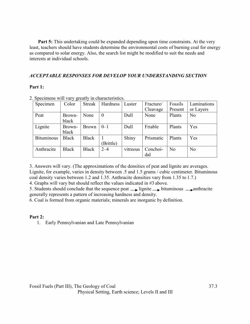
2. Specimens will vary greatly in characteristics.
Specimen Color Streak Hardness Luster Fracture/ Cleavage
Fossils Present
Laminations or Layers
Peat Brown- black
None 0 Dull None Plants No
Lignite Brown- black
Brown 0–1 Dull Friable Plants Yes
Bituminous Black Black 1 (Brittle)
Shiny Prismatic Plants Yes
Anthracite Black Black 2–4 vitreous Conchoi- dal
No No
3. Answers will vary. (The approximations of the densities of peat and lignite are averages. Lignite, for example, varies in density between .5 and 1.5 grams / cubic centimeter. Bituminous coal density varies between 1.2 and 1.35. Anthracite densities vary from 1.35 to 1.7.) 4. Graphs will vary but should reflect the values indicated in #3 above. 5. Students should conclude that the sequence peat lignite bituminous anthracite generally represents a pattern of increasing hardness and density. 6. Coal is formed from organic materials; minerals are inorganic by definition.
Part 2:
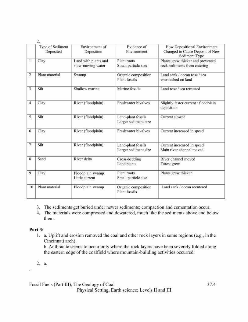
1. Early Pennsylvanian and Late Pennsylvanian
Fossil Fuels (Part III), The Geology of Coal Physical Setting, Earth science; Levels II and III
37.4
2.
Type of Sediment Deposited
Environment of Deposition
Evidence of Environment
How Depositional Environment Changed to Cause Deposit of New
Sediment Type 1 Clay Land with plants and
slow-moving water Plant roots Small particle size
Plants grew thicker and prevented rock sediments from entering
2 Plant material Swamp Organic composition Plant fossils
Land sank / ocean rose / sea encroached on land
3 Silt Shallow marine Marine fossils Land rose / sea retreated
4 Clay River (floodplain) Freshwater bivalves Slightly faster current / floodplain deposition
5 Silt River (floodplain) Land-plant fossils Larger sediment size
Current slowed
6 Clay River (floodplain) Freshwater bivalves Current increased in speed
7 Silt River (floodplain) Land-plant fossils Larger sediment size
Current increased in speed Main river channel moved
8 Sand River delta Cross-bedding Land plants
River channel moved Forest grew
9 Clay Floodplain swamp Little current
Plant roots Small particle size
Plants grew thicker
10 Plant material Floodplain swamp Organic composition Plant fossils
Land sank / ocean reentered
3. The sediments get buried under newer sediments; compaction and cementation occur. 4. The materials were compressed and dewatered, much like the sediments above and below
them.
Part 3: 1. a. Uplift and erosion removed the coal and other rock layers in some regions (e.g., in the
Cincinnati arch). b. Anthracite seems to occur only where the rock layers have been severely folded along the eastern edge of the coalfield where mountain-building activities occurred.
2. a. .
Fossil Fuels (Part III), The Geology of Coal Physical Setting, Earth science; Levels II and III
37.5
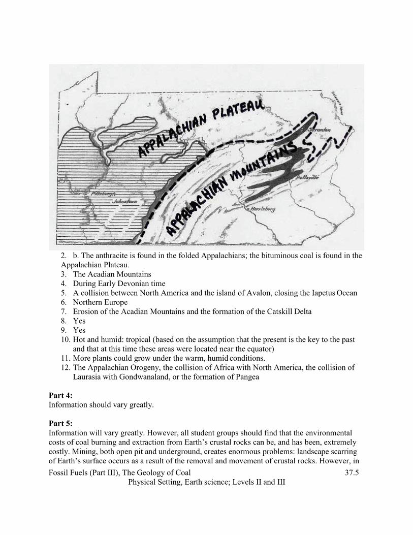
2. b. The anthracite is found in the folded Appalachians; the bituminous coal is found in the Appalachian Plateau. 3. The Acadian Mountains 4. During Early Devonian time 5. A collision between North America and the island of Avalon, closing the Iapetus Ocean 6. Northern Europe 7. Erosion of the Acadian Mountains and the formation of the Catskill Delta 8. Yes 9. Yes 10. Hot and humid: tropical (based on the assumption that the present is the key to the past
and that at this time these areas were located near the equator) 11. More plants could grow under the warm, humid conditions. 12. The Appalachian Orogeny, the collision of Africa with North America, the collision of
Laurasia with Gondwanaland, or the formation of Pangea Part 4: Information should vary greatly.
Part 5: Information will vary greatly. However, all student groups should find that the environmental costs of coal burning and extraction from Earth’s crustal rocks can be, and has been, extremely costly. Mining, both open pit and underground, creates enormous problems: landscape scarring of Earth’s surface occurs as a result of the removal and movement of crustal rocks. However, in
Fossil Fuels (Part III), The Geology of Coal Physical Setting, Earth science; Levels II and III
37.6
these times of rising energy costs, students should also find that for the United States, coal is an abundant resource and may at least be an attractive alternative to oil costs and foreign dependency. All groups should look carefully at the cost-benefit arguments of coal versus solar energy.
ADDITIONAL SUPPORT FOR TEACHERS
SOURCE FOR THIS ADAPTED ACTIVITY This lesson was not adapted from another source.
BACKGROUND INFORMATION Some sample information from the Internet:
Peat exposed to heat and pressure from burial beneath other sediments becomes compressed and chemically changes into low-grade coals such as lignite. Under further heat and pressure, peat is converted to higher grade coals. The pressure from overlying sediments that bury a peat bed will compact the coal. Peats transform to low-grade lignites when they are compressed to about 20% of their original thickness. Lignite typically transforms to bituminous coal as it is compressed further and heated to 100°C–200°C. This drives much of the water and other volatiles from the coal. Longer exposure to elevated temperature will further drive volatiles from the coal, and drive the chemical reactions that produce anthracite. Anthracite coals are typically compressed to 5%–10% of the original thickness of the peat bed, and contain less than 10% water and other volatiles (Nichols, 1999).
COAL: Ancient Gift Serving Modern Man from American Coal Foundation
How Coal Is Formed
Coal is called a fossil fuel because it was formed from the remains of vegetation that grew as long as 400 million years ago. It is often referred to as “buried sunshine,” because the plants that formed coal captured energy from the Sun through photosynthesis to create the compounds that make up plant tissues. The most important element in the plant material is carbon, which gives coal most of its energy.
Most of our coal was formed about 300 million years ago, when steamy swamps covered much of Earth. As plants and trees died, their remains sank to the bottom of the swampy areas, accumulating layer upon layer and eventually forming a soggy, dense material called peat.
Over long periods of time, the makeup of Earth’s surface changed, and seas and great rivers caused deposits of sand, clay, and other mineral matter to accumulate, burying the peat. Sandstone and other sedimentary rocks were formed, and the pressure caused by
Fossil Fuels (Part III), The Geology of Coal Physical Setting, Earth science; Levels II and III
37.7
their weight squeezed water from the peat. Increasingly deeper burial and the heat associated with it gradually changed the material to coal. Scientists estimate that 3–7 feet of compacted plant matter were required to form 1 foot of bituminous coal.
Coal formation is a continuing process (some of our newest coal is a mere 1 million years old). Today, in areas such as the Great Dismal Swamp of North Carolina and Virginia, the Okefenokee Swamp of Georgia, and the Everglades in Florida, plant life decays and subsides, eventually to be covered by silts and sands and other matter. Perhaps millions of years from now, these areas will contain large coal beds.
Coal Formation
The process of forming coal is closely linked to the formation of fossils; in fact, the majority of fossils recovered in Cape Breton come from the coal areas or coalfields. Fossils have been found ranging from entire or partial tree trunks and branches to shrubs and vine growth. To study the evolution of coal and these fossils, we must go back to prehistoric times, approximately 325 million years ago, when this area was covered in lush, dense vegetation.
It is fairly well known that coal beds consist of altered plant remains. Growth began in forested swamps and when it died, it sank below the water, beginning coal formation. However, more than a heavy growth of vegetation is needed for the formation of coal. The debris must be buried, compressed, and protected from erosion. Even though all the biological, geographic, and climatic factors may be favorable, coal could not be formed unless the plant debris was submerged and buried by sediments.
There are four stages in coal formation: peat, lignite, bituminous, and anthracite. The stage depends upon the conditions to which the plant remains are subjected after they were buried: the greater the pressure and heat, the higher the rank of coal. Higher-ranking coal is denser and contains less moisture and gases and has a higher heat value than lower-ranking coal.
Peat is the first stage in the formation of coal. Normally, vegetable matter is oxidized to water and carbon dioxide. However, if the plant material accumulates under water, oxygen may not be present and the decomposition is only partial. This incomplete destruction leads to the accumulation of an organic substance called peat. Peat is a fibrous, soft, spongy substance in which plant remains are easily recognizable. It contains a large amount of water and must be dried before use. Therefore, it is seldom used as a source of heat. Peat burns with a long flame and considerable smoke.
Lignite—the second stage—is formed when peat is subjected to increased vertical pressure from accumulating sediments. Lignite is dark brown in color and, like peat, contains traces of the plants from which it came. It is found in many places, but is used only when more efficient fuel is not available. It crumbles easily and should not be shipped or handled before use.
Bituminous coal is the third stage. Added pressure has made it compact and virtually all traces of
Fossil Fuels (Part III), The Geology of Coal Physical Setting, Earth science; Levels II and III
37.8
plant life have disappeared. Also known as “soft coal,” bituminous coal is the type found in Cape Breton and is the most abundant of coal fuels; it is used extensively in industry as a source of heat energy.
Anthracite, the fourth stage in coal formation, is also known as “hard coal” because it is hard and has a high luster. It appears to have formed as a result of combined pressure and high temperature. Anthracite burns with a short flame and little smoke
REFERENCES FOR BACKGROUND INFORMATION Blatt, Berry & Brande: Principles of Stratigraphic Analysis, Blackwell, 1991. Dunbar, Carl: Historical Geology, Wiley, 1960. Lyell, C.: A Manual of Elementary Geology, Appleton, 1854. Moore, Lalicker & Fischer: Invertebrate Fossils, McGraw Hill, 1952. Shimer & Shrock: Index Fossils of North America, MIT Press, 1987. Winchester, Simon: The Map That Changed the World, HarperCollins, 2001.
Produced by the Research Foundation of the State University of New York with funding from the New York State Energy Research and Development Authority (NYSERDA)
nyserda.ny.gov
(STUDENT HANDOUT SECTION FOLLOWS)
37.1
Name
Date
Introduction
Fossil Fuels (Part III), The Geology of Coal: Interpreting Geologic History
Coal in its many forms was the fuel that ignited the Industrial Revolution. Those countries that possessed an abundance of coal and rocks containing iron ore developed into leading world powers, and unfortunately, leading world polluters. The patterns of distribution of coals within sedimentary and metamorphic rocks allowed geologists to discover and decipher how and where coal formed. Let’s see if you can do the same.
Part 1: Examining Coal Samples
Materials (per group of students) 1 hand sample each of: • Peat • Bituminous coal • Lignite • Anthracite
Hand lens Electronic balance Graduated polypropylene 500 or 1,000 mL beaker Streak plate Glass scratch plate Iron file or nail Copper penny
Procedure 1. Gather the materials at your lab station. 2. Examine the physical characteristics of each of the specimens through the hand lens.
Write the characteristics in the proper location in the table below.
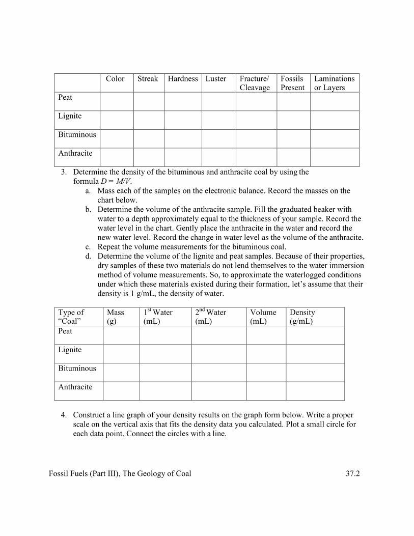
Fossil Fuels (Part III), The Geology of Coal 37.2
Color Streak Hardness Luster Fracture/ Cleavage
Fossils Present
Laminations or Layers
Peat
Lignite
Bituminous
Anthracite
3. Determine the density of the bituminous and anthracite coal by using the formula D = M/V.
a. Mass each of the samples on the electronic balance. Record the masses on the chart below.
b. Determine the volume of the anthracite sample. Fill the graduated beaker with water to a depth approximately equal to the thickness of your sample. Record the water level in the chart. Gently place the anthracite in the water and record the new water level. Record the change in water level as the volume of the anthracite.
c. Repeat the volume measurements for the bituminous coal. d. Determine the volume of the lignite and peat samples. Because of their properties,
dry samples of these two materials do not lend themselves to the water immersion method of volume measurements. So, to approximate the waterlogged conditions under which these materials existed during their formation, let’s assume that their density is 1 g/mL, the density of water.
Type of “Coal”
Mass (g)
1st Water (mL)
2nd Water (mL)
Volume (mL)
Density (g/mL)
Peat
Lignite
Bituminous
Anthracite
4. Construct a line graph of your density results on the graph form below. Write a proper
scale on the vertical axis that fits the density data you calculated. Plot a small circle for each data point. Connect the circles with a line.
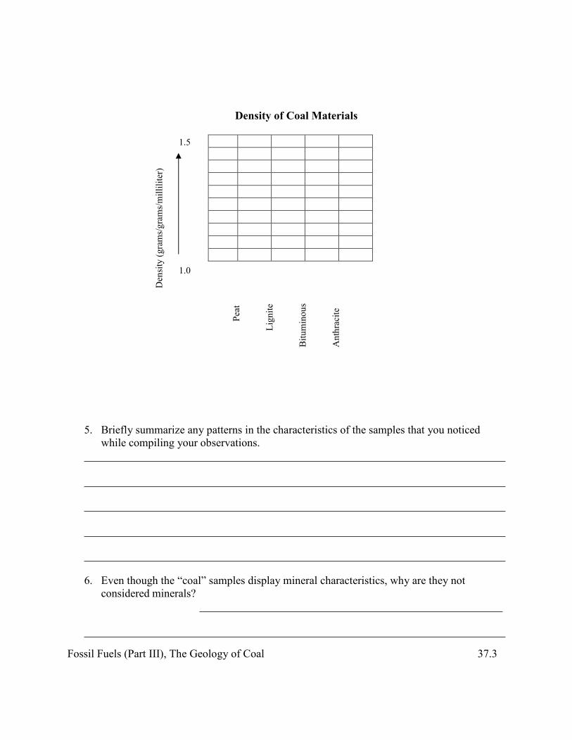
Fossil Fuels (Part III), The Geology of Coal 37.3
Density of Coal Materials
1.5
1.0
5. Briefly summarize any patterns in the characteristics of the samples that you noticed while compiling your observations.
6. Even though the “coal” samples display mineral characteristics, why are they not considered minerals?
Den
sity
(gra
ms/g
ram
s/mill
ilite
r)
Peat
Lign
ite
Bitu
min
ous
Ant
hrac
ite
Fossil Fuels (Part III), The Geology of Coal 37.4
Part 2: Rocks and Fossils Associated with Coal in England
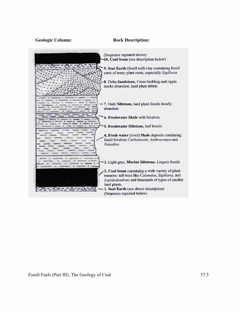
Procedure: 1. Examine the geologic column and fossil information in the figure below. It illustrates the
typical, repetitious pattern of sediment deposition that is found in the coalfields of England. William Smith, the father of geology, noticed this pattern while he was working as a canal builder in the late 1700s in the North Somerset region. The “coal measures,” as they are called, were deposited between 310 and 290 million years ago and consist of many seams of coal interspersed among layers of sedimentary rocks. During which geologic epochs were these rock layers deposited?
and
Fossil Fuels (Part III), The Geology of Coal 37.5
Geologic Column: Rock Description:
Fossil Fuels (Part III), The Geology of Coal 37.6
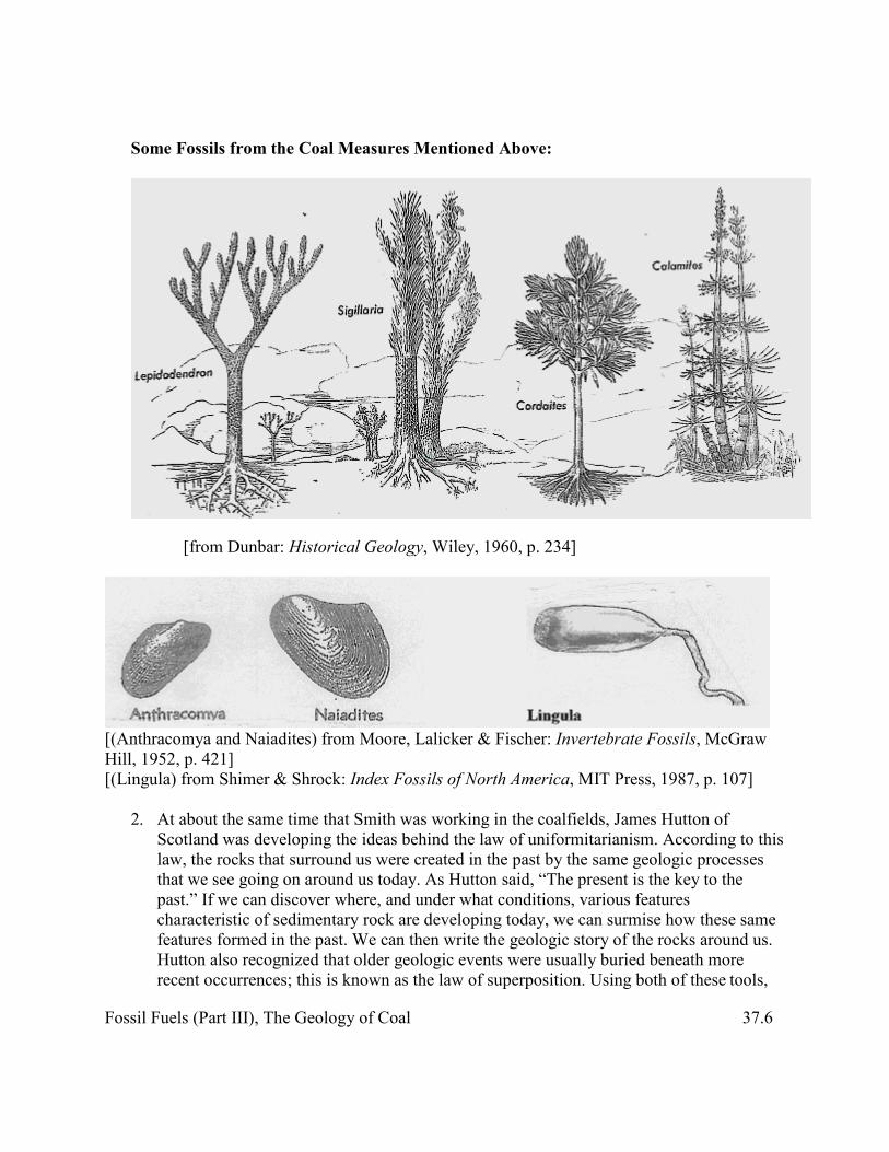
Some Fossils from the Coal Measures Mentioned Above:
[from Dunbar: Historical Geology, Wiley, 1960, p. 234]
[(Anthracomya and Naiadites) from Moore, Lalicker & Fischer: Invertebrate Fossils, McGraw Hill, 1952, p. 421] [(Lingula) from Shimer & Shrock: Index Fossils of North America, MIT Press, 1987, p. 107]
2. At about the same time that Smith was working in the coalfields, James Hutton of
Scotland was developing the ideas behind the law of uniformitarianism. According to this law, the rocks that surround us were created in the past by the same geologic processes that we see going on around us today. As Hutton said, “The present is the key to the past.” If we can discover where, and under what conditions, various features characteristic of sedimentary rock are developing today, we can surmise how these same features formed in the past. We can then write the geologic story of the rocks around us. Hutton also recognized that older geologic events were usually buried beneath more recent occurrences; this is known as the law of superposition. Using both of these tools,

Fossil Fuels (Part III), The Geology of Coal 37.7
we might be able to interpret the history of Smith’s coal measures. Fill in the chart below to write a geologic history of the section of England’s coal measures shown above. Name the type of sediments deposited to form each numbered layer, the environment of deposition, and the evidence of that environment indicated above. Describe the changes in the depositional environment that might have occurred to cause the change in the overlying type of sediment.
Type of Sediment
Deposited Environment of
Deposition Evidence of
Environment How Depositional Environment
Changed to Cause Deposit of New Sediment Type
1
2
3
4
5
6
7
8
9
10
3. Describe the geologic processes that caused the sediments to turn to sedimentary rock.
Fossil Fuels (Part III), The Geology of Coal 37.8
4. What changes did these same processes make in the coal-forming plant materials?
Part 3: Patterns of Coal Distribution in the Eastern United States
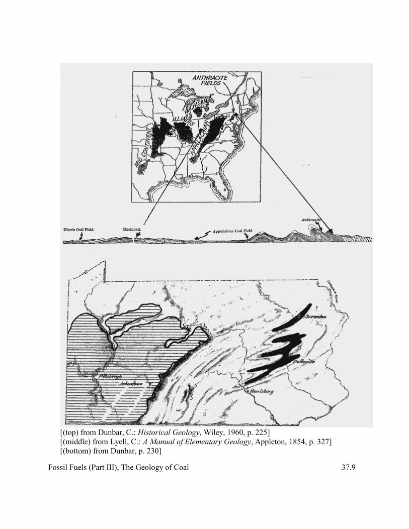
While the coal measures were being deposited in England, many of the same processes were occurring in the eastern half of North America as shown below. Coal deposits accumulated at various times throughout the Carboniferous Period from the present-day coast to what is now the Mississippi River region. The map at the top of the diagram below indicates those areas where coal is currently found. If deposits of coal once covered this whole region, why does the map show breaks—areas where no coal is found—in the coalfields? Why is there so little anthracite? And why is the area of the anthracite fields so small? 1. Look at the geologic cross section below the map and respond to these questions using
the information shown there.
a. There are breaks in the coalfields because
b. The anthracite fields are small compared to the size of the Illinois, Michigan, Appalachian, and midcontinent bituminous coalfields because
Fossil Fuels (Part III), The Geology of Coal 37.9
[(top) from Dunbar, C.: Historical Geology, Wiley, 1960, p. 225] [(middle) from Lyell, C.: A Manual of Elementary Geology, Appleton, 1854, p. 327] [(bottom) from Dunbar, p. 230]
Fossil Fuels (Part III), The Geology of Coal 37.10
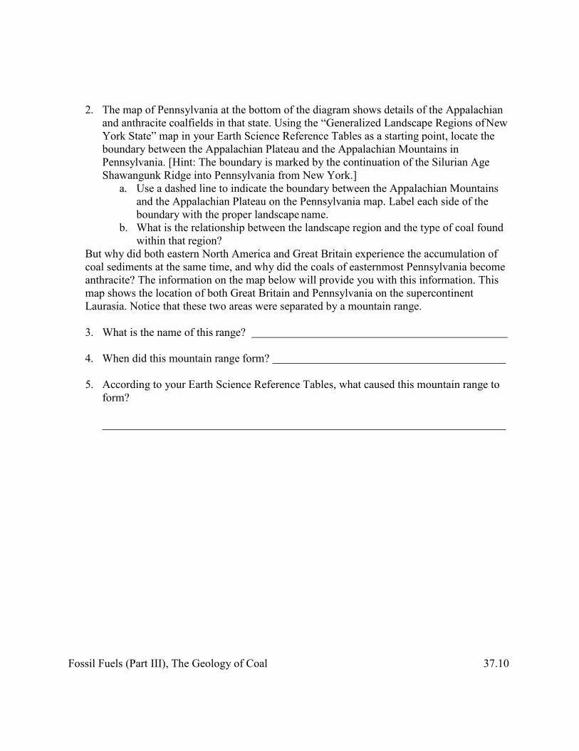
2. The map of Pennsylvania at the bottom of the diagram shows details of the Appalachian and anthracite coalfields in that state. Using the “Generalized Landscape Regions of New York State” map in your Earth Science Reference Tables as a starting point, locate the boundary between the Appalachian Plateau and the Appalachian Mountains in Pennsylvania. [Hint: The boundary is marked by the continuation of the Silurian Age Shawangunk Ridge into Pennsylvania from New York.]
a. Use a dashed line to indicate the boundary between the Appalachian Mountains and the Appalachian Plateau on the Pennsylvania map. Label each side of the boundary with the proper landscape name.
b. What is the relationship between the landscape region and the type of coal found within that region?
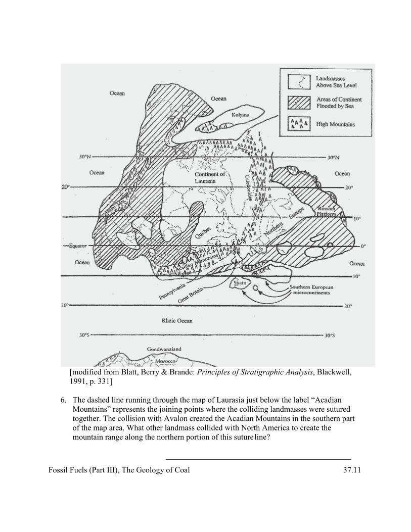
But why did both eastern North America and Great Britain experience the accumulation of coal sediments at the same time, and why did the coals of easternmost Pennsylvania become anthracite? The information on the map below will provide you with this information. This map shows the location of both Great Britain and Pennsylvania on the supercontinent Laurasia. Notice that these two areas were separated by a mountain range.
3. What is the name of this range?
4. When did this mountain range form?
5. According to your Earth Science Reference Tables, what caused this mountain range to form?
Fossil Fuels (Part III), The Geology of Coal 37.11
[modified from Blatt, Berry & Brande: Principles of Stratigraphic Analysis, Blackwell, 1991, p. 331]
6. The dashed line running through the map of Laurasia just below the label “Acadian
Mountains” represents the joining points where the colliding landmasses were sutured together. The collision with Avalon created the Acadian Mountains in the southern part of the map area. What other landmass collided with North America to create the mountain range along the northern portion of this suture line?

Fossil Fuels (Part III), The Geology of Coal 37.12
The map shown above represents an interpretation of how the continent of Laurasia looked at the very end of the Devonian Period, just before the Carboniferous Period began.
7. According to your Earth Science Reference Tables, what two important geologic events occurred in New York State between the Acadian Orogeny and the end of the Devonian Period?
and
8. Do you think these types of activities occurred on both sides of the mountain ranges in the future Pennsylvania and the future England?
9. Were both of these areas near the shorelines of shallow seas that had flooded continental
landmasses—that is, were they at or near sea level?
10. Using your knowledge of Earth’s temperature patterns and the Moisture Belt diagram on page 14 of your Earth Science Reference Tables, how would you describe the climate for these two areas?
11. How might this combination of factors encourage the growth of coal-producing swamps
as the Carboniferous Period began?
12. What major tectonic event changed the coals of eastern Pennsylvania into anthracite?
Part 4: How Does Coal Form? Were You Right?
At this point, you should have a pretty good idea of what coal is and how coal is formed. Now do a Web search using appropriate key words and prepare a brief report or printout of your findings. Prepare to report to the class two of the new facts you discover. Two new coal facts I discovered online are:
(1)

Fossil Fuels (Part III), The Geology of Coal 37.13
(2)
Part 5: The Environmental Cost of Coal
A. Working in groups assigned by your teacher, research the environmental, health, and monetary costs of mining, transporting, and burning coal in its various forms. Respond to each of these questions:
1. What problems have developed in the mining of coal? 2. What costs are associated with the transportation of coal from the mine to its use point? 3. What are the costs of burning coal? [Each group should use your school’s DAS system to
determine the air quality costs of coal burning.] 4. How much coal is found in the United States? 5. How much energy would this coal release if it is burned? 6. Answer questions 4 and 5 substituting other energy resources (e.g., uranium, oil, natural
gas, sunlight, oil shale). B. Prepare to participate in a classroom debate/discussion on these energy issues.