pbo strainmeter products - unavco · pbo strainmeter products february 2014 type rate format...

2
PBO STRAINMETER PRODUCTS February 2014 Type Rate Format Frequency LSM Strain 1sps, 300s SEED/Ice9 Hourly BSM Strain 20,1 sps, 300 * s SEED/Bottle/ASCII * Daily Environmental 1 sps to 30 min SEED/ASCII Daily Barometer 1 sps SEED Streaming Seismic 1, 100 sps SEED Streaming Pore pressure 1 sps SEED/ASCII Streaming Tiltmeter 1 sps ASCII Daily CH0 CH1 CH2 CH3 120° 120° 90° 30° R M Cross section of GTSM21 strainmeter Cross section of GTSM21 strain gauge, R=referance gap, M=diameter d t /(1e+8) 1-(d t /1e+8) d o /(1e+8) 1-(d o /1e+8) u t = ( ) * - R M The linear gauge strain, u, at time t, is calculated with respect to a fixed raw data point (d o ) . d t , raw value at time t, R = reference gap (1e-4 or 2e-4 m), M = diameter (0.087m) Network Code: PB Station Code: 4 character B-number, e.g, B004 Channel code: 1. Rate R<= 600 s interval , L=1 sps, B=20 sps 2. Measurement S=strain, K=temperature, E=voltage, D=pressure, R=rainfall 3. Orientation or location 1=CH0, 2=CH1, 3=CH2, 4=CH3, O=Outside, D=Downhole Location Code: T0 measurement made at strainmeter TS measurement made at surface TP measurement made at pore pressure sensor T[1-8] SOH checks at each gauge at different gains PBO Web Page http://pbo.unavco.org/ PBO Strainmeter Page http://pbo.unavco.org/data/bsm (lsm) PBO Status Maps http://pbo.unavco.org/network/bsm (lsm) Plotting Tools http://pbosoftware.unavco.org/plotting/src/bsm_plots/plot_page.php BSM Home Pages http://pbo.unavco.org/station/overview/B001 BSM Documentation http://pbo.unavco.org/?pageid=101 PBO Seismic Pages http://pbo.unavco.org/data/seismic UNAVCO Web Page http://www.unavco.org/ 300 s data Edit data Edits records 300 s data decimate linearize apply edits !"#"$%&" ()$"*)+" &$"#,- &.,"/- (%$) 0)$$"0&.)#/ !"#"$%&" %$"%+- /*"%$ /&$%.# Processed Data Remove predicted signals Remove borehole trend, tides, barometric pressure Raw 1sps data GTSM21 LOGGER UNAVCO convert to mSEED collect bottle files Processed data (XML) via LDM Informs operations of problems with data flow and quality BSMAC Communicates with GTSM21 Raw Data Bottle Data logger files via LDM mSEED data via SEEDLink Processed data (ASCII), 24 hours UNAVCO - BSMAC Monitor dataflow, quality Track metadata, archiving Process data Data Rates and Formats GTSM21 Strainmeter Web Pages BSM SEED Codes LSM SEED Codes Level 2 Strainmeter Processing Steps Data Flow Updated Daily Updated Hourly Updated Every 14 Days Station Codes: CHL1, CHL2, DHL2, GVS1, SCS1, SCS2 Channel code: 1. Rate R = 300 s interval , L = 1 sps, 2. Measurement S=Strain, X=Optical Anchor (also see BSM codes) 3. Orientation or location O=Outside, I=Inside, V=Vacuum Pipe Location Code: LI = Interferometer, LM = Mid-point of LSM, LR = Retroreflector Photodetector Laser Beams Merged Mirror Reference Beam Beam Splitter Mirror Optical Anchors 400-600 meters laser Interferometer Retroreector

Upload: doquynh

Post on 09-Mar-2019

219 views

Category:

Documents


0 download

TRANSCRIPT

PBO STRAINMETER PRODUCTS

February 2014

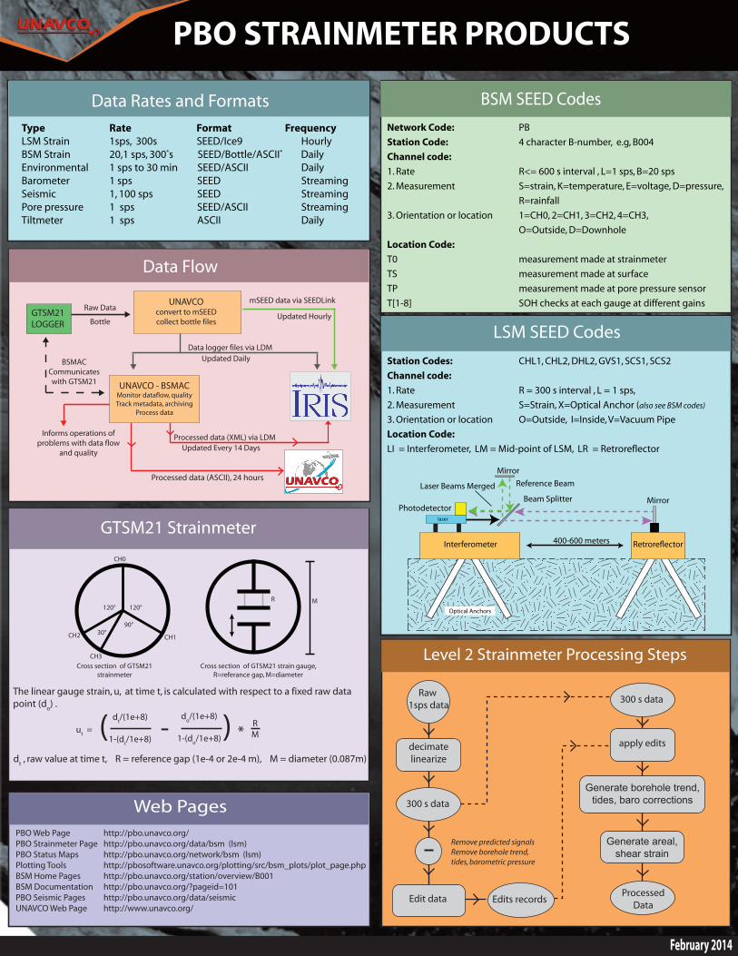
Type Rate Format FrequencyLSM Strain 1sps, 300s SEED/Ice9 HourlyBSM Strain 20,1 sps, 300*s SEED/Bottle/ASCII* DailyEnvironmental 1 sps to 30 min SEED/ASCII DailyBarometer 1 sps SEED StreamingSeismic 1, 100 sps SEED StreamingPore pressure 1 sps SEED/ASCII StreamingTiltmeter 1 sps ASCII Daily

CH0

CH1CH2

CH3

120°120°

90°30°

R M

Cross section of GTSM21 strainmeter

Cross section of GTSM21 strain gauge, R=referance gap, M=diameter

dt/(1e+8)

1-(dt/1e+8)

do/(1e+8)

1-(do/1e+8)ut = ( ) * - R

M

The linear gauge strain, u, at time t, is calculated with respect to a fixed raw data point (do) .

dt , raw value at time t, R = reference gap (1e-4 or 2e-4 m), M = diameter (0.087m)

Network Code: PBStation Code: 4 character B-number, e.g, B004Channel code: 1. Rate R<= 600 s interval , L=1 sps, B=20 sps2. Measurement S=strain, K=temperature, E=voltage, D=pressure, R=rainfall3. Orientation or location 1=CH0, 2=CH1, 3=CH2, 4=CH3, O=Outside, D=DownholeLocation Code: T0 measurement made at strainmeterTS measurement made at surfaceTP measurement made at pore pressure sensorT[1-8] SOH checks at each gauge at different gains

PBO Web Page http://pbo.unavco.org/PBO Strainmeter Page http://pbo.unavco.org/data/bsm (lsm)PBO Status Maps http://pbo.unavco.org/network/bsm (lsm)Plotting Tools http://pbosoftware.unavco.org/plotting/src/bsm_plots/plot_page.phpBSM Home Pages http://pbo.unavco.org/station/overview/B001BSM Documentation http://pbo.unavco.org/?pageid=101PBO Seismic Pages http://pbo.unavco.org/data/seismicUNAVCO Web Page http://www.unavco.org/

300 s data

Edit data Edits records

300 s data

decimate linearize

apply edits

!"#"$%&"'()$"*)+"'&$"#,-&.,"/-'(%$)'0)$$"0&.)#/

!"#"$%&"'%$"%+-/*"%$'/&$%.#

ProcessedData

Remove predicted signalsRemove borehole trend,tides, barometric pressure

Raw 1sps data

GTSM21 LOGGER

UNAVCOconvert to mSEEDcollect bottle files

IRIS DMCWEB

Processed data (XML) via LDMInforms operations of problems with data flow

and quality

BSMACCommunicates with GTSM21

Raw Data

Bottle

Data logger files via LDM

mSEED data via SEEDLink

Processed data (ASCII), 24 hours

UNAVCO - BSMACMonitor dataflow, qualityTrack metadata, archiving

Process data

Data Rates and Formats

GTSM21 Strainmeter

Web Pages

BSM SEED Codes

LSM SEED Codes

Level 2 Strainmeter Processing Steps

Data Flow

Updated Daily

Updated Hourly

Updated Every 14 Days

Station Codes: CHL1, CHL2, DHL2, GVS1, SCS1, SCS2Channel code: 1. Rate R = 300 s interval , L = 1 sps,2. Measurement S=Strain, X=Optical Anchor (also see BSM codes)

3. Orientation or location O=Outside, I=Inside, V=Vacuum PipeLocation Code: LI = Interferometer, LM = Mid-point of LSM, LR = Retroreflector

Photodetector

Laser Beams Merged

MirrorReference Beam

Beam Splitter Mirror

Optical Anchors

400-600 meters

laser

Interferometer Retrore!ector

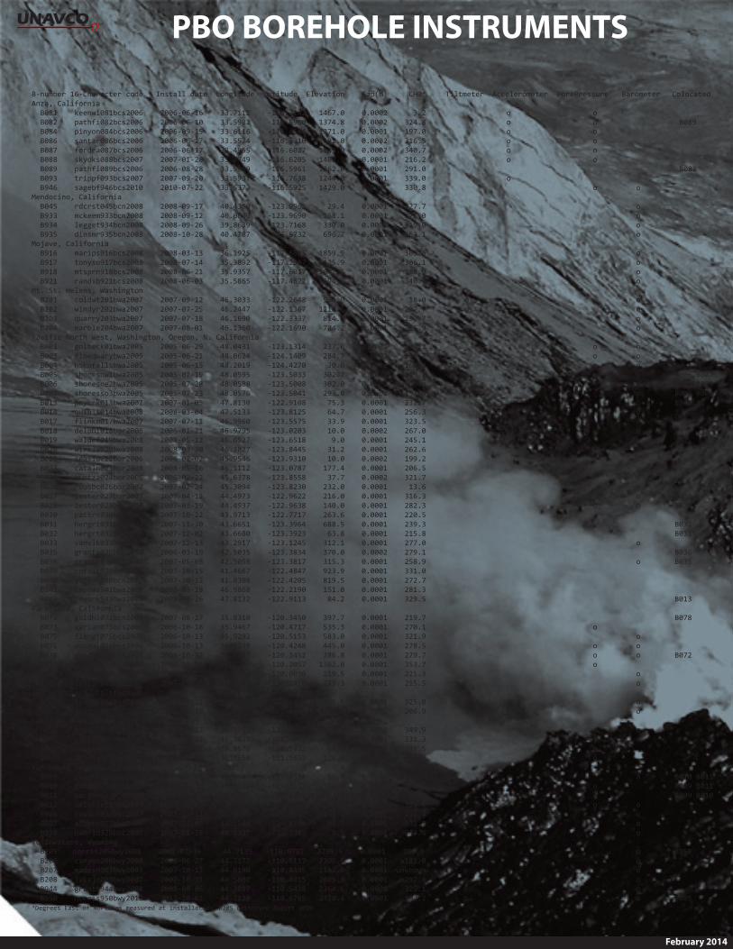
PBO BOREHOLE INSTRUMENTS

February 2014

B-­‐number  16-­‐Character  code      Install  date    Longitude    Latitude    Elevation        Gap(m)          CH0*   Tiltmeter   Accelerometer   PorePressure   Barometer   ColocatedAnza,  California                                                                                                  B081        keenwi081bcs2006        2006-­‐06-­‐16        33.7112        -­‐116.7142      1467.0        0.0002            3.2   o     o                  B082        pathfi082bcs2006        2006-­‐06-­‐10        33.5982        -­‐116.5960      1374.8        0.0002        324.8     o           o                                 B089    B084        pinyon084bcs2006        2006-­‐09-­‐15        33.6116        -­‐116.4564      1271.0        0.0001        197.0   o             o                  B086        santar086bcs2006        2006-­‐06-­‐17        33.5574        -­‐116.5310      1392.0        0.0002        316.5     o             o                  B087        fordra087bcs2006        2006-­‐06-­‐17        33.4955        -­‐116.6027      1139.0        0.0002        340.7     o             o                  B088        skyoks088bcs2007        2007-­‐01-­‐28        33.3749        -­‐116.6205      1403.9        0.0001        216.2     o             o                  B089        pathfi089bcs2006        2006-­‐08-­‐28        33.5999        -­‐116.5961      1362.0        0.0001        291.0                                                                   B082    B093        trippf093bcs2007        2007-­‐09-­‐20        33.5937        -­‐116.7638      1244.0        0.0001        339.0     o                          B946        sagebf946bcs2010        2010-­‐07-­‐22        33.5373        -­‐116.5925      1429.0        0.0001        330.8                               o           o      Mendocino,  California                                                                                                  B045        rdcrst045bcn2008        2008-­‐09-­‐17        40.4360        -­‐123.9965          29.4        0.0001        227.7                                         o          B933        mckeem933bcn2008        2008-­‐09-­‐12        40.0600        -­‐123.9690        268.1        0.0001        271.0                                         o          B934        legget934bcn2008        2008-­‐09-­‐26        39.8639        -­‐123.7168        330.0        0.0001        319.0                                         o          B935        dinsmr935bcn2008        2008-­‐10-­‐28        40.4787        -­‐123.5732        696.7        0.0001        263.1                                         o      Mojave,  California                                                                                                  B916        marips916bcs2008        2008-­‐03-­‐13        36.1925        -­‐117.6685      1859.9        0.0001        303.6                                         o          B917        tonyso917bcs2008        2008-­‐07-­‐14        35.3892        -­‐117.2587      1125.9        0.0001        306.1                                         o          B918        mtsprn918bcs2008        2008-­‐06-­‐21        35.9357        -­‐117.6017      1042.6        0.0001        288.9                                         o          B921        randsb921bcs2008        2008-­‐06-­‐03        35.5865        -­‐117.4622        694.5        0.0001        340.5                                         o      Mt.  St.  Helens,  Washington                                                                                                  B201        coldwt201bwa2007        2007-­‐09-­‐12        46.3033        -­‐122.2648        990.0        0.0001          18.0                  o                               o          B202        windyr202bwa2007        2007-­‐07-­‐25        46.2447        -­‐122.1367      1218.6        0.0001        207.7                  o                               o          B203        quarry203bwa2007        2007-­‐07-­‐18        46.1690        -­‐122.3337        814.4        0.0001        290.7                  o                               o          B204        marble204bwa2007        2007-­‐08-­‐01        46.1360        -­‐122.1690        784.2        0.0001        235.9                  o                               o      Pacific  North  West,  Washington,  Oregon,  N.  California                                                                                                  B001        golbeck01bwa2005        2005-­‐06-­‐29        48.0431        -­‐123.1314        237.0        0.0002        200.2         o           o          B003        floequarybwa2005        2005-­‐06-­‐21        48.0624        -­‐124.1409        284.7        0.0002        250.7                               o           o          B004        hokofallsbwa2005        2005-­‐06-­‐15        48.2019        -­‐124.4270          30.0        0.0002        168.2                               o           o          B005        shoresnw1bwa2005        2005-­‐07-­‐19        48.0595        -­‐123.5033        302.7        0.0002        319.7                               o           o                B006  B007    B006        shoresne2bwa2005        2005-­‐07-­‐28        48.0588        -­‐123.5008        302.0        0.0002    Unknown                                         o                B005  B007    B007        shoresso3bwa2005        2005-­‐07-­‐23        48.0576        -­‐123.5041        293.0        0.0002        193.0                                         o                B005  B006    B013        pnycrk013bwa2007        2007-­‐01-­‐05        47.8130        -­‐122.9108          75.3        0.0001        231.7                                         o                B943    B014        quinlt014bwa2008        2008-­‐03-­‐04        47.5133        -­‐123.8125          64.7        0.0001        256.3                                         o          B017        flinkm017bwa2007        2007-­‐07-­‐11        46.9960        -­‐123.5575          33.9        0.0001        323.5                                         o          B018        delphi018bor2006        2006-­‐01-­‐21        46.9795        -­‐123.0203          10.0        0.0002        267.0                                         o          B019        waldrf019bwa2008        2008-­‐05-­‐12        46.6527        -­‐123.6518            9.0        0.0001        245.1                                         o          B020        wirkla020bwa2008        2008-­‐03-­‐30        46.3827        -­‐123.8445          31.2        0.0001        262.6                                         o          B022        seaside22bor2006        2006-­‐02-­‐02        45.9546        -­‐123.9310          10.0        0.0002        199.2                                       o   o            B023        cataln023bor2008        2008-­‐05-­‐16        46.1112        -­‐123.0787        177.4        0.0001        206.5                                         o          B024        kuntza024bor2006        2006-­‐02-­‐22        45.6378        -­‐123.8558          37.7        0.0002        321.7                                         o          B026        roosbc026bor2007        2007-­‐02-­‐24        45.3094        -­‐123.8230        232.0        0.0001          13.6                                         o          B027        lester027bor2007        2007-­‐04-­‐12        44.4973        -­‐122.9622        216.0        0.0001        316.3                                         o                B028    B028        lester028bor2007        2007-­‐03-­‐19        44.4937        -­‐122.9638        140.0        0.0001        282.3                               o           o                B027    B030        pattrs030bor2007        2007-­‐10-­‐22        43.9713        -­‐122.7717        263.6        0.0001        220.5                                            B031        hergrt031bor2007        2007-­‐11-­‐30        43.6651        -­‐123.3964        688.5        0.0001        239.3                                                                B032    B032        hergrt032bor2007        2007-­‐12-­‐02        43.6680        -­‐123.3923          63.8        0.0001        215.8                                                                B031    B033        vanvlk033bor2007        2007-­‐12-­‐13        43.2917        -­‐123.1245        312.1        0.0001        277.0                                         o          B035        grants035bor2006        2006-­‐03-­‐19        42.5035        -­‐123.3834        370.0        0.0002        279.1                                                                B036    B036        grants036bor2007        2007-­‐05-­‐08        42.5058        -­‐123.3817        315.3        0.0001        258.9                                         o                B035    B039        cofflt039bcn2007        2007-­‐10-­‐15        41.4667        -­‐122.4847        923.9        0.0001        331.0                                          B040        yorkmn040bcn2007        2007-­‐10-­‐12        41.8308        -­‐122.4205        819.5        0.0001        272.7                                          B941        kapows941bwa2008        2008-­‐03-­‐18        46.9868        -­‐122.2190        151.0        0.0001        281.3                                          B943        pnycrk943bwa2008        2008-­‐02-­‐26        47.8132        -­‐122.9113          84.2        0.0001        329.5                                                                B013Parkfield,  California                                                                                                  B072        goldhl072bcn2007        2007-­‐08-­‐27        35.8310        -­‐120.3450        397.7        0.0001        219.7                                                                B078    B073        varian073bcs2006        2006-­‐10-­‐18        35.9467        -­‐120.4717        535.3        0.0001        270.1                               o                  B075        flengt075bcs2006        2006-­‐10-­‐13        35.9292        -­‐120.5153        583.0        0.0001        321.9                                         o          B076        donnal076bcs2006        2006-­‐10-­‐13        35.9398        -­‐120.4248        445.0        0.0001        278.5                               o           o          B078        goldhl078bcs2006        2006-­‐10-­‐12        35.8377        -­‐120.3452        386.8        0.0001        279.7                             o           o                B072    B079        jackcn079bcs2006        2006-­‐10-­‐13        35.7157        -­‐120.2057      1362.0        0.0001        353.7                               o                  B900        blacka900bcn2007        2007-­‐08-­‐22        35.6860        -­‐120.0030        219.5        0.0001        221.3                                         o          B901        indspr901bcn2007        2007-­‐09-­‐26        35.6897        -­‐120.1420        275.3        0.0001        215.5                                         o      San  Francisco,  California                                                                                                  B054        sibley054bcn2008        2008-­‐08-­‐21        37.8602        -­‐122.1995        405.6        0.0001        325.0                                         o          B057        lucasv057bcn2008        2008-­‐06-­‐10        38.0273        -­‐122.5655          14.4        0.0001        206.9                                         o      San  Juan  Bautista,  California                                                                                                  B058        sjgrad058bcn2007        2007-­‐05-­‐17        36.7995        -­‐121.5808        114.2        0.0001        349.9                               o           o          B065        gabiln065bcn2007        2007-­‐06-­‐22        36.7437        -­‐121.4742        643.0        0.0001        231.3                                         o          B066        rockrd066bcn2007        2007-­‐06-­‐07        36.8575        -­‐121.5922          67.0        0.0001        331.5                               o                  B067        stoney067bcn2007        2007-­‐06-­‐12        36.7650        -­‐121.5655        126.2        0.0001        311.6                               o              Vancouver  Island,  Canada                                                                                                  B009        pacgeosi1bbc2005        2005-­‐09-­‐14        48.6487        -­‐123.4512          15.0        0.0002        271.4                                         o                B010  B011    B010        pacgeosi2bbc2005        2005-­‐09-­‐26        48.6502        -­‐123.4513            5.0        0.0002        267.8                               o                                    B009  B011    B011        pacgeosi3bbc2005        2005-­‐09-­‐13        48.6495        -­‐123.4482          22.0        0.0002    Unknown                               o                                    B009  B010    B012        ucluelet1bbc2005        2005-­‐09-­‐22        48.9246        -­‐125.5420          13.0        0.0002        329.4                               o           o          B926        cowich926bbc2007        2007-­‐11-­‐12        48.8202        -­‐124.1312        191.6        0.0001        236.4                                         o          B927        albern927bbc2007        2007-­‐12-­‐06        49.2188        -­‐124.8144          98.7        0.0001        331.1                                         o          B928        bamfld928bbc2007        2007-­‐11-­‐28        48.8337        -­‐125.1345            9.5        0.0001        243.4                                       o      Yellowstone,  Wyoming                                                                                                  B205+      norris205bwy2008        2008-­‐07-­‐16          44.7135      -­‐110.6782      2295.9        0.0001        200.9   o                               o                B950          B206        canyon206bwy2008        2008-­‐06-­‐27        44.7177        -­‐110.5117      2399.5        0.0001        181.0   o                               o          B207        madisn207bwy2007        2007-­‐10-­‐17        44.6190        -­‐110.8485      2182.0        0.0001    Unknown   o                               o          B208        lakejn208bwy2007        2007-­‐10-­‐31        44.5602        -­‐110.4015      2405.8        0.0001        292.4   o                               o          B944        grantt944bwy2008        2008-­‐08-­‐06        44.3897        -­‐110.5438      2364.6        0.0001        325.1   o                               o          B950        norris950bwy2013        2013-­‐10-­‐01        44.7128        -­‐110.6785      2328.4        0.0001        184.2   o                               o                B205*Degrees  East  of  North  as  measured  at  installation  +B205  destroyed  August  2010