patterns and ecological implications of agricultural land-use changes: a case study from central...
TRANSCRIPT

Agriculture, Ecosystems and Environment 102 (2004) 81–92
Patterns and ecological implications of agricultural land-usechanges: a case study from central Himalaya, India
R.L. Semwala, S. Nautiyalb, K.K. Senb, U. Ranaa,R.K. Maikhuria, K.S. Raoc, K.G. Saxenad,∗
a G.B. Pant Institute of Himalayan Environment and Development, Garhwal Unit, P. Box 92, Srinagar, Garhwal 246174, Indiab G.B. Pant Institute of Himalayan Environment and Development, Kosi-Katarmal, Almora 263643, India
c Centre for Inter-disciplinary Studies of Mountain and Hill Environment, University of Delhi, South Campus, New Delhi 110021, Indiad School of Environmental Sciences, Jawaharlal Nehru University, New Delhi 110067, India
Received 1 October 2002; received in revised form 23 May 2003; accepted 6 June 2003
Abstract
Land-use change has important implications for sustainable livelihood of local communities where traditional crop–livestockmixed farming is sustained with local inputs. Knowledge of recent changes in land use, driving forces and implicationsof changes within the context of sustainable development is limited. This study analyses the changes in spatial patterns ofagricultural land use, crop diversity, manure input, yield, soil loss and run-off from cropland, and dependence of agroecosystemson forests, during the 1963–1993 period in a small watershed in central Himalaya, India. Data obtained from existing maps,interpretation of satellite imagery, geographic information system (GIS) based land-use change analysis, participatory surveyand field measurements were integrated to quantify changes at the landscape/watershed scale. During the 1963–1993 period,agricultural land use increased by 30% at the cost of loss of 5% of forestland. About 60% of agricultural expansion occurredin community forests compared to 35% in protected forests and 5% in reserve forests. Agricultural expansion was mostconspicuous at higher elevations (1800–2600 m) and on medium slopes (10–30◦). Cultivation of buckwheat (FagopyrumesculentumL., Fagopyrum tataricum(L.) Gaertner), hogmillet (Panicum miliaceumL.) and foxtail millet (Setaria italica(L.)Beauv.) was abandoned. Potato (Solanum tuberosumL.), a cash crop, completely replaced the abandoned crops and partiallyreplaced many other traditional crops. Soil loss, run-off and manure input related to potato cultivation was much highercompared to other crops. Mean annual fodder yield from cropland declined by 44%, while manure input, soil loss and run-offincreased by 46, 90 and 51%, respectively. Changes in land use and management have improved household income but at thecost of increase in intensity of biomass removal from forests and loss of forest cover. As farm productivity is dependent onforests, continued depletion of forest resources will result in poor economic returns from agriculture to local people togetherwith loss of global benefits from forest biodiversity and ecosystem services. Policy support for sustainable income from foreststo local people as well as technologies enhancing agricultural productivity through conservation of traditional crop diversityand efficient resource recycling within agroecosystems is needed for sustainable livelihood of local communities togetherwith global benefits from the Himalayan forests and ecosystem services.© 2003 Elsevier B.V. All rights reserved.
Keywords:Crop diversity and productivity; Forest; Land-use change; Central Himalaya; Soil loss; Run-off; Manure; Sustainable livelihood
∗ Corresponding author. Fax:+91-11-6172438.E-mail address:[email protected] (K.G. Saxena).
0167-8809/$ – see front matter © 2003 Elsevier B.V. All rights reserved.doi:10.1016/S0167-8809(03)00228-7

82 R.L. Semwal et al. / Agriculture, Ecosystems and Environment 102 (2004) 81–92
1. Introduction
The Himalayas is a vast mountain system cover-ing partly or fully eight countries of Asia includ-ing Afghanistan, Bangladesh, Bhutan, China, India,Myanmar, Nepal and Pakistan. India’s recognition asone of the four ‘megadiversity’ countries of Asia andas 1 of the 10 largest forested areas in the world derivespartly from the Himalayas. Although the Himalayascovers only 18% of India’s geographical area, it ac-counts for more than 50% of India’s forest cover and40% of the species endemic to the Indian subconti-nent. In terms of spatial extent, agriculture is a minorland use (net sown area accounts for only 10% of to-tal area of Indian Himalaya) distributed as ‘patches’in the ‘matrix’ of forests, but is significant from bothecological and socio-economic considerations. Tradi-tional crop–livestock mixed farming is the basis oflivelihood of local communities and backbone of ruraleconomy (Rao and Saxena, 1996; Tripathi and Sah,2001).
An agricultural system will be considered to besustainable if its productivity is maintained in thelong run, natural resources driving agricultural pro-duction process are conserved and, profitability ofproduction and therefore financial income of farm-ers are guaranteed (Neher, 1992; Kessler, 1994).As agricultural production is directly linked to sur-rounding ecosystems, consideration of all interactionsbetween the agricultural production system and nat-ural ecosystems within cultivated landscapes is acritical requirement for evaluation of sustainability(Giampietro and Bukkens, 1992; Lefroy et al., 2000;von Wiren-Lehr, 2001). Traditional farming in theHimalayas is highly dependent on forests for live-stock feed and manure. Apart from these inputs thatdrive agricultural production process, forests providea variety of other products and services which arecritical for sustainable livelihood of mountain people(Rao and Saxena, 1996; Sen et al., 1997). Extensionof agricultural land use into forestland coupled withecosystem degradation arising from traditional prac-tices of litter collection, grazing and lopping in forestsfor sustaining livestock and maintaining soil fertilityin cropland could be a threat to forest biodiversity andecosystem services on one hand and sustainability oftraditional farming on the other (Singh et al., 1984;Schmidt et al., 1993; Schreier et al., 1994; Pilbeam
et al., 2000). Sustainable land use is crucial not onlyfor the sustainable livelihood of 115 million mountainpeople but also the many more people living in theadjoining Indo-gangetic plains as accelerated erosiondue to inappropriate land use in the Himalayas partlycontributes to devastating floods in the plains (Ivesand Messerli, 1989).
Efforts have been made to analyse changes in broadland-use/land-cover types in the Himalayas (Virgo andSubba, 1994; Thapa and Weber, 1995; Schweik et al.,1997; Jackson et al., 1998; Rao and Pant, 2001;Gautam et al., 2002). Yet, knowledge on changesin spatial patterns of agricultural land use, drivingfactors and their implications within the context ofsustainable development is limited (Thapa, 1996;Hurni, 2000; Sankhayan et al., 2003). The objectiveof this study was to analyse the trends and impli-cations of changes in spatial patterns of agriculturalland use, crop diversity, yields, manure input, soilloss and run-off from cropland, and dependence ofagroecosystems on forests in a central Himalayanwatershed during the 1963–1993 period.
2. Methods
2.1. Study area
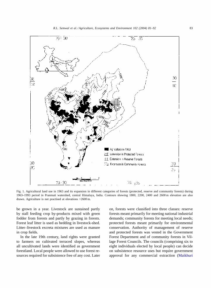
The study was carried out in the Pranmati watershedlocated in the State of Uttar Pradesh, India (Fig. 1)covering an area of 94 km2 and encompassing ninevillages. Elevation varies from 1120 to 4070 m amsl.The climate year is divisible into a warm dry period(March–June), warm rainy season (July–September)and a dry winter (October–February). Average annualrainfall is 170 cm and maximum and minimum tem-peratures are 24 and 11◦C, respectively. Parent mate-rial is represented by schists and gneisses. Soils are20–80 cm deep, sandy loam in texture and can be clas-sified as Dystric Cambisol according to FAO system.
Rainfed agriculture is practised on terracedslopes. Though two crops in a year, one duringMarch–October period (rainy season crops) and theother during October–April period (winter seasoncrops), can be harvested up to an altitude of 2200 m,a field is traditionally fallowed during winter seasononce during each 2-year period. In cooler climates athigher elevations (2200–2600 m), only one crop can
R.L. Semwal et al. / Agriculture, Ecosystems and Environment 102 (2004) 81–92 83
Fig. 1. Agricultural land use in 1963 and its expansion in different categories of forests (protected, reserve and community forests) during1963–1993 period in Pranmati watershed, central Himalaya, India. Contours showing 1800, 2200, 2400 and 2600 m elevation are alsodrawn. Agriculture is not practised at elevations >2600 m.
be grown in a year. Livestock are sustained partlyby stall feeding crop by-products mixed with greenfodder from forests and partly by grazing in forests.Forest leaf litter is used as bedding in livestock-shed.Litter–livestock excreta mixtures are used as manurein crop fields.
In the late 19th century, land rights were grantedto farmers on cultivated terraced slopes, whereasall uncultivated lands were identified as governmentforestland. Local people were allowed to use forest re-sources required for subsistence free of any cost. Later
on, forests were classified into three classes: reserveforests meant primarily for meeting national industrialdemands; community forests for meeting local needs;protected forests meant primarily for environmentalconservation. Authority of management of reserveand protected forests was vested in the GovernmentForest Department and of community forests in Vil-lage Forest Councils. The councils (comprising six toeight individuals elected by local people) can decideon subsistence resource uses but require governmentapproval for any commercial extraction (Maikhuri

84 R.L. Semwal et al. / Agriculture, Ecosystems and Environment 102 (2004) 81–92
et al., 2000). Reserve forests of the Pranmati water-shed, confined largely to lower altitudes (<1900 m),are managed for pine (Pinus roxburghii Sargent)resin extraction by the Forest Department involvinglocal people as paid-labourers as prescribed in theworking plan. Protected forests are highly inaccessi-ble and dominated byQuercus semecarpifoliaSmithand Rhododendron arboreumSmith (1900–2400 m)or alpine meadows (>2500 m). Community forests,confined largely to 1900–2400 m elevation, are dom-inated by Quercus leucotrichophoraA. Camus,Q.semecarpifoliaand R. arboreum. Felling of greentrees has been banned since 1976 and agriculturesince 1952 in all forestlands.
2.2. Human and livestock population
Data on number of households and human popu-lation were compiled from village records. Livestockholdings were not registered. Participatory discussionswere held with 20% of households, selected randomlyin each village, to enumerate current livestock popu-lation as well as that in 1963, as recalled by elderlyfamily members.
2.3. Agriculture/forest land-use/land-coverdynamics
Four land-use/land-cover types, viz., agriculture,forest, alpine meadows and drainage/river-bed, asfound in 1963 were mapped based on the details inthe Survey of India topographical map and in 1993by visual interpretation of Standard Geocoded FalseColour Composite (1:50 000 scale) of IRS-1B satellitedata of April 1993 (interpreted in 1994). Boundariesof reserve, protected and community forests were ex-tracted from forest management maps. All thematicmaps were digitised using Arc/Info based geographicinformation system (GIS) for spatio-temporal analysis.
Crop-wise mapping was not possible on imagerybecause of limited resolution of satellite data. Anintensive ground survey of the watershed was carriedout to identify relationships between cropping patternsand mappable terrain features, viz., elevation, aspectand slope. Choice of crops was affected by elevationbut not by aspect or slope. Three zones differing incrops and their relative area were distinguished: (a)low elevation (1120–1850 m) zone where amaranth
(Amaranthus paniculatusL.), fingermillet (Eleusinecoracana(L.) Gaertner), rice (Oryza sativaL.), barn-yard millet (Echinochloa frumentaceaLink), horseg-ram (Macrotyloma uniflorum (Lam.) Verdc.) andpotato (Solanum tuberosumL.) were grown duringrainy season with rice and fingermillet being the mostdominant crops; (b) mid-elevation (1850–2400 m)zone where all crops of low elevation zone excepthorsegram were grown with potato and amaranthbeing the most dominant crops; (c) high elevation(2400–2600 m) zone where only potato was grownduring the rainy season. During the winter season,barley (Hordeum vulgareL.), naked barley (HordeumhimalayensL.), lentil (Lens esculentaMoench), mus-tard (Brassica campestrisL.) and wheat (TriticumaestivumL.) were grown in the low and mid-elevationzones, and only mustard at the high elevation zone.Each household had at least one parcel of land ineach zone. The three crop zones were mapped byintegrating elevation and land-use maps in GIS.
In 20 random holdings, area under different cropswas measured in the 1994–1995 period. In addition,family elders were asked to tell the size of holdingsin traditional area unit (Nali which were convertedto metric units) and relative area under differentcrops during participatory discussions. While theabsolute area of holdings reported by farmers were1.3–1.7 times smaller than the measured areas, re-ported relative crop area did not differ significantly(P > 0.05; Mann–Whitney rank test) from that ob-tained from field measurements. These farmers wereasked whether they could recall crop-wise relativearea in/around 1963. All of them could recall averagerelative area under different crops during 1960–1965period.
2.4. Manure input and productivity
Manure input and yields of edible parts andby-products were measured in 20 fields (averagesize 80 m2) of a crop in an elevation zone duringthe 1994–1995 period. In addition to measurements,elders in each household were asked to quantifycrop-wise manure input and yields in terms of theirtraditional measurement units (mandwhich were con-verted to metric units) during participatory discussionsand compared with field measurements. Farmers’assessment did not differ significantly (P > 0.05;

R.L. Semwal et al. / Agriculture, Ecosystems and Environment 102 (2004) 81–92 85
Mann–Whitney rank test) from the measurements.These farmers were asked to quantify relative changesin manure input and yields during 1963–1993 period.Manure input and yields as in/around 1963 werecomputed based on reported changes and estimationsdone during 1994–1995.
2.5. Soil loss and run-off
Soil loss and run-off were monitored only fromrainy season crops in the mid-elevation (1850–2400 m)zone. Because of damage to run-off plots, measure-ments in horsegram fields, which covered only 1% ofcropped area in 1993, could not be completed. Dueto narrow terrace width (3–4 m) and nearly verticalstone-lined risers, standard run-off plots (20–25 m×2.5 m) recommended by US Soil Conservation Servicewere not feasible. Five replicate plots (5 m× 2.5 m)for each crop were established in the year 1995 withgalvanised tin sheets dipping nearly 20 cm deep intosoil and leaving 5 cm above the ground. Run-off wascollected through a PVC tube into a drum placed atthe next lower terrace. At regular intervals, run-offwas measured. Eroded soil was weighed after dryingsamples of suspended solution and deposited sedimentat 105± 5◦C for 24 h. As erosion in the area during
Fig. 2. Number of households and human and livestock population of Pranmati watershed, central Himalaya, India in 1963 and 1993.
winter season is negligible (Rawat and Rawat, 1994),soil loss and run-off from rainy season crops couldbe taken as annual losses from cropland. Participatorydiscussions revealed that farmers perceived soil lossand run-off from potato fields to be higher than thosefrom other crops, but were unable to express this per-ception in quantitative terms.
2.6. Statistical methods
Mann–Whitney rank test was used to compare thearea, yield and manure input related to different cropsin 1963 and 1993. One-way analysis of variance andleast significant difference (P = 0.05) were appliedto compare mean values of soil loss and run-off fromdifferent crops (Snedecor and Cochran, 1967).
3. Results
3.1. Human and livestock population
During the period 1963–1993, the number of house-holds in the watershed increased by 182% and hu-man population by 122%. Among livestock, cattleshowed the highest growth rate (182%) followed bysheep-goats (66%) and mules (33%) (Fig. 2).

86 R.L. Semwal et al. / Agriculture, Ecosystems and Environment 102 (2004) 81–92
Table 1Disaggregation of agricultural land-use expansion (during 1963–1993 period) in different elevation and slope classes in different foresttypes in Pranmati watershed, central Himalaya, India
Percentage of total expansion in Totala
Reserve forests Protected forests Community forests
Elevation class1150–1800 m 5.8 0.0 5.7 3.81800–2400 m 94.2 38.9 75.5 69.52400–2600 m 0.0 61.1 18.8 26.7
Slope class<10◦ 0.0 26.4 8.2 11.510–20◦ 9.3 29.2 19.4 19.320–30◦ 70.6 34.7 54.4 53.330–40◦ 20.1 9.7 18.0 15.9
Totalb 5.6 59.6 34.8
a Agricultural expansion in a given elevation/slope class as % of total expansion in watershed.b Agricultural expansion in a given forest type as % of total expansion in watershed.
3.2. Agricultural/forest land-use dynamics
During 1963–1993 period, agricultural land use in-creased by 30% at the cost of loss of 5% of forestland.About 60% of agricultural expansion occurred in com-munity forests compared to 35% in protected forestsand 5% in reserve forests. Agricultural expansion wasmost conspicuous at higher elevations (1800–2600 m)and on medium slopes (10–30◦) (Fig. 1, Table 1).Mean size of agricultural patches increased by 87%.As reduction in the number of patches due to coales-cence of adjacent patches was equal to that of newagricultural patches, patch density did not change dur-ing 1963–1993 period. Insignificant change in shapecomplexity index is indicative of a uniform pattern ofagricultural expansion (Table 2).
Table 2Changes in patchiness of agricultural land use between 1963 and1993 period in Pranmati watershed, central Himalaya, India
Attribute Year
1963 1993
Total number of patches 30 30Patch area (ha)
Minimum 0.9 2.7Maximum 260.9 343.9Mean 31.0 58.0
Shape complexity index(perimeter (m):area (ha) ratio)
729.1 727.1
3.3. Changes in crop diversity, yields and manureinput
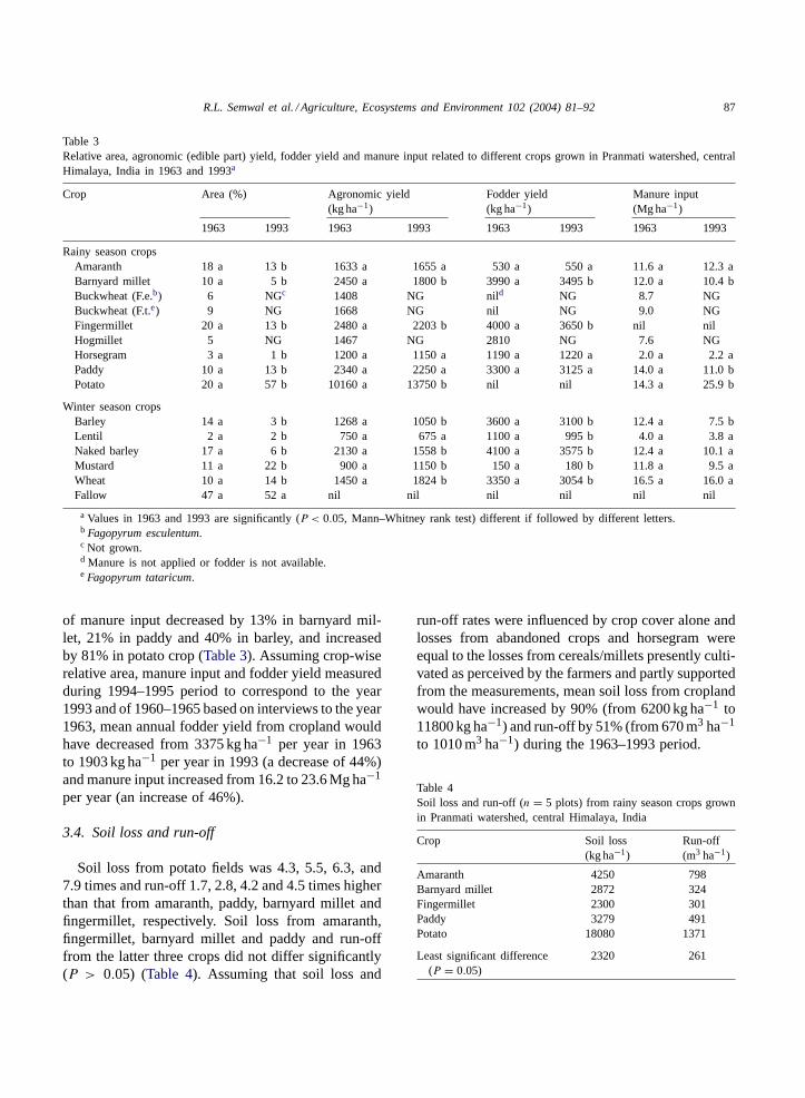
Among rainy season crops, buckwheat (two species:Fagopyrum esculentum(L.) Moench andFagopyrumtataricum (L.) Gaertner) and hog millet (PanicummilaceumL.) grown as pure crops and foxtail millet(Setaria italica (L.) Beauv.) as a minor crop mixedwith paddy were abandoned during the 1963–1993period. Complete replacement of abandoned cropsand partial replacement of amaranth, barnyard millet,fingermillet and horsegram by potato led to about300% increase in area under potato. During winterseason, mustard and wheat replaced substantial areaunder barley and naked barley (Table 3).
Farmers did not perceive any significant change inyields of amaranth, horsegram, paddy and lentil dur-ing the 1963–1993 period. Edible yield was reportedto have increased by 35% in potato, 27% in mustardand 25% in wheat, and to have declined by 26% inbarnyard millet, 11% in barley and 19% in naked bar-ley. Changes in yields of by-products used as fodderwere not as pronounced as those in edible compo-nent. Buckwheat and potato had no fodder value, whileamaranth, horsegram, lentil and mustard yielded loweramounts of fodder (180–1220 kg ha−1) compared tomillets and cereals (3054–3650 kg ha−1 as measuredin 1994/1995). Manure was applied to all crops ex-cept fingermillet. During the 1963–1993 period, rate
R.L. Semwal et al. / Agriculture, Ecosystems and Environment 102 (2004) 81–92 87
Table 3Relative area, agronomic (edible part) yield, fodder yield and manure input related to different crops grown in Pranmati watershed, centralHimalaya, India in 1963 and 1993a
Crop Area (%) Agronomic yield(kg ha−1)
Fodder yield(kg ha−1)
Manure input(Mg ha−1)
1963 1993 1963 1993 1963 1993 1963 1993
Rainy season cropsAmaranth 18 a 13 b 1633 a 1655 a 530 a 550 a 11.6 a 12.3 aBarnyard millet 10 a 5 b 2450 a 1800 b 3990 a 3495 b 12.0 a 10.4 bBuckwheat (F.e.b) 6 NGc 1408 NG nild NG 8.7 NGBuckwheat (F.t.e) 9 NG 1668 NG nil NG 9.0 NGFingermillet 20 a 13 b 2480 a 2203 b 4000 a 3650 b nil nilHogmillet 5 NG 1467 NG 2810 NG 7.6 NGHorsegram 3 a 1 b 1200 a 1150 a 1190 a 1220 a 2.0 a 2.2 aPaddy 10 a 13 b 2340 a 2250 a 3300 a 3125 a 14.0 a 11.0 bPotato 20 a 57 b 10160 a 13750 b nil nil 14.3 a 25.9 b
Winter season cropsBarley 14 a 3 b 1268 a 1050 b 3600 a 3100 b 12.4 a 7.5 bLentil 2 a 2 b 750 a 675 a 1100 a 995 b 4.0 a 3.8 aNaked barley 17 a 6 b 2130 a 1558 b 4100 a 3575 b 12.4 a 10.1 aMustard 11 a 22 b 900 a 1150 b 150 a 180 b 11.8 a 9.5 aWheat 10 a 14 b 1450 a 1824 b 3350 a 3054 b 16.5 a 16.0 aFallow 47 a 52 a nil nil nil nil nil nil
a Values in 1963 and 1993 are significantly (P < 0.05, Mann–Whitney rank test) different if followed by different letters.b Fagopyrum esculentum.c Not grown.d Manure is not applied or fodder is not available.e Fagopyrum tataricum.
of manure input decreased by 13% in barnyard mil-let, 21% in paddy and 40% in barley, and increasedby 81% in potato crop (Table 3). Assuming crop-wiserelative area, manure input and fodder yield measuredduring 1994–1995 period to correspond to the year1993 and of 1960–1965 based on interviews to the year1963, mean annual fodder yield from cropland wouldhave decreased from 3375 kg ha−1 per year in 1963to 1903 kg ha−1 per year in 1993 (a decrease of 44%)and manure input increased from 16.2 to 23.6 Mg ha−1
per year (an increase of 46%).
3.4. Soil loss and run-off
Soil loss from potato fields was 4.3, 5.5, 6.3, and7.9 times and run-off 1.7, 2.8, 4.2 and 4.5 times higherthan that from amaranth, paddy, barnyard millet andfingermillet, respectively. Soil loss from amaranth,fingermillet, barnyard millet and paddy and run-offfrom the latter three crops did not differ significantly(P > 0.05) (Table 4). Assuming that soil loss and
run-off rates were influenced by crop cover alone andlosses from abandoned crops and horsegram wereequal to the losses from cereals/millets presently culti-vated as perceived by the farmers and partly supportedfrom the measurements, mean soil loss from croplandwould have increased by 90% (from 6200 kg ha−1 to11800 kg ha−1) and run-off by 51% (from 670 m3 ha−1
to 1010 m3 ha−1) during the 1963–1993 period.
Table 4Soil loss and run-off (n = 5 plots) from rainy season crops grownin Pranmati watershed, central Himalaya, India
Crop Soil loss(kg ha−1)
Run-off(m3 ha−1)
Amaranth 4250 798Barnyard millet 2872 324Fingermillet 2300 301Paddy 3279 491Potato 18080 1371
Least significant difference(P = 0.05)
2320 261

88 R.L. Semwal et al. / Agriculture, Ecosystems and Environment 102 (2004) 81–92
4. Discussion
4.1. Methodology
This study shows that a participatory survey canprovide data sets complementing the informationavailable from existing land-use maps or those de-rived from satellite imagery as also shown elsewhere(Midmore et al., 1996; Zurayk et al., 2001). However,reconstruction of the past based on farmers’ percep-tions will always be limited to variables which are tra-ditionally quantified, and to a time scale (30 years inthis study) which is within the range of human mem-ory (Showers, 1996; Fujisaka et al., 1998). Possibilityof farmers hiding or providing inaccurate informationdoes exist (Omiti et al., 1999). In the present case,farmers reported size of their holdings smaller thanthe actual cultivated area probably because they didnot want to accept illicit encroachment into forest-land. Change in cultivated area, which was not trulyrevealed by farmers, could be obtained from maps de-picting the 1963 scenario and interpreting the presentland-use from satellite data. Accuracy of changes insoil loss and run-off from cropland presented hereis limited by inherent drawbacks of run-off plotmethodology (Stocking, 1995) and partial validationof farmers’ perceptions. Intensive experimentationand modelling approaches are needed to obtain moreprecise estimates of changes in soil loss and run-off(Midmore et al., 1996; Tenberg et al., 1997). Analysisof patterns and implications of land-use/land-coverdynamics based on monitoring of key parameters atshorter intervals would have been more useful thanthe analysis based on assessments at just two pointsof time separated by a longer interval of 30 yearspresented here but was not possible because of avail-ability of limited data depicting past scenarios.
4.2. Agricultural expansion
Agricultural expansion into forestland observedin the Pranmati watershed is a common trend inthe Himalayas (Virgo and Subba, 1994; Thapa andWeber, 1995; Schweik et al., 1997; Rao and Pant,2001) and other mountain regions in developingcountries (Fox et al., 1995; Kammerbauer and Ardon,1999; Midmore et al., 1996), though stagnation ordecline in agricultural land use has been reported in
some pockets (Studsrod and Wegge, 1995; Maikhuriet al., 2000). The rates and spatio-temporal patternsof expansion vary partly because of variation in bio-physical, socio-economic and policy factors drivingland-use dynamics (Veldkamp and Lambin, 2001)and partly because of variation in spatio-temporalscale and techniques adopted for change analysis.Concentration of agricultural expansion in higher al-titudes of the Pranmati watershed, where ecologicalconditions are more favourable for the most prof-itable crop potato (Sen et al., 2002), indicates thatexpansion is driven largely by farmers’ tendency formaximisation of income. Expansion occurred largelyin forestland on moderate slopes where traditional ter-racing was feasible and institutional arrangements offorest protection provided in forest policy were weak.Agricultural expansion in reserve forests was negligi-ble because these forests provided significant incometo local people involved in pine resin extraction su-pervised by government officials also empoweredto impose huge penalties for illicit cropping. Com-munity and protected forests were more frequentlyencroached because they were relatively inaccessible,excluded from government working plans and rarelymonitored by government officials. People’s Institu-tion of Forest Council has failed to protect communityforests for several reasons: (a) councils can charge amaximum fine of Rs 50 (US$ 1.2) which is negligi-ble when compared with income from illicit croppingin forestland. (b) Councils cannot utilise communityforest resources on a commercial scale and hence areunable to satisfy people’s aspirations for economicdevelopment. Marginal upland communities tend toconserve forests when policies are such that they getdirect economic benefits from forests (Jackson et al.,1998; Dongol et al., 2002). (c) Institutional arrange-ments of penalising or rewarding councils based ontheir abilities to protect forests are not in place. (d)People are not much concerned for loss of commu-nity forests because they have rights to use resourcesrequired to sustain agriculture and other subsistenceneeds free of any cost from reserve/protected forests.
4.3. Changes in cropping patterns, managementpractices and their ecological implications
Policies of granting land rights in forestland, pro-tecting farmers from exploitation by traders, supplying

R.L. Semwal et al. / Agriculture, Ecosystems and Environment 102 (2004) 81–92 89
modern inputs at a subsidised price and by banningimport of high value crops have encouraged cash cropsin many mountain areas (Midmore et al., 1996; Singhet al., 1997; Ives and He, 1996; Renaud et al., 1998).Increasing stress on potato in the Pranmati watershedis driven by a socio-cultural change from subsis-tence to market economy facilitated by improvementin accessibility and supply of staple food grains atsubsidised price by the government (Maikhuri et al.,1996). Potato cultivation offers a comparative advan-tage in that environmental conditions at higher eleva-tions favour high yield of disease-free tubers withoutusing any modern input. Farmers have gained sub-stantial economic benefits by expanding cash cropsthat primarily are for sale to external markets (Singhet al., 1997; Sen et al., 2002). Growing tendency to-wards external linkages offers new potentialities, butat the same time, new risks for the local communities(Bohle and Adhikari, 1998). Annual local productionof staple food was 3.4 times higher than the minimumlocal requirement in 1963 and almost equal to localrequirement in 1993 (data not presented). Narrowingdown of the traditional diverse food base as a resultof abandonment of buckwheat, hog millet and foxtailmillet under the influence of market economy (Allan,1986; Chu-Lin et al., 1999) implies more risks tolocal livelihood in the events of downfall in marketprice/demand of potato, termination of supply of sta-ple food grains at subsidised price by the government,pest outbreaks in a cash crop dominated homogeneouslandscape and abnormal climate years (Giampietro,1997). As the biological potential of traditionalcrops/cultivars is poorly understood, their loss is notin the interest of either the scientific or the wider com-munity. Differing from the trend observed in Pranmatiwatershed, cropping systems enabling improvementin farm economy by conserving and/enhancing agro-biodiversity have evolved over time in a few locations.In Chhakinal watershed (District Kullu, Himachal Hi-malaya, India), farmers switched from monocroppingof traditional crops giving low economic returns tomixed cropping on small plots, rather than abandoningthe crops altogether (Singh et al., 1997). Tribal farm-ers in the Nanda Devi Biosphere Reserve (UttaranchalHimalaya, India) began cultivation of many costlymedicinal plants without any significant loss of tradi-tional food crop diversity (Maikhuri et al., 2000). Suchinitiatives of conserving and/enhancing biodiversity in
the Himalayas and elsewhere (Bunch, 1999; Conellyand Chaiken, 2000) are, however, highly localised.
Farmers doubled manure input to the potato cropduring 1963–1993 period probably to maximise prof-its (Briggs and Twomlow, 2002). With diversion oflabour to potato cultivation, they reduced manureinput to crops like barnyard millet, rainfed paddyand barley considered to tolerate water and nutrientstress and cause less erosion. Even though farm-ers, with substantial income from potato export (Senet al., 2002), can partially replace traditional manureby fertilisers and a combination of manure and fer-tiliser can sustain higher yields (Pilbeam et al., 1999;Sherchan et al., 1999), such responses are altogetherlacking. This supports the hypothesis ofAbdoulayeand Lowenberg-DeBoer (2000)that farmers intensifyfirst using traditional inputs and turn to modern inputsonly when they have exhausted the potential of theirtraditional methods.
Increase in livestock population coupled withchanges in composition of livestock holdings is awidespread trend, but the causes and magnitude ofthese changes vary (Sharma and Shaw, 1993; Mishra,1997; Maikhuri et al., 2000). A higher rate of in-crease in cattle population compared to that of otherlivestock types in the Pranmati watershed could beexplained due to a change from traditional joint fami-lies to nuclear families but persistence of traditions ofensuring self-sufficiency in respect of cattle requiredfor ploughing and manure at the household level andregarding sheep-goat–mule husbandry primarily asthe occupation of socio-economically weaker sectionof the society.
Complete/partial replacement of traditional cropsyielding fodder by potato lacking any fodder valueduring rainy season, and barley giving higher fodderyields by mustard giving lower fodder yields duringwinter season, led to a decline in fodder yield fromcropland. Increase in manure input and decline infodder yield from cropland coupled with decline inforest cover and increase in livestock population im-ply an increase in intensity of grazing, lopping and oflitter removal in forests. High intensity of these distur-bances together with loss of forest cover as a result ofagricultural expansion reduce structural complexity,productivity and soil and water conservation capac-ity of forest ecosystems (Bruijnzeel and Bremmer,1989; Rawat and Rawat, 1994). It has been estimated

90 R.L. Semwal et al. / Agriculture, Ecosystems and Environment 102 (2004) 81–92
that 4–5 ha of forestland would be the minimum re-quirement for providing fodder and manure neededfor maintaining soil fertility and sustainable yields in1 ha of traditional agricultural land use (Hrabovzskyand Miyan, 1987; Ashish, 1993). If this requirementis assumed to be true across the region, agriculturalproductivity as in 1993 (4.3 ha of forestland availablefor 1 ha of agricultural land use) seems to be notconstrained by shortage of fodder and manure in thePranmati watershed. Complete abandonment or longterm fallowing of agricultural land, use of chemicalfertilisers and plantation of multipurpose trees onfarmland are the common responses to the scarcity offorest resources required to sustain farming in the Hi-malayan region (Gilmour and Nurse, 1991; Rao andSaxena, 1996; Schweik et al., 1997; Nautiyal et al.,1998). The absence of such responses in the Pranmatiwatershed suggest that forest resources here have notyet declined to an extent that can be perceived as athreat to livelihood by farmers. However, persistenceof the trends of agricultural expansion in forestlandcoupled with reduction in fodder yield from croplandand lack of initiatives towards improvement in pro-ductivity of remaining forests would result in shortageof manure and livestock feed threatening the sustain-ability of agricultural land use over a period of time.
Extreme depletion of forest resources may resultin changes like drying-up of springs (the source ofpotable water), increase in frequency of landslides andscarcity of forests products like medicinal plants andbamboos used in cottage industry (Rawat and Rawat,1994; Rao and Saxena, 1996; Sen et al., 1997). Ab-sence of such changes as deduced from participatorydiscussions also suggests that forests in the watershedhave not yet depleted to an extent that will have anegative impact on local livelihood. Himalayan forestsare highly valued global resources for their rich andunique biodiversity and ecosystem services (Ives andMesserli, 1989). Research is needed to answer howmuch of forest biomass can be used without any threatto integrity of forest ecosystems and how much for-est area is needed to maintain watershed integrity andecosystem services.
Despite the higher manure input, soil loss frompotato crops was several fold higher than that fromother crops indicating limitations of indigenous soilmanagement capacity (Tenberg et al., 1998; Murageet al., 2000). Earthing-up and weeding in initial crop
growth phase seem to cause higher erosion from potatocompared to other crops where earthing-up is not doneand weeding is done at a relatively advanced cropgrowth stage (Sen et al., 1997; Poudel et al., 2000). Ifsoil loss of 2000–11 000 kg ha−1 per year is consid-ered to be a safe limit for sustainable soil productivity(Donahue et al., 1987), erosion is an ecological costassociated with potato cultivation. Erosion inducedreduction in crop yields (Tenberg et al., 1997; Poudelet al., 2000) is not yet apparent in Pranmati watershedpartly because farmers put back soil trapped in grassstrips maintained on terrace margin along with hugemanure input (Sen et al., 1997). Abandonment ofpotato cultivation after a period of 40–50 years in areasadjacent to the present watershed (Rao and Saxena,1994) suggests that indigenous practices of compen-sating for erosion are not sustainable in the long term.
5. Conclusions
Agriculture is the backbone of livelihood and econ-omy of local communities in the Himalayas. Currentpolicy framework provides limited scope of directeconomic benefits from forest resources but allowsunrestricted use of forest resources needed for sus-taining livestock and preparing traditional manure.Local farmers have benefited economically from il-licit agricultural expansion in forestland coupled withreplacement of traditional staple crops by cash cropsover significant area in the recent past. Agriculturalland use and management practices have changedsuch that intensity of grazing, lopping and litterremoval in forests, and soil loss and run-off fromagroecosystems have significantly increased, whilecrop diversity has eroded. As crop and livestockproductivity is maintained with inputs derived fromforests, continued depletion of forest resources willresult in poor economic returns from agriculture tolocal people as well as loss of global benefits fromHimalayan forests and ecosystem services. Researchand policy support for sustainable income from foreststo local people and technologies enhancing agricul-tural productivity through conservation of traditionalcrop diversity and efficient resource recycling withinagroecosystems is needed for sustainable livelihood oflocal communities together with global benefits fromthe Himalayas. Interventions such as scientific inputs

R.L. Semwal et al. / Agriculture, Ecosystems and Environment 102 (2004) 81–92 91
enabling improvement in traditional soil conserva-tion and fertility management practices, economicincentives for maintaining a diversified cropping sys-tem and forest policies favouring income to localpeople from sustainable utilisation of non-timberforest resources could reduce the risks of decline inagricultural productivity/profitability together withconservation of forests and their ecological functions.
Acknowledgements
We are grateful to the Director, G.B. Pant Insti-tute of Himalayan Environment and Development forthe facilities, to the TSBF-CIAT for partial financialsupport and to the two anonymous reviewers and theeditor-in-chief for comments/suggestions.
References
Abdoulaye, T., Lowenberg-DeBoer, J., 2000. Intensification ofSahelian farming systems: evidence from Niger. Agric. Syst.64, 67–81.
Allan, N.J.R., 1986. Accessibility and altitudinal zonation modelsof mountains. Mountain Res. Dev. 6, 185–194.
Ashish, M., 1993. Decentralized management of natural resourcesin the U.P. hills. Econ. Polit. Weekly XXVII, 1793–1796.
Bohle, H., Adhikari, J., 1998. Rural livelihoods at risk. HowNepalese farmers cope with food insecurity. Mountain Res.Dev. 18, 321–332.
Briggs, L., Twomlow, S.J., 2002. Organic material flows withina smallholder highland farming system of south west Uganda.Agric. Ecosyst. Environ. 89, 191–212.
Bruijnzeel, L.A., Bremmer, C.N., 1989. Highland–lowlandinteraction in the Ganges Brahmputra River Basin: a reviewof published literature. ICIMOD Occasional Paper No. 11.International Centre for Integrated Mountain Development,Kathmandu, Nepal.
Bunch, R., 1999. More productivity with fewer external inputs:central American case studies of agroecological developmentand their broader implications. Environ. Dev. Sustain. 1, 219–233.
Chu-Lin, L., Fox, J., Xing, L., Lihang, G., Kui, C., Jieru, W.,1999. State policies, markets, land use practices, and commonproperty: 50 years of change in a Yunnan village. MountainRes. Dev. 19, 133–139.
Conelly, W.T., Chaiken, M.S., 2000. Intensive farming,agro-diversity, and food security under conditions of extremepopulation pressure in western Kenya. Hum. Ecol. 28, 19–51.
Donahue, R.L., Miller, R.W., Shickluna, J.C., 1987. AnIntroduction to Soils and Plant Growth. Prentice-Hall, Delhi.
Dongol, C.M., Hughey, K.F.D., Bigsby, H.R., 2002. Capitalformation and sustainable community forestry in Nepal.Mountain Res. Dev. 22, 70–77.
Fox, J., Krummerl, J., Yaransaran, S., Ekasingh, M., Podger, N.,1995. Land use and landscape dynamics in northern Thailand:assessing change in three upland watersheds. Ambio 24, 328–334.
Fujisaka, S., Castilla, C., Escobar, G., Rodrgues, V., Veneklaas,E.J., Thomas, R., Fisher, M., 1998. The effects of forestconversion on annual crops and pastures: estimates of carbonemissions and plant species loss in a Brazilian Amazon colony.Agric. Ecosyst. Environ. 69, 17–26.
Gautam, A.P., Webb, E.L., Eiumnoh, A., 2002. GIS assessment ofland use/land cover changes associated with community forestryimplementation in the middle hills of Nepal. Mountain Res.Dev. 22, 63–69.
Giampietro, M., 1997. Socioeconomic constraints to farming withbiodiversity. Agric. Ecosyst. Environ. 62, 145–167.
Giampietro, M., Bukkens, S.G.F., 1992. Sustainable development:scientific and ethical assessments. J. Agric. Environ. Ethics 5,27–57.
Gilmour, D.A., Nurse, M.C., 1991. Farmer initiatives in increasingtree cover in central Nepal. Mountain Res. Dev. 11, 329–337.
Hrabovzsky, J., Miyan, K., 1987. Population growth and land usein Himalaya. Mountain Res. Dev. 7, 264–270.
Hurni, H., 2000. Assessing sustainable land management (SLM).Agric. Ecosyst. Environ. 81, 83–92.
Ives, J.D., He, Y., 1996. Environmental and cultural change inthe Yulong Xue Shan, Lijiang District, NW Yunnan, China.In: Rerkassem, B. (Ed.), Montane Mainland South East Asiain Transition. Chiang Mai University, Chiang Mai, Thailand,pp. 1–16.
Ives, J.D., Messerli, B., 1989. The Himalayan Dilemma:Reconciling Development and Conservation. Routledge,London.
Jackson, W.J., Tamarkar, R.M., Hunt, S., Shepherd, K.R., 1998.Land use changes in two middle hill districts of Nepal.Mountain Res. Dev. 18, 193–212.
Kammerbauer, J., Ardon, C., 1999. Land use dynamics andlandscape change pattern in a typical watershed in the hillsideregion of central Honduras. Agric. Ecosyst. Environ. 75, 93–100.
Kessler, J.J., 1994. Usefulness of human carrying capacity conceptin assessing ecological sustainability of land-use in semi-aridregions. Agric. Ecosyst. Environ. 48, 273–284.
Lefroy, R.D.B., Bechstedt, H.D., Rais, M., 2000. Indicators forsustainable land management based on farmer surveys inVietnam, Indonesia, and Thailand. Agric. Ecosyst. Environ. 81,137–146.
Maikhuri, R.K., Rao, K.S., Saxena, K.G., 1996. Traditional cropdiversity for sustainable development of central Himalayanagroecosystems. Int. J. Sustain. Dev. World Ecol. 3, 8–31.
Maikhuri, R.K., Nautiyal, S., Rao, K.S., Chandrasekhar, K.,Gavali, R., Saxena, K.G., 2000. Analysis and resolutionof protected area-people conflicts in Nanda Devi BiosphereReserve. Environ. Conserv. 27, 43–53.
Midmore, D.J., Jansen, H.G.P., Dumsday, R.G., 1996. Soil erosionand environmental impact of vegetable production in CameronHighlands, Malaysia. Agric. Ecosyst. Environ. 60, 29–46.

92 R.L. Semwal et al. / Agriculture, Ecosystems and Environment 102 (2004) 81–92
Mishra, C., 1997. Livestock depredation by large carnivores inthe Indian trans-Himalaya conflict perceptions and conservationprospects. Environ. Conserv. 24, 338–343.
Murage, E.W., Karanja, N.K., Smithson, P.C., Woomer, P.L.,2000. Diagnostic indicators of soil quality in productiveand non-productive smallholders’ fields of Kenya’s highlands.Agric. Ecosyst. Environ. 79, 1–8.
Nautiyal, S., Maikhuri, R.K., Semwal, R.L., Rao, K.S., Saxena,K.G., 1998. Agroforestry systems in the rural landscape—a casestudy in Garhwal Himalaya, India. Agrofor. Syst. 41, 151–165.
Neher, D., 1992. Ecological sustainability in agricultural systems:definitions and measurement. J. Sustain. Agric. 2, 51–61.
Omiti, J.M., Parton, K.A., Sinden, J.A., Ehui, S.K., 1999.Monitoring changes in land-use practices following agrariandecollectivisation in Ethiopia. Agric. Ecosyst. Environ. 72, 111–118.
Pilbeam, C.J., Tripathi, B.P., Munakarmy, R.C., Gregory, P.J.,1999. Productivity and economic benefits of integrated nutrientmanagement in three major cropping systems in the mid-hillsof Nepal. Mountain Res. Dev. 19, 333–344.
Pilbeam, C.J., Tripathi, B.P., Sherchan, D.P., Gregory, P.J., Gaunt,J., 2000. Nitrogen balances for households in the mid-hills ofNepal. Agric. Ecosyst. Environ. 79, 61–72.
Poudel, D.D., Midmore, D.J., West, L.T., 2000. Farmerparticipatory research to minimize soil erosion on steeplandvegetable systems in the Philippines. Agric. Ecosyst. Environ.79, 113–127.
Rao, K.S., Pant, R., 2001. Land use dynamics and landscapechange pattern in a typical microwatershed in the mid elevationzone of central Himalaya, India. Agric. Ecosyst. Environ. 86,113–123.
Rao, K.S., Saxena, K.G., 1994. Sustainable Development andRehabilitation of Degraded Village Lands. Bishen SinghMahendra Pal Singh, Dehradun, India.
Rao, K.S., Saxena, K.G., 1996. Minor forest products’management: problems and prospects in high altitude villagesof central Himalaya. Int. J. Sustain. Dev. World Ecol. 3, 60–70.
Rawat, J.S., Rawat, M.S., 1994. Accelerated erosion anddenudation in the Nana Kosi Watershed, Central Himalaya,India. Part I. Sediment load. Mountain Res. Dev. 14, 25–38.
Renaud, F., Bechstedt, H.D., Udomachai, N., 1998. Farming systemand soil conservation practices in a study area of northernThailand. Mountain Res. Dev. 18, 345–356.
Sankhayan, P.L., Gurung, N., Sitaula, B.K., Hofstad, O., 2003.Bio-economic modeling of land use and forest degradation atwatershed level in Nepal. Agric. Ecosyst. Environ. 94, 105–116.
Schmidt, M.G., Schreier, H., Shah, P.B., 1993. Factors affectingthe nutrient status of forest sites in a mountain watershed inNepal. J. Soil Sci. 44, 417–425.
Schreier, H., Shah, P.B., Lavkulich, L.M., Brown, S.P., 1994.Maintaining soil fertility under increasing land use pressure inthe middle mountains of Nepal. Soil Use Manage. 10, 137–142.
Schweik, C.M., Adhikari, K., Pandit, K.N., 1997. Land-coverchange and forest institutions: a comparison of two sub-basinsin the southern Siwalik Hills of Nepal. Mountain Res. Dev. 17,99–116.
Sen, K.K., Rao, K.S., Saxena, K.G., 1997. Soil erosion due tosettled upland farming in the Himalaya: a case study in PranmatiWatershed. Int. J. Sustain. Dev. World Ecol. 4, 65–74.
Sen, K.K., Semwal, R.L., Rana, U., Maikhuri, R.K., Rao, K.S.,Saxena, K.G., 2002. Patterns and implications of land use/landcover change: a caste study in Pranmati Watershed (GarhwalHimalaya, India). Mountain Res. Dev. 22, 56–62.
Sharma, U.R., Shaw, W.W., 1993. Role of Nepal’s Royal ChitwanNational Park in meeting the grazing and fodder needs of localpeople. Environ. Conserv. 20, 139–142.
Sherchan, D.P., Pilbeam, C.J., Gregory, P.J., 1999. Response ofwheat–rice and maize/millet systems to fertilizer and manureapplications in the mid-hills of Nepal. Exp. Agric. 35, 1–13.
Showers, K.B., 1996. Soil erosion in the kingdom of Lesothoand development of historical environmental impact assessment.Ecol. Appl. 6, 653–664.
Singh, J.S., Pandey, U., Tiwari, A.K., 1984. Man and forests: acentral Himalayan case study. Ambio 13, 80–87.
Singh, G.S., Rao, K.S., Saxena, K.G., 1997. Energy and economicefficiency of the mountain farming system: a case study in thenorth-western Himalaya. J. Sustain. Agric. 9, 25–49.
Snedecor, G.W., Cochran, W.G., 1967. Statistical Methods. Oxfordand IBH Publishing Company, New Delhi, India.
Stocking, M., 1995. Soil erosion in developing countries: wheregeomorphology fears to tread. Catena 25, 253–267.
Studsrod, J.E., Wegge, P., 1995. Park–people relationships: thecase of damage caused by park animals around Royal BardiaNational Park. Nepal Environ. Conserv. 22, 133–142.
Tenberg, A., Stocking, M., Dechen, S.C.F., 1997. The impact oferosion on soil productivity—an experimental design appliedin Sao Paulo State, Brazil. Geogr. Ann. A 79, 95–107.
Tenberg, A., Ellis-Jones, J., Kiome, R., Stocking, M., 1998.Applying the concept of agrobiodiversity to indigenous soil andwater conservation in eastern Kenya. Agric. Ecosyst. Environ.70, 259–272.
Thapa, G.B., 1996. Land use, land management and environmentin a subsistence mountain economy in Nepal. Agric. Ecosyst.Environ. 57, 57–71.
Thapa, G.B., Weber, K.E., 1995. Status and management ofwatersheds in the Upper Pokhara Valley, Nepal. Environ.Manage. 19, 497–513.
Tripathi, R.S., Sah, V.K., 2001. Material and energy flows inhigh-hill, mid-hill and valley farming systems of GarhwalHimalaya. Agric. Ecosyst. Environ. 86, 75–91.
Veldkamp, A., Lambin, E.F., 2001. Predicting land use change.Agric. Ecosyst. Environ. 85, 1–6.
Virgo, K.J., Subba, K.J., 1994. Land-use change between 1978 and1990 in Dhankuta district, Koshi Hills, eastern Nepal. MountainRes. Dev. 14, 159–170.
von Wiren-Lehr, S., 2001. Sustainability in agriculture—anevaluation of principal goal-oriented concepts to close the gapbetween theory and practice. Agric. Ecosyst. Environ. 84, 115–129.
Zurayk, R., Hamadeh, S., Salma, T., Sayegh, C., Chehab, A.,Shab, K., 2001. Using indigenous knowledge in land useinvestigations: a participatory study in a semi-arid mountainousregion of Lebanon. Agric. Ecosyst. Environ. 86, 247–262.