participatory land use planning workshop proceedings (plup)
TRANSCRIPT

Land and Water Division Working Paper 5
Participatory Land Use Planning Workshop
FOOD AND AGRICULTURE ORGANIZATION OF THE UNITED NATIONS
and Water Division Working Paper 5
Participatory Land Use Planning Workshop
Proceedings
(PLUP)
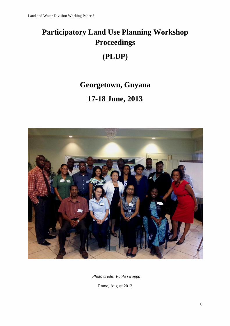
Georgetown, Guyana
17-18 June, 2013
OOD AND AGRICULTURE ORGANIZATION OF THE UNITED NATIONS
Participatory Land Use Planning Workshop
Land and Water Division Working Paper 5
0
Participatory Land Use Planning Workshop
Proceedings
(PLUP)
Georgetown, Guyana
17-18 June, 2013
Photo credit: Paolo Groppo
Rome, August 2013

Land and Water Division Working Paper 5
1
The views expressed in this paper are those of the authors and do not necessarily reflect the
views of the Food and Agriculture Organization of the United Nations FAO.
The designations employed and the presentation in this information product do not imply the
expression of any opinion whatsoever on the part of the Food and Agriculture Organization of
the United Nations (FAO) concerning the legal or developmental status of any country,
territory, city or area, or of its authorities, or concerning the delimitation of frontiers or
boundaries.
The mention of specific companies or products, irrespective of whether these have been
patented or not, does not imply that these have been endorsed or recommended by FAO in
preference to others of a similar nature that are not mentioned.

Land and Water Division Working Paper 5
2
AKNOWLEDGMENTS
This document was prepared under the technical direction of Paolo Groppo, Territorial
Development Officer (NRL) and Lystra Fletcher-Paul, Natural Resources Officer and FAO
Representative in Guyana, with the support of Jordan Treakle and Margherita Brunori from
the Land and Water Division (NRL).
FAO also thanks Riccardo Biancalani, former Chief Technical Advisor of FAO project
Inventory of Post-War Situation of Land Resources in Bosnia and Herzegovina project
(GCP/BIH/002/ITA), Sylvia Clementi, consultant on the same project and all the participants
to the workshop who contributed with their comments and contributions to the preparation of
this document.

Land and Water Division Working Paper 5
3
Table of Contents
INTRODUCTION 5
PARTICIPATORY LAND USE PLANNING WORKSHOP 6
TERRITORIAL/LANDSCAPE FACILITATION 10
How to manage a group: Working Group Management 13
THE PARTICIPATORY DIMENSION IN PLUP 20
Major warning for participatory techniques 20
Conditions for the success of participatory approaches 22
What are the tools? (Overview of existing tools) 23
Who are the stakeholders? 24
Power analysis 29
What to say to stakeholders to create awareness? 29
How can stakeholders participate? 30
What are the outcomes of a participatory land use planning process? 30
Seek for a consensus 31
Land Conflict Management 34
The outcome: Social Territorial Pact 35
CASE STUDIES 40
WORKING GROUPS 43
GENERAL FINDINGS AND RECOMMENDATIONS 46
Annex 1: List of Participants 49
Annex 2: Draft Annotated Agenda 51
Annex 3: Opening Remarks by Ms. Lystra-Fletcher, FAOR 52
Annex 4: Participatory Land Use Development: experiences in some
municipalities in Bosnia and Herzegovina 54
Annex 5: PowerPoint presentations by Participants:
Barbados 66
Santa Lucia 67
Antigua 69
Guyana 70
Annex 6: More details on tools 71
A-Economical Ecological Zoning 71
B- Interviews: Key informants / stakeholder analysis 71
C- SWOT analysis (Strengths, Weaknesses, Opportunities and
Threats) during a meeting 72
D- Problem tree analysis during a meeting 74
E- Table of analysis during a meeting 77
F- Venn diagrams during a meeting 77
G- Role-play during a meeting 79
H- Scenario writing during a meeting 80

Land and Water Division Working Paper 5
4
References 82

Land and Water Division Working Paper 5
5
INTRODUCTION
Participatory Land Use Planning (PLUP) has been gaining international recognition as an
important tool for managing local resources. Participatory Land Use Planning is the systematic
assessment of physical, social and economic factors in such a way as to encourage and assist
land users in selecting options that increase their productivity, are sustainable, and meet the
needs of society1.
PLUP puts local users in the centre of interest, calls for the use of simple, low-cost planning
techniques to foster active participation and to find a consensus among them. PLUP thus aims
at making the best use of the available resources, both in the interest of achieving sustainability
and finding effective compromises and solutions with available funds and capacities or
defining what could be supported by external help.
The origin of this training workshop dates back to an initial request by some of the English
speaking Caribbean countries in the course of 2012. A draft concept note was then prepared to
start framing the possible intervention it. Main elements were:
- Sustainable land management (SLM) is a critical issue. Poor land management
contributes to soil degradation and reduced productivity, biodiversity loss and missed
economic opportunities among many other issues, with direct negative impacts on
poverty, inequity, safety and other development processes. SLM, on the other hand,
contributes to food production and security, integrated planning and development, new
economic opportunities, enhanced and diversified rural livelihoods, disaster risk
reduction, climate change adaptation and biodiversity conservation.
- The objectives of SLM could not be achieved without adequate land use planning to
manage and harmonize multiple and at times conflicting land uses, to build resilience
and mechanisms to cope with rapid change, and to ensure that the way land is used
contributes optimally to social and economic development without compromising
cultural integrity and environmental sustainability. Effective land use planning is
critically needed, but the traditional, “top-down” approach to planning appears no
longer appropriate due to the weakening of many central planning agencies in the
region (in part as a result of a weakening of the fiscal base), capacity issues in planning
and enforcement, and because of the complexity of the issues to be addressed.
- A participatory approach to land use planning is therefore needed, because it can: (a) mesh
and harmonize several planning instruments from the national to the local level; (b) build the
capacity of stakeholders to adapt and respond to change, (c) validate and incorporate local
1 The proposed approach is inspired by many field experiences as well as methodological proposals elaborated by
FAO, in particular:
FAO. 2005. Participatory and Negotiated Territorial Development (PNTD). Rome. (Also available at
http://www.fao.org/sd/dim_pe2/pe2_050402a1_en.htm);
FAO. 2005. Negotiation and mediation techniques for natural resource management.Rome. (Also available at
http://www.fao.org/docrep/008/a0032e/a0032e00.htm#Contents);
FAO. 2004.Participatory Land Use Development in the Municipalities of Bosnia and Herzegovina (PLUD).
Rome. (Also available at
http://www.fao.org/fileadmin/user_upload/Europe/documents/Publications/BAguidelines_en.pdf ); and
FAO.1993. Guidelines for Land Use Planning. Rome. (Also available at
http://www.fao.org/docrep/t0715e/t0715e00.HTM ).
Land and Water Division Working Paper 5
6
knowledge and perspectives into the planning process; and (d) generate greater commitment
towards implementation among governmental agencies, the private sector, communities and
civil society.
There is no single instrument or methodology for participatory land use planning in the region,
but there are several innovative and valuable experiences in several Caribbean countries,
which should be documented, analysed and used towards the formulation of guidelines and the
identification of good practices suited to the needs and conditions of the Caribbean.
PARTICIPATORY LAND USE PLANNING WORKSHOP
The objectives of the workshop were:
To present FAO developments in relation to specific components of the land use
planning area of work, with a specific focus on Participation, Negotiation, the
Gender dimension and Facilitation skills.
To share the experiences of selected Caribbean countries in land use planning.
To present concrete case studies of a medium-long term FAO field project and
lessons learned.
To discuss practical follow-up recommendations to mainstream these findings into
the policies, laws and institutional framework of the interested countries, as well as
to prepare the groundwork for possible technical assistance by FAO on these
matters.
The agenda is attached in Annex 2, together with the list of participants (Annex 1).
The opening session was composed by three speeches:
Opening remarks by Ms Fletcher-Paul (Annex 3), followed by a welcome address by Mr
George Jervis, Permanent Secretary, Ministry of Agriculture and Mr Joslyn Mc Kenzie,
Permanent Secretary Ministry of Natural Resources and the Environment.
The training exercise was presented as an opportunity to overcome prejudice and to change.
The course offered the participants a way to go beyond the traditional “participatory”
dimension of planning, thus approaching the principles of territorial negotiation/landscape
approach, starting from the participants visions and experiences. The aim was to build the
methodological bases together, so that a locally based PLUP “will be born within the
participants”, and it would not be seen as an external suggestion.
In the pedagogical field it is crucial to create a flexible atmosphere and to release individuals
and groups from the standards presented by the traditional planning approaches, which are
sometimes rigid, top-down and centralized. This is why adequate space was given in the
programme for an initial ice breaking game, aimed at facilitating the interaction between
participants.
The aim was to promote the adoption of a pedagogical attitude to enhance the capacity building
process. In order to create a new opportunity for institutional updating and to provide

Land and Water Division Working Paper 5
7
development skills, it is crucial to use a really broadminded pedagogy, with no imposition,
preconception or conventional point of reference.
It was also very important for the participants to “learn a method”, as well as to meditate as a
group and to come out of the course deeply convinced that the method of dialogue, negotiation
and respect for one another is the constituent of a new vision of development.
The table below depicts the basic concepts presented during the presentations and working
groups sessions:
Concepts suggested/discussed during the
presentations
Key words to be remembered
Development: it doesn’t relate just to economy.
It is a cluster of different elements, with people
at the core of it
SYSTEM - ENVIRONMENT
Territory: evolution of its meaning (towards the
“social construction”)
TERRITORY
Sustainability: development is not confined to
us; it has to do with the future generations as
well
SUSTAINABILITY – FUTURE
GENERATIONS
Centralized and decentralized approach HOMOGENEITY AND NON
HOMOGENEITY
DIFFERENT APPROACHES TO THE
POPULATION
Participation: everybody has the right to take
part in development choices and taking part
implies more than merely being informed of the
background issues
PARTICIPATION – INFORMATION
COMMUNICATION
Negotiation: even weak actors need to be able to
protect their rights. Strong actors need to learn
to communicate with the weaker actors
NEGOTIATION – RIGHTS PROTECTION –
SOCIAL MOVEMENT
Dialogue: we need to communicate more.
Acknowledging our mistakes can help us
develop more effective and sustainable
practices and lifestyles. We have to accept one
other, use respect, not force. It is important to
recognize every actor’s social legitimacy
DIALOGUE – JUSTICE – DREAM
–PRAGMATISM
We have to voluntarily put ourselves in the
position to listen to all those interlocutors who
risk isolation because of socioeconomic,
ideological, or ethnical reasons
ISOLATION
Dialogue is not possible without flexibility and
without the ability to let oneself be spurred on
by external forces
LISTENING – OPEN-MINDEDNESS -
CHANGE

Land and Water Division Working Paper 5
8
Facilitation oscillates between these two
concepts
EMPOWERMENT - ADVOCACY
To define the rules of the dialogue, to gain the
other’s trust
ESTABLISHMENT OF A DIALOGUE
MECHANISM
A basic collaboration is an agreement among
the actors, that approve one each other’s
legitimacy and power, in order to define
problems and suggest solutions
AGREEMENT BUILDING PROCESS
During the presentation and when presenting/discussing field case studies, the evolution of the
concept of land was also discussed and top-down versus bottom-up approaches were
compared:
LAND INCLUDING HUMAN
POPULATIONS
We must outline that it is impossible to deal
with land (and natural resources) issues without
considering that actors live and depend on the
territory. The objective is to avoid a
“technocratic” reading of the territory (each
expert has a different point of view, according to
his background as an agronomist, economist,
etc.) but to stimulate a common reflection
Readers should keep in mind that throughout
the present document the words land and land
resources are used in a wide sense, and imply
not only the land surface and its attributes, such
as climate, but also associated resources, such
as water, plant, animal and human populations,
settlement patterns, and the results of human
activity. (FAO-UNEP, 1997).
Centralized and top-down approach
Decentralized and client-driven approach
Implement decisions taken by a small group of
decision-makers at central level without
knowledge of the socio-economic reality at
village and district level
Different village groups at district level with
different interests and strategies become
partners, expressing their opinion, developing
strategies and analysing the constraints and
opportunities with the assistance of experts
Hypothesis: homogeneous and harmonious
societies at village level
Hypothesis: societies at village level divided
into socio-economic strata and with conflicts
Technological innovations developed by
research centers, tested by a limited number of
“pilot farmers”
The generation and dissemination of innovative
techniques resulting from joint research
between researchers and farmers in viable
technologies chosen from an initially proposed
“technological menu”
Community members are considered as
beneficiaries or as persons that need to be
assisted
Community members are considered as
protagonists and partners
Rare and weak forms of self-organization Widespread and viable forms of

Land and Water Division Working Paper 5
9
self-organization
High degree of administrative centralization The administrative decentralization process is
well developed
The rhythm of change is fast, rigid and imposed
by administration
The rhythm of change is time consuming,
flexible and negotiated between the population
and administration

Land and Water Division Working Paper 5
10
TERRITORIAL/LANDSCAPE FACILITATION
A specific session of the Workshop was dedicated to highlight the profile, role and skills
needed for the Facilitation team who has a central role to play in such a negotiated approach.
Understanding stakeholders and the enabling environment are the conditions for implementing
a participatory process in land use planning.
The Territorial Facilitator should be seen as a traveller towards the others and oneself;
therefore its fellow travellers are communication and relation. These, and other eternally
recurrent questions, are two crucial human problems and, just like all the others big issues of
life, they will never be conclusively resolved.
To activate a process of dialogue among public and private stakeholders on territorial issues,
trust and confidence need to be built and maintained. It takes time and a CDC (Curiosity, Doubt
and Critical spirit) attitude must be adopted. The (Team of) specialist(s) behave as “territorial
doctor(s)”, always wondering WHY the situation is like it is and looks for coherence. Learning
is at the heart of a participatory planning process. It has to be well prepared and organized and
the facilitator activates the dialogue by disseminating the information and looking for a
common interest among stakeholders.
The tasks and basic skills necessary for the process of territorial negotiation are, by definition,
multiple and unsettled, meaning that, even if they concern natural resources (access, use and
managing of the land, waters, etc…) the negotiation could start from matters not directly
related to those at stake (health or educational problems, or others), therefore it is necessary to
have a systemic vision to be able to refer to experts of the specific areas of interest, according to
the current processes.
To summarize we can categorize these tasks in the following groups:

Land and Water Division Working Paper 5
11
A- Pre-Meeting: what you should know.
It is crucial to build a relaxed, convivial climate. Don’t lose your sense of humour. Do not
express your opinion (or don’t let it show on any given subject). Impartiality is important.
Act as an honest broker.
The first step is to define the objectives you want from the work session. Prepare your work
session materials. Try to identify the main different moments in the work session, the input
needed and the expected output.
Plan your daily schedule with timing. Be focused, goal-oriented, determined but with empathy
and flexibility.
B- Communicate
An open ear
What for?
Who? Says what? To whom?
With what impact?
This process entails doing, listening and discussion. In this process, people create their own
rules, such as the amount of debate time allotted for each participant, how to communicate with
one another or even the procedure for the creation of monthly reports or of sanctions.
Try to have as much knowledge about the area, its history, planning conflicts and individual
stakeholders’ interests. The communicative goals are to stimulate social life, an understanding
of the environment and ways to act upon it, changes, strengths, weaknesses and constraints in
the territory. Keep the discussion alive and ensure that everybody has a common
understanding. You need to inform the participants and to be receptive to their information.
Minimize the message’s deformation and be sure to understand it well. Do we speak the same
language? Ask for a repeat and a reformulating of the information given.
Remember the 4 Rs: Realistic, Resume, Reformulate and Redefine. This simply means to make
sure that what you are trying to accomplish is accessible to everyone’s understanding or
capacities and make sure the main points can be easily reviewed. Use examples, comparisons,
logical cause to effect arguments but remember that your attitude, your body language and
behaviour are more important than your speech. Inspire confidence and have a relaxed attitude,
maintain eye contact when answering questions and keep the attention of the other participants.
Be professional and summarize. Seat people together in a circle or a square. Everyone must be
able to follow the process, so always be available, honest and open.
To sum up, be enthusiastic and positive, intervene to be constructive, fix the problems right
away, be gentle and tolerant, use humour, pictures, drawings or sketch plans. Plan, organize
and prepare well, manage people and time, keep going, don’t slow down, make sure everyone
is comfortable, keep things as simple as possible, get to the heart of issues, to what people are
saying, record accurately and synthesize.

Land and Water Division Working Paper 5
12
If you have a problem, deal with it right away. If someone does something completely different
or unacceptable, take care of it. Don’t let the problem remain. Remember to always be gentle
and tolerant. Never raise your voice or cut someone off. Ensure there is only one discussion at
any one time and that only one person is speaking at a time. Don’t overreact, silence is
sometimes golden. Never allow aggression; re-orient attacks, don’t answer them.
C- Listen
Listen carefully. When answering someone, repeat his position. Reformulate to be sure to have
understood well. Listen carefully, communicate well, understand the process, negotiate well
and manage conflicts.
When answering someone, replicate his position so that everyone has heard it. Be specific.
Inspire confidence but most importantly, remain neutral, keep eye contact, be patient, calm,
persistent, honest, open, warm, caring, confident, collaborative, coherent, logical, flexible and
energetic.
D- Express
Express yourself clearly without abusing people’s time. Allow everyone to express themselves.
Let those who speak less often feel integrated in the debate. Make sure everyone is heard and
has equal access. Get actors to explain their positions. Intervene to bring constructive elements
and keep an open expression (good tone of voice and gestures).
Free expression allows the understanding of the others’ positions and of their practices.
E- Animate
To animate is to give life to collaboration. Be active, don’t monopolize or let others
monopolize the discussions, make it diverse and interesting. These meetings must be
understood as a golden moment of exchange and assembly, which encourage cooperation.
Clarify issues, expectations and fears. This is everyone’s project. The actors must accept it and
acknowledge a greater and more complex reality. Share information, maintain motivation,
adapt activities and coordinate. Your main concern is to help the group analyse the situation
and to grasp a more desirable potential one. For this, you must understand each actor’s
motivations. The actors think in two ways: what to gain and what to lose.
At the beginning, they are fearful. It is important to start by building confidence between them.
Winning trust takes time and ensuring constructive debates is the key to this process. Use
Icebreakers to get people talking.
Newspaper Trick: take one double page of a current broadsheet newspaper and tear it into 10 -
16 pieces. Hand out the pieces so that each member of the group has at least one piece. They
then spend a few minutes re-assembling the double page. This gets people talking and working
together.
Another goal is to share knowledge and to learn to work together efficiently.
Remind people of what they are doing.
1.Tell them what you are going to tell them. (Introduction)
2.Tell it to them. (Development)
3.Tell them what you told them. (Conclusion)

Land and Water Division Working Paper 5
13
Use short mini-exercises (such as role-playing) or concrete examples to help clarify some
points. Use charts and point to them.
Have a checklist of the work session consisting of
1. Time
2. Goals
3. Activities
4. Conclusions (arrangements for session monitoring and future scheduling).
Possible ideas for discussion: communications, economic development (industry, commerce,
agriculture, tourism), environment, research and information dissemination, services (culture,
sports, leisure…).
Example of a workshop on territorial assets:
1. Welcome, introduction (15 minutes)= people meet and present themselves.
Question: what is the most important activity in your life? (brief chat).
2. Putting it into context (10 minutes)= coordinator discusses the work session’s
objectives. Territorial assets identification.
3. Reflection (15 minutes)= identify territorial assets, opportunities of
improvement. Each participant thinks up an asset linked to an opportunity.
4. Identify area of assets and opportunities (20 minutes). Using a chart, write an
asset and an opportunity. The group decides if it is important and discusses why,
whom and where it affects.
5. What are the priorities? (30 minutes). Look at the chart of all the assets and
opportunities. Why are these important and others not? Are there any surprises?
What do these surprises mean? Would you change your mind? What is viable
and what are alternative possibilities? Use sheets to write up these questions.
6. Summarize the activities. Make sub-groups (45minutes). Discussion to
determine who will want to work on which asset:
i. Discuss strengths, weaknesses, opportunities and constraints.
ii. Resume key points.
7. Participants present the key points to other groups (30 minutes).
8. Evaluate the session asking for feedback and suggestions for the next meeting
and animator thanks everyone (15 minutes).
How to manage a group: Working Group Management
Working Groups may have two different kinds of participants: members and experts. Members
and experts are invited from key players in a particular thematic community concerned and are
expected to prepare themselves for the working group meetings and to participate actively in
the meetings’ discussions.
Members will be asked to perform work in support of the Working Groups mandate. To
co-ordinate amongst themselves and with the Working Group coordinator, members may meet
in a smaller subgroup.
Experts should be invited to participate in specific Working Group meetings when a wide
range of opinions are sought and a wide distribution of knowledge is required.

Land and Water Division Working Paper 5
14
A- Management Team
Each Working Group will be organized around a regional coordinator and a note-taker
appointed to follow the activities. The note-taker will be selected on a voluntary basis among
the participants.
Regional coordinator
The regional coordinator should be a person stemming from the thematic community
concerned. S/he will ensure the technical management of the Group and will work in close
co-ordination with the Working Group’s note-taker, and the technical expert following the
activities of the Group. S/he will establish the work plan with the Working Groups and
facilitate the discussions during the meetings.
Note-taker
The Working Group’s note-taker will be in charge of writing the draft minutes of the meetings.
S/he will make sure that all points of discussion have been properly reported and will have to
work in close collaboration with the regional coordinator.
Technical expert
S/he will provide the interface with the Technical Institutes and with the Working Groups. S/he
will participate in the meetings of the Working Groups when his technical advice is needed. In
particulars, s/he will keep the Technical Institutes informed about the progress and the results
obtained and will inform the regional coordinator of possible re-orientations or new directives
based on his/her technical advisory skills (farming system analysis, soil suitability, etc…).
B- Operation and management suggestions
Each Working Group will be formed on the basis of agreed:

Land and Water Division Working Paper 5
15
• Terms of Reference for the work plan;
• List of members and experts;
• Management rules for the Working Groups.
Meeting scheduling
At the first meeting, the regional coordinator will send invitations and remind participants of
meeting dates. Each invitation will be sent at the end of the work session. In event that it is
impossible to set a specific meeting date, the expert or member may, in advance, inform the
regional coordinator of the Group and propose an expert (with appropriate skills) of his
organisation to participate in the meeting in his/her place.
After each meeting, minutes will be drafted by the note-taker, written by the regional
coordinator and distributed to the participants. The Group will review them during the next
session and will be invited to comment on them.
Every persons participating in the Group, either as a member or as an expert, will receive the
draft minutes of the last meeting before the new session to be able to better prepare him/herself
and to actively participate in the meetings.
For each group of key issues to be addressed, a preparatory group of members will be organised
and will meet for one or several meetings, as required. When required, Working Group outputs
will be presented to a larger group of experts to consolidate and validate the Working Group’s
results.
Assessment of Working Groups
The Working Groups are a relevant element of this exercise. In particular the following three
elements will be the subject of assessments for Working Group participants:
• The meetings themselves.
• The related documents produced by the land use planning team.
• The overall impact of the Working Group’s results.
Participants and Experts are asked to give some of their time to support this effort.
Representation and Participation rules to be defined with the participants
The following points have to be considered as a thematic outline of working rules’ suggestion.
1.The personal integrity and values of each participant will be respected by the other
participants and the motivations and intentions of participants will not be criticized.
2. Every member will communicate with his/her respective organization and will be
responsible for keeping them apprised of ongoing review processes and project timelines.
Significant comments and questions expressed by the organization will be communicated back
to the Working Group at its next regular meeting.
3. The personal integrity, values and legitimacy of the interests of each participant will be
respected by other participants. Participants are requested to use active listening and to speak
one at a time. Everyone will participate in discussions, no one will dominate.

Land and Water Division Working Paper 5
16
4. Every member is responsible for communicating his/her position on issues under
consideration. It is incumbent upon each member to state the interests of the organization they
represent. Voicing these interests is essential to enable meaningful dialogue and full
consideration of issues by the Working Group. After a decision is made, no member will work
to undermine that decision.
5. Participants agree to read the background information provided before each meeting and to
be prepared to effectively discuss issues on the agenda. Information is needed at a minimum of
four working days prior to a meeting.
6. If a participant must miss a meeting, that he/she will communicate his or her comments
orally or in writing to the Working Group or to the regional coordinator at least two days before
the scheduled meeting. Participants may also contact the regional coordinator between
meetings at any time to discuss their concerns and needs related to this dialogue. If requested
by the participants, these discussions may be treated as confidential with the regional
coordinator.
7. In order to establish group trust, consistent participation is strongly encouraged.
8. The membership of the Working Group is established with the intention of having operating
rules. These Operating Rules may be refined and new terms added at the discretion of the
Working Group. However, all revisions shall be by consensus of the Working Group.
9. Resignation and Replacement of a Working Group member. In the event that an existing
member is no longer able to participate in the Working Group, said member will notify the
Working Group in writing of his/her resignation and may recommend a replacement member
from their organization. Upon receipt of the resignation letter, the Working Group will either
accept the recommended replacement or suggest a different individual who is of the same type
of constituency as the person leaving the Working Group. If acceptable to the Working Group,
the proposed replacement individual will be recommended for appointment by the regional
coordinator.
10.Topic-specific subcommittees may be convened (as appropriate) to further discuss planning
process issues and to develop advisory documents on key topics. The Working Group prior to
initiating work will approve the composition of all subcommittees.
11. Information Sharing and Joint Fact-Finding
The parties will freely exchange documents and other information, excluding privileged or
confidential information. Individual members are free to discuss the work of the Working
Group with other Working Group members outside of meetings and with members of other
related planning efforts.
The selected experts will work together to analyse the options and report to the Working Group
their points of agreement and disagreement, as well as the reasoning behind their conclusions.
While this approach cannot be expected to resolve all issues, it will provide the Working Group
with the information that does exist. It will also clearly identify areas of unavoidable
uncertainty and disagreement.
12. Decision-Making Processes

Land and Water Division Working Paper 5
17
Decisions will not be made lightly and Working Group members understand that decisions will
frame future actions. It is the responsibility of all Working Group members to keep the process
and meetings on track and focused.
As the participants discuss and make decisions on issues, the regional coordinator will draft
language that reflects the emerging consensus of the participants. Draft statements that are
prepared in this manner will then be circulated for review by all participants during and after
meetings. The regional coordinator will then integrate comments into a revised statement,
which in turn will be presented to the next meeting where s/he will seek further discussion and
possible ratification. This pattern of drafting, revising and ratification will be the primary
method of seeking agreements that emerge from discussions held by the participants.
The Working Group will strive to achieve decisions by consensus. In seeking consensus, each
member has an obligation to articulate interests, propose alternatives, listen to proposals and
build agreements by negotiating a recommendation for adoption by the full Working Group. In
exchange, each member has the right to expect: a full articulation of agreements and areas of
disagreement (if any exist) and an opportunity to revisit issues on the grounds of substantial
new information becoming available during the Working Group’s deliberations.
Definition of Consensus: The Working Group defines consensus as “unanimous agreement by
the Working Group members”.
The Group will utilize the following operational interpretation of consensus: “Consensus is a
process used to find the highest level of agreement without dividing the participants into
factions. Everyone in the group supports, agrees to, or can accept a particular decision”2.
In seeking consensus on an interim or final recommendation, it is understood that members
should voice their concerns with specific proposals along the way, rather than wait until a final
recommendation has been developed. In addition, the Working Group will use the following
three levels to indicate a member’s degree of approval and support for any proposal or decision
being considered by the Working Group, and to determine the degree of consensus in the
Working Group:
NO: I do not agree with the proposal. I feel the need to block its adoption and propose an
alternative.
OK: I may not be enthusiastic about it, but I can accept the proposal.
YES: I think this proposal is the best choice among the options available to us.
The goal is for all members of the Working Group to be in the “YES”, or “OK” levels of
agreement. The Working Group will be considered to have reached consensus if all members
are at those two levels. If any member of the Working Group is at a “NO” level, the Working
Group will stop and evaluate how best to proceed.
C- Behaviour management
The goal of effective behaviour management is to assist people in making positive decisions
about their own behaviour and actions. The goal is not simply compliance but joyful
participation. Effective behaviour management begins by creating a safe, secure, and
2Clementi S., June 2004. Support guidelines for a participatory process in land use planning (PLUP) Mission Report (Unpublished) to
project. Project Gcp/Bih/002/Ita, Inventory Of The Post-War Situation Of Land Ressources In Bosnia And Herzegovina. P. 7.

Land and Water Division Working Paper 5
18
comfortable setting for the group's activities. When the needs for security, belonging and
recognition are being met, acting out and misbehaviour will less likely occur.
A Well-Planned Program
Effective behaviour management is rooted in good program organization and strong
leadership. Well-prepared, relevant and exciting programs will capture the imagination and
energy of the participants and will deter disruptive and negative behaviour patterns.When they
are actively engaged, participants do not succumb to the monotony or discouragement that lead
to negative behaviour.
Individual Attention
By observing individual participants in the program, leaders can anticipate problems and look
for ways to challenge and involve bored or drifting members. Many behavioural problems
result from inattention or neglecting to act on small problems. It is a constant challenge to find
effective ways to engage each participant when each has varied interests and needs.
Work as a Team
Group members will commit to group goals and expectations when they have had a part in
setting those targets. Members who have chosen expectations together will be more likely to
work cooperatively in achieving the Group’s goals.
Clear Expectations
Uncertainty and confusion add stress to individuals and groups and can lead to acting-out
behaviour. When norms of group behaviour are simple and clear, members then generally
respond well. Too many rules, constantly changing expectations, or unclear consequences
often set the stage for negative behaviour.
Respond Rather than React
Quick reactions and immediate action are needed when someone is in great danger. Instinctive
human responses and reflex actions save lives in such situations. With most behaviour
however, a well thought out response is better than a quick reaction. Leaders who are known
for balanced and well thought out responses will gain both respect and authority in leading
groups.
Addressing Negative Behaviour
Some behaviour, however, is either so unsafe or so disruptive that it must be addressed.
Responses should be immediate, consistent, and fair. They should also be related to the
violation, appropriate to the severity of the violation, and should only be made when the intent
is to follow through. Some behaviour can be addressed in front of the group and some require a
private setting.
Consistent and related to the violation: Leaders gain respect in a group when they treat persons
and situations equally. Inconsistency will undermine both group unity and the leader’s
effectiveness.

Land and Water Division Working Paper 5
19
Levels of Consequence
Begin with the least restrictive response. In any case, take it easy. Do not dramatize tense
moments of discussion. Hopefully, trouble will be solved before many levels of consequence
are needed. Seek to engage the concerned member in positive choices by reinforcing positive
behaviour.
Monitoring Our Response
When dealing with unacceptable behaviour, it is important that a facilitator monitor his/her
feelings while confronting or correcting the behaviour. The group’s responses are more
effective when reason balances the energy of negative emotions like anger, fear, or frustration.
The Behaviour Policy sets limits on discipline. Physical and verbal abuse of any kind is not
permitted. Monitoring feelings and discussing those feelings with a wise facilitator will help to
keep all responses within proper bounds.

Land and Water Division Working Paper 5
20
THE PARTICIPATORY DIMENSION IN PLUP
The PLUP approach is a step-wise process whose required tasks can be realized according to
these simple questions:
What is the present situation of land use?
Assess the present situation and factors influencing land use compare it if possible with
the past situation and highlight the major event impacting the identified changes
(socio-economic conditions, demographic trends, farming systems, available extension
services, outside land use claims, legal frameworks, decentralized bodies and
decision-making processes of the local administration).
Recognize all stakeholders and analyse their position, resources, interests,
relationships, influence, etc...
Assess the present territorial assets and needs of the local population in terms of land
for different uses.
Identify areas or purpose of conflict between competitive or incompatible uses.
Which uses need to be changed and which ones do not?
Assess the future needs of land for its different uses.
Evaluate the land’s ability to satisfy the identified needs and the conditions that have to
be fit together.
Identify unsustainable land use practices.
Identify ways to resolve conflicting or competitive uses.
How can changes be made and what are the best options?
Seek sustainable land use options.
Identify and evaluate the technological innovations.
Identify the service and training requirements.
Negotiate those options that best fit with the identified needs.
How, when and by whom can the changes be implemented?
Document the desired changes.
Prepare the planned structure for the implementation of the agreed options and the
required actions and tasks to be taken.
PLUP as a bottom-up approach focuses on planning at a local level. Nevertheless, important
activities related to land use planning have to be carried out at higher administrative levels. The
main responsibilities and tasks of higher-level activities are to create the framework conditions
in which a local-level PLUP can be effectively implemented.
Major warning for participatory techniques
Some issues of participatory techniques should be kept in mind:
Illusion of a transparent dialogue.

Land and Water Division Working Paper 5
21
Analyzing and synthesizing abilities.
Weight of the project’s logic.
What prioritization means when confronted with a legitimate proposition.
No end result guarantee.
Prerequisites for participatory diagnosis and land use: managing local reality and project
interface:
General framework and schedule.
Identification of thematic actions.
Specification of complementary diagnosis, if necessary.
Selection of appropriate tools.
Modalities of starting up, realization of the whole process, feedback collection and
performance evaluation.
Recognizing natural group leaders, animators, etc...
Information pertinence.
Negotiation of priority with stakeholders, nature and modalities of the relationships
among them.
From answering these points, a strategy can be built combining individual interviews, field
observations, meetings and workshops, negotiation tables, etc…
Once the conditions to facilitate the organization of the participation has been satisfied, these
following activities summarize briefly what kind of process such participatory land use
planning exercises could be.
Examples of a work plan for a participatory land use planning process
Identifying the stakeholders (stakeholder map).
Brainstorming meeting on assets, opportunities, needs and problems.
Creating working groups according to the stakeholders’ main interests.
Meeting to agree on the rules of the game and on communication mechanisms.
Using EEZ maps and other information to support the analysis of problems, needs and
opportunities.
Formulating and evaluating possible options for the improvement of land use.
Reporting groups’ proposal to the other working groups during a general workshop.
Negotiating overall future land use.
INVENTORY AND
INFORMATION ON LAND
SENSITIZED AND
INFORMED MUNICIPALITY
AND LAND USERS
ECOLOGICAL
ECONOMIC ZONING
SOCIAL PACT ON FUTURE
LAND USE
AGRICULTURAL LAND DEVELOPMENT
PORTFOLIO
Land and Water Division Working Paper 5
22
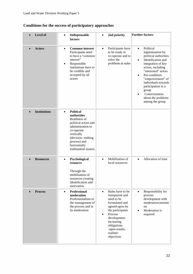
Conditions for the success of participatory approaches
Level of Indispensable
factors
2nd priority Further factors
Actors Common interest Participants need
to have a “common
interest”
Responsible
institutions have to
be credible and
accepted by all
actors
Participants have
to be ready to
co-operate and to
solve the
problems at stake
Political
legitimisation by
political authorities
Identification and
integration of key
actors, including
“interested” actors
Pre-condition:
“empowerment” of
individuals towards
participation in a
group
Consciousness
about the problems
among the group
Institutions Political
authorities Readiness of
political actors and
administration to
co-operate
vertically
(decision- making
process) and
horizontally
(substantial issues)
Resources Psychological
resource
Through the
mobilisation of
resources creating
identification and
motivation
Mobilisation of
local resources
Allocation of time
Process Professional
moderation
Professionalism in
the management of
the process and in
its moderation
Rules have to be
transparent and
need to be
formulated and
agreed-upon by
the participants
Process
development:
increasing
obligations
-open results,
realistic
objectives
Responsibility for
process
development with
moderation/animati
on
Moderation is
required

Land and Water Division Working Paper 5
23
What are the tools? (Overview of existing tools)
Participatory methods play an important role, since they are used to gain access to local
knowledge, provide the tools which allow efficient communication with local stakeholders and
to document the results.
Mapping techniques allow the creation of a reliable representation of the land use situation, to
localize and quantify land use changes and to provide a reference document. They help to point
out territorial dynamics, trends and changes.
To enable the local population to carry out the land use options, to
participate effectively in the planning process and to facilitate the
decision-making process in the community.
Creation of working groups
with local facilitators
To show and represent important aspects, like labour distribution,
mobility, etc, to visualize changes, trends and polarity for local
development etc.
Social mapping and
diagramming
To identify their needs, their strategies and interrelationships, the main
issues, constraints and potential areas of conflict.
Open questionnaires,
interviews with
stakeholders /
Stakeholders’ analysis
To come to a common understanding and agreement on the situation
in general, the activities, interests, contributions and opportunities for
new networks, the views of different groups, the perceived needs etc.
Community meetings and
workshops / SWOT analysis
Venn Diagram, Problem tree
analysis, Scenario writing.
To understand the position and the potential of the stakeholder (what
are their problems and their opportunities), who the actors are in the
local decision-making process, who the other stakeholders are and
what is the role of women in the local economy.
Participatory situation
analysis with key informant
doing interviews
Objective Tool
To create a base map and reference system which indicate the precise
location of planning units and its boundaries and to determine the area
of land units.
Topographic maps, GPS
measurements, GIS
To identify the location, quantity and distribution of land resources, to
facilitate discussion and document decisions on land use, to provide a
reliable basis for planning implementation to serve as reference for
future activities.
Land use maps,
Ecological-Economic. Zoning (EEZ)
To view and discuss ideas on land use, create a common
understanding between local land users, planners and other
stakeholders.
Transect walks and diagram
To discuss community boundaries, the land use situation, relative
extent and position of land use areas, planned land use changes and
other interventions with local users and stakeholders.
Village survey, sketch mapping,
topographic model
Objective Tool

Land and Water Division Working Paper 5
24
Who are the stakeholders?
How to identify and analyse the stakeholders?
A stakeholder is any individual, social group or institution that possesses a stake (or interest) in
the land use planning for agricultural development in our project. Stakeholders can be thought
of as those parties who are affected directly or indirectly by management decisions, in a
positive or negative way. It includes those who can influence such decisions, as well as those
who would like to influence decisions.
Key informants individual interviews or Workshops or focus group discussions are three out of
a range of techniques that can be used for this purpose. In all, the aim is for design and
management teams to have identified all key stakeholders and to be aware of their potential
impact on the activity and vice versa.
How to do a stakeholder analysis
Stakeholder analysis concerns the inventory and analysis of:
- current stakeholders and those potentially affected by future decisions;
- their characteristics, such as interest, power, control over resources, knowledge and
information, how they are organized or represented, and limitations for participation;
- their relationships with others, such as coalition, dependencies, conflicts and strategies;
- their influence and motivation towards decision making, including expectations, likely
gains and willingness to participate and invest resources.
A stakeholder analysis can be used to predict the support that can be expected and the
resistance that may be met in a participatory development process. It can be used to identify
weak parties who may need special assistance and support in order to participate effectively. It
can be used to avoid the pitfall of bypassing powerful stakeholders who can derail the process
if they so desire, and other stakeholders who depend on and affect the resource in substantial
ways.
Stakeholder analysis is a tool for planning and guiding participation in local development
management. It is done for particular settings, situations and activities because these determine
whom the stakeholders are in each case. Stakeholders’ perspectives and interests change over
time.
Individual interviews, with representative stakeholder groups, explore main issues,
perceptions, constraints and potential areas of conflict.
List the identified stakeholders in the first column and fill in the rest of the table according the
information collected through interviews and other data sources.

Land and Water Division Working Paper 5
25
Or use other methodology to your convenience
The use of workshops to undertake participatory Stakeholder Analysis is one method. It is not
the only means of undertaking an analysis, but it is a common one. It assumes that stakeholders
can be brought together and fairly represented in one space at one time, which may not always
be possible.
Stage 1: Form working groups
Stage 2: Inform participants about Stakeholder Analysis
Stage 3: Completing a Stakeholder Table
Participants should be asked to compile an initial Stakeholder Table for their own activity in
small groups. An hour is usually adequate for this purpose. Only the main stakeholders should
be listed at this stage, with no attempt to determine whether the stakeholders listed are key,
primary or secondary.
Here, a useful method for each group is to:
draw an outline table on a flipchart;
identify stakeholders in a brainstorming session using Post-Its to write them
down (one stakeholder per Post-It);
place the stakeholders in the first column of the table;
select (up to) ten main stakeholders. For each one, complete the other columns
(again using Post-Its);
check that no important stakeholders have been missed out. If they have, add
them in and complete the other columns for them also.
At the end of this phase, each group should present its findings to the others, followed by a
discussion to identify common ground and differences of opinion. It may be possible to agree
on a single table. If not, the facilitator should suggest that each group nominate one person to
produce a single stakeholder table.
Secondary
Stakeholder :
Indirect and passive
Primary
Stakeholder :Direct
and active
Implications on Project Program
Positive and negative
Interests
Goals, Needs, Wishes:
Openly expressed or hidden,
Motives:
Hope, expectations, fears
Attitude towards others:
Friendly, hostile, neutral
Characteristics
Their resources (financial,
social, material…), their
perceptions, their status, their
structure, their network:
relationships
Type:
Groups, institutions,
individuals who are
concerned and located
in the area or who may
affect the:
project/program

Land and Water Division Working Paper 5
26
Stage 4: Influence and importance
“Influence” is the power a stakeholder has to facilitate or impede the achievement of an
activity’s objectives. “Importance” is the priority given to satisfying the needs and interests of
each stakeholder.
In an urban livelihoods programme, local politicians may have a great “influence” over a
programme by facilitating or impeding the allocation of necessary resources, while the urban
poor (at least to start with) may have very little power to influence the outcome of the activity.
At the same time, local politicians may have very little “importance” as far as the activity is
concerned, since it is not designed to meet their needs, while the urban poor are central and
very important to it.
A specimen Table of Importance and Influence is shown as Box 2. From the initial stakeholder
table agreed by the participants, and using the headings shown in Box 2, list the main
stakeholders in the first column. Ask the whole group to agree on influence and importance
scores for each stakeholder, allowing sufficient time for discussion. To score each stakeholder,
use a five-point scale where 1= very little importance or influence, to 5 = very great importance
or influence.
Box 2: Table of Importance and Influence
Stakeholders Importance Influence
Small farmers 5 2
Food traders 1 3
Labourers 5 1
Moneylenders 1 4
Government officials 2 5
NGO 4 3
Once each stakeholder has been scored, the facilitator should introduce the Importance/
Influence Matrix, and the scores transferred from the Table of influence and importance. The
Matrix gives the relative locations of the various stakeholders.

Land and Water Division Working Paper 5
27
Importance/Influence Matrix.
It is important to pay particular attention to their inter-relationships
Whom do they know?
What are their relationships (direct or indirect, of collaboration, of conflict, of
neutrality?)
What is their system for acting? Collectively, individually or within the family?
What knowledge network do they use?
What are the interactions between local and external actors and, in particular, with
the institutions present on the territory and for collective actions being undertaken?
Below, you will find an example of a survey of inter-relations.
Two distinct aspects can be identified: the typology and characteristics of the relationships.
The typology refers to the space of the social structures in the rural areas and the characteristics
to the actors’ power. In this context power can mean either political power or the power to
express the productive and reproductive capacities of the rural families.
Types of relations:
- Political.
- Economic.
- Cultural (including gender).
- Legal.
Characteristics (qualifications) of relations:
- Antagonistic (an actor proposes their substitution).
- Conflicting (they have opposite interests vis-à-vis the objectives).
- Collaborative.
- Synergistic and complementary.
- Allied.
- Dominant/submissive/subordinate.
- Autonomous/dependent.
- Overlapping.
- Other.
Stakeholders must be accommodated
Stakeholders may become dangerous
or very supportive of the project if they
become interested
Stakeholders will have little
impact on the project
WEAK
INTEREST
Stakeholders in this segment
may prove helpful if they
become supporters of the project
STRONG
INTEREST
STRONG INFLUENCE WEAK INFLUENCE

Land and Water Division Working Paper 5
28
Create a matrix of the relations between the actors: one for each theme. One of the following
themes should be chosen: land occupation, production line, political power, production
network. Other themes can also be chosen. A definition of the characteristic should be placed in
each cell.
Theme chosen
Actor 1 Actor 2 Actor n
Actor 1 political: political:
economic: economic:
cultural (gender): cultural (gender):
legal: legal:
Actor 2 political: political:
economic: economic:
cultural (gender): cultural (gender):
legal: legal:
Actor n political: political:
economic: economic:
cultural (gender): cultural (gender):
legal: legal:
Prepare Venn charts (see annexes for more details on tools) for the actors being surveyed in
order to specify the external and internal organisations/groups/important persons active in the
community.
the importance given by the actors to the government and non-governmental
institutions with whom they deal with;
how important the impact of these institutions is considered by the actors on their
socio-productive conditions;
the level of proximity, affinity and identification with these institutions.
Final synthesis of the relationships of the actors, by highlighting:
critical points;
emerging trends and changes in line with the foreseen evolution at the macro, meso and
micro levels of each of the four themes mentioned above and their potentials.
Land and Water Division Working Paper 5
29
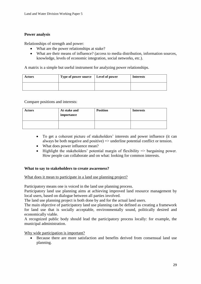
Power analysis
Relationships of strength and power:
What are the power relationships at stake?
What are their means of influence? (access to media distribution, information sources,
knowledge, levels of economic integration, social networks, etc.).
A matrix is a simple but useful instrument for analyzing power relationships.
Actors Type of power source Level of power Interests
Compare positions and interests:
Actors At stake and
importance
Position Interests
To get a coherent picture of stakeholders’ interests and power influence (it can
always be both negative and positive) => underline potential conflict or tension.
What does power influence mean?
Highlight the stakeholders’ potential margin of flexibility => bargaining power.
How people can collaborate and on what: looking for common interests.
What to say to stakeholders to create awareness?
What does it mean to participate in a land use planning project?
Participatory means one is voiced in the land use planning process.
Participatory land use planning aims at achieving improved land resource management by
local users, based on dialogue between all parties involved.
The land use planning project is both done by and for the actual land users.
The main objective of participatory land use planning can be defined as creating a framework
for land use that is socially acceptable, environmentally sound, politically desired and
economically viable.
A recognized public body should lead the participatory process locally: for example, the
municipal administration.
Why wide participation is important?
Because there are more satisfaction and benefits derived from consensual land use
planning.

Land and Water Division Working Paper 5
30
The exercise of land-use planning tries to iiddeennttiiffyy llaanndd--uussee ooppttiioonnss tthhaatt aarree aacccceeppttaabbllee ttoo aallll
ssttaakkeehhoollddeerrss and to satisfy the needs of all parties involved. Local land users must agree with
the results of the planning process, as tthheeyy wwiillll hhaavvee ttoo lliivvee wwiitthh iitt..
For land users: Interests are declared and possibly considered in the decision-making
process.
For local administrations: increase of credibility, easier implementation of decisions,
reduced conflict on land use.
How can stakeholders participate?
People will not participate in a participatory process unless they see some gain in doing so.
Being able to participate in this land use planning process implies following some basic
principles.
These are some basic principles of participation:
- Commitment on a voluntary basis.
- Agreement on the freedom of speech principle.
- Respect for others’ opinions.
- Participation as genuine partners.
- Transparency of the process: continuous access to information.
- Sharing and creating information: stakeholder is fully informed on issues at stake.
- Willingness for seeking a consensus during negotiation on options for future land use.
People participate in joint analysis which leads to action plan proposals and the formation of a
new local institution or the strengthening of existing ones.
The objectives considered in land use planning are those of the stakeholders, so it therefore
follows that the stakeholders should formulate them. Clear specification of differing objectives
provides the basis for defining and evaluating improved types of land use aimed at satisfying
all of them as far as possible.
What are the outcomes of a participatory land use planning process?
An open dialogue on land issues to promote local democracy on land resources management
Improved land-use options for local development based on a consensus
SOCIAL TERRITORIAL PACT
LAND DEVELOPMENT PORTFOLIO

Land and Water Division Working Paper 5
31
Seek for a consensus
Working Group proposal
Each Working Group should formulate the project proposal(s) in a standard model. Below is a
suggestion of a project proposal presentation. Add to the description document a design, a map
and other visual materials for the project proposal. Documents should not exceed 8-10 pages.
1. Cover page
The cover page includes the area concerned (photo), project title, Working Group’s name, etc.
Make it brief, simple and pleasant.
2. Executive Summary Provide a short summary of the goal, purposes, and principal expected results of the
project, and link the project to the land development portfolio goal of promoting
agricultural development in the municipality.
List the partners and organizations involved.
State the estimated duration of the project.
State the total funding requested from public or private investments, together with the
financial contributions expected from partner organizations and other sources.
3. Background Provide relevant social, political, economic and/or other information to describe the
local context and the development challenges being addressed, i.e. what are the

Land and Water Division Working Paper 5
32
problems or issues to be addressed, and why are they important in the proposed
municipality?
If it is the case, describe how other government and/or donor programs may support the
proposed project.
4. Justification Describe the link between the proposed project and the development challenges defined
above. How does the project respond to local developmental needs and priorities?
Describe how the project is in line with the social territorial pact, how aware the local
population is as to their rights and responsibilities as citizens, their empowerment as
citizens (includes power-sharing, participation and influence in decisions) and their
satisfaction with local organizations that could assist in improving their lives.
5. Project Description Describe each element in narrative form in a project proposal framework. It provides an
overview of the project, summarizing and integrating many of the key issues, including the
project goal, purposes, resources, results at three levels and risks.
Benefits to the entire municipality. What positive effects will the project have in the
municipality: political, scientific, institutional, commercial, or other?
Technology Use: Define the “technology” (model or approach) that the project will use
or need. Assess the relevance of this technology to the local developmental context.
6. Environmental sustainability Using the services of a technical expert if necessary, describe:
The environmental effects of the project, including the environmental effects of malfunctions
or accidents that may occur in connection with the project and any cumulative environmental
effects that are likely to result from the project in combination with other projects or activities
that have been or will be carried out:
The significance of the effects.
Comments received from the public, if any.
Measures that are technically and economically feasible and that would mitigate any
significant adverse environmental effects.
Any other relevant matter such as the need for and alternatives to the project.
Describe how the project will respect the local environment and promote sustainable
development.
7. Management Strategy and Structure Outline how the project will be managed, including planning (i.e. the preparation of
annual work plans), collecting baseline data, monitoring, and reporting functions.
Indicate how the partner organizations and other participants will work together and
foster equitable participation in the management of the project.
8. Communications Strategy Describe your strategy in promoting the project to key stakeholders and to a wider audience in
the municipality. The strategy should include:
Goals and objectives.
Audiences and key messages.
Media of communication (print, website, events, radio or television broadcasts, etc…).
Schedule of events/broadcasts/distribution.

Land and Water Division Working Paper 5
33
Initiatives for both municipal and external audiences.
9. Partners
Briefly describe the origins of the proposal: how the partner organizations came together and
how the proposal was developed.
Public Partners
Provide a brief profile of the public partners (including addresses, names of the key
contact person) and their potential roles.
Explain why the leading public partner is the most appropriate to implement the
proposed project, based on his technical and managerial experience and capacity.
Explain how the proposed project fits with the mandates, priorities, and existing
programs of the leading public partner.
Private Partners
Provide a brief profile of the private partners (including addresses and names of the key
contact person) and their potential roles.
Explain why the leading private partner is the most appropriate to implement the
proposed project, based on his technical and managerial experience and capacity.
Explain how the proposed project fits with the mandates, priorities, and existing
activities of the leading private partner.
10. Future funding needs If the project will be implemented or will require maintenance beyond the funding requested,
explain how the project proposal plans to cover future financial needs. If partial funds are
requested from a funding source, explain how and where the project proposal can obtain the
remaining funds.
Seeking for a consensus on a project proposal
General work plan process of a PLUP project
PLUP Working Groups’ Proposals Finalization Organizational groups’ project project Land Design activities Proposals Review Development Assessment Agreement Portfolio
All the Working Groups’ proposal projects will be presented in a general assessment
workshop. They will be distributed prior to the workshop to all participants, who will be asked
to respond to these project proposals and to react with an alternative option in case of
Preparation
Deliberation
Integration
CCCooonnnsssooolll iiidddaaattt iiiooonnn
DDDiiisssssseeemmmiiinnnaaatttiiiooonnn
Month 1 Month 2 Month 3 Month 4 Month 5

Land and Water Division Working Paper 5
34
disagreement. They should be willing to make compromises and procedures for discussion
should be established (role of moderator, facilitator, and technical support) in order to ensure
the proper functioning of the negotiation process. The essence of negotiation among
stakeholders is that all the people affected are fairly represented in the discussions. The
discussion starts on common ground and tends towards a win-win solution where direct mutual
benefits are immediately visible.
Fig. 1. FAO, 1999. The Future of Our Land. Facing the Challenge Guidelines for Integrated Planning for
Sustainable Management of Land Resources, Rome. (Available at
http://www.fao.org/DOCREP/004/X3810E/x3810e07.htm#ii .
Land Conflict Management
A land conflict is a natural phenomenon and refers to the legitimate but opposing interests,
activities and impacts on the environment resulting from different goals and objectives of the
many groups and individuals involved or affected by the use and exploitation of land.
There will be competitive situations, when expansion of cultivated land encroaches on land
traditionally used for grazing, when people are denied access to forest products necessary for
their livelihood, when there is competition for water livestock or irrigation and when long term
interests compete also with short term profits etc.
Sustainability of Working Groups
The overall project is also about targeting capacity building. To overcome difficulties when the
project will be ending, the sustainability of the participatory land-use planning process could
be strengthened with the involvement and training of the supportive local leaders, the
municipal agents and others that should work continuously on upgrading the
Working group
proposals
During general
workshop

Land and Water Division Working Paper 5
35
consensus-building process leading towards the social territorial pact. Building partnership
could be valuable in terms of sustainability of the process.
Partnerships require common goals, a good fit in the comparative advantages of the groups
involved, a commitment to mutual learning, a high degree of trust, respect for local knowledge
and initiative, shared decision-making and commitment to capacity building. Partnerships also
require a good deal of time to develop.
Prepare the future and decide what kind of sustainability such a process can have. Imagine
possible collaborative alliances, partnerships among stakeholders in cooperation with
municipal authorities.
Inter-sectoral partnerships combining one or more sectors
The outcome: Social Territorial Pact
What is it?
The social territorial pact is the result of a participatory process leading to a negotiated
agreement on land use among different stakeholders in a territory. It includes the diversity of
stakeholders’ interests that manifest themselves and that might not otherwise be voiced and
integrated in the decision-making processes on land use planning. The social territorial pact
renews social ties that lead to a collective territorial development project. It corresponds to the
aggregate of local demands made through local negotiation processes.
How it operates?
It implies the participation of a diverse array of actors, from both public and private sectors,
groups and individuals, from agricultural and non-agricultural activities, such as farmers,
farmers’ associations, cooperatives, small business associations, financial institutions, NGOs,
municipal authorities, industry and mining, tourism and leisure, environmental associations
etc. In this sense, there is a need for stimulating the expression of local demands.
Usually, the social territorial pact process should be led locally. In this land use planning
project, reaching a social territorial pact involved a lengthy process of collecting, compiling,
analysing and disseminating available data (technical and socio-economic information on the
territory) to the municipality and to land users; this implied recognizing stakeholders and
holding sensitization seminars pertaining to the commitment required of them to participate in

Land and Water Division Working Paper 5
36
this project. Local television and radio stations are a useful way to inform larger audiences on
the seminar’s events.
These technical data involve land resources or soil quality, parcel size, present land use, land
registers (etc) and the socio-economic data which include demographics, migration,
employment statistics, education levels, public and private investments, farming systems
analysis, (etc). This information was obtained through the cooperation of technical institutes
with the FAO’s own team of field specialists, collaborating with the municipal agents.
In this participatory process, stakeholders formulate their own perceptions about the territory’s
assets, opportunities and future but also try to determine the needs and major constraints
encountered in their uses of the territory. One of the challenges in this context is to overcome
the mistrust that exists between local people and institutions that might block the commitment
needed in the participatory process. First of all, it is crucial to outline common ground that
allows the installation of a dialogue focused on a win-win solution. The creation of working
groups will support the joint analysis of stakeholders’ visions of territorial interests.
FIG.2: An example of land use in Stolac municipality (Bosnia-Herzegovina).
HISTORICAL
15th Century
SITE
WASTE DISPOSAL
Abandoned
State vineyards
SMALL PRIVATE
AGRICULTURAL
PARCELS
EXPANSION OF
SAND MINE
IRRIGATED
AGRICULTURE

Land and Water Division Working Paper 5
37
As shown in fig.2, different uses and land users co-exist in the municipality of Stolac. These
activities are not always compatible. In this context, the expansion of a sand mine exploitation
competes with the adjacent uses of small farmers on their private parcels. It also causes
deforestation of the hill, jeopardizes the water supply for irrigated agriculture and the natural
river flow as it spurts waste materials. The excavation extends in the surrounding area and the
river water quality is not only affected by this mining industry’s effluents but also on
spontaneous waste disposal (old cars, iron scraps…). This waste dump is situated on
abandoned agricultural state land and represents therefore a strong soil-polluting agent through
rainwater and river flows.
This local eco-system is also a matter of water supply for the local population and the adjoining
municipality of Čapljina.
This situation reaches a critical point where the intensification of current uses, in the absence of
environmental law, will induce a negative impact to all of the present interdependent uses.
In such a land use planning project, the recognised stakeholders in this area may be set up as in
the summary map (fig.3). It is important to determine the present stakeholders but also all
who have an interest in this zone. An environmental association is represented and there is also
a representative for the refugees but it is not an exhaustive list (it could also have been possible
to imagine the participation of the adjoining municipality of Čapljina etc.)
FIG.3: Example of a stakeholder map in Stolac Municipality.
Municipal Authority
Small farmers
Waste management
Environmental
protection
Agricultural state land
Small parcels Low level of mechanization Interested in agricultural
state land
Director of
sand
exploitation
Construction activity in expansion without environmental protection regulation
Commercial
farmers
Large irrigated parcels
High mechanization
Interested in agricultural
state land
Environmental
association
Environmental conservation Eco-tourism
promotion
Representative
of refugees
Resettlement on agricultural state
land
Interested in agricultural state land

Land and Water Division Working Paper 5
38
Having a complete analysis of the stakeholders, their interests and their influence is crucial
when seeking a consensus.
It also allows the identification of possible common ground that will encourage the
participation of public and private stakeholders that would accept to open a dialogue on
territorial issues leading to a negotiated agreement. In this case, information on land use has
been the vehicle to start the discussion among the stakeholders.
The facilitator (FAO Regional coordinator) plays a key role in sensitizing stakeholders,
enhancing motivation of the participatory process as well as looking for alliances or
partnerships with local associations, or NGOs, to support the participation of the weakest or
marginalized stakeholders. In this sense, it is supposed to satisfy the demands of each
stakeholder.
Some constraints limit the level of satisfaction. Stakeholders might not be in a position to
discuss certain dimensions of their interests. In our case, the municipality might not want to
open a dialogue on land register and land tenure issues, even if it might play a key role for
ensuring private investment guarantees. Another constriction might currently be due to the
limited public financial resources and the lack of legal frameworks to deal with environmental
issues on the agricultural state land: it has already been decided to freeze its use as a waste
disposal area. Thus, the clean parcels that are left will be the only piece of land that could
possibly be allocated for rent only.
Municipality WWAASSTTEE DDIISSPPOOSSAALL MMAANNAAGGEEMMEENNTT RREESSTTRRIICCTTEEDD
AARREEAA
Small farmers AACCCCEESSSS TTOO PPRREE--IIDDEENNTTIIFFIIEEDD AAGGRRIICCUULLTTUURRAALL
SSTTAATTEE LLAANNDD
Commercial farmers IIMMPPRROOVVEEDD IIRRRRIIGGAATTIIOONN -- DDRRAAIINNAAGGEE CCHHAANNNNEELL
AANNDD WWAATTEERR SSUUPPPPLLYY GGUUAARRAANNTTEEEEDD
Director of
sand mine RREELLOOCCAATTIIOONN OOFF SSAANNDD EEXXPPLLOOIITTAATTIIOONN
Environmental Association CCOONNSSEERRVVAATTIIOONN AARREEAA IIDDEENNTTIIFFIIEEDD AANNDD
PPRROOMMOOTTIIOONN OOFF EECCOO--TTOOUURRIISSMM
Representative of Refugees NNEEWW RREESSEETTTTLLEEMMEENNTT AARREEAA DDEEFFIINNEEDD
FIG.4: A model of a possible social pact in Stolac.
Once there is a consensus on how to use the land, it will be easier to formulate concrete
proposals for action and projects for local development. It also implies negotiating compatible
proposals. In this case, it is supposed that all the stakeholders are able to negotiate. They are
informed and are aware of their rights. They agreed on the rules of the game and on respective
duties and know their margins of bargaining power. But there is no end-result guarantee. The
responsibilities of the outcome are in the hands of the stakeholders who are seeking a
consensus.

Land and Water Division Working Paper 5
39
Special attention has to be paid to include in the discussion meso or macro administrative levels
and to disseminate the information of the work progress in order to get the support required
facilitating the implementation of the final proposal. For example, the enactment of the social
territorial pact at higher administration levels could be an obstacle for the implementation of
the proposed activities.
WWhhaatt SSoocciiaall TTeerrrriittoorriiaall PPaacctt iiss NNOOTT
A new or an additional instrument of planning and resources allocation.
A sum of non-integrated requests that would satisfy only one interest.
An additional bureaucratic procedure.
A long-term perspective because it is re-negotiable.
Negotiation process
New territorial
conditions
New Social Territorial Pact on new land-use
options

Land and Water Division Working Paper 5
40
CASE STUDIES
After the initial presentations on these methodological aspects, some case studies, from the
region as well as from abroad, were presented (see Annexes 4 and 5). Each one of them has
been followed by Q&A session, in order to better clarify commonalities and differences
between countries. Based on that, as well as on other reviews done by FAO in the region3, the
global picture that emerged can be summarized as follows.
The impacts of land degradation, from inappropriate agricultural and forestry practices, poorly
sited development, and industrial activities, have long been recognized as a major challenge to
development by many Caribbean countries. In all the participating countries responsibility for
agriculture, the control of land use, and the management of natural resources, including water,
is assigned to different agencies within the system of public administration. This sectoral
approach inhibits integrated planning. New and more inclusive approaches for a sustainable
management of natural resources are needed as well as strengthened institutions able to deal
with the complexity of the issues at stake. These holistic and negotiated approaches would have
to support a wide range of national development objectives, like:
enhanced performance of key major economic sectors, starting with agriculture,
together with the creation of new economic and employment opportunities;
poverty reduction, especially through diversified rural livelihoods strategies;
achievement of environmental and biodiversity policies;
disaster risk management;
climate change adaptation.
In order to achieve these diverse benefits, these approaches need to be implemented across an
equally wide range of human decisions and activities, from agricultural and grazing practices
to land use zoning, housing, urban planning and renewal, watershed management, biodiversity
conservation and management, commercial and residential construction, forestry, road
construction, and industrial and domestic waste management. All of these are, to one degree or
another, policy and legal issues.
The existing legal frameworks does guarantee the right to property, subject to certain
limitations, and no property may be compulsorily acquired except for a public purpose on
payment of compensation. According to some experts, the Land Acquisition Acts in force in
some of these countries are not fully consistent with the Constitutions. Many farmers are land
tenants not landowners and insecurity of tenure is recognized as the main factor limiting the
ability of land tenants to invest in improvements to their farms. Since the 1930s this problem
has been addressed by laws giving land tenants security of tenure provided they practice “good
husbandry”, coupled with laws for the creation of land settlement schemes on Crown/State
lands. In most countries this old legislation is in disuse.
3 FAO. 2012. TCP/RLA/0067 Assistance in the Development of Land Use Planning and Agricultural Production
Zoning in the OECS. Technical report on Land Law and Agricultural Production in the Eastern Caribbean : A
Regional Overview of Issues and Options prepared by Christine Toppin-Allahar. Rome.

Land and Water Division Working Paper 5
41
“Family land” which is co-owned in undivided shares by the heirs and successors of the
original purchasers, is very common in the Caribbean, particularly in the civil law jurisdiction
of St Lucia where 45% of all land holdings fall into this category. This affects agricultural
development as all the beneficial co-owners of the land enjoy the right to live upon and
cultivate the land and no individual can borrow against it. Although an application for partition
may be made to subdivide the land, this is sometime impossible and only St Lucia has
introduced legislation to facilitate dealings with undivided family land.
Dominica is the only island with a community of indigenous people, the Caribs, and the Carib
Council holds all the land within the Carib Reserve as communal land and administers it in
accordance with the provisions of a special Act. The fact that the land is communally owned
affects access of the occupants to credit and investment in agriculture. The situation in Barbuda
is also unique as all the land is vested in the Crown on behalf of the people of Barbuda in
perpetuity and all the inhabitants of the island are deemed to be land tenants, but traditionally
land in Barbuda has been treated as communal land, which has frustrated agricultural
development. Legally, the use of the land by residents is controlled by the Barbuda Council,
however, an issue arises between the central and local Government as to the allocation of land
to foreign investors.
Two systems for proving and transferring title to land exist: the Common law deeds system,
which is in force in Grenada and St Vincent-Grenadines, and the Torrens system of registered
title, which is used in Antigua-Barbuda and St Lucia. Both systems co-exist in Dominica and St
Kitts-Nevis, but in these countries the old systems of land registration are not cadastral-based.
The countries that have adopted compulsory land registration systems have the best land
records. However, as a result of institutional constraints, it is doubtful that the land registration
process is operating much more efficiently than the deeds registration process.
Taxation has not been used as an instrument for guiding land use. Only Antigua-Barbuda, St
Lucia and St Vincent-Grenadines have direct taxes on land. With the possible exception of St
Vincent-Grenadines where there is an exemption for small farms, land tax is being used
primarily for the purposes of revenue collection and not as a policy instrument. In the other
countries, taxes and other imposts are payable on the transfer of land. In some cases, for
example in Dominica where caveats are used to secure loans in order to avoid the fees payable
on the registration of mortgages, the system of charges on land transactions has some perverse
results.
In addition to land acquired compulsorily or by agreement, the Crown/State holds all land for
which no land grants have ever been issued. The amount of land owned by the Crown/State
varies greatly between countries, but in every country there is legislation governing its
administration. However, there are several problems that affect the ability of the agencies
responsible for Crown/State lands administration to discharge their mandate. Chief amongst
these are inadequate land information, limited institutional capacity and a policy environment
in which Crown/State land is a tool for political patronage. Additionally, there are in some
cases deficiencies in the legislation under which they operate that aggravate those problems.
All countries have land use planning and/or development control legislation. With the
exception of the St Vincent-Grenadines legislation enacted in 1992, until recently much of this
legislation was obsolete. Hence land use laws have not been effective in curtailing the
conversion of arable land to non-agricultural uses. One of the reasons for this in some countries
is that the provision with respect to agricultural land has been persistently misinterpreted.

Land and Water Division Working Paper 5
42
However, several countries have recently enacted new land use legislation. These enactments
are intended to provide a better and more participatory system of land use planning and a more
equitable and transparent system of development control, including provisions for
environmental impact assessment.
With the exception of St Lucia and St Vincent-Grenadines, none of the islands have legislation
dealing specifically with soil conservation, although there are a few provisions with respect to
soil conservation in the forest and land tenancy laws. Moreover, it appears that only
Antigua-Barbuda and Grenada have laws for the control of agricultural fires. Loose livestock,
who do appreciable environmental damage, are a major problem, particularly the Leeward
Islands, because there are large numbers of landless livestock farmers. In most countries, the
law takes a punitive approach to this problem by providing for the impoundment of loose
livestock, but in St Lucia the law also provides for the declaration of publicly-owned lands as
pasturage on which animals may be grazed by license.

Land and Water Division Working Paper 5
43
WORKING GROUPS
This was then followed by an intense working group session structured around the following
guiding questions:
Q1. Asymmetries of power: how to engage dialogue with (and control of) the most powerful
actors.
Q2. Who cuts the cake: setting priorities between Government, market forces, local
communities and between sectors?
Q3. Coping with time and resource constraints.
Q4. Moving forward in the case where new plans have to be prepared in the future.
Q5. Define the skills needed for facilitating these negotiated processes and the role of
academia.
Q6. The role of FAO in providing technical assistance in the future.
The main findings of the group discussions were as follows:
Q1. Asymmetries of power: how to engage dialogue with (and control of) the most
powerful actors
1. In order to engage the powerful actors, one must first identify who they are and why they are
powerful. The power of the actors also varies with the circumstances, their history, culture and
situation.
2. Powerful actors include:
a. private sector persons such as hoteliers, persons who own or control land,
b. Government, donors or persons with political power
c. squatters: they own power because of the number of squatters and they can exert influence
over Government – especially around election time.
3. Different approaches are required to engage them in dialogue, depending on the stakeholders
a. For Government and private sector (e.g. hotels) interagency meetings may be more
appropriate
b. For community groups, meetings with community leaders /heads or groups may be more
appropriate, then follow up with meetings involving a wider group of stakeholders.
c. In all cases, background information of the area and the persons to be engaged should be
obtained prior to the engagement should be provided. This includes information on existing
legislation, codes of conduct, the geopolitical, socioeconomic and environmental attributes of
the area; as well as the track record of the actors.
d. When sharing or presenting information, the format of presentation should be appropriate for
the target audience.
e. Good negotiators should be used, they should be persons who are credible and have the
people’s interests at heart.
f. The areas of conflict should be identified, with the aim of finding areas of common interests
which could be used as the starting point for dialogue.
g. At all times, all stakeholders should be kept informed.

Land and Water Division Working Paper 5
44
Q2. Who cuts the cake: setting priorities between Government, market forces, local
communities and between sectors?
1. In most cases, Government has this responsibility. However, supporters (including donors)
are also among the most powerful actors and may often influence the process even though they
are seldom visible during the process.
2. The ‘cake cutter’ is also influenced by the aggression and negotiation skills of particular
interest groups.
3. The size of the cake depends on:
a. Consultation and dialogue.
b. Overarching national interests/priorities (e.g. tourism vs agriculture).
c. Available resources, the country’s economic situation, environmental condition and social
context.
d. Established land use policy/plans/zoning; existing laws, plans, programmes.
e. Sector needs.
f. Community needs, including the level of power of the actors
4. Sometimes, the government may override market forces in favor of communal benefits
(Case of Jamaica was cited).
5. Market forces may be used to the advantage of the negotiators.
Q3. Coping with time and resource constraints
1. Prioritize activities.
2. Involve stakeholders from the very beginning and at all stages so that they are aware of the
project demands.
3. Use social media to facilitate the consultative/participatory process.
4. For time constraints:
a. Include additional time in the project design for participation (may not know what the final
project design may be so this may pose a difficulty).
b. Implement mechanisms to fast track and improve the ease of doing business.
c. Prepare “smart” action plans.
d. Establish effective monitoring and evaluation systems and make a concerted effort to
implement corrective measures/recommendations.
5. For resource constraints:
a. Include miscellaneous costs in the budget.
b. Conduct effective stakeholder analysis and build capacity.
c. Include contingency plans to ensure sustainability (e.g. assignment of alternates on the
project and information sharing with alternates).
Q4. Moving forward in the case where new plans have to be prepared in the future
1. The “top down” approach seems to be the norm in most countries, even if there is
consultation, there is rarely negotiation. Nevertheless, to promote a more “bottom up”
approach the following actions are recommended:
a. modification of existing policies to incorporate negotiation;
b. develop and implement an aggressive public awareness campaign, to build awareness
(especially in state agencies) about the importance of and need for negotiation;

Land and Water Division Working Paper 5
45
c. build capacity in negotiation/facilitation. In this regard, the role of academia is important in
teaching negotiation skills;
d. build negotiation capacity in civil society;
e. establish a team of partners/experts in negotiation in land matters;
f. find a political champion;
g. conduct an inventory of plans, programs, policies and conduct baseline studies to identify
data gaps, and social, cultural and other challenges as well as lessons learnt and opportunities;
h. assess the legislation, financial and institutional capacities.
Q5. Define the skills needed for facilitating these negotiated processes and the role of
academia.
1. Skills required:
a. Strong advocacy and negotiation skills.
b. Be credible and friendly.
c. Good communicator, both as a good listener and speaker.
d. Good mediator, able to resolve conflict, including listening, empathy, fairness, good people
and time management, flexible, local knowledge as well as knowledge of indigenous
communities.
e. Tolerance and respect for others.
f. Good public relations.
g. Social and psycho social skills.
h. Legal minded.
2. Academia needs to:
a. Become more integrally involved in projects to introduce a higher level of objectivity to the
process.
b. Incorporate negotiation awareness and skills into the land related courses e.g. in land use
planning, land resource management and land administration.
c. Recognize and raise awareness that other players can assist e.g. NGOs in the region who
already do facilitation and negotiation work.
d. Challenge the status quo and provide alternatives
e. Provide technical information
f. Assist in monitoring and evaluation
g. Generate empirical data through research to enhance the knowledge base
Q6. The role of FAO in the future to provide technical assistance
1. Human resource capacity building (e.g. training workshops for key state land management
agency staff in negotiation and facilitation).
2. Negotiation sensitization for agency heads/policy makers/other stakeholders involved in the
process.
3. Resource mobilization to assist countries in improving the negotiation and facilitation skills
of all stakeholders.
4. Sharing best practices of experiences of other regions.
5. Information sharing through study tours, workshops, internships .
6. Conducting baseline studies .

Land and Water Division Working Paper 5
46
GENERAL FINDINGS AND RECOMMENDATIONS
1. Land management is a very broad and complex domain, which is linked to and impacts
on practically all dimensions of economic and social development, cultural identity and
expression, and environmental sustainability.
2. In most Caribbean countries, the “top down” approach to land use planning seems to be
the norm.
3. Governments believe that consultation is equivalent to negotiation. So, even if there is
consultation, there is rarely negotiation.
4. In view of the challenges currently being experienced with enforcement of land
legislation and development controls as well as poor land management, it is recognized
that a more participatory approach of land use planning is needed to (a) harmonize
several planning instruments, (b) build capacity of stakeholders to adapt and respond to
the new shift in paradigm (c) validate and incorporate local knowledge and
perspectives into the planning process and (d) generate greater commitment to
implementation among government agencies, the private sector, communities and civil
society.
5. It was further recognized that there is no single instrument or methodology for
participatory land use in the Region, but there are several innovative and valuable
experiences in several Caribbean countries which should be documented, analysed and
used in the formulation of guidelines and the identification of good practices which are
appropriate to the needs and conditions of the Caribbean.
6. The training course went beyond the traditional participatory dimensions of planning
and introduced participants to the principles of territorial negotiation and facilitation. It
also provided participants with useful information and tools on subject areas such as
communication skills, group management, behaviour management, stakeholder
analysis, power analysis and conflict management inter alia.
7. Recognizing the asymmetries of power and in seeking to engage dialogue with the most
powerful actors, it is important to first identify who they are and why they are powerful.
The power of the actors also varies with the circumstances, their history, culture and
situation.
8. Power actors may be government, private sector or community groups – such as
squatters.
9. Different approaches are required to engage them in dialogue, depending on the
stakeholders.
10. In all cases, background information on the groups should be obtained prior to the
engagement and issues on which there is common agreement should be found as the
basis for engagement.
11. In most cases, Government is responsible for setting the priorities and sharing the
resources. However, financiers (including donors) are also among the most powerful

Land and Water Division Working Paper 5
47
actors and may often influence the process even though they are seldom visible during
the process.
12. The “cake cutter” may also be influenced by the aggression and negotiation skills of
particular interest groups.
13. In coping with time and resource constraints, it is important to prioritize activities and
involve stakeholders from the very beginning and at all stages so that they are aware of
the project demands and the issues which affect implementation and decision making.
14. For time constraints, establish effective monitoring and evaluation systems and make a
concerted effort to implement corrective measures/recommendations.
15. For resource constraints, include contingency plans and miscellaneous costs in the
budget to ensure sustainability.
16. Where new plans have to be prepared in the future, recommendations include:
a. Modification of existing policies to incorporate negotiation.
b. Aggressive public awareness campaigns, to build awareness (especially in state
agencies) about the importance of and need for negotiation.
c. Build capacity in negotiation/facilitation. In this regard, the role of academia is
important in teaching negotiation skills.
d. Establish a team of partners/experts in negotiation in land matters.
e. Find a political champion.
f. Conduct an inventory of plans, programs, policies and conduct baseline studies
to identify data gaps, and social, cultural and other challenges as well as lessons
learnt and opportunities.
g. Assess the legislation, financial and institutional capacities.
17. Skills required for facilitation processes include:
a. Strong advocacy and negotiation skills.
b. Be credible and of good character.
c. Good communication – both as a good listener and speaker.
d. Good mediation skills - to resolve conflict, including listening, empathy,
fairness, good people and time management, flexible, local knowledge as well
as knowledge of indigenous communities.
e. Tolerance and respect for others.
f. Good public relations.
g. Social and psycho social skills.
h. Legal minded.
18. Academia needs to:
a. Become more integrally involved in projects to introduce a higher level of
objectivity to the process.
b. Incorporate negotiation awareness and skills into the land related courses e.g. in
land use planning, land resource management and land administration.
c. Recognize and raise awareness that other players can assist e.g. NGOs in the
region who already do facilitation and negotiation work.
d. Challenge the status quo and provide alternatives.
e. Provide technical information.

Land and Water Division Working Paper 5
48
f. Assist in monitoring and evaluation.
g. Generate empirical data through research to enhance the knowledge base.
19. The role of FAO in the future to provide technical assistance
a. Human resource capacity building (e.g. training workshops for key state land
management agency staff in negotiation and facilitation).
b. Negotiation sensitization for agency heads/policy makers/other stakeholders
involved in the process.
c. Resource mobilization to assist countries in improving the negotiation and
facilitation skills of all stakeholders.
d. Sharing best practices of experiences of other regions.
e. Information sharing through study tours, workshops, internships.
f. Conducting baseline studies.

Land and Water Division Working Paper 5
49
Annex 1: List of Participants
PARTICIPATORY LAND USE PLANNING MEETING 17 - 18 JUNE, 2013
GRAND COASTAL HOTEL
COUNTRY NAME OF
PARTICIPANT ORGANISATION DESIGNATION E-MAIL ADDRESS TELE #
ANTIGUA &
BARBUDA
Ms Oniecia Anthony Martin Ministry of Agriculture,
Lands, Housing & The
Environment
Parasitologist, Agricultural
Assistant
IIII, Extention Division
[email protected]; [email protected]
268-720-1373
BAHAMAS Mr Fredrick Tyrone Smith Ministry of Agriculture, Marine
Resources and Local
Government
[email protected] 242-32-57502/9
BARBADOS Mr Timothy Elliot Drakes Ministry of
Agriculture, Food,
Fisheries , and Water
Resource Management
[email protected] 246-231-8650;246-4
16-4463;
246-434-5077
Kenny Ward Ministry of Agriculture
Senior Agricultural Assistant
[email protected] 592-422-9817
DOMINICA Mr Chester Alie Ministry of the
Environment, Natural Resources and
Physical Planning
Development
Control Officer
dm
767-266-3282
GRENADA Mr Raymond Baptiste Ministry of
Agriculture
Chief Land Use
Officer
[email protected] 473-417-2382,
405-4284
JAMAICA Ms Lisa Campbell Land Administration
and Management
Programme
Project Director [email protected] 876-383-2267
JAMAICA Ms Elizabeth Stair Ministry of Water,
Land, Environment &
Climate Change/National Land
Agency
CEO, Commissioner
of Lands
[email protected] 876-946-4240,
876-371-1344 (M)
ST
KITTS/NEVIS
Mr Dwight Francis Lands and Survey Director Lands & Surveys
[email protected] 869-662-2727 (M); 869-467-1117 (O)
ST
KITTS/NEVIS
Conrad Kelly Agricultural Resource
Management Project, Ministry of
Agriculture
Project Manager [email protected] 869 465 4829 (O)
869-662-4419
ST LUCIA Mr Kemuel M. Jn Baptiste Ministry of
Agriculture,
Development Control Authority
Director of
Extension and Rural
Advisory Services
[email protected] 758-468-4128/4129;
488-2159
ST LUCIA Dr Natalie Boodram Environmental Health
& Environmental
Management Unit, Caribbean Public
Health Agency
Senior Programme
Officer
G
758-452-2501
TRINIDAD Dr Charisse Griffith-Charles Lecturer, Programme
Coordinator
Department of Geo
matics Engineering and Land
Management
Charisse.Griffith-Charles
@sta.uwi.edu
868-662-2002, ext
82520

Land and Water Division Working Paper 5
50
TRINIDAD Ms Marissa Mohamed Caribbean Network for
Integrated Rural
Development
(CNIRD)
Executive Director [email protected]
om;
marissa.mohamed@cnirdre
gional.org;
868-773-5205,868-2
21-8499
ST VINCENT Mr Shelford Gydian Stowe Ministry of Housing,
Physical Planning Unit
Physical Planning
Officer
784-456-1410/457-8
908
GUYANA Ms Sonia Gumbes Luke Environmental Protec
tion Agency
Senior
Environmental Officer
epa.guyana.org
592-225-0506,
592-694-6753(M)
Ms Tashana Redmond Environmental Protec
tion Agency
Senior
Environmental
Officer
m
592-672-0395(M)
Ms Diana Fernandes Environmental Protec
tion Agency
Senior
Environmental Officer II
dianafernandes2300@gmai
l.com
592-225-6048
Mr Hosen Alam Proctected Areas Officer
Protected Area Com-
mission
592-615-8066(M)
Ms Kerry Anne Cort Guyana Forestry Com
mission
GIS Officer [email protected] 592-226-7271/4(O)
592-628-8637(M)
Mr Yannick Edwards Guyana Forestry
Commission
Forest Resources
Information
Technician
om
592-226-7271/4(O)5
92-647-7371(M)
Andrea Mahammad Guyana Lands &
Surveys Commission
andreamahammad2012@y
ahoo.com
592-227-2582;
592-226-4052
Mr Geoffrey King Guyana Lands & Surveys Commission
Consultant [email protected]
592-695-7277(M)
Mr Robin Singh Guyana Lands &
Surveys Commission
Land Use Planner [email protected] 592-225-8296;
592-643-8099
Dr Noemi De La Ville Guyana Lands & Surveys Commission
Dr Richard Blair Caricom Secretariat [email protected] 592-600-5522
Ms Laura George Ameridian Peoples
Association (APA)
592-227-0275
Dwight Walrond Guyana Livestock
Development Authority
[email protected] 592-220-6556-7(O)
592-623-0100(M)
Adrian Ifill Guyana Lands &
Surveys Commission
Land Use
Technician
[email protected] 592-683-5664

Land and Water Division Working Paper 5
51
Annex 2: Draft Annotated Agenda
MONDAY 17 JUNE 2013
Registration of the participants
Welcome of the participants
Welcome address by Mr. Joslyn Mc Kenzie,
Permanent Secretary Ministry of Natural Resources and the Environment
Welcome address by Ms. Lystra Fletcher Paul,
FAO Representative to Guyana
Introduction of the participants
Adoption of the annotated agenda and the time-table
Coffee break
Recent developments in land use approaches
Methodological approaches to land use development/territorial development
with specific reference to: Participation, Negotiation and Gender dimensions
(including Facilitation skills)
Mr. Paolo Groppo
Plenary discussion
Lunch break
Case studies: FAO and Caribbean countries
A concrete application of participatory Land Use Planning in the context of
Bosnia-Herzegovina
Mr. Paolo Groppo
Brief Discussion
Coffee break
Presentations of case studies by Caribbean countries: Antigua and Barbuda,
Barbados and St Lucia
Brief Discussion
Preparation of working groups
TUESDAY 18 JUNE 2013
Brief summary of Day 1
Formation of break-out groups and elections of chairpersons and rapporteurs
Working groups
Coffee break
Working groups (continued)
Lunch Break
Plenary discussion
Emergence of a set of (possible) convergent principles and methodological
aspects to deal with PLUP in the Caribbean countries
Identification and recommendations on how to mainstream participation,
negotiation and gender dimensions into the national Land Use Planning approaches
Coffee break
Elements for a follow-up strategy
Final Evaluation
Closing of the workshop

Land and Water Division Working Paper 5
52
Annex 3: Opening Remarks by Ms. Lystra-Fletcher, FAO
Mr George Jervis, Permanent Secretary in the Ministry of Agriculture
Mr Joslyn Mc Kenzie, Permanent Secretary in the Ministry of Natural Resources and the
Environment;
My colleague, Paolo Groppo, FAO Rome
Participants, Ladies and Gentlemen,
On behalf of the Food and Agriculture Organization of the United Nations, I am pleased to
welcome you to Guyana to this training workshop on Participatory Land Use Planning.
I also wish at the outset to thank the Ministries of Agriculture and Natural Resources and the
Environment for agreeing to host this workshop and for your generous support and assistance.
Ladies and gentlemen, sustainable land management (SLM) has been identified as a priority
issue among land managers in the Caribbean. Poor land management contributes to soil
degradation and reduced productivity, biodiversity loss and missed economic opportunities
among many other issues, with direct negative impacts on poverty, inequity, safety and other
development processes. Sustainable Land Management, on the other hand, contributes to food
production and security, integrated planning and development, new economic opportunities,
enhanced and diversified rural livelihoods, disaster risk reduction, climate change adaptation
and biodiversity conservation.
Land use planning is an important element of Sustainable Land Management. It is needed to
manage and harmonize multiple and at times conflicting land uses, to build resilience and
mechanisms to cope with rapid change, and to ensure that the way land is used contributes
optimally to social and economic development without compromising cultural integrity and
environmental sustainability. But land use planning is more than just about land zoning and
development control. Moreover, the traditional, ‘top-down’ approach to planning appears no
longer appropriate, because of the weakening of many central planning agencies in the region,
because of capacity issues in planning and enforcement, and because of the complexity of the
issues to be addressed.
A participatory approach to land use planning is therefore needed, because it can: (a) mesh and
harmonize several planning instruments, from the national to the local level, (b) build the
capacity of stakeholders to adapt and respond to change, (c) validate and incorporate local
knowledge and perspectives into the planning process, and (d) generate greater commitment
towards implementation among governmental agencies, the private sector, communities and
civil society.
The Food and Agriculture Organization of the United Nations has been working in a number of
countries in Latin America and Europe, in the area of participatory land use planning and has
developed a tools and guidelines to assist countries who wish to use this approach. This
workshop, is therefore aimed at exposing land decision makers from various Governments of
the Caribbean to recent conceptual and practical developments in relation to land use
planning/territorial development in order to update a vision and possible strategy for its
implementation in the region.

Land and Water Division Working Paper 5
53
The Objectives of the workshop are:
a) To present FAO developments in relation to specific components of the land use
planning area of work, with a specific focus on Participation, Negotiation, Gender
dimension and Facilitating skills.
b) To share the experiences of selected Caribbean countries in land use planning.
c) To present concrete case studies of a medium-long term FAO field project and lessons
learned.
d) To discuss and agree on practical follow-up recommendations to mainstream these
findings into the policies, laws and institutional framework of the interested countries,
as well as to prepare the groundwork for possible technical assistance by FAO on
these matters.
It is also timely and appropriate that after this workshop you will attend the Regional
Awareness Raising Workshop on the Voluntary Guidelines on the Responsible Governance of
Tenure of Land, Fisheries and Forests in the Context of National Food Security. This
workshop will give you some insights into best practice and internationally agreed standards in
terms of governance of tenure of land, forests and fisheries. By the end of this week, you will
get a better idea of the land tenure issues which affect land use planning and how the skills you
will learn from this workshop can be applied to help communities and policy-makers at local
and national levels make informed choices regarding land use, business ventures, and public
policy. We also hope that you would be able to identify specific opportunities where FAO
could provide you with technical assistance to assist you in developing your countries’ land use
plans.
Most importantly, we hope that you will take advantage of the week that you are here in
Guyana to interact and share your rich experiences and to network so that when you return to
your respective countries, you would have established linkages which you can use to assist you
in the future as you develop and roll out your land use plans.
Take the time also, to enjoy Guyana with its rich culture and biodiversity. I warn you, however,
that unless you want to spend the rest of your days here, either eat the labba or drink the creek
water, but don’t do both.
In closing I wish to thank you.
Ladies and gentlemen, we wish you a successful workshop.

Land and Water Division Working Paper 5
54
Annex 4: Participatory Land Use Development: experiences in some municipalities in
Bosnia and Herzegovina
R. Biancalani, M. Ljuša, S. Pudar, S. Miljković
Inventory of the Post War Situation of Land Resources in Bosnia and Herzegovina Project
This paper provides an overview of a participatory land use development process implemented
in some municipalities of Bosnia and Herzegovina. The principles of the public participation in
decision making are quite new for the country. The experience reported here shows the
potentiality of this methodology for the development of the rural areas as well as the problems
to be faced and solved. After a general narration, a case study is described.
These activities have been realized within the FAO project “Inventory of the Post War
Situation of Land Resources in Bosnia and Herzegovina”, funded by the Italian Cooperation4.
BACKGROUND
General situation
Bosnia and Herzegovina (BIH) is one of the five States that emerged from the dissolution of the
former Yugoslavia. It is geographically situated in southeast Europe, in the Balkan Peninsula,
between 42° 26' and 45° 15' of northern latitude and 15° 45' and 19° 41' of eastern longitude. It
covers an area of about 51,000 sq km.
The war that followed the declaration of independence in 1992 lasted almost four years and left
deep wounds in the social and economic structure of the country. Politically, it left a very
complex situation. The Dayton peace accord, signed in Paris in December 1995, created a
single State comprising two Entities, the Federation of Bosnia and Herzegovina and the
Republika Srpska (RS). The Federation is composed of ten Cantons, each with a large degree
of autonomy. Moreover, an autonomous District has been established on the territory of the
former Municipality of Brčko, in the northeast of the country.
All this creates a system of 14 Governments (State, Entities, District and Cantons), often with
little or no coordination among them. Only in recent times some effort to overcome this
situation has been put in place, but the longer part of the road is still ahead.
Finally, 143 municipalities make up the lower level of the institutional set-up.
The entire system is overlooked by the International Community through the Office of the
High Representative (OHR), which is responsible for coordinating the implementation of the
civilian aspects of the Dayton agreement.
To date, there is no Ministry of Agriculture at State level. Each Entity has a Ministry dealing
with agriculture, forest and water. The Brčko District has a similar Department, while in the
Cantons the matter goes under either a specific Ministry or the Ministry for Economy.
Legislation on land resources
The main legislation dealing with land issues refers to the two laws on agricultural land of the
Entities. In the Federation, the law was issued in 1998. A new law is being discussed, but is still
4 Documents available at ftp://ftp.fao.org/docrep/fao/009/a0208t/a0208t02.pdf.

Land and Water Division Working Paper 5
55
pending. In the RS, the law has been issued in 2004, but went immediately under criticism and
it is currently under revision.
Both laws are extremely loaded with norms and regulations, providing strict control to the land
utilization. The Federal law is shorter and focused on the agricultural aspects, taking into
consideration particularly the protection of the agricultural land, which is classified according
to its actual use and the quality of the soil following a national version of the land capability
classification. The law of RS is much longer, and provides many norms about the ownership
and leasing of the land. These norms affect seriously the land market, making it difficult if not
impossible a transparent transfer of property.
These laws give to the municipalities, together with other governing bodies, the task of
planning the use of the land, according to master plans that should be prepared at Entity or
Canton level. Both laws, in the absence of such plans, entitle the municipalities to take their
own decisions on those matters, although in RS they have to be approved by the Ministry of
Agriculture.
LOCAL GOVERNANCE IN RURAL AREAS
The ways war affected the rural areas of BIH have consequences on the local capability of
governance. Massive movements of people, widespread destructions and landmines
contamination have created a high number of special situations, each with its own different
kind and degree of problems and difficulties.
The role of the municipalities in the development of the rural areas is particularly important and
it is growing. The municipality is the nearest formal authority to the citizens, and often the only
one with which they can talk. The formal role of the municipality in the process of land use
planning has been mentioned, but many of them are going further, preparing and sometimes
implementing general development plans for the local economy.
In spite of the problems that they have to face, in the difficult institutional set-up of BIH the
municipalities are perceived as stable institutions. Although considerable differences exist
among them, a general problem of many municipalities is the scarcity of financial resources.
However, beyond that there are other issues that need to be addressed in order to promote the
economic development of the rural areas.
Personnel in the municipalities’ staff needs training and capacity building to be put up-to-date
with the modern methodologies of local governance and sometimes also with the use of
common computer technology.
A passive attitude is still diffuse among the rural people. Without generalizing, we can say that
many farmers do not see great opportunities for a better future in their environment. There is a
diffuse tendency to be waiting for support, instructions and direction from above, being it the
municipality, the Government or else. This unfortunately matches two other problems. On one
hand, the local authorities have often the attitude to direct and regulate the life of the people in
as many details as possible, as shown by the above mentioned laws on agriculture. On the
other, in many situations a clear “aid addiction” syndrome can be identified. The huge amount
of free direct aid that has been distributed in the past ten years, sometimes concentrated in
specific areas, has contributed to this passive behaviour. On this respect, however, we can say

Land and Water Division Working Paper 5
56
that in the more recent period the international support has been directed more on capacity and
awareness building, trying to create the conditions for a self-sustainable development.
Finally, persistent ethnical tensions and the problems related to the return of refugees and IDPs
are still hindering the capability of development in many areas of the country.
In this context FAO, with the financial support of the Italian Cooperation, has introduced the
participatory land use development approach (PLUD), based on the concepts of the Negotiated
Territorial Development5
. The project has proposed to the national counterparts a
double-folded approach, focusing on one side on the open negotiation and participation of the
local stakeholders together with the relevant authorities, and on the other on a detailed
collection and processing of information about natural resources and demographic and
economic data.
DATA COLLECTION
The collection and processing of environmental and socio-economic data has been done in
collaboration with three national technical institutions: the Agropedology Institute of Sarajevo,
the Agricultural Institute of Banja Luka and the Agronomy Institute of Mostar.
Main data collected were:
Soil data (characteristics and qualities).
Land cover.
Risk of erosion.
Parcel size.
Cadastral data (population, land use, production).
Farming system (size and type of farms, productions, market orientation).
Agro-industry.
The data were collected from existing records, maps and databases, satellite imagery,
interviews and surveys. However, some of the old data were unreliable, given that many
records had been lost or destroyed in the war, and that what remains is often not updated. This
is particularly true for cadastral and demographic data.
After the completion of the initial collection and survey, a preliminary Ecologic-economic
Zoning (EEZ)6 was prepared, to serve as the technical basis for the following participatory
process. The work of data processing then went on, in order to obtain a final zoning system,
based on a complete database stored in a Geographic Information System (GIS).
PARTICIPATORY APPROACH
Three municipalities have been selected as pilot areas at the beginning of the activity,
following consultations with the Entity governments. The three areas were Sanski Most and
Prnjavor in the north of the country, and Stolac in the south. All these municipalities have a
specific agricultural vocation, and each of them has been differently affected by the war.
A project office was established in each pilot area, hosted within the municipality building and
staffed with a national, serving as local coordinator of the project activities and working closely
5 FAO. 2005. Participatory and Negotiated Territorial Development, Rome.
6 FAO.1996. Agro-Ecological Zoning - FAO Soils Bulletin 73, Rome.

Land and Water Division Working Paper 5
57
with the municipality staff. The key tasks of the coordinator were: support to the municipal
administration and technical institutes involved in the project, support in linking FAO and the
institutes with the municipal administration, data collection and its organization, and
implementation of the participatory process.
The work started with a stakeholder identification and analysis carried out in the area of the
municipality. This activity allowed the coordinator and the municipality to have a detailed and
systematic knowledge of the social and economic environment of the area.
The stakeholder analysis is the foundation upon which the rest of the process is to be built. To
summarize, this analysis is used in the design and management of the land use development
process to identify:
the interests of all stakeholders who may affect or be affected by the process;
potential conflicts and risks that could jeopardize the process;
opportunities and relationships to build upon in implementing the process to help make
it a success;
the groups that should be encouraged to participate in different stages of the activity
cycle;
ways to improve the process and reduce, or hopefully remove, negative impacts on
vulnerable and disadvantaged groups7.
After the stakeholder analysis was completed, the participatory process started with the
summoning of an initial workshop where all the stakeholders were invited to participate. The
workshop was the opportunity for a firsthand knowledge among the participants. Also, a
SWOT8 analysis was performed about the development capabilities of the area, and the
preliminary EEZ was considered as the basis for further discussion on the development
perspectives. The final purpose of the workshop was to identify a shared vision for the future
development of the municipality, into which each stakeholder could find its own interests
recognized and safeguarded. At the end of the workshop, working groups have been
established following either the zones criteria or specific subjects (agriculture, business,
environment). The criteria for group formation were chosen by the participants with the
guidance of the project coordinator.
After the initial workshop, the work of the groups started, also promoted and followed-up by
the coordinator. In a period of about three months, the groups analysed the situation of their
zone or sector, identifying priorities for actions and preparing a development portfolio of
projects in order to implement those priorities.
At the end of the groups’ activity, a general assessment workshop was organized as final
moment of the participatory process. The main purpose was to present the work of the groups
and formally ratify the choice of the projects to be included in the development portfolio. A
second purpose was to prioritize the proposals of each working group. Per each project a
responsible person or focal point has been identified, in order to follow-up the subsequent
phases of fund raising and final realization.
7 FAO/Cooperazione Italiana. 2004. Participatory land use development in the municipalities of Bosnia and
Herzegovina, Sarajevo. 8 SWOT: Strengths, Weaknesses, Opportunities, Threats.

Land and Water Division Working Paper 5
58
After the first three pilot areas, the entire process was repeated in other three municipalities,
Srebrenica, Bratunac and Milići, in the east of BIH.
RESULTS ACHIEVED AND PROBLEMS ENCOUNTERED
Although the achievements in the six areas were not homogeneous, reflecting the differences in
the economic and social situations, a common reaction has been the positive reception of the
participatory approach. In all the cases, the two main workshops have been well attended, by
all types of stakeholders from institutions, farming, economy and civil society.
In all but one cases the first workshop has been the more successful. This shows on one side the
interest of many people about the issues of local development, but also the difficulties of
keeping the attention high during a process that sometimes can appear to be long and even
pointless. The mentioned exception has been Srebrenica, where the final workshop was better
attended than the initial one. However, Srebrenica is a very special case, and its outcome
cannot be generalized.
Despite the difficulties, the participation process has been welcomed by all the municipal
authorities. They have seen it as a way to get nearer to their population, and as a tool for
overcoming barriers and resistances within the society. In all the areas, again with the
exception of Srebrenica, it has created new dynamics among the main actors of the economic
and social life. In the first three pilot areas, and to a certain extent also in Milići, it has created
the conditions for the preparation of a concrete set of development projects, some of which are
now under implementation or in the funding phase.
Another important achievement is the link that has been established between the technical
aspects of data collection and the participatory process. The idea that the technical knowledge
could be shared, discussed and finally used by final users without a specific academic
background was quite new in BIH. For that reason, we found a certain resistance on this aspect,
not only from the technical institutions involved, as expected, but also from some of the
stakeholders in the municipalities, who did not consider themselves ready, or entitled, to take
on the responsibilities connected with taking decisions based on objective data.
Among the problems encountered in carrying out the activity, the difficulty in stimulating the
participation of the stakeholders has been already mentioned. That is due to lack of previous
experiences but also to practical reasons linked to the day-by-day life in the rural areas.
Moreover, people has the need to be shown that their efforts are worthwhile, which takes a
longer time and further action.
Scarce motivation among the municipality officers is also an issue. This depends to a great
extent on how much the municipal administration is willing to invest in the participatory
process, in order to be able to provide incentive to the staff and to give them the perception of
the importance of their work.
Finally, poor technical skill of the local actors has been often a constraint. This refers not only
to the technical means of collecting and analyzing the ecologic-economic data already
mentioned, but also to the capability of using those data as a basis for decision making, and to
the skill of presenting a project proposal in a precise and standardized manner, in order to make
it more acceptable by any funding institution. Furthermore, the capability of finding funding

Land and Water Division Working Paper 5
59
sources is scarcely developed, making it more difficult the implementation of the projects
included in the development portfolio.
CONCLUSIONS
The participatory development process has proved to be potentially applicable and effective in
the context of the municipalities of Bosnia and Herzegovina. Its implementation got a positive
response in the majority of the pilot areas where has been tested. Also, the introduction of
technical aspects in the process has resulted in more interest by the recipient municipalities and
an opportunity of professional growth for the technical institutions involved.
Further steps need however to be made, in order to extend the area involved in this kind of
activity, so that the local institutions can utilize a wider body of experience. The technical
capability of the municipalities needs to be improved, as well as their capacity of presenting the
results and raising funds. Also, a deeper involvement and commitment of the Government
would be advisable.
Special efforts need to be undertaken in motivating the personnel involved in the activity and to
make really possible and effective the participation of the stakeholders.
A specific attention needs to be dedicated to the financial aspects of the implementation of the
projects of the development portfolio, in order to avoid the risk of the process being seen as a
merely academic, time consuming exercise.
PARTICIPATORY PROCESS IN THE MUNICIPALITY OF STOLAC
Case study
General description of the municipality
The municipality of Stolac is located in the southeastern part of BIH. Administratively, it
belongs to the Herzegovina-Neretva Canton in the Federation of BIH.
Before the war the municipality covered 541 sqkm. After the Dayton Peace Agreement, Stolac
covers about 280 sqkm, while the rest of the territory belongs to the newly establish
municipality of Berkovići in RS.
The urban part of the municipality is located in the Valley of the River Bregava, while other
settlements are scattered in the rural parts of the municipality.
Stolac was a medium developed municipality in the prewar period. Main industries were metal,
textile and wine/food processing. That industrial capacity is now destroyed or obsolete, so at
present the main activity of the people is agricultural production.
The area is in a bad economic situation, which influences the organization of the municipal
administration as well as the motivation of the municipal staff. Additionally, the political
situation creates other problems, which bring at a very low level the communication and
collaboration between the administration and the local nongovernmental sector as well as the
International Community. The lack of some departments and services (e.g. Extension Service)
in the municipality structure is evident and affects its capacity of action.

Land and Water Division Working Paper 5
60
Data collection
The collection and analysis of ecologic, economic and demographic data were carried out with
the contribution of the three national institutes mentioned above. In this phase, physical and
geographic characteristics of the municipality, demographic data, industry, agriculture,
investments and other relevant data were collected from different sources, including relevant
institutions in Mostar, Čapljina and Sarajevo.
The collection of data was supported by the municipality, cooperatives, NGOs, associations,
private sector, agricultural producers and others.
However, the quality of some data was questionable, especially statistics data from cadastre.
Namely, it happened that the same data, taken from different sources, had different values,
while in other cases the data on agricultural sector did not match with the actual situation on the
ground.
The data have been used in the preparation of the ecologic-economic zoning system. The
following table shows the GIS layers that have been used.
Table 1 – GIS layers used in the EEZ Municipality border
Cadastral borders
Digital elevation model
Slope aspect
Slope %
Potential erosion
Soil map
Soil capability
Present Land Use
Plots size
Hydrological network
Distance from rivers
Roads
Population density (1991)
Settlements
Cadastral data
Distribution of greenhouses
Ecologic-Economic Zones
A preliminary EEZ was prepared for the initial discussion among the stakeholders. At the end
of the process, a total of eight final zones have been identified: four agricultural zones (A1, A2,
A3, A4), two pasture zones (P1, P2), one tourism zone (T1) and one urban zone (U1). Figure 1
shows the EEZ map.

Land and Water Division Working Paper 5
61
Figure 1 – EEZ map
Participatory process
The first step leading to the participatory process was the stakeholders’ identification and
analysis. The main problem in stakeholders’ identification was the great number of registered
organizations that do not work or even do not exist in reality.
The analysis considered the stakeholders’ interest and influence, resources and problems they
face with, their organization, motivation and willingness to make the changes on the field, as
well as collaboration and relationship among them.
Besides the municipality administration, which was considered the key stakeholder, the
analysis process included public, private and nongovernmental sector. Seventeen stakeholders
have been identified and analysed. The list of the stakeholders, with their influence and interest
for the process is presented in Table 2.
Table 2 Stakeholder influence/interest data Stakeholder Influence Interest
Cooperative «Agriplod» 1 1
Cooperative «Dubrave» 2 3
Entrepreneur Association «Privrednik» 1 1
Association of beekeepers 4 1
Vine processing Company «Stolački podrumi» 2 5
Tobacco station 4 5
Forest Company «Šume Herceg-Bosne» 1 1
Youth center «Modra rijeka» 1 3
NGO «Dažd» 2 3
NGO «Novo vrijeme» 2 3
Corporation «Hutovo blato Park of nature» 1 1
Hunting Association «Kamenjarka» 3 3

Land and Water Division Working Paper 5
62
Vet station 4 4
Civil protection 3 1
Public Utility Company 3 1
Association of Serbs returnees 4 4
Agricultural producers 1 1
1 - Strong influence / interest
5 - Weak influence / interest
Generally speaking, nongovernmental sector in Stolac is not well developed. A small number
of organizations actively work and have some impact on the present situation in the
municipality. It has to be pointed out that some of the organizations have been recently
established and have no experience, implemented projects or concrete ideas for the future.
After the completion of the stakeholders’ analysis, the initial workshop was organized. It was
attended by more than thirty persons, including the Mayor, the heads of the municipal
departments, representatives of cooperatives, private companies, NGOs, associations and
agricultural producers.
During the workshop the main assets of the area have been identified and discussed in three
working groups. Each group considered a specific sector, as follows:
1. Agriculture
2. Infrastructure and Environment
3. Business and Services
The list of the assets is in table 3
Table 3 – list of the assets of the municipality of Stolac
1. Natural resources
2. Climate
3. Water resources
4. Fruit breeding and grape production
5. Production of early vegetables and tobacco
6. Cattle and sheep breeding
7. Honey production
8. Organic agriculture and herbal plants
9. Irrigation
10. Hutovo blato – natural park
11. Hunting, fishing and tourism
12. Forestry
13. Human capacity
Each group discussed the opportunities offered by some of the assets, and also considered
problems and limitations (SWOT analysis).
The final outcome of the initial workshop was a division of the stakeholders into working
groups per each ecologic-economic zone, as per following table.

Land and Water Division Working Paper 5
63
Table 4 – distribution of working groups per EEZ
GROUPS
EEZ AGRICULTURE INFRASTRUCTURE
ENVIRONMENT
BUSINESS
SERVICES
A1 X X X
A2 X X X
A3 X X X
A4 X X X
P1 X X X
P2*
T1 X X
U1 X X
* Given the poor economic potential of this zone, no group was working on it
The groups consisted of the municipal staff, representatives of NGOs, cooperatives,
associations, private companies, agricultural producers and the people who showed interest
and willingness to participate. However, the composition of the working groups varied, given
that different stakeholders had different interest for the thematic groups and the Zones. For
example, the Entrepreneurs Association «Privrednik», the cooperative «Agriplod» and the
Civil protection had the interest to participate in all three working groups but not for all the
Zones.
It is worth noting also that two stakeholders from the bordering municipality of Čapljina were
involved in the process: the Corporation “Hutovo blato Park of nature” and the Forest
Company “Šume Herceg-Bosne”.
The working groups held regular meetings during a period of three months, facilitated by the
project Coordinator. The work of each group started with the identification of the assets and
problems of each Zone in the group’s sector of interest. The groups’ meetings were open to the
public and were generally well attended by the farmers and other dwellers of each zone,
although differences in the participation appeared between the various zones and subjects. The
discussion led to the identification of sets of concrete actions and projects to be undertaken in
each Zone, called the Development Portfolio.
During and after the group work, the coordinator carried out an intense activity of facilitation
within the groups and coordination among the groups. From all these discussions four project
proposals emerged as follows:
Reconstruction of the irrigation channel in Vidovo polje.
Revitalization of vineyards and orchards.
Reconstruction of the city beach on the river Bregava.
Supply of equipment for bee hives manufacturing.
A general assessment workshop was organized in order to present the proposals and ratify the
choice. The final ecologic-economic zoning was also presented. More than thirty persons
participated in the workshop, mostly the stakeholders who were members of the working
groups.

Land and Water Division Working Paper 5
64
Focal points were selected for each chosen project. These persons had a key role in the
organization of the groups’ activity and in keeping the links with FAO, the technical institutes,
other international organizations and the donors.
After the general assessment workshop the groups have continued to work on the selected
projects. A logical framework has been created for each project. Based on it, project documents
have been prepared, supported by the GIS databases and other outputs prepared by the
technical institutes.
At present, the reconstruction of the irrigation channel has found a donor and is initiating the
activities. This project has shown a good new collaboration between the farmers and the
municipal administration. After completion, the irrigation channel will become one of the main
assets in the EEZ A4 and a base for implementation of other projects of the Development
Portfolio.
The reconstruction of the city beach has been included in a more comprehensive project for the
revitalization of tourism activity in the area. The activity has started with the cleaning of the
riverbed and the construction of small tourist infrastructures.
The other two projects are still pending, while the groups are looking for funds.
Achievements
At the beginning of the process the situation in the municipality was very difficult. Motivation
of the municipal staff was low. Collaboration between municipality and stakeholders almost
did not exist. Also, there was not any organized database on local resources.
The participatory process for the first time created a link between municipality and
stakeholders. All stakeholders got the opportunity to express their opinions and to work
through negotiations to find solutions for their problems. The process raised some very
sensitive points, and helped in making decisions on issues that had been unsolved for years.
This activity contributed in establishing better relationships between the municipality and the
stakeholders, which resulted in further discussions and new ideas even after the completion of
the formal PLUD process. The mutual cooperative action of non government organizations
strengthened the civil society and laid a sound foundation for future works.
A well organized GIS database is now available to the municipality for any further activity.

Land and Water Division Working Paper 5
65
REFERENCES
FAO. 2005. Participatory and Negotiated Territorial Development. Rome. (Available at
http://www.fao.org/sd/dim_pe2/docs/pe2_050402d1_en.pdf).
FAO/Cooperazione Italiana. 2004. Participatory land use development in the municipalities
of Bosnia and Herzegovina, Sarajevo; within the project Inventory of Post War Situation of
Land Resources in Bosnia and Herzegovina – GCP/BIH/002/ITA. Rome. (Available at
www.plud.ba).
FAO. Información sobre Tierras y Aguas para un Desarrollo Agrícola Sostenible -
GCP/RLA/126/JPN.(Available at www.rlc.fao.org/proyecto/gcp/rla/126/jpn/Principal3.htm).
FAO. AGRO-ECOLOGICAL ZONING - FAO Soils Bulletin 73. (Available at
http://www.fao.org/documents/show_cdr.asp?url_file=/docrep/W2962E/w2962e00.htm).
UNDP. RMAP - The Rights-based Municipal Assessment and Planning Project.
(Available at http://rmap.undp.ba/).
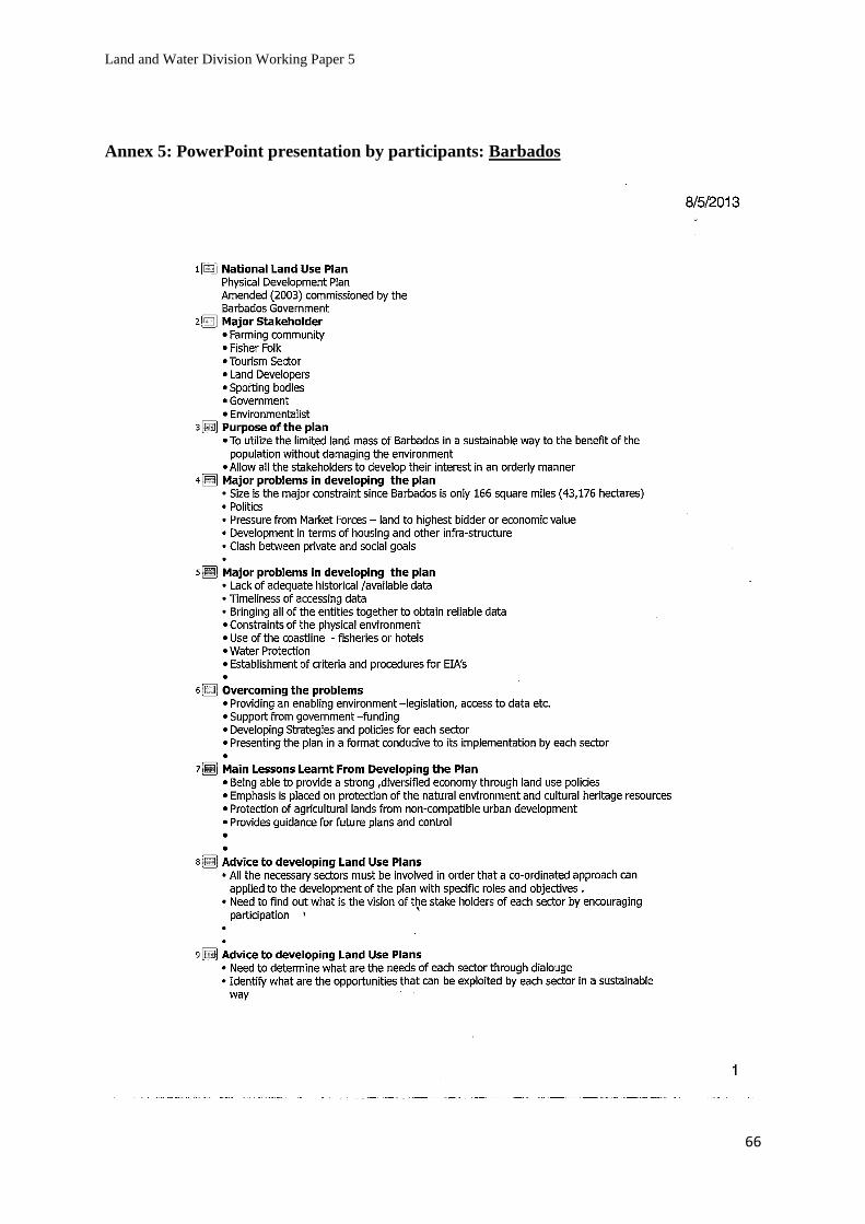
Land and Water Division Working Paper 5
66
Annex 5: PowerPoint presentation by participants: Barbados

Land and Water Division Working Paper 5
67
Santa Lucia

Land and Water Division Working Paper 5
68

Land and Water Division Working Paper 5
69
Antigua

Land and Water Division Working Paper 5
70
Guyana

Land and Water Division Working Paper 5
71
Annex 6: More details on tools
A-Ecological-Economic Zoning
EEZ has two major objectives: first, it must be considered as a tool to aggregate data in a
simple, easily understandable and readily usable form for municipality use. To date, a wide
number of data have been collected and compiled by technical institutions and municipalities.
Some datasets are more useful than others, some are very relevant for planning but their use is
difficult to comprehend by lower level technicians. A major challenge remains to identify what
is really needed under general and specific conditions, how to analyse and present it, always
taking into account the costs involved.
Second, an EEZ is an excellent tool to initiate the participatory process. This process includes
the discussion on options for development, identification of priorities, coming to an overall
agreement on these priorities between different actors. In one word, its elaboration and use
provides a mechanism to induce a locally driven development process. On the basis of EEZ,
working groups that discuss options can be more easily identified on the basis of area specific
criteria (EEZ). Stakeholders from specific EEZ zones know their area, have a direct stake in its
development, feel more responsible and accountable. If groups are organised in this way, there
is a more realistic horizon for achieving something concrete through participation. The role of
the municipality and the RC is to facilitate consensus making within and between groups.
The reflection on the EEZ in the workshop has resulted in a more fine-tuned approach,
considering a two-step approach. It defines in a clearer way the flow of activities, the
responsibilities of the actors, the nature of required information and datasets at different stages.
An initial “technical” zoning results in an “initial EEZ”, that serves as a tool for further
discussion (step1). The outcome of the participatory process is a “negotiated EEZ”, that can be
considered as the territorial pact (step 2).
This two-step approach facilitates in some way the structuring of required information, the
responsibilities and timing for its collection. A standardised minimum dataset for developing
the initial EEZ can be identified for all municipalities. This set includes layers that are required
(i) to respond to the implementation of national or regional policies and laws, and (ii) to
characterize in the most efficient way the present status of the municipality.
B- Interviews: Key informants / stakeholder analysis
These are essentially informal but require some pre-defined guidance and a thematic approach.
Some questions can be thought out before, but mostly, the interview should become a
discussion and the key aspect is to establish a horizontal, or equal relationship. It is important
that the interviewed are clear about the benefits their information will have on the whole
process and that their information will not be known by neighbours or officials.
Start out with visible things or people and ask what, where, who, when, why and how type
questions and build progressively more complex discussions and remarks into it, relating them
to specific pre-established themes.
Key questions example:
What resources are abundant?

Land and Water Division Working Paper 5
72
What resources are scarce? Why? (legal, economic, financial, technological, social reasons etc)
Does everyone have access to land? (women, poor people, etc?)
Who makes the final decision for resources allocation? (Local authority, cantons, entity level,
private sector companies in land, water, forests, etc)
Which resources are more problematic?
Where is the best or the worst area for these resources? Etc.
It is crucial that you remain patient and open, and that you take small notes on key words. Be
aware of non-verbal communication, never criticize and accept refreshments if they are
offered. Don’t agree or disagree (or nod or shake your head), sit still and at the same level as the
interviewed, do not bring written documents with you that might scare or impress them.
The key is to make the participants understand that you know the subject at hand but that you
need their help to know more about it, in other words to learn. The group interviews should not
last over two hours and politely stop participants who are dominating the conversation, either
with a discrete hand signal, by gently intervening or by resuming and recalling the goals of the
discussion. For individual interviews, it requires an average of one hour. You can use
diagrams, which are very useful at presenting complex information in a visual form and help
make it become more easily shared and discussed.
C- SWOT analysis (Strengths, Weaknesses, Opportunities and Threats) during a meeting
This simple tool is useful to understand the general framework of the situation. It provides
insight into the overall picture.
Why use this tool?
A SWOT analysis is a very effective way of identifying your Strengths and Weaknesses, and of
examining the Opportunities and Threats you face. Carrying out an analysis using the SWOT
framework helps you to focus your activities in areas where you are strong and where the
greatest opportunities lie.
How to use this tool:
To carry out a SWOT analysis write down answers to the following questions. Where
appropriate, use similar questions:
For strengths (S), it is practical to ask the following question: what are the strengths inherent in
the territorial asset? What can be improved? What are the available resources? Also, it is
important to examine an area’s natural advantages, its people’s specific abilities (traditional
knowledge, good practices etc) and in what area the local authorities (municipal staff) do well.
Example:
What are your advantages?
What do you do well?
What relevant resources do you have?
What do other people see as your strengths?
Consider this from your own point of view and from the point of view of the people you deal
with. Don't be modest. Be realistic. If you are having any difficulty with this, try writing down
a list of your characteristics. Some of these will hopefully be strengths!
In looking at your strengths, think about them in relation to your competitors - for example, if
all your competitors provide high quality products, then a high quality production process is
not a strength in the market, it is a necessity.

Land and Water Division Working Paper 5
73
For weaknesses (W), ask what is done badly, what is in the way of attaining goals? Things that
might be improved by access to information, by special support, by training (new technology
etc.), by building partnerships, or what should be avoided that might be facilitated by
participatory processes (alliances that would create a monopoly situation).
Example:
What could you improve?
What do you do badly?
What should you avoid?
Again, consider this from an internal and external basis: Do other people seem to perceive
weaknesses that you do not see? Are your competitors doing any better than you? It is best to be
realistic now and face any unpleasant truths as soon as possible.
Opportunities (O) often reflect things people don’t control but would like to take advantage of.
With everyone’s full cooperation, what are the interesting trends that can influence and
galvanize sustainable development.
Example:
How to support the creation of a new cooperation network (working on strengthening
complementary capacity)?
What and where are the good opportunities?
What are the interesting trends you are aware of?
Useful opportunities can come from such things as:
Changes in technology and markets on both a broad and narrow scale
Changes in government policy related to your field
Changes in social patterns, population profiles, lifestyle changes, etc.
Local Events
A useful approach to looking at opportunities is to look at your strengths and ask yourself
whether these open up any opportunities. Alternatively, look at your weaknesses and ask
yourself whether you could open up opportunities by eliminating them.
Under threats or constraints (T), look at obstacles people face, things that might be mitigated
only if improvements are made. Here, you evaluate what the competition is doing, scan the
speed of change and its effect on the local environment and analyse the economic situation.
Example:
What obstacles do you face?
What is your competition doing?
Are the required specifications for your job, products or services changing?
Is changing technology threatening your position?
Do you have bad debt or cash-flow problems?
Could any of your weaknesses seriously threaten your business?
Carrying out this analysis will often be illuminating - both in terms of pointing out what needs
to be done, and in putting problems into perspective.
Simple rules for a successful SWOT analysis:
Be realistic about the strengths and weaknesses of your position, or your organization.
The analysis should distinguish between where you or your organization is today, and
where it could be in the future.
Be specific. Avoid grey areas.
Always analyse taking into account your “competition” i.e. is it better or worse than
your competition?

Land and Water Division Working Paper 5
74
Keep your SWOT short and simple. Avoid complexity and over-analysis
A SWOT is subjective.
Strengths Weaknesses
Opportunities Threats
D- Problem tree analysis during a meeting
This is a cause and effect analysis, which consists in systematically identifying all problems,
classing them hierarchically and prioritizing them in order to elaborate a potential strategy for
the community. The causal relationships between all major problems are visualized in a
problem tree (which is a cause-to-effect diagram, putting the causes on the bottom and the
effects on top). Organizing these problems in a logical sequence permits logical conclusions
and eventually, the identification of efficient solutions.
1- Start by identifying the major problems:
What are the major problems regarding the use of this territorial asset?
What did you do to try to solve the problem? These problems must be existing negative
situations that could be resolved, and not situations without solutions. The group must seek a
consensus in order to find one major problem.
To do this, you can have participants introduce and explain their main problem; then the group
can determine the weight given to each of the problems introduced (more important than…)
2- The next step involves placing all the problems in a diagram and identifying the substantial
and direct causes of the problem (why), which are placed below the identified problem.
3- Then, the effects are identified and placed above the problem. Secondary causes and effects
are then added, creating a ‘tree’ with different levels. Use mobile cardboard cards with a big
blank sheet of paper and pins to position the problem in the tree. These problems can then be
moved during the exercise.
Participants must validate the problem tree after agreeing that all the causes and effects have
been interlinked.

Land and Water Division Working Paper 5
75
4- Finally, start at the bottom of the diagram and work your way up: each problem must be
examined to determine if it can be resolved.
How to prevent this problem?
What resources are needed to become more successful at preventing such a problem?
Then propose a feasible solution that would support the formulation of a strategy or a new
solution.
To do this, remind participants to be positive and to seek a wished-for situation.

Land and Water Division Working Paper 5
76
Example of a problem tree of upland and high land agriculture expansion.
Source: author’s own elaboration.

Land and Water Division Working Paper 5
77
E- Table of analysis during a meeting
This entails making a table.
On the left column, you identify recurrent problems (problems that many participants have in
common), resuming into one problem all the problems that seem similar (that have the same
causes, effect and solutions).
On the second column (to the right of the first one) you list some of the problem’s causes (by
looking at your problem-tree analysis; suggestions should be included here).
On the third column, possible strategies are discussed and noted, and finally, on the fourth
column, the group studies the efficiency, the advantages and disadvantages of the different
strategies. These could become possible actions in the future.
Example: (Of course there are other possible reasons in this illustrated problem)
Problems Causes Possible strategies
to resolve the problem
Possible future
actions which
would resolve the
problem
Access to larger
land surfaces
State land
privatization
policy
Municipality, Cantons, Entity
representative, State farm
manager and interested farmers
negotiate locally the use of new
parcels
Land leasing for a
short period
Land
fragmentation
Start a land consolidation
process
Negotiate the use and
the exchange of
adjoining parcels
Land register is
obsolete
Not yet defined Solution that exceeds
local authority’s
competency and
decision level
F- Venn diagrams during a meeting
Prepare Venn charts for the stakeholders being surveyed, in order to specify the importance
given by the stakeholders to the administrative bodies and to non-governmental institutions
with whom they deal with, how important the stakeholders consider the impact of these
institutions on their socio-productive conditions, the level of proximity, affinity and
identification with these institutions and the importance of and proximity with all the other
stakeholders.
1- Explain the objectives of the Venn diagram on institutions
2- Ask what kind of assistance exists among the people?
Which local group is organised along environmental issues (water, grazing, arable land),
economic issues (savings, credit, agriculture, and livestock), social issues (health, literacy,
religion, tradition, education, sport).
Are there political groups?
Who makes important decisions in the municipalities?
Write down all the institutions:
Name or organisation / type of organisation / main activities

Land and Water Division Working Paper 5
78
3- You place the communities in the centre and all the institutions and stakeholders who have
a relationship defined by the diagnosis are shown in circles; the relations and links with the
centre and among them are shown by lines and their power by a + or – sign.
4- It is important to highlight the stakeholders and organizations that might generate conflict.
To do so, ask participants to discuss in which way they benefit from different organisations.
Ask them to show the degree of contact/co-operation between themselves and those
institutions by distance between the circles.
Institutions with which they do not have much contact with should be placed far from their own
rectangle.
Institutions that are in close contact with the participants and with whom they co-operate most
should be inside the circle. Ask also in which of these institutions do poor people not
participate and mark it with a special symbol.
Make a final synthesis of the relationships among stakeholders by highlighting critical points
and emerging trends and changes
For more info on how to do a Venn diagram, see:
http:// www.fao.org/docrep/003/X5996E/x5996e06.htm

Land and Water Division Working Paper 5
79
G- Role-play during a meeting
Role-play is a participatory learning method that emphasises ‘learning by doing’.
This involves acting out encounters and although role-plays cannot be used for learning factual
knowledge, they are a good way of understanding attitudes. This activity can be very rewarding
if done well. In role-plays, participants assume a specific role, enter a simulated scenario and
behave as they expect they should in the circumstances.
Role-plays can be remarkably heterogeneous; they may be very simple (such as role-playing a
telephone call between a citizen and the municipality) or complex (designing and running a
facility). The reality of the scenario and its linkage to personal experience is also flexible.
Start by developing a situation consisting of a combination of people, places and purposes.
Brief the characters before the role-play. It is a good idea to think about the briefing in advance,
write down the description of each character and hand these to the participants just before the
start of the role-play. They must fully understand who they are supposed to be and what they
are supposed to do.
Provide details of each character’s age, education, status, interests and attitudes. The observers
should also know what to look for during the role-play. Role-plays improve with practice so do
not hesitate to repeat the experience (and alternate participants). Make sure the role-play is not
too long. Interest declines after about 10 minutes and stop it as soon as this happens. Role-plays
are successful and effective when participants are enthusiastic. It is up to you to create the
energy and imagination for this activity.
A scenario example of tourism development: The Resort at Hutuvo Blato National Park
This role-play is based on a consultation process associated with a proposed major resort
development. The development site is on the southern Stolac area adjacent to a National Park
and on a former sheep station containing endangered species and heritage buildings. The land
has also been partially re-vegetated. The nearest population centre is a small town ten
kilometres away. The local Government body has a reputation for comprehensive and thorough
consultations on development issues and has asked the developers to consult with key
stakeholders in a series of meetings. The issues revolve around the scale, scope and design of
the development, local planning considerations and potential impacts on the local community,
regional economy and natural and cultural heritage. In addition to the developers and local
Government employees, the following stakeholders are invited to be present at the meetings:
farmer’s association representatives, non-government cultural and natural heritage agencies,
regional and local tourism organisations, national park management agency and the local
Chamber of Commerce.
The structure of role-plays can be documented with scenario descriptions, roles, aims,
expectations, data, scripts, maps and illustrations.
The participants in their role wrote an assessed position paper on their role's reaction to the
issues. So, for example, the municipal spatial planning player may comment on the issue of
increased traffic caused by a resort development.
The position paper was assessed and returned promptly so that the participants could receive
feedback before the next meeting.

Land and Water Division Working Paper 5
80
H- Scenario writing during a meeting
Forecast (make a projection) with a time frame of 5, 10 or 20 years. Analyse the potentials or
the constraints of the current situation. Work out contrasting scenarios that must be attainable.
One person volunteers to write a draft. Make a checklist of key questions and their impacts.
These include demography, human resources, NGOs, infrastructure, economy, family holdings
and crafts, marketing, credits or subsidies, forestry, water management and fishing, agriculture
and tourism etc. The group makes a decision on the preferred scenario.
Method and procedure
The Future Workshop process starts with a preparatory phase and then follows, in its classical
form, three operative phases with contents shown in the following table:
Future Workshops
PHASE CONTENTS EXPECTED RESULTS
1. Preparation The issue to be analysed is decided and the
structure and environment of sessions are
prepared.
Summary of contributions. Key
question
2. Critique Clarification of the issue selected:
dissatisfactions and negative experiences of
the present situation.
Problematic areas for the
following discussion are defined.
3. Fantasy Free idea generation (as an answer to the
problems) and of desires, dreams, fantasies,
opinions concerning the future. The
participants are asked to forget practical
limitations and obstacles in their present
reality.
Indication of a collection of ideas
and choices for some solutions
and planning guidelines.
4.
Implementation
Going back to the present reality, to its
power structures and to its real limits, to
analyse the actual feasibility of the previous
phase solutions and ideas. Identification of
obstacles and limits to the plan
implementation and definition of possible
ways to overcome them.
Creation of strategic lines to be
followed in order to fulfil the
traced goals. Action plan and
implementation proposal are
drawn.
Source : http://www.iamb.it/incosusw/scenario_Tunis.pdf
The ideal process length is of several appointments, though each phase can be reduced or
expanded to longer or shorter time-scales depending on available time and resources and the
issue to be addressed. The Future Workshops method represents one of the possible future
scenario methods whose goal is that of building alternative future scenarios based on the
interactive work of a group of people. This method is structured to be used with stakeholders
and does not require high levels of expertise. It also aims to enhance as much as possible the
sharing of views and creativity development.
While the positive side of the application of Futures Workshops among communities (e.g.:
unexpressed abilities and capabilities emerge, the participants identify themselves as a group,
the emerging solutions are often surprising) are demonstrated through a wide number of
applications in many different fields. Nonetheless, the method presents limitations due to time
constraints.

Land and Water Division Working Paper 5
81
Time is generally an important factor in interactive methods as a longer process allows
participants to go deeper in future thinking, with the aim being to gain new knowledge and new
ways of thinking through the interaction.

Land and Water Division Working Paper 5
82
References
FAO. 1993. Guidelines for Land Use Planning. Rome. (Available at
http://www.fao.org/docrep/t0715e/t0715e00.HTM).
FAO. 1996. Agro-Ecological Zoning Guidelines. Rome. (Available at
http://www.fao.org/docrep/w2962e/w2962e00.htm#P-2).
FAO. 2004. Participatory Land Use Development in the Municipalities of Bosnia and
Herzegovina (PLUD). Rome. (Available at
http://www.fao.org/fileadmin/user_upload/Europe/documents/Publications/BAguidelines_en.
pdf ).
FAO. 2005. Participatory and Negotiated Territorial Development (PNTD). Rome. (Available
at http://www.fao.org/sd/dim_pe2/pe2_050402a1_en.htm).
FAO. 2005. Negotiation and mediation techniques for natural resource management. Rome
(Available at http://www.fao.org/docrep/008/a0032e/a0032e00.htm#Contents).