participatory digital mapping: bildig comity reilience … · 2018-05-22 · participatory digital...
TRANSCRIPT

POLICY BRIEF May 2018
ZURICH FLOOD RESILIENCE POLICY BRIEF Browse other publications: https://answers.practicalaction.org/our-resources
PARTICIPATORY DIGITAL MAPPING: BUILDING COMMUNITY RESILIENCE IN NEPAL, PERU AND MEXICO
The Zurich Flood Resilience Alliance (ZFRA) has developed an approach that combines state-of-the-art collaborative digital mapping techniques with community-based participatory methods. The process engages a broad range of actors such as local volunteers, local government, and national and international non-governmental organizations (NGOs), with digital mapping experts to co-produce critical local flood exposure information. Applications to communities in Nepal, Peru, and Mexico demonstrate the immense potential for making an essential contribution to building community resilience.
Key Learnings
1 Critical data gaps can be closed
Integrating web-based remote collaborative mapping and community-based participatory mapping offers an opportunity to comprehensively produce spatial information on resources and capacities of communities at local scales. This critical information is currently missing in many developing countries.
2 Mapping identifies local resources and needs
Detailed, geographically referenced information on safe shelters, health posts, schools, raised hand pumps, culverts, and elevated open spaces captures existing capacities of flood-prone communities, and helps to identify key capacity gaps.
3 Stakeholder participation is essential
By enhancing stakeholder engagement and public participation, integrated digital mapping offers an effective way to co
produce knowledge on disaster risks and impacts whilst mapping out existing physical and natural characteristics and capital of disaster-prone communities.
4 Flood exposure information strengthens resilience
Enhanced flood exposure information improves the understanding of flood risk beyond political and administrative boundaries at the wider basin scale and supports a more holistic resilience building programme. This integrates emergency preparedness with long-term risk management and land use planning in vulnerable communities.
5 The approach is replicable
If up-scaled, this approach can fill critical data gaps for validating global and regional flood model outputs, supporting the production of reliable local flood inundation maps, and helping to build flood resilience from local to national levels.
Summary
Contact Wei Liu [email protected]
Visit practicalaction.org
Produced in partnership with:
The projectIn order for vulnerable communities to effectively build their resilience and protect themselves from the impacts of flooding, it is vital to have information that is comprehensive, locally applicable, and accessible. Humanitarian and development organizations have long utilized vulnerability and capacity assessments (VCAs) as an integral part of post disaster reconstruction and recovery efforts as well as disaster risk management planning.
This approach emphasizes community-based participatory mapping activities and constitutes a significant source of valuable local risk information. However, disaster risk knowledge gathered through this widely adopted approach is often siloed and inaccessible, captured by different actors in various formats such as hand-drawn community hazard maps, and is not integrated with other risk information or updated over time.
The ZFRA has developed a process to co-produce critical flood risk information with a wider range of stakeholders and citizens. This process combines the various strengths from tools currently used by community-based participatory and web-based collaborative mapping approaches.
Figure 1. Trained local social mobilisers collect and map out asset information in their communities
Our process builds on recent developments in data collection and communication via personal devices and social media, which have greatly enhanced citizens’ abilities to contribute spatial data (McCallum et al., 2016). Such crowdsourced geographic information is shared through OpenStreetMap (OSM), a platform which has been adopted by well-known brands including Foursquare and Apple, and which has over 4.3 million users (as of 30 October 2017). This widely used platform for sharing free geographic data offers new opportunities to compile and validate local knowledge, making it accessible to decision-makers at community, district, national, and international levels.
The process represents a key step forward in improving
resilience by combining existing knowledge with new technologies.
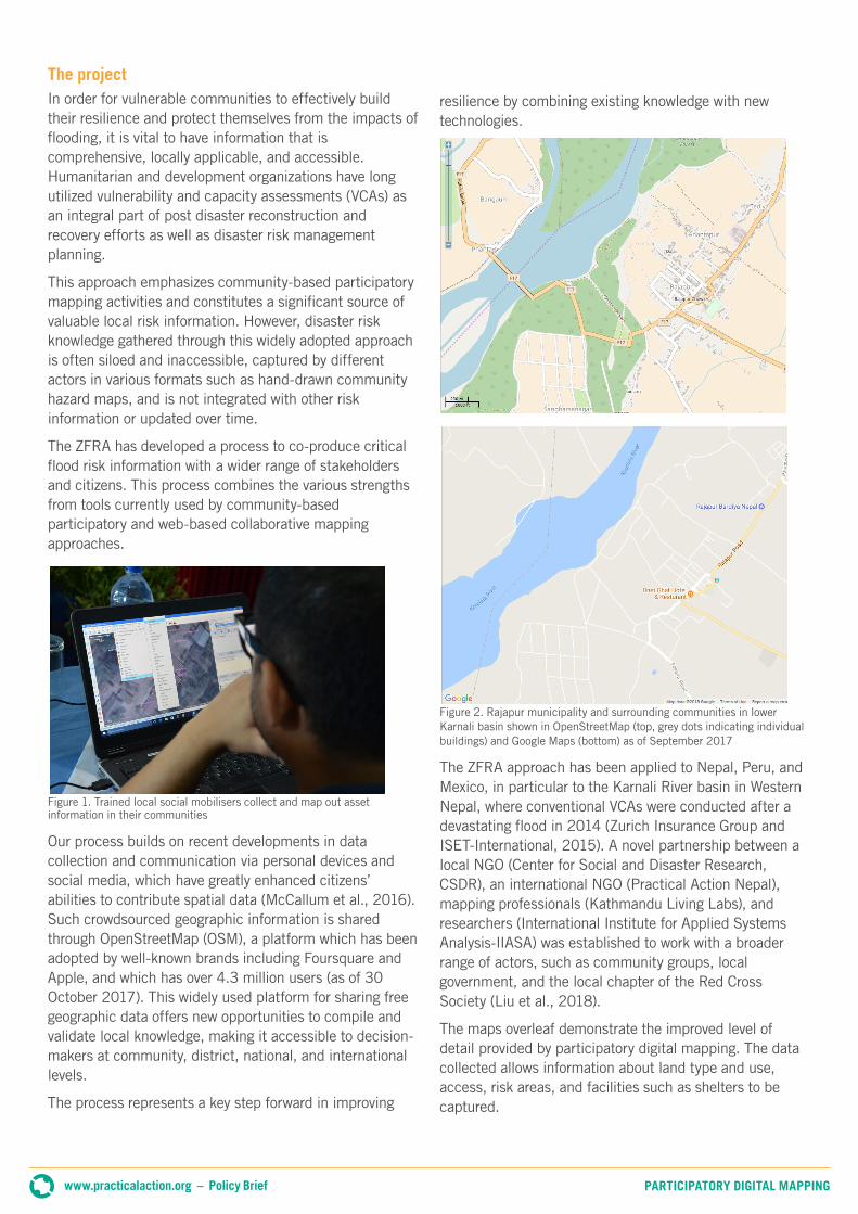
Figure 2. Rajapur municipality and surrounding communities in lower Karnali basin shown in OpenStreetMap (top, grey dots indicating individual buildings) and Google Maps (bottom) as of September 2017
The ZFRA approach has been applied to Nepal, Peru, and Mexico, in particular to the Karnali River basin in Western Nepal, where conventional VCAs were conducted after a devastating flood in 2014 (Zurich Insurance Group and ISET-International, 2015). A novel partnership between a local NGO (Center for Social and Disaster Research, CSDR), an international NGO (Practical Action Nepal), mapping professionals (Kathmandu Living Labs), and researchers (International Institute for Applied Systems Analysis-IIASA) was established to work with a broader range of actors, such as community groups, local government, and the local chapter of the Red Cross Society (Liu et al., 2018).
The maps overleaf demonstrate the improved level of detail provided by participatory digital mapping. The data collected allows information about land type and use, access, risk areas, and facilities such as shelters to be captured.
www.practicalaction.org – Policy Brief PARTICIPATORY DIGITAL MAPPING

Figure 3. New capacity map for flood preparedness showing distribution of safe shelters across lower Karnali river basin
Figure 4. A close-up of Chakkhapur, Nepal, detailing the locations of villages, buildings, roads, raised handpumps, health posts, culverts, and irrigation drains mapped in OSM
www.practicalaction.org – Policy Brief PARTICIPATORY DIGITAL MAPPING

www.practicalaction.org +44 (0) 1926 634400
Practical Action, The Schumacher Centre, Bourton on Dunsmore, RUGBY CV23 9QZ
ContributionsLiu Wei (IIASA), Sumit Dugar (Practical Action), Gaurav Thapa (Kathmandu Living Labs), and
Sarah Brown (Practical Action)
Reviewed ByMirianna Budimir, Alison Sneddon, Reinhard Mechler, Linda See, Ian McCallum, and Michael Szoenyi
Photo credit© 2018 Practical Action
The Zurich Flood Resilience AllianceThe Zurich Flood Resilience Alliance is a multi-sectoral programme which focuses on finding practical ways to help communities in developed and developing countries to strengthen their resilience to flood risk. Find out more: https://zurich.com/en/corporate-responsibility/flood-resilience
About Practical ActionPractical Action uses technology to challenge poverty by building the capabilities of poor people, improving their access to technical options and knowledge. We work internationally from regional offices around the world. www.practicalaction.org
Main achievementsThis collaboration generated a large amount of geographic information that is richer in content, more accurate, and easier to update and share than conventional VCA processes.
Over a dozen local social workers from a number of organizations were trained and have contributed to data collection and validation on the ground, as shown in Figure 1. As a result, over 50,000 buildings and 100 km of roads and trails were mapped across the lower Karnali basin, and many other features, such as agricultural land, community forests, safe shelters, and irrigation canals, have been added by local volunteer mappers (see Figures 2–4).
Digital community maps were created for all of the ZFRA communities. These provided valuable new information to help stakeholders visualize the spatial patterns of past flood impacts, understand distribution of exposure of assets and capacities, and assist with flood risk reduction and resilience building efforts.
The project was announced as a winner of the Global Competition for Youth-Led Projects on Flood and Droughts, organized by the Water Youth Network in collaboration with the World Meteorological Organization, at the Global Platform for diaster risk reduction (DRR) in May 2017.
ConclusionsWhile technologies such as satellite-based remote sensing and advancement in global-scale disaster risk modelling have provided substantial data and information at global and regional scales, appropriate local level risk information is still scarce. The critical information gap in spatial risk information at local levels seriously compromises efforts to build disaster resilience in disaster-prone developing countries. In line with the United Nations Sendai Framework for Disaster Risk Reduction (2015), communities and countries need to consider readily available and easily accessible geo-spatial data as a vital component of their disaster risk management plans. Our approach integrates web-based remote collaborative
mapping with communityled participatory mapping building on existing local engagement tools and processes.
As demonstrated in Nepal and Latin America, it has great potential to engage a broad range of actors such as communities, NGOs, and governments, as well as volunteers and researchers from around the world to help fill this critical knowledge gap. Integrated mapping also helps make data more accessible, comparable, and manageable, and can enable decision-makers to navigate an increasingly complex data environment, resulting in enhanced access to disaster risk information, and ultimately contributing to building resilience (Liu et al., 2018). The ZFRA will further develop the methodology while working with partners to replicate the efforts in other flood-prone regions.
ReferencesLiu, W., S. Dugar, et al. (2018) ‘Integrated participatory and collaborative risk mapping for enhancing disaster resilience’, Integrated Participatory and Collaborative Risk Mapping for Enhancing Disaster Resilience. ISPRS Int. J. Geo-Inf, 7, 68 <https://doi.org/10.3390/ijgi7020068> [accessed 7 May 2018].
McCallum, I., Liu, W., et al. (2016) ‘Technologies to support community flood disaster risk reduction’, International Journal of Disaster Risk Science 7(2): 198–204 <https://doi.org/10.1007/s13753-016-0086-5>.
OpenStreetMap (no date) ‘Stats report' <https://www.openstreetmap.org/stats/data_stats.html> [accessed 8 January 2018].
United Nations International Strategy for Disaster Reduction (2015) Sendai Framework for Disaster Risk Reduction 2015–2030 [pdf], Geneva: UNISDR <www.wcdrr.org/uploads/Sendai_Framework_for_Disaster_Risk_Reduction_2015-2030.pdf> [accessed 8 January 2018].
Zurich Insurance Group and ISET-International (2015) Risk Nexus: Urgent case for recovery: what we can learn from the August 2014 Karnali River floods in Nepal [pdf] <https://reliefweb.int/sites/reliefweb.int/files/resources/risk-nexus-karnali-river-floods-nepal-july-2015.pdf> [accessed 8 January 2018].
© 2018 Practical Action