part a local expression of ouv of the gbrwha 253916 file ppg master planning - local expression of...
TRANSCRIPT
Part ALocal expression of OUV
of the GBRWHA
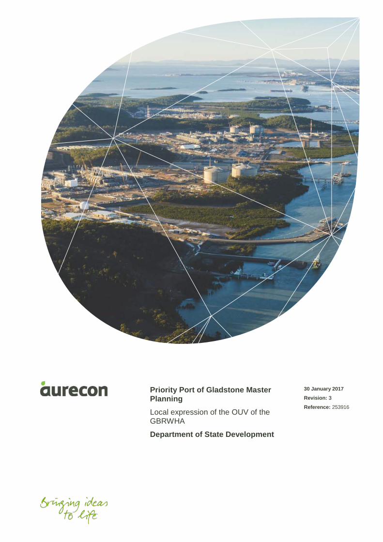
Priority Port of Gladstone Master Planning
Local expression of the OUV of the GBRWHA
Department of State Development
30 January 2017
Revision: 3
Reference: 253916
Project 253916 File PPG master planning - Local expression of OUV of the GBRWHA.docx 30 January 2017 Revision 3
Document control record
Document prepared by:
Aurecon Australasia Pty Ltd
ABN 54 005 139 873
Level 14, 32 Turbot Street Brisbane QLD 4000
Locked Bag 331 Brisbane QLD 4001 Australia
TFE W
+61 7 3173 8000+61 7 3173 [email protected]
A person using Aurecon documents or data accepts the risk of:
a) Using the documents or data in electronic form without requesting and checking them for accuracy against the original hardcopy version.
b) Using the documents or data for any purpose not agreed to in writing by Aurecon.
Document control
Report title Local expression of the OUV of the GBRWHA
Document ID Project number 253916
File path http://cs.au.aurecongroup.com/cs/llisapi.dll/open/174721033?func=ll&objId=174721033&objAction=browse
Client Department of State Development
Rev Date Revision details/status Author Reviewer Verifier (if required)
Approver
0 13 December 2016 Working draft for DSD and GPC review CA/LL SC SC
1 22 December 2016 Draft for DSD review CA/LL SC SC
2 11 January 2017 Updated draft for DSD review CA/LL SC SC
3 30 January 2017 Final for issue to DSD CA/LL SC SC
Current revision 3
Approval
Author signature Approver signature
Name Cassandra Arkinstall Name Stephen Cole
Title Project Leader and Environmental Scientist
Title Project Director
Project 253916 File PPG master planning - Local expression of OUV of the GBRWHA.docx 30 January 2017 Revision 3 Page iii
Contents 1 Introduction 1
1.1 Project background 1
1.2 Purpose of this report 1
1.3 Great Barrier Reef World Heritage Area and the priority Port of Gladstone 2
1.4 Priority Port of Gladstone master planned area 4
1.5 Environmental values within the master planned area and surrounds 5
2 Methodology 10
2.1 Key information sources 10
2.2 Identification of local attributes expressed within the master planned area and surrounds 12
2.3 Presence of local attributes 13
2.4 Contribution of the local attribute to the OUV of the GBRWHA 14
3 OUV of the GBRWHA within the master planned area and surrounds 16
3.1 Independent Review of the Port of Gladstone and the local attributes present within the master planned area and surrounds 16
3.2 Presence of local attributes 17
4 Contribution of local attributes to the OUV of the GBRWHA 20
5 Conclusion 23
6 References 29
Appendices Appendix A
EMF Panel methodology for identifying the local expression of the OUV of the GBRWHA
Appendix B
Justification for the presence and contribution classifications for the locally expressed attributes of the OUV of the GBRWHA
Appendix C
Flora and fauna database searches
Appendix D
Local Statement of Integrity (Adaptive Strategies)
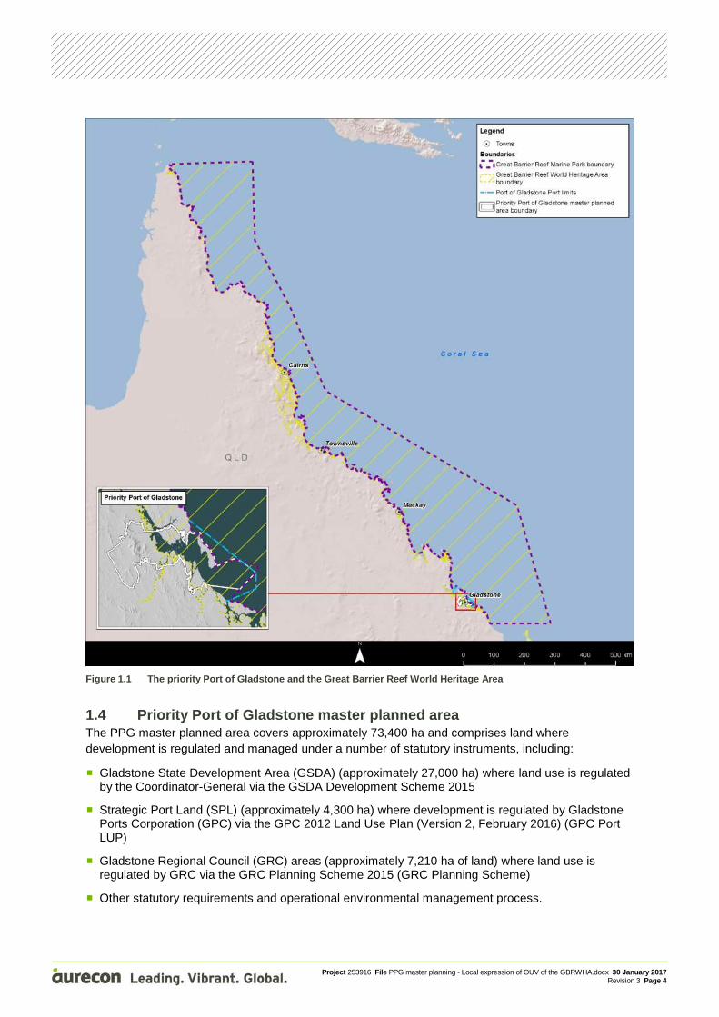
Figures Figure 1.1 The priority Port of Gladstone and the Great Barrier Reef World Heritage Area
Figure 1.2 Priority Port of Gladstone master planned area
Figure 2.1 Overview of the methodology for identifying the local expression of the OUV of the
GBRWHA
Figure 2.2 Detailed methodology for identifying local expression of OUV of the GBRWHA in the PPG
master planned area and surrounds
Project 253916 File PPG master planning - Local expression of OUV of the GBRWHA.docx 30 January 2017 Revision 3 Page iv
Tables Table 1.1 Environmental values within and surrounding the master planned area and surrounds as
identified in the evidence base 5 Table 2.1 Key information sources utilised to identify the local expression of the OUV of the
GBRWHA 11 Table 2.2 Assessment of contribution of the local attribute to the OUV of the GBRWHA 14 Table 3.1 Local attributes within the master planned area and surrounds, and the associated OUV
criteria 16 Table 3.2 Presence classification for local attributes expressed within and surrounding the master
planned area and surrounds 18 Table 4.1 Contribution of local attribute to the OUV of the GBRWHA for the master planned area
and surrounds 20 Table 5.1 Locally expressed attributes within the PPG master planned area and surrounds and the
contribution to the four OUV criteria 26
Project 253916 File PPG master planning - Local expression of OUV of the GBRWHA.docx 30 January 2017 Revision 3 Page v
Acronyms and abbreviations
Acronym/abbreviation Definition
ACH Act Aboriginal Cultural Heritage Act 2003 (Qld)
AHD Australian Height Datum
AIMS Australian Institute of Marine Science
DSD Department of State Development
DoEE Department of the Environment and Energy
DoE Department of the Environment
DSEWPaC Department of Sustainability, Environment, Water, Population and Communities
EAAF East Asian-Australasian Flyway
EMF Environmental management framework
EP Act Environmental Protection Act 1994 (Qld)
EPBC Act Environment Protection and Biodiversity Conservation Act 1999 (Cth)
Evidence Base Report Evidence Base Report for Gladstone Port Master Planned Area
FHA Fish Habitat Area
GBR Great Barrier Reef
GBRMP Great Barrier Reef Marine Park
GBRWHA Great Barrier Reef World Heritage Area
GHHP Gladstone Healthy Harbour Partnership
GPC Gladstone Ports Corporation
GPC Port LUP GPC 2012 Land Use Plan
GRC Gladstone Regional Council
GRC Planning Scheme Gladstone Regional Council Planning Scheme 2015
GSDA Gladstone State Development Area
ha hectares
IUCN International Union for Conservation of Nature
JCU James Cook University
km kilometres
master plan priority Port of Gladstone master plan
m metres
NC Act Nature Conservation Act 1992 (Qld)
OUV Outstanding Universal Value
PPG priority Port of Gladstone
PMM priority management measure
Ports Act Sustainable Ports Development Act 2015 (Qld)

Project 253916 File PPG master planning - Local expression of OUV of the GBRWHA.docx 30 January 2017 Revision 3 Page vi
Acronym/abbreviation Definition
Qld Queensland
Reef 2050 Reef 2050 Long-Term Sustainability Plan
RE Regional Ecosystem
SPL Strategic Port Land
TEC Threatened Ecological Community
TSSC Threatened Species Scientific Committee
TUMRA Traditional Use of Marine Resource Agreement
VM Act Vegetation Management Act 1999 (Qld)
WHA World Heritage Area
Project 253916 File PPG master planning - Local expression of OUV of the GBRWHA.docx 30 January 2017 Revision 3 Page vii
Glossary of terms
Term Meaning
attributes World Heritage attributes are specific elements or features of a World Heritage property that contribute to its outstanding universal value (OUV). They collectively link to one or more criteria for World Heritage listing.
environmental value ‘Environmental value’ is defined under the Environmental Protection Act 1994 (EP Act) and the Sustainable Ports Development Act 2015 (Ports Act) as:
A quality or physical characteristic of the environment that is conducive to ecological health or public amenity or safety; or
Another quality of the environment identified and declared to be an environmental value under an environmental protection policy or regulation
For the purpose of the priority port master planning process, environmental value also includes the OUV of the Great Barrier Reef World Heritage Area (GBRWHA) and other environmental values.
Great Barrier Reef coastal zone
The Great Barrier Reef (GBR) coastal zone includes areas adjacent to the Great Barrier Reef and includes Queensland waters, islands and adjacent inland areas, 5 kilometres (km) inland and 10 metres (m) Australian Height Datum (AHD), whichever is further.
Great Barrier Reef Marine Park
The area subject to protection under the Great Barrier Reef Marine Park Act 1975 covering 344,400 km2 including the subsoil beneath the seabed (1000 m below) and the airspace above (915 m high). It is a multiple-use marine park area that supports a range of communities and industries that depend on the Reef for recreation or their livelihoods (including tourism, fishing, boating and shipping). The Great Barrier Reef Marine Park (GBRMP) is a matter of national environmental significance and the Great Barrier Reef Marine Park Authority (GBRMPA) is responsible for its protection and management.
Great Barrier Reef World Heritage Area
The GBRWHA extends from the top of Cape York in north-east Australia to just north of Bundaberg, and from the low water mark on the Queensland coast to the outer boundary of the GBRMP, which is beyond the edge of the continental shelf. The area was declared a World Heritage Area in 1981 because of its OUV.
About 99 per cent of the World Heritage Area is within the GBRMP but encompasses:
Some 980 islands which are under Queensland jurisdiction
Some internal waters or Queensland (for examples, some deep bays, narrow inlets or channels between islands)
All waters seaward of the low water mark from north of Bundaberg to Cape York.
local expression of OUV Environmental values present in the priority port and surrounds and that contribute to the OUV of the GBRWHA.
master planned area The area identified in the priority Port of Gladstone (PPG) master plan as the master planned area for the port, and is approved by regulation.
Project 253916 File PPG master planning - Local expression of OUV of the GBRWHA.docx 30 January 2017 Revision 3 Page viii
Term Meaning
nesting beach In relation to marine turtles, a nesting beach is a location where marine turtle species have been observed nesting. Nesting beaches may contain only scattered records of nesting turtles, or may contain rookeries of marine turtles (ie breeding colonies).
other environmental values
Refer to definition of environmental values.
Other environmental values are those environmental values that are not considered to contribute to the OUV of the GBRWHA.
Outstanding Universal Value
Outstanding universal value is the central idea of the World Heritage Convention. The Operational Guidelines (paragraph 49) defines OUV as cultural and/or natural significance that is so exceptional as to transcend national boundaries and to be of common importance for present and future generations of all humanity.
OUV of the GBRWHA The GBR was inscribed on the World Heritage List in 1981 in recognition of its OUV. The World Heritage Committee listed the GBR for the following natural criteria:
Criterion (vii) – contain superlative natural phenomena or areas of exceptional natural beauty and aesthetic importance
Criterion (viii) – be outstanding examples representing major stages of earth’s history, including the record of life, significant ongoing geological processes in the development of landforms, or significant geomorphic or physiographic features
Criterion (ix) – be outstanding examples representing significant ongoing ecological and biological processes in the evolution and development of terrestrial, freshwater, coastal and marine ecosystems and communities of plants and animals
Criterion (x) – contain the most important and significant natural habitats for in situ conservation of biological diversity, including those containing threatened species of OUV from the point of view of science or conservation.
This term is used throughout this report and refers to environmental values within the master planned area and surrounds that contribute to the local expression of the OUV of the GBRWHA.
rookery A colony of breeding animals, particularly a breeding colony of marine turtles.
surrounds For the purposes of this assessment, surrounds includes areas outside of the priority Port of Gladstone master planned area. Specifically, surrounds includes all areas where it is not unreasonable to assume that potential impacts may occur as a result of the activities identified for the scenarios assessed as part of the master planning risk assessment (Aurecon 2016). Due to the range of potential future activities within the master planned area, the different potential impact pathways, varying sensitivities of receptors, and different biological traits (eg behaviours and responses to stress) of receptors, the definition of surrounds is specific to each future activity, environmental value or local attribute.
Project 253916 File PPG master planning - Local expression of OUV of the GBRWHA.docx 30 January 2017 Revision 3 Page 1
1 Introduction
1.1 Project background The Port of Gladstone is located within the Great Barrier Reef World Heritage Area (GBRWHA) and is Queensland’s largest multi-cargo port and the fifth largest coal export terminal in the world (by throughput). The port is located within a diverse region containing a range of urban communities, major industrial precincts and environmental values of international importance. There is significant opportunity for continued growth in the import and export of a range of commodities to Australia and the world, with the Port of Gladstone playing a pivotal role in the future growth of the national port trade.
Under the Sustainable Ports Development Act 2015 (Qld) (Ports Act), the Port of Gladstone is defined as one of four priority ports in Queensland (along with Port of Abbot Point, Ports of Hay Point and Mackay, and Port of Townsville), requiring a port master plan to ensure sustainable development of the port into the future.
The master planning process for the priority Port of Gladstone (PPG) is being led by the Department of State Development (DSD). Once finalised, the PPG master plan will be implemented through the port overlay. The port overlay will state how priority management measures (PMMs) are to be achieved and the responsible entity or entities for implementing the PMMs (DSD 2016). The port overlay will also include other content to implement the master plan strategic vision, objectives, desired outcomes and state interests.
Priority port master planning delivers certainty for priority ports and associated industries within a sustainable development framework (DSD 2016). Priority port master planning is a commitment in the Reef 2050: Long Term Sustainability Plan (Reef 2050) and will ensure the Outstanding Universal Value (OUV) of the Great Barrier Reef World Heritage Area (GBRWHA) is an intrinsic consideration in the future port development, management and governance (DSD 2016).
1.2 Purpose of this report The purpose of this report is to identify the presence and local expression of OUV within the PPG master planned area and surrounding areas, and the contribution they make to the OUV of the GBRWHA.
The key items addressed in this report include:
The OUV of the GBRWHA attributes that occur within the priority Port of Gladstone master planned area and surrounds based on the best available information
Definition of the environmental values that are included in the OUV of the GBRWHA attributes for the master planned area and surrounds
For the OUV of the GBRWHA attributes, an analysis of the presence of these attributes in the PPG master planned area and surrounds was undertaken
Classification of the contribution level of the locally expressed attributes, in the context of their contribution to the OUV of the GBRWHA
Local statement of integrity to provide clarity and understanding of how the draft master plan relates to the integrity of the World Heritage Area.
This document does not consider the statutory approval processes in place in the PPG and what approvals may be required for proposed development activities. It is not intended for the information within this report to replace the requirement for a proponent to adhere to part/all of the statutory approval processes.
Project 253916 File PPG master planning - Local expression of OUV of the GBRWHA.docx 30 January 2017 Revision 3 Page 2
The results of this report will be included into the PPG master planning evidence base in the following ways:
As a benchmark for the review of the risk assessment report (Aurecon 2016) to determine if amendments are required (eg review of potential impacts, environmental value ‘sensitivity’ ratings, review of PMMs and development of additional PMMs if required)
To provide input into PMM 2 (environmental values monitoring and reporting program) and the port overlay supporting report in terms of identifying the key environmental values to be monitored and gaps in the existing monitoring programs for the key environmental values that contribute to the OUV of the GBRWHA
To inform the future preparation of other guidelines and management plans required to be prepared under the port overlay (eg environmental assessment guideline, land management plan guideline and land management plans).
1.3 Great Barrier Reef World Heritage Area and the priority Port of Gladstone
The Great Barrier Reef (GBR) was inscribed on the World Heritage List in recognition of its OUV in 1981 for all four of the natural heritage criteria. The boundary of the GBRWHA is shown in Figure 1.1, covering an area of approximately 348,000 km2, including:
Approximately 2,000 km of Queensland coast, from the top of Cape York to just north of Fraser Island
All islands within the outer boundary (over 900 islands)
All waters seaward of low water mark (including internal waters of Queensland and port waters)
Eleven (11) trading ports.
OUV is the fundamental concept of the World Heritage Convention and underpins the listing of properties on the World Heritage List. To be considered of OUV, a property needs to:
Meet one or more of ten criteria set out in the convention
Meet the conditions of integrity
If a cultural heritage property, meet the conditions of authenticity
Have an adequate system of protection and management to safeguard its future.
The natural criteria that the GBRWHA was inscribed for are:
Criterion (vii) – contain superlative natural phenomena or areas of exceptional natural beauty and aesthetic importance
Criterion (viii) – be outstanding examples representing major stages of earth's history, including the record of life, significant ongoing geological processes in the development of landforms, or significant geomorphic or physiographic features
Criterion (ix) – be outstanding examples representing significant ongoing ecological and biological processes in the evolution and development of terrestrial, freshwater, coastal and marine ecosystems and communities of plants and animals
Criterion (x) – contain the most important and significant natural habitats for in situ conservation of biological diversity, including those containing threatened species of OUV from the point of view of science or conservation.
Project 253916 File PPG master planning - Local expression of OUV of the GBRWHA.docx 30 January 2017 Revision 3 Page 3
The boundary of the nominated GBRWHA addressed the holistic and interconnected nature of the OUV of a complex coastal marine system covering a very large area (DSEWPaC 2013). At the time of inscription, substantial areas of the GBR had not been surveyed, and while the nomination provided a broad description and inventory of the natural and cultural heritage values at a broad scale, the nomination documents were not required to provide more specific information on the values (DSEWPaC 2013).
The GBRWHA was nominated on the basis of management for conservation and reasonable multiple use, and the inscription recognises long standing uses, such as: port operations; shipping; commercial, recreational and Indigenous fisheries; recreation; tourism; and activities on islands, coastal lands and catchments within, adjacent to or discharging into the waters of the GBRWHA (DSEWPaC 2013).
The GBRWHA includes waters seaward of the low water mark, including those within the Port of Gladstone (refer Figure 1.1). Approximately 59% of the PPG master planned area is situated within the GBRWHA, however is located outside of the state and Commonwealth marine parks boundaries.
The area of the master plan within the GBRWHA contributes only 0.1% of the total area of the GBRWHA.
Project 253916 File PPG master planning - Local expression of OUV of the GBRWHA.docx 30 January 2017 Revision 3 Page 4
Figure 1.1 The priority Port of Gladstone and the Great Barrier Reef World Heritage Area
1.4 Priority Port of Gladstone master planned area The PPG master planned area covers approximately 73,400 ha and comprises land where development is regulated and managed under a number of statutory instruments, including:
Gladstone State Development Area (GSDA) (approximately 27,000 ha) where land use is regulated by the Coordinator-General via the GSDA Development Scheme 2015
Strategic Port Land (SPL) (approximately 4,300 ha) where development is regulated by Gladstone Ports Corporation (GPC) via the GPC 2012 Land Use Plan (Version 2, February 2016) (GPC Port LUP)
Gladstone Regional Council (GRC) areas (approximately 7,210 ha of land) where land use is regulated by GRC via the GRC Planning Scheme 2015 (GRC Planning Scheme)
Other statutory requirements and operational environmental management process.
Project 253916 File PPG master planning - Local expression of OUV of the GBRWHA.docx 30 January 2017 Revision 3 Page 5
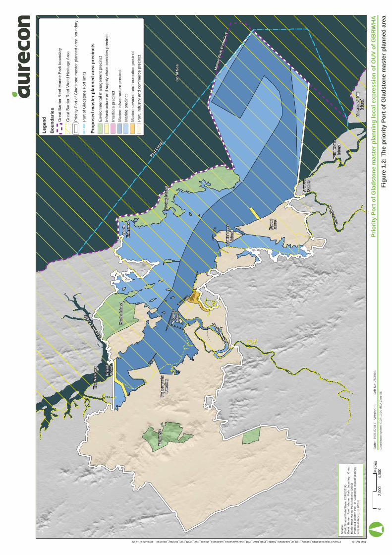
Approximately 59% of the master planned area is within the GBRWHA, including approximately 38,600 ha of marine and intertidal areas. Whilst there are some statutory/operational requirements that apply to these areas, there is currently no planning instrument. The master planned area is illustrated in Figure 1.2.
The area of the master plan within the GBRWHA contributes 0.1% of the total area of the GBRWHA.
1.5 Environmental values within the master planned area and surrounds The environmental values within and surrounding the master planned area were identified and mapped for the PPG evidence base, which includes:
Evidence Based Report for the Proposed Gladstone Port Master Planned Area (AECOM 2016)
Priority Port of Gladstone Master Planning – Risk Assessment (Aurecon 2016).
Environmental values within the master planned area and surrounds are as defined under the Environmental Protection Act 1994 (Qld) (EP Act) and the Ports Act as:
A quality or physical characteristic of the environment that is conducive to ecological health or public amenity or safety; or
Another quality of the environment identified and declared to be an environmental value under an environmental protection policy or regulation.
For the purpose of the priority port master planning process, environmental values also includes the OUV of the GBRWHA and all other environmental values (ie not considered to contribute to the OUV of the GBRWHA).
The area surrounding the master planned area (ie the ‘surrounds’) is defined as areas outside of the PPG master planned area where it is not unreasonable to assume that there is potential for impacts to occur as a result of activities in the master planned area (ie the scenarios and activities assessed in the master planning risk assessment). Due to the range of future activities that may within the master planned area occur during the master plan timeframe, the different potential impact pathways, varying sensitivities of receptors, and different biological traits (eg behaviours and responses to stress) of receptors, the definition of surrounds is specific to each future activity, environmental value or local attribute.
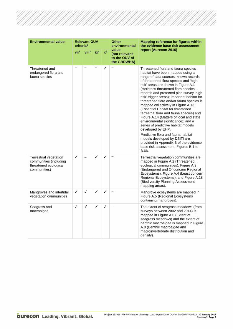
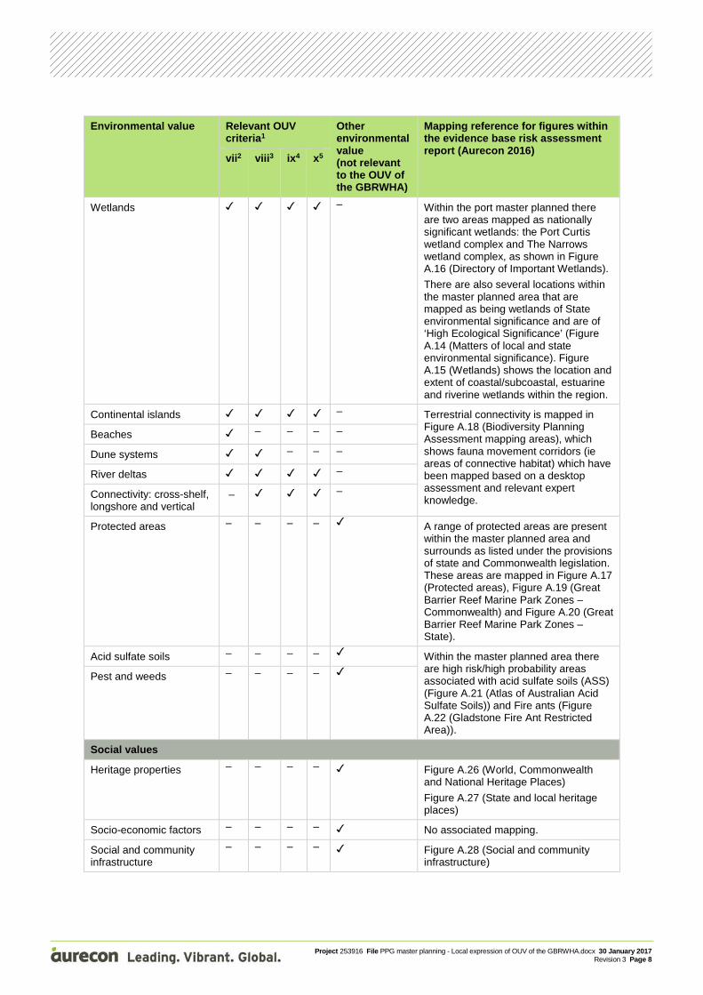
Table 1.1 lists the environmental values known to occur within the master planned area and surrounds as identified in the evidence base, including an indication of whether the value contributes to the OUV of the GBRWHA, or is considered an ‘other environmental value’.
The information in Table 1.1 provides the basis for the assessment of the local expression of the OUV of the GBRWHA for the PPG master planned area and surrounds (ie this report).
Table 1.1 Environmental values within and surrounding the master planned area and surrounds as identified in the evidence base
Environmental value Relevant OUV criteria1
Other environmental value (not relevant to the OUV of the GBRWHA)
Mapping reference for figures within the evidence base risk assessment report (Aurecon 2016)
vii2 viii3 ix4 x5
Fringing reefs – Figure A.7 shows the extent of reefs using indicative reef boundaries.
Inshore turbid reefs – –
Coral species – diversity and extent
–
Wig
gin
sIs
lan
d
Fri
en
dP
oin
t
Th
e N
arr
ow
s
Targ
inn
ie
Gra
ham
's C
reek
Cu
rtis
Isla
nd
N
ort
hE
ntr
an
ce
Fac
ing
Isla
nd
Cal
liope
Riv
er
So
uth
Tre
es
Isla
nd
Bo
yne
Isla
nd
Tan
nu
mS
and
s
Bo
yne
Riv
er
Wild
Cat
tle
Isla
nd
Mar
ine
Par
k B
ou
nd
ary
Co
ral
Se
a
Hu
mm
ock
Hil
lIs
lan
d
Fis
he
rma
n's
L
and
ing
Port
Lim
its
P:\GIS\Projects\253916_Priority_Port_of_Gladstone_Master_Plan_Draft_Port_Overlay\253916_Gladstone_Master_Plan_Draft_Port_Overlay_020.mxd 19/01/2017 10:27
Co
ordi
nat
e sy
stem
: GD
A 1
994
MG
A Z
one
56
Map by: RB
Fig
ure
1.2
: T
he
pri
ori
ty P
ort
of
Gla
ds
ton
e m
as
ter
pla
nn
ed
are
a
Pri
ori
ty P
ort
of
Gla
ds
ton
e m
aste
r p
lan
nin
g l
oc
al
ex
pre
ss
ion
of
OU
V o
f G
BR
WH
AD
ate
:19
/01
/20
17
Ve
rsio
n:
1Jo
b N
o:
25
391
6
So
urc
e:
Wo
rld
Sh
ad
ed R
elie
f Ba
se:
ES
RI (
201
4)
Gre
at
Ba
rrie
r R
eef
M
ari
ne
Par
k b
oun
da
ry:
Gre
at
Ba
rrie
r R
eef
Mar
ine
Pa
rk A
uth
ori
ty (
20
10)
Pro
po
sed
pri
ori
ty P
ort
of G
lad
sto
ne
ma
ste
r p
lan
ne
dar
ea b
oun
da
ry:
DS
D (
201
6)
Le
ge
nd
Bo
un
da
rie
s
Gre
at B
arrie
r R
eef M
arin
e P
ark
boun
dary
Gre
at B
arrie
r R
eef W
orld
He
ritag
e A
rea
Prio
rity
Por
t of G
lads
tone
mas
ter
plan
ned
area
bou
ndar
y
Por
t of G
lads
ton
e P
ort l
imits
Pro
po
se
d m
as
ter
pla
nn
ed
are
a p
rec
inc
ts
Env
ironm
enta
l man
agem
ent p
reci
nct
Infr
astr
uctu
re a
nd
supp
ly c
hain
cor
ridor
s pr
ecin
ct
Inte
rfac
e pr
ecin
ct
Mar
ine
infr
astr
uctu
re p
reci
nct
Mar
ine
prec
inct
Mar
ine
serv
ices
and
rec
reat
ion
prec
inct
Por
t, in
dust
ry a
nd
com
mer
ce p
reci
nct
°0
4,0
00
2,0
00
Me
tre
s

Project 253916 File PPG master planning - Local expression of OUV of the GBRWHA.docx 30 January 2017 Revision 3 Page 6
Environmental value Relevant OUV criteria1
Other environmental value (not relevant to the OUV of the GBRWHA)
Mapping reference for figures within the evidence base risk assessment report (Aurecon 2016)
vii2 viii3 ix4 x5
Marine water quality – – – No associated mapping.
Fresh water and groundwater quality
– – – – No associated mapping.
Fish and nekton – – Habitat areas considered to be important to fish and nekton include (but are not limited to) Figure A.5 (Regional Ecosystems containing mangroves), Figure A.6 (Extent of seagrass meadows), Figure A.7 (Reefs), Figure A.8 (Benthic macroalgae distribution and density), and Figure A.9 (Fish habitat areas and fish movement passages).
Marine megafauna – – The density of dugong has been mapped based on the results of aerial surveys and is shown in Figure A.10 (Relative dugong density based on aerial surveys from 1986 to 2005 and Dugong Protection Areas). Habitat considered important to dugong has also been mapped in Figure A.6 (Extent of seagrass meadows) and Figure A.8 (Benthic macroalgae and macroinvertebrate distribution and density).
Marine turtles and other marine reptiles
– – – Turtle nesting areas are situated on the eastern side of Facing Island and are mapped in Figure A.11 (Marine turtle nesting areas).
Other areas that are important habitat or foraging resources for marine turtles and other marine reptiles are mapped in Figure A.6 (Extent of seagrass meadows), Figure A.7 (Reefs) and Figure A.8 (Benthic macroalgae and macroinvertebrate distribution and density).
Macroinvertebrates – Macroinvertebrate communities are shown in Figure A.8 (Benthic macroalgae and macroinvertebrate distribution and density).
Shorebirds, migratory birds and seabirds
– – A diverse range of habitat types occur within the master planned area as shown in Figure A.12 (Shorebird habitat), providing foraging and roosting habitat for a range of migratory bird species.
Project 253916 File PPG master planning - Local expression of OUV of the GBRWHA.docx 30 January 2017 Revision 3 Page 7
Environmental value Relevant OUV criteria1
Other environmental value (not relevant to the OUV of the GBRWHA)
Mapping reference for figures within the evidence base risk assessment report (Aurecon 2016)
vii2 viii3 ix4 x5
Threatened and endangered flora and fauna species
– – – – Threatened flora and fauna species habitat have been mapped using a range of data sources: known records of threatened flora species and ‘high risk’ areas are shown in Figure A.1 (Herbrecs threatened flora species records and protected plan survey ‘high risk’ trigger areas); important habitat for threatened flora and/or fauna species is mapped collectively in Figure A.13 (Essential Habitat for threatened terrestrial flora and fauna species) and Figure A.14 (Matters of local and state environmental significance); and a series of predictive habitat models developed by EHP.
Predictive flora and fauna habitat models developed by DSITI are provided in Appendix B of the evidence base risk assessment, Figures B.1 to B.66.
Terrestrial vegetation communities (including threatened ecological communities)
– – Terrestrial vegetation communities are mapped in Figure A.2 (Threatened ecological communities), Figure A.3 (Endangered and Of concern Regional Ecosystems), Figure A.4 (Least concern Regional Ecosystems), and Figure A.18 (Biodiversity Planning Assessment mapping areas).
Mangroves and intertidal vegetation communities
– Mangrove ecosystems are mapped in Figure A.5 (Regional Ecosystems containing mangroves).
Seagrass and macroalgae
– The extent of seagrass meadows (from surveys between 2002 and 2014) is mapped in Figure A.6 (Extent of seagrass meadows) and the extent of benthic macroalgae is mapped in Figure A.8 (Benthic macroalgae and macroinvertebrate distribution and density).
Project 253916 File PPG master planning - Local expression of OUV of the GBRWHA.docx 30 January 2017 Revision 3 Page 8
Environmental value Relevant OUV criteria1
Other environmental value (not relevant to the OUV of the GBRWHA)
Mapping reference for figures within the evidence base risk assessment report (Aurecon 2016)
vii2 viii3 ix4 x5
Wetlands – Within the port master planned there are two areas mapped as nationally significant wetlands: the Port Curtis wetland complex and The Narrows wetland complex, as shown in Figure A.16 (Directory of Important Wetlands).
There are also several locations within the master planned area that are mapped as being wetlands of State environmental significance and are of ‘High Ecological Significance’ (Figure A.14 (Matters of local and state environmental significance). Figure A.15 (Wetlands) shows the location and extent of coastal/subcoastal, estuarine and riverine wetlands within the region.
Continental islands – Terrestrial connectivity is mapped in Figure A.18 (Biodiversity Planning Assessment mapping areas), which shows fauna movement corridors (ie areas of connective habitat) which have been mapped based on a desktop assessment and relevant expert knowledge.
Beaches – – – –
Dune systems – – –
River deltas –
Connectivity: cross-shelf, longshore and vertical
– –
Protected areas – – – – A range of protected areas are present within the master planned area and surrounds as listed under the provisions of state and Commonwealth legislation. These areas are mapped in Figure A.17 (Protected areas), Figure A.19 (Great Barrier Reef Marine Park Zones – Commonwealth) and Figure A.20 (Great Barrier Reef Marine Park Zones – State).
Acid sulfate soils – – – – Within the master planned area there are high risk/high probability areas associated with acid sulfate soils (ASS) (Figure A.21 (Atlas of Australian Acid Sulfate Soils)) and Fire ants (Figure A.22 (Gladstone Fire Ant Restricted Area)).
Pest and weeds – – – –
Social values
Heritage properties – – – – Figure A.26 (World, Commonwealth and National Heritage Places)
Figure A.27 (State and local heritage places)
Socio-economic factors – – – – No associated mapping.
Social and community infrastructure
– – – – Figure A.28 (Social and community infrastructure)
Project 253916 File PPG master planning - Local expression of OUV of the GBRWHA.docx 30 January 2017 Revision 3 Page 9
Environmental value Relevant OUV criteria1
Other environmental value (not relevant to the OUV of the GBRWHA)
Mapping reference for figures within the evidence base risk assessment report (Aurecon 2016)
vii2 viii3 ix4 x5
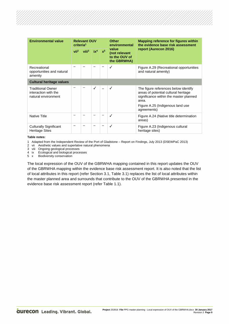
Recreational opportunities and natural amenity
– – – – Figure A.29 (Recreational opportunities and natural amenity)
Cultural heritage values
Traditional Owner interaction with the natural environment
– – – The figure references below identify areas of potential cultural heritage significance within the master planned area.
Figure A.25 (Indigenous land use agreements)
Native Title – – – – Figure A.24 (Native title determination areas)
Culturally Significant Heritage Sites
– – – – Figure A.23 (Indigenous cultural heritage sites)
Table notes:
1 Adapted from the Independent Review of the Port of Gladstone – Report on Findings, July 2013 (DSEWPaC 2013) 2 vii Aesthetic values and superlative natural phenomena 3 viii Ongoing geological processes 4 ix Ecological and biological processes 5 x Biodiversity conservation
The local expression of the OUV of the GBRWHA mapping contained in this report updates the OUV of the GBRWHA mapping within the evidence base risk assessment report. It is also noted that the list of local attributes in this report (refer Section 3.1, Table 3.1) replaces the list of local attributes within the master planned area and surrounds that contribute to the OUV of the GBRWHA presented in the evidence base risk assessment report (refer Table 1.1).
Project 253916 File PPG master planning - Local expression of OUV of the GBRWHA.docx 30 January 2017 Revision 3 Page 10
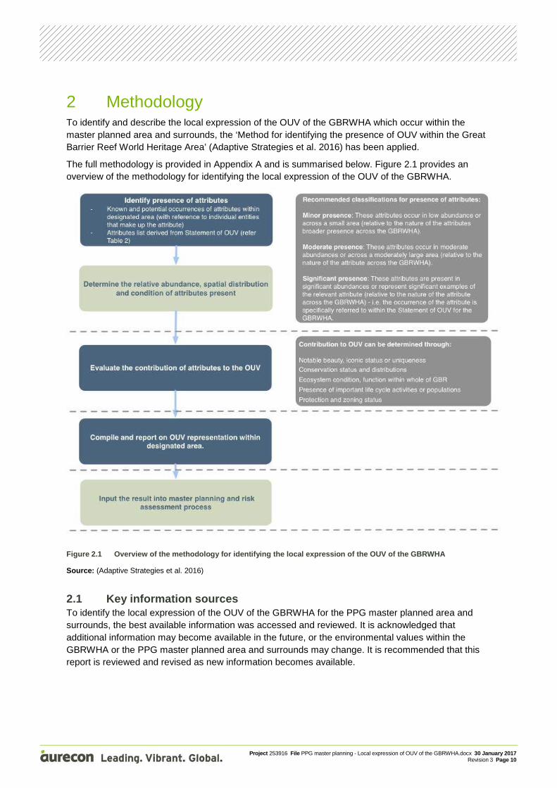
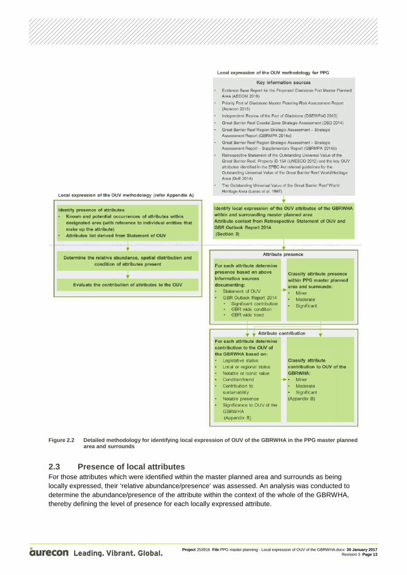
2 Methodology To identify and describe the local expression of the OUV of the GBRWHA which occur within the master planned area and surrounds, the ‘Method for identifying the presence of OUV within the Great Barrier Reef World Heritage Area’ (Adaptive Strategies et al. 2016) has been applied.
The full methodology is provided in Appendix A and is summarised below. Figure 2.1 provides an overview of the methodology for identifying the local expression of the OUV of the GBRWHA.
Figure 2.1 Overview of the methodology for identifying the local expression of the OUV of the GBRWHA
Source: (Adaptive Strategies et al. 2016)
2.1 Key information sources To identify the local expression of the OUV of the GBRWHA for the PPG master planned area and surrounds, the best available information was accessed and reviewed. It is acknowledged that additional information may become available in the future, or the environmental values within the GBRWHA or the PPG master planned area and surrounds may change. It is recommended that this report is reviewed and revised as new information becomes available.
Project 253916 File PPG master planning - Local expression of OUV of the GBRWHA.docx 30 January 2017 Revision 3 Page 11
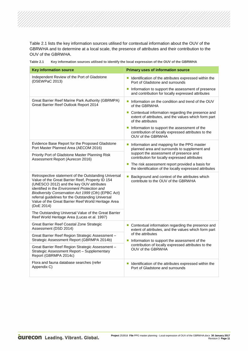
Table 2.1 lists the key information sources utilised for contextual information about the OUV of the GBRWHA and to determine at a local scale, the presence of attributes and their contribution to the OUV of the GBRWHA.
Table 2.1 Key information sources utilised to identify the local expression of the OUV of the GBRWHA
Key information source Primary uses of information source
Independent Review of the Port of Gladstone (DSEWPaC 2013)
Identification of the attributes expressed within the Port of Gladstone and surrounds
Information to support the assessment of presence and contribution for locally expressed attributes
Great Barrier Reef Marine Park Authority (GBRMPA) Great Barrier Reef Outlook Report 2014
Information on the condition and trend of the OUV of the GBRWHA
Contextual information regarding the presence and extent of attributes, and the values which form part of the attributes
Information to support the assessment of the contribution of locally expressed attributes to the OUV of the GBRWHA
Evidence Base Report for the Proposed Gladstone Port Master Planned Area (AECOM 2016)
Information and mapping for the PPG master planned area and surrounds to supplement and support the assessment of presence and contribution for locally expressed attributes
The risk assessment report provided a basis for the identification of the locally expressed attributes
Priority Port of Gladstone Master Planning Risk Assessment Report (Aurecon 2016)
Retrospective statement of the Outstanding Universal Value of the Great Barrier Reef, Property ID 154 (UNESCO 2012) and the key OUV attributes identified in the Environment Protection and Biodiversity Conservation Act 1999 (Cth) (EPBC Act) referral guidelines for the Outstanding Universal Value of the Great Barrier Reef World Heritage Area (DoE 2014)
Background and context of the attributes which contribute to the OUV of the GBRWHA
The Outstanding Universal Value of the Great Barrier Reef World Heritage Area (Lucas et al. 1997)
Great Barrier Reef Coastal Zone Strategic Assessment (DSD 2014)
Contextual information regarding the presence and extent of attributes, and the values which form part of the attributes
Information to support the assessment of the contribution of locally expressed attributes to the OUV of the GBRWHA
Great Barrier Reef Region Strategic Assessment – Strategic Assessment Report (GBRMPA 2014b)
Great Barrier Reef Region Strategic Assessment – Strategic Assessment Report – Supplementary Report (GBRMPA 2014c)
Flora and fauna database searches (refer Appendix C)
Identification of the attributes expressed within the Port of Gladstone and surrounds
Project 253916 File PPG master planning - Local expression of OUV of the GBRWHA.docx 30 January 2017 Revision 3 Page 12
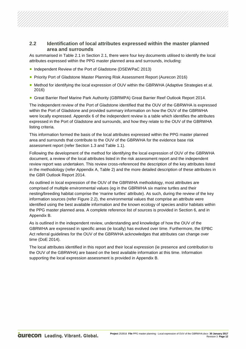
2.2 Identification of local attributes expressed within the master planned area and surrounds
As summarised in Table 2.1 in Section 2.1, there were four key documents utilised to identify the local attributes expressed within the PPG master planned area and surrounds, including:
Independent Review of the Port of Gladstone (DSEWPaC 2013)
Priority Port of Gladstone Master Planning Risk Assessment Report (Aurecon 2016)
Method for identifying the local expression of OUV within the GBRWHA (Adaptive Strategies et al. 2016)
Great Barrier Reef Marine Park Authority (GBRMPA) Great Barrier Reef Outlook Report 2014.
The independent review of the Port of Gladstone identified that the OUV of the GBRWHA is expressed within the Port of Gladstone and provided summary information on how the OUV of the GBRWHA were locally expressed. Appendix 6 of the independent review is a table which identifies the attributes expressed in the Port of Gladstone and surrounds, and how they relate to the OUV of the GBRWHA listing criteria.
This information formed the basis of the local attributes expressed within the PPG master planned area and surrounds that contribute to the OUV of the GBRWHA for the evidence base risk assessment report (refer Section 1.3 and Table 1.1).
Following the development of the method for identifying the local expression of OUV of the GBRWHA document, a review of the local attributes listed in the risk assessment report and the independent review report was undertaken. This review cross-referenced the description of the key attributes listed in the methodology (refer Appendix A, Table 2) and the more detailed description of these attributes in the GBR Outlook Report 2014.
As outlined in local expression of the OUV of the GBRWHA methodology, most attributes are comprised of multiple environmental values (eg in the GBRWHA six marine turtles and their nesting/breeding habitat comprise the ‘marine turtles’ attribute). As such, during the review of the key information sources (refer Figure 2.2), the environmental values that comprise an attribute were identified using the best available information and the known ecology of species and/or habitats within the PPG master planned area. A complete reference list of sources is provided in Section 6, and in Appendix B.
As is outlined in the independent review, understanding and knowledge of how the OUV of the GBRWHA are expressed in specific areas (ie locally) has evolved over time. Furthermore, the EPBC Act referral guidelines for the OUV of the GBRWHA acknowledges that attributes can change over time (DoE 2014).
The local attributes identified in this report and their local expression (ie presence and contribution to the OUV of the GBRWHA) are based on the best available information at this time. Information supporting the local expression assessment is provided in Appendix B.
Project 253916 File PPG master planning - Local expression of OUV of the GBRWHA.docx 30 January 2017 Revision 3 Page 13
Figure 2.2 Detailed methodology for identifying local expression of OUV of the GBRWHA in the PPG master planned
area and surrounds
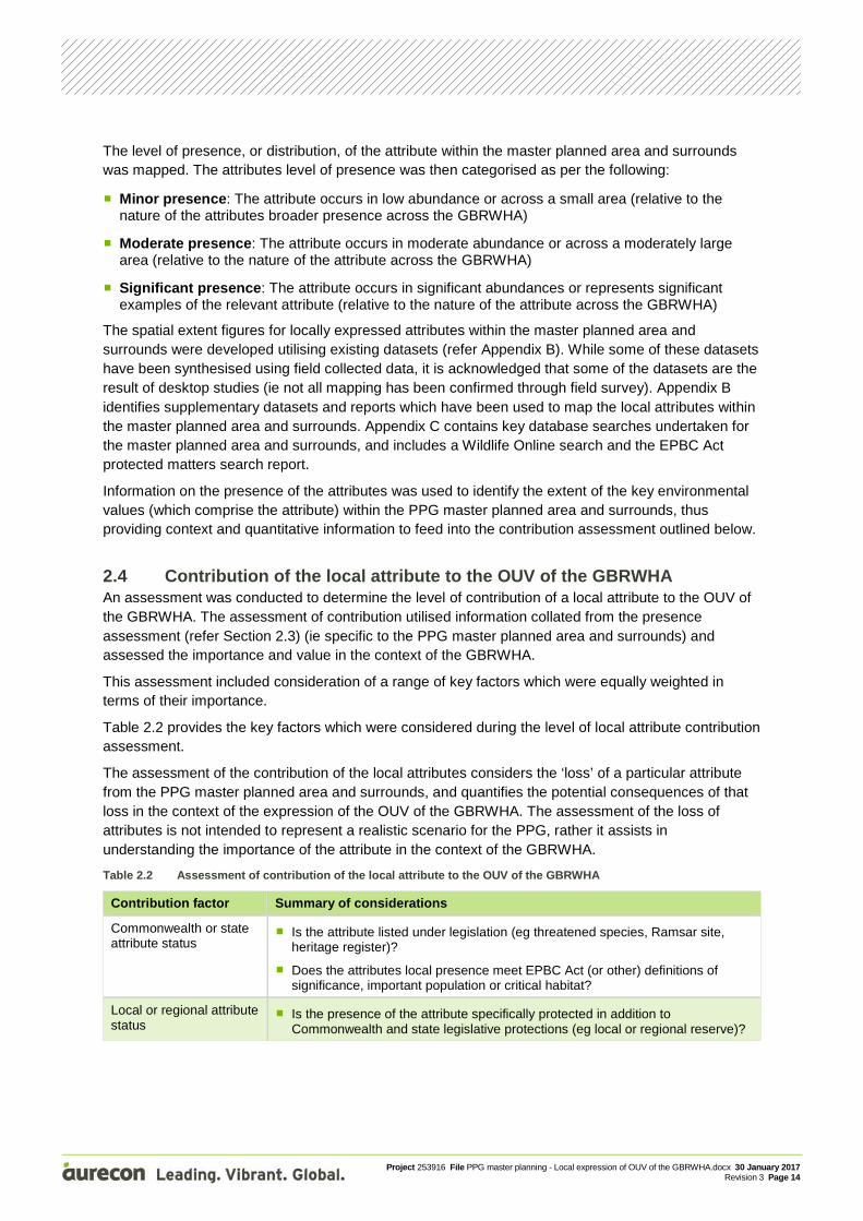
2.3 Presence of local attributes For those attributes which were identified within the master planned area and surrounds as being locally expressed, their ‘relative abundance/presence’ was assessed. An analysis was conducted to determine the abundance/presence of the attribute within the context of the whole of the GBRWHA, thereby defining the level of presence for each locally expressed attribute.
Project 253916 File PPG master planning - Local expression of OUV of the GBRWHA.docx 30 January 2017 Revision 3 Page 14
The level of presence, or distribution, of the attribute within the master planned area and surrounds was mapped. The attributes level of presence was then categorised as per the following:
Minor presence: The attribute occurs in low abundance or across a small area (relative to the nature of the attributes broader presence across the GBRWHA)
Moderate presence: The attribute occurs in moderate abundance or across a moderately large area (relative to the nature of the attribute across the GBRWHA)
Significant presence: The attribute occurs in significant abundances or represents significant examples of the relevant attribute (relative to the nature of the attribute across the GBRWHA)
The spatial extent figures for locally expressed attributes within the master planned area and surrounds were developed utilising existing datasets (refer Appendix B). While some of these datasets have been synthesised using field collected data, it is acknowledged that some of the datasets are the result of desktop studies (ie not all mapping has been confirmed through field survey). Appendix B identifies supplementary datasets and reports which have been used to map the local attributes within the master planned area and surrounds. Appendix C contains key database searches undertaken for the master planned area and surrounds, and includes a Wildlife Online search and the EPBC Act protected matters search report.
Information on the presence of the attributes was used to identify the extent of the key environmental values (which comprise the attribute) within the PPG master planned area and surrounds, thus providing context and quantitative information to feed into the contribution assessment outlined below.
2.4 Contribution of the local attribute to the OUV of the GBRWHA An assessment was conducted to determine the level of contribution of a local attribute to the OUV of the GBRWHA. The assessment of contribution utilised information collated from the presence assessment (refer Section 2.3) (ie specific to the PPG master planned area and surrounds) and assessed the importance and value in the context of the GBRWHA.
This assessment included consideration of a range of key factors which were equally weighted in terms of their importance.
Table 2.2 provides the key factors which were considered during the level of local attribute contribution assessment.
The assessment of the contribution of the local attributes considers the ‘loss’ of a particular attribute from the PPG master planned area and surrounds, and quantifies the potential consequences of that loss in the context of the expression of the OUV of the GBRWHA. The assessment of the loss of attributes is not intended to represent a realistic scenario for the PPG, rather it assists in understanding the importance of the attribute in the context of the GBRWHA.
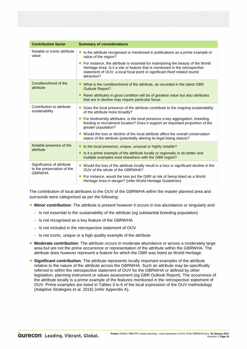
Table 2.2 Assessment of contribution of the local attribute to the OUV of the GBRWHA
Contribution factor Summary of considerations
Commonwealth or state attribute status
Is the attribute listed under legislation (eg threatened species, Ramsar site, heritage register)?
Does the attributes local presence meet EPBC Act (or other) definitions of significance, important population or critical habitat?
Local or regional attribute status
Is the presence of the attribute specifically protected in addition to Commonwealth and state legislative protections (eg local or regional reserve)?
Project 253916 File PPG master planning - Local expression of OUV of the GBRWHA.docx 30 January 2017 Revision 3 Page 15
Contribution factor Summary of considerations
Notable or iconic attribute value
Is the attribute recognised or mentioned in publications as a prime example or value of the region?
For instance, the attribute is essential for maintaining the beauty of the World Heritage Area. Is it a site or feature that is mentioned in the retrospective statement of OUV, a local focal point or significant Reef related tourist attraction?
Condition/trend of the attribute
What is the condition/trend of the attribute, as recorded in the latest GBR Outlook Report?
Rarer attributes in good condition will be of greatest value but also attributes that are in decline may require particular focus.
Contribution to attribute sustainability
Does the local presence of the attribute contribute to the ongoing sustainability of the attribute more broadly?
For biodiversity attributes, is the local presence a key aggregation, breeding, feeding or recruitment location? Does it support an important proportion of the greater population?
Would the loss or decline of the local attribute affect the overall conservation status of the attribute (potentially altering its legal listing status)?
Notable presence of the attribute
Is the local presence, unique, unusual or highly notable?
Is it a prime example of the attribute locally or regionally or do better and multiple examples exist elsewhere with the GBR region?
Significance of attribute to the preservation of the GBRWHA
Would the loss of the attribute locally result in a loss or significant decline in the OUV of the whole of the GBRWHA?
For instance, would the loss put the GBR at risk of being listed as a World Heritage Area in danger? (refer World Heritage Guidelines).
The contribution of local attributes to the OUV of the GBRWHA within the master planned area and surrounds were categorised as per the following:
Minor contribution: The attribute is present however it occurs in low abundance or singularly and:
− Is not essential to the sustainability of the attribute (eg substantial breeding population)
− Is not recognised as a key feature of the GBRWHA
− Is not included in the retrospective statement of OUV
− Is not iconic, unique or a high quality example of the attribute
Moderate contribution: The attribute occurs in moderate abundance or across a moderately large area but are not the prime occurrence or representation of the attribute within the GBRWHA. The attribute does however represent a feature for which the GBR was listed as World Heritage.
Significant contribution: The attribute represents locally important examples of the attribute relative to the nature of the attribute across the GBRWHA. Such an attribute may be specifically referred to within the retrospective statement of OUV for the GBRWHA or defined by other legislation, planning instrument or values assessment (eg GBR Outlook Report). The occurrence of the attribute locally is a prime example of the features mentioned in the retrospective statement of OUV. Prime examples are listed in Tables 3 to 6 of the local expression of the OUV methodology (Adaptive Strategies et al. 2016) (refer Appendix A).
Project 253916 File PPG master planning - Local expression of OUV of the GBRWHA.docx 30 January 2017 Revision 3 Page 16
3 OUV of the GBRWHA within the master planned area and surrounds
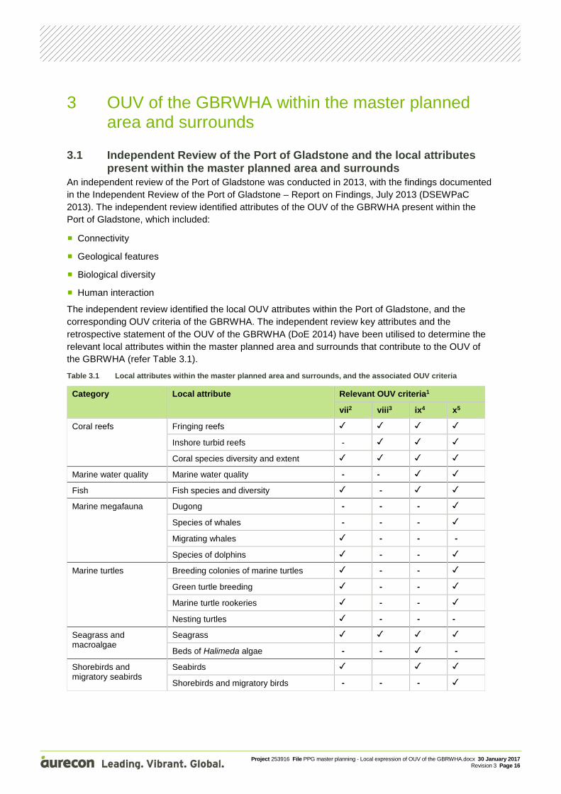
3.1 Independent Review of the Port of Gladstone and the local attributes present within the master planned area and surrounds
An independent review of the Port of Gladstone was conducted in 2013, with the findings documented in the Independent Review of the Port of Gladstone – Report on Findings, July 2013 (DSEWPaC 2013). The independent review identified attributes of the OUV of the GBRWHA present within the Port of Gladstone, which included:
Connectivity
Geological features
Biological diversity
Human interaction
The independent review identified the local OUV attributes within the Port of Gladstone, and the corresponding OUV criteria of the GBRWHA. The independent review key attributes and the retrospective statement of the OUV of the GBRWHA (DoE 2014) have been utilised to determine the relevant local attributes within the master planned area and surrounds that contribute to the OUV of the GBRWHA (refer Table 3.1).
Table 3.1 Local attributes within the master planned area and surrounds, and the associated OUV criteria
Category Local attribute Relevant OUV criteria1
vii2 viii3 ix4 x5
Coral reefs Fringing reefs
Inshore turbid reefs -
Coral species diversity and extent
Marine water quality Marine water quality - -
Fish Fish species and diversity -
Marine megafauna Dugong - - -
Species of whales - - -
Migrating whales - - -
Species of dolphins - -
Marine turtles Breeding colonies of marine turtles - -
Green turtle breeding - -
Marine turtle rookeries - -
Nesting turtles - - -
Seagrass and macroalgae
Seagrass
Beds of Halimeda algae - - -
Shorebirds and migratory seabirds
Seabirds
Shorebirds and migratory birds - - -
Project 253916 File PPG master planning - Local expression of OUV of the GBRWHA.docx 30 January 2017 Revision 3 Page 17
Category Local attribute Relevant OUV criteria1
vii2 viii3 ix4 x5
Flora, fauna and ecological communities
Threatened and endangered flora and fauna species (including threatened ecological communities)
- -
Vegetated mountains - - -
Mangroves
Mangrove species diversity - - -
Vast mangrove forests - - -
Continental islands Continental islands and green vegetated islands
- -
Plant species diversity and endemism (species being unique to a defined geographic location)
- - -
Vegetation of the continental islands - -
Geomorphology Beaches - - -
Dune systems - -
River deltas
Connectivity: cross-shelf, longshore and vertical
-
Cultural heritage values Traditional Owner interaction with the natural environment
- - -
Marine fauna Marine faunal groups diversity (including sharks, rays, megafauna, marine turtles and other marine reptiles)
-
Total species diversity Total species diversity -
Table notes: 2 Adapted from the Independent Review of the Port of Gladstone – Report on Findings, July 2013 (DSEWPaC 2013) 2 vii Aesthetic values and superlative natural phenomena 3 viii Ongoing geological processes 4 ix Ecological and biological processes 5 x Biodiversity conservation
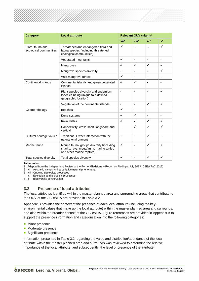
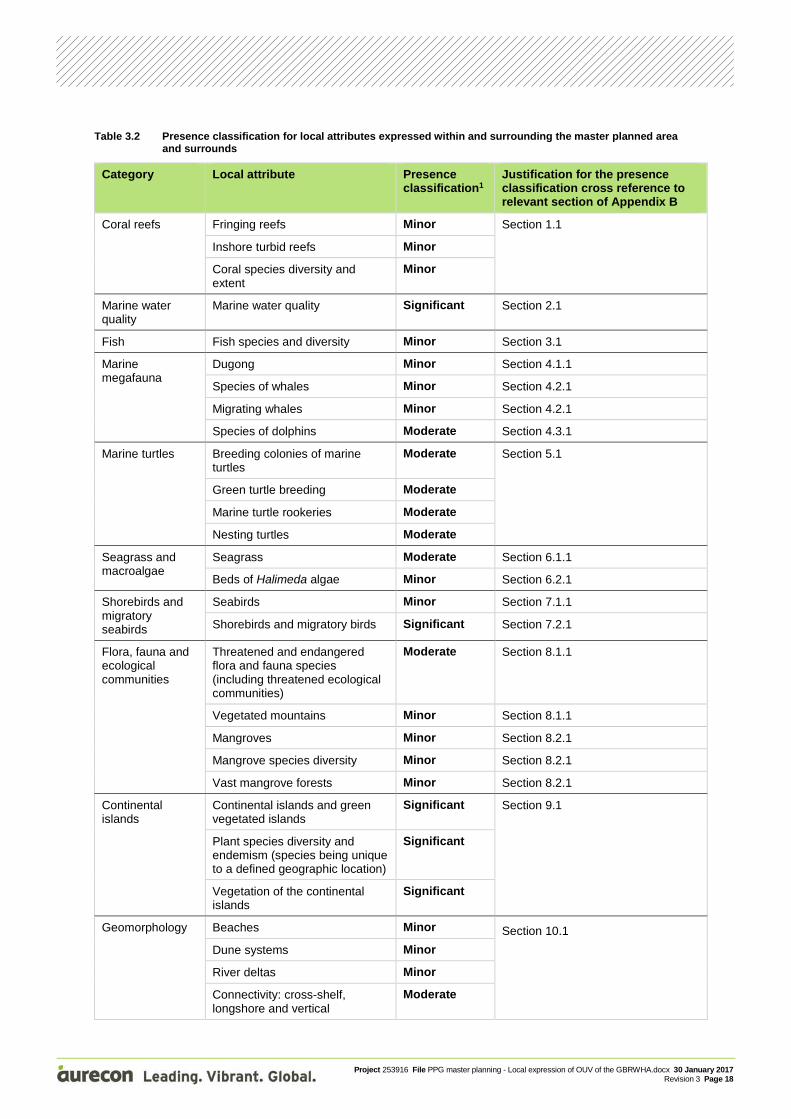
3.2 Presence of local attributes The local attributes identified within the master planned area and surrounding areas that contribute to the OUV of the GBRWHA are provided in Table 3.2.
Appendix B provides the context of the presence of each local attribute (including the key environmental values that make up the local attribute) within the master planned area and surrounds, and also within the broader context of the GBRWHA. Figure references are provided in Appendix B to support the presence information and categorisation into the following categories:
Minor presence
Moderate presence
Significant presence
Information presented in Table 3.2 regarding the value and distribution/abundance of the local attribute within the master planned area and surrounds was reviewed to determine the relative importance of the local attribute, and subsequently, the level of presence of the attribute.
Project 253916 File PPG master planning - Local expression of OUV of the GBRWHA.docx 30 January 2017 Revision 3 Page 18
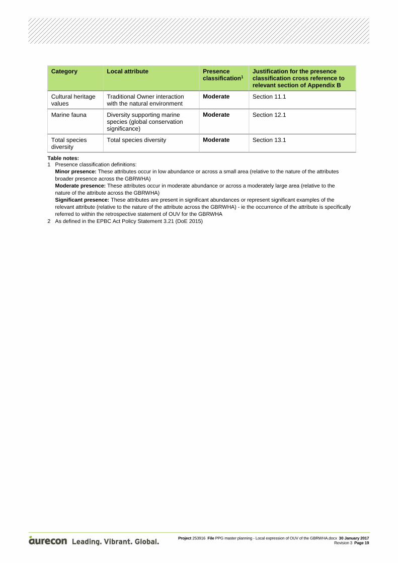
Table 3.2 Presence classification for local attributes expressed within and surrounding the master planned area and surrounds
Category Local attribute Presence classification1
Justification for the presence classification cross reference to relevant section of Appendix B
Coral reefs Fringing reefs Minor Section 1.1
Inshore turbid reefs Minor
Coral species diversity and extent
Minor
Marine water quality
Marine water quality Significant Section 2.1
Fish Fish species and diversity Minor Section 3.1
Marine megafauna
Dugong Minor Section 4.1.1
Species of whales Minor Section 4.2.1
Migrating whales Minor Section 4.2.1
Species of dolphins Moderate Section 4.3.1
Marine turtles Breeding colonies of marine turtles
Moderate Section 5.1
Green turtle breeding Moderate
Marine turtle rookeries Moderate
Nesting turtles Moderate
Seagrass and macroalgae
Seagrass Moderate Section 6.1.1
Beds of Halimeda algae Minor Section 6.2.1
Shorebirds and migratory seabirds
Seabirds Minor Section 7.1.1
Shorebirds and migratory birds Significant Section 7.2.1
Flora, fauna and ecological communities
Threatened and endangered flora and fauna species (including threatened ecological communities)
Moderate Section 8.1.1
Vegetated mountains Minor Section 8.1.1
Mangroves Minor Section 8.2.1
Mangrove species diversity Minor Section 8.2.1
Vast mangrove forests Minor Section 8.2.1
Continental islands
Continental islands and green vegetated islands
Significant Section 9.1
Plant species diversity and endemism (species being unique to a defined geographic location)
Significant
Vegetation of the continental islands
Significant
Geomorphology Beaches Minor Section 10.1
Dune systems Minor
River deltas Minor
Connectivity: cross-shelf, longshore and vertical
Moderate
Project 253916 File PPG master planning - Local expression of OUV of the GBRWHA.docx 30 January 2017 Revision 3 Page 19
Category Local attribute Presence classification1
Justification for the presence classification cross reference to relevant section of Appendix B
Cultural heritage values
Traditional Owner interaction with the natural environment
Moderate Section 11.1
Marine fauna Diversity supporting marine species (global conservation significance)
Moderate Section 12.1
Total species diversity
Total species diversity Moderate Section 13.1
Table notes: 1 Presence classification definitions:
Minor presence: These attributes occur in low abundance or across a small area (relative to the nature of the attributes broader presence across the GBRWHA) Moderate presence: These attributes occur in moderate abundance or across a moderately large area (relative to the nature of the attribute across the GBRWHA) Significant presence: These attributes are present in significant abundances or represent significant examples of the relevant attribute (relative to the nature of the attribute across the GBRWHA) - ie the occurrence of the attribute is specifically referred to within the retrospective statement of OUV for the GBRWHA
2 As defined in the EPBC Act Policy Statement 3.21 (DoE 2015)
Project 253916 File PPG master planning - Local expression of OUV of the GBRWHA.docx 30 January 2017 Revision 3 Page 20
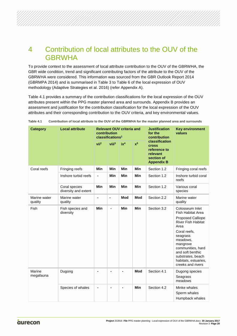
4 Contribution of local attributes to the OUV of the GBRWHA
To provide context to the assessment of local attribute contribution to the OUV of the GBRWHA, the GBR wide condition, trend and significant contributing factors of the attribute to the OUV of the GBRWHA were considered. This information was sourced from the GBR Outlook Report 2014 (GBRMPA 2014) and is summarised in Table 3 to Table 6 of the local expression of OUV methodology (Adaptive Strategies et al. 2016) (refer Appendix A).
Table 4.1 provides a summary of the contribution classifications for the local expression of the OUV attributes present within the PPG master planned area and surrounds. Appendix B provides an assessment and justification for the contribution classification for the local expression of the OUV attributes and their corresponding contribution to the OUV criteria, and key environmental values.
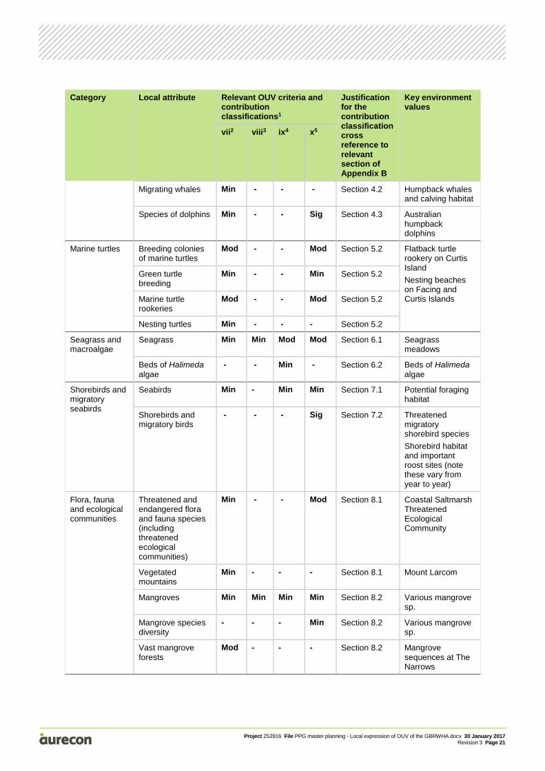
Table 4.1 Contribution of local attribute to the OUV of the GBRWHA for the master planned area and surrounds
Category Local attribute Relevant OUV criteria and contribution classifications1
Justification for the contribution classification cross reference to relevant section of Appendix B
Key environment values
vii2 viii3 ix4 x5
Coral reefs Fringing reefs Min Min Min Min Section 1.2 Fringing coral reefs
Inshore turbid reefs - Min Min Min Section 1.2 Inshore turbid coral reefs
Coral species diversity and extent
Min Min Min Min Section 1.2 Various coral species
Marine water quality
Marine water quality
- - Mod Mod Section 2.2 Marine water quality
Fish Fish species and diversity
Min - Min Min Section 3.2 Colosseum Inlet Fish Habitat Area
Proposed Calliope River Fish Habitat Area
Coral reefs, seagrass meadows, mangrove communities, hard and soft benthic substrates, beach habitats, estuaries, creeks and rivers
Marine megafauna
Dugong - - - Mod Section 4.1 Dugong species
Seagrass meadows
Species of whales - - - Min Section 4.2 Minke whales
Sperm whales
Humpback whales
Project 253916 File PPG master planning - Local expression of OUV of the GBRWHA.docx 30 January 2017 Revision 3 Page 21
Category Local attribute Relevant OUV criteria and contribution classifications1
Justification for the contribution classification cross reference to relevant section of Appendix B
Key environment values
vii2 viii3 ix4 x5
Migrating whales Min - - - Section 4.2 Humpback whales and calving habitat
Species of dolphins Min - - Sig Section 4.3 Australian humpback dolphins
Marine turtles Breeding colonies of marine turtles
Mod - - Mod Section 5.2 Flatback turtle rookery on Curtis Island
Nesting beaches on Facing and Curtis Islands
Green turtle breeding
Min - - Min Section 5.2
Marine turtle rookeries
Mod - - Mod Section 5.2
Nesting turtles Min - - - Section 5.2
Seagrass and macroalgae
Seagrass Min Min Mod Mod Section 6.1 Seagrass meadows
Beds of Halimeda algae
- - Min - Section 6.2 Beds of Halimeda algae
Shorebirds and migratory seabirds
Seabirds Min - Min Min Section 7.1 Potential foraging habitat
Shorebirds and migratory birds
- - - Sig Section 7.2 Threatened migratory shorebird species
Shorebird habitat and important roost sites (note these vary from year to year)
Flora, fauna and ecological communities
Threatened and endangered flora and fauna species (including threatened ecological communities)
Min - - Mod Section 8.1 Coastal Saltmarsh Threatened Ecological Community
Vegetated mountains
Min - - - Section 8.1 Mount Larcom
Mangroves Min Min Min Min Section 8.2 Various mangrove sp.
Mangrove species diversity
- - - Min Section 8.2 Various mangrove sp.
Vast mangrove forests
Mod - - - Section 8.2 Mangrove sequences at The Narrows
Project 253916 File PPG master planning - Local expression of OUV of the GBRWHA.docx 30 January 2017 Revision 3 Page 22
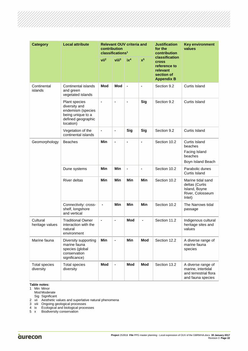
Category Local attribute Relevant OUV criteria and contribution classifications1
Justification for the contribution classification cross reference to relevant section of Appendix B
Key environment values
vii2 viii3 ix4 x5
Continental islands
Continental islands and green vegetated islands
Mod Mod - - Section 9.2 Curtis Island
Plant species diversity and endemism (species being unique to a defined geographic location)
- - - Sig Section 9.2 Curtis Island
Vegetation of the continental islands
- - Sig Sig Section 9.2 Curtis Island
Geomorphology Beaches Min - - - Section 10.2 Curtis Island beaches
Facing Island beaches
Boyn Island Beach
Dune systems Min Min - - Section 10.2 Parabolic dunes Curtis Island
River deltas Min Min Min Min Section 10.2 Marine tidal sand deltas (Curtis Island, Boyne River, Colosseum Inlet)
Connectivity: cross-shelf, longshore and vertical
- Min Min Min Section 10.2 The Narrows tidal passage
Cultural heritage values
Traditional Owner interaction with the natural environment
- - Mod - Section 11.2 Indigenous cultural heritage sites and values
Marine fauna Diversity supporting marine fauna species (global conservation significance)
Min - Min Mod Section 12.2 A diverse range of marine fauna species
Total species diversity
Total species diversity
Mod - Mod Mod Section 13.2 A diverse range of marine, intertidal and terrestrial flora and fauna species
Table notes: 1 Min Minor Mod Moderate Sig Significant 2 vii Aesthetic values and superlative natural phenomena 3 viii Ongoing geological processes 4 ix Ecological and biological processes 5 x Biodiversity conservation
Project 253916 File PPG master planning - Local expression of OUV of the GBRWHA.docx 30 January 2017 Revision 3 Page 23
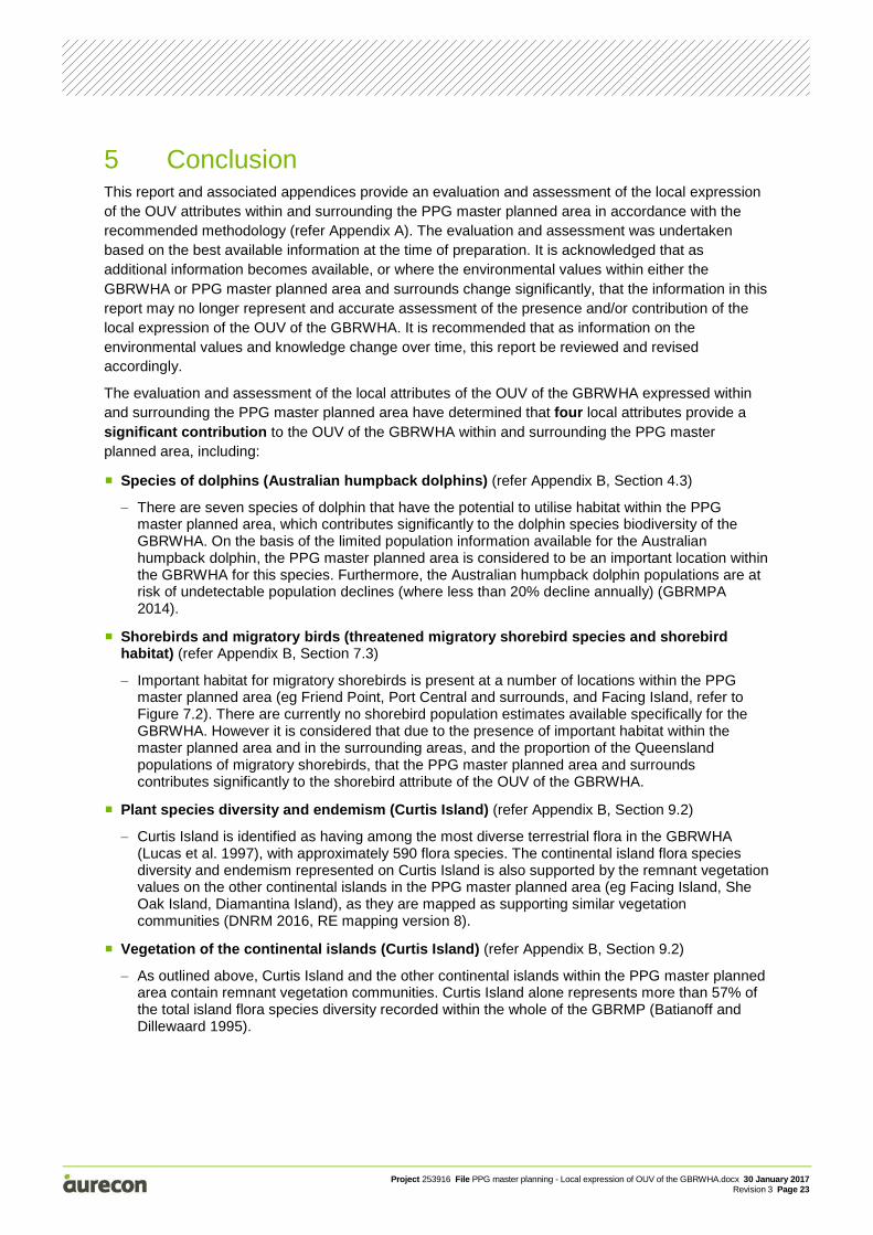
5 Conclusion This report and associated appendices provide an evaluation and assessment of the local expression of the OUV attributes within and surrounding the PPG master planned area in accordance with the recommended methodology (refer Appendix A). The evaluation and assessment was undertaken based on the best available information at the time of preparation. It is acknowledged that as additional information becomes available, or where the environmental values within either the GBRWHA or PPG master planned area and surrounds change significantly, that the information in this report may no longer represent and accurate assessment of the presence and/or contribution of the local expression of the OUV of the GBRWHA. It is recommended that as information on the environmental values and knowledge change over time, this report be reviewed and revised accordingly.
The evaluation and assessment of the local attributes of the OUV of the GBRWHA expressed within and surrounding the PPG master planned area have determined that four local attributes provide a significant contribution to the OUV of the GBRWHA within and surrounding the PPG master planned area, including:
Species of dolphins (Australian humpback dolphins) (refer Appendix B, Section 4.3)
− There are seven species of dolphin that have the potential to utilise habitat within the PPG master planned area, which contributes significantly to the dolphin species biodiversity of the GBRWHA. On the basis of the limited population information available for the Australian humpback dolphin, the PPG master planned area is considered to be an important location within the GBRWHA for this species. Furthermore, the Australian humpback dolphin populations are at risk of undetectable population declines (where less than 20% decline annually) (GBRMPA 2014).
Shorebirds and migratory birds (threatened migratory shorebird species and shorebird habitat) (refer Appendix B, Section 7.3)
− Important habitat for migratory shorebirds is present at a number of locations within the PPG master planned area (eg Friend Point, Port Central and surrounds, and Facing Island, refer to Figure 7.2). There are currently no shorebird population estimates available specifically for the GBRWHA. However it is considered that due to the presence of important habitat within the master planned area and in the surrounding areas, and the proportion of the Queensland populations of migratory shorebirds, that the PPG master planned area and surrounds contributes significantly to the shorebird attribute of the OUV of the GBRWHA.
Plant species diversity and endemism (Curtis Island) (refer Appendix B, Section 9.2)
− Curtis Island is identified as having among the most diverse terrestrial flora in the GBRWHA (Lucas et al. 1997), with approximately 590 flora species. The continental island flora species diversity and endemism represented on Curtis Island is also supported by the remnant vegetation values on the other continental islands in the PPG master planned area (eg Facing Island, She Oak Island, Diamantina Island), as they are mapped as supporting similar vegetation communities (DNRM 2016, RE mapping version 8).
Vegetation of the continental islands (Curtis Island) (refer Appendix B, Section 9.2)
− As outlined above, Curtis Island and the other continental islands within the PPG master planned area contain remnant vegetation communities. Curtis Island alone represents more than 57% of the total island flora species diversity recorded within the whole of the GBRMP (Batianoff and Dillewaard 1995).
Project 253916 File PPG master planning - Local expression of OUV of the GBRWHA.docx 30 January 2017 Revision 3 Page 24
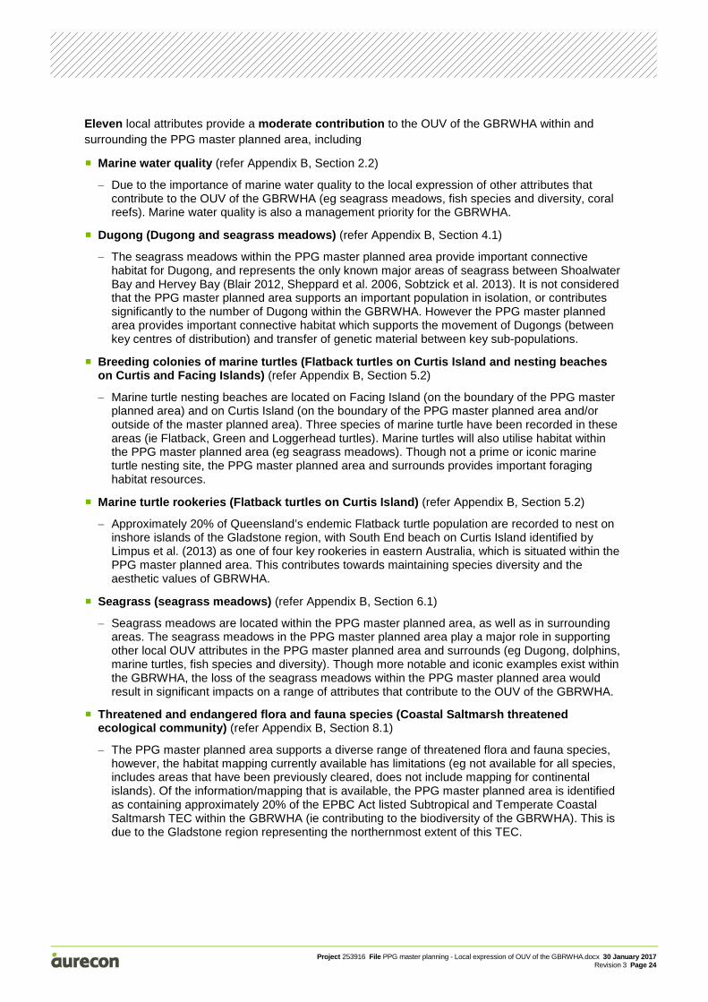
Eleven local attributes provide a moderate contribution to the OUV of the GBRWHA within and surrounding the PPG master planned area, including
Marine water quality (refer Appendix B, Section 2.2)
− Due to the importance of marine water quality to the local expression of other attributes that contribute to the OUV of the GBRWHA (eg seagrass meadows, fish species and diversity, coral reefs). Marine water quality is also a management priority for the GBRWHA.
Dugong (Dugong and seagrass meadows) (refer Appendix B, Section 4.1)
− The seagrass meadows within the PPG master planned area provide important connective habitat for Dugong, and represents the only known major areas of seagrass between Shoalwater Bay and Hervey Bay (Blair 2012, Sheppard et al. 2006, Sobtzick et al. 2013). It is not considered that the PPG master planned area supports an important population in isolation, or contributes significantly to the number of Dugong within the GBRWHA. However the PPG master planned area provides important connective habitat which supports the movement of Dugongs (between key centres of distribution) and transfer of genetic material between key sub-populations.
Breeding colonies of marine turtles (Flatback turtles on Curtis Island and nesting beaches on Curtis and Facing Islands) (refer Appendix B, Section 5.2)
− Marine turtle nesting beaches are located on Facing Island (on the boundary of the PPG master planned area) and on Curtis Island (on the boundary of the PPG master planned area and/or outside of the master planned area). Three species of marine turtle have been recorded in these areas (ie Flatback, Green and Loggerhead turtles). Marine turtles will also utilise habitat within the PPG master planned area (eg seagrass meadows). Though not a prime or iconic marine turtle nesting site, the PPG master planned area and surrounds provides important foraging habitat resources.
Marine turtle rookeries (Flatback turtles on Curtis Island) (refer Appendix B, Section 5.2)
− Approximately 20% of Queensland’s endemic Flatback turtle population are recorded to nest on inshore islands of the Gladstone region, with South End beach on Curtis Island identified by Limpus et al. (2013) as one of four key rookeries in eastern Australia, which is situated within the PPG master planned area. This contributes towards maintaining species diversity and the aesthetic values of GBRWHA.
Seagrass (seagrass meadows) (refer Appendix B, Section 6.1)
− Seagrass meadows are located within the PPG master planned area, as well as in surrounding areas. The seagrass meadows in the PPG master planned area play a major role in supporting other local OUV attributes in the PPG master planned area and surrounds (eg Dugong, dolphins, marine turtles, fish species and diversity). Though more notable and iconic examples exist within the GBRWHA, the loss of the seagrass meadows within the PPG master planned area would result in significant impacts on a range of attributes that contribute to the OUV of the GBRWHA.
Threatened and endangered flora and fauna species (Coastal Saltmarsh threatened ecological community) (refer Appendix B, Section 8.1)
− The PPG master planned area supports a diverse range of threatened flora and fauna species, however, the habitat mapping currently available has limitations (eg not available for all species, includes areas that have been previously cleared, does not include mapping for continental islands). Of the information/mapping that is available, the PPG master planned area is identified as containing approximately 20% of the EPBC Act listed Subtropical and Temperate Coastal Saltmarsh TEC within the GBRWHA (ie contributing to the biodiversity of the GBRWHA). This is due to the Gladstone region representing the northernmost extent of this TEC.
Project 253916 File PPG master planning - Local expression of OUV of the GBRWHA.docx 30 January 2017 Revision 3 Page 25
Vast mangrove forests (mangrove sequences at The Narrows) (refer Appendix B, Section 8.2)
− The GBRWHA supports approximately 2,069 km2 of mangrove forests (Lucas et al. 1997). Approximately 31.11 km2 of remnant mangrove forests are present within the PPG master planned area, representing approximately 1.50% of the GBRWHA mangrove areas. The vast mangrove forests of The Narrows (situated outside of and adjacent to the master planned area) are noted as a notable example of mangrove sequences in the GBRWHA (Lucas et al. 1997).
Continental islands and green vegetated islands (Curtis Island) (refer Appendix B, Section 9.2)
− The continental islands, including Curtis and Facing Islands, contribute to the aesthetic values of the GBRWHA. Though there are approximately 600 continental islands within the GBRWHA (Lucas et al. 1997), Curtis Island represents a significant and notable example and with commensurate flora species value to Hinchinbrook Island (situated approximately 800 km to the north of the PPG master planned area).
Traditional owner interaction with the natural environment (Indigenous cultural heritage sites and values) (refer Appendix B, Section 11.2)
− There are 353 known cultural heritage artefacts/site in the PPG master planned area and surrounds. It is considered that the loss of these values would have a significant impact on the preservation of cultural heritage of the Indigenous people represented by the Port Curtis Coral Coast group. The Port Curtis Coral Coast group have entered into a Traditional Use of Marine Resource Agreement (TUMRA) which includes the Capricorn-Bunker Group of reefs, cays and islands, and the PPG master planned area and surrounds.
Diversity supporting marine fauna species (global conservation significance) (a diverse range of marine fauna) (refer Appendix B, Section 12.2)
− Based on the database search results for the PPG master planned area (refer Appendix C), there are 18 globally significant threatened marine species with the potential to occur within the PPG master planned area and surrounds (though not able to be directly correlated with information from the Outlook Report 2014, refer Section 12 of Appendix B). There are also several marine fauna species present within the PPG master planned area which are considered to have a moderate to significant contribution to the OUV of the GBRWHA (eg Dugong, marine turtles and Australian humpback dolphin). This diversity is supported by a range of habitat present within the master planned area (eg coral reefs, seagrass meadows, mangrove communities).
Total species diversity (a diverse range of marine, intertidal and terrestrial flora and fauna species) (refer Appendix B, Section 13.2)
− The diversity of available habitat types within the PPG master planned area contributes to the total species diversity, including continental islands, coastal saltmarsh, coral reefs, seagrass meadows, mangrove communities, hard and soft benthic substrates and beach habitats. Though the habitats within the PPG master planned area and surrounds are not considered to be unique in the context of the GBRWHA, some habitats are considered important regionally (eg seagrass meadows) or nationally (eg The Narrows vast mangrove forests, migratory shorebird habitat). The diversity of seagrass species, mangrove species, and whale and dolphin species of the GBRWHA are well represented within the PPG master planned area and surrounds.
Twenty-two local attributes provide a minor contribution to the OUV of the GBRWHA within and surrounding the PPG master planned area (refer Table 4.1).
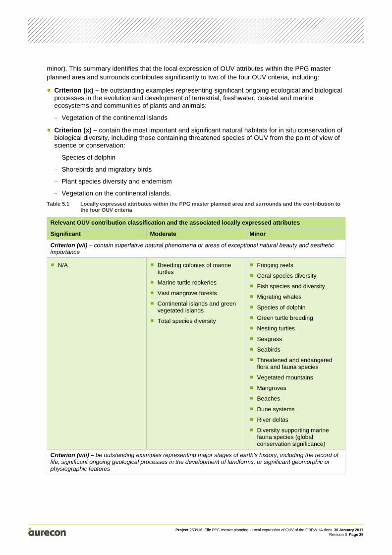
Table 5.1 lists the local expression of the attributes relevant to each of the four OUV criteria, categorising each attribute into the relevant contribution classifications (ie significant, moderate and
Project 253916 File PPG master planning - Local expression of OUV of the GBRWHA.docx 30 January 2017 Revision 3 Page 26
minor). This summary identifies that the local expression of OUV attributes within the PPG master planned area and surrounds contributes significantly to two of the four OUV criteria, including:
Criterion (ix) – be outstanding examples representing significant ongoing ecological and biological processes in the evolution and development of terrestrial, freshwater, coastal and marine ecosystems and communities of plants and animals:
− Vegetation of the continental islands
Criterion (x) – contain the most important and significant natural habitats for in situ conservation of biological diversity, including those containing threatened species of OUV from the point of view of science or conservation:
− Species of dolphin
− Shorebirds and migratory birds
− Plant species diversity and endemism
− Vegetation on the continental islands.
Table 5.1 Locally expressed attributes within the PPG master planned area and surrounds and the contribution to the four OUV criteria
Relevant OUV contribution classification and the associated locally expressed attributes
Significant Moderate Minor
Criterion (vii) – contain superlative natural phenomena or areas of exceptional natural beauty and aesthetic importance
N/A Breeding colonies of marine turtles
Marine turtle rookeries
Vast mangrove forests
Continental islands and green vegetated islands
Total species diversity
Fringing reefs
Coral species diversity
Fish species and diversity
Migrating whales
Species of dolphin
Green turtle breeding
Nesting turtles
Seagrass
Seabirds
Threatened and endangered flora and fauna species
Vegetated mountains
Mangroves
Beaches
Dune systems
River deltas
Diversity supporting marine fauna species (global conservation significance)
Criterion (viii) – be outstanding examples representing major stages of earth's history, including the record of life, significant ongoing geological processes in the development of landforms, or significant geomorphic or physiographic features
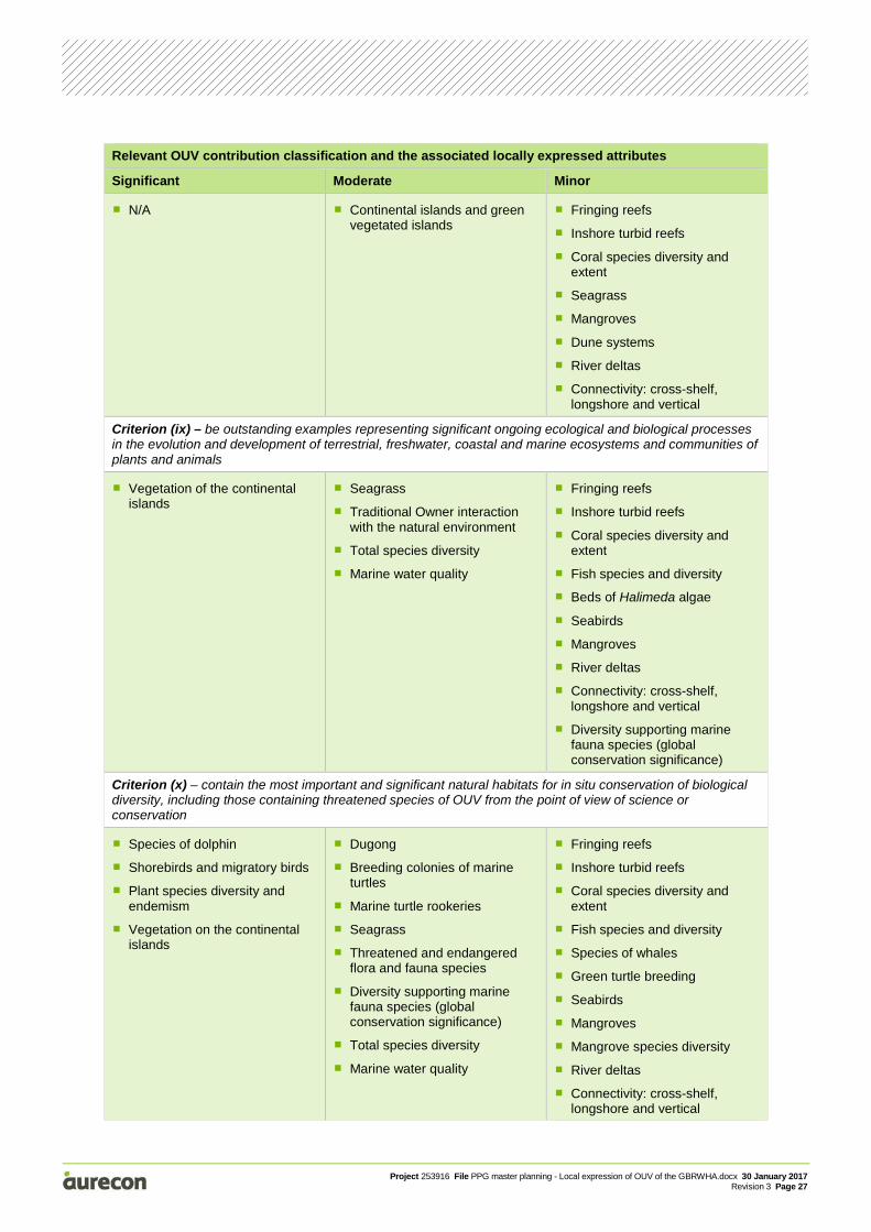
Project 253916 File PPG master planning - Local expression of OUV of the GBRWHA.docx 30 January 2017 Revision 3 Page 27
Relevant OUV contribution classification and the associated locally expressed attributes
Significant Moderate Minor
N/A Continental islands and green vegetated islands
Fringing reefs
Inshore turbid reefs
Coral species diversity and extent
Seagrass
Mangroves
Dune systems
River deltas
Connectivity: cross-shelf, longshore and vertical
Criterion (ix) – be outstanding examples representing significant ongoing ecological and biological processes in the evolution and development of terrestrial, freshwater, coastal and marine ecosystems and communities of plants and animals
Vegetation of the continental islands
Seagrass
Traditional Owner interaction with the natural environment
Total species diversity
Marine water quality
Fringing reefs
Inshore turbid reefs
Coral species diversity and extent
Fish species and diversity
Beds of Halimeda algae
Seabirds
Mangroves
River deltas
Connectivity: cross-shelf, longshore and vertical
Diversity supporting marine fauna species (global conservation significance)
Criterion (x) – contain the most important and significant natural habitats for in situ conservation of biological diversity, including those containing threatened species of OUV from the point of view of science or conservation
Species of dolphin
Shorebirds and migratory birds
Plant species diversity and endemism
Vegetation on the continental islands
Dugong
Breeding colonies of marine turtles
Marine turtle rookeries
Seagrass
Threatened and endangered flora and fauna species
Diversity supporting marine fauna species (global conservation significance)
Total species diversity
Marine water quality
Fringing reefs
Inshore turbid reefs
Coral species diversity and extent
Fish species and diversity
Species of whales
Green turtle breeding
Seabirds
Mangroves
Mangrove species diversity
River deltas
Connectivity: cross-shelf, longshore and vertical
Project 253916 File PPG master planning - Local expression of OUV of the GBRWHA.docx 30 January 2017 Revision 3 Page 28
The findings of this report will be included into the PPG master planning evidence base and will be used to review the master planning risk assessment report (and revise as required) and to provide input on the key environmental values to be monitored on an ongoing basis (ie PMM 2 of the draft master plan and preliminary draft port overlay). The information will also be utilised to assist in the future preparation of guidelines and management plans that are required under the PPG master plan preliminary draft port overlay.
It is recommended that as additional environmental values information and knowledge becomes available relevant to the local expression of the OUV attributes in the PPG master planned area and surrounds, that a review of the new information is undertaken, and this report is revised as required. Similarly, in the event that there is a significant change in the OUV of the GBRWHA, or the attributes that contribute to the OUV of the GBRWHA, this report and the findings may require review and revision to take into account potential changes to the presence or contribution of the local expression of the OUV of the GBRWHA.
Project 253916 File PPG master planning - Local expression of OUV of the GBRWHA.docx 30 January 2017 Revision 3 Page 29
6 References Adaptive Strategies, GHD and RMC 2016, Method for identifying the presence of Outstanding Universal Value within the Great Barrier Reef World Heritage Area, Prepared for Queensland Department of State Development, Adaptive Strategies, Brisbane.
AECOM 2016, Evidence Base Report for the Proposed Gladstone Port Master Planned Area, Prepared for Queensland Department of State Development, AECOM, Brisbane.
Aurecon 2016, Priority Port of Gladstone master planning – Risk assessment, Prepared for Queensland Department of State Development, Aurecon, Brisbane.
Blair, D, 2012, Genetic evidence for distinctiveness and connectivity among Australian Dugongs, Final Report to the Australian Marine Mammal Centre, 31 March 2012.
Cleguer, C, Limpus, CG, Gredzens, C, Hamann, M, Marsh, H, 2015, Annual report on dugong tracking and habitat use in Gladstone in 2014, Report produced for the Ecosystem Research and Monitoring Program Advisory Panel as part of Gladstone Ports Corporation’s Ecosystem Research and Monitoring Program.
Commonwealth of Australia, 2015, Reef 2050 Long-Term Sustainability Plan, Commonwealth of Australia, Canberra.
Department of the Environment (DoE), 2014, EPBC Act Policy Statement 3.21 – Industry guidelines for avoiding, assessing and mitigating impacts on EPBC Act listed migratory shorebird species, Commonwealth of Australia, Canberra.
Department of the Environment (DoE), 2015, EPBC Act referral guidelines for the Outstanding Universal Value of the Great Barrier Reef World Heritage Area, Commonwealth of Australia, Canberra.
Department of the Environment and Energy (DoEE), 2016, Dugong dugon in Species Profile and Threats Database, Department of the Environment, Canberra, viewed 5 December 2016, http://www.environment.gov.au/cgi-bin/sprat/public/publicspecies.pl?taxon_id=28
Department of the Environment and Energy (DoEE), 2016a, Sousa sahulensis in Species Profile and Threats Database, Department of the Environment, Canberra, viewed 10 October 2016, <http://www.environment.gov.au/cgi-bin/sprat/public/publicspecies.pl?taxon_id=28>
Department of State Development (DSD) 2014, Great Barrier Reef Coastal Zone Strategic Assessment, State of Queensland, Department of State Development, Brisbane.
Department of State Development (DSD) 2016, Draft master plan for the priority Port of Gladstone, State of Queensland, Department of State Development, Brisbane.
Department of Sustainability, Environment, Water, Population and Communities (DSEWPaC) 2013, Independent Review of the Port of Gladstone Report on Findings July 2013, Commonwealth of Australia, Canberra.
Environment Australia 2003, Recovery plan for marine turtles in Australia, Marine Species Section Approvals and Wildlife Division, Canberra.
Geoscience Australia and James Cook University (JCU) 2013, Geological and geomorphological features of outstanding universal value in the Great Barrier Reef World Heritage Area, Technical Report prepared for the Department of Sustainability, Environment, Water, Population and Communities.
Great Barrier Reef Marine Park Authority (GBRMPA) 2014a, Great Barrier Reef Outlook Report 2014, GBRMPA, Townsville.
Project 253916 File PPG master planning - Local expression of OUV of the GBRWHA.docx 30 January 2017 Revision 3 Page 30
Great Barrier Reef Marine Park Authority (GBRMPA) 2014b, Great Barrier Reef region Strategic Assessment: Strategic Assessment Report, Great Barrier Reef Marine Park Authority, Townsville.
Great Barrier Reef Marine Park Authority (GBRMPA) 2014c, Great Barrier Reef region Strategic Assessment: Strategic Assessment Report – Supplementary Report, Great Barrier Reef Marine Park Authority, Townsville.
Hale, PT, Barreto, AS and Ross, GJB, 2000, Comparative morphology and distribution of the aduncus and truncates forms of bottlenose dolphin Tursiops in the Indian and Western Pacific Oceans, Aquatic Mammals 26(2): 101-110.
Limpus, CJ 2008a, A biological review of Australian marine turtles. 2. Green turtle, Chelonia mydas (Linnaeus), Environmental Protection Agency, Brisbane.
Limpus, CJ 2009, A biological review of Australian marine turtle species. 3. Hawksbill turtle, Eretmochelys imbricata (Linnaeus), Environmental Protection Agency, Brisbane.
Limpus, CJ, Gilmore, K & Barrett, P 2000, Queensland Turtle Conservation Project - Curtis Island Marine Turtle Nesting Study 1999-2000, Prepared for Gladstone Port Authority and Queensland Park and Wildlife Service, Gladstone.
Limpus, CJ, McLaren, M, McLaren, G & Knuckey, B 2006, Queensland Turtle Conservation Project: Curtis Island and Woongarra Coast Flatback Turtle Studies 2005 – 2006 , Environment Protection Agency, Brisbane.
Limpus C, Parmenter, J & Chaloupha, M 2013, Monitoring of Coastal Turtles in the Port Curtis and Port Alma Region: Gap Analysis Parts 1 to 6, Report produced for the Ecosystem Research and Monitoring Program Advisory Panel as part of Gladstone Ports Corporation’s Ecosystem Research and Monitoring Program.
Lucas P, Webb T, Valentine P and Marsh H 1997, The outstanding universal value of the Great Barrier Reef World Heritage Area, Great Barrier Reef Marine Park Authority, Townsville.
Parra, GJ, and Jedensjö, M, 2009, Feeding habits of Australian snubfin (Orcaella heinsohni) and Indo-Pacific humpback dolphins (Sousa chinensis), project report to the Great Barrier Reef Marine Park Authority and the Reef and Rainforest Research Centre Limited, Cairns, University of Queensland, Brisbane, viewed 5 December 2016, <http://www.rrrc.org.au/publications/downloads/141e-UQ-Parra-G-et-al-2009-Feeding-Habits-of-Snubfin-and-Pacific-Humpback-Dolpins.pdf>.
Sheppard J, Preen AR, Marsh H, Lawler IR, Whiting S and Jones RE, 2006, ‘Movement heterogeneity of dugongs, Dugong dugon (Müller) over large spatial scales’, Journal of Experimental Marine Biology and Ecology, vol. 334, pp. 64-83.
Sobtzick, S, Grech, A, Coles, R, Cagnazzi, D and Marsh, H, 2013, Status of the dugong population in the Gladstone area. A Report for Gladstone Ports Corporation Limited for Project CA 20017: Monitoring of Dugongs, Centre for Tropical Water & Aquatic Ecosystem Research (TropWATER) Publication, James Cook University, Townsville
Threatened Species Scientific Committee (TSSC) 2013, Commonwealth Conservation Advice for Subtropical and Temperate Coastal Saltmarsh. Canberra, viewed 5 December 2016, <http://www.environment.gov.au/biodiversity/threatened/communities/pubs/118-conservation-advice.pdf>
United Nationals Educational, Scientific and Cultural Organisation (UNESCO) 2012, Statement of Outstanding Universal Value, Great Barrier Reef, Property ID 154.