part 4 - new build inspections
TRANSCRIPT

Part 4Foundations
4.1 Land quality - managing ground conditions
4.2 Building near trees
4.3 No longer allocated
4.4 Strip and trench fill foundations
4.5 Raft, pile, pier and beam foundations
4.6 Vibratory ground improvement techniques

Chapter 4.1Land quality - managing ground conditions
Part 4 Foundations

4.1
4.1
Page 5 Chapter 4.1
Land quality - managing ground conditions
2013
CONTENTS
Clause Page
Objectives 1
Procedural summary 1
PROCEDURAL FLOW CHART 2
DESIGN
Initial assessment
Desk study D1 3
Walkover survey D2 3
Results D3 4
Where hazards are not suspected
Basic investigation D4 4
Where hazards are suspected
Detailed investigation D5 4
Managing the hazards D6 5
Documentation and verification D7 5
Unforeseen hazards D8 6
APPENDIX 4.1-A
References 6
APPENDIX 4.1-B
Potential hazards and associated risks 7
APPENDIX 4.1-C
Site investigation techniques 8
APPENDIX 4.1-D
“Suitable persons” and “Consultants or Specialists”
9
INDEX 9
Hazardous sitesBuilders are reminded that where a site* is hazardous, NHBC Rules state that, they must notify NHBC in writing at least 8 weeks before work begins.
Failure to provide NHBC with information about hazardous sites may result in a delay in processing the registration, hold up construction work on site and the issue of the 10 year cover.
* Site is defined in NHBC Rules as an area of land which is covered by a single detailed planning consent.
SCOPE
This Chapter gives guidance on meeting the Technical Requirements and recommendations for assessing the site with regard to managing the ground conditions.

4.14
.1
Page 1Chapter 4.1
Land quality - managing ground conditions
2013
ObjectivesThis Chapter provides a framework for managing geotechnical and contamination risks with the objective of ensuring that:• all sites are properly assessed and
investigated • foundations and substructure designs
are suitable for the ground conditions • sites are properly remediated where
necessary or appropriate design precautions are taken, and
• appropriate documentation and verification can be provided to NHBC.
Assessment of geotechnical and contamination issuesAssessment should be carried out by direct investigation and examination of the ground, supplemented where necessary by results of laboratory testing on samples obtained.
Examples of potential hazards and associated risks relating to geotechnical and contamination issues are listed in Appendix 4.1-B.
Additionally, contaminated land should be assessed using the following framework:
Contamination may exist as a result of past industrial activities, the dumping of waste materials, spills or the presence of naturally occuring substances.
For contaminated land to exist the source, pathway and receptor (known as the pollutant linkage) must all exist.
A written or diagrammatic representation of the site characteristics (known as a Conceptual Model) should be produced to show the possible relationships between the contaminants, pathways and receptors.
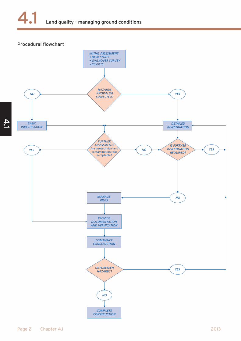
Procedural summaryThe processes to assess and manage the ground conditions are:• illustrated in the Procedural flowchart,
and• described in detail in the pages that
follow.Useful references are contained in Appendix 4.1-A.
Initial assessment (Clauses D1 to D3)NHBC requires all sites to be assessed by a Desk study and a Walkover survey.
The Results should be used to determine whether or not hazards are known or suspected.
Basic investigation (Clause D4)Where hazards are not suspected a basic investigation will be required to support the results of the initial assessment.
Detailed investigation(Clause D5)Where hazards are known or suspected a detailed investigation will be required.
Further assessmentAfter the basic or detailed investigation has been undertaken a further assessment is required to confirm that all the objectives have been met. Where the results are inconclusive, further site investigation will be required.
Where hazards are found (Clause D6)Where hazards are identified, design precautions or remediation will be required to minimise their effects.
Documentation and verification (Clause D7)NHBC will require documentation to show that:• the site has been properly assessed an
investigated • where necessary, suitable precautions
are incorporated into the design • all necessary remediation has been
carried out.
Unforeseen hazards(Clause D8)If any unforeseen hazards are found during the course of construction, further investigation may be required.
4.1
4.1
Page 2 Chapter 4.1
Land quality - managing ground conditions
2013
Procedural flowchart

4.14
.1
Page 3Chapter 4.1
Land quality - managing ground conditions
2013
DESIGN STANDARDS
INITIAL ASSESSMENTDESK STUDY
4.1 - D1 A desk study of the site and the surrounding area shall be undertaken by a suitable person
A desk study is the collection and examination of existing information obtained from a wide variety of sources.
It should indicate any potential hazards at an early stage and provide a basis for the investigation.
A suitable person, as described in Appendix 4.1-D, should carry out the desk study.
Items to be taken into account include:
(a) soils, geology, surface water and ground waterInvestigate the soils, geology, surface water and ground water of the site and surrounding area.
(b) use of the site and surrounding areaResearch the current use and history of the site and surrounding area to assess the potential problems including those which may have been left by:• industrial, commercial and agricultural
uses including storage • mining • quarrying • landfilling and tipping.
Some sites may have been associated with more than one process.
(c) sources of informationRefer to key sources of information including:• the Environment Agency or its
equivalent, for example coastal erosion, landfill sites, details of water abstraction
• the Local Authority, for example planning and environmental health
• county records offices, libraries, museums, and local history sources
• the utility companies• the Coal Authority
- mining reports - past, present and proposed mining
• the British Geological Survey - maps and information
• soil survey maps• the Ordnance Survey
- current and previous editions of plans and aerial photographs.
The above list is not exhaustive and local sources may be relevant.
(d) existing site informationReview all available information from:• the vendor of the site • previous in-house information • ongoing monitoring.
INITIAL ASSESSMENTWALKOVER STUDY
4.1 - D2 A walkover survey of the site and the surrounding area shall be undertaken by a suitable person
A walkover survey is a direct inspection of the site and the surrounding area carried out in conjunction with the desk study.
Look for indications of any potential hazards to provide a basis for the investigation.
A photographic record of the site can help in the reporting of the walkover survey.
A suitable person, as described in Appendix 4.1-D, should carry out the walkover survey.
Items to be taken into account include:
(a) topography
What is the significance of any abrupt changes in slope?
Are there any valley bottoms or depressions which may be soft
or filled?
Is there evidence of overburden on slopes?
Is there excavation at the base of a slope?
Are there any signs of landslip, e.g. tilting trees, posts or walls?
Is there evidence of imported soil, tipped material or rubbish?
Is it hot? Does it have an odour?
Are there signs of local subsidence?
(b) soils and rocks
What is the basic type of ground?
Is there any evidence of peat, silt or other highly compressible
material at or below the surface?
Is there cracking or stickiness of the surface which may indicate a shrinkable sub-soil?
Are there sudden changes in conditions e.g. clay to chalk or
soil to rock?
(c) surface water and ground water
Is a high water table indicated, e.g. by waterlogged ground?
Are there any signs of flooding?
Are there any reeds or water-loving plants?
Are there any springs, ponds, wells, ditches or
streams?
Is there any discoloured water? What is its source?
(d) vegetation (which may indicate the nature of the soils)
Is the vegetation sparse, dead or dying?
What is the type and condition of vegetation on land adjoining
the site?
What are the species, height and condition of the trees?
What are the species, height, spread and condition of hedges
and scrub on clay?
Is there evidence of former trees, hedges or scrub onclay?

4.1
4.1
Page 4 Chapter 4.1
Land quality - managing ground conditions
2013
(e) structural information
Is there evidence of damage to structures, e.g. cracking in buildings, on or around the site?
Is there other evidence of movement?
Is there evidence of any structures or services belowground?
(f) local information
‘A few years backthere was a tip in
the area.’
Is there local knowledge of the site e.g. mining, refuse tipping, flooding?
Are there local industrial history records indicating past
and present uses of the site?
WATER LANEDo local place names and street names give clues e.g. Brickfield Cottage, Water Lane?
INITIAL ASSESSMENTRESULTS
4.1 - D3 The results of the desk study and walkover survey shall be recorded and evaluated by a suitable person
A suitable person, as described in Appendix 4.1-D, should record the results of the initial assessment and evaluate whether hazards are suspected.
The record should include the following as appropriate:• site plans with dates, showing: - previous uses of the site - current uses of the site - the proposed site layout• details of the geology of the site from:
- geological maps - previous site investigations - laboratory test results
• photographs of the site to show particular points of interest or concern, (e.g. areas of ground instability), with dates
• copies and interpretation of aerial photographs, with dates
• a list of sources of information consulted (e.g. Environment Agency, Coal Authority, etc.) and copies of the information obtained.
Sites where hazards are not suspected
BASIC INVESTIGATION4.1 - D4 A basic investigation of the site shall be carried out and recorded by a suitable person to the satisfaction of NHBC
Where the results of the initial assessment indicate that hazards are not suspected on the site, this should be substantiated by carrying out a basic investigation.
This approach is to provide assurance for all sites, regardless of how free of hazards they may appear.
Only suitable persons with the skills and knowledge described in Appendix 4.1-D should carry out the basic investigation.
The following provides a specification for the basic investigation for all sites.
Trial pits should be located so as to be representative of the site. (For more detailed information refer to BS EN 1997-2)
The number and depth of trial pits needed depends upon:• the proposed development • how inconsistent the soil and geology is
across the site • the nature of the site.
The depth of the trial pits should not usually be less than 3m.
Items to be taken into account include:
(a) geotechnical investigation(see Appendix 4.1-C)
A basic geotechnical investigation should be carried out. This will include trial pits and, where they do not provide sufficient information, boreholes will be necessary.
Physical tests, such as plasticity index tests, should be carried out as appropriate to support the results of the initial assessment.
Trial pits should be located outside the likely foundation area. The distance from the edge of the foundation should not be less than the trial pit depth.
(b) contamination investigation(see Appendix 4.1-C)
A basic contamination investigation should be carried out as part of the basic geotechnical investigation. This should consist of sampling and testing of soil taken from trial pits during the geotechnical investigation, as found to be necessary from the outcome of the initial assessment.
During the excavation of the trial pits the use of sight and smell may help to identify certain contaminants.
Where there is any doubt about the condition of the ground a detailed investigation should be carried out (see 4.1 - D5).
FURTHER ASSESSMENTIf the basic investigationreveals the presence of geotechnical and/or contamination hazards or has not addressed all of the original objectives further detailed investigationshould be carried out (see Clause D5).
If the basic investigationaddresses all of the original objectives refer to Clause D7, Documentation and Verification.
Sites where hazards are suspected
DETAILED INVESTIGATION4.1 - D5 Where hazards are suspected a detailed investigation of the site shall be carried out, under the supervision of a consultant or specialist acceptable to NHBC, to determine and report on the nature and extent of all hazardous ground conditions
A detailed investigation should be carried out where:• hazards are suspected from the outset• the initial assessment identified hazards,
or• the basic investigation identified
hazards.
The basic (geotechnical and contamination) investigation should form the minimum requirement for any site investigation.
In addition to the basic investigation, the detailed investigation should:• adopt a structured and staged approach• gather information based on clearly
defined stages of investigation• consider the immediate site and the
adjacent area• take into account the possibility of
future development in the vicinity of the site
• consider the nature of the development• consider the complexity of the ground
conditions• cover the extent of influence of the
proposed foundations• consider the presence of soil gas; if
there is any possibility of gas being present, then a full gas investigation should be carried out, which should include flow measurements
• provide a clear understanding of the problems, and an understanding of the liabilities, which have to be managed in order to develop the site
• consider: - the surface water and ground water conditions - the soils and geology, and - the previous site history.

4.14
.1
Page 5Chapter 4.1
Land quality - managing ground conditions
2013
A consultant or specialist acceptable to NHBC should be appointed to:• design and supervise the detailed
investigation • present all the factual data obtained
from the detailed investigation.
Guidance for the appointment of a consultant or specialist is given in Appendix 4.1-D.
FURTHER ASSESSMENTIf the detailed investigation has not satisfactorily addressed all of the original objectives further investigation should be carried out.
MANAGING THE RISKS4.1 - D6 Any hazardous ground conditions shall be satisfactorily managed under the supervision of a consultant or specialist acceptable to NHBC
As appropriate, the consultant or specialistacceptable to NHBC should:• identify any results which show that
design precautions and/or remediation may be necessary
• carry out a risk assessment to determine appropriate design precautions and/or remedial treatment
• specify the options for remediating any contamination that may be present and provide a remediation statement
• make recommendations as to appropriate design precautions including any ground improvement techniques as necessary
• make recommendations on appropriate precautions for all underground services serving the site
• ensure the works are appropriately supervised
• produce a remediation report.
Items to be taken into account include:
DESIGN CONSIDERATIONS
(a) design precautions Solutions for dealing with geotechnical hazards include the following:• specialist foundations:
- piling and ground beams - rafts
• ground improvement techniques: - vibro - dynamic compaction - surcharging.
(b) remediation techniques
Solutions for dealing with contamination hazards include the following:• risk avoidance - treatment to reduce the
risk to the target by changing pathway or isolating the target by: - changing layout - building protective measures into construction
• engineering based - treatment to remove or isolate the contaminants or modify the pathway by: - excavation - providing ground barriers - covering and capping
• process based - treatment to remove, modify, stabilise or destroy the contaminants by: - physical means - biological means - chemical means - thermal means.
(c) site locationThe identification of any constraints associated with the site and surrounding area which could restrict design precautions or remediation techniques should be identified and specified.
(d) timescaleTime constraints may influence the solution chosen since some techniques are very time consuming. This should not alter the requirement for effective remediation.
(e) consultationIn order to avoid abortive works it is important that the requirements of all statutory authorities are met by the proposed solution for the site.
REMEDIATION
(f) method statementThe method statement should detail the proposed remediation strategy for the site.
The statement should include the followingdetails:• original risk assessment, identification of
the remediation objectives and outline information of the method chosen
• remediation objectives for ground, ground water and soil gas
• working method for implementation of the remediation
• waste classification and methods for controlling and disposing of waste
• proposed supervision and monitoring of remediation
• all validation sampling and testing to be implemented.
(g) reportsThe report should include the following information:• photographic records, especially
for work which will be buried (e.g. membranes)
• site diaries or drawings, environmental supervisor’s site diary, and independent witness statements where appropriate
• accurate surveys of the levels and position of all remediated areas
• a description of any remedial materials used
• details of soil movements and waste transfer notes
• results of post-remediation sampling; laboratory certificates should be provided in appendices
• validation test results• monitoring results• details of all consultations and meetings
with statutory authorities.
Now refer to Clause D7, Documentation and Verification.
All sites
DOCUMENTATION AND VERIFICATION4.1 - D7 Documentation and verification shall be provided to the satisfaction of NHBC that the site is suitable for the proposed development
Items to be taken into account include:
(a) geotechnical assessment
WHERE GEOTECHNICAL HAZARDS ARE PRESENT
NHBC should be provided with design proposals to overcome the hazards.
(b) contamination assessment
WHERE CONTAMINATION HAZARDS ARE NOT PRESENT
Evidence to substantiate that the site is not suspected to be hazardous may be asked for.
WHERE CONTAMINATION HAZARDS ARE PRESENT
NHBC should be provided with design proposals to overcome the hazards.
Radon gasWhere the site is within an area susceptible to radon it will be necessary to follow appropriate guidance in Building Regulations and associated documents.
The following table indicates the documentation required by NHBC.

4.1
4.1
Page 6 Chapter 4.1
Land quality - managing ground conditions
2013
Documentation required by NHBC
Nogeotechnical or contamination hazards present
Geotechnical hazards present (but no contaminationhazards)
Contamination hazards present (but no geotechnicalhazards)
Geotechnical and contamination hazards present
Initial assessment, further assessment and basic investigation
Detailed investigation
Proposals to manage geotechnical risks
Proposals to manage contamination risks
Verfication evidence
UNFORESEEN HAZARDS
4.1 - D8 Where any additional or unforeseen ground conditions are found during construction, the builder shall ensure that they are investigated and managed to the satisfaction of NHBC
As construction proceeds, additional or unforeseen hazards may be found. For example, it is possible to have undetected hazards which are missed by the site investigation.
Where additional or unforeseen hazards are found additional specialist advice is required so that the hazard is properly investigated, managed and verified.
APPENDIx 4.1-A
References
BRE: Report BR211 - ‘Radon: Guidance on protective measures for new dwellings’
Report BR212 - ‘Construction of new buildings on gas-contaminated land’
Report BR376 - ‘Radon: guidance on protective measures for new dwellings in Scotland’
Report BR413 - ‘Radon: guidance on protective measures for new dwellings in Northern Ireland’
Report BR414 - ‘Protective measures for housing on gas-contaminated land’
Digest 383 - ‘Site investigation for low-rise buildings: Soil description’
BSI: BS EN 1997-2- Geotechnical design: Ground investigation and testing
BS 10175 - Investigation of potentially contaminated sites
BS EN ISO 14688 - Geotechnical investigation and testing. Identification and classification of soil: Part 1. Identification and description. Part 2. Principles for a classification.
BS EN ISO 22476 - Geotechnical investigation and testing. Sampling methods and groundwater measurements. Part 1. Technical principles for execution.
BS 8485 - Code of practice for the characterization and remediation of ground gas in affected development.
CIRIA: C665 - Assessing risks posed by hazardous ground gasses to buildings.
Special publications 101 - 112 - Remedial treatment for contaminated land
DCLG and its predecessor departments
Approved Documents A and C - Structures and site preparation and resistance to contaminants and moisture
DEFRA and its predecessor departments
CLAN 02/05 Soil guideline values and the determination of land as contaminated land under Part 2A
Circular 01/2006 Environmental Protection Act 1990: Part 2A Contaminated Land
Department of the Environment Industry Profiles - Information on the processes, materials and wastes associated with individual industries
Department of the Environment - Waste Management Paper No 27 - Landfill Gas: A technical memorandum on the monitoring and control of landfill gas.
Environment Agency
CLR11 Model procedures for the management of land contamination
CLEA (Contaminated Land Exposure Assessment) guidance and software Science Reports SR 1,2,3 and 7.
NHBC: Guidance on evaluation of development proposals on sites where methane and carbon dioxide are present.
R&D Publication 66 - Guidance for the safe development of housing on land affected by contamination.

4.14
.1
Page 7Chapter 4.1
Land quality - managing ground conditions
2013
APPENDIx 4.1-B
Examples of potential hazards and associated risksPotential hazard Associated risk
High water table or low lying land Flooding.
Effects from toxic or noxious materials which could be concentrated or transported by ground water.
Mining, past, present and proposed
Ground movement which will depend on the type of workings and materials extracted.
Existence of ground gasses including methane and carbon dioxide.
Solution features in chalk and limestone including swallow holes
Underground cavities.
Trees Shrinkage and heave of clay soils. See Technical Requirement R5.
Physical damage caused by roots.
Peat Acid attack.
Changes in volume due to variations in moisture content.
Production of methane and carbon dioxide.
Low bearing capacity ground Settlement of foundations and sub-structures.
Infill and made ground including tipping Release of gases which may be explosive or asphyxiating.
Low bearing capacity causing settlement.
Former buildings or structures Underground obstructions producing variations in bearing capacity and settlement characteristics.
Adjacent buildings Effect on stability of both the new and existing buildings.
Existing drains, including land drains Contamination, flooding, waterlogging and interruption of land drainage systems.
Sulfates in ground or ground water Expansive reaction.
Chemical attack on concrete, mortar and bricks or blocks made with cement.
Unstable ground subject to landslip Ground movement.
Seas, lakes and rivers adjacent to land Erosion.
Contamination Substances which may be:
• carcinogenic
• toxic
• asphyxiating
• corrosive
• phytotoxic
• combustive
• explosive
• radioactive.

4.1
4.1
Page 8 Chapter 4.1
Land quality - managing ground conditions
2013
APPENDIx 4.1-C
Site investigation techniques (In accordance with the recommendations of BS EN 1997-2 Geotechnical design: Ground investigation and testing)
Site investigation normally comprises a combination of the following:
Direct investigationThese techniques involve intrusive activities to enable retrieval and examination of the ground using the following methods of investigation:
a) trial pitsTrial pits allow the detailed inspection, logging, sampling and in-situ testing of large volumes of natural soil or fill and the assessment of ground water conditions.
b) trenchesTrenches are extended trial pits or linked trial pits which are excavated where greater exposure of the ground conditions is required.
Trial pits and trenches should be positioned where they will not affect future foundations.
c) boreholes• Light cable percussion drilling
The conventional equipment used in the UK to drill boreholes in soils and weak rocks is the light cable percussion rig, often referred to as the shell and auger rig.
• Continuous flight auger Exploratory boreholes may also be drilled in soils by mechanical continuous flight augers of various sizes. Hollow stem methods are typically employed where sample retrieval is required.
• Rotary drilling Rotary drilling is used to investigate rock and sometimes stiff soils such as Boulder Clay. The two basic rotary methods are open-hole drilling and rotary coring.
d) probesProbing techniques can be used for the analysis of the relative density of soils and also for environmental sampling and monitoring (such as chemical and physical testing of gases, liquids and solids).
Indirect investigationGeophysical techniques (for example, electromagnetic, resistivity, seismic, gravity and ground radar) provide indirect interpretations of ground conditions. These measure from the surface, variations in properties of the ground both horizontally and vertically and hence attempt to define subsurface conditions.
Geophysical methods rely for their effectiveness on marked contrasts in the physical properties being measured. The required contrasts are provided by boundaries between distinctive strata with different properties (for example, between sand and gravel and rockhead). Definable contrasts may also be provided by faulting, underground cables and pipelines or by cavities.
SamplingThe number and type of samples taken and tests which are carried out for any particular investigation are designed to be appropriate to the range of ground materials encountered and to the development which is planned. The requirements should take account of the results of the desk study, the walkover survey and the site investigation.
Samples should always be taken, stored and transported carefully to avoid cross contamination.
Samples can be taken of:
a) soils and rocksSamples from trial pits and boreholes are taken to enable soil and rock descriptions to be made and to provide material for physical and chemical testing.
Samples of soils may be either ‘disturbed’ (that is, not retaining the original structure and consistency) or ‘undisturbed’. Having undergone minimal disturbance, it follows that ‘undisturbed’ samples provide a more reliable indication of physical soil properties than ‘disturbed’ samples.
b) ground waterGround water should be collected from appropriately designed monitoring wells. The wells should be screened and sealed to ensure that the relevant stratum is being monitored.
c) gasGas sampling should be carried out from appropriately designed monitoring wells. Boreholes or window sampling holes are typically used. Identification of likely source and measurement of gas flows plays an important role in assessment of risk.
Testinga) in-situ testingA wide variety of in-situ tests can be used to support the results of direct testing. These range from basic tests undertaken by geologists or engineers using simple hand-held devices or portable test kits to the more elaborate methods that require specialist personnel and equipment.
b) laboratory testingTesting laboratories should participate in quality assrance programmes (such as Contest and Aquacheck) and be
accredited for relevant tests (by the likes of UKAS and MCERTS).
Physical tests on soil and rock materials are carried out to provide the following information on ground:
• strength • relative density • deformation• settlement• consolidation characteristics• permeability.
Chemical tests on soils, rocks, ground water and gases can be carried out to provide an indication of potential contamination on the site.

4.14
.1
Page 9Chapter 4.1
Land quality - managing ground conditions
2013
APPENDIx 4.1-D
“Suitable persons” and “consultants or specialists”SUITABLE PERSONSThe following skills and knowledge are required by the person responsible for the Initial Assessment (Clause D3), Basic Investigation (Clause D4) and Documentation and Verification (Clause D7):
• be able to carry out a desk study and walkover survey• understand the hazards that can affect the development and know from where they originate • know how to collect information relating to such hazards on and adjacent to the site • be able to recognise the signs of potential hazards• be able to determine when specialist advice and detailed testing is required, and• be able to report the findings in a clear and concise manner.
CONSULTANTS OR SPECIALISTSThe following criteria should be used as guidance for the appointment of a consultant or specialist responsible for the Detailed Investigation (Clause D5), management of hazards (Clause D6) and Documentation and Verification (Clause D7):
Experience has experience with similar types of site and development
Appropriate discipline(s)
a thorough understanding of all the relevant skills required on the project and has access to the skills of other disciplines including chemists, geologists, hydrogeologists,toxicologists and environmental chemists
Project management ability to manage a project team consisting of the appropriate disciplines
Communication able to communicate effectively within their organisation, with the client, statutory authorities and the general public
Reporting can prepare comprehensive and well presented reports
Legislation understands the legislation and liabilities associated with the area of the United Kingdom in which the development is being carried out
Quality assurance has an appropriate quality management system and uses appropriately accredited laboratories
Risk management can carry out risk assessments as part of the risk management process
Site investigation can design site investigation programmes which include soil sampling, testing and laboratory analysis
Health and safety is fully aware of all occupational hygiene issues and health and safety legislation
Engineering design understands effective risk reduction techniques e.g. engineered foundations and sub-structure details or suitable remediation
Professional indemnity insurance
has, and maintains, appropriate Professional Indemnity Insurance for the work being carried out.
INDEx
A
Assessment 1
B
Basic investigation 1, 4, 9
C
Consultant 5, 9
Contamination 5
Contamination hazards 4, 5, 7
D
Design considerations 5
Desk study 1, 3, 4, 9
Detailed investigation 1, 4, 9
Documentation 1, 5, 6, 9
F
Further assessment 1, 4
Further investigation 1, 4
G
Geotechnical hazards 5, 6
H
Hazards 1, 3, 4, 5, 6, 7, 8, 9
I
Initial assessment 1, 3, 4, 9
O
Objectives 1
P
Pathway 1
Potential hazards 7
Procedural flow chart 1, 2
Procedural summary 1
R
Receptor 1
Remediation 5
Results 1, 4, 5, 8, 9
S
Site investigation techniques
8
Source 1
Specialist 4, 5, 9
Suitable person 3, 4, 9
Supervision 4, 5
U
Unforeseen hazards 2, 9
V
Verification 2, 9
W
Walkover survey 2, 4, 5, 9