part 2, chapter 24 drainage and floodplains€¦ · 24.2.2 drainage analysis ... after screening is...
TRANSCRIPT
Topic No. 650-000-001 Project Development and Environment Manual Drainage and Floodplains Effective: August 17, 2016
Drainage and Floodplains Table of Contents
PART 2, CHAPTER 24
DRAINAGE AND FLOODPLAINS
TABLE OF CONTENTS
24.1 OVERVIEW ................................................................................................. 24-1
24.1.1 Definitions ................................................................................................. 24-1
24.2 PROCEDURE ........................................................................................... 24-2
24.2.1 Determine Level of Effort .......................................................................... 24-2
24.2.1.1 Projects Not Qualifying for Screening........................................... 24-3
24.2.1.2 Projects Qualifying for Screening ................................................. 24-3
24.2.2 Drainage Analysis ..................................................................................... 24-4
24.2.2.1 Existing Drainage Conditions ....................................................... 24-5
24.2.2.2 Proposed Drainage Conditions .................................................... 24-6
24.2.2.3 Environmental Look Around ......................................................... 24-6
24.2.2.4 Pond Siting Evaluation ................................................................. 24-7
24.2.3 Location Hydraulic Studies and Report ..................................................... 24-7
24.2.3.1 Location Hydraulic Study .............................................................. 24-9
24.2.3.2 Only Practicable Alternative ....................................................... 24-10
24.2.3.3 Risk Evaluation .......................................................................... 24-10
24.2.3.4 Location Hydraulic Report .......................................................... 24-12
24.2.4 Bridge Hydraulic Report .......................................................................... 24-14
24.2.5 Environmental Document ........................................................................ 24-14
24.2.5.1 Type 2 Categorical Exclusion ..................................................... 24-14
24.2.5.2 State Environmental Impact Report............................................ 24-15
Topic No. 650-000-001 Project Development and Environment Manual Drainage and Floodplains Effective: August 17, 2016
Drainage and Floodplains Table of Contents
24.2.5.3 Environmental Assessment and Draft Environmental Impact
Statement ................................................................................... 24-15
24.2.5.4 Finding Of No Significant Impact and Final Environmental Impact
Statement ................................................................................... 24-17
24.2.6 Public Involvement .................................................................................. 24-17
24.3 REFERENCES........................................................................................ 24-18
24.4 HISTORY ................................................................................................ 24-18
LIST OF FIGURES
Figure 24-1 Floodplain Statements .......................................................................... 24-19
Topic No. 650-000-001 Project Development and Environment Manual Drainage and Floodplains Effective: August 17, 2016
Drainage and Floodplains 24-1
PART 2, CHAPTER 24
DRAINAGE AND FLOODPLAINS
24.1 OVERVIEW
The purpose of this chapter is to outline the procedure for drainage analysis and the evaluation of project impacts on floodplains during project development, and provide guidance on how to document floodplain analysis in the Environmental Document. Protection of floodplains and floodways is required by Executive Order 11988, Floodplain Management; USDOT Order 5650.2, Floodplain Management and Protection; and Federal-Aid Policy Guide 23 CFR § 650A. The intent of these regulations is to avoid or minimize highway and land use development encroachments that reduce storage and increase water surface elevations within 100-year (base) floodplains. Where encroachment is unavoidable, the regulations require the Florida Department of Transportation (FDOT) to take appropriate measures to minimize impacts. Further guidance for implementation of Executive Order 11988 can be found in the Guidelines for Implementing Executive Order 11988, Floodplain Management. This chapter, along with the Federal Highway Administration's (FHWA) Technical Advisory T6640.8A, Guidance for Preparation and Processing Environmental and Section 4(f) Documents, provide guidelines for assessing highway impacts on base floodplains and regulatory floodways to comply with 23 CFR Part 771 and the regulations cited above. The District Drainage Engineer or designee is responsible for assessing project impacts on base floodplains and regulatory floodways, and incorporating that evaluation into the Environmental Document and the Location Hydraulics Report (LHR). The drainage analysis conducted during the Project Development and Environment (PD&E) Study is dependent on the level of engineering and design analyses required for the PD&E project. At a minimum, the PD&E Study should estimate the approximate size and potential locations of stormwater management facilities that meet the requirements of the FDOT Drainage Manual, Topic No. 625-040-002.
24.1.1 Definitions
Base Flood - The flood or tide having a 1% chance of being equaled or exceeded in any given year (commonly known as a 100-year flood).
Base Floodplain - The area subject to flooding by the base flood.
Encroachment - activities or construction within the floodplain including fill, new
construction, substantial improvements, and other development.

Topic No. 650-000-001 Project Development and Environment Manual Drainage and Floodplains Effective: August 17, 2016
Drainage and Floodplains 24-2
Direct Effects – Impacts which occur as a direct result of an action and occur at the same time and place as the action.
Floodplain - Any land area susceptible to being inundated by floodwaters from any source.
Flood Receptor -The entity that may be harmed (e.g., a person, property, habitat), by flood.
Indirect Effects – Impacts which are reasonably foreseeable effects that occur as a result of an action but occur later in time or are removed from the action location.
Impact - The effect of an encroachment upon the human, natural or physical environment.
Hydraulic Capacity - Measure of the volume of water which can pass through a given structure or culvert or measure of the volume and flow of water within a watercourse.
Natural and Beneficial Floodplain Values - Include but are not limited to fish, wildlife, plants, open space, natural beauty, scientific study, outdoor recreation, agriculture, aquaculture, forestry, natural moderation of floods, water quality maintenance, and groundwater recharge.
Regulatory Floodway - The floodplain area that is reserved in an open manner by federal, state or local requirements, i.e., unconfined or unobstructed either horizontally or vertically, to provide for the discharge of the base flood so that the cumulative increase in water surface elevation is no more than a designated amount [not to exceed 1 foot as established by the Federal Emergency Management Agency (FEMA) for administering the National Flood Insurance Program].
Risk - The consequences associated with the probability of flooding attributable to an encroachment, including the potential for property loss and hazard to life during the service life of a facility (highway).
Support Base Floodplain Development - The process to encourage, allow, serve, or otherwise facilitate additional base floodplain development. Direct support results from an encroachment, while indirect support results from an action out of the base floodplain.
24.2 PROCEDURE
Drainage requirements and potential floodplain impacts should be assessed for all FDOT projects. If a project has multiple alternatives, the potential floodplain impact needs to be determined for each alternative.
24.2.1 Determine Level of Effort
The level of drainage analysis needed in the PD&E phase is dependent on the level of engineering detail required for a particular project. If the project will have advanced
Topic No. 650-000-001 Project Development and Environment Manual Drainage and Floodplains Effective: August 17, 2016
Drainage and Floodplains 24-3
design activities the drainage analysis will be completed in accordance with the FDOT Drainage Manual, Topic No. 625-040-002. The level of assessment and documentation for floodplains during the PD&E phase depends on if there is a floodplain impact and its significance, as defined in Section 24.2.3. The scope of the floodplain analysis will vary depending on the significance of the base floodplain encroachments. Detailed floodplain evaluations are generally not warranted for transportation projects not qualifying for screening in the FDOT’s Efficient Transportation Decision Making (ETDM) Environmental Screening Tool (EST) [typically Type 1 Categorical Exclusions (CEs) and Non-Major State Actions (NMSA)], or where there is no floodplain involvement. See Part 1, Chapter 2, Federal Highway Administration Class of Action Determination and Chapter 2, ETDM Process of the ETDM Manual, Topic No. 650-000-002 for clarification on projects that qualify for screening.
24.2.1.1 Projects Not Qualifying for Screening
Floodplain issues may be identified for projects that do not qualify for EST screening and advance straight to the Design phase. For transportation projects not qualifying for EST screening, documentation in the Environmental Document is as follows:
1. Type 1 Categorical Exclusions - For these projects, check “No” next to the question on floodplain encroachment in the Type 1 Categorical Exclusion Checklist, Form No. 650-050-12 (See Part 1, Chapter 2, Federal Highway Administration Class of Action Determination) and document that there are no floodplain impacts.
2. Non-Major State Actions - For a NMSA mark “No” on the appropriate section of the Non-Major State Action Checklist (see Part 1 Chapter 10, State, Local or Privately funded Project Delivery) to document that there are no floodplain impacts.
3. Type 2 Categorical Exclusions - Some Type 2 CEs may not require screening through the EST. For these projects, floodplain impacts are documented on the Type 2 Categorical Exclusion Determination Form, Form No. 650-050-11, and in the project file. See Section 24.2.5.1 for guidance on documenting Type 2 CEs.
24.2.1.2 Projects Qualifying for Screening
Transportation projects qualifying for EST screening generally are more complex. In accordance with Part 1, Chapter 2, Federal Highway Administration Class of Action Determination, qualifying projects must complete the ETDM Programming Screen and may also have completed the Planning Screen.
1. Planning Screen Evaluation - In the Preliminary Environmental Discussion (PED), provide a discussion about known potential project involvement with floodplains, identification of drainage basins and receiving water bodies and their
Topic No. 650-000-001 Project Development and Environment Manual Drainage and Floodplains Effective: August 17, 2016
Drainage and Floodplains 24-4
designations in accordance with Part 1, Chapter 3, Preliminary Environmental Discussion and Advance Notification.
Review information available in the Planning Screen regarding the location of floodplains as identified by the Federal Emergency Management Agency (FEMA) and Flood Insurance Rate Maps (FIRM), and the locations of Special Flood Hazard Areas (SFHA). Review specific information about areas of flood hazards that were provided by the Environmental Technical Advisory Team (ETAT).
2. Programming Screen Evaluation - Include discussion about known potential project involvement with floodplains, drainage basins and receiving water bodies [based on information obtained in the Planning Screen (if completed) and the District familiarity with the project area] in the PED and, if separate, the Advance Notification (AN).
Coordinate continuously with the ETAT and other stakeholders throughout the Programming Screen process. Coordination may include FDOT staff such as District Drainage Engineer, District Permit Coordinator, District Environmental Management Office staff, and others who may be involved in the project following the screening.
After screening is completed, review ETAT comments related to floodplains from the Programming Screen Summary Report. The report will contain the floodplain PEDs, ETAT comments related to floodplains, as well the District’s Summary Degree of Effect (SDOEs), which should identify potential effects. Use this information to determine the level of potential floodplain impacts and how they may be evaluated and mitigated in the next phase of the project. Begin to evaluate and document existing conditions for use in the floodplain analysis.
3. PD&E Evaluation - Review the Programming Screen Summary Report for ETAT comments for floodplain issues as well as ETAT comments on other issues that may concern possible floodplain impact and drainage designs, such as “Coastal and Marine” and “Wetlands and Surface Waters.” The Water Management Districts (WMDs) may have reference to a recent drainage study as being the best available information, which may supersede existing floodplain maps. Comments from the WMDs are especially important for this issue.
Complete the appropriate level of analysis and documentation based on the project context, anticipated impacts, and outcome of any resource agency meetings. Document floodplain commitments in the Environmental Document and the Project Commitment Record, Form No. 700-011-35. (See Part 2, Chapter 32, Commitments). See Section 24.2.5.3 for documentation of floodplain impacts in the Environmental Document.
24.2.2 Drainage Analysis
This section highlights the required drainage analysis in a PD&E Study.

Topic No. 650-000-001 Project Development and Environment Manual Drainage and Floodplains Effective: August 17, 2016
Drainage and Floodplains 24-5
24.2.2.1 Existing Drainage Conditions
For each alternative being considered the existing drainage conditions should be identified as follows:
1. General drainage patterns in the vicinity of the project.
2. Description of the existing drainage basins with their respective outfalls (include information about name and size of basin and whether it is an open or closed basin).
3. The receiving water bodies, their classifications (Class I through V), their special designations if appropriate (e.g., Outstanding Florida Waters, Wild and Scenic River) and if they are verified impaired through the Florida Department of Environmental Protection’s (DEP’s) Total Maximum Daily Load Program.
4. The WMDs with jurisdiction over the project (for a list of the WMDs and their jurisdiction see DEP’s website).
5. Base flood elevation as determined.
6. The land use within the project area.
7. History of flooding.
8. The soil types within the project area.
9. For projects on existing alignments, provide the description of existing stormwater systems and management facilities including:
a. Ditches
b. Storm drains
c. Location and size of cross drains
d. Location and description of bridges
e. Location and size of ponds
f. Other stormwater facilities
g. Any previous permit information This information is documented in the Preliminary Engineering Report (PER), Pond Siting Report, and summarized in the Affected Environment section of an Environmental Impact Statement (EIS), or the Impacts section of an Environmental Assessment (EA).
Topic No. 650-000-001 Project Development and Environment Manual Drainage and Floodplains Effective: August 17, 2016
Drainage and Floodplains 24-6
24.2.2.2 Proposed Drainage Conditions
For each alternative being considered, build upon the information gathered on existing drainage conditions (Section 24.2.2.1) and provide preliminary drainage concepts including:
1. Description of the drainage basins with their respective outfall
2. The water quality treatment requirements of the WMD and the rate (or volume) discharge requirements of the WMD’s and FDOT requirements
3. The required floodplain compensation and acre-feet of storage volume required
4. General discussion of the preliminary proposed drainage (ditched, piped, ponds, etc.)
5. Approximate size and potential locations of Stormwater Management Facilities
6. Approximate location and size of cross drains (new or existing)
7. Treatment of existing cross drains (e.g., lengthened, type of end treatment, replaced, plugged)
8. Proposed new bridge structures
9. Modifications to existing bridge structures
This information is documented in the PER, Pond Siting Report, LHR and summarized the Environmental Consequences section of an EIS or the Impacts section of an EA.
24.2.2.3 Environmental Look Around
After the stormwater management requirements are estimated and before stormwater management design decisions are planned, the project manager should explore watershed wide stormwater needs and approaches to meeting permit requirements by convening Environmental Look Around (ELA) meeting(s) with regional stakeholders. The ELA should explore the following opportunities:
1. WMD/DEP Issues - Wetland rehydration, water supply needs, minimum flows and levels, flooding, Total Maximum Daily Load (TMDL) requirements, acquisition of fill from DEP/WMD lands
2. City / County Issues - Stormwater re-use, flooding, discharge to golf courses or parks, National Pollutant Discharge Elimination System (NPDES) needs, and water supply needs
Topic No. 650-000-001 Project Development and Environment Manual Drainage and Floodplains Effective: August 17, 2016
Drainage and Floodplains 24-7
3. FDOT Project Permitting - Regional treatment, stormwater re-use, and joint use facilities
Potential participants from FDOT include the Design Engineer, Drainage Engineer, Permit Coordinator and NPDES Coordinator. Potential stakeholders from the City/County include the City Engineer, Public Works Director and Stormwater Engineer. Other stakeholders might include WMD/DEP staff involved in reviewing permits and water quality issues. Areas of potential cooperation are documented in the project reports for future follow up as the project development process moves forward. Section 5.3 of the FDOT Drainage Manual, Topic No. 625-040-002 describes this process in more detail.
24.2.2.4 Pond Siting Evaluation
Identifying size and potential location of stormwater management facilities (ponds) is a requirement in the PD&E phase. For all ponds requiring right of way (ROW) acquisition, a pond siting evaluation is required during PD&E. The FDOT Drainage Manual, Topic No. 625-040-002 lists the information required to be in the pond siting evaluation. When identifying the size and location of pond sites, it is important to consider the aesthetic qualities of stormwater management ponds on all FDOT projects. The FDOT Drainage Manual, Topic No. 625-040-002 requires the design of stormwater management facilities be consistent with the Highway Beautification Policy, Topic No. 000-650-011 and integrated with existing and proposed landscaping and adjoining land uses.
24.2.3 Location Hydraulic Studies and Report
FDOT requires a LHR to be prepared for any Type 2 CE, EA, EIS, or State Environmental Impact Report (SEIR) project that may have a potential to encroach on the base floodplain, pursuant to 23 CFR Part 650A. The LHR describe the types of construction activities as well as a description of the measures to avoid or minimize floodplain impacts associated with the project. The District Drainage Engineer or the designee must review the LHR and verify that all base floodplains are identified and the location hydraulic study is consistent with existing basin and floodplain management program. Additionally, the project manager or designee should consult with local natural resource and floodplain management agencies when a hydraulic study shows an impact to floodplains. Title 23 CFR Part 650A requires location hydraulic studies for all alternatives containing floodplain encroachments and for those actions which would support base floodplain development. These studies include discussion of the following:
1. The practicability of alternatives to any longitudinal encroachments.
2. The risks associated with implementation of the action.
3. The impacts on natural and beneficial floodplain values.
Topic No. 650-000-001 Project Development and Environment Manual Drainage and Floodplains Effective: August 17, 2016
Drainage and Floodplains 24-8
4. The potential for the project to support or encourage incompatible floodplain development.
5. The measures to minimize floodplain impacts.
6. The measures to restore and preserve the natural and beneficial floodplain values impacted.
The information contained in the LHR is site specific, but the level of effort and engineering detail involved is dependent upon the flood risk associated with each type of encroachment. Use of detailed calculations for every drainage structure associated with a project is not usually necessary and should be avoided, unless the project is accelerated and includes design phase activities with the PD&E Study. The encroachment types are listed below:
1. No Involvement - No involvement means that there are no floodplains in the vicinity of the proposed alternatives.
2. None - When encroachments are classified as “none,” this means that there are floodplains in the vicinity of the proposed alternatives, but there is no floodplain encroachment.
3. Minimal Encroachments - Minimal encroachments on a floodplain occur when there is a floodplain involvement but the impacts on human life, transportation facilities, and natural and beneficial floodplain values are not significant and can be resolved with minimal efforts. Normally, these minimal efforts to address the impacts will consist of applying the FDOT’s drainage design standards and following the WMD’s procedures to achieve results that will not increase or significantly change the flood elevations and/or limits.
4. Significant Encroachments - A highway encroachment and any direct support of likely base floodplain development that would involve one or more of the following construction or flood related activities:
a. A significant potential for interruption or termination of a transportation facility which is needed for emergency vehicles or which provides a community’s only evacuation route
b. A significant risk including the potential for property loss and hazard to life
c. A significant adverse impact on natural and beneficial floodplain values
If the conditions are such that, even after following the standards and procedures, flood elevations and or flood limits are predicted to significantly change, a risk evaluation including an assessment comparing capital costs and risks associated with the proposed improvements must be done.
Topic No. 650-000-001 Project Development and Environment Manual Drainage and Floodplains Effective: August 17, 2016
Drainage and Floodplains 24-9
Note, that even though the amount of floodplain involvement could be small, the impacts may be important or notable enough to be considered a significant encroachment. It is possible that a project will involve more than one type of encroachment. When this occurs, it is necessary to include information that addresses each of the encroachment types in the LHR.
24.2.3.1 Location Hydraulic Study
Every wetland and cross drain has an associated floodplain; however, it is not necessary to evaluate the hydraulic impacts of each one. The impacts to flood elevations and limits are minimized by appropriately designing cross drain facilities in accordance with the FDOT Drainage Manual, Topic No. 625-040-002. Only those alternatives or design features that may create substantial differences in flood elevations and limits should be evaluated. For projects or alternatives that would not create substantial changes in the flood elevations, include a statement in the LHR indicating that the drainage features will be developed in accordance with the FDOT’s drainage standards and procedures, and therefore no adverse impacts to floodplains are anticipated as a result of this project.
The expected change in flood elevations due to a project must be estimated to aid in performing the appropriate level of risk evaluation, see Section 24.2.3.3. Alternatives to avoid the longitudinal encroachment of the floodplain will include evaluation and discussion of the practicality of the alternatives. New alignment alternatives usually require a preliminary evaluation to determine hydraulic capacity. When new alignments include longitudinal encroachments, they should be analyzed to determine any increase in flood height. On existing alignments the possibility of decreased hydraulic performance of existing structures requires an evaluation to determine the resultant change in flood heights upstream (and downstream where appropriate).
If the hydraulic evaluation determines that flood elevations will not change significantly, no further evaluation is needed and the encroachment should be considered to be minimal. If the hydraulic evaluation shows that flood elevations will increase either upstream or downstream, a location hydraulic study must be performed on the area impacted to evaluate the potential for flood impacts. The location hydraulic study should consist of an evaluation of the floodplain to determine any increase in the number of flood receptors and the increase in damage to present flood receptors that will result from any increase in flood elevations. If necessary, consultation with local natural resource and floodplain management agencies should be initiated to adequately assess flood impacts.
Whenever it is determined that the proposed project will involve a regulatory floodway, the District Drainage Engineer, or designee, must work with local agencies and the FEMA to ensure the project will be developed consistent with local floodway plans and floodplain management programs. This coordination effort and all associated drainage work must be documented in the LHR and summarized in the Environmental Document.
Topic No. 650-000-001 Project Development and Environment Manual Drainage and Floodplains Effective: August 17, 2016
Drainage and Floodplains 24-10
The impacts of each encroachment on natural floodplain values (i.e., flora, fauna, open space, water quality, etc.), must be evaluated After evaluating the impacts to the floodplain, a statement explaining the significance of any encroachments will be included in the LHR for each type of construction activity in the floodplain. Similar types of floodplain construction activities should be grouped together and the significance of their floodplain encroachments addressed accordingly. Figure 24-1 provides several sample statements for use in the Environmental Document. The statements may be modified to fit the project activities and flood risk identified in the LHR.
24.2.3.2 Only Practicable Alternative
Alternatives to avoid the longitudinal encroachment of the floodplain will include evaluation and discussion of the practicality of the alternatives. Pursuant to 23 CFR § 650.113, a proposed alternative which includes a significant encroachment will not be approved unless it is the only practicable alternative. The practicable alternative finding must be included in the final Environmental Document and must be supported by the following information:
1. The reasons why the proposed action must be located in the floodplain,
2. The alternatives considered and why they were not practicable, and
3. A statement indicating whether the action conforms to applicable State or local floodplain protection standards.
24.2.3.3 Risk Evaluation
Once project impacts have been identified, the District Drainage Engineer or designee must perform a risk assessment or a risk analysis based on engineering information and professional judgment. Risk assessment is a subjective analysis of the risks resulting from various design alternatives, without detailed quantification of flood risks and losses. It may consist of developing the construction costs for each alternative, and subjectively comparing the risks associated with each alternative. A risk assessment is usually more appropriate for small structures, or for structures whose size is not influenced by hydraulic constraints. Risk analysis encompasses an economic comparison of alternatives using expected total costs (construction costs plus risks costs) to determine the alternative with the least total expected cost to the public. It should include probable flood related costs during the service life of the facility for highway operation, maintenance, and repair, for highway aggravated flood damage to other property, and for additional or interrupted highway travel. The cost and effort required for a risk analysis is considerably higher than for a risk assessment. Selection of the process to be used should be based on the size of the project and potential risk involved. Risk evaluation must be documented in the LHR.
Topic No. 650-000-001 Project Development and Environment Manual Drainage and Floodplains Effective: August 17, 2016
Drainage and Floodplains 24-11
Based on the data presented in the LHR, the District Drainage Engineer, in consultation with the Project Manager, will determine if the floodplain encroachment is significant. In reaching this determination, the factors discussed in 23 CFR Part 650A concerning significant encroachments must be considered. These are:
1. Does the proposed project's encroachments create:
a. A significant potential for interruption or termination of a transportation facility which is needed for emergency vehicles or provides a community's only evacuation route?;
b. A significant flood risk?; or
c. A significant adverse impact on natural and beneficial floodplain values?
2. The impacts evaluated to determine the significance of each encroachment should include both direct and indirect impacts. The analyst must keep in mind that in evaluating risk, that risk is related to the potential for property loss and hazard to life. It must include consideration of:
a. Risks to transportation infrastructure
b. Risks to highway users - loss of life, service disruption.
c. Risks to residents – damages, service disruption, property loss.
3. Finally, in assessing the significance of each encroachment on natural floodplain values, the District Drainage Engineer in coordination with the Project Manager, and in consultation with District Environmental Office staff, must evaluate the potential for loss or gain to beneficial values as a result of project impacts. Some of these values include:
a. Natural moderation of floods
b. Water quality maintenance
c. Groundwater recharge
d. Fish and wildlife habitat
e. Plants
f. Open space and natural beauty
g. Recreation
Topic No. 650-000-001 Project Development and Environment Manual Drainage and Floodplains Effective: August 17, 2016
Drainage and Floodplains 24-12
h. Agriculture and Aquaculture
i. Forestry
24.2.3.4 Location Hydraulic Report
As defined in Section 24.2.3, there are four categories of encroachments as they pertain to base floodplain involvement; no involvement, none, minimal and significant. As a result of early field and document reviews, a preliminary determination of impact is made as to the level of significance of the encroachment. This preliminary determination is made by the Project Manager in coordination with the District Drainage Engineer. Based on the preliminary determination, the type of documentation necessary for the LHR is determined. The following describes the requirements necessary for the completion of the LHR for each level of significance of encroachment.
1. None or No Involvement - For projects where the level of significance for the floodplain encroachment is “none” or “no involvement”, a location hydraulic study is not required and the review of the project alternatives is documented in the Environmental Document and the PER.
2. Minimal Encroachments - If a project has minimal impacts due to floodplain
encroachments the report should describe the types of floodplain construction activities and include a commitment to perform drainage design during the project’s Design phase in accordance with FDOT Drainage Manual, Topic No. 625-040-002 and FDOT Design Standards. Commitments should be documented in the Environmental Document and the Project Commitment Record, Form No. 700-011-35.
The following items must be included in the LHR for all alternatives containing minimal encroachments. Each item should be discussed to a level that adequately addresses the environmental impacts and risks:
a. General description of the project including: location, length, existing and proposed typical sections, drainage basins, cross drains;
b. Determination of whether the proposed action is in the base (100-year) floodplain;
c. The history of flooding of the existing facilities and/or measures to minimize any impacts due to the proposed improvements;
d. Determination of whether the encroachment is longitudinal or transverse, and if it is a longitudinal encroachment an evaluation and discussion of practicable avoidance alternatives;
e. The practicability of avoidance alternatives and/or measures to minimize impacts;
Topic No. 650-000-001 Project Development and Environment Manual Drainage and Floodplains Effective: August 17, 2016
Drainage and Floodplains 24-13
f. Impact of the proposed project on emergency services and evacuation;
g. Impacts of the proposed project on the base flood, likelihood of flood risk, overtopping, location of overtopping, backwater, etc.;
h. Determination of the impact of the proposed project on regulatory floodways, if any, and documentation of coordination with FEMA and local agencies to determine the requirements for the project to be developed consistent with the regulatory floodway;
i. The impacts on natural and beneficial floodplain values, and measures to restore and preserve these values (this information may also be addressed as part of the wetland impact evaluation and recommendations);
j. Consistency of the proposed project with the local floodplain development plan or the land use elements in the Local Comprehensive Plan, and the potential of encouraging development in the base floodplain;
k. A map showing project, location, and impacted floodplains. A FIRM Map should be used if available. If not, other maps (e.g., USGS, U.S. Army Corps of Engineers, Soil Conservation Service, Bureau of Land Management, U.S. Forest Service, or best available information from the WMDs,) may be used. Copies of applicable maps should be included in the appendix; and
l. Results of any risk assessments performed.
3. Significant Encroachments - In addition to the items listed in the requirements for minimal encroachments the following additional items must be included in the LHR for all alternatives containing significant encroachments and for those actions which would support base flood development:
a. Measures to minimize floodplain impacts associated with the project;
b. The practicability of avoidance alternatives to significant encroachments or support of incompatible floodplain development;
c. The hydraulic adequacy of existing structures;
d. The frequency of traffic interruption due to flooding for the existing facility;
e. When replacing structures and for structures proposed as alternatives on new alignments, discuss the requirements to meet hydraulic needs for the proposed project;
f. Drainage problems which would result from extending or replacing existing structures;

Topic No. 650-000-001 Project Development and Environment Manual Drainage and Floodplains Effective: August 17, 2016
Drainage and Floodplains 24-14
g. Estimate both the existing floodplain volume (capacity) and the volume of the encroachment (this information can be estimated based on United States Geological Survey (USGS) Maps, FIRM Maps, existing drainage maps, or best available information from the WMDs, etc.);
h. Flooding impacts to private property;
If the project involves a bridge structure, and if a separate Bridge Hydraulic Report (BHR) is not prepared during PD&E, the following items must be addressed in the LHR:
1. Conceptual bridge length.
2. Conceptual scour considerations.
3. Preliminary clearances both vertically and horizontally.
Once the LHR is complete, the information contained in it is summarized in the Environmental Document according to Section 24.2.5.
24.2.4 Bridge Hydraulic Report
BHRs are not normally completed during the PD&E phase of a project. However, a BHR may be prepared to determine the “hydraulic length” of the bridge or the length necessary to meet the hydraulic requirements. This is particularly important in situations where the bridge or culvert has a history of roadway overtopping. Correcting the overtopping usually involves raising the road and providing much larger hydraulic capacity through the bridge or culvert. This situation may be appropriate for a Risk Analysis to compare the construction costs to risk costs. The construction costs should be documented in the Environmental Document. If bridge alternatives will be developed to avoid or minimize wetland impacts, then a BHR will analyze and document the costs and benefits of the additional bridge length, in accordance with Chapter 4 of the FDOT Drainage Manual, Topic No. 625-040-002. If the entire project consists of a bridge replacement with no other cross drains, then the requirements of the LHR must be included in the draft BHR.
24.2.5 Environmental Document
24.2.5.1 Type 2 Categorical Exclusion
For a Type 2 CE, section C6 of the Type 2 Categorical Exclusion Determination Form, Form No. 650-050-11 (See Part 1, Chapter 2, Federal Highway Administration Class of Action Determination) should be checked:
1. NoInv is marked if there are no floodplains in the vicinity of the proposed alternatives.
Topic No. 650-000-001 Project Development and Environment Manual Drainage and Floodplains Effective: August 17, 2016
Drainage and Floodplains 24-15
2. None is marked when there are floodplains in the vicinity but there are no floodplain encroachment impacts from the recommended alternative.
3. NotSig is marked when there are impacts due to floodplain encroachments. The supporting documentation should describe the types of floodplain, construction activities and a commitment to perform drainage design during the project’s design phase in accordance with FDOT’s drainage design standards.
If there is regulatory floodway involvement then the supporting documentation to the Type 2 Categorical Exclusion Determination Form, Form No. 650-050-11 must address the project's consistency with the regulatory floodway and demonstrate coordination with the FEMA and local floodway management agencies on the consistency issue.
24.2.5.2 State Environmental Impact Report
For SEIRs, include the results of the coordination in the Environmental Analysis section of the SEIR by placing an "X" in the appropriate column indicating the level of impact. (See Part 1, Chapter 10, State, Local Agency and Private Projects Delivery)
1. NoInv is marked if there are no floodplains in the vicinity of the proposed alternatives.
2. Enhance is marked if the project will be a benefit to the floodplain, such as by providing improved hydraulic opening on a bridge.
3. No is marked when there are floodplains in the vicinity but there are no floodplain encroachment impacts from the recommended alternative.
4. Yes is marked if there is a potential floodplains impact. Provide justification of decision in the Basis for Decision column and supplement with attachments as necessary to substantiate the impact determination (See Section 24.2.5.3)
24.2.5.3 Environmental Assessment and Draft Environmental Impact Statement
The floodplain section for an EA or Draft Environmental Impact Statement (DEIS) must include:
1. Identification of the geographic area of the base floodplain and a determination of whether or not the proposed action will encroach upon the base floodplain through the use of available reference maps. The potential references include:
a. FIRM must be used, if available. The map reference number must be provided in the document. If the project is not in a FEMA-identified hazard area, FIRM will not be available and other sources should be used.
Topic No. 650-000-001 Project Development and Environment Manual Drainage and Floodplains Effective: August 17, 2016
Drainage and Floodplains 24-16
b. Other maps, e.g., USGS., U.S. Army Corps of Engineers, Soil Conservation Service, Bureau of Land Management, U.S. Forest Service, or best available information from the WMDs) may be used.
c. Appropriate maps will be developed by the Drainage Engineer if no other maps are available.
2. An exhibit showing the relationship of each project alternative under study with each base floodplain and regulatory floodway involved.
3. If there is no encroachment on a base floodplain and the proposed action will not support development in the base floodplain, a statement to that effect will be provided (see Figure 24-1 for sample statements).
4. If the proposed project encroaches or supports base floodplain development within a base floodplain, discuss the following information for each proposed alternative that causes the impacts commensurate with the level of impacts:
a. Flood risks associated with, or resulting from, the proposed action.
b. Impacts on natural and beneficial floodplain values.
c. Degree to which the action provides direct effects or indirect effects in the support of development in the base floodplain, see FDOT Cumulative Effects Evaluation Handbook .
d. The potential for significant interruption or termination of community's only evacuation route or facility for emergency vehicles.
e. Measures to minimize floodplain impacts associated with each alternative.
f. Measures to restore and preserve the natural and beneficial floodplain values that are impacted.
The EA or DEIS should briefly summarize the results of the LHR. It should identify the number of encroachments and any support of incompatible base floodplain developments and their potential impacts. Where an encroachment results in substantial impacts or supports incompatible floodplain development, the EA or DEIS should provide more information on the location, impacts, and appropriate mitigation measures. The EA or DEIS should also include an evaluation and discussion of practicable alternatives to avoid or eliminate such involvements. If a particular alternative encroaches upon a regulatory floodway, the following questions must be addressed in the EA and DEIS:
1. Can the highway encroachment be located so that it is consistent with the regulatory floodway?; or
Topic No. 650-000-001 Project Development and Environment Manual Drainage and Floodplains Effective: August 17, 2016
Drainage and Floodplains 24-17
2. Can the regulatory floodway be revised to accommodate the proposed project? (This typically involves a FEMA map revision.)
For each alternative encroaching upon a designated or proposed regulatory floodway, the EA or DEIS should provide a preliminary indication of whether the encroachment would be consistent with or require a revision to the regulatory floodway. Engineering and environmental analyses should be undertaken, commensurate with the level of encroachment, to permit the consistency evaluation and identify impacts. Coordination with FEMA and appropriate state and local governmental agencies should be undertaken for each regulatory floodway encroachment.
24.2.5.4 Finding Of No Significant Impact and Final Environmental Impact Statement
If the preferred alternative includes significant encroachments that significantly affect the human environment, the Environmental Impact Section and the Executive Summary of the Final Environmental Impact Statement (FEIS) must include an "Only Practicable Alternative Finding" required by 23 CFR § 650.113 and Executive Order 11988. When the preferred alternative includes significant encroachments but the human environment is not significantly affected, the finding must be provided in the Floodplain Findings paragraph in a Finding of No Significant Impact (FONSI). The only practicable alternative finding should:
1. Reference Executive Order 11988 and Federal-Aid Policy Guide, 23 CFR § 650 A;
2. State the reasons why the proposed action must be located in the floodplain;
3. Discuss the alternatives considered and why they were not practicable; and
4. Provide a statement indicating whether or not the action conforms to applicable State or local floodplain protection standards.
If the preferred alternative encroaches on a regulatory floodway, the FONSI or FEIS should discuss the consistency of the action with the regulatory floodway. If a regulatory floodway revision is necessary, the FONSI or FEIS should include evidence from FEMA and local or State agency indicating that such revision is acceptable.
24.2.6 Public Involvement
In accordance with Executive Order 11988, the FDOT must provide public notice if there will be a significant floodplain encroachment. To comply, the District must include in its public workshop or hearing advertisements, a statement that the project involves encroachments on base floodplains and, if applicable, involvement with a regulatory floodway. At all public workshops, the District should include information concerning any
Topic No. 650-000-001 Project Development and Environment Manual Drainage and Floodplains Effective: August 17, 2016
Drainage and Floodplains 24-18
anticipated floodplain encroachments. If a public hearing is held, the presentation at the public hearing must also include any anticipated floodplain encroachments.
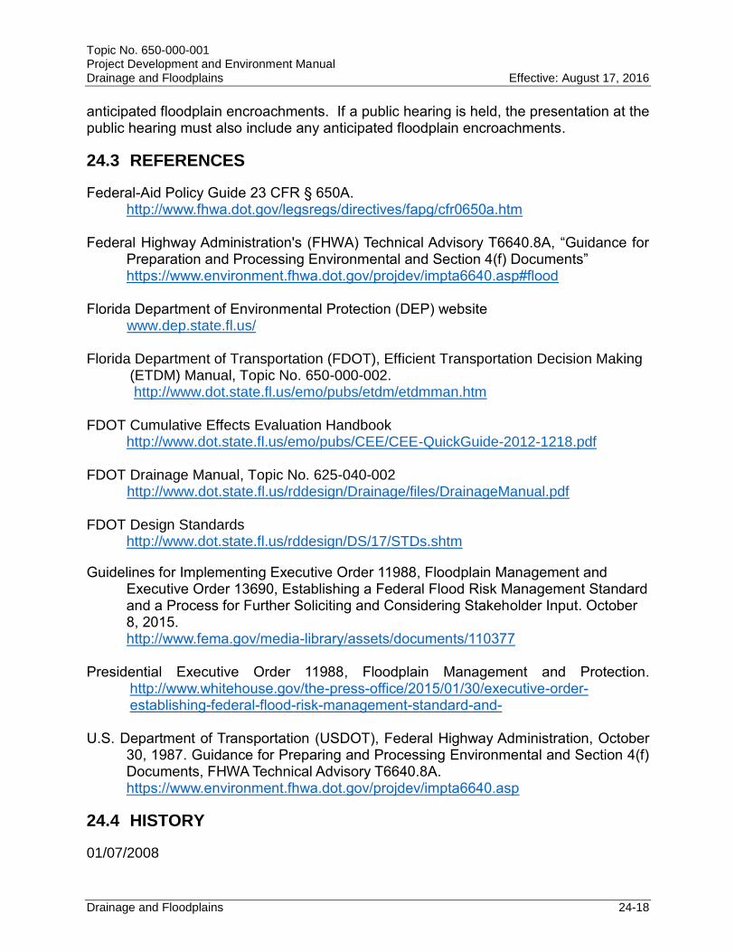
24.3 REFERENCES
Federal-Aid Policy Guide 23 CFR § 650A. http://www.fhwa.dot.gov/legsregs/directives/fapg/cfr0650a.htm Federal Highway Administration's (FHWA) Technical Advisory T6640.8A, “Guidance for
Preparation and Processing Environmental and Section 4(f) Documents” https://www.environment.fhwa.dot.gov/projdev/impta6640.asp#flood Florida Department of Environmental Protection (DEP) website www.dep.state.fl.us/ Florida Department of Transportation (FDOT), Efficient Transportation Decision Making
(ETDM) Manual, Topic No. 650-000-002. http://www.dot.state.fl.us/emo/pubs/etdm/etdmman.htm
FDOT Cumulative Effects Evaluation Handbook http://www.dot.state.fl.us/emo/pubs/CEE/CEE-QuickGuide-2012-1218.pdf FDOT Drainage Manual, Topic No. 625-040-002
http://www.dot.state.fl.us/rddesign/Drainage/files/DrainageManual.pdf FDOT Design Standards http://www.dot.state.fl.us/rddesign/DS/17/STDs.shtm
Guidelines for Implementing Executive Order 11988, Floodplain Management and Executive Order 13690, Establishing a Federal Flood Risk Management Standard and a Process for Further Soliciting and Considering Stakeholder Input. October 8, 2015. http://www.fema.gov/media-library/assets/documents/110377
Presidential Executive Order 11988, Floodplain Management and Protection.
http://www.whitehouse.gov/the-press-office/2015/01/30/executive-order-establishing-federal-flood-risk-management-standard-and-
U.S. Department of Transportation (USDOT), Federal Highway Administration, October
30, 1987. Guidance for Preparing and Processing Environmental and Section 4(f) Documents, FHWA Technical Advisory T6640.8A. https://www.environment.fhwa.dot.gov/projdev/impta6640.asp
24.4 HISTORY
01/07/2008
Topic No. 650-000-001 Project Development and Environment Manual Drainage and Floodplains Effective: August 17, 2016
Drainage and Floodplains 24-19
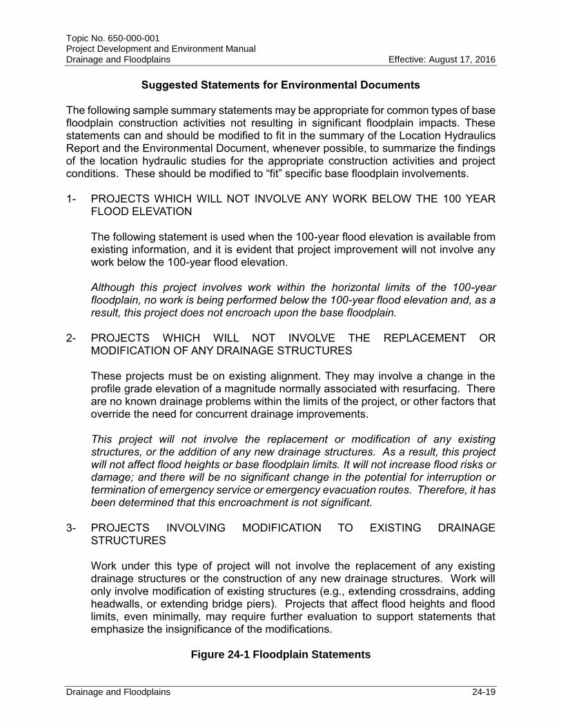
Suggested Statements for Environmental Documents
The following sample summary statements may be appropriate for common types of base floodplain construction activities not resulting in significant floodplain impacts. These statements can and should be modified to fit in the summary of the Location Hydraulics Report and the Environmental Document, whenever possible, to summarize the findings of the location hydraulic studies for the appropriate construction activities and project conditions. These should be modified to “fit” specific base floodplain involvements. 1- PROJECTS WHICH WILL NOT INVOLVE ANY WORK BELOW THE 100 YEAR
FLOOD ELEVATION
The following statement is used when the 100-year flood elevation is available from existing information, and it is evident that project improvement will not involve any work below the 100-year flood elevation.
Although this project involves work within the horizontal limits of the 100-year floodplain, no work is being performed below the 100-year flood elevation and, as a result, this project does not encroach upon the base floodplain.
2- PROJECTS WHICH WILL NOT INVOLVE THE REPLACEMENT OR
MODIFICATION OF ANY DRAINAGE STRUCTURES
These projects must be on existing alignment. They may involve a change in the profile grade elevation of a magnitude normally associated with resurfacing. There are no known drainage problems within the limits of the project, or other factors that override the need for concurrent drainage improvements.
This project will not involve the replacement or modification of any existing structures, or the addition of any new drainage structures. As a result, this project will not affect flood heights or base floodplain limits. It will not increase flood risks or damage; and there will be no significant change in the potential for interruption or termination of emergency service or emergency evacuation routes. Therefore, it has been determined that this encroachment is not significant.
3- PROJECTS INVOLVING MODIFICATION TO EXISTING DRAINAGE
STRUCTURES
Work under this type of project will not involve the replacement of any existing drainage structures or the construction of any new drainage structures. Work will only involve modification of existing structures (e.g., extending crossdrains, adding headwalls, or extending bridge piers). Projects that affect flood heights and flood limits, even minimally, may require further evaluation to support statements that emphasize the insignificance of the modifications.
Figure 24-1 Floodplain Statements
Topic No. 650-000-001 Project Development and Environment Manual Drainage and Floodplains Effective: August 17, 2016
Drainage and Floodplains 24-20
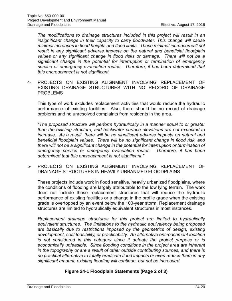
The modifications to drainage structures included in this project will result in an insignificant change in their capacity to carry floodwater. This change will cause minimal increases in flood heights and flood limits. These minimal increases will not result in any significant adverse impacts on the natural and beneficial floodplain values or any significant change in flood risks or damage. There will not be a significant change in the potential for interruption or termination of emergency service or emergency evacuation routes. Therefore, it has been determined that this encroachment is not significant.
4- PROJECTS ON EXISTING ALIGNMENT INVOLVING REPLACEMENT OF
EXISTING DRAINAGE STRUCTURES WITH NO RECORD OF DRAINAGE PROBLEMS
This type of work excludes replacement activities that would reduce the hydraulic performance of existing facilities. Also, there should be no record of drainage problems and no unresolved complaints from residents in the area.
"The proposed structure will perform hydraulically in a manner equal to or greater than the existing structure, and backwater surface elevations are not expected to increase. As a result, there will be no significant adverse impacts on natural and beneficial floodplain values. There will be no significant change in flood risk, and there will not be a significant change in the potential for interruption or termination of emergency service or emergency evacuation routes. Therefore, it has been determined that this encroachment is not significant."
5- PROJECTS ON EXISTING ALIGNMENT INVOLVING REPLACEMENT OF DRAINAGE STRUCTURES IN HEAVILY URBANIZED FLOODPLAINS
These projects include work in flood sensitive, heavily urbanized floodplains, where the conditions of flooding are largely attributable to the low lying terrain. The work does not include those replacement structures that will reduce the hydraulic performance of existing facilities or a change in the profile grade when the existing grade is overtopped by an event below the 100-year storm. Replacement drainage structures are limited to hydraulically equivalent structures in most instances. Replacement drainage structures for this project are limited to hydraulically equivalent structures. The limitations to the hydraulic equivalency being proposed are basically due to restrictions imposed by the geometrics of design, existing development, cost feasibility, or practicability. An alternative encroachment location is not considered in this category since it defeats the project purpose or is economically unfeasible. Since flooding conditions in the project area are inherent in the topography or are a result of other outside contributing sources, and there is no practical alternative to totally eradicate flood impacts or even reduce them in any significant amount, existing flooding will continue, but not be increased.
Figure 24-1 Floodplain Statements (Page 2 of 3)
Topic No. 650-000-001 Project Development and Environment Manual Drainage and Floodplains Effective: August 17, 2016
Drainage and Floodplains 24-21
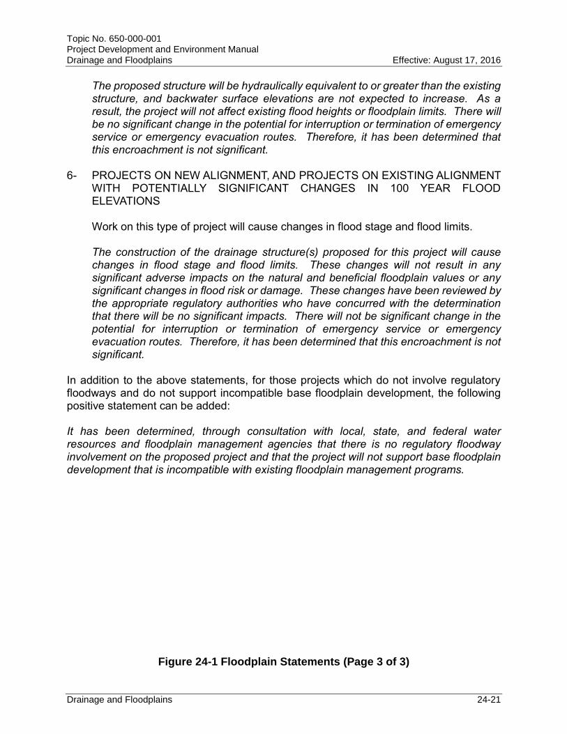
The proposed structure will be hydraulically equivalent to or greater than the existing structure, and backwater surface elevations are not expected to increase. As a result, the project will not affect existing flood heights or floodplain limits. There will be no significant change in the potential for interruption or termination of emergency service or emergency evacuation routes. Therefore, it has been determined that this encroachment is not significant.
6- PROJECTS ON NEW ALIGNMENT, AND PROJECTS ON EXISTING ALIGNMENT
WITH POTENTIALLY SIGNIFICANT CHANGES IN 100 YEAR FLOOD ELEVATIONS
Work on this type of project will cause changes in flood stage and flood limits. The construction of the drainage structure(s) proposed for this project will cause changes in flood stage and flood limits. These changes will not result in any significant adverse impacts on the natural and beneficial floodplain values or any significant changes in flood risk or damage. These changes have been reviewed by the appropriate regulatory authorities who have concurred with the determination that there will be no significant impacts. There will not be significant change in the potential for interruption or termination of emergency service or emergency evacuation routes. Therefore, it has been determined that this encroachment is not significant.
In addition to the above statements, for those projects which do not involve regulatory floodways and do not support incompatible base floodplain development, the following positive statement can be added: It has been determined, through consultation with local, state, and federal water resources and floodplain management agencies that there is no regulatory floodway involvement on the proposed project and that the project will not support base floodplain development that is incompatible with existing floodplain management programs.
Figure 24-1 Floodplain Statements (Page 3 of 3)