parks victoria technical series victorian intertidal reef monitoring
TRANSCRIPT

p a r k s v i c t o r i a t e c h n i c a l s e r i e s
number 61
victorian intertidal reef monitoring program: the reef biota of central victoria’s
marine protected areas volume 3
M Edmunds, K Stewart, K Pritchard and R Zavalas
June 2010

© Parks Victoria
All rights reserved. This document is subject to the Copyright Act 1968, no part of this publication may be reproduced, stored in a retrieval system, or transmitted in any form, or by any means, electronic, mechanical, photocopying or otherwise without the prior permission of the publisher.
First published 2010
Published by Parks Victoria Level 10, 535 Bourke Street, Melbourne Victoria 3000
Opinions expressed by the Authors of this publication are not necessarily those of Parks Victoria, unless expressly stated. Parks Victoria and all persons involved in the preparation and distribution of this publication do not accept any responsibility for the accuracy of any of the opinions or information contained in the publication.
Author(s):
Matt Edmunds – Marine Ecologist, Australian Marine Ecology
Kim Stewart – Marine Ecologist, Australian Marine Ecology
Katharine Pritchard – Marine Ecologist, Australian Marine Ecology
Richard Zavalas – Marine Ecologist, Australian Marine Ecology
National Library of Australia Cataloguing-in-publication data
Includes bibliography ISSN 1448-4935
Citation
Edmunds, M., Stewart, K., Pritchard, K., and Zavalas, R. (2010) Victorian Intertidal Reef Monitoring Program: The reef biota of central Victoria’s marine protected areas. Volume 3. Parks Victoria Technical Series No.61. Parks Victoria, Melbourne.
Printed on environmentally friendly paper

Parks Victoria Technical Paper Series No. 61
Victorian Intertidal Reef Monitoring Program:
The Intertidal Reef Biota of Central Victoria’s Marine Protected Areas
Volume 3
Matt Edmunds
Kim Stewart
Katharine Pritchard
Richard Zavalas
Australian Marine Ecology
June 2010

Parks Victoria Technical Series No. 61 Intertidal Reef Monitoring Program
II
EXECUTIVE SUMMARY
Intertidal reefs are present on headlands and points throughout Victoria, providing a variety of different habitats between the marine and terrestrial environments. Intertidal reefs have important social and cultural values and, because of their accessibility and proximity to land, are subject to human pressures including collection, trampling and pollution. To effectively manage and conserve these habitats, the Victorian Government has established a long-term Intertidal Reef Monitoring Program (IRMP). The IRMP provides information on the status of Victorian intertidal reef flora and fauna, as well as the nature and magnitude of trends in species populations and species diversity through time.
Within the Victorian Embayments bioregion, intertidal survey sites were established on reefs in the northern Port Phillip Bay marine sanctuaries at Point Cooke, Jawbone and Ricketts Point. Reference sites were also surveyed in association with each of these sanctuaries.
Along the Central Victorian bioregion, intertidal survey sites were established at Point Addis, Port Phillip Heads and Bunurong Marine National Parks and Point Danger, Barwon Bluff and Mushroom Reef Marine Sanctuaries. Reference sites were also surveyed in association with each of these locations.
The IRMP uses standardised visual census methods for surveying invertebrates and macroalgae on intertidal reefs. The standard operating procedures were modified in consultation with Parks Victoria after the first survey of reefs in 2003. The northern Port Phillip Bay sites and the Mushroom Reef Marine Sanctuary were resurveyed in 2004 using the revised standard operating procedures. All monitoring sites were resurveyed in the summer of 2004/2005. In addition, 4 new sites were established and surveyed inside and outside Bunurong Marine National Park (Eagles Nest) and Port Phillip Heads Marine National Park (Point Lonsdale). Another survey of the sites along the open coast (i.e. excluding those in Port Phillip Bay) was done in summer 2005/2006. All sites were surveyed in autumn 2007 and again in autumn to early winter in 2009.
The objectives of the program were to:
1. Provide an overview of the methods used for the IRMP.
2. Provide general descriptions of the biological communities and species populations at each monitoring site.
3. Identify any unusual biological phenomena, interesting or unique communities or species.
4. Identify any introduced species at the monitoring locations.
Surveys occur at a single reef during a single low tide and target the predominant substratum type. Five fixed transects, each running from high to low shore, are positioned at equal distance across the intertidal area to be surveyed, which is 30-100 m in length. Surveys of biota occur in quadrats at sample locations along each transect and are surveyed for: (1) the density of non-sessile invertebrates; and (2) the percentage cover of macroalgae and aggregated sessile invertebrates.
There were considerable differences in the intertidal flora and fauna between the Port Phillip Bay and the open coast sites. The open coast sites had greater species richness and diversity, along with a much higher cover of the alga Hormosira banksii and higher abundances of the snail Austrocochlea constricta, and the limpet Siphonaria spp. The assemblages at sites within Port Phillip Bay showed greater variation through time than those on the outer coast. There were differences in assemblages between the outer coast sites. The western sites, from Barwon Bluff to Point Addis, were reasonably similar with one another, as well as with the Port Phillip Heads sites.

Parks Victoria Technical Series No. 61 Intertidal Reef Monitoring Program
III
The differences and similarities in assemblage structure between sites was generally maintained over time. There were temporal variations in structure, but the magnitude of these were generally less than the between-site differences.
Within Port Phillip Bay, the brown alga Neptune’s necklace Hormosira banksii covered areas low on the shore at some sites. The ephemeral green algae Ulva spp. and Enteromorpha spp. occurred as small patchily distributed tufts. Galeolaria caespitosa was the most common and occurred low on the shoreline at most sites in low density. The top shell Austrocochlea porcata was the most common mobile invertebrate species at almost all sites. The variegated limpet Cellana tramoserica was also relatively common, as was the conniwink Bembicium spp. Less common species in varying abundances included the warrener Turbo undulatus, the black nerite Nerita atramentosa and the carnivorous gastropods Lepsiella vinosa and Cominella lineolata.
Outside Port Phillip Bay, Hormosira banksii was the dominant algae at most sites. Patches of small coralline and filamentous turfing species were also common. In 2009 H. banksii cover decreased by approximately half at all sites on the western central coast and at Mushroom Reef. On the open coast the pulmonate limpet Siphonaria spp., striped conniwink Bembicium nanum and C. tramoserica were all moderate to highly abundant. Austrocochlea constricta, Notoacmea mayi, Clypidina rugosa, Nodilittorina unifasciata and N. acutispira also occurred at most sites, but with a wide range of abundances being observed throughout their ranges.
The results in this report present a snapshot in time for community structures and species-population trends, which operate over long time scales. As monitoring continues and longer-term data sets are accumulated (over multiple years to decades) the program will be able to more adequately assess trends and ecological patterns occurring in the system.
Parks Victoria Technical Series No. 61 Intertidal Reef Monitoring Program
IV
CONTENTS
EXECUTIVE SUMMARY............................................................................................II
CONTENTS.............................................................................................................. IV
INDEX OF FIGURES AND TABLES....................................................................... VII
1 INTRODUCTION..................................................................................................1
1.1 Intertidal Reef Ecosystems..............................................................................................1
1.2 Intertidal Reef Monitoring Program..................................................................................1
1.2.1 Objectives ................................................................................................................................1
1.2.2 Monitoring Protocols and Locations.........................................................................................3
1.2.3 Monitoring Central Victorian Marine Protected Areas..............................................................4
2 METHODS ...........................................................................................................5
2.1 Site Selection and Survey Times ....................................................................................5
2.1.1 General Description of Survey Technique .............................................................................11
2.2 Visual Census Techniques............................................................................................13
2.2.1 Method A – Mobile Invertebrates ...........................................................................................13
2.2.2 Method B – Macroalgae and Sessile Invertebrates ...............................................................13
2.2.3 Video/Photo Quadrats............................................................................................................13
2.2.4 Qualitative Observations ........................................................................................................14
2.3 Data Analysis ................................................................................................................17
2.3.1 Community Structure .............................................................................................................17
2.3.2 Species Diversity....................................................................................................................17
2.3.3 Species Populations...............................................................................................................17
2.3.4 Initial Analyses .......................................................................................................................18
3 REGIONAL ANALYSIS .....................................................................................19
3.1 Biogeography................................................................................................................19
3.2 Macroalgae and Aggregating Sessile Invertebrates ......................................................19
3.3 Mobile Invertebrates .....................................................................................................25
4 POINT COOKE MARINE SANCTUARY............................................................30
4.1 Site Description and Transect Layout............................................................................30
4.1.1 Point Cooke Marine Sanctuary (Site 4107) ...........................................................................30
4.1.2 Altona Reference (Site 4108).................................................................................................30
4.2 Macroalgae and Aggregating Sessile Invertebrates ......................................................32
4.3 Mobile Invertebrates .....................................................................................................34
5 JAWBONE MARINE SANCTUARY ..................................................................37
5.1 Site Description and Transect Layout............................................................................37
5.1.1 Jawbone Marine Sanctuary (Site 4109).................................................................................37
5.1.2 Williamstown Reference (Site 4110)......................................................................................37
5.2 Macroalgae and Aggregating Sessile Invertebrates ......................................................39
5.3 Mobile Invertebrates .....................................................................................................39
6 RICKETTS POINT MARINE SANCTUARY.......................................................43
6.1 Site description and Transect layout .............................................................................43
6.1.1 Ricketts Point Marine Sanctuary (Site 4111) .........................................................................43

Parks Victoria Technical Series No. 61 Intertidal Reef Monitoring Program
V
6.1.2 Halfmoon Bay Reference (Site 4112) ....................................................................................43
6.2 Macroalgae and Aggregating Sessile Invertebrates ......................................................45
6.3 Mobile Invertebrates .....................................................................................................47
7 PORT PHILLIP HEADS MARINE NATIONAL PARK .......................................50
7.1 Site Description and Transect Layout............................................................................50
7.1.1 Point Lonsdale (Site 2823).....................................................................................................50
7.1.2 Cheviot Bay Reference (Site 2824) .......................................................................................50
7.2 Macroalgae and Aggregating Sessile Invertebrates ......................................................51
7.3 Mobile Invertebrates .....................................................................................................53
8 MUSHROOM REEF MARINE SANCTUARY ....................................................56
8.1 Site Description and Transect Layout............................................................................56
8.1.1 Mushroom Reef Marine Sanctuary (Site 2907) .....................................................................56
8.1.2 Flinders West Reference (Site 2908).....................................................................................56
8.2 Macroalgae and Aggregating Sessile Invertebrates ......................................................58
8.3 Mobile Invertebrates .....................................................................................................60
9 BUNURONG MARINE NATIONAL PARK ........................................................64
9.1 Site Description and Transect Layout............................................................................64
9.1.1 Eagles Nest (Site 3020) .........................................................................................................64
9.1.2 Caves Reference (Site 3021).................................................................................................64
9.2 Macroalgae and Aggregating Sessile Invertebrates ......................................................66
9.3 Mobile Invertebrates .....................................................................................................67
10 POINT ADDIS MARINE NATIONAL PARK ......................................................70
10.1 Site Description and Transect Layout.........................................................................70
10.1.1 Point Addis Marine National Park (Site 3901) .......................................................................70
10.1.2 Winipop Reference (Site 3902)..............................................................................................70
10.2 Macroalgae and Aggregating Sessile Invertebrates....................................................72
10.3 Mobile Invertebrates...................................................................................................73
11 POINT DANGER MARINE SANCTUARY .........................................................76
11.1 Site Description and Transect Layout.........................................................................76
11.1.1 Point Danger Marine Sanctuary (Site 4002) ..........................................................................76
11.1.2 Point Danger West Reference (Site 4001).............................................................................76
11.2 Macroalgae and Aggregating Sessile Invertebrates....................................................79
11.3 Mobile Invertebrates...................................................................................................80
12 BARWON BLUFF MARINE SANCTUARY .......................................................83
12.1 Site Description and Transect Layout.........................................................................83
12.1.1 Barwon Bluff Marine Sanctuary (Site 4004)...........................................................................83
12.1.2 Barwon Beach Reference (Site 4003) ...................................................................................83
12.2 Macroalgae and Aggregating Sessile Invertebrates....................................................85
12.3 Mobile Invertebrates...................................................................................................87
ACKNOWLEDGEMENTS ........................................................................................90
REFERENCES.........................................................................................................91
APPENDIX 1 ........................................................................................................ A1.1
A1. Site Details................................................................................................................ A1.1

Parks Victoria Technical Series No. 61 Intertidal Reef Monitoring Program
VI
A1.1 Point Cooke Marine Sanctuary............................................................................................. A1.1
A1.2 Jawbone Marine Sanctuary.................................................................................................. A1.2
A1.3 Ricketts Point Marine Sanctuary .......................................................................................... A1.3
A1.4 Point Addis Marine National Park......................................................................................... A1.4
A1.5 Point Danger Marine Sanctuary ........................................................................................... A1.6
A1.6 Barwon Bluff Marine Sanctuary............................................................................................ A1.7
A1.7 Port Phillip Heads Marine National Park .............................................................................. A1.8
A1.8 Mushroom Reef Marine Sanctuary..................................................................................... A1.10
A1.9 Bunurong Marine National Park ......................................................................................... A1.11
Parks Victoria Technical Series No. 61 Intertidal Reef Monitoring Program
VII
INDEX OF FIGURES AND TABLES FIGURES
Figure 1.1. An example plot depicting change in an environmental, population or community variable over time (days, months or years). ........................................... 2
Figure 1.2. Parks Victoria Ranger Mr Dale Appleton working with marine biologist during intertidal reef monitoring surveys. ................................................................. 3
Figure 2.1. Location of intertidal monitoring sites in northern Port Phillip Bay. Marine Sanctuary areas are indicated by grey shading. ...................................................... 6
Figure 2.2. Location of intertidal monitoring sites along the eastern coastline of central Victoria (excluding Bunurong Marine National Park). ............................................... 7
Figure 2.3. Location of intertidal monitoring sites at Bunurong Marine National Park. Marine National Park areas are indicated by grey shading. ..................................... 8
Figure 2.4. Location of intertidal monitoring sites along the western coastline of central Victoria. Marine protected areas’ boundaries are indicated by grey shading. ........... 9
Figure 2.5. Example layout of high and low shore baselines and transects on an intertidal reef. Transects (T1-T5) run across the shore from right to left when looking towards the water. Endpoints of each transect are equidistant along each of the baselines. Sampling locations (S1-S5) are arranged down shore along each transect and encompass differences in substratum height down the shore. ...............................................................................................................12
Figure 2.6. Configuration of a sampling location along a transect. Each 2 x 2m sampling location is centred on a point along the transect line. A quadrat is placed randomly within the sampling location using random x- and y-coordinates between -1 and 1.................................................................................12
Figure 2.7. Quadrat with the alga Hormosira banksii and snail Bembicium nanum. The abundance of each gastropod is counted within the quadrat. The cover of macrophytes and highly aggregated animals is measured by the number of points intersecting each species on the quadrat grid...............................................14
Figure 2.8. Marine biologist counting invertebrates within quadrats during intertidal reef monitoring surveys at Halfmoon Bay (Site 4112), May 2009...................................14
Figure 2.9. Examples of typical flora and fauna on intertidal reefs: a. the brown alga Hormosira banksii; b. the common limpet Cellana tramoserica; c. the limpets Siphonaria spp. (centre) and Notoacmea mayi; d. the gastropods Bembicium nanum (bottom) and Austrocochlea constricta; e. the gastropods Cominella lineolata (top) and Dicathais orbita; and f. the anemone Aulactinia veratra and the green alga Ulva spp. in standing water. ............................................................16
Figure 3.1. Algal and aggregating sessile invertebrate diversity (Hill’s N2) of intertidal sites within Port Phillip Bay. ....................................................................................21
Figure 3.2. Algal and aggregating sessile invertebrate diversity (Hills N2) of intertidal sites along the eastern central Victorian coast. .......................................................21
Figure 3.3. Algal and aggregating sessile invertebrate diversity (Hills N2) of intertidal sites along the western central Victorian coast. ......................................................22
Figure 3.4. Algal and aggregating sessile invertebrate species richness of intertidal sites within Port Phillip Bay. ....................................................................................22
Figure 3.5. Algal and aggregating sessile invertebrate species richness of intertidal sites along the eastern central Victorian coast. .......................................................23
Figure 3.6. Algal and aggregating sessile invertebrate species richness of intertidal sites along the western central Victorian coast. ......................................................23

Parks Victoria Technical Series No. 61 Intertidal Reef Monitoring Program
VIII
Figure 3.7. Two dimensional MDS plot of algal and sessile invertebrate assemblages on intertidal reefs in (a) northern Port Phillip Bay; (b) Port Phillip Heads and the eastern Victorian coastline; and (c) western Victorian coastline. Lines connect sites examined during consecutive surveys. Kruskal stress = 0.20............24
Figure 3.8. Invertebrate species diversity (Hills N2) of intertidal sites within Port Phillip Bay. ........................................................................................................................26
Figure 3.9. Invertebrate species diversity (Hills N2) of intertidal sites along the eastern central Victorian coast. ...........................................................................................26
Figure 3.10. Invertebrate species diversity (Hills N2) of intertidal sites along the western central Victorian coast. ...........................................................................................27
Figure 3.11. Invertebrate species richness of intertidal sites within Port Phillip Bay..............27
Figure 3.12. Invertebrate species richness of intertidal sites along the eastern central Victorian coast. .......................................................................................................28
Figure 3.13. Invertebrate species richness of intertidal sites along the western central Victorian coast. .......................................................................................................28
Figure 3.14. Two dimensional MDS plot of invertebrate assemblages on intertidal reefs in (a) northern Port Phillip Bay; (b) Port Phillip Heads and the eastern Victorian coastline; and (c) western Victorian coastline. Lines connect sites during consecutive surveys. Kruskal stress = 0.13. ...........................................................29
Figure 4.1. Intertidal reef habitat at Point Cooke Marine Sanctuary: a. 1 June 2007; and b. 29 April 2009. .....................................................................................................31
Figure 4.2. Intertidal reef at the Altona reference site, 27 April 2009.....................................32
Figure 4.3. Mean sizes (±±±± 95% confidence intervals) of Austrocochlea porcata at the Point Cooke Marine Sanctuary and the Altona reference site. ................................36
Figure 5.1. Intertidal reef at Jawbone Marine Sanctuary, 3 May 2007. .................................38
Figure 5.2. Intertidal reef at the Williamstown reference site, 30 April 2009. .........................38
Figure 5.3. Mean sizes (±±±± 95% confidence intervals) of (a) Austrocochlea porcata; (b) Cellana tramoserica; and (c) Bembicium spp. at the Jawbone Marine Sanctuary site and Williamstown reference site. .....................................................42
Figure 6.1. Intertidal reef at Ricketts Point Marine Sanctuary, 28 April 2009.........................44
Figure 6.2. The intertidal reef monitoring reference site at Halfmoon Bay, 1 May 2009. The high-shore baseline is at the right of the reef. ..................................................44
Figure 6.3. Mean sizes (±±±± 95% confidence intervals) of (a) Austrocochlea porcata; (b) Cellana tramoserica; and (c) Bembicium spp. at the Ricketts Point Marine Sanctuary site and Halfmoon Bay reference site. Note that C. tramoserica density was too low at Ricketts Point to analyse over time......................................49
Figure 7.1. Intertidal reef at Point Lonsdale, Port Phillip Heads Marine National Park, 12 June 2009..........................................................................................................50
Figure 7.2. Intertidal reef at the Cheviot Bay reference site, 22 December 2004. .................51
Figure 7.3. Mean sizes (±±±± 95% confidence intervals) of (a) Austrocochlea constricta (b) Cellana tramoserica and (c) Siphonaria spp. at the Point Lonsdale site, in Port Phillip Heads MNP, and the Cheviot Bay reference site..........................................55
Figure 8.2. Intertidal reef at the Flinders West reference site, 8 June 2007. .........................58
Figure 8.3. Mean sizes (±±±± 95% confidence intervals) of (a) Austrocochlea constricta and (b) Cellana tramoserica (c) Bembicium nanum and (d) Siphonaria spp. at the Mushroom Reef MS site and Flinders West reference site................................63
Figure 9.1. Intertidal reef at Eagles Nest, Bunurong Marine National Park, 7 June 2007. .....65

Parks Victoria Technical Series No. 61 Intertidal Reef Monitoring Program
IX
Figure 9.2. Intertidal reef at the Caves reference site, 7 June 2007, showing: a. the study area; and b. the limpet Cellana tramoserica. .................................................65
Figure 9.3. Mean sizes (±±±± 95% confidence intervals) of (a) Austrocochlea constricta; (b) Cellana tramoserica and (c) Siphonaria spp. at the Eagles Nest site, in Bunurong MNP, and the Caves reference site. .......................................................69
Figure 10.1. Intertidal reef at Point Addis Marine National Park, 17 December 2004............71
Figure 10.2. Intertidal reef at the Winkipop reference site, 28 May 2009. .............................71
Figure 10.3. Mean sizes (±±±± 95% confidence intervals) of Cellana tramoserica at the Point Addis MNP site and Winkipop reference site. ................................................75
Figure 11.1. Intertidal reef at Point Danger Marine Sanctuary: a-b. 14 January 2005; c-d. 30 April 2009. .....................................................................................................77
Figure 11.2. Intertidal reef at the Point Danger West reference site: a) 17 January 2005; b) 30 April 2009. Note: sand inundation along the high shore was lower in 2009, but remained higher than when the site was established...........................78
Figure 11.3. Mean sizes (±±±± 95% confidence intervals) of (a) Cellana tramoserica; and (b) Bembicium nanum at the Point Danger Marine Sanctuary and the Point Danger West reference site. ...................................................................................82
Figure 12.1. Intertidal reef at Barwon Bluff Marine Sanctuary: a. 30 November 2005; and b. 1 May 2009. .................................................................................................84
Figure 12.2. Size Mean sizes (±±±± 95% confidence intervals) of Cellana tramoserica at the Barwon Bluff MS site and the Barwon Beach reference site..............................89
TABLES
Table 2.1. Intertidal reef monitoring sites. Coordinates in Map Grid of Australia (Zone 55). .........................................................................................................................10
Table 2.2. Survey dates of intertidal monitoring sites............................................................11
Table 2.3. Intertidal species in south eastern Australia surveyed using Methods A and B. .....................................................................................................................15
Table 4.1. Abundance (percent cover) of macroalgae and aggregating sessile invertebrates at the Point Cooke MS site and Altona reference site during Survey 2 (May 2004), Survey 3 (April 2005), Survey 5 (May to June 2007) and Survey 6 (April 2009). .............................................................................................33
Table 4.2. Density of megafaunal (invertebrates 0.25m2) at the Point Cooke MS site and the Altona reference sites during Survey 2 (May 2004), Survey 3 (April 2005), Survey 5 (May-June 2007) and Survey 6 (April 2009)..................................35
Table 5.1. Abundance (percent cover) of macroalgae and aggregating sessile invertebrates at the Jawbone MS site and the Williamstown reference site during Survey 2 (May 2004), Survey 3 (April 2005), Survey 5 (May 2007) and Survey 6 (April 2009). .............................................................................................40
Table 5.2. Density of megafaunal (invertebrates 0.25m2) at the Jawbone MS site and Williamstown reference site during Survey 2 (May 2004), Survey 3 (April 2005), Survey 5 (May 2007) and Survey 6 (April 2009). .........................................41
Table 6.1. Abundance (percent cover) of macroalgae and aggregating sessile invertebrates at the Ricketts Point MS site and the Halfmoon Bay reference site during Survey 2 (May 2004), Survey 3 (April 2005), Survey 5 (May 2007) and Survey 6 (April-May 2009). ..............................................................................46
Table 6.2. Density of megafaunal (invertebrates 0.25m2) at the Ricketts Point MS site and the Halfmoon Bay reference site during Survey 2 (May 2004), Survey 3 (April 2005), Survey 5 (May 2007) and Survey 6 (April-May 2009). ........................48

Parks Victoria Technical Series No. 61 Intertidal Reef Monitoring Program
X
Table 7.1. Abundance (percent cover) of macroalgae and aggregating sessile invertebrates at the Point Lonsdale site, PPH MNP, and Cheviot Bay reference site during Survey 3 (December 2004), Survey 4 (September 2005), Survey 5 (May 2007) and Survey 6 (June 2009). ....................................................52
Table 7.2. Density of megafaunal (invertebrates 0.25m2) at the Point Lonsdale site, PPH MNP, and Cheviot Bay reference site during Survey 3 (December 2004), Survey 4 (September 2005), Survey 5 (May 2007) and Survey 6 (June 2009)........54
Table 8.1. Abundance (percent cover) of macroalgae and aggregating sessile invertebrates at the Mushroom Reef MS site and the Flinders West reference site during Survey 2 (June 2004), Survey 3 (February 2005), Survey 4 (December 2005), Survey 5 (May 2007) and Survey 6 (May 2009). .......................59
Table 8.2. Density of megafaunal (invertebrates 0.25m2) at the Mushroom Reef MS site and Flinders West reference site during Survey 2 (June 2004), Survey 3 (February 2005), Survey 4 (December 2005), Survey 5 (June 2007) and Survey 6 (May 2009). .............................................................................................61
Table 9.2. Density of megafaunal (invertebrates 0.25m2) at Eagles Nest, Bunurong MNP site and Caves reference site during Survey 3 (February 2005), Survey 4 (January 2006), Survey 5 (June 2007) and Survey 6 (June 2009). .........................68
Table 10.1. Abundance (percent cover) of macroalgae and aggregating sessile invertebrates at the Point Addis MNP site and Winkipop reference site during Survey 3 (December 2004), Survey 4 (November 2005), Survey 5 (May 2007) and Survey 6 (May 2009)........................................................................................72
Table 10.2. Density of megafaunal (invertebrates 0.25m2) at the Point Addis MNP site and Winkipop reference site during Survey 3 (December 2004), Survey 4 (November 2005), Survey 5 (May 2007) and Survey 6 (May 2009). .......................74
Table 11.1. Abundance (percent cover) of macroalgae and aggregating sessile invertebrates at the Point Danger MS site and the Point Danger West reference site during Survey 3 (January 2005), Survey 4 (December 2005), Survey 5 (May 2007) and Survey 6 (April 2009). ....................................................79
Table 11.2. Density of megafaunal (invertebrates 0.25m2) at the Point Danger MS site and the Point Danger West reference site during Survey 3 (January 2005), Survey 4 (December 2005), Survey 5 (May 2007) and Survey 6 (April 2009). ........81
Table 12.1. Mean abundance (percent cover) of macroalgae and aggregating sessile invertebrates at the Barwon Bluff Marine Sanctuary site and the Barwon Beach reference site during Survey 3 (January 2005), Survey 4 (November 2005), Survey 5 (May 2007) and Survey 6 (May 2009)...........................................86
Table 12.2. Density of megafaunal (invertebrates 0.25m2) at the Barwon Bluff Marine Sanctuary site and the Barwon Beach reference site during Survey 3 (January 2005), Survey 4 (November 2005), Survey 5 (May 2007) and Survey 6 (May 2009). .....................................................................................................................88

Parks Victoria Technical Series No. 61 Intertidal Reef Monitoring Program
1
1 INTRODUCTION
1.1 Intertidal Reef Ecosystems
Rocky intertidal reefs are restricted to a narrow fringe between fully terrestrial environments on land and fully submerged subtidal environments further offshore. Intertidal reefs in Victoria are generally restricted to headlands and points and are often isolated from each other by stretches of sandy beach. Victorian intertidal reefs vary in structure from steep sloping rock faces to relatively flat or gently sloping boulder fields and rock platforms. Weathering creates features on intertidal reefs including cobble fields, vertical steps, undulations in the reef, crevices, patches of sand and rock pools. The influence of the regular tidal cycle is the most important determinant of the types of biota inhabiting rocky reefs. Intertidal reefs tend to experience rapid changes and extremes in environmental conditions including temperature, salinity and exposure to air causing desiccation stress.
Typical algal species on protected intertidal reefs include the mat forming brown algae Neptune’s necklace Hormosira banksii and the green algae sea lettuce Ulva spp. and Enteromorpha spp. Other small turfing species are also often present. Less conspicuous is a thin layer of microscopic algae growing directly on the surface of the reef, which is an important food source for species of grazing molluscs.
Molluscs tend to be the dominant faunal component on intertidal reefs. Herbivorous species include the limpet Cellana tramoserica, as well as other species such as top shells Austrocochlea spp. and conniwinks Bembicium spp. Molluscan predators include Cominella lineolata and Lepsiella vinosa. The small mussel Xenostrobus pulex and tubeworms such as Galeolaria caespitosa create encrusting mats on the surface of the reef. Other invertebrates on intertidal reefs include small crustaceans such as crabs, as well as sessile animals including anemones. Fishes move in over the reef as the tide rises and can be important structuring components of intertidal reef communities.
Intertidal reefs are the most accessible component of marine environments and consequently these habitats have important social and cultural values. Due to their accessibility, intertidal reefs are sometimes subject to human pressures, including collection of animals for food and fishing bait, trampling and pollution from catchment discharges. To effectively manage and conserve these habitats, the Victorian Government, through Parks Victoria, has established the Intertidal Reef Monitoring Program (IRMP).
1.2 Intertidal Reef Monitoring Program
1.2.1 Objectives
An important aspect in the management and conservation of Victorian marine natural resources and assets is assessing the condition of the ecosystem and how this changes over time. Combined with an understanding of ecosystem processes, this information can be used to manage threats or pressures on the environment to ensure ecosystem sustainability.
Consequently, Parks Victoria established a long-term Intertidal Reef Monitoring Program (IRMP). The primary objective of the IRMP is to provide information on the status of Victorian reef flora and fauna. This includes monitoring the nature and magnitude of trends in species abundances, species diversity and community structure. This will be achieved through regular surveys at locations throughout Victoria, encompassing both representative and unique habitats and communities.
Information from the IRMP is allowing managers to better understand and interpret long-term changes in the population and community dynamics of Victoria’s reef flora and fauna. As a longer time series of data is collected, the IRMP will allow managers to:

Parks Victoria Technical Series No. 61 Intertidal Reef Monitoring Program
2
Compare changes in the status of species populations and biological communities between highly protected marine national parks and marine sanctuaries and other Victorian reefs.
Determine associations among species and between species and environmental parameters (e.g. exposure, reef topography) and assess how these associations vary through space and time.
Provide benchmarks for assessing the effectiveness of management actions, in accordance with international best practice for quality environmental management systems.
Provide baseline data to detect the responses of species and communities to unforeseen and unpredictable events such as marine pest invasions, mass mortality events, oil spills, severe storm events and climate change.
A monitoring survey gives an estimate of population abundance and community structure from a small window in time. Patterns seen in data from periodic surveys are unlikely to exactly match changes in the real populations over time or definitively predict the size and nature of future variation. Plots of changes over time are unlikely to match the changes in real populations because changes over shorter time periods and actual minima and maxima may not be adequately sampled (Figure 1.1). Furthermore, because the nature and magnitude of environmental variation is different over different time scales, variation over long periods may not be adequately predicted from shorter-term data. Sources of environmental variation can operate at the scale of months (e.g. seasonal variation), years (e.g. El Niño), decades (e.g. extreme storm events) or even centuries (e.g. global warming). Other studies indicate this monitoring program will begin to adequately reflect average trends and patterns as the surveys continue over longer periods (multiple years to decades). Results always need to be interpreted within the context of the time scale over which they have been measured.
Figure 1.1. An example plot depicting change in an environmental, population or community variable over time (days, months or years). The black circles denote examples of monitoring times. Note how data from these times may not necessarily reflect patterns over shorter time periods, or true maxima or minima over longer time periods. Note further how data from any window of 2 or 3 consecutive monitoring times fails to adequately estimate the patterns or variation over the longer time period.
Time
Pa
ram
ete
r

Parks Victoria Technical Series No. 61 Intertidal Reef Monitoring Program
3
1.2.2 Monitoring Protocols and Locations
The IRMP was initiated in April 2003 with 14 sites established on intertidal reef habitats inside and outside the following marine protected areas:
• Point Addis Marine National Park
• Point Danger Marine Sanctuary
• Barwon Heads Marine Sanctuary
• Point Cooke Marine Sanctuary
• Jawbone Marine Sanctuary
• Ricketts Point Marine Sanctuary
• Mushroom Reef Marine Sanctuary
The intertidal reef monitoring program uses standardised visual census methods for surveying invertebrates and macroalgae on intertidal reefs. The initial round of surveys was done using a draft Standard Operating Procedure (Edmunds and Hart 2003; Edmunds et al. 2004). These Standard Operating Procedures (SOP) were peer reviewed after the first survey. The SOP was modified in consultation with Parks Victoria and according to recommendations made during the peer review process. Details of the updated standard operational procedures (SOP) and quality control protocols are described in Hart and Edmunds (2005).
Existing monitoring sites in Port Phillip Bay and at the Mushroom Reef Marine Sanctuary were resurveyed in 2004 using the revised standard operating procedures (Hart and Edmunds 2005). All monitoring sites were then surveyed in the summer of 2004/2005. In addition, new sites were established and surveyed inside and outside:
• Bunurong Marine National Park
• Port Phillip Heads Marine National Park
Sites along the central Victorian coast, excluding those within Port Phillip Bay, were surveyed in summer 2005/2006. All monitoring sites were surveyed again in autumn 2007 and autumn to early winter in 2009.
Figure 1.2. Parks Victoria Ranger Mr Dale Appleton working with marine biologist during intertidal reef monitoring surveys.

Parks Victoria Technical Series No. 61 Intertidal Reef Monitoring Program
4
1.2.3 Monitoring Central Victorian Marine Protected Areas
This report describes the intertidal reef monitoring program and results from surveys, undertaken between April to June 2009, in the following marine protected areas (and corresponding reference sites) in central Victoria:
• Point Cooke Marine Sanctuary
• Jawbone Marine Sanctuary
• Ricketts Point Marine Sanctuary
• Port Phillip Heads Marine National Park
• Mushroom Reef Marine Sanctuary
• Bunurong Marine National Park
• Point Addis Marine National Park
• Point Danger Marine Sanctuary
• Barwon Heads Marine Sanctuary
•
The objectives of this report were to:
1. Provide an overview of the methods used for the IRMP.
2. Provide general descriptions of the biological communities and species populations at each monitoring site and any changes over time.
3. Identify any unusual biological phenomena, interesting or unique communities or species.
4. Identify any introduced species at the monitoring locations.

Parks Victoria Technical Series No. 61 Intertidal Reef Monitoring Program
5
2 METHODS
2.1 Site Selection and Survey Times
Intertidal survey sites were established on the intertidal reefs in nine marine protected areas in the Central Victorian and Victorian Embayments Bioregions. These were:
• Northern Port Phillip Bay (Point Cooke Marine Sanctuary, Jawbone Marine Sanctuary and Ricketts Point Marine Sanctuary in northern Port Phillip Bay) (Figure 2.1)
• Port Phillip Heads Marine National Park and Mushroom Reef Marine Sanctuary (Figure 2.2)
• Bunurong Marine National Park along the eastern coast of central Victoria (Figure 2.3); Point Addis Marine National Park, Point Danger Marine Sanctuary and Barwon Heads Marine Sanctuary along the western coast of central Victoria (Figure 2.4)
Two sites were surveyed in each area, one inside and one outside the MPA.
Each site was assigned a number in accordance with the Parks Victoria (PV) and Department of Sustainability and Environment (DSE) database system for marine monitoring (Table 2.1). Survey dates are shown in Table 2.2. A description of each intertidal reef and sampling considerations at each site is given separately for each marine sanctuary in Appendix 1 section A1.Site Details.

Parks Victoria Technical Series No. 61 Intertidal Reef Monitoring Program
6
Figure 2.1. Location of intertidal monitoring sites in northern Port Phillip Bay. Marine Sanctuary areas are indicated by grey shading.

Parks Victoria Technical Series No. 61 Intertidal Reef Monitoring Program
7
Figure 2.2. Location of intertidal monitoring sites along the eastern coastline of central Victoria (excluding Bunurong Marine National Park). Marine protected areas are indicated by grey shading.

Parks Victoria Technical Series No. 61 Intertidal Reef Monitoring Program
8
Figure 2.3. Location of intertidal monitoring sites at Bunurong Marine National Park. Marine National Park areas are indicated by grey shading.

Parks Victoria Technical Series No. 61 Intertidal Reef Monitoring Program
9
Figure 2.4. Location of intertidal monitoring sites along the western coastline of central Victoria. Marine protected areas’ boundaries are indicated by grey shading.

Parks Victoria Technical Series No. 61 Intertidal Reef Monitoring Program
10
Table 2.1. Intertidal reef monitoring sites. Coordinates in Map Grid of Australia (Zone 55).
Site Number Site Name Status Easting
(MGA)
Northing
(MGA)
Point Cooke MS
4107 Point Cooke Marine Sanctuary 305876 5799893
4108 Altona Reference 310020 5806233
Jawbone MS
4109 Jawbone Marine Sanctuary 313062 5807137
4110 Williamstown Reference 315545 5806228
Ricketts Point MS
4111 Ricketts Point Marine Sanctuary 327001 5792953
4112 Halfmoon Bay Reference 325118 5795723
Port Phillip Heads MNP
2823 Pt Lonsdale Marine National Park 291321 5759033
2824 Cheviot Bay Reference 295939 5756879
Mushroom Reef MS
2907 Mushroom Reef Marine Sanctuary 327050 5738412
2908 West Flinders Reference 326497 5739009
Bunurong MNP
3020 Eagles Nest Marine National Park 384362 5719082 3021 Caves Reference 385203 5719868
Point Addis MNP
3901 Point Addis Marine National Park 260162 5746979 3902 Winkipop Reference 262913 5750014
Point Danger MS
4002 Point Danger Marine Sanctuary 266413 5753027 4001 Pt Danger West Reference 266093 5752959
Barwon Bluff MS
4004 Barwon Bluff Marine Sanctuary 281293 5758960 4003 Barwon Beach Reference 280828 5759028

Parks Victoria Technical Series No. 61 Intertidal Reef Monitoring Program
11
Table 2.2. Survey dates of intertidal monitoring sites.
Sites Survey 1
2003
Survey 2
2004
Survey 3
2004/05
Survey 4
2005/06
Survey 5
2007
Survey 6
2009
4107 Point Cooke 21-04-03 07-05-04 14-04-05 01-06-07 29-04-09
4108 Altona 22-04-03 13-05-04 01-04-05 04-05-07 29-04-09
4109 Jawbone 19-04-03 11-05-04 04-04-05 03-05-07 30-04-09
4110 Williamstown 23-04-03 12-05-04 04-04-05 04-05-07 30-04-09
4111 Ricketts Point 20-04-03 20-05-04 18-04-05 18-05-07 28-04-09
4112 Halfmoon Bay 20-04-03 21-05-04 26-04-05 18-05-07 01-05-09
2823 Point Lonsdale 09-12-04 23-09-05 12-05-07 12-06-09
2824 Cheviot Bay 22-12-04 21-09-05 11-05-07 12-06-09
2907 Mushroom Reef 25-04-03 08-06-04 15-02-05 13-12-05 08-06-07 29-05-09
2908 West Flinders 25-04-03 09-06-04 15-02-05 13-12-05 08-06-07 29-05-09
3020 Eagles Nest 01-02-05 06-01-06 07-06-07 28-06-09
3021 Caves 01-02-05 06-01-06 07-06-07 28-06-09
3901 Point Addis 17-12-04 17-11-05 24-05-07 28-05-09
3902 Winkipop 20-12-04 18-11-05 24-05-07 28-05-09
4001 Point Danger West
09-07-03 17-01-05 01-12-05 23-05-07 30-04-09
4002 Point Danger 08-07-03 14-01-05 01-12-05 23-05-07 30-04-09
4003 Barwon Beach 24-04-03 21-01-05 30-11-05 09-05-07 01-05-09
4004 Barwon Bluff 24-04-03 25-05-04 18-01-05 30-11-05 09-05-07 01-05-09
2.1.1 General Description of Survey Technique
Each site is surveyed during a single low tide. Surveys target the predominant substratum type at each intertidal reef (e.g. basalt boulder field, flat sandstone reef, basalt reef). The maximum along-shore distance that is practical to sample in a single tide using this method is 100 m.
Within the area to be surveyed, the high and low shore boundaries are identified. On vertically sloping shores, the high shore boundary generally approximates the mean high water level. On relatively flat shores with little variation in vertical height across the shore, the high shore is at the landward edge and the low shore is at the seaward edge of the flat area. A weighted tape measure or numbered transect line is placed along the high shore, beginning at the right hand side of the shore when looking towards the sea. This is the high-shore baseline (A-B, Figure 2.5). Similarly, a low shore baseline is established by placing a transect line along the low shore. The positions of each end of both baselines are recorded using dGPS and photographed (C-D, Figure 2.5).
Five fixed transects, each running from high to low shore, are positioned across the intertidal area to be surveyed (Figure 2.5). Transect 1 is furthest to the right-hand side and Transect 5 to the left-hand side of the reef when looking out to sea. Each transect runs between points on the high and low shore baselines. Adjacent transects are roughly equidistant from each other.
Surveys of biota occur in quadrats, randomly placed during each survey at five fixed sampling locations (2 x 2m area) along each transect (Figure 2.6). The fixed sampling locations are positioned to distribute sampling effort along each transect and to encompass any changes in substratum height across the reef.

Parks Victoria Technical Series No. 61 Intertidal Reef Monitoring Program
12
Figure 2.5. Example layout of high and low shore baselines and transects on an intertidal reef. Transects (T1-T5) run across the shore from right to left when looking towards the water. Endpoints of each transect are equidistant along each of the baselines. Sampling locations (S1-S5) are arranged down shore along each transect and encompass differences in substratum height down the shore.
Figure 2.6. Configuration of a sampling location along a transect. Each 2 x 2m sampling location is centred on a point along the transect line. A quadrat is placed randomly within the sampling location using random x- and y-coordinates between -1 and 1.
S1 T1 T2 T3 T4 T5
low-shore baseline
high-shore baseline
S2
S3
S4
S5
A B
D C
(1, 1)
(-1, -1)
2 m
(0,0) 2 m
Transect Line

Parks Victoria Technical Series No. 61 Intertidal Reef Monitoring Program
13
2.2 Visual Census Techniques
2.2.1 Method A – Mobile Invertebrates
The density of non-sessile invertebrates, such as gastropods and sea stars, is measured by counting individuals within 0.5 x 0.5 m quadrats (Figures 2.7, 2.8, 2.9, Table 2.3). All observable individuals on the rock surface or within crevices and algal fronds are counted. To ensure the monitoring has minimal impact over time, rocks are not overturned or disturbed. Selected specimens are collected for identification and preservation in a reference collection.
The Bembicium populations in northern Port Phillip Bay are likely to comprise three separate species: Bembicium nanum; B. melanostomum; and B. auratum. Anderson (1958) concluded these species could only be separated with difficulty in the field. This problem was compounded with the small sizes and heavy shell erosion of most individuals surveyed. As such, the species were grouped at genus level. Similarly, species from the genus Siphonaria were often too small to identify reliably in the field and were grouped as Siphonaria spp.
The shell length of 50 -100 individuals of abundant species of gastropod are measured at each site. This is done to identify changes in the size structure of commonly collected species over time, which may indicate impacts on populations because of illegal shellfish collection. Data collected also provides general information on population size structure and recruitment dynamics. Species measured include those that are commonly collected on intertidal shores for bait or food, such as Cellana tramoserica and Austrocochlea spp. as well as non-collected ‘control’ species, including Siphonaria spp., Cominella lineolata and Bembicium spp. Individuals are selected randomly by selecting five individuals (of each species) encountered within each quadrat location. If necessary, at the end of the quadrat sampling, additional size measurements are taken from all individuals within aggregations nearest to the observer.
2.2.2 Method B – Macroalgae and Sessile Invertebrates
The abundance of algae and highly aggregated sessile invertebrates, such as tubeworms and mussels, is measured as proportional cover of the substratum. This is done using a points-intersection method. The 0.5 x 0.5 m quadrat is divided into a grid of 7 x 7 perpendicular wires, giving 50 regularly spaced points (including one corner). Cover is estimated by the number of points directly above each species (Figures 2.7). Selected specimens are collected for identification and preservation in a reference collection.
Some species have been shown to respond to changes in nutrient and freshwater inputs on Victorian intertidal reefs (Fox et al. 2000). Fluctuations in the population status of these species may indicate changes in nutrient loadings affecting MPAs or other intertidal areas. Species that may respond include the algae Ulva spp., Cladophora subsimplex, Capreolia implexia, Ceramium flaccidum, Corallina officinalis, Hormosira banksii and the tubeworm Boccardia proboscidea. The presence/absence of these species within each quadrat is recorded (if present and not detected under any points). Species recorded as present, but not recorded under any points, are not included in analyses.
2.2.3 Video/Photo Quadrats
During initial surveys, a photograph was taken of the substratum and biota at each quadrat position. This was done to provide a permanent qualitative record of the biota and microhabitat conditions. The photograph was taken such that the minimum dimension is 50 cm (i.e. at the scale of a quadrat). This method was not employed during recent surveys.

Parks Victoria Technical Series No. 61 Intertidal Reef Monitoring Program
14
2.2.4 Qualitative Observations
At each site, observers record general observations of topography, reef structure (rugosity, relief, boulder sizes, etc.), biogenic habitat structure (Hormosira, algal turfs) and a general description of the flora and fauna. Video and photographic records are also taken at each site.
For each quadrat, the substratum microhabitats present are recorded. These are classified as: horizontal surface, flat, rock top (h); rock pool (p); rocky rubble or cobble (r); sand (s); or vertical surface, rock side, crevice (v).
Figure 2.7. Quadrat with the alga Hormosira banksii and snail Bembicium nanum. The abundance of each gastropod is counted within the quadrat. The cover of macrophytes and highly aggregated animals is measured by the number of points intersecting each species on the quadrat grid.
Figure 2.8. Marine biologist counting invertebrates within quadrats during intertidal reef monitoring surveys at Halfmoon Bay (Site 4112), May 2009.

Parks Victoria Technical Series No. 61 Intertidal Reef Monitoring Program
15
Table 2.3. Intertidal species in south eastern Australia surveyed using Methods A and B.
Algae Sessile Invertebrates Mobile Invertebrates
Blue-Green Algae Tube Worms Limpets
Rivularia sp. Galeolaria caespitosa Clypidina rugosa
Symploca sp. Boccardia proboscidea Patella chapmani
Cellana tramoserica
Patelloida alticostata
Green Algae Barnacles Patelloida insignis
Cladophora prolifera Catomerus polymerus Patelloida latistrigata
Cladophora subsimplex Chthamalus antennatus Notoacmea mayi
Codium spp. Chaemosipho tasmanica Notoacmea petterdi
Enteromorpha spp. Tesseropora rosea Notoacmea spp.
Dictyosphaeria serica Tetraclitella purpurascens Siphonaria spp.
Ulva spp. Snails
Bivalves Austrocochlea constricta
Brown Algae Mytilus edulis Austrocochlea porcata
Chordaria cladosiphon Xenostrobus pulex Austrocochlea odontis
Colpomenia sinuosa Brachidontes rostratus Austrocochlea concamerata
Hormosira banksii Saccostrea glomerata Turbo undulatus
Leathesia difformis Nerita atramentosa
Notheia anomala Bembicium nanum
Scytosiphon lomentaria Ascidians Bembicium spp.
Splanchnidium rugosum Pyura stolonifera Nodilittorina unifasciata
Nodilittorina acutispira
Dicathais orbita
Red Algae Anemones Lepsiella vinosa
Capreolia implexa Actinia tenebrosa Cominella lineolata
Ceramium flaccidum Aulactinia veratra Calliostoma armillata
Corallina officinalis Anthothoe albocincta Mitra glabra
Gracilaria spp. Oulactis muscosa
Laurencia spp. Sea stars
Parvulastra exigua
Meridiastra calcar
Sea Slugs
Onchidella patelloides
Sea Hares
Aplysia gigantea
Crabs
Cyclograpsus granulosus
Paragrapsus gaimardii

Parks Victoria Technical Series No. 61 Intertidal Reef Monitoring Program
16
a. b.
c. d.
e. f.
Figure 2.9. Examples of typical flora and fauna on intertidal reefs: a. the brown alga Hormosira banksii; b. the common limpet Cellana tramoserica; c. the limpets Siphonaria spp. (centre) and Notoacmea mayi; d. the gastropods Bembicium nanum (bottom) and Austrocochlea constricta; e. the gastropods Cominella lineolata (top) and Dicathais orbita; and f. the anemone Aulactinia veratra and the green alga Ulva spp. in standing water.
Parks Victoria Technical Series No. 61 Intertidal Reef Monitoring Program
17
2.3 Data Analysis
2.3.1 Community Structure
Community structure is a multivariate function of both the type of species present and the abundance of each species. The community structure between pairs of samples was compared using the Bray-Curtis dissimilarity coefficient. This index compares the abundance of each species between two samples to give a single value of the difference between the samples, expressed as a percentage (Faith et al. 1987; Clarke 1993).
Prior to analysis, the data were log transformed to down-weight the influence of highly abundant species in describing community structure, giving a more even weighting between abundant and rarer species (following abundance transformations by Sweatman et al. 2000).
The multivariate information in the dissimilarity matrix was simplified and depicted using non-metric multidimensional scaling (MDS; Clarke 1993). This ordination method finds the representation in fewer dimensions that best depicts the actual patterns in higher dimensions. The MDS results were then depicted graphically to show differences between the replicates at each location. The distance between points on the MDS plot is representative of the relative difference in community structure.
Kruskall stress is an indicator statistic calculated during the ordination process and indicates the degree of disparity between the reduced dimensional data set and the original hyper-dimensional data set. A guide to interpreting the Kruskal stress indicator is given by Clarke (1993): (< 0.1) a good ordination with no real risk of drawing false inferences; (< 0.2) can lead to a usable picture, although for values at the upper end of this range there is potential to mislead; and (> 0.2) likely to yield plots which can be dangerous to interpret.
2.3.2 Species Diversity
Species diversity involves the consideration of two components: species richness and evenness. Species richness is the number of species present in the community while evenness is the degree of similarity of abundances between species. If all species in a community have similar abundances, then the community has a high degree of evenness. If a community has most of the individuals belonging to one species, it has low evenness. Species diversity is a combination of species richness and the relative abundance of each species, and is often referred to as species heterogeneity. Measures of diversity give an indication of the likelihood that two individuals selected at random from a community are different species.
Species richness (S) was enumerated by the total species count per site. This value was used for calculation of evenness and heterogeneity statistics. Species diversity (i.e. heterogeneity among species) was described using the reciprocal of Simpson’s index (1/DSimpson = Hill’s N2). This index provides more weighting for common species, as opposed to the weighting of rarer species such as by the Shannon-Weiner Index (Krebs 1999). The weighting of common species was considered more appropriate for this study, with the sampling being directed more towards the enumeration of common species rather than rarer ones.
2.3.3 Species Populations
The abundances of each species were summarised by calculating the mean density per quadrat (0.25m2) for each site. The abundance of common species such as Austrocochlea spp. and Cellana tramoserica were compared between this survey and the previous survey. Abundance was not compared for the initial survey because of differences in survey methodology. The sizes of common species were assessed by calculating mean lengths and size frequency curves for each site where there was a high abundance of individuals.

Parks Victoria Technical Series No. 61 Intertidal Reef Monitoring Program
18
2.3.4 Initial Analyses
Differences in sampling methodology restricted analyses to only those data collected using the revised standard operating procedures. An exception is size data, which are comparable between both methods. It should be noted that for the initial IRMP surveys there will only be cursory exploration and investigation of the data. When a longer time series is available, there will be more detailed assessments of temporal trends. The analyses do not standardise the height of quadrats on the shoreline, so comparisons between sites should be interpreted with caution.

Parks Victoria Technical Series No. 61 Intertidal Reef Monitoring Program
19
3 REGIONAL ANALYSIS
3.1 Biogeography
Victoria’s marine environment has been classified into five bioregions. These bioregions reflect differences in physical processes such as ocean currents and geology, which in turn influence the distribution of ecosystems and diversity over scales of 100-1000 km.
Point Cooke, Jawbone and Ricketts Point marine sanctuaries are in the Victorian Embayments bioregion (which includes Port Phillip Bay, Westernport Bay and Corner Inlet). Habitats in this bioregion are mostly sheltered from large swells and currents typical of open coastal locations. There also tends to be a larger estuarine influence on habitats in this bioregion.
Point Danger, Barwon Bluff and Mushroom Reef marine sanctuaries and Point Addis, Port Phillip Heads and Bunurong marine national parks are in the Central Victorian bioregion. Habitats in this bioregion are generally exposed to strong winds, large swell and currents that are typical of open coastal locations. Intertidal platforms in this bioregion can also be influenced by sand movement along the open coastline.
3.2 Macroalgae and Aggregating Sessile Invertebrates
Locations surveyed along the open coastline generally had a similar level of diversity, but higher species richness, than sites examined within Port Phillip Bay (Figures 3.1 to 3.6). Species diversity was more consistent than species richness at each site between surveys.
In Port Phillip Bay, species diversity increased between 2007 and 2009 at Jawbone (Site 4109) and Ricketts Point (Site 4111) marine sanctuaries, and remained stable at Point Cooke (Site 4107), while decreasing at all reference sites (Figure 3.1). Species richness also increased at all marine sanctuary sites between 2007 and 2009. There was a corresponding increase in species richness at the Halfmoon Bay reference site (Site 4112), but declines at both Altona (Site 4108) and Williamstown (Site 4110; Figure 3.4).
At Port Phillip Heads, species diversity remained stable at Point Lonsdale (Site 2823) but increased slightly at the Cheviot Bay reference site (Site 2824) between 2007 and 2009 surveys (Figure 3.2). In contrast, species richness continued to increase at Point Lonsdale, and decrease at Cheviot Bay (Figure 3.5). At Mushroom Reef diversity increased considerably at both the sanctuary and reference sites between the 2004 and 2005 surveys, before gradually returning to initial levels by 2007 (Figure 3.2). Species richness increased at both sites between 2007 and 2009, but increased but more at the reference site (Site 2908). At Bunurong, species diversity and richness both decreased at the marine park site (Site 3020). Species richness also decreased at the reference site (Site 3021), but to a lesser degree.
On the western central Victorian coast, species diversity was stable or increased slightly at all sites between 2007 and 2009 (Figure 3.3). Species richness increased substantially at all MPA sites between 2007 and 2009, reversing a declining trend. There was a corresponding increase in species richness at the Winkipop reference site (Site 3901), and a slight increase at Barwon Beach (Site 4003), while it remained unchanged at Point Danger West (Site 4001; Figure 3.6).
Most of the algal and sessile invertebrate communities in Port Phillip Bay were distinct from communities along the exposed coastline (Figure 3.7). Within Port Phillip Bay, Williamstown (Site 4110) and Ricketts Point (Site 4111) had similar assemblages, with a moderate coverage of Hormosira banksii making them more like those of the open coast than other Port Phillip Bay sites. Point Cooke, Jawbone, and Altona showed high temporal variation in assemblage structure (Figure 3.7), probably related to the ephemeral coverage of sea lettuce Ulva spp. and the green alga Enteromorpha spp. at these sites.

Parks Victoria Technical Series No. 61 Intertidal Reef Monitoring Program
20
On the coastline east of Port Phillip Bay, temporal variation was relatively low. In previous years sites had a gradient of algal and sessile invertebrate assemblages. The assemblages at the Flinders sites (Sites 2907 and 2908) overlapped with those of the Port Phillip Heads sites (Sites 2823 and 2824), which in turn overlapped with the Bunurong sites’ assemblages (Sites 3020 and 3021). In 2009, this gradient was not as defined, as the assemblages at Bunurong sites became more similar to those at Mushroom Reef and Flinders (Figure 3.7b).
Coastal sites west of Port Phillip Bay had a smaller range of assemblages than those on the east coast (Figure 3.7). There was no clear separation of assemblages between west coast sites, and they overlapped with those of Port Phillip Heads sites, reflecting the structural similarity and geographic proximity of these sites.
The most abundant macroalgae on the open coast was Neptune’s necklace Hormosira banksii. In previous years there was a high cover of this species at all coastal sites except for Mushroom Reef (Site 2907). In 2009 H. banksii cover decreased by approximately half at all sites on the western central coast and at Mushroom Reef. Patches of small coralline and filamentous turfing species occurred at most coastal locations in low abundance but were relatively abundant at Point Addis (Site 3901), Cheviot Bay (Site 2824), Barwon Beach (Site 4003) and in particular Flinders West (2908). Mat forming mussels, such as Xenostrobus pulex, were abundant at several locations including Point Danger (Sites 4001 and 4002) and Bunurong (Sites 3020 and 3021).

Parks Victoria Technical Series No. 61 Intertidal Reef Monitoring Program
21
Algal and Aggregating Sessile Invertebrate Species Diversity
0
2
4
6
8
Hill
s N
2
4108 Altona Ref4107 Point Cooke MS
0
2
4
6
8
Hill
s N
2
4110 Williamstown Ref4109 Jawbone MS
2004 2005 2006 2007 2008 2009 2010
Year
0
2
4
6
8
Hill
s N
2
4112 Halfmoon Bay Ref4111 Ricketts Point MS
Figure 3.1. Algal and aggregating sessile invertebrate diversity (Hill’s N2) of intertidal sites within Port Phillip Bay.
Algal and Aggregating Sessile Invertebrate Species Diversity
0
2
4
6
8
Hill
s N
2
2824 Cheviot Bay Ref2823 Point Lonsdale PPH MNP
0
2
4
6
8
Hill
s N
2
2908 West Flinders Ref2907 Mushroom Reef MS
2004 2005 2006 2007 2008 2009 2010
Year
0
2
4
6
8
Hill
s N
2
3021 Caves Ref3020 Eagles Nest, Bunurong MNP
Figure 3.2. Algal and aggregating sessile invertebrate diversity (Hills N2) of intertidal sites along the eastern central Victorian coast.

Parks Victoria Technical Series No. 61 Intertidal Reef Monitoring Program
22
Algal and Aggregating Sessile Invertebrate Species Diversity
0
2
4
6
8
Hill
s N
2
3902 Winkipop Ref3901 Point Addis MNP
0
2
4
6
8
Hill
s N
2
4002 Point Danger MS4001 Point Danger West Ref
2004 2005 2006 2007 2008 2009 2010
Year
0
2
4
6
8
Hill
s N
2
4004 Barwon Bluff MS4003 Barwon Beach Ref
Figure 3.3. Algal and aggregating sessile invertebrate diversity (Hills N2) of intertidal sites along the western central Victorian coast.
Algal and Aggregating Sessile Invertebrate Species Richness
0
5
10
15
Spe
cie
s C
ou
nt
4108 Altona Ref4107 Point Cooke MS
0
5
10
15
Sp
ecie
s C
ou
nt
4110 Williamstown Ref4109 Jawbone MS
2004 2005 2006 2007 2008 2009 2010
Year
0
5
10
15
Spe
cie
s C
oun
t
4112 Halfmoon Bay Ref4111 Ricketts Point MS
Figure 3.4. Algal and aggregating sessile invertebrate species richness of intertidal sites within Port Phillip Bay.

Parks Victoria Technical Series No. 61 Intertidal Reef Monitoring Program
23
Algal and Aggregating Sessile Invertebrate Species Richness
0
5
10
15
Sp
ecie
s C
ou
nt
2824 Cheviot Bay Ref2823 Point Lonsdale PPH MNP
0
5
10
15
Sp
ecie
s C
ou
nt
2908 West Flinders Ref2907 Mushroom Reef MS
2004 2005 2006 2007 2008 2009 2010
Year
0
5
10
15
Spe
cie
s C
ou
nt
3021 Caves Ref3020 Eagles Nest, Bunurong MNP
Figure 3.5. Algal and aggregating sessile invertebrate species richness of intertidal sites along the eastern central Victorian coast.
Algal and Aggregating Sessile Invertebrate Species Richness
0
5
10
15
Sp
eci e
s C
ou
nt
3902 Winkipop Ref3901 Point Addis MNP
0
5
10
15
Sp
eci e
s C
ou
nt
4002 Point Danger MS4001 Point Danger West Ref
2004 2005 2006 2007 2008 2009 2010
Year
0
5
10
15
Spe
ci e
s C
ou
nt
4004 Barwon Bluff MS4003 Barwon Beach Ref
Figure 3.6. Algal and aggregating sessile invertebrate species richness of intertidal sites along the western central Victorian coast.

Parks Victoria Technical Series No. 61 Intertidal Reef Monitoring Program
24
Halfmoon Bay ReferenceRicketts Pt MSWilliamstown ReferenceJawbone MSAltona ReferencePt Cooke MS
a. Port Phillip Bay Sites
Caves ReferenceEagles Nest MNPFlinders West ReferenceMushroom Reef MSCheviot Bay ReferencePt Lonsdale MNP
b. East Coast Sites
Barwon Bluff MSBarwon Beach ReferencePt Danger MSPt Danger West ReferenceWinkipop ReferencePt Addis MNP
c. West Coast Sites
Figure 3.7. Two dimensional MDS plot of algal and sessile invertebrate assemblages on intertidal reefs in (a) northern Port Phillip Bay; (b) Port Phillip Heads and the eastern Victorian coastline; and (c) western Victorian coastline. Lines connect sites examined during consecutive surveys. Kruskal stress = 0.20.

Parks Victoria Technical Series No. 61 Intertidal Reef Monitoring Program
25
3.3 Mobile Invertebrates
Sites along the open coastline generally had a higher, and more variable, richness and diversity of mobile invertebrate species than sites in Port Phillip Bay (Figures 3.8 to 3.13). Within Port Phillip Bay, Halfmoon Bay (Site 4112) had the highest species richness and diversity (Figure 3.8), with an assemblage more similar to those of intertidal reefs on the open coast (Figure 3.14).
Species richness and/or diversity appear to have peaked at many sites in the summer 2005-2006 (survey 4) and then declined to 2007. These sites included Barwon Bluff (Site 4004), Point Danger (Site 4002), Point Danger West (Site 4001), Point Addis (Site 3901), Mushroom Reef (Site 2907), Flinders West (Site 2908) and Williamstown (Site 4110; Figures 3.11 to 3.13). Conversely, species richness reached a low at Ricketts Point and Halfmoon Bay in 2005, but has steadily increased in subsequent surveys (Sites 4111 and 4112; Figure 3.11).
Between 2007 and 2009, species richness and diversity has been relatively stable or increased at most sites. There was, however, continued decline in species diversity at Flinders West (Site 2908) and Barwon Bluff (Site 4004). Species richness decreased at Caves (Site 3021) and Winkipop (Site 3902).
The mobile invertebrate communities in Port Phillip Bay were distinct from those on the open coast and encompassed a greater range of assemblage types (Figure 3.14). Within Port Phillip Bay the sites at Altona (Site 4108), Jawbone (Site 4109) and Williamstown (Site 4110) had similar mobile invertebrate assemblages, reflecting their geographical proximity. Point Cooke (Site 4107) and Halfmoon Bay (Site 4112) had assemblages that were distinct from other sites (Figure 3.14). The species rich mobile invertebrate assemblage at Halfmoon Bay was intermediate between assemblages at other Port Phillip Bay sites and those of the open coast (Figure 3.11).
The top shell Austrocochlea porcata was the most common species at almost all sites In Port Phillip Bay. Cellana tramoserica was also relatively common, as was Bembicium spp. Less common species, in varying abundances, included the warrener Turbo undulatus, the black nerite Nerita atramentosa and the carnivorous gastropods Lepsiella vinosa and Cominella lineolata.
For sites outside Port Phillip Bay there was no apparent separation between mobile invertebrate assemblages from the east and west coasts. Sites east of Port Phillip Bay had a gradient of assemblages (Figure 3.14b), from those of the Flinders sites (Sites 2907 and 2908) through to the Port Phillip Heads’ assemblages (Sites 2823 and 2824), with the Bunurong sites (Sites 3020 and 3021) intermediate between these locations. Assemblages from sites west of Port Phillip Bay showed no clear distinctions, although assemblages at Winkipop (Site 3902) and Barwon Bluff (Site 4004) showed greater temporal variation (Figure 3.14c).
The pulmonate limpet Siphonaria spp., striped conniwink Bembicium nanum and variegated limpet Cellana tramoserica were relatively abundant at sites surveyed along the open coast. Austrocochlea constricta, Clypidina rugosa, Nodilittorina unifasciata, N. acutispira, Lepsiella vinosa and Cominella lineolata were also common, but their abundances varied widely across sites.

Parks Victoria Technical Series No. 61 Intertidal Reef Monitoring Program
26
Invertebrate Species Diversity
0
2
4
6
8
Hill
s N
2
4108 Altona Ref4107 Point Cooke MS
0
2
4
6
8
Hill
s N
2
4110 Williamstown Ref4109 Jawbone MS
2004 2005 2006 2007 2008 2009 2010
Year
0
2
4
6
8
Hill
s N
2
4112 Halfmoon Bay Ref4111 Ricketts Point MS
Figure 3.8. Invertebrate species diversity (Hills N2) of intertidal sites within Port Phillip Bay.
Invertebrate Species Diversity
0
2
4
6
8
Hill
s N
2
2824 Cheviot Bay Ref2823 Point Lonsdale PPH MNP
0
2
4
6
8
Hill
s N
2
2908 West Flinders Ref2907 Mushroom Reef MS
2004 2005 2006 2007 2008 2009 2010
Year
0
2
4
6
8
Hill
s N
2
3021 Caves Ref3020 Eagles Nest, Bunurong MNP
Figure 3.9. Invertebrate species diversity (Hills N2) of intertidal sites along the eastern central Victorian coast.

Parks Victoria Technical Series No. 61 Intertidal Reef Monitoring Program
27
Invertebrate Species Diversity
0
2
4
6
8
Hill
s N
2
3902 Winkipop Ref3901 Point Addis MNP
0
2
4
6
8
Hill
s N
2
4002 Point Danger MS4001 Point Danger West Ref
2004 2005 2006 2007 2008 2009 2010
Year
0
2
4
6
8
Hill
s N
2
4004 Barwon Bluff MS4003 Barwon Beach Ref
Figure 3.10. Invertebrate species diversity (Hills N2) of intertidal sites along the western central Victorian coast.
Invertebrate Species Richness
0
5
10
15
20
25
Spe
cie
s C
ou
nt
4108 Altona Ref4107 Point Cooke MS
0
5
10
15
20
25
Sp
ecie
s C
ou
nt
4110 Williamstown Ref4109 Jawbone MS
2004 2005 2006 2007 2008 2009 2010
Year
0
5
10
15
20
25
Spe
cie
s C
oun
t
4112 Halfmoon Bay Ref4111 Ricketts Point MS
Figure 3.11. Invertebrate species richness of intertidal sites within Port Phillip Bay.

Parks Victoria Technical Series No. 61 Intertidal Reef Monitoring Program
28
Invertebrate Species Richness
0
5
10
15
20
25
Spe
cie
s C
ou
nt
2824 Cheviot Bay Ref2823 Point Lonsdale PPH MNP
0
5
10
15
20
25
Sp
ecie
s C
ou
nt
2908 West Flinders Ref2907 Mushroom Reef MS
2004 2005 2006 2007 2008 2009 2010
Year
0
5
10
15
20
25
Spe
cie
s C
oun
t
3021 Caves Ref3020 Eagles Nest, Bunurong MNP
Figure 3.12. Invertebrate species richness of intertidal sites along the eastern central Victorian coast.
Invertebrate Species Richness
0
5
10
15
20
25
Spe
ci e
s C
ou
nt
3902 Winkipop Ref3901 Point Addis MNP
0
5
10
15
20
25
Sp
eci e
s C
ou
nt
4002 Point Danger MS4001 Point Danger West Ref
2004 2005 2006 2007 2008 2009 2010
Year
0
5
10
15
20
25
Spe
ci e
s C
oun
t
4004 Barwon Bluff MS4003 Barwon Beach Ref
Figure 3.13. Invertebrate species richness of intertidal sites along the western central Victorian coast.
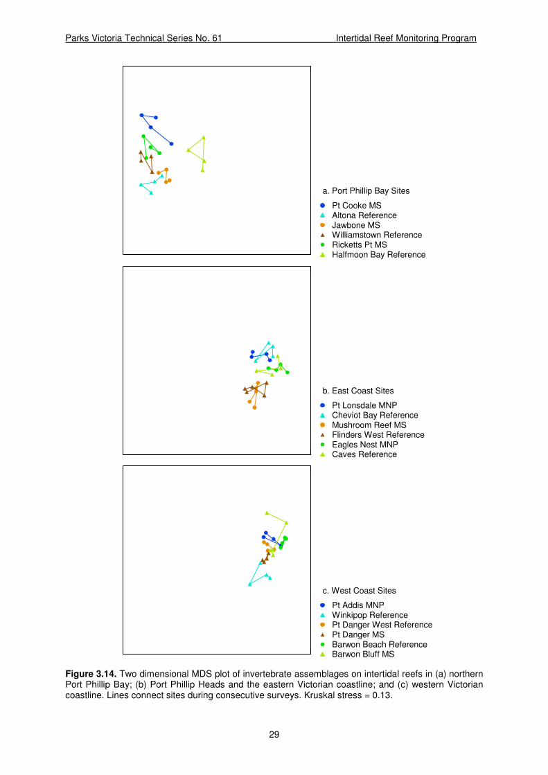
Parks Victoria Technical Series No. 61 Intertidal Reef Monitoring Program
29
Halfmoon Bay ReferenceRicketts Pt MSWilliamstown ReferenceJawbone MSAltona ReferencePt Cooke MS
a. Port Phillip Bay Sites
Caves ReferenceEagles Nest MNPFlinders West ReferenceMushroom Reef MSCheviot Bay ReferencePt Lonsdale MNP
b. East Coast Sites
Barwon Bluff MSBarwon Beach ReferencePt Danger MSPt Danger West ReferenceWinkipop ReferencePt Addis MNP
c. West Coast Sites
Figure 3.14. Two dimensional MDS plot of invertebrate assemblages on intertidal reefs in (a) northern Port Phillip Bay; (b) Port Phillip Heads and the eastern Victorian coastline; and (c) western Victorian coastline. Lines connect sites during consecutive surveys. Kruskal stress = 0.13.
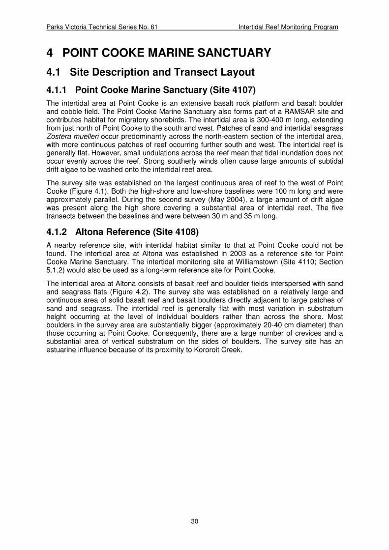
Parks Victoria Technical Series No. 61 Intertidal Reef Monitoring Program
30
4 POINT COOKE MARINE SANCTUARY
4.1 Site Description and Transect Layout
4.1.1 Point Cooke Marine Sanctuary (Site 4107)
The intertidal area at Point Cooke is an extensive basalt rock platform and basalt boulder and cobble field. The Point Cooke Marine Sanctuary also forms part of a RAMSAR site and contributes habitat for migratory shorebirds. The intertidal area is 300-400 m long, extending from just north of Point Cooke to the south and west. Patches of sand and intertidal seagrass Zostera muelleri occur predominantly across the north-eastern section of the intertidal area, with more continuous patches of reef occurring further south and west. The intertidal reef is generally flat. However, small undulations across the reef mean that tidal inundation does not occur evenly across the reef. Strong southerly winds often cause large amounts of subtidal drift algae to be washed onto the intertidal reef area.
The survey site was established on the largest continuous area of reef to the west of Point Cooke (Figure 4.1). Both the high-shore and low-shore baselines were 100 m long and were approximately parallel. During the second survey (May 2004), a large amount of drift algae was present along the high shore covering a substantial area of intertidal reef. The five transects between the baselines and were between 30 m and 35 m long.
4.1.2 Altona Reference (Site 4108)
A nearby reference site, with intertidal habitat similar to that at Point Cooke could not be found. The intertidal area at Altona was established in 2003 as a reference site for Point Cooke Marine Sanctuary. The intertidal monitoring site at Williamstown (Site 4110; Section 5.1.2) would also be used as a long-term reference site for Point Cooke.
The intertidal area at Altona consists of basalt reef and boulder fields interspersed with sand and seagrass flats (Figure 4.2). The survey site was established on a relatively large and continuous area of solid basalt reef and basalt boulders directly adjacent to large patches of sand and seagrass. The intertidal reef is generally flat with most variation in substratum height occurring at the level of individual boulders rather than across the shore. Most boulders in the survey area are substantially bigger (approximately 20-40 cm diameter) than those occurring at Point Cooke. Consequently, there are a large number of crevices and a substantial area of vertical substratum on the sides of boulders. The survey site has an estuarine influence because of its proximity to Kororoit Creek.

Parks Victoria Technical Series No. 61 Intertidal Reef Monitoring Program
31
a.
b.
Figure 4.1. Intertidal reef habitat at Point Cooke Marine Sanctuary: a. 1 June 2007; and b. 29 April 2009.

Parks Victoria Technical Series No. 61 Intertidal Reef Monitoring Program
32
Figure 4.2. Intertidal reef at the Altona reference site, 27 April 2009.
4.2 Macroalgae and Aggregating Sessile Invertebrates
In April 2005, a large area (nearly 60%) of the Point Cooke intertidal reef was covered with Ulva spp. which was relatively evenly spread across the survey area. Enteromorpha spp. also occurred in moderate quantities and was similarly distributed across the reef. In June 2007, Enteromorpha spp. were not recorded at Point Cooke, and the cover of Ulva spp. had decreased to just 3%. A previously small patch of sand and Zostera muelleri seagrass has gradually extended across a wide band of the reef and Z. muelleri covered 6% of the study area in April 2009. The coverage of filamentous red algae, which increased from none to almost 9% in 2007, was less than 2% in 2009. The high amounts of drift macroalgae observed in 2004 were not observed during subsequent surveys.
Altona had much less macroalgal cover than Point Cooke (Table 4.1). No algae were recorded in the study area in May 2004. In April 2005 Ulva spp. and Enteromorpha spp. each covered nearly 10%, although this had almost disappeared by May 2007. A low coverage of coralline algal species was also observed in the 2005 and 2007 surveys. In 2009, Ulva spp. covered 6% of the study area and Enteromorpha spp. was present at very low density. No other sessile species were observed.
Aggregating sessile invertebrates did not contribute greatly to the structure of either reef, although there were small patches of Galeolaria caespitosa on the low shoreline. The blue mussel Mytilis edulis was found at Point Cooke in small numbers, also low on the shore.
Waves and currents can deposit and erode sand and shell material in the intertidal zone, periodically inundating and exposing areas of reef. The amount of sand inundation was similar at both sites in 2004, it was much greater at Point Cooke than Altona during the 2005 and 2007 surveys. In 2009, sand coverage was lower at Altona than in 2007 and higher at Point Cooke, the two sites having a similar coverage of 18% and 14% respectively (Table 4.1).

Parks Victoria Technical Series No. 61 Intertidal Reef Monitoring Program
33
Table 4.1. Abundance (percent cover) of macroalgae and aggregating sessile invertebrates at the Point Cooke MS site and Altona reference site during Survey 2 (May 2004), Survey 3 (April 2005), Survey 5 (May to June 2007) and Survey 6 (April 2009).
‘+’ = present in quadrats but not observed under any points; empty cell = not observed in any quadrats.
Point Cooke MS (Site 4107) Altona reference (Site 4108)
Survey Survey Species
2 3 5 6 2 3 5 6
Macrophytes
Algal turf 1.20
Ceramium flaccidum 0.20
Corallina officinalis 1.20 + + 0.08 0.64 0.90
Corallines unidentified
0.40
Encrusting corallines + 0.08 + +
Enteromorpha spp. 2.60 14.08 9.12 1.20 +
Filamentous red algae
0.60 8.70 1.48
Grateloupia filicina 0.10
Hypnea sp. 1.00
Laurencia botryoides 0.24
Laurencia filiformis 0.04
Symploca sp. + 2.10
Ulva spp. 8.90 59.44 3.40 1.52 9.84 + 6.32
Zostera muelleri 2.80 3.10 6.04
Sessile Invertebrates
Galeolaria caespitosa
+ 1.20 1.00 2.00 0.40 1.20
Mytilus edulis 0.10 0.32 0.04
Sponges 0.20 0.20
Other
Drift macroalgae 20.0 0.16 0.2 0.10 0.16
Drift seagrass 2.70 +
Sand/Shell material 15.0 10.64 33.10 17.92 18.5 0.48 6.90 13.80

Parks Victoria Technical Series No. 61 Intertidal Reef Monitoring Program
34
4.3 Mobile Invertebrates
Mobile invertebrates were lower in density at Point Cooke than Altona (Table 4.2). The low densities of individuals recorded means that interpretation of the results must be cautious. Most mobile invertebrates occurred in greater abundances in the lower areas of the shore.
The herbivorous gastropod Austrocochlea porcata was the most abundant invertebrate at both sites. Initially A. porcata occurred at much higher densities at Altona, however, there have been consistent, substantial increases in its abundance at Point Cooke and only a slight increase at Altona. In 2009, both sites recorded just under 40 A. porcata individuals 0.25m2 (Table 4.2).
The conniwink Bembicium spp. and limpet Cellana tramoserica were consistently present in low densities at Altona, but have only been recorded intermittently at very low densities at Point Cooke.
The warrener Turbo undulatus was recorded in low densities on the low shore at Point Cooke. A similar density of T. undulatus, 0.50 individuals 0.25m2, was recorded at this location in 2003 (Edmunds et al. 2004). Turbo undulatus was only recorded at Altona, at low density, in 2005.
The carnivorous gastropods Cominella lineolata and Lepsiella vinosa occurred at Altona in similar densities to those found at Point Cooke during the 2004 and 2005 surveys, but only at Point Cooke during the 2007 survey. In 2009, C. lineolata abundance had increased at both sites, and L. vinosa was absent.
The seastar Parvulastra exigua occurred on the seaward edge of the intertidal reef at Altona in low densities during surveys 2004 and 2005. The abundance of Parvulastra exigua increased by more than ten times at Altona between 2005 and 2007, but had decreased by almost two thirds in 2009. This species has not been recorded at Point Cooke during any of the surveys to date.
The herbivorous gastropod Austrocochlea porcata was the only species abundant enough to assess size trends within the sites (Figure 4.3). Although larger at Point Cooke in 2003, 2004 and 2007, the mean size of A. porcata were approximately equal in 2009. The large increase in abundance of A. porcata at Point Cooke between 2007 and 2009 indicates high recruitment of new animals at this site. A greater proportion of younger, smaller, animals would decrease the mean size, and this may account for the decrease in mean size observed at Point Cooke over this period.

Parks Victoria Technical Series No. 61 Intertidal Reef Monitoring Program
35
Table 4.2. Density of megafaunal (invertebrates 0.25m2) at the Point Cooke MS site and the Altona
reference sites during Survey 2 (May 2004), Survey 3 (April 2005), Survey 5 (May-June 2007) and Survey 6 (April 2009).
Point Cooke MS
(Site 4107)
Altona reference
(Site 4108)
Survey Survey Species
2 3 5 6 2 3 5 6
Cnidaria
Actinia tenebrosa 0.56
Aulactinia veratra 3.24 2.92
Oulactis muscosa 0.20 0.20
Unidentified anemone
0.36
Mollusca
Austrocochlea odontis
0.20 0.20
Austrocochlea porcata
5.80 2.92 14.24 38.08 20.50 27.40 29.88 39.60
Batillaria australis 0.04
Bembicium spp. 0.08 0.56 1.60 0.72 2.52 0.80
Cellana tramoserica 0.08 2.70 0.32 0.44 0.36
Cominella lineolata 0.40 0.12 0.04 1.16 0.10 0.04 0.40
Dicathais orbita 0.04
Lepsiella vinosa 0.20 0.04 0.12 0.40 0.04
Mitra glabra 0.04
Mytilus edulis 0.04 0.04
Nerita atramentosa 0.68 1.12 0.12 0.28
Nodilittorina unifasciata
0.20
Notoacmea mayi 0.08
Siphonaria spp. 0.08
Turbo undulatus 0.04 0.48 0.04 0.12
Unidentified chiton 0.16 0.04 0.04
Crustacea
Unidentified crab 0.04
Echinodermata
Parvulastra exigua 0.60 0.32 4.00 1.56

Parks Victoria Technical Series No. 61 Intertidal Reef Monitoring Program
36
Mean Sizes
Austrocochlea porcata
2003 2004 2005 2006 2007 2008 2009 2010
Year
0
10
20
30
Length
(m
m)
2003 2004 2005 2006 2007 2008 2009 2010
Year
0
10
20
30
Length
(m
m)
4108 Altona Ref4107 Point Cooke MS
Figure 4.3. Mean sizes (± 95% confidence intervals) of Austrocochlea porcata at the Point Cooke Marine Sanctuary and the Altona reference site.

Parks Victoria Technical Series No. 61 Intertidal Reef Monitoring Program
37
5 JAWBONE MARINE SANCTUARY
5.1 Site Description and Transect Layout
5.1.1 Jawbone Marine Sanctuary (Site 4109)
There is an extensive area of fractured basalt reef and boulder field at Jawbone Marine Sanctuary (Site 4109). The reef forms a band up to 30 m wide and extends for several hundred metres from the point at Jawbone, to the southwest boundary of the Sanctuary. The large basalt boulders create medium to high relief intertidal reef with considerable habitat structure because of the large amount of vertical substratum and crevices (Figure 5.1). The intertidal reef at Jawbone Marine Sanctuary has a large estuarine influence because of the proximity of Kororoit Creek and there is an area of mangrove and salt marsh habitat at the eastern end of the sanctuary. This area is also a RAMSAR site and is an important habitat for migratory shorebirds.
The survey site was established on a continuous area of reef. The high-shore and low-shore baselines were 100 m in length and were parallel to shore. The five transects placed between the baselines were 6-18 m in length.
5.1.2 Williamstown Reference (Site 4110)
The reference site for the Jawbone Marine Sanctuary was intertidal reef at Point Gellibrand, Williamstown (site 4110). As at the Jawbone Marine Sanctuary, the intertidal area is a fractured basalt reef and boulder field. However, the boulders were smaller at Williamstown and consequently there was less vertical structure and fewer crevices (Figure 5.2). The intertidal reef has a south-westerly aspect.
The high-shore baseline was 62 m. The low-shore baseline was 100 m in length. The five transects established were 30-44 m in length.

Parks Victoria Technical Series No. 61 Intertidal Reef Monitoring Program
38
Figure 5.1. Intertidal reef at Jawbone Marine Sanctuary, 3 May 2007.
Figure 5.2. Intertidal reef at the Williamstown reference site, 30 April 2009.

Parks Victoria Technical Series No. 61 Intertidal Reef Monitoring Program
39
5.2 Macroalgae and Aggregating Sessile Invertebrates
The abundance of macroalgae and sessile invertebrates was very low at the Jawbone Marine Sanctuary, covering less than 5% of the study area (Site 4109; Table 5.1). The calcareous tube-worm Galeolaria caespitosa was present at low densities, low in the intertidal zone. Turfing and coralline algae, the green algae sea lettuce Ulva spp. and Codium fragile and the seagrass Zostera muelleri were present very low in the intertidal zone, at the eastern end of the study area.
Macroalgal cover at Williamstown (Site 4110) was predominantly the brown alga Neptune’s necklace Hormosira banksii, which occurred in patches on the lower region of the shore. The abundance of H. banksii steadily increased at this site between 2004 and 2007, but had the same coverage (13%) in 2009 as it did in 2007. Turfing algae also covered 13% of the intertidal zone in 2007, but was absent in 2009.
The coverage of sand and shell material decreased at both sites between 2007 and 2009.
5.3 Mobile Invertebrates
The intertidal reef invertebrate communities at Jawbone Marine Sanctuary (Site 4109) and at the reference site at Williamstown (Site 4110) were similar in species density and community structure (Table 5.2). The mobile invertebrate population structure at Jawbone was dominated by the top shell Austrocochlea porcata, the conniwink Bembicium spp., the black nerite Nerita atramentosa and the variegated limpet Cellana tramoserica (Table 5.2). The abundance of C. tramoserica has decreased steadily at Jawbone MS since 2004. The only carnivorous gastropod recorded was Lepsiella vinosa.
At Williamstown, the dominant invertebrates were the herbivorous gastropods Bembicium spp. and Austrocochlea porcata. Bembicium spp. were in higher densities at Williamstown than at Jawbone and tended to dominate the high shore region. The abundance of Austrocochlea porcata was variable at this site and increased substantially between 2007 and 2009 (Table 5.2). As at Jawbone, the abundance of the limpet Cellana tramoserica has also been in steady decline. Throughout the monitoring program it has occurred at much lower densities at Williamstown than at Jawbone. In 2009 it was not recorded within quadrats at this site at all.

Parks Victoria Technical Series No. 61 Intertidal Reef Monitoring Program
40
Table 5.1. Abundance (percent cover) of macroalgae and aggregating sessile invertebrates at the Jawbone MS site and the Williamstown reference site during Survey 2 (May 2004), Survey 3 (April 2005), Survey 5 (May 2007) and Survey 6 (April 2009).
‘+’ = present in quadrats but not observed under any points; empty cell = not observed in any quadrats.
Jawbone MS
(Site 4109)
Williamstown Reference
(Site 4110)
Survey Survey Species
2 3 5 6 2 3 5 6
Macrophytes
Algal turf 2.50 1.12 0.36 0.10 13.44
Cladophora spp. +
Codium fragile 0.24 0.24
Codium spp. 0.56 0.24
Corallina officinalis + 0.56 0.16
Corallines unidentified +
Encrusting corallines + + + +
Enteromorpha spp. + + 0.32 +
Filamentous green algae 0.10 0.04
Heterozostera tasmanica 0.20
Hormosira banksii 6.90 8.48 13.28 13.28
Leathesia difformis +
Notheia anomala +
Sargassum spp. 0.04
Symploca sp. + 0.24
Ulva spp. 1.30 1.36 + 1.00 0.10 + 0.8 0.16
Unidentified lichen + 1.44 +
Zostera meulleri 1.40
Sessile Invertebrates
Galeolaria caespitosa 0.20 0.72 0.72 0.20 1.40 0.56 0.64 0.24
Unidentified barnacles +
Unidentified bivalve +
Other
Drift macroalgae 0.36 +
Drift seagrass 1.20 0.56 0.20
Sand/Shell material 0.72 1.84 5.28 1.92 8.56 0.60

Parks Victoria Technical Series No. 61 Intertidal Reef Monitoring Program
41
Table 5.2. Density of megafaunal (invertebrates 0.25m2) at the Jawbone MS site and Williamstown
reference site during Survey 2 (May 2004), Survey 3 (April 2005), Survey 5 (May 2007) and Survey 6 (April 2009).
Jawbone MS
(Site 4109)
Williamstown Reference
(Site 4110)
Survey Survey Species
2 3 5 6 2 3 5 6
Mollusca
Austrocochlea odontis 0.08
Austrocochlea porcata 4.40 7.24 7.20 4.04 3.60 8.88 2.52 14.08
Bembicium spp. 2.12 0.80 3.28 0.72 8.84 5.60 4.12 6.32
Cellana tramoserica 6.32 4.76 3.00 2.32 1.12 0.96 0.6
Clypidina rugosa 0.08
Cominella lineolata 0.04 0.04
Lepsiella vinosa 0.08 0.16 0.08 0.04 0.04 0.08
Nerita atramentosa 1.08 0.84 1.88 1.92 0.12
Notoacmea mayi 0.16 0.32 0.32 0.12 0.04
Patelloida alticostata 0.04
Siphonaria spp. 0.04 0.08 0.08
Turbo undulatus 0.04 0.20 0.04 0.48 0.08 0.28
Crustacea
Unidentified crab 0.16
Echinodermata
Parvulastra exigua 0.12 0.08 0.28 0.88
The mean size of Austrocochlea porcata was relatively stable over time at Williamstown (Figure 5.3a). At Jawbone Marine Sanctuary the mean size was more variable, alternating between approximately 12 mm and 17 mm in length. At the time of the 2009 survey, the mean length of A. porcata was around 17 mm at both sites.
The mean size of the limpet Cellana tramoserica was also relatively stable, between 30 and 35 mm (Figure 5.3b). The most recent survey in 2009 recorded a mean size of 30 mm at Jawbone compared to a mean size of 32 mm at Williamstown.
The mean size of the conniwink Bembicium spp. have been consistently larger at Williamstown than at Jawbone MS, with a mean size of 15 mm compared to 7 mm, respectively (Figure 5.3c).

Parks Victoria Technical Series No. 61 Intertidal Reef Monitoring Program
42
Mean Sizes
a. Austrocochlea porcata
0
10
20
30
Le
ng
th (
mm
)
0
10
20
30
Le
ng
th (
mm
)
b. Cellana tramoserica
0
10
20
30
40
50
Le
ng
th (
mm
)
0
10
20
30
40
50
Le
ng
th (
mm
)
c. Bembicium spp.
2003 2004 2005 2006 2007 2008 2009 2010
Year
0
10
20
30
Le
ng
th (
mm
)
2003 2004 2005 2006 2007 2008 2009 2010
Year
0
10
20
30
Le
ng
th (
mm
)
4110 Williamstown Ref4109 Jawbone MS
Figure 5.3. Mean sizes (± 95% confidence intervals) of (a) Austrocochlea porcata; (b) Cellana tramoserica; and (c) Bembicium spp. at the Jawbone Marine Sanctuary site and Williamstown reference site.
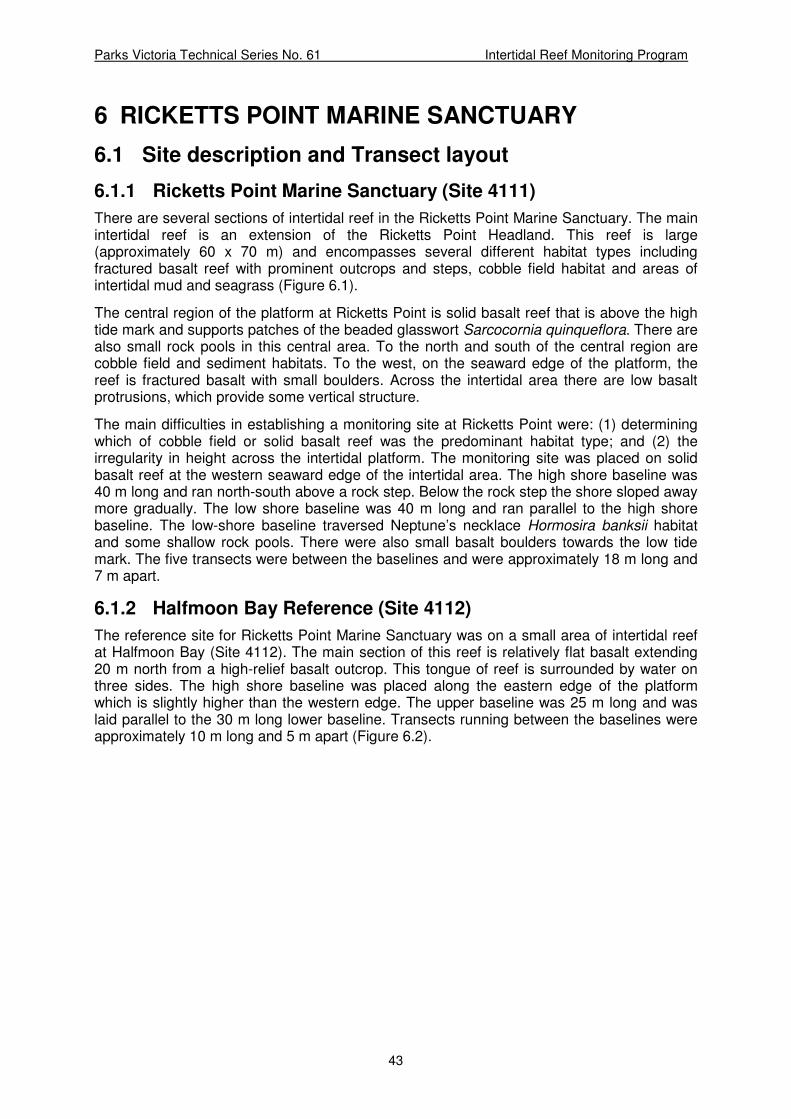
Parks Victoria Technical Series No. 61 Intertidal Reef Monitoring Program
43
6 RICKETTS POINT MARINE SANCTUARY
6.1 Site description and Transect layout
6.1.1 Ricketts Point Marine Sanctuary (Site 4111)
There are several sections of intertidal reef in the Ricketts Point Marine Sanctuary. The main intertidal reef is an extension of the Ricketts Point Headland. This reef is large (approximately 60 x 70 m) and encompasses several different habitat types including fractured basalt reef with prominent outcrops and steps, cobble field habitat and areas of intertidal mud and seagrass (Figure 6.1).
The central region of the platform at Ricketts Point is solid basalt reef that is above the high tide mark and supports patches of the beaded glasswort Sarcocornia quinqueflora. There are also small rock pools in this central area. To the north and south of the central region are cobble field and sediment habitats. To the west, on the seaward edge of the platform, the reef is fractured basalt with small boulders. Across the intertidal area there are low basalt protrusions, which provide some vertical structure.
The main difficulties in establishing a monitoring site at Ricketts Point were: (1) determining which of cobble field or solid basalt reef was the predominant habitat type; and (2) the irregularity in height across the intertidal platform. The monitoring site was placed on solid basalt reef at the western seaward edge of the intertidal area. The high shore baseline was 40 m long and ran north-south above a rock step. Below the rock step the shore sloped away more gradually. The low shore baseline was 40 m long and ran parallel to the high shore baseline. The low-shore baseline traversed Neptune’s necklace Hormosira banksii habitat and some shallow rock pools. There were also small basalt boulders towards the low tide mark. The five transects were between the baselines and were approximately 18 m long and 7 m apart.
6.1.2 Halfmoon Bay Reference (Site 4112)
The reference site for Ricketts Point Marine Sanctuary was on a small area of intertidal reef at Halfmoon Bay (Site 4112). The main section of this reef is relatively flat basalt extending 20 m north from a high-relief basalt outcrop. This tongue of reef is surrounded by water on three sides. The high shore baseline was placed along the eastern edge of the platform which is slightly higher than the western edge. The upper baseline was 25 m long and was laid parallel to the 30 m long lower baseline. Transects running between the baselines were approximately 10 m long and 5 m apart (Figure 6.2).

Parks Victoria Technical Series No. 61 Intertidal Reef Monitoring Program
44
Figure 6.1. Intertidal reef at Ricketts Point Marine Sanctuary, 28 April 2009.
Figure 6.2. The intertidal reef monitoring reference site at Halfmoon Bay, 1 May 2009. The high-shore baseline is at the right of the reef.

Parks Victoria Technical Series No. 61 Intertidal Reef Monitoring Program
45
6.2 Macroalgae and Aggregating Sessile Invertebrates
The high shore area of the Ricketts Point site is exposed for long times between high tide periods resulting in a low algal coverage of the area. Patches of the blue-green algae Symploca sp. (Table 6.1). The percentage cover of Symploca sp. at Ricketts Point was highly variable, it decreased ten-fold between 2005 and 2007 before increasing nearly five-fold to 2009. Macroalgal cover along the seaward edge of the platform was predominantly the brown alga Neptune’s necklace Hormosira banksii. The cover of Ulva spp. was low, but increased between 2007 and 2009 (Table 6.1).
Small patches of the calcareous tube-worm Galeolaria caespitosa were present, occurring in higher abundance low on the shore (Table 6.1).
Halfmoon Bay had a similar proportion of algal cover to Ricketts Point in 2009, however this consisted almost entirely of small patches of algal turf (Table 6.1). Hormosira banksii was almost absent at Halfmoon Bay, even low on the shoreline. Patches of the blue-green algae Symploca sp. were present in low abundance.
The filter-feeding polychaete Galeolaria caespitosa was abundant at Halfmoon Bay from 2004 to 2007, forming aggregations in some areas of the low shore region. This contrasted with the low coverage of G. caespitosa at Ricketts Point. In 2009, the cover of G. caespitosa decreased by two thirds within the study area at Halfmoon Bay.

Parks Victoria Technical Series No. 61 Intertidal Reef Monitoring Program
46
Table 6.1. Abundance (percent cover) of macroalgae and aggregating sessile invertebrates at the Ricketts Point MS site and the Halfmoon Bay reference site during Survey 2 (May 2004), Survey 3 (April 2005), Survey 5 (May 2007) and Survey 6 (April-May 2009).
‘+’ = present in quadrats but not observed under any points; empty cell = not observed in any quadrats.
Ricketts Pt MS
(Site 4111)
Halfmoon Bay Reference
(Site 4112)
Survey Survey Species
2 3 5 6 2 3 5 6
Macrophytes
Algal turf 7.04 0.24 2.40 0.12 7.36 7.20 12.00 11.16
Codium fragile 0.04
Corallina officinalis 0.16 0.08 0.24 0.48 1.12 0.36
Encrusting corallines +
Enteromorpha spp. 2.40 0.08 1.76 2.08 2.08 +
Hormosira banksii 16.72 5.36 11.36 5.12 0.04
Notheia anomala +
Sarcocornia quinqueflora 0.80
Sargassum spp. 0.16 0.16
Symploca spp. 2.96 9.60 0.96 4.28 + 3.44 +
Ulva spp. 0.40 0.16 2.40 0.32 1.04 + 1.04
Unidentified brown algae 0.16
Unidentified green algae 0.12
Unidentified lichen 0.48 +
Sessile Invertebrates
Chthamalus antennatus 0.16 0.88 +
Unidentified Barnacles 0.08 +
Galeolaria caespitosa 2.24 1.52 2.64 1.72 11.84 18.56 13.84 3.60
Mytilus edulis +
Xenostrobus pulex 0.04 0.04
Other
Drift macroalgae 0.08
Drift seagrass +
Sand/Shell material 0.96 0.48 0.76 + 0.32 0.24

Parks Victoria Technical Series No. 61 Intertidal Reef Monitoring Program
47
6.3 Mobile Invertebrates
At Ricketts Point the mobile invertebrate community had low species richness and diversity. The herbivorous gastropod Austrocochlea porcata was the most abundant species, increasing in abundance down the shoreline (Table 6.2). There was a five fold increase in the abundance of A. porcata between the 2005 and 2007 surveys, from 9 to 45 individuals 0.25m2. There were 34 individuals 0.25m2 in 2009. The limpet Cellana tramoserica and the carnivorous gastropods Lepsiella vinosa and Cominella lineolata occurred at low densities (Table 6.2).
In contrast to Ricketts Point, there was a high abundance and species diversity of invertebrates at Halfmoon Bay. The limpet Cellana tramoserica was the most abundant species and the herbivorous gastropod Austrocochlea porcata also occurred in moderate density (Table 6.2). The abundance of A. porcata and Bembicium spp. consistently declined at Halfmoon Bay (Table 6.2).
The carnivorous gastropod Lepsiella vinosa had a much higher abundance at Halfmoon Bay than at Ricketts Point and had increased in abundance between the 2005 and 2007 surveys (Table 6.2).
Anemones, such as Aulactinia veratra and Actinia tenebrosa and seastars Tosia australis Meridiastra calcar and Coscinasterias muricata were present at Halfmoon Bay in small rock pools on the seaward edge of the intertidal reef (Table 6.2).
The mean size of Austrocochlea porcata (Figure 6.3a) was higher at Ricketts Point (17 mm) than at Halfmoon Bay (12 mm). The mean size of A. porcata has been relatively stable at Ricketts Point, while there has been a consistent decline at Halfmoon Bay, from 19 mm in 2003, to 10 mm in 2009 (Figure 6.3a).
There were insufficient Cellana tramoserica at Ricketts Point to analyse size over time. At Halfmoon Bay, there has been an increase in mean size since the last survey from 16 mm to 22 mm (Figure 6.3b). There was a high abundance of small individuals during the 2005 survey, suggesting a recent recruitment event. This pattern was not seen in 2007.
The temporal variation in the mean size of Bembicium spp. at Ricketts Point has corresponded to that at the Halfmoon Bay reference site, although Bembicium have consistently been 2-3 mm larger at Ricketts Point (Figure 6.3c). The decrease in the mean size observed at both sites between the 2005 and 2007 is due to a large number of small new recruits being present in 2007.

Parks Victoria Technical Series No. 61 Intertidal Reef Monitoring Program
48
Table 6.2. Density of megafaunal (invertebrates 0.25m2) at the Ricketts Point MS site and the
Halfmoon Bay reference site during Survey 2 (May 2004), Survey 3 (April 2005), Survey 5 (May 2007) and Survey 6 (April-May 2009).
Ricketts Pt MS
(Site 4111)
Halfmoon Bay Reference
(Site 4112)
Survey Survey Species
2 3 5 6 2 3 5 6
Cnidaria
Actinia tenebrosa 0.04 0.40 0.04 1.28
Aulactinia veratra 0.04 0.04
Mollusca
Austrocochlea concamerata 0.16 0.32
Austrocochlea odontis 0.10 0.48 0.10 0.24
Austrocochlea porcata 13.70 9.00 45.48 33.56 9.40 5.88 5.88 3.88
Bembicium spp. 1.50 2.84 0.12 0.80 6.10 1.40 0.92 0.80
Cellana tramoserica 0.20 0.44 0.12 7.60 12.32 10.08 7.68
Clypidina rugosa 0.08
Cominella lineolata 0.28 0.08 0.60 0.48 0.28
Gazameda sp. 0.04
Lepsiella vinosa 0.30 0.24 0.72 0.04 2.00 2.16 6.64 2.08
Nerita atramentosa 2.00 0.24
Notoacmea mayi 0.16 2.40 35.72 0.28
Notoacmea spp. 0.76 2.08
Onchidella patelloides 0.40 1.16 0.12
Patelloida alticostata 1.70 10.16 3.60 1.96
Patelloida insignis 0.04
Patelloida latistrigata 0.28 0.16
Siphonaria spp. 0.04 0.20 0.08 0.08 1.88
Turbo undulatus 0.32 0.60 0.90 0.32 0.32 0.08
Unidentified chiton 0.04 0.10 0.04 0.04
Echinodermata
Coscinasterias muricata 0.04 0.04
Meridiastra calcar 0.30 0.04 1.60 0.60
Tosia australis 0.04

Parks Victoria Technical Series No. 61 Intertidal Reef Monitoring Program
49
Mean Sizes
a. Austrocochlea porcata
0
10
20
30
Le
ng
th (
mm
)
0
10
20
30
Le
ng
th (
mm
)
b. Cellana tramoserica
0
10
20
30
40
50
Le
ng
th (
mm
)
0
10
20
30
40
50
Le
ng
th (
mm
)
c. Bembicium spp.
2003 2004 2005 2006 2007 2008 2009 2010
Year
0
10
20
30
Le
ng
th (
mm
)
2003 2004 2005 2006 2007 2008 2009 2010
Year
0
10
20
30
Le
ng
th (
mm
)
4112 Halfmoon Bay Ref4111 Ricketts Point MS
Figure 6.3. Mean sizes (± 95% confidence intervals) of (a) Austrocochlea porcata; (b) Cellana tramoserica; and (c) Bembicium spp. at the Ricketts Point Marine Sanctuary site and Halfmoon Bay
reference site. Note that C. tramoserica density was too low at Ricketts Point to analyse over time.

Parks Victoria Technical Series No. 61 Intertidal Reef Monitoring Program
50
7 PORT PHILLIP HEADS MARINE NATIONAL PARK
7.1 Site Description and Transect Layout
7.1.1 Point Lonsdale (Site 2823)
The intertidal reef surveyed for the Port Phillip Heads Marine National Park was located at Point Lonsdale. This is on the western side of Port Phillip Heads with an extensive, triangularly shaped intertidal platform projecting eastwards from the Point Lonsdale headland. The low relief calcarenite site is uneven in patches as a result of exposure to strong weather and wave action. The intertidal platform is subject to a high level of trampling by the public.
The survey area is on the southern expanse of reef, exposed to swell and wind from the prevailing southern quarter. Transect layout was simple with high and low shore baselines of 100 m, separated by 50-60 m long transects.
Figure 7.1. Intertidal reef at Point Lonsdale, Port Phillip Heads Marine National Park, 12 June 2009.
7.1.2 Cheviot Bay Reference (Site 2824)
The intertidal reef is less extensive than at Point Lonsdale and is interrupted by large rock pools and tidal channels. The reef at this site is exposed to the prevailing south-westerly weather and sub-maximal wave conditions. The low relief survey area is located immediately to the east of the Point Nepean section of the Port Phillips Heads Marine National Park, with the western end of Cheviot Beach being included within the Marine Park Boundary. It is in an area of restricted access because of unexploded ordinance in the vicinity and thus is protected from the high levels of human trampling that occur at Point Lonsdale. Special permission for the management authority (Parks Victoria) is required.

Parks Victoria Technical Series No. 61 Intertidal Reef Monitoring Program
51
The high shore baseline of the survey area followed the contour of the shore for 85 m. The low shore baseline was 100 m long and was run at a slight angle giving Transect 1 a length of 35 m compared to 52 m for Transect 5.
Figure 7.2. Intertidal reef at the Cheviot Bay reference site, 22 December 2004.
7.2 Macroalgae and Aggregating Sessile Invertebrates
The small change in shore height across both platforms and low relief of the reefs resulted in a macroalgal community dominated by Neptune’s necklace Hormosira banksii. Cover of H. banksii more than halved at both sites between 2007 and 2009 (Table 7.1). Coralline and turfing algae were consistently more abundant at Cheviot Bay, although they were present at only low densities.
The sessile invertebrates Galeolaria caespitosa and Xenostrobus pulex were present at both sites in very low abundances. Sand inundation appeared to be similar at both sites.

Parks Victoria Technical Series No. 61 Intertidal Reef Monitoring Program
52
Table 7.1. Abundance (percent cover) of macroalgae and aggregating sessile invertebrates at the Point Lonsdale site, PPH MNP, and Cheviot Bay reference site during Survey 3 (December 2004), Survey 4 (September 2005), Survey 5 (May 2007) and Survey 6 (June 2009).
‘+’ = present in quadrats but not observed under any points; empty cell = not observed in any quadrats.
Point Lonsdale, PPH MNP
(Site 2823)
Cheviot Bay Reference
(Site 2824)
Survey Survey Species
1 2 5 6 1 2 5 6
Macrophytes
Algal turf 0.48 1.04 0.8 0.20 6.72 5.84 3.2 6.76
Caulerpa flexillis +
Caulocystis cephalornithos 0.04
Cladophora prolifera + 0.40
Colpomenia sp. + + + 0.04
Corallina officinalis 0.4 0.04 2.4 3.52 0.26
Corallines unidentified 0.80 0.16 4.64 2.24
Echinothamnion sp. 2.16
Ectocarpus spp. 0.24
Encrusting corallines + + + + + 0.80
Enteromorpha spp. 0.40 + 1 +
Filamentous greens 0.24 +
Halopteris spp. 0.08
Hormosira banksii 78.72 71.04 67.84 30.08 56.00 59.12 59.92 24.36
Laurencia botryoides +
Laurencia spp. +
Leathesia difformis + +
Notheia anomala 0.40 + +
Sargassum spp. 8.08
Scytosiphon lomentaria +
Symploca spp. 0.08 + +
Thallose red algae +
Ulva spp. + + 0.08 0.08 4.56 0.08 + 0.84
Sessile Invertebrates
Chthamalus antennatus +
Galeolaria caespitosa 0.24 + 0.08 + + 0.08 0.16 +
Xenostrobus pulex 0.24 + 0.64 1.04 + 0.40 0.04
Other
Drift macroalgae 0.32 + + +
Drift seagrass +
Sand 2.32 4.56 7.28 5.2 5.12 8.64 4.00 6.00
Parks Victoria Technical Series No. 61 Intertidal Reef Monitoring Program
53
7.3 Mobile Invertebrates
Point Lonsdale and Cheviot Bay had moderate levels of invertebrate species richness compared to other central Victorian sites and relatively high levels of species diversity (Figure 3.9 and 3.12).
The abundance of the slit limpet Clypidina rugosa peaked sharply at both sites in 2007. In 2007 it was the most common species at both sites, although densities at Cheviot Bay were much higher than at Point Lonsdale (51 c.f. 28 individuals 0.25m2; Table 7.2). In 2009 C. rugosa was still the most abundant species at both sites, although densities had decreased greatly. Siphonaria spp. densities were also higher at Cheviot Bay, but decreased by two thirds in 2009 (Table 7.2).
The striped conniwink Bembicium nanum was more common at Point Lonsdale than Cheviot Bay, where it has consistently declined in abundance. There was also a declining trend in the abundance of the warrener Turbo undulatus at Cheviot Bay (Table 7.2).
The small (approximately 1-2 mm shell length), black periwinkle Nodilittorina acutispira was recorded at both Point Lonsdale and Cheviot Bay at moderate to high densities in the September 2005 survey, but had not been previously recorded in the December 2004 survey. In May 2007 it was not recorded at Cheviot Bay and there was a corresponding decrease in abundance at Point Lonsdale (Table 7.2). In 2009 N. acutispira was present at low density at Cheviot Bay, but not at Point Lonsdale.
At Cheviot Bay, new recruits of the black nerite Nerita atramentosa were in high abundance during the 2007 survey. These recruits were very small (>1 mm). This recruitment event was unsuccessful, as no N, atramentosa were observed in the Cheviot Bay study area in 2009.
The mean size of Austrocochlea constricta increased at both sites between 2004 and 2009. The size of this species was not measured at Point Lonsdale or Cheviot Bay during the 2007 survey due to lower densities and time constraints (Figure 7.3a). Cellana tramoserica lengths remained relatively constant, with a mean size of 21 mm at Point Lonsdale and 28 mm at Cheviot Bay in 2007 (Figure 7.3b). In 2009, mean sizes of C. tramoserica increased by 7 mm, to 28 mm, at Point Lonsdale, while decreasing by 7 mm, to 21 mm, at the reference site. The mean size of Siphonaria spp. increased at both sites between 2005 and 2009 (Figure 7.3c).

Parks Victoria Technical Series No. 61 Intertidal Reef Monitoring Program
54
Table 7.2. Density of megafaunal (invertebrates 0.25m2) at the Point Lonsdale site, PPH MNP, and
Cheviot Bay reference site during Survey 3 (December 2004), Survey 4 (September 2005), Survey 5 (May 2007) and Survey 6 (June 2009).
Point Lonsdale, PPH MNP
(Site 2823)
Cheviot Bay Reference
(Site 2824)
Survey Survey Species
3 4 5 6 3 4 5 6
Cnidaria
Actinia tenebrosa 0.04 0.04
Anthothoe albocincta 0.08
Oulactis muscosa 0.16
Unidentified anemone 0.04 0.28
Mollusca
Austrocochlea constricta 1.76 0.96 0.32 0.08 0.36 0.44 0.12 0.16
Austrocochlea odontis 0.52 0.80 0.48 0.56
Austrocochlea porcata 0.36 0.24 0.04
Bembicium nanum 11.08 15.84 6.32 13.48 4.48 3.60 1.2 0.52
Calliostoma armillata 0.04
Cellana tramoserica 5.72 5.28 1.24 5.68 3.48 1.84 1.04 1.20
Clypidina rugosa 1.64 12.96 27.64 17.84 22.36 14.44 51.48 14.56
Cominella lineolata 0.80 0.44 0.76 0.48 0.04 0.88 0.32 0.88
Conus anemone 0.04
Dicathais orbita 0.20 0.12 0.04 0.32 0.20 0.24 0.08
Lepsiella vinosa 0.28 0.16 0.04 0.12 0.08
Nerita atramentosa 0.48 33.84
Nodilittorina acutispira 13.24 0.4 16.80 6.60
Notoacmea mayi 0.64 0.72 0.16 0.08 9.32 2.92 3.72
Notoacmea petterdi 3.20
Onchidella patelloides 0.04
Patella chapmani 0.08
Patelloida alticostata 1.24 0.80 1.28 1.20 1.88 1.72 2.12 1.24
Patelloida insignis 0.08
Patelloida latistrigata 2.92 0.64
Siphonaria spp. 10.28 2.88 5.88 8.08 27.16 27.48 38.2 12.64
Turbo undulatus 1.72 2.96 0.76 0.24 2.08 1.76 0.08 0.28
Unidentified chiton 0.2 0.04 0.08
Unidentified nudibranch 0.04
Crustacea
Unidentified crab 0.04 0.04
Echinodermata
Parvulastra exigua 0.04

Parks Victoria Technical Series No. 61 Intertidal Reef Monitoring Program
55
Mean Sizes
a. Austrocochlea constricta
0
10
20
30
Le
ng
th (
mm
)
0
10
20
30
Le
ng
th (
mm
)
b. Cellana tramoserica
0
10
20
30
40
50
Le
ng
th (
mm
)
0
10
20
30
40
50
Le
ng
th (
mm
)
c. Siphonaria spp.
2003 2004 2005 2006 2007 2008 2009 2010
Year
0
5
10
15
Le
ng
th (
mm
)
2003 2004 2005 2006 2007 2008 2009 2010
Year
0
5
10
15
Le
ng
th (
mm
)
2824 Cheviot Bay Ref2823 Point Lonsdale, PPH MNP
Figure 7.3. Mean sizes (± 95% confidence intervals) of (a) Austrocochlea constricta (b) Cellana tramoserica and (c) Siphonaria spp. at the Point Lonsdale site, in Port Phillip Heads MNP, and the Cheviot Bay reference site.

Parks Victoria Technical Series No. 61 Intertidal Reef Monitoring Program
56
8 MUSHROOM REEF MARINE SANCTUARY
8.1 Site Description and Transect Layout
8.1.1 Mushroom Reef Marine Sanctuary (Site 2907)
Mushroom Reef is a basalt intertidal reef in the shape of a mushroom when observed from the air. There is a large intertidal isthmus (the stem of the mushroom) that is composed of basalt pebbles and boulders (Figure 8.1a). Sections of the isthmus tend to inundate with water soon after the tide begins to rise. The head of the mushroom is low-relief but uneven basalt reef with some pebbles and boulders (Figure 8.1b). The highest section of the reef is the centre of the head of the mushroom. This area slopes away gently to the subtidal at its outer edge. Mushroom Reef is exposed on all sides, but is protected from large swell a shallow reef further offshore.
The survey site at Mushroom Reef was positioned at the south eastern side of the head of the mushroom as this is representative of the predominant intertidal habitat. The baselines were 100 m long and parallel to shore. Transects were 40-45 m long and separated by 25 m.
8.1.2 Flinders West Reference (Site 2908)
The reference site for Mushroom Reef was on the nearest intertidal platform to the west of the marine sanctuary. The intertidal area at Flinders West is a low-relief gently sloping basalt reef with occasional small steps and boulder outcrops (Figure 8.2). Patches of sand covered areas at the lowest reef extent. As with Mushroom Reef, Flinders West has a south-easterly aspect and is moderately sheltered from wind and waves from the southwest. It is also protected from large swell by a shallow reef further offshore.
Baselines were run on the eastern side of the reef and were fanned out across the triangularly shaped intertidal platform. The high shore baseline was approximately 55 m long while the low shore baseline was approximately 70 m long. Transects increase in length along these baselines with Transect 1 measuring 27 m and Transect 5 measuring 62 m.

Parks Victoria Technical Series No. 61 Intertidal Reef Monitoring Program
57
a.
b. c.
Figure 8.1. Intertidal reef at Mushroom Reef Marine Sanctuary: a) the cobble causeway, 8 June 2004; and b-c) the reef platform, 29 May 2009.

Parks Victoria Technical Series No. 61 Intertidal Reef Monitoring Program
58
Figure 8.2. Intertidal reef at the Flinders West reference site, 8 June 2007.
8.2 Macroalgae and Aggregating Sessile Invertebrates
Macroalgal cover at Mushroom Reef was relatively low (Table 8.1). Neptune’s necklace Hormosira banksii and crustose coralline algae were the dominant species, with Enteromorpha spp., and unidentified erect coralline algae occurring in low densities. The cover of H. banksii was variable, ranging between 13% and less than 1% cover (Table 8.1). The abundance of sea lettuce Ulva spp. at this site has fluctuated between 8% and less than 1%. In 2007 and 2009 it was not present under any of the sampling points (Table 8.1).
At Flinders West there was a substantial increase in the abundance of turfing algae between 2007 and 2009, reversing a declining trend. The cover of Hormosira banksii decreased ten-fold between December 2005 and June 2007 and remained low in 2009 (Table 8.1). There was an increase in the abundance of erect coralline algae between 2004 and 2007, although they were not recorded in 2009. The seagrass Zostera mullerii, having previously been recorded at Flinders West during the February 2005 and May 2007 surveys, was not present in May 2009 (Table 8.1).
The mussel Xenostrobus pulex was the only aggregating sessile invertebrate present in quantifiable patches at either site in 2009 (Table 8.1).

Parks Victoria Technical Series No. 61 Intertidal Reef Monitoring Program
59
Table 8.1. Abundance (percent cover) of macroalgae and aggregating sessile invertebrates at the Mushroom Reef MS site and the Flinders West reference site during Survey 2 (June 2004), Survey 3 (February 2005), Survey 4 (December 2005), Survey 5 (May 2007) and Survey 6 (May 2009).
‘+’ = present in quadrats but not observed under any points; empty cell = not observed in any quadrats.
Mushroom Reef MS
(Site 2907 )
Flinders West Reference
(Site 2908)
Survey Survey Species
2 3 4 5 6 2 3 4 5 6
Macrophytes
Algal turf 2.00 0.24 0.40 1.92 5.44 16.16 6.72 1.92 16.36
Amphibolis antarctica
1.44
Brown algae unidentified
+ + 0.08 0.12
Caulocystis cephalornithos
0.16
Codium fragile + 0.08
Colpomenia spp. + 0.04
Corallina officinalis 0.72 2.32 0.04 2.36 27.44 4.40 0.04
Corallines unidentified
1.52 6.24 1.84 4.24 15.44 30.00
Cystophora spp. +
Echinothamnion sp.
0.08
Encrusting corallines
0.24 1.44 + 1.20 4.52 0.72 0.56 0.48 1.12 2.48
Enteromorpha spp. + + 2.48 0.12 +
Filamentous green algae
+
Filamentous red algae
0.64
Heterosiphonia muelleri
1.96
Hormosira banksii 13.36 0.96 3.92 11.52 3.48 4.96 17.28 22.80 2.16 3.00
Jania spp. +
Laurencia spp. 0.16 + 0.08 2.4 1.72
Notheia anomala 0.08 + 0.04
Rivularia sp. 0.08 + 0.04 0.04
Sargassum spp. +
Symploca + + + + + +
Thallose red algae 3.44 0.40 +
Ulva spp. 6.24 1.68 7.60 + + + + 0.24 + +
Zostera meulleri 3.28 4.00

Parks Victoria Technical Series No. 61 Intertidal Reef Monitoring Program
60
Table 8.1. (continued)
Mushroom Reef MS
(Site 2907 )
Flinders West Reference
(Site 2908)
Survey Survey Species
2 3 4 5 6 2 3 4 5 6
Sessile Invertebrates
Brachidontes rostratus
+ 2.08 +
Catomerus polymerus
0.40
Chthamalus antennatus
+ + + 0.24
Galeolaria caespitosa
+ + + 0.32 0.08 + +
Tetraclitela purpuracens
0.40
Xenostrobus pulex 0.16 0.32 2.24 1.12 + 1.36 0.48 0.48 0.08 0.92
Other
Drift macroalgae 1.44 6.00
Drift seagrass 0.08
Sand 0.16 0.32 0.24 0.48
8.3 Mobile Invertebrates
The invertebrate community at Mushroom Reef is species rich and highly diverse (Table 8.2). The top shell Austrocochlea constricta was the most abundant species at Mushroom Reef, occurring in dense patches across the shoreline. The striped conniwink Bembicium nanum, black nerite Nerita atrimentosa and the pulmonate limpet Siphonaria spp. were also present in high densities (Table 8.2).
The crab Cyclograpsus granulosus has been recorded in cobble microhabitat, although none were observed during recent surveys. The seastar Parvulastra exigua was common in shallow stands of water on the reef (Table 8.2).
A similar community of species was present at Flinders West, although there has been a declining trend in the assemblage diversity at this site. This is due to the decreasing of Bembicium nanum, Austrocochlea constricta, and Nerita atrimentosa and increasing numerical dominance of Siphonaria spp. In 2009 Siphonaria spp. was the most abundant species present, showing a increasing in density since December 2005 (Table 8.2).
As at Mushroom Reef, low numbers of crabs such as Paragrapsus gaimardii were recorded in past surveys at Flinders west, although none were observed in the most recent surveys (Table 8.2). Noticeably lower densities of the seastar Parvulastra exigua were present at Flinders West than at Mushroom Reef.

Parks Victoria Technical Series No. 61 Intertidal Reef Monitoring Program
61
Table 8.2. Density of megafaunal (invertebrates 0.25m2) at the Mushroom Reef MS site and Flinders
West reference site during Survey 2 (June 2004), Survey 3 (February 2005), Survey 4 (December 2005), Survey 5 (June 2007) and Survey 6 (May 2009).
Mushroom Reef MS
(Site 2907 )
Flinders West Reference
(Site 2908)
Survey Survey Species
2 3 4 5 6 2 3 4 5 6
Cnidaria
Actinia tenebrosa 0.08 0.04 0.08 0.20 0.36
Anthothoe albocincta 0.04
Aulactinia veratra 0.04 0.24 2.56 0.16 0.64 0.04
Oulactis muscosa 2.04 1.12 0.32 1.96
Mollusca
Aplysia parvula 0.04
Astralium aureum 0.04
Austrocochlea constricta
15.32 12.92 15.76 27.24 16.56 2.2 3.84 4.24 3.12 0.08
Austrocochlea odontis
0.04 0.16 0.08 0.04 0.04 0.04 0.04
Bembicium nanum 13.16 15.72 19.00 13.88 13.80 5.68 9.92 8.08 0.80 0.04
Callistoma armillata 0.12
Cellana tramoserica 0.64 2.96 0.96 0.32 0.20 0.68 1.00 0.96 0.36 0.56
Chromodoris tinctoria 0.08
Clypidina rugosa 0.24 0.04 0.60 0.32 0.40
Cominella lineolata 0.04 0.20 0.32 0.20 0.36 0.08 0.04 0.52 0.80
Dicathais orbita 0.04
Lepsiella vinosa 1.80 0.92 2.52 2.28 2.32 1.52 1.00 0.52 1.08 1.32
Mitra glabra 0.04
Nerita atramentosa 2.08 6.04 8.88 14.56 9.16 2.04 7.16 9.56 5.2 2.32
Nodilittorina unifasciata
0.20 2.52 18.80
Notoacmea mayi 0.24 0.36 0.20 0.08 0.12 2.04 0.16
Notoacmea spp. 0.08 0.48
Onchidella patelloides 0.08 0.28 0.08 0.04
Opalia australis 0.12
Patella chapmani 0.04 0.04
Patelloida alticostata 0.12 0.16 1.92 0.16 0.2 0.24 0.36 0.16
Patelloida latistrigata 0.12
Patelloida insignis 0.28 0.08 0.04

Parks Victoria Technical Series No. 61 Intertidal Reef Monitoring Program
62
Table 8.2. (continued)
Mushroom Reef MS
(Site 2907 )
Flinders West Reference
(Site 2908)
Survey Survey Species
2 3 4 5 6 2 3 4 5 6
Mollusca (continued)
Siphonaria spp. 1.8 20.12 31.68 15.32 5.68 13.96 19.64 6.80 13.96 27.08
Turbo undulatus 0.12 0.80 0.52 0.32
Unidentified chiton 0.04 0.08 0.04 0.2 0.04 0.12
Unidentified limpet 0.04 0.08
Crustacea
Cyclograpsus granulosus
0.04
Paragrapsus gaimardii
0.08
Unidentified crab 0.04
Echinodermata
Meridiastra calcar 0.04
Parvulastra exigua 1.00 5.56 4.60 1.76 4.76 0.24 0.04 0.16 0.24 0.32
Tosia australis 0.04
Austrocochlea constricta were larger at Flinders West than Mushroom Reef. Mean sizes of A. Constricta at Flinders West increased between 2005 and 2009 from 12 mm to 19 mm respectively (Figure 8.3a). At Mushroom Reef, mean sizes remained and 12 mm to 15 mm.
The mean size of Cellana tramoserica at Mushroom Reef was not measured during the 2007 and 2009 surveys due to very low densities and time constraints (Figure 8.3b). The mean size of C. tramoserica at the reference site at Flinders West showed an increase from 20 mm to 32 mm between 2004 and 2009.
Bembicium nanum mean size changed little at either site between 2005 and 2007 before increasing at both sites to 2009 (Figure 8.3c). The mean size of pulmonate limpet Siphonaria spp. decreased at both sites by approximately 2 mm between 2007 and 2009 (Figure 8.3d).
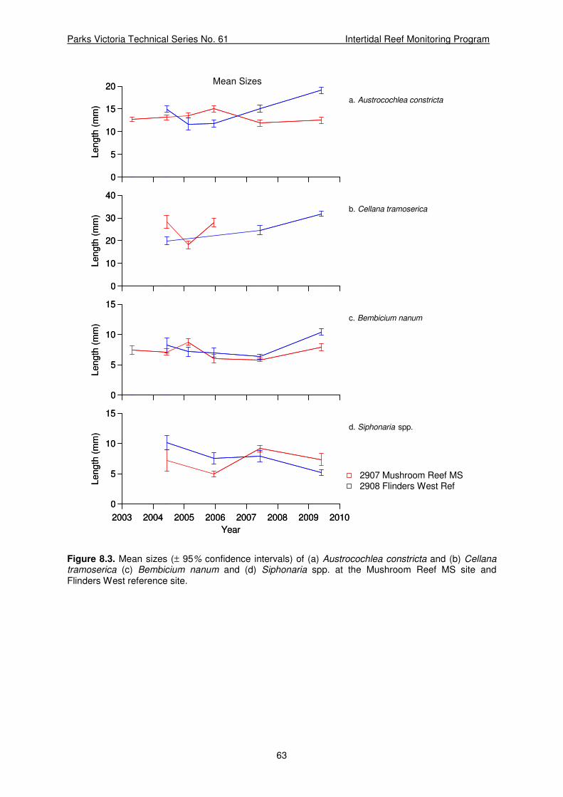
Parks Victoria Technical Series No. 61 Intertidal Reef Monitoring Program
63
Mean Sizes
a. Austrocochlea constricta
0
5
10
15
20Length
(m
m)
0
5
10
15
20Length
(m
m)
b. Cellana tramoserica
0
10
20
30
40
Length
(m
m)
0
10
20
30
40
Length
(m
m)
c. Bembicium nanum
0
5
10
15
Length
(m
m)
0
5
10
15
Length
(m
m)
d. Siphonaria spp.
2003 2004 2005 2006 2007 2008 2009 2010
Year
0
5
10
15
Length
(m
m)
2003 2004 2005 2006 2007 2008 2009 2010
Year
0
5
10
15
Length
(m
m)
2908 Flinders West Ref2907 Mushroom Reef MS
Figure 8.3. Mean sizes (± 95% confidence intervals) of (a) Austrocochlea constricta and (b) Cellana tramoserica (c) Bembicium nanum and (d) Siphonaria spp. at the Mushroom Reef MS site and Flinders West reference site.

Parks Victoria Technical Series No. 61 Intertidal Reef Monitoring Program
64
9 BUNURONG MARINE NATIONAL PARK
9.1 Site Description and Transect Layout
9.1.1 Eagles Nest (Site 3020)
There were many potential intertidal reefs within the Bunurong Marine National Park that could have been monitored. The mudstone reefs of the area form large intertidal platforms. Located on the eastern side of the Eagles Nest headland, Site 3020 was selected as being representative of the predominant habitat type of the area. Keough and King (1991) studied visitor traffic to the Bunurong area and found the intertidal reefs at Eagles Nest had the highest visitation rates. Combined with easy access from the Eagles Nest carpark, this site was the most suitable for long-term intertidal studies.
The site is on the eastern side of the Marine National Park. It has an east facing aspect with the Eagles Nest headland sheltering it from the north and west. It is exposed to swells from the southeast, but not directly exposed to the prevailing south and southwest swell. The reef platform is relatively flat with little relief (Figure 9.1).
High and low shore baselines were 56 m and 48 m, respectively. The transects range in length from 25 m at Transect 1 to 50 m at Transect 5.
9.1.2 Caves Reference (Site 3021)
The reference site is at the Caves (Site 3021), located to the east of Bunurong Marine National Park. The site is situated directly below the access stairs from the Caves carpark. As with Eagles Nest, the reef substratum is mudstone, has a southeast facing aspect and is sheltered from the north and west by the Caves headland. The reef is exposed to southeast and southerly swell but is more sheltered from direct exposure to the prevailing southwest swell. There is a large area platform at this site, with little rugose structure or relief (Figure 9.2). On the eastern end of the survey area (Transect 5), there is more structure with large rocky outcrops towards the high shore level. Baselines were 48 m long and transects ranged from 80 m in length at Transect 1 to 100 m in length at Transect 5.

Parks Victoria Technical Series No. 61 Intertidal Reef Monitoring Program
65
Figure 9.1. Intertidal reef at Eagles Nest, Bunurong Marine National Park, 7 June 2007.
a. b.
Figure 9.2. Intertidal reef at the Caves reference site, 7 June 2007, showing: a. the study area; and b. the limpet Cellana tramoserica.

Parks Victoria Technical Series No. 61 Intertidal Reef Monitoring Program
66
9.2 Macroalgae and Aggregating Sessile Invertebrates
The species composition and abundances of sessile organisms was generally similar between the two sites. The dominant cover was by the brown alga Hormosira banksii, 5-11% cover, with the mat-forming mussel Xenostrobus pulex also being relatively abundant, 1-8% cover (Table 9.1). Algal turf had the next highest cover, with 1-5% cover.
The cover of H. banksii decreased by more than a half between November 2005 and May 2007 at Eagles Nest, and between 2007 and 2009 at the Caves (Table 10.1). There was an increasing trend in the cover of algal turf and small brown algae at both sites between the January 2005 and May 2007 surveys (Table 10.1). Xenostrobus pulex increased at both sites between 2007 and 2009 (Table 10.1).
There was considerable sand present on Eagles Nest during November 2005, with 11% cover, but both sites had less than 4% cover during most surveys (Table 10.1). Sand increased from 2% to 6% at the Caves between 2007 and 2009.
Table 9.1. Abundance (percent cover) of macroalgae and aggregating sessile invertebrates at the Eagles Nest MNP site and Caves reference site, during Survey 3 (February 2005), Survey 4 (January 2006), Survey 5 (June 2007) and Survey 6 (June 2009).
‘+’ = present in quadrats but not observed under any points; empty cell = not observed in any quadrats.
Eagles Nest MPA
(Site 3020)
The Caves Reference
(Site 3021)
Survey Survey Species
3 4 5 6 3 4 5 6
Macrophytes
Acrocarpia paniculata 1.52
Algal turf 1.44 2.56 4.64 0.88 2.00 2.72
Brown algae unidentified + 4.32 + 2.68
Caulocystis cephalornithos 1.72
Colpomenia sinuosa +
Corallina officinalis + 0.32 0.48 + + 0.16 0.16
Corallines unidentified +
Cystophora spp. +
Chordaria cladosiphon 0.48
Encrusting corallines + 0.24 + 0.24 + 0.08
Enteromorpha compressa 0.08
Enteromorpha spp. + + 0.04
Filamentous brown algae 0.48
Green algae unidentified 0.32 +
Hormosira banksii 11.60 10.48 4.48 5.64 8.24 7.68 8.96 3.44
Jania spp. 0.08
Laurencia spp. +
Leathesia difformis +
Notheia anomala 1.04 + 0.40 0.24 0.52

Parks Victoria Technical Series No. 61 Intertidal Reef Monitoring Program
67
Table 9.1. (continued)
Eagles Nest MPA
(Site 3020)
The Caves Reference
(Site 3021)
Survey Survey Species
3 4 5 6 3 4 5 6
Macrophytes (continued)
Rivularia sp. + 0.56 + +
Sargassum spp. + 0.08
Symploca sp. 0.80 0.40 0.16 + 1.28 1.2 0.28
Ulva spp. + + 0.16 0.12
Unidentified blue-green algae 2.16 +
Unidentified lichen 0.24 0.80 2.96
Zostera meulleri 2.72
Sessile Invertebrates
Catomerus polymerus 0.08
Chamaesipho tasmanica 0.24 +
Chthamalus antennatus + + + 0.08 0.08 + + 0.04
Galeolaria caespitosa + 0.16 0.16 + + 0.16 + 0.04
Tetraclitella purpurascens 0.08 +
Xenostrobus pulex 6.08 5.92 4.00 8.16 8.64 4.88 0.88 2.20
Other
Drift macroalgae 0.32
Drift seagrass + 0.32
Sand 1.76 11.28 1.04 0.72 2.56 4.40 1.92 6.36
9.3 Mobile Invertebrates
The species composition of the mobile invertebrates at Eagles Nest and The caves was very similar (Table 9.2). The assemblages were comprised of the snails Bembicium nanum, Nodilittorina acutispira, Nodilittorina unifasciata and limpet Siphonaria spp. were the most abundant species during all surveys at both sites. The snail Austrocochlea constricta, and limpets Cellana tramoserica, Notoacmea mayi and Patelloida alticostata were also common (Table 9.2).
There was a large increase in the abundance of Nodilittorina acutispira between 2005 and 2007 at both sites, increasing from 12 to 348 individuals 0.25m2 at Eagles Nest and 0.6 to 828 individuals 0.25m2 at The Caves (Table 9.2). Between 2007 and 2009, the abundances of N. acutispira decreased markedly, but remained the most abundant species at both sites (Table 9.2). Conversely, the abundance of the limpet Siphonaria nearly doubled at both sites over the same period. The abundance of Bembicium nanum more than doubled Eagles Nest, while decreasing by more than a half at the Caves reference site between 2007 and 2009.
During May 2007, Austrocochlea constricta were not measures at Eagles Nest due to low abundances and time constraints (Figure 9.3a). There was a slight decrease in mean sizes of the limpet Cellana tramoserica to May 2009 (Figure 9.3b). There were no apparent trends in Siphonaria size, although they were consistently larger at Eagles Nest (Figure 9.3c).

Parks Victoria Technical Series No. 61 Intertidal Reef Monitoring Program
68
Table 9.2. Density of megafaunal (invertebrates 0.25m2) at Eagles Nest, Bunurong MNP site and
Caves reference site during Survey 3 (February 2005), Survey 4 (January 2006), Survey 5 (June 2007) and Survey 6 (June 2009).
Eagles Nest MPA
(Site 3020)
The Caves Reference
(Site 3021)
Survey Survey Species
3 4 5 6 3 4 5 6
Cnidaria
Actinia tenebrosa 0.04 0.04
Aulactinia veratra 0.04 0.20 0.68 0.16 0.16 0.04
Oulactis muscosa 0.2
Mollusca
Austrocochlea constricta 1.32 0.56 4.76 0.28 1.96 3.12 2.32 2.00
Austrocochlea odontis 0.4 0.04 0.32 0.08 0.28 1.28
Bembicium nanum 33.52 42.84 24.84 54.64 46.88 150.36 19.32 8.16
Cellana tramoserica 2.6 1.68 2.20 0.44 0.72 2.48 1.12 1.20
Clypidina rugosa 0.04 2.56 0.20 0.76 11.24
Cominella lineolata 0.4 0.20 0.16 0.04 0.08 0.04 0.36 0.12
Dicathais orbita 0.12 0.12 0.08 0.12
Lepsiella vinosa 0.12 0.04 0.20 0.08 0.72 0.40 0.76 0.16
Nerita atramentosa 0.2 0.16 0.04 0.32 0.80 0.04
Nodilittorina acutispira 12.04 40.32 348.88 127.48 0.60 2.88 828.96 56.04
Nodilittorina praetermissa 0.04
Nodilittorina unifasciata 84.8 149.44 121.88 40.32 116.6 157.24 93.84 15.72
Notoacmea mayi 0.2 0.40 2.36 0.12 1.04 6.96 4.52 2.40
Notoacmea spp. 2.88
Patelloida alticostata 0.8 0.40 1.12 0.28 0.52 0.84 0.16 0.32
Patelloida insignis 0.04
Patelloida latistrigata 0.28 0.24 0.04
Prothalotia ramburi 0.04
Siphonaria spp. 7.44 10.68 7.32 13.84 13.88 24.76 19.6 34.16
Thalotia pulcherrima 0.32
Turbo undulatus 0.72 0.16 0.04 0.12 0.20
Unidentified Chiton 0.04
Echinodermata
Parvulastra exigua 0.08 0.04
Crustacea
Unidentified crab 0.08 0.04 0.04

Parks Victoria Technical Series No. 61 Intertidal Reef Monitoring Program
69
Mean Sizes
a. Austrocochlea constricta
0
10
20
30Le
ngth
(m
m)
0
10
20
30Le
ngth
(m
m)
b. Cellana tramoserica
0
10
20
30
40
50
Le
ngth
(m
m)
0
10
20
30
40
50
Le
ngth
(m
m)
c. Siphonaria spp.
2003 2004 2005 2006 2007 2008 2009 2010
Year
0
5
10
15
Le
ngth
(m
m)
2003 2004 2005 2006 2007 2008 2009 2010
Year
0
5
10
15
Le
ngth
(m
m)
3021 Caves Ref3020 Eacgles Nest, Bunurong MNP
Figure 9.3. Mean sizes (± 95% confidence intervals) of (a) Austrocochlea constricta; (b) Cellana tramoserica and (c) Siphonaria spp. at the Eagles Nest site, in Bunurong MNP, and the Caves reference site.

Parks Victoria Technical Series No. 61 Intertidal Reef Monitoring Program
70
10 POINT ADDIS MARINE NATIONAL PARK
10.1 Site Description and Transect Layout
10.1.1 Point Addis Marine National Park (Site 3901)
The main intertidal reef at Point Addis is a large and prominent tongue of intertidal platform that extends east from the base of cliffs northeast of Point Addis. This reef is long and is undulating in places. The platform is relatively low and large areas of this reef remain inundated during some tidal cycles. It is relatively exposed to wave action. The survey site is on a smaller patch of reef that fringes the coastal cliffs. It is a low-relief, uneven reef that drops steeply at the seaward edge into subtidal habitat (Figure 10.1). Undulations in the reef caused by weathering create patches of standing water.
The intertidal reefs are exposed to the south and east. The Point Addis headland provides some protection from southwest winds and swell, although large waves from the southwest can wrap around Point Addis onto these reefs.
The survey area bridges a large channel that intersects the baselines. Additional coordinates of this were recorded and the affected transects shifted appropriately. The high and low baselines were 74 m and 81 m in length respectively. Transects range in length from 16 m at Transect 1 to 22 m at Transect 5.
10.1.2 Winipop Reference (Site 3902)
The reference site for Point Addis Marine National Park was located to the east of the park at Winkipop reef. The intertidal area at Winkipop is a very low-relief, gently sloping reef (Figure 10.2). The area exposed at low tide is 30 to 50 m wide. This area is exposed to large southerly swell. There is a narrow band of sandy beach on the landward side of the reef. As at Point Addis, pools of standing water were common in undulations in the reef surface. This reef may be periodically subject to some sand inundation. Baselines were run parallel to shore and were 100 m long. Transects were evenly spaced every 25 m and each was approximately 35 m in length.
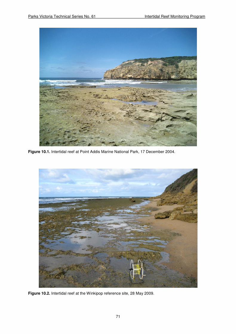
Parks Victoria Technical Series No. 61 Intertidal Reef Monitoring Program
71
Figure 10.1. Intertidal reef at Point Addis Marine National Park, 17 December 2004.
Figure 10.2. Intertidal reef at the Winkipop reference site, 28 May 2009.

Parks Victoria Technical Series No. 61 Intertidal Reef Monitoring Program
72
10.2 Macroalgae and Aggregating Sessile Invertebrates
The brown alga Hormosira banksii was the prevalent sessile organism, although its cover halved at both sites between 2007 and 2009 (Table 10.1). The cover of algal turf also decreased by half at Point Addis, and was not present at all at Winkipop in 2009. There was a low cover of the tube warm Galeolaria caespitosa at both sites. There was a relatively high species richness of other seaweeds at both Point Addis and Winkipop, although in very low abundances (< 1% cover; Table 10.1).
There were no marked trends in the abundances of the sessile organisms over time. The sand cover at Point Addis varied by 4-7% between surveys (1 to 8% cover), but was relatively constant at Winkipop, with 4-8% cover. In 2009 there was 4% cover of sand at both sites (Table 10.1).
Table 10.1. Abundance (percent cover) of macroalgae and aggregating sessile invertebrates at the Point Addis MNP site and Winkipop reference site during Survey 3 (December 2004), Survey 4 (November 2005), Survey 5 (May 2007) and Survey 6 (May 2009).
‘+’ = present in quadrats but not observed under any points; empty cell = not observed in any quadrats.
Point Addis MNP
(Site 3901)
Winkipop reference
(Site 3902)
Survey Survey Species
3 4 5 6 3 4 5 6
Macrophytes
Acrocarpia paniculata 1.76
Algal turf 5.60 12.48 11.76 4.88 2.40 0.80 1.92
Amphibolis antarctica +
Brown algae unidentified 0.24 0.64 2.76 + +
Caulerpa brownii + 0.08
Caulerpa simpliciuscula +
Caulocystis cephalornithos
3.28
Chaetomorpha coliformis 1.04
Cladophora prolifera +
Codium pomoides +
Codium spp. +
Colpomenia sinuosa 0.04
Corallina officinalis 1.12 1.76
Corallines unidentified + + 0.24 0.56
Cystophora spp. 0.12 0.16 0.56 0.32
Dictyosphaeria serica + + +
Encrusting corallines + + 0.40 0.28 + + +
Enteromorpha spp. + 0.24 0.12 + + +
Filamentous green algae 0.16
Filamentous red algae 0.20
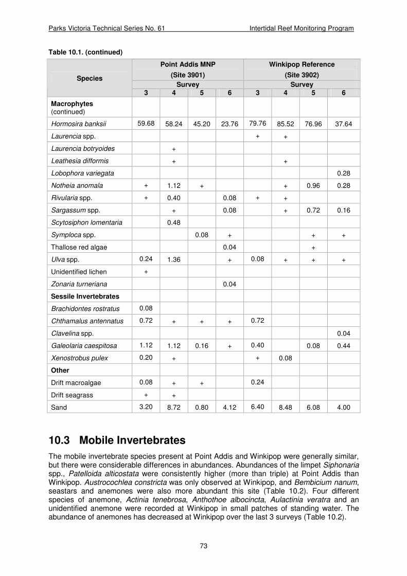
Parks Victoria Technical Series No. 61 Intertidal Reef Monitoring Program
73
Table 10.1. (continued)
Point Addis MNP
(Site 3901)
Winkipop Reference
(Site 3902)
Survey Survey Species
3 4 5 6 3 4 5 6
Macrophytes (continued)
Hormosira banksii 59.68 58.24 45.20 23.76 79.76 85.52 76.96 37.64
Laurencia spp. + +
Laurencia botryoides +
Leathesia difformis + +
Lobophora variegata 0.28
Notheia anomala + 1.12 + + 0.96 0.28
Rivularia spp. + 0.40 0.08 + +
Sargassum spp. + 0.08 + 0.72 0.16
Scytosiphon lomentaria 0.48
Symploca spp. 0.08 + + +
Thallose red algae 0.04 +
Ulva spp. 0.24 1.36 + 0.08 + + +
Unidentified lichen +
Zonaria turneriana 0.04
Sessile Invertebrates
Brachidontes rostratus 0.08
Chthamalus antennatus 0.72 + + + 0.72
Clavelina spp. 0.04
Galeolaria caespitosa 1.12 1.12 0.16 + 0.40 0.08 0.44
Xenostrobus pulex 0.20 + + 0.08
Other
Drift macroalgae 0.08 + + 0.24
Drift seagrass + +
Sand 3.20 8.72 0.80 4.12 6.40 8.48 6.08 4.00
10.3 Mobile Invertebrates
The mobile invertebrate species present at Point Addis and Winkipop were generally similar, but there were considerable differences in abundances. Abundances of the limpet Siphonaria spp., Patelloida alticostata were consistently higher (more than triple) at Point Addis than Winkipop. Austrocochlea constricta was only observed at Winkipop, and Bembicium nanum, seastars and anemones were also more abundant this site (Table 10.2). Four different species of anemone, Actinia tenebrosa, Anthothoe albocincta, Aulactinia veratra and an unidentified anemone were recorded at Winkipop in small patches of standing water. The abundance of anemones has decreased at Winkipop over the last 3 surveys (Table 10.2).
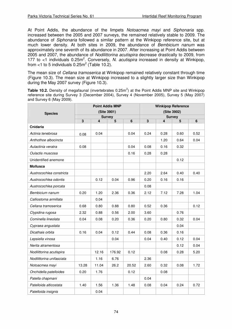
Parks Victoria Technical Series No. 61 Intertidal Reef Monitoring Program
74
At Point Addis, the abundance of the limpets Notoacmea mayi and Siphonaria spp. increased between the 2005 and 2007 surveys, the remained relatively stable to 2009. The abundance of Siphonaria followed a similar pattern at the Winkipop reference site, but at much lower density. At both sites in 2009, the abundance of Bembicium nanum was approximately one seventh of its abundance in 2007. After increasing at Point Addis between 2005 and 2007, the abundance of Nodilittorina acutispira decrease drastically to 2009, from 177 to <1 individuals 0.25m2. Conversely, N. acutispira increased in density at Winkipop, from <1 to 5 individuals 0.25m2 (Table 10.2).
The mean size of Cellana tramoserica at Winkipop remained relatively constant through time (Figure 10.3). The mean size at Winkipop increased to a slightly larger size than Winkipop during the May 2007 survey (Figure 10.3).
Table 10.2. Density of megafaunal (invertebrates 0.25m2) at the Point Addis MNP site and Winkipop
reference site during Survey 3 (December 2004), Survey 4 (November 2005), Survey 5 (May 2007) and Survey 6 (May 2009).
Point Addis MNP
(Site 3901)
Winkipop Reference
(Site 3902)
Survey Survey Species
3 4 5 6 3 4 5 6
Cnidaria
Actinia tenebrosa 0.08 0.04 0.04 0.24 0.28 0.60 0.52
Anthothoe albocincta 1.20 0.64 0.04
Aulactinia veratra 0.08 0.04 0.08 0.16 0.32
Oulactis muscosa 0.16 0.28 0.28
Unidentified anemone 0.12
Mollusca
Austrocochlea constricta 2.20 2.64 0.40 0.40
Austrocochlea odontis 0.12 0.04 0.96 0.20 0.16 0.16
Austrocochlea porcata 0.08
Bembicium nanum 0.20 1.20 2.36 0.36 2.12 7.12 7.28 1.04
Calliostoma armillata 0.04
Cellana tramoserica 0.68 0.80 0.88 0.80 0.52 0.36 0.12
Clypidina rugosa 2.32 0.88 0.56 2.00 3.60 0.76
Cominella lineolata 0.04 0.08 0.20 0.36 0.20 0.80 0.32 0.04
Cypraea angustata 0.04
Dicathais orbita 0.16 0.04 0.12 0.44 0.08 0.36 0.16
Lepsiella vinosa 0.04 0.04 0.40 0.12 0.04
Nerita atramentosa 0.12 0.04
Nodilittorina acutispira 12.16 176.92 0.12 0.08 0.28 5.20
Nodilittorina unifasciata 1.16 6.76 2.36
Notoacmea mayi 13.28 11.04 26.2 20.52 2.60 0.32 0.08 1.72
Onchidella patelloides 0.20 1.76 0.12 0.08
Patella chapmani 0.04
Patelloida alticostata 1.40 1.56 1.36 1.48 0.08 0.04 0.24 0.72
Patelloida insignis 0.04

Parks Victoria Technical Series No. 61 Intertidal Reef Monitoring Program
75
Table 10.2. (continued)
Point Addis MNP
(Site 3901)
Winkipop Reference
(Site 3902)
Survey Survey Species
3 4 5 6 3 4 5 6
Mollusca (continued)
Patelloida latistrigata 0.16
Siphonaria spp. 21.64 23.04 35.88 30.12 6.00 0.12 4.76 5.28
Turbo undulatus 0.08 0.24 0.44 0.20 0.76 0.24 0.12
Unidentified chiton 0.12 0.04 0.12 0.04
Echinodermata
Parvulastra exigua 0.72 0.80 0.48 0.56
Meridiastra calcar 0.04 0.16 0.04
Crustacea
Plagusia chabrus 0.04
Unidentified crab 0.04 0.12 0.04
Cyclograpsus granulosus 0.28
Mean Sizes
Cellana tramoserica
2003 2004 2005 2006 2007 2008 2009 2010
Year
0
10
20
30
40
50
Le
ng
th (
mm
)
2003 2004 2005 2006 2007 2008 2009 2010
Year
0
10
20
30
40
50
Le
ng
th (
mm
)
3902 Winkipop Ref3901 Point Addis MNP
Figure 10.3. Mean sizes (± 95% confidence intervals) of Cellana tramoserica at the Point Addis MNP site and Winkipop reference site.

Parks Victoria Technical Series No. 61 Intertidal Reef Monitoring Program
76
11 POINT DANGER MARINE SANCTUARY
11.1 Site Description and Transect Layout
11.1.1 Point Danger Marine Sanctuary (Site 4002)
The intertidal area at Point Danger is a large sandstone reef platform that is an extension of the Point Danger headland (Figure 11.1). The reef is exposed to the north, east and south, however most of the prevailing weather and waves are from the south and southwest. There are large areas of sandy beach to the west and north of the platform.
The reef is a relatively flat sandstone platform which quickly drains or floods with the tide. The reef surface has been eroded to make it rugose, with a relief of 10-15 cm. Most of the reef is affected by sand inundation, with a thin layer of sand being present in many quadrats.
The survey site is in the near shore region of the platform towards the south/west border of the sanctuary. The high and low-shore baselines are approximately transverse to the headland. Baseline lengths were 46 m each, with transects of 41-43 m, forming a square survey area.
11.1.2 Point Danger West Reference (Site 4001)
The reference site, Point Danger West, is separated from the Point Danger intertidal platform by a short section of sandy beach. As with Point Danger, the sandstone platform has been eroded to create an uneven surface at the scale of 10s centimetres. This reef is subject to significant sand inundation (Figure 11.2). The site baselines were 50 m, with transects of 30 m.

Parks Victoria Technical Series No. 61 Intertidal Reef Monitoring Program
77
a. b.
c. d.
Figure 11.1. Intertidal reef at Point Danger Marine Sanctuary: a-b. 14 January 2005; c-d. 30 April 2009.

Parks Victoria Technical Series No. 61 Intertidal Reef Monitoring Program
78
a.
b.
Figure 11.2. Intertidal reef at the Point Danger West reference site: a) 17 January 2005; b) 30 April 2009. Note: sand inundation along the high shore was lower in 2009, but remained higher than when the site was established.

Parks Victoria Technical Series No. 61 Intertidal Reef Monitoring Program
79
11.2 Macroalgae and Aggregating Sessile Invertebrates
In 2009, the predominant sessile species at Point Danger and Point Danger West were the brown alga Hormosira banksii, algal turfs and the mat-forming mussel Xenostrobus pulex (Table 11.1). A variety of other sessile species were observed, but in low abundances of < 3% cover. The cover of H. banksii decreased by half between 2007 and 2009. The abundance of X. pulex decreased at both sites between 2005 and 2007, but remained stable at Point Danger MS between 2007 and 2009, while increasing at the reference site.
Sand inundation at both reefs was variable between surveys, 2-30% cover, with both sites having a much higher cover during the May 2007 survey (Table 11.1).
Table 11.1. Abundance (percent cover) of macroalgae and aggregating sessile invertebrates at the Point Danger MS site and the Point Danger West reference site during Survey 3 (January 2005), Survey 4 (December 2005), Survey 5 (May 2007) and Survey 6 (April 2009).
‘+’ = present in quadrats but not observed under any points; empty cell = not observed in any quadrats.
Point Danger MS
(Site 4002)
Point Danger West Reference
(Site 4001)
Survey Survey Species
3 4 5 6 3 4 5 6
Macrophytes
Algal turf 2.24 0.88 4.64 0.64 2.32 11.20 2.32 3.96
Brown algae unidentified 0.56 0.08 +
Caulerpa brownie 0.12
Corallina officinalis + 0.20 + 0.48
Corallines unidentified + 0.32
Dictyosphaeria serica +
Encrusting corallines 0.24 0.16 + + 0.96 0.72 +
Enteromorpha spp. 1.12 0.56 2.08 1.88 0.72 3.20 0.56 0.60
Filamentous red algae 2.04 + 0.36
Green algae unidentified 0.88 0.44 2.72 +
Hormosira banksii 21.12 13.76 23.68 12.28 37.28 21.20 22.56 12.32
Notheia anomala +
Rivularia spp. 0.08 + + +
Sargassum spp. +
Symploca spp. 0.04 + 0.48 +
Ulva spp. 0.32 5.20 + 0.16 0.16 + +
Sessile Invertebrates
Brachidontes rostratus 1.44 + +
Chthamalus antennatus 1.68 0.64 + +
Galeolaria caespitosa 0.16 0.08 0.48 0.72 + + + +
Xenostrobus pulex 12.8 22.32 11.60 10.76 6.4 10.32 1.52 7.16

Parks Victoria Technical Series No. 61 Intertidal Reef Monitoring Program
80
Table 11.1. (continued)
Point Danger MS
(Site 4002)
Point Danger West Reference
(Site 4001)
Survey Survey Species
3 4 5 6 3 4 5 6
Other
Drift macroalgae 0.04 +
Drift seagrass +
Sand 8.88 15.92 33.04 2.96 2.32 1.76 25.52 15.96
11.3 Mobile Invertebrates
Point Danger and Point Danger West had a similar suite of mobile invertebrate species which were generally similar in abundances between the two sites (Table 11.2). The snail Bembicium nanum and the limpets Clypidina rugosa and Siphonaria spp. were the numerically dominant species. The snails Dicathais orbita, Lepsiella vinosa, Turbo undulatus and limpet Patelloida alticostata occurred at lower densities. The predatory gastropod Lepsiella vinosa appeared to be associated with Xenostrobus pulex mussel beds. The two sites differed predominantly in the abundance of Bembicium nanum, with Point Danger having much higher densities than Point Danger West (11-50 c.f. 1-8 individuals 0.25m2; Table 11.2).
The abundance of Bembicium nanum at Point Danger MS was much lower in 2009 than in 2007, but only slightly lower at the reference site. The abundance of Siphonaria spp. doubled between 2007 and 2009, while decreasing to a third at Point Danger West.
The mean size of the limpet Cellana tramoserica population decreased slightly at both sites between 2007 and 2009, decreasing by 2 mm to 26 mm at Point Danger MS and decreasing by 5 mm to 29 mm at the reference site (Figure 11.3a). The mean size of Bembicium nanum was smaller at Point Danger MS than at Point Danger West, 5 mm and 9 mm respectively. Mean sizes of B. nanum decreased at both between 2007 and 2009, but by a greater amount at the reference site, and sizes were approximately the same, around 3 mm, in 2009 (Figure 11.3b).

Parks Victoria Technical Series No. 61 Intertidal Reef Monitoring Program
81
Table 11.2. Density of megafaunal (invertebrates 0.25m2) at the Point Danger MS site and the Point
Danger West reference site during Survey 3 (January 2005), Survey 4 (December 2005), Survey 5 (May 2007) and Survey 6 (April 2009).
Point Danger MS
(Site 4002)
Point Danger West Reference
(Site 4001)
Survey Survey Species
3 4 5 6 3 4 5 6
Cnidaria
Actinia tenebrosa 0.60 0.36 0.52 0.16 0.48
Aulactinia veratra 0.12 0.04
Oulactis muscosa 0.08 0.04 0.20 1.16
Mollusca
Austrocochlea constricta 1.48 2.12 0.76 0.84 0.12 0.56 0.16
Austrocochlea odontis 0.16 1.20 0.40 0.56 0.20 0.16 0.24 0.16
Austrocochlea porcata 0.04
Bembicium nanum 11.76 19.92 50.80 11.28 0.80 1.36 7.80 5.44
Cellana tramoserica 1.20 1.48 0.20 0.48 0.32 0.20 0.64 0.24
Clypidina rugosa 23.04 16.52 6.72 16.04 18.24 16.44 10.60 10.20
Cominella lineolata 0.76 0.40 0.28 0.76 0.48 0.48 0.36 0.48
Dicathais orbita 0.68 0.64 2.08 2.12 0.24 0.48 0.68 0.32
Lepsiella vinosa 1.16 1.72 0.52 0.88 0.16 0.28 0.12
Nodilittorina acutispira 7.00 2.36 22.28 0.48
Nodilittorina unifasciata 0.12 0.32 8.00 0.20 0.16
Notoacmea mayi 0.12 2.48 1.52 0.40 3.04 6.96 0.36
Notoacmea petterdi 0.44
Onchidella patelloides 0.16 0.68 0.12 0.80 0.24 0.48
Patelloida alticostata 0.08 0.40 1.92 0.24 0.36 0.16 0.64 0.36
Patelloida insignis 0.12 0.08
Prothalotia ramburi 0.12
Siphonaria spp. 2.84 2.28 3.68 7.28 5.44 2.80 9.88 3.48
Turbo undulatus 0.52 0.88 0.20 0.08 0.16 0.16 0.28 0.72
Unidentified chiton 0.04 0.12
Crustacea
Unidentified crab 0.24 0.04

Parks Victoria Technical Series No. 61 Intertidal Reef Monitoring Program
82
Mean Sizes
a. Cellana tramoserica
0
10
20
30
40
50
Le
ngth
(m
m)
0
10
20
30
40
50
Le
ngth
(m
m)
b. Bembicium nanum
0
5
10
15
20
Le
ng
th (
mm
)
2003 2004 2005 2006 2007 2008 2009 2010
Year
0
5
10
15
20
Le
ng
th (
mm
)
4002 Point Panger MS4001 Point Danger West Ref
Figure 11.3. Mean sizes (± 95% confidence intervals) of (a) Cellana tramoserica; and (b) Bembicium nanum at the Point Danger Marine Sanctuary and the Point Danger West reference site.

Parks Victoria Technical Series No. 61 Intertidal Reef Monitoring Program
83
12 BARWON BLUFF MARINE SANCTUARY
12.1 Site Description and Transect Layout
12.1.1 Barwon Bluff Marine Sanctuary (Site 4004)
The intertidal reef at Barwon Bluff is composed of sections of sandstone and basalt reef. The intertidal rock platform extends from the end of Barwon Bluff as a pincer-shaped reef. The north-eastern section of the pincer is a basalt platform and boulder reef. This section of the reef is relatively protected from swell but has a large estuarine influence from the adjacent mouth of the Barwon River. The south-western section of the pincer is a relatively flat sandstone reef, which is more exposed to large swells and sand inundation due to its exposure towards the south and proximity to an adjacent surf beach and strong cross-shore currents. The survey site is on the sandstone section of the reef (Figure 12.1).
The sandstone platform has three large rockpools in the centre of the survey area. The transects to not intercept any of these pools. Relief 5-10 cm high is present as ripples in the platform. These ripples act as traps for cross-shore sand movement. The edge of the platform drops sharply into subtidal habitat. At the high shore end of the platform there is a distinctive rise in shore height. This has been encompassed by the high shore baseline which follows this contour for 52 m. The low shore baseline borders rockpools on the south-western corner and is 53 m long. Transect lengths range from 47 m at Transect 1 to 49 m at Transect 5.
12.1.2 Barwon Beach Reference (Site 4003)
To the west of the intertidal platform at Barwon Bluff, there are several smaller isolated patches of intertidal sandstone reef. These reefs are directly exposed to large southerly swells and sand inundation due to their proximity to the adjacent surf beach and strong longshore currents. The reef surface has been weathered to create an uneven surface at the scale of 10s of centimetres. The reference site is on one of these reefs, approximately 400 m west of Barwon Bluff, directly below a set of access stairs. These stairs are the closest access point and are the first set west of Barwon Bluff.
The reef structure is rugose with many depressions or rock pools approximately 20 cm in depth and 20-100 cm in diameter. It is more rugose than the Barwon Bluff Marine Sanctuary (Site 4004). The high shore baseline runs parallel to the shore for 45 m and follows the same shore height contour as at Barwon Bluff. The low shore baseline is 37 m long and is angled back towards shore such that Transect 1 is 33 m long and Transect 5 is 24 m long.

Parks Victoria Technical Series No. 61 Intertidal Reef Monitoring Program
84
a.
b.
Figure 12.1. Intertidal reef at Barwon Bluff Marine Sanctuary: a. 30 November 2005; and b. 1 May 2009.

Parks Victoria Technical Series No. 61 Intertidal Reef Monitoring Program
85
12.2 Macroalgae and Aggregating Sessile Invertebrates
As with most exposed rock platforms of the central Victorian coast the dominant algae at both Barwon Bluff and the reference site at Barwon Beach was the brown algae Neptune’s necklace Hormosira banksii. In 2009, the cover of H. banksii decreased by more than two thirds at Barwon Bluff, from 57% to 16%, and more than half at Barwon Beach, from 38% to 14% (Table 12.1). The only other macroalgae which occurred in appreciable quantities on the shore were turf forming species. At Barwon Bluff, algal turf had previously covered 3-4% of the reef, in 2009 this had decreased to 1.5%. At Barwon Beach, the algal turf cover was 13 and 12% cover in January and November 2005, but was only 2% cover in May 2007. In 2009 this increased to 4% cover.
The mat forming mussel Xenostrobus pulex had a low cover in patches across the shore at both sites, occupying exposed patches of rock between sand/H. banksii microhabitat (Table 12.1). The abundance of X. pulex did not change markedly between surveys.
Barnacles were a more prevalent species at Barwon Beach, albeit in very low densities high on the rock platform (Table 12.1). Galeolaria caespitosa was also more abundant at Barwon Beach.
Sand inundation was higher at Barwon Bluff, but decreased over the last three surveys (Table 12.1). Sand inundation at the Barwon beach site was lower than at Barwon Bluff, despite an increase in cover to the 2007 survey. Sand inundation is expected to vary considerably over shorter time scales, being influenced by prevailing weather conditions.

Parks Victoria Technical Series No. 61 Intertidal Reef Monitoring Program
86
Table 12.1. Mean abundance (percent cover) of macroalgae and aggregating sessile invertebrates at the Barwon Bluff Marine Sanctuary site and the Barwon Beach reference site during Survey 3 (January 2005), Survey 4 (November 2005), Survey 5 (May 2007) and Survey 6 (May 2009).
‘+’ = present in quadrats but not observed under any points; empty cell = not observed in any quadrats.
Barwon Bluff MS
(Site 4004)
Barwon Beach Reference
(Site 4003)
Survey Survey Species
3 4 5 6 3 4 5 6
Macrophytes
Algal turf 3.2 4.48 4.24 1.52 13.84 12.4 2.0 4.08
Brown algae unidentified 0.16
Caulocystis cephalornithos 0.12
Colpomenia sinuosa +
Corallina officinalis 0.4 0.16 + 1.64 + + 1.76 +
Corallines unidentified + 0.04
Cystophora spp. 0.16 0.20 0.96
Encrusting corallines 0.32 0.40 + 0.24 + +
Enteromorpha spp. + + + +
Filamentous red algae + 0.12
Green algae unidentified 0.72
Halopteris spp. 0.04
Hormosira banksii 46.32 47.04 57.20 15.68 31.52 30.96 37.76 14.28
Laurencia filiformis +
Leathesia difformis + +
Nothea anomala + +
Rivularia spp. + 0.04 + +
Syctosiphon lomentaria 0.08
Symploca + + 0.20 0.24 0.80
Ulva spp. + 0.40 0.76 0.08 1.92 0.08
Sessile Invertebrates
Chamaesipho tasmanica 1.04 +
Chthamalus antennatus + 0.08 0.40 1.56 + 0.28
Galeolaria caespitosa 0.08 + 0.32 0.64 1.04 0.16 0.72
Unidentified Barnacles + +
Xenostrobus pulex 2.24 0.16 0.16 0.20 + 0.88 0.16 +
Other
Drift macroalgae + 0.8
Drift seagrass +
Sand 12.72 19.36 13.68 4.52 0.32 1.12 8.96 2.12

Parks Victoria Technical Series No. 61 Intertidal Reef Monitoring Program
87
12.3 Mobile Invertebrates
The mobile invertebrates assemblages Barwon Bluff and Barwon Beach sites were both dominated by the gastropod snails Bembicium nanum, Nodilittorina acutispira and N. unifasciata and the limpets Clypidina rugosa, Notoacmea mayi, Cellana tramoserica and Siphonaria spp. (Table 12.2). The periwinkle Nodilittorina acutispira and the limpet Notoacmea mayi were present in particularly high densities in the mid to low region of the intertidal platforms in 2007. After increasing between 2005 and 2007, the abundance of Nodilittorina acutispira decrease drastically to 2009, from 43 individuals 0.25m2 to none at Barwon Bluff, and from 1281 to 40 individuals 0.25m2 at Barwon Beach. The abundance of Clypidina rugosa was higher at both sites in 2009, particularly at Barwon Bluff. There was a decreasing trend in Siphonaria spp. abundances at Barwon Bluff from January 2005 to May 2009, conversely abundances increased at Barwon Beach from 2005 (Table 12.2).
The predatory gastropods Cominella lineolata and Dicathais orbita were low in abundance at both sites during all surveys (Table 12.2).
Two individuals of the sea hare Aplysia gigantea were found in a single quadrat in January 2005. The quadrat encompassed a small body of standing water adjacent to one of the large rock pools in the middle of the survey area. No individuals were recorded in any of the following surveys.
The mean size of Cellana tramoserica has increased steadily since January 2005, from 200 mm to 36 mm. Mean size also increased slightly at Barwon Beach between January 2005 and May 2007, but were smaller in 2009, at approximately 20 mm (Figure 12.2).

Parks Victoria Technical Series No. 61 Intertidal Reef Monitoring Program
88
Table 12.2. Density of megafaunal (invertebrates 0.25m2) at the Barwon Bluff Marine Sanctuary site
and the Barwon Beach reference site during Survey 3 (January 2005), Survey 4 (November 2005), Survey 5 (May 2007) and Survey 6 (May 2009).
Barwon Bluff MS
(Site 4004)
Barwon Beach Reference
(Site 4003)
Survey Survey Species
3 4 5 6 3 4 5 6
Cnidaria
Actinia tenebrosa 0.20
Anthothoe albocincta 0.04
Aulactinia veratra 0.56 0.36 0.12 0.40 0.08 0.08 0.40
Oulactis muscosa 1.20 0.04 0.16
Mollusca
Aplysia gigantea 0.08
Austrocochlea concamerata 0.12 0.28
Austrocochlea constricta 0.72 1.16 0.16 0.08
Austrocochlea odontis 0.04 1.56 0.36 0.04 0.16
Bembicium nanum 1.56 2.72 0.76 0.04 8.08 2.64 15.04 5.52
Calliostoma armillata 0.12
Cellana tramoserica 1.12 1.32 5.04 2.72 2.60 2.12
Clypidina rugosa 7.92 17.76 4.96 55.60 64.4 22.44 50.48 61.68
Cominella lineolata 0.12 0.48 0.28 0.52 0.16 0.12 0.04
Dicathais orbita 0.36 0.88 0.04 0.32 0.36 0.16 0.36 0.12
Haustrum bailyana 0.04
Lepsiella vinosa 0.12 0.16 0.04
Nodilittorina acutispira 0.44 19.52 43.60 285.76 271.92 1280.8 40.08
Nodilittorina unifasciata 0.72 4.08 0.32 71.0 78.36 34.44 1.88
Notoacmea mayi 8.68 6.84 20.20 1.92 39.64 4.00 11.72 8.04
Notoacmea petterdi 0.04 0.2 0.08
Onchidella patelloides 0.08 0.16 0.12
Patelloida alticostata 0.92 0.40 1.84 1.00 0.44 0.48
Patelloida insignis 0.24 0.04 0.08
Patelloida latistrigata 0.04 0.36 0.12 0.72
Phasianotrochus eximius 0.12
Prothalotia ramburi 0.32
Siphonaria spp. 24.8 11.64 9.60 1.92 14.16 4.44 7.04 17.12
Turbo undulatus 0.64 1.96 0.24 0.04
Unidentified chiton 0.12 0.08 0.08
Unidentified limpet 0.32

Parks Victoria Technical Series No. 61 Intertidal Reef Monitoring Program
89
Table 12.2. (continued)
Barwon Bluff MS
(Site 4004)
Barwon Beach Reference
(Site 4003)
Survey Survey Species
3 4 5 6 3 4 5 6
Crustacea
Paragrapsus gaimardii 0.72
Unidentified crab 0.08
Mean Sizes
Cellana tramoserica
2003 2004 2005 2006 2007 2008 2009 2010
Year
0
10
20
30
40
50
Len
gth
(m
m)
2003 2004 2005 2006 2007 2008 2009 2010
Year
0
10
20
30
40
50
Len
gth
(m
m)
4004 Barwon Bluff MS4003 Barwon Beach Ref
Figure 12.2. Size Mean sizes (± 95% confidence intervals) of Cellana tramoserica at the Barwon Bluff MS site and the Barwon Beach reference site.

Parks Victoria Technical Series No. 61 Intertidal Reef Monitoring Program
90
ACKNOWLEDGEMENTS
This project was funded by Parks Victoria and supervised by Dr Steffan Howe.

Parks Victoria Technical Series No. 61 Intertidal Reef Monitoring Program
91
REFERENCES
Anderson, H (1958) The gastropod genus Bembicium, Philippi. Australian Journal of Marine and Freshwater Research 9, 546-568.
Clarke KR (1993) Non-parametric multivariate analyses of changes in community structure. Australian Journal of Ecology 18, 117-143.
Hart S & Edmunds M (2003) Standard Operational Procedure: Intertidal Reef Monitoring Australian Marine Ecology Operations Manual No. 235, Melbourne, 59 pp.
Edmunds M, Hart S, Elias J and Power B (2004) Victorian Intertidal Reef Monitoring Program: The Reef Biota in Central Victoria and Port Phillip Bay Marine Sanctuaries. Parks Victoria Technical Series No. 11. Parks Victoria, Melbourne.
Faith D, Minchin P & Belbin (1987) Compositional dissimilarity as a robust measure of ecological distance. Vegetation 69, 57-68.
Fox D, Jacoby C & Molloy R (2000) Eastern Treatment Plant: Monitoring the Receiving Environment. Monitoring Program – 2001 to 2003. Report to the Melbourne Water Corporation. CSIRO Environmental Projects Office, Melbourne.
Gilmour P & Edmunds M (2007) Victorian intertidal reef monitoring program: the intertidal reef biota of central Victoria’s marine protected areas. Parks Victoria Technical Series (No.46). Parks Victoria, Melbourne.
Hart SP & Edmunds M (2005) Parks Victoria Standard Operating Procedure: Biological Monitoring of Intertidal Reefs. Parks Victoria Technical Series No. 21, Parks Victoria, Melbourne.
Keough MJ & King A (1991) Recommendations for monitoring of marine plant and animal populations in Wilsons Promontory National Park and the Bunurong Marine Park. Department of Zoology, Melbourne University.
Krebs CJ (1999) Ecological Methodology, Second Edition. Benjamin/Cummings, Menlo Park.
Sweatman H, Cheal A, Coleman G, Fitzpatrick B, Miller I, Ninio R, Osborne K, Page C, Ryan D, Thompson A and Tomkins P (2000) Long-term Monitoring of the Great Barrier Reef. Status Report Number 4. Australian Institute of Marine Science, Townsville.

Parks Victoria Technical Series No. 61 Intertidal Reef Monitoring Program
A1.1
APPENDIX 1
A1. Site Details
A1.1 Point Cooke Marine Sanctuary
Point Cooke – Site 4107
Site Description
The intertidal area at Point Cooke is an extensive basalt rock platform and basalt boulder and cobble field. The Point Cooke Marine Sanctuary also forms part of a RAMSAR site and contributes habitat for migratory shorebirds. The intertidal area is 300-400 m long, extending from just north of Point Cooke to the south and west. Patches of sand and intertidal seagrass Zostera muelleri occur predominantly across the north-eastern section of the intertidal area, with more continuous patches of reef occurring further south and west. The intertidal reef is generally flat. However, small undulations across the reef mean that tidal inundation does not occur evenly across the reef. Strong southerly winds may cause large amounts of subtidal drift algae to be washed onto the intertidal reef area.
Transect Layout
The survey site was established on the largest continuous area of reef to the west of Point Cooke (Figure 4.1). Both the high-shore and low-shore baselines were 100 m long and were approximately parallel. The five transects between the baselines and were between 30 m and 35 m long.
Table A1.1. Site details for Point Cooke (Site 4107) in Point Cooke MS.
Site: 4107 Pt Cooke
MPA/Ref: MPA
Site coordinates
Baseline position
MGA Zone
MGA Easting
MGA Northing
Longitude Latitude
A 55 305876 5799893 144.7913 -37.9278
B 55 305965 5799917 144.7923 -37.9276
C 55 305890 5799858 144.7914 -37.9281
D 55 305966 5799881 144.7923 -37.9279
Altona – Site 4108
Site Description
Altona, site 4108, is the reference site for Point Cooke MS. The intertidal area at Altona consists of basalt reef and boulder fields interspersed with sand and seagrass flats. The survey site was established on a relatively large and continuous area of solid basalt reef and basalt boulders directly adjacent to large patches of sand and seagrass. The intertidal reef is generally flat with most variation in substratum height occurring at the level of individual boulders rather than across the shore. Most boulders in the survey area are substantially bigger (approximately 20-40 cm diameter) than those occurring at Point Cooke. Consequently, there are a large number of crevices and a substantial area of vertical substratum on the sides of boulders. The survey site has an estuarine influence because of its proximity to Kororoit Creek.
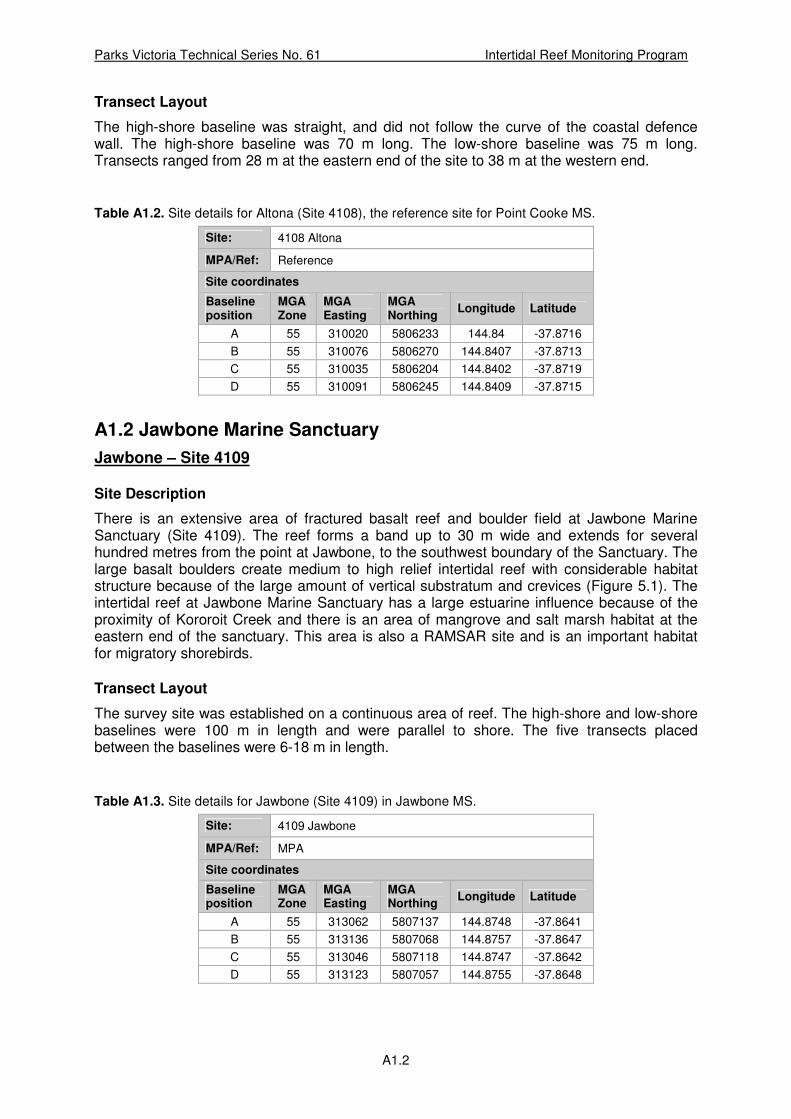
Parks Victoria Technical Series No. 61 Intertidal Reef Monitoring Program
A1.2
Transect Layout
The high-shore baseline was straight, and did not follow the curve of the coastal defence wall. The high-shore baseline was 70 m long. The low-shore baseline was 75 m long. Transects ranged from 28 m at the eastern end of the site to 38 m at the western end.
Table A1.2. Site details for Altona (Site 4108), the reference site for Point Cooke MS.
Site: 4108 Altona
MPA/Ref: Reference
Site coordinates
Baseline position
MGA Zone
MGA Easting
MGA Northing
Longitude Latitude
A 55 310020 5806233 144.84 -37.8716
B 55 310076 5806270 144.8407 -37.8713
C 55 310035 5806204 144.8402 -37.8719
D 55 310091 5806245 144.8409 -37.8715
A1.2 Jawbone Marine Sanctuary
Jawbone – Site 4109
Site Description
There is an extensive area of fractured basalt reef and boulder field at Jawbone Marine Sanctuary (Site 4109). The reef forms a band up to 30 m wide and extends for several hundred metres from the point at Jawbone, to the southwest boundary of the Sanctuary. The large basalt boulders create medium to high relief intertidal reef with considerable habitat structure because of the large amount of vertical substratum and crevices (Figure 5.1). The intertidal reef at Jawbone Marine Sanctuary has a large estuarine influence because of the proximity of Kororoit Creek and there is an area of mangrove and salt marsh habitat at the eastern end of the sanctuary. This area is also a RAMSAR site and is an important habitat for migratory shorebirds.
Transect Layout
The survey site was established on a continuous area of reef. The high-shore and low-shore baselines were 100 m in length and were parallel to shore. The five transects placed between the baselines were 6-18 m in length.
Table A1.3. Site details for Jawbone (Site 4109) in Jawbone MS.
Site: 4109 Jawbone
MPA/Ref: MPA
Site coordinates
Baseline position
MGA Zone
MGA Easting
MGA Northing
Longitude Latitude
A 55 313062 5807137 144.8748 -37.8641
B 55 313136 5807068 144.8757 -37.8647
C 55 313046 5807118 144.8747 -37.8642
D 55 313123 5807057 144.8755 -37.8648

Parks Victoria Technical Series No. 61 Intertidal Reef Monitoring Program
A1.3
Williamstown – Site 4110
Site Description
The reference site for the Jawbone Marine Sanctuary was intertidal reef at Point Gellibrand, Williamstown (Site 4110). As at the Jawbone Marine Sanctuary, the intertidal area is a fractured basalt reef and boulder field. However, the boulders were smaller at Williamstown and consequently there was less vertical structure and fewer crevices (Figure 5.2). The intertidal reef has a south-westerly aspect.
Transect Layout
The high-shore baseline was 62 m. The low-shore baseline was 100 m in length. The five transects established were 30-44 m in length.
Table A1.4. Site details for Williamstown (Site 4110), the reference site for Jawbone MS.
Site: 4110 Williamstown
MPA/Ref: Reference
Site coordinates
Baseline position
MGA Zone
MGA Easting
MGA Northing
Longitude Latitude
A 55 315545 5806228 144.9028 -37.8728
B 55 315531 5806210 144.9027 -37.8729
C 55 315579 5806185 144.9032 -37.8732
D 55 315618 5806206 144.9036 -37.873
A1.3 Ricketts Point Marine Sanctuary
Ricketts Point – Site 4111
Site Description
There are several sections of intertidal reef in the Ricketts Point Marine Sanctuary. The main intertidal reef is an extension of the Ricketts Point Headland. This reef is large (approximately 60 x 70 m) and encompasses several different habitat types including fractured basalt reef with prominent outcrops and steps, cobble field habitat and areas of intertidal mud and seagrass.
The central region of the platform at Ricketts Point is solid basalt reef that is above the high tide mark and supports patches of the beaded glasswort Sarcocornia quinqueflora. To the north and south of the central region are cobble field and sediment habitats. The monitoring site was placed on solid basalt reef at the western seaward edge of the intertidal area, where the reef is fractured basalt with small boulders.
Transect Layout
The high shore baseline was 40 m long and ran north-south above a rock step. Below the rock step the shore sloped away more gradually. The low shore baseline was 40 m long and ran parallel to the high shore baseline. The low-shore baseline traversed Neptune’s necklace Hormosira banksii habitat and some shallow rock pools. There were also small basalt boulders towards the low tide mark. The five transects were between the baselines and were approximately 18 m long and 7 m apart.
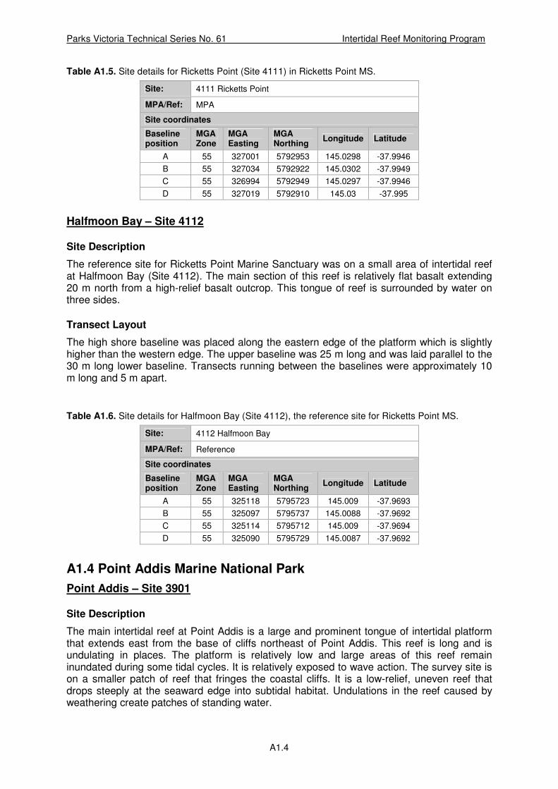
Parks Victoria Technical Series No. 61 Intertidal Reef Monitoring Program
A1.4
Table A1.5. Site details for Ricketts Point (Site 4111) in Ricketts Point MS.
Site: 4111 Ricketts Point
MPA/Ref: MPA
Site coordinates
Baseline position
MGA Zone
MGA Easting
MGA Northing
Longitude Latitude
A 55 327001 5792953 145.0298 -37.9946
B 55 327034 5792922 145.0302 -37.9949
C 55 326994 5792949 145.0297 -37.9946
D 55 327019 5792910 145.03 -37.995
Halfmoon Bay – Site 4112
Site Description
The reference site for Ricketts Point Marine Sanctuary was on a small area of intertidal reef at Halfmoon Bay (Site 4112). The main section of this reef is relatively flat basalt extending 20 m north from a high-relief basalt outcrop. This tongue of reef is surrounded by water on three sides.
Transect Layout
The high shore baseline was placed along the eastern edge of the platform which is slightly higher than the western edge. The upper baseline was 25 m long and was laid parallel to the 30 m long lower baseline. Transects running between the baselines were approximately 10 m long and 5 m apart.
Table A1.6. Site details for Halfmoon Bay (Site 4112), the reference site for Ricketts Point MS.
Site: 4112 Halfmoon Bay
MPA/Ref: Reference
Site coordinates
Baseline position
MGA Zone
MGA Easting
MGA Northing
Longitude Latitude
A 55 325118 5795723 145.009 -37.9693
B 55 325097 5795737 145.0088 -37.9692
C 55 325114 5795712 145.009 -37.9694
D 55 325090 5795729 145.0087 -37.9692
A1.4 Point Addis Marine National Park
Point Addis – Site 3901
Site Description
The main intertidal reef at Point Addis is a large and prominent tongue of intertidal platform that extends east from the base of cliffs northeast of Point Addis. This reef is long and is undulating in places. The platform is relatively low and large areas of this reef remain inundated during some tidal cycles. It is relatively exposed to wave action. The survey site is on a smaller patch of reef that fringes the coastal cliffs. It is a low-relief, uneven reef that drops steeply at the seaward edge into subtidal habitat. Undulations in the reef caused by weathering create patches of standing water.

Parks Victoria Technical Series No. 61 Intertidal Reef Monitoring Program
A1.5
The intertidal reefs are exposed to the south and east. The Point Addis headland provides some protection from southwest winds and swell, although large waves from the southwest can wrap around Point Addis onto these reefs.
The survey area bridges a large channel that intersects the baselines. Additional coordinates of this were recorded and the affected transects shifted appropriately.
Transect Layout
The high and low baselines were 74 m and 81 m in length respectively. Transects range in length from 16 m at Transect 1 to 22 m at Transect 5.
Table A1.7. Site details for Point Addis (Site 3901) in Point Addis MNP.
Site: 3901 Point Addis
MPA/Ref: MPA
Site coordinates
Baseline position
MGA Zone
MGA Easting
MGA Northing
Longitude Latitude
A 55 260162 5746979 144.2538 -38.3933
B 55 260166 5747053 144.2539 -38.3926
C 55 260177 5746972 144.254 -38.3933
D 55 260185 5747055 144.2541 -38.3926
Winkipop – Site 3902
Site Description
The reference site for Point Addis Marine National Park was located to the east of the park at Winkipop reef. The intertidal area at Winkipop is a very low-relief, gently sloping reef. The area exposed at low tide is 30 to 50 m wide. This area is exposed to large southerly swell. There is a narrow band of sandy beach on the landward side of the reef. As at Point Addis, pools of standing water were common in undulations in the reef surface. This reef may be periodically subject to some sand inundation.
Transect Layout
Baselines were run parallel to shore and were 100 m long. Transects were evenly spaced every 25 m and each was approximately 35 m in length.
Table A1.8. Site details for Winkipop (Site 3902), the reference site for Point Addis MNP.
Site: 3902 Winkipop
MPA/Ref: Reference
Site coordinates
Baseline position
MGA Zone
MGA Easting
MGA Northing
Longitude Latitude
A 55 262913 5750014 144.2863 -38.3667
B 55 262948 5750105 144.2867 -38.3659
C 55 262942 5749997 144.2866 -38.3668
D 55 262986 5750086 144.2871 -38.366

Parks Victoria Technical Series No. 61 Intertidal Reef Monitoring Program
A1.6
A1.5 Point Danger Marine Sanctuary
Point Danger – Site 4002
Site Description
The intertidal area at Point Danger is a large sandstone reef platform that is an extension of the Point Danger headland. The reef is exposed to the north, east and south, however most of the prevailing weather and waves are from the south and southwest. There are large areas of sandy beach to the west and north of the platform.
The reef is a relatively flat sandstone platform which quickly drains or floods with the tide. The reef surface has been eroded to make it rugose, with a relief of 10-15 cm. Most of the reef is affected by sand inundation, with a thin layer of sand being present in many quadrats.
The survey site is in the near shore region of the platform towards the south/west border of the sanctuary.
Transect Layout
The high and low-shore baselines are approximately transverse to the headland. Baseline lengths were 46 m each, with transects of 41-43 m, forming a square survey area.
Table A1.9. Site details for Point Danger (Site 4002) in Point Danger MS.
Site: 4002 Point Danger
MPA/Ref: MPA
Site coordinates
Baseline position
MGA Zone
MGA Easting
MGA Northing
Longitude Latitude
A 55 266413 5753027 144.3273 -38.3405
B 55 266446 5753068 144.3277 -38.3401
C 55 266447 5753006 144.3277 -38.3407
D 55 266483 5753039 144.3281 -38.3404
Point Danger West – Site 4001
Site Description
The reference site, Point Danger West, is separated from the Point Danger intertidal platform by a short section of sandy beach. As with Point Danger, the sandstone platform has been eroded to create an uneven surface at the scale of 10s centimetres. This reef is subject to significant sand inundation.
Transect Layout
The site baselines were 50 m, with transects of 30 m.

Parks Victoria Technical Series No. 61 Intertidal Reef Monitoring Program
A1.7
Table A1.10. Site details for Point Danger West (Site 4001), the reference site for Point Danger MS.
Site: 4001 Pt Danger West
MPA/Ref: Reference
Site coordinates
Baseline position
MGA Zone
MGA Easting
MGA Northing
Longitude Latitude
A 55 266093 5752959 144.3236 -38.341
B 55 266143 5752979 144.3242 -38.3408
C 55 266099 5752928 144.3237 -38.3413
D 55 266144 5752946 144.3242 -38.3411
A1.6 Barwon Bluff Marine Sanctuary
Barwon Bluff – Site 4004
Site Description
The intertidal reef at Barwon Bluff is composed of sections of sandstone and basalt reef. The intertidal rock platform extends from the end of Barwon Bluff as a pincer-shaped reef. The north-eastern section of the pincer is a basalt platform and boulder reef. This section of the reef is relatively protected from swell but has a large estuarine influence from the adjacent mouth of the Barwon River. The south-western section of the pincer is a relatively flat sandstone reef, which is more exposed to large swells and sand inundation due to its exposure towards the south and proximity to an adjacent surf beach and strong cross-shore currents. The survey site is on the sandstone section of the reef (Figure 12.1).
The sandstone platform has three large rockpools in the centre of the survey area. The transects do not intercept any of these pools. Relief 5-10 cm high is present as ripples in the platform. These ripples act as traps for cross-shore sand movement. The edge of the platform drops sharply into subtidal habitat.
Transect Layout
At the high shore end of the platform there is a distinctive rise in shore height. This has been encompassed by the high shore baseline which follows this contour for 52 m. The low shore baseline borders rockpools on the south-western corner and is 53 m long. Transect lengths range from 47 m at Transect 1 to 49 m at Transect 5.
Table A1.11. Site details for Barwon Bluff (Site 4004) in Barwon Bluff MS.
Site: 4004 Barwon Bluff
MPA/Ref: MPA
Site coordinates
Baseline position
MGA Zone
MGA Easting
MGA Northing
Longitude Latitude
A 55 281293 5758960 144.4992 -38.2908
B 55 281339 5758952 144.4998 -38.2909
C 55 281289 5758913 144.4992 -38.2912
D 55 281352 5758904 144.4999 -38.2913

Parks Victoria Technical Series No. 61 Intertidal Reef Monitoring Program
A1.8
Barwon Beach – Site 4003
Site Description
To the west of the intertidal platform at Barwon Bluff, there are several smaller isolated patches of intertidal sandstone reef. These reefs are directly exposed to large southerly swells and sand inundation due to their proximity to the adjacent surf beach and strong longshore currents. The reef surface has been weathered to create an uneven surface at the scale of 10s of centimetres. The reference site is on one of these reefs, approximately 400 m west of Barwon Bluff, directly below a set of access stairs. These stairs are the closest access point and are the first set west of Barwon Bluff.
The reef structure is rugose with many depressions or rock pools approximately 20 cm in depth and 20-100 cm in diameter. It is more rugose than the Barwon Bluff Marine Sanctuary (Site 4004).
Transect Layout
The high shore baseline runs parallel to the shore for 45 m and follows the same shore height contour as at Barwon Bluff. The low shore baseline is 37 m long and is angled back towards shore such that Transect 1 is 33 m long and Transect 5 is 24 m long.
Table A1.12. Site details for Barwon Beach (Site 4003), the reference site for Barwon Bluff MS.
Site: 4003 Barwon Beach
MPA/Ref: Reference
Site coordinates
Baseline position
MGA Zone
MGA Easting
MGA Northing
Longitude Latitude
A 55 280828 5759028 144.4939 -38.2901
B 55 280873 5759015 144.4945 -38.2902
C 55 280828 5758994 144.4939 -38.2904
D 55 280864 5758990 144.4943 -38.2904
A1.7 Port Phillip Heads Marine National Park
Point Lonsdale – Site 2823
Site Description
The intertidal reef surveyed for the Port Phillip Heads Marine National Park was located at Point Lonsdale. This is on the western side of Port Phillip Heads with an extensive, triangularly shaped intertidal platform projecting eastwards from the Point Lonsdale headland. The low relief calcarenite site is uneven in patches as a result of exposure to strong weather and wave action. The intertidal platform is subject to a high level of trampling by the public.
Transect Layout
The survey area is on the southern expanse of reef. The transect layout was simple with high and low shore baselines of 100 m, separated by 50-60 m long transects.
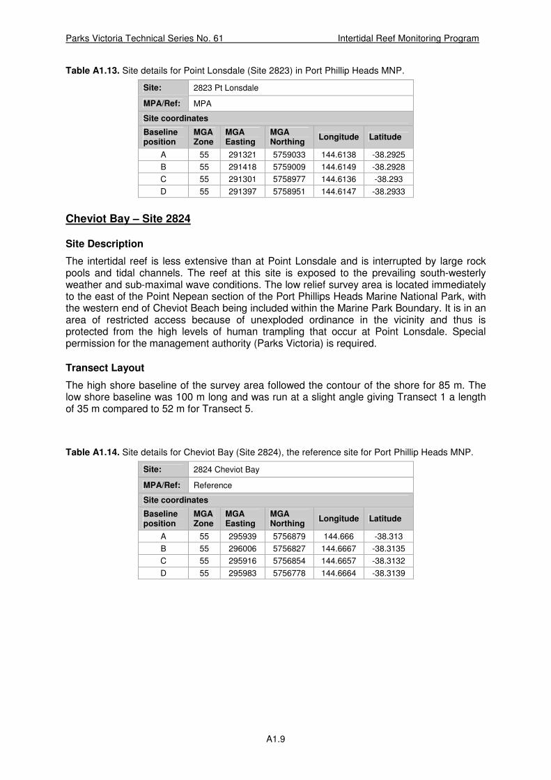
Parks Victoria Technical Series No. 61 Intertidal Reef Monitoring Program
A1.9
Table A1.13. Site details for Point Lonsdale (Site 2823) in Port Phillip Heads MNP.
Site: 2823 Pt Lonsdale
MPA/Ref: MPA
Site coordinates
Baseline position
MGA Zone
MGA Easting
MGA Northing
Longitude Latitude
A 55 291321 5759033 144.6138 -38.2925
B 55 291418 5759009 144.6149 -38.2928
C 55 291301 5758977 144.6136 -38.293
D 55 291397 5758951 144.6147 -38.2933
Cheviot Bay – Site 2824
Site Description
The intertidal reef is less extensive than at Point Lonsdale and is interrupted by large rock pools and tidal channels. The reef at this site is exposed to the prevailing south-westerly weather and sub-maximal wave conditions. The low relief survey area is located immediately to the east of the Point Nepean section of the Port Phillips Heads Marine National Park, with the western end of Cheviot Beach being included within the Marine Park Boundary. It is in an area of restricted access because of unexploded ordinance in the vicinity and thus is protected from the high levels of human trampling that occur at Point Lonsdale. Special permission for the management authority (Parks Victoria) is required.
Transect Layout
The high shore baseline of the survey area followed the contour of the shore for 85 m. The low shore baseline was 100 m long and was run at a slight angle giving Transect 1 a length of 35 m compared to 52 m for Transect 5.
Table A1.14. Site details for Cheviot Bay (Site 2824), the reference site for Port Phillip Heads MNP.
Site: 2824 Cheviot Bay
MPA/Ref: Reference
Site coordinates
Baseline position
MGA Zone
MGA Easting
MGA Northing
Longitude Latitude
A 55 295939 5756879 144.666 -38.313
B 55 296006 5756827 144.6667 -38.3135
C 55 295916 5756854 144.6657 -38.3132
D 55 295983 5756778 144.6664 -38.3139
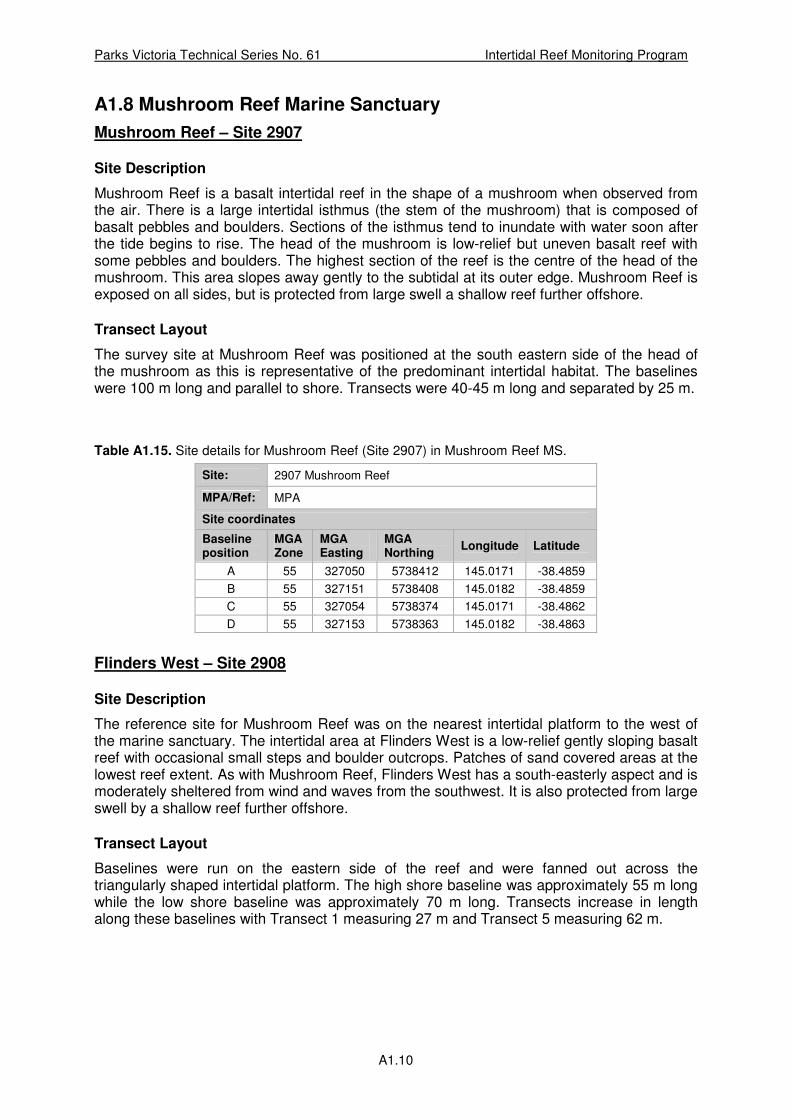
Parks Victoria Technical Series No. 61 Intertidal Reef Monitoring Program
A1.10
A1.8 Mushroom Reef Marine Sanctuary
Mushroom Reef – Site 2907
Site Description
Mushroom Reef is a basalt intertidal reef in the shape of a mushroom when observed from the air. There is a large intertidal isthmus (the stem of the mushroom) that is composed of basalt pebbles and boulders. Sections of the isthmus tend to inundate with water soon after the tide begins to rise. The head of the mushroom is low-relief but uneven basalt reef with some pebbles and boulders. The highest section of the reef is the centre of the head of the mushroom. This area slopes away gently to the subtidal at its outer edge. Mushroom Reef is exposed on all sides, but is protected from large swell a shallow reef further offshore.
Transect Layout
The survey site at Mushroom Reef was positioned at the south eastern side of the head of the mushroom as this is representative of the predominant intertidal habitat. The baselines were 100 m long and parallel to shore. Transects were 40-45 m long and separated by 25 m.
Table A1.15. Site details for Mushroom Reef (Site 2907) in Mushroom Reef MS.
Site: 2907 Mushroom Reef
MPA/Ref: MPA
Site coordinates
Baseline position
MGA Zone
MGA Easting
MGA Northing
Longitude Latitude
A 55 327050 5738412 145.0171 -38.4859
B 55 327151 5738408 145.0182 -38.4859
C 55 327054 5738374 145.0171 -38.4862
D 55 327153 5738363 145.0182 -38.4863
Flinders West – Site 2908
Site Description
The reference site for Mushroom Reef was on the nearest intertidal platform to the west of the marine sanctuary. The intertidal area at Flinders West is a low-relief gently sloping basalt reef with occasional small steps and boulder outcrops. Patches of sand covered areas at the lowest reef extent. As with Mushroom Reef, Flinders West has a south-easterly aspect and is moderately sheltered from wind and waves from the southwest. It is also protected from large swell by a shallow reef further offshore.
Transect Layout
Baselines were run on the eastern side of the reef and were fanned out across the triangularly shaped intertidal platform. The high shore baseline was approximately 55 m long while the low shore baseline was approximately 70 m long. Transects increase in length along these baselines with Transect 1 measuring 27 m and Transect 5 measuring 62 m.

Parks Victoria Technical Series No. 61 Intertidal Reef Monitoring Program
A1.11
Table A1.16. Site details for Flinders West (Site 2908), the reference site for Mushroom Reef MS.
Site: 2908 Flinders West
MPA/Ref: Reference
Site coordinates
Baseline position
MGA Zone
MGA Easting
MGA Northing
Longitude Latitude
A 55 326497 5739009 145.0109 -38.4804
B 55 326549 5738995 145.0115 -38.4805
C 55 326496 5739005 145.0109 -38.4804
D 55 326561 5738983 145.0116 -38.4806
A1.9 Bunurong Marine National Park
Eagles Nest – Site 3020
Site Description
Located on the eastern side of the Eagles Nest headland, Site 3020 was selected as being representative of the predominant habitat type of the area. The site is on the eastern side of the Marine National Park. It has an east facing aspect with the Eagles Nest headland sheltering it from the north and west. It is exposed to swells from the southeast, but not directly exposed to the prevailing south and southwest swell. The reef platform is relatively flat with little relief.
Transect Layout
High and low shore baselines were 56 m and 48 m, respectively. The transects range in length from 25 m at Transect 1 to 50 m at Transect 5.
Table A1.17. Site details for Eagles Nest (Site 3020) in Bunurong MNP.
Site: 3020 Eagles Nest
MPA/Ref: MPA
Site coordinates
Baseline position
MGA Zone
MGA Easting
MGA Northing
Longitude Latitude
A 55 384362 5719082 145.6708 -38.6693
B 55 384326 5719129 145.6703 -38.6689
C 55 384382 5719098 145.671 -38.6692
D 55 384372 5719143 145.6709 -38.6688
Cave – Site 3021
Site Description
The reference site is at the Caves (Site 3021), located to the east of Bunurong Marine National Park. The site is situated directly below the access stairs from the Caves carpark. As with Eagles Nest, the reef substratum is mudstone, has a southeast facing aspect and is sheltered from the north and west by the Caves headland. The reef is exposed to southeast and southerly swell but is more sheltered from direct exposure to the prevailing southwest swell. There is a large area platform at this site, with little rugose structure or relief. On the
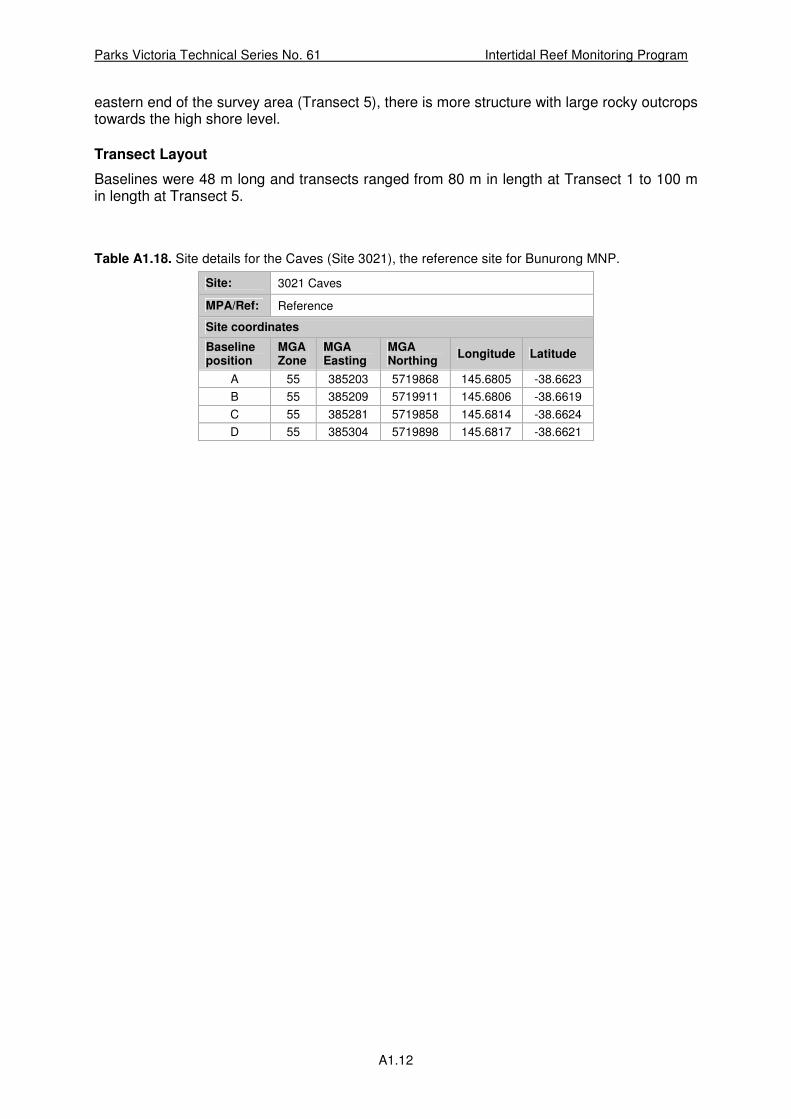
Parks Victoria Technical Series No. 61 Intertidal Reef Monitoring Program
A1.12
eastern end of the survey area (Transect 5), there is more structure with large rocky outcrops towards the high shore level.
Transect Layout
Baselines were 48 m long and transects ranged from 80 m in length at Transect 1 to 100 m in length at Transect 5.
Table A1.18. Site details for the Caves (Site 3021), the reference site for Bunurong MNP.
Site: 3021 Caves
MPA/Ref: Reference
Site coordinates
Baseline position
MGA Zone
MGA Easting
MGA Northing
Longitude Latitude
A 55 385203 5719868 145.6805 -38.6623
B 55 385209 5719911 145.6806 -38.6619
C 55 385281 5719858 145.6814 -38.6624
D 55 385304 5719898 145.6817 -38.6621


Parks Victoria is responsible for managing the Victorian protected
area network, which ranges from wilderness areas to metropolitan
parks and includes both marine and terrestrial components.
Our role is to protect the natural and cultural values of the parks
and other assets we manage, while providing a great range of
outdoor opportunities for all Victorians and visitors.
A broad range of environmental research and monitoring activities
supported by Parks Victoria provides information to enhance park
management decisions. This Technical Series highlights some of
the environmental research and monitoring activities done within
Victoria’s protected area network.
Healthy Parks Healthy People
For more information contact the Parks Victoria Information Centre
on 13 1963, or visit www.parkweb.vic.gov.au