park avenue pedestrian safety plan
DESCRIPTION
ÂTRANSCRIPT
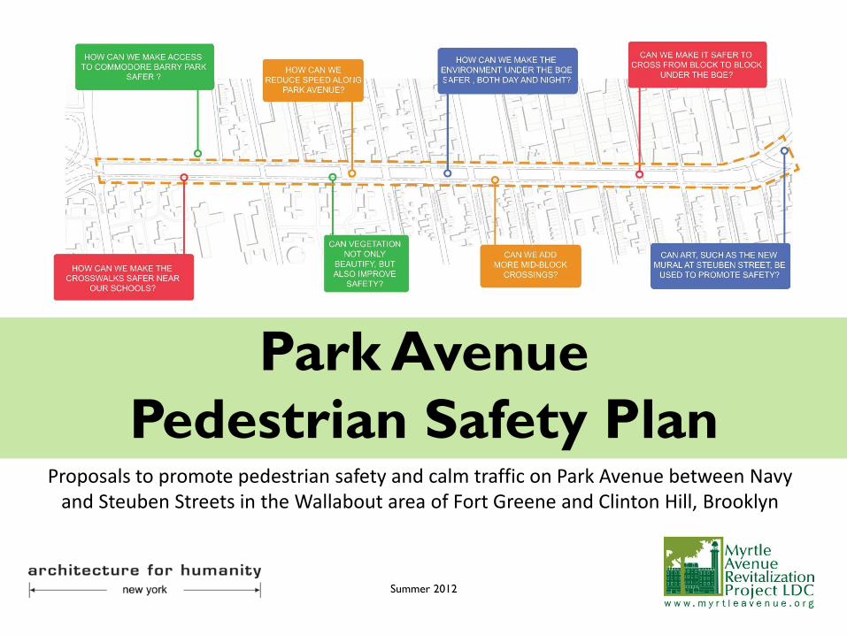
Park Avenue
Pedestrian Safety Plan Proposals to promote pedestrian safety and calm traffic on Park Avenue between Navy
and Steuben Streets in the Wallabout area of Fort Greene and Clinton Hill, Brooklyn
Summer 2012


Table of Contents
Executive Summary 4
Introduction 5
The Impacts of the BQE 7
Community Involvement 8
Site Characteristics: Park Avenue 10
Summary of Proposals 12
Sitewide Interventions 13
Intersection Treatments 22
Site Specific Interventions 26
Sanitation 33
Downspout Repair 35
Green Infrastructure 36
Advocacy and Implementation 38
About MARP 39
About AFHNY 40
Acknowledgements 41
Cover Graphic: Architecture for Humanity New York
3

Executive Summary
The Brooklyn-Queens Expressway both connects and divides. While it
connects Brooklyn, Queens, and the East River Bridges, it divides the urban
fabric of the neighborhoods it traverses. In the Wallabout area of Fort
Greene and Clinton Hill, Park Avenue is the de-facto service road for the
BQE. Due to design, neglect, and driver behavior, Park Avenue is an
unsightly speedway, hostile to increasing pedestrian volumes.
This project started as a visioning process with the goal of improving the
spaces under the elevated BQE. However, based on feedback from the
public, the project was transformed into the broader Park Avenue
Pedestrian and Traffic Safety Project. With input from the community, city
agencies, architects, planners, elected officials, and an Advisory Committee
of key stakeholders, this report contains dozens of practical
recommendations to improve Park Avenue.
Most of the proposals are intended for the Department of Transportation.
Lighting, signage, and re-timed traffic lights are some of the corridor-wide
proposals. Both adding and removing on-street parking in strategic
locations could also slow traffic and improve safety. The crux of the
proposals deal with the intersections. Using a combination of standard
treatments, these awkward areas could be greatly improved. Three unique
areas – the Navy Street intersection, the NYCHA/Commodore Barry Park
superblock, and “The Crossover” near Grand and Steuben – are each
treated separately. Other proposals address sanitation issues, street trees,
BQE maintenance, and green infrastructure.
4
Introduction
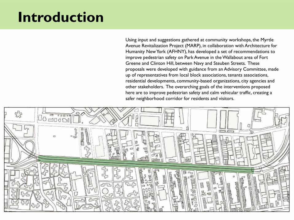
Using input and suggestions gathered at community workshops, the Myrtle
Avenue Revitalization Project (MARP), in collaboration with Architecture for
Humanity New York (AFHNY), has developed a set of recommendations to
improve pedestrian safety on Park Avenue in the Wallabout area of Fort
Greene and Clinton Hill, between Navy and Steuben Streets. These
proposals were developed with guidance from an Advisory Committee, made
up of representatives from local block associations, tenants associations,
residential developments, community-based organizations, city agencies and
other stakeholders. The overarching goals of the interventions proposed
here are to improve pedestrian safety and calm vehicular traffic, creating a
safer neighborhood corridor for residents and visitors.

Introduction
The 17-block stretch of Park Avenue, between Navy Street and Steuben
Street, crosses through the Wallabout area of Fort Greene and Clinton Hill
in Brooklyn, with the elevated Brooklyn-Queens Expressway running
directly above it. In the census tracts just north and south of Park Avenue,
there are approximately 12,000 residents, six schools, three parks, and
numerous retail and light-industrial businesses, as well as various other
community facilities like hospitals and churches. Despite these
characteristics that commonly describe a residential, pedestrian
neighborhood, Park Avenue is often thought of as a ‘throughway’, dominated
by four lanes of fast-moving traffic bracketing a 300+ space parking area.
The latter elements have created environmental, travel and sanitation
conditions that are unsafe for the many school children, seniors, bus riders
and others residents that use Park Avenue daily.
The following report includes both short and long term recommendations
to improve safety on Park Avenue through design interventions that calm
traffic, optimize pedestrian crossings, and even improve sanitation
conditions. In order to see these interventions implemented, MARP is
building a strong coalition of community-based support. This report will be
distributed to relevant city agencies and elected officials in summer/fall
2012 to advocate for implementation of the proposals presented here.

The Impacts of the BQE
The idea for the Brooklyn-Queens Expressway
was originated by the Regional Plan Association
in 1936 as a way to connect the Gowanus
Parkway and the Triborough Bridge. The first
part of this plan was completed in 1939, and the
later portions of the BQE were completed after
World War II by Robert Moses. The next phase
of the BQE construction connected the
Kosciuszko Bridge and Williamsburg in 1950, and
the final phase stretched from southern
Brooklyn to the Grand Central Parkway in
Queens. Construction was completed in 1964.
The BQE stretches 11.6 miles and, presently,
sees roughly 160,000 cars per day.
Although considered one of the crowning
achievements of Moses, the BQE has often been
criticized for cutting through and clearing a
number of neighborhoods and communities.
Moses envisioned the project as a necessary
part of New York‘s arterial system to aid in
national defense, industry and commerce. For
the Wallabout area of Fort Greene and Clinton
Hill, the BQE has created a physical barrier that
slices through these neighborhoods, isolating the
northern sections, creating dark, blighted spaces,
bringing noise, vibrations, and air pollution, and
creating unsafe conditions for pedestrians.
Historic Photo of the BQE Near the Brooklyn Navy Yard
Credit: TBTA
BQE Construction 1959, Credit: Brooklynpix.com
7

Community Involvement
During 2009 and 2010, MARP conducted three community workshops about
improving the spaces under and around the BQE in the Wallabout area of Fort
Greene and Clinton Hill. After reviewing the results, pedestrian safety on Park
Avenue was determined to be the priority issue for community residents.
Speeding cars, faded cross-walks, dangerous intersections, and an absence of
traffic lights are some of the specific problems that the community identified.
In late 2010, a team of volunteer consultants from Architecture for Humanity
New York (AFHNY) joined the project, conducting site research and
facilitating additional workshops, focusing specifically on traffic calming and
pedestrian safety. The proposals in this report are the result, in large part, of
the research and workshops that have taken place since early 2011, but were
influenced by community input gathered at all of the following events:
• April 2009: Spacebuster Workshop facilitated by Pratt urban planning
students under the BQE
• September 2010: Parking Day Potluck with Design Trust for Public Space
under the BQE
• October 2010: Envisioning Under the BQE Workshop facilitated by Pratt
urban planning studio at PS67
• November 2010: Envisioning Under the BQE Workshop for Teens facilitated
by Pratt urban planning studio at Benjamin Banneker Academy
• November 2011: Park Ave Pedestrian Safety Workshop with AFHNY at
Benjamin Banneker Academy
• February 2012: Surveys conducted by AFHNY at Sacred Heart Church
• April 2012: Advisory Committee meeting; presentation to Community
Board 2 Transportation Committee for feedback
• May 2012: Presentation of Draft Proposals for Park Avenue Pedestrian
Safety with AFH at Navy Yard Houses
• May 2012: Advisory Committee meeting; presentation to Community
Board 2 Transportation Committee (received resolution of support)
Community meeting
Spacebuster event
8

Community Involvement
Typical intersection
Graphic: Pratt Planning Studio 2010
Community Meetings

Site Characteristics: Park Avenue
Surveys and research, along with community input, revealed the
following about the current conditions along Park Avenue between
Navy and Steuben Streets:
• Diversity of user groups and institutions: User groups include school
children and parents, bus riders, seniors, residents, shoppers, workers,
bikers, and drivers (both passing through and searching for parking).
Institutions include primary and secondary schools, churches, a
hospital, parks and various retail and industrial businesses. Large
residential developments include Ingersoll Houses, Whitman Houses,
Navy Yard Houses, The Chocolate Factory, and Navy Green. The
Brooklyn Navy Yard is just one block north of the site.
• Speeding traffic: Traffic is very fast, especially during non-rush hours.
• Difficulty crossing north-south on foot: Many people are unable to
cross during one traffic light cycle. Crosswalks are faded and many
curb cuts are not ADA accessible throughout the site.
Typical pedestrian behavior and conditions
10

Site Characteristics: Park Avenue
• High rate of crashes: 76th percentile, mostly rear ends (NYCDOT)
• Poor lighting in some areas: Despite the fact that NYS DOT installed lights
under the elevated infrastructure during a rehabilitation project a few years
ago, most street corners on the north and south sides of Park Avenue are dark
and do not meet NYC DOT minimum standards for street lighting, especially
near Commodore Barry Park.
• Lack of greenery: There are very few street trees, even though there are many
sites available for trees. Street trees and other plantings are known to help
calm traffic.
• Sanitation: The areas under the BQE are very unclean, with rampant littering,
illegal dumping, and drainage issues.
• Parking under BQE could be optimized: There are no pavement markings to
indicate where drivers should park. This sometimes leads to an inefficient use
of space. Furthermore, the street sweeping occurs overnight, which makes it
difficult for residents to use the space efficiently.
Litter under the BQE
11
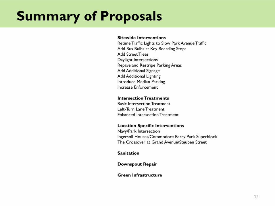
Summary of Proposals
Sitewide Interventions
Retime Traffic Lights to Slow Park Avenue Traffic
Add Bus Bulbs at Key Boarding Stops
Add Street Trees
Daylight Intersections
Repave and Restripe Parking Areas
Add Additional Signage
Add Additional Lighting
Introduce Median Parking
Increase Enforcement
Intersection Treatments
Basic Intersection Treatment
Left-Turn Lane Treatment
Enhanced Intersection Treatment
Location Specific Interventions
Navy/Park Intersection
Ingersoll Houses/Commodore Barry Park Superblock
The Crossover at Grand Avenue/Steuben Street
Sanitation
Downspout Repair
Green Infrastructure
12

Proposals: Sitewide Interventions
Retime Traffic Lights to Slow Park Avenue Traffic
Green lights as far as the eye can see may be considered a sign of good luck.
However, they are also an invitation to speed. We propose that DOT studies
the traffic signal timing and adjusts it with the following goals in mind:
• Reduce the maximum sustained speed that a driver on the corridor can
travel.
• Eliminate cycle timing that allows drivers to speed in order to “catch” the
next green light.
• Consider increasing the green interval for key cross streets, such as
Washington Avenue, Vanderbilt Avenue, and Navy Street.
• Encourage a sustained speed under 30mph.
Typical intersection
13

Proposals: Sitewide Interventions
Add Bus Bulbs at Key Boarding Stops
Bus bulbs have numerous benefits: • Reduce the need for buses to pull over and pull out when entering and
exiting a bus stop, thus reducing travel times. • Act as a curb extension, which calms vehicular traffic and reduces
pedestrian crossing distance. • Allow for the installation of bus shelters or benches on sidewalks that
might otherwise not be able to accommodate them. Priority needs to go to the busiest stops for boarding passengers. The MTA provided the most recent ridership data available: Daily boardings, Northbound B62 Daily boardings, Southbound B62 (runs east on Park Avenue) (runs west on Park Avenue) PARK AV NAVY ST 61 PARK AV RYERSON ST 23 PARK AV N PORTLAND ST 52 PARK AV WASHINGTON 95 PARK AV CARLTON AV 86 PARK AV VANDERBILT AV 78 PARK AV VANDERBILT AV 72 PARK AV CARLTON AV 154 PARK AV WASHINGTON 81 PARK AV N PORTLAND ST 219 PARK AV RYERSON ST 20 NAVY ST PARK AV 79 CLASSON AV PARK AV 31 The highlighted stops are the most heavily used, and therefore these locations are recommended for bus bulbs. It is worth mentioning that the sidewalk at southbound (westbound) North Portland is also extremely narrow and would significantly benefit from a bus bulb (see photo at left). Proposed locations are highlighted below in blue.
Example of a Bus Bulb
Westbound Bus Stop at North Portland

Proposals: Sitewide Interventions
Add Street Trees
Various studies have shown that street trees can reduce vehicle speeds. Trees
visually narrow the roadway and provide drivers with a gauge for speed. With
the elevated BQE dominating the area, Park Avenue desperately needs
additional greening.
• We propose adding as many street trees as possible at the site, based on
the Department of Parks and Recreation siting guidelines and existing
underground utilities. See the map below showing areas that do not have
street trees.
• For sidewalks that are too narrow for street trees, we propose in-street
tree bump outs (see the Green Infrastructure section for more details on
tree bump outs).
A treeless block-face on Park Avenue
Highlighted Sidewalks Lack Street Trees

Proposals: Sitewide Interventions
Daylight Intersections
Daylighting – the removal of on-street parking at the approach to an
intersection – improves safety by improving the site lines of a driver
approaching an intersection. Daylighting also improves the sightlines of a
pedestrian waiting to cross a street.
• We propose 20-foot daylighting on Park Avenue at near-side corners
throughout the entire site area. Where vehicle turning is constrained,
removing the last on-street parking space is appropriate (see the
“Daylighting in Effect” photo). Where street geometry is not constrained,
we propose neckdowns (temporary or permanent) to replace the parking
and provide space for pedestrians (see the “Daylighting w/ Amenities”
photo).
Renderings of Daylighting (Graphic: Streetswiki) 16

Proposals: Sitewide Interventions
Repave and Restripe Parking Areas The pavement under the BQE is in terrible condition. Pot holes are large and
deep. Pavement is uneven. The following are consequences of these
conditions:
• Street sweepers are unable to clean inside the large potholes and trash
builds up over time.
• Pavement condition adds to the poorly kept feel of the area, and may
encourage littering and illegal dumping.
• Water pools in the potholes.
We propose the following:
• NYC DOT routinely repaves every street in the city. The parking area
under the BQE should be prioritized and completely repaved.
• Stripe the parking spaces, to encourage drivers to use the space efficiently.
Typical potholed area under the BQE
Large pothole with trash under the BQE 17

Proposals: Sitewide Interventions
Additional Signage
We propose adding the following signage, where appropriate, throughout the
entire site:
• Speed limit
• School crossing
• Stop signs at the exits of the parking areas under the BQE (see
Intersection Treatments for more details)
• Moveable variable message signs that indicate to drivers how fast they are
traveling
18

Proposals: Sitewide Interventions
Lighting
Architecture for Humanity volunteers used light meters to measure light levels throughout the entire site area, including side streets. Although the areas under and adjacent to the BQE are now quite bright due to lights installed by NYS DOT, the immediate side street areas are almost all below the DOT minimum light standards. Please see the following diagram which indicates the low light areas (below 0.5 foot candles).
• We request that DOT add lights, as necessary, to bring lighting up to minimum standards. In particular, the area near Washington Hall Park is a priority due to public safety concerns and a lack of lights inside the park, as well as Commodore Barry Park entrances, and the areas near the Soundwaves mural between Grand Avenue and Steuben Street.
Areas of Low Light with Measured Foot Candles (Nov 2011)
Graphic: AFHNY
19

Proposals: Sitewide Interventions
Median Parking
Excessive travel capacity and wide open lanes invite speeding traffic, which occurs more often at times of low traffic volume. Data provided by DOT indicates that eastbound traffic is lighter than westbound traffic. This may be due to the BQE off ramp at Kent Avenue, which dumps traffic onto westbound Williamsburg Street, then merges with westbound Park Avenue. There is no off ramp which directs eastbound traffic through the site.
Widening the sidewalk and narrowing the roadways would calm traffic and cause cars to slow down. However, the capital expenditures would be high, and traffic flow would suffer during periods of heavier volume. We propose allowing time-of-day parallel parking on the Park Avenue side of both the north and south median, as permitted by traffic volumes.
This solution will:
• Calm traffic when volume is low
• Allow normal traffic flow when volume is high
• Provide additional street parking at off-hours (when residents need it most).
Besides being effective and flexible, this proposal is economical, involving only signage and paint.
Graphic: AFHNY
Graphic: AFHNY
Existing Eastbound Park Avenue
Proposed Median Parking on Eastbound Park Avenue
20

Proposals: Sitewide Interventions
Increase Enforcement
Physical interventions, like neckdowns and traffic lights, can significantly calm
traffic. Unfortunately, Park Avenue will likely continue to attract reckless
speeding without proper enforcement of speed limits and traffic laws.
• The NYPD should step up enforcement of the speed limit on Park Avenue,
especially at the times when fast driving coincide with high pedestrian
activity.
• The installation of temporary variable message speed monitors will show
drivers how fast they are going, encouraging ‘self-enforcement’ of posted
speed limits.
21

Proposals: Intersection Treatments
Intersection Treatments Most accidents occur at intersections. The intersections along Park Avenue are especially dangerous for the following reasons: • Speeding traffic, particularly on Park Avenue • The entrances/exits to the parking areas create an additional conflict point
and can confuse both drivers and pedestrians alike.
• The parking area adds effective width to the crossing distance of Park Avenue. This makes crossing on foot difficult for people with small children, the elderly, or disabled.
• Most pedestrian islands lack curb cuts, which forces many users into the cross street traffic when crossing with the light.
• Most exits from the parking areas are not controlled. Drivers are not necessarily aware of crossing pedestrians and can (legally) cross a pedestrian’s path without stopping.
• Interior corners cannot be swept, so trash piles up. DOT is already installing pedestrian ramps at most corners that don’t already have them. Most of the median corners under the BQE do not have pedestrian ramps and will be replaced. We propose that DOT adopts these new design standards and implements them when reconstruction occurs.
Existing Intersection
Graphic: AFHNY
22

Proposals: Intersection Treatments
Basic Intersection Treatment
We propose the following series of treatments for at least four intersections along Park Avenue under the BQE:
• Stop signs at exits of parking areas
• Raised crosswalk/driveway at entrances/exits to parking areas
• Curb cuts at pedestrian islands
• Neckdowns (temporary or permanent)
• “No Parking” markings along the cross street under the BQE. Some – but not most – of the current intersections have these markings.
• Explore the possibility of Crosswalks parallel to Park Avenue under the BQE.
Recommended for the following Park Avenue Intersections:
• Cumberland Street
• Carlton Avenue
• Adelphi Street
• Hall Street
Existing Intersection
Proposal for a Basic Intersection
Graphic: AFHNY
Graphic: AFHNY

Proposals: Intersection Treatments
Left-Turn Lane Treatment
Washington Avenue, Clinton Avenue, and
Vanderbilt Avenue see a large volume of cars
that turn left from westbound Park Avenue. At
these intersections, we propose a left-turn lane
carved from the existing parking area. Other
interventions at these intersections would be
similar to the “Basic” intersection treatment.
Recommended for the following Park Avenue
Intersections:
• Clinton Avenue
• Vanderbilt Avenue
• Washington Avenue
Existing Intersection
Proposal for a Left-Turn Lane
Graphic: AFHNY
Graphic: AFHNY

Proposals: Intersection Treatments
Enhanced Intersection Treatment
North Portland Avenue, Clinton Avenue, and Clermont Avenue have more pedestrian cross traffic than other cross streets in the site. For these busier intersections, we propose closing the parking area entrance/exit, which will eliminate the awkward crossing and provide pedestrians with a safe route under the BQE (see graphic). Only one end of each parking area would be closed.
Please note:
• The proposal shown here is conceptual and would need further design iterations.
• Cars will still be able to enter the parking area at the intersections to the east and west of the “Enhanced” intersection.
• Intersections that do not get a left-turn lane or “Enhanced” treatment should receive the “Basic” intersection treatment.
Existing Intersection
Proposal for Enhanced Intersection
Graphic: AFHNY
Graphic: AFHNY

Proposals: Site Specific Interventions
Location-Specific Proposals
The following proposals deal with three unique sites within the study area:
• Navy Street intersection
• Ingersoll Houses/Commodore Barry Park superblocks
• “The Crossover” near Steuben Street
Treatments are tailored to the challenges and opportunities of each area.
Navy Street approaching Park Avenue, looking north
Ingersoll Houses Superblock, south of BQE looking west The Crossover, looking east
26

Proposals: Navy/Park Intersection
Existing Conditions
Originally, this intersection was not included in the study area. After countless
comments from stakeholders and the Advisory Committee, MARP and
AFHNY decided to include the entire intersection and propose specific
treatments to address safety.
Following are the unique challenges of this intersection:
• Heavy cross traffic
• Three slip lanes that allow cars to make right turns while maintaining speed.
Slip lanes belong on highways, not in an urban setting. Not surprisingly,
highway-like design brings highway-like speeds.
• A very busy bike lane on Navy, which leads to both the Manhattan and
Brooklyn Bridges
• Rampant illegal parking on sidewalks under the BQE and along the BQE
on-ramp. Frequently, some of these cars block pedestrian access.
Existing Navy/Park Intersection
Graphic: AFHNY
Multiple cars illegally parked on sidewalk
27

Proposals: Navy/Park Intersection
Proposed Improvements
We propose the following interventions:
• Close all three slip lanes. Right-turning cars will proceed to the main
intersection, as they normally do at other intersections. The unused slip
lanes should become landscaped pedestrian refuge islands. The results
would be reduced turning car speeds and reduced number of conflicts
between cars and pedestrians/cyclists.
• Add crosswalks to facilitate pedestrian movement. The intersection is
already controlled with traffic lights.
• Discourage illegal parking on sidewalks and elsewhere, through signage,
greening, pavement treatments, and/or the installation of bollards or other
preventative means.
Proposal for the Navy Street Intersection
Graphic: AFHNY
28

Proposals: Ingersoll/Park Superblocks
Existing Conditions
Superblocks are, unfortunately, a common sight in a
pedestrian-heavy city like New York. Superblocks
reduce the number of controlled intersections and
make pedestrian movements less efficient – and
dangerous. Because there are fewer controlled
intersections, drivers are encouraged to go faster.
The Ingersoll Houses and Commodore Barry Park
superblocks, spanning four blocks between Navy and
North Portland, are especially challenging for the
following reasons:
• There are two superblocks across from each other.
• Even though there are breaks in the median to allow
cars to pass under the BQE, there are no controlled
crossings in the four-block stretch.
• The housing and school on the south side and the
park on the north side are both large pedestrian trip
generators.
• Every parked car under the BQE generates at least
two pedestrian trips.
• Westbound Park Avenue slopes slightly downward in
this area. That condition, combined with the lack of
traffic controls, leads to especially fast driving.
Existing Superblocks
Graphic: AFHNY
Commodore Barry Superblock, Park Avenue side
29
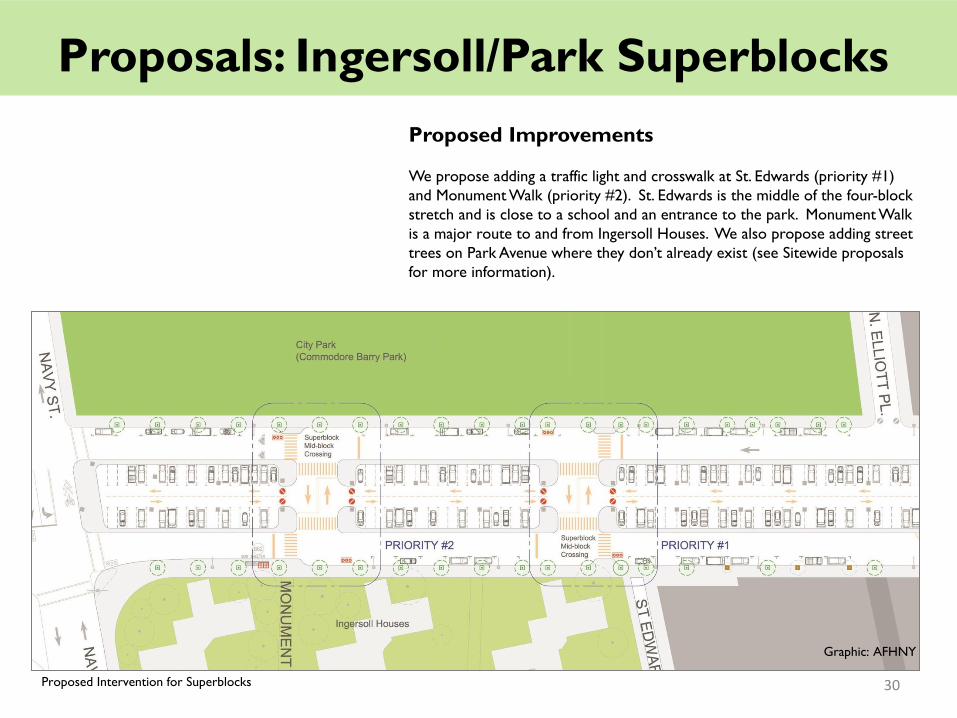
Proposals: Ingersoll/Park Superblocks
Proposed Improvements
We propose adding a traffic light and crosswalk at St. Edwards (priority #1)
and Monument Walk (priority #2). St. Edwards is the middle of the four-block
stretch and is close to a school and an entrance to the park. Monument Walk
is a major route to and from Ingersoll Houses. We also propose adding street
trees on Park Avenue where they don’t already exist (see Sitewide proposals
for more information).
Proposed Intervention for Superblocks
Graphic: AFHNY
30

Proposals: The Crossover
Existing Conditions
Park Avenue between Grand Avenue and
Steuben Street is so unique; we needed to give it
a name – The Crossover. In this area, the BQE
turns from South Williamsburg into Clinton Hill
and starts to run parallel above Park Avenue. To
the east, Park Avenue is a simple two lane two-
way street with a parking lane on each side,
similar to countless other streets in New York.
As Park Avenue approaches the BQE,
westbound traffic splits off from the eastbound
traffic and crosses over to the north side of the
BQE. As eastbound traffic approaches this area,
the two lanes of travel are reduced to one, in
order to match Park Avenue’s width to the east.
The existing conditions produce a number of
unsafe conditions:
• The crossover lane has highway-like curves
without any controls. This encourages
speeding.
• There are no traffic controls in the area,
making pedestrian crossing very dangerous.
• The Park Avenue eastbound lane crosses
Grand Avenue at an awkward angle. The
homes on the southeast corner of that
intersection have been repeatedly hit by cars.
Existing Conditions of “The Crossover”
Graphic: AFHNY
31
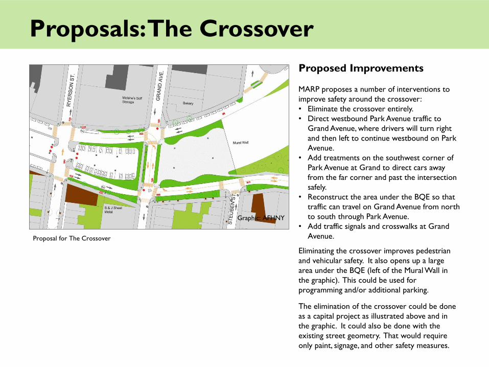
Proposals: The Crossover
Proposed Improvements
MARP proposes a number of interventions to
improve safety around the crossover:
• Eliminate the crossover entirely.
• Direct westbound Park Avenue traffic to
Grand Avenue, where drivers will turn right
and then left to continue westbound on Park
Avenue.
• Add treatments on the southwest corner of
Park Avenue at Grand to direct cars away
from the far corner and past the intersection
safely.
• Reconstruct the area under the BQE so that
traffic can travel on Grand Avenue from north
to south through Park Avenue.
• Add traffic signals and crosswalks at Grand
Avenue.
Eliminating the crossover improves pedestrian
and vehicular safety. It also opens up a large
area under the BQE (left of the Mural Wall in
the graphic). This could be used for
programming and/or additional parking.
The elimination of the crossover could be done
as a capital project as illustrated above and in
the graphic. It could also be done with the
existing street geometry. That would require
only paint, signage, and other safety measures.
Proposal for The Crossover
Graphic: AFHNY

Proposals: Sanitation
Throughout the planning process, residents and stakeholders often raised
specific sanitation-related issues regarding Park Avenue and the areas under
the BQE. Since these issues affect the pedestrian experience, we decided to
include them. The sanitation-related issues are:
• A lack of corner trash bins at bus stops and near commercial areas.
• Street sweeping regulations under the BQE that negatively impact
residents.
• Poor street sweeping effectiveness under the BQE.
• Rampant illegal dumping under the BQE.
Corner Trash Bins
We request new corner trash bins at the following locations:
• Southeast corner of Park and Washington (bus stop)
• Northwest corner of Park and Washington (bus stop and grocery store)
• Southeast corner of Park at Clinton (high school)
• Southeast corner of Park at Vanderbilt (two bus stops)
• Northeast corner of Park at Cumberland Street (retail businesses)
• Northwest corner of Park at North Oxford (junior/senior high school)
• Northeast corner of Park at North Portland (junior/senior high school)
• Southeast corner of Park at North Portland (bus stop)
• Northeast corner of Park at Navy Street (bus stop)
Street Sweeping Regulations
Currently, the parking area under the BQE is scheduled for alternate side
street sweeping from 3am to 6am, three times per week, six nights total.
These regulations pose greater challenges for residents than commuters, and
effectively reduce the parking capacity of the area. Nearly every night, one
side of the parking area cannot be used. Most other streets in CB2 are now
cleaned once per week.
Sign displaying existing street sweeping hours
33

Proposals: Sanitation
We request that street sweeping schedules under the BQE be changed in the
following ways:
• Sweep during normal daytime hours, not during the middle of the night.
• Sweep each parking lane once per week instead of three times per week.
• If possible, sweep in the travel lanes under the BQE in addition to the
parking lane.
We understand the current challenges that street sweepers face under the
BQE. Uneven pavement reduces the effectiveness of the machines. The
corners behind the highway supports, which gather trash, can not be swept by
the machines at all. MARP’s proposals to DOT will help to address both of
these issues. Hopefully, street sweeping will be more effective in the future.
Illegal Dumping
Illegal dumping is a big problem under the BQE. We request that the
Department of Sanitation handle illegal dumping as quickly as practical. Illegal
dumping that is not removed attracts more dumping. Perhaps street sweeper
drivers can inform the appropriate manager each time they see illegal debris
on their route. Or perhaps a special crew can be scheduled to remove illegal
debris on a regular interval, at least once a week.
It is quite possible that our proposals for the street sweeping schedule will
result in reduced dumping. If cars are allowed to park overnight there will be
less space to dump. Furthermore, our proposals to DOT will make the entire
area safer and more accessible to pedestrians. This too could result in
reduced dumping.
Illegal dumping under the BQE
34
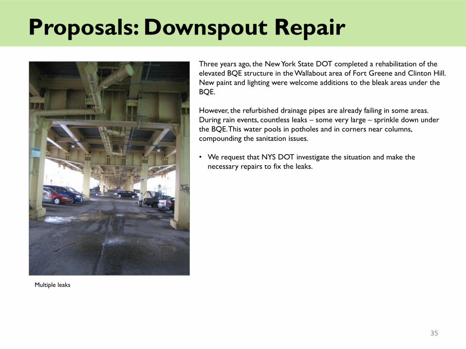
Proposals: Downspout Repair
Three years ago, the New York State DOT completed a rehabilitation of the
elevated BQE structure in the Wallabout area of Fort Greene and Clinton Hill.
New paint and lighting were welcome additions to the bleak areas under the
BQE.
However, the refurbished drainage pipes are already failing in some areas.
During rain events, countless leaks – some very large – sprinkle down under
the BQE. This water pools in potholes and in corners near columns,
compounding the sanitation issues.
• We request that NYS DOT investigate the situation and make the
necessary repairs to fix the leaks.
Multiple leaks
35
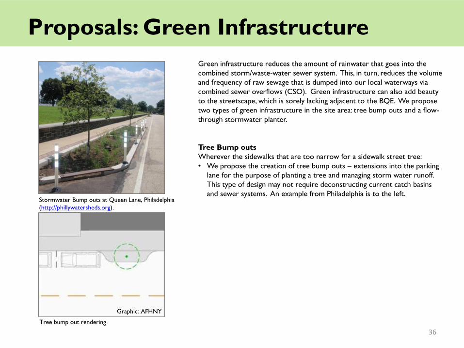
Proposals: Green Infrastructure
Green infrastructure reduces the amount of rainwater that goes into the
combined storm/waste-water sewer system. This, in turn, reduces the volume
and frequency of raw sewage that is dumped into our local waterways via
combined sewer overflows (CSO). Green infrastructure can also add beauty
to the streetscape, which is sorely lacking adjacent to the BQE. We propose
two types of green infrastructure in the site area: tree bump outs and a flow-
through stormwater planter.
Tree Bump outs
Wherever the sidewalks that are too narrow for a sidewalk street tree:
• We propose the creation of tree bump outs – extensions into the parking
lane for the purpose of planting a tree and managing storm water runoff.
This type of design may not require deconstructing current catch basins
and sewer systems. An example from Philadelphia is to the left.
Stormwater Bump outs at Queen Lane, Philadelphia
(http://phillywatersheds.org).
Graphic: AFHNY
Tree bump out rendering
36

Proposals: Green Infrastructure
Flow-through Stormwater Planter
AKRF partnered with MARP to do preliminary design and engineering work
for a green infrastructure installation near the “Crossover.” This area
contains large areas of underutilized median/sidewalk space as well as
downspouts from the elevated BQE.
• During rain events, runoff from the BQE roadway travels through the
downspouts and is directed into at-grade catch basins. This presents a
unique opportunity to intercept the rainwater and direct it to planted
areas, reducing CSO events and adding greenery in a very innovative and
visually impactful manner.
Graphic: AKRF
Rendering of Flow-Through Stormwater Planter
37

Advocacy and Implementation
MARP is committed to advocating for the implementation of the proposals
described here. We will continue to press on city agencies including
Transportation, Sanitation and Parks, and will meet with local elected
officials to rally their support.
What can you do to help make Park Avenue safer?
Sign an online petition, available at www.ParkAvenueSafetyProject.org.
Tell your neighbors about the proposals in this report, and ask them to get
involved.
Call 311 to report:
• Speeding on Park Avenue and other traffic law violations
• Illegal dumping under the BQE
• Broken or nonfunctioning lighting under the BQE
Call, write, fax or email your elected officials asking them to help improve
conditions for pedestrians on Park Avenue (contact information at left).
Contact Brooklyn Community Board 2 to thank them for their support so
far, and to make sure these issues stay on their radar.
Share your story! Have you had a brush with danger while crossing Park
Avenue? Contact the local press and blogs to keep Park Avenue safety
issues in the spotlight.
Brooklyn Community Board # 2 350 Jay Street, 8th Floor Brooklyn NY 11201-2921 P: 718-596-5410, F: 718-852-1461 [email protected] Council Member Letitia James 67 Hanson Place Brooklyn, NY 11217 P: (718) 260-9191, F: (718) 260-9099 [email protected] State Senator Velmanette Montgomery 30 Third Avenue, 6th Floor, Room 615 Brooklyn, NY 11217 P: (718) 643-6140, F: (718) 237-4137 [email protected] Assembly Member Joseph R. Lentol 619 Lorimer Street Brooklyn, NY 11211 P: (718) 383-7474, F: (718) 383-1576 [email protected] Assembly Member Hakeem Jeffries 55 Hanson place, Room 328 Brooklyn, NY 11217 P: (718) 596-0100, F: (718) 596-4992 [email protected] Brooklyn Borough President Marty Markowitz 209 Joralemon Street Brooklyn, NY 11201 P: (718) 802-3700, F: (718) 802-3522 [email protected]
38
The Myrtle Avenue Revitalization Project Local Development Corporation
(MARP) is a not-for-profit, 501(c)(3) organization incorporated in 1999,
founded with the mission to restore the Main Street of the Fort Greene
and Clinton Hill community to a bustling, economically vital neighborhood
commercial corridor that provides entrepreneurial, cultural, recreational,
and employment opportunities for all those who live, work, study or visit
the area.
MARP provides programs in commercial revitalization, business attraction
and retention, facade improvement, historic preservation, improving food
access, cultural events production, marketing, local tourism initiatives, small
business assistance, environmental stewardship, and urban planning and
advocacy for the neighborhood and its small businesses.
MARP also manages Myrtle Avenue‘s Business Improvement District (BID),
which provides supplementary sanitation, graffiti removal, district marketing,
and beautification services. These programs aim to attract shoppers and
new businesses, expand local employment, improve the built environment
and the infrastructure along the avenue, protect and maintain historic
properties, and improve the overall quality of life for the neighborhood‘s
residents, merchants, and visitors.
For more information, visit www.myrtleavenue.org. To find out more about
the Park Avenue Pedestrian Safety Plan, contact Meredith Phillips Almeida at
[email protected], Dan Scorse at [email protected], or call
718-230-1689.
MARP Board Dr. Thomas F. Schutte (Chair), Pratt Institute Seth Edwards (Vice Chair), JP Morgan Chase Bernell Grier (Treasurer), Neighborhood Housing Services of NYC Dr. Georgianna Glose (Secretary), Fort Greene SNAP Michael Banach, St. Joseph's College Luan Cox, GoodWorldCreations LLC P. Ann Daniels, Willoughby Walk Co-ops John Dew, Clinton Hill Co-ops / Community Board 2 Gary Hattem, Deutsche Bank Foundation Stuart Leffler, ConEdison Mike Massiah, Port Authority of NY & NJ K. Aletha Maybank, NYC Dept of Health Brian Robinson, Gnarly Vines Jose Ramon Sanchez, Long Island University Sudha Seetharaman, Trilok Fusion Arts Lawrence Whiteside, Community Board 2 Land Use Committee MARP Staff M. Blaise Backer, Executive Director Meredith Phillips Almeida, Deputy Director Dominique Bryant, Farm Stand Manager Daniel DeSoto, Graphic Designer Kassy Nystrom, Program Manger, Food Access Initiatives Chad Purkey, Program Manager, Preservation Initiatives Raome Quinones, Streetscape Inspector Daniel Scorse, Program Manager, Planning & Streetscape Initiatives Jennifer Stokes, Program Manager, Business Assistance
About MARP

Architecture for Humanity is a nonprofit design services firm founded by
Cameron Sinclair and Kate Stohr in 1999, with a network of more than
40,000 professional architects and designers. Each year 10,000 people
directly benefit from structures designed by Architecture for Humanity.
Their advocacy, training and outreach programs impact an additional 50,000
people annually.
Architecture for Humanity New York is a local chapter of Architecture for
Humanity. AFHNY provides a platform for socially responsible design
advocacy; partnering design professionals with local non-profit
organizations, schools, government agencies and community groups.
AFHNY creates innovative, sustainable, affordable solutions to humanitarian
issues. Since the chapter was founded in 2003, they have completed over
40 local projects for underserved New York City communities.
For more information, visit newyork.architectureforhumanity.org.
About AFHNY

Special thanks to our funders for supporting this project:
Brooklyn Community Foundation
NYC Department of Small Business Services
Architecture for Humanity New York
Isabel Aguirre, Cassandra Ballew, Lynda Bauer, Amanda
Champion, Nick Duch, Renee Ferguson, Angela Fdez Formica,
Matthew Grogan, Cristina Handal, Elisa Holland (Phase 2
Project Co-coordinator), Shan Jayakumar (Phase 2 Project
Co-coordinator), Krista Kennedy, Susan Kosor, Mrunalini
Kulkarni, Lucas London (Phase 1 Project Coordinator), Rucha
Mandlik, Matthew Moser, Fern Moulton, Kathy Mu. Paola
Pietrantoni, Nestor Rouyet, Dan Sullivan, Priyanka Virvadekar,
Susana Arellano, Robert Barrett, Beth Bingham, Tanika
Chatterjee, Eileen Chen, Jack Conviser, Richard Glance, Diana
Harari, Steven Lancaster, Irene Leung (Phase 1 Project
Coordinator), Edit Leventon, Cequyna Moore, Valerio Sibona,
Zenon Tech-Czarny (Research Lead)
Brooklyn Borough President Marty Markowitz
Councilmember Letitia James
Assembly Member Hakeem Jeffries
Assembly Member Joseph Lentol
State Senator Velmanette Montgomery
State Committee Member Lincoln Restler
Brooklyn Community Board 2 District Manager Rob Perris
Brooklyn Community Board 2 – Transportation Committee
New York City Department of Transportation
New York City Department of Sanitation
Park Avenue Safety Advisory Committee
Derrick Aiken, Auburn Shelter
Stephanie Bergsman, East Side Resident
Dominique Bryant, Ingersoll Houses
Juollie Carroll, Waverly Block Association
Danelle Davis, The Chocolate Factory
John Dew, Brooklyn Community Board 2 / MARP Board
Tammy Dobrez, Pratt Area Community Council
Valentino Ellis, Banneker High School
Evan Gregory, East Side Resident
Jacqueline Hart, Sacred Heart Church
Becky Holding, Greene Hill School
Matt Hopkins, Brooklyn Navy Yard
Chris Hrones, NYCDOT
Mike Lavery, Department of Parks and Recreation
Laura MacNeil, Fort Greene Association
Tahira Moore, Councilmember Letitia James
Kecia Morse, Navy Yard Houses
Denise Rios, Hall Street Block Association
Lisa Robateau, Ryerson Block Association
AKRF
Benjamin Banneker Academy for Community Development,
PS 67, and Navy Yard Houses (workshop hosts)
Eva Hanhardt and Ayse Yonder, Pratt Institute
Fresh Fanatic
Pratt Urban Planning Studio, Fall 2010
Rev. Robert Vitaglione, Sacred Heart Church
Acknowledgements